verdant power, llc project no. 12611-005
TRANSCRIPT

UNITED STATES OF AMERICA 138 FERC ¶ 62,049FEDERAL ENERGY REGULATORY COMMISSION
Verdant Power, LLC Project No. 12611-005
ORDER ISSUING PILOT PROJECT LICENSE(MINOR PROJECT)
(January 23, 2012)
INTRODUCTION
1. On December 29, 2010, Verdant Power, LLC (Verdant) filed, pursuant to Part I of the Federal Power Act (FPA),1 an application for a 10-year pilot project license to construct, operate, and maintain its proposed Roosevelt Island Tidal Energy Project No. 12611 (RITE Project or project). The 1,050-kilowatt (kW) project will be located in the East River in New York County, New York.2
2. Commission staff developed the hydrokinetic pilot project licensing process from the Integrated Licensing Process to meet the needs of entities, such as Verdant, who are interested in testing new hydropower technologies while minimizing the risk of adverse environmental impacts. The goal of the process is to allow developers to test new hydrokinetic technologies, to determine appropriate sites for these technologies, and to confirm the technology’s environmental and other effects without compromising the Commission’s oversight of the projects and limiting agency and stakeholder input.
3. As outlined in the Commission staff’s pilot project licensing process white paper,3
an ideal pilot project would be (1) small, (2) short term, (3) located in environmentally non-sensitive areas based on the Commission’s review of the record, (4) removable and able to be shut down on short notice, (5) removed, with the site restored, before the end of the license term (unless a new license is granted), and (6) initiated by a draft
1 16 U.S.C. §§ 791a-828c (2006).
2 Pursuant to section 23(b)(1) of the FPA, 16 U.S.C. § 817(1) (2006), the project is required to be licensed because it is located in navigable waters of the United States.
3 See FERC, Federal Energy Regulatory Commission Licensing Hydrokinetic Pilot Projects, available at http://www.ferc.gov/industries/hydropower/gen-info/licensing/hydrokinetics/pdf/white_paper.pdf (issued April 14, 2008).
20120123-3007 FERC PDF (Unofficial) 01/23/2012

Project No. 12611-005 - 2 -
application in a form sufficient to support environmental analysis. After review of Verdant’s pilot project application, staff concluded that Verdant’s proposal complies with the guidelines set forth in the white paper.
4. As discussed below, this order issues a pilot project license for the project.
BACKGROUND
5. The Commission issued public notice of the application, accepting the pilot project license application, soliciting motions to intervene and protests, and soliciting comments, final recommendations, terms and conditions, and prescriptions on February 2, 2011.4 The U.S. Department of the Interior (Interior), New York State Department of Environmental Conservation (New York DEC), and National Marine Fisheries Service (NMFS) filed timely notices of intervention and Riverkeeper, Inc. (Riverkeeper) filed a timely and unopposed motion to intervene.5 The U.S. Army Corps of Engineers (Corps), Interior, NMFS, and New York DEC filed comments on the application.
6. An Environmental Assessment (EA) was prepared by Commission staff and issued on May 3, 2011. The U.S. Environmental Protection Agency (EPA), NMFS, New York DEC, Corps, and Riverkeeper filed comments on the EA.
7. The interventions, comments, and recommendations have been fully considered in determining whether, and under what conditions, to issue this license.
PROJECT DESCRIPTION
A. Project Area
8. The East River is a 17-mile-long tidal strait connecting the waters of the Long Island Sound with those of the Atlantic Ocean in New York Harbor. The East River separates the New York City boroughs of Manhattan and the Bronx from Brooklyn and Queens. The Harlem River flows from the Hudson River and connects with the East River at Hell Gate.6 The East River is not a freshwater river, but rather a saltwater
4 76 Fed. Reg. 7183 (2011).
5 Under Rule 214(a)(2) of the Commission’s Rules of Practice and Procedure, Interior, New York DEC, and NMFS became parties to the proceeding upon timely filing of their notices of intervention. See 18 C.F.R. § 385.214(a)(2) (2011). Because Riverkeeper’s motion was timely and unopposed, it automatically became a party to the proceeding pursuant to 18 C.F.R. § 385.214(c)(1) (2011).
6 Hell Gate is a narrow tidal straight in the East River that separates Astoria and Queens from Randall’s Island and Wards Island (formerly two separate islands that are
(continued)
20120123-3007 FERC PDF (Unofficial) 01/23/2012

Project No. 12611-005 - 3 -
conveyance passage for tidal flow. There is some freshwater influence from the Harlem River and some direct drainage area from the surrounding metropolis, but the river is predominantly controlled by tidal influence.
B. Project Facilities
9. The RITE Project will use the natural tidal currents of the East River to generate electricity via turbine generator units mounted on the riverbed. Verdant’s Kinetic Hydropower System (KHPS) turbines will capture energy from the flow in both ebb and flood directions by yawing with the changing tide, using a passive system with a downstream rotor.
10. Verdant will conduct a three-phased development approach for the RITE Project that will consist of: 1) three 35-kW, 5-meter-diameter axial flow KHPS turbines mounted on a single triframe mount, with a total installed capacity of 105 kW, installed in year 1, in Phase 1; (2) nine additional 35-kW, 5-meter-diameter axial flow KHPS turbines mounted on three triframe mounts, with a total installed capacity of 420 kW, installed in year 3, in Phase 2; (3) eighteen additional 35-kW, 5-meter-diameter axial flow KHPS turbines mounted on six triframe mounts, with a total installed capacity of 1,050 kW, installed in year 5, in Phase 3; (4) 480-volt underwater cables from each turbine to five shoreline switchgear vaults that will interconnect to a control room and interconnection points; and (5) appurtenant facilities for navigation safety and operation. The pilot project is estimated to have an annual generation of 2.40 gigawatt-hours (GWh) after the completion of Phase 3.
C. Project Boundary
11. The project boundary extends approximately 250 feet from the eastern shoreline of Roosevelt Island into the east channel of the East River and follows the contour of the shoreline from the Roosevelt Island Bridge at its southern extent to the tip of Roosevelt Island at its northern extent. The project boundary encompasses 21.6 acres, which includes 21.2 acres of underwater land and 0.4 acres of shoreline for the control room, cable vaults, and underground transmission lines.
D. Proposed Project Operation
12. Verdant proposes to operate the project remotely, with no manned control center but with the availability of dispatch technicians to check the interconnection as required. A supervisory computer running custom software will be housed in the control room to acquire generator status and performance for each turbine in the overall KHPS
now connected by landfill).
20120123-3007 FERC PDF (Unofficial) 01/23/2012

Project No. 12611-005 - 4 -
turbine array for the purposes of power accounting and maintenance indications. A data acquisition and control system will collect and store all generation data and provide secure remote internet-based access. The system will integrate information from the 30 turbines and Acoustic Doppler Current Profiler (ADCP) instrumentation,7 allowing real-time and post-processed performance, monitoring, and measurement.
13. The operation of the RITE Project will follow a very predictable tidal cycle, quite dissimilar to the hydrologic cycle of conventional hydropower. This predictive cycle follows a four-time-per-day on-off cycle with slack tides of no generation, and monthly periods of high spring tides, and lower neap tides with corresponding higher andlower generation periods. While this cycle permits extreme predictability for generation (and operation and maintenance activities (O&M)), it allows no flexibility in terms of seasonal alternative operation. Once deployed, the KHPS turbines will continue to yaw (either under load or not) on both ebb and flood cycles. The RITE Project will likely have periods when some percentage of the turbines is in a “no-load” condition (i.e. not producing electricity) due to a mechanical or electrical issue. During a no-load condition, the automatic brake of the affected turbines will be applied and turbine rotors will cease rotating.
14. As the water velocity begins to decrease, the KHPS turbines will trip off and lock the blades in position as slack tide approaches. The locking of the rotor during this phase of operation greatly reduces unwanted forces on the blades. During this time the machine would passively yaw to the flood position, where it will begin to rotate again, loading to the grid automatically and generating on flood tide. The application of the brake will prevent turbines from freely rotating in a “no-load” condition, which will subsequently reduce maximum blade velocities and forces.
E. Proposed Project Maintenance
15. Verdant proposes to operate the RITE Project to minimize the mobilization and time-on-site costs for deployment-related equipment and personnel. The minimum target service period is 2 to 3 years,8 which is a metric that Verdant seeks to validate through the RITE Project.
7 An ADCP is a sonar device that measures water current velocities over a range
of depths.
8 The target service period is the frequency at which Verdant expects to perform maintenance on the project.
20120123-3007 FERC PDF (Unofficial) 01/23/2012

Project No. 12611-005 - 5 -
16. The proposed plan for maintenance is a remove-and-replace strategy with repairs or servicing to be conducted on shore. Both for construction and maintenance in a tidal current, the short 1.5- to 2-hour duration of slack tides is the only period suitable for maintenance activity. No turbine servicing will be performed on site, but a local service shop is expected to be established to refurbish KHPS turbines for the array.
17. With 30 KHPS turbines planned to be installed (as well as six planned spare turbines), and depending on the attrition rate, the turbines may be serviced either on a regular schedule or an on-demand basis. For this size array, remote generator performance monitoring can give notice of a turbine failure or advance notice of an incipient failure. A detailed service cost model, which can be continuously updated, will be further developed through this pilot project. Ultimately, this model will determine at which point maintenance is warranted for turbines in future projects.
F. Proposed Safety Plans
15. The RITE Project will involve the operation of turbines mounted on triframes anchored to the channel bottom of the East River. To address safety concerns with the technology, Verdant is proposing to implement the following plans: 1) a Public Safety Plan - Emergency Shutdown Plan; 2) a Navigation Safety Plan; and 3) a Project Removal and Site Restoration Plan.9
G. Proposed Environmental Measures
16. In addition to the above plans, Verdant proposes to construct and operate the project with the following environmental protection, mitigation, and enhancement measures: (1) record water velocity and water surface level data at the project with the use of ADCPs; (2) implement the Seasonal Hydroacoustics Monitoring Plan; (3) implement the Seasonal Dual-Frequency Identification Sonar (DIDSON) Monitoring Plan; (4) implement the Seasonal Species Characterization – Netting Plan; (5) implement the Tagged Species Detection Plan; (6) monitor and record all rare, threatened, and endangered species and migration occurrences; (7) implement the Bird Observation Monitoring Plan; (8) implement the Underwater Noise Monitoring and Evaluation Plan; (9) provide interpretive displays, including an informational project board at the control room and an informational kiosk near the north end of the project boundary; (10) design shoreline vaults and land-based facilities to blend in with the existing environment; and
9 The Project Removal and Site Restoration Plan addresses the pilot project
licensing requirement that the project remove the project and restore the site at the end of the license term if a new license is not obtained. Verdant plans to determine whether it will pursue a new license based on the results of the pilot project operation and monitoring.
20120123-3007 FERC PDF (Unofficial) 01/23/2012

Project No. 12611-005 - 6 -
(11) consult with the New York State Historic Preservation Officer (SHPO) and Delaware Nation regarding unanticipated discoveries of cultural materials or human remains during construction activities and over the license term, and regarding any new post-construction land-clearing or ground-disturbing activities undertaken in the future.
SUMMARY OF LICENSE REQUIREMENTS
18. As summarized below, this license, which authorizes 1,050 kW of renewable energy, requires a number of measures to protect and enhance fish, wildlife, cultural, and aesthetic resources at the project.
19. To ensure public safety, the license requires Verdant to implement its Public Safety and Emergency Shutdown Plan, which includes measures for identifying and responding to emergencies at the project, including the remote shutdown of the project turbines.
20. To minimize the effects of the project on the water velocities and water surface levels of the east channel of the East River, the license requires Verdant to record water velocity and water surface level data at the project with the use of ADCPs.
21. To minimize any aesthetic impact, the license requires Verdant to design the shoreline switchgear and cable vaults to blend in with the existing shoreline, to design all land-based facilities to be low profile, to select non-reflective colors that blend with the natural landscape, and to develop design guidelines for future project improvements.
22. To ensure protection of the U.S. Coast Guard (Coast Guard) designated, 140-foot-wide and 21-foot-deep navigation channel, as well as public safety, in the east channel of the East River, the license requires Verdant to implement its Navigation and Safety Plan, which includes the maintenance of a 14-acre exclusion zone;10 marking the extreme corners of the exclusion zone with permanent lighted buoys (at least five) and two lighted danger signs; consultation with the Coast Guard on siting and marking of the semi-permanent construction pilings; and maintenance of an eight camera video surveillance system.
23. To ensure protection of any cultural resources in the project area, the license requires Verdant to consult with the New York SHPO and Delaware Nation regarding unanticipated discoveries of cultural materials or human remains during construction activities and over the license term, and regarding any new post-construction land-clearing or ground-disturbing activities undertaken in the future.
10 An exclusion zone is an area where surface-based and underwater activities are
prohibited.
20120123-3007 FERC PDF (Unofficial) 01/23/2012

Project No. 12611-005 - 7 -
24. To ensure adequate protection of recreational resources in the project area, the license requires Verdant to install interpretive displays, including an informational project board at the project control room and an informational kiosk near the north end of the project boundary.
25. To ensure the protection of aesthetic and environmental resources in and around the East River, the license requires Verdant to implement its Project Removal and Site Restoration Plan, which includes measures for removing the project and restoring the project site in the case that a new license is not obtained at the end of the pilot project license term.
WATER QUALITY CERTIFICATION
26. In instances where the Clean Water Act (CWA) applies, section 401(d) of the CWA11 provides that, where the state water quality certifying agency has issued a water quality certification for a proposed hydroelectric project, the certification shall become a condition of any federal license that authorizes construction or operation of the project.12
27. On January 28, 2011, Verdant submitted its application for certification, which was received by New York DEC on January 31, 2011. On December 12, 2011, the New York DEC issued the certification for the RITE Project. The certification contains 31 conditions, including 24 natural resource conditions (discussed below), 1 general condition that applies to water quality certifications, and 6 general conditions that apply to all authorized permits. The seven general conditions are administrative and as such are not discussed further.
28. Conditions 1 and 2 stipulate that all activities must be in conformance with the list of plans proposed by Verdant and approved and required by the certification. Conditions 3 through 5 require the submittal of contract plans and specifications, a notice of intent to commence work, and as-built drawings. Condition 7 requires that the certification be posted on site and condition 8 requires the submittal of periodic progress reports.
29. The certification also includes requirements to: (1) implement the Project Removal and Site Restoration Plan (condition 6); (2) report any mortality or injury to aquatic organisms (condition 9); (3) implement the Seasonal Hydroacoustics Monitoring Plan with the specified modifications (condition 10); (4) implement the Seasonal DIDSON Monitoring Plan with the specified modifications (condition 11); (5) implement
11 33 U.S.C. § 1341(d) (2006).
12 Some hydrokinetic projects may not involve discharges into the navigable waters, in which case section 401 will not apply.
20120123-3007 FERC PDF (Unofficial) 01/23/2012

Project No. 12611-005 - 8 -
the Seasonal Species Characterization – Netting Plan (condition 12); (6) implement the Tagged Species Detection Plan (condition 13); (7) monitor for rare, threatened, or endangered species in the project area (condition 14); (8) implement the Bird Observation Monitoring Plan with one specified modification (condition 15); (9) implement the Underwater Noise Monitoring and Evaluation Plan (condition 16); and (10) monitor recreation use to determine whether installation of the project turbines affects recreation use in the project area after consultation with the New York City Department of Parks and Recreation, the New York State Office of Parks, Recreation, and Historic Preservation, the National Park Service, and the Recreation Study Group13 (condition 17).
30. Condition 18 limits dredging and excavation activities to areas authorized by the certification. Condition 19 states that there shall be no unreasonable interference with navigation by the work authorized by the certification. Condition 20 requires the removal of all project equipment 60 days prior to the expiration of the certification unless the permittee has obtained a license from the Federal Energy Regulatory Commission. Condition 21 protects the State of New York from any claims of liability for any damage or injury to the structure or work authorized by the certification due to future operations undertaken by the state for the conservation or improvement of navigation, or for other purposes. Conditions 22 and 24 pertain to the potential need for removal or alteration of the work authorized by the certification, and for site restoration. Condition 23 states that all necessary precautions be taken to preclude contamination of any wetland or waterway resulting from the project.
31. All 31 conditions of the certification are set forth in Appendix A of this order and incorporated into the license (see Ordering Paragraph (E)). Article 401 requires the licensee to file reports required by the certification conditions with the Commission.
COASTAL ZONE MANAGEMENT ACT
32. Under section 307(c)(3)(A) of the Coastal Zone Management Act (CZMA), the Commission cannot issue a license for a project within or affecting a state’s coastal zone unless the state CZMA agency concurs with the license applicant’s certification of
13 The Recreation Study Group is a group of stakeholders that Verdant consulted
in developing the pre-filing recreation studies that were conducted. The group consists of representatives from the following entities: New York DEC; FWS; NOAA; EPA; Coast Guard; Riverkeeper; National Park Service; New York State Office of Parks, Recreation, and Historic Preservation; Long Island Power Authority; Roosevelt Island Operating Company; Hydropower Reform Coalition; Hudson River Fisherman’s Association; Rocket Charters; New York Rivers United; New York City Department of City Planning; Moran Towing; Stevens Institute; New York Maritime Association; Columbia University; and KeySpan Energy.
20120123-3007 FERC PDF (Unofficial) 01/23/2012

Project No. 12611-005 - 9 -
consistency with the state’s CZMA program, or the agency’s concurrence is conclusively presumed by its failure to act within 180 days of its receipt of the applicant’s certification.14
33. On February 3, 2011, Verdant submitted a request for consistency determination to the New York State Department of State (New York DOS). By letter dated August 5, 2011, (3 days after the conclusion of the 180-day period) the New York DOS issued Verdant the final determination of consistency with the New York Coastal Management Program, in which it concurred with Verdant’s consistency certification without prejudice.
SECTION 18 FISHWAY PRESCRIPTIONS
34. Section 18 of the FPA15 provides that the Commission shall require the construction, maintenance, and operation by a licensee of such fishways as may be prescribed by the Secretary of the Interior or the Secretary of Commerce, as appropriate. No fishway prescriptions or reservations of authority were filed under section 18 of the FPA.
THREATENED AND ENDANGERED SPECIES
35. Section 7(a)(2) of the Endangered Species Act of 197316 requires federal agencies to ensure that their actions are not likely to jeopardize the continued existence of federally listed threatened and endangered species, or result in the destruction or adverse modification of their designated critical habitat.
36. There are five federally listed species with the potential to occur in the project area: the threatened green turtle and loggerhead turtle and the endangered shortnose sturgeon, Kemp’s ridley turtle, and leatherback turtle. The Atlantic sturgeon, a species proposed for listing as endangered, may also occur in the project area. Commission staffconcluded in the biological assessment (BA) issued January 13, 2011, that licensing the RITE Project is not likely to adversely affect the five federally listed species and their habitat and is not likely to jeopardize the Atlantic sturgeon. NMFS concurred with this finding by letter filed May 16, 2011. Certification 14 requires the licensee to continue to monitor rare, threatened, and endangered species in the project area and submit annual
14 See 16 U.S.C. § 1456(3)(A) (2006).
15 Id. § 811.
16 Id. § 1536(a).
20120123-3007 FERC PDF (Unofficial) 01/23/2012

Project No. 12611-005 - 10 -
reports by December 31 of each year, as required by the section 401 water quality certification.
MARINE MAMMAL PROTECTION ACT
37. The Marine Mammal Protection Act (MMPA)17 prohibits, with certain exceptions, the “take” (defined under the statute as actions that are or may be lethal, injurious, or harassing18) of marine mammals in U.S. waters and the high seas. The MMPA includes a mechanism for allowing, upon request, the incidental taking of small numbers of marine mammals by U.S. citizens engaged in a specified activity within a specified geographical region.19 Take authorization is granted through either a letter of authorization, or conditions contained in an incidental harassment authorization.20
38. Harbor seals, not an ESA-listed species, are the only marine mammals that are known to occur in the vicinity of the RITE Project. Commission staff found in the EA21
that the proposed action would not likely affect harbor seals or their habitat and that an incidental harassment authorization did not appear to be necessary. In its comments on the EA filed on June 3, 2011, NMFS noted that adequate coordination under the MMPA
17 16 U.S.C. §§ 1361 et seq. (2006).
18 ”Harassment” is defined as “any act of pursuit, torment, or annoyance that has the potential to: (1) injure a marine mammal or marine mammal stock in the wild; or (2) disturb a marine mammal or marine mammal stock in the wild by causing a disruption of behavioral patterns, including, but not limited to, migration, breathing, nursing, breeding, feeding, or sheltering but which does not have the potential to injure a marine mammal or mammal stock in the wild. See 50 C.F.R. § 216.3 (2011).
19 16 U.S.C. § 1371(a)(5) (2006).
20 An incidental harassment authorization, valid for one year, is an expeditedprocess to authorize the incidental take of small numbers of marine mammals by harassment, which includes actions that have the potential to disturb a marine mammal by causing disruption of behavioral patterns, including migration, breathing, nursing, breeding, feeding, or sheltering, but which does not have the potential to seriously injure the mammal. 50 C.F.R. § 216.3 (2011). A letter of authorization is valid for five years and authorizes harassment that has the potential to injure a marine mammal.
21 See EA at 55.
20120123-3007 FERC PDF (Unofficial) 01/23/2012

Project No. 12611-005 - 11 -
has not yet occurred and a determination under MMPA remains unresolved.22 Consequently, Verdant must work with NMFS to satisfy the requirements of the MMPA.
ESSENTIAL FISH HABITAT PROGRAM
39. Section 305(b)(2) of the Magnuson-Stevens Fishery Conservation and Management Act23 (Magnuson-Stevens Act) requires federal agencies to consult with the Secretary of Commerce regarding any action or proposed action authorized, funded, or undertaken by the agency that may adversely affect Essential Fish Habitat (EFH) identified under the Act. Under section 305(b)(4)(A) of the Magnuson-Stevens Act, NMFS is required to provide EFH conservation recommendations for actions that would adversely affect EFH.24 Under section 305(b)(4)(B) of the Magnuson-Stevens Act, an agency must, within 30 days after receiving recommended conservation measures from NMFS or a Regional Fishery Management Council, describe the measures proposed by the agency for avoiding, mitigating, or offsetting the effects of the agency’s activity on the EFH. 25
40. The RITE Project area contains EFH for a number of species/life stages. Supplemental information pertaining to project effects on EFH was provided in an EFH assessment prepared by Verdant and included in the final license application. In a letter filed March 4, 2011, NMFS concluded that the EFH assessment is suitable for addressing its needs for the RITE Project and provided six conservation recommendations pursuant to section 305(b)(4)(a) of the Magnuson-Stevens Act.
41. Commission staff found in the EA that the proposed action would not likely adversely affect EFH for any of the 18 species with designated EFH located in the project area.26 Each of NMFS’ conservation recommendations are discussed below.
22 Unlike the ESA, the MMPA does not impose consultation requirements on
federal agencies in respect to their authorization of activities.
23 16 U.S.C. § 1855(b)(2) (2006).
24 Id. § 1855(b)(4)(A).
25 16 U.S.C. § 1855(b)(4)(B) (2006). The measures recommended by the Secretary of Commerce are advisory, not prescriptive. However, if the federal agency does not agree with the recommendations, the agency must explain its reasons for not following the recommendations.
26 See EA at 8.
20120123-3007 FERC PDF (Unofficial) 01/23/2012

Project No. 12611-005 - 12 -
A. Environmental Monitoring Plans
42. NMFS recommends (conservation recommendation 1) that all of the environmental studies should be finalized to the satisfaction of the involved state and federal agencies prior to the installation of any turbines.
43. The environmental monitoring studies were developed in consultation with the involved state and federal agencies using the Commission’s pilot project licensing procedures, which provided the agencies several opportunities to file comments on the plans with the Commission. The water quality certification (Appendix A) issued by New York DEC for the RITE Project requires the implementation of these developed plans.
B. Adaptive Management
44. NMFS recommends (conservation recommendation 2) that appropriate adaptive management conditions or provisions be included in any pilot project license. NMFS also recommends (conservation recommendation 3) that the goals and objectives of each installation phase be met prior to Verdant proceeding to the next phase of deployment.
45. Certification condition 2 approves the Adaptive Management Insert filed by Verdant with the Commission on May 31, 2011.27 The insert details the adaptive management strategies and protocols developed in consultation with the resource agencies that ensure that the monitoring effectively protects the environment and informs the safe operation of the project. The insert specifies that Verdant will report on the results of its monitoring after each phase of installment and allow for the resource agencies to review the reports and collectively recommend an action, as necessary, prior to proceeding to the next phase of installation.
C. Project Removal and Site Restoration Plan
46. NMFS recommends (conservation recommendation 4) that Verdant supply evidence of purchase of a surety bond or equivalent financial assurance instrument to cover the entirety of costs of removing the project at the end of the license term in accordance with the proposed Project Removal and Site Restoration Plan. NMFS also recommends (conservation recommendation 5) that a final project removal and site restoration plan is completed prior to project installation.
47. Certification condition 6 requires the licensee to implement the Project Removal and Site Restoration Plan filed December 29, 2010. As part of the plan, the licensee is required to file proof of purchase of a surety bond, or equivalent financial assurance
27 The filing date of May 24, 2011, specified in the certification condition 2 refers to the date that the insert was filed with the New York DEC.
20120123-3007 FERC PDF (Unofficial) 01/23/2012

Project No. 12611-005 - 13 -
instrument, to cover the entirety of the costs of removing the project at least 90 days prior to commencing project construction and installation. The licensee is also required to file proof of the maintenance of the bond, or equivalent financial assurance, by December 31 of each year.
D. EFH Coordination
48. NMFS recommends (conservation recommendation 6) that, in the event that installing the new turbine mounts requires substantial drilling or even minor explosive devices (or other unforeseen events related to project installation or maintenance arise that could affect designated EFH), EFH coordination should be reinitiated at the earliest opportunity and resolved as expeditiously as is practicable.
49. Article 401 requires the licensee to file an application for an amendment of the license for any deviations from the proposed installation, operation, and monitoring required in this license. A license amendment may require the licensee to reinitiate consultation under the Magnuson-Stevens Act.
NATIONAL HISTORIC PRESERVATION ACT
50. Under section 106 of the National Historic Preservation Act (NHPA),28 and its implementing regulations,29 federal agencies must take into account the effect of any proposed undertaking on properties listed or eligible for listing in the National Register (defined as historic properties) and afford the Advisory Council on Historic Preservation a reasonable opportunity to comment on the undertaking. This generally requires the Commission to consult with the State Historic Preservation Officer (SHPO) to determine whether and how a proposed action may affect historic properties, and to seek ways to avoid or minimize any adverse effects.
51. In February 2004, the Commission designated Verdant as a non-federal representative for the purposes of conducting section 106 consultation under the NHPA. Pursuant to section 106, and as the Commission’s designated non-federal representative, Verdant consulted with the New York SHPO to locate, determine National Register eligibility, and assess potential adverse effects to historic properties associated with the project. In a letter dated December 22, 2008, the New York SHPO concluded that no historic properties would be affected by the federal licensing action.30 As a result of
28 16 U.S.C. § 470 (2006).
29 36 C.F.R. Part 800 (2011).
30 See Verdant’s Final Hydrokinetic Pilot Project License, Volume 1, Part B.
20120123-3007 FERC PDF (Unofficial) 01/23/2012

Project No. 12611-005 - 14 -
these findings made by Verdant, and the SHPO’s concurrence that no historic properties would be affected by the project, Commission staff found in the EA that the drafting of a programmatic agreement to resolve adverse effects to historic properties was not necessary.31 However, to ensure the proper treatment of any cultural resources that may be discovered, Article 406 requires the licensee to stop all land-clearing and land-disturbing activities in the vicinity and consult with the SHPO and the Delaware Nation of Oklahoma if it discovers previously unidentified cultural resources during the course of constructing or developing project works or other facilities at the project.
RECOMMENDATIONS OF STATE AND FEDERAL FISH AND WILDLIFE AGENCIES PURSUANT TO SECTION 10(J) OF THE FPA
52. Section 10(j) of the FPA32 requires the Commission, when issuing a license, to include conditions based on recommendations by federal and state fish and wildlife agencies submitted pursuant to the Fish and Wildlife Coordination Act,33 to “adequately and equitably protect, mitigate damages to, and enhance fish and wildlife (including related spawning grounds and habitat)” affected by the project.
53. No 10(j) recommendations were filed for the RITE Project.
SECTION 10(A) OF THE FPA
54. Section 10(a) of the FPA34 requires that any project for which the Commission issues a license shall be best adapted to a comprehensive plan for improving or developing a waterway or waterways for the use or benefit of interstate or foreign commerce; for the improvement and utilization of waterpower development; for the adequate protection, mitigation, and enhancement of fish and wildlife; and for other beneficial public uses, including irrigation, flood control, water supply, recreation, and other purposes.
55. Verdant’s proposed operation and environmental measures are described throughout its 14 environmental monitoring and safeguard plans. The following section
31 See EA at 9.
32 16 U.S.C. § 803(j)(1) (2006).
33 Id. §§ 661-667e.
34 Id. § 803(a)(1).
20120123-3007 FERC PDF (Unofficial) 01/23/2012

Project No. 12611-005 - 15 -
discusses modifications to these plans recommended by agencies, commenters, stakeholders, and Commission staff.35
A. Seasonal Hydroacoustics Monitoring Plan
56. The potential exists for the project to affect the presence, abundance, and spatial distribution of fish migrating in and around the KHPS turbine array. Verdant proposed a Seasonal Hydroacoustics Monitoring Plan to evaluate these effects. As part of the plan, a fixed hydroacoustics system would be deployed from September 15th to December 15th
during one year in Phase 2 and one year in Phase 3. The fixed hydroacoustics system would use two BioSonics’ split-beam transducers (SBTs) with remote aiming capabilities attached to small bottom mounts, one located at the northern extent of the turbine array and one located at the southern extent. Data from the SBTs would be delivered to shore via submarine cables and automatically analyzed using BioSonics proprietary algorithms to generate fish event reports.
57. Interior recommended that Verdant consider conducting additional monitoring during the months of April and May to capture spring activity when there would be an abundance of fish. NMFS recommended that the adaptive management strategy of the Seasonal Hydroacoustics Monitoring Plan include provisions for: 1) additional monitoring to occur during the spring and/or summer months in subsequent years should the results of the Seasonal Species Characterization – Netting Plan (discussed below) suggest that the proposed fall sampling is not an adequate surrogate for the spring and summer assemblages; and 2) additional monitoring in the event that the proposed monitoring is unable to adequately characterize the use of the project area by fish due to equipment failure, unexpectedly low abundance of fish moving through the system, or other issues outside of Verdant’s control. The New York DEC further recommended that any additional sampling that may be necessary due to equipment failure, low abundance of fish, or other issues should be conducted during the same defined season or during the same timeframe the following year.
58. In the EA, Commission staff noted that, although monitoring has shown that the highest numbers of fish occur in the project area from October through December, Verdant’s proposal may not account for the variation in fish species that may occur among the spring, summer, and fall assemblages. In addition, Commission staff noted that Verdant’s proposal would not account for unforeseen difficulties that may arise in the proposed monitoring due to the challenging aquatic environment (extreme tidal currents) of the east channel of the East River.36 The EA recommended specific
35 See EA at 119-125.
36 See EA at 120.
20120123-3007 FERC PDF (Unofficial) 01/23/2012
Project No. 12611-005 - 16 -
provisions within the monitoring plan for the potential need for: 1) additional sampling if the results of the Seasonal Species Characterization – Netting Plan show that the fall fish assemblage is not an effective surrogate for the spring and summer fish assemblages; and 2) additional sampling due to equipment failure, unexpectedly low abundance of fish, or other issues outside of Verdant’s control. Conducting any necessary additional sampling during the same defined season or same timeframe the following year would ensure that the sampling data collected in each phase of deployment could be compared and evaluated for any potential effects due to project build-out.
59. NMFS also recommended that a third SBT be placed at the interior portion of the turbine array to provide valuable additional data, and that the location of the SBTs and other pertinent details be finalized prior to the final installation through the proposed adaptive management process. Riverkeeper also recommended that Verdant deploy a third SBT at or near the center of the turbine array to monitor fish movement at the meso and macro scales because of the valuable data, unattainable through other means such as DIDSON, that could be acquired and the relatively low cost of deploying a third SBT.
60. In the EA, Commission staff noted that the proposed location of the SBTs would, due to their field of coverage, provide useful data on fish both entering and swimming within the turbine array. Commission staff further noted that the micro-scale data collected as part of the Seasonal DIDSON Monitoring Plan would supplement the meso-and macro-scale hydroacoustics data to provide an understanding of the behavior of fish moving through the project area.37 Although deploying an additional SBT at an interior portion of the array would provide further data on how fish are migrating through the array, the additional SBT deployment would be quite costly (annualized cost of $20,980). The EA recommended specific provisions within the monitoring plan to require Verdant to consult with the NMFS, U.S. Fish and Wildlife Service (FWS), and New York DEC regarding the final location of the SBTs prior to each monitoring phase. This would also allow for the potential relocation of one of the SBTs to the interior portion of the array in Phase 3 if the data collected in Phase 2 indicates that the proposed locations do not provide adequate coverage of the areas of interest.
61. This license does not adopt the recommendation for the deployment of a third SBT as part of the monitoring plan. Certification condition 10 requires the licensee to implement the Seasonal Hydroacoustics Monitoring Plan, filed December 29, 2010, with the modification to include provisions for: 1) additional sampling during spring and/or summer based on the results of the Seasonal Species Characterization – Netting Plan; 2) additional sampling due to equipment failure, low abundance of fish, or other issues outside Verdant’s control, with any additional sampling to occur during the same defined
37 See id. at 122-23.
20120123-3007 FERC PDF (Unofficial) 01/23/2012

Project No. 12611-005 - 17 -
season or same timeframe the following year; and 3) consultation with state and federal agencies regarding final location of SBTs for each phase.
B. Seasonal DIDSON Monitoring Plan
62. Verdant proposed a Seasonal DIDSON Monitoring Plan to monitor any effects that the pilot project may have on fish behavior. As part of the plan, a DIDSON unit would be deployed for 3-week periods during the window of September 15th to December 1st. Verdant explained that the DIDSON deployment periods would be limited to approximately three weeks because biofouling greatly reduces the instrument’s effectiveness after three weeks.
63. NMFS recommended that the monitoring plan allow for equipment cleaning or maintenance that would permit extended use or additional DIDSON deployments as may be necessary to ensure that the planned monitoring would produce adequate observation of both large and small fish size classes and an appropriate representation of species that occur in the East River during the second half of any calendar year. Interior recommended that Verdant explore alternative maintenance activities to allow for equipment cleaning or maintenance that would allow for extended deployment of the DIDSON equipment to monitor as much of the peak fish activity (late May through December) as possible.
64. The EA recommended that the monitoring plan include a provision for cleaning and maintenance of the DIDSON unit to ensure that the units could be redeployed for extended monitoring if the results of the monitoring indicate that additional sampling may be needed either due to a lack of useful data or the sampling period is inadequate.38 Certification condition 11 requires the licensee to implement the DIDSON Monitoring Plan, filed December 29, 2010, with the following modifications: 1) to specify the investigation of cleaning and maintenance alternatives for the DIDSON equipment that may allow for extended monitoring; and 2) to specify that extended monitoring may occur if an effective cleaning and maintenance strategy for the equipment is discovered.
38 See id. at 120-21.
20120123-3007 FERC PDF (Unofficial) 01/23/2012

Project No. 12611-005 - 18 -
C. Seasonal Species Characterization – Netting Plan
65. Verdant proposed a Seasonal Species Characterization – Netting Plan to characterize the species of fish that are likely being monitored in the Seasonal Hydroacoustics and DIDSON Monitoring plans and identify any effects that the project may have on fish injury and/or mortality. As part of the plan, netting would be conducted using a mid-water research trawl during or near slack tide in the near shore areas adjacent to the proposed project. The netting would occur during the first year of each phase of deployment and would consist of one day during the period of late-May to June, one day during the period of July to August, once a week every other week from September 15th
to December 1st. After each tow the contents of the net would be inspected and all organisms sorted, identified, and counted; the representative catch would be documented photographically and any dead or injured fish would be frozen and archived for potential forensic examination.
66. NMFS recommended monthly sampling during late June through August to verify species’ presence and absence relative to the more intensive fall collections. Interior recommended that additional sampling occur in April and May to capture the spring peak in fish abundance.
67. In the EA, Commission staff note that the spring and summer netting events are crucial in determining the adequacy of using the fall fish assemblage as a surrogate for the spring and summer fish assemblages in the Seasonal Hydroacoustics Monitoring Plan and Seasonal DIDSON Monitoring Plan. The recommendations made by NMFS and Interior were made prior to Verdant finalizing its proposed plan, which included the addition of sampling events in the spring and summer months. Staff found that the Seasonal Species Characterization – Netting Plan as proposed will adequately characterize the species of fish migrating through the project area, inform the results of the proposed hydroacoustics and DIDSON monitoring, and ensure that each of the monitoring schedules allows for an adequate representation of the fish community in the East River. The additional sampling recommended by NMFS and Interior would provide minimal additional verification data regarding seasonal fish assemblages when compared to Verdant’s proposal. Therefore, this license does not adopt the recommendations for additional sampling. Certification condition 12 requires the licensee to implement the Seasonal Species Characterization – Netting Plan, filed December 29, 2010.
20120123-3007 FERC PDF (Unofficial) 01/23/2012
Project No. 12611-005 - 19 -
D. Tagged Species Detection Plan
68. Verdant proposed a Tagged Species Detection Plan to evaluate the presence of ESA-listed species (shortnose sturgeon), species proposed for ESA listing (Atlantic sturgeon), and some of the EFH species, including bluefish and winter flounder. Verdant would work cooperatively with area researchers from academia and state and federal agencies and purchase and install VEMCO VR2W hydrophones in the project area to detect acoustically tagged fish. A hydrophone would be placed in both the east and west channels of the East River, proximate to the proposed RITE Project boundary. Data files from the VEMCO VR2W hydrophone receivers would be downloaded and sent to the Connecticut Department of Environmental Protection39 and any data on fish detected from the instruments would be shared with Verdant. Verdant proposed to conduct monitoring for one complete year in Phase 1, with no monitoring proposed in Phases 2 and 3 unless it is determined to be necessary based on the results of the Phase 1 monitoring.
69. Riverkeeper and NMFS recommended that Verdant deploy LOTEK hydrophone receivers, in addition to the proposed VEMCO receivers, to monitor shortnose and Atlantic sturgeon in the project area.40
70. In the EA, Commission staff noted that, although the installation of additional LOTEK receivers may provide further data on the movement of Atlantic sturgeon, the benefits of the LOTEK receivers would be minimal because the LOTEK tags implanted in the Hudson River sturgeon are set to expire in 2013. Staff concluded that using LOTEK receivers in addition to the proposed VEMCO receivers would not be worth the additional levelized annual cost of $1,680. 41 Therefore, this license does not adopt the recommendations for deploying LOTEK receivers as part of the plan. Certification condition 13 requires the licensee to implement the Tagged Species Detection Plan, filed December 29, 2010.
39 The Connecticut Department of Environmental Protection is currently tagging,
and logging the migration patterns of shortnose sturgeon and Atlantic sturgeon in the Connecticut River and Long Island Sound.
40 New York DEC surgically implanted 29 Atlantic sturgeon in the Hudson River with LOTEK tags in 2008 for the purposes of pinpointing, via mobile tracking, spawning and foraging locations in the Hudson River. Although a network of VEMCO receivers are located along the east coast, New York DEC chose LOTEK tags for this study because VEMCO does not make a mobile tracking receiver.
41 See EA at 124-25.
20120123-3007 FERC PDF (Unofficial) 01/23/2012

Project No. 12611-005 - 20 -
E. Underwater Noise Monitoring and Evaluation Plan
71. Underwater deployments, such as the RITE Project, have the potential to produce noise levels that can cause injury to fish, depending on the sensitivity of the fish species that occur in the deployment area. Verdant proposed an Underwater Noise Monitoring and Evaluation Plan to investigate the effects of project operation on the underwater noise environment on a micro-, meso-, and macro-scale. The micro (in-field) noise monitoring would consist of a stationary mounted hydrophone deployed within the KHPS turbine array to capture the noise signature of the KHPS turbines. The stationary mount would allow Verdant to compare the sound levels during all stages of the tidal cycle and with different combinations of turbines coming on and off line to validate the total field array sound levels. Timestamps of the noise measurements would be maintained in order to correlate them with the operation status of the turbines. The study is expected to take 1 month during Phases 1 and 3, with the potential for further data collection during Phase 2 based on the results of the Phase 1 study.
72. In the EA, Commission staff concluded that the methods and reporting proposed in the Underwater Noise Monitoring and Evaluation Plan would allow for an adequate assessment of potential effects from project noise, with the adaptive management provisions allowing for the potential of additional monitoring based on the results.42 Staff found that any effect of the project on the local underwater noise environment would be expected to be minimal due to the commercial boat traffic and urban noise associated with the proposed project location.43 Certification condition 16 requires the licensee to implement the Underwater Noise Monitoring and Evaluation Plan, filed December 29, 2010.
F. RITE Bird Observation Plan
73. Verdant proposed to continue to monitor birds in the project area in order to increase the validity of the data to ensure that avian species, especially diving birds, are not affected by the presence of the project. Additionally, the plan provides for the development of remedial measures to address adverse effects that are identified during monitoring. Verdant proposed to continue monitoring avian species for 3 years; 1 year during Phase 1 and 2 years during Phase 2.
74. Interior recommended that Verdant continue monitoring avian species for an additional year during Phase 3, when the project is fully deployed, to understand the potential impacts of the project to avian species for each phase of deployment.
42 See id. at 59.
43 See id.
20120123-3007 FERC PDF (Unofficial) 01/23/2012

Project No. 12611-005 - 21 -
75. In the EA, Commission staff concluded that an additional year of monitoring during Phase 3 would: 1) provide an additional season to study the presence, abundance, and activity of birds in the project area and would increase the statistical significance of the data obtained and would further bolster the applicant’s ability to identify and mitigate any adverse effects; 2) provide greater opportunity to capture more data over time in order to account for the high variability in avian migration patterns; and 3) allow for further analysis of the use of the area by birds and ensure that this new technology is not affecting any avian species, even after full build-out of the proposed project. 44 Certification condition 15 requires the licensee to implement the Bird Observation Plan, filed December 29, 2010, with the requirement to include a provision for one year of seasonal spring and fall (11 days) bird monitoring during Phase 3.
G. Recreational Use
76. Within the RITE Project area, a number of recreation sites exist that allow both residents and visitors to take advantage of the East River. The 147-acre Roosevelt Island contains a number of land-based recreational resources, including several parks that provide green space with picnic tables and barbeque pits. The popular waterfront promenade, locally called the Riverwalk, encircles the island north of the Queensboro Bridge and offers views of Manhattan and the river. The Riverwalk provides opportunities for pleasure walking, running, biking, and some shoreline fishing. While no sites on Roosevelt Island provide direct water access, Hallet’s Cove, which provides water access across from the project area, and the Long Island Community Boathouse, which provides water access across from the southern tip of Roosevelt Island, are located nearby.
77. As the project will be located in one of the most urbanized areas in the world, Verdant proposed to provide interpretive displays that would focus on the importance of renewable energy in today’s energy discussions and the role hydrokinetics can serve. Verdant’s proposed interpretive displays include an informational project board at the control room and an informational kiosk near the north end of the project boundary. 45 As this provision would ensure recreational users are adequately informed about the project, Article 407 requires the licensee to provide such interpretative displays.
78. Riverkeeper recommended that Verdant develop a recreational monitoring plan in consultation with the New York State Parks, National Park Service, Recreation Study Group, and other interested groups. Riverkeeper further recommended that the plan should include monitoring during all seasons.
44 See id. at 121-122.
45 See id. at 118.
20120123-3007 FERC PDF (Unofficial) 01/23/2012

Project No. 12611-005 - 22 -
79. In the EA, staff recommended that Verdant develop and implement a recreation monitoring plan that would provide information on changes in recreational use patterns within the project area and document any adverse effects on recreational resources caused by such changes.46 Staff recommended that monitoring occur for one year during Phase 1 and Phase 2 and for 2 years during Phase 3, when the largest number of turbines is added to the project. Certification condition 17 requires the licensee to develop and implement a recreational use monitoring plan after consultation with New York State Parks, the National Park Service, and the Recreation Study Group that includes monitoring for one year after Phase 1 deployment, for one year after Phase 2 deployment, and for two years after Phase 3 deployment.
80. The Corps, in its comments, inquired about the purpose of recreational boat monitoring after issuance of a license and whether the monitoring would be in real-time or after-the-fact. If it is an after-the-fact monitoring plan, the Corps is concerned that the public would not be adequately protected from harm in the event of a boating accident. The Corps further inquired about Verdant’s proposed action plan in the event a boat intrudes within the exclusion zone.
81. As stated in the EA, the development and implementation of a recreation monitoring plan would provide information on changes in recreational use patterns within the project area and allow for documentation of any adverse effects on recreational resources caused by such changes.47 Thus, contrary to the Corps’ understanding, the recreation monitoring plan is a tool to gauge the use and the effects of such use of a public resource and is not intended to independently protect the public from immediate harm. Measures to protect the public are contained in the licensee’s Navigation and Safety Plan and Public Safety – Emergency Shutdown Plan. While the data collected during the recreational monitoring can be used to inform Verdant and the Commission about whether the project is creating unsafe recreational conditions, that is not the intent of the monitoring.
82. The Corps also recommended that, prior to any license issuance, Verdant post signs and send public notice to recreational fishermen informing them about the project. The Commission has issued five public notices, beginning in December 2008, notifying the public of the project proposal and the opportunity to provide comments in the ongoing licensing proceeding. In addition, Verdant has consulted with recreation groups throughout the licensing process, specifically organizing a Recreation Study Group, consisting of New York State Parks, the National Park Service, and local recreational groups and fisherman, to study the potential effects of the proposed project on
46 See id. at 122.
47 See id.
20120123-3007 FERC PDF (Unofficial) 01/23/2012

Project No. 12611-005 - 23 -
recreational use in the East River. This consultation, along with the interpretive displays required by Article 407, has provided, and will continue to provide, sufficient notice to recreational fisherman regarding the existence of the project. Therefore, this license does not include the Corps’ recommendation.
83. Riverkeeper also objected to staff’s conclusion in the EA that the project’s effect on recreational boating, fishing, and swimming in the project area is minor, alleging that the project will “permanently and significantly” limit the recreational use of the river.48
84. As explained in the EA, Commission staff found that, although the proposed project has the potential to impact recreation in the east channel of the East River, Verdant appears to have addressed many of the potential conflicts and concerns raised during consultation. Staff found that, because the west channel being the main navigation channel, limiting the project area to the east channel and designating a 14-acre exclusion zone, approved by the Coast Guard and marked with lighted buoys and danger signs, would limit the potential for vessels or recreationists to enter the project area and come into contact with the generation units. Staff found that the project construction and operation would have a limited effect on boating, kayaking, and sailing activities because most boating occurs in the west channel of the East River, rather than the east channel where the project is located. Staff also found that the small footprint of the project area also allows for continued navigation around the proposed project, as necessary, and would reduce conflicts with recreational users who access the east channel to avoid the main navigation route in the west channel. Moreover, Verdant proposes to maintain a 140-foot-wide and 21-foot-deep navigation channel that is located adjacent to the project area, as recommended by the Coast Guard, to allow for any boating that occurs in the east channel.49 Shoreline fishing would not likely be affected since the closest turbine would
48 It further contended that this loss of recreation opportunities could be a violation of the state’s public trust doctrine, which guarantees the public’s access to navigable waters of New York for purposes of commerce, fishing, bathing, and recreation. Under this doctrine, title to, or rights to use, public land may only be transferred if it serves the public benefit. As discussed elsewhere in this order, I have evaluated the RITE Project under the requirements of the FPA and found that the proposed project, with staff’s recommended measures, would meet the comprehensive development/public interest requirements of the FPA. Issues related to the state’s public trust doctrine are not a part of the review under the FPA. See Broadwater Energy LLC and Broadwater Pipeline LLC, 124 FERC ¶ 61,225 at P 253-55 (2008). In any event, in case of a conflict between the conditions of this license and any obligations imposed by the state pursuant to the public trust doctrine, the FPA preempts state law. First Iowa Hydroelectric Cooperative v. Federal Power Commission, 328 U.S. 152 (1946).
49 See EA at 88.
20120123-3007 FERC PDF (Unofficial) 01/23/2012

Project No. 12611-005 - 24 -
be 17 meters from shore.50 Although boat fishing in the vicinity of the project area would be affected by the project’s exclusion zone, this zone is only 14 acres and the remaining waters of the east channel would provide adequate area for the few commercial and charter fishing operations that use the project area.51 Swimming would not likely be affected because swimming is mostly prohibited on the East River.52
H. Navigation and Safety Plan
85. Verdant proposed a Navigation and Safety Plan to address navigation safety and security in the project area. The plan includes provisions for: 1) a Coast Guard-designated 140-foot-wide and 21-foot-deep navigation zone around the project; 2) a 14-acre exclusion zone marked at the extreme corners with permanent lighted buoys (at least five) and two lighted danger signs; 3) consultation with the Coast Guard on siting and marking of the semi-permanent construction pilings; and 4) maintenance of an eight-camera video surveillance system. Verdant consulted with the Coast Guard and other stakeholders to finalize the Navigation and Safety Plan, the project layout, and the safety buoy locations. Additionally, Verdant proposed to maintain close coordination with the Coast Guard regarding scheduled and unscheduled navigation events that could impact traffic into the east channel and would schedule installation and maintenance activities in close consultation and coordination with the Coast Guard.
86. In the EA, Commission staff found that, although the proposed project has the potential to impact navigation in the east channel of the East River, Verdant appears to have addressed many of the potential conflicts and concerns raised during consultation. Staff found that, because the west channel being the main navigation channel, limiting the project area to the east channel and designating a 14-acre exclusion zone, approved by the Coast Guard and marked with lighted buoys and danger signs, would limit the potential for vessels or recreationists to enter the project area and come into contact with the generation units. Staff also found that the small footprint of the project area also allows for continued navigation around the proposed project, as necessary, and would reduce conflicts with recreational users who access the east channel to avoid the main navigation route in the west channel. Staff concluded that continued consultation with the Coast Guard throughout the term of any license issued for the RITE Project would ensure that appropriate safety measures are still in place and any scheduled or unscheduled events that could affect navigation in the east channel are appropriatelyaddressed and necessary steps are taken to reduce any potential safety issues to both the
50 See id. at 86.
51 See id.
52 See id. at 87.
20120123-3007 FERC PDF (Unofficial) 01/23/2012

Project No. 12611-005 - 25 -
project and the public. Therefore, Article 404 requires the licensee to implement the Navigation and Safety Plan, filed December 29, 2010.
87. In its comments on the EA, the Corps requested that the Commission provide a letter from the Coast Guard demonstrating its approval for the exclusion zone and location of the buoys.
88. Article 404 requires the licensee to file with the Commission documentation of approval by the Coast Guard regarding the location of the exclusion zone and associated buoys at least 90 days prior to commencing project construction and installation.
I. Aesthetics
89. Verdant proposed to install a buoy system, which would include at least five lighted buoys, to designate the 14-acre boating and recreation exclusion zone. Verdant also proposed to install five small shoreline utility vaults to house the switchgear and cable that brings the power from the turbines to the shoreline. Verdant has designed theshoreline switchgear and cable vaults to blend in with the existing shoreline by mimicking the circa 1975 steam tunnel vents which are currently located between 135 feet and 185 feet apart along the shore.
90. Riverkeeper noted in its comments on the EA that the installation of lighted buoys would degrade the natural beauty of the East River.
91. In the EA, Commission staff found that the project would be located in one of the most densely populated urban regions of the country and the existing viewshed from the project area is primarily urban with a mix of residential, commercial, and industrial settings.53 As such, the installation of the lighted safety buoys would not detract greatly from the existing setting. Article 405 requires the licensee to maintain the aesthetic values of the project area through the selection of materials and non-reflective colors that blend with the natural landscape.
EXEMPTION OF THE FERC FORM 80 RECREATION REPORT
92. The FERC Form 80 Recreation Report (Form 80) collects recreation usage data on recreation facilities at projects through the term of their licenses. Since the RITE Project has little or no potential for recreation facilities, the licensee is exempt from filing the Form 80 during the term of its license (Article 408).
53 See EA at 95.
20120123-3007 FERC PDF (Unofficial) 01/23/2012

Project No. 12611-005 - 26 -
OTHER ISSUES
A. EPA’s Comments on the EA
93. EPA stated that, pursuant to Executive Order 12898 (Federal Actions to Address Environmental Justice in Minority Populations and Low Income Populations), the EA should have addressed environmental justice and any possible project impacts on minority and low income populations. I disagree. The executive order requires that specified federal agencies make achieving environmental justice part of their missions by identifying and addressing, as appropriate, disproportionately high and adverse human or environmental health effects of their programs, policies, and activities on minorities and low income populations. However, the executive order applies to the agencies specified in section 1-102 of that order, and the Commission is not one of the specified agencies. While the provisions of Executive Order 12898 are not binding on the Commission, it will, in appropriate cases, examine a proposed action to determine whether it could have disproportionately high and adverse human health or environmental effects on minority or low income communities.54 There is no allegation or evidence in this proceeding to suggest that the RITE Project could result in such adverse impacts. Thus, an analysis of such effects is unnecessary in the present proceeding.
94. EPA also stated that Verdant will have to obtain an easement, lease, or permit from the New York State Office of General Services for use of underwater lands, and the EA should have discussed Verdant’s permitted use of such submerged lands.
95. Pursuant to section 75 of the New York State Public Lands Law, construction activities such as those that will be undertaken in the RITE Project involving mooring or anchoring in state-owned lands underwater require a lease, easement, or permit from the New York State Office of General Services.55 Verdant has received a permit, valid through September 2010 and has sought its renewal. Standard Article 5 set forth in L-Form 14 requires the licensee to acquire title in fee or the right to use in perpetuity all lands, other than lands of the United States, necessary or appropriate for the construction, maintenance, and operation of the project, within five years. This requirement includes authorization from the New York State Office of General Services for Verdant to undertake certain activities on state-owned underwater lands.
54 See, e.g., New York Power Authority, 120 FERC ¶ 61,266, at P 9 (2007); Gulf
LNG Energy, LLC, 118 FERC ¶ 61,128, at P 82 (2007).
55 See N.Y. Pub. Lands Law § 75 (Consol. 2011).
20120123-3007 FERC PDF (Unofficial) 01/23/2012

Project No. 12611-005 - 27 -
B. U.S. Army Corps of Engineers’ Comments on the EA
96. The Corps in its comment on the EA requested clarification on: whether rip rap would be installed; whether trenching would occur to bury cables; the location, installation method, and type of cofferdam; whether the project would comply with the Coast Guard’s recommendation for the navigation channel; and the size of the exclusion zone.
97. In response, Verdant filed a clarification on August 31, 2011, in which it stated that the project will not place any rip rap in the channel. It also clarified that it does not intend to trench to bury cables and does not intend to install any cofferdams associated with the project. It also noted that the proposed project structures would fall outside of the existing 140-foot-wide navigation channel, as discussed in consultation with the Coast Guard.
98. As for the size of the exclusion zone, as noted in the EA, the exclusion zone will occupy 14 acres and is approved by the Coast Guard.56
ADMINISTRATIVE PROVISIONS
A. Annual Charges
99. The Commission collects annual charges from licensees for administration of the FPA. Article 201 provides for the collection of funds for administration of the FPA. Under the regulations currently in effect, projects with authorized installed capacity of less than or equal to 1,500 kW, like this project, will not be assessed an annual charge.
B. Exhibit F and G Drawings
100. The Commission requires licensees to file sets of approved project drawings on microfilm and in electronic file format. Article 202 requires the filing of the approved exhibit F drawings (F-1, F-2, F-3, F-4, F-5, and F-6).
101. The exhibit G drawing filed as part of the application for license does not conform to the Commission’s regulations and is not approved. Exhibit G-1 was not stamped by a certified land surveyor. Article 203 requires the licensee to file a revised exhibit G drawing that is stamped by a certified land surveyor and meets the requirements of sections 4.39 and 4.41(h) of the Commission’s regulations.
56 See EA at 93.
20120123-3007 FERC PDF (Unofficial) 01/23/2012

Project No. 12611-005 - 28 -
C. Project Financing
102. To ensure completion of project construction, Article 204 requires the licensee to file for Commission approval at least 90 days before the start of construction a project financing plan that shows that the licensee has acquired the funds or commitment for funds necessary to construct the project in accordance with the license.
D. Project Land Rights Progress Report
103. The project will occupy 21.6 acres of land. Standard Article 5 set forth in L-Form 14 requires the licensee to acquire title in fee or the right to use in perpetuity all lands, other than lands of the United States, necessary or appropriate for the construction, maintenance, and operation of the project, within five years. In order to monitor compliance with Article 5, Article 205 requires the licensee to file no later than four years after license issuance, a report detailing its progress on acquiring title in fee or the necessary rights to all lands within the project boundary. The report shall include specific documentation on the status of the rights that have been acquired as of the filing date of the progress report, and a plan and schedule to acquire all remaining land prior to the five-year deadline.
E. Use and Occupancy of Project Lands and Waters
104. Requiring a licensee to obtain prior Commission approval for every use or occupancy of project land would be unduly burdensome. Therefore, Article 409 allows the licensee to grant permission, without prior Commission approval, for the use and occupancy of project lands and waters for such minor activities as landscape planting and boat docks. Such uses must be consistent with the purposes of protecting and enhancing the scenic, recreational, and environmental values of the project.
F. Start of Construction
105. Article 301 requires the licensee to commence construction of Phase 1 within two years from the issuance date of the license and to complete construction of Phase 3 within six years of the issuance date of the license.
G. Review of Final Plans and Specifications
106. Article 302 requires the licensee to provide the Commission’s Division of Dam Safety and Inspection New York Regional Office (D2SI-NYRO) with final contract drawings and specifications, a quality control and inspection program, a temporary construction emergency action plan, a soil erosion and sediment control plan, and a supporting design report consistent with the Commission’s engineering guidelines.
20120123-3007 FERC PDF (Unofficial) 01/23/2012

Project No. 12611-005 - 29 -
107. Article 303 requires the licensee to provide design drawings and letters of approval for any cofferdams and deep excavations at least 30 days before the start of any on-site construction authorized by the license.
108. Where new construction or modifications to the project are involved, the Commission requires licensees to file revised drawings of project features as-built. Article 304 provides for the filing of these drawings.
H. Safeguard Plans
109. Article 402 requires the licensee to implement the Public Safety – Emergency Shutdown Plan, filed December 29, 2010, upon license issuance and submit a copy of the plan to the Commission’s Division of Dam Safety and Inspections. The plan provides safeguards to address emergencies at the project.
110. Certification condition 6 requires the licensee to implement the Project Removal and Site Restoration Plan, filed December 29, 2010, upon license issuance. The plan ensures the protection of the public resource at the end of the license term, if a new license has not been sought. Article 403 requires additional provisions to the Project Removal and Site Restoration Plan to ensure that removal and restoration activities, if necessary, are completed prior to license expiration. These provisions require Verdant to provide the Commission: 1) a detailed timeline for the removal and site restoration activities 6 months prior to license expiration; 2) documentation of consultation regarding planned removal and site restoration activities 6 months prior to license expiration; and 3) documentation of completion of project removal and site restoration activities prior to license expiration.
20120123-3007 FERC PDF (Unofficial) 01/23/2012

Project No. 12611-005 - 30 -
STATE AND FEDERAL COMPREHENSIVE PLANS
111. Section 10(a)(2)(A) of the FPA,57 requires the Commission to consider the extent to which a project is consistent with federal or state comprehensive plans for improving, developing, or conserving a waterway or waterways affected by the project.58 Under section 10(a)(2)(A), federal and state agencies filed comprehensive plans that address various resources in New York. Of these, Commission staff identified and reviewed nine comprehensive plans that are relevant to this project.59 No conflicts were found.
112. In its comments on the EA, EPA recommended that three additional plans be included in the list of comprehensive plans provided in the EA: (1) the Hudson-Raritan Estuary Comprehensive Plan, March 2009, U.S. Army Corps of Engineers, (2) the NY-NJ Harbor Estuary Program Action Plan, Revised April 2011, NY-NJ Harbor Estuary Program, and (3) the Regional Sediment Management Plan, October 2008, NY-NJ Harbor Estuary Program. The Commission affords FPA section 10(a)(2)(A) comprehensive plan status to any federal or state plan that: 1) is a comprehensive study of one or more of the beneficial uses of a waterway or waterways; 2) specifies the standards, data, and methodology used; and 3) is filed with the Secretary of the Commission.60 Although the three plans that EPA cited have not been filed with the Commission, and can therefore not be afforded comprehensive plan status, Commission staff has reviewed the plans and did not find any conflicts with them and the RITE Project.
CONSERVATION EFFORTS
113. Section 10(a)(2)(C) of the FPA61 requires the Commission to consider the electricity consumption improvement programs of the applicant, including its plans, performance, and capabilities for encouraging or assisting its customers to conserve electricity cost-effectively, taking into account the published policies, restrictions, and requirements of state regulatory authorities. Verdant has investigated three options for power market sales for the RITE Project. The turbines would be interconnected with the ConEd system in New York City. The first option is direct market power to commercial
57 16 U.S.C. § 803(a)(2)(A) (2006).
58 Comprehensive plans for this purpose are defined at 18 C.F.R. § 2.19 (2011).
59 The list of applicable plans can be found in section 5.3 of the EA for the project.
60 See 18 C.F.R. § 2.19(b) (2011).
61 16 U.S.C. § 803(a)(2)(C) (2006).
20120123-3007 FERC PDF (Unofficial) 01/23/2012

Project No. 12611-005 - 31 -
users (e.g., Roosevelt Island Operating Company, Metropolitan Transit Authority, Roosevelt Island Coler-Goldwater Memorial Hospital, the Octagon, or other commercial property developer). The second option is sale to local distribution companies (e.g., ConEd). The final option is direct connection to the New York Metropolitan Transportation Authority to power the Roosevelt Island F line station (1 to 2 turbines; up to 70 kW).
114. Given the limits of its ability to influence users of the electricity generated by the project, Verdant meets the requirements of section 10(a)(2)(C) of the FPA.
SAFE MANAGEMENT, OPERATION, AND MAINTENANCE OF THE PROJECT
115. Staff reviewed Verdant’s preliminary plans to build the project as described in the license application. The project will be safe when constructed, operated, and maintained in accordance with the Commission’s standards and provisions of this license.
NEED FOR POWER
116. To assess the need for power, staff looked at the needs in the operating region in which the project is located. The project would be located in the New York Subregion of the Northeast Power Coordinating Council Region of the North American Electric Reliability Corporation (NERC). NERC annually forecasts electrical supply and demand in the nation and the region for a 10-year period. NERC’s most recent report on annual supply and demand projections indicates that, for the period 2010-2019, total summer demand is projected to increase at an average rate of 0.64 percent per year over the 10-year planning period. The project, as licensed, will help meet a portion of this demand.
117. The RITE Project will demonstrate the potential of an emergent renewable energy industry segment with the goal of bringing clean, competitively-priced electricity to commercial and residential consumers in New York State and other states. The future use of the project’s power and its contribution to a diversified generation mix demonstrate that the project would help meet a need for power in the region.
PROJECT ECONOMICS
118. In determining whether to issue a license for an original hydrokinetic pilot project, the Commission considers a number of public interest factors, including the economic benefits of project power. Under the Commission’s approach to evaluating the economics of hydropower projects, as articulated in Mead Corp.,62 the Commission uses
62 Mead Corp., 72 FERC ¶ 61,027 (1995) (Mead Corp.).
20120123-3007 FERC PDF (Unofficial) 01/23/2012

Project No. 12611-005 - 32 -
current costs to compare the costs of the project and likely alternative power with no forecasts concerning potential future inflation, escalation, or deflation beyond the license issuance date. The basic purpose of the Commission’s economic analysis is to provide a general estimate of the potential power benefits and the costs of a project, and of reasonable alternatives to project power. The estimate helps to support an informed decision concerning what is in the public interest with respect to a proposed license.
119. In applying this analysis to the RITE Project, I have considered two options: Verdant’s proposal and the project as licensed herein. As proposed by Verdant, the levelized annual cost of operating the RITE Project is $2,241,000, or 933.75 mills/kWh. The proposed project would generate an estimated average of 2,400,000 kWh of energy annually. The annual cost of alternative power under Verdant’s proposal would be $162,600, or 67.75 mills/kWh.63 Overall, the project would produce power at a cost that is $2,078,400, or 866.00 mills/kWh, more than the cost of alternative power.
120. As licensed herein with the mandatory conditions and staff measures, the levelized annual cost of operating the project would be about $2,244,400, or 935.17 mills/kWh.64 Based on an estimated average generation of 2,400,000 kWh as licensed, the annual cost of alternative power under the staff alternative would be $162,600, or 67.75 mills/kWh. Overall, the project would produce power at a cost that is $2,081,800, or 867.42 mills/MWh, more than the cost of alternative power.
121. The project has relatively high capital and operation and maintenance costs with respect to the amount of power produced. Although our analysis shows that the project as licensed herein would cost more to operate than our estimated cost of alternative power, it is the applicant who must decide whether to accept this license and any financial risk that entails. This project’s value, however, lies in its successful testing and demonstration of Verdant’s KHPS turbine technology, and the project’s ability to raise the profile of, and advance, the emergent tidal energy industry.
63 The alternative power cost is a product of two components, the energy value and
renewable energy certificate value. The energy value of 52.75 mills/kWh was based on the average non-escalated day-ahead price obtained from http://www.ferc.gov/market-oversight/mkt-electric/new-york/2011/04-2011-elec-nyiso-dly.pdf for a year. The renewable energy certificate value of 15.00 mills/kWh was based on the values of renewable energy certificates provided to Tier 1 and 2 participants in New York State’s Renewable Portfolio Standards program.
64 These costs are represented in table 18 of the EA. In response to EPA’s inquiry about whether the costs in table 18 include more than the costs included in table 19 of the EA, the answer is yes. Table 19 only includes the costs of the environmental measures, while table 18 includes the costs of both the environmental and developmental measures.
20120123-3007 FERC PDF (Unofficial) 01/23/2012

Project No. 12611-005 - 33 -
122. Although staff does not explicitly account for the effects that inflation may have on the future cost of electricity, the fact that hydropower generation is relatively insensitive to inflation compared to fossil-fueled generators is an important economic consideration for power producers and the consumers they serve. This is one reason project economics is only one of the many public interest factors the Commission considers in determining whether or not, and under what conditions, to issue a license.
COMPREHENSIVE DEVELOPMENT
123. Sections 4(e) and 10(a)(1) of the FPA65 require the Commission to give equal consideration to the power development purposes and to the purposes of energy conservation, the protection, mitigation of damage to, and enhancement of fish and wildlife, the protection of recreational opportunities, and the preservation of other aspects of environmental quality. Any license issued shall be such as in the Commission’s judgment will be best adapted to a comprehensive plan for improving or developing a waterway or waterways for all beneficial public uses. The decision to license this project, and the terms and conditions included herein, reflect such consideration.
124. The EA for the project contains background information, analysis of effects, and support for related license articles. Based on the record of this proceeding, including the EA and the comments thereon, licensing the RITE Project as described in this order would not constitute a major federal action significantly affecting the quality of the human environment. The project will be safe if operated and maintained in accordance with the requirements of this license.
125. Based on my independent review and evaluation of the RITE Project, recommendations from the resource agencies and other stakeholders, and the no-action alternative, as documented in the EA, the proposed RITE Project has been selected, with the staff-recommended measures, and found to be best adapted to a comprehensive plan for improving or developing the East River.
126. This alternative has been selected because: (1) issuing a pilot license will allow Verdant to test the generating equipment’s dependability as a source of electrical energy for the region; (2) the 1,050 kW of electric energy generated during the 10-year pilot project license will come from a renewable resource, which would not contribute to atmospheric pollution; (3) the recommended environmental measures will adequately protect, mitigate, and enhance fish and wildlife resources affected by the project; and (4) the monitoring required for the project will provide an improved understanding of the environmental effects of tidal energy projects that will be instrumental in assessing the
65 16 U.S.C. §§ 797(e) and 803(a)(1) (2006).
20120123-3007 FERC PDF (Unofficial) 01/23/2012

Project No. 12611-005 - 34 -
potential effects of future projects of this type and identifying measures to minimize adverse environmental effects.
LICENSE TERM
127. I am issuing a 10-year license for the RITE Project. Although the FPA establishes that the maximum license term length the Commission can set is 50 years, the FPA does not establish a minimum license term for original projects. Because Verdant requested a 10-year license term, and because the project is a small-scale pilot project meant to demonstrate the generating potential of a new technology, I have determined that a 10-year license is appropriate.
The Director orders:
(A) This license is issued to Verdant Power, LLC (licensee), for a period of 10 years, effective the first day of the month in which this order is issued, to construct, operate, and maintain the Roosevelt Island Tidal Energy Project. This license is subject to the terms and conditions of the FPA, which is incorporated by reference as part of this license, and subject to the regulations the Commission issues under the provisions of the FPA.
(B) The project consists of:
(1) All lands, to the extent of the licensee’s interests in these lands, described in the project description and the project boundary discussion of this order.
(2) Project works consisting of: (a) thirty 35-kilowatt, 5-meter-diameter axial flow Kinetic Hydropower System (KHPS) turbines; (b) ten triframe mounts, each of which will support 3 KHPS turbines; (c) 480-volt underwater cables from each turbine to five shoreline switchgear vaults that will interconnect to a control room and interconnection points; and (d) appurtenant facilities for navigation safety and operation.
The project works generally described above are more specifically shown and described by those portions of exhibits A and F shown below:
Exhibit A: The following sections of exhibit A filed on December 29, 2010:
Introduction section, page A-1; sections 2.1.1 through 2.1.5, pages A-5 through A-11; and sections 2.2.1 through 2.2.4, pages A-13 through A-17, describing the mechanical, electrical and transmission equipment within the application for the license.
Exhibit F: The following exhibit F drawings filed on December 29, 2010:
20120123-3007 FERC PDF (Unofficial) 01/23/2012

Project No. 12611-005 - 35 -
Exhibit F DrawingFERC
No. 12611-Description
Exhibit F-1 1Site Plan and Layout of KHPS Triframe Mounts and Turbine
Units
Exhibit F-2 2Layout of Exclusion Area with
Turbine Units Mounted on Piles
Exhibit F-3 3Layout of Existing and Proposed
Buoys with Installs
Exhibit F-4 4Plan and Elevation of KHPS
Triframe Mount and Turbine Units
Exhibit F-5 5Elevation of KHPS Turbine Array and Typical Shoreline Switchgear
Vault Detail
Exhibit F-6 6Detail of Semi-Permanent Piles, Cable Emergence, and Anchored
Buoy Marker
(3) All of the structures, fixtures, equipment or facilities used to operate or maintain the project, all portable property that may be employed in connection with the project, and all riparian or other rights that are necessary or appropriate in the operation or maintenance of the project.
(C) The exhibits A and F described above are approved and made part of the license. The exhibit G drawing filed as part of the application for license does not conform to Commission regulations and is not approved.
(D) The following sections of the FPA are waived and excluded from the license for this minor project:
4(b), except the second sentence; 4(e), insofar as it relates to approval of plans by the Chief of Engineers and the Secretary of the Army; 6, insofar as it relates to public notice and to the acceptance and expression in the license of terms and conditions of the FPA that are waived here; 10(c), insofar as it relates to depreciation reserves; 10(d); 10(f); 14, except insofar as the power of condemnation is reserved; 15; 16; 19; 20; and 22.
(E) This license is subject to the conditions submitted by the New York State Department of Environmental Conservation under section 401(a)(1) of the Clean Water Act, 33 U.S.C. § 1341(a)(1) (2006), as those conditions are set forth in Appendix A to this order.
(F) This license is also subject to: (a) the articles set forth in Form L-14
20120123-3007 FERC PDF (Unofficial) 01/23/2012

Project No. 12611-005 - 36 -
(October 1975), entitled, “Terms and Conditions of License for Unconstructed Minor Project Affecting Navigable Waters of the United States” (see 54 FPC 1876) and (b) the following additional articles:
Article 201. Administrative Annual Charges. The licensee shall pay the United States annual charges, effective as of the date of commencement of project construction and as determined in accordance with the provisions of the Commission’s regulations in effect from time to time for the purpose of reimbursing the United States for the cost of administration of Part 1 of the Federal Power Act. The authorized installed capacity for that purpose is 1,050 kilowatts. Under the regulations currently in effect, projects with authorized installed capacity of less than or equal to 1,500 kW will not be assessed an annual charge.
Article 202. Exhibit F Drawings. Within 45 days of the date of issuance of this license, the licensee shall file the approved exhibit drawings in aperture card and electronic file formats.
(a) Three sets of the approved exhibit drawings shall be reproduced on silver or gelatin 35mm microfilm. All microfilm shall be mounted on type D (3-1/4" X 7-3/8") aperture cards. Prior to microfilming, the FERC Project-Drawing Number (i.e., P-12611-#### through P-12611-####) shall be shown in the margin below the title block of the approved drawing. After mounting, the FERC Drawing Number shall be typed on the upper right corner of each aperture card. Additionally, the Project Number, FERC Exhibit (i.e., F-1, etc.), Drawing Title, and date of this license shall be typed on the upper left corner of each aperture card.
Two of the sets of aperture cards shall be filed with the Secretary of the Commission, ATTN: OEP/DHAC. The third set shall be filed with the Commission’s Division of Dam Safety and Inspections New York Regional Office.
(b) The licensee shall file two separate sets of exhibit drawings in electronic raster format with the Secretary of the Commission, ATTN: OEP/DHAC. A third set shall be filed with the Commission’s Division of Dam Safety and Inspections New York Regional Office. Exhibit F drawings must be segregated from other project exhibits and identified as Critical Energy Infrastructure Information (CEII) material under 18 C.F.R. § 388.113(c) (2011). Each drawing must be a separate electronic file, and the file name shall include: FERC Project-Drawing Number, FERC Exhibit, Drawing Title, date of this license, and file extension in the following format [P-12611-####, D-1, Description, MM-DD-YYYY.TIF]. Electronic drawings shall meet the following format specification:
IMAGERY - black & white raster fileFILE TYPE – Tagged Image File Format, (TIFF) CCITT Group 4
20120123-3007 FERC PDF (Unofficial) 01/23/2012

Project No. 12611-005 - 37 -
RESOLUTION – 300 dpi desired, (200 dpi min)DRAWING SIZE FORMAT – 24” X 36” (min), 28” X 40” (max)FILE SIZE – less than 1 MB desired
Article 203. Exhibit G Drawing. Within 30 days of the issuance of this license, the licensee shall file, for Commission approval, a revised exhibit G drawing(s). The revised exhibit G shall be stamped by a certified land surveyor and meet the requirements of sections 4.39 and 4.41(h) of the Commission’s regulations.
Article 204. Project Financing Plan. At least 90 days before starting construction, the licensee shall file with the Commission, for approval, three copies of a project financing plan. The plan must show that the licensee has acquired the funds, or commitment for funds, necessary to construct, operate, and maintain the project in accordance with the license. The plan must include, at a minimum, financial statements, including a balance sheet, income statement, and a statement of actual or estimated cash flows over the license term which provide evidence that the licensee has sufficient assets, credit, and projected revenues to cover project construction, operation, and maintenance expenses, and any other estimated project liabilities and expenses.
The financial statements must be prepared in accordance with generally accepted accounting principles and signed by an independent certified public accountant. The licensee shall not commence project construction or initiate any ground-disturbing activities that are associated with the project before the project financing plan is approved.
Article 205. Project Land Rights Progress Report. No later than four years after license issuance, the licensee shall file a report with the Commission describing the status of acquiring title in fee or the rights for all the lands within the project boundary. The report must provide an overview map of each parcel and summary table identifying the licensee’s rights over each parcel within the project boundary. The report shall also include specific supporting documentation showing the status of the land rights on all parcels of land within the project boundary that: (1) have been acquired up to the date of filing of the report, including pertinent deeds, lease agreements, and/or bill of sale information that specifically verify the licensee’s rights; and (2) the licensee’s plan and schedule for acquiring all remaining project lands prior to the five-year deadline, including a history of actions taken, current owner information, the type of ownership to be acquired whether in fee or by easement, and the timeline for completing property acquisition.
Article 301. Start of Construction. The licensee shall commence construction of the Phase 1 within two years from the issuance date of the license and shall complete construction of Phase 3 within six years from the issuance date of the license.
20120123-3007 FERC PDF (Unofficial) 01/23/2012

Project No. 12611-005 - 38 -
Article 302. Contract Plans and Specifications. At least 60 days prior to the start of any on-site construction, the licensee shall submit one copy of its plans and specifications and a supporting design document to the Division of Dam Safety and Inspections (D2SI) – New York Regional Engineer, and two copies to the Commission (one of these shall be a courtesy copy to the Director, D2SI). The submittal must also include as part of preconstruction requirements: a Quality Control and Inspection Program, Temporary Construction Emergency Action Plan, and Soil Erosion and Sediment Control Plan. The licensee may not begin construction until the D2SI-New York Regional Engineer has reviewed and commented on the plans and specifications, determined that all preconstruction requirements have been satisfied, and authorized start of construction.
Article 303. Review of Cofferdam and Deep Excavation Designs. The licensee shall review and approve the design of any contractor-designed cofferdams and deep excavations prior to the start of construction and shall ensure that construction of cofferdams and deep excavations are consistent with the approved design. At least 30 days prior to the start of on-site construction, the licensee shall submit one copy to the D2SI – New York Regional Engineer, and two copies to the Commission (one of these shall be a courtesy copy to the Director, D2SI), of the approved cofferdam/deep excavation drawings and specifications, and the letter(s) of approval.
Article 304. As-built Drawings. Within 90 days of completion of construction of the facilities authorized by this license, the licensee shall file for Commission approval, revised exhibits A, F, and G, as applicable, to describe and show those project facilities as built. A courtesy copy shall be filed with the Commission’s Division of Dam Safety and Inspections (D2SI) – New York Regional Engineer, the Director, D2SI, and the Director, Division of Hydropower Administration and Compliance.
Article 401. Commission Approval, Notification, and Filing of Amendments.
(a) Commission Approval of Plans
New York Department of Environmental Conservation’s (New York DEC) section 401 water quality certification (Appendix A to this order) approves and requires the implementation of the following plans: 1) Seasonal Hydroacoustics Monitoring Plan; 2) Seasonal DIDSON Monitoring Plan; 3) Seasonal Species Characterization – Netting Plan; 4) Tagged Species Detection Plan; 5) Bird Observation Monitoring Plan; and 6) Underwater Noise Monitoring and Evaluation Plan. These plans are approved and made part of this license and may not be amended without prior Commission approval. Upon license issuance, the licensee shall implement these plans.
(b) Requirement to File Reports
20120123-3007 FERC PDF (Unofficial) 01/23/2012

Project No. 12611-005 - 39 -
Certain certification conditions require the licensee to file reports with other entities. These reports document compliance with requirements of this license and may have bearing on future actions. Each such report shall be submitted to the Commission. These reports are listed in the following table.
New York DEC
condition no. Description
Date Due to
New York DEC
Date Due to
Commission
6 Project Removal and Site Restoration – Proof of purchase of a surety bond or equivalent financial assurance instrument
At least 90 days prior to commencing project construction and installation
At least 90 days prior to commencing project construction and installation
6 Project Removal and Site Restoration – Proof of the maintenance of the bond or equivalent financial assurance
December 31 of each year
December 31 of each year
10 Seasonal Hydroacoustics Monitoring Annual Reports
February 15 of each year that monitoring occurs
March 15* of each year that monitoring occurs
11 Seasonal Dual-Frequency Identification Sonar (DIDSON) Monitoring Annual Reports
February 15 of each year that monitoring occurs
March 15* of each year that monitoring occurs
12 Seasonal Species Characterization – Netting Annual Reports
February 15 of each year that monitoring occurs
March 15* of each year that monitoring occurs
13 Tagged Species Detection Annual Reports
February 15 of each year that monitoring occurs
March 15* of each year that monitoring occurs
20120123-3007 FERC PDF (Unofficial) 01/23/2012
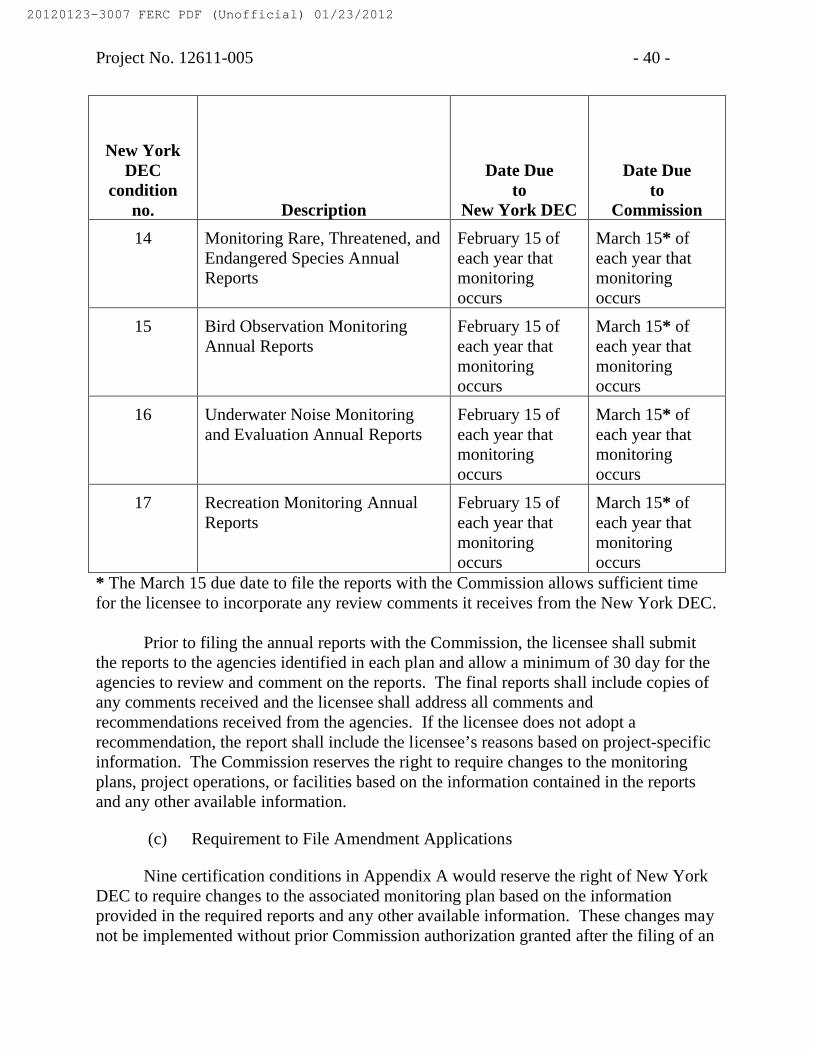
Project No. 12611-005 - 40 -
New York DEC
condition no. Description
Date Due to
New York DEC
Date Due to
Commission
14 Monitoring Rare, Threatened, and Endangered Species Annual Reports
February 15 of each year that monitoring occurs
March 15* of each year that monitoring occurs
15 Bird Observation Monitoring Annual Reports
February 15 of each year that monitoring occurs
March 15* of each year that monitoring occurs
16 Underwater Noise Monitoring and Evaluation Annual Reports
February 15 of each year that monitoring occurs
March 15* of each year that monitoring occurs
17 Recreation Monitoring Annual Reports
February 15 of each year that monitoring occurs
March 15* of each year that monitoring occurs
* The March 15 due date to file the reports with the Commission allows sufficient time for the licensee to incorporate any review comments it receives from the New York DEC.
Prior to filing the annual reports with the Commission, the licensee shall submit the reports to the agencies identified in each plan and allow a minimum of 30 day for the agencies to review and comment on the reports. The final reports shall include copies of any comments received and the licensee shall address all comments and recommendations received from the agencies. If the licensee does not adopt a recommendation, the report shall include the licensee’s reasons based on project-specific information. The Commission reserves the right to require changes to the monitoring plans, project operations, or facilities based on the information contained in the reports and any other available information.
(c) Requirement to File Amendment Applications
Nine certification conditions in Appendix A would reserve the right of New York DEC to require changes to the associated monitoring plan based on the information provided in the required reports and any other available information. These changes may not be implemented without prior Commission authorization granted after the filing of an
20120123-3007 FERC PDF (Unofficial) 01/23/2012

Project No. 12611-005 - 41 -
application to amend the license. These conditions are listed below.
New York DEC condition no.
Description
10 Seasonal Hydroacoustics Monitoring Plan
11Seasonal Dual-Frequency Identification Sonar (DIDSON) Monitoring Plan
12 Seasonal Species Characterization – Netting Plan
13 Tagged Species Detection Plan
15 Bird Observation Monitoring Plan
16 Underwater Noise Monitoring and Evaluation Plan
17 Recreation Monitoring
22 State May Order Removal or Alteration of Work
24 State May Require Site Restoration
Article 402. Public Safety – Emergency Shutdown Plan. The Public Safety –Emergency Shutdown Plan, filed December 29, 2010, is approved and made part of this license. Revisions to the plan may be necessary as experience is gathered during the term of the license. At least 60 days before starting project operations, the licensee shall submit one copy of the Public Safety – Emergency Shutdown Plan with any proposed revisions, to the D2SI – New York Regional Engineer, and two copies to the Commission (one of these shall be a courtesy copy to the Director, D2SI). All future revisions to the plan shall be submitted to the D2SI-New York Regional Engineer for review and comment prior to implementation.
Article 403. Project Removal and Site Restoration Plan. The Project Removal and Site Restoration Plan, filed December 29, 2010 and required by certification condition 6, is approved and made part of this license with the following provisions: 1) a detailed timeline for the removal and site restoration activities shall be filed with the Commission 6 months prior to license expiration; 2) documentation of consultation with the New York Department of State, New York Department of Environmental Protection, U.S. Fish and Wildlife Service, National Marine Fisheries Service, U.S. Coast Guard, and U.S. Army Corps of Engineers regarding planned removal and site restoration activities shall be filed with the Commission 6 months prior to license expiration; and 3)
20120123-3007 FERC PDF (Unofficial) 01/23/2012

Project No. 12611-005 - 42 -
documentation of completion of project removal and site restoration activities shall be filed with the Commission prior to license expiration. This plan may not be amended without prior Commission approval. Upon license issuance the licensee shall implement the plan.
Article 404. Navigation and Safety Plan. The Navigation and Safety Plan, filed December 29, 2010, is approved and made part of this license and may not be amended without prior Commission approval. Upon license issuance, the licensee shall implement the plan with the following modification: at least 90 days prior to commencing project construction and installation, the licensee shall file with the Commission documentation of approval by the U.S. Coast Guard regarding the location of the exclusion zone and associated buoys.
Article 405. Aesthetic Resources. The licensee shall design the shoreline switchgear and cable vaults to blend with the existing shoreline by mimicking the circa 1975 steam tunnel vents, which are currently located between 135 feet and 185 feet apart along the shore. All land-based facilities shall be designed as relatively low-profile structures to minimize any aesthetic impact. The licensee also shall maintain aesthetic values of the project area through the selection of materials and non-reflective colors that blend with the natural landscape.
Article 406. Cultural Resources. Prior to beginning any land-clearing or land-disturbing activities within the project boundary, other than those specifically authorized in this license, the licensee shall consult with the New York State Historic Preservation Officer (SHPO). If the licensee discovers previously unidentified cultural resources during the course of constructing or developing project works or other facilities at the project, the licensee shall stop all land-clearing and land-disturbing activities in the vicinity of the resources and consult with the SHPO and the Delaware Nation of Oklahoma (Delaware Nation).
In either instance, the licensee shall file a historic properties management plan (plan) for Commission approval. The plan shall be prepared by a qualified cultural resource specialist after having consulted with the SHPO and the Delaware Nation. The plan shall include the following items:
(1) a description of each discovered property indicating whether it is listed on or eligible to be listed on the National Register of Historic Places; (2) a description of the potential effect on each discovered property; (3) proposed measures for avoiding or mitigating effects; (4) documentation of the nature and extent of consultation; and (5) a schedule for mitigating effects and conducting additional studies.
The Commission may require changes to the plan. The licensee shall not begin
20120123-3007 FERC PDF (Unofficial) 01/23/2012

Project No. 12611-005 - 43 -
land-clearing or land-disturbing activities, other than those specifically authorized in this license, or resume such activities in the vicinity of a property discovered during construction, until informed by the Commission that the requirements of this article have been fulfilled.
Article 407. Interpretive Displays. Within 3 months of license issuance, the licensee shall install interpretive displays, including an informational project board at the control room and an informational kiosk near the north end of the project boundary that provide details on the project technology and the natural environment of the project area. Within 6 months of license issuance, the licensee shall file documentation of the installation of the displays. The documentation shall include the text and graphics on the displays, photographs of the displays, and a map showing the location of the displays. In addition, the filing shall include location point data that is representative of the displays. The location points must be positionally accurate to ±40 feet in order to comply with National Map Accuracy Standards for maps at a 1:24,000 scale. The location points must include latitude/longitude in decimal degrees, based on the horizontal reference datum of the North American Datum of 1983 (NAD 83). The attribute table for each point must include at least the development name and recreational feature.
Article 408. FERC Form 80 Exemption. There is little or no potential for recreation facilities within the project boundary. Therefore, upon the issuance date of the license, the licensee is exempt from 18 C.F.R. § 8.11, the filing of the FERC Form 80 recreation report, for the Roosevelt Island Tidal Energy Project.
Article 409. Use and Occupancy. (a) In accordance with the provisions of this article, the licensee shall have the authority to grant permission for certain types of use and occupancy of project lands and waters and to convey certain interests in project lands and waters for certain types of use and occupancy, without prior Commission approval. The licensee may exercise the authority only if the proposed use and occupancy is consistent with the purposes of protecting and enhancing the scenic, recreational, and other environmental values of the project. For those purposes, the licensee shall also have continuing responsibility to supervise and control the use and occupancies for which it grants permission, and to monitor the use of, and ensure compliance with the covenants of the instrument of conveyance for, any interests that it has conveyed, under this article. If a permitted use and occupancy violates any condition of this article or any other condition imposed by the licensee for protection and enhancement of the project’s scenic, recreational, or other environmental values, or if a covenant of a conveyance made under the authority of this article is violated, the licensee shall take any lawful action necessary to correct the violation. For a permitted use or occupancy, that action includes, if necessary, canceling the permission to use and occupy the project lands and waters and requiring the removal of any non-complying structures and facilities.
20120123-3007 FERC PDF (Unofficial) 01/23/2012
Project No. 12611-005 - 44 -
(b) The type of use and occupancy of project lands and waters for which the licensee may grant permission without prior Commission approval are: (1) landscape plantings; (2) non-commercial piers, landings, boat docks, or similar structures and facilities that can accommodate no more than 10 water craft at a time and where said facility is intended to serve single-family type dwellings; (3) embankments, bulkheads, retaining walls, or similar structures for erosion control to protect the existing shoreline; and (4) food plots and other wildlife enhancements. To the extent feasible and desirable to protect and enhance the project’s scenic, recreational, and other environmental values, the licensee shall require multiple use and occupancy of facilities for access to project lands or waters. The licensee shall also ensure, to the satisfaction of the Commission’s authorized representative, that the use and occupancies for which it grants permission are maintained in good repair and comply with applicable state and local health and safety requirements. Before granting permission for construction of bulkheads or retaining walls, the licensee shall: (1) inspect the site of the proposed construction, (2) consider whether the planting of vegetation or the use of riprap would be adequate to control erosion at the site, and (3) determine that the proposed construction is needed and would not change the basic contour of the impoundment shoreline. To implement this paragraph (b), the licensee may, among other things, establish a program for issuing permits for the specified types of use and occupancy of project lands and waters, which may be subject to the payment of a reasonable fee to cover the licensee’s costs of administering the permit program. The Commission reserves the right to require the licensee to file a description of its standards, guidelines, and procedures for implementing this paragraph (b) and to require modification of those standards, guidelines, or procedures.
(c) The licensee may convey easements or rights-of-way across, or leases of project lands for: (1) replacement, expansion, realignment, or maintenance of bridges or roads where all necessary state and federal approvals have been obtained; (2) storm drains and water mains; (3) sewers that do not discharge into project waters; (4) minor access roads; (5) telephone, gas, and electric utility distribution lines; (6) non-project overhead electric transmission lines that do not require erection of support structures within the project boundary; (7) submarine, overhead, or underground major telephone distribution cables or major electric distribution lines (69-kV or less); and (8) water intake or pumping facilities that do not extract more than one million gallons per day from a project impoundment. No later than January 31 of each year, the licensee shall file three copies of a report briefly describing for each conveyance made under this paragraph (c) during the prior calendar year, the type of interest conveyed, the location of the lands subject to the conveyance, and the nature of the use for which the interest was conveyed.
(d) The licensee may convey fee title to, easements or rights-of-way across, or leases of project lands for: (1) construction of new bridges or roads for which all necessary state and federal approvals have been obtained; (2) sewer or effluent lines that
20120123-3007 FERC PDF (Unofficial) 01/23/2012

Project No. 12611-005 - 45 -
discharge into project waters, for which all necessary federal and state water quality certification or permits have been obtained; (3) other pipelines that cross project lands or waters but do not discharge into project waters; (4) non-project overhead electric transmission lines that require erection of support structures within the project boundary, for which all necessary federal and state approvals have been obtained; (5) private or public marinas that can accommodate no more than 10 water craft at a time and are located at least one-half mile (measured over project waters) from any other private or public marina; (6) recreational development consistent with an approved report on recreational resources of an Exhibit E; and (7) other uses, if: (i) the amount of land conveyed for a particular use is five acres or less; (ii) all of the land conveyed is located at least 75 feet, measured horizontally, from project waters at normal surface elevation; and (iii) no more than 50 total acres of project lands for each project development are conveyed under this clause (d)(7) in any calendar year. At least 60 days before conveying any interest in project lands under this paragraph (d), the licensee must submit a letter to the Director, Office of Energy Projects, stating its intent to convey the interest and briefly describing the type of interest and location of the lands to be conveyed (a marked Exhibit G map may be used), the nature of the proposed use, the identity of any federal or state agency official consulted, and any federal or state approvals required for the proposed use. Unless the Director, within 45 days from the filing date, requires the licensee to file an application for prior approval, the licensee may convey the intended interest at the end of that period.
(e) The following additional conditions apply to any intended conveyance under paragraph (c) or (d) of this article:
(1) Before conveying the interest, the licensee shall consult with federal and state fish and wildlife or recreation agencies, as appropriate, and the State Historic Preservation Officer.
(2) Before conveying the interest, the licensee shall determine that the proposed use of the lands to be conveyed is not inconsistent with any approved report on recreational resources of an Exhibit E; or, if the project does not have an approved report on recreational resources, that the lands to be conveyed do not have recreational value.
(3) The instrument of conveyance must include the following covenants running with the land: (i) the use of the lands conveyed shall not endanger health, create a nuisance, or otherwise be incompatible with overall project recreational use; (ii) the grantee shall take all reasonable precautions to ensure that the construction, operation,and maintenance of structures or facilities on the conveyed lands will occur in a manner that will protect the scenic, recreational, and environmental values of the project; and (iii) the grantee shall not unduly restrict public access to project waters.
20120123-3007 FERC PDF (Unofficial) 01/23/2012

Project No. 12611-005 - 46 -
(4) The Commission reserves the right to require the licensee to take reasonable remedial action to correct any violation of the terms and conditions of this article, for the protection and enhancement of the project’s scenic, recreational, and other environmental values.
(f) The conveyance of an interest in project lands under this article does not in itself change the project boundaries. The project boundaries may be changed to exclude land conveyed under this article only upon approval of revised Exhibit G drawings (project boundary maps) reflecting exclusion of that land. Lands conveyed under this article will be excluded from the project only upon a determination that the lands are not necessary for project purposes, such as operation and maintenance, flowage, recreation, public access, protection of environmental resources, and shoreline control, including shoreline aesthetic values. Absent extraordinary circumstances, proposals to exclude lands conveyed under this article from the project shall be consolidated for consideration when revised Exhibit G drawings would be filed for approval for other purposes.
(g) The authority granted to the licensee under this article shall not apply to any part of the public lands and reservations of the United States included within the project boundary.
(G) The licensee shall serve copies of any Commission filing required by this order on any entity specified in the order to be consulted on matters relating to that filing. Proof of service on these entities must accompany the filing with the Commission.
(H) This order constitutes final agency action. Any party may file a request for rehearing of this order within 30 days from the date of its issuance, as provided in section 313(a) of the FPA, 16 U.S.C. § 8251 (2006), and section 385.713 of the Commission’s regulations, 18 C.F.R. § 385.713 (2011). The filing of a request for rehearing does not operate as a stay of the effective date of this license or of any date specified in this order. The licensee’s failure to file a request for rehearing shall constitute acceptance of this order.
Jeff C. WrightDirectorOffice of Energy Projects
20120123-3007 FERC PDF (Unofficial) 01/23/2012

Project No. 12611-005 - 47 -
Form L-14(October, 1975)
FEDERAL ENERGY REGULATORY COMMISSION
TERMS AND CONDITIONS OF LICENSE FOR UNCONSTRUCTED MINOR PROJECT AFFECTING NAVIGABLE WATERS OF THE UNITED STATES
Article 1. The entire project, as described in this order of the Commission, shall be subject to all of the provisions, terms, and conditions of the license.
Article 2. No substantial change shall be made in the maps, plans, specifications, and statements described and designated as exhibits and approved by the Commission in its order as a part of the license until such change shall have been approved by the Commission: Provided, however, That if the Licensee or the Commission deems it necessary or desirable that said approved exhibits, or any of them, be changed, there shall be submitted to the Commission for approval a revised, or additional exhibit or exhibits covering the proposed changes which, upon approval by the Commission, shall become a part of the license and shall supersede, in whole or in part, such exhibit or exhibits theretofore made a part of the license as may be specified by the Commission.
Article 3. The project works shall be constructed in substantial conformity with the approved exhibits referred to in Article 2 herein or as changed in accordance with the provisions of said article. Except when emergency shall require for the protection of navigation, life, health, or property, there shall not be made without prior approval of the Commission any substantial alteration or addition not in conformity with the approved plans to any dam or other project works under the license or any substantial use of project lands and waters not authorized herein; and any emergency alteration, addition, or use so made shall thereafter be subject to such modification and change as the Commission may direct. Minor changes in project works, or in uses of project lands and waters, or divergence from such approved exhibits may be made if such changes will not result in a decrease in efficiency, in a material increase in cost, in an adverse environmental impact, or in impairment of the general scheme of development; but any of such minor changes made without the prior approval of the Commission, which in its judgment have produced or will produce any of such results, shall be subject to such alteration as the Commission may direct.
Upon the completion of the project, or at such other time as the Commission may direct, the Licensee shall submit to the Commission for approval revised exhibits insofar as necessary to show any divergence from or variations in the project area and project boundary as finally located or in the project works as actually constructed when compared with the area and boundary shown and the works described in the license or in the exhibits approved by the Commission, together with a statement in writing setting
20120123-3007 FERC PDF (Unofficial) 01/23/2012

Project No. 12611-005 - 48 -
forth the reasons which in the opinion of the Licensee necessitated or justified variation in or divergence from the approved exhibits. Such revised exhibits shall, if and when approved by the Commission, be made a part of the license under the provisions of Article 2 hereof.
Article 4. The construction, operation, and maintenance of the project and any work incidental to additions or alterations shall be subject to the inspection and supervision of the Regional Engineer, Federal Energy Regulatory Commission, in the region wherein the project is located, or of such other officer or agent as the Commission may designate, who shall be the authorized representative of the Commission for such purposes. The Licensee shall cooperate fully with said representative and shall furnish him a detailed program of inspection by the Licensee that will provide for an adequate and qualified inspection force for construction of the project and for any subsequent alterations to the project. Construction of the project works or any features or alteration thereof shall not be initiated until the program of inspection for the project works or any such feature thereof has been approved by said representative. The Licensee shall also furnish to said representative such further information as he may require concerning the construction, operation, and maintenance of the project, and of any alteration thereof, and shall notify him of the date upon which work will begin, as far in advance thereof as said representative may reasonably specify, and shall notify him promptly in writing of any suspension of work for a period of more than one week, and of its resumption and completion. The Licensee shall allow said representative and other officers or employees of the United States, showing proper credentials, free and unrestricted access to, through, and across the project lands and project works in the performance of their official duties. The Licensee shall comply with such rules and regulations of general or special applicability as the Commission may prescribe from time to time for the protection of life, health, or property.
Article 5. The Licensee, within five years from the date of issuance of the license, shall acquire title in fee or the right to use in perpetuity all lands, other than lands of the United States, necessary or appropriate for the construction, maintenance, and operation of the project. The Licensee or its successors and assigns shall, during the period of the license, retain the possession of all project property covered by the license as issued or as later amended, including the project area, the project works, and all franchises, easements, water rights, and rights of occupancy and use; and none of such properties shall be voluntarily sold, leased, transferred, abandoned, or otherwise disposed of without the prior written approval of the Commission, except that the Licensee may lease or otherwise dispose of interests in project lands or property without specific written approval of the Commission pursuant to the then current regulations of the Commission. The provisions of this article are not intended to prevent the abandonment or the retirement from service of structures, equipment, or other project works in connection with replacements thereof when they become obsolete, inadequate, or inefficient for further service due to wear and tear; and mortgage or trust deeds or judicial sales made
20120123-3007 FERC PDF (Unofficial) 01/23/2012

Project No. 12611-005 - 49 -
thereunder, or tax sales, shall not be deemed voluntary transfers within the meaning of this article.
Article 6. The Licensee shall install and thereafter maintain gages and stream-gaging stations for the purpose of determining the stage and flow of the stream or streams on which the project is located, the amount of water held in and withdrawn from storage, and the effective head on the turbines; shall provide for the required reading of such gages and for the adequate rating of such stations; and shall install and maintain standard meters adequate for the determination of the amount of electric energy generated by the project works. The number, character, and location of gages, meters, or other measuring devices, and the method of operation thereof, shall at all times be satisfactory to the Commission or its authorized representative. The Commission reserves the right, after notice and opportunity for hearing, to require such alterations in the number, character, and location of gages, meters, or other measuring devices, and the method of operation thereof, as are necessary to secure adequate determinations. The installation of gages, the rating of said stream or streams, and the determination of the flow thereof, shall be under the supervision of, or in cooperation with, the District Engineer of the United States Geological Survey having charge of stream-gaging operations in the region of the project, and the Licensee shall advance to the United States Geological Survey the amount of funds estimated to be necessary for such supervision, or cooperation for such periods as may be mutually agreed upon. The Licensee shall keep accurate and sufficient records of the foregoing determinations to the satisfaction of the Commission, and shall make return of such records annually at such time and in such form as the Commission may prescribe.
Article 7. The Licensee shall, after notice and opportunity for hearing, install additional capacity or make other changes in the project as directed by the Commission, to the extent that it is economically sound and in the public interest to do so.
Article 8. The Licensee shall, after notice and opportunity for hearing, coordinate the operation of the project, electrically and hydraulically, with such other projects or power systems and in such manner as the Commission may direct in the interest of power and other beneficial public uses of water resources, and on such conditions concerning the equitable sharing of benefits by the Licensee as the Commission may order.
Article 9. The United States specifically retains and safeguards the right to use water in such amount, to be determined by the Secretary of the Army, as may be necessary for the purposes of navigation on the navigable waterway affected; and the operations of the Licensee, so far as they affect the use, storage and discharge from storage of waters affected by the license, shall at all times be controlled by such reasonable rules and regulations as the Secretary of the Army may prescribe in the interest of navigation, and as the Commission may prescribe for the protection of life, health, and property, and in the interest of the fullest practicable conservation and utilization of such waters for power purposes and for other beneficial public uses,
20120123-3007 FERC PDF (Unofficial) 01/23/2012

Project No. 12611-005 - 50 -
including recreational purposes, and the Licensee shall release water from the project reservoir at such rate in cubic feet per second, or such volume in acre-feet per specified period of time, as the Secretary of the Army may prescribe in the interest of navigation, or as the Commission may prescribe for the other purposes hereinbefore mentioned.
Article 10. On the application of any person, association, corporation, Federal agency, State or municipality, the Licensee shall permit such reasonable use of its reservoir or other project properties, including works, lands and water rights, or parts thereof, as may be ordered by the Commission, after notice and opportunity for hearing, in the interests of comprehensive development of the waterway or waterways involved and the conservation and utilization of the water resources of the region for water supply or for the purposes of steam-electric, irrigation, industrial, municipal or similar uses. The Licensee shall receive reasonable compensation for use of its reservoir or other project properties or parts thereof for such purposes, to include at least full reimbursement for any damages or expenses which the joint use causes the Licensee to incur. Any such compensation shall be fixed by the Commission either by approval of an agreement between the Licensee and the party or parties benefiting or after notice and opportunity for hearing. Applications shall contain information in sufficient detail to afford a full understanding of the proposed use, including satisfactory evidence that the applicant possesses necessary water rights pursuant to applicable State law, or a showing of cause why such evidence cannot concurrently be submitted, and a statement as to the relationship of the proposed use to any State or municipal plans or orders which may have been adopted with respect to the use of such waters.
Article 11. The Licensee shall, for the conservation and development of fish and wildlife resources, construct, maintain, and operate, or arrange for the construction, maintenance, and operation of such reasonable facilities, and comply with such reasonable modifications of the project structures and operation, as may be ordered by the Commission upon its own motion or upon the recommendation of the Secretary of the Interior or the fish and wildlife agency or agencies of any State in which the project or a part thereof is located, after notice and opportunity for hearing.
Article 12. Whenever the United States shall desire, in connection with the project, to construct fish and wildlife facilities or to improve the existing fish and wildlife facilities at its own expense, the Licensee shall permit the United States or its designated agency to use, free of cost, such of the Licensee’s lands and interests in lands, reservoirs, waterways and project works as may be reasonably required to complete such facilities or such improvements thereof. In addition, after notice and opportunity for hearing, the Licensee shall modify the project operation as may be reasonably prescribed by the Commission in order to permit the maintenance and operation of the fish and wildlife facilities constructed or improved by the United States under the provisions of this article. This article shall not be interpreted to place any obligation on the United States to construct or improve fish and wildlife facilities or to relieve the Licensee of any
20120123-3007 FERC PDF (Unofficial) 01/23/2012

Project No. 12611-005 - 51 -
obligation under this license.
Article 13. So far as is consistent with proper operation of the project, the Licensee shall allow the public free access, to a reasonable extent, to project waters and adjacent project lands owned by the Licensee for the purpose of full public utilization of such lands and waters for navigation and for outdoor recreational purposes, including fishing and hunting: Provided, That the Licensee may reserve from public access such portions of the project waters, adjacent lands, and project facilities as may be necessary for the protection of life, health, and property.
Article 14. In the construction, maintenance, or operation of the project, the Licensee shall be responsible for, and shall take reasonable measures to prevent, soil erosion on lands adjacent to streams or other waters, stream sedimentation, and any form of water or air pollution. The Commission, upon the request or upon its own motion, may order the Licensee to take such measures as the Commission finds to be necessary for these purposes, after notice and opportunity for hearing.
Article 15. The Licensee shall consult with the appropriate State and Federal agencies and, within one year of the date of issuance of this license, shall submit for Commission approval a plan for clearing the reservoir area. Further, the Licensee shall clear and keep clear to an adequate width lands along open conduits and shall dispose of all temporary structures, unused timber, brush, refuse, or other material unnecessary for the purposes of the project which results from the clearing of lands or from the maintenance or alteration of the project works. In addition, all trees along the periphery of project reservoirs which may die during operations of the project shall be removed. Upon approval of the clearing plan all clearing of the lands and disposal of the unnecessary material shall be done with due diligence and to the satisfaction of the authorized representative of the Commission and in accordance with appropriate Federal, State, and local statues and regulations.
Article 16. Material may be dredged or excavated from, or placed as fill in, project lands and/or waters only in the prosecution of work specifically authorized under the license; in the maintenance of the project; or after obtaining Commission approval, as appropriate. Any such material shall be removed and/or deposited in such manner as to reasonably preserve the environmental values of the project and so as not to interfere with traffic on land or water. Dredging and filling in a navigable water of the United States shall also be done to the satisfaction of the District Engineer, Department of the Army, in charge of the locality.
Article 17. If the Licensee shall cause or suffer essential project property to be removed or destroyed or to become unfit for use, without adequate replacement, or shall abandon or discontinue good faith operation of the project or refuse or neglect to comply with the terms of the license and the lawful orders of the Commission mailed to the
20120123-3007 FERC PDF (Unofficial) 01/23/2012

Project No. 12611-005 - 52 -
record address of the Licensee or its agent, the Commission will deem it to be the intent of the Licensee to surrender the license. The Commission, after notice and opportunity for hearing, may require the Licensee to remove any or all structures, equipment and power lines within the project boundary and to take any such other action necessary to restore the project waters, lands, and facilities remaining within the project boundary to a condition satisfactory to the United States agency having jurisdiction over its lands or the Commission’s authorized representative, as appropriate, or to provide for the continued operation and maintenance of nonpower facilities and fulfill such other obligations under the license as the Commission may prescribe. In addition, the Commission in its discretion, after notice and opportunity for hearing, may also agree to the surrender of the license when the Commission, for the reasons recited herein, deems it to be the intent of the Licensee to surrender the license.
Article 18. The right of the Licensee and of its successors and assigns to use or occupy waters over which the United States has jurisdiction, or lands of the United States under the license, for the purpose of maintaining the project works or otherwise, shall absolutely cease at the end of the license period, unless the Licensee has obtained a new license pursuant to the then existing laws and regulations, or an annual license under the terms and conditions of this license.
Article 19. The terms and conditions expressly set forth in the license shall not be construed as impairing any terms and conditions of the Federal Power Act which are not expressly set forth herein.
20120123-3007 FERC PDF (Unofficial) 01/23/2012
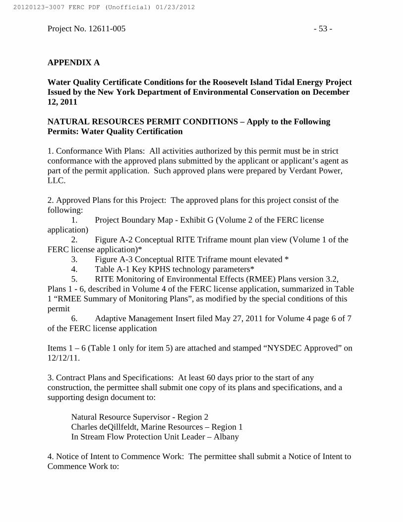
Project No. 12611-005 - 53 -
APPENDIX A
Water Quality Certificate Conditions for the Roosevelt Island Tidal Energy Project Issued by the New York Department of Environmental Conservation on December 12, 2011
NATURAL RESOURCES PERMIT CONDITIONS – Apply to the Following Permits: Water Quality Certification
1. Conformance With Plans: All activities authorized by this permit must be in strict conformance with the approved plans submitted by the applicant or applicant’s agent as part of the permit application. Such approved plans were prepared by Verdant Power, LLC.
2. Approved Plans for this Project: The approved plans for this project consist of the following:
1. Project Boundary Map - Exhibit G (Volume 2 of the FERC license application)
2. Figure A-2 Conceptual RITE Triframe mount plan view (Volume 1 of the FERC license application)*
3. Figure A-3 Conceptual RITE Triframe mount elevated * 4. Table A-1 Key KPHS technology parameters* 5. RITE Monitoring of Environmental Effects (RMEE) Plans version 3.2,
Plans 1 - 6, described in Volume 4 of the FERC license application, summarized in Table 1 “RMEE Summary of Monitoring Plans”, as modified by the special conditions of this permit
6. Adaptive Management Insert filed May 27, 2011 for Volume 4 page 6 of 7 of the FERC license application
Items 1 – 6 (Table 1 only for item 5) are attached and stamped “NYSDEC Approved” on 12/12/11.
3. Contract Plans and Specifications: At least 60 days prior to the start of any construction, the permittee shall submit one copy of its plans and specifications, and a supporting design document to:
Natural Resource Supervisor - Region 2 Charles deQillfeldt, Marine Resources – Region 1 In Stream Flow Protection Unit Leader – Albany
4. Notice of Intent to Commence Work: The permittee shall submit a Notice of Intent to Commence Work to:
20120123-3007 FERC PDF (Unofficial) 01/23/2012

Project No. 12611-005 - 54 -
Marine Resources Program Manager NYSDEC Region 2 1 Hunters Point Plaza, 47- 40 21st Street Long Island City, NY 11101-5407
at least 48 hours in advance of the time of commencement and shall also notify him/her promptly in writing of the completion of work.
5. As-built Drawings: Within 90 days of completion of construction of the facilities authorized by this permit, the permittee shall provide revised FERC license application exhibits A, F, and G, as applicable, to describe and show those project facilities as built.
6. Project Removal and Site Restoration Plan: Upon FERC license issuance, the permittee shall implement the Project Removal and Site Restoration Plan, filed December 29, 2010. As part of the plan, at least 90 days prior to commencing project construction and installation, the permittee shall file proof of purchase of a surety bond, or equivalent financial assurance instrument, to cover the entirety of the costs of removing the project. The permittee shall file proof of the maintenance of the bond, or equivalent financial assurance, by December 31 of each year. This proof must be sent to:
Regional Permit Administrator, Region 1
7. Post Sign and Permit: The enclosed permit and permit sign must be conspicuously posted in a publicly accessible location at the project site. They must be visible, legible and protected from the elements at all times.
8. Progress Reports: Periodic progress reports must be provided to the Department as indicated in the approved plans. The progress reports must include quarterly technical memos to provide data and current status of the monitoring effort, and Annual Reports that address overall effectiveness of the monitoring plan, provide agency comments and the permittees response to issues raised, and any measures that will be taken to address the effectiveness of the plan. The annual reports must be received no later than February 15 of each calendar year by the following staff:
Natural Resource Supervisor - Region 2 Charles deQillfeldt, Marine Resources – Region 1 Regional Permit Administrator, Region 1 In Stream Flow Protection Unit Leader – Albany
9. Reporting of Mortality or Injury to Aquatic Organisms: Any lethal or nonlethal injury to any rare, threatened or endangered species, or to any sea turtles, aquatic mammals, water fowl, raptors or shorebirds that may be directly or indirectly attributed to the
20120123-3007 FERC PDF (Unofficial) 01/23/2012

Project No. 12611-005 - 55 -
project must be reported to the Department immediately via e-mail, and within 24 hours of the incident via phone. The Department contact is Charles deQillfeldt, phone: 631-444-0439, e-mail: [email protected].
10. Seasonal Hydroacoustics Monitoring Plan (RMEE-1): Upon FERC license issuance, the permittee shall implement RMEE-1, filed with the FERC license on December 29, 2010, with the following modifications:
(1) section 3.3 shall be modified to specify the potential need for additional monitoring during the spring and/or summer of Phase 1 and Phase 2, if the results of the Seasonal Species Characterization Netting Plan suggests that the proposed fall sampling is not an adequate surrogate for the spring and summer fish assemblages;
(2) section 3.3. shall be modified to specify the potential need for additional monitoring due equipment failure, unexpectedly low abundance of fish, or other issues outside of the licensee’s control; and
(3) section 3.1 shall be modified to specify that the final location of the split beam transducers will be determined in consultation with the National Marine Fisheries Service, U.S. Fish and Wildlife Service, and New York State Department of Environmental Conservation prior to each monitoring phase.
As part of the plan, the permitee shall submit annual reports by February 15 of each year that monitoring occurs. The permittee shall submit to the Department documentation of any consultation, and copies of any comments and recommendations made by any consulted entity in connection with each report. The Department reserves the right to require changes to the RMEE-1 based on the information contained in the report and any other available information.
11. Seasonal Dual-Frequency Identification Sonar (DIDSON) Monitoring Plan (RMEE-2): Upon FERC license issuance, the permittee shall implement RMEE-2, filed with the FERC license on December 29, 2010, with the following modifications:
(1) section 3.1 shall be modified to specify that the permittee will investigate cleaning and maintenance alternatives for the DIDSON equipment that may allow for extended monitoring; and
(2) section 3.3 shall be modified to specify that extended monitoring may occur if an effective cleaning and maintenance strategy for the equipment is discovered.
As part of the plan, the permitee shall submit annual reports by February 15 of each year that monitoring occurs. The permittee shall submit to the Department documentation of any consultation, and copies of any comments and recommendations made by any consulted entity in connection with each report. The Department reserves the right to require changes to RMEE-2 based on the information contained in the report and any other available information
20120123-3007 FERC PDF (Unofficial) 01/23/2012

Project No. 12611-005 - 56 -
12. Seasonal Species Characterization – Netting Plan (RMEE-3): Upon FERC license issuance, the permittee shall implement RMEE-3, filed with the FERC license on December 29, 2010. As part of the plan, the permitee shall submit annual reports by February 15 of each year that monitoring occurs. The permittee shall submit to the Department documentation of any consultation, and copies of any comments and recommendations made by any consulted entity in connection with each report. The Department reserves the right to require changes to RMEE-3 based on the information contained in the report and any other available information.
13. Tagged Species Detection Plan (RMEE-4): Upon FERC license issuance, the permittee shall implement RMEE-4, filed with the FERC license on December 29, 2010, modified to provide monitoring for one complete year in Phase 1, with no monitoring proposed in Phases 2 and 3 unless it is determined to be necessary based on evaluation of Phase 1 data. As part of the plan, the permitee shall submit annual reports by February 15 of each year that monitoring occurs. The permittee shall submit to the Department documentation of any consultation, and copies of any comments and recommendations made by any consulted entity in connection with each report. The Department reserves the right to require changes to the RMEE-4- based on the information contained in the report and any other available information.
14. Monitoring Rare, Threatened, and Endangered Species: Upon FERC license issuance, the licensee shall continue to monitor for rare, threatened, and endangered species in the project area. The permittee shall submit annual reports by February 15 of each year. The report shall include, at a minimum:
(1) a list of any rare, threatened, or endangered species observed at the project over the previous year;
(2) the date, time, and duration the species was present in the project area; and (3) a discussion of whether the installed project or any project features appeared to
be impacting the observed species (4) information on any actions taken or proposed by the permittee to limit impacts
to these species
15. Bird Observation Monitoring Plan (RMEE-5): Upon FERC license issuance, the permittee shall implement the RMEE-5, filed with the FERC license application on December 29, 2010, with the following modification:
(1) table 2-2 of the Bird Observation Monitoring Plan shall be modified to include one year of seasonal spring and fall (11 days) bird monitoring during Phase 3 (30 turbines). As part of the plan, the permitee shall submit annual reports by February 15 of each year that monitoring occurs. The permittee shall submit to the Department documentation of any consultation, and copies of any comments and recommendations
20120123-3007 FERC PDF (Unofficial) 01/23/2012

Project No. 12611-005 - 57 -
made by any consulted entity in connection with each report. The Department reserves the right to require changes to the RMEE-5 based on the information contained in the report and any other available information.
16. Underwater Noise Monitoring and Evaluation Plan (RMEE-6): Upon FERC license issuance, the licensee shall implement the RMEE-6, filed with the FERC license on December 29, 2010. As part of the plan, the permittee shall submit annual reports by February 15 of each year that monitoring occurs. The permittee shall submit to the Department documentation of any consultation, and copies of any comments and recommendations made by any consulted entity in connection with each report. The Department reserves the right to require changes to RMEE-6 based on the information contained in the report and any other available information.
17. Recreation Monitoring: The permittee, after consultation with the New York City Department of Parks and Recreation, the New York State Office of Parks, Recreation, and Historic Preservation, the National Park Service, and the Recreation Study Group [consisting of the following entities: New York DEC; FWS; NOAA; EPA; Coast Guard; Riverkeeper; National Park Service; New York State Office of Parks, Recreation, and Historic Preservation; Long Island Power Authority; Roosevelt Island Operating Company; Hydropower Reform Coalition; Hudson River Fisherman’s Association; Rocket Charters; New York Rivers United; New York City Department of City Planning; Moran Towing; Stevens Institute; New York Maritime Association; Columbia University; and KeySpan Energy], shall monitor recreation use to determine whether installation of the project turbines is affecting recreation use in the project area. Monitoring studies shall occur for one year after Phase 1 deployment, for one year after Phase 2 deployment, and for two years after Phase 3 deployment. Monitoring studies, at a minimum, shall include the collection of annual recreation use data.
As part of the plan, the licensee shall submit annual reports by February 15 of each year that monitoring occurs (years 1, 2, 4, and 5). This report shall include:
(1) annual recreation use figures; (2) a description of the methodology used to collect all study data; (3) a discussion of whether the project’s exclusion zone and the installed turbines
are affecting recreation use in the project area, specifically at Hallet’s Cove and the north end of Roosevelt Island;
(4) documentation of agency consultation and agency comments on the report after it has been prepared and provided to the agencies; and
(5) specific descriptions of how the agencies’ comments are accommodated by the report.
The permittee shall allow a minimum of 30 days for the Department to comment and to make recommendations prior to filing the report with FERC. The Department reserves
20120123-3007 FERC PDF (Unofficial) 01/23/2012

Project No. 12611-005 - 58 -
the right to require changes to the monitoring based on the information contained in the report and any other available information.
18. No Dredging or Excavation: No dredging, excavating or other alteration of shoreline or underwater areas is authorized by this permit except for that specifically described in this permit and the approved plans.
19. No Interference With Navigation: There shall be no unreasonable interference with navigation by the work herein authorized.
20. Removal of All Equipment Prior to Permit Expiration: All equipment including but not limited to the pilings, triframe mounts, electric cables, instruments and associated mounts/anchors, must be completely removed from the East River 60 days prior to the expiration of this permit unless the permittee has obtained a license from Federal Energy Regulatory Commission (FERC) authorizing the construction and operation of the Pilot Project field of turbine units.
21. State Not Liable for Damage: The State of New York shall in no case be liable for any damage or injury to the structure or work herein authorized which may be caused by or result from future operations undertaken by the State for the conservation or improvement of navigation, or for other purposes, and no claim or right to compensation shall accrue from any such damage.
22. State May Order Removal or Alteration of Work: If future operations by the State of New York require an alteration in the position of the structure or work herein authorized, or if, in the opinion of the Department of Environmental Conservation it shall cause unreasonable obstruction to the free navigation of said waters or flood flows or endanger the health, safety or welfare of the people of the State, or cause loss or destruction of the natural resources of the State, the owner may be ordered by the Department to remove or alter the structural work, obstructions, or hazards caused thereby without expense to the State, and if, upon the expiration or revocation of this permit, the structure, fill, excavation, or other modification of the watercourse hereby authorized shall not be completed, the owners, shall, without expense to the State, and to such extent and in such time and manner as the Department of Environmental Conservation may require, remove all or any portion of the uncompleted structure or fill and restore to its former condition the navigable and flood capacity of the watercourse. No claim shall be made against the State of New York on account of any such removal or alteration.
23. Precautions Against Contamination of Waters All necessary precautions shall be taken to preclude contamination of any wetland or waterway by suspended solids, sediments, fuels, solvents, lubricants, epoxy coatings, paints, concrete, leachate or any other environmentally deleterious materials associated with the project.
20120123-3007 FERC PDF (Unofficial) 01/23/2012

Project No. 12611-005 - 59 -
24. State May Require Site Restoration: If upon the expiration or revocation of this permit, the project hereby authorized has not been completed, the applicant shall, without expense to the State, and to such extent and in such time and manner as the Department of Environmental Conservation may lawfully require, remove all or any portion of the uncompleted structure or fill and restore the site to its former condition. No claim shall be made against the State of New York on account of any such removal or alteration.
WATER QUALITY CERTIFICATION SPECIFIC CONDITIONS
1. Water Quality Certification: The NYS Department of Environmental Conservation hereby certifies that the subject project will not contravene effluent limitations or other limitations or standards under Sections 301, 302, 303, 306 and 307 of the Clean Water Act of 1977 (PL 95-217) provided that all of the conditions listed herein are met.
GENERAL CONDITIONS -– Apply to ALL Authorized Permits
1. Facility Inspection by The Department: The permitted site or facility, including relevant records, is subject to inspection at reasonable hours and intervals by an authorized representative of the Department of Environmental Conservation (the Department) to determine whether the permittee is complying with this permit and the ECL. Such representative may order the work suspended pursuant to ECL 71- 0301 and SAPA 401(3).
The permittee shall provide a person to accompany the Department’s representative during an inspection to the permit area when requested by the Department.
A copy of this permit, including all referenced maps, drawings and special conditions, must be available for inspection by the Department at all times at the project site or facility. Failure to produce a copy of the permit upon request by a Department representative is a violation of this permit.
2. Relationship of this Permit to Other Department Orders and Determinations: Unless expressly provided for by the Department, issuance of this permit does not modify, supersede or rescind any order or determination previously issued by the Department or any of the terms, conditions or requirements contained in such order or determination.
3. Applications For Permit Renewals, Modifications or Transfers: The permittee must submit a separate written application to the Department for permit renewal, modification or transfer of this permit. Such application must include any forms or supplemental information the Department requires. Any renewal, modification or transfer granted by the Department must be in writing. Submission of applications for permit renewal, modification or transfer are to be submitted to:
20120123-3007 FERC PDF (Unofficial) 01/23/2012

Project No. 12611-005 - 60 -
Deputy Chief Permit Administrator NYSDEC HEADQUARTERS 625 BROADWAY ALBANY, NY 12233
4. Submission of Renewal Application: The permittee must submit a renewal application at least 30 days before permit expiration for the following permit authorizations: Water Quality Certification.
5. Permit Modifications, Suspensions and Revocations by the Department: The Department reserves the right to exercise all available authority to modify, suspend or revoke this permit. The grounds for modification, suspension or revocation include:
a. materially false or inaccurate statements in the permit application or supporting papers;
b. failure by the permittee to comply with any terms or conditions of the permit; c. exceeding the scope of the project as described in the permit application; d. newly discovered material information or a material change in environmental
conditions, relevant technology or applicable law or regulations since the issuance of the existing permit;
e. noncompliance with previously issued permit conditions, orders of the commissioner, any provisions of the Environmental Conservation Law or regulations of the Department related to the permitted activity.
6. Permit Transfer: Permits are transferrable unless specifically prohibited by statute, regulation or another permit condition. Applications for permit transfer should be submitted prior to actual transfer of ownership.
NOTIFICATION OF OTHER PERMITTEE OBLIGATIONS
Item A: Permittee Accepts Legal Responsibility and Agrees to Indemnification
The permittee, excepting state or federal agencies, expressly agrees to indemnify and hold harmless the Department of Environmental Conservation of the State of New York, its representatives, employees, and agents ("DEC") for all claims, suits, actions, and damages, to the extent attributable to the permittee’s acts or omissions in connection with the permittee’s undertaking of activities in connection with, or operation and maintenance of, the facility or facilities authorized by the permit whether in compliance or not in compliance with the terms and conditions of the permit. This indemnification does not extend to any claims, suits, actions, or damages to the extent attributable to DEC’s own negligent or intentional acts or omissions, or to any claims, suits, or actions naming the DEC and arising under Article 78 of the New York Civil Practice Laws and Rules or any citizen suit or civil rights provision under federal or state laws.
20120123-3007 FERC PDF (Unofficial) 01/23/2012

Project No. 12611-005 - 61 -
Item B: Permittee’s Contractors to Comply with Permit
The permittee is responsible for informing its independent contractors, employees, agents and assigns of their responsibility to comply with this permit, including all special conditions while acting as the permittee’s agent with respect to the permitted activities, and such persons shall be subject to the same sanctions for violations of the Environmental Conservation Law as those prescribed for the permittee.
Item C: Permittee Responsible for Obtaining Other Required Permits
The permittee is responsible for obtaining any other permits, approvals, lands, easements and rights-ofway that may be required to carry out the activities that are authorized by this permit.
Item D: No Right to Trespass or Interfere with Riparian Rights
This permit does not convey to the permittee any right to trespass upon the lands or interfere with the riparian rights of others in order to perform the permitted work nor does it authorize the impairment of any rights, title, or interest in real or personal property held or vested in a person not a party to the permit.
20120123-3007 FERC PDF (Unofficial) 01/23/2012

Document Content(s)
P-12611-005Order Move11.DOC...........................................1-61
20120123-3007 FERC PDF (Unofficial) 01/23/2012