verde report final - arizona navigable streams ... supplement 10/404... · i’m aware of the grist...
TRANSCRIPT

404


1
NAVIGABILITY ALONG THE NATURAL CHANNEL
OF THE VERDE RIVER, AZ
Detailed analysis from Sullivan Lake to the USGS gage near Clarkdale. and
General analysis from Clarkdale gage to mouth.
An assessment based on history, Federal GLO surveys, hydrology, hydraulics and morphology
By
Hjalmar W. Hjalmarson, PE
October 4, 2014
APPENDICES E THROUGH M
2
FORWARD As a fourth generation resident of the Verde Valley, with a great grandmother and several ancestors resting in the Valley View Cemetery at Clarkdale, Arizona, I’ve experienced first hand the changing Verde River. When I was born in Phoenix, the population of Arizona was about 1 million – a small fraction of the present population. Since settlers first discovered the Verde River watershed in the middle of the 19th century, the population of the area has also increased at an impressive rate. Many of the early settlers were miners, ranchers and farmers. My grandparents and great grandmother arrived in Jerome in 1914 where my grandfather (W. J. Flood), a graduate of the school on mines at Reno NV, was a mining engineer and member of the Arizona 4th legislature with M. A. Perkins and others. My personal experience and memories of the Verde River Watershed include my time as a child living in Prescott during WW2 when my father was an army officer stationed in Iceland for 6 years. My mother would take us on picnics to various lakes in the Prescott area including Sullivan Lake at the head of the Verde River. I have childhood memories of swimming in Sullivan Lake when the water was clear and always flowing over the dam. My brothers and I were not allowed to swim near the dam. It’s easy to think of my early experiences as the “good old days” and conjure up impressions of how pristine and natural the area was before tens of thousands of humans discovered the beautiful area. As I’ve matured and learned about hydrology as a professional river engineer for the past 53 years, however, I’ve grown to realize that humans impacted the flow in the Verde River long before I was born and even before my grandfather was born. For example, I’ve observed the base flow at the USGS streamflow gage near Paulden, a gage site I personally selected as a young USGS engineer, steadily decrease. I’ve also come to realize that when the train dropped us off for a picnic and swim in the Verde River Canyon in the late 1940s, that the flow in the river was significantly less than the natural base flow before settlers arrived in the 1850s. The early accounts of the area by military explorations of Whipple, Ives and Sitgreaves are fascinating. I’m aware of the grist mills on Granite Creek and at Del Rio Springs and accounts by ranch women and Sharlot M. Hall of the early living conditions. Thanks in part to John Wesley Powell I’ve learned that to understand river conditions, one needs to focus beyond the river on the total watershed. I now realize that before my education, personal impressions of the natural Verde River were incorrect because humans within the watershed had significantly impacted the base flow long before my great grandmother arrived in the area. When human impacts are understood and applied with the proper hydrologic context, we can begin to see what the natural Verde River once was. Win Hjalmarson 2014

52
G2. Hydrology Under present, and recent, conditions there is considerable travel by canoes and kayaks along much of the Verde River downstream of Granite Creek. Exceptions are areas affected by SRP reservoirs—namely Bartlett and Horseshoe where there is also boating on the river. General speaking, there is considerable recreational boating along the Verde River. Also, there are a few commercial businesses providing small boating opportunities for visitors and local residents. The amount of base runoff in the Verde River obviously is a potential factor limiting navigability. As explained previously in the Hydrology section of this report, the natural and ordinary perennial/intermittent stream flow is comprised of surface runoff and base runoff. Surface runoff is derived from precipitation and snowmelt. Base runoff is maintained by ground-water discharge all along the Verde River. Base flow is comprised of ground-water discharge from mountain front springs and seeps (Base Qmf on Figure 3 of this report) and Quaternary aquifers (Base Qqa) and basin fill and deeper aquifers (Base Qbfa). Base runoff Qqa and Qmf was first used by settlers for farming and mining because it was on or near the surface at springs and along streams and could be rather easily diverted using small dams or shallow wells. The computation of base runoff of the upper Verde River above the USGS gage near Clarkdale (09504000) is discussed in detail in the Hydrology section. Important parts of this analysis of the hydrology below USGS gage 09504000 are (1) USGS records of stream flow at gages 09503700, 09504000, 0950600 and 09510000; (2) a report by the USBR (1952) that calculated the Virgin flow for the mouth of the Verde River; and (3) a report by the USGS (HA-664 by Freethey and Anderson (1986)) that estimated base runoff (Qbfa, the 90th percentile of daily discharge) for the basin fill and underlying aquifers. An important part of the hydrologic analysis was the distribution of the 100 cfs difference between the Virgin average annual runoff and the gaged average annual runoff at gage 09510000 (See Item F of Table 2 of 2). Base runoff of the lower reach of the Verde River is simply computed by adding (1) the 100 cfs difference (Item F of Table 2 of 2) that was associated with early settler use of base flow such as for mining (section G1e) and irrigation (section G1f) and (2) the base flow (from USGS HA664) at and below the USGS gage 09506000. The base runoff associated with Qqa and Qmf was simply distributed across the middle Verde River between USGS gages 09504000 and 09506000. The resulting natural base flow is shown in Figure G3. The larger springs in the Verde River Watershed are mostly carbonate springs in tributaries such as West Clear Creek, Sycamore Creek, Oak Creek and Fossil Creek where they discharge from the lower Paleozoic rocks of the Redwall Limestone or the Martin Formation (Parker and others, 2005 and Bills and others, 2007). Springs in the lower part of Sycamore Canyon maintain a perennial flow in lower Sycamore Creek within the primitive area. The discharge of Sycamore Creek during the dry months of July and August ranges from 4,550 to 5,125 gallons per minute. About half this

53
discharge comes from Summer's Spring. Fossil Spring, for example, has a very steady flow of about 21,647 gal/year or about 48 cfs (Figure G2). The rather steady discharge from these springs supports the rather steady base flow of the Verde River.
Figure G2. Discharge of Fossil Springs from intermittent current-meter measurements in
Fossil Creek above and below springs (Parker and others, 2005). Natural average annual runoff and median runoff (Figure G3) were computed in a similar manner as base runoff using records of stream flow at USGS gages 09506000 and 09510000.
Figure G3.—Natural and recent flow in the Verde River from mouth of Granite Creek to the mouth.
73
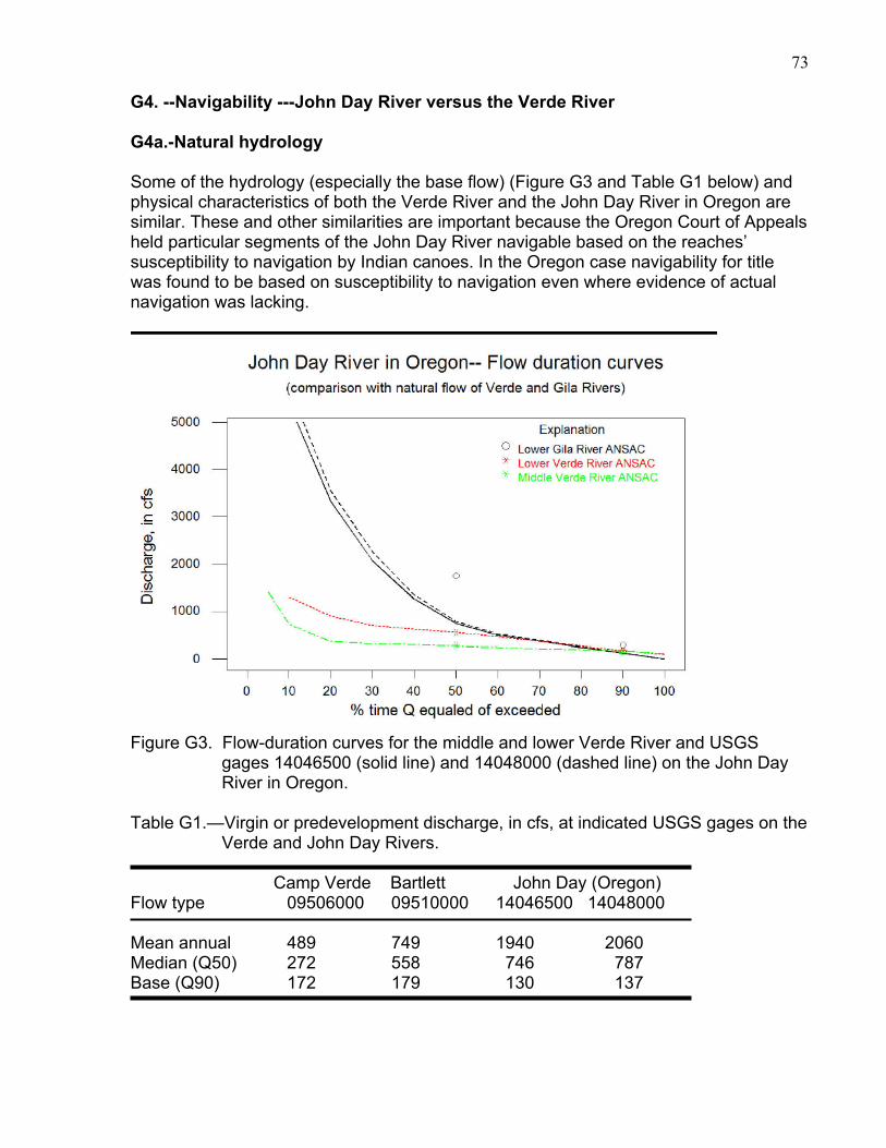
G4. --Navigability ---John Day River versus the Verde River G4a.-Natural hydrology Some of the hydrology (especially the base flow) (Figure G3 and Table G1 below) and physical characteristics of both the Verde River and the John Day River in Oregon are similar. These and other similarities are important because the Oregon Court of Appeals held particular segments of the John Day River navigable based on the reaches’ susceptibility to navigation by Indian canoes. In the Oregon case navigability for title was found to be based on susceptibility to navigation even where evidence of actual navigation was lacking.
Figure G3. Flow-duration curves for the middle and lower Verde River and USGS
gages 14046500 (solid line) and 14048000 (dashed line) on the John Day River in Oregon.
Table G1.—Virgin or predevelopment discharge, in cfs, at indicated USGS gages on the
Verde and John Day Rivers. Camp Verde Bartlett John Day (Oregon) Flow type 09506000 09510000 14046500 14048000 Mean annual 489 749 1940 2060 Median (Q50) 272 558 746 787 Base (Q90) 172 179 130 137

74
Northwest Steelheaders Association Inc. v. Simantel, Decided: May 11, 2005, Court of Appeals of Oregon.: http://caselaw.findlaw.com/or-court-of-appeals/1419601.html, 10p. The John Day River is 284 miles long and the second longest free-flowing/undammed river in the continental United States (the longest being the Yellowstone River). The river drains an area of nearly 8,100 square miles, which is approximately 8% of the total area of Oregon. By contrast, the Verde River is 230 miles long with a drainage area of 6,188 square miles at the Salt River confluence, which is about 6% of the total area of Arizona. Both rivers drain mountainous areas with spring snowmelt and the channels have numerous pools and riffles. The John Day and Verde Rivers are shown below.
Photo of John Day River on left from Eric Mortenson of The Oregonian, October 02, 2009 , “John Day River property will become Oregon's largest recreation site” http://www.oregonlive.com/environment/index.ssf/2009/09/john_day_river_property_will_b.html The flow-duration curves of mean daily discharge for the Verde and John Day Rivers are average (ordinary) curves that represent natural, or approximately natural, conditions (Figure G3). “The stream flow record integrates the effects of climate, topography, and geology, and gives a distribution of runoff both in time and in magnitude. When the flows are arranged according to frequency of occurrence and a flow-duration curve is plotted, the resulting curve shows the integrated effect of the various factors that affect runoff.” (Searcy, 1959). The shapes of the curves for the USGS gages on the two rivers obviously are different because the rather steep slope for the wide range of higher flows of the John Day curve denotes a more variable and larger direct runoff than for the Verde River. However, the curves for low flows are similar and it is the low flows that are most important in determining navigability. The flatter slope for the Verde River indicates the presence of base runoff from ground-water storage in the basin fill and lower Paleozoic rocks of the Redwall Limestone and Martin Formation (both typically large aquifers). For example, at Fossil Creek, springs discharge from a limestone aquifer supplied at least in part from the leakage through the overlying Permian-Pennsylvanian rocks from the C aquifer and thus ground water must travel through the Naco Formation at some locations beneath the Colorado Plateau

75
(Parker and others, 2005). The flat slope of the lower end of the duration curves for both rivers shows there is a large amount of aquifer storage in both the Verde River and John Day River watersheds. The timing, duration, and sequence of water discharges in the Verde River, or any river for that matter, is important for determining navigability. On the Verde River, the base flow is very important because snowmelt is seasonal and not present a large portion of the time during a typical year. The flat slope of the flow-duration curves of the Verde River (Figure G3) shows that base flow is all or a large portion of the runoff at least 70% of the time during a typical year. The similarity of the lower ends of the flow-duration curves for the John Day and Verde Rivers suggests the rivers have similar navigability characteristics (Figure G3). Both rivers have pools and riffles with defined channels and similar amounts of base flow for approximately 50% of the time. Thus, if the John Day River is navigable then it follows that the Verde River also is navigable. G4b.- Federal Land Surveys along the John Day River The following three original Federal survey plats in Oregon for T3N R17E, T3N R18E and T2N R19E each include both the Columbia and John Day Rivers. On each plat the Columbia River was meandered but the John Day River was not. The John Day River is considered navigable for title purposes in Oregon (Northwest Steelheaders Ass'n v. Simantel 199 Ore. App. 471, 112 P.3d 383 (2005)).(Plats were obtained by Hjalmarson from BLM website in 2014)

76
T3N R17E OREGON John Day River
Excerpts of the above plat
Only the Columbia River was meandered. Survey was completed on March 18, 1880.

77