vicroads - gis workflow based speed sign management system · vicroads has developed a state-wide...
TRANSCRIPT

VicRoads - GIS Workflow Based Speed Sign Management System Domenic Gangi, Sandeep Badwal, Richard Zhou, Sameer Babbar
Abstract VicRoads has developed a state-wide GIS speed sign management system that tracks the status of a request to install or replace a speed sign. The system allows the entry the proposed speed signs on the GIS map which are then forwarded for approval to the appropriate authority. If approved a Memorandum of Consent is automatically generated which textually describes the location of the signs in relation to the nearest side road, produces a schedule and map of those sign changes. This Consent is then forwarded via email to the Council for installation with an automatically generated Notification of Completion (NOC) form to be returned upon installation. The system audits the status of any approved signs that have not yet been received within a month and then alerts the responsible officer to confirm status. The signs can be viewed at various stages; proposed, approved, installed, removed and not approved.
Background and Overview VicRoads is the responsible state authority for managing the 22,320km of arterial road network which includes implementing road safety strategies and providing registration and licensing services in the state of Victoria, Australia. Speed is the biggest road safety challenge facing Victoria today. Over the last few years, VicRoads has heavily focussed on introducing speed enforcement using speed signs, speed zones etc. to reduce speeding on the road network. The new speed sign application has been designed to facilitate the process for assessing, approving, issuing, recording and auditing of speed sign information. VicRoads embarked a project in February 2004 to standardise the existing spreadsheets and word processor based practices of managing speed sign into an integrated workflow based management system. The key sponsorship for the project was provided by the road safety business area within VicRoads. From the beginning the project was envisaged as a multi user, multi region asset management enterprise system and single source for speed signs information in the state.
Function The system utilises a GIS map to represent the location of speed signs on the road network at the various stages of the approval process; proposed, approved, installed, removed and not approved. Users of the system need to enter speed sign details into the system to process an application for a Memorandum of Consent (MOC) and forward it to their Team Leader for approval. If an application for an MOC is approved an MOC is automatically generated together with an accompanying Notification of Completion (NOC) form. The MOC will also include an automatically generated schedule of signs and a map of the proposed sign locations.

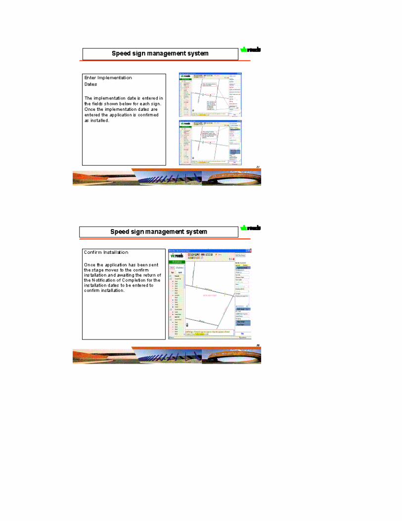
Once an MOC is approved and forwarded to the applicant either by email or hardcopy, an NOC is to be returned to VicRoads within a month and entered into the system otherwise the application will trigger an email requiring the NOC to be provided to VicRoads or confirmation provided that the signs have been installed as per the MOC. Details of the system functionality are attached in the appendix below.
Technology An internal customised build option was preferred primarily because of heavy VicRoads specific functionality and the availability of good internet GIS skill sets within the organisation. The speed sign system makes use of ESRI technology, ArcIMS 9.0 with .Net link, MapObject 2.0, integrated with MS Access as the database. This application utilises the Spatial Functionality web services created by VicRoads for common GIS functionality. The application comprises of four modules
1. Spatial functionality module 2. System functionality module 3. Application web Module 4. Work flow engine 5. Shape Edit module 6. Speed Signs placement Algorithm
Spatial Functionality Module This module comprises of standard GIS functionality like Pan, Zoom, info, print, highlight etc. The print functionality is specifically enhanced by using PDF technology. VicRoads has created a series of web services which provide the above functionality.

System Functionality Module This module comprises of all the functionality to set the system framework. It includes an auto legend/Table of Contents creator, which is a .Net based application developed internally by VicRoads to create an enhanced Legend/TOC for ArcIMS based internet applications. This application takes ArcIMS AXL file as an input, allows the user to define the layers visibility, positioning etc. and then creates a legend/TOC. The legend/TOC can be expanded/collapsed or toggled and provide functionality like fast refresh, checkboxes to hide-show layers. It Stores the TOC/Legend configuration as a modifiable XML files which can be updated by the core application.

Legend/TOC:
Application web Module/Core Module This module comprises of all the speed signs specific GIS functionality such as a list view of speed signs, search for an intersection, audit list etc. This functionality is created utilizing ArcIMS .Net connector and utilises Access as the database for managing the intersections information. It has a sophisticated reporting engine supporting both spatial and non-spatial queries, with a choice of output in either HTML or PDF formats. This provides the functionality to add, delete or update speed sign information and location. It provides the functionality to show images/photos as the background. This module also provides a front end to the workflow engine.

Work Flow Engine The work flow engine is designed for business rule changes. The speed sign application follows a lifecycle approach for speed signs, in which a number of activities can be performed on a speed sign. This module comprises the sequence definition of workflow activities. For a particular sign category, a flow id is defined based on the different steps that can be created regarding approval, delegation and email policy. The flow steps and relative activities are defined in the database. Once the business rule(work process of speed sign application) changes, there’s no need to change the source code of the system, the only requirement is to redefine the flow steps and relative activities in the database, the system will follow the new process to handle the speed sign applications.

Shape Edit Module This module comprises of the creating, deleting, updating speed sign spatial information on the web using ArcIMS and Mapobjects. This module provides a sophisticated locking mechanism built into the application, which allows the user to edit or add a speed sign without locking the shape file for all the users.
Speed Signs Placement Algorithm The system utilises a complex algorithm for the placement of speed signs. The speed sign is defined in terms of location by the four elements.
• Road name on which the sign is to be referenced against

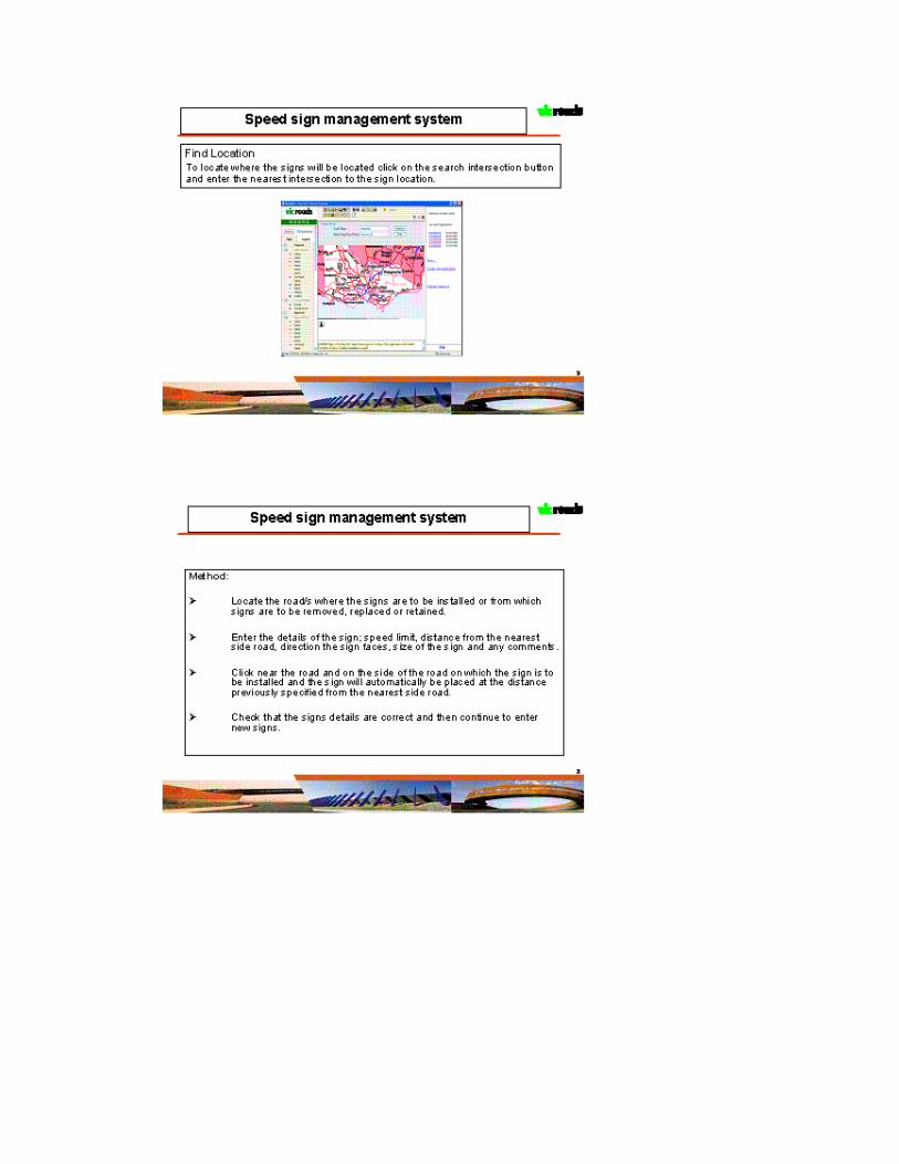
• Side of the road the sign is on • Nearest intersection of roads, roads start or road end • Distance from the nearest intersection of roads, road start or road end • Direction of the sign and the direction of the traffic
It’s a complicated and time consuming exercise for the users to enter all this information manually and accurately. There was a tendency for the data to become inconsistent because of wrong names etc. The users of the system were also not professional GIS operators and would need to be trainined to understand functionalities like snap, buffer etc. A one click algorithm has been developed to decrease the complexity of these operations. The user only needs to provide the distance from the nearest intersection etc. and click on the map. The system automatically calculates the other parameters like road name, direction etc. and show these to the user.
User click on the map
Blank values before click

Software architecture
Spatial Data ManagementWeb Service
Signs Spatial Database(Shape Format) Signs Attributes Database(MDB)
Signs ManagementSystem
ArcIMS App ServerArcIMS Spatial Server ArcIMS
.NET link
IIS
Web Client
Spatial Data Editor(MO )
Client
Application Sever
System components
ArcIMS components
Developed components
Software Architecture
ArcIMS Htmlviewer
Servlet Connector
Database
Filled values after the click

The application is based on multitiered architecture and is developed using Microsoft .Net technology. Typically the user requests information over the intranet server using a browser. The server then processes the request, interacts with the database and sends the information back to the client viewer.
Client Side components The applications client is based on ArcIMS HTML viewer. The standard functionality of the HTML viewer was enhanced by using webservcies to provide the application specific functionality. The client also used the VicRoads in-built tool for advance legend/TOC.
Server Side Components The client makes a request to the signs management system, dll’s written in Microsoft .net. The system interacts with the database and retrieves the parameters required for the request. Based on these parameters an ArcIMS ArcXML request is created by the system and sent to the ArcIMS server using the ESRI ArcIMS .net Link. The System then handles the ArcXML response based on information returned from ArcIMS and appropriate client response is created. The spatial data management utility which is a wrapper dll built around ESRI mapobjects product is used to manage edits to the underlying shape file. The wrapper dll is written in Microsoft .net technology and also supports advance request management functionality so that the shape file doesn’t get locked during editing. After the edits have been confirmed a request is sent to the ArcIMS via the system to refresh the map. The map is refreshed and the final map is shown to user with the changes, without the need to restart the ArcIMS services. Currently the system doesn’t support simultaneous edits.
Database components The database component consists of ESRI shapefiles and signs attribute MS Access database. The database is specifically designed to provide fast zoom/pan functionality for the speed signs application. The MS Access database stores all business information of the system , while the shape files only store the rendering information. Since various databases are used, an extra mechanism is developed to guarantee the data consistency between Access database and DBF database.
Summary and future works Speed Signs management system was successfully rolled out in VicRoads in March 2006. The application team learnt many invaluable lessons during the system development specifically around webservices and component software development. The underlying architecture used in the speed sign application has also been adopted for some of the VicRoads internet application, using the same mechanism to edit data on the web. Continuous work is being carried out on improving the speed of the system. The team is also exploring the opportunities to allow multiple edits on the shapefile.
Acknowledgements Many a thanks to GIS spatial services team in VicRoads with special mention to Richard Zhou ,Qinglin Song and Sameer Babbar for their enormous support.

Appendix Details of the system functionality are including in the appendix “Speed Sign System Functionaltiy”:
References 1-www.vicroads.vic.gov.au
Author Information Domenic Gangi, Team Leader Data Management, VicRoads. 60 Denmark Street, Kew, Victoria 3101, Australia. Phone:+(03)98542948,[email protected] Sandeep Badwal, Team Leader Functional (RoadsOne), VicRoads, 3 Prospect Hill Road, Camberwell, Victoria 3124, Australia. Phone:+(03)98118182 [email protected] Richard Zhou, VicRoads. 60 Denmark Street, Kew, Victoria 3101, Australia. Phone:+(03)98542215,[email protected] Sameer Babbar, Team Leader, Spatial Services, VicRoads. 60 Denmark Street, Kew, Victoria 3101, Australia. Phone:+(03)98542064,[email protected]

Appendix: Speed Sign System Functionaltiy
2
Speed sign management system
Functions
Applications requesting consent to install or remove speed signs are displayed on a GIS map at the following stages of the process:
– Proposed– Approved– Installed – Removed– Not Approved