victoria regional rapidbus implementation strategy
TRANSCRIPT
Victoria Regional RapidBus Implementation Strategy

ACKNOWLEDGEMENTS
BC Transit has worked extensively with area municipalities, Capital Regional District, as well as the Ministry of Transportation and Infrastructure on the planning, designing, and implementation of rapid transit related infrastructure and services for several years. Most recently, all agencies provided input and feedback on the RapidBus Implementation Strategy to accelerate service enhancements to make public transit the best transportation solution in the region. Ongoing collaboration and leadership at all levels of government are required to continue to advance RapidBus and to achieve ridership targets and broader regional goals for a healthy, vibrant Victoria region.

Table of ContentsINTRODUCTION 1
1. RAPIDBUS BACKGROUND & OVERVIEW 41.1 What is RapidBus? ................................................................5
1.2 Common Questions .............................................................6
1.3 Background ............................................................................7
1.4 What’s Been Achieved? .......................................................8
1.5 Challenges Ahead ............................................................. 10

2. RAPIDBUS TOOLKIT 132.1 Brand & Identity ................................................................. 15
2.2 Service ................................................................................... 16
2.3 Stations ................................................................................. 17
2.4 Street Treatments .............................................................. 20
2.5 Vehicles/Fare Collections ................................................ 22
3. RAPIDBUS IMPLEMENTATION STRATEGY 233.1 Phase 1 - Implement Westshore Line .......................... 27
3.2 Phase 2 - Assessment & Design of McKenzie & Peninsula Lines ............................................................... 31
3.3 Phase 3 - Explore Expansion of RapidBus Network ............................................................. 34
APPENDIX A RapidBus Street Treatment Toolkit

V I C TO R I A R E G I O N A L R A P I D B U S I M P L E M E N TAT I O N S T R AT E G Y 1
The Regional Growth Strategy and Regional Transportation Plan outline a vision where transportation is sustainable, offers choice and enables smart growth and livable communities. The Victoria Regional Transit Commission (VRTC) recently identified the goal of increasing transit mode share from 12% to 15% across the region. This means that daily transit travel would increase from approximately 80,000 to over 200,000 trips per day in 2038. Initiatives that are required to achieve this goal will be expanded and improved transit service (including RapidBus), sustainable land-use decisions, improved transit infrastructure and facilities and the expansion of technological improvements.
BC Transit is committed to contributing to stronger, more sustainable communities in the Victoria Region. The need to realize this potential in the Victoria Region is increasingly important because of factors such as climate change, affordability, population growth, traffic congestion, an aging population and the economic impacts of the COVID-19 pandemic.
Introduction
This report is intended to provide the strategic and technical foundation needed to accelerate the implementation of RapidBus services throughout the Victoria region, with the goal of introducing the flagship Westshore-Downtown Victoria Line in the next three years and then subsequent RapidBus lines across the region.
INTRODUC TION
In fall 2020, the Ministry of Transportation and Infrastructure released the South Island Transportation Strategy. This strategy was an integrated approach to support and encourage many travel choices by focusing policy and investment on increasing the infrastructure needed to build connections, capacity, improve safety and the choices for sustainable travel. As part of this strategy, and aligning with BC Transit’s 10 Year Vision for the Victoria Region, one of the key priorities to support sustainable travel options is to advance rapid transit services around the region.

V I C TO R I A R E G I O N A L R A P I D B U S I M P L E M E N TAT I O N S T R AT E G Y2
RapidBus VisionThe implementation of RapidBus services in the Victoria Region has the potential to significantly increase transit mode share by:
Supporting post-pandemic regional economic recovery
Shaping and supporting growth and regional connectivity
Improving passenger comfort and convenience
Improving efficiency and capacity of the transit system
Support the region’s climate action goals

V I C TO R I A R E G I O N A L R A P I D B U S I M P L E M E N TAT I O N S T R AT E G Y 3
Plan OutlineThis plan will be used as the strategic and technical foundation needed to accelerate the implementation of RapidBus services throughout the Victoria Region. Subsequent sections are outlined below.
1. RAPIDBUS BACKGROUND & OVERVIEW This section summarizes the project scope and provides background on the work completed to date
2. RAPIDBUS TOOLKITThis section provides the ingredients necessary for transit to cross the threshold of becoming a RapidBus service
3. RAPIDBUS IMPLEMENTATION STRATEGYThis section provides guidance on the key actions required to advance the RapidBus system in the Victoria Region. The implementation strategy is divided into three different phases that can proceed concurrently:
a. Phase One – Implementation of the Westshore to Downtown Victoria RapidBus line
b. Phase Two – Continue design and conceptual analysis of the McKenzie and Peninsula Lines
c. Phase Three – Explore opportunities to expand the RapidBus network to other parts of the Victoria Region

V I C TO R I A R E G I O N A L R A P I D B U S I M P L E M E N TAT I O N S T R AT E G Y
RAPIDBUS BACKGROUND & OVERVIEW
4
1. RAPIDBUS BACKGROUND & OVERVIEW

V I C TO R I A R E G I O N A L R A P I D B U S I M P L E M E N TAT I O N S T R AT E G Y
RAPIDBUS BACKGROUND & OVERVIEW
5
1.1 What is RapidBus?RapidBus is transit service that outperforms the personal automobile in speed, comfort and reliability. Beyond the importance of connectivity between areas of highest travel demands in the region, RapidBus must include a combination of branded services, corridor treatments, and improved station amenities. Over time, the RapidBus system will be implemented across several corridors to create a high capacity transit system. For existing and future transit customers, RapidBus will be CONNECTED, FREQUENT, FAST, and RELIABLE to increase ridership and support local governments in meeting their sustainable land use, climate and transportation goals..
FIGURE 1 – RapidBus Network Concept Plan
CONNECTEDRapidBus is the cornerstone to supporting sustainable growth in the region. The system will connect urban centres and access to gateways, support multi-modal connections within mobility hubs as well as the Frequent Transit Network (FTN) and other local and specialized services.
FREQUENTRapidBus service would have a targeted minimum frequency of every 10 minutes, with higher frequency as demand requires.
FAST & RELIABLEWhen mixed with traffic, transit travel times can be 25% to 50% of posted speeds and even less on some days for many congested corridors. The travel times can also vary by 10 to 20 minutes or more from one day to the next due to non-recurring incidents that impact all travel. All RapidBus corridors will include transit priority infrastructure to significantly reduce travel times and improve reliability for customers.

V I C TO R I A R E G I O N A L R A P I D B U S I M P L E M E N TAT I O N S T R AT E G Y
RAPIDBUS BACKGROUND & OVERVIEW
6
1.2 Common Questions
When Will RapidBus Be Implemented?The implementation of infrastructure enhancements and service expansion has been underway for the past several years in support of the Rapid Transit Network. The goal is to implement the Westshore-Downtown Victoria Line within the next three years, and then the proposed other lines in subsequent years.
Is RapidBus Different than Frequent Transit Network?Crossing the threshold to becoming a RapidBus service includes delivering consistent and frequent services, limiting the number of stops to high passenger volume areas, expanding transit priority infrastructure, implementing attractive and comfortable stations and creating a unique brand.
What is the Impact of Covid?Communities will be facing a steep climb towards economic recovery as a result of the significant impacts of the COVID-19 pandemic. The efficient movement of people makes economies run as it generates economic participation, especially for those people who are already facing affordability
challenges. For many people across the province, public transit is the only way they can get to their jobs in essential services. Further to this, the challenges that public transit helps address, including climate change, affordability and congestion, will exist long after the pandemic is over. So it is important that communities across the province continue to leverage the positive momentum made in transit ridership growth over the past five years.
Where Will RapidBus Be Implemented?The 2011 Victoria Region Transit Future Plan identified the original Rapid Transit Network that prioritized improving service quality between the Westshore, Peninsula, UVIC and Downtown Victoria areas. These connections remain the priorities today as a large percentage of transit ridership is generated by these corridors. In addition to these connections, several other corridors may be future candidates for RapidBus type services in the future. Additional information on these can be found in section 3.3.
Why RapidBus & Not Light Rail Transit (LRT)?The Victoria region has consistently identified the need for attractive, high capacity transit services such as LRT and commuter rail. RapidBus does not eliminate the need to consider LRT or other forms of higher capacity transit systems or even parallel RapidBus facilities. On the busiest corridor - Douglas Street – RapidBus treatments described in this strategy could support more service and ridership assuming increased vehicle capacities. Along other corridors to the Westshore, Peninsula, and UVIC, RapidBus services, facilities and vehicles could support substantially more service frequencies and ridership. Although LRT or other forms of high capacity transit may be required within the next 20 years or more, RapidBus provides sufficient capacity at a fraction of the cost. A well designed RapidBus network can offer many of the same benefits of LRT and considered a pre-cursor to rail-based transit in the future.

V I C TO R I A R E G I O N A L R A P I D B U S I M P L E M E N TAT I O N S T R AT E G Y
RAPIDBUS BACKGROUND & OVERVIEW
7
1.3 BackgroundThe Transit Future Plan (TFP) for the Victoria region’s transit network provided a 25-year vision and describes what services, infrastructure, and investments are required to get there. The TFP includes four distinct layers of service designed to support varied customer needs and to support land use plans around the region. In particular, the emphasis of the TFP was to transition the hub-and-spoke system where services were concentrated on the downtown to more of a ‘networked structure of service to connect designated regional centres as well as other transit lines’.
Figure 2 provides the conceptual layout of the general service layers that would make up much of the transit system. As illustrated, the Rapid Transit Network (RTN) would provide connections between the primary land use nodes or travel hubs in the region. The Frequent Transit Network (FTN) would serve higher density, mixed use corridors with frequent service that would also provide convenient connections to the RTN.
Beyond the network level characteristics, the service and corridor features would be slightly different. The RTN was to be branded as a unique service, with stations and street treatments to ensure fast, reliable connections supporting high demand travel patterns. The table below summarizes the key features and differences between the RTN and FTN as envisioned in the 2011 Plan.
RTN Features FTN FeaturesLand Use Connects designated regional nodes Serving mixed-use corridors
Vehicle Type High capacity Standard vehicle capacity
Service Frequency 15 minutes or better 15 minutes
Stop Interval Limited stops at key locations Stops where needed
Station / Stops Branded Rapid Transit stations:
• all door boarding;• off-board fare payment;• real time information;• bike storage;
HIgh level stop amenities
Priority Treatments • Signal priority• Separated from traffic
Transit priority treatments
FIGURE 2 – Rapid Transit Network
36 TRANSIT FUTURE PLAN VICTORIA REGION
“
”
To achieve the vision and goals of the Transit Future Plan, and the 12 per cent transit mode share target, the transit network must meet the future transportation needs of the Victoria region. The network must support the Regional Growth Strategy and municipal land use plans by connecting regional and local centres with high quality transit services.
The Transit Future Plan network includes four distinct layers of transit service to better match transit service to demand. The network is designed to be more competitive with automobile travel by improving the directness and reliability of the transit system. The network is less focused on the Downtown area than today’s network with an increased emphasis on connections between Regional Centres, cross town movements, connections to other transit lines and local destinations. The Transit Future Plan network may require more customers to transfer from one service to another to complete their journey with the trade off that trips will be more frequent and overall travel will be more direct.
The Network
Transit Network:Routes
Regional Centre
Existing Transit Network
Rapid Transit Network:Exclusive Corridor
Priority Corridor
Transit Network:Routes
Regional Centre
Transit Future Plan
The network is designed to be more competitive with automobile travel by improving the directness and reliability of the transit system.
• customer information;• Park & Ride; and• AT Connections
Source: Transit Future Plan, 2011.

V I C TO R I A R E G I O N A L R A P I D B U S I M P L E M E N TAT I O N S T R AT E G Y
RAPIDBUS BACKGROUND & OVERVIEW
8
Since the Transit Future Plan was completed, the RTN has been the focus of enhanced transit services, improved stations, exchanges that are integrated with other modes, transit lanes and priority treatments at intersections, as well as park-and-ride lots at strategic locations. In partnership with Victoria, Saanich, Ministry of Transportation and Infrastructure, and BC Transit, dedicated bus only lanes have been implemented along Douglas Street north of Herald Street through to Tillicum Road on Highway 1. Additionally, transit priority treatments are in place at strategic locations such as Highway 1 / Tillicum, Highway 17 / Sayward and Millstream and Helmcken.
Designs are being prepared for expanding bus-on-shoulder lanes on sections of Highway 1. BC Transit is currently working with local area municipalities and MoTI to implement transit priority treatments on Old Island Highway.
Figure 3 illustrates the strategic facilities that have already been implemented along the RTN. These investments have been the direct result of collaboration and partnerships between local, regional, and provincial agencies working with community stakeholders.
1.4 What’s Been Achieved?FIGURE 3 – Existing Rapid Transit Infrastructure
V I C TO R I A R E G I O N A L R A P I D B U S I M P L E M E N TAT I O N S T R AT E G Y
RAPIDBUS BACKGROUND & OVERVIEW
9
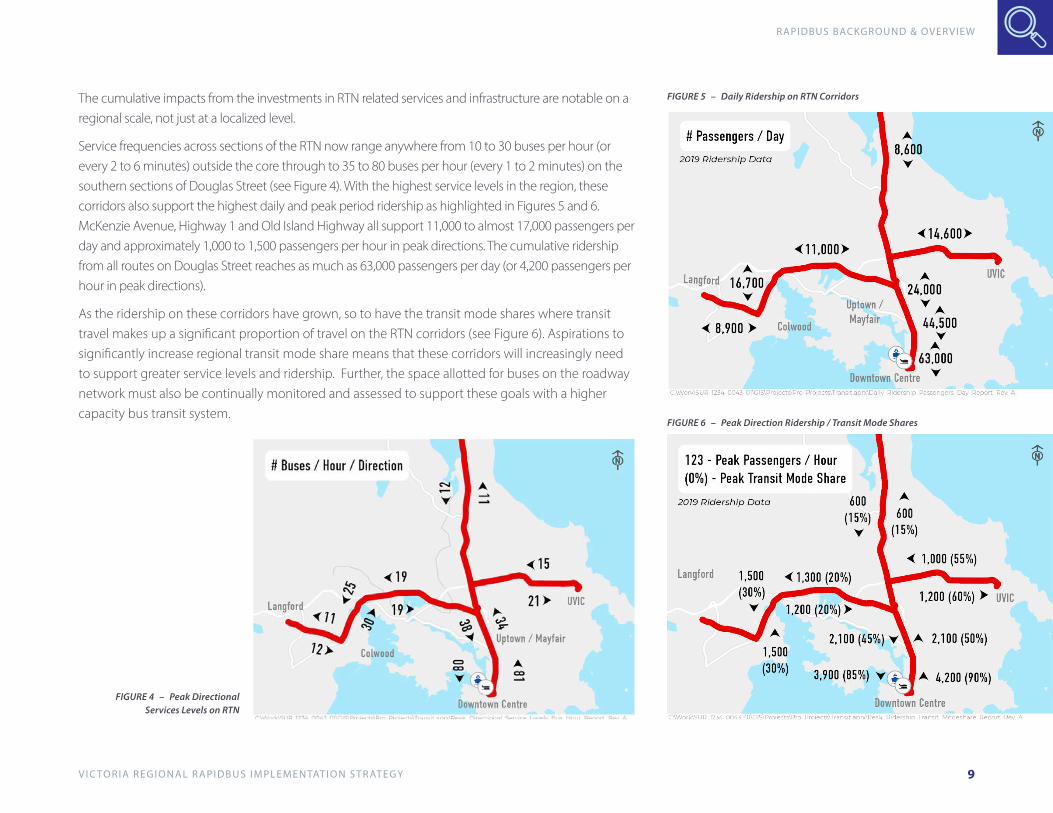
The cumulative impacts from the investments in RTN related services and infrastructure are notable on a regional scale, not just at a localized level.
Service frequencies across sections of the RTN now range anywhere from 10 to 30 buses per hour (or every 2 to 6 minutes) outside the core through to 35 to 80 buses per hour (every 1 to 2 minutes) on the southern sections of Douglas Street (see Figure 4). With the highest service levels in the region, these corridors also support the highest daily and peak period ridership as highlighted in Figures 5 and 6. McKenzie Avenue, Highway 1 and Old Island Highway all support 11,000 to almost 17,000 passengers per day and approximately 1,000 to 1,500 passengers per hour in peak directions. The cumulative ridership from all routes on Douglas Street reaches as much as 63,000 passengers per day (or 4,200 passengers per hour in peak directions).
As the ridership on these corridors have grown, so to have the transit mode shares where transit travel makes up a significant proportion of travel on the RTN corridors (see Figure 6). Aspirations to significantly increase regional transit mode share means that these corridors will increasingly need to support greater service levels and ridership. Further, the space allotted for buses on the roadway network must also be continually monitored and assessed to support these goals with a higher capacity bus transit system.
FIGURE 4 – Peak Directional Services Levels on RTN
FIGURE 5 – Daily Ridership on RTN Corridors
FIGURE 6 – Peak Direction Ridership / Transit Mode Shares

V I C TO R I A R E G I O N A L R A P I D B U S I M P L E M E N TAT I O N S T R AT E G Y
RAPIDBUS BACKGROUND & OVERVIEW
10
1.5 Challenges AheadTransit serves an important role in shaping communities, improving social equity, reducing greenhouse gas emissions, as well as providing mobility and sustainable transportation choices. The implementation of RapidBus services in the Victoria Region will continue to support solutions for the challenges highlighted below.
Challenge Description OpportunityClimate Change In 2019, the CRD Board voted unanimously to declare a climate
emergency as climate change is a threat to urban and rural communities across B.C. Most greenhouse gas emissions in B.C. come from creating and using energy, including transportation.
Shifting to more environmentally-sustainable modes of transportation, such as transit, can help realize an overall reduction in greenhouse gas emissions. Likewise, BC Transit has committed to operating a low-carbon, fully-electric fleet by 2040, cutting emission significantly and meeting the Province’s targets.
Safety Transportation-related impacts on safety are an ongoing concern for the South Vancouver Island region; from crashes, near-misses, auto crime, and impaired driving, the need to increase multimodal safety is top-of-mind of the region.
The reduction of vehicles on the roads can result in a decrease in the number of vehicle collisions, improving safety for everyone.
Affordability The Victoria Region is one of the most expensive places in Canada to live and transportation costs can account for nearly 20% of most people’s expenditures.
BC Transit is committed to making transportation more affordable by linking communities in the Victoria Region to jobs, healthcare, and education with affordable fares.
Congestion Traffic congestion in the region is bad for the environment, bad for the economy and bad for our citizens’ health and quality of life.
By shifting modes and increasing transit ridership, transit service can help alleviate congestion by moving people more efficiently and effectively, particularly where transit supportive infrastructure (e.g. bus only lanes) is available.
Economic Recovery Many communities in the Victoria Region will be facing a steep climb towards economic recovery as a result of the significant impacts of the COVID-19 pandemic.
The efficient movement of people makes economies run as it generates economic participation, especially for those people who are already facing affordability challenges.

V I C TO R I A R E G I O N A L R A P I D B U S I M P L E M E N TAT I O N S T R AT E G Y
RAPIDBUS BACKGROUND & OVERVIEW
11
TRANSIT MODE SHARE TARGET (2038)The Regional Growth Strategy and Regional Transportation Plan outline a vision where transportation is sustainable, offers choice and enables smart growth and livable communities. The Victoria Regional Transit Commission (VRTC) recently identified the goal of increasing transit mode share from 12% to 15% across the region. This means that daily transit travel would increase from approximately 80,000 to over 200,000 trips per day in 2038. Initiatives that are required to achieve this goal will be expanded and improved transit service (including RapidBus), sustainable land-use decisions, improved transit infrastructure and facilities and the expansion of technological improvements.
Specific to the Victoria region, some of the key challenges that will continue to increase pressures on the communities and transportation are briefly described.
GROWTH PRESSURESPopulation and employment growth in the Victoria region are projected to increase by less than 1% per year over the next 20 years. Although the Core and Westshore communities account for approximately 95% of the population growth, the Core Area accounts for more than 60% of the planned employment growth (see Figure 7). Beyond connecting designated urban centres in the region, growth in travel between Westshore and Core area communities will continue to see the greatest pressures and need for attractive, high capacity transit services.
A
DAILY TRANSIT RIDERSHIP TRAJECTORY
50,000
100,000
150,000
200,000
250,000
2001 2006 2011 2017
15% MODE SHARE
7.5% MODE SHARE
(BAU)
2038EXISTINGMODE SHARE
2038TARGETMODE SHARE
B
FIGURE 7 – Population & Employment Growth FIGURE 8 – Transit Ridership & Mode Shares

V I C TO R I A R E G I O N A L R A P I D B U S I M P L E M E N TAT I O N S T R AT E G Y
RAPIDBUS BACKGROUND & OVERVIEW
12
Mobility & Reliability for TransitFast and reliable travel times are cornerstones to attract more people to ride transit, provide sufficient capacity, and achieve mode share targets. Today, many of the corridors designated for rapid transit are also some of the most congested in the region during the peak periods as highlighted in red and orange in Figure 9. Expanding periods of congestion during the week and weekends impacts travel times and reliability that customers must factor into their trip planning, particularly for those corridors without dedicated bus lanes.
C Growth in Travel (2038)Congestion along major corridors in the region can be an incentive to managing increases in car travel. At the same time, population and employment growth pressures means that the demand for travel by 2038 will continue to increase as illustrated in Figure 10. On one hand, these growth pressures could further reduce travel speeds and reliability for transit without dedicated facilities. Conversely, the attractiveness and shift to transit along these corridors could grow substantially with dedicated bus lanes.
D
FIGURE 9 – Projected 2038 Corridor Growth Pressures FIGURE 10 – Projected Corridor Growth Pressures

V I C TO R I A R E G I O N A L R A P I D B U S I M P L E M E N TAT I O N S T R AT E G Y
RAPIDBUS TOOLKIT
13
2. RAPIDBUS TOOLKIT

V I C TO R I A R E G I O N A L R A P I D B U S I M P L E M E N TAT I O N S T R AT E G Y
RAPIDBUS TOOLKIT
14
The following section provides the ingredients (or ‘toolkit’ of features) necessary for transit to cross the threshold of becoming a complete RapidBus system.
BRANDING through distinct service, stations, corridors and vehicle designs to enhance the customer experience
SERVICE designed to be faster, more reliable and more frequent
STATIONS with enhanced features, amenities & multi-modal connections
STREET TREATMENTS to improve travel times, increase predictability and create a sense of permanence for RapidBus
VEHICLES & FARE COLLECTION systems designed to comfortably carry more riders and accommodate all-door boardings with support of pre-paid fares or electronic passes
Key RapidBus Features
V I C TO R I A R E G I O N A L R A P I D B U S I M P L E M E N TAT I O N S T R AT E G Y
RAPIDBUS TOOLKIT
15
2.1 Brand & IdentityRapidBus is only one aspect that is part of the transit system. It is planned as a form of rapid transit in the region that is recognizable to everyone. Cities across North America and elsewhere in the world, have referred to this bus-based, rapid transit system in different forms (including Bus Rapid Transit or BRT) with the intent to significantly improve the experience for customers and to provide a high capacity system that is understood and easily identifiable to everyone with unique vehicles, stations, and dedicated street space or running-ways. In the Victoria region, RapidBus will strive to be:
• ‘SPINE’ OF THE REGIONAL TRANSIT SYSTEM connecting urban centres by three RapidBus Lines between downtown Victoria, Westshore, UVIC and Saanich Peninsula initially and potentially other communities in future with high capacity transit.
• EASY TO UNDERSTAND for residents and visitors with identifiable stations connected to other transit services and modes of transportation that conveniently extend the benefits of RapidBus.
• FREQUENT & DIRECT where customers do not require schedules and services connect directly to areas of highest demand.
• FAST & RELIABLE travel times that are competitive with or better than driving and are consistent throughout the day.
• COMFORTABLE & SECURE for the entire journey from connecting to RapidBus Stations by any mode, waiting and boarding vehicles, riding the bus, and exiting at a destination.
V I C TO R I A R E G I O N A L R A P I D B U S I M P L E M E N TAT I O N S T R AT E G Y
RAPIDBUS TOOLKIT
16
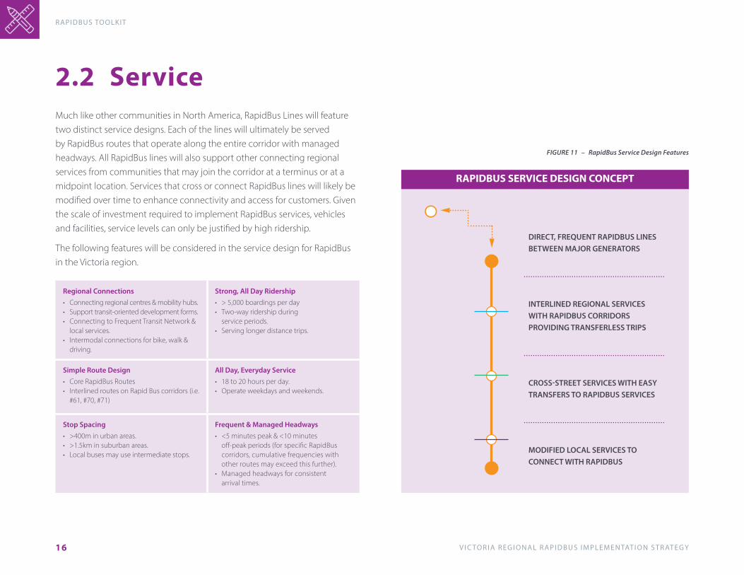
2.2 ServiceMuch like other communities in North America, RapidBus Lines will feature two distinct service designs. Each of the lines will ultimately be served by RapidBus routes that operate along the entire corridor with managed headways. All RapidBus lines will also support other connecting regional services from communities that may join the corridor at a terminus or at a midpoint location. Services that cross or connect RapidBus lines will likely be modified over time to enhance connectivity and access for customers. Given the scale of investment required to implement RapidBus services, vehicles and facilities, service levels can only be justified by high ridership.
The following features will be considered in the service design for RapidBus in the Victoria region.
Regional Connections • Connecting regional centres & mobility hubs.• Support transit-oriented development forms.• Connecting to Frequent Transit Network &
local services.• Intermodal connections for bike, walk &
driving.
Strong, All Day Ridership• > 5,000 boardings per day• Two-way ridership during
service periods.• Serving longer distance trips.
Simple Route Design• Core RapidBus Routes • Interlined routes on Rapid Bus corridors (i.e.
#61, #70, #71)
All Day, Everyday Service • 18 to 20 hours per day.• Operate weekdays and weekends.
Stop Spacing• >400m in urban areas.• >1.5km in suburban areas.• Local buses may use intermediate stops.
Frequent & Managed Headways• <5 minutes peak & <10 minutes
off-peak periods (for specific RapidBus corridors, cumulative frequencies with other routes may exceed this further).
• Managed headways for consistent arrival times.
FIGURE 11 – RapidBus Service Design Features
RAPIDBUS SERVICE DESIGN CONCEPT
DIRECT, FREQUENT RAPIDBUS LINES BETWEEN MAJOR GENERATORS
INTERLINED REGIONAL SERVICES WITH RAPIDBUS CORRIDORS PROVIDING TRANSFERLESS TRIPS
CROSS-STREET SERVICES WITH EASYTRANSFERS TO RAPIDBUS SERVICES
MODIFIED LOCAL SERVICES TO CONNECT WITH RAPIDBUS

V I C TO R I A R E G I O N A L R A P I D B U S I M P L E M E N TAT I O N S T R AT E G Y
RAPIDBUS TOOLKIT
17
2.3 StationsRapidBus stations will be implemented in various environments across the region. In designated urban centres, stations will be part of the urban character and design with attractive walking and cycling connections. Stations should offer sufficient space for passengers waiting and boarding RapidBus and other street activity. Along other major corridors and at terminus stations, RapidBus Stations will connect to other modes designed to extend the ‘reach’ of the transit system. For some, the first and last mile options to connect with RapidBus may include attractive walking and cycling facilities. For others where local services may not be accessible or convenient, vehicle trip connections to park-and-ride lots or pick-up and drop-off areas will significantly expand the service area of RapidBus.
The design and location of RapidBus Stations can minimize travel times for all customers and increase its capacity. In the busiest locations, larger or separate station areas may ultimately be required for RapidBus services. This will allow for easy boarding and alighting with social distancing in mind. Further, multiple door boardings with advanced fare payment systems will be essential to improve overall travel times. Beyond the configuration of RapidBus Stations, efforts made to consolidate the number of stops and increase spacing will significantly improve travel times and reliability for transit.
Real-time information and other station features will ensure RapidBus offers a high level of comfort and safety for all passengers and allows for social distancing where possible.
Identifiable Stations• Unique RapidBus station appearance.• Integrated with land use and urban form.
Passenger / Multi-bus Capacity• Approximately 1.5m2 to 2.5m2 per passenger
of space for peak periods OR 3m or more clear width for loading.
• Platform lengths of 30 to 45m.
Real-time Passenger Information • Next route and bus arrival time displays.• Supplemental information such as schedules,
hours of service, trip planning web links.
Advanced Fare Payment• Off-vehicle fare payment. • All door boarding.
Passenger Amenities & Support Facilities• Weather protection.• Passenger channelization.• Seating, lighting, garbage cans.• Universal design (tactile cues, colour, audible cues, etc).• Inter-modal connections for pick-up/drop-off,
walk, bike, park-and-ride, etc.
Stop / Station Location • >Multiple stops to accommodate
RapidBus & local bus.• Tiered stops for RapidBus bypass.• Bus bulges for in-street operation.• Bus stop consolidation.
V I C TO R I A R E G I O N A L R A P I D B U S I M P L E M E N TAT I O N S T R AT E G Y
RAPIDBUS TOOLKIT
18
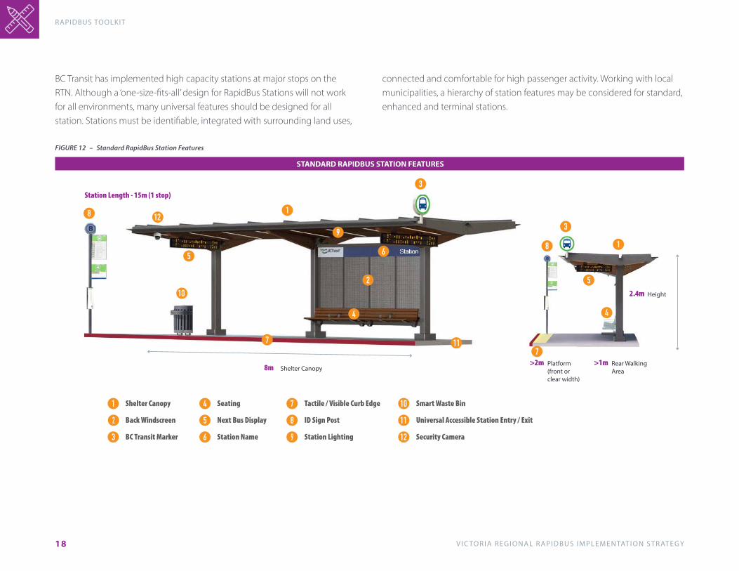
BC Transit has implemented high capacity stations at major stops on the RTN. Although a ‘one-size-fits-all’ design for RapidBus Stations will not work for all environments, many universal features should be designed for all station. Stations must be identifiable, integrated with surrounding land uses,
1
1
2
3
3
4 4
5
5
6
77
8
8
9
10
11
STANDARD RAPIDBUS STATION FEATURES
Shelter Canopy8m
Height2.4m
Platform(front or clear width)
>2m Rear WalkingArea
>1m
Station Length - 15m (1 stop)
Shelter Canopy 1
Back Windscreen2
BC Transit Marker3
Seating4
Next Bus Display5
Station Name6
Tactile / Visible Curb Edge7
ID Sign Post8
Station Lighting9
Smart Waste Bin10
Universal Accessible Station Entry / Exit11
Security Camera12
12
connected and comfortable for high passenger activity. Working with local municipalities, a hierarchy of station features may be considered for standard, enhanced and terminal stations.
FIGURE 12 – Standard RapidBus Station Features

V I C TO R I A R E G I O N A L R A P I D B U S I M P L E M E N TAT I O N S T R AT E G Y
RAPIDBUS TOOLKIT
19
ENHANCED RAPIDBUS STATION FEATURES
1
1
2
3
3
444
55
56
7
7
8
9
9
10
11
12
11
6
Shelter Canopy13m
Height2.4m
Platform(front or clear width)
>3m Rear WalkingArea
>2m
Station Length - 10m (1 stop) to 30m (2 stop)
Shelter Canopy 1
Back Windscreen2
BC Transit Marker3
Seating4
Next Bus Display5
Station Name6
Tactile / Visible Curb Edge7
ID Sign Post8
Station Lighting9
Smart Waste Bin10
Universal Accessible Station Entry / Exit11
Security Camera12
FIGURE 13 – Enhanced RapidBus Station Features

V I C TO R I A R E G I O N A L R A P I D B U S I M P L E M E N TAT I O N S T R AT E G Y
RAPIDBUS TOOLKIT
20
2.4 Street TreatmentsRapidBus must be fast, reliable, and serve large volumes of passengers. The Victoria region has a long history of implementing transit priority in ‘hotspot’ locations where traffic delays are impacting services and customers. The recently implemented corridor treatments across Douglas Street and Highway 1 have demonstrated the direct benefits of providing dedicated space and priority for transit in support of a quality, high capacity experience for transit customers. During peak periods, travel times for customers have been reduced by as much as 10 to 20 minutes as illustrated in Figure 14 (20% for trips between Westshore and Downtown, and 10% for those from Sooke). Additionally, travel time reliability for customers and operators has also improved significantly. It should be recognized that the same benefits exist for all other routes operating along these corridors.
Over the next 20 years, the volume of traffic on RapidBus corridors will continue to grow and the average delays for transit will increase exponentially where no priority is provided. For primary transit corridors, the ‘people-carrying’ capacity of the street will in turn decline if priority treatments are not in place. The ‘toolkit’ identifies various types of treatments that have varying costs and levels of effectiveness in terms of increasing capacity and speeds as well as improving reliability for transit. They include forms of turn restrictions for traffic sharing lanes with buses, signal timing and priority treatments, intersection queue jumpers and dedicated bus lanes. Together, they will enhance the customer experience and create high capacity transit corridors. As experienced with the Highway 1 and Douglas Street bus lanes, localized treatments for RapidBus will better serve the regional needs of customers. At the same time, they will improve efficiencies and cost effectiveness of transit services in the region (see Figure 15).
Area municipalities, the Ministry of Transportation and Infrastructure and BC Transit will work together with community stakeholders to address potential challenges in the planning and design of priority treatments. Utilizing standard treatments and designs from other communities across North America will ensure ‘complete street’ approach is taken – one that is balanced and considers all street uses.
+
++
CO
ST &
EFF
EC
TIV
EN
ESS
(CA
PA
CIT
Y, S
PE
ED
S, R
ELI
AB
ILIT
Y)
IMPLEMENTATION CHALLENGES
HIGHER
HIGHER
TRAFFIC TURNRESTRICTIONS
SIGNAL TIMING& PRIORITY
BUS QUEUEJUMPS
DEDICATEDBUS LANES
0102030405060708090
100110120130140
97103
81 83
68
116 114
85
127 127
RU
NN
ING
TIM
E/L
AYO
VE
R (M
INU
TES)
PM PEAK DIRECTION TRIP TIMES
ROUTE
SUMMER 2018 FALL 2019
47 GOLDSTREAMMEADOWS
48 HAPPY VALLEY 50 LANGFORD 61 SOOKE 65 SOOKE
FIGURE 14 – Transit Travel Time Improvements with Priority Treatments
FIGURE 15 – Effectiveness and Challenges of Cumulative Street Treatment

V I C TO R I A R E G I O N A L R A P I D B U S I M P L E M E N TAT I O N S T R AT E G Y
RAPIDBUS TOOLKIT
21
Street Treatments (Continued)Streets that prioritize transit can in turn create higher ridership, improved services levels, and the need for more compact, sustainable development patterns. In this regard, transit priority treatments may be used in response to or as an incentive to improve ridership. In very broad terms, conditions to consider various treatments should at a minimum include peak service levels, passenger volumes, as well as delays or speeds across the corridor. In this regard, bus-based systems that include all street treatments can support as many as 80 to 100 buses per hour and 5,000 to 7,000 passengers per hour per direction as highlighted in Figure 16.
Successful implementation of transit street treatments must recognize that RapidBus corridors are ‘Living Streets.’ Designing streets as public spaces enhances both transit performance and supports a vibrant urban realm.
STREET TREATMENTS
PE
AK
PE
RIO
D C
ON
DIT
ION
S
SIGNAL TIMING& PRIORITY
TRAFFIC TURNRESTRICTIONS
BUS QUEUEJUMPS
DEDICATEDBUS LANES
SERVICELEVELS
PASSENGERVOLUMES
STREETSPEEDS
<10BUSES/HOUR
30-100BUSES/HOUR
<500PASSENGER
/HOUR
2,000 TO 7,000PASSENGER
/HOUR
50% OF POSTEDSPEEDS
<25% OF POSTED SPEEDS
FIGURE 16 – Key Factors to Consider Street Treatments
Utilizing standardized street treatments described in NACTO’S Transit Street Design Guide provides the range of choices to be planned, designed, and evaluated with community and regional stakeholders. Additional information can be found in Appendix A.
V I C TO R I A R E G I O N A L R A P I D B U S I M P L E M E N TAT I O N S T R AT E G Y
RAPIDBUS TOOLKIT
22
2.5 Vehicles/Fare Collections
High Capacity Vehicles• Double Decker buses• Articulated buses (option)
Doors• All door boarding and alighting. • Multiple sets of two-channel doors to
permit simultaneous boarding and alighting with comfort.
Interior Configuration• Low floor vehicles to get on and off
quickly. • Security cameras.• Easy pre-paid / on-board fare
payment.
Vehicle ITS• Advanced vehicle location & monitoring.• Signal communications for priority
treatments. • Automated next stop display/
announcements. • Passenger data collection systems.
Exterior Appearance• Distinctive exterior ‘RapidBus’
design.
Fare Collection• Mobile devices.• Contactless payments. • Advanced online payments.• In-vehicle fare payment monitoring.
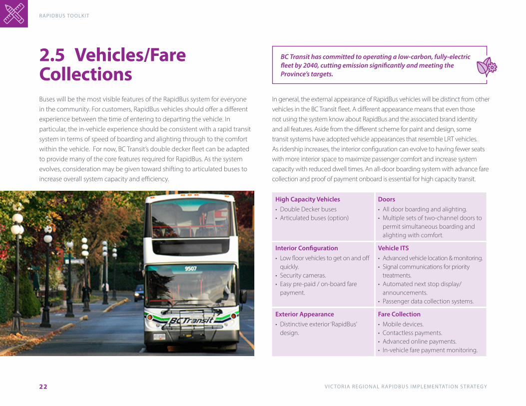
Buses will be the most visible features of the RapidBus system for everyone in the community. For customers, RapidBus vehicles should offer a different experience between the time of entering to departing the vehicle. In particular, the in-vehicle experience should be consistent with a rapid transit system in terms of speed of boarding and alighting through to the comfort within the vehicle. For now, BC Transit’s double decker fleet can be adapted to provide many of the core features required for RapidBus. As the system evolves, consideration may be given toward shifting to articulated buses to increase overall system capacity and efficiency.
In general, the external appearance of RapidBus vehicles will be distinct from other vehicles in the BC Transit fleet. A different appearance means that even those not using the system know about RapidBus and the associated brand identity and all features. Aside from the different scheme for paint and design, some transit systems have adopted vehicle appearances that resemble LRT vehicles. As ridership increases, the interior configuration can evolve to having fewer seats with more interior space to maximize passenger comfort and increase system capacity with reduced dwell times. An all-door boarding system with advance fare collection and proof of payment onboard is essential for high capacity transit.
BC Transit has committed to operating a low-carbon, fully-electric fleet by 2040, cutting emission significantly and meeting the Province’s targets.
V I C TO R I A R E G I O N A L R A P I D B U S I M P L E M E N TAT I O N S T R AT E G Y
R A P I D B U S I M P L E M E N TAT I O N S T R AT E G Y
23
3. RAPIDBUS IMPLEMENTATION STRATEGY
V I C TO R I A R E G I O N A L R A P I D B U S I M P L E M E N TAT I O N S T R AT E G Y
RAPIDBUS I M P L E M E N TAT I O N S T R AT E G Y
24
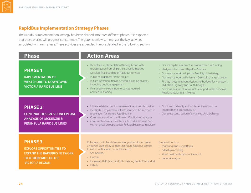
RapidBus Implementation Strategy PhasesThe RapidBus implementation strategy has been divided into three different phases. It is expected that these phases will progress concurrently. The graphic below summarizes the key activities associated with each phase. These activities are expanded in more detailed in the following section.
• Kick-off an Implementation Working Group with representation from all partners directly involved
• Develop final branding of RapidBus services• Public engagement for the project• Initiate Westshore transit network planning analysis
including public engagement • Finalize service expansion resources required
and secure funding
• Finalize capital infrastructure costs and secure funding• Design and construct RapidBus Stations• Commence work on Uptown Mobility Hub strategy• Commence work on Parliament District Exchange strategy• Finalize street treatment design and budgets for Highway 1,
Old Island Highway and South Douglas• Continue analysis of infrastructure opportunities on Sooke
Road and Goldstream Avenue
• Initiate a detailed corridor review of the McKenzie corridor• Identify bus stops where infrastructure can be improved in
preparation for a future RapidBus line• Commence work on the Uptown Mobility Hub strategy• Continue the development Peninsula Local Area Transit Plan,
with emphasis on opportunities for RapidBus service integration
• Continue to identify and implement infrastructure improvements on Highway 17
• Complete construction of enhanced UVic Exchange
Collaborate with Local Government partners to complete a network scan of key corridors for future RapidBus service. Corridors will include, but not limited to, • Shelbourne, • Quadra, • Esquimalt-UVIC (specifically the existing Route 15 corridor)• Hillside
Scope will include:• reviewing land use patterns, • ridership modeling,• street treatment opportunities and • network analysis
PHASE 1 IMPLEMENTATION OF WESTSHORE TO DOWNTOWN VICTORIA RAPIDBUS LINE
PHASE 2 CONTINUE DESIGN & CONCEPTUAL ANALYSIS OF MCKENZIE & PENINSULA RAPIDBUS LINES
PHASE 3 EXPLORE OPPORTUNITIES TO EXPAND THE RAPIDBUS NETWORK TO OTHER PARTS OF THE VICTORIA REGION
Phase Action Areas

V I C TO R I A R E G I O N A L R A P I D B U S I M P L E M E N TAT I O N S T R AT E G Y
R A P I D B U S I M P L E M E N TAT I O N S T R AT E G Y
25
2021 20222023
SPRING SUMMER FALL WINTER SPRING SUMMER FALL WINTER
PHASE 1
IMPLEMENTATION OF WESTSHORE TO DOWNTOWN VICTORIA RAPIDBUS LINE
Kick-off an Implementation Working Group with representation from all partners directly involved
Develop final branding of RapidBus services
Public Engagement
Initiate Westshore transit network planning analysis
Finalize service expansion resources required and secure funding
Finalize capital infrastructure costs and secure funding
Design and construct RapidBus stations
Commence work on Uptown Mobility Strategy OngoingCommence work on Parliament Precinct Exchange strategy
Ongoing
Finalize street treatment design and budgets for Highway 1, Old Island Highway and South Douglas
Conintue analysis of infrastructure opportunities on Sooke Road and Goldstream Avenue
PHASE 2
CONTINUE DESIGN & CONCEPTUAL ANALYSIS OF MCKENZIE & PENINSULA RAPIDBUS LINES
Initiate a detailed corridor review of the McKenzie corridor
Identify bus stops along McKenize corridor where infrastructure can be improved in preparation for a future RapidBus Line
Ongoing
Commence work on Uptown Mobility Strategy Ongoing
Continue the development of the Peninsula Local Area Transit Plan, with emphasis on opportunities for future RapidBus Service integration
Continue to identify and implement infrastructure improvements on Highway 17
Ongoing
Complete construction of enhanced UVic exchange Complete
PHASE 3
EXPLORE OPPORTUNITIES TO EXPAND THE RAPIDBUS NETWORK TO OTHER PARTS OF THE VICTORIA REGION
Collaborate with Local Government partners to complete a network scan of key corridors for future RapidBus services
Timeline to be developed in collaboration with local government partners
Victoria Regional RapidBus Phasing Timeline

V I C TO R I A R E G I O N A L R A P I D B U S I M P L E M E N TAT I O N S T R AT E G Y
RAPIDBUS I M P L E M E N TAT I O N S T R AT E G Y
26
Multi-Partner ApproachSteering these projects towards implementation will be a multi-agency collaboration requiring the support of all levels of government in the Victoria region. The graphic below summarizes the role that each key stakeholder will play in the process. A critical component of the implementation strategy will be the creation of multi-disciplinary project working groups.
BC TRANSIT
LOCAL GOVERNMENTPARTNERS
MINISTRY OF TRANSPORTATION & INFRASTRUCTURE
FEDERAL GOVERNMENT
• Contributes funding for infrastructure (stations and exchanges) on local right-of-ways
• Street treatments
• Potential funding for infrastructure (ICIP - Investing in Canada Improvement Program
• Provincial funding for service• Leads the development and
implementation of highway corridor infrastructure, stations and exchanges
• Service implementation and operations• Local funding (Victoria Regional
Transit Commission) for service and infrastructure

V I C TO R I A R E G I O N A L R A P I D B U S I M P L E M E N TAT I O N S T R AT E G Y
R A P I D B U S I M P L E M E N TAT I O N S T R AT E G Y
27
3.1 Phase 1 - Implement Westshore Line
Six Mile Station Area
FIGURE 17 – Westshore Line Stations & Designated Urban Areas Goldstream / Island Station Area
The Westshore Line has been at the centre of planning, design, and implementation of RapidBus features for many years. BC Transit along with area municipalities and the Ministry continue to advance infrastructure improvements that include everything from street treatments and station area enhancements through to service increases along the corridor.
The Westshore Line will connect Langford Centre Station to the Legislature Station in downtown Victoria, and will provide a single transfer connection to the UVIC and Peninsula Lines at Uptown/Saanich Exchange. The Westshore Line connects the regional centres of downtown Victoria, Uptown, Colwood Corners and Langford Centre, as well as several other urban nodes as illustrated in Figure 17. Attractive walking and cycling facilities are needed within 800m of station areas and additional park-and-ride facilities could be strategically located along the RapidBus corridor. Transit priority treatments continue to be planned and designed across the corridor.
Veterans Station Area

V I C TO R I A R E G I O N A L R A P I D B U S I M P L E M E N TAT I O N S T R AT E G Y
RAPIDBUS I M P L E M E N TAT I O N S T R AT E G Y
28
FIGURE 18 – Westshore Line 10 Year Infrastructure Plan
• 22 stations in each direction with potential for fewer stops to reduce travel times and increase RapidBus capacity.
• Extend Douglas (south) curb bus lanes, Highway 1 bus-on-shoulder, and Old Island Highway intersection queue jumpers (or bus lanes in next 10-years).
• Consider long-term RapidBus route alternatives to connect Langford Station (Goldstream, E&N, etc.).
• Dedicated bus lanes could eliminate existing travel time variability during peaks of approximately 15 to 20 minutes between Goldstream / Old Island Highway and Parliament District.
• 11,000 daily rides today with potential to increase to more than 30,000 daily rides by 2038 to achieve mode share targets.
AS PART OF THE IMPLEMENTATION STRATEGY, THE KEY FEATURES OF RAPIDBUS SERVING THE WESTSHORE LINE ILLUSTRATED IN FIGURE 18 WILL INCLUDE:

V I C TO R I A R E G I O N A L R A P I D B U S I M P L E M E N TAT I O N S T R AT E G Y
R A P I D B U S I M P L E M E N TAT I O N S T R AT E G Y
29
Transit & Mobility HubsThe 2014 Regional Transportation Plan identifies several regional transportation nodes or mobility hubs as “key locations of regional activity and destinations where transportation modes integrate seamlessly and efficiently, and where both the environment and urban form will encourage transit, active transportation and other alternatives to driving alone.” Many designated community core areas in the region have been recognized as ‘Complete Hubs’ with significant trip origins and destinations, served by major transit routes and active transportation as well as by major arterial and collector roads. The scale, density, and mixture of land uses along with the urban form will encourage high pedestrian activity within and around these mobility hubs.
Perhaps the most prominent of the mobility hubs for RapidBus is the Uptown Station area. The Uptown Station area essentially represents ‘Central Station’ of the region’s RapidBus network serving Westshore, UVIC, and Peninsula Lines. The station will also support connections to the Frequent Transit Network and local services and could ultimately become the highest throughput and transfer point in the system.
Existing land uses in the Uptown area already make the area a regional trip generator throughout the day and on weekends. Further emphasizing the regional destination, the District of Saanich Uptown-Douglas Corridor Plan outlines the future shape and form of land uses across a mix of neighbourhoods to create a high functioning, cohesive core for Saanich.
BC Transit will continue to work with the MoTI, Saanich, and other area municipalities on the plans and designs for the Uptown Transit Station. Many of the same qualities that contribute toward a thriving, livable core area are also essential for the success of most
FIGURE 19 – Uptown RapidBus Station Area Walkshed and Land Use Plan
RapidBus stations. Some of those principle design qualities include:
• Efficient & seamless integration of sustainable transportation options. • Focus on improving transportation / transit customer experience. • Ensure safety and security for all travelers. • Create strong sense of placemaking within and around the station area. • Design for flexibility in transportation and transit technologies. • Design for equity by considering availability and accessibility. • Create partnership opportunities with government agencies and private sector.
V I C TO R I A R E G I O N A L R A P I D B U S I M P L E M E N TAT I O N S T R AT E G Y
RAPIDBUS I M P L E M E N TAT I O N S T R AT E G Y
30
The checklist below provides an overview of the key actions required towards progressing the Westshore to Downtown RapidBus line towards implementation.
� Kick-off an Implementation Working Group with representation from all partners directly involved. Group will meet regularly and will be accountable progressing towards implementation of the Westshore to Downtown RapidBus line (Lead: BC Transit | Support: MOTI, District of Saanich, City of Victoria, Town of View Royal, City of Colwood, City of Langford) (spring 2021)
� Develop final branding of RapidBus services (Lead: BC Transit) (spring 2021)
� Public engagement for the project (Lead: BC Transit | Support: MOTI, District of Saanich, City of Victoria, Town of View Royal, City of Colwood, City of Langford) (summer 2021)
� Initiate Westshore transit network planning analysis. Review existing local and frequent transit network to prepare the Westshore for future integration with RapidBus service. (Lead: BC Transit | Support: MOTI, Town of View Royal, City of Colwood, City of Langford) (summer 2021)
� Finalize service expansion resources required and secure funding. (Lead: BC Transit | Support: MOTI) (2021-2022)
� Finalize capital infrastructure costs and secure funding (Lead: BC Transit | Support: MOTI, District of Saanich, City of Victoria, Town of View Royal, City of Colwood, City of Langford) (2021-2022)
� Design and construct RapidBus stations. (Lead: BC Transit | Support: MOTI, District of Saanich, City of Victoria, Town of View Royal, City of Colwood, City of Langford) (2021-2022)
� Commence work on Uptown Mobility Hub strategy. (BC Transit, District of Saanich, BCTFA, MOTI) (Ongoing)
� Commence work on Parliament District Exchange strategy. (Lead: City of Victoria | Support: BC Transit) (Ongoing)
� Finalize street treatment design and budgets for Highway 1, Old Island Highway and South Douglas. (Lead: BC Transit | Support: MOTI, District of Saanich, City of Victoria, Town of View Royal, City of Colwood, City of Langford) (2021-2022)
� Continue analysis of infrastructure opportunities on Sooke Road and Goldstream Avenue. (Lead: BC Transit | Support: City of Langford, City of Colwood) (2021- )
V I C TO R I A R E G I O N A L R A P I D B U S I M P L E M E N TAT I O N S T R AT E G Y
R A P I D B U S I M P L E M E N TAT I O N S T R AT E G Y
31
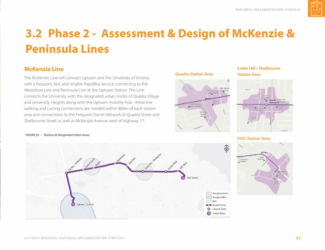
McKenzie LineThe McKenzie Line will connect Uptown and the University of Victoria with a frequent, fast, and reliable RapidBus service connecting to the Westshore Line and Peninsula Line at the Uptown Station. The Line connects the University with the designated urban nodes of Quadra Village and University Heights along with the Uptown mobility hub. Attractive walking and cycling connections are needed within 800m of each station area and connections to the Frequent Transit Network at Quadra Street and Shelbourne Street as well as McKenzie Avenue west of Highway 17.
FIGURE 20 – Stations & Designated Urban Areas
Quadra Station Area Cedar Hill / Shelbourne Station Area
UVIC Station Area
3.2 Phase 2 - Assessment & Design of McKenzie & Peninsula Lines

V I C TO R I A R E G I O N A L R A P I D B U S I M P L E M E N TAT I O N S T R AT E G Y
RAPIDBUS I M P L E M E N TAT I O N S T R AT E G Y
32
Peninsula LineThe Peninsula Line extends along Highway 17 between Swartz Bay Ferry Terminal through the designated urban centres of Sidney, Uptown and downtown Victoria. Although much of the corridor north of Uptown is surrounded by rural land uses, integrated transit services and attractive intermodal connections are essential. RapidBus and / or local service connections to Sidney and the airport still need to be designed through local area planning. Additionally, Frequent Transit Network services across the Peninsula can may be interlined and operate along the RapidBus corridor and/or provide attractive transfers for customers. Park-and-ride / pick-up and drop-off facilities are required across the corridor at strategic locations to intercept vehicle trips with an attractive, convenient alternative to driving. Transit priority treatments being planned with the Ministry of Transportation and Infrastructure include intersection queue jumpers as well as bus-on-shoulder facilities to reduce travel times and improve reliability.
FIGURE 21 – Peninsula Line Stations & Designated Urban Areas

V I C TO R I A R E G I O N A L R A P I D B U S I M P L E M E N TAT I O N S T R AT E G Y
R A P I D B U S I M P L E M E N TAT I O N S T R AT E G Y
33
The checklist below provides an overview of the key actions required towards progress the McKenzie RapidBus Line towards implementation.
� Initiate a detailed corridor review of the McKenzie corridor (Lead: District of Saanich and BC Transit) (2021)
� Identify bus stops along McKenzie corridor where infrastructure can be improved in preparation for a future RapidBus line. (Lead: District of Saanich and BC Transit) (2021-2023)
� Commence work on Uptown Mobility Hub strategy. (BC Transit, District of Saanich, BCTFA, MOTI) (Ongoing)
� Continue the development of the Peninsula Local Area Transit Plan, with emphasis on opportunities for future RapidBus service integration (Lead: BC Transit | Support: MOTI, District of North Saanich, Town of Sidney, District of Central Saanich) (2021)
� Continue to identify and implement infrastructure improvements on Highway 17. (Lead: MOTI and BC Transit) (2021- )
� Complete construction of enhanced UVic Exchange. (Lead: BC Transit and UVic) (2022)

V I C TO R I A R E G I O N A L R A P I D B U S I M P L E M E N TAT I O N S T R AT E G Y
RAPIDBUS I M P L E M E N TAT I O N S T R AT E G Y
34
• Collaborate with Local Government partners to complete a network scan of key corridors for future RapidBus service. Corridors will include, but not limited to, Shelbourne, Quadra, Esquimalt-UVic and Hillside. Scope will include review land use patterns, ridership modeling, street treatment opportunities and network analysis. (Lead: BC Transit | Support: Various local government partners) (2022/23)
3.3 Phase 3 - Explore Expansion of RapidBus Network
7
VICTORIA REGIONAL TRANSIT SYSTEM
Transit Future Network
X
X X
XA
B
XX
X
X
X
X
X
X
X
X
X
X
X
X
XX
X
X
X
Lansdowne
Oak Bay Ave.
Hillside
Bay
Gordo
n Hea
d
Feltham
enru
oble
hS
Tynd
all
Shelbourne
Cook
Lansdowne
.dR yaB luoF
Pandora
Oak Bay Ave.JohnsonJohnson
Quad
ra
Glanford
Pat Bay Hwy.
Quadra
Tillic
um
Burnside
Tattersall
Interurban
Admirals
Helm
cken
Helm
cken
Wilk
inson
Quad
ra
Hillside
Bay
McKenzie
Gordo
n Hea
d
Hend
erso
nHe
nder
son
Feltham
enru
oble
hS
Tynd
all
Cordova Bay Rd.Shelbourne
Glanford
Pat Bay Hwy.
Quadra
Tillic
um
McKenzie
Burnside
Gorge
salg
uoD
sal g
uoD
Tattersall
Craigflower
TransCanada Hwy.
Interurban
Lam
pson
Esquimalt
Interurban
Admirals
Admirals
Lam
pson
Helm
cken
Helm
cken
Millstream
Millstream
Jack
lin
Peat
t
Jack
lin
Peat
t
Trans Canada Hwy.
Islan
d Hw
y.Isl
and
Hwy.
Esquimalt
Sooke Rd.
Happ
y Val
ley
Metchosin
Vete
rans
Mem
oria
l Par
kway
Happ
y Val
ley
Metchosin
Latoria
Vete
rans
Mem
oria
l Par
kway
GoldstreamJenkinsJenkins
Pat Bay Hwy.
Stellys X Rd.
Pat Bay Hwy.
West Saanich Rd.
.dR
hcin
aaS l
artne
C
Wallace
dlefi
dlO
Keeting X Rd.Keeting X Rd.
Mt. Newton X Rd.
Stellys X Rd.
Pat Bay Hwy.
Wilk
inson
W. Saanich
Royal Oak
Mar
kham
Yates
Cook
Fort
Fairfie
ld
Fairfield
Fairfield
Belleville
htfiF
Malaview
Resthaven
McDonald Park
htfiF
Malaview
Resthaven
Loch
side
McDonald Park
McTavish
Elk Lake
Rapid Transit Network:Exclusive Corridor
Priority Corridor
Frequent Transit Network:Frequent Corridor
E&N Transportation Corridor:
Regional Growth Centres
Educational Institutions
CFB Esquimalt
Park
Transit Exchange
Park & Ride (Existing)
Park & Ride (Planned)
RTN and FTN corridors
Transit Future Plan25 year transit network
RTN and FTN corridors
X
X
X
East Sooke
SookeX
Local Transit Network and Targeted Services not displayed on map
Appendix ARAPIDBUS STREET TREATMENT TOOLKIT
V I C TO R I A R E G I O N A L R A P I D B U S I M P L E M E N TAT I O N S T R AT E G Y36
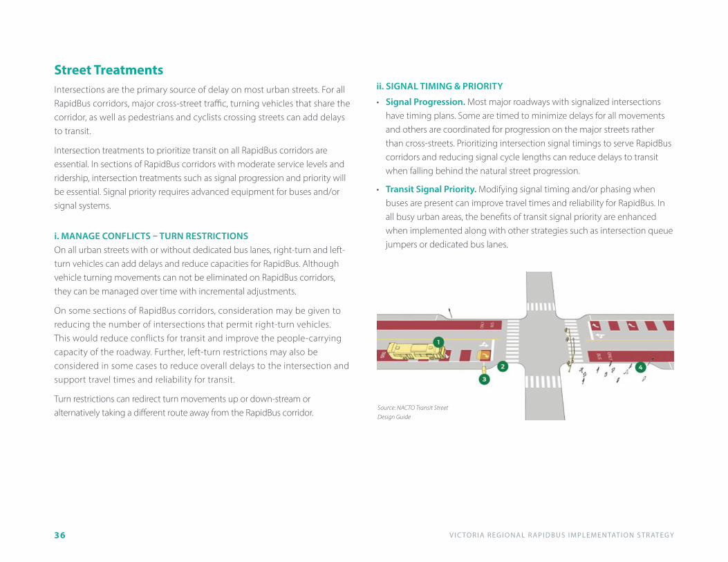
Street TreatmentsIntersections are the primary source of delay on most urban streets. For all RapidBus corridors, major cross-street traffic, turning vehicles that share the corridor, as well as pedestrians and cyclists crossing streets can add delays to transit.
Intersection treatments to prioritize transit on all RapidBus corridors are essential. In sections of RapidBus corridors with moderate service levels and ridership, intersection treatments such as signal progression and priority will be essential. Signal priority requires advanced equipment for buses and/or signal systems.
ii. SIGNAL TIMING & PRIORITY
• Signal Progression. Most major roadways with signalized intersections have timing plans. Some are timed to minimize delays for all movements and others are coordinated for progression on the major streets rather than cross-streets. Prioritizing intersection signal timings to serve RapidBus corridors and reducing signal cycle lengths can reduce delays to transit when falling behind the natural street progression.
• Transit Signal Priority. Modifying signal timing and/or phasing when buses are present can improve travel times and reliability for RapidBus. In all busy urban areas, the benefits of transit signal priority are enhanced when implemented along with other strategies such as intersection queue jumpers or dedicated bus lanes.
i. MANAGE CONFLICTS – TURN RESTRICTIONSOn all urban streets with or without dedicated bus lanes, right-turn and left-turn vehicles can add delays and reduce capacities for RapidBus. Although vehicle turning movements can not be eliminated on RapidBus corridors, they can be managed over time with incremental adjustments.
On some sections of RapidBus corridors, consideration may be given to reducing the number of intersections that permit right-turn vehicles. This would reduce conflicts for transit and improve the people-carrying capacity of the roadway. Further, left-turn restrictions may also be considered in some cases to reduce overall delays to the intersection and support travel times and reliability for transit.
Turn restrictions can redirect turn movements up or down-stream or alternatively taking a different route away from the RapidBus corridor.
Source: NACTO Transit Street Design Guide

V I C TO R I A R E G I O N A L R A P I D B U S I M P L E M E N TAT I O N S T R AT E G Y 37
Source: NACTO Transit Street Design Guide
• Right-turn Pocket Lane. In cases where the right-turn traffic is high (>200 vehicles per hour) and can not be prohibited, a separate right-turn (or pocket) lane may be provided. Since they increase crossing distances for pedestrians, they may be considered when other options are not possible.
iii. BUS QUEUE JUMP LANEIntersections along RapidBus corridors should be efficient and safe for people on the street. A variety of design elements for all modes can be integrated to balance street uses and improve capacity of the transit system. The following are example bus queue jump lanes to consider.
• Right-turn Shared Lane. On some sections of RapidBus corridors with a curb-side bus lane, right-turn vehicles may be permitted at intersections where low volumes are turning or are required for access and circulation. On shared-lane sections of RapidBus corridor, the right-lane may be restricted only to turning vehicles and buses.
Source: NACTO Transit Street Design Guide
Source: NACTO Transit Street Design Guide
• Dropped Transit Lane. In some cases, exclusive use of the through travel lanes by RapidBus will not be possible and a shared arrangement is essential. Although it may limit capacity rapid transit, transit lanes may be dropped before and immediately after some signalized intersections.
• Bus Queue Jump Lane. At some signalized intersections with only moderate delay, queue jump lanes for buses may be used to bypass vehicle queues and those waiting to turn right. Queue jump lanes currently exist at select intersections in the Victoria region. Experience shows that they reduce delay for transit considerably, resulting in reduced travel time for customers and run-time in the schedule.
Source: NACTO Transit Street Design Guide
V I C TO R I A R E G I O N A L R A P I D B U S I M P L E M E N TAT I O N S T R AT E G Y38
iv. DEDICATED BUS LANESDedicated bus lanes ensure fast, reliable travel for all transit customers. On RapidBus corridors, they also increase the people-carrying capacity of the roadway. In some cases, dedicated bus lanes may be implemented earlier than needed on RapidBus corridors as an incentive to increase ridership and service levels as well as to provide sustainable transportation choices. As ridership and service levels grow and travel speeds and reliability deteriorate, dedicated lanes should eventually be implemented on all RapidBus corridors – either 24/7 or during peak periods as a minimum.
There are generally four types of dedicated bus lanes that have been implemented on streets in the region and other communities: curb; centre; side running; and bus-on-shoulder lanes. Dedicated busways have also been implemented in some communities where alternative rights-of-way are available. The choice of configuration is influenced by several factors and the capacities will also vary slightly.
Whereas the curb lanes on Douglas Street can support turning vehicles and other traffic, centre or side running bus lanes would be exclusive to transit at all times of day. For urban streets, the choice of bus lanes can be influenced by several factors such as the available right-of-way, presence and frequency of accesses and cross-streets, as well as number of traffic lanes remaining on the street.
The capacities of dedicated bus lanes are influenced by several factors such as station size and layout, vehicle size, signal timing and vehicle conflicts. For complete systems, the potential directional capacity of each could be anywhere from 5,000 passengers per hour for curb lanes to 10,000 passengers per hour in high capacity busway corridors. With the exception of the southern sections of Douglas Street, bus frequencies and passenger loads could easily be accommodated on most RapidBus corridors for the next 10
to 20 years or more. Beyond the next 10 years however, alternative strategies may include rerouting non-RapidBus services to other corridors, expanding the RapidBus network and/or considering rail-based technologies.
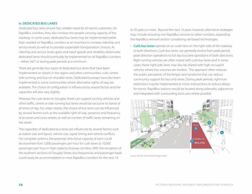
• Curb bus lanes operate on an outer lane on the right-side of the roadway in both directions. Curb bus lanes can generally evolve from peak period, peak direction operations to full day bus lane operations in both directions. Right turning vehicles are often mixed with curb bus lanes and in some cases, these right-side lanes may also be shared with high-occupant vehicles where bus volumes are modest. This approach often reduces the public perception of the ‘empty lane’ syndrome that can reduce community support for bus only lanes. During peak periods, right-turn restrictions may be implemented at minor intersections to reduce delays for transit. RapidBus stations would be located along sidewalks, adjacent to and integrated with surrounding land uses where possible
Source: NACTO Transit Street Design Guide

V I C TO R I A R E G I O N A L R A P I D B U S I M P L E M E N TAT I O N S T R AT E G Y 39
• Side Running Bus Lanes are dedicated areas of the road for bus only operation. The side running lanes can be located on either side of the road with protected space to physically separate buses from general purpose traffic. Reduced conflicts with general purpose traffic and transit signal priority would further reduce transit travel times relative to curb bus lanes. Because of the configuration, however, side running bus lanes could never be opened for general purpose traffic or parking at any time and would eliminate access to adjacent property driveways and minor cross-street intersections.
• Centre Bus Lanes are similar to side running lanes in that they are dedicated for bus use only. In this regard, conflicts with general purpose traffic are limited to signalized intersections where buses would be prioritized and left-turns for general purpose traffic could be permitted and accommodated with turn lanes. Centre running bus lanes would eliminate mid-block left-turn movements to access property. Right-turn access to properties along with minor intersections could be maintained along with on-street parking where adequate rights of way exist.
• Bus-on-shoulder lanes are similar to urban curb bus lanes in that transit lanes occur on the right side along roads without curb, gutter and sidewalks (such as on Highway 1 and Highway 17). Use of the shoulder for buses only can be a cost-effective strategy for prioritizing transit on highways or rural roadways where bus frequency may not be as high as in urban areas, but where transit passenger travel times are still impacted by areas of recurring congestion
Source: NACTO Transit Street Design Guide