· web viewguide to the global cryosphere watch surface-based observational network - cryonet...
TRANSCRIPT

WMO Global Cryosphere Watch - CryoNet Draft 25-05-2013
Guide to the Global Cryosphere Watch Surface-Based Observational Network -
CryoNet
Wolfgang Schöner1, Eric Brun, Michele Citterio, Charles Fierz, Barry Goodison, Jeff Key, Tetsuo Ohata, Þorsteinn Þorsteinsson, …
1Zentralanstalt für Meteorologie und Geodynamik (ZAMG), Vienna, Austria2 Meteo France, Paris, France
3 Geological Survey of Denmark and Greenland (GEUS), Copenhagen, Danmark4 Institute for Snow and Avalanche Research SLF, Davos, Switzerland
5 Environmental Canada, , Canada6 NOAA, , USA
7 , , Japan8 WSL - Institute for Snow and Avalanche Research SLF, Davos, Switzerland
9 Icelandic Meteorological Office, Reyclavik, Iceland
Version 0.2, 15 June 2013
1

WMO Global Cryosphere Watch - CryoNet Draft 25-05-2013
Document Version
Version Authors Date Description0.1 W. Schöner Jan. 2013 Initial draft0.2 W. Schöner Jun.
2013Major modification based on feedback from CryoNet team
0.3 CryoNet team Oct. 2013
Major modification based on feedback from CryoNet team
0.4 W. Schöner Major modification based on outcome from Asia-CryoNet meeting
2

WMO Global Cryosphere Watch - CryoNet Draft 25-05-2013
The CryoNet Working Group:
Jeff Key [email protected]
Barry Goodison [email protected]
Wolfgang Schöner [email protected]
Eric Brun [email protected]
Christophe Genthon [email protected]
Charles Fierz [email protected]
Tetsuo Ohata [email protected]
Þorsteinn Þorsteinsson [email protected]
Michele Citterio [email protected]
Sandy Starkweather sandy.starkweather @noaa.gov
Matthias Bernhardt [email protected]
Hugues Lantuit [email protected]
Xiao Cunde [email protected]
Vasily Smolyanitsky [email protected]
Juan Manuel Hörler [email protected]
Kari Luojus [email protected]
3

WMO Global Cryosphere Watch - CryoNet Draft 25-05-2013
Table of Contents
1. Introduction2. GCW-CryoNet objectives3. Observations of Global Cryosphere Watch focal areas4. Structure of CryoNet
4.1. Observations4.2. Cooperation and capacity building4.3. Services
5. Criteria for site inclusion into CryoNet6. Measurement Standards and Best Practices7. Appendix
4
WMO Global Cryosphere Watch - CryoNet Draft 25-05-2013
1. Introduction
The cryosphere collectively describes elements of the Earth System containing water in its frozen state. It includes solid precipitation, snow cover, sea ice, lake and river ice, glaciers, ice caps, ice sheets, permafrost, and seasonally frozen ground. The cryosphere is global, existing not just in the Arctic, Antarctic and mountain regions, but at all latitudes and in approximately one hundred countries. The cryosphere provides some of the most useful indicators of climate change, yet is one the most under-sampled domains of the Earth System. Improved cryospheric monitoring and integration of that monitoring is essential to fully assess, predict, and adapt to climate variability and change.
The cryosphere, its changes, and its impacts have received increasing attention in recent years. Today, it receives constant coverage by the media, creating an unparalleled demand for authoritative information on the past, present and future state of the world’s snow and ice resources on a multitude of time and space scales, reaching from polar ice to tropical glaciers.
The cryosphere is a key element of the Earth system that is particularly relevant for understanding climate change through its feedback mechanisms, societal impacts as a major water resource and source for hydropower business economics such as tourism (snow) or transport business and infrastructure (sea
ice and frozen ground) weather forecasting (e.g. snow cover data for data assimilation for NWP) hazard prevention such as low lands/ sea-shore flooding (sea level), mountain glacier
lake outburst floods (GLOFs)
WMO, with the co-operation of other national and international bodies and organizations, and using its global observing and telecommunication capability, is in a position to provide an integrated, authoritative, continuing assessment of the cryosphere – a Global Cryosphere Watch (GCW).
GCW will initiate a comprehensive surface-based cryosphere observing network called “CryoNet”, a network of reference sites or “supersites” in cold climate regions, on land or sea, operating a sustained, standardized programme for observing and monitoring as many cryospheric components as possible. The goals and implementation of GCW are described in the GCW Implementation Plan, available at http://globalcryospherewatch.org. The conceptual framework of GCW is described by Figure 1, with the major activity “CryoNet” covering the observation part of GCW. Initially, CryoNet will build on existing cryosphere observing programmes or add standardized cryospheric observations to existing facilities to create a tiered network from simple sites to integrated environmental observatories.
5
WMO Global Cryosphere Watch - CryoNet Draft 25-05-2013
Figure 1: The conceptual framework of Global Cryosphere Watch (GCW) and its CryoNet part (red box)
The purpose of this document is to describe the implementation of CryoNet. It will identify linkages to existing networks, provide a detailed site type structure, list the required observations, and establish criteria for inclusion in CryoNet.
CryoNet covers all components of the cryosphere (glaciers, ice shelves, ice sheets, snow, frozen ground including permafrost, sea ice, river/lake ice) through an extensive approach of in-situ observations. Whereas some of these cryospheric components are already measured through existing component networks (such as GTN-P for permafrost or GTN-G for glaciers), other components are not represented by similar networks (e.g. sea ice) or partly covered by existing networks (e.g. snow). The present situation of singular cryospheric monitoring networks is described by Figure 2. In several cases these networks are performing measurements on the same cryospheric quantity (e.g. snow water equivalent) using different guidelines or procedures. Consequently, an improved and integrating global cryospheric network of surface observations is of utmost relevance for assessing the state of the cryosphere. The following gaps have been identified by the community of researchers and practitioners with respect to cryospheric observations and monitoring:
lack of harmonization in cryospheric observations lack of network-hosts for several cryospheric observations (e.g. glacier flow
measurements, automatic weather stations on glaciers) lack of guidelines for some of the cryospheric observations need for improved training in particular at the international level
6
CryoNet

WMO Global Cryosphere Watch - CryoNet Draft 25-05-2013
access to cryospheric observational data
GCW-CryoNet aims to fully support the existing networks and gain added value from a series of across-network-boundaries and new activities. WMO already coordinates worldwide monitoring of one of the “spheres” mentioned in the GCW document (the atmosphere, GAW); and thus can build on extensive experience and knowhow in building up a new monitoring system for the cryosphere and identify opportunities for system science (e.g. atmosphere-cryosphere feedbacks).
active compilation of standardised & quality checked data
scientific observations of the cryosphere
GCW CryoNET
glac
iers
GTN-
G
perm
afro
stGT
N-P
ice
shee
ts... snow ...
sea
ice
...
lake
& ri
ver i
ce...
Figure 2: The current structure of cryospheric monitoring and the need for a Global Cryosphere Watch and CryoNet
Linkages:
The Global Terrestrial Observing System (GTOS) and GCOS, currently through the Terrestrial Observations Panel for Climate (TOPC), guide the development of crucial networks such as the Global Terrestrial Networks (GTNs) for permafrost, glaciers, hydrology, run-off, and lakes (GTN-P, GTN-G, GTN-H, GTN-R, GTN-L). GCW will work in close cooperation with the TOPC and these terrestrial networks. As encouraged by GCOS, GCW will facilitate the establishment of high-latitude reference sites with co-located measurements of key variables, especially permafrost and snow cover, thus enhancing GCOS/GTOS Networks for Permafrost (GTN-P), Glaciers (-G) and Hydrology (-H) and including the measurements of solid precipitation.
GCW is considered as the cryospheric component of the Global Climate Observing System (GCOS).
The GCOS implementation strategy envisaged five observation network types for climate:
(a) Comprehensive global observing networks, including regional and national in situ sites as well as satellites;
7

WMO Global Cryosphere Watch - CryoNet Draft 25-05-2013
(b) Baseline global observing networks, a limited number of observations at selected locations that are globally distributed and provide long-term, high-quality data records of key variables;
(c) Reference networks that provide highly detailed and accurate observations at a few locations for calibration purposes;
(d) Research networks that can provide estimates of the local variability of key variables;
(e) Ecosystem networks, where a number of different variables are measured at several locations within a specific ecosystem.
GCW-CryoNet will contribute to all of the above GCOS topics as the relevant network for the cryosphere.
2. GCW CryoNet objectives
The main long-term objectives of GCW-CryoNet are in line with the WMO Strategic Plan 2011-20?? and identical with those expressed in further documents………. [????, 2011]. The overall objective of CryoNet is to provide a comprehensive network of cryospheric in-situ observations using standardized procedures as well as to enable a related framework of network-services according to user needs. With respect to the first GCW Implementation Plan (200?-20??) [WMO, 20??], the CryoNet aims for the following main developments:
Link different cryospheric observational networks to achieve its comprehensive potential through
Extensive monitoring of cryosphere through harmonized measurements
Providing cryospheric-data for improved process understanding and modelling
Providing calibration and validation data for satellite data
Linking cryospheric ground truth observations to cryospheric models
Training for cryospheric observations
Standardized guidelines for cryospheric observations
- Extensive monitoring of cryosphere through harmonized measurementsCurrently observations of the cryosphere are done by a series of independent networks and independent research projects. Each network structure and research project is based on its
8

WMO Global Cryosphere Watch - CryoNet Draft 25-05-2013
own objectives and preferences. While some networks and independent researchers may prefer their own approach, identifying common best practices will slowly incentivize most of the community towards harmonized measurements. Adjustment of differences and inconsistencies among different measurements, procedures and methods, will make them uniform and mutually compatible. Filling gaps from missing observations could be easier achieved in a comprehensive monitoring program based on high number of users. Extensive monitoring covering several cryospheric variables will initiate new research fields. A standardized terminology/vocabulary for the cryosphere will facilitate communication between specialists speaking different languages.
- Providing cryospheric-data for improved process understanding and modellingCryospheric observations are essential input data for earth system modelling, in particular for past and future climate simulations in order to understand and predict climate change. CyroNet will actively engage with the modelling community through a series of workshops to clearly identify the highest priority observational needs of the modelling community, addressing issues of scale and process representation.
- Providing calibration and validation data for satellite dataToday satellite data and products offer an indispensable source for Earth observation and input for model studies. However, satellite data are needed to be calibrated and validated against observations (ground truth data). In particular global coverage of calibration/validation data is important for satellite data and derived products. GCW-CryoNet will clearly improve the access to calibration/validation data for satellite data.
- Linking cryospheric ground truth observations to cryospheric modelsSimilar as satellite data cryospheric models (also as part of more complex climate models or earth system models) are highly dependent on high quality as well as spatially and temporally dense observation data. They are needed as driving data as well as for model calibration/validation. Cryospheric models are highly relevant for short-term forecast purposes (e.g. snow cover models, sea ice models) on the time scale of hours to days or for scenario generation (e.g. ice sheet models, permafrost models) on the time scales of decades to centuries.
- Training for cryospheric observationsTraining is essential for high quality measurements relevant for spatial analysis (inter-site comparison), as model input or calibration/validation of satellite data. Training of observers based on standardized guidelines and protocols (see below) is a WMO activity done at a regular base at both national and international level. Thus GCW can provide highly practical and user-relevant trainings for cryospheric observations. This will be done in cooperation with cooperating cryospheric networks.
- Standardized guidelines for cryospheric observations
9
WMO Global Cryosphere Watch - CryoNet Draft 25-05-2013
A critical component in the development of CryoNet is the effort to establish best practices, guidelines and standards for cryospheric measurements. This would include consideration of data homogeneity, interoperability, and compatibility of observations from all GCW constituent observing and monitoring systems and derived cryospheric products. The first step in the process is to determine what is currently being measured, how it is being measured and which best practices, guidelines or standards are being followed and who are conducting or co-ordinating the measurements. Once this compilation is available, then the different practices, methods, standards could be compiled and compared as a first step in ultimately preparing a comprehensive manual on the topic.
3. Observations of Global Cryosphere Watch focal areas
3.1. SnowcoverCurrent status
There is no global co-ordinated monitoring of snow on the ground. This relates to the fact that network requirements differ from application to application such as avalanche warning, meteorological observations, snow hydrology, etc. This situation exists even in a small country like Switzerland! Guides to best practices are thus found in various manuals pertaining to each of these applications, often coinciding but not always. Sometimes basic requirements may not be fulfilled, for example, distinguishing between “no measurement available” and “no snow observed on the ground”. Moreover, best practices that work in an alpine region may not work in extreme conditions as found in East Antarctica, where, for example, “snow depth” is much more difficult to define unequivocally.
Since 1954, there exists an “International Classification of Seasonal Snow on the Ground” (ICSSG) that covers many aspects of snow monitoring but not all. ICSSG was reproduced at least in part in many other manuals relating to snow observations, for example in the 1970 UNESCO-IASH-WMO “Seasonal snow cover, a guide for measurement compilation and assemblage of data.”, and has recently been revised (2009).
However, as the number of regular and continuous manual observations diminishes worldwide, there is an urgent need to improve our ability to measure automatically snow on the ground and to validate those measurements against manual observations. One important step in that direction is SPICE. Again, requirements are very different depending on the application. While an avalanche forecaster will not bother (much) about an error of ±5 cm in the depth of snowfall, road maintenance may become active as soon as a road is covered by 1 cm of snow.
Goals Standardize automatic measurements and manual observations across the different
fields of application
10

WMO Global Cryosphere Watch - CryoNet Draft 25-05-2013
Reconcile automatic and manual observations, for example, precipitation with daily observations of depth of snowfall
Make authorized translations available to all players
3.2. GlaciersCurrent status
World Glacier Inventory (WGI) database has been made by World Glacier Monitoring Service (WGMS). This integrative approach is based on detailed (index) in situ measurements of mass balance at Tier 2 (Tier 3) sites and length change measurements at Tier 4 sites, combined with global information from remote sensing data (glacier inventories) at Tier 5 sites (Haeberli, 2006). Currently, there are about 50 Tier 2 / 3 sites and about 550 Tier 4 sites that are maintained due to their integration in an international observing program. Glacier inventories comprise basic information on physiographic properties of glaciers, including glacier boundaries and surfacetopography.
The WGI currently contains information on 130,000 glaciers that cover over 470,000 km2. Efforts are made to compile standardized data on glacier thickness measurements. It has to be kept in mind that the inventory is mainly based on aerial photographs and maps from the 1970s, and also includes data from the GLIMS inventory (mainly satellite images after 2000) and the Randolph Glacier Map. The latter gives rough glacier outlines and useful to models . However, even after 50 years of glacier observations there is still no complete inventory due to monitoring challenges, which include that fully automated algorithms are challenged by snow, perennial snow, and debris cover, as well as the problem that it is difficult in some regions to get minimal snow and cloud free images at the end of an ablation season. In 2012, WGMS published its tenth volume of Fluctuations of Glaciers (2005-2010), whereas the basic data can be found on the official GTN-G.
Goals To fill large gaps in the global glacier monitoring. For instance, Glacier mass balance
data are sparse and unsuitable either for regional and/or global assessments or for water management.
Set up anchor stations, in the major cryospheric regions, for calibrating and validating satellite-based observations and process models
To enhance meteorological observations over glacier areas , in synergy with remote sensing data (topography, glacier facies, albedo, accumulation, etc.) to give a more comprehensive picture of mass balance in various climate zones and globally.
On the existing observed glaciers, fill gaps in critical parameters of glaciology, such as mass balance, ice velocity, ice thickness, ice temperatures, glacier area and length.
In general, CryoNet will help maintain and enhance a solid ground-based glacier observation network.
3.3. Ice sheetsCurrent status
The Greenland Ice Sheet is currently monitored by the Danish PROMICE network, operating transects of automatic weather stations at various elevations in the ablation area arount the
11

WMO Global Cryosphere Watch - CryoNet Draft 25-05-2013
entire margin of the ice sheet, and by the US GC-Net automatic weather stations in the accumulation area. Some sectors are monitored by some local network like the Dutch K-Transect.
GoalsTo provide consistent, extended time series of year-round ground observation of surface mass balance and near-surface weather:
1) sufficiently representative of all regions, elevation bands and climatic settings to enable climate models calibration/driving/validation and for calibration/validation of remote sensing datasets.
1)2) suitable for process studies and detailed modelling of the energy and mass fluxes at the ice surface taking place at the observation sites
3.4. Sea iceCurrent status
Floating ice – sea ice, icebergs, and ice covered lakes and rivers – affects large regions of economic, environmental, and social importance. The prevalent component, the sea ice is formed from the freezing of sea water. Offshore, drift ice is dynamic, being moved by winds and currents. Near the shore, ‘fast ice’ forms early in the season and remains stationary. Oscillations with a time scale couple of years to multi-decadal and ‘linear trends’, which in turn can be a part of a longer term oscillations, are inherent to variability of sea ice cover state with Arctic sea ice cover undergoing extreme minimum conditions in the last decade and Antarctic sea ice cover of lesser scale but maximum conditions. In the late winter (March in the Arctic, September in the Antarctic), sea ice extent is 15 – 17 million square kilometres in the Arctic (14.7 – 2011, 16.8 – 19791) and 18 to 20 million square kilometres in the Antarctic (18.0 – 1986, 19.5 – 2012). In the late summer (September in the Arctic, February in the Antarctic) sea ice extent drops to 3 – 8 million square kilometres in the Arctic (3.3 – 2012, 7.6 - 1980) and 2 – 4 million square kilometres in the Antarctic (2.3 – 1997, 3.8 – 2008).
Lake and river ice is formed from the freezing of fresh water (if we count Caspian Sea as a sea area) and in general behaves similar to sea ice though undergoes much lesser variations in area – from close to 0 extent in summer up to somewhat 0.2 million square kilometres in the late winter for the Northern hemisphere with ‘fast ice’ predominant and negligible area in the Southern hemisphere mostly concentrated in the Antarctica in a form of lakes with perennial ice.
Icebergs are formed from the ‘calving’ of pieces of glacier into the sea. In the Northern hemisphere the most well-known icebergs originating in Greenland transit far into the North Atlantic up to shipping lanes. Icebergs can be also found throughout the whole Arctic Ocean including the Barents and Greenland Seas. Icebergs in the Antarctic originate from Antarctic ice shelves. They are far more abundant and much larger than Arctic icebergs – 93% of the world’s mass of icebergs is found surrounding Antarctica.
1 Extremes based on the SSMR-SSM/I-SSMIS NASATEAM algorithm series of ice extent estimates from October 1978 till August 2013
12

WMO Global Cryosphere Watch - CryoNet Draft 25-05-2013
Basement of the ice information is the continuous monitoring of the sea, lake and river ice and icebergs executed by the national ice services, International Ice Patrol as well as the research community on hemispheric, circumpolar or regional scales (figure 3.4). A wide variety of user requirement inventories for ice information have been developed to support different application areas. The key features of ice user requirements are:
1) The ice parameter to be measured2) The spatial scale of the observations3) The frequency of the observation 4) The coding and presentation of the product
On the largest level requirements to ice information are presently tracked by the WMO Expert Team on Sea Ice (ETSI) and the International Ice Charting Working Group (IICWG) and are summarized in the prime WMO ice standard – the “WMO Sea-Ice Nomenclature” (WMO No.259) and the IICWG “Ice Information Services: Socio-Economic Benefits and Earth Observation Requirements”.
Northern hemisphere Southern hemisphereFigure 3.4 – Areas of the sea ice and icebergs monitoring in the World Ocean
The key parameters/features describing ice are ice extent/edge location, ice concentration, stage of ice development/thickness, forms of floating ice, leads/polynyas, state of decay, ice topography, ice dynamics, ice motion/drift, ice phenomena (break-up, freeze-up etc) icebergs position, concentration, form and dimensions.
It is evident that the satellite means are the prime source of data ice monitoring though not all of the mentioned key parameters can be presently observed with sufficient accuracy on a basis of the spaceborne measurements (decay, topography, thickness etc). In situ, coastal, shipborne and airborne measurements remain and will remain a vital complementary or sometimes prime source of ice information.
As most of the ice parameters are 2D, ice chart remains the common form to summarize the observed or diagnosed ice parameters for more than a centennial period. The ‘ice chart’ is a multi-layer presentation of the ice (sea or lake and river ice and icebergs) cover state for a certain period of time (typically 1-3 days) with coding of parameters in accordance with the WMO No.259 and WMO/TD-No.1214 (SIGRID-3 format). The ice chart is based on the ‘ice charting, performed by the ice analysts following standard procedures by
13

WMO Global Cryosphere Watch - CryoNet Draft 25-05-2013
means of analysis of multi-spectral and multi-source information using GIS and thus differs from the second common form of the ice information – 2D or 1D satellite products based on the automated processing of the satellite data and coded in one of the accepted formats for NWP (e.g. netCDF). The third one form is the ice observations at a point (coastal, shipborne) summarized in a form of reports disseminated via the WMO GTS. Lastly, there are variety of research and applied observations of the ice geophysical properties coded in a user-defined form and formats.
The ‘Ice Logistics Portal’ (http://www.bsis-ice.de/IcePortal/), supervised by the IICWG and ETSI, the NSIDC and a number of centers of the national ice services (Russian AARI, USA NIC etc) are providing collection and dissemination of the operational and historical series of ice data and partly the reports. Satellite products are provided by national and international facilities like the OSISAF - Ocean and Sea Ice Satellite Application Facility or again the NSIDC.
GoalsThere is an extended and developing system of sea, lake and river ice and icebergs observations. It may be also defined as sustained for certain areas of the World (e.g. Baltic Sea), though not on a global scale where we still awaiting advances of the satellite means (e.g. routine open SAR monitoring) as well as ground-trouth measurents with sufficient density. In many parts the ice information is gained, coded and provided in accordance with the WMO standards (WMO No.259, WMO/TD.-No.1214, 1215) though there are insufficient standartization or harmonization of the observations at a point and ice charting, routine and scientific products, fresh water and sea ice products or coding of the satellite products. There is a certain gap in developing meta-data for ice information via WIS. The Cryonet will ensure, mainly by supervision:
• extension of both ground-based and spaceborne observational network to meet the observational requirements for the key ice features
• development of the common set of nomenclatures / glosarries for ice information
• development of the harmonized observational procedures based on existing WMO and national practices
• development of the harmonized coding procedures for raster and vector pointal/linear/polygone
• integration of ice information into WIS
3.5. Lake iceCurrent status
Goals
3.6. Permafrost
14

WMO Global Cryosphere Watch - CryoNet Draft 25-05-2013
Current status
Figure X: Location of long-term monitoring sites of the Thermal State of Permafrost (TSP) in GTN-P (source: .
Goals
4. Structure of CryoNet
Based on its general objectives, three highly interlinked core tasks of activity are relevant for CryoNet which are:
- ObservationsProviding essential cryospheric variables from existing cryospheric observational networks (such as GTN-P, GTN-P, national networks (PROMICE, GC-Net …)) and potential new networks in standardized and traceable format for the GCW data portal which will be the link to the various users of CryoNet data
- Coordination and capacity buildingCooperation and communication with existing cryospheric networks and with national WMO representatives in order to provide a common and sustainable CryoNet of cryospheric observations. Financial coverage of costs for monitoring networks is a key issue generally relevant for all networks. Though GCW through WMO is not able to directly fund monitoring activities, it has a high potential for
15

CoordinationCapacity building
ObservationsServices
WMO Global Cryosphere Watch - CryoNet Draft 25-05-2013
promoting the relevance of cryospheric monitoring through its existing international networks.
- ServiceTo support the CryoNet community with relevant observational guidelines, training, harmonisation activities, standardization documents and technical know-how in order to provide cryospheric observations at the highest level of quality possible.
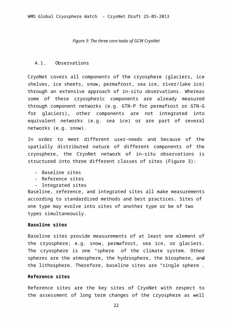
Figure 3: The three core tasks of GCW CryoNet
4.1. Observations
CryoNet covers all components of the cryosphere (glaciers, ice shelves, ice sheets, snow, permafrost, sea ice, river/lake ice) through an extensive approach of in-situ observations. Whereas some of these cryospheric components are already measured through component networks (e.g. GTN-P for permafrost or GTN-G for glaciers), other components are not integrated into equivalent networks (e.g. sea ice) or are part of several networks (e.g. snow).
In order to meet different user-needs and because of the spatially distributed nature of different components of the cryosphere, the CryoNet network of in-situ observations is structured into three different classes of sites (Figure 3):
- Baseline sites- Reference sites- Integrated sites
Baseline, reference, and integrated sites all make measurements according to standardized methods and best practices. Sites of one type may evolve into sites of another type or be of two types simultaneously.
Baseline sites
16

WMO Global Cryosphere Watch - CryoNet Draft 25-05-2013
Baseline sites provide measurements of at least one element of the cryosphere; e.g. snow, permafrost, sea ice, or glaciers. The cryosphere is one “sphere” of the climate system. Other spheres are the atmosphere, the hydrosphere, the biosphere, and the lithosphere. Therefore, baseline sites are “single sphere”.
Reference sites
Reference sites are the key sites of CryoNet with respect to the assessment of long term changes of the cryosphere as well as for the validation and calibration of satellite data and cryospheric models. In general these sites are supported by long-term financial commitments running standard monitoring programs of the cryosphere. In order to be accepted as a reference site for a single cryospheric component (either by GCW-CryoNet or by the relevant component network) the site/station has to accept relevant standards and has to provide continuous measurements since at least 10 years. Ideally, reference sites are sites fully in operation but could be closed stations in case of highly relevance of the data. Similar to Integrated sites Reference sites could also have a research oriented focus, but for a specific cryospheric component.
Integrated sites
The mission of Integrated sites is to promote, through worldwide scientific collaboration, progress in the scientific understanding of the physical processes generating changes of the cryosphere. These sites integrate in-situ and space-based observations at high level of extensiveness and create platforms of cryospheric observatories.
Monitoring at integrated sites covers several components of the cryosphere with a highly process orientated approach. Thus these sites are ideal places for understanding the interaction between the atmosphere, the other spheres, and the various cryospheric components including feedback mechanisms. Integrated sites could either be a single station or a larger region covering several stations or field sites. Integrated sites are suitable sites for defining standards of cryospheric observations and making trainings on measurements. Because of the high level of measurements, on-site technical staff is obligatory at integrated sites. In general these sites are supported by long-term financial commitments running standard monitoring programs of the cryosphere. Whereas Integrated sites may also be Reference sites for some cryospheric components Integrated sites are also reference sites, they may not be for other cryospheric components they are not.
17

WMO Global Cryosphere Watch - CryoNet Draft 25-05-2013
Figure 4: The structure of CryoNet
4.2. Cooperation and capacity building
Cooperation between existing cryospheric networks is a major mission of GCW and is an obvious need to be concluded from the CryoNet questionnaire shown in the appendix. Primary existing networks already cooperating with GCW for CryoNet are:
IACS (International Association of Cryospheric Sciences)WGMS (World Glacier Monitoring Service)NSIDC (National Snow and Ice Data Centre)GTN-P (Global Terrestrial Network – Permafrost)IPA (International Permafrost Association)GTN-G (Global Terrestrial Network- Glaciers)IASOAS (International Arctic Systems for Observing the Atmosphere and Surface)…………
Funding of a sustainable long-term monitoring of the cryosphere is a major objective and challenge for GCW CryoNet. Though GCW is not able to provide direct funds for the cryospheric observations in the participating countries, GCW is able, through its WMO background, to support and push the relevance of an extensive and coordinated cryospheric monitoring using its international network and via national WMO representatives. The GAW (Global Atmosphere Watch) program of WMO could serve as a good example of a powerful network successfully hosted by WMO. Cooperation with on-going cal/val satellite programsand modelling activities is also a major mission of CryoNet. Identifying relevant satellite
18
Baseline Sites
Single sphereStandardized
Reference Sites
Single sphereLong-term continousCal/ValStandardizedLong-term financial commitment
Integrated Sites
Multi sphereCal/ValStrong research focusTraining Onsite staffStandardizedLong-term financial commitment
WMO Global Cryosphere Watch - CryoNet Draft 25-05-2013
products/programs, as well as model development activities is an important step to understanding the broader connection of these observations with some of the communities that they will eventually serve. Integrating their detailed perspective as part of the on-going development of CryoNet will be essential, and vice-versa.
4.3. Services
GCW-CryoNet, through its WMO roots, has a high potential for supporting cryospheric observational network with relevant services. Based on the experience from other WMO networks CryoNet can provide the following relevant services to network operators and data users:
+ Intercomparison experiments on sensors, measurement procedures, ….
+ Guidelines for cryospheric measurements
+ Training of observers and students
+ open and completely documented reference implementations of typical measuring stations
5. Criteria for Site Inclusion into CryoNet
A tiered observational networkCryoNet needs clear criteria for assigning existing and new stations/sites to the single classes of the network. Such criteria has have to guarantee (e.g. for a data user) that well-described levels of data quality, measurement standards and guidelines have been met.
Currently, Cryonet neither do haveprovides such criteria nor can easily adopt existing criteria from cryospheric component networks. However, there is high potential from some of these component networks and GCW, in strong cooperation with these networks, will establish such criteria catalogue. This will be done as a separate GCW-Cryonet document covering the 3 classes of sites (baseline Baseline sites, reference Reference sites and integrated Integrated sites)
Essential characteristics of a GCW-CryoNet Station/Site
1. The station/site location is chosen such that, for the variables measured, it is regionally representative.
2. There are adequate power, communication and building facilities to sustain long term observations with greater than 90% data capture (i.e. <10% missing data).
19

WMO Global Cryosphere Watch - CryoNet Draft 25-05-2013
3. The technical support provided is trained in the operation of the equipment.
4. There is a commitment by the responsible agency to long term observations of at least one of the GCW variables in the GCW focal areas.
5. The GCW observation made is of known quality and linked to the GCW Standard.
6. The data and associated metadata are submitted to one of the international cryospheric data centres (such as GTN-P, WGMS, GCOS etc. ) no later than one year after the observation is made. Changes of metadata including instrumentation, traceability, observation procedures, are reported to the responsible WDC in a timely manner.
7. If possible, data are submitted to a designated data distribution system in near-real-time.
8. Standard meteorological in situ observations, necessary for the accurate determination and interpretation of the GCW variables, are made with known accuracy and precision.
9. The station characteristics and observational programme are updated in the GCW Station Information System (GCWSIS) on a regular basis.
10. A station logbook (i.e. record of observations made and activities that may affect observations) is maintained and is used in the data validation process.
11. Observational data users have been involved in the observation design process.
6. Measurement Standards and Best Practices
To ensure high quality, consistent observations, measurements of snow and ice properties at CryoNet sites will be made according to accepted standards. Many measurement standards have been compiled by WMO or other networks, though the compilation is not exhaustive for snow and ice measurements. Some existing cryosphere networks have their own standards. However, similar to item 4 from above “criteria for site inclusion”, there is no GCW-CryoNet measurement standard available but it could be easily extracted from existing measurement standards or guidelines from single cryosphere component networks. In fact it will be a major effort of GCW-CryoNet to establish such standard in agreement with the standards and guidelines existing (and routinely used) for observations of single cryospheric components. Thus CryoNet measurement standards will draw on existing standards and add new standards, as necessary. They will be reviewed by the scientific community, modified as necessary, and maintained in the GCW Manual.
As a first step towards a GCW measurement standard/guideline GCW-CryoNet made a survey of existing measurement standards and practices that is listed with some details in Table 1. The GCW-CryoNet measurement standard/guideline will be reworked as a separate document within the implementation phase of CryoNet. Existing manuals such as the
20

WMO Global Cryosphere Watch - CryoNet Draft 25-05-2013
Manual on the Global Observing System and the Guide to Meteorological Instruments and Methods of Observation (CIMO Guide) could serve as an important base for a “GCW-Manual”. Establishing best practices, guidelines and standards for cryospheric measurements will include consideration of data homogeneity, interoperability, and compatibility of observations from all GCW constituent observing and monitoring systems and derived cryospheric products.
Additionally, intercomparisons campaigns of instruments will be conducted in order to determine and intercompare performance characteristics of instruments under field or laboratory conditions and to link readings of different instruments – data compatibility & homogeneity. The current WMO Solid Precipitation Intercomparison Experiment (SPICE), including snowfall & snow depth, is of direct relevance to GCW, and is considered as a contribution to GCW. Potential GCW reference sites might be suitable sites for inclusion in this intercomparison.
The following objectives are part of the CryoNet implementation with respect to measurement standards and best practices:
Standardization of Practices (networks, observations, instruments, data exchange & policy, products):
• Review existing GCW practices and develop an inventory; identify differences and inconsistencies
• Identify a need for new standard/best practices, identify priorities and develop new standard/best practices
• Develop a Cryospheric Vocabulary
• Identify standard/practices that may be promoted to ISO standards?
• Develop “GCW Manual”; provide input to WIGOS Manual, CIMO Guide
• Register cryospheric user requirements in WMO Rolling Review of Requirements (RRR) data base (propose a new application area – Cryosphere, identify focal points for different application areas and observing system capabilities, verify existing variables and add new (key) cryospheric variables in RRR database)
• Establish Centres of Excellence from among GCW Reference sites e.g., Instrument Centres and Testbeds responsible for maintaining a set of standard instruments, calibration, intercomparison, traceability, compatibility, integration of RS and in-situ observations
Table 1: List of existing cryospheric guidelines
Organisation Guideline (authors and title) Year published
Cryospheric component
IACS, UNESCO Fierz, C., Armstrong, R.L., Durand, Y., Etchevers, P., 2009 Snow21
WMO Global Cryosphere Watch - CryoNet Draft 25-05-2013
Greene, E., McClung, D.M., Nishimura, K., Satyawali, P.K. and Sokratov, S.A. 2009. The International Classification for Seasonal Snow on the Ground. IHP-VII Technical Documents in Hydrology No. 83, UNESCO-IHP, Paris. 90 pp.
IACS, UNESCO Cogley, J.G., Hock, R., Rasmussen, L.A., Arendt, A.A., Bauder, A., Braithwaite, R.J., Jansson, P., Kaser, G., Möller, M., Nicholson, L. and Zemp, M., 2010, Glossary of Glacier Mass Balance and Related Terms. IHP-VII Technical Documents in Hydrology No. 86, IACS Contribution No. 2, UNESCO-IHP, Paris. 114 pp.
2010 Glaciers
UNESCO Kaser, G., Fountain, A., and Jansson, P., 2003. A Manual For Monitoring the Mass Balance of Mountain Glaciers. IHP-VI Technical Documents in Hydrology No. 59, UNESCO-IHP, Paris.
2003 Glaciers
WMO Goodison B.E., P.Y.T. Louie, D. Yang, 1998, WMO Solid Precipitation Measurement Intercomparison- Final Report, WMO/TD - No. 872
1998 Snow
WMO Nitu R. and Wong K., 2010, CIMO Survey on National Summaries of Methods and Instruments for Solid Precipitation Measurements at Automatic Weather Stations
2010 Snow
WMO World Meteorological Organization (WMO) 2008. Guide to meteorological instruments and methods of observation. WMO-8 8 1-681
2008 Snow
UNESCO, IAHS, ICSI, WMO
UNESCO, IASH, WMO, 1970. Seasonal snow cover, a guide for measurement compilation and assemblageof data. Technical papers in hydrology, a contribution to the International Hydrological Decade, published bythe United Nations Educational, Scientific and Cultural Organisation, Place de Fontenoy, 75 Paris-7e, 37pages.
1970 Snow
National Hydrology Research Institute Canada
Östrem G. and M. Brugmann, 1991, Glacier Mass Balance Measurements. A manual for field and office work. National Hydrology Research Institute (Canada), Science Report No. 4
1991 Glaciers
CEN CEN/TR 15996:2010, Hydrometry - Measurement of snow water equivalent using snow mass registration devices
2010 Snow
UNESCO, ICSI, IAHS
UNESCO, IAHS, 1970, Combined Heat, Ice and Water Balances at Selected Glacier Basins. A Guide to Measurement and Data Compilation. Technical Papers in Hydrology No. 5, UNESCO, Paris
1970 Glaciers
Environment Canada
Manual of Climatological Observations, 3rd Edition 1992 Precipitation, snowfall
Environment Canada
MANOBS, Manual of Surface Weather Observations, 7th Edition
1977, 2011 Precipitation, snow
WMO WMO Sea ice Nomenclature, WMO-No.259. Volume I – Terminology, Volume II – Illustrated Glossary, Volume III – International system of sea ice symbols.
2004 Sea Ice
22

WMO Global Cryosphere Watch - CryoNet Draft 25-05-2013
Electronic version is available at http://www.aari.ru/gdsidb/XML/wmo_259.php
WMO Sea ice Information Services in the World, WMO-No.574. “Sea Ice Information Services in the World" is intended to provide to mariners and other users the latest snapshot of the sea ice services available world-wide, effectively extending the WMO publication No. 9, Volume D - information for Shipping.
2010 edition
Sea Ice
WMO-IOC JCOMM
Electronic Chart Systems Ice Objects Catalogue, version 5.1
2012 Ice(sea, lake)
WMO SIGRID-3: A vector archive format for sea ice charts, JCOMM-TR-23, WMO/TD-NO.1214
2010 edition
Ice (sea, lake and river)
WMO Ice Chart Colour Code Standard, JCOMM-TR-23, WMO/TD-NO.1214
2004 Ice (sea, lake and river)
National Research Council Canada
Johnston, M.E, Timco, G. W. Understanding and Identifying Old Ice in Summer. National Research Council Canada, Canadian Hydraulics Centre, 2008
2008 Sea Ice
Arctic and Antarctic Research InstituteRussia
Manual for ice experts – ice observers 2007 Sea ice
Meteorological Service of Canada
Manual of standard procedures for observing and reporting ice conditions
2005 Sea ice
Canadian Avalanche Association
Observation Guidelines and Recording Standards for Weather, Snowpack and Avalanches. Canadian Avalanche Association, Revelstoke, BC, Canada. Updated 2008.
2007 Snow, Weather, Avalanches
American Avalanche Association
Greene, E., Atkins, E.D., Birkeland, K., Elder, K., Landry, C., Lazar, B., McCammon, I., Moore, M., Sharaf, D., Sternenz, C., Tremper, B., and Williams, K., 2010. Snow, Weather, and Avalanches: Observational Guidelines for Avalanche Programs in the United States. American Avalanche Association, Pagosa Springs, CO.
2010 Snow, Weather, Avalanches
WGMS General Guidelines for Data Submission and Notes on the Completion of Data Sheets. World Glacier Monitoring Service, Zurich, Switzerland:
2011 Glaciers
UNESCO, GTN-G
Perennial ice and snow masses – a guide for compilation and assemblage of data for the World Glacier Inventory. Technical Papers in Hydrology No. 1
1970 Glaciers
ESA Guidelines for the compilation of glacier inventory data from digital sources, 23 pp. Online at: http://www.globglacier.ch/docs/guidelines_inventory.pdf
2010 Glaciers
GTOS ECV T6 Glaciers and ice caps (GTOS Report), link: 2009 GlaciersWMO IGOS Cryosphere Theme Report, WMO TD-No. 1405,
(http://igos-cryosphere.org/docs/cryos_theme_report.pdf)
2007 All
IPA Global Terrestrial Network on Permafrost Strategy 2012 Permafrost23

WMO Global Cryosphere Watch - CryoNet Draft 25-05-2013
and Implementation Plan, 2012-2016International Ice Charting Working group
Ice Information Services: Socio-Economic Benefits and Earth Observation Requirements. Electronic version is available at: nsidc.org/noaa/iicwg/docs/IICWG_2007/IICWG_SE_2007_Update_Final_.pdf
2007 Ice (sea, lake and river)
24
WMO Global Cryosphere Watch - CryoNet Draft 25-05-2013
7. Appendix
7.1. Results from the GCW-CryoNet Questionnaire for the Vienna meeting, 20-22 November 2012
One of the top priorities of the Global Cryosphere Watch (GCW) is the initiation of CryoNet, the surface-based observational network. Engagement of participants in advance of the meeting is essential so that background information can be shared before the meeting itself. This first implementation workshop for CryoNet will define the types of surface sites, such as supersites, reference sites, and/or tiered sites in cold climate regions, on land or sea, operating a sustained, standardized programme for observing and monitoring as many cryospheric variables as possible. We will also initiate the development of formal procedures for establishing the GCW network, evaluate potential supersites, discuss measurement standards, and explore data availability and exchange.
To start the GCW-CryoNet discussion prior to the meeting and to share participants’ thoughts on the purpose and benefits, structure and scope of the network, participants were asked to answer a few questions about contributions to, and benefits from, CryoNet. A second questionnaire sought information on potential sites for CryoNet (see agenda item 3.2). Additional information on the different types of sites is provided below.
Background Questions
1. How could GCW-CryoNet help meet your national, regional or global interests?
2. What could you or your organization contribute to the implementation of GCW-CryoNet?
3. What do you see as the benefits of CryoNet: (e.g. for operational and research network operators, scientific and decision/policy making community, environmental monitoring and modelling, scientists, satellite data providers, etc.)?
4. What do you see as existing gaps in cryospheric observations (e.g. thematic, spatial, temporal, availability, exchange, data policy, etc.) and how might CryoNet address these?
5. Please prioritize CryoNet activities according your personal view (indicate HIGH/MEDIUM/LOW):
Establishment of CryoNet tier#1-tier#4 network:
Establishment of supersite network:
Harmonisation of cryospheric network:
Standards, guidelines and training for observations:
Inter-comparison experiments (e.g. sensors, methods):
Cooperation with existing networks:
Data policy on archiving, accessibility and exchange:
Support national needs:
25

WMO Global Cryosphere Watch - CryoNet Draft 25-05-2013
Resuts of 5 (prioritization of CryoNet activities according to personal view of the workshop- participants (indicate HIGH/MEDIUM/LOW)): CryoNet questionnaire: General statements on CryoNet
0 0.5 1 1.5 2 2.5 3
Establishment of CryoNet tier#1-tier#4network:
Establishment of supersite network:
Harmonisation of cryospheric network:
Standards, guidelines and training forobservations:
Inter-comparison experiments (e.g. sensors,methods
Cooperation with existing networks:
Data policy on archiving, accessibility andexchange
Support national needs
STDMean
Conclusions from the feedback to questions:
- High interest from participants to establish CryoNet- Existing cryo-networks are highly interested in cooperation- There is high potential for harmonisation and standardization in cryospheric
observations- Establishment of CryoNet network was ranked at the highest priority - ………………..
26

WMO Global Cryosphere Watch - CryoNet Draft 25-05-2013
a) Station inventory
Established inLocation Scan Green Green Green Can Antarc Sval Green Alps Alps Alps Green Antarc Alps Himal T-Shan Can AlasCountry AT CH FI DK DK DK F RU CN CN JP JP JP F F F DK GB GE CHI CHI CN USAtmosphere Gases
AerosolsUV,strat. O3Integral water vapourRadiationOptical thicknessPrecipitationAir temperatureWind speed directionAir pressureHumidity /vapour press.Aerological sounding
Snowcover HeightSWETemperatureStratigraphyIonic compoundsConductivity, pHStable isotopes
Permafrost Borehole temperatureBorehole extensiometerBorehole seismicActive layer thicknessSnow on groundAWSGST, BTS
Glacier/ice cap Mass balanceIce flowIce temperatureBasal water pressureAWS
Lake ice Ice thicknessWhite ice thicknessIce layersSnow on iceAWS
Sea ice Ice thicknessTimingIce flowSnow on iceAWSIcebergs
Ice sheet Mass balanceIce flowIce temperatureChemistryAWS
Satellite linkagesHydrologyEcology
Barr
ow
1973
GAWBSRN
Aler
t
1950
GAWBSRNGTN-PGUAN
Tian
shan
St.
1959
WGMS
Mt.
Ever
est
2008
NP
Berc
htes
gade
n
1978
Halle
y
1956
GAWAnTON
N-P
ole
drift
ing
stati
on
GTS
Prom
ice
Eure
ka
1886 1901 1931 1908 1995
GLORIAITEX
CALMSIOSACD
NDACCLTER
GTN-P
GAWGAW
GRUANGEWEXNDACC
ICOSTCCON
WGMS BSRN
Soda
nkyl
ä
Serm
ilik
Zack
enbe
rg
Dom
e C
Antarc
Nuu
k
BSRN
Sonn
blic
k
Zugs
pitz
e/Sc
hne
efer
ner
Wei
ssflu
hjoc
h
WGMSGAW
Alps Alps AlpsGE
2005 1947
Pear
l (al
l 3 si
tes)
NDACCTCCON
Rabb
en
1957 1991
Syow
a
GAWBSRN
Glac
iocl
im
SIGM
A-A+
B
2012
Col d
e Po
rte
1961
Niv
ose
1983
27

WMO Global Cryosphere Watch - CryoNet Draft 25-05-2013
28