virginia truck parking studyvirginiadot.org/projects/resources/virginiatruckparkingstudy_final...2...
TRANSCRIPT

Virginia Truck Parking Study
July 2015
Prepared for:
Prepared by:

TABLE OF CONTENTS Executive Summary ....................................................................................................................................................1
Background ......................................................................................................................................................................... 1 Truck Parking Challenges in Virginia ................................................................................................................................... 2 Recommendations .............................................................................................................................................................. 6
Background ...............................................................................................................................................................9
Literature Review .................................................................................................................................................... 10
National Perspective on Truck Parking ............................................................................................................................. 10 Virginia Perspective on Truck Parking ............................................................................................................................... 16 Studies Completed by Other States .................................................................................................................................. 19
Policy Review ........................................................................................................................................................... 26
Federal Truck Parking Related Policies ............................................................................................................................. 26 Virginia Truck Parking Related Policies ............................................................................................................................. 27
Existing Conditions ................................................................................................................................................... 30
Study Corridors ................................................................................................................................................................. 30 Truck Parking Inventory .................................................................................................................................................... 36 Crash Data ......................................................................................................................................................................... 40
Stakeholder Outreach .............................................................................................................................................. 45
Virginia State Troopers...................................................................................................................................................... 45 VDOT Residency Staff ........................................................................................................................................................ 49 VDOT Rest Area Staff ........................................................................................................................................................ 50 Truckers Who Travel on Virginia’s Roads .......................................................................................................................... 52 Trucker Focus Group ......................................................................................................................................................... 53 Owners/Operators of Virginia Truck Stops ....................................................................................................................... 54
Truck Parking Needs................................................................................................................................................. 55
Applying Supply to Study Corridors .................................................................................................................................. 55 Calculating Demand on Study Corridors ........................................................................................................................... 55 Identifying Gaps on Study Corridors ................................................................................................................................. 59 Identifying Demand Indicators from Surveys ................................................................................................................... 59
Truck Parking Challenges in Virginia ......................................................................................................................... 63
Challenges that Impact the Traveling Public and Truck Parking ....................................................................................... 63 Challenges for Truckers ..................................................................................................................................................... 64 Regional Challenges .......................................................................................................................................................... 64
Recommendations ................................................................................................................................................... 68

i
LIST OF FIGURES AND MAPS Figure 1: Areas with Safety Challenges in Virginia .................................................................................................................. 2
Figure 2: How Significant is the Truck Parking Issue/Problem in Your State? ...................................................................... 13
Figure 3: AASHTO Truck Parking Survey Results ................................................................................................................... 14
Figure 4: Pennsylvania Shoulder and Interchange Truck Parking ......................................................................................... 21
Figure 5: Pennsylvania 24-Hour Truck Parking Accumulation Profile ................................................................................... 22
Figure 6: Maps of Trucks Parked Illegally on I-95 in Maryland ............................................................................................. 23
Figure 7: Corridors of Statewide Significance throughout Virginia ...................................................................................... 31
Figure 8: Truck Parking Inventory ......................................................................................................................................... 38
Figure 9: Truck Parking Inventory with Distribution Centers ................................................................................................ 39
Figure 10: Total Truck Related Crashes in Study Corridors ................................................................................................... 41
Figure 11: Truck Related Fatal Crashes in Study Corridors ................................................................................................... 42
Figure 12: Truck Related Crashes on Study Corridor Ramps ................................................................................................ 44
Figure 13: Areas Identified by State Troopers Where Trucks Are Parking on Ramps........................................................... 47
Figure 14: Areas Identified by State Troopers Where Trucks Are Parking in Other Undesignated Areas ............................ 48
Figure 15: Truck Parking Net Demand on the Study Corridors ............................................................................................. 57
Figure 16: Truck Parking Gaps on Study Corridors ............................................................................................................... 60
Figure 17: Truck Parking Survey Demand ............................................................................................................................. 61
Figure 18: Areas with Safety Challenges in Virginia .............................................................................................................. 63

ii
LIST OF TABLES Table 1: Northern Virginia Region – Summary of Truck Parking Demand .............................................................................. 4
Table 2: Hampton Roads Region – Summary of Truck Parking Demand ................................................................................ 5
Table 3: Southwest Region – Summary of Truck Parking Demand ......................................................................................... 6
Table 4: Summary of National Truck Parking Supply and Demand ...................................................................................... 11
Table 5: Demand/Supply Ratio along Interstate and NHS Routes* in Virginia ..................................................................... 12
Table 6: SAFETEA-LU Section 1305 Grant Requests (2006-2012) ......................................................................................... 12
Table 7: 2011 Commercial Motor Vehicle Violations in Select States .................................................................................. 13
Table 8: Strategies to Reduce the Truck Parking Shortage ................................................................................................... 15
Table 9: Components of a Real-Time Parking Information Systems and Technology Options ............................................ 15
Table 10: Estimate of Shortfall of Commercial Truck Parking in Virginia ............................................................................. 16
Table 11: Summary of Alternatives Analysis Based on Study Criteria .................................................................................. 17
Table 12: Summary of Master Plan Truck Parking Recommendations ................................................................................. 18
Table 13: Summary of Trucks Parked Illegally on I-95 in Maryland ...................................................................................... 23
Table 14: Summary of Trucks Parking at Night in Tennessee ............................................................................................... 25
Table 15: Study Corridors ...................................................................................................................................................... 30
Table 16: Summary of Truck Parking Generators by Corridor .............................................................................................. 37
Table 17: Summary of Truck Crashes on Study Corridors ..................................................................................................... 40
Table 18: Summary of Truck Crashes on Study Corridor Ramps .......................................................................................... 43
Table 19: Virginia Rest Areas and Welcome Centers ............................................................................................................ 51
Table 20: Truck Parking Net Demand on the Study Corridors by Segment .......................................................................... 58
Table 21: Northern Virginia Region – Summary of Truck Parking Demand .......................................................................... 65
Table 22: Hampton Roads Region – Summary of Truck Parking Demand ............................................................................ 66
Table 23: Southwest Region – Summary of Truck Parking Demand ..................................................................................... 67
APPENDIX Appendix A: Truck Parking Inventory
Appendix B: Demand Methodology
1
EXECUTIVE SUMMARY
Background The commercial trucking industry in the continental United States is comprised of thousands of freight motor carriers, with millions of drivers moving goods locally or on long hauls between cities. Movement of goods through and around the Commonwealth is vital to Virginia’s economy. The Virginia Department of Transportation (VDOT) serves to provide a safe road network for all users. The demands placed on truck drivers, such as driving long hours, often at night, and maneuvering on congested routes, can sometimes lead to driver fatigue and may increase safety risks.
Motor carriers cannot always find parking spaces at rest areas or commercial truck stops, and often choose to park on shoulders of roadway mainlines and ramps or other undesignated locations, increasing the risk of crashes and accelerating the deterioration of the pavement on shoulders. Therefore, the FY 2014/2015 VDOT Business Plan committed VDOT to “launch a truck parking study to identify areas where commercial truck parking is needed along 14 Corridors of Statewide Significance (CoSS) to provide safe places for truckers to rest so they do not impede traffic by parking on entrance and exit ramps.”
This truck parking study was conducted between September 2013 and June 2014. It provides VDOT with current information to address truck parking challenges statewide.
The primary purpose of this study was to identify the frequency of trucks parking on ramps near interchanges, rest areas, and welcome centers on the CoSS; and to determine where truck parking is needed. Starting with the latest interstate truck parking research in Virginia, “Estimation of the Demand for Commercial Truck Parking on Interstate Highways in Virginia” (2004) conducted by the Virginia Center for Transportation and Innovation Research (VCTIR), this study documents the supply of truck parking spaces throughout the state, including public and private facilities, and estimates truck parking demand for each CoSS using a methodology established by Federal Highway Administration (FHWA) in “Study of Adequacy of Commercial Truck Parking Facilities” (2002).
The study team consisted of personnel from VDOT, various stakeholders and consultants. Feedback from a number of key stakeholders, both from within and outside of VDOT, helped to guide the study process and to identify key challenges related to truck parking safety in Virginia. These key stakeholders included representatives from the Virginia Trucking Association (VTA), Federal Motor Carrier Safety Association (FMCSA), FHWA, Owner Operator Independent Drivers Association (OOIDA), truck stop operators/owners, truck drivers in Virginia, Virginia State Police, VDOT residencies, and staff from the VDOT Rest Area and Welcome Center Program. Stakeholders were a primary source of information for this study to ensure the interests of the trucking industry were considered during data collection and development of recommendations. The results of this study complement the ongoing regional, multistate and national efforts on addressing truck parking capacity and safety.

2
Truck Parking Challenges in Virginia The following sections outline both statewide and regional truck parking challenges that were identified by stakeholders.
Challenges Related to Truck Parking
Vehicles parked on mainline and ramp shoulders pose a significant safety risk to the travelling public. Locations where trucks park in undesignated areas, such as mainline and ramp shoulders, were identified through the stakeholder surveys. Corridors and interchanges with higher incidence of trucks parking in undesignated areas on CoSS, shown in Figure 1, include:
A - Near the I-66 and US 17 interchange in Fauquier County B - Near the I-77 and US 58 interchange in Carroll County C - Near the I-81 and US 250 interchange in Augusta County D - Near the I-81 and I-64 interchange near Lexington, Virginia E - Near the I-95, I-85 and US 460 interchange near Petersburg F - Isolated interchanges on I-81 throughout the entire corridor G - I-64, between Richmond and Hampton Roads H - I-95, between Richmond and Washington, D.C.
Figure 1: Areas with Safety Challenges in Virginia
Trucks parking in undesignated areas, specifically on ramp and mainline shoulders or shoulders within parking
areas, cause significant maintenance challenges for VDOT and commercial truck stop owners. In addition, many truck parking facilities are not designed to meet the current size requirements for truck, which creates other maintenance challenges. Damage to various assets on the site, including light poles, shoulders, sidewalks, curbs,
3
and landscaped areas, as well as damage to other vehicles can also occur when trucks drive through a site that does not meet the current size requirements for trucks.
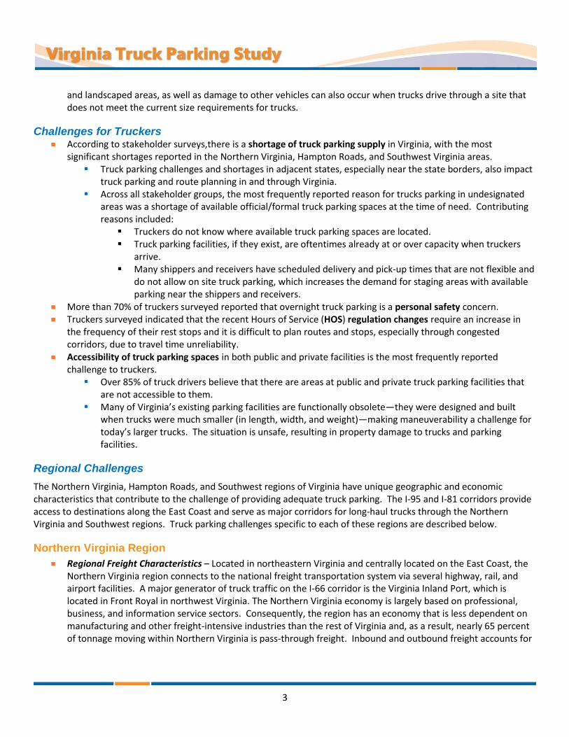
Challenges for Truckers
According to stakeholder surveys,there is a shortage of truck parking supply in Virginia, with the most significant shortages reported in the Northern Virginia, Hampton Roads, and Southwest Virginia areas.
Truck parking challenges and shortages in adjacent states, especially near the state borders, also impact truck parking and route planning in and through Virginia.
Across all stakeholder groups, the most frequently reported reason for trucks parking in undesignated areas was a shortage of available official/formal truck parking spaces at the time of need. Contributing reasons included:
Truckers do not know where available truck parking spaces are located. Truck parking facilities, if they exist, are oftentimes already at or over capacity when truckers
arrive. Many shippers and receivers have scheduled delivery and pick-up times that are not flexible and
do not allow on site truck parking, which increases the demand for staging areas with available parking near the shippers and receivers.
More than 70% of truckers surveyed reported that overnight truck parking is a personal safety concern.
Truckers surveyed indicated that the recent Hours of Service (HOS) regulation changes require an increase in the frequency of their rest stops and it is difficult to plan routes and stops, especially through congested corridors, due to travel time unreliability.
Accessibility of truck parking spaces in both public and private facilities is the most frequently reported challenge to truckers.
Over 85% of truck drivers believe that there are areas at public and private truck parking facilities that are not accessible to them.
Many of Virginia’s existing parking facilities are functionally obsolete—they were designed and built when trucks were much smaller (in length, width, and weight)—making maneuverability a challenge for today’s larger trucks. The situation is unsafe, resulting in property damage to trucks and parking facilities.
Regional Challenges
The Northern Virginia, Hampton Roads, and Southwest regions of Virginia have unique geographic and economic characteristics that contribute to the challenge of providing adequate truck parking. The I-95 and I-81 corridors provide access to destinations along the East Coast and serve as major corridors for long-haul trucks through the Northern Virginia and Southwest regions. Truck parking challenges specific to each of these regions are described below.
Northern Virginia Region
Regional Freight Characteristics – Located in northeastern Virginia and centrally located on the East Coast, the Northern Virginia region connects to the national freight transportation system via several highway, rail, and airport facilities. A major generator of truck traffic on the I-66 corridor is the Virginia Inland Port, which is located in Front Royal in northwest Virginia. The Northern Virginia economy is largely based on professional, business, and information service sectors. Consequently, the region has an economy that is less dependent on manufacturing and other freight-intensive industries than the rest of Virginia and, as a result, nearly 65 percent of tonnage moving within Northern Virginia is pass-through freight. Inbound and outbound freight accounts for

4
26 and 5 percent, respectively, of the total tonnage moving through the region. The remaining four percent is internal tonnage that moves from one part of the region to another.
Shortage of Truck Parking Spaces – Based on the estimated demand, there is a shortage of 1,069 truck parking spaces in the Northern Virginia region. This deficit is summarized in Table 1.
Table 1: Northern Virginia Region – Summary of Truck Parking Demand
Major Corridors within Region
Truck Parking Spaces (+) Surplus / (-) Deficit
I-95 (North of Richmond) -463
I-66 -542
US 29 (North of Charlottesville) -64
Net Demand = -1,069
Transportation Congestion – Historically, Northern Virginia has been the fastest growing region of the state and this growth is anticipated to continue and is expected to account for one third of Virginia’s net population gain by 2030. Much of the population growth is projected to occur along the I-66 corridor, which is expected to add the equivalent populations of Arlington and Washington, D.C. to the region1. Population growth translates to an increased demand on the transportation network. In the Northern Virginia region, many segments of the transportation network are currently stressed or over capacity to the point that they are identified as freight bottlenecks. Several segments of the major transportation routes (I-95, I-66, I-495, I-395, and US 17) in the Northern Virginia region are identified as roadway or rail bottlenecks.1 These bottlenecks prohibit the efficient flow of freight through the system and across the region. Traffic congestion and bottlenecks in the Northern Virginia area impacts truckers’ ability to efficiently pass through the region and effectively plan stops along routes to meet HOS regulations.
High Land Acquisition Costs – It is estimated that approximately one acre of land is required for every 10 to 15 truck parking spaces.2 Based on this assumption and an estimated deficit of 1,100 truck parking spaces in the Northern Virginia region, approximately 100 acres of land is needed to address the deficit. Ideal truck parking sites are those near interchanges. In the Northern Virginia region, these ideal locations are rarely available and when they are available, these locations command premium prices. Building large-scale, privately-owned truck parking facilities in this region may be considered cost prohibitive by developers due to the high land values and resulting return on investment.
Diverse Truck Parking Needs – Based on the regional freight characteristics, truck parking in the Northern Virginia region needs to accommodate both long-haul truck trips (typically defined as trips that cannot be completed within a single day, or 11 hours, under Federal Motor Carrier Safety Administration (FMCSA) regulations) and regional truck parking needs. The regional truck parking needs include the truck staging areas by major truck generators, such as rail terminals, warehouse districts, and distribution centers.
1 The Virginia Statewide Multimodal Freight Study (Final Report 2010)
2 North Jersey Truck Rest Stop Study, Gannett-Fleming (2008)

5
Hampton Roads Region
Regional Freight Characteristics – Located in southeastern Virginia at a central location on the East Coast and on the Chesapeake Bay, the Hampton Roads region is characterized by several international marine terminals. The Virginia Port Authority (VPA) operates four marine terminals: Norfolk International Terminals (NIT), Portsmouth Marine Terminal (PMT), Newport News Marine Terminal (NNMT), and the leased APM Terminal (APMT). Additional existing and future port facilities in the Hampton Roads region include the new privately-developed APM (Maersk) container terminal, the future Craney Island container terminal, privately-owned terminals handling coal and other commodities, and U.S. government facilities. The Hampton Roads region is also an important base for the US Navy and naval shipbuilding. Hampton Roads regularly ranks second or third among Atlantic Coast ports for container volumes, and is among the top 20 in the country for total tonnage. The large number of marine terminals generates inbound and outbound freight accounting for 52 and 30 percent of the total tonnage moving through the region, respectively. Pass-through freight accounts for eight percent of tonnage moving within the region3. The remaining ten percent is internal tonnage that moves from one part of the region to another.
Shortage of Truck Parking Spaces – Based on the estimated demand, there is a shortage of 671 truck parking spaces in the Hampton Roads region. This deficit is summarized in Table 2.
Table 2: Hampton Roads Region – Summary of Truck Parking Demand
Major Corridors within Region
Truck Parking Spaces (+) Surplus / (-) Deficit
I-64 (East of I-95) -562
US 460 (East of I-95) -46
US 58 (East of I-95) +31
US 17 (Tennessee State Line to I-95) -94
Net Demand = -671
Diverse Truck Parking Needs – Due to the impact of the marine terminals, there is a significant need for terminal truck staging and port-specific truck parking in the Hampton Roads region. In addition to parking near the marine terminals, parking for long-haul truck trips and regional truck trips are also needed. The parking needs in this region vary by corridor. I-64 and US 460 are more utilized for local Virginia trucking trips and less utilized in accommodating through trucks.3 US 460, US 58, and US 17 are secondary connections with a projected increase in truck traffic.
Southwest Virginia Region
Regional Freight Characteristics – The Southwest Virginia region serves as a major connection to the national freight system via several highways, rail, and airport facilities. Over 90 percent of tonnage moving within the Southwest Virginia region is pass-through freight. This is a significantly larger percentage than in the Northern Virginia and Hampton Roads regions and is due to the influence of I-81, which is a major national freight transportation corridor that traverses the state and is part of the national freight transportation corridor. The
3 The Virginia Statewide Multimodal Freight Study (Final Report 2010)

6
Virginia Freight Study noted the highest Average Annual Daily Truck Traffic (AADTT) on I-81 in 2005 exceeded 10,000 trucks per day. I-81 has the highest average truck percentages in the state at 27 percent of all traffic. This reflects a combination of both high truck volumes and low passenger car traffic. Local trucking facilities, such as warehouses and distribution centers, are also prevalent in this region due to affordable real estate prices and access to a strong workforce.
Shortage of Truck Parking Spaces – Based on the estimated demand, there is a shortage of 1,034 truck parking spaces in the Southwest Virginia region. This deficit is summarized in Table 3.
Table 3: Southwest Region – Summary of Truck Parking Demand
Major Corridors within Region
Truck Parking Spaces (+) Surplus / (-) Deficit
I-81 (Tennessee State Line to I-64) -692
US 11 (Tennessee State Line to I-64) -32
US 58 (West Virginia State Line to US 29) -9
US 220 (Tennessee State Line to I-81) -111
US 460 (West Virginia State Line to I-95) -190
Net Demand = -1,034
Diverse Truck Parking Needs – Due to the heavy through truck trips on the I-81 corridor, there is a significant need for long-haul truck parking along this corridor. In addition, parking for local truck trips is also needed. Corridors that primarily serve local truck trips rather than through trucks include US 460 and US 58 and parking for local truck trips should be focused along these corridors.
Geographic Characteristics – The mountainous and rolling terrain of the Southwest Virginia region provides challenges to identifying suitable locations for constructing new truck parking facilities and when expanding existing parking facilities. These terrain challenges can substantially impact project costs.
Recommendations To support VDOT’s mission to provide a safe and secure transportation system, the department strives to identify, prioritize, and implement safety improvements to reduce severe crashes and fatalities. To mitigate the safety risks associated with trucks parking on mainline and ramp shoulders, the instances of occurance must be reduced or eliminated. Given the HOS requirements and the existing truck parking inventory, increasing the supply of truck parking spaces in appropriate areas will have a significant impact in mitigating truck parking in undesirable locations. The following recommendations have been developed to guide VDOT in pursuit of this objective.
Recommendation 1 - Partner with private industry and local governments to increase capacity and related improvements.
VDOT should identify and prioritize truck parking improvements in congested areas, specifically in the regions identified in this study with high truck parking supply deficits, and collaborate with stakeholders to establish additional truck parking spaces.
VDOT should partner with the private sector and localities to identify opportunities to expand existing truck parking facilities or develop new truck parking facilities by:

7
Examining the possibilities of creating special incentives for the private sector to develop truck parking facilities
Creating tax abatements or low-cost loans for new or expanded truck parking facilities along the high-demand and low-supply corridors identified in this report
VDOT should encourage counties and municipalities, through outreach and training, to recognize that truck parking is a necessary part of transportation infrastructure.
VDOT should identify additional funding incentives and bonding that could prompt development activity.
VDOT should collaborate with local officials with coordination from shippers and receivers around the Commonwealth, especially in the Washington, D.C. and Hampton Roads metro areas, to identify opportunities in providing staging areas for truck parking, so truckers can meet HOS requirements in these congested areas.
VDOT should inform the private truck stop owners of the results of this study so they are aware of the magnitude and locations of the truck parking supply shortages in Virginia.
VDOT should encourage private truck stop owners to provide or increase on-site security and improve site and parking space accessibility.
VDOT should create a multi-disciplinary task force to assess and develop solutions for existing and future truck parking challenges.
Potential Task Force participants should include VDOT, Virginia State Police, truck stop owners (NATSO), trucker advocacy groups such as VTA and OOIDA, and other industry stakeholders. As part of the Task Force, VDOT should hold a workshop to review the findings from this study and collectively develop implementable strategies and action items.
VDOT should work with neighboring states, the I-95 Corridor Coalition, and the I-81 Corridor Coalition to develop regional truck parking solutions.
VDOT should develop a new Informational and Instructional Memoranda (I&IM) that would focus on truck accessibility when planning for and/or designing roadway facilities, such as ramps, shoulders, or truck parking areas.
Recommendation 2 - Provide accurate and real-time information about truck parking supply and availability in Virginia.
VDOT should maintain a database of available truck parking spaces statewide and make this information available to the public in digital and/or hard copy formats. VDOT should consider posting hard copy (printed) maps of truck parking facilities in Virginia at the following locations:
VDOT rest areas and welcome centers Weigh stations Ports facilities (public and private) Private commercial truck stop facilities State Police Division offices Rest areas and truck stops in adjacent states
VDOT should explore the feasibility of using the 511 webpage and interactive voice response (IVR) technology in partnership with the truck stop owners to relay truck parking and truck stop information to truckers. The 511 webpage and IVR could be regularly updated to provide real-time information for truckers consisting of:
Location of nearby truck stops Available resources at the facilities Number of available spaces at each facility
VDOT should monitor the efforts of the I-95 Corridor Coalition as it pertains to the pilot truck parking information system that was recently deployed at the northbound I-95 rest area in Caroline County. If this pilot

8
project is determined to be successful, VDOT should identify opportunities for deployment of this technology in other areas of the state.
Recommendation 3 - Improve the safety, effectiveness, and supply of truck parking spaces at State-owned facilities.
VDOT should investigate the potential for using park & ride lots or weigh stations to allow overnight truck parking by studying the demand, safety, and other impacts it may have on normal commuter operations and facility maintenance.
VDOT should investigate the use of abandoned construction staging areas on interstate facilities—designated areas where vehicles, supplies, and construction equipment are positioned for access and use while construction is underway—for use as truck parking areas.
VDOT should convert unused state-owned facilities, such as the closed rest areas on I-64 west of Richmond in Louisa County or closed-down residencies, to truck-only parking facilities to increase supply.
VDOT should restripe the existing truck parking spaces and drive aisles within the rest areas and welcome centers to accommodate current vehicle fleet sizes. This change will help reduce the risk of property damage and vehicular damage resulting from navigating a parking area with poor accessibility.
Note: While this recommendation can help reduce damage to vehicles and state property, this action will reduce available VDOT truck parking supply.
VDOT should expand existing Safety Rest Areas to increase parking capacity and to address problems associated with functional obsolescence, so that trucks can maneuver safely on these facilities.
VDOT should prioritize the expansion of facilities over construction of new facilities and focus efforts in the regions and corridors with the greatest need first.
VDOT should explore the feasibility of installing security cameras at VDOT rest areas to deter illegal activity from occurring and to provide a sense of security to all patrons, including truck drivers.
VDOT should continue to work collaboratively with the Virginia State Police to increase police presence in VDOT rest areas and welcome centers.
VDOT should partner with the Virginia State Police to prohibit recreational vehicles and single-unit trucks from parking in designated truck-only areas.
To support VDOT’s overall mission to provide a safe and secure transportation system, the department strives to identify, prioritize and implement safety improvements aimed at reducing crashes and deaths. The recommendations provided herein are intended to help mitigate safety risks associated with trucks parking on mainline and ramp shoulders. Of all the recommendations, increasing the supply of truck parking spaces will have the most significant impact in achieving this goal.

9
BACKGROUND The commercial trucking industry in the continental United States is comprised of thousands of freight motor carriers, with millions of drivers moving goods locally or on long hauls between cities. Movement of goods through and around the Commonwealth is vital to Virginia’s economy. The Virginia Department of Transportation (VDOT) serves to provide a safe road network for all users. The demands placed on truck drivers, such as driving long hours, often at night, and maneuvering on congested routes, can sometimes lead to driver fatigue and may increase safety risks.
Motor carriers cannot always find parking spaces at rest areas or commercial truck stops, and often choose to park on shoulders of roadway mainlines and ramps or other undesignated locations, increasing the risk of crashes and accelerating the deterioration of the pavement on shoulders. Therefore, one of the action items in the 2013 VDOT Business Plan stated VDOT would “launch a truck parking study to identify areas where commercial truck parking is needed along 14 Corridors of Statewide Significance (CoSS) to provide safe places for truckers to rest so they do not impede traffic by parking on entrance and exit ramps.”
This truck parking study was conducted between September 2013 and June 2014. It provides VDOT with current information to address truck parking challenges statewide.
The primary purpose of this study was to identify the frequency of trucks parking on ramps near interchanges, rest areas, and welcome centers on the CoSS; and to determine where truck parking is needed. Starting with the latest interstate truck parking research in Virginia from a 2014 study conducted by the Virginia Center for Transportation and Innovation Research (VCTIR) , this study documents the supply of truck parking spaces throughout the state, including public and private facilities, and estimates truck parking demand for each CoSS using a methodology established by Federal Highway Administration (FHWA) in 2002.
The study team consisted of personnel from VDOT, various stakeholders and consultants. Feedback from a number of key stakeholders, both from within and outside of VDOT, helped to guide the study process and to identify key challenges related to truck parking safety in Virginia. These key stakeholders included representatives from the Virginia Trucking Association (VTA), Federal Motor Carrier Safety Association (FMCSA), FHWA, Owner Operator Independent Drivers Association (OOIDA), truck stop operators/owners, truck drivers in Virginia, Virginia State Police, VDOT residencies, and staff from the VDOT Rest Area and Welcome Center Program. Stakeholders were a primary source of information for this study to ensure the interests of the trucking industry were considered during data collection and development of recommendations. The results of this study complement the ongoing regional, multistate and national efforts on addressing truck parking capacity and safety.
10
LITERATURE REVIEW
National Perspective on Truck Parking The five studies described below provide a national perspective on truck parking challenges along with various proposed strategies to address these challenges.
Study of Adequacy of Commercial Truck Parking Facilities Federal Highway Administration (FHWA) – March 2002
This report documents the findings of an FHWA study that investigated commercial truck parking facilities serving the National Highway System (NHS). This study was conducted in response to Section 4027 of the Transportation Equity Act for the 21st Century (TEA-21). A comprehensive assessment of the adequacy of truck parking capacity was performed based on a national inventory of truck parking spaces and truck parking demand models. This study documented that the demand for truck parking spaces exceeded the available supply and that projected increases in vehicle miles driven by trucks would worsen the problem.
Key conclusions on truck parking from this study included the following:
Nearly half of the surveyed truck operators reported that available parking spaces at public rest areas are rare.
Commercial vehicle (CMV) operators preferred commercial truck stops and travel plazas for activities that required them to park their vehicles, but preferred public rest areas when stopping for a short nap.
Public rest area parking spaces accommodated 23 percent of the truck parking supply while 77 percent of the supply was accommodated by commercial truck stops and travel plaza parking.
The estimated truck parking demand at public facilities far outweighed the supply, while the private commercial facility truck parking supply seemed sufficient to meet estimated demand.
Thirty-five states had a shortage of truck parking spaces at public facilities, while only eight states had a shortage at private commercial facilities.
It was shown that truck parking shortages at public rest areas would continue to worsen, but a surplus of truck parking spaces would be created at privately-owned truck stops.
Report recommendations for addressing existing and future truck parking deficiencies were categorized according to the following list. These categories of recommendations were also found in several of the other studies documented as part of this literature review.

11
Educate and/or inform drivers about available spaces
Expand and/or improve private truck stops and travel plazas
Encourage the formation of public-private partnerships
Expand and/or improve public rest areas
Change parking enforcement rules
Conduct additional truck parking studies
At the time of this study, plans to increase the supply of truck parking were approved in 15 states and were under consideration in an additional 22 states. Furthermore, 16 states planned to improve the availability and utilization of truck parking facilities using Intelligent Transportation System (ITS) technology.
The methodology and equations created in this study to estimate truck parking demand were applied by the Virginia Truck Parking Study team to compute truck parking demand in Virginia. The section of this report titled Calculating Demand on Study Corridors provides more details on the methodology and demand equations.
Synthesis 317 – Dealing with Truck Parking Demands National Cooperative Highway Research Program (NCHRP) – 2003
The goal of this report was to identify successful and innovative strategies to manage truck parking demand. Data was gathered through a survey distributed to highway engineers in all 50 states. Table 4 illustrates a supply shortfall of more than 100% in public parking spaces, while at the same time, the private parking supply showed a surplus at the national level.
Table 4: Summary of National Truck Parking Supply and Demand
Roadway System
Daily Parking Demand Parking Supply
Public Private Total Public Private Total
Interstate 56,000 189,000 245,000 28,000 254,000 282,000
Other 10,000 32,000 42,000 3,000 24,000 27,000
Total 66,000 221,000 287,000 31,000 278,000 309,000
At the time of this study, Virginia was estimated to have a total of 39 public facilities with 820 parking spaces and 15 private facilities with 7,445 parking spaces. As summarized in Table 5, the study showed a shortage in the number of available public truck parking spaces in Virginia and a surplus in private truck parking spaces; however, a sufficient number of parking spaces were available during peak demands on the overall system. The study concluded that a number of states were experiencing significant shortages in truck parking supply.

12
Table 5: Demand/Supply Ratio along Interstate and NHS Routes* in Virginia
Facility Demand/Supply Ratio Category
Public 2.16 Shortage
Private 0.80 Surplus
Total 0.93 Sufficient
*NHS route carrying more than 1,000 trucks per day
Demand/Supply Ratio Parking Space Utilization Less than 0.9 Surplus = Available parking spaces is likely to exceed peak demand
0.9 to 1.1 Sufficient = Peak demand and supply of parking spaces are nearly the same More than 1.1 Shortage = Overcrowding is likely
Commercial Motor Vehicle Parking Shortage Federal Highway Administration (FHWA) – 2012
This study, which was conducted in 2012, referenced the Study of Adequacy of Commercial Truck Parking Facilities to provide background on the truck parking issue at the national level. Two unique points documented in this study included: 1) background information on SAFETEA-LU Section 1305, and 2) observations from the safety enforcement community.
SAFETEA-LU Section 1305
Section 1305 of SAFETEA-LU established a pilot program to address the shortage of long-term parking for commercial motor vehicles on the National Highway System (NHS). The program was initially funded with over $30 million between 2005 through 2012. ITS projects typically were funded since they were the most cost-effective projects. Some construction projects that increased the number of truck parking spaces also were funded. Thirty-six states and one corridor coalition requested funding for more than $231 million between 2006 and 2012; this was approximately eight times the amount of available program funds (Table 6). This funding shortage further substantiates the fact that truck parking supply is a nationwide issue.
Observations from Safety Enforcement Community
This study documented the fact that truck parking shortages are a safety concern. As reported in Study of Adequacy of Commercial Truck Parking Facilities, “an inadequate supply of truck parking spaces can result in two negative consequences: (1) tired truck drivers may continue to drive because they have difficulty finding a place to park for rest, and (2) truck drivers may choose to park at unsafe locations, such as the shoulder of the road and exit ramps, if they are unable to find available parking.”
HOS regulations during 2011 required a driver to take 10 consecutive hours off duty after driving a maximum of 11 hours. Table 7 summarizes the 2011 HOS violations, truck parking violations, and the percentage of illegally parked truck
Table 6: SAFETEA-LU Section 1305 Grant Requests
(2006-2012)
State/Agency Amount Requested
I-95 Corridor Coalition $10,500,000
Virginia $3,085,591
Other 35 States $217,812,289
Total $231,397,880
13
drivers who reported they could not find a parking space and were about to exceed their HOS. This data was provided by the Commercial Vehicle Safety Alliance (CVSA), who obtained it from a cross-section of state law enforcement officials. Previous studies noted that the lack of available parking results in truckers parking illegally, which is corroborated by the information in Table 7.
Table 7: 2011 Commercial Motor Vehicle Violations in Select States
State
2011 Illegally Parked Drivers Who Could Not Find a Parking Space
and Were Out of HOS HOS Violations
Truck Parking Violations
Colorado 3,048 0 No Data
Idaho 2,506 39 25%
Kentucky 2,078 19 No Data
Maine 8,790 12 2%
Minnesota 4,173 30 <5%
Missouri 15,798 No data No Data
Montana 10,524 0 3%
Nebraska 4,750 342 73%
New Jersey 4,261 No data No Data
Virginia 14,826 140 No Data
Wisconsin 621 90 5%
Total 70,754 672
Source: Commercial Vehicle Safety Alliance (CVSA)
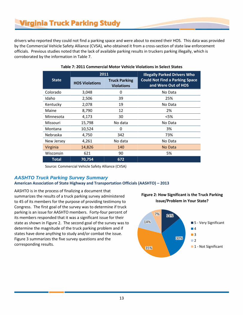
AASHTO Truck Parking Survey Summary American Association of State Highway and Transportation Officials (AASHTO) – 2013
AASHTO is in the process of finalizing a document that summarizes the results of a truck parking survey administered to 45 of its members for the purpose of providing testimony to Congress. The first goal of the survey was to determine if truck parking is an issue for AASHTO members. Forty-four percent of its members responded that it was a significant issue for their state as shown in Figure 2. The second goal of the survey was to determine the magnitude of the truck parking problem and if states have done anything to study and/or combat the issue. Figure 3 summarizes the five survey questions and the corresponding results.
Figure 2: How Significant is the Truck Parking
Issue/Problem in Your State?
14%
30%
35%
14%
7%
5 - Very Significant
4
3
2
1 - Not Significant

14
Figure 3: AASHTO Truck Parking Survey Results
Survey Question 1 indicates that at least half of the states have assessed the extent of truck parking challenges in their state, while Question 2 suggests most states have not completed a detailed analysis of the challenges they face.
The responses to Questions 3 through 5 and the additional comments accompanying the survey described specific efforts states have taken over the years to address truck parking. These results show that a large percentage of the DOTs are in some stage of addressing truck parking challenges in their state.
Intelligent Transportation Systems and Truck Parking US Department of Transportation (US DOT), Volpe National Transportation Systems Center – 2005
Similar to the results documented in other studies, this study confirms there is a shortage in truck parking based on a literature review. This study proposes the three strategies, shown in Table 8, to reduce the truck parking shortage. This study documents the challenges associated with making underutilized spaces more attractive and increasing the supply of spaces. The study also suggests that finding technology that more effectively matches demand with available supply is the most cost-effective approach.
“…… across all of these issues, the paramount concern in all of the
actions taken by the states has been
safety.”
Source: 2013 AASHTO Truck Parking Survey Summary
Question 1 Has your DOT done a study or analysis of trucking parking
need and availability (public and private)?
Question 2 Has your DOT analyzed truck parking availability and geographic distribution (public and private) in light of
just-in-time delivery demands, Hours of Service requirements, and patterns of highway freight movement?
Question 3 Has your state taken action to increase truck parking
(public and private)?
Question 4 Has your state taken steps to improve information
available to truckers concerning available truck parking?
Question 5 Is your state working with trucking companies and/or
private truck stop operators to increase truck parking or improve information regarding parking?

15
Table 8: Strategies to Reduce the Truck Parking Shortage
Strategy Make underutilized spaces
more attractive Increase the supply
of spaces Better match supply
and demand
Example Recommendations
Better lighting to reduce crime
Improvements to parking layouts
Construction Using weigh stations Using park and ride lots Relaxing time limits
Technologies that provide up-to-the-minute information on parking availability
Feasibility of Implementation
May not be sufficient areas where truckers are unable to find a truck stop with available space
Capital intensive May be resisted by local
residents, particularly in metropolitan areas where land prices are high
Most practical and cost-effective
This report expands on this strategy by defining the three major components to establishing a real-time parking information system and describes various technology options available to implementing the systems, which are summarized in Table 9.
Table 9: Components of a Real-Time Parking Information Systems and Technology Options
Parking Data Collection
Conversion of Raw Data to Parking Availability Information
Information Dissemination
Inductive loops Magnetometers Ultrasonic sensors Infrared sensors Video detection
Furnish information to the driver just before the entry to the rest area or truck stop
Furnish information on the number of spaces occupied and the number of spaces available
Provide a forecast of space availability, based on historical information
Allow drivers to send an inquiry/request for parking to the parking management system, and incorporate this request along with requests from other drivers into the forecasts
Variable message signs Traveler information radio Citizens band (CB) radio Cellular telephone 511 trucker information On-board computers
Although this study indicates that technologies providing availability information have the best return on investment out of the three main strategies, it is opinion of this study team that the impact of this technology to improve utilization is neutralized when parking supply is severely inadequate—as it generally is in Virginia.
16
Virginia Perspective on Truck Parking The studies described in this section of the report summarize the state of truck parking in Virginia based on research conducted in the early to mid-2000s.
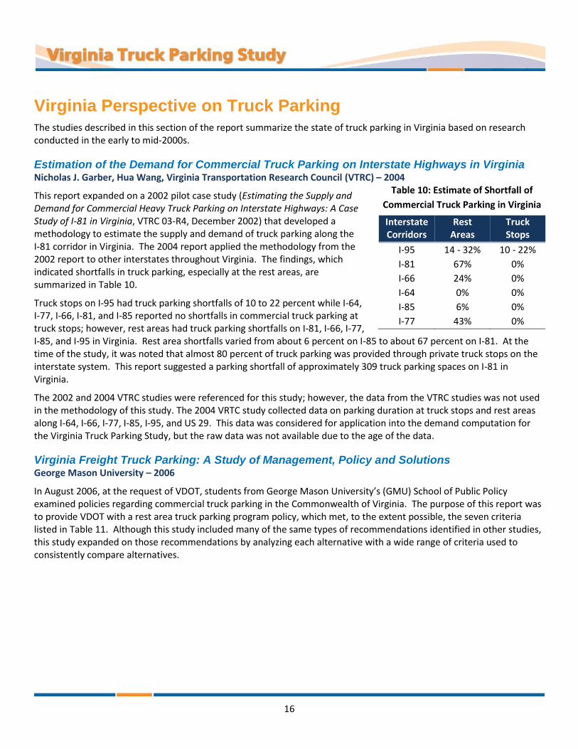
Estimation of the Demand for Commercial Truck Parking on Interstate Highways in Virginia Nicholas J. Garber, Hua Wang, Virginia Transportation Research Council (VTRC) – 2004
This report expanded on a 2002 pilot case study (Estimating the Supply and Demand for Commercial Heavy Truck Parking on Interstate Highways: A Case Study of I-81 in Virginia, VTRC 03-R4, December 2002) that developed a methodology to estimate the supply and demand of truck parking along the I-81 corridor in Virginia. The 2004 report applied the methodology from the 2002 report to other interstates throughout Virginia. The findings, which indicated shortfalls in truck parking, especially at the rest areas, are summarized in Table 10.
Truck stops on I-95 had truck parking shortfalls of 10 to 22 percent while I-64, I-77, I-66, I-81, and I-85 reported no shortfalls in commercial truck parking at truck stops; however, rest areas had truck parking shortfalls on I-81, I-66, I-77, I-85, and I-95 in Virginia. Rest area shortfalls varied from about 6 percent on I-85 to about 67 percent on I-81. At the time of the study, it was noted that almost 80 percent of truck parking was provided through private truck stops on the interstate system. This report suggested a parking shortfall of approximately 309 truck parking spaces on I-81 in Virginia.
The 2002 and 2004 VTRC studies were referenced for this study; however, the data from the VTRC studies was not used in the methodology of this study. The 2004 VRTC study collected data on parking duration at truck stops and rest areas along I-64, I-66, I-77, I-85, I-95, and US 29. This data was considered for application into the demand computation for the Virginia Truck Parking Study, but the raw data was not available due to the age of the data.
Virginia Freight Truck Parking: A Study of Management, Policy and Solutions George Mason University – 2006
In August 2006, at the request of VDOT, students from George Mason University’s (GMU) School of Public Policy examined policies regarding commercial truck parking in the Commonwealth of Virginia. The purpose of this report was to provide VDOT with a rest area truck parking program policy, which met, to the extent possible, the seven criteria listed in Table 11. Although this study included many of the same types of recommendations identified in other studies, this study expanded on those recommendations by analyzing each alternative with a wide range of criteria used to consistently compare alternatives.
Table 10: Estimate of Shortfall of
Commercial Truck Parking in Virginia
Interstate Corridors
Rest Areas
Truck Stops
I-95 14 - 32% 10 - 22%
I-81 67% 0%
I-66 24% 0%
I-64 0% 0%
I-85 6% 0%
I-77 43% 0%

17
Table 11: Summary of Alternatives Analysis Based on Study Criteria
Alternatives
Is Criteria Met?
Co
nsi
ste
nt
wit
h F
eder
al
Po
licy
Eco
no
mic
s &
C
ost
s
Tech
no
logi
cal
Feas
ibili
ty
Equ
itab
le
Enfo
rcea
ble
Safe
ty
Co
mm
un
ity
Imp
acts
No Action No Maybe Yes Maybe Yes No Yes
Improvement of Existing Rest Areas
Re-Design & Layout of Rest Area
Yes Yes Yes Yes Maybe Yes No
ITS Yes Yes Maybe Yes Yes Maybe No
Utilization of Other
Infrastructure
Use of Highway Access Ramps
Maybe Yes Yes Yes Yes No No
Use of Weigh Stations
Yes Yes Yes Yes Yes Yes No
Private-Public Partnerships
Yes Maybe Maybe Yes Yes Yes Yes
Expanding Capacity
New Rest Areas Yes No Yes Yes Yes Yes Maybe
Existing Rest Areas Yes Yes Yes Yes Yes Yes Maybe
VDOT Safety Rest Area and Welcome Center Master Plan Virginia Department of Transportation (VDOT) – 2009
The VDOT Safety Rest Area and Welcome Center Master Plan is a long-range master plan for Virginia’s rest areas and welcome centers. The Master Plan provides recommendations to guide VDOT in making strategic business decisions to improve Virginia’s rest areas and welcome centers to meet existing (2006) conditions and projected 20-year horizon (2026) visitor demand.
As part of the Master Plan efforts, a detailed review of each facility was completed. Data collected during the reviews included rest area parking supply, adjacent mainline traffic volume, mainline crash data, observations of existing site conditions and constraints, vehicle dwell time and traffic data at select sites, and interchange inventories of commercial facilities open 24 hours a day, seven days a week along select highway corridors.
The Master Plan estimated existing and projected parking demand along each interstate corridor and at each facility using AASHTO guidelines. Furthermore, a gap analysis was performed using the AASHTO guidelines to evaluate the adequacy of the spacing of Virginia’s rest areas and welcome centers. Based on the analysis, recommendations were developed to fill critical gaps and meet projected corridor parking needs. Recommendations included constructing new facilities on new locations, constructing new facilities on existing locations, reconstructing existing facilities, and expanding parking at existing facilities. In addition, the Master Plan recommendations were prioritized as High (0-3 year implementation), Medium (3-10 year implementation), and Low (10-20 year implementation). Table 12 provides a summary of the Master Plan recommendations related to truck parking as well as the priority of each recommendation.

18
Table 12: Summary of Master Plan Truck Parking Recommendations
Site Name Interstate
Facility Mile
Marker Additional Truck Parking Spaces
Priority
New Facility Construction on New Location
Carson* I-95 Southbound - 20 High
Fairfield* I-81 Northbound - 35 High
New Facility Construction on Existing Location
Louisa* I-64 Westbound 145 20 High
Fauquier I-66 Westbound 16 30 High
Longdale Furnace (Trucks) I-64 Eastbound 34 10 Medium
Longdale Furnace (Trucks) I-64 Westbound 34 10 Medium
Existing Facility Reconstruction
Goochland I-64 Eastbound 169 25 High
Ladysmith I-95 Northbound 107 20 High
Ladysmith I-95 Southbound 107 100 High
Existing Facility Parking Expansion
New Kent I-64 Westbound 213 10 Low
Lambsburg I-77 Northbound 1 20 High
Smyth I-81 Southbound 53 9 High
Radford I-81 Southbound 108 15 High
Fairfield I-81 Southbound 199 40 High
Mt Sidney I-81 Northbound 232 20 High
Mt Sidney I-81 Southbound 232 40 High
Dale City (Trucks) I-95 Northbound 154 0 High
Dale City (Trucks) I-95 Southbound 154 0 High
*Proposed Site Name
The VDOT rest area and welcome centers are Virginia’s supply of public truck parking facilities. The Master Plan reflects the planning efforts to date on Virginia’s public truck parking. This study used the truck parking inventory data from the Master Plan for analysis; however, the analysis methodology differs from the methodology used in the Master Plan. In this study the FHWA demand equation is used rather than the AASHTO guidelines. In addition to the parking inventory, the Master Plan recommendations were also considered when developing recommendations for this study.
Virginia Statewide Multimodal Freight Study Virginia Department of Transportation (VDOT) – 2010
The purpose of the Statewide Multimodal Freight Study was to examine the freight issues in Virginia on both a statewide and regional/corridor level and identify critical needs and recommendations. All modes of freight transport (truck, rail, air, and water) as well as the interaction between different modes of transport were considered in this study. The Freight Study was conducted in two phases. Phase I focused on collecting data and an inventory of conditions and need. In Phase II, freight policy and infrastructure recommendations were developed. The study looked at freight on both a statewide and a corridor/subregion level. The study identified projects that are most important to freight movement in

19
Virginia. These projects included programmed near-term projects, potential longer-term projects, and potential freight strategies.
In Phase I, the following were identified as some of the critical issues for truck freight on Virginia’s roads today:
Capacity, congestion, speed, and reliability, especially on critical corridors and in urban areas
Safety and emergency response
Truck rest areas
Advanced two-way information systems
Mode-shift strategies
Time-shift strategies
Funding
In addition, this study found the freight tonnage moving into, out of, and within Virginia is expected to roughly double by 2035. This increase in freight tonnage along with growing urban congestion will further intensify these critical issues.
In Phase II potential freight strategies were identified. These strategies were considered during the development of recommendations for this study. Some of the freight strategies related to trucks in the Statewide Multimodal Freight Study included the following:
Software portals to improve coordination with the trucking industry, allow the Commonwealth to identify and respond to issues on established truck routes, and increase overall trucking efficiency
Real-time “5-1-1” Information System for Trucks and Freight Shippers that could include information on incidents, delays, work zones activities, routing recommendations, and availability of space at rest areas
Support the development of dedicated highway lanes for trucks
Increased focus on freight transportation and land use coordination to identify existing and designated freight facilities, freight land use clusters, and truck routings in state transportation plans, and encourage local and regional plans to be consistent
Organizational strategies such as staff-level policy and planning positions serving the modal agencies to increase the responsiveness and collaboration to effectively address freight transportation needs within the Commonwealth’s Long-Range Transportation Planning process
Identify new funding sources and strategies that could include highway tolling, increased motor fuel tax, and improved Federal grant and loan utilization
In addition to identifying strategies, during Phase II, profiles were created for 11 multimodal freight corridors and 4 subregions in Virginia. The profiles included information on the geography, economic structure, commodity flows, transportation facilities, and recommendations to improve the flow of freight in the corridors and subregions. Information from these profiles were used in the regional and corridor challenges portion of this study.
Studies Completed by Other States The studies summarized below provide insight to how New Jersey, Pennsylvania, Tennessee, and Maryland have approached truck parking challenges. The literature review did not reveal truck parking studies in other neighboring states, including West Virginia, Kentucky, or North Carolina.

20
North New Jersey Truck Stop Study Gannett-Fleming – 2008
The North Jersey Transportation Planning Authority undertook this study to determine the adequacy of available truck parking in the region and identify solutions to providing additional parking facilities to meet demand. As part of this study, a database of regional truck stops was developed. The database included information on the facility ranging from parking capacity to vehicle size limits and amenities provided. A survey of the trucking industry was also undertaken to ascertain the challenges from the driver’s perspective and the industry’s perspective. From these tasks and identifying the demand using the 2002 FHWA methodology, the report identified a number of recommendations for further consideration.
The truck driver surveys were used to determine parking needs, habits, and any challenges. The results provided a general understanding of what was important to drivers pertaining to parking. Interestingly, drivers indicated that they only required basic services: a restroom, trash containers, and food. Other services, such as fuel and sleeping facilities, were required, but less often. Drivers surveyed also indicated that they had difficulty finding designated parking due to capacity constraints at existing facilities—either not enough parking or none available at the preferred location. The majority of the drivers surveyed identified that they preferred parking locations to be within 3 miles of the highway system. If the facility is more than 5 miles, patronage would significantly decline. Other common themes that were identified in the surveys of drivers and industry included:
Truck stops should be simple, safe, and clean
There is little need for excessive amenities
More and larger spaces are need at existing truck stops
Parking on shoulders is not safe for drivers or the traveling public, but they are utilized out of necessity
Since carriers are regional or national, trucking problems identified are not limited to New Jersey
Based on the results of the survey, demand models, and the availability of facilities, the study made several recommendations including policy and institutional, planning and finance, partnering, and recommended new or expanded sites. The study also identified sites with potential for expansion or new development, including the proposed layouts for these developments.
Truck Parking in Pennsylvania Pennsylvania State Transportation Advisory Committee – 2007
This study investigated truck parking challenges and trends facing Pennsylvania, identified regions in the state where parking demand was the highest, and developed options for parking providers, drivers, and decision makers. Pennsylvania undertook the study using a three-step approach, which involved a review of the current practice, interviews with other states and trucking interests, and data collection on truck parking practices throughout the state.
Truck traffic in Pennsylvania was expected to increase rapidly on some of its highways with freight models projecting up to 50 percent increases, or more, on the major truck routes by 2030. The study recognized that truck parking is not just a function of the number of trucks, but also a function of the HOS requirements for drivers. The time drivers are allowed to be behind the wheel, the levels of congestion, and increased travel times all significantly impact the distance the driver can cover, the route to be taken, and where the driver must rest.
The study incorporated one-time surveys to document the locations of where trucks were parked on the shoulders and ramps of Pennsylvania’s core highway system. The results found that almost 1,100 trucks were parked on ramps and shoulders during the overnight hours. Figure 4 shows the results of the study inventory of truck parking on ramps throughout the state. To better understand truck parking demand, the study also documented parking activity during a 24-hour period at the three predominant types of truck parking facilities (rest areas, Turnpike Service Plazas, and private

21
truck stops) in the state. The results indicated that all three facility types had similar parking characteristics. Those drivers who parked less than three hours constituted the greatest amount of activity throughout the day. The study also found that demand for parking increased during the overnight hours, with the peak accumulation occurring between 3 a.m. and 4 a.m. Figure 5 shows the 24-hour parking accumulation profile.
Figure 4: Pennsylvania Shoulder and Interchange Truck Parking
Source: Truck Parking in Pennsylvania, Pennsylvania State Transportation Advisory Committee, December 2007
The study developed a 12-point strategy to address the truck parking challenges in the state. The 12 points were further categorized as: Partnering, Policy, Planning and Finance, and Technology and Design.
Partnering
Advance Technical Advisory Committee study recommendations by forming a public-private task force
Collaborate with neighboring states to forge regional solutions
Explore opportunities for expanding truck parking capacity and local economic development through dual-use facilities, brownfield reuse, and provision of parking at truck-oriented developments

22
Figure 5: Pennsylvania 24-Hour Truck Parking Accumulation Profile
Source: Truck Parking in Pennsylvania, Pennsylvania State Transportation Advisory Committee, December 2007
Policy
Remove obstacles to public-private partnering for truck parking facilities and driver services
Develop truck parking policy through the National Governors Association and AASHTO for the reauthorization of federal transportation legislation emphasizing partnership, innovative finance, and new funding programs
Planning and Finance
Explore all funding opportunities, particularly for innovative pilot projects
Address truck parking through established statewide planning and programming processes
Reevaluate approaches for accommodating the growing truck parking demand on toll facilities, particularly the Pennsylvania Turnpike mainline
Establish appropriate performance monitoring to track progress
Technology and Design
Develop complementary ITS applications that support more efficient operations and truck parking
Evaluate new truck parking design concepts to provide improved access to services, more parking at existing sites, and improved circulation
Integrate technologies and design principles into truck parking facilities to mitigate environmental impacts
23
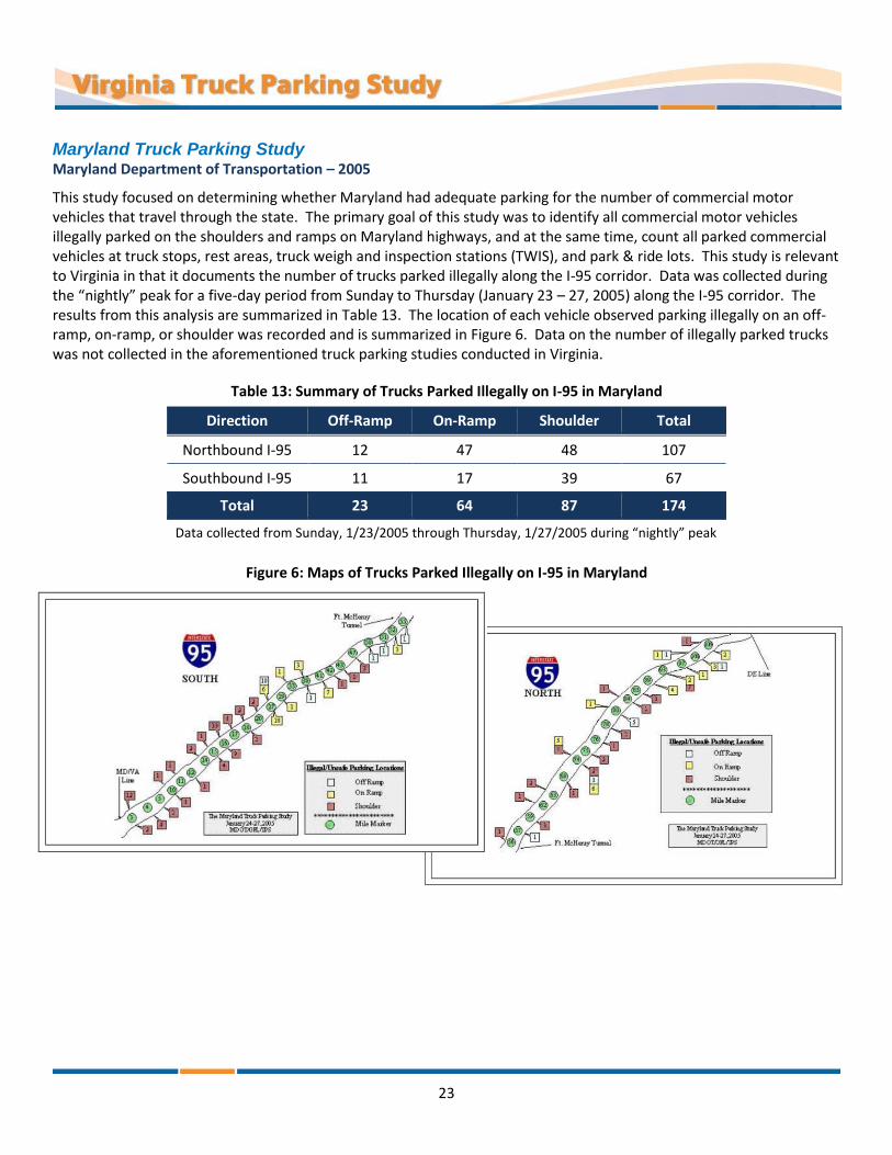
Maryland Truck Parking Study Maryland Department of Transportation – 2005
This study focused on determining whether Maryland had adequate parking for the number of commercial motor vehicles that travel through the state. The primary goal of this study was to identify all commercial motor vehicles illegally parked on the shoulders and ramps on Maryland highways, and at the same time, count all parked commercial vehicles at truck stops, rest areas, truck weigh and inspection stations (TWIS), and park & ride lots. This study is relevant to Virginia in that it documents the number of trucks parked illegally along the I-95 corridor. Data was collected during the “nightly” peak for a five-day period from Sunday to Thursday (January 23 – 27, 2005) along the I-95 corridor. The results from this analysis are summarized in Table 13. The location of each vehicle observed parking illegally on an off-ramp, on-ramp, or shoulder was recorded and is summarized in Figure 6. Data on the number of illegally parked trucks was not collected in the aforementioned truck parking studies conducted in Virginia.
Table 13: Summary of Trucks Parked Illegally on I-95 in Maryland
Direction Off-Ramp On-Ramp Shoulder Total
Northbound I-95 12 47 48 107
Southbound I-95 11 17 39 67
Total 23 64 87 174
Data collected from Sunday, 1/23/2005 through Thursday, 1/27/2005 during “nightly” peak
Figure 6: Maps of Trucks Parked Illegally on I-95 in Maryland

24
Maryland Truck Parking Partnership Study Gannett-Fleming – 2006
Based on the Baltimore Metropolitan Council (BMC) travel demand model, truck vehicle trips in the Baltimore region were projected to increase more than 30 percent over the next 25 years. The BMC Truck Parking Partnership Study focused on two specific areas within the Baltimore region known for truck parking in undesirable locations: I-83 in Hunt Valley and I-95 in Jessup. Similar to the conditions in other states, Maryland was faced with the following truck parking challenges along these corridors:
Implications for regional commercial and public safety
Driver compliance with federal HOS regulations
Enforcement dilemma of parked trucks versus tired drivers
Public perception that truck parking facilities are undesirable
No truck parking facilities on I-83
Truck parking on shoulders in Hunt Valley
Jessup TA Travel Center is over capacity
I-95 Savage rest areas are over capacity
This study provided a wide range of recommendations, many similar to those stated in previous studies; however, this study emphasized public-private partnerships and local problem solving as two key strategies to address truck parking challenges. The study recommended that the BMC and an Ad-Hoc Truck Parking Task Force organize their efforts broadly around these two guiding themes. Recommendations unique to this study included:
Advance a pilot/demonstration project with public and private partners
Issue a Request for Information (RFI) as a means of inviting and testing market-based solutions to rest area parking needs. In the process, promote partnership approaches among developers, businesses, commercial real estate agents, and others
Establish a basic performance monitoring and data collection protocol and process to regularly assess regional truck parking utilization
Incorporate truck parking improvements in project planning and design, including the on-going I-95 improvements
Identify “safe-haven” truck parking locations. This would allow law enforcement officials to direct illegally parked truck operators to designated parking locations to increase safety. As such, a safe haven initiative would have both law enforcement and parking capacity benefits. This recommendation should be an immediate priority for the ad hoc task force
Overnight Truck Parking along Tennessee’s Interstate Highways and Rest Areas Transportation Research Board (TRB) – 2000
This study conducted in Tennessee included a detailed survey of truck parking at night—between 10:00 p.m. and 6:00 a.m., for each day of the week—at public rest areas, at interchanges, and on shoulders. Similar to the Maryland truck study, the goal was to better understand occupancy characteristics of trucks. Table 14 summarizes the results of the survey and highlights the I-81 corridor through Tennessee. More than 50 percent of trucks were observed parking in unmarked pull-out areas, at interchanges, and on mainline shoulders throughout the state of Tennessee and 46 percent along the I-81 corridor. This large percentage established a trend of trucks parking outside of truck stops and rest areas.

25
Table 14: Summary of Trucks Parking at Night in Tennessee
Highway Segments
Rest Areas and Welcome Centers
Pull-Out Areas
Parked at Interchanges
Parked Along Mainline Shoulders
Total Parked
Designated Spaces
Parked Inside
Parked Along Ramps
Estimated Spaces
Parked Inside or
Along Ramps
I-81 from I-40 Split/Bristol 74 74 14 50 45 30 0 163
All Other Highway Segments
398 394 103 245 241 309 14 1,061
Total 472 468 117 295 286 339 14 1,224
Proportion 38.2% 9.6% 24.1% 27.7% 1.1%
The study also recorded the hourly distribution of automobile and truck traffic volumes at a location on I-40 near Knoxville, Tennessee. Key observations from this data included:
Typically more than 50 percent of trucks arriving at rest areas after 2 a.m. park on ramps
Of trucks parked inside a rest area, nearly 75 percent occupy a parking space for more than four hours. Of the trucks parked on the shoulder of a ramp, nearly 55 percent occupy the ramp for more than four hours

26
POLICY REVIEW A review of policies related to truck parking was performed for this study. The following sections summarize the federal and Virginia-specific truck parking related policies. Some of the parking policies in the following sections apply to all motor vehicles while others are specific to trucks.
Federal Truck Parking Related Policies
MAP-21
The Moving Ahead for Progress in the 21st Century Act (MAP-21), was signed into law on July 6, 2012 and provides over $105 billion dollars in funding for surface transportation programs in fiscal years 2013 and 2014. Sections of MAP-21 related to truck parking and freight policy are summarized in more detail in the following sections.
§1115 National Freight Policy
Section 1115 of MAP-21, establishes a policy to improve the performance of the national freight network. Some areas for improvement include congestion, safety, infrastructure conditions, use of advanced technology, accountability in the operation and maintenance of the network, and environmental impacts. Under Section 1115, states are required to:
Establish a national freight network to assist in prioritizing resources toward improved movement of freight on highways
Develop a national freight strategic plan and update the plan every five years
Develop tools to evaluate proposed transportation projects using a performance-based approach
Prepare a report every two years describing the condition and performance of the national freight network
§1401 Jason’s Law
In MAP-21, Congress has made it a national priority to address the shortage of long-term parking for trucks on the National Highway System (NHS). Section 1401 of MAP-21, Jason’s Law, extended the eligibility of National Highway Performance Program (NHPP), Surface Transportation Plan (STP), and Highway Safety Improvement Program (HSIP) funds to truck parking projects.
Under Jason’s Law, eligible projects may include:
Constructing rest areas that include parking for commercial motor vehicles
Constructing commercial motor vehicle parking facilities adjacent to commercial truck stops and travel plazas
Opening existing facilities to commercial motor vehicle parking, including inspection and weigh stations and park & ride facilities
Promoting the availability of publicly or privately provided commercial motor vehicle parking on the NHS using intelligent transportation systems and other means
Making capital improvements to public commercial motor vehicle parking facilities currently closed on a seasonal basis to allow the facilities to remain open year-round
Improving the geometric design of interchanges on the National Highway System to improve access to commercial motor vehicle parking facilities
Jason’s Law also requires all states to conduct an inventory of existing truck parking, assess the volume of commercial motor vehicles in the State, and measure the adequacy of commercial motor vehicle parking facilities in the state. The results of this evaluation must be made available to the public.

27
Hours-of-Service (HOS) Regulations
The Code of Federal Regulations, Title 49 – Transportation (Part 395), outlines HOS restrictions for truck drivers. FMCSA revised the federal HOS regulations in July 2013 to replace HOS regulations enacted in 2003. The following list summarizes the HOS regulations for commercial property-carrying drivers:
11-Hour Driving Limit. May drive a maximum of 11 hours after 10 consecutive hours off duty
14-Hour Limit. May not drive beyond the 14th consecutive hour after coming on duty, following 10 consecutive hours off duty. Off-duty time does not extend the 14-hour period
Rest Breaks. May drive only if 8 hours or less have passed since the end of driver’s last off-duty or sleeper berth period of at least 30 minutes [49 CFR 397.5 mandatory “in attendance” time may be included in break if no other duties performed]
60/70-Hour On-Duty Limit. May not drive after 60/70 hours on duty in 7/8 consecutive days. A driver may restart a 7/8 consecutive day period after taking 34 or more consecutive hours off duty. These off-duty hours must include two periods from 1 a.m. to 5 a.m. of home terminal time, and may only be used once per week, or 168 hours, measured from the beginning of the previous restart
Sleeper Berth Provision. Drivers using the sleeper berth provision must take at least 8 consecutive hours in the sleeper berth, plus a separate 2 consecutive hours either in the sleeper berth, off duty, or any combination of the two
Limitations to Commercialization of Rest Areas
The Code of Federal Regulations, Title 23 – Highways (Part 752), defines a safety rest area as “a roadside facility safely removed from the traveled way with parking and such facilities for the motorist deemed necessary for his rest, relaxation, comfort and information needs.” The Code defines information centers as “facilities located at safety rest areas which provide information of interest to the traveling public.” Federal-Aid Highway Law (U.S. Code 23, § 111) limits the commercialization of rest areas on the interstate highway system to only vending machines for the purpose of dispensing food, drink, or other articles the state determines are appropriate and desirable. Dispensing petroleum products or motor vehicle replacement parts are not allowed. Toll roads are exempt to these restrictions because they are not a part of the federally funded interstate system.
Transportation of Hazardous Materials – Parking Rules
Section 49 of the Code of Federal Regulations, Part 397, contains federal regulations for the transportation of hazardous materials. Trucks hauling materials deemed to be hazardous are subject to more stringent parking requirements. Trucks hauling hazardous materials may not be parked within five feet of the traveled portion of a public roadway or highway. In addition, these trucks are not permitted on private property, including truck stops, without consent from the private property manager who must be made aware of the hazardous materials being transported in the truck. These vehicles also must not be located within 300 feet of bridges, tunnels, dwelling units, offices, or areas where people assemble other than for brief periods when it is impractical to park in any other place.
Virginia Truck Parking Related Policies
Virginia Administrative Code – Waysides and Rest Areas
The Virginia Administrative Code 24VAC30-50-10 (Waysides and rest areas) contain the following regulations related to parking and sleeping at waysides and rest areas:

28
When an area is posted for limited parking, the operator of each vehicle may be required to sign a register setting forth the time of arrival
When posted, parking shall be limited to the period specified
No overnight parking will be permitted
Camping is not permitted at any time
Sleeping in any section of the rest area building is not permitted at any time Any person found in violation of these rules and regulations will be guilty of a misdemeanor and the fine for each offense ranges from $5 to $100.
Prior to July 2009, truck parking was limited to two hours at Virginia safety rest areas and welcome centers. This restriction no longer applies to rest areas in Virginia.
Code of Virginia – Motor Vehicles
The Code of Virginia is the statutory law of Virginia and includes the laws that govern motor vehicles. The following sections pertain to the stopping and parking of motor vehicles.
§46.2-888 Stopping on highways; general rule
This section of the Code of Virginia prohibits a person from stopping a vehicle in a manner that impedes other vehicles or makes the use of the highway dangerous to others. This provision does not apply to vehicles that are stopped due to an emergency, an accident, or a mechanical breakdown.
§46.2-889 Location of parked vehicles
This section of the Code of Virginia prohibits vehicles from stopping unless the vehicle is close to and parallel to the right edge of the roadway. On one-way streets vehicles also are permitted to be stopped close to and parallel to the left edge of the roadway. Parking at an angle may be permitted certain locations when it is authorized by the Commonwealth Transportation Board (CTB) or the local authority with jurisdiction of the highway.
§46.2-1220 Parking, stopping, and standing regulations in counties, cities, or towns; parking meters; presumption as to violation of ordinances; penalty
This section of the Code of Virginia gives authority to the governing body of any county, city, or town to regulate the parking, stopping, and standing of vehicles within the jurisdiction’s limits. However, any ordinance that regulates parking on an interstate highway or any arterial highway or any extension of an arterial highway must be approved by the Commissioner of Highways.
§46.2-1222.1 Regulation or prohibition of certain vehicles in certain counties and towns
This section of the Code of Virginia provides the authority for a county or town to regulate or prohibit certain vehicles from parking on any public highway in any residence district. Regulated vehicles can include any or all of the following: (i) any trailer or semitrailer; (ii) any vehicle with three or more axles; (iii) any vehicle that has a gross vehicle weight rating of 12,000 or more pounds; (iv) any vehicle designed to transport 16 or more passengers including the driver; (v) and any vehicle or any size that is used in the transportation of hazardous materials. The regulation does not apply to vehicles loading or unloading passengers, vehicles that are temporarily parked to perform work at a location, or utility generators being used during a loss of commercial power.

29
§46.2-1222.2 Local ordinances prohibiting parking of certain vehicles
This section of the Code of Virginia provides the authority for local governing bodies to place a two-hour parking limit on vehicles with gross weights greater than 12,000 pounds or lengths 30 feet or more on streets adjacent to commercial business areas. This parking limit does not apply to vehicles loading or unloading, waiting to be loaded or unloaded, or engaged in utility or other service work.
§46.2-1223 Authority of Commissioner to regulate parking on certain parts of State Highway System
This section of the Code of Virginia gives authority to the Commissioner of Highways to regulate parking on any part of the primary and secondary systems of state highways.
§46.2-1224 County ordinances prohibiting certain parking in streets and highways
This section of the Code of Virginia gives authority to the governing body of any county to prohibit any person from parking any motor vehicle, trailer, or semitrailer on or adjacent to the highways when the vehicle is parked for commercial purposes. This parking restriction does not apply to vehicles loading or unloading passengers.
This section of the Code of Virginia also gives authority to the governing bodies of counties that meet population thresholds and towns within these county limits to prohibit commercial vehicles from parking on highways in areas zoned for residential use. Commercial vehicles can also be prohibited on highways in areas zoned for commercial or industrial use if the highway does not meet the current geometric design standards of the VDOT Road Design Manual or Subdivision Street Requirements. Specifications on what types of vehicles are classified as “commercial vehicles” are defined in this section. This regulation does not apply to commercial vehicles loading or unloading passengers or vehicles that are temporarily parked to deliver goods or perform work at a location.
Virginia Driver’s Manual – Department of Motor Vehicles (DMV)
The Virginia Driver’s Manual is a general guide to the motor vehicle laws contained in the Code of Virginia and provides guidance on parking on public roads. Drivers are advised to move as far from traffic as possible when parking on a public road. If there is a shoulder, drivers should pull over as far on the shoulder as possible. If a curb is present, drivers may not park more than one foot away from the curb. In addition, the Virginia Driver’s Manual lists the following areas where drivers are prohibited from parking on public roads:
Beside another parked vehicle (double parking)
On crosswalks or sidewalks
In front of driveways
Within areas where parking is prohibited by yellow painted curbs or No Parking signs
In a parking space reserved for disabled persons
On the hard surface of a road when no curb is present
Within 15 feet of a fire hydrant
Within 20 feet of an intersection
Within 15 feet of the entrance to a fire, ambulance or rescue squad station
Within 500 feet of where fire trucks or equipment are stopped answering an alarm
Within 50 feet of a railroad crossing
In such a way that blocks or creates a a hazard for other vehicles in a designated traffic lane

30
EXISTING CONDITIONS
Study Corridors Virginia’s CoSS are key transportation corridors throughout Virginia that represent multimodal connections to major activity centers inside, and in some cases, outside of Virginia. Many of these routes carry a high volume of vehicles and serve unique statewide functions. These routes include the interstate system and many key primary routes throughout the Commonwealth. The location, component corridors, and characteristics of the CoSS are defined in the 2035 Update Virginia Surface Transportation Plan (VSTP), which also incorporates other statewide modal plans such as the Statewide Rail Plan, the Statewide Highway Plan, and the Statewide Transit and Travel Demand Management Plan. There are 12 COSSs that consist of 33 different Component Corridors as outlined in Table 15. Figure 7 illustrates the corridors used in this study. A description of each corridor and its characteristics as it relates to freight movements is included in the sections below.
Table 15: Study Corridors
Corridor of Statewide Significance Component Corridors
Coastal Corridor US 17
Crescent Corridor I-81, I-381, I-581, US 11
East – West Corridor I-64, I-664, I-564, I-264, I-464, US 250, US 60, and US 11
Eastern Shore Corridor US 13
Heartland Corridor US 460
North Carolina to West Virginia Corridor US 220
North – South Corridor VA 234, VA 659*
Northern Virginia Corridor I-66, US 50, and VA 55
Seminole Corridor US 29 and VA 28
Southside Corridor US 58
Washington to North Carolina Corridor I-95. I-395, I-495, I-85, I-195, I-295, US 1, and US 301
Western Mountain Corridor I-77 and US 52
*VA 659 is a future route planned route planned for the North-South Corridor. For the purposes of this study, VA 659 was not analyzed. See Figure 7 for the location of VA 659.

31
Figure 7: Corridors of Statewide Significance throughout Virginia

32
Coastal Corridor
The Coastal Corridor is mostly defined by US 17, which is a highway running north-to-south in the eastern United States for close to 1,200 miles. It is known as the “Coastal Highway,” as it is near to the Atlantic Coast for much of its length. US 17 is parallel to US 1 throughout its length, though it is typically closer to the Atlantic Coast than US 1 and further from I-95 than US 1. The northern terminus is in the City of Winchester, Virginia, at US 50, while the southern terminus is in Punta Gorda, Florida, at US 41.
In Virginia, US 17 does not, for the most part, parallel the coast the way it does through North Carolina, South Carolina, and Georgia, though it runs close in its southern sections, especially in the Hampton Roads area. The northern end of US 17 is in the mountainous area of Winchester, Virginia. US 17 is located in five Planning Districts, three Metropolitan Planning Organizations (MPOs), 11 counties, and five cities in Virginia.
The Coastal Corridor is an important freight corridor; with most freight movements accomplished via trucking along the highway, though other options exist, including rail and air. It serves as an important freight alternative to I-64 and I-95 between the Port of Virginia and Washington, D.C. and other markets to the north. While there is little rail directly along the corridor, except through Hampton Roads near the Port of Virginia, US 17 also accesses the Virginia Inland Port via I-66 to the north.
Crescent Corridor
The Crescent Corridor parallels the Appalachian Mountains in the western part of Virginia and is generally defined by I-81. I-81 is a multi-lane interstate that stretches from Tennessee to New York. The southern terminus is at I-40 in Tennessee east of Knoxville in Dandridge, and the northern terminus is at the Canadian border near Fishers Landing, New York.
In Virginia, I-81 is approximately 325 miles in length with the southern terminus at the Tennessee border near Bristol, Virginia, and the northern terminus at the West Virginia state line north of Winchester, Virginia, making it the longest interstate in Virginia. I-81 includes more miles in Virginia than any other state it travels through. The Crescent Corridor is located in five Planning Districts, five MPOs, 13 counties, and five cities in Virginia.
In Virginia, the Crescent Corridor acts as the major corridor for through freight movement, carrying almost 40 percent of the total interstate truck traffic in Virginia. The corridor in Virginia has been called the “National Rest Stop” for through travel, as the state is centrally located along the East Coast. Trucking accounts for 80 percent of the freight movement along the corridor. In addition, freight is moved through freight rail lines operated by Norfolk Southern. The corridor also provides access to almost 30 higher education institutions, including Virginia Tech and James Madison University.
East-West Corridor
The East-West Corridor is primarily defined by I-64, a multi-lane interstate between Virginia and Missouri. The western terminus is near St. Louis, MO with the eastern terminus in the Hampton Roads region. In Virginia, I-64 is approximately 300 miles in length with the western terminus at the West Virginia State Line, west of Covington, Virginia, and the eastern terminus in the Hampton Roads area. I-64 is located in five Planning Districts and three MPOs.
I-64 is an east-west interstate in Virginia that provides the only interstate access to the Port of Virginia’s facilities in the Hampton Roads region. The corridor also connects the Port with national markets to the west.
It is also an important evacuation corridor from the Hampton Roads region to the west. The corridor provides access to multiple military facilities, especially in the Hampton Roads region, though there are some in the Richmond region as

33
well. The corridor accesses numerous educational institutions, such as the University of Virginia and Virginia Commonwealth University, and serves as a primary tourist and recreational route.
The East-West Corridor is an important freight corridor, with most freight movement accomplished via trucking along the highway, though other options exist. Trucking accounts for 80 percent of the freight tonnage movement along the corridor. Freight rail accounts for 16 percent of the total freight movement, which is mostly along CSX rail lines, including their Coal Corridor.
Eastern Shore Corridor
The Eastern Shore Corridor is mostly defined by US 13, which is a highway oriented from north-to-south for more than 500 miles in the eastern United States, from the northeast suburbs of Philadelphia, Pennsylvania, to Fayetteville, North Carolina. In Virginia, US 13 serves as a connector between the Hampton Roads area and Virginia’s Eastern Shore and provides the only direct connection to the Peninsula without leaving the state. The Eastern Shore Corridor passes through four cities and two counties in Virginia. In addition, US 13 crosses the Chesapeake Bay at its mouth via the Chesapeake Bay Bridge-Tunnel, a 20-mile long combination facility.
While US 13 does not directly access the Port of Virginia, the Chesapeake Bay Bridge-Tunnel was constructed to allow for two major shipping channels into these ports with little to no disruption of shipping or vehicular traffic. The Port of Virginia’s facilities can be accessed indirectly in the Hampton Roads region from the Eastern Shore Corridor.
The Eastern Shore Corridor is an important freight corridor, with most freight movement accomplished via trucking along the highway or along the Bay Coast Railroad and Barge, which connects rail facilities in Hampton Roads with rail facilities along the Virginia Eastern Shore via barge transport.
Heartland Corridor
The Heartland Corridor is mostly defined by US 460, which is a highway running east-to-west from Norfolk, Virginia, to Frankfort, Kentucky, and is considered a spur of US 60. In Virginia, there are two separate stretches of US 460. The main highway runs between Norfolk and West Virginia, exiting Virginia west of Blacksburg in Giles County. It reenters Virginia in the Town of Bluefield in Tazewell County and continues to the west into Kentucky. The Heartland Corridor is located in seven separate Planning Districts and five MPOs.
US 460 is more than 400 miles in length through Virginia, providing local access to a number of communities. The Heartland Corridor is an important freight corridor for moving freight in and out of the Port of Virginia, and it provides direct access to the major east coast freight corridors, including I-95 and I-81 which handle well over half of the total interstate truck traffic in Virginia. Most freight movement is accomplished via trucking along the highway, though other options exist, including rail and air. Trucking accounts for most of the freight movement, while freight rail accounts for most of the remainder. Norfolk Southern freight rail lines run along most of the corridor as part of its Heartland Corridor, which is one of the most important freight corridors in the eastern United States, providing access between the Port of Virginia and the Midwest.
North Carolina to West Virginia Corridor
The North Carolina to West Virginia Corridor is mostly defined by US 220, running north-to-south in the eastern United States with its northern terminus in Waverly, New York, near the Pennsylvania border and its southern terminus in Rockingham, North Carolina. US 220 is a scenic, mountainous roadway through most of its length in Virginia and provides a key access roadway to West Virginia. It is a prime logging route in Virginia and provides access to tourist activities, including multiple ski resorts. The corridor also provides a linkage between I-81 and I-64 between Roanoke

34
and Clifton Forge. This part of the route is frequently used as a shortcut by freight and passenger traffic alike, traveling from northbound I-81 to westbound I-64 or from eastbound I-64 to southbound I-81.
The North Carolina to West Virginia Corridor is a freight corridor, with most freight movement accomplished via truck along the highway facilities. Trucking accounts for 77 percent of the freight movement, and freight rail accounts for the remainder of the total freight movement, mostly on Norfolk Southern rail lines.
Northern Virginia Corridor
The Northern Virginia Corridor is primarily defined by I-66, which is a four- to eight-lane interstate located in the northern part of Virginia. This corridor traverses urban, suburban, and rural areas over the course of its approximate 75-mile length. The western limit of I-66 is located at I-81 near Strasburg, Virginia, and the eastern limit is at the border of the District of Columbia in Arlington, Virginia. I-66 is primarily a commuting corridor used to connect residential areas in the west to employment centers in the east.
The Virginia Inland Port is located one mile off I-66, five miles from the western terminus of the corridor. Cargo from Virginia’s three other ports, located in Hampton Roads, travels to the Virginia Inland Port five days a week to be further distributed to the Unites States and international markets, in effect bringing the Port of Virginia 220 miles inland. The Inland Port is located near the junction with I-81, the major freight corridor in Virginia. Norfolk Southern provides rail lines in and out of the Inland Port.
The corridor provides a link from the important I-81 freight corridor to the nation’s capital and links service providers to markets in Northern Virginia and the entire Washington, D.C. metropolitan area. Trucking accounts for approximately 90 percent of the freight movement (99 percent of freight value), and freight rail accounts for most of the remainder of the total freight movement, which is concentrated along a portion of Norfolk Southern’s Crescent Corridor. The corridor provides access to the Dulles International and Ronald Reagan National Airports, and provides an important evacuation route from Washington, D.C. The Northern Virginia Connector is also an important technology corridor, especially in western Fairfax County and through Loudoun and Prince William Counties.
Seminole Corridor
The Seminole Corridor is primarily defined by US 29, which is a highway oriented north-to-south in the eastern United States for over 1,000 miles. The northern terminus is in the suburbs of Baltimore, Maryland, and its southern terminus is in Pensacola, Florida. Within Virginia, US 29 serves as the major north-south corridor through the central part of the state, as it lies west of I-95 and east of I-81. It provides the main connection between the Washington, D.C. metropolitan area and the cities of Charlottesville, Lynchburg, and Danville. It is a freight alternative to the heavy freight corridor of I-81 to the west, and is one of two major corridors (along with US 460) serving the Lynchburg area. US 29 is also defined as a National Scenic Highway. The Seminole Corridor is located in five Planning Districts, 12 counties, and four cities.
Most of the freight movement in the Seminole Corridor is accomplished via trucking along the highway facilities. It is used as a freight alternative to the I-81 and I-95 corridors, as it lies between these other corridors. Trucking accounts for over 70 percent of the freight movement, and freight rail accounts for the remainder of the total freight movement. Rail freight movement is mostly along the eastern line of Norfolk Southern’s Crescent Corridor, which is parallel to the Seminole Corridor throughout most of its length in Virginia.
Southside Corridor
The Southside Corridor is primarily defined by US 58, a highway oriented from east to west for over 500 miles, mostly in southern Virginia. The western terminus of the roadway is just east of the Cumberland Gap Tunnel, in Tennessee, while

35
the eastern terminus of the roadway is at US 60 in the City of Virginia Beach, Virginia near the coast. US 58 serves as the main corridor along the southern part of the Virginia. US 58 is located in five Planning Districts, three MPOs, 14 counties, 14 towns, and 10 cities.
US 58 is the major corridor along the southern part of the state and provides access to I-81, US 29, I-85, and I-95. US 58 is an important freight corridor in Virginia and accesses economic opportunities in a relatively undeveloped portion of the state. US 58 is also the longest roadway in the Virginia and connects to Kentucky. It is an important evacuation route from the Hampton Roads area, especially as it provides access to the coast without crossing any major waterways in Hampton Roads.
The Southside Corridor does not directly access the Port of Virginia, but it provides indirect access to the three ports via US 13. Most of the freight movement in the corridor is via trucking along the highway with trucks accounting for 77 percent of the freight movement, and freight rail accounts for 21 percent of the total freight movement. There are multiple rail lines along the Southside Corridor, though none run throughout the entire length of the corridor.
Washington to North Carolina Corridor
The Washington to North Carolina Corridor is primarily defined by I-95, a multi-lane interstate on the East Coast of the United States, traveling from Maine to Florida and serving as the primary east coast corridor. I-95 serves many major east coast metropolitan areas, including Boston; New York City; Philadelphia; Baltimore; Washington, D.C.; and Miami. It is also an important north-south freight corridor in the eastern United States.
In the Commonwealth of Virginia, it serves as the main through corridor in the state for both passengers and freight, with almost 40 percent of the total interstate traffic in Virginia using the corridor. It links the Washington, D.C. metropolitan area with Richmond and provides access to numerous military facilities including Fort Belvoir, Marine Corps Base Quantico, and Fort A.P. Hill. I-95 offers the main access via I-495 and I-395 to government facilities and other employment centers in and around Washington, D.C. The corridor is located in four Planning Districts and three MPOs.
In Virginia, I-95 is approximately 178 miles in length with the southern terminus at the North Carolina border and serves as the major north-to-south corridor on the eastern side of the state. In Fairfax County, Virginia, I-95 follows the Capital Beltway (I-495) to the east to the Woodrow Wilson Bridge and the Maryland border. The character of the highway changes from north to south, as it is as wide as ten lanes in Northern Virginia and used primarily for commuting, while it is a four-lane highway south of Petersburg.
The Washington to North Carolina Corridor is an important freight corridor, with most freight movement (77 percent) accomplished via trucking along the highway facilities and 22 percent of the freight movement by volume handled by rail. I-95 is the main East Coast interstate and links the southeast to the Washington, D.C./Baltimore/ Philadelphia/New York/Boston megalopolis, which is the largest regional economy in the world. There are extensive service and technology industries in the Washington D.C. region; higher education, finance, and government in Richmond; and military facilities, distribution, and warehousing throughout the corridor.
Western Mountain Corridor
The Western Mountain Corridor is mostly defined by I-77, a multi-lane interstate between Ohio and South Carolina, with the northern terminus at I-90 in Cleveland, Ohio and the southern terminus at I-26 in Columbia, South Carolina. It is a major north-south corridor in the eastern United States, providing a connection between major east-west corridors such as I-20, I-40, I-64, I-70, and I-80. It also connects with I-85 and I-81, which are both north-south corridors.
In Virginia, I-77 serves as an important corridor for the southwestern part of the state, despite significant geographic challenges along its length in Virginia. I-77 travels for approximately 67 miles from the West Virginia State Line to the

36
north to the North Carolina State Line to the south. I-77 traverses mostly mountainous terrain through Virginia and passes through the East River Mountain Tunnel between West Virginia and Virginia, with approximately half of the mile-long tunnel in each state. In addition, I-77 passes through the Big Walker Mountain Tunnel within Virginia. The Western Mountain Corridor passes through three counties in Virginia, all of which are located in the Mount Rogers Planning District.
The Western Mountain Corridor is a short corridor through Virginia that serves primarily as a multi-state connection, linking North Carolina and South Carolina to West Virginia and Ohio and providing connections to the Midwest from the Southeast. I-77 provides a north-south connection across the Appalachian Mountains between North Carolina and West Virginia due to the Big Walker Mountain Tunnel and the East River Mountain Tunnel, which is located on the Virginia-West Virginia border. The Western Mountain Corridor is also an important freight connection, linking the important I-81 freight corridor and the Virginia Inland Port with points to the Southeast, such as the Carolinas, Georgia, and Florida. Trucking accounts for three-quarters of the freight movement, and freight rail accounts for most of the remainder of the total freight movement, this is along Norfolk Southern rail lines. Trucks account for over 20 percent of the total traffic along I-77 through Virginia.
Truck Parking Inventory Truck parking needs in Virginia are accommodated primarily by privately-owned commercial truck stops and VDOT-owned safety rest areas and welcome centers. An updated statewide inventory of truck parking spaces was not conducted in Virginia since the early 2000s. An inventory of available public and private truck parking spaces along the CoSS was compiled to serve as the foundation for analysis throughout the study. For a parking facility to be considered for inclusion into the inventory, it had to be accessible within two miles of a CoSS. Several sources were reviewed by the study team to develop a list of public and private truck parking facilities in Virginia, which included the following data sets:
37 rest areas and welcome centers managed by VDOT
7 facilities included in a database from Truck Stop Info Plus
71 facilities included in a truck stop mobile application (Trucker Path developed by Geo Trucker)
18 commercial truck stop websites
The truck parking inventory research and compilation efforts captured VDOT-owned and privately-owned parking facilities, long-term and short-term parking facilities, and basic amenities identified for each facility. The sources were reviewed to obtain the following data: location of the facility, number of truck parking spaces, available amenities, and ownership. An on-site inventory was not conducted as part of this study to verify the number of truck parking spaces reported at each confirmed facility; therefore the study team relied on data in the aforementioned sources of truck parking inventory.
One hundred thirty-three truck parking facilities were confirmed in Virginia, consisting of 37 public and 96 private facilities. A total of 7,464 truck parking spaces were reported, of which approximately 90% were provided in private facilities, while the remaining 10% were provided at VDOT safety rest areas and welcome centers. Additionally, 49 truck parking facilities were confirmed to exist in adjacent states along the CoSS within 50 miles of the Virginia state line. Truck parking data was obtained for the surrounding states using a truck stop mobile application and commercial truck stop websites. A summary table of truck parking facilities identified in this study is provided in Appendix A. The truck parking inventory is illustrated in Figure 8.
In Figure 9, major truck parking generators were identified, which included ports of Virginia, commercial airports, manufacturing plants, and distribution centers (data obtained from Virginia Economic Development Partnership).
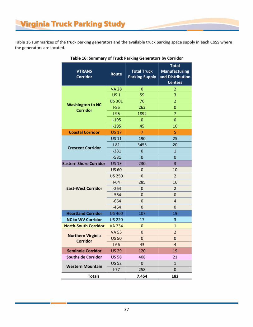
37
Table 16 summarizes of the truck parking generators and the available truck parking space supply in each CoSS where the generators are located.
Table 16: Summary of Truck Parking Generators by Corridor
VTRANS Corridor
Route Total Truck
Parking Supply
Total Manufacturing
and Distribution Centers
Washington to NC Corridor
VA 28 0 2
US 1 59 3
US 301 76 2
I-85 263
0 I-95 1892 7
I-195 0 0
I-295 45 10
Coastal Corridor US 17 7 5
Crescent Corridor
US 11 190 25
I-81 3455 20
I-381 0 1
I-581 0 0
Eastern Shore Corridor US 13 230 3
East-West Corridor
US 60 0 10
US 250 0 2
I-64 285 16
I-264 0 2
I-564 0 0
I-664 0 4
I-464 0 0
Heartland Corridor US 460 107 19
NC to WV Corridor US 220 17 3
North-South Corridor VA 234 0 1
Northern Virginia Corridor
VA 55 0 2
US 50 0 0
I-66 43 4
Seminole Corridor US 29 120 19
Southside Corridor US 58 408 21
Western Mountain US 52 0 1
I-77 258 0
Totals 7,454 182
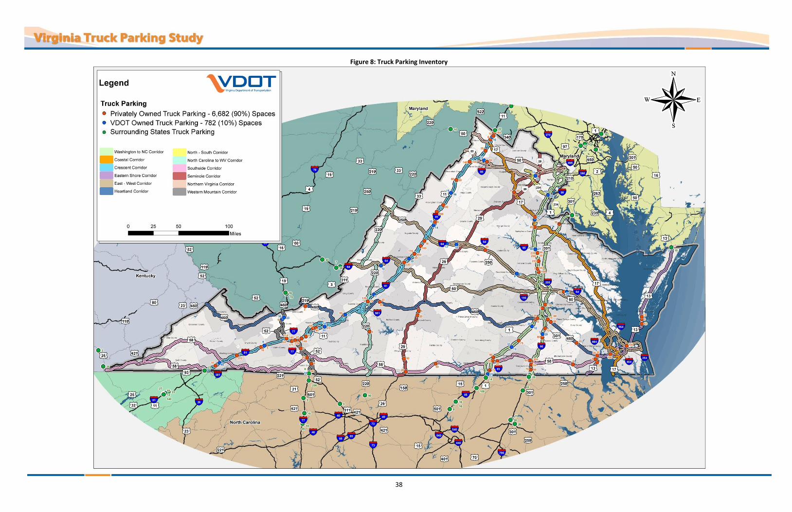
38
Figure 8: Truck Parking Inventory

39
Figure 9: Truck Parking Inventory with Distribution Centers

40
Crash Data
Truck Related Crashes on the CoSS
VDOT provided crash data from the Roadway Network System (RNS). The data was used in conjunction with the Crash Analysis Tool (CAT) to identify truck crashes that occurred on the CoSS. The tools assisted with analyzing crashes by severity, crash type, and vehicle type to identify corridors with potentially higher safety risks in Virginia. As shown in Table 17, 12,066 crashes involving trucks occurred on the CoSS between 2008 and 2012. Corridors with the highest percentage of truck related crashes were I-95, I-81, I-495 and I-64. Total truck related crashes along the CoSS are summarized in Figure 10. Truck related fatal crashes along the CoSS are summarized in Figure 11.
Table 17: Summary of Truck Crashes on Study Corridors
Corridor
Severity
Fatal (K)
Injury
Total* Proportion by
Corridor A B C
Coastal Corridor 3 59 67 138 566 5%
Crescent Corridor 50 328 326 403 2,420 20%
Eastern Shore Corridor 4 37 50 107 243 2%
East-West Corridor 15 251 241 415 1,874 16%
Heartland Corridor 19 79 59 93 446 4%
NC to WV Corridor 10 32 42 75 341 3%
North-South Corridor 0 12 13 30 102 1%
Northern Virginia Corridor 12 60 60 208 769 6%
Seminole Corridor 11 66 66 114 528 4%
Southside Corridor 9 62 47 104 466 4%
Washington to NC Corridor 36 396 372 928 3,962 33%
Western Mountain 13 58 44 72 349 3%
Totals 182 1,440 1,387 2,687 12,066
3% 25% 24% 47% National Safety Council (NSC) Injury Scale
A – Incapacitating injury B – Non-incapacitating injury
C – Possible injury K - Fatal

41
Figure 10: Total Truck Related Crashes in Study Corridors

42
Figure 11: Truck Related Fatal Crashes in Study Corridors

43
Truck Related Crashes on the Ramps of CoSS
Twenty-five percent (25%) of total truck related crashes occurring on the CoSS were on entrance and exit ramps. Although these ramp crashes did not represent a majority of the total crashes within each CoSS, there is a potential safety risk associated with trucks parking within the clear zone and along ramps. When trucks park on shoulders or ramps they become a fixed object within the travel way endangering the traveling public. Truck related fatal crashes on ramps were identified in Figure 12. As shown in Table 18, 4,117 crashes involving trucks occurred on the study corridor ramps between 2008 and 2012.
Table 18: Summary of Truck Crashes on Study Corridor Ramps
Corridor
Severity
Fatal (K)
Injury
Total* Proportion by
Corridor A B C
Coastal Corridor 0
9
6
18
103
3% 16%
1% 19%
1% 1% 2% 9%
1%
1%
46%
2% 0%
Crescent Corridor 15 93 86 119 641
16%
Eastern Shore Corridor 0 3 8 4 29 <1%
East-West Corridor 3 74 86 153 774 19%
Heartland Corridor 0 2 1 6 23 1%
NC to WV Corridor 2 10 8 10 78 2%
North-South Corridor 0 2 1 3 29 <1%
Northern Virginia Corridor 3 21 25 104
374 9%
Seminole Corridor 0 4 6 6 46 1%
Southside Corridor 0 5 2 12 52 1%
Washington to NC Corridor 14 168 169 425 1,899 46%
Western Mountain 1 13 10 9 69 2%
Totals 38 404 408 869 4,117 100%
Proportion by Severity 2% 24% 24% 50% National Safety Council (NSC) Injury Scale
A – Incapacitating injury B – Non-incapacitating injury
C – Possible injury K - Fatal

44
Figure 12: Truck Related Crashes on Study Corridor Ramps

45
STAKEHOLDER OUTREACH Truck parking in undesignated locations, specifically on shoulders of entrance ramps and mainline roadway is a safety concern and presents higher risks to the traveling public as well as the parked trucks. In an attempt to understand quality and quantity of these risks, five key stakeholder groups were targeted for outreach efforts.
Virginia State Troopers
VDOT Residency Staff
VDOT Rest Area Staff
Truckers who travel on Virginia roads
Owners/operators of Virginia truck stops
Each stakeholder group provided input regarding safety risks related to truck parking and provided unique perspectives related to the other challenges facing each stakeholder group. The study team developed survey questionnaires tailored for each stakeholder group, administered the surveys, and summarized the key finding, which are described in more detail in the following sections of this report. The Virginia Truck Parking Study Stakeholder Outreach report summarizes the questionnaires and results in more detail.
The following sections describe the survey objectives, methodology, and key findings for each stakeholder group. These findings became the foundation for defining the truck parking challenges in Virginia; estimating truck parking deficiencies and surpluses; and guiding the development of recommendations.
Virginia State Troopers
Survey Objectives
Identify specific locations where truckers are parking in areas that are not designated for truck parking, such as: Ramp shoulders Mainline shoulders Other undesignated areas
Understand the circumstances and extent for which the occurrence of parking in undesignated areas happens and what challenges are presented
Methodology
In early October 2013, VDOT distributed a 12-to-15 minute online survey to approximately 1,000 Virginia state troopers. The survey received 680 responses, with representation from each state police division as noted below:
Division 1 (Richmond) – 102 responses, 15%
Division 2 (Culpeper) – 115 responses, 17%
Division 3 (Appomattox) – 64 responses, 9%
Division 4 (Wytheville) – 67 responses, 10%
Division 5 (Chesapeake) – 113 responses, 17%
Division 6 (Salem) – 162 responses, 24%
Division 7 (Fairfax) – 57 response, 8%

46
Key Findings
More than half of the respondents observed trucks parking in undesignated areas Trucks parking in undesignated areas, ramps, were reported by 64% of the respondents (433 of 680) Trucks parking in undesignated areas, other, were reported by 56% of the respondents (383 of 680) Challenges with trucks were noted at designated truck parking areas by 55% of the respondents (377 of
680) 11% of respondents reported no problems in any of these areas
Truck parking in undesignated areas (ramps and other areas) was observed primarily overnight by 90% of respondents and often on ramps. Seventy-two percent (72%) of respondents indicated that truck parking on ramps was observed 3 or more days a week
Respondents most often ask trucks parked in undesignated areas to move Respondents ask the driver to move (70%) Citations are issued (41%) A warning is issued (40%)
Sixty-six percent (66%) of respondents reported that designated truck parking areas are over capacity
State trooper respondents offered a variety of suggestions for truck parking to improve safety, including: Increasing the quantity of truck parking spaces Increasing the size and accessibility of truck parking spaces Adding more No Parking signs along shoulders Removing time restrictions from lots Increasing truck driver education related to safety risks caused by parking on ramps and shoulders
The top 3 corridors patrolled by respondents reporting truck parking challenges, 67% of all surveys, were: I-81 (26% of total) I-64 (22% of total) I-95 (19% of total)
State troopers identified locations where truck parking on ramps was observed. A map showing these locations is included in Figure 13. Locations with multiple responses were inferred to be more prevalent, problematic and pose higher risks when compared to other ramps. High risk locations for truck parking on ramps Virginia include:
I-64, just east of Richmond and west of Williamsburg
I-95, between Richmond and Washington, D.C.
Near the intersection of I-66 and US 17 in Fauquier County
Near the intersection of I-77 and US 58 in Carroll County
Near the intersection of I-81 and US 250 in Augusta County
Isolated interchanges on I-81 throughout the entire corridor
Near the intersection of I-81 and I-64 near Lexington, Virginia

47
Figure 13: Areas Identified by State Troopers Where Trucks Are Parking on Ramps

48
Figure 14: Areas Identified by State Troopers Where Trucks Are Parking in Other Undesignated Areas

49
State troopers identified locations where truck parking undesignated areas, such as shoulders of highways, closed weigh stations, and abandoned toll plazas, was observed. A map of these locations is included in Figure 14. Locations with multiple responses were inferred to be more prevalent, problematic and pose higher risks when compared to other undesignated areas. High risk locations for truck parking in undesignated areas in Virginia include:
I-64, between Richmond and Hampton Roads
Near the intersection of I-95, I-85 and US 460 near Petersburg
I-95 near Washington, D.C.
Isolated interchanges on I-66
Isolated interchanges on I-81
Near the intersection of I-81 and I-64, near Lexington, Virginia
VDOT Residency Staff
Survey Objectives
Identify specific locations where truckers are parking in areas that are not designated for truck parking, such as: Ramp shoulders Mainline shoulders Other undesignated areas
Understand the circumstances and extent for which the occurrence of parking in undesignated areas happens and what challenges are presented
Methodology
In late October 2013, VDOT distributed a 5- to 7-minute online survey to all VDOT Residency Administrators. Survey responses were received from 16 of the 43 Residency Administrators, with representation as follows:
Appomattox
Arlington
Bedford
Chesterfield
Christiansburg
Edinburg
Franklin
Fredericksburg
Leesburg (2)
Lexington
Norfolk
Northern Neck
Salem
Warrenton
Wytheville
Due to the small sample size, these results were considered more qualitative in nature. It may be assumed that the non-respondents did not have any truck parking challenges in their area or that their residency contained no CoSS.
Key Findings
Eleven of 16 respondents identified at least one “truck parking hot spot” – that is, where trucks are parking in undesignated areas. In total, 21 hot spots were identified
The overnight period was reported most often as the time when trucks were parked in a hot spot (15 out of 21 locations)
An average of five trucks are typically parked at one of these hot spot locations
Respondents believe trucks are parking in undesignated areas because of limited parking options or unawareness of options
Trucks parking at a hot spot was creating a safety concern at one quarter (5 out of 21) of the locations On a 1 to 5 scale—where 1 is “not a concern” and 5 is a “major concern”—this concern averaged a score
of 2.4

50
Trucks parking at a hot spot was creating a maintenance concern at one quarter (5 out of 21) of the locations On a 1 to 5 scale—where 1 is “not a concern” and 5 is a “major concern”—this concern averaged a score
of 2.5
Litter was the most mentioned (57%) problem observed at unauthorized truck parking locations. Other commonly observed problems included:
57% - Litter 52% - Shoulder damage 38% - Fuel/oil spillage 19% - Obstacles in clear recovery zone for errant vehicles 19% - Restrictions on sight distance 5% - Soil erosion
VDOT Rest Area Staff
Survey Objectives
Identify specific locations where truckers are parking in areas that are not designated for truck parking, such as: Entry ramp shoulders Exit ramp shoulders Areas with “No Parking” signs On shoulders in truck parking area In designated car parking area
Assess the utilization of the truck designated parking areas
Understand the circumstances and extent for which the occurrence of parking in undesignated areas happens and what challenges are presented
Methodology
VDOT Maintenance Division has 43 active rest areas and welcome centers, 36 of which include truck parking. The seven facilities that do not permit truck parking were not included in this survey. The surveys were completed in November 2013 by VDOT staff charged with regularly inspecting rest areas across Virginia. Table 19 lists all active rest areas and welcome centers in Virginia. The facilities in the left column (Truck Parking Permitted) were included in the survey process.
Key Findings
Truck parking at the reviewed rest areas is being utilized to the fullest extent possible. Ninety-seven percent (97%) of the rest areas are at or over capacity for truck parking
Trucks are parked in undesignated areas, typically daily and overnight (on average 3 to 4 trucks are observed at the same time)
Trucks are parked regularly on exit ramp shoulders at 81% of the facilities (29 of 36 rest areas) Trucks are parked regularly on entry ramp shoulders at 72% of the facilities (26 of 36 rest areas) Parking on shoulders within the truck parking areas was reported at 33% of the facilities Parking in areas with “No Parking” signs was reported at 22% of the facilities Parking in designated car parking areas was reported at 8% of the facilities
Truck parking in undesignated areas is contributing to difficulty accessing designated truck parking spaces. In addition, many sites reported other geometric deficiencies contributing to the accessibility of truck parking spaces, such as undersized parking spaces and drive aisles

51
Trucks parking on ramp shoulders and in undesignated parking areas cause significant maintenance problems at the facilities
Table 19: Virginia Rest Areas and Welcome Centers
Truck Parking Permitted Truck Parking Not Permitted
Longdale Furnace Trucks Rest Area (I-64 Eastbound) Jerry’s Run Welcome Center(I-64 Eastbound)
Charlottesville Rest Area (I-64 Eastbound) New Church Welcome Center (US 13 Southbound)
Charlottesville Rest Area (I-64 Westbound) Bristol Welcome Center (I-81 Northbound)
Goochland Rest Area (I-64 Eastbound) Rural Retreat Rest Area (I-81 Northbound)
Goochland Rest Area (I-64 Westbound) Skippers Welcome Center (I-95 Northbound)
New Kent East Coast Gateway Welcome Center (I-64 Eastbound) Dale City Cars Rest Area (I-95 Northbound)
New Kent Rest Area (I-64 Westbound) Dale City Cars Rest Area (I-95 Southbound)
Front Royal Trucks Rest Area (I-66 Eastbound)
Manassas Rest Area (I-66 Eastbound)
Manassas Welcome Center (I-66 Westbound)
Lambsburg Welcome Center (I-77 Northbound)
Rocky Gap Rest Area (I-77 Northbound)
Rocky Gap Welcome Center (I-77 Southbound)
Abingdon Trucks Rest Area (I-81 Northbound)
Smyth Rest Area (I-81 Southbound)
Radford Rest Area (I-81 Northbound)
Radford Rest Area (I-81 Southbound)
Ironto Rest Area (I-81 Northbound)
Troutville Rest Area (I-81 Southbound)
Fairfield Rest Area (I-81 Southbound)
Mt Sidney Rest Area (I-81 Northbound)
Mt Sidney Rest Area (I-81 Southbound)
New Market Rest Area (I-81 Northbound)
New Market Rest Area (I-81 Southbound)
Winchester Welcome Center (I-81 Southbound)
Bracey Welcome Center (I-85 Northbound)
Alberta Rest Area (I-85 Northbound)
Alberta Rest Area (I-85 Southbound)
Dinwiddie Rest Area (I-85 Northbound)
Dinwiddie Rest Area (I-85 Southbound)
Carson Rest Area (I-95 Northbound)
Ladysmith Rest Area (I-95 Northbound)
Ladysmith Rest Area (I-95 Southbound)
Fredericksburg Welcome Center (I-95 Southbound)
Dale City Trucks Rest Area (I-95 Northbound)
Dale City Trucks Rest Area (I-95 Southbound)

52
Staff reported the top-rated factors causing safety concerns at the facilities were as follows: 58% - Trucks parking in undesignated areas was mentioned at 21 of the 36 rest areas reviewed 33% - Lighting was mentioned at 12 of the 36 rest areas 17% - Security was mentioned at six of the 36 rest areas 11% - Accidents in parking area was mentioned at four of the 36 rest areas 6% - Illegal activity was mentioned at two of the 36 rest areas
Truckers Who Travel on Virginia’s Roads
Survey Objectives
Identify specific locations where truckers are parking in areas for short-term and long-term purposes that are not designated for truck parking, such as:
Ramp shoulders Mainline shoulders Other undesignated areas
Understand the circumstances and extent for which the occurrence of parking in undesignated areas happens and what challenges are presented
Understand perceptions of truck drivers relative to their experiences in Virginia and elsewhere
Methodology
In November 2013, a 20- to 25-minute online survey was administered to approximately 3,000 Virginia members of the Owner Operator Independent Drivers Association (OOIDA), 580 members of the Virginia Trucking Association (VTA), and 3,131 members of the American Truckers Association (ATA). Truckers who never travel on Virginia roads were screened out of the survey - 445 responses were received.
Key Findings
A majority of respondents reported having parked in undesignated areas, specifically shoulders of ramps and mainlines, to fulfill both short-term and long-term parking needs; however, respondents reported that parking in undesignated areas is infrequent
On a 1 to 5 scale, where 1 is “not at all safe” and 5 is a “very safe”, respondents reported average personal safety ratings of 3.3 while parking for short-term purposes
On a 1 to 5 scale, where 1 is “not at all safe” and 5 is a “very safe”, respondents reported average personal safety ratings of 3.5 while parking for long-term purposes
On a 1 to 5 scale, where 1 is “not at all safe” and 5 is a “very safe”, respondents reported average personal safety ratings of 3.3 while parking at VDOT Rest Areas
87% of respondents rated personal safety about the same or better in Virginia than most other states
95% of respondents rated accessibility (size, maneuverability) of truck parking facilities about the same or worse than most other states
Availability and accessibility of truck parking facilities was reported as the main challenges for respondents, which contributed to parking in undesignated parking areas
For short-term parking, truckers prefer VDOT rest areas (33%) over private truck stops (26%). For long-term parking, truckers prefer, by a wide margin, to use private truck stops (49%) over VDOT rest areas (15%)
Most respondents (83%) reported that the HOS regulation changes have increased the number of stops they make per trip and is a concern for respondents

53
Nearly all respondents (97%) say there is not enough truck parking at VDOT rest areas, with more respondents indicating more inadequacy of available nighttime parking
Expanding truck parking supply in Virginia was the most preferred option for improving trucker safety
A majority of respondents (64%) indicated that information about truck parking location options in Virginia is inadequate
Trucker Focus Group
Survey Objectives
Discuss key findings found in previous stakeholder surveys, especially truckers surveys
Validate the results of the online trucker surveys. Understand the circumstances and extent for which the occurrence of parking in undesignated areas happens and what challenges are presented
Understand perceptions of truck drivers relative to their experiences in Virginia and elsewhere
Identify additional truck parking challenges and concerns not covered in online trucker survey
Prioritize truck parking challenges that pertain to the results of these surveys
Methodology
In March 2014, a 90-minute focus group survey was conducted via phone interview with four Virginia members of OOIDA.
Key Findings
Trucker focus group members identified the following areas of Virginia as having deficient parking supply: Northern Virginia area (I-66, I-95, I-495, and I-395). Spaces available at rest areas in Northern Virginia
are too small Near the Hampton Roads area The Bristol and Wytheville areas along the I-81 corridor
Trucker focus group members noted the following factors that contributed to difficultly meeting HOS regulations:
With the mandatory 30-minute break, truckers may have to stop early because there is no parking downstream
Navigating through congested areas creates challenges for estimating trip length in terms of time and for planning stops to meet HOS regulations
Recommendations from the trucker focus group included: Identify truck parking challenges in other states bordering Virginia to help with problems causing
Virginia parking impacts Main need for parking is simply a lot with gravel, port-a-potties, trash receptacles, and periodic police
presence to help with personal safety. Could use existing weigh stations or abandoned state property for this purpose
Reduce traffic congestion to improve throughput of trucks and other vehicles through the state and minimize bottlenecks
Consider reducing and/or eliminating lane restrictions for trucks on the interstates with more than two lanes in each direction
Partner with shippers and receivers to provide on-site truck parking Communication to truckers by electronic or static signing is the preferred way to receive information
about available truck parking

54
Add signs at rest areas to alert truckers where additional parking can be found Educate state police so they know where to send truckers to rest
Owners/Operators of Virginia Truck Stops
Survey Objectives
Assess the truck parking capacity and utilization of truck stop facilities
Identify specific locations near truck stop facilities where truckers are parking in areas that are not designated for truck parking, such as:
Ramp shoulders Mainline shoulders Commercial/retail parking lots Other undesignated areas
Understand the circumstances and extent for which the occurrence of parking in undesignated areas happens and what challenges are presented
Understand perceptions of owners/operators on potential truck parking information systems and concepts to build the capacity of truck parking in Virginia
Methodology
In March 2014, telephone interview surveys were conducted from a sample of 40 Virginia truck stop owners/operators. A total of 14 surveys were completed.
Key Findings
93% reported that their facility was at capacity or over capacity
71% of respondents were aware of areas near their facility where truckers are parking in parking areas not designated for truck parking
64% of respondents rated the truck parking information system concept as “very beneficial”
On a 1 to 5 scale, where 1 is “not at all appealing” and 5 is a “very appealing”, proposed concepts to build the capacity of truck parking in Virginia received the following percentages of combined 4 and 5 ratings:
78% - Expand truck parking in privately-owned truck stops 71% - Expand truck parking in VDOT Safety Rest Area 71% - Improve interchange design and layouts 64% - Build more VDOT Safety Rest Areas 50% - Build new truck parking lots, with amenities, across Virginia 28% - Build new truck parking staging lots near large distribution and logistics centers 28% - Build designated truck parking spots on a limited number of shoulders and ramps across Virginia 21% - Build new privately-owned truck stops 14% - Build new truck parking lots, with no amenities, across Virginia
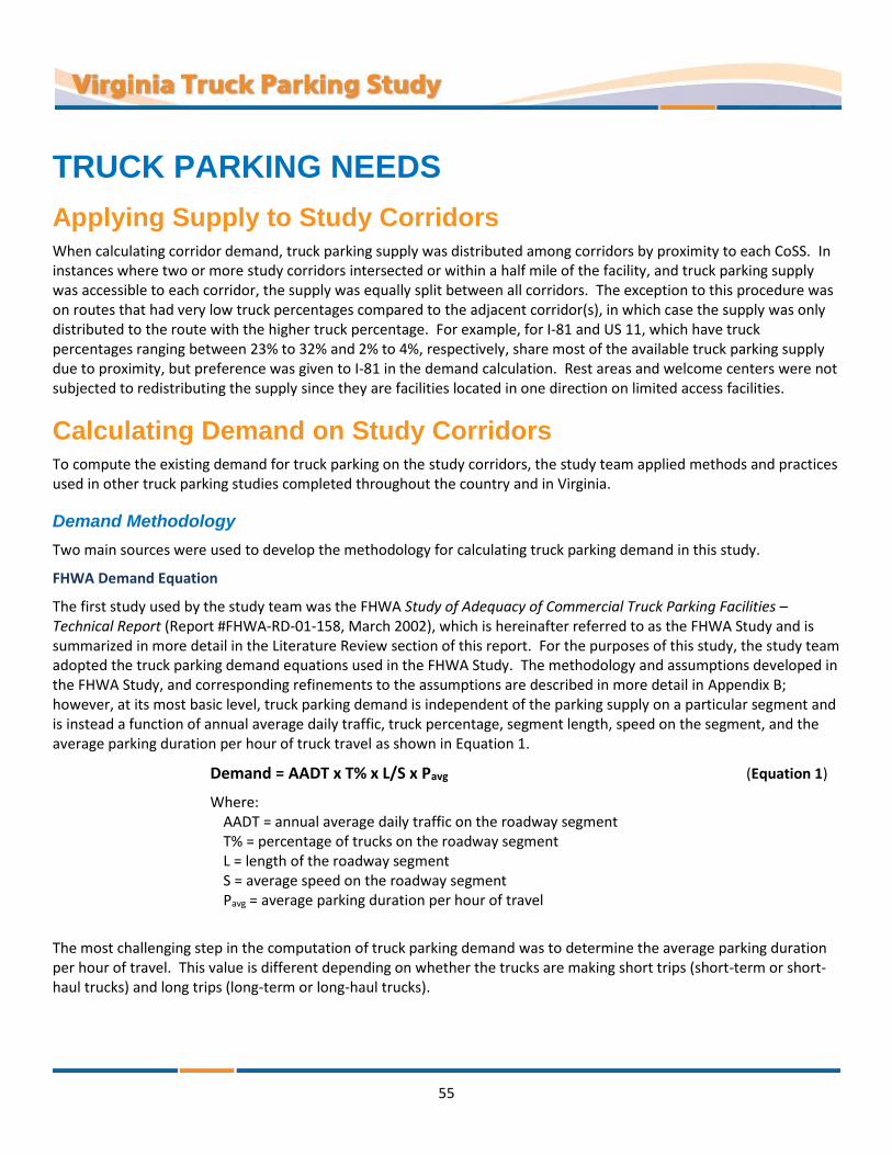
55
TRUCK PARKING NEEDS
Applying Supply to Study Corridors When calculating corridor demand, truck parking supply was distributed among corridors by proximity to each CoSS. In instances where two or more study corridors intersected or within a half mile of the facility, and truck parking supply was accessible to each corridor, the supply was equally split between all corridors. The exception to this procedure was on routes that had very low truck percentages compared to the adjacent corridor(s), in which case the supply was only distributed to the route with the higher truck percentage. For example, for I-81 and US 11, which have truck percentages ranging between 23% to 32% and 2% to 4%, respectively, share most of the available truck parking supply due to proximity, but preference was given to I-81 in the demand calculation. Rest areas and welcome centers were not subjected to redistributing the supply since they are facilities located in one direction on limited access facilities.
Calculating Demand on Study Corridors To compute the existing demand for truck parking on the study corridors, the study team applied methods and practices used in other truck parking studies completed throughout the country and in Virginia.
Demand Methodology
Two main sources were used to develop the methodology for calculating truck parking demand in this study.
FHWA Demand Equation
The first study used by the study team was the FHWA Study of Adequacy of Commercial Truck Parking Facilities – Technical Report (Report #FHWA-RD-01-158, March 2002), which is hereinafter referred to as the FHWA Study and is summarized in more detail in the Literature Review section of this report. For the purposes of this study, the study team adopted the truck parking demand equations used in the FHWA Study. The methodology and assumptions developed in the FHWA Study, and corresponding refinements to the assumptions are described in more detail in Appendix B; however, at its most basic level, truck parking demand is independent of the parking supply on a particular segment and is instead a function of annual average daily traffic, truck percentage, segment length, speed on the segment, and the average parking duration per hour of truck travel as shown in Equation 1.
Demand = AADT x T% x L/S x Pavg (Equation 1)
Where: AADT = annual average daily traffic on the roadway segment T% = percentage of trucks on the roadway segment L = length of the roadway segment S = average speed on the roadway segment Pavg = average parking duration per hour of travel
The most challenging step in the computation of truck parking demand was to determine the average parking duration per hour of travel. This value is different depending on whether the trucks are making short trips (short-term or short-haul trucks) and long trips (long-term or long-haul trucks).
56
There are numerous factors that impact the average time trucks park, which can vary from state to state or by corridor such as:
HOS limitations
Variation in parking characteristics between short-haul (trips that can be made within a single day) and long-haul trucks
Ratio of long-haul to short-haul trucks in the vehicle mix (varies widely by region— short-haul typically higher in urban areas and long-haul typically higher in rural areas)
Time required for loading/unloading, staging, and other activities that occur off the roadway network while driver is “on duty”
Demand for parking at public rest areas versus commercial truck stops
In this phase of the study, truck parking data collection was not considered, but to calculate a more accurate demand, additional data collection and analysis should be completed. To obtain the most accurate demand results detailed parking duration studies would need to be completed at facilities along each of the study corridors to obtain peak hours and average parking duration. Each of these routes has unique characteristics influencing the attractiveness to short-haul and long-haul truck traffic, which impacts parking demand and duration data. For example, interstates tend to have higher rates of long-haul traffic than US highways.
Pennsylvania Study Data and Assumptions
The second study, conducted by the Pennsylvania State Transportation Advisory Committee (PSTAC) in 2007 (Truck Parking in Pennsylvania – Final Report, December 2007), which is hereinafter referred to as the PSTAC Study, was used by the study team to fine tune the methodologies developed in the FHWA Study: the federal HOS regulations changed between 2002 and 2007, and then again between 2007 and 2013, thus a few of the original truck driving time assumptions were modified; also, because no new truck parking data was collected for this project, the study team relied heavily on the data and assumptions provided in the PSTAC Study. The PSTAC Study’s values for peak parking demand, average parking duration, and average parking duration per hour of travel were incorporated into the demand methodology applied in this study. The detailed methodology is included in Appendix B.
Demand on Virginia’s Corridors
The truck parking equations created in the FHWA Study were used to compute the truck parking demand in each direction of travel on each segment within each corridor. Total parking demand was then compared to the available supply as documented in Figure 15 for each segment in each direction. Some corridors were underutilized for truck parking, while others were overloaded, which lead to truck parking capacity constraints. Figure 15 shows locations where truck parking demand is impacted the most. The study corridors were divided into 106 segments throughout the state as shown in Figure 15; segments are labeled by route shield and letter with the termini denoted by asterisks.
The corridor segments were assessed for unmet truck parking demand based on upon a calculated need and its current truck parking capacity. The findings of corridors with unmet truck parking demand are shown in Figure 15. Table 20 details the demand by direction and along the corridor segments described in Figure 15.
Virginia offers 7,500 private and public truck parking spaces; however, a demand of nearly 12,500 spaces means there is a statewide deficit of nearly 5,000 spaces. Three corridors show significant deficits in available truck parking: I-64 has a 1,131-space deficit; I-81 has an 842-space deficit; and I-95 is short 386 spaces. The areas experiencing the greatest impact include most of I-64, most of I-66, I-95 north of Fredericksburg, I-81 south of Lexington, and portions of I-464.

57
Figure 15: Truck Parking Net Demand on the Study Corridors

58
Table 20: Truck Parking Net Demand on the Study Corridors by Segment

59
Identifying Gaps on Study Corridors Gaps in truck parking are shown in Figure 16. The identification of gaps considered the truck parking supply and the corridor demand. In instances where there are parallel routes (such as I-81 and US 11, I-64 and US 250, or I-95 and US 1), the gap in truck parking applies to both corridors, because truck parking is most likely shared between the two corridors. Locations where there is a deficit of 250 to 700 truck parking spaces that are at least 10 miles from a truck parking facility with more than 20 spaces were identified as significant gap locations. These locations are shown in Figure 16 in red or orange with purple highlights:
Gap locations with a deficit of 500 to 700 truck parking spaces (red with purple highlight):
I-64 between New Kent and Norfolk
I-66 between Strasburg and Washingon D.C.
I-81 between Roanoke and Lexington
I-95 between Fredericksburg and Washington D.C.
Gap locations with a deficit of 250 to 499 truck parking spaces (orange with purple highlight):
I-64 between Staunton and Charlottesville
I-64 between US 15 and Richmond
I-295 between Route 5 and US Route 301
Identifying Demand Indicators from Surveys The results from the Virginia State Troopers and Virginia Truckers surveys were used to indicate locations and corridors where truck parking needs are perceived to be greatest. The responses are subjective in nature and should only be used in conjunction with the calculated demand and identfied gaps.
Virginia State Trooper Identified Truck Parking Needs
The Virginia State Troopers survey results identified 1,200 locations (many duplicates) on the CoSS where truckers park in areas not designated for trucks. Some examples of undesignated parking areas include, but are not limited to, ramps, shoulders, closed weigh stations, abandoned toll plazas, or unmarked areas. A density layer was created to represent the most frequently reported locations where trucks park in undesignated areas. Those locations are shown in Figure 17.
Virginia Trucker Identified Parking Needs
The Virginia Trucker survey results were used to identify study corridors that need, or were perceived to need, additional truck parking. Trucker responses only indicated entire corridors and did not identify specific locations for truck parking needs. Figure 17 shows the number of responses by study corridor.
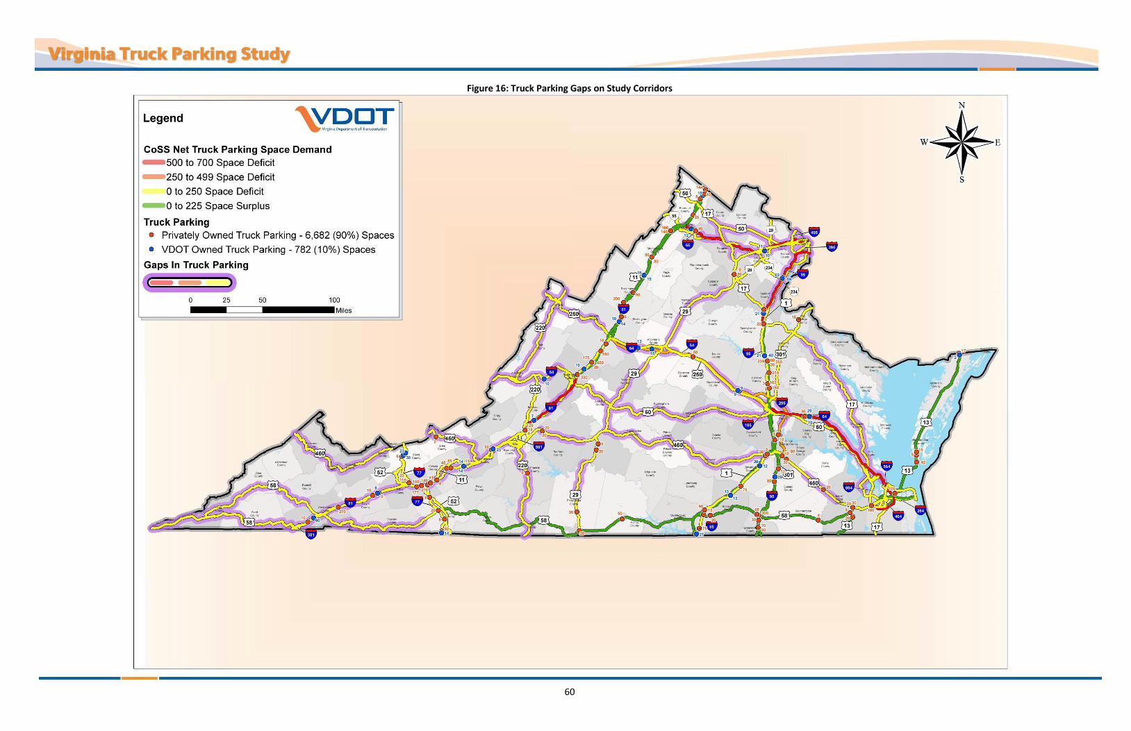
60
Figure 16: Truck Parking Gaps on Study Corridors
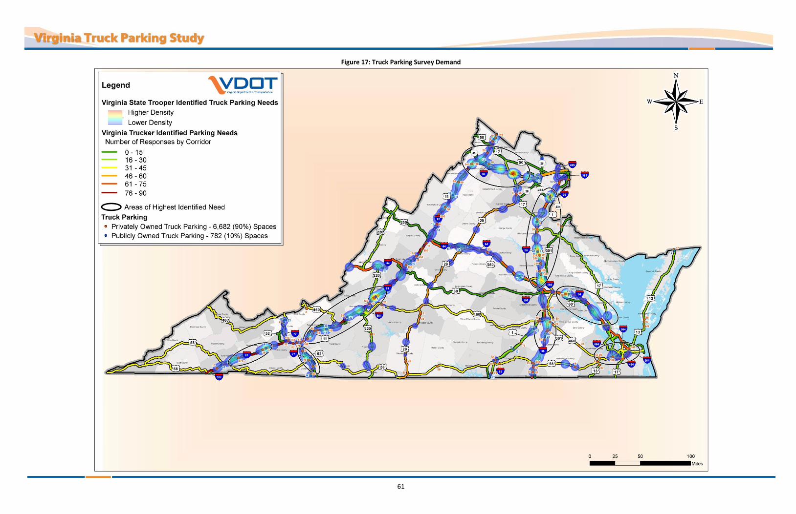
61
Figure 17: Truck Parking Survey Demand
62
Summary of Survey Demand
Areas where the State Trooper and Virginia Trucker identified needs overlap are shown in Figure 17. Areas with the highest reported needs include the following locations:
All of I-66 in Northern Virginia
I-64, just east of Richmond and west of Williamsburg
I-95, between Richmond and Washington, D.C.
I-81, Southwest Virginia from Wytheville to Roanoke
I-81, Southwest Virginia near Bristol
US 460, Hampton Roads area
I-77, south of I-81

63
TRUCK PARKING CHALLENGES IN VIRGINIA Truck parking related challenges were identified by stakeholders during this study. The following sections outline both statewide and regional truck parking challenges that were identified.
Challenges that Impact the Traveling Public and Truck Parking Vehicles parked on mainline and ramp shoulders pose a significant safety risk to the travelling public. Locations
where trucks park in undesignated areas, such as mainline and ramp shoulders, were identified through the stakeholder surveys. Corridors and interchanges with higher incidence of trucks parking in undesignated areas on CoSS, shown in Figure 18, include:
A - Near the I-66 and US 17 interchange in Fauquier County B - Near the I-77 and US 58 interchange in Carroll County C - Near the I-81 and US 250 interchange in Augusta County D - Near the I-81 and I-64 interchange near Lexington, Virginia E - Near the I-95, I-85 and US 460 interchange near Petersburg F - Isolated interchanges on I-81 throughout the entire corridor G - I-64, between Richmond and Hampton Roads H - I-95, between Richmond and Washington, D.C.
Figure 18: Areas with Safety Challenges in Virginia
Trucks parking in undesignated areas, specifically on ramp and mainline shoulders or shoulders within parking areas, cause significant maintenance challenges for VDOT and commercial truck stop owners. In addition, many truck parking facilities are not designed to meet the current size requirements for truck, which creates other maintenance challenges. Damage to various assets on the site, including light poles, shoulders, sidewalks, curbs,

64
and landscaped areas, as well as damage to other vehicles can also occur when trucks drive through a site that does not meet the current size requirements for trucks.
Challenges for Truckers According to stakeholder surveys,there is a shortage of truck parking supply in Virginia, with the most
significant shortages reported in the Northern Virginia, Hampton Roads, and Southwest Virginia areas. Truck parking challenges and shortages in adjacent states, especially near the state borders, also impact
truck parking and route planning in and through Virginia. Across all stakeholder groups, the most frequently reported reason for trucks parking in undesignated
areas was a shortage of available official/formal truck parking spaces at the time of need. Contributing reasons included:
Truckers do not know where available truck parking spaces are located. Truck parking facilities, if they exist, are oftentimes already at or over capacity when truckers
arrive. Many shippers and receivers have scheduled delivery and pick-up times that are not flexible and
do not allow on site truck parking, which increases the demand for staging areas with available parking near the shippers and receivers.
More than 70% of truckers surveyed reported that overnight truck parking is a personal safety concern.
Truckers surveyed indicated that the recent Hours of Service (HOS) regulation changes require an increase in the frequency of their rest stops and it is difficult to plan routes and stops, especially through congested corridors, due to travel time unreliability.
Accessibility of truck parking spaces in both public and private facilities is the most frequently reported challenge to truckers.
Over 85% of truck drivers believe that there are areas at public and private truck parking facilities that are not accessible to them.
Many of Virginia’s existing parking facilities are functionally obsolete—they were designed and built when trucks were much smaller (in length, with, and weight)—making maneuverability a challenge for today’s larger trucks. The situation is unsafe, resulting in property damage to trucks and parking facilities.
Regional Challenges The Northern Virginia, Hampton Roads, and Southwest regions of Virginia have unique geographic and economic characteristics that contribute to the challenge of providing adequate truck parking. The I-95 and I-81 corridors provide access to destinations along the East Coast and serve as major corridors for long-haul trucks through the Northern Virginia and Southwest regions. Truck parking challenges specific to each of these regions are described below.
Northern Virginia Region
Regional Freight Characteristics – Located in northeastern Virginia and centrally located on the East Coast, the Northern Virginia region connects to the national freight transportation system via several highway, rail, and airport facilities. A major generator of truck traffic on the I-66 corridor is the Virginia Inland Port, which is located in Front Royal in northwest Virginia. The Northern Virginia economy is largely based on professional, business, and information service sectors. Consequently, the region has an economy that is less dependent on manufacturing and other freight-intensive industries than the rest of Virginia and, as a result, nearly 65 percent of tonnage moving within Northern Virginia is pass-through freight. Inbound and outbound freight accounts for

65
26 and 5 percent, respectively, of the total tonnage moving through the region. The remaining four percent is internal tonnage that moves from one part of the region to another.
Shortage of Truck Parking Spaces – Based on the estimated demand, there is a shortage of 1,069 truck parking spaces in the Northern Virginia region. This deficit is summarized inTable 21.
Table 21: Northern Virginia Region – Summary of Truck Parking Demand
Major Corridors within Region
Truck Parking Spaces (+) Surplus / (-) Deficit
I-95 (North of Richmond) -463
I-66 -542
US 29 (North of Charlottesville) -64
Net Demand = -1,069
Transportation Congestion – Historically, Northern Virginia has been the fastest growing region of the state and this growth is anticipated to continue and is expected to account for one third of Virginia’s net population gain by 2030. Much of the population growth is projected to occur along the I-66 corridor, which is expected to add the equivalent populations of Arlington and Washington, D.C. to the region1. Population growth translates to an increased demand on the transportation network. In the Northern Virginia region, many segments of the transportation network are currently stressed or over capacity to the point that they are identified as freight bottlenecks. Several segments of the major transportation routes (I-95, I-66, I-495, I-395, and US 17) in the Northern Virginia region are identified as roadway or rail bottlenecks.4 These bottlenecks prohibit the efficient flow of freight through the system and across the region. Traffic congestion and bottlenecks in the Northern Virginia area impacts truckers’ ability to efficiently pass through the region and effectively plan stops along routes to meet HOS regulations.
High Land Acquisition Costs – It is estimated that approximately one acre of land is required for every 10 to 15 truck parking spaces.5 Based on this assumption and an estimated deficit of 1,100 truck parking spaces in the Northern Virginia region, approximately 100 acres of land is needed to address the deficit. Ideal truck parking sites are those near interchanges. In the Northern Virginia region, these ideal locations are rarely available and when they are available, these locations command premium prices. Building large-scale, privately-owned truck parking facilities in this region may be considered cost prohibitive by developers due to the high land values and resulting return on investment.
Diverse Truck Parking Needs – Based on the regional freight characteristics, truck parking in the Northern Virginia region needs to accommodate both long-haul truck trips (typically defined as trips that cannot be completed within a single day, or 11 hours, under Federal Motor Carrier Safety Administration (FMCSA) regulations) and regional truck parking needs. The regional truck parking needs include the truck staging areas by major truck generators, such as rail terminals, warehouse districts, and distribution centers.
4 The Virginia Statewide Multimodal Freight Study (Final Report 2010)
5 North Jersey Truck Rest Stop Study, Gannett-Fleming (2008)

66
Hampton Roads Region
Regional Freight Characteristics – Located in southeastern Virginia at a central location on the East Coast and on the Chesapeake Bay, the Hampton Roads region is characterized by several marine terminals. The Virginia Port Authority (VPA) operates three marine terminals: Norfolk International Terminals (NIT), Portsmouth Marine Terminal (PMT), and Newport News Marine Terminal (NNMT). Additional existing and future port facilities in the Hampton Roads region include the new privately-developed APM (Maersk) container terminal, the future Craney Island container terminal, privately-owned terminals handling coal and other commodities, and U.S. government facilities. The Hampton Roads region is also an important base for the US Navy and naval shipbuilding. Hampton Roads regularly ranks second or third among Atlantic Coast ports for container volumes, and is among the top 20 in the country for total tonnage. The large number of marine terminals generates inbound and outbound freight accounting for 52 and 30 percent of the total tonnage moving through the region, respectively. Pass-through freight accounts for eight percent of tonnage moving within the region3. The remaining ten percent is internal tonnage that moves from one part of the region to another.
Shortage of Truck Parking Spaces – Based on the estimated demand, there is a shortage of 671 truck parking spaces in the Hampton Roads region. This deficit is summarized in Table 22.
Table 22: Hampton Roads Region – Summary of Truck Parking Demand
Major Corridors within Region
Truck Parking Spaces (+) Surplus / (-) Deficit
I-64 (East of I-95) -562
US 460 (East of I-95) -46
US 58 (East of I-95) +31
US 17 (Tennessee State Line to I-95) -94
Net Demand = -671
Diverse Truck Parking Needs – Due to the impact of the marine terminals, there is a significant need for terminal truck staging and port-specific truck parking in the Hampton Roads region. In addition to parking near the marine terminals, parking for long-haul truck trips and regional truck trips are also needed. The parking needs in this region vary by corridor. I-64 and US 460 are more utilized for local Virginia trucking trips and less utilized in accommodating through trucks.6 US 460, US 58, and US 17 are secondary connections with a projected increase in truck traffic.
Southwest Virginia Region
Regional Freight Characteristics –The Southwest Virginia region serves as a major connection to the national freight system via several highways, rail, and airport facilities. Over 90 percent of tonnage moving within the Southwest Virginia region is pass-through freight. This is a significantly larger percentage than in the Northern Virginia and Hampton Roads regions and is due to the influence of I-81, which is a major national freight transportation corridor that traverses the state and is part of the national freight transportation corridor. The Virginia Freight Study noted the highest Average Annual Daily Truck Traffic (AADTT) on I-81 in 2005 exceeded 10,000 trucks per day. I-81 has the highest average truck percentages in the state at 27 percent of all traffic. This reflects a combination of both high truck volumes and low passenger car traffic. Local trucking facilities,
6 The Virginia Statewide Multimodal Freight Study (Final Report 2010)
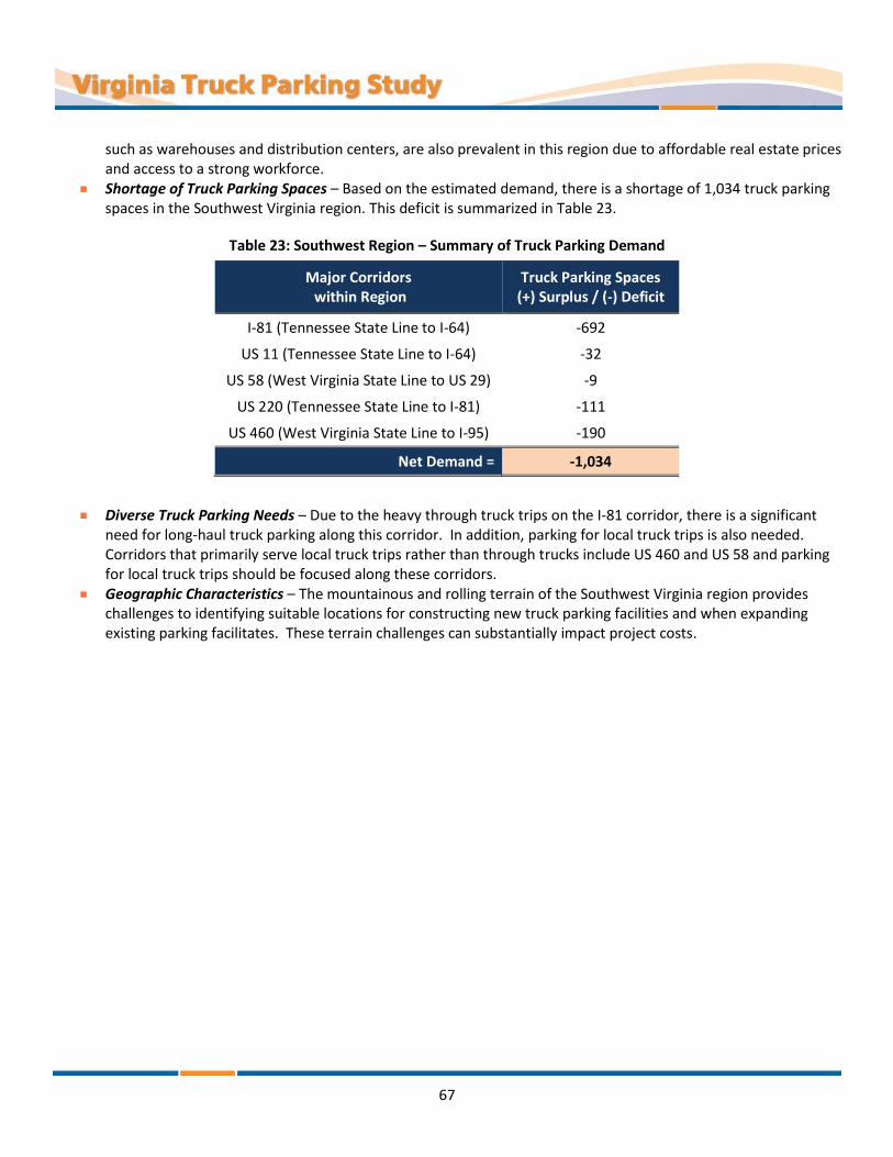
67
such as warehouses and distribution centers, are also prevalent in this region due to affordable real estate prices and access to a strong workforce.
Shortage of Truck Parking Spaces – Based on the estimated demand, there is a shortage of 1,034 truck parking spaces in the Southwest Virginia region. This deficit is summarized in Table 23.
Table 23: Southwest Region – Summary of Truck Parking Demand
Major Corridors within Region
Truck Parking Spaces (+) Surplus / (-) Deficit
I-81 (Tennessee State Line to I-64) -692
US 11 (Tennessee State Line to I-64) -32
US 58 (West Virginia State Line to US 29) -9
US 220 (Tennessee State Line to I-81) -111
US 460 (West Virginia State Line to I-95) -190
Net Demand = -1,034
Diverse Truck Parking Needs – Due to the heavy through truck trips on the I-81 corridor, there is a significant need for long-haul truck parking along this corridor. In addition, parking for local truck trips is also needed. Corridors that primarily serve local truck trips rather than through trucks include US 460 and US 58 and parking for local truck trips should be focused along these corridors.
Geographic Characteristics – The mountainous and rolling terrain of the Southwest Virginia region provides challenges to identifying suitable locations for constructing new truck parking facilities and when expanding existing parking facilitates. These terrain challenges can substantially impact project costs.

68
RECOMMENDATIONS To support VDOT’s mission to provide a safe and secure transportation system, the department strives to identify, prioritize, and implement safety improvements to reduce severe crashes and fatalities. To mitigate the safety risks associated with trucks parking on mainline and ramp shoulders, the instances of occurance must be reduced or eliminated. Given the HOS requirements and the existing truck parking inventory, increasing the supply of truck parking spaces in appropriate areas will have a significant impact in mitigating truck parking in undesirable locations. The following recommendations have been developed to guide VDOT in pursuit of this objective.
Recommendation 1 - Partner with private industry and local governments to increase capacity and related improvements.
VDOT should identify and prioritize truck parking improvements in congested areas, specifically in the regions identified in this study with high truck parking supply deficits, and collaborate with stakeholders to establish additional truck parking spaces.
VDOT should partner with the private sector and localities to identify opportunities to expand existing truck parking facilities or develop new truck parking facilities by:
Examining the possibilities of creating special incentives for the private sector to develop truck parking facilities
Creating tax abatements or low-cost loans for new or expanded truck parking facilities along the high-demand and low-supply corridors identified in this report
VDOT should encourage counties and municipalities, through outreach and training, to recognize that truck parking is a necessary part of transportation infrastructure.
VDOT should identify additional funding incentives and bonding that could prompt development activity.
VDOT should collaborate with local officials with coordination from shippers and receivers around the Commonwealth, especially in the Washington, D.C. and Hampton Roads metro areas, to identify opportunities in providing staging areas for truck parking, so truckers can meet HOS requirements in these congested areas.
VDOT should inform the private truck stop owners of the results of this study so they are aware of the magnitude and locations of the truck parking supply shortages in Virginia.
VDOT should encourage private truck stop owners to provide or increase on-site security and improve site and parking space accessibility.
VDOT should create a multi-disciplinary task force to assess and develop solutions for existing and future truck parking challenges.
Potential Task Force participants should include VDOT, Virginia State Police, truck stop owners (NATSO), trucker advocacy groups such as VTA and OOIDA, and other industry stakeholders. As part of the Task Force, VDOT should hold a workshop to review the findings from this study and collectively develop implementable strategies and action items.
VDOT should work with neighboring states, the I-95 Corridor Coalition, and the I-81 Corridor Coalition to develop regional truck parking solutions.
VDOT should develop a new Informational and Instructional Memoranda (I&IM) that would focus on truck accessibility when planning for and/or designing roadway facilities, such as ramps, shoulders, or truck parking areas.
69
Recommendation 2 - Provide accurate and real-time information about truck parking supply and availability in Virginia.
VDOT should maintain a database of available truck parking spaces statewide and make this information available to the public in digital and/or hard copy formats. VDOT should consider posting hard copy (printed) maps of truck parking facilities in Virginia at the following locations:
VDOT rest areas and welcome centers Weigh stations Ports facilities (public and private) Private commercial truck stop facilities State Police Division offices Rest areas and truck stops in adjacent states
VDOT should explore the feasibility of using the 511 webpage and interactive voice response (IVR) technology in partnership with the truck stop owners to relay truck parking and truck stop information to truckers. The 511 webpage and IVR could be regularly updated to provide real-time information for truckers consisting of:
Location of nearby truck stops Available resources at the facilities Number of available spaces at each facility
VDOT should monitor the efforts of the I-95 Corridor Coalition as it pertains to the pilot truck parking information system that was recently deployed at the northbound I-95 rest area in Caroline County. If this pilot project is determined to be successful, VDOT should identify opportunities for deployment of this technology in other areas of the state.
Recommendation 3 - Improve the safety, effectiveness, and supply of truck parking spaces at State-owned facilities.
VDOT should investigate the potential for using park & ride lots or weigh stations to allow overnight truck parking by studying the demand, safety, and other impacts it may have on normal commuter operations and facility maintenance.
VDOT should investigate the use of abandoned construction staging areas on interstate facilities—designated areas where vehicles, supplies, and construction equipment are positioned for access and use while construction is underway—for use as truck parking areas.
VDOT should convert unused state-owned facilities, such as the closed rest areas on I-64 west of Richmond in Louisa County or closed-down residencies, to truck-only parking facilities to increase supply.
VDOT should restripe the existing truck parking spaces and drive aisles within the rest areas and welcome centers to accommodate current vehicle fleet sizes. This change will help reduce the risk of property damage and vehicular damage resulting from navigating a parking area with poor accessibility.
Note: While this recommendation can help reduce damage to vehicles and state property, this action will reduce available VDOT truck parking supply.
VDOT should expand existing Safety Rest Areas to increase parking capacity and to address problems associated with functional obsolescence, so that trucks can maneuver safely on these facilities.
VDOT should prioritize the expansion of facilities over construction of new facilities and focus efforts in the regions and corridors with the greatest need first.
VDOT should explore the feasibility of installing security cameras at VDOT rest areas to deter illegal activity from occurring and to provide a sense of security to all patrons, including truck drivers.
VDOT should continue to work collaboratively with the Virginia State Police to increase police presence in VDOT rest areas and welcome centers.

70
VDOT should partner with the Virginia State Police to prohibit recreational vehicles and single-unit trucks from parking in designated truck-only areas.
To support VDOT’s overall mission to provide a safe and secure transportation system, the department strives to identify, prioritize and implement safety improvements aimed at reducing crashes and deaths. The recommendations provided herein are intended to help mitigate safety risks associated with trucks parking on mainline and ramp shoulders. Of all the recommendations, increasing the supply of truck parking spaces will have the most significant impact in achieving this goal.
.
Appendix A: Truck Parking Inventory

Name Owner Overnight Spaces Corridor Milemarker
Lankford Truck Plaza Private Y 15 13 78.0
Royal Farms Private N 17 13 142.0
Wilco #797 Private Y 20 13 14.0
Rest Area NB Caperville Private Y 42 13 74.0
Exxon Private N 5 13 80.0
New Church Public Y 2 13 142.0
Quarles Truck Stop Private Y 50 17 201.0
Foster Convenience Private Y 5 29 63.0
Pilot Travel Center Private Y 20 29 7.0
Kangaroo Express 3478 Private Y 30 29 18.0
Mapco Express #4062 (East Coast) Private Y 9 29 0.0
Goldys Truck Plaza Private Y 20 29 59.0
New Dixie Mart No.15 (BP) Private U 4 58 446.0
Exxon Private Y 8 58 467.0
Slip-In Food Marts Inc Private U 20 58 381.0
Wilco Travel Plaza Private Y 50 58 326.0
Pilot Travel Center, Providence Forge Private Y 30 64 211.0
Crossing Point Citgo Private Y 50 64 136.0
Big Charlie's Truck Plaza Private Y 100 64 282.0
Franks Trucking Center Private Y 100 64 209.0
7-11 #34516 Front Royal Private Y 10 66 6.0
Kangaroo Express Private Y 6 77 58.0
Kangaroo Express Private N 8 77 24.0
Kangaroo Express Private N 9 77 8.0
Cockerham Fuel Center Private N 20 77 14.0
Love's Lambsburg Private Y 90 77 1.0
Kangaroo Express Private Y 22 77 41.0
Village Truck Stop Private N 5 81 54.0
Kangaroo Express Private Y 6 81 149.0

Name Owner Overnight Spaces Corridor Milemarker
Handy Mart / Johnson's Exxon Private N 8 81 317.0
Quick Stop Private Y 10 81 10.0
Radford Travel Center Private N 15 81 109.0
Kangaroo Express Private N 16 81 50.0
Pilot Travel Center Private Y 18 81 150.0
High Point Truck Stop Private Y 25 81 307.0
Dublin Handy Mart Private Y 45 81 98.0
On The Run Exxon Private Y 50 81 128.0
Sheetz Travel Center Private Y 50 81 273.0
Shenandoah Truck Center (Liberty) Private Y 80 81 273.0
Pilot Travel Center Private Y 90 81 251.0
Love's Toms Brook Private Y 100 81 291.0
TA Wytheville Private Y 114 81 72.0
TA Roanoake #21 Private Y 129 81 150.0
Love's Max Meadows Private Y 140 81 84.0
Wilco Travel Plaza Private Y 140 81 291.0
Flying J Private Y 144 81 323.0
Wilco Travel Plaza Private Y 150 81 77.0
Flying J Private Y 177 81 77.0
Harrisonburg Truck Stop Private Y 200 81 243.0
Petro Glade Spring Private Y 270 81 29.0
Flying J Private Y 270 81 80.0
BP Denos Food Mart #10 Private U 6 81 235.0
I-81 Travel Plaza Private Y 41 81 86.0
Lancer Travel Plaza Private Y 85 81 101.0
Bir Truck Shop Private U 8 81 89.0
Cigarette Outlet & Truck Stop Private U 10 81 321.0
Shell Private Y 15 85 12.0
East Coast/Mapco Express Private Y 20 85 61.0

Name Owner Overnight Spaces Corridor Milemarker
Simmons Travel Center Private Y 75 85 4.0
Davis Travel Center Private Y 75 85 39.0
Thrift Mart Private Y 5 85 64.0
Love's Travel Private Y 90 85 15.0
Mapco Express #4061 (East Coast) Private Y 3 95 92.0
East Coast Private Y 5 95 133.0
US Gas, Exxon Private Y 12 95 41.0
Mr. Fuel Private Y 20 95 104.0
Simmons Travel Center Private Y 30 95 8.0
Love's Ruther Glen Private Y 60 95 104.0
MS 58 Plaza Private Y 65 95 11.0
Love's Skippers Private Y 70 95 4.0
Davis Travel Center, Stony Creek Private Y 80 95 33.0
Pilot Travel Center #384 Private Y 110 95 58.0
Richmond Travel Center Private Y 158 95 89.0
Travel Centers Ashland Private Y 183 95 92.0
Flying J Carmel Church SB Private Y 239 95 104.0
Flying J, Ruther Glen NB Private Y 250 95 104.0
Pilot Travel Center, Emporia Private Y 300 95 11.0
95 Fuel Stop Private U 20 95 126.0
All American Private Y 215 95 98.0
NEW Truck Stop I-95 Exit 4 Private Y 80 95 4.0
Dudley's Truck Stop & Restaurant Private U 5 220 41.0
Mapco Express #4065 Private N 5 295 15.0
East Coast/MAPCO Store #4058 Private Y 10 295 3.0
Quarles Truck Stop Private Y 15 301 0.0
Tow Star Liberty Private N 2 460 88.0
Miller Mart #55 Private Y 20 460 21.0
Woco Express Travel Plaza Private Y 20 460 354.0

Name Owner Overnight Spaces Corridor Milemarker
Citgo Private Y 30 460 21.0
Exxon Private Y 20 460 170.0
Shell Private N 20 460 327.0
Exxon Private Y 20 460 170.0
Wilco Travel Plaza Private Y 80 460 324.0
Goochland East Public Y 9 64 EB 169.0
Longdale Furnace (Trucks) East Public Y 12 64 EB 34.0
Charlottesville East Public Y 13 64 EB 105.0
East Coast Gateway Public Y 70 64 EB 213.0
Goochland West Public Y 9 64 WB 168.0
Charlottesville West Public Y 15 64 WB 113.0
New Kent Public Y 29 64 WB 213.0
Kangaroo Express Private N 18 64/81 217.0
Smiley's Fuel City, LLC Private Y 20 64/81 205.0
Pilot Travel Center, Staunton Private Y 100 64/81 213.0
Wilco Travel Plaza 735 Private Y 175 64/81 205.0
Lee Hi Travel Plaza Private Y 330 64/81 195.0
Petro Raphine (White's Travel Plaza) Private Y 450 64/81 205.0
Manassas East Public Y 10 66 EB 48.0
Front Royal Public Y 10 66 EB 3.0
Manassas West Public Y 11 66 WB 48.0
Lambsburg Public Y 14 77 NB 1.0
Rocky Gap North Public Y 30 77 NB 59.0
Rocky Gap South Public Y 23 77 SB 61.0
Mt. Sidney North Public Y 14 81 NB 232.0
Radford North Public Y 14 81 NB 108.0
New Market North Public Y 19 81 NB 262.0
Ironto Public Y 23 81 NB 129.0
Abingdon (Trucks) Public Y 60 81 NB 13.0
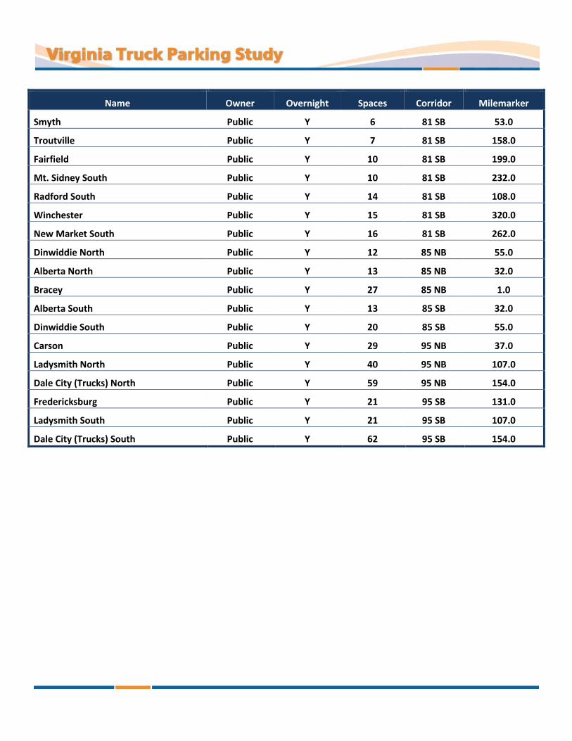
Name Owner Overnight Spaces Corridor Milemarker
Smyth Public Y 6 81 SB 53.0
Troutville Public Y 7 81 SB 158.0
Fairfield Public Y 10 81 SB 199.0
Mt. Sidney South Public Y 10 81 SB 232.0
Radford South Public Y 14 81 SB 108.0
Winchester Public Y 15 81 SB 320.0
New Market South Public Y 16 81 SB 262.0
Dinwiddie North Public Y 12 85 NB 55.0
Alberta North Public Y 13 85 NB 32.0
Bracey Public Y 27 85 NB 1.0
Alberta South Public Y 13 85 SB 32.0
Dinwiddie South Public Y 20 85 SB 55.0
Carson Public Y 29 95 NB 37.0
Ladysmith North Public Y 40 95 NB 107.0
Dale City (Trucks) North Public Y 59 95 NB 154.0
Fredericksburg Public Y 21 95 SB 131.0
Ladysmith South Public Y 21 95 SB 107.0
Dale City (Trucks) South Public Y 62 95 SB 154.0

Name Owner Overnight Spaces Corridor Milemarker State
Pilot Travel Center Private Y 25 25E 0.0 Kentucky
Mapco Express #1060 Private Y 2 25 Kentucky
Welcome Center Public N 15 13 Maryland
One Stop Travel Plaza Private Y 80 301 0.0 Maryland
Pilot Travel Center Private Y 90 81 5.0 Maryland
Pilot Travel Center Private Y 90 70 24.0 Maryland
New Transit Truck Stop Private Y 50 97 10.0 Maryland
TA Baltimore South #151 Private Y 436 95 41.0 Maryland
Welcome Center NB Public Y 22 95 NB 35.0 Maryland
Welcome Center SB Public Y 16 95 SB 35.0 Maryland
TA Baltimore #216 Private Y 181 95 57.0 Maryland
Welcome Center SB Public Y 8 77 SB 105.0 North Carolina
Brintle Enterprises Inc Private Y 200 77 100.0 North Carolina
Wilco Travel Plaza #122 Private Y 5 77 83.0 North Carolina
Rest Area NB Public Y 15 77 NB 73.0 North Carolina
Rest Area SB Public Y 20 77 SB 65.0 North Carolina
Fast Track #133 Private Y 15 77 65.0 North Carolina
Kangaroo Express #3188 Private Y 5 52 118.0 North Carolina
Eagle Xpress Private 50 220 North Carolina
Rest Area SB Public Y 14 85 SB 232.0 North Carolina
Chex Truck World Private Y 100 85 220.0 North Carolina
Rest Area SB Public N 18 85 SB 202.0 North Carolina
Rest Area NB Public Y 16 85 NB 202.0 North Carolina
Wilco Hess #1827 Private N 8 85 191.0 North Carolina
Shell Private Y 8 85 191.0 North Carolina
Welcome Center SB Public Y 20 95 SB 180.0 North Carolina
Pilot Travel Center Private Y 25 95 180.0 North Carolina
Oasis Travel Center Private 60 95 168.0 North Carolina
Rest Area SB Public Y 19 95 141.0 North Carolina

Name Owner Overnight Spaces Corridor Milemarker State
Rest Area NB Public 20 95 141.0 North Carolina
Wilco Hess Private 20 301 North Carolina
Welcome Center NB Public Y 15 81 NB 1.0 Pennsylvania
TA Greencastle #213 Private Y 190 81 5.0 Pennsylvania
Greencastle Sunoco Private Y 15 81 5.0 Pennsylvania
Welcome Center SB Public Y 23 81 SB 1.0 Tennessee
Rest Area SB Public Y 23 81 SB 41.0 Tennessee
Rest Area NB Public Y 27 81 NB 36.0 Tennessee
Roadrunner #119 Private Y 10 81 36.0 Tennessee
TA Greeneville #201 Private Y 140 81 36.0 Tennessee
Pilot Travel Center Private Y 12 81 36.0 Tennessee
Rest Area NB Public Y 70 77 NB 17.0 West Virginia
Rest Area SB Public Y 16 77 SB 14.0 West Virginia
Welcome Center WB Public Y 7 64 WB 175.0 West Virginia
Stop In Food Store Private 20 64 175.0 West Virginia
Alta Station Private Y 30 64 161.0 West Virginia
Mt Top Truck Stop Private Y 10 50 West Virginia
Welcome Center NB Public Y 22 81 NB 232.0 West Virginia
Welcome Center SB Public Y 20 81 SB 24.0 West Virginia
Appendix B: Demand Methodology
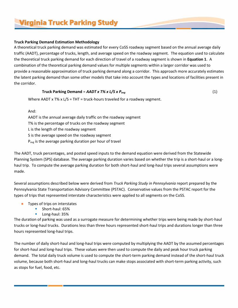
Truck Parking Demand Estimation Methodology A theoretical truck parking demand was estimated for every CoSS roadway segment based on the annual average daily
traffic (AADT), percentage of trucks, length, and average speed on the roadway segment. The equation used to calculate
the theoretical truck parking demand for each direction of travel of a roadway segment is shown in Equation 1. A
combination of the theoretical parking demand values for multiple segments within a larger corridor was used to
provide a reasonable approximation of truck parking demand along a corridor. This approach more accurately estimates
the latent parking demand than some other models that take into account the types and locations of facilities present in
the corridor.
Truck Parking Demand = AADT x T% x L/S x Pavg (1)
Where AADT x T% x L/S = THT = truck-hours traveled for a roadway segment.
And:
AADT is the annual average daily traffic on the roadway segment
T% is the percentage of trucks on the roadway segment
L is the length of the roadway segment
S is the average speed on the roadway segment
Pavg is the average parking duration per hour of travel
The AADT, truck percentages, and posted speed inputs to the demand equation were derived from the Statewide
Planning System (SPS) database. The average parking duration varies based on whether the trip is a short-haul or a long-
haul trip. To compute the average parking duration for both short-haul and long-haul trips several assumptions were
made.
Several assumptions described below were derived from Truck Parking Study in Pennsylvania report prepared by the
Pennsylvania State Transportation Advisory Committee (PSTAC). Conservative values from the PSTAC report for the
types of trips that represented interstate characteristics were applied to all segments on the CoSS.
Types of trips on interstates Short-haul: 65% Long-haul: 35%
The duration of parking was used as a surrogate measure for determining whether trips were being made by short-haul
trucks or long-haul trucks. Durations less than three hours represented short-haul trips and durations longer than three
hours represented long-haul trips.
The number of daily short-haul and long-haul trips were computed by multiplying the AADT by the assumed percentages
for short-haul and long-haul trips. These values were then used to compute the daily and peak hour truck parking
demand. The total daily truck volume is used to compute the short-term parking demand instead of the short-haul truck
volume, because both short-haul and long-haul trucks can make stops associated with short-term parking activity, such
as stops for fuel, food, etc.

Short-term (short-haul trips) Pavg(short-term) – 5 min parked to 55 min of travel per hour = 0.083 hr Average parking duration(short-term) – 22 min = 0.367 hr per stop Peak overall parking activity(short-term) – 3:00 to 4:00 am 2.11% trucks parked less than 3 hours are in the facility during the peak parking period between 3:00 to
4:00 am Truck-hours parked(short-term) = AADT x T% x L/S x Pavg (short-term)
Daily truck stops(short-term) = Pavg(short-term) /average parking duration(short-term)
Peak parking demand(short-term) = daily truck stops(short-term) x 2.11% Using these short-term parking assumptions, the short-term demand is computed using Equation 2:
Truck Parking Demand(short-term) = (AADT x T% x L/S) 0.083/0.367 x 0.0211 (2)
Long-term (long-haul trips)
Fd = 0.786 = 11/14 = Driving hours permitted in a daily on-duty window (FMCSA regulations) OD8 = 70 hrs = Maximum on-duty hours permitted over 8 consecutive days (FMCSA) DR8 = Fd x OD8 = 55 hrs = Maximum driving hours permitted over 8 consecutive days Ht = 192 hrs = Total hours in 8 consecutive days Hh = 42 hrs = Average hours at home (off-duty) for long-haul truckers over 8 consecutive days (from
2002 FHWA study) Hr = Ht – Hh = 150 hrs = Average hours with truck (on- or off-duty) for long-haul truckers over 8
consecutive days D% = DR8 / Hr = 0.367 = Fraction of time on the road (on-duty and driving) for long-haul truckers over 8
consecutive days P% = 1 – D% = 0.633 = Fraction of time long-haul truckers must be off-duty and/or parked over 8
consecutive days under FMCSA regulations Pavg(long-term) = P% / D% = 1.725 = Hours parked for FMCSA regulations for every hour of driving Average parking duration(long-term) – 435 min = 7.25 hr 45.35% trucks parked more than 3 hours are in the facility during the peak parking period during 3:00 to
4:00 am
Truck-hours parked(long-term) = AADT x T% x L/S x Pavg(long-term)
Daily truck stops(long-term) = Pavg(long-term)/average parking duration(long-term)
Peak parking demand(long-term) = daily truck stops(long-term) x 45.35%
Using these long-term parking assumptions, the long-term demand is computed using Equation 3:
Truck Parking Demand(long-term) = (T% x AADT x 0.35 x L/S) 1.725/7.25 x 0.4535 (3)
The combined segment parking demand is computed by adding the demand for short-term parking (Equation 2) to the
demand for long-term parking (Equation 3), which results in Equation 4.
Overall Segment Truck Parking Demand = Demand(short-term) + Demand(long-term) (4)