vol. 8 no. 4, december 2017 ra ii wigos project … 1 - vol. 8 no. 4, december 2017 ra ii wigos...
TRANSCRIPT

- 1 -
Vol. 8 No. 4, December 2017
RA II WIGOS Project Newsletter
DEVELOPING SUPPORT FOR NATIONAL METEOROLOGICAL AND HYDRO-
LOGICAL SERVICES IN SATELLITE DATA, PRODUCTS AND TRAINING
Contents of this issue Page
² Inter-Comparison between COMS/MI and Himawari-8/AHI 1
² RGB Experts and Developers Workshop 2017 4
² The Second Joint GSICS/IVOS Lunar Calibration Workshop 6 ² From the Co-editors 9
Inter-comparison between COMS /MI and Himawari-8/AHI
Based on the GEO-LEO in-ter-calibration method developed by the GSICS (Global Space-based Inter-Calibration System), the National Meteorological Satellite Center (NMSC) of KMA compared each channel of COMS/MI with the Himawari-8/AHI.
The inter-comparison proceeded to the following five steps: 1) The difference in observation time be-tween two satellites is within 5 minutes, and pixels of the difference less than 1% were selected in the area of latitude and longitude within ± 35° from the center position of each satellite.
2) To reduce the uncertainty caused by temporal and spatial differences, uniformity Figure 1 Inter-calibration algorithm
- 2 -
test was performed and the pixels in homo-geneous scenes are used. 3) For visible channel, the sun-glint region is
removed to avoid the effects of specular reflections on pixels with a solar zenith angle less than 40°. 4) The observed difference due to the spectral response function (SRF), which is a unique characteristic of the sensor determined before the launch, is corrected. For this, spectral band adjustment factor (SBAF) between the two sensors is calculated by NASA Web Tool (http://cloudsgate2.larc.nasa.gov) and applied to Himawari-8/AHI. 5) And then the GSICS correction coefficients (slope and offset) obtained by GSICS GEO-LEO (IASI) and visible vicarious calibra-tion method (earth targets) are applied to visible and infrared channels of COMS/MI and Himawari-8/AHI. The COMS/MI visible chan-nel has been operated for almost 7 years and as a result the sensor degradation during the period is almost 20%. Thus, for the direct comparison of two visible sensors with and/or without onboard calibration target, the correc-tion is essential.
The corresponding channels used in
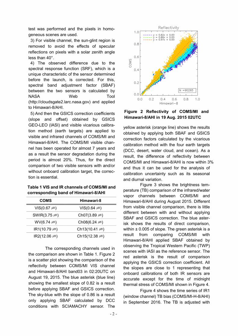
the comparison are shown in Table 1. Figure 2 is a scatter plot showing the comparison of the reflectivity between COMS/MI VIS channel and Himawari-8/AHI band03 in 02:20UTC on August 19, 2015. The blue asterisk (blue line) showing the smallest slope of 0.82 is a result before applying SBAF and GSICS correction. The sky-blue with the slope of 0.86 is a result only applying SBAF calculated by DCC conditions with SCIAMACHY sensor. The
yellow asterisk (orange line) shows the results obtained by applying both SBAF and GSICS correction factors calculated by the vicarious calibration method with the four earth targets (DCC, desert, water cloud, and ocean). As a result, the difference of reflectivity between COMS/MI and Himawari-8/AHI is now within 3% and thus it can be used for the analysis of calibration uncertainty such as its seasonal and diurnal variation.
Figure 3 shows the brightness tem-perature (TB) comparison of the infrared/water vapor channels between COMS/MI and Himawari-8/AHI during August 2015. Different from visible channel comparison, there is little different between with and without applying SBAF and GSICS correction. The blue aster-isk shows the results of direct comparison, within ± 0.005 of slope. The green asterisk is a result from comparing COMS/MI with Himawari-8/AHI applied SBAF obtained by observing the Tropical Western Pacific (TWP) scenes with IASI as the reference sensor. The red asterisk is the result of comparison applying the GSICS correction coefficient. All the slopes are close to 1 representing that onboard calibrations of both IR sensors are accurate except for the time of midnight thermal stress of COMS/MI shown in Figure 4.
Figure 4 shows the time series of IR1 (window channel) TB bias (COMS/MI-H-8/AHI) in September 2016. The TB is adjusted with
COMS Himawari-8
VIS(0.67㎛) VIS(0.64㎛)
SWIR(3.75㎛) Ch07(3.89㎛)
WV(6.74㎛) Ch08(6.24㎛)
IR1(10.79㎛) Ch13(10.41㎛)
IR2(12.06㎛) Ch15(12.38㎛)
Table 1 VIS and IR channels of COMS/MI and corresponding band of Himawari-8/AHI
Figure 2 Reflectivity of COMS/MI and Himawari-8/AHI in 19 Aug. 2015 02UTC

- 3 -
SBAF, GSICS correction coefficient. The thick red line represents the latitudinal average of TB. The gray line (right Y-axis) represents the number of application of MBCC (Midnight Blackbody Calibration Correction) during the same period.
It can be a good example for the GEO-GEO inter-comparison, since COMS/MI clearly showed the diurnal variation in the midnight thermal stress period in spite of its correction, assumed that the Himawari-8/AHI has good performance. There also showed the diurnal variation in other months such as March, June and December.
The limited equatorial cross time of LEO in specific local time prevented from investigating the full diurnal variation of the IR calibration. The advent of next-generation GEO imager, GEO-LEO inter-comparison would give the opportunity to investigate and find the way to correct the COMS/MI diurnal variation during the thermal stress period.
Through this process, the two sen-sors will be able to normalize to a common
Figure 3 Scatter plots of IR TB of COMS/MI and compatible band of Himawari-8/AHI
Figure 4 Diurnal variation of IR1(10.8 ㎛) TB bias in Sep. 2016
- 4 -
standard and use it as a single data, which is expected to enable continuity and accumula-tion in climate data. It is expected that gener-ating the Climate Data Record (CDR) with the same accuracy by homogenizing the observed values of the best reference with same level will improve the accuracy of the Essential Climate Variables (ECVs). Reference “SCOPE-CM_Phase-2-Implementation-Plan”, 2012 “Radiometric Inter-Calibration between Himawari-8 AHI and S-NPP VIIRS for the Solar Reflectivity Bands”, Fangfang Yu and Xiangqian Wu, remote sensing, 2016
(Hyeji Yang, NMSC/KMA)
RGB Experts and Developers Workshop 2017
The RGB Experts and Developers
Workshop 2017 was held at the headquarters of the Japan Meteorological Agency (JMA) in Tokyo from 7 to 9 November 2017. The event was co-hosted by JMA, the World Meteoro-logical Organization (WMO) and the European Organization for the Exploitation of Meteoro-logical Satellites (EUMETSAT). It is held every five years, with the first taking place in Boulder, Colorado (USA), in 2007 and the second in Seeheim (Germany) in 2012. This third workshop in Tokyo was attended by 30 experts (including 8 from JMA) from 15 countries.
Naoyuki Hasegawa, the Director-General of JMA’s Observation Department, welcomed the attendees. In his address, he noted that RGB composite techniques have been developed under international cooperation, and highlighted the role of discussions at the workshop in contributing to further progress in this area. Dr. Stephan Bojinski of the WMO Space Program also gave an address sum-marizing the specifications of new-generation meteorological satellites, reviewing the recommendations and RGB composite recipes discussed at the previous workshops, and noting the challenges faced at this workshop.
The event featured eight sessions cover-ing the following: l Review of existing RGBs l New RGBs based on newly-available
channels in GEO l RGBs based on LEO imagers and other
sensors l Application examples outside MSG 0°
footprint l Intercomparisons of GEO RGBs in
overlap regions l Practical examples of RGBs in the
forecasting and research context (togeth-er with quantitative products, NWP output and Conceptual models)

- 5 -
l Compilation of demonstration and training material
l Potential standards for other composites The full workshop agenda is posted on the WMO website at: http://www.wmo.int/pages/prog/sat/meetings/RGB-WS-2017.php
The discussions produced recom-mendations for the modification of current RGB recipes and ideas for new RGB recipes in consideration of sulfur dioxide, fire intensity, smoke and other variables. The presentation materials and final workshop report will be available on the WMO website soon.
The workshop was followed by a JMA and Weather Business Consortium (WXBC) public session at which Motowo Hayashi from JMA’s Meteorological Satellite Center (MSC), Dr. Jochen Kerkmann from EUMETSAT and Bodo Zeschke from the Australian Bureau of Meteorology (AuBoM) presented stunning imagery to emphasize the usefulness of RGB composite imagery. The successful event attracted around 80 people, and active discussions among attendees and presenters continued even after the session ended. (Shiro Omori, JMA)
Figure 5 Examples of RGB imagery: Day Microphysics RGB (left), Natural Color RGB (middle) and Airmass RGB (right) at 02:40 UTC on December 26, 2017. Cf. “Himawari Real-Time Image”, MSC/JMA (http://www.data.jma.go.jp/mscweb/data/himawari/index.html).

- 6 -
The Second Joint GSICS/IVOS Lunar Calibration Workshop
In the recent years, significant efforts
have been made to promote and develop lunar calibration activities within Global Space-based Inter-Calibration System (GSICS) and Infrared and Visible Optical Sensor (IVOS), subgroup of Working Group on Calibration and Validation(WGCV), Committee on Earth Observation Satellites (CEOS) In December 2014 experts from 14 agencies and depart-ments attended the joint GSICS-IVOS Lunar Calibration Workshop organized by EU-METSAT in collaboration with USGS, CNES and NASA. In total it represented potentially more than 25 instruments capable of observ-ing the Moon, covering a spectral range from about 0.4μm to 2.3μm. One of the major achievements of the workshop was to work on
a common lunar irradiance model: the GSICS Implementation of the ROLO (GIRO) model. The GIRO was endorsed as the established publicly-available reference for lunar calibra-tion, directly traceable to the USGS ROLO model.
More recently, many initiatives were undertaken by the members of the Lunar Calibration Community with for instance dedicated lunar measurement campaigns, developments of radiance models, or new algorithms to develop new lunar in-ter-calibration products. In order to pursue the efforts of sharing knowledge and expertise on lunar calibration, the Second Joint GSICS/IVOS Lunar Calibra-tion Workshop was hosted by the China Meteorological Administration (CMA) in Xi’an, China, November 13-16, 2017.
This workshop was organized by CMA, Xi'an Institute of Optics and Precision Mechanics (XIOPM), Chinese Academy of Sciences (CAS), EUMETSAT, USGS and NOAA. The experts from 16 agencies and departments attended the joint GSICS-IVOS Lunar Calibration Workshop. The main objectives of the workshop ware:
a. To share knowledge and expertise on
the latest dedicated ground-based lunar observation campaigns, and also space-based lunar datasets, that can help with refining the current lunar cali-bration reference.
b. To share knowledge and expertise in the preparation of lunar irradiance measurements from observations by the instruments to be monitored.
- 7 -
c. To work jointly on algorithms to compare and inter-calibrate instruments with lu-nar observation capabilities, even from different time-scale, supporting the generation of Fundamental Climate Data Records.
d. To explore further alternative applica-tions of lunar observations for calibra-tion purposes or post-launch assess-ments, such as geometric and Modula-tion Transfer Function (MTF) charac-terization.
Session 1: Measurements and Moon Observation
In session 1, it was presented for the achievement from the project “Solar bands calibration technique based on Lunar radiance source. And especially it was presented for the current activities of CMA and their collaborat-ing institutes on lunar measurements and lunar calibration. Session 2: Using the ROLO/GLOD
In session 2, it was presented for the lunar data preparation for the LEO satellites (MODIS, VIIRS, ASTER, MERSI, Tansat, Proba-V, SGLI/GCOM-C and so on) and GEO satellites (FY-2, SEVIRI/Meteosat-9, COMS, AHI/Himawari-8, and ABI/GOES-16) by experts from each agency. Session 3: Lunar Model Development
In this session, it was represented for the current status of the ROLO and future developments and comparison of the Lunar model using the hyper-spectral imager ob-servation. It was also presented for the current limitation of using the ROLO for absolute calibration due to 5-10% current absolute scale uncertainty of the ROLO. The next step is to refine/develop a new empirical formula-tion of the ROLO model: utilization of knowledge gained from current and past lunar calibration accomplishments such as VIIRS time series of libration dependency effect, wide phase angle coverage data (GEOs, PLEIADES). NPP VIIRS clearly shows a dependence effect. Those data could be used as constrains on the fitting procedure to derive the model. Other instruments shall demon-
strate that the data are fully validated. Potentially lunar calibration can provide an absolute calibration reference with uncertainty of 1% (k=1). Session 4: Inter-calibration and inter-band Calibration
In this session, it was introduced for the inter-calibration scheme using the moon and current issues that the moon is used through the GIRO model for inter-calibration of multiple instruments. It was also presented for moving from MODIS to VIIRS as a new reference for inter-calibration. Session 5: Alternative uses of lunar meas-urements
Lunar image is a nearly ideal and widely available target for the evaluation of the spatial quality of space-based optical instru-ments. Fermi function based parametric method for edge location to sub-pixel accuracy to derive fitting function of edge spread function. Also it was presented MTF evaluation of SEVIRI/Meteosat-9, AHI/Himawari-8, FY-2, MERSI and Proba-V using Lunar observation. Also it was introduced the electronic cross-talk characterization using lunar observation for MODIS and VIIRS. The small size of the moon makes it a good target for electronic cross-talk characterization. And electronic x-talk will appear in striping in between detectors in some thermal infrared bands. In band 04 of the ABI/GOES-R, it appeared blooming effect (halo) around the moon. Image enhancement shows patterns that need to be worked out. NOAA performs north-south scan of the Moon. NS-scans reveal cross-talk in band 6 in GOES-16 ABI. . In flight it is difficult to identify the reasons for the cross-talk (separation between opti-cal/electronic and light reflection, out-of-band, etc.) Discussion of various terms regarding cross-talk: subsystem level detector testing (without optics) can reveal electronic cross-talk while ruling out optical cross-talk. Session 6: Conclusion and way forward
In this session, the participants discuss for some issues like below;
- 8 -
- Establishing new requirements on the ROLO/GIRO application
- Establishing new requirements on lunar measurements
- Next steps for inter-calibration - Nest steps for alternative methods (ra-
diance models/MTF/other irradiance models)
This workshop lead to an updated as-
sessment of the current lunar observation dataset that can either support refining the accuracy of the current version of the RO-LO/GIRO or be part of the GSICS Lunar Observation Dataset (GLOD). It will also contribute to defining recommendations or methodologies to compare and inter-calibrate instruments using the Moon. Finally it is intending to provide more insight on the use of lunar observations in satellite mission Cal/Val plans and for sensor monitoring activities. (Tae-Hyeong Oh, NMSC/KMA)
- 9 -
Members of the Coordinating Group JAPAN (Co-coordinator) Dr Hiroshi KUNIMATSU Senior Supervisor for Satellite Operations Satellite Program Division Japan Meteorological Agency REPUBLIC OF KOREA (Co-coordinator) Dr Dohyeong KIM Senior Researcher Satellite Planning Division, National Meteorological Satellite Center Korea Meteorological Administration CHINA Mr Xiang FANG Director, Remote Sensing Data Application National Satellite Meteorological Center China Meteorological Administration INDIA Mr A. K. SHARMA Deputy Director General of Meteorology India Meteorological Department RUSSIAN FEDERATION Ms Tatiana BOURTSEVA Chief, Information Department ROSHYDROMET Dr Oleg POKROVSKIY Principal Scientist, Main Geophysical Obser-vatory ROSHYDROMET EUMETSAT (Observer) Dr Kenneth HOLMLUND Chief Scientist EUMETSAT
From the Co-editors
The co-editors invite contributions to the newsletter. Although it is assumed that the major contributors for the time being will be satellite operators, we also welcome articles (short contributions of less than a page are fine) from all RA II Members, regardless of whether they are registered with the WMO Secretariat as members of the WIGOS Project Coordinating Group. We look forward to receiving your contributions to the newsletter. (Dohyeong KIM, KMA, and Hiroshi KU-NIMATSU, JMA) RA II WIGOS Project Home Page http://www.jma.go.jp/jma/jma-eng/satellite/ra2wigosproject/ra2wigosproject-intro_en_jma.html Editorials and Inquiries Hiroshi KUNIMATSU (Dr.) Senior Supervisor for Satellite Operations Satellite Program Division Observation Department Japan Meteorological Agency 1-3-4 Otemachi, Chiyoda-ku Tokyo 100-8122, Japan Tel: +81-3-3201-8677 Fax: +81-3-3217-1036 Email: [email protected] Dohyeong KIM (Dr.) Senior Researcher Satellite Planning Division, National Meteorological Satellite Center Korea Meteorological Administration 64-18 Guam-gil, Gwanghyewon, Jincheon, Chungbuk, 365-830, Republic of Korea Tel: +82-43-717-0205 Fax: +82-43-717-0210 Email: [email protected] (Editor-in-chief of this issue: Dohyeong Kim)