volunteers: stepping up since the beginning
TRANSCRIPT

VOLUNTEERS: Stepping Up Since The Beginning
Paddling, boating, wading, collecting, restoring…and picking updead birds - Watershed Council volunteers are up for it all! For40 years, volunteers have helped collect data and carry out manyprojects that further our mission. The Watershed Council isfortunate to have dozens of volunteers out in the field assistingwith data collection and protection efforts. This article shines aspotlight on four of our current volunteers.
Volunteer Stream Monitoring began asAdopt-a-Stream in 1988, and it became
what it is today in 2005. Kathy Germainjoined the program in 2006 by takinga macroinvertebrate identificationcourse offered by the WatershedCouncil. Since then, Kathy has shined
as an expert identifier, and taken herclassroom of students at North Central
Michigan College in Petoskey to samplelocal streams annually. Now that she’s newly
retired after over 40 years of teaching science, she’ll continue tovolunteer as an expert identifier. “I intend to keep doing it untilI’m 100. I’m hooked on it. I love it. You never know what’s goingto be in each collection jar. It’s like unwrapping a package.”Kathy’s attitude about volunteering is this: “Don't be afraid tojump in - literally, into your waders. Get in the river. The datayou collect is important and you may find a new passion.”
Volunteer Lake Monitoring beganin 1986. One of the longestserving volunteers is JohnFowler from Pickerel Lake.John takes his boat out onPickerel Lake to collect weeklywater samples. While hisbeginnings as a volunteer aresomething to laugh about, hesays he “got conned into it by mybrother-in-law and neighbors,” his commitment and contribution are no joke. Throughout John’smany years of volunteering, he has observed Pickerel Lake doesn’tchange much from year to year, but he finds the changes thatoccur throughout the year to be very interesting. One changethat John looks for is the growth of purple loosestrife, an invasiveplant. Understanding the ecosystem around Pickerel Lake is important to John, who’s had an interest in biology since college.
Volunteer Botulism Monitoring began in 2011.Over the years, volunteers have logged enoughmiles to equal a trip from the MackinacBridge to Washington, D.C. - 800 miles ofmonitoring! One of the longest servingbotulism monitors is Tec Cummings ofHarbor Springs. Since 2011, Tec has walkedthe same 2.5 mile stretch of Lake Michiganfor 3 months in the fall each year, totaling225 miles. On his most intense day, hefound and buried 35 dead birds! Theyoungest of his siblings, Tec was sent to thebeach a lot as a kid when everyone left thehouse, so for him, walking the beach comesnaturally. Styling himself as a Handy Man “witha capital ‘h,’” Tec’s interest in botulism monitoring is literally “forthe birds,” or his love of them anyway. “I love birds and I lovethe beach,” he says. It certainly helps. Watershed Council volunteersare part of a much larger lake-wide effort to estimate bird mortalityand predict changes in the Great Lakes.
The Watershed Action Volunteer Experience (WAVE) is ournewest volunteer program, at only one year old. According toNancy Cunningham, “If you have any love for the outdoors, thisis a wonderful way to keep our Earth healthy.” Nancy is the leaderof the Friends of the Boyne River team and is a member of theLake Charlevoix Association team. Both teams are creating educational signage. As a retired teacher, this aligns with Nancy’sinterests to “spread information.” Nancy’s father was a “pre-EPAenvironmentalist” who questioned General Motors’ chromatecontamination in the Flint River in the 1950s and her motherkept a victory garden during WWII. Now as a master gardenerherself, Nancy volunteers with the same passion as her parents. Notonly is she on two WAVE teams, she also coordinates invasive
species control for Friends of the Boyne Riverand has been a volunteer stream monitor
since 2008.
When asked what their favorite partof volunteering is, the most commonanswer was “the people you meet.”We agree! Thank you volunteers foryour time, talents, passion, humbleness,
and generosity for 40 years.
KathyGe
rmain
Tec Cummings
Nancy
Cunningha
m
John Fowler

Tip of the Mitt Watershed Council
Board of DirectorsClaire Rasmussen, PresidentBob Kingon, Vice PresidentRick Brandi, TreasurerPam Roudi, Secretary
Herm Boatin Larry LevengoodRick Doornbos Jim McKimmyBill Foster Linda OelkeCharlie Gano Susan StewartScott Kendzierski Donna Stine
Watershed Council StaffGail Gruenwald, Executive Director and Staff Attorney
Administrative TeamLynn D. Buffington,Financial and Operations Director
Development/Communications TeamKate Cwikiel,Communications Coordinator
Debbie Esposito,Data and Membership Specialist
Abigail Hackman,Administrative and CommunicationsAssistant
Education TeamEli Baker,Water Resources Education Coordinator
Policy and Advocacy TeamJennifer McKay,Policy Director
Grenetta Thomassey, Ph. D.,Watershed Policy Director
Watershed Protection TeamJennifer Buchanan,Watershed Protection Director
David Edwards,Monitoring and Research Director
Caroline Keson,Water Resource Specialist
Memberof:
Tip of the Mitt Watershed Council
426 Bay Street, Petoskey, MI 49770(231) 347-1181 • (231) 347-5928 fax
www.watershedcouncil.org
2
Reflections From Our Executive Director
July is here and the celebration of the Watershed Council’s 40thanniversary is in full swing! The Watershed Council has worked to protect Northern Michigan’s precious waters since 1979. Asyou will read in this newsletter, our critical work continues and isjust as important to our region now as it was then. While publicsupport of protecting our waters has increased over the past fourdecades, the challenges we face are extremely difficult and requireour committed attention.
A significant focus of this newsletter is the efforts of our volunteers. We have dozens of volunteers that devote hundreds of hours annually to expand upon the scope and geographyof our work. We couldn’t possibly monitor and collect all the data without our volunteers.They make the science happen across our service area under the direction of our qualifiedstaff. We have relied on our volunteer network throughout our history. The long term trendsthat we track are essential to making wise decisions about our waters. Volunteers make this happen!
Of course, in addition to our essential volunteers, we have relied on our generous membersfor 40 years. As a membership organization, our members not only help support us financiallybut help to guide the organization. We are a grassroots organization and our members providethe soil that has allowed us to grow and thrive.
We look forward to 40 more years of effective, results-oriented programming. Thank youto all our volunteers and members for making this work possible! Please join us for our40th celebration or any of our summer events.
Gail GruenwaldExecutive Director
New Grants!Tip of the Mitt Watershed Council is excited to announce our recent awards from theMichigan Department of Natural Resources (MDNR) Aquatic Habitat Grants Program!The Program provides support for projects that help to protect and restore aquatic habitats throughout Michigan.
• Natural Shoreline Principles and Practices in Action: Contractor Training and Public Demonstration on Lake Charlevoix
The Watershed Council will restore approximately 200 linear feet of degraded shorelineat East Jordan’s Tourist Park on Lake Charlevoix in association with the Michigan NaturalShoreline Partnership’s contractor training program. The project will serve as a hands-ondemonstration of applying bioengineering practices on a high-energy lake system. Theproject will take place in 2020.
• Improving Aquatic Connectivity within the Crooked River Watershed
The Watershed Council will improve two road/stream crossings within the CrookedRiver Watershed with channel-spanning structures. The larger of the two crossings is atBanwell Road over Berry Creek, a tributary to Pickerel Lake. The existing culverts will be replaced with a channel-spanning timber bridge. The second site is at Snider Roadand crosses over a tributary to the Crooked River. Additional funding for this project was received in 2018 through the U.S. Fish and Wildlife Service’s National Fish HabitatPartnership program. Construction will take place in 2020.

3Summer 2019 www.watershedcouncil.org
Department of EnvironmentalQuality RestructuredMichigan’s Governor Gretchen Whitmer signed an executive order thatrestructured the Department of Environmental Quality as the Departmentof Environment, Great Lakes, and Energy (EGLE) (pronounced “eagle”).Governor Whitmer’s executive order also establishes three new officeswithin EGLE:
• Office of the Clean Water Public Advocate to accept and investigate complaints and concerns related to drinking water quality.
• Office of the Environmental Justice Public Advocate who will accept and investigate complaints and concerns related to environmental justice in Michigan.
• Interagency Environmental Justice Response Team consisting of directors of major departments within Michigan government, to assist in developing, implementing, and regularly updating a statewide environmental justice plan.
EGLE also assumes many activities of the Michigan Agency for Energythrough the creation of the new Office of Climate and Energy. The Officeof Climate and Energy was created to coordinate activities related to climate response and to make recommendations regarding the mitigationof climate impact, among other functions. The Office of the Great Lakesmoved from the Department of Natural Resources into EGLE.
EGLE will also house the Michigan PFAS Action Response Team,MPART, which was created by former Governor Rick Snyder, to addressPFAS contamination throughout the State. MPART will now fall withinthe Department rather than being run from the Governor’s office.
COLLECTION EVENTSBring your unwanted and unused over-the-counter and prescription medications, including controlled
substances, to one of the following collection events for proper disposal.
PETOSKEYThursday, October 17, 2019
7:00 a.m. – 4:00 p.m.McLaren Northern Michigan,
Petoskey CampusHospital Circle Drive
off Mitchell Street
CHEBOYGANThursday, October 24, 2019
9:00 a.m. – 1:00 p.m.McLaren Northern Michigan,
Cheboygan Campus Entrance North of the Emergency
Department
Both events will also be acceptingsharps, cell phones, shoes,
eyeglasses, and hearing aids for proper disposal/recycling.
40TH ANNIVERSARY Annual Meeting and Gala Fundraiser
2019 marks the Watershed Council’s 40th anniversary of protecting what youlove here in Northern Michigan. We are excited to celebrate this milestone withour members who have made it possible. Join us for our 40th Anniversary AnnualMeeting and Gala Fundraiser on July 16. The Gala will be at the Grand UnityEvent Center in Petoskey from 6:00 p.m. - 8:30 p.m. Tickets are $50 each andwill include specialty drinks, heavy hors d'oeuvres, live music, a silent auction,commemorative wine glasses, a brief membership meeting, and more! Join usfor the festivities, mingle with friends, and enjoy the view of Lake Michigan. Nospecial dress code. Call us at (231) 347-1181 to purchase tickets and reserveyour spot. You won't want to miss out on this exclusive gala celebrating the Watershed Council's 40 years of protecting what you love!
July 16, 20196:00 p.m. – 8:30 p.m.
Grand Unity Event Center1106 Charlevoix, AvePetoskey, MI 49770
RESERVE YOUR TICKETS TODAY!

Understanding the Pipeline Permitting Process in MichiganMultiple federal and state agencies and commissions are involved in permitting andoverseeing siting, construction, operation, and maintenance of pipeline infrastructure.This webinar hosted by Watershed Council staff will help describe the various pipelinepermitting processes in Michigan and the role citizens can play.
Look for more information to come on www.watershedcouncil.org.
Save theDate
September 5, 2019
4 Tip of the Mitt Watershed Council
How Can MiWaters Benefit Your Search for Information?
Article submitted by: Brian Marshall, [email protected] • (989) 370-0462
MiWaters provides several options for you to connect with theDepartment of Environment, Great Lakes, and Energy's (EGLE)Water Resources Division (WRD) to gather permit information,report a spill, or search for information on activity in your area.
MiWaters, pronounced “My Waters,” is an online electronicdatabase that provides helpful tools for the WRD to connectour regulatory system with the public electronically. MiWaterswas also developed to allow Michigan to fulfill federal electronicreporting requirements, with a focus on permitting and compliance to establish a streamlined electronic permittingprocess. From the home page, the public user can access theWRD’s permitting programs, including public notice and publichearing listings, search active or past permit records, access permitapplications, and report complaints (e.g., placing fill in wetlands),spills, or pollution events (e.g., petroleum products in water).Here is what you need to get started:
Searching Public Notices and Public Hearings The public notice search allows the user to narrow search resultswith filters for county, applicant name, or program area (e.g.,Resource, Aquatic Nuisance Control, National Pollution Discharge Elimination System (NPDES), etc.). Once a noticeor listing is selected, one can then review the details of the notice, including downloading the application documents toreview, view details, and submit comments.
Search for Existing Records with Site ExplorerAnother great resource in MiWaters is Site Explorer. Site Exploreris an interactive mapping tool for searching the State for sitesof interest. By clicking on a site, public users can see informationabout the regulated entity’s activities at that location, such asinspections reports, applications, permits, or enforcement actions.Site Explorer also has different layers that can be added to themap, such as wetlands, conservation easements, Great Lakesbottomland conveyances, and much more.
Reporting Spills, Pollution, and Unauthorized ActivitiesUsers can also report spills, leaks, or discharges to surface waters,such as unusual discolored water, oil sheens, and unusualamounts of dead fish. MiWaters can also be used for reportinggeneral complaints regarding unauthorized activities in a wetland,lake, stream, sand dune, or Great Lakes coastal area, such asdredging, filling, and placement of a structure without permits.The uniqueness of reporting spills and complaints is that thepublic user can write exactly what was observed, put in the location of the complaint, and add photos. Once submitted,the information goes directly to the local staff representativeto review and respond.
For more information on MiWaters, visit the MiWaters homepage, or contact the appropriate EGLE office if you have questions that couldn’t be answered by the online help menu.The MiWaters home page can be accessed by following thislink: https://miwaters.deq.state.mi.us/miwaters/external/home.
WEBINAR

5Summer 2019 www.watershedcouncil.org
VOLUNTEER LAKE MONITORING- 2018 ReviewBackgroundSince 1986, Tip of the Mitt Watershed Council’s Volunteer Lake Monitors (VLM) have venturedout on the inland lakes of the region to collect invaluable data that help to conserve and protectimportant resources of Northern Michigan. Objectives of this monitoring effort are to identify,characterize, and document baseline data and any changes to lake ecosystems. Most importantly,through identifying and documenting trends and changes, volunteers gain hands-on experienceprotecting Northern Michigan’s lakes. Each spring, volunteers participate in a half-day trainingprior to collecting data for the season. During the summer months, volunteers venture out to theirmonitoring station once a week. Larger lakes, such as Charlevoix, Burt, and Mullett, have multiplemonitoring volunteers and stations. The following section summarizes monitoring parameters andoverall 2018 program results.
Secchi DiscThe Secchi disc was invented in 1865 by Pietro Angelo Secchi, an Italian Jesuit priest active inoceanography, meteorology, physics, and astronomy. The disc is black and white with an alternatingpattern, and is used to measure water clarity. The disc is lowered into the water and the depth at which the disc is no longer visible is recorded. Water clarity, principally determined by the concentration of algae and/or suspended sediment in the water column, is a simple and valuablemeasurement to assess water quality. Throughout the summer, different algae bloom at different times, causing clarity to vary greatly throughout the season. Secchi disc depths rangefrom just a few feet in small inland lakes to over 60 feet in the Great Lakes! Of particular interestfor lakes in our region is the continued presence of zebra and quagga mussels. These mussels areincredible filter feeders and can dramatically reduce algae in the water column. The use of a Secchi discallows us to monitor the mussels’ impact on water clarity and identify potential changes in lakes.
Water clarity data for some lakes in our service area extend back to the 1980s, providing a long-term view of water quality conditions and trends. Seasonal averages are used for trend assessmentsbecause water clarity can vary greatly, depending on magnitude of algal blooms, weather events,and other factors. Data from Lake Charlevoix demonstrate the changes that have occurred overtime in a number of the region’s lakes. Secchi disc depths in Lake Charlevoix have increased fromapproximately 10 feet in 1987 to over 18 feet in 2018 (Figure 1). This trend of increasing watertransparency is also fairly well pronounced in Black, Burt, Douglas, Elk, Michigan, Mullett, Pickerel,Skegemog, and Walloon Lakes. What do all these lakes have in common that might be causingsuch changes? Invasive zebra mussels.
2018REPORT
Tip of the Mitt Watershed Council
Volunteer Monitoring Programs
6 Tip of the Mitt Watershed Council
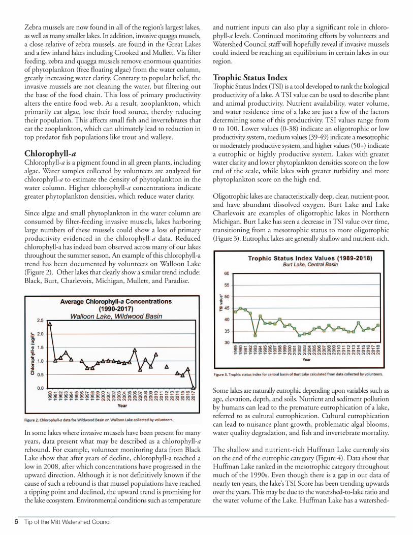
Zebra mussels are now found in all of the region’s largest lakes,as well as many smaller lakes. In addition, invasive quagga mussels,a close relative of zebra mussels, are found in the Great Lakesand a few inland lakes including Crooked and Mullett. Via filterfeeding, zebra and quagga mussels remove enormous quantitiesof phytoplankton (free floating algae) from the water column,greatly increasing water clarity. Contrary to popular belief, theinvasive mussels are not cleaning the water, but filtering outthe base of the food chain. This loss of primary productivityalters the entire food web. As a result, zooplankton, which primarily eat algae, lose their food source, thereby reducingtheir population. This affects small fish and invertebrates thateat the zooplankton, which can ultimately lead to reduction intop predator fish populations like trout and walleye.
Chlorophyll-aChlorophyll-a is a pigment found in all green plants, includingalgae. Water samples collected by volunteers are analyzed forchlorophyll-a to estimate the density of phytoplankton in thewater column. Higher chlorophyll-a concentrations indicategreater phytoplankton densities, which reduce water clarity.
Since algae and small phytoplankton in the water column areconsumed by filter-feeding invasive mussels, lakes harboringlarge numbers of these mussels could show a loss of primaryproductivity evidenced in the chlorophyll-a data. Reducedchlorophyll-a has indeed been observed across many of our lakesthroughout the summer season. An example of this chlorophyll-atrend has been documented by volunteers on Walloon Lake(Figure 2). Other lakes that clearly show a similar trend include:Black, Burt, Charlevoix, Michigan, Mullett, and Paradise.
In some lakes where invasive mussels have been present for manyyears, data present what may be described as a chlorophyll-arebound. For example, volunteer monitoring data from BlackLake show that after years of decline, chlorophyll-a reached alow in 2008, after which concentrations have progressed in theupward direction. Although it is not definitively known if thecause of such a rebound is that mussel populations have reacheda tipping point and declined, the upward trend is promising forthe lake ecosystem. Environmental conditions such as temperature
and nutrient inputs can also play a significant role in chloro-phyll-a levels. Continued monitoring efforts by volunteers andWatershed Council staff will hopefully reveal if invasive musselscould indeed be reaching an equilibrium in certain lakes in ourregion.
Trophic Status IndexTrophic Status Index (TSI) is a tool developed to rank the biologicalproductivity of a lake. A TSI value can be used to describe plantand animal productivity. Nutrient availability, water volume,and water residence time of a lake are just a few of the factorsdetermining some of this productivity. TSI values range from0 to 100. Lower values (0-38) indicate an oligotrophic or lowproductivity system, medium values (39-49) indicate a mesotrophicor moderately productive system, and higher values (50+) indicatea eutrophic or highly productive system. Lakes with greaterwater clarity and lower phytoplankton densities score on the lowend of the scale, while lakes with greater turbidity and morephytoplankton score on the high end.
Oligotrophic lakes are characteristically deep, clear, nutrient-poor,and have abundant dissolved oxygen. Burt Lake and LakeCharlevoix are examples of oligotrophic lakes in NorthernMichigan. Burt Lake has seen a decrease in TSI value over time,transitioning from a mesotrophic status to more oligotrophic(Figure 3). Eutrophic lakes are generally shallow and nutrient-rich.
Some lakes are naturally eutrophic depending upon variables such asage, elevation, depth, and soils. Nutrient and sediment pollutionby humans can lead to the premature eutrophication of a lake,referred to as cultural eutrophication. Cultural eutrophicationcan lead to nuisance plant growth, problematic algal blooms,water quality degradation, and fish and invertebrate mortality.
The shallow and nutrient-rich Huffman Lake currently sitson the end of the eutrophic category (Figure 4). Data show thatHuffman Lake ranked in the mesotrophic category throughoutmuch of the 1990s. Even though there is a gap in our data ofnearly ten years, the lake’s TSI Score has been trending upwardsover the years. This may be due to the watershed-to-lake ratio andthe water volume of the Lake. Huffman Lake has a watershed-

7Summer 2019 www.watershedcouncil.org
to-lake ratio of 46:1. This means that roughly 46acres of watershed surface area is drained for every 1acre of Huffman Lake’s surface area. This value doesnot consider water volume, but Huffman is one ofthe shallower lakes in the region.
2018 Results and DiscussionMost of the lakes monitored in 2018 showed valuesin the mesotrophic category. In 2018, a total of 26 siteswere monitored on 21 lakes by over 60 volunteers.Table 1 shows the compiled results for TSI scoresand averaged Secchi disc depths for comparison withother lakes monitored in 2018.
The hundreds of hours spent each summer by ourVolunteer Lake Monitors continues to provide long-term data that is used not only by the WatershedCouncil, but by lake associations, government agencies,and private entities to evaluate lake conditions andchanges over time. The Watershed Council regularlysupplies the Michigan Department of Natural Resources (MDNR), Michigan Department of Environment, Great Lakes, and Energy (EGLE),and various academic institutions with data collectedby our volunteers. As resources to investigate waterquality become increasingly scarce (usually in the form of state and federal budget cuts), volunteer monitoring programs continue toensure that environmental changes in and around our lakes do not go undocumented. If you would like more information on anylakes listed (or not listed), or would like to become a Volunteer Lake Monitor, please contact our office at (231) 347-1181.

8 Tip of the Mitt Watershed Council
Streams are the freshwater circulation system of NorthernMichigan. Their primary function is to drain the landscapeand carry rainwater, snowmelt, and groundwater into and outof the region’s lakes. Our moving waters provide recreationalopportunities to anglers, paddlers, and others, as well as habitatto a wide variety of wildlife. Fortunately, many Northern Michiganresidents recognize the value of these streams. During springand fall of each year, volunteer stream monitors perform biological monitoring by collecting aquatic insects and othermacroinvertebrates to assess stream ecosystem health. Macroin-vertebrates are the quintessential “canary in the coal mine,” as theyserve as key water quality indicators. Several macroinvertebrateorders, such as mayflies, stoneflies, and caddisflies, are highlysensitive to environmental change or pollution. A healthy variety of these pollution-sensitive macroinvertebrates portraysa healthy ecosystem with high water quality, while a streamwith only pollution-tolerant aquatic worms and midges revealsan ecosystem that is likely suffering. Since 2005, our volunteerstream monitors have collected these biological data, whichserve to document annual stream conditions and changes overtime. Most noticeable trends point to changes occurring within thestream’s watershed. In 2018, over 100 Volunteer Stream Monitorshelped monitor 31 sites on 17 different rivers and creeks!
Although most Northern Michigan streams have excellentwater quality, there are a few sites where diversity is low due tourban runoff and other nonpoint source pollutants.
Biological data are assessed using three different measurementsof diversity:
1) Total Taxa = total number of macroinvertebrate families found at a site
2) EPT taxa = number of families in the three pollution- sensitive insect orders (Ephemeroptera-mayflies, Plecoptera-stoneflies, and Trichoptera-caddisflies)
3) Sensitive Taxa = number of the most sensitive macroinvertebrate families
Although not every site is monitored each year, taxa scores foreach site are averaged using data from all monitoring events asshown in Table 1.
Many rivers and streams in Northern Michigan rank amongthe best in the State for water quality. Notable rivers such asthe Jordan, Pigeon, Maple, Cedar, and Sturgeon all host diverseand sensitive macroinvertebrate populations. Should theserivers begin to undergo impacts from large-scale degradation,our “canaries in the coal mine”- stoneflies, caddisflies, andmayflies - will begin to disappear. Tracking macroinvertebratecommunities on a biannual basis allows us to keep our fingeron the pulse of the rivers and streams included in the VolunteerStream Monitoring Program.
Alternatively, many of our urbanized streams have low diversityand host only pollution-tolerant organisms. These streamscould support sensitive organisms, but development-relatedimpacts suppress the population and degrade water quality.Stormwater outfalls discharge large quantities of warm, pollutant-laden water during rain storms. Eroding banks yieldsediment that smothers the vital interstitial spaces of cobbleand gravel. Banks devoid of vegetation reduce habitat diversityand allow the water to warm on hot days. Fortunately, thereare methods to mitigate these impacts. For example, rain gardens and other stormwater treatment methods keep untreated stormwater out of streams, and restoration projectscan restore habitat. Many other solutions exist and by monitoringthe stream, we can track improvements in water quality. Manyof these projects are already underway, as the Watershed Counciland other conservation organizations work to protect and improveour waters.
2018 VOLUNTEER STREAM MONITORING
In 2018, over100 Volunteer
Stream Monitorshelped monitor 31 sites on 17 different rivers
and creeks!

9Summer 2019 www.watershedcouncil.org
Table 1. Average Taxa Values for Volunteer Stream Monitoring Program Sites in 2018

10 Tip of the Mitt Watershed Council
Stream Reports for 2018A water quality grade is assigned to each monitoring site using a weightednumeric scoring system based on total taxa, EPT taxa, and sensitive taxaindices. A poor grade does not necessarily indicate poor water quality, butrather the presence of a pollution-tolerant macroinvertebrate community.In some streams, such as Schoof ’s or Horton Creek, the slow flowing nature of the stream does not provide the habitat necessary to supportsensitive species. The important aspect is comparing biological data overmany years. From year to year, macroinvertebrate grades can vary andsometimes can’t be explained by water quality or habitat changes. Thetiming of seasons or hatches could be the culprit. A lowered grade one yearis less concerning if the overall average is still high and the stream returnsto its typical grade. The following site specific letter grades are for only the2018 monitoring season. The average grade for all monitoring years islocated within the site description and associated map below (Figure 1).
Water Quality Grading System*
A = Excellent B = Good C = Moderate D = PoorE = Very Poor
*Grades based on a system that utilizes all three index scores.
Figure 1: Volunteer Monitoring Sites for 2018 with stream water quality grades.
11Summer 2019 www.watershedcouncil.org
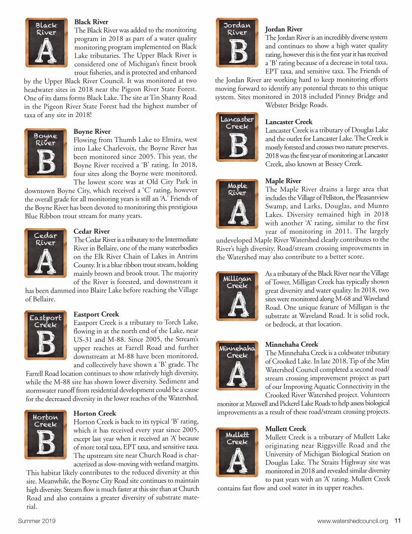
Black RiverThe Black River was added to the monitoringprogram in 2018 as part of a water qualitymonitoring program implemented on BlackLake tributaries. The Upper Black River isconsidered one of Michigan’s finest brooktrout fisheries, and is protected and enhanced
by the Upper Black River Council. It was monitored at twoheadwater sites in 2018 near the Pigeon River State Forest.One of its dams forms Black Lake. The site at Tin Shanty Roadin the Pigeon River State Forest had the highest number oftaxa of any site in 2018!
Boyne River Flowing from Thumb Lake to Elmira, westinto Lake Charlevoix, the Boyne River hasbeen monitored since 2005. This year, theBoyne River received a ‘B’ rating. In 2018,four sites along the Boyne were monitored.The lowest score was at Old City Park in
downtown Boyne City, which received a ‘C’ rating, howeverthe overall grade for all monitoring years is still an ‘A.’ Friends ofthe Boyne River has been devoted to monitoring this prestigiousBlue Ribbon trout stream for many years.
Cedar RiverThe Cedar River is a tributary to the IntermediateRiver in Bellaire, one of the many waterbodieson the Elk River Chain of Lakes in AntrimCounty. It is a blue ribbon trout stream, holdingmainly brown and brook trout. The majorityof the River is forested, and downstream it
has been dammed into Blaire Lake before reaching the Villageof Bellaire.
Eastport CreekEastport Creek is a tributary to Torch Lake,flowing in at the north end of the Lake, nearUS-31 and M-88. Since 2005, the Stream’supper reaches at Farrell Road and furtherdownstream at M-88 have been monitored,and collectively have shown a ‘B’ grade. The
Farrell Road location continues to show relatively high diversity,while the M-88 site has shown lower diversity. Sediment andstormwater runoff from residential development could be a causefor the decreased diversity in the lower reaches of the Watershed.
Horton Creek Horton Creek is back to its typical ‘B’ rating,which it has received every year since 2005,except last year when it received an ‘A’ becauseof more total taxa, EPT taxa, and sensitive taxa.The upstream site near Church Road is char-acterized as slow-moving with wetland margins.
This habitat likely contributes to the reduced diversity at thissite. Meanwhile, the Boyne City Road site continues to maintainhigh diversity. Stream flow is much faster at this site than at ChurchRoad and also contains a greater diversity of substrate mate-rial.
Jordan RiverThe Jordan River is an incredibly diverse systemand continues to show a high water qualityrating, however this is the first year it has receiveda ‘B’ rating because of a decrease in total taxa,EPT taxa, and sensitive taxa. The Friends of
the Jordan River are working hard to keep monitoring effortsmoving forward to identify any potential threats to this uniquesystem. Sites monitored in 2018 included Pinney Bridge and
Webster Bridge Roads.
Lancaster CreekLancaster Creek is a tributary of Douglas Lakeand the outlet for Lancaster Lake. The Creek ismostly forested and crosses two nature preserves.2018 was the first year of monitoring at LancasterCreek, also known at Bessey Creek.
Maple RiverThe Maple River drains a large area that includes the Village of Pellston, the Pleasantview Swamp, and Larks, Douglas, and MunroLakes. Diversity remained high in 2018with another ‘A’ rating, similar to the firstyear of monitoring in 2011. The largely
undeveloped Maple River Watershed clearly contributes to theRiver’s high diversity. Road/stream crossing improvements inthe Watershed may also contribute to a better score.
As a tributary of the Black River near the Villageof Tower, Milligan Creek has typically showngreat diversity and water quality. In 2018, twosites were monitored along M-68 and WavelandRoad. One unique feature of Milligan is thesubstrate at Waveland Road. It is solid rock,or bedrock, at that location.
Minnehaha CreekThe Minnehaha Creek is a coldwater tributaryof Crooked Lake. In late 2018, Tip of the MittWatershed Council completed a second road/stream crossing improvement project as partof our Improving Aquatic Connectivity in theCrooked River Watershed project. Volunteers
monitor at Maxwell and Pickerel Lake Roads to help assess biologicalimprovements as a result of these road/stream crossing projects.
Mullett CreekMullett Creek is a tributary of Mullett Lakeoriginating near Riggsville Road and the University of Michigan Biological Station onDouglas Lake. The Straits Highway site wasmonitored in 2018 and revealed similar diversityto past years with an ‘A’ rating. Mullett Creek
contains fast flow and cool water in its upper reaches.
BlackRiver
BoyneRiver
CedarRiver
EastportCreek
HortonCreek
JordanRiver
LancasterCreek
Maple River
MilliganCreek
MinnehahaCreek
MullettCreek
12 Tip of the Mitt Watershed Council
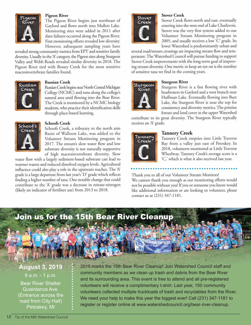
Pigeon RiverThe Pigeon River begins just northeast ofGaylord and flows north into Mullett Lake.Monitoring sites were added in 2011 afterdam failures occurred along the Pigeon River.First monitoring efforts revealed low diversity.However, subsequent sampling years have
revealed strong community metrics from EPT and sensitive familydiversity. Usually in the ‘A’ category, the Pigeon sites along SturgeonValley and Webb Roads revealed similar diversity in 2018. ThePigeon River tied with Bessey Creek for the most sensitivemacroinvertebrate families found.
Russian CreekRussian Creek begins near North Central MichiganCollege (NCMC) and runs along the college’snatural area until flowing into the Bear River.The Creek is monitored by a NCMC biologystudents, who practice their identification skillsthrough place-based learning.
Schoofs CreekSchoofs Creek, a tributary to the north armBasin of Walloon Lake, was added to the Volunteer Stream Monitoring program in2017. The stream’s slow water flow and lowsubstrate diversity is not naturally supportiveof high macroinvertebrate diversity. Slow
water flow with a largely sediment-based substrate can lead towarmer waters and reduced dissolved oxygen levels. Agriculturalinfluence could also play a role in the upstream reaches. The ‘A’grade is a large departure from last year’s ‘D’ grade which reflectsfinding a higher number of taxa. One notable change that couldcontribute to the ‘A’ grade was a decrease in nitrate-nitrogen(likely an indicator of fertilizer use) from 2013 to 2018.
Stover CreekStover Creek flows north and east, eventuallyentering into the west end of Lake Charlevoix.Stover was the very first system added to ourVolunteer Stream Monitoring program in2005, and usually receives a low ‘C’ grade. Itslower Watershed is predominantly urban and
several road/stream crossings are impacting stream flow and tem-perature. The Watershed Council will pursue funding to supportStover Creek improvements with the long-term goal of improv-ing stream diversity. One metric to keep an eye on is the numberof sensitive taxa we find in the coming years.
Sturgeon River Sturgeon River is a fast flowing river withheadwaters in Gaylord and a west branch nearHuffman Lake. Eventually flowing into BurtLake, the Sturgeon River is near the top forconsistency and diversity metrics. The pristineforests and land cover in the upper Watershed
contribute to its great diversity. The Sturgeon River typically receives an ‘A’ grade.
Tannery CreekTannery Creek empties into Little TraverseBay from a valley just east of Petoskey. In2018, volunteers monitored at Little TraverseWheelway. Tannery Creek’s average score is a‘C,’ which is what it also received last year.
Thank you to all of our Volunteer Stream Monitors!We cannot thank you enough as our monitoring efforts wouldnot be possible without you! If you or someone you know wouldlike additional information or are looking to volunteer, pleasecontact us at (231) 347-1181.
PigeonRiver
RussianCreek
Schoof’sCreek
StoverCreek
SturgeonRiver
TanneryCreek
2019 marks the 15th Bear River Cleanup! Join Watershed Council staff and
community members as we clean up trash and debris from the Bear River
and its surrounding area. This event is free to attend and all pre-registered
volunteers will receive a complimentary t-shirt. Last year, 150 community
volunteers collected multiple truckloads of trash and recyclables from the River.
We need your help to make this year the biggest ever! Call (231) 347-1181 to
register or register online at www.watershedcouncil.org/bear-river-cleanup.
Join us for the 15th Bear River Cleanup
August 3, 2019
9 a.m. - 1 p.m.
Bear River Shelter
Quaintance Ave.
(Entrance across the
road from City Hall)
Petoskey, MI

13Summer 2019 www.watershedcouncil.org
If your leisure-time plans include boating or fishing, recentchanges in Michigan’s Natural Resources and EnvironmentalProtection Act (NREPA) may affect you.
What boaters need to knowIn addition to the existing law requiring all aquatic plants beremoved from boats and trailers before launching, the recentchanges require the following prior to transporting any watercraftover land, both motorized and non-motorized:
• Remove all drain plugs from bilges, ballast tanks, and live wells.
• Drain all water from any live wells and bilges.
• Ensure the watercraft, trailer, and any conveyance used to transport the watercraft or trailer are free of aquatic organisms, including plants.
This means after trailering boats, and before getting on theroad, boaters must pull plugs, drain water and remove plantsand debris from all watercraft, trailers and other conveyances.
What anglers need to know • A person shall not release baitfish in any waters of this State. A person who collects fish shall not use the fish as bait or cut bait except in the inland lake, stream, or Great Lake where the fish was caught, or in a connecting waterway of the inland lake, stream, or Great Lake where the fish was caught if the fish could freely move between the original location of capture and the location of release.
• A person, who catches fish other than baitfish in a lake, stream, Great Lake, or connecting waterway shall only release the fish in the lake, stream, or Great Lake where the fish was caught, or in a connecting waterway of the lake, stream, or Great Lake where the fish was caught if the fish could freely move between the original location of capture and the location of release.
Whether purchased or collected, unused baitfish should be disposed of on land or in the trash – never in the water. Anybaitfish an angler collects may be used only in the waters whereit was originally collected. And remember when practicingcatch-and-release fishing, return the fish to the water where itwas caught.
Draining boats and cleaning trailers can limit the spread of zebraand quagga mussels, which are common in some inland lakes.A more recent invader, the tiny New Zealand mudsnail, canhitchhike from river to river when mud or debris is left onkayaks, canoes, and gear.
Moving fish from one body of water to another can spread fishviruses and parasites, such as viral hemorrhagic septicemia virus(VHSv) and Heterosporis, and can affect many different fishspecies. Fish diseases also can be spread to new locations whenwater carrying parasites or infection is transferred via bilges, livewells, or ballast tanks.
For more information on the new boating and fishing laws,visit the Laws section at Michigan.gov/invasives.
New Boating and Fishing Law
Here are some simple rules of thumb to helpboaters and anglers navigate these laws:
• CLEAN boats, trailers, and equipment.
• DRAIN live wells, bilges, and all water – pull all drain plugs.
• DRY boats and equipment.
• DISPOSE of unwanted bait in the trash.

Tip of the Mitt Watershed Council
Welcome New Interns!This summer, the Watershed Council is lucky to have threeamazing interns – Alex Rocco, Caleb Short, and Garrett Greer.In order to get to know them a little better, we asked them afew questions about their interests and hobbies.
Q: What school do you attend and what is your area of study?
Alex: I attend Jacksonville State University in Alabama as agraduate biology student studying crayfish ecology. I have aB.S. in wildlife and fisheries science, with a concentration infisheries from Tennessee Tech University.
Caleb: I attend the University of Michigan-Flint and my majoris in wildlife biology.
Garrett: I am currently attending Lake Superior State Universitywhere my major is political science (law) with a focus on environmental policy.
Q: What interests you about water resources protection?
Alex: I am especially interested in aquatic invasive species andtheir effects on humans, infrastructure, and local ecology.
Caleb: I am able to apply knowledge in practical situations inmy home state along with seeing the impact of everyone’s actions in and around the Great Lakes.
Garrett: Freshwater, next to the air we breathe, is the mostcritical resource on this planet. It is up to us to be the beststewards possible so that future generations can enjoy and useour amazing freshwater resources like so many before them.Protecting it is critical in a world that is waging war on thequality of our water.
Q: What do you hope to gain from this internship?
Alex: I hope to gain experience and skills working under biologistsand help to further ensure the high quality of freshwater habitatsin Northern Michigan.
Caleb: I am excited to gain experience working on and in thewater as well as gain insight into possible future career paths.
Garrett: From this internship I want to gain direction and experience. I want to know what the leg work of policy-making is really like and hope to find out if water resource protectionis my passion. I would also like to create a bigger network. Thepeople that work at the Watershed Council are truly at thevanguard for the fight for nature and will be amazing allies inthe future.
Q: What do you plan to do after graduation?
Alex: After graduation, I would like to get a job as a freshwaterbiologist for a nonprofit or government.
Caleb: Grad school! I wish I could go to school forever, but Ihope to find a career in research and conservation in wildlifebiology. I’m certain that this summer will impact my future career decisions as well.
Garrett: After graduation I plan on working in the field whereverI can find footing. Whether that be with a nonprofit like theWatershed Council or a government job with the State, I wantto protect the valuable resources we have left and serve any waypossible.
Q: What is your favorite thing to do outside?
Alex: When I’m outside for fun, I’m either preparing to gofishing or fishing. I fish for all species with lots of different tackle,but I especially like to fly fish for smallmouth bass and trout.
Caleb: Birding!
Garrett: My favorite things to do outside are hunting, trail riding, kayaking, and hiking. Just being outside is a treasure soanything that gets me out of the four walls and into nature ismy favorite thing to do.
2019 Summer Interns (left to right): Garrett Greer, Caleb Short, and Alex Rocco
Exclusive Watershed Council NotecardsThese beautiful notecards were made exclusively for the Watershed Council by local NorthernMichigan artist Lisa Loyd. These notecards are perfect for any occasion thanks to their colorful,water-related artwork and blank inside pages. All proceeds from the purchase of these notecardsgo towards the Watershed Council’s resource protection programming. Each pack of notecardsis $12. To purchase, stop by the Watershed Council office, call (231) 347-1181, or order online at www.watershedcouncil.org.
14

15Summer 2019 www.watershedcouncil.org
Alpine Chocolat HausAmerican Spoon Foods, Inc.B.C. Pizza CorporateBar HarborBeards BreweryBellaire Bed & BreakfastBiere De Mac Brew WorksBig Stone Bay Fishery, Inc.Bill's Farm MarketBlue Moon KitchenBoyne City Taproom/Round Lake Group LLCBoyne Mountain ResortBreakers TopinabeeBridge Street Tap Room/Round Lake Group LLCBurnt Marshmallow BrewingCafe EsperanceCafe SanteCellar 152 Pub and ProvisionsChandler's, A Restaurant & Wine CellarCherry RepublicChristopher's Downtown CafeCircle MCity Park GrillColin's Corner CafeCoveyou Scenic Farm MarketCrooked Tree BreadworksCrooked Vine Vineyard and WineryCross Village General StoreDaddy FranksDalwhinnie Bakery & DeliDixie SaloonDripworks CoffeeDrost's ChocolatesEthanology DistillationFarmer White'sFlour Girl PizzaFrench Quarter New Orleans BistroFreshwater GrillFriske Orchards Farm Market
Front Porch CafeFustini'sGrain Train Market CafeGreenside Grille at Indian River Golf ClubGrey Gables Restaurant and CateringHarvest Thyme Farm & Vineyards LLCHarwood GoldHigh Five SpiritsHorton Creek Inn Bed & BreakfastHouse on the Hill Bed and BreakfastJarman's Pure Maple SyrupJEGA Catering IncorporatedJohan's Pastry Shop, Inc.John Cross FisheriesJulienne TomatoesKilwins Quality ConfectionsKing OrchardsKnot Just A BarLake Charlevoix Brewing/ Round Lake Group LLCLake Street MarketLake Street PubLibby's CafeMackinaw Trail WineryMaple Moon Sugarbush and WineryMichael's Tavern and SteakhouseMim's Mediterranean GrillMy Sister's Bake ShopNauti Inn BarstroNourish Northern MichiganPaper Station BistroPearl's New Orleans KitchenPetoskey CheesePetoskey Farms Vineyard & WineryPier M33 On The CheboyganPlath's MeatsPolish KitchenPond Hill FarmRed Mesa GrillResort Pike Cider and Winery
Roast & ToastRowe Inn RestaurantRoyal Farms Inc.Rudbeckia Farm and WineryRuthann's Gourmet BakerySage at Odawa CasinoSecrets on MainShanty Creek Resorts/ Bellaire Group LtdShort's Brewing CompanySide Door SaloonSmoke on the WaterStafford's Hospitality, Inc.Stiggs Brewery & KitchenSuzie's PiesSweetwater Catering CompanyTerry's of CharlevoixThai Orchid CuisineThe LocalThirsty SturgeonTip of the Mitt Watershed CouncilToonies Fish & Steak HouseToski Sands Market and Wine ShopVernales RestaurantVillager PubWalloon Lake WineryWalloon Village General StoreWhi-Ski Inn
Tip of the Oven Mitt: Waves of Flavor from LocalChefs and Watershed Council MembersHot off the press! Over the past several months, the Watershed Council has been workingwith more than 100 area food and drink venues to put together this exclusive collection of 300 Northern Michigan recipes. All proceeds from this cookbook go towards the Watershed Council's youth education programs. Help us educate thenext generation of watershed stewards while cooking up some delicious, local recipes.The cookbooks are $25 each. Whether you purchase for yourself, give as a gift, or do both,this cookbook is sure to be treasured for many years. To purchase, stop by the WatershedCouncil office, call (231) 347-1181, or order online at www.watershedcouncil.org. A $5 shipping and handling fee per book is added to all online orders.
A Special Thank You to All of Our Cookbook Contributors:
HOT OFF THE PRESS!
$25.00 eachProceeds benefit
our youth education programs!

ADDRESS SERVICE REQUESTED
This newsletter contains information
worth sharing.
When you’re donereading it, don’t
throw it out.
Pass it on!
Non-Profit Org.
USPS Mktg.
Petoskey, MI
Permit No. 108
Dennis and Cynthia ColleranDorset Charitable TrustMr. and Mrs. Ron FenechFred KraftKevin and Marcia MeyerMary V. RingwaltMalinda Smyth and Thomas Wagner
In Memory of...Joanne A. Duff Philip English Carol JehleJoan Keller Bruce Davis and Heidi HillWilliam MacPhee Elizabeth and Stephen LaymanJeffrey MooreDenise RodgersJo Ann SkandalarisSteven G. Pilon Jim and Shari Veller
In Honor of...Caroline Keson Raven Hill Discovery Center
In Recognition of...Michigan Paddle Events, LLC
Michigan Overboard #overboardchallenge
New MembersTribute Gifts
03/16/2019 - 06/12/2019
Saturday, August 17, 201912:00 Noon - 4:00 p.m.Bayfront Park, Petoskey, MI
Free Admission. Public Welcome.
Join us for a family-friendly water festival at BayfrontPark with hands-on activities for kids and adults.Learn from Northern Michigan’s environmental experts on wildlife, water quality, stewardship, andrecreation. Learning stations feature the natural and cultural heritage of the region.
Thank You for Your Support