w etland resource evaluation and the nra's 1. resource ... · w etland resource evaluation and...
TRANSCRIPT
W e t l a n d R e s o u r c e E v a l u a t i o n a n d t h e N R A 's
R o l e i n i t s C o n s e r v a t i o n
1. Resource Assessm ent
Environm ental Consultancy
University of Sheffield
R&D Note 377
Further copies of this report are available from:
Foundation for Water Research, Allen House, The Listons,Liston Rd, Marlow, Bucks SL7 1FD. Tel: 01628-891589, Fax: 01628-472711
Wetland Resource Evaluation and the NRA's Role in its Conservation1. Resource Assessment
B. D. Wheeler, S. C. Shaw, P. Bradley,S. J. Power, S. Wise, C. Clark, C. J. S. Routh
Research Contractor: Environmental Consultancy University of Sheffield
National Rivers Authority Manley House Kestrel Way Exeter EX2 7LQ
R&D Note 377
Com m issioning Organisation:National Rivers Authority Rivers House Waterside DriveAztec West Tel: (01454) 624400Bristol BS12 4UD Fax:(01454) 624409
© National Rivers Authority 1995
All rights reserved. No part of this document may be produced, stored in a retrieval system, or transmitted, in any form or by any means, electronic, mechanical, photocopying, recording or otherwise without the prior permission of the National Rivers Authority.
The views expressed in this document are not necessarily those of the NRA. Its officers, servants or agents accept no liability whatsoever for any loss or damage arising from the interpretation or use of the information, or reliance on views contained herein.
Dissem ination StatusInternal: Released to Regions External: Public Domain
Statement o f UseThis report documents the information available on wetland distribution in England and Wales, and proposes a strategy for NRA involvement in the development of a national wetland inventory. It is one of a series of three reports with others covering 'Classification of British Wetlands' and 'The NRA's Role in Wetland Conservation'.
Research ContractorThis document was produced under R & D Project 474 by:
Environmental Consultancy University of Sheffield Endcliffe Holt 343 Fulwood RoadSheffield Tel: (0114) 2669292S10 3BQ Fax:(0114) 2667707
NRA Project LeaderThe NRA's Project Leader for R & D Project 474 was: Lyn Jenkins - NRA South Western Region.
Additional CopiesNRA staff wishing to purchase further copies of this document should contact their Regional R&D Coordinator. External persons should purchase copies from Foundation for Water Research, Allen House, The Listons, Marlow, Bucks., SL7 1FD. Tel: (01628) 891589 or Fax: (01628)472711
R&D Note 377
CONTENTS Page
Summary 1
Keywords 1
1. General Introduction1.1 Objectives 21.2 Wetlands in England and Wales 21.3 Significance of hydrological regime 31.4 Hydrological regime and wetland vegetation 51.5 Wetland soils 71.6 Wetland functions 81.7 Wetland terms in common usage 9
2. 'Wetland': A Working Definition2.1 Introduction 122.2 Existing definitions and perceptions of wetlands 132.3 Alternative terms to ‘wetland’ 142.4 Suggested working definition 152.5 Identification of wetlands 162.6 Identification and characterisation of a wetland ‘on the ground’ 21
3. Wetland Classification3.1 Introduction 233.2 Proposed hydrotopographical classification of British Wetlands 23
4. Towards A Wetland Resource Inventory4.1 Introduction 264.2 Existing NRA inventories 264.3 Liaison and ad-hoc data purchase external to the NRA 294.4 Inventory Formats 30
5. Inventory Development Strategy5.1 Introduction 345.2 Consideration of the NRA's Uses for a Wetland Resource Inventory 355.3 Networking with other organisations 355.4 Input data formats 355.5 Establishment of a digital base map 365.6 'Desk-based' resource survey 375.7 'Field-based' reconnaissance 395.8 Proposed Pilot Study - Anglian Region 405.9 Costs for establishment of a Wetland Resource Inventory 42
for England and Wales
R&D Note 377
References 43
Glossary Of Terms 46
Appendices
A l . Wetland Soil Types and Wetness ClassesA l.l Wetland Soil Types 51A1.2 Soil Wetland Classes 52
A2. National Vegetation Classification (NVC) communitiesRodwell, (1991 a,b, 1992 & in press) 54
A 3. Provisional key to hydrotopographical elements. 56
A4. Sources of wetland resource dataA 4.1 Introduction 60A4.2 English Nature 60A4.3 Countryside Council for Wales (CCW) 61A4.4 Scottish Natural Heritage (NRPI) 62A4.5 Royal Society for the Protection of Birds 62A4.6 Institute of Terrestrial Ecology 63A4.7 Soil Survey and Land Research Centre 63A4.8 Agricultural Development and Advisory Service (ADAS) 64A4.9 Broads Authority 65A4.10 Countryside Commission 65A 4.11 County Wildlife Trusts 65A4.12 Local Authorities/Biological Records Centres 66A 4.13 Wildfowl and Wetlands Trust 66A4.14 English Heritage 67A4.15 Remote Sensing 67
A 5. Geographical Information SystemsA5.1 Storage and Management of Environmental Data 70A5.2 Data Display and Map Production 72A5.3 Inventory and Simple Query 72A5.4 Change Detection 73A5.5 Modelling Effects o f Change 73A5.6 Modelling Environmental Processes 73A5.7 Limitations of GIS 74A5.8 Case Studies 75
R&D Note 377 ii
Figures and Tables
Figure 1.1 Conceptual model of the direct and indirect effects of hydrology on wetlands (after Mitsch & Gosselink, 1993). 6
Table 1.1 Major Components of Hydrologic Budgets for Wetlands. 5
Table 1.2 Wetland terms in common usage. 10
Table 2.1 Checklist for the identification of wetland areas using existing information sources. 22
Table 3.1 Proposed topographical classification of British Wetlands. 25
Table 4.1. Sources of wetland resource data. 31
Table A l . l . Soil Wetness Classes. 52
Table A1.2 Relationships of Wetness Class to Field Capacity Days and Depth to Slowly Permeable Horizon.
53
R&D Note 377 iii

R&D Note 377 IV
SUMMARY
This R&D note provides a strategy for the assessment of the wetland resource of England and Wales. As a first step the report defines wetlands in their UK context. The following working definition is suggested:
Wetland is land that has (or had until modified) a water level predominantly at, near, or up to1.5 m above the ground surface fo r sufficient time during the year to allow hydrological processes to be a major influence on the soils and biota. These processes may be expressed in certain features, such as characteristic soils and vegetation.
The report also summarises a hydrotopographical classification of wetlands. This classification is developed further in R&D Note 378, produced as part of this research project.
The report then develops a strategy for the establishment of a wetland resource Inventory based on a geographical information system (GIS) as a means of storing and manipulating site data from across England and Wales. A summary of the strategy is as follows;
1 . a . Early commitment by the NRA to GIS development as a basis for thewetland resource Inventory with ongoing consideration of the options for using GIS.
b . Establishment of an 'Inventory network' with external organisations to ensure commitment to the programme and create a communication channel for transfer of relevant data as the project progresses.
2 . Definition of the optimum map and data formats for ultimate entry into the Inventory
3 . Proposed pilot study - Anglian Region.
4 . Establishment of a digital map base
5 . Desk based wetland resource survey;
a . Collation and assimilation of existing NRA resource data at a national level.b . Audit of external information sourcesc . Interpretation of existing aerial photographs.
6 . Field based reconnaissance of identified sites
7 . Preparation of a GIS Wetland Resource Inventory for each NRA region.
It is estimated that the completion of a wetland resource Inventory for all the regions in England & Wales could take 3 - 5 years to develop at a cost of £0.5 -£1M excluding data purchase.
Keywords
Wetland, GIS, Resource, Survey, Classification, Inventory, Definition, Hydrotopography
R&D Note 377 1
1. GENERAL INTRODUCTION
1.1 Objectives
The NRA has duties to 'further' and 'promote' the conservation of wetlands and requires access to sufficient information on the location, geographical extent and character of the wetland resource to carry out those duties. For most wetlands this information is, frequently, either lacking or difficult to obtain; hence the need for a Wetland Resource Inventory Initiative. The project reported in this document forms the first part of a scoping exercise designed to establish the extent o f the wetland resource in England and Wales and to assess the NRA’s role in wetland conservation. The NRA's role in wetland conservation and details of current procedures are considered in detail in R&D Note 381.
In addition an initial aim of the project was to provide a definition of the term ‘wetland’ appropriate to the NRA, to encompass the areas for which the NRA has responsibilities, and which would act as a basis for the assessment of the geographical extent o f the resource. However, it became clear that the classification of wetlands had become an important part of the definition, and therefore this has also been addressed. A summary of the proposed classification is provided in Chapter 3, and the classification is considered in detail in a second NRA R&D Note 378.
Although the project brief focuses on England and Wales, the definition should be of more general application. It should be noted, however, that the NRA’s terms of reference for this project specifically excluded detailed consideration of ‘coastal’ wetlands and open water habitats (see below).
1.2 Wetlands in England and Wales
1 . 2 . 1 Introduction
Human societies have had a long and complex interaction with wetlands. For much of the last two millennia, and particularly during the last few centuries, the focus of much interest in many temperate wetlands has been to drain and claim them for agricultural, forestry and peat extraction. This has lead to a major reduction in the area of extant wetlands. Water abstraction and pollution also threaten the wetland resource. In some areas only relatively small remnants persist.
Wetland ecosystems form an important part of the remaining semi-natural habitat in England and Wales supporting many threatened plant and animal species. Many also contain an important archaeological and palaeoecological archive. Wetlands are identified as an area of priority in the ‘World Conservation Strategy’ (published in 1980), and many sites and species associated with wetlands are afforded statutory protection under legislation such as the Wildlife and Countryside Act 1981 (as amended), EC Wild Birds Directive (EC Directive 79/409 on the Conservation of Wild Birds) and the EC Habitats Directive (Council Directive on the Conservation of Natural Habitats of Wild Flora and Fauna - 92/43/EEC). Wetlands are not only important for in situ flora and associated fauna; many may also be used seasonally for
R&D Note 377 2
example as winter feeding grounds or passage areas for birds, or as part of the life cycle of invertebrates.
Many wetland sites have been influenced by some form of vegetation management or habitat manipulation, usually to increase their utility or economic value; pools have been dug and surfaces flooded to encourage wildfowl for shooting; peat has been dug for fuel, animal bedding and, more recently, growing media for horticulture. Crops have also been collected; reed (Phragmites australis) has been harvested from various fens; marsh hay and litter have been mown in many sites; and crops such as ‘sedge’ (Cladium mariscus) has been of local importance, for example in East Anglia. Large areas of both blanket and raised bogs have been afforested. Many sites have also been used for rough grazing for livestock, particularly in the summer.
Some of these forms of exploitation are still practised. However, the high biodiversity and natural history interest of some wetland sites occur not despite, but because of, human manipulation, often referred to as their ‘traditional’ management. The ‘traditional’ wetlands may not have been carefully manicured ecosystems; but neither were they ‘wilderness’. Effective conservation of many wetlands will often therefore require active management when the objective is to preserve the essential character of their present, or recent, vegetation.
When coupled to the vulnerability of wetland sites, these factors provide reasons both for wetland conservation and, where appropriate, restoration. The role of the NRA in this process is considered in detail in the third R&D Note 381 from the current project.
1 . 2 . 2 Regional variation in wetland types
There is considerable variation across England and Wales in the proportion of different wetland types represented in each NRA region. This variation can be related to such factors as soil, topography, geology and climate as well as human interference. Climatic factors (rainfall, sunshine and temperature etc.) are important in affecting the formation and development of wetlands and will interact with other physical factors, such as topography and soil type. For example, in an area of high rainfall, a wetland may form on a more permeable substratum than in an area of low rainfall.
Wetlands in northern and western England and Wales include both upland wetlands (e.g. blanket bog) and lowland wetlands, while in the south and east, wetlands are mainly those associated with low-lying ground. Similarly, the water resource in the lowlands is predominantly groundwater, while in northern and western England and in Wales, surface water forms the major water source. Different types of wetland vary in their susceptibility to changes in hydrological regime or management both ‘on site’ and in the catchment. Thus the main problems for conservation, management and restoration of wetlands vary considerably between NRA regions.
1.3 Significance of hydrological regime
The common feature of all wetland types is that their formation, processes and characteristics are largely dominated and controlled by the effects of excess water. The term ‘wetland’ may be variously used to describe a wide range of habitats ranging from areas which are only
R&D Note 377 3
periodically wet (e.g. wet meadows) to those which are permanently inundated with up to 6m of water (see Chapter 2). Several factors affect the types of plant and animal life found in wetlands, these can include: the depth of water, water fluctuations, duration of elevated water levels, water temperature and water / substratum chemistry. These factors also affect, either directly or indirectly, the range of fauna (e.g. fish, birds, molluscs, crustaceans, insects, worms and microscopic organisms) which feed on the vegetation or substrata, or use them for shelter etc. Wetlands can therefore also be considered as those areas which have been wet for long enough to develop a prevalence of flora and fauna specially adapted to such conditions.
The character of wetlands and their associated flora and fauna, is critically dependent upon the nature and availability of water supply. Wetlands are therefore generally more influenced by events in their surroundings ( ‘external’ factors) than are drylands. For this reason, fragmentation of sites and changes in the drainage of their surroundings may affect the hydrochemical characteristics of sites, particularly for example fens. By contrast, bogs are often less directly dependent upon the water management of their surroundings. In some instances the achievement of particular conservation or restoration objectives, such as maintenance of current water conditions or a return to a former condition, may demand control of such ‘external’ factors as well as ‘internal’ ones.
Wetlands are sensitive to change to the extent that small modifications in hydrology can result in significant biotic changes. Mitsch & Gosselink (1993) suggest that “Hydrology is probably the single most important determinant o f the establishment and maintenance o f specific types o f wetlands and wetland processes.” Simple cause and effect relationships are difficult to establish, primarily because hydrology is highly variable in its control, both spatially and temporally. A notable feature of wetlands is that many of the characteristic plants and animals appear to be associated with specific water regimes or microtopographical variation with respect to water levels, although in general, these have not been accurately examined or quantified.
Hydrological regimes affect a wide range wetland characteristics. In summary:
• degree and duration of soil anoxia (oxygen availability and redox status);• sediment properties;• nutrient availability and cycling;• soil salinity (coastal wetlands);• species composition (and richness);• primary productivity;• organic matter accumulation;• pH.
The conceptual model shown in Figure 1.1 demonstrates the direct and indirect effects of hydrology on wetlands. The presence of feedback loops demonstrates the active role of chemical and biological processes in responding to, and influencing, wetland hydrology. For example, wetland biota may affect wetland hydrology through sediment trapping, nutrient retention and peat accumulation. Table 1.1 gives the main hydrological features important in wetlands and indicates the range o f these variables. The wide variation in hydrological conditions is likely to produce comparable variability in wetland soils and vegetation response. This in turn creates problems in defining the boundary of the wetland as discussed in Chapter2 .
R&D Note 377 4
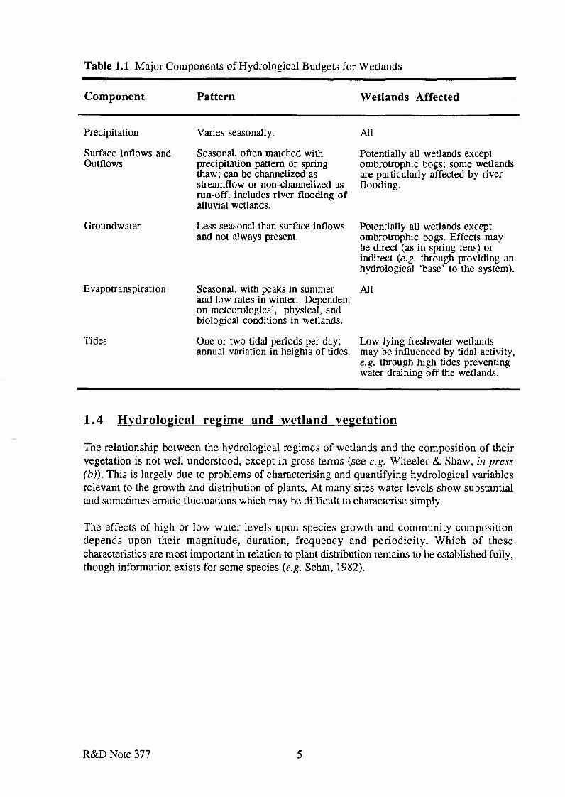
Table 1.1 Major Components of Hydrological Budgets for Wetlands
Com ponent Pattern W etlands Affected
Precipitation Varies seasonally. All
Surface Inflows and Outflows
Seasonal, often matched with precipitation pattern or spring thaw; can be channelized as streamflow or non-channelized as run-off; includes river flooding of alluvial wetlands.
Potentially all wetlands except ombrotrophic bogs; some wetlands are particularly affected by river flooding.
Groundwater Less seasonal than surface inflows and not always present.
Potentially all wetlands except ombrotrophic bogs. Effects may be direct (as in spring fens) or indirect (e.g. through providing an hydrological ‘base’ to the system).
Evapotranspiration Seasonal, with peaks in summer and low rates in winter. Dependent on meteorological, physical, and biological conditions in wetlands.
All
Tides One or two tidal periods per day; annual variation in heights of tides.
Low-lying freshwater wetlands may be influenced by tidal activity, e.g. through high tides preventing water draining off the wetlands.
1.4 Hydrological regime and wetland vegetation
The relationship between the hydrological regimes of wetlands and the composition of their vegetation is not well understood, except in gross terms (see e.g. Wheeler & Shaw, in press (b)). This is largely due to problems of characterising and quantifying hydrological variables relevant to the growth and distribution of plants. At many sites water levels show substantial and sometimes erratic fluctuations which may be difficult to characterise simply.
The effects of high or low water levels upon species growth and community composition depends upon their magnitude, duration, frequency and periodicity. Which of these characteristics are most important in relation to plant distribution remains to be established fully, though information exists for some species (e.g. Schat, 1982).
R&D Note 377 5
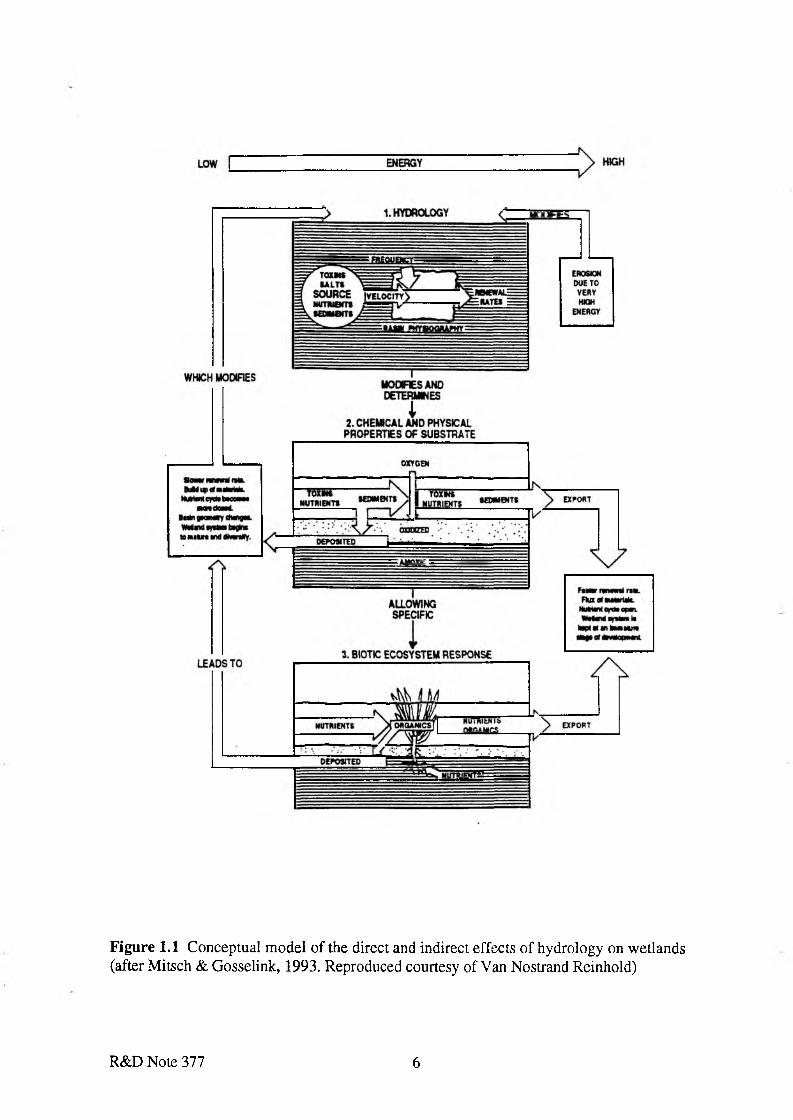
F ig u re 1.1 C onceptual m odel o f the direct and indirect effects o f hydrology on w etlands (after M itsch & G osselink, 1993. R eproduced courtesy o f Van Nostrand Reinhold)
R&D Note 377 6

The hydrological properties of wetland sites are not just a function of water-level changes. In many sites water flow is also an important surface process, though one that has been little quantified. In addition to water regime, a range of other variables can influence the composition of wetland vegetation, for example base-richness, nutrient availability, succession and vegetation management (e.g. Wheeler & Shaw, in press (a)).
In addition a variety of factors may influence the degree of wetness tolerated by plant species in addition to the hydroperiod. These include:
• availability of oxygen to roots;• concentration of reduced toxins;• presence of moving water;• possible species interactions (e.g. substratum-aeration by wetland plants and
competitive exclusion);• relative tolerances of different stages of plant growth (i.e. seedlings and mature
plants) to wetland conditions.
Not all plant species that grow in wetlands require high water levels for ‘good’ growth. Rather, they are tolerant of wetland conditions and, when they do not usually occur in drier sites, are probably excluded by interactions with ‘dryland’ species (Ellenberg, 1954).
The main problems of waterlogging to the growth of many plant species are (i) the development of anoxia in the substratum; and (ii) the consequent increase in availability of soluble, reduced toxins (especially Fe2+, Mn2* and S-). Various adaptations that may enable plants to tolerate waterlogged, anaerobic, soils have been identified but the ecological significance of some of these in relation to the distribution of plants remains to be fully established. An assessment of the mechanisms which permit plants to survive in wetlands is hampered by a lack of information for many species and complicated by the broad range of water conditions present in wetlands; the reasons why some plants can or cannot grow in permanently flooded shallow swamps may be rather different to those that apply in a fen meadow with sub-surface summer water level (Braendle & Crawford, 1987).
1.5 Wetland soils
Soils may be wet due to permanent or seasonal influence of combinations of the following factors:
• topography;• impeded drainage;• climate;• river flooding;• surface run-off;• land drainage;• discharge of groundwater.
In well-draining soils, water moves predominantly downward, and oxidising conditions occur throughout most of the year. When downward movement of water is impeded, reducing conditions may be created as micro-organisms and roots use up the oxygen in the soil, which if
R&D Note 377 7
not replaced fast enough creates an oxygen deficit. Exceptions to this are in areas where a constant flow of oxygenated water provides sufficient oxygen to prevent the establishment of reducing conditions (e.g. in spring fens). Reducing conditions lead to chemical changes, for example the reduction of iron and manganese, which increases their solubility, and the conversion of sulphates to sulphides and nitrates to ammonia. This type of environment has characteristic colours, textures and compositions, which typify hydric soils (see below). Impeded drainage may also result in the accumulation of products of weathering derived from either higher up the soil profile or on higher ground (e.g. accumulation of silt). River-flooding may also provide an input of mineral material (alluvium), which may further help to impede drainage of water coming from the valley-sides.
The variable nature of the physical and biochemical status of wetland soils means that the boundaries of the wetland may change as well.
More detailed descriptions of wetland soil types and wetness classes as classified by the Soil Survey of England and Wales are presented in Appendix 1.
1.6 Wetland functions
The present document, together with R&D Note 378 (Wetland Classification), aim towards the identification of wetlands on the ground and their classification according to their situation in the landscape and hydrotopographical elements (see Chapter 3). The next step in optimising the management of the resource is to evaluate the physical, chemical and biological functions performed by wetlands. Wetland functions are considered in detail in NRA R&D Note 114, 'Water Resource Management and Protection of Wetland Functioning', and a methodology for providing a quantitative evaluation of wetlands is being developed through the EC-STEP project (with co-funding from the NRA) entitled, 'Functional Analysis of European Wetland Ecosystems (FAEWE).
Wetlands combine a complex array of physical, chemical and biological interactions between aquatic and terrestrial ecosystems and can be considered to perform a wide range of functions (see for example Maltby 1992, Maltby, 1988 & 1991, after Adamus & Stockwell, 1983 & Adamus et al, 1987). In addition to functions relating to human interactions (e.g. heritage, recreation, science, education, transport, provision of harvestable materials), wetlands also have a range of physical / hydrological, chemical and biological functions as outlined below.
1 . 6 . 1 Physical / hydrological wetland functions
Wetlands can perform a number of physical and hydrological functions:
• coastal protection;• flood mitigation (hydrological buffer to regulate water flows through storing
floodwaters, reducing floodwater peaks, altering flood peak timing);• aquifer recharge;• sediment trapping;• shoreline anchorage and dissipation of erosive forces (sediment stabilization);• influence on atmospheric/climatic fluctuations (e.g. carbon, methane flux, micro
climates).
R&D Note 377 8
1 . 6 . 2 Chemical wetland functions
Unlike most terrestrial systems, many wetlands do not rely directly on weathering of parent material for a source of chemical elements. The products of weathering from other systems, as solutes or solids are delivered by water (either groundwater or rainfall), as a result the hydrological regime of the wetland system is essential to its supply of chemical elements. Chemical wetland functions include:
• pollutant trapping;• toxic residue removal;• carbon store;• nutrient store;• denitrification (under waterlogged, anaerobic conditions).
These processes can help to maintain freshwater and estuarine water quality, and are sometimes practically applied in the processing of waste water and sewage effluent.
1 . 6 . 3 Biological wetland functions
The key biological characteristic important in wetlands is the ability of wetland species to withstand various degrees of waterlogging or inundation. Thus hydrological conditions affect:
• zonation of species;• wetland productivity and food chain support;• habitats for wildlife (including fisheries).
Clearly, the vegetation is crucial in affecting many of the above functions, and can influence the hydrological conditions via feed-back mechanisms, for example, through sediment trapping and the build up of peat (Figure 1.1).
1.7 Wetland terms in common usage
Many terms are commonly used to describe different wetland types, but these are often used very loosely and inconsistently and can be a source of confusion. Table 1.2 provides a list of terms used most often, together with comments on the wetlands they are frequently used to describe. Aspects of wetland terminology, the use and derivation of some of the terms are discussed further in R&D Note 378. A wider glossary of terms is provided at the end of this report.
R&D Note 377 9
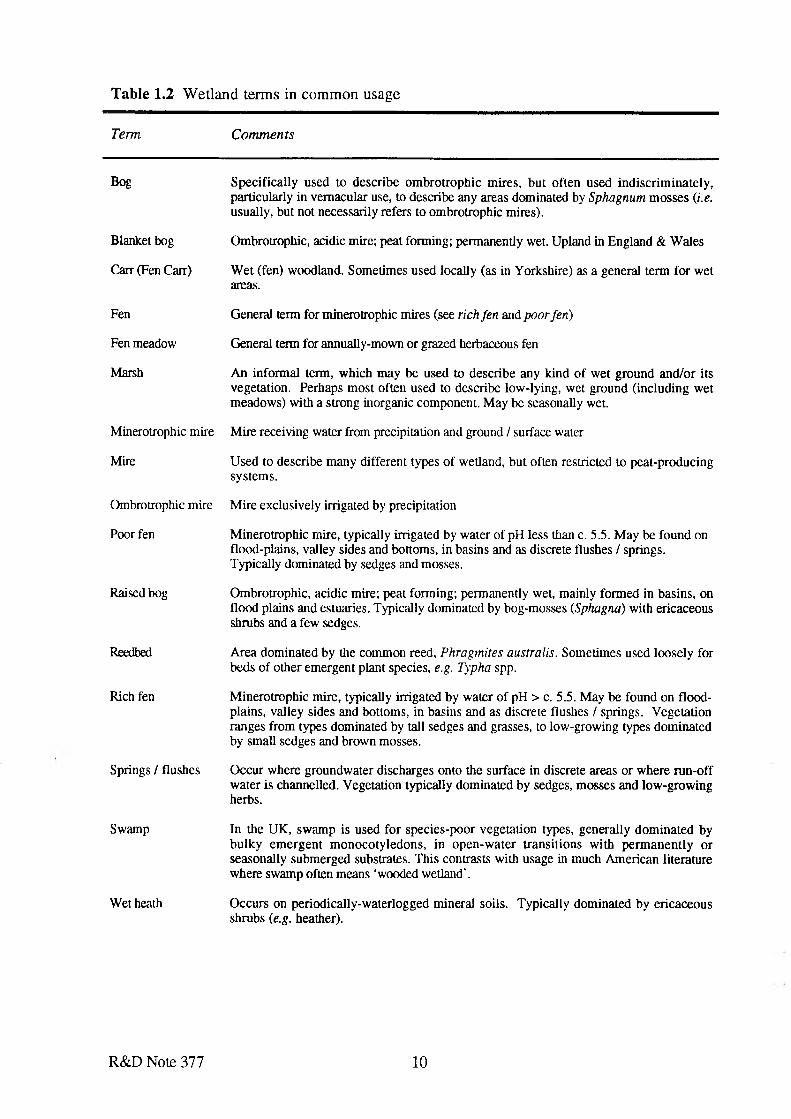
Table 1.2 Wetland terms in common usage
Term
Bog
Blanket bog
Carr (Fen Carr)
Fen
Fen meadow
Marsh
Minerotrophic mire
Mire
Ombrotrophic mire
Poor fen
Raised bog
Reedbed
Rich fen
Springs / flushes
Swamp
Wet heath
Comments
Specifically used to describe ombrotrophic mires, but often used indiscriminately, particularly in vernacular use, to describe any areas dominated by Sphagnum mosses (i.e. usually, but not necessarily refers to ombrotrophic mires).
Ombrotrophic, acidic mire; peat forming; permanently wet. Upland in England & Wales
Wet (fen) woodland. Sometimes used locally (as in Yorkshire) as a general term for wet areas.
General term for minerotrophic mires (see rich fen and poor fen)
General term for annually-mown or grazed herbaceous fen
An informal term, which may be used to describe any kind o f wet ground and/or its vegetation. Perhaps most often used to describe low-lying, wet ground (including wet meadows) with a strong inorganic component. May be seasonally wet.
Mire receiving water from precipitation and ground / surface water
Used to describe many different types of wetland, but often restricted to peat-producing systems.
Mire exclusively irrigated by precipitation
Minerotrophic mire, typically irrigated by water of pH less than c. 5.5. May be found on flood-plains, valley sides and bottoms, in basins and as discrete flushes / springs. Typically dominated by sedges and mosses.
Ombrotrophic, acidic mire; peat forming; permanently wet, mainly formed in basins, on flood plains and estuaries. Typically dominated by bog-mosses (Sphagna) with ericaceous shrubs and a few sedges.
Area dominated by the common reed, Phragmites australis. Sometimes used loosely for beds of other emergent plant species, e.g. Typha spp.
Minerotrophic mire, typically irrigated by water of pH > c. 5.5. May be found on floodplains, valley sides and bottoms, in basins and as discrete flushes / springs. Vegetation ranges from types dominated by tall sedges and grasses, to low-growing types dominated by small sedges and brown mosses.
Occur where groundwater discharges onto the surface in discrete areas or where run-off water is channelled. Vegetation typically dominated by sedges, mosses and low-growing herbs.
In the UK, swamp is used for species-poor vegetation types, generally dominated by bulky emergent monocotyledons, in open-water transitions with permanently or seasonally submerged substrates. This contrasts with usage in much American literature where swamp often means ‘wooded wetland’.
Occurs on periodically-waterlogged mineral soils. Typically dominated by ericaceous shrubs (e.g. heather).
R&D Note 377 10

Wet meadow / grassland
Wet woodland /carr
Typically a grass-dominated sward, mown or grazed, which is periodically flooded (or at least saturated), supporting at least some mire plant species. Often particularly important for birds (both breeding and wintering). Typically found as grazing marshes on floodplains, and on areas which have been subjected to partial drainage (or formerly well- drained sites in which the drainage is no longer effective).
Usually found on floodplains / valley bottoms, but may also occur on wet valley slopes. Most commonly dominated by willow, alder or birch.
R&D Note 377 11
2. ’WETLAND': A WORKING DEFINITION
2.1 Introduction
The NRA requires a clear definition of the term wetland, appropriate to its responsibilities, as recommended in NRA R&D Note 114. At face value it means ‘land that is wet’, but this generates the qualifying query: "How wet?". There is general agreement that ‘wetland’ refers to a habitat that occupies a position somewhere between dry land and aquatic ecosystems and differences of definition refer mainly to the exact position of its upper and lower limits (Mitsch & Gosselink, 1993). At the wetter end of the spectrum, various workers have included constantly submerged shallow-water ecosystems within the wetland concept. For example, the ‘Ramsar’ definition1 (see below) includes shallow water to 6 m depth; other definitions include standing water that is sufficiently shallow to support the growth of emergent plants.
The upper limit of ‘wetland’ can be difficult to define, or recognise, not least because the drier parts of many wetland sites have been modified by human activity and badly-damaged ‘wetlands’ have frequently lost many of their distinctive wetland features. At the 'drier limit' of the spectrum wetlands must still at least be characterised by the presence of hydric soils
As used here, the concept of wetland essentially accommodates sites that have (or once had) a water level close to the ground surface for much of the year, but which may experience some periodic inundation or drying. Wetland is used as a term which encompasses peat-based mires along with related waterlogged sites upon mineral substrata (see Chapter 1).
The main aim of this report is to provide a broad definition of wetlands appropriate to the NRA’s responsibilities, particularly with a view to facilitating future evaluation of the geographical extent of the wetland resource in England and Wales. Areas considered to be wetlands include a wide range of topographical locations, hydrological conditions and vegetation-types (see Chapter 3 and R&D Note 378) and as a result are not easily defined.
In the current context two main conditions to the definition were specified:
(a) Coastal and saltmarsh areas, and deep water habitats were not to be included. Although it is recognised that these also fall under the responsibilities of the NRA, these have been excluded, for purely practical reasons. Deep open-water habitats can also be considered to fall outside the concept of wet-land (see below).
(b) The boundaries should be broad, rather than narrow, so that all areas of potential interest are included. Once an area has been identified as potentially of wetland interest, NRA can always draw back if it is subsequently considered to fall outside of its remit.
The Ramsar Convention on Wetlands o f International Importance Especially as Waterfowl Habitat (1971).
2.2 Existing definitions and perceptions of wetlands
Staff at all of the NRA regions, together with many ‘outside’ bodies (including English Nature) were approached concerning their definition of wetlands. Where specified, the responses can be broken down into several main types:
• Ramsar definition (see below)• All ‘wet’ areas (including lakes etc.)• Lowland ‘wet’ areas• Land that is ‘wet’• Must have standing water for at least a few days per year.• An area of usually low-lying land, submerged or inundated periodically by fresh or
saline water• Open water or mire, marsh, fen or ‘wet’ grassland• Supports ‘wetland’ plants or animals• Water-bodies; rivers; sites with high water levels• It might be easier to define areas which are not wetlands!
Most respondents would include areas of open water (lakes, ponds, rivers etc. and coastal systems) within the concept of wetland, but accepted that these were not being considered under the current project.
The majority of consultees did not have a clear working definition of a wetland; even those regularly working in wetlands. Where specified, the definition given was usually fairly vague, and often defined in terms of existing habitat types (marsh, fen, bog, wet grassland etc.), which, of course, may themselves be equally loosely defined. It was also clear that for many, the concept of wetland was at least partly influenced by the ‘local’ types of wetland. Thus, for example, many had not considered including upland, ombrotrophic systems as wetlands.
There are few published definitions of wetlands, and as in the current context, often the definition given is that appropriate for a specific application. For example, Brooks (1987) defines wetlands as “sites which are waterlogged or water-covered fo r a significant part o f the year: swamps, marshes, bogs, fens, wet grasslands” but does not define ‘significant’; Coles (1984) defines as wetland “any area o f land covered by water fo r part o f each year, or each day, or which has been drowned by water at any time in its existence". Denny (1993) suggests that wetlands can be defined as “areas o f water supporting aquatic vegetation and areas o f permanently or seasonally flooded land in which the plant communities contain species adapted to wet or waterlogged conditions”. EAU (1993) define wetlands as “vegetated areas, which are regularly or periodically covered with freshwater, or in which the water level is very near the surface”.
The Ramsar convention on Wetlands of International Importance (1971) defined wedands as:
"areas o f marsh, fen, peatland or water, whether natural or artificial, permanent or temporary, with water that is static or flowing, fresh, brackish or salt, including areas o f marine water, the depth o f which at low tide does not exceed six metres
R&D Note 377 13
This definition has not been adopted here as it is too broad, and includes a wide variety of habitats, including rivers, lakes and coastal areas, which are specifically excluded from the current project. It also applies only to extant wetlands, does not include vegetation or soil criteria and would exclude, for example, areas of periodically-flooded lowland pasture and claimed marsh. The deep water limit is also considered inappropriate in the current context.
In the USA, Cowardin et al. (1979) defined wetlands as: “lands transitional between terrestrial and aquatic systems where the water table is usually at or near the surface or the land is covered by shallow water..... Wetland ecosystems have one or more o f the three following attributes:
(a) they support hydrophytes, at least periodically;(b) the substrate is classified as predominantly undrained hydric soil;(c) the substrate is non-soil and is saturated with water or covered by shallow water
at some time during the growing season each year. ”
This definition has become widely accepted in the USA and has been used as the basis for a detailed wetland classification and Inventory (Mitsch & Gosselink, 1993).
A further, remarkably circular, definition of wetlands was provided by the US Army Corps of Engineers:
The term wetlands means those areas that are inundated or saturated by surface or groundwater at a frequency and duration sufficient to support, and that under normal circumstances do support, a prevalence o f vegetation typically adapted fo r life in saturated conditions.
Although broad, these definitions were not considered entirely appropriate in the current context, particularly the former, as it includes coastal wetlands, some aquatic habitats and nonvegetated habitats. The latter is solely based on vegetation criteria and water level assumptions; neither does it take into account claimed areas which could revert to wetland.
For Canada, Tarnocai (1980) defined wetland as "land having a water table at, near, or above the surface o f the soil or land which is saturated for a long enough period to promote wetland or aquatic processes, as indicated by hydric soils, hydrophilic vegetation and various kinds o f biological activity which are adapted to the wet environment." Shallow, open water less than two metres deep is considered to be a wetland. Areas periodically inundated with water are wetlands only if the waterlogged condition is dominant in the development of the ecosystem.
As a broad definition, this is closest to being appropriate for the current context, with the exception of the deep water limit, which is considered to be too deep.
2.3 Alternative terms to ‘wetland’
The variations in definition of ‘wetland’ mean that, although it can be assigned an exact and specific meaning, the precise scope of this will not be universally understood or accepted. The possibility of using less ambiguous terms can therefore be considered, to accommodate the sorts of waterlogged habitats considered. This is dealt with further in R&D Note 378, where it is suggested that one solution to this problem is to retain the general category of ‘wetland’ to
R&D Note 377 14
refer to shallow water-wet land complexes, but to subdivide into two main types - AQUATIC and PALUDIC wetlands. Aquatic wetlands include bodies of shallow open water (lakes, rivers, pools etc.), whilst the term paludic wetlands includes sites that have (or once had) a water level close to the ground surface fo r much o f the year, but which may experience some periodic inundation or drying. ‘Paludic wetland’ thus represents wet land in the strict sense and in its scope comes close to that of mire (Gore, 1983). This docum ent is exclusively concerned with paludic wetlands.
2.4 Suggested working definition^ ^ ' M
The following working definition of a wetland is suggested:
W etland is land that has (or had until m odified) a w ater level predominantly at, near, or up to 1.5 m above the ground surface for sufficient time during the year to allow hydrological processes to be a major influence on the soils and biota. These processes may be expressed in certain features, such as characteristic soils and vegetation.
This broadly encompasses sites which have (or once had) a water level close to the ground surface for much of the year, but which may experience some periodic inundation or drying. As it stands, it is recognised that this definition is broad but to some extent arbitrary decisions have to be made on what constitutes wetland soils and vegetation types.
Clearly, to be of practical use, particularly in evaluating the areal extent of wetlands, the definition must aid identification of wetland sites ‘on the ground’. Further clarification is given and some of the main ‘problems’ are identified below.
2 . 4 . 1 Key elem ents of wetlands
The soils, vegetation, water supply and topographical location interact to characterise different types of wetlands. The key features identifying a specific area as wetland include:
• The nature of the substratum must be influenced by an excess of water, i.e. where the ground is kept permanently or periodically waterlogged by topography, impeded drainage, climate, river flooding, surface run-off, land drainage or discharge of groundwater. Wetlands are often associated with hydric soils, in particular alluvium and soils predominantly formed from peat (see Chapter 1).
• The area should support (or formerly have supported) a flora and fauna characteristic of wet or damp habitats. [This will exclude, fo r example, ‘aquatics ’ and areas subjected to irregular floods which do not support wetland vegetation.}
R&D Note 377 15
2.5 Identification of wetlands
2 . 5 . 1 Problems o f scale
Wetlands vary widely in size. This range of scale is not unique to wetlands but it is important for their detection and conservation, especially where the wetland units occur in small 'parcels' in a catchm ent (Mitsch & Gosselink, 1993). For practical purposes, a size lim it of approximately 30 x 30 m2 seems appropriate, as this is both the approximate minimum limit of resolution of satellite imagery, and the limit of what is mappable at c. 1:10,000 map scale. However, this limit could miss important features, such as river marginal vegetation and small, isolated springs / flushes. It is important that these are picked up on the ground during survey. Conversely, it would not be practical to exclude small ponds, open drainage ditches etc. from the assessment of the resource, where these occur within larger areas of wetland.
2 . 5 . 2 Boundary definitions
It is important to acknowledge that pin-pointing the upper (dryland) and lower (deep water) limits in wetlands is an arbitrary procedure because wetlands form a continuous gradient between the respective boundaries. The process is further complicated by the fact that some wetlands are ephemeral in nature; their seasonal boundaries vary both within a hydrological year and on a year-to-year basis. The feedback loops between hydrology and chemical and biological characteristics of a wetland (see Figure 1.1) ensure that wetlands also alter naturally through time, for example through the deposition of alluvium and peat. Thus successional changes must also be allowed for in their boundary detection. Wetlands are also subject to a high degree of human impact in terms of drainage, altered channel morphometry, and altered land use. Identification of boundaries will thus also need to take into account the current and former status of any particular area.
In many cases, human intervention means that identification of the boundaries of extant wetlands will be determined in practice by physical limits such as river embankments, walls or roads. Where natural transitions still exist, the boundaries will be identified by a combination of factors such as soils, vegetation and water regime. Identification of former wetlands may be more problematic, and will probably rely mainly on historic information, coupled with identification of soil types.
a . W et-land/deep water boundary
A cut-off limit of 1.5 m water depth is recommended in this document as the communities identified by the NVC as ‘swamps’ (see Table 2.1) generally occur between summer watertable limits of about 1.5 m above ground to about 50 cm below (Rodwell, in press). However, it is recommended that where emergent vegetation forms small patches within an otherwise ‘open water’ habitat (e.g. small patches of Typha in a river or canal), they should be excluded.
R&D Note 377 16

There are a number of boundary criteria which may be used to define the upper wetland limit. These include:
• water level position and range of fluctuation;• catchment topography;• land use (e.g. drainage and including future/past use);• presence/absence of soil mottling;• gley morphology;• soil class/type;• vegetation.
Zoltai (1988) defines the dry 'wetland' extreme as areas which are periodically inundated and where waterlogged conditions dominate throughout the development of the ecosystem. This is similar to the definition given by Orme (1990) who defines the upper wetland limit where saturated or periodically flooded terrain gives way to drier conditions.
The US definition suggests the following criteria:
(1) the boundary between land with predominantly hydrophytic cover and land with predominantly mesophytic or xerophytic cover; [i.e. must have predominantly wetland plants]
(2) the boundary between soil that is predominantly hydric and soil that is predominantly non-hydric; or
(3) in the case of wetlands without vegetation or soil, the boundary between land that is flooded or saturated at some time each year and land that is not.
The last criterion is probably not applicable in the current context, as it will mainly apply to coastal situations. However, the first two criteria should be applicable for areas with seminatural vegetation. The working definition will as a result include areas considered as ‘wet meadows’, but in the broader context, also include claimed areas which would revert to wedand if active hydrological management ceased.
The use of wetland vegetation and soils in establishing wetland boundaries are discussed in sections 2.5.3 -2.5.9. Although there is little published to guide the definition of upper wetland limit, one possibility is to use a soil-based criterion such as field capacity. It is a useful indicator of the potential climatic control on soil waterlogging. A further advantage is that it may be possible to make estimates from published material and available meteorological information as a 'desk exercise'; field monitoring is not always necessary. The relationship between field capacity and subsoil permeability is shown in Appendix 1 Table A1.2. Gleying is discussed further below. Tables A l . l and A1.2 are useful because the upper wetland limit could be defined in terms of the number of field capacity days as shown. It is likely that only wetland class VI (and possibly V) will be of interest for the purposes of this study.
The problems or limitations of boundary definition for this upper wetland limit relate largely to linking hydrological and soil characteristics to the biotic criteria which generally define the conservation importance of wetlands. The vegetation response at this upper wetland limit (and the lower limit) represents a continuum; any zonation reflects the response of individual species
b . Wet-land/dry-land boundary ( ‘upland’ limit)
R&D Note 377 17
to environmental gradients. Here, interspecific plant competition may be as important as environmental gradients, so any link between soil and water boundaries and vegetation zonation may not be direct. However, in most areas of semi-natural vegetation, the plant communities present will provide a good indication of the presence of wet conditions (see Table A3.1). Obviously, vegetation criteria will be less useful in identifying claimed areas of former wetland.
2 . 5 . 3 W etland soils
Permanent or periodic saturation causes changes in the chemical and physical characteristics of the soil, which may be used as indicators of wetland soils. Wetland soils are not necessarily wholly organic, although peatlands form a very important component of the wetland resource (Chapter 1).
For the present purpose, areas of impeded drainage giving rise to such soils as peaty podsols will be included. These are thought to be largely indistinguishable from upland peatlands (e.g. blanket bog) by remote sensing.
Apart from the presence of alluvium or peat soils, the key properties of soil which are important for wetland boundary definition are:
a. Gley m orphologyGleying is the chemical, reduction, mobilisation and removal or deposition of iron and manganese in the soil as a result of waterlogging. This produces distinctive soil horizons. Ferric (reduced) iron is more mobile than ferrous (oxidised) iron, and the soil horizons in waterlogged soils are commonly grey. The reduction of iron by micro-organisms or the products of decomposing organic matter (which produces organic acids capable of forming soluble iron complexes) is known as gleying. All of the following criteria must be met for gleying to occur:
• presence of sustained anaerobic conditions;• sufficiently high soil temperatures to enable microbial activity;• presence of organic matter as a microbial substrate.
A possible limitation to the use of gley morphology as a criteria in wetland boundary definition is that it is not very responsive to changes in drainage regime, thus it will not distinguish 'recent' or ephemeral wetlands.
b . M ottlingSoil mottling is controlled by microbial processes. It occurs as a result of wetting/drying cycles in the upper soil horizons which are produced by water level fluctuations. This periodic waterlogging allows intermittent or localised aeration of the soil with consequent re-oxidation of iron and manganese. Mottling is the visual representation of iron and manganese mobilisation in the soil. The result is that the subsoil becomes mottled with grey, yellow and ochreous colours, sometimes accompanied by black ferri-manganiferous nodules (Avery, 1980). Orange/red-brown mottles usually reflect iron mobilisation and re-oxidation; dark red- brown/black mottles record manganese movement in the soil profile. Mottling thus represents an intermittently aerated soil within a generally reduced soil matrix, and implies some seasonal aeration of a generally waterlogged soil. It is, therefore, an extremely valuable delim iter o f the upper w etland boundary where the substrate is largely composed of mineral material. Furthermore, the mottles are relatively insoluble so they
R&D Note 377 18
remain after, for example, drainage. Soil mottling may thus be used to define historic wetland boundaries.
c . Soil wetness classesTaking into account the above soil-based criteria, the soil wetness classes (Table A l . l ) are largely defined by:
• depth to gleyed horizons;• amount and nature of organic matter accumulated in upper horizons;• duration of wetness at 70 cm and 40 cm depth (i.e. number of days the water level is
within 40 cm and 70 cm of the soil surface).
A number of useful boundary definitions are incorporated within the criteria used to define the soil wetness classes. As far as wetland boundaries are concerned a major limitation is that the criteria refer almost exclusively to mineral wetland soils, but in most cases it can be assumed that the presence of peat indicates present or former waterlogged conditions. A further limitation may be the relationship between the water regime of the waterlogged soil and gley morphology because this will also be dependent on the source of waterlogging. Thus groundwater gleys will exhibit a different relationship to surface water gleys. Problems also arise where land use, drainage and seasonal fluctuations in water inflows and water level position distort the pedological boundaries.
2 . 5 . 4 H ydroperiod
The hydroperiod defines the hydrological signature of a wetland, that is, the pattern of inundation and drying out. It is influenced by the physical features of the terrain and the proximity of the wetland to other water bodies. The hydro period is important in determining wetland boundaries because it may be used to demonstrate the seasonal and year-to-year variations in the water balance of a wetland. The water balance of a wetland is governed by the relative importance of the following: precipitation (inflow only), flooding rivers, surface flows, groundwater and tides. Any analysis of the role of hydrology in wetlands must involve some evaluation of these parameters.
The water balance may change on a seasonal and longer term basis. For example, long-term changes in the hydroperiod and soil water level position are possible as a result of climate change, sea level rise, or catastrophic (e.g. flood) events. On a shorter timescale, the duration and frequency of flooding varies with wetland type. The main complication in the use of the hydroperiod to define wetland boundaries is elucidating the importance of groundwater inflows/outflows relative to other components of the water balance.
The question of how long (or often) the soil has to be waterlogged to be classified as wetland is probably impossible to quantify precisely, other than in terms of ‘sufficient’ time to influence the soils and associated flora and fauna. For many plant species, the water levels during the main growing season may be most important. However, winter flooding may be important in affecting over-wintering plant structures and attracting wintering wetland birds. For seasonally-flooded areas, an annual (or 1 in 2 year?) flooding regime may be appropriate; this should be apparent in its effect on the soils and vegetation (see below).
R&D Note 377 19
2 . 5 . 5 W etland vegetation
Vegetation types which are associated with wetlands (as defined here) include those categorised as mires, swamps, woodlands and wet grasslands within the National Vegetation Classification (Rodwell, 1991 a, b; 1992; in press). A basic list of relevant community types is provided in Appendix 2.
2 . 5 . 6 Degraded or agriculturally-improved former wetland
There are large areas of land which are included under this general category, for example areas of claimed peatland in the Lancashire Mosslands, Cambridgeshire Fens and Somerset Levels. These areas may be affected by drainage or cessation of flooding (e.g. open drainage, embankments). They may also be under-drained, for example with mole or tile drains. However, the effects of drainage are usually partially reversible by, for example, ditch blocking or breaching embankments, and communities characteristic of moister soils may be able to return (Rodwell, 1991b). Some of these sites are of conservation interest (e.g. as winter feeding-grounds for wetland birds etc.). Others should be identified as of potential interest for restoration to wetland.
It should be possible to identify areas of former wetland from information such as situation and soil type (see below). However, for NRA purposes, it is recommended that a distinction should be made between:
i) areas which have considerable extant nature conservation interest (even if not ‘wetland’ interest);
ii) degraded areas which have restricted conservation interest, but retaining small patches with high interest which could act as foci for expansion of wetland vegetation if rewetted; and
iii) those which have been degraded and are unlikely to be capable of restoration to conservation interest without considerable investment.
2 . 5 . 7 Artificial wetlands
Some wetlands occur in purposely constructed sites such as reservoirs, canals, drains, ponds, which have since become vegetated. Others have been produced (or altered) as a by-product of other activities, such as peat digging, mineral extraction (including mining subsidence hollows) or areas where drainage is impeded as a result of road, railway or reservoir construction. With the exception of those within existing wetland types (e.g. peatland), it may not be possible to identify such areas from soil maps as there may have been insufficient time for development of hydric soils. However, such areas should be identified and included, where possible.
2 . 5 . 8 Saline habitats
Coastal wedands have been specifically excluded from the current definition, but brackish water vegetation may survive well away from current tidal influence (as in Broadland). Such communities should only be included where present inland from the coast, as suggested by Treweek et al (1993).
R&D Note 377 20

2 . 5 . 9 Ditches and ponds
Although many ditches and ponds may technically fall within the working definition, these should only be included where they fall within other areas of wetland or where they form a network that links wetland systems (as in Pevensey / Ouse Washes, Somerset Levels etc.).
2.6 Identification and characterisation of a wetland ‘on the ground’
In many cases it is possible to identify ‘core’ areas of wetlands and former wetlands from existing information (see Chapter 5). However, it will be necessary to carry out some field investigations to verify wetland boundaries and classification into different wetland types. For NRA purposes, one of the main aims is to ascertain whether a site is a wetland and hence may be affected by activities relating to water resources and hydrological management.
Pending a full survey of wetlands, the following table is intended as a check-list for the identification of actual or possible wetland areas using existing information sources, which should be verified in the field as necessary by looking at situation, soils and vegetation.
R&D Note 377 21
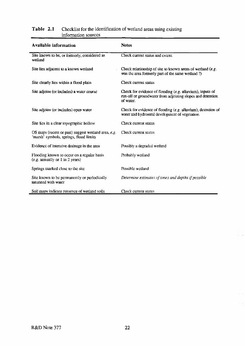
Table 2.1 Checklist for the identification of wetland areas using existing information sources
A v a ila b le in form ation N otes
Site known to be, or formerly, considered as wetland
Check current status and extent
Site lies adjacent to a known wetland Check relationship of site to known areas of wetland (e.g. was the area formerly part of the same wetland ?)
Site clearly lies within a flood plain Check current status
Site adjoins (or includes) a water course Check for evidence of flooding (e.g. alluvium), inputs of run-off or groundwater from adjoining slopes and detention of water.
Site adjoins (or includes) open water Check for evidence of flooding (e.g. alluvium), detention of water and hydroserai development of vegetation.
Site lies in a clear topographic hollow Check current status
OS maps (recent or past) suggest wetland area, e.g. ‘marsh’ symbols, springs, flood limits
Check cuuent status
Evidence of intensive drainage in the area Possibly a degraded wetland
Flooding known to occur on a regular basis (e.g. annually or 1 in 2 years)
Probably wetland
Springs marked close to the site Possible wetland
Site known to be permanently or periodically saturated with water
Determine estimates of times and depths if possible
Soil maps indicate presence of wetland soils Check current status
R&D Note 377 22
3. WETLAND CLASSIFICATION
3.1 Introduction
In attempting to provide a working definition of ‘wetland’ and a procedure for evaluating the wetland resource, it became clear that there is much confusion surrounding perceptions of wetlands, both in terms of what areas can be so categorised, and how these have been subdivided into different sub-categories of wetland. It was also recognised that the usefulness of the proposed major project to evaluate the extent of the wetland resource in England and Wales would be considerably enhanced if it included a basic classification into wetland types as these vary considerably in their response and susceptibility to internal and external influences.
Wetland ecologists have long wanted to use a simple and informal classification of wetlands, so that broad ‘types’ could be identified and recognised. Numerous features can be used to classify wetlands, but many workers have used ‘hydrotopography’ as a basis for an informal typology. ‘Hydrotopography’ essentially refers to the ‘shape’ and situation with respect to (usually presumed) water sources. Existing hydrotopographical classifications of wetlands in Britain have many limitations. These stem primarily from a failure to distinguish between (a) the topographical situation within which the wetland occurs; (b) the topography of the wetland itself; and (c) distinct ‘hydrotopographical’ elements within a wetland site.
3.2 Proposed hydrotopographical classification of British wetlands
To help overcome the limitations outlined above, a two-layered ‘hydrotopographical’ classification is proposed in detail in R&D Note 378 and summarised below. The first layer identifies situation-types, i.e. the position the wetland occupies in the landscape, with special emphasis upon principal apparent sources of water. Many, but not all, wetlands can be referred to a single situation-type. The second layer identifies hydrotopographical elements, i.e. units with distinctive water supply and, sometimes, distinctive topography in response to this. Many wetlands will contain a number of hydrotopographical elements and the same element may occur in wetlands belonging to different situation-types. The hydrotopographical elements correspond in large measure with the concept of the mesotope.
The situation-type is a crude category which is as variable as the landscapes within which wetlands occur. It represents the first approximation for a wetland classification, but because of its variability it does not represent a very useful unit of wetland resource assessment, even in purely ‘hydrotopographical’ terms.
The hydrotopographical element is also variable, but is more readily categorised. The units adopted here broadly correspond to units recognised by other workers, with some amendment, addition and changes of rank in a manner consistent with the rationale of this classification. The hydrotopographical element is considered a more useful unit of wetland resource. Its main limitation is that some elements are not readily recognised without measurement. It is suggested that as a first approximation, wetlands should be classified to the level of the hydrotopographical element when this is possible and to the level of the situation-type when it is not. Intuitive assessment of the hydrological properties of wetlands should be discouraged.
R&D Note 377 23

A classification based upon hydrotopographical elements does not provide an adequate environmental or biological classification of wetlands, even at a first approximation. It is seen as an independent, basic, classification upon which it is possible to superimpose classifications based on other features (e.g. base-status, fertility, vegetation, management etc.). Thus a given hydrotopographical element can show much variation with respect to features such as base- status, fertility and vegetation. R&D Note 378 describes how these additional elements can be superimposed in a hierarchical manner on to the basic hydrotopographical classification outlined here.
In view of this, it is important that the potential value of ‘hydrotopographical’ units for assessing the wetland resource is clearly recognised. They are essentially ‘rule-of-thumb’ categories that can be used for describing wetland ‘types’, but they do not necessarily relate well to other specific features. For example, they do not provide a reliable guide to ‘wildlife interest’. If an assessment of the wetland resource is primarily for establishing its importance for biological conservation then this should be done by direct assessment of the biological resource and classification of the wetland on this basis then superimposed on the basic hydrotopographical framework.
An outline of the proposed classification follows in Table 3.1 with the provisional key to this classification in Appendix 3. Details of the classification, it's rationale and guidance for its use are provided in R&D Note 378.
It is recognised that the classification is in some respects incomplete. Other potential categories (mainly hydrotopographical elements) are currently under review. Comments on the proposed categories and on possible expansion are welcomed.
The extent to which this classification can be applied ultimately depends upon the level of information available for particular sites. It should be possible to allocate all sites, or parts of sites, to a ‘situation-unit’ with relative ease. Some of the ‘hydrotopographical elements’ are also obvious, but others are not. It is inevitable that there will always be some overlap or transitional types.
In constructing the classification existing units have been adopted where considered appropriate. This hydrotopographical approach to classifying wetlands is clear, logical, consistent, comprehensive and capable of application at various levels of complexity. The distinction has been made between units which reflect the topography of whole sites (or parts of sites) and units which are better seen as elements within sites. On the whole, the proposals provide a rationalisation, clarification and synthesis of the suggestions of others. It should be emphasised that it is preferable to implement a simple classification correctly than to apply a sophisticated classification inaccurately.
R&D Note 377 24
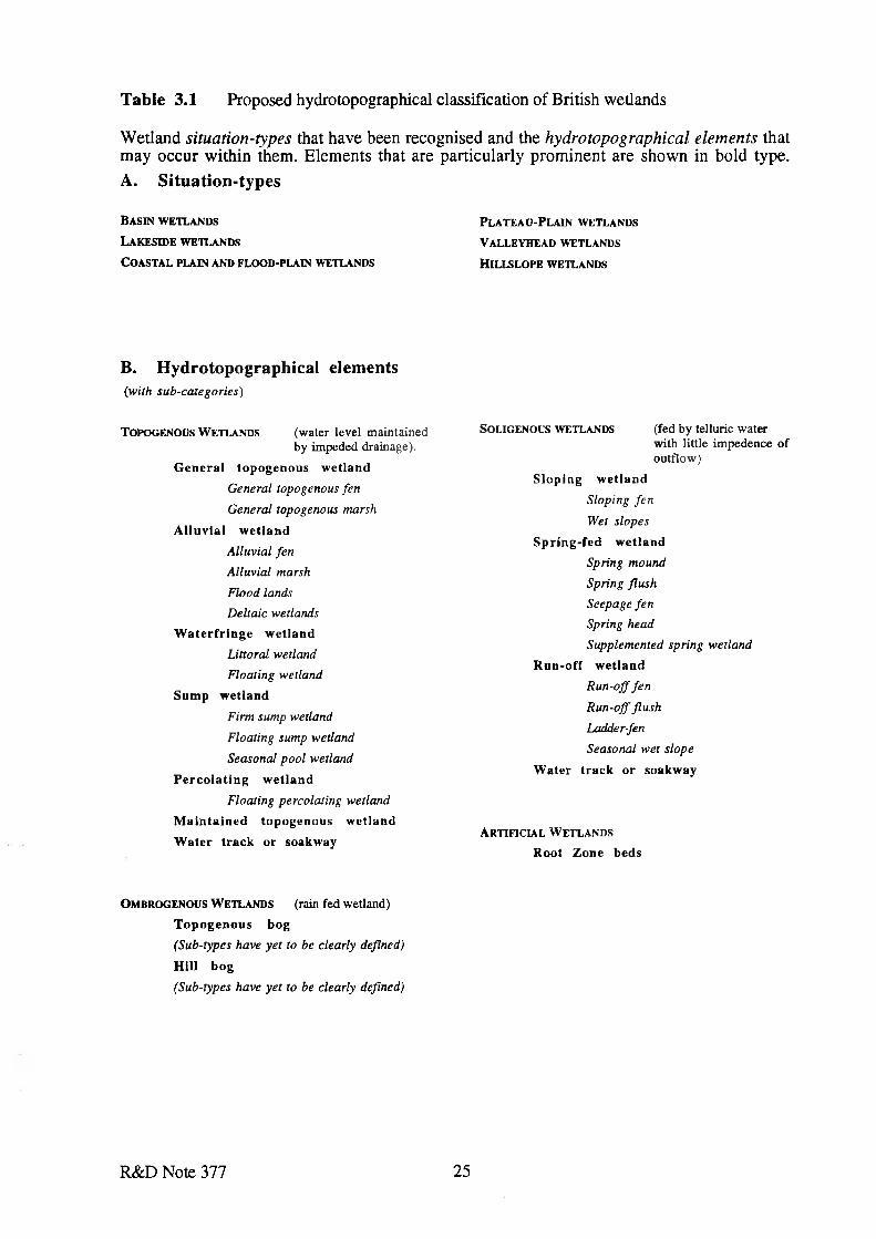
Table 3.1 Proposed hydrotopographical classification of British wetlands
Wetland situation-types that have been recognised and the hydrotopographical elements that may occur within them. Elements that are particularly prominent are shown in bold type.A. Situation-types
B a sin w e t l a n d s P l a t e a u -P la in w e t l a n d s
L a k e s id e w e t l a n d s V a l l e y h e a d w e t l a n d s
C o a s t a l p l a in a n d f l o o d -p l a in w e t l a n d s H il l s l o p e w e t l a n d s
B. Hydrotopographical elements(with sub-categories)
T o po g e n o u s W etla n d s (w ater level m ain tained by im peded drainage).
General topogenous wetlandGeneral topogenous fen
General topogenous marsh
Alluvial wetland Alluvial fen Alluvial marsh
Flood lands Deltaic wetlands
W aterfringe wetland Littoral wetland
Floating wetland
Sump wetlandFirm sump wetland
Floating sump wetland
Seasonal pool wetland
Percolating wetlandFloating percolating wetland
M aintained topogenous wetland Water track or soakway
S o l ig e n o u s w e t l a n d s (fed by telluric w ater w ith little im pedence o f ou tflow )
Sloping wetlandSloping fen
Wet slopes
Spring-fed wetland Spring mound Spring flush Seepage fen Spring headSupplemented spring wetland
Run-off wetland Run-off fen
Run-off flush
Ladder-fen
Seasonal wet slope
Water track or soakway
A r t if ic ia l W e t l a n d s
Root Zone beds
O m b r o g e n o u s W e t l a n d s (rain fed w etland)
Topogenous bog(Sub-types have yet to be clearly defined)
Hill bog(Sub-types have yet to be clearly defined)
R&D Note 377 25
4. TOWARDS A WETLAND RESOURCE INVENTORY
4.1 Introduction
The NRA has a statutory duty to 'further' and 'promote' the conservation of wetlands1, and requires access to sufficient information pertaining to the location, geographical extent and character of the wetland resource to carry out those duties. With respect to most wetlands this information is, for the most part, either lacking or difficult to obtain; hence, the Wetland Resource Inventory Initiative. This initiative should:
• collate information on the wetland resource of England and Wales• store the data in the most cost effective and consistent form• facilitate retrieval of site data for day to day NRA case work• identify any gaps in the wetland Inventory and provide a method by which poorly
recorded sites can be identified, classified and recorded and the Inventory up-dated accordingly.
This chapter:
• outlines the available information on the wetland resource• reviews the alternative methods for establishing an Inventory of wetlands
in the context of the NRA's requirements and• presents an overall strategy for achieving a national wetland Inventory.
4.2 Existing NRA inventories
At regional level the NRA's approach to survey and assessment of wetlands has been largely ad hoc and reactive. The extent of coverage and the potential value of the information for use in this project is regionally specific, and there is currently no systematic approach to wetlands survey work at national level. The Inventory of wetlands held by each NRA region is at present incomplete.
4 . 2 . 1 River Corridor Survey
Although not specifically concerned with wetlands per se, River Corridor Surveys (RCS) are a major component of the NRA's current habitat resource assessment programme. RCS highlight important features worthy o f protection, identifying opportunities to rehabilitate and enhance degraded habitats. RCS provide the information needed by the NRA to assess environmental impacts and propose conservation opportunities in carrying out its regulatory, operational and advisory activities.
'River corridor' generally describes the stretch of river, its banks and the land close by. The corridor usually incorporates land and vegetation within 50 metres of the river bank, but where there are extensive water meadows, marshes or other wetland areas, the corridor may be larger
Other statutory and non-statutory duties are considered in R&D Note 381.
R&D Note 377 26
to include such associated features. This information is mapped in 500m sections 'based on Ordnance Survey information modified as necessary to a different scale which includes the basic river channel outline and significant corridor features' (River Corridor Surveys Methods and Procedures, Conservation Technical Handbook, NRA 1992). A summary description of the section including adjacent land-use, management, opportunities for habitat enhancement. A cross-section is also given with each 500m section.
RCS are limited to the narrow strip of land immediately adjacent to the main river limiting the potential value of such information in its capacity to identify wetland types and extent. In general the NRA carries out RCS in a largely ad-hoc manner, some programmed and some reactive (eg prior to engineering or maintenance works). Comprehensive cover of all main rivers has yet to be achieved, and there has been limited repetition of RCS to monitor changes in river corridors; one of the few examples being the River Kennet which was re-surveyed after 5 years.
Although RCS information is potentially available for input into a national wetland Inventory, its practical use is limited by its storage as hard copy (usually hand-annotated) maps, and also by the lack of a single repository for these data.
4 .2 .2 R iver H ab ita t Survey
Whilst River Corridor Surveys are still considered within the NRA to be the most suitable method of survey for aiding sensitive flood defence management of rivers, it is not considered ideal for cost-effective gathering of information for routine inputs to catchment management plans. RCS has also generally failed to deliver comprehensive and nation wide inventories of in-stream, bank and floodplain habitats which can be analysed for area, regional and national resources and appraisals made regarding losses and gains of these or the relative quality of these.
For these reasons the NRA has trailled and is developing a simpler form of habitat evaluation based on physical structure of rivers and their corridor habitats. In common with RCS, the new River Habitat Survey operates over 500m reaches and includes separate assessments o f inchannel, marginal, bank, riparian buffer strips and floodplain character. Another feature in common with RCS is the highlighting of wetland habitats beyond the 50m strip along the river corridor if these are identified during the survey. Within ten evenly spaced transects across the 500m reach physical characterisation of habitats and vegetation is recorded in a form which can be stored, retrieved and statistically analysed.
One of the objectives is to be able to 'type' rivers and their 'physical architecture' to provide a rapid appraisal of extant features requiring protection or consideration of restoration. The survey outputs will enable the NRA to determine the relationship between different river types and the extent and type of various floodplain wetlands and link this to management strategies for rivers which can be instrumental in sustaining and furthering wetland conservation.
4 .2 .3 N ational F loodplain M aps
Section 105 (2) of the Water Resources Act 1991 requires the NRA to conduct surveys for the purpose of carrying out its flood defence functions. In the NRA's strategy for Flood Defence, it is recognised that further information on the likelihood of flooding, on the condition of river and coastal systems and the capacities of channels and defences is required to meet the NRA's
R&D Note 377 27

general supervisory duty for all matters relating to flood defence. It states that the NRA will carry out surveys of all 'main' and 'ordinary' rivers under s. 105 to provide information on land at risk of flooding.
The visible output from s. 105 surveys is likely to be a set of maps showing the floodplain separated into defended areas, washlands and natural floodplains. They will identify areas of flood risk across all catchments.
The NRA has recently signed a Memorandum of Understanding with representatives of the Association of District Councils, County Councils and Metropolitan Authorities concerning the sort of information required as input to structure and local plans, and the targeting of NRA resources in response to development pressures.
A complete set of surveys is not immediately achievable and the Memorandum seeks to prioritise the areas covered within the resource constraints of the NRA and the capability of national survey programmes.
The NRA's input to local plans is increasing and includes advising planning authorities on the allocation of development land to minimise flood risk. Initially, the NRA will concentrate on those areas where there is pressure to develop best practice to mitigate against potential flooding.
This project is of particular significance to the assessment of the wetland resource as it is not restricted to the main river and the mapped information produced could be used as an overlay to identify former wetlands (eg drained areas) with potential for restoration. A combination of survey techniques may be used in compiling the Floodplain Maps, however, a survey strategy has yet to be developed.
4 . 2 . 4 Water Level M anagement Plans
Recent guidelines from MAFF require the operating authorities (NRA and IDB) to produce detailed management proposals concerning water control for SSSI's in each district. The first stage is to provide prioritised information (with input from English Nature) relating to sites in which water level management is a perceived problem and to highlight where water levels may be controlled. By the end of 1994 the operating authorities should have identified a schedule of sites and a timetable for the production of plans. If a plan cannot be produced by the end of 1995 the Guidelines require that interim plans should be developed for the outstanding sites.
The guidelines require that all SSSIs which need water control measures to maintain the features for which they were designated must have Water Level Management Plans by 1998. The completed Plans are expected to be available to the NRA as a whole and, as such, should be available for development of the wetland Inventory.
4 . 2 . 5 Conservation Sites Register
Conservation Sites Registers are held by certain NRA regions. Thames Region for instance has a GIS/spreadsheet system of sites o f conservation importance while Anglian Region has compiled a computer database of all notified sites of conservation, archaeological and architectural interest linked with a co-ordinate mapping system.
R&D Note 377 28

Where available, such systems may represent an important starting point for identifying wetland areas within each region.
4.3 Liaison and ad-hoc data purchase external to the NRA
The NRA does not currently hold complete information on the location, geographical extent and character of wetlands within each region sufficient to compile an Inventory. At present, the Authority relies heavily upon data supplied by key organisations including English Nature, Countryside Council for Wales, the County Wildlife Trusts and RSPB in undertaking casework concerning wetlands. Each region may, in conjunction with other interested bodies, also enter into specific species monitoring projects, such as for otters and wildfowl.
In advance of a possible future IT based wetland Inventory there are a number of advantages associated with continuing and developing information networking and ongoing liaison with such organisations. These are largely associated with the inherent problems of the alternative approach; involving collation, management and utilisation of a centralised (probably regionally located) paper-based inventory (see 4.4). Until the NRA develops the means to hold and manage such a dataset, it would be superfluous to proceed with large scale resource inventory development.
The primary third party sources of wetland resource data have been investigated (Appendix 4). Information relating to wetlands is available from a wide range of sources in various formats and has been collected by a range of different techniques.
A database of organisations, groups and individuals with a wetland interest identified by a previous project (NRA R&D Note 393) was used for an initial questionnaire survey for the current project. This was supplemented by a number of key organisations and individuals known to ECUS and NRA personnel to be actively involved in wetlands. The aim of this questionnaire was to identify existing sources of information and in particular to identify specific projects of direct applicability for input into a wetland resource survey of England & Wales.
The approach to selected contacts followed a series of structured questioning wherever possible. These included:
• the nature of the information available;• the areas covered;• basis of information (aerial photos, field survey, satellite etc.);• form of the data (paper copy, digitised etc.);• scale of mapping;• level of detail (boundaries, qualitative, quantitative etc.);• level of accuracy / any limitations and, where possible,• the costs of acquiring (and using) the information.
R&D Note 377 29
The sources identified are as follows;
• English Nature (EN)• Countryside Council for Wales (CCW)• Scottish Natural Heritage (SNH)• Royal Society for the Protection of Birds (RSPB)• Institute of Terrestrial Ecology (ITE)• Soil Survey and Land Research Centre (SSLRC)• Agricultural Development and Advisory Service (ADAS)• Broads Authority (BA)• Countryside Commission (CC)• County Wildlife Trusts (CWT)• Local Authorities/Biological Records Office (LA/BRO)• Wildfowl and Wetlands Trust (WWT)• English Heritage (EH)• Remote Sensing (RS) various sources.
Table 4.1 below summarises the range of data available from these sources that would be pertinent to the establishment of a wetland resource information. More detail of these sources and the information they hold is presented in Appendix 4.
4.4 Inventory Formats
Nationally, the NRA does not currently possess the means by which to computerise a wetland resource Inventory, although this situation may change within the next five years, with the proposed introduction of a NRA-wide GIS system. In the meantime, the NRA requires a strategy for dealing with wetland data. The Consultants have considered two alternative formats for a national wetland resource Inventory. The first is a hard copy (paper based) collation of available information, whilst the second (taking into account the GIS development mentioned above) is a computer based Geographical Information System. The two are compared below.
4 . 4 . 1 Paper-based Inventory
It has been suggested that the NRA could collate a paper-based wetland inventory in preparation for future computerisation of the data. However, this is not recommended. A paper-based system, comprising maps and supporting reports, would not only be very time consuming to develop and manage, it would also lack all but the most basic functionality (ie interaction between map and data), and would be unlikely to assist the NRA significantly in fulfilling its statutory and non-statutory duties with respect to wetlands.
A hard copy database would also represent a very poor investment, due to its inflexibility and the difficulty of incorporating new mapped data. Such an inventory would be unable to keep pace with advances within source data, and would rapidly become outdated.
R&D Note 377 30
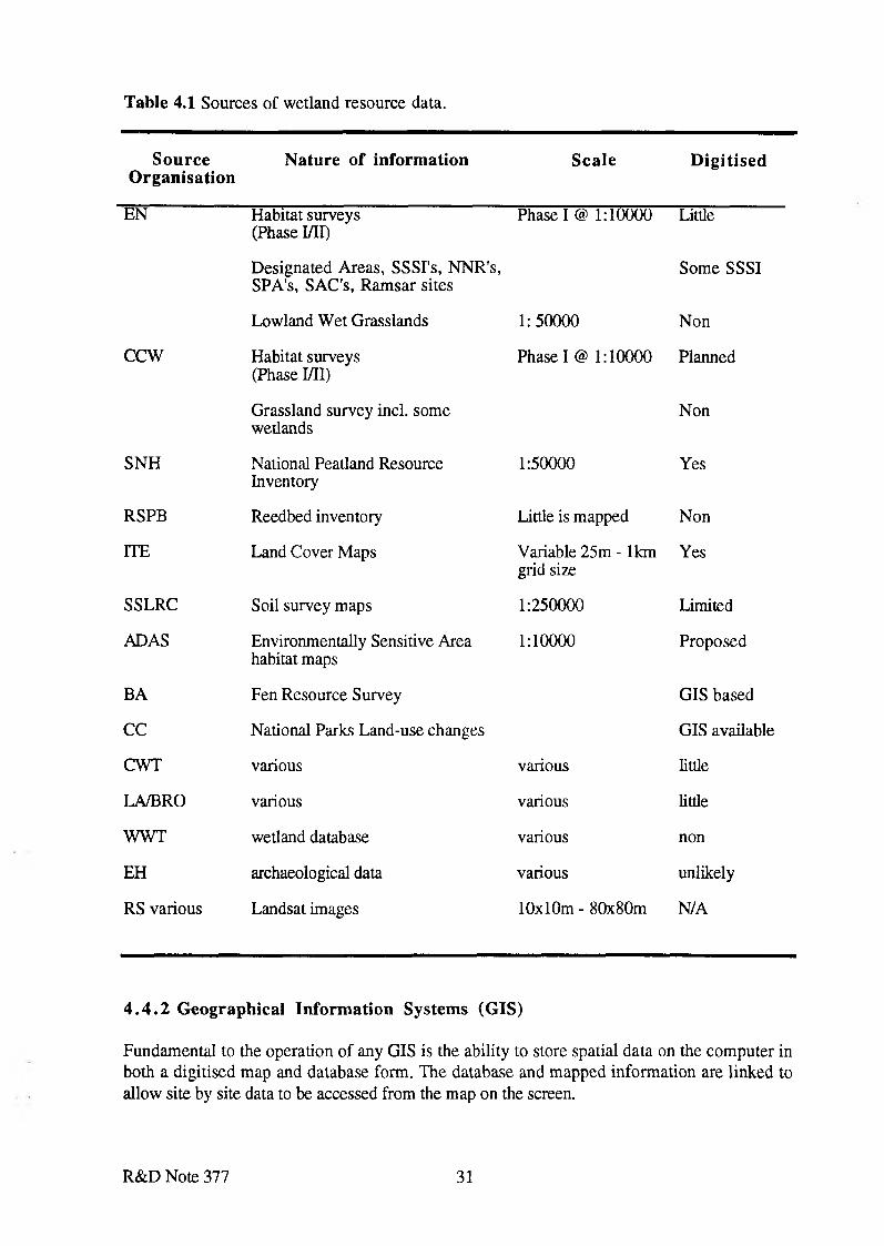
Table 4.1 Sources of wetland resource data.
SourceO rganisation
Nature of information Scale D ig itised
EN Habitat surveys (Phase I/II)
Designated Areas, SSSI's, NNR's, SPA's, SAC's, Ramsar sites
Phase I @ 1:10000 Little
Some SSSI
Lowland Wet Grasslands 1:50000 Non
c cw Habitat surveys (Phase I/II)
Grassland survey incl. some wetlands
Phase I @ 1:10000 Planned
Non
SNH National Peatland Resource Inventory
1:50000 Yes
RSPB Reedbed inventory Little is mapped Non
ITE Land Cover Maps Variable 25m - 1km grid size
Yes
SSLRC Soil survey maps 1:250000 Limited
ADAS Environmentally Sensitive Area habitat maps
1:10000 Proposed
BA Fen Resource Survey GIS based
CC National Parks Land-use changes GIS available
CWT various various little
LA/BRO various various little
WWT wetland database various non
EH archaeological data various unlikely
RS various Landsat images 10x10m - 80x80m N/A
4 . 4 . 2 Geographical Inform ation Systems (GIS)
Fundamental to the operation of any GIS is the ability to store spatial data on the computer in both a digitised map and database form. The database and mapped information are linked to allow site by site data to be accessed from the map on the screen.
R&D Note 377 31

The world's first operational GIS, the Canadian GIS was established to manage environmental information, and many of the early GIS developments in North America were driven by environmental agencies (Tomlinson, 1987). In contrast, in the UK early developments have been dominated by organisations such as the utilities and local government concerned with machinery and facilities management (DoE, 1987). However over the last few years there has been an explosive growth of interest in GIS among organisations and agencies in the UK concerned with environmental matters, ranging from pressure groups such as Friends of the Earth (Doig, 1992) through to government departments such as the DoE (Gamsworthy, 1992).
In general terms GIS are being used by a wide range of environmental agencies for one or more of the following tasks, which are listed in approximate order of complexity:
1. Storage and Management of Environmental Data;2. Data Display and Map Production;3. Simple Inventory Analysis - measurement of areas etc;4. Detection of change over time;5. Model effects of proposed changes;6. Computer modelling of environmental processes.
Each of these is discussed in turn in Appendix 5, illustrated with appropriate examples and related as far as possible to potential uses for a Wetland Resource Inventory. The main advantages in using GIS for the inventory base are:
• The ability to store and manage large amounts of spatial data derived from a variety of sources and at various scales;
• The ability to combine these different data together for production of maps, or for analysis;
• The ability to assess change in the environment over time, and to predict the possible effects of planned changes.
The main limitations are:
• The high start-up costs. These are partly the costs of software and hardware but are mainly related to costs of data capture and staff training;
• The long lead time before useful results can be produced. Again this relates largely to the time necessary to build the GIS database and train staff to use the system;
• The need to ensure that the system will be acceptable and useful to the staff in the organisation, i.e. a change in philosophy.
R&D Note 377 32
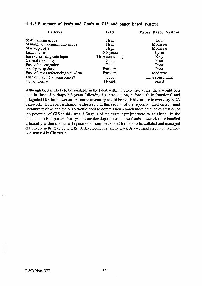
4 . 4 . 3 Summary o f Pro's and Con's o f GIS and paper based systems
Criteria G IS Paper Based System
Staff training needs Management commitment needs Start -up costs Lead in timeEase of existing data input General flexibility Ease of interrogation Ability to up-dateEase of cross referencing sites/data Ease of inventory management Output format
High High High
5-8 years Time consuming
Good Good
Excellent Excellent
Good Flexible
Low Moderate Moderate
1 year Easy Poor Poor Poor
Moderate Time consuming
Fixed
Although GIS is likely to be available in the NRA within the next five years, there would be a lead-in time of perhaps 2-3 years following its introduction, before a fully functional and integrated GIS-based wetland resource inventory would be available for use in everyday NRA casework. However, it should be stressed that this section of the report is based on a limited literature review, and the NRA would need to commission a much more detailed evaluation of the potential of GIS in this area if Stage 3 of the current project were to go-ahead. In the meantime it is important that systems are developed to enable wetlands casework to be handled efficiently within the current operational framework, and for data to be collated and managed effectively in the lead up to GIS. A development strategy towards a wetland resource inventory is discussed in Chapter 5.
R&D Note 377 33
5. INVENTORY DEVELOPMENT STRATEGY
5.1 Introduction
The aim of the Wetland Inventory Development Strategy is to provide a methodology by which wetland sites can be identified, classified and recorded according to the approach summarised earlier in this report (Chapters 2 and 3) and discussed in detail in R&D Note 378.
After careful thought, and in the light of the insights gained from this project as a whole, a hierarchical structured strategy for development of the resource Inventory is proposed.
The resource Inventory will require collation of available information from a number of organisations at regional and sub-regional level (see Appendix 4). Because of this a regionally- based wetland resource Inventory is proposed. This will also be more practical to administer and in view of the volume of data will be more feasible to handle technically. It is suggested within NRA R&D Note 114 that catchment-based Inventories would be appropriate.
Such a regional wetland resource Inventory would need to be GIS-based (see Chapter 4). Although some regions have already begun using GIS and computer based databases for a range of other uses, the basic requirements of such a system are unlikely to be available within the NRA nationwide for perhaps five years. Until such time as the GIS capability is developed, a strategy is required which provides for efficient and effective data management. This must be coupled with continuing liaison with other organisations concerned with wetland management. Within the overall strategy for development of a GIS based wetland resource Inventory the decisions to be taken by the NRA and tasks to be carried out must be prioritised. Inventory Development Strategy priorities for the NRA can be summarised as
1 . a . Early commitment by the NRA to GIS development as a basis for thewetland resource Inventory with ongoing consideration of the options for using GIS.
b . Establishment of an 'Inventory network' with external organisations to ensure commitment to the programme and create a communication channel for transfer of relevant data.
2 . Definition o f the optimum map and data formats for ultimate entry into the Inventory
3 . Proposed pilot study - Anglian Region.4 . Establishment of a digital map base5 . Desk based resource survey;
a . Collation and assimilation of existing NRA resource data at a national level.b . Audit of external information sourcesc . Interpretation of existing aerial photographs.
6 . Field based reconnaissance of identified sites7 . Preparation of a GIS Wetland Resource Inventory.
R&D Note 377 34
5.2 Consideration of the NRA's Uses for a Wetland ResourceInventory
For such a major project to be successful over such a time scale it is essential that there is a commitment to the GIS route throughout the NRA’s management structure; this must be both philosophical and financial. The development process is evolutionary and changes must be expected but a wholesale shift in policy mid way through the project would be very costly.
The NRA should define their uses for the Inventory before any work commences to ensure the final product can produce the required outputs. An overview of the potential uses of GIS in a Wetland Resource Inventory is presented earlier in this report (see 4.4) and more detail provided in Appendix 5. However, it is not possible to give detailed recommendations at this stage regarding the definitive system for the Inventory without a clear picture of what use the NRA intends to make of the technology within all sections of its work as a multi-faceted environmental organisation.
5.3 Networking with other organisations
In advance of a GIS-based wetland resource Inventory it is considered both inappropriate and non cost-effective for the NRA to centralise large amounts of resource data from external organisations. Rather, the NRA should develop links with other providers of wetland resource data.
Most NRA regions have already established firm links with certain providers of wetland data, particularly English Nature, Countryside Council for Wales, RSPB and County Wildlife Trusts. However, there is considerable potential for further development of links with other organisations listed in Chapter 4. Further details of these sources are presented in Appendix 4. Networking with these organisations should aim to establish lines of ad-hoc data acquisition for NRA casework, and in addition investigate the extent to which other organisations would be willing to co-operate in developing a centralised resource Inventory.
Development of the resource Inventory has been identified as an important requirement by a number of organisations and, following preliminary consultation with many of these, it is clear that there exists considerable enthusiasm for the concept of an Inventory. Many organisations could benefit from such a development, and it is considered very likely that fruitful co-operation would be achieved, maximising the use of existing data in developing the Inventory, and controlling development costs.
5.4 Input data formats
For data to be entered into a GIS database most cost-effectively the formats of all mapped and written information should be outlined at the start of the project with their ultimate use in mind. This includes preferred map scales, map details to be included, database fields and print out formats.
The wetland Inventory should identify wetland location, geographical extent, character (classification) and other information relating to its status. For the NRA to evaluate the wetland
R&D Note 377 35

resource and to assess the potential NRA operational impact on wetland habitats, such information needs to be readily available and easily up-dated. The provision of this information as paper maps would be inflexible and impracticable to manage.
The production of a functioning GIS detailing the wetland resource requires a digital map base or maps onto which further information relating to wetlands from various sources could be imposed. GIS has the flexibility of being able to import mapped information in various formats and source scales, and is able to output hard copy maps 'tailored' to individual casework. The results of casework or management may be mapped and/or entered into the associated database to provide a powerful tool for monitoring the NRA's responsibilities with respect to wetlands.
Ideally, information relating to wetland habitats should be available at a constant scale and format; perhaps, not surprisingly it is not! There is no real substitute for detailed 'on the ground survey' to assess habitats which can prove to be highly variable in extent and interest over a short distance.
1:10,000 is the most widely used scale across the NRA. This scale has been generally found to be of sufficient detail by NRA operational staff. Preliminary colour maps at this scale may pick out wetland habitat zones to enable quantification of the resource. This scale is considered suitable for locating and mapping wetland sites within their hydrotopographical context
5.5 Establishment of a digital base map
For a wetland Inventory held at a national, regional or sub-regional level to be of functional use to the NRA as an operational tool there must be an adequate form of base map. National cover of digital mapped data is available in two formats: raster and vector. These two formats are explained in Appendix 5. Based on this appraisal of the two systems vector-format data are recommended for the resource Inventory, and the NRA's strategic GIS development plans.
The recommended supplier of digital vector format data is Ordnance Survey. To date, the availability of national cover vector data from Ordnance Survey has been limited, particularly at the NRA's preferred 1:10,000 scale1. However, the Land-line series of digital maps is becoming available at a range of scales which will together cover the whole of the United Kingdom: 1:1,250 (restricted to major towns and cities); 1:2,500 (includes smaller towns, villages and developed rural areas); and 1:10,000 (exclusively 'mountain and moorland' areas). National cover of vector-format digital mapped data is likely to be available from Ordnance Survey by the end of 1995. Two purchase options are likely to be possible: i) outright, or ii) with continuous updating; of which the latter is recommended. The price of this data has yet to be decided and costs would therefore need to be negotiated when the Land-line data become available.
Digital map coverage of England and Wales would be of considerable value to all sections of the NRA. The cost of these data should therefore be considered a strategic investment by the NRA which should not be borne by the Resource Inventory Initiative alone. Indeed, some
As determined by structured interviews with NRA personnel within the current project.
R&D Note 377 36
NRA regions have already obtained vector-format digital data from Ordnance Survey for other purposes.
5.6 ’Desk-based* resource survey
Desk-based investigations should first draw together information available from national datasets (see Chapter 4 & Appendix 4) to identify broad areas where wetlands occur. More detailed desk study at regional and sub-regional level would then be required to overlay onto the national data set information collated from a wide range of organisations, including NRA regions.
In most cases information derived from desk-based investigations will not enable accurate mapping of the geographical extent and assessment of classification characteristics. The desk studies would, however, enable locations of wetland sites to be identified for further investigation.
The desk based resource survey will, in summary, identify in detail the information available across all relevant organisations and assess its incorporation into the Inventory. With the addition of aerial photograph interpretation it will highlight gaps in the Inventory coverage and point the way for additional survey work.
Careful consideration should be given to 'if and 'how' existing site data could be incorporated into the Inventory. This may involve some reformatting. In the planning of any new data collection and mapping initiatives, consideration for the inclusion of the data in the Inventory should be given when result formats are decided. It is not intended that the NRA should purchase or obtain hardcopy of externally held information at this stage.
5 . 6 . 1 Collation and assimilation of NRA resource data
A considerable body of River Corridor Survey data are available at NRA regional level, but the potential usefulness in terms of the current project is limited by inconsistent coverage, unsuitable format and its geographical limitation to narrow strips of land adjacent to main river. Existing river corridor survey will identify areas of actual existing wetland features in close proximity to the main river channel. An assessment of the nature and quality of the information contained within this source would need to be addressed within the proposed pilot study.
When available, the NRA's Section 105 maps (national floodplain maps) will represent an important data source for the wetland Inventory; identifying situation types where wetlands may occur. This will be a national database of information developed by NRA to carry out its flood defence functions, and would presumably be made available for the wetland resource Inventory at no additional cost. Ideally, the final format of these Section 105 maps should be consistent with easy integration with the wetland resource Inventory. Similarly, output from the NRA's proposed River Habitat Survey should also be in a form which would be easily incorporated.
The NRA will also need to collect wetland information for the forthcoming 'Water Level Management Plans’. Whilst progressing such casework it would be appropriate to also collect data required for the resource Inventory. The 'Field Handbook' proposed later (5.7) would provide a list of criteria to be checked during field visits by NRA staff. Again, it is important
R&D Note 377 37
that data should be collected and stored in a way which would enable rapid incorporation into the resource Inventory.
Conservation Sites Registers are held by certain regions, eg NRA Thames Region's GIS/spreadsheet system of sites of conservation importance; and Anglian Region's computer database of all notified sites of conservation, archaeological and architectural interest linked with a co-ordinate mapping system. Where available, such systems may represent an important starting point for identifying wetland areas within each region.
5 . 6 . 2 Audit of data from external sources
The primary aim of desk-based investigations should be to identify the location and geographical extent of wetland sites, to facilitate a (largely field-based) assessment of the character and condition (ie classification) of each site. Identification of wetlands is considered in detail earlier in this report (2.5).
The establishment of a network of external contacts with respect to wetland data will facilitate the identification and assessment of relevant wetland data. However, as noted previously, it will not be cost effective for the NRA to collate all the paper based information themselves. Rather the data should be assessed for its relevance, format and availability for entry into a GIS based Inventory. An audit of the available information is required at this stage, rather than a collation. The external organisations, like the NRA should be encouraged to take into account the format of the Inventory when planning any wetland resource surveys.
5 . 6 . 3 Photointerpretation of aerial photography
A method that involves sophisticated photointerpretation of aerial photos as the sole basis for producing the wetland Inventory is rejected. This is primarily because aerial photo coverage of England and Wales is inconsistent in terms of scale, year, season and quality. Commissioning new flights to achieve uniform coverage would be prohibitively expensive (£M's) and Aero films estimate it could take ten years to achieve.
However, where aerial photographic coverage is readily available, it would be useful in mapping physical features and habitat boundaries of sites identified from other data sources and, having located 'known' wetland sites it should also be possible to map other 'similar' sites for field-based assessment.
In this approach ecologists or biogeographers experienced in interpreting stereo aerial photographs would map 'wetland' areas directly onto acetate film overlays, along with the results of the desk study investigation (5.6.1 & 5.6.2). These interpretations would require some ground checking and modification. The results should be digitised and the geometry corrected to eliminate the distortion inherent in aerial photos and then mosaiced together. Alternatively this latter process could be performed by 'eyeballing' the interpreted polygons directly from the photos to OS maps.
Advantages:• high spatial resolution (e.g. 1:10 000);• high involvement of wetland specialists in actual mapping;• classification of some sites to 'situation-type' possible;• little need for expensive computing facilities.
R&D Note 377 38
Disadvantages:• inconsistent data source; scale differences for different areas;• considerable date range (season & year);• existing coverage of variable quality, plus some colour, some black & white;• geometry problems; large effort in correcting to map geometry;• time consuming and logistically problematic to cover England & Wales.
5.7 'Field-based* reconnaissance
By overlaying the results of the desk study investigations and interpretation of available aerial photographs the vast majority of wetland sites should have been identified. This exercise will also highlight gaps in the Inventory. Such gaps can be filled by field survey. Whether the NRA should complete such a survey to provide a full resource Inventory is an internal policy matter. However the findings of this project as a whole indicate that a stand-alone site by site survey programme is not seen as the role of the NRA alone. Wetland surveys to be undertaken by the NRA should be limited to the needs of the NRA's case work and day to day operational requirements. This does not preclude the NRA establishing a survey programme based on predicted information needs. If a good network of interested parties including English Nature is established as part of the Inventory programme then the requirements of the Inventory and the day to day operational needs of the NRA can be taken into account during the coordination of all wetland survey work.
The detail of field coverage must be consistent with providing the information required to delimit each wetland site (Chapter 2) and classify it in accordance with the classification summarised in Chapter 3 and detailed in R&D Note 378. Appendix 3 provides a provisional key to the hydrotopographical elements of wetland that will be useful in the classification of both known and 'new' wetlands. However, survey methodologies will be elaborated further within a proposed 'Handbook of Wetland Identification and Classification' to be developed and subsequently field tested by the NRA. Some basic field reconnaisance will be required to 'road-test' the Inventory and confirm that the desk based resource survey has provided sufficiently detailed and up to date information on a statistically determined number of sites.
More detailed survey data beyond the needs of site classification may be required as an input to NRA casework and this in turn would benefit the Inventory. A more detailed survey may include;
• vegetation survey to NVC level (see Appendix 2)• water sources• water levels• slopes• soils and substrates• water quality
The exact scope of the survey and the level of detail required is determined on a site by site basis dependent on the needs of the NRA.
R&D Note 377 39
In summary two levels of field work can be envisaged;
• site reconnaisance to identify and classify the site for entry into the Inventory. This may be something that the NRA wishes undertake on a policy led strategic country-wide basis;
• wetland site survey covering ecological and biological resources as well as hydrotopographical elements. This is something that may be necessary as part of NRA casework on an individual site basis but it is not seen as the NRA's role to undertake alone a comprehensive survey of all wetlands as an end point in itself.
5.8 Proposed Pilot Study - Anglian Region
5 . 8 . 1 Rationale
A pilot study is proposed for the Anglian Region. This region is selected for its rich variety of wildlife habitats, flora and landscapes associated with its water features. Many of these are protected by statutory designations, comprising one fifth of England & Wales' Ramsar sites plus over 700 SSSIs and 30 NNRs. The regional pilot study will enable an overall methodology for completion of a national Inventory to be tested on a smaller scale using limited financial and man-power resources. The pilot study will however stimulate the required management decisions to be made and commitment to be given to the project at an early stage.
The study outlined for the assessment of the wetland resource of the region will test the relative merits of the various wetland data sources and enable an assessment of the practicality of applying the methodology to a national Inventory. It will field test practical aspects of strategy as outlined above i.e. data collation, organisational networking, photointerpretation of aerial photographs and field-based reconnaissance methods. For the purposes of the pilot study it is assumed the NRA will have access to a nationally co-ordinated GIS and as such all accumulation and assimilation of the wetland information is geared to that end.
5 . 8 . 2 Establishment of a Digital Map base
Ordnance Survey 1:10,000 information from the forthcoming Landline data would be purchased for the region providing the digital geographical context of the drainage network onto which wetland resource data can be overlayed.
5 . 8 . 3 Desk Based Resource Survey
Collation of existing data from within the region will focus primarily on the datasets outlined earlier (5.6). It appears that a good inter-organisational network already exists within the region which will facilitate data collation. Assessment of the relative value of each of these sources would be made to identify the extent of wetland related information and to identify the areas where data is lacking. To some extent this is already known and the prime wetland areas of the region are comprehensively covered by external organisations, with a great deal of information held by the county wildlife trusts, for example. Data from national datasets including EN lowland wet grassland sites, RSPB reedbed survey and NPRI would appear to be more comprehensively covered at regional and sub-regional level within this region.
R&D Note 377 40
Phase 1 type information from the EN teams within the region varies in quantity and quality of coverage; from Essex with very recent complete 1:10,000 hard copy Phase 1 maps, to Lincolnshire and South Humberside where information is completely lacking. Liaison with the area-based offices within EN would appraise such information.
The Broads Authority (together with English Nature) have surveyed and evaluated the fen resource of the entire Authority Executive Area and will present the survey and management information as both hard copy and GIS. The GIS's interactive database details the English Nature Phase 2 fen survey information for the fen sites. The GIS thus holds the most up to date information relating to location, extent and value of all fen sites within the Broadlands and would be essential to the wetland resource assessment of the region. The Broads Authority also hold mapped information on the location of grazing marshes of SSSI quality.
Within Anglian Region a computer database register exists which includes all notified wetland areas. Information relating to the location and designation of the SSSI's of the region is already held by Anglian NRA but if gaps exist in the database such information can be specifically purchased from MR DATA GRAFFIX, Cleveland.
Having collated and, as far as reasonable, assimilated known data on the location, geographical extent and character of the region's wetland resource, this would be supplemented by aerial photograph interpretation. Where suitable aerial photographic coverage exists and can be obtained at an acceptable cost, known wetland sites can be examined for further details of geographical extent, condition and character. It may be possible to classify tentatively wetlands to 'situation type' from aerial photos, although this would need to be investigated further within the pilot study.
Having examined known wetland sites, it should also be possible to look for other sites which display similar features on the aerial photographs. This may provide a very useful and efficient means of identifying additional wetland sites.
5 . 8 . 4 Field Based Reconnaissance
The wetlands of East Anglia are some of the most comprehensively known and studied in the country and because of this, field based reconnaissance work should largely be limited to ground truthing and validation of the Wetland Resource Inventory rather than gathering fresh field data to fill in gaps. It is essential that the pilot study is taken as an opportunity to assess the accuracy and currency of existing data for instance Ordnance Survey map information on wetland types and limits.
A 'Field Handbook' for undertaking such field-based assessment of wetlands has been proposed earlier (5.7), and would be field tested within the pilot study investigation.
R&D Note 377 41
5 . 8 . 5 Preparation of a GIS Wetland Resource Inventory for the Anglian Region
Having followed the various steps outlined in the Strategy Priorities (5.1) sufficient information should be available to construct a GIS for the Anglian Region based on the OS digitised base map. Overlain on this will be site by site information collated from the various sources into a database specifically designed for the Inventory. This will allow NRA staff to interrogate the GIS on a routine basis as part of their case-work and extract the information required whether it is mapped or tabulated. The whole GIS should have been so designed that it is available to accept information from any wetland site across the regions.
Based on past experience it is certain that despite the development of guidelines as to the format of both the data required and the GIS structure at the out-set, that ongoing development will be required throughout the pilot study. This will however ensure that structural and formatting changes are required to only one regional Inventory rather than several regional systems.
5 . 8 . 6 Costs and timescales
Despite strenuous efforts to achieve an accurate assessment of the cost implications of the NRA developing a Wetland Resource Inventory for the Anglian Region, this is not possible at this stage. Costs are not available for much of the data, as most sources were not developed with a view to commercial purchase. Costs in the future will depend upon the level of co-operation achieved between the NRA and other organisations in developing the resource Inventory.
It is estimated that the pilot project for the Anglian Region could be completed over an 18-24 month period. Costs are very approximate but may be of the order of £75-100K plus the cost of data purchase and any field reconnaissance work required.
5.9 Costs for establishment of a Wetland Resource Inventory for England and Wales
As with the pilot project, an estimate for completing the wetland resource Inventory for all regions can only be an order of magnitude estimate. Again the costs of data purchase remain a major unknown. If a working Inventory network can be established with some co-operation agreement then costs should be significantly reduced. The major cost will be NRA staff or consultants time with additional overheads for GIS software licences, digitised data capture, aerial photographs and computer hardware.
Based on the pilot study estimates for a full Inventory for all the NRA regions may take 3 - 5 years to complete at a cost, excluding data purchase and any field reconnaissance work required, of the order of £0.5 - 1.0M.
R&D Note 377 42
REFERENCESArmstrong, W. (1964). Oxygen diffusion from the roots of some British bog plants. Nature.
London. 204, 801-802.Armstrong, W. (1980). Aeration in higher plants. Advances in Botanical Research, 7, 226-
332.Avery, B. W. (1980) Soil Classification for England and Wales. Soil Survey Technical
Monograph, 14, pp 109.Barclay, A.M. & Crawford, R.M.M. (1982). Plant growth and survival under strict
anaerohiosis- Journal of Experimental Botany, 33, 541-549.Bird C (1993) The role of GIS for handling landscape change data for the national parks. In
Green et al (eds) Geographic Information 1994, Taylor and Francis.Blake-Parker, W. (1988). Use of hydric soils to assist in worldwide wetland inventories. In:
Ecology and Management of Wetlands. Vol. 2. Management, Use and Value of Wetlands, (ed. D.D. Hook et al.). Croom Helm, London.
Braendle, R. & Crawford, R.M.M. (1987). Rhizome anoxia tolerance and habitat specialization in wetland plants. In: Plant Life in Aquatic and Amphibious Habitats, (ed. by R.M.M. Crawford), pp. 397-410. Blackwell Scientific Publications, Oxford.
Briggs, S A, Plummer, S E, George, D G, Roberts, G, Sewell, I, Huthnance, J, Gurney, R J, Wyatt, B K, Aiken, J (1992). A Review of Remote Sensing. Natural Environment Research Council, R & D Note 28.
Brooks, A. (1987) Waterways and Wetlands. British Trust for Conservation Volunteers.Brown G. (1993) Mapping the Environmentally Sensitive Areas of Wales. Mapping Awareness
and GIS in Europe, 7(2), 17-19.Burrough P.A. (1986) Principles of Geographic Information Systems for Land Resources
Assessment. Clarendon, Oxford.Campbell H. (1991) Organisational issues and the utilisation of Geographic Information
System s. RRL Initiative Discussion Paper 9, Dept of Town and Regional Planning, University of Sheffield..
Clymo, R. S. (1983) Peat. In: Gore, A.J.P. (E d). Mires. Swamp. Bog. Fen and Moor. Ecosystems of the World. 4A.. Elsevier, Amsterdam
Coles, B. (1995) Wetland Management: a survey for English Heritage. Wetland Archaeological Research Project, University of Exeter.
Coles, J. (1984). The Archaeology of Wetlands. Edinburgh University Press, Edinburgh.Conway, V.M. (1937). Studies in the autecology of Cladium mariscus R.Br. Part III. The
aeration of the subterranean parts of the plant. New Phytologist, 36, 64-96.Cook, R.E.D. (1990). Iron toxicity to Wetland Plants. Ph.D. thesis, University of Sheffield.Cowardin, L. M., Carter, V., Golet, F.C. & LaRoe, E.T. (1979) Classification of wetlands
and deepwater habitats of the United States. US Fish & Wildlife Service Publication FWS/OBS-79-31, Washington, pp 103.
Denny, P. (1993). Water Management Strategies for the Conservation of Wetlands. J. Inst. Wat. Eng. Man, Vol. 7, p387-392.
DOE (1987) Handling Geographic Information. London, HMSO.Doig, J. (1992) GIS in Friends of the Earth. Mapping Awareness and GIS in Europe 6(4),9-
12.Ecological Advisory Unit (1993). Review of Conservtion Survey Methodologies. NRA R&D
Note 393/3/SW.Ellenberg, H. (1954). Uher einige Fortschritte der kausalen Vegetationskunde. Vegetatio, 5=6,
199-211.Everett, M.J. (1989) Reedbeds - a scarce habitat In: RSPB Conserv. Rev., 3,14-19.Gamsworthy, J. (1992) Department of the Environment: GIS activities. Mapping Awareness
and GIS in Europe 6(4), 42-45.Goodchild, M.F., Parks B.O. and Stayaert L.T. (eds) (1993) Environmental Modelling with
GIS. Oxford, OUP.Goode, D.A. (1972). Criteria for selection of peatland nature reserves in Britain. Proceedings
of the 4th International Peat Congress. I-IV, Helsinki.Gore, A.J.P. (1983) (ed.). Ecosvtems of the World. 4B: Mires, swamp, bog, fen and moor.
Regional Studies. Elsevier, Amsterdam.
R&D Note 377 43
Grootjans, A.P. & Ten Klooster, W.P. (1980). Changes of ground water regime in wet meadows. Acta Botanica Neerlandica, 29, 541-554.
Grootjans, A.P., Schipper, P.C. & van der Windt, H.J. (1986). Influence of drainage on N- mineralisation and vegetation response in wet meadows. Oecologica Plantarum, 7, 3-14.
Haines-Young, R.H., Bunce R.G.H. and Parr T.W. (1993) Countryside Information Systems: in Green et al (eds) Geographic Information 1994, Taylor and Francis.
Haines-Young, R.H., ward N. and Avery M. (1990) GIS for environmental management. Mapping Awareness 4(9), 51-54.
Ingram, H.A.P. (1983). Hydrology. In: Gore, AJ.P. (Ed). Mires. Swamp. Bog. Fen and Moor. Ecosystems of the World. 4A. 67-158. Elsevier, Amsterdam
Ivanov, K.E. (1981). Water movement in Mirelands. Academic Press.Justin, S.H.F.W. & Armstrong, W. (1987). The anatomical characteristics of roots and plant
response to soil flooding. New Phytologist, 106, 465-495.Klotzli, F. (1969) Die Grundwasserheziehungen der Streu- und Moorwiesen im nordlichen
Schweizer Mitteland. Beitrag geobot. Landesaufn, 52,1-296.Lloyd, J.W., Tellam, J.H., Rukin, N. & Lemer, D.N. (1993). Wetland vulnerability in East
Anglia: a possible conceptual framework and generalized approach. Journal of Environmental Management, 37, 87-102.
Maltby, E. (1992) Water Resource Management and the Protection of Wetland Functioning. Report to NRA. Wetland Ecosystems Research Group, University of Exeter.
Mitsch, W. J. and Gosselink, J. G. (1993) Wetlands. Van Nostrand Reinhold. 2nd Edition, pp 722.
Montanari, J.H. (1988). Planning and organizing for large wetland resource inventories. In: The ecology and Management of W etlands. Vol. 2. Management, Use and Value of Wetlands. (Ed. D.D. Hook et al.) Croom Helm, London
Moorhead, K.K. (1992). Diversity of Hydric Soils in North Carolina. USA. Environmental Management, 14, No. 2, 241-247.
Mounsey, H.M. (1991) Multisource, multinational environmental GIS: lessons learnt from C O R IN E . In Maguire D.J., Goodchild M.F. and Rhind D.W. (eds) Geographical Information Systems (2 vols) Longman.
Murkin, H.R. & Ward, P. (1980). Earlv spring cutting to control cattail in a northern marsh. Wildlife Socety Bulletin, 8, 254-256.
Nature Conservancy Council (1989). Guidelines for the Selection of Biological SSSI’s. NCC, Peterborough.
NERC (1975) Flood Studies Report (5 volsV London, Natural Environmental Research Council.
NERC (1980) Low How Studies Report (3 volsl Wallingford, Institute of Hydrology.Niemann, E. (1973). Grundwasser und Vegetationsgefiige. Nova Acta Leopold, 6, 1-147.Orme, A. R. (1990) Wetland morphology, hydrodynamics and sedimentation. In: Williams. M.
(Editor') Wetlands: a threatened landscape. Blackwell, pp 42-94.Pritchard, D. E., Housden, S. D.,Mudge, G. P. , Galbriath, C. A. and Pienkowski, M. W.
(Eds) (1992). Important Bird Areas in the United Kingdom Including the Channel Islands and the Isle of Man. RSPB, Sandy.
Pywell, R H, O’Wilen, B (1975). Remote Sensing the Nation's Wetlands. The National Wetland's Inventory.
Ratcliffe, D. A. (1964). Mires and Bogs. In: The Vegetation of Scotland. (Ed by J H Burnett), pp. 426-478. Oliver & Boyd, Edinburgh.
Ratcliffe, D.A. (Ed) (1977). A Nature Conservation Review. Vols 1 and 2. Cambridge University Press, Cambridge.
Rhind, D.W. (1990) Environmental monitoring and prediction. RRL Initiative Discussion Paper 8, Dept of Town and Regional Planning, University of Sheffield.
Rhind, J. (1993) Managing environmental data - the biodiversity map library. Mapping Awareness and GIS in Europe 7(2),3-7.
Rodwell, J (1991a). British Plant Communities: Volume 1. Woodlands and Scrub. Cambridge University Press, Cambridge.
Rodwell, J (1991b). British Plant Communities: Volume 2. Mires and Heaths. Cambridge University Press, Cambridge.
R&D Note 377 44
Rodwell, J (1992). British Plant Communities: Volume 3. Grasslands and MontaneCommunities. Cambridge University Press, Cambridge.
Rodwell, J (in press). British Plant Communities: Volume 4. Aquatic communities, swamp and tall-herb fen. Cambridge University Press, Cambridge.
Schat, H. (1982). On the Ecology of some Dutch Dune Slack Plants. Doctoral thesis, Vrije Universiteit, Amsterdam.
Schat, H. (1984). A comparative ecophvsiological study on the effects of waterlogging and submergence on dune slack plants: growth, survival and mineral nutrition in sand culture experiments. Oecologia (Berlin), 62, 279-286.
Sellars, B. (1991). The Response and Tolerance of Wetland Plants to Sulphide. Ph.D. thesis, University of Sheffield.
Shaw, S.C. & Wheeler, B.D. (1991). A Review of the Habitat Conditions and Management Characteristics of Herbaceous Fen Vegetation Types in Lowland Britain. Nature Conservancy Council, Peterborough.
Smith, L. P. (1967) Potential Transpiration. Technical Bull. Ministry Agriculture, Fisheries and Food, London, No. 34.
Snowden, R.E.D. & Wheeler, B.D. (19931 Iron toxicity to fen plants. Journal of Ecology, 81, 35-46.
Stewart, D. (1993) Geographic Information Systems in the Forestry Commission. In Green et al (eds) Geographic Information 1994, Taylor and Francis.
Succow, M. & Lange, E. (1984). The mire types of the German Democratic Republic. European Mires (Ed by P. D. Moore) pp. 149-175. Academic Press, London.
Succow, M. (1988). Landschaftsokologische Moorkunde. Gustav Fischer Verlag, Jena.Tamocai, C. (1980). Canadian wetland registry. In: Proceedings of a Workshop on Canadian
Wetlands. (Eds. C.D.A. Rubec & F.C. Pollett), pp. 9-39. Lands Directorate, Environment Canada. Ecological Land Classification Series No 12. Ottawa, Ontario.
Thewessen, T, van der Velde R. and Verlouw H. (1992) European groundwater threats analysed with GIS. GIS Europe 1(3), 28-33.
Tomlinson, R.F. (1987) Current and potential uses of geographic Information Systems - the North American experience. International Journal of GIS, 1(3),203-8.
Treweek, J. R. (1993). Wetland restoration: techniques for an integrated approach. Phase II report. Institute of Terrestrial Ecology.
Verhoeven, J.T.A., van Beek, S., Dekker, M. & Storm, W. (1983). Nutrient dynamics in small mesotrophic fens surrounded bv cultivated land. I. Production and nutrient uptake hv vegetation in relation to the flow of eutrophicated water. Oecologia, 60, 25-33.
Wheeler, B.D. & Shaw, S.C. (in press, a). A focus on fens. In: Restoration of Temperate Wetlands (eds. B.D. Wheeler, S.C. Shaw, W.J. Fojt & R.A. Robertson). Wiley, Chichester.
Wheeler, B.D. & Shaw, S.C. (in press, b). Plants as Hydrologists ? An assessment of the value of plants as indicators of water conditions in fens. Hydrology and Hvdrochemistrv of Wetlands (eds J. Hughes & L. Heathwaite). Wiley, Chichester.
Wheeler, B.D. (1984). British fens: a review. European Mires (Ed by P. D. Moore) pp. 237- 281. Academic Press, London.
Wheeler, B.D. (1993). Botanical diversity in British mires. Biodiversity and Conservation, 2, 490-512.
Williams, D.C. and Lyon J.G. (1991) Use of a geographic information system data base to measure and evaluate wetland changes in the St. Mary's River. Michigan. Hydrobiologia, 219, 83-95.
Williams, M. (1990) Wetlands: a threatened landscape. Blackwell, pp 417.Willis, A.J., Folkes, B.F., Hope-Simpson, J.F. & Yemm, E.W. (1959a). Braunton Burrows:
the dune system and its vegetation. Part I. Journal of Ecology, 47,1-24.Willis, A.J., Folkes, B.F., Hope-Simpson, J.F. & Yemm, E.W. (1959b). Braunton Burrows:
the dune system and its vegetation. Part II. Journal of Ecology, 47, 249-288.Zoltai, S. C. (1988) Wetland environments and classification. In: Wetlands of Canada,
Ecological Land Classification Series, 24, pp 1-26.
R&D Note 377 45
GLOSSARY OF TERMSNote that the definitions relate to the way in which the terms are used in this document, and should not be taken as general definitions. Words underlined also appear in the glossary.Words in bold relate to the wetland types described in the proposed classification (Chapter 3). (ST = situation type; HE = Hydrotopographical element; HEs = sub-categories of hydrotopographical elements).
acrotelm
allochthonousallogenicAlluvial wetland (HE)
Alluvial fen (HEs)
Alluvial marsh (HEs)
anoxicARTIFICIALWETLANDS
aquiferautochthonous autogenic basin mire
BASIN WETLANDS(ST)bog
bulk density catotelm
centripetalclaimedclimax ecosystem
the uppermost, ‘active layer’ o f an undamaged raised bog, comprising the living plant cover passing downwards into recently-dead plant material and thence to fresh peat. It forms the largely oxygenated surface layer with high hydraulic conductivity, within which the water level fluctuates and the main water movement occurs.of imported origin (cf. autochthonous).caused by external factors (cf. autogenic).topogenous wetland irrigated by overbank flooding o f watercourses; can be quite extensive, but more usually forms a quite narrow ribbon alongside rivers etc. substratum usually with a considerable fraction of mineral material (silts etc.) (Subcategories: alluvial fen. alluyiaLmarsh and flood-lands).Alluvial wetland sites which retain a high water-table year-round. This will either be because they are flooded very regularly or because other water sources keep them wet. The latter examples are likely to have a strongly peat-based infill.Alluvial wetland sites largely dependent on river-flooding for their water supply. Show considerable seasonal flux of water levels and have a substratum composed largely o f alluvium.lacking oxygen.Wetlands created by human activity and maintained specifically by this. This category does not include many of the wetlands that have been produced deliberately or incidentally by human activity, as many of these (e.g. clay pits, reservoirs) occur in, or m im ic, various natural ‘situation-types’ and support sim ilar ‘hydrotopographical elements and they are most appropriately classified as man-made examples of the appropriate natural types. However, there are other wetlands which have not only been deliberately engineered but are also maintained by an artificial supply o f water and these seem best allocated to a separate category, water-bearing substratum, at full moisture capacity, formed in situ (cf. allochthonous).‘self-made’, [caused by reactions of organisms themselves,] (cf. allogenic).used variously to describe ‘hollows’ in the landscape - these may occur at various scales, from great synclinal basins, through the basins of large lakes and lochs, to small depressions. TTie term basin mire seems to be used by some authors to refer to this latter situation, though it is not clear why size alone should predicate fundamental distinctions of ‘hydrotopography’, nor what constitutes, in the minds of the authors, the upper size limit to basin mires.associated with discrete basins and ground hollows (e.g. Delamere Forest Mires, Border Mires).general term for om brotronhic mires (but sometimes used colloquially for minemllQEllk mires).
the amount of solid material per unit volume.the lower ‘inert’ layer o f the peat of an undamaged raised bog. The catotelm underlies the acrotelm. and is permanently saturated, mainly anoxic and o f low hydraulic conductivity,
tending towards a centre.conversion of wetland to a new land-use, frequently agriculture, the mature or stabilised stage in a successional series of communities.
R&D Note 377 46

COASTAL ANDF l o o d p l a i nWETLAND (ST) Deltaic wetlands (HEs)diplotelmic
discharge zone draw-down
eutrophicevapotranspiration
fen
field capacity
Flood Lands (HEs) Flood-plain mire
FLOOD-PLAIN WETLANDS (ST)Flush
fluvial deposition fluviogenous wetlands Grazing marshes
Headwater Fen
HILLSLOPE WETLANDS (ST) H ill bog (HE)
hover development
Hover wetlands(HEs)humification (von Post scale)hydraulic conductivity [K - , K s a l ]
hydraulic gradient
hydraulic head hydromorphology
hydroperiod hydrosere (hydroserai)
hydrostatic pressurehydrotopographicalelement
associated with river flood-plains and coastal plains, including active examples and inactive ones (when their inactivity is largely a product of drainage and water management) (e.g. Suffolk and Norfolk Broad land).alluvial wetlands forming in a deltaic environment, e.g. resulting from a stream flowing into a lake.‘Two - layered’. In raised bogs, this refers to the typical occurrence of an uppermost ‘active layer’ (the acrotelm) and lower ‘inert layer’ (the catotelm).zone of groundwater water movement into a wetland.refers to the fall in water level caused by a steepened hydraulic gradient, for example as a result of water movement to drains or ditches, nutrient - enriched (not necessarily base-rich).loss of water from the soil by evaporation from the surface and by transpiration from the plants growing thereon; the volume of water lost in this way. general term for minerotrophic mires (see rich fen and poor fen).the total amount o f water remaining in a freely drained soil after the excess has flowed into the undelying unsaturated soil.Alluvial wetland with land liable to occasional or controlled flooding.this is a generic term that has been used to refer to wetlands developed on river floodplains, though it has tended to exclude examples that are groundwater-fed. see Coastal and Flood Plain wetlands.
Hillslope wetland with an open vegetation and skeletal substratum with runnels and rapid surface water movement.material deposited by a water course.riverside wetlands that are directly flooded with river water, in whole, or part, this term often particularly applies to areas of (partly) claimed flood-plain wetlands which are summer dry; it is not, however, specific to these.Haslam (1965) used this term in much the same sense as ‘vallevheari wetland’ is used here.on sloping ground and hillslopes (numerous solipenous fens: ‘blanket bog’).
rain-fed peatlands on sloping ground; peat surface raised slightly above the level of underlying fen peat or mineral soil, usually conforming quite closely to subsurface topography (Sub-types have yet to be clearly defined).formation of a semi-floating raft o f vegetation over water or fluid muds (rafting). (Also known as schwinpmoor).Waterfringe wetlands developed by rafting (=schwinvmnor).
degree of decomposition (of peat) [production of humus from the decay o f organic matter as a result o f microbial action].the rate at which water moves through a material. ATsat denotes saturated hydraulic conductivity - i.e. the rate at which water moves through a saturated material, the change in hydraulic head or water surface elevation over a given distance.
the difference in pressure-head between two hydraulically-connected points, used here synonymously with hvdrotopographv.
the pattern of water level fluctuation in a wetlandautogenic terrestrialisation of open water. Occurs through gradual infilling with accumulating plant (± mineral) material. May occur via initial formation o f a floating raft.the pressure created by the weight of water acting upon itself.unit with distinctive water supply and, sometimes, distinctive topography in response to this. Many wetlands will contain a number of such elements, and the same element may occur in wetlands belonging to different situation types.
R&D Note 377 47

hydrotopography
“Ladder fen’
lacustrine wetland LAKESIDE WETLANDS (ST)
littoral colonisation Littoral wetlands (HEs) macrofossils
minerotrophic minerotrophic mire mire
mire macrotope
mire mesotope
mire microtope
morphometryoligotrophicombrotrophicombrotrophic bogOMBROGENOUSWETLANDS
ontogenyOpen water transition mire
palaeoecology
paludification(paludosere)paludologypedologyperched water mound
P ercolating wetland (HE)
permeability
an ill-defined term which is usually used to mean the ‘shape’ of the wetland and its situation with respect to the cause(s) of its wetness (i.e. apparent sources of water), (see run-off wetland).
A generic term for wetlands around lakes and pools.associated with lakes: although this ‘situation’ can be readily recognised, it may better subsumed within the other categories, such as basins and flood-plains, rather than being given a separate identity.encroachment o f vegetation by rooting on accumulating peat and muds.Waterfringe wetlands developed by the littoral process of terrestrialisation.
plant or animal remains preserved in peat which can be identified without the use of a high-powered microscope (e.g. stems, leaves & roots but not pollen grains), fed by groundwater.mire whose surface is irrigated both by precipitation and groundwater.a general term applied to peat-producing ecosystems which develop in sites of abundant water supply.mire complex which has been formed by the fusion of isolated mire mesotopes which originated from separate centres o f mire formation.mire system developed from one original centre of peat formation. May join together into a macrotope.small-scale topographical features associated with the mire surface, for example a regular arrangement of ridges and hollows.
nutrient poor (not necessarily base-poor).supplied solely by water derived from the atmosphere (rain, snow, fog etc.).bog whose surface is irrigated more-or-less exclusively by precipitation inputs.rain-fed peatlands in hollows, flats and gentle slopes; peat surface raised slightly above the level of any groundwater level, fen peat or mineral soil, often to produce a (slight) dome of peat that is sometimes independent of subsurface topography.history of development.Used by Goode (1972) and Ratcliffe (1977) but not clearly defined. Perhaps mostly refers to hydroserai wetlands, but not exclusive to these. Not clear how these authors distinguish it clearly from basin mires.the study o f the relationship between past organisms and the environment in which they lived.the development o f wetland directly over mineral ground through impeded drainage and / or increase in water supply.study of wetlands (literally, o f marshes).the study of soilsrefers to the water mound developed within a raised bog as a result o f impeded drainage and storage o f water derived solely from precipitation (i.e. perched above the level o f regional groundwater levels).gently sloping wetland irrigated by groundwater percolating from marginal soligenous slopes, or by groundwater discharge into the peat mass; often situated between land margins and rivers or pools; sites range from being small to very large; probably very widespread, but recognition may require hydrological / topographical / stratigraphical studies though it can sometimes be deduced by the position o f the mire in the landscape. Sub-categories:
Firm percolating wetland: wetland with ± solid peat infill; water movement mostly confined to upper horizons;Floating percolating wetland: wetland with loose or floating peat infill; water movement throughout much of peat infill, or sometimes beneath it.
the capacity of a porous medium for transmitting water.
R&D Note 377 48
PLATEAU-PLAIN WETLANDS (ST)
poor fen precipitation
recharge zone rich fenRoot Zone beds (HE)(surface) run-off
Run-off wetland(HE)
scalariform‘schwingmoor’seresituation type
Sloping wetland (HE)
Soakway (HE)SOLIGENOUSWETLANDS
Spring-fed wetland (HE)
Spring fen / Seepage fen
on flat or slightly undulating ground without close association with lakes, rivers; or discrete, shallow basins; kept wet by high rainfall, impermeable substratum, high groundwater level etc. Includes sites on former river flood-plains, terraces etc. (e.g. Flanders Moss).
minerotrophic mire, typically of pH less than c. 5.5.deposition of water on the earth's surface by rain, snow, mist, frost, condensationetc.; the quantity of water so deposited.zone within a wetland acting as a water supply.minerotrophic mire, typically of pH more than c. 5.5.Artificial wetlands constructed to treat domestic and industrial effluent.
water that reaches (or leaves) a mire either by overland flow or percolation through the upper layers of the substratum (due to gravity).
hillslope wetland irrigated primarily by surface run-off; principally found in the wetter regions o f Britain where low-permeability bed-rock coupled with high precipitation permits the development of, sometimes extensive, wetlands fed primarily by run-off and rainfall.Sub-categories;
Run-offfen: relatively slow water-movement; peat-based;Run-off flush: relatively rapid water-movement; skeletal substratum;Ladder-fen: scalariform sloping mires;
Seasonal wet slope: slopes which are not permanently wet.ladder-like.floating vegetation mat / raft (German.)plant successional sequence (as used in e.g. hydrosere, paludosere).the position the wetland occupies in the landscape, with especial emphasis on principal water supply. May include several different hydrotopographical elements.soligenous wetland where the main source of water is not known, or in which no particular water source is dominant or where there is an evident and complex mosaic o f areas fed by springs and by surface run-off [default category for soligenous wetlands]. Sub-categories:
Sloping fen ± permanently wet;Sloping marsh seasonally wet slope.
tracks of preferential water-movement through sloping wetlands.Wetlands primarily kept wet by supply of telluric water with little impedance to outflow. Most typical of relatively steep slopes where groundwater or run-off input produces surface-wet conditions. Spring-fed wetlands on flat surfaces would often not be classified here unless characterised by rates o f water throughflow comparable to that on the steeper slopes. Often have thin deposits o f peat and water movement is often more by surface flow than percolation through the peat, soligenous wedand irrigated primarily by groundwater discharge; often sloping and frequently small. Sub-categories:
Spring mound: domes o f peat and mineral material (especially calcite) developed upon the sites o f strong springs; much size variation; sometimes large;Spring flush open vegetation upon skeletal substratum, with much water movement, developed around and below point sources o f groundwater discharge lacking obvious dome;Seepage fen: peat-based wetland developed below springs and groundwater seepage, lacking obvious dome.
These are generic terms which include various types of soligenous wetlands. In the valleyhead wetland context authors have tended to use these terms either generally to refer to the entire complex or specifically to refer to the seepage slopes.
R&D Note 377 49

(peat) stratigraphy
Sump wetland(HE)
telluric water terrestrialisation
T opogenousW etlands
General topogenous wetland (HE)Topogenous bog (HE)
Tufa mounds
Valley Fen
VALLEYHEAD WETLANDS (ST)Water meadow
Water track (HE)
W aterfringe wetland (HE)
description o f the layering within a peat deposit based on the composition and character of the peat and mineral content± flat-surfaced topogenous wetland, usually in depressions, where precipitation, drainage or run-off water collects or where water level is maintained by a high groundwater level, but with little net throughflow of water. Often characterised by substantial water level flux, the ecological effects of which depend inter alia upon base-line water levels and the vertical mobility (if any) of the vegetation / substratum. (Subcategories:
Firm sump wetland sump wetland with solid peat infdl with little vertical mobility;Floating sump wetland sump wetland with hose or floating peat infill with vertical mobility;Seasonal pool wetland wetlands around temporary pools or other sites which periodically flood and dry.
water derived from the earth, e.g. river water.transition from open water to ‘solid’ ground through the process o f hvdroseral succession.
Wetlands in which high water level is maintained by impeded drainage (detention) of water inputs. Water inputs may include precipitation, land drainage, river flooding, run-off and groundwater. Impeded drainage is typically a product of landscape configuration, but it may also be induced by river water levels or the topography of the wetland itself.topogenous wetland where source of water is not known, not obvious or in which no particular water source is dominant [default category for topogenous wetlands]. (Sub-categories: General topogenous fen and General topogenous marsh).rain-fed peatlands in hollows, flats and gentle slopes; peat surface raised slightly above the level of any groundwater level, fen peat or mineral soil, often to produce a (slight) dome of peat that is sometimes independent of subsurface topography (Sub- types have yet to be clearly defined).Convex domes of peat and, particularly, calcite. Small examples are effectively calcite-based spring-heads but large examples can support a wide range of wetland vegetation and represent a rather different unit.This term has been used by various UK workers to refer to valleyhead wetlands, but it has also been used by other workers (e.g. Haslam, 1965) in a quite different sense. Haslam (1965) specifically used this term to refer to flood-plain systems, but this is not a common usage in the UK (Haslam used headwater fen to refer to the valley fens of some other UK workers).associated with the upper reaches of valleys; mainly soligenous (e.g. New Forest valley mires).Alluvial wetland with hydrological characteristics largely determined by a specific management regime.trackways of preferential water movement through topogenous wetlands. Water tracks are essentially sluggish, have a muddy substratum beneath shallow surface water and support mire plant species and vegetation-types.topogenous wetland fringing open water of lakes and pools, typically o f rather small extent. [In principle, Waterfringe wetlands can also occur alongside rivers, but examples in the UK are usually extremely narrow and fragmentary].
R&D Note 377 50
APPENDIX 1
WETLAND SOIL TYPES AND WETNESS CLASSES
A 1.1 Wetland soil types
Wetland soils may be described as hydric, which describes a soil that is saturated, flooded, and ponded long enough during the growing season to develop anaerobic conditions in the upper soil layers. Wetland soils are of two types: (i) mineral and (ii) organic, although nearly all wetland soils contain organic material.
M ineral wetland soils: The evaluation of whether a mineral soil is an hydric soil is usually determined on the basis of:
• soil colour;• presence/absence of gleying/mottling;• presence/absence of an oxidised rhizosphere (many wetland plants transport oxygen to
their roots from emergent vegetation; excess oxygen diffuses from their roots resulting in oxidised iron along small roots).
Where waterlogging is caused by a slowly permeable subsoil stagnogley soils form. If organic matter is accumulating at the soil surface the soil is referred to as stagnohumic; where groundwater is the main reason for waterlogging, groundwater gley soils form.
Organic wetland soils: Organic wetland soils are distinguished by their dark colour. Their soil wetness class depends on criteria such as:
• degree of decomposition;• floristic composition.
Peatlands are wetland ecosystems in which the substratum is composed mainly or entirely of peat. Peat is an organic soil formed mainly from the remains of plants that have accumulated in wet conditions in situ. It accumulates in wetland habitats, primarily because waterlogging and associated anoxia retards the decomposition of plant material. Under the definition used by the Soil Survey of England and Wales, peat soils must have at least 40 cm of organic material1 within the upper 80 cm, or at least 30 cm if it rests directly on bedrock and no overlying mineral layer that is more than 30 cm thick and has a non-humose B or C horizon at its base.
The characteristics of organic soils in wetlands are discussed in detail by, for example, Ingram (1983) and Clymo (1983).
The soils of England and Wales have been classified into different soil types by The Soil Survey of England and Wales, and complete coverage is given on maps at a scale of 1:250,000. Although these include hydric soil types, there is no definitive list available of soils which could be considered exclusively associated with wetlands. Studies in the US suggest that there may be good correlation between hydric soils and wetland vegetation (see e.g. Moorhead, 1992),
iOrganic material is defined as comprising more that 12 or 18 percent organic carbon, dependent on the clay content (Avery, 1980).
R&D Note 377 51

but as yet, comparable studies have not been carried out for the soils of England and Wales. It is also not clear how satisfactorily the work could be extrapolated to identify areas of drained wetland although this avenue could be usefully explored (R. Burton,p ers . com m .).
A1.2 Soil wetness classes
Table A 1.1 outlines the six soil wetness classes recognised by the Soil Survey of England and Wales. They range from class I which describes a freely drained (unmottled) soil profile, through to class VI which is wet throughout the year and commonly has a peaty surface and hydrophilous vegetation. "Wet' soils are defined as containing water which is removable at a suction of less than 10 mb, and can be related, therefore, to the concept of field capacity shown in Table A 1.2 (see also Chapter 2). The criteria used to determine the incidence of waterlogging include:
• soil properties;• catchment characteristics;• climate;• drainage status.
Table A l.l . Soil Wetness Classes
WetnessClass
Duration of waterlogging
I The soil profile is not waterlogged within 70 cm depth for more than 30 days1 in most years2 .
II The soil profile is waterlogged within 70 cm depth for 30-90 days in most years.
III The soil profile is waterlogged within 70 cm for 90-180 days in most years.
IV The soil profile is waterlogged within 70 cm depth for more than 180 days, but not waterlogged within 40 cm depth for more than 180 days in most years.
V The soil profile is waterlogged within 40 cm depth for 180-335 days, and is usually waterlogged within 70 cm for more than 335 days in most years.
VI The soil profile is waterlogged within 40 cm depth for more than 335 days in most years.
The number of days specified is not necessarily a continuous period.
In most years is defined as more than 10 out of 20 years.
R&D Note 377 52
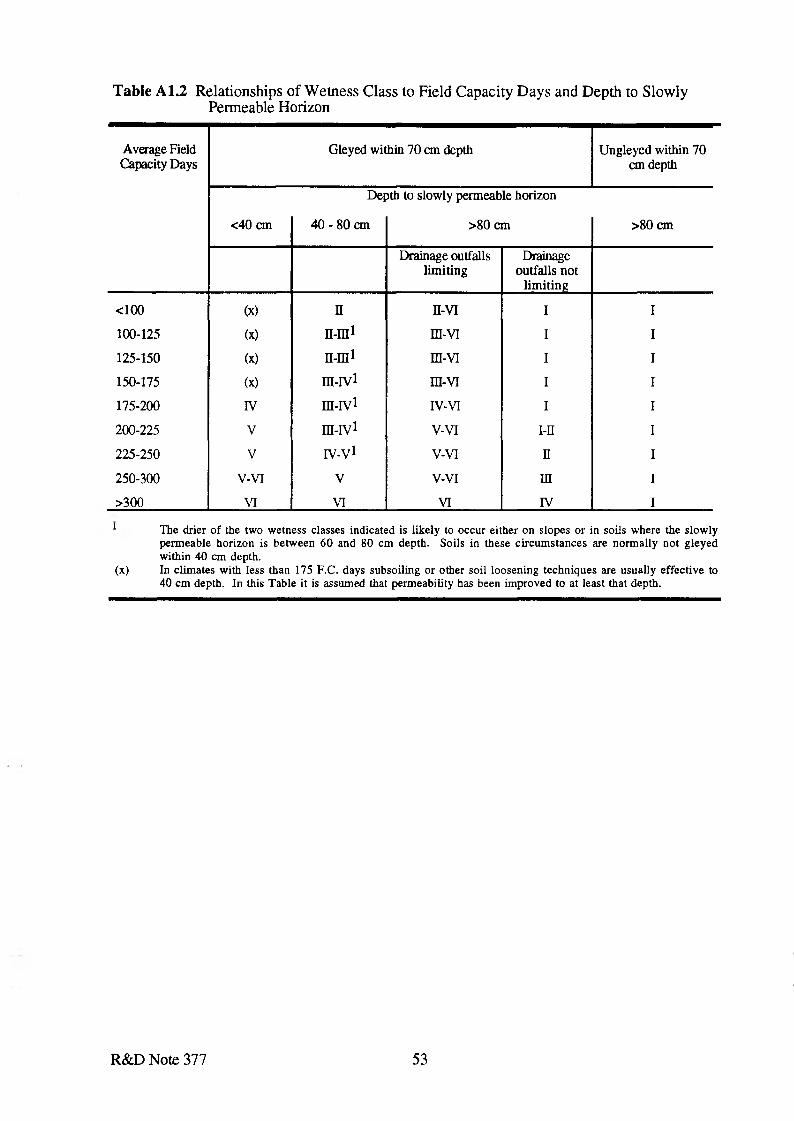
Table A1.2 Relationships of Wetness Class to Field Capacity Days and Depth to Slowly Permeable Horizon
Average Field Capacity Days
Gleyed within 70 cm depth Ungleyed within 70 cm depth
Depth to slowly permeable horizon
<40 cm 40 - 80 cm >80 cm >80 cm
Drainage outfalls limiting
Drainage outfalls not
limiting
<100 (x) n n-vi I I
100-125 (x) n-m1 m-vi I I
125-150 (X) n-ni1 m-VT I I
150-175 (X) ra-rv1 m-vi I I
175-200 IV m-iv1 IV-VI I I
200-225 V m-iv1 V-VI i-n I
225-250 V IV-V1 V-VI n I
250-300 V-VI V V-VI in I
>300 VI VI VI IV I
1 The drier of the two wetness classes indicated is likely to occur either on slopes or in soils where the slowlypermeable horizon is between 60 and 80 cm depth. Soils in these circumstances are normally not gleyed within 40 cm depth.
(x) In climates with less than 175 F.C. days subsoiling or other soil loosening techniques are usually effective to 40 cm depth. In this Table it is assumed that permeability has been improved to at least that depth.
R&D Note 377 53
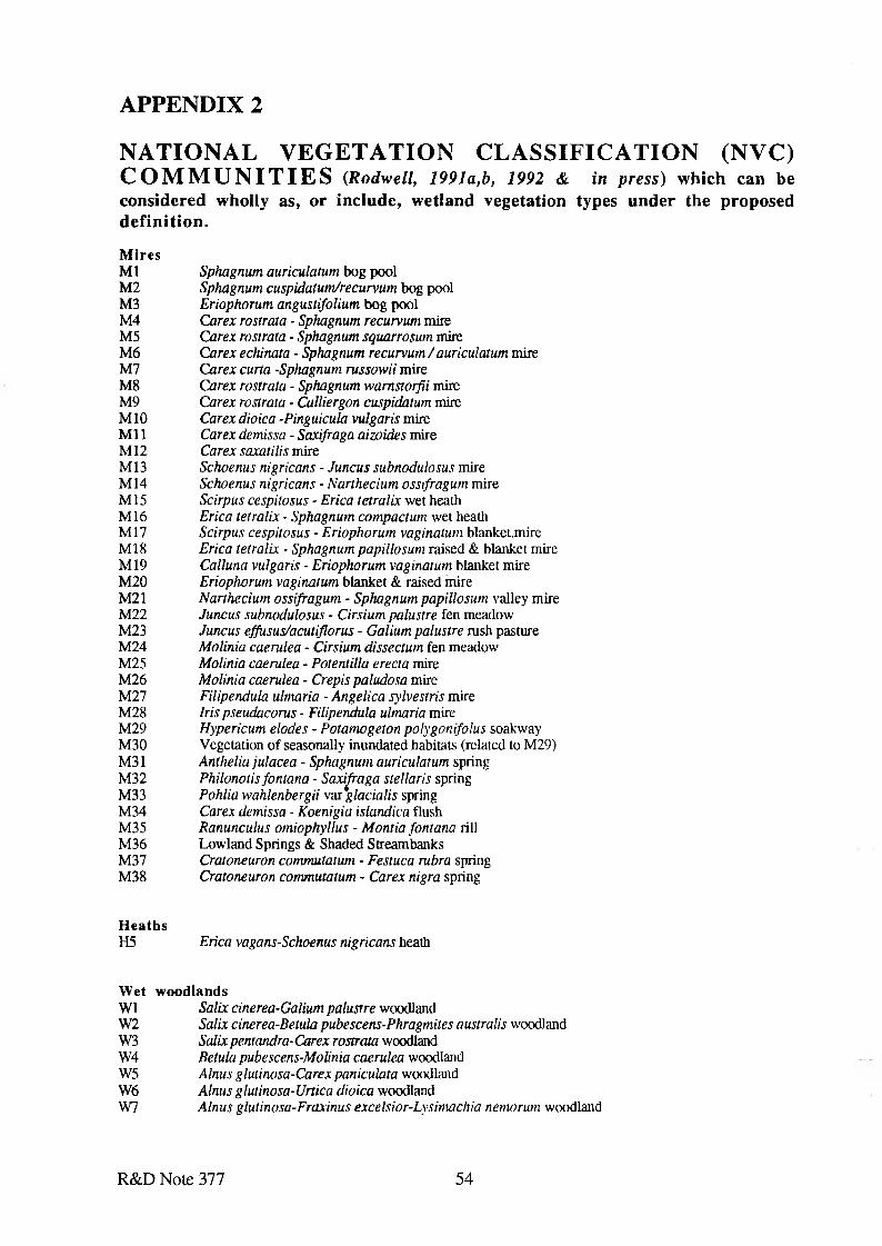
APPENDIX 2
NATIONAL VEGETATION CLASSIFICATIO N (NVC) C O M M U N IT IE S (R odw ell, 1991a,b, 1992 & in p re s s) which can be considered wholly as, or include, wetland vegetation types under the proposed definition.M iresM l Sphagnum auriculatum bog poolM2 Sphagnum cuspidatum/recurvum bog poolM3 Eriophorum angustifolium bog poolM4 Carex rostrata - Sphagnum recurvum mireM5 Carex rostrata - Sphagnum squarrosum mireM6 Carex echinata - Sphagnum recurvum/auriculatum mireM7 Carex curta -Sphagnum russowii mireM8 Carex rostrata - Sphagnum wamstorfii mireM9 Carex rostrata - Calliergon cuspidatum mireM10 Carex dioica -Pinguicula vulgaris mireM il Carex demissa - Saxifraga aizoides mireM12 Carex saxatilis mireM13 Schoenus nigricans - Juncus subnodulosus mireM14 Schoenus nigricans - Narthecium ossifragum mireM15 Scirpus cespitosus - Erica tetralix wet heathM16 Erica tetralix - Sphagnum compactum wet heathM17 Scirpus cespitosus - Eriophorum vaginatum blanket.mireM18 Erica tetralix ■ Sphagnum papillosum raised & blanket mireM19 Calluna vulgaris - Eriophorum vaginatum blanket mireM20 Eriophorum vaginatum blanket & raised mireM21 Narthecium ossifragum - Sphagnum papillosum valley mireM22 Juncus subnodulosus - Cirsium palustre fen meadowM23 Juncus effusus/acutiflorus - Galium palustre rush pastureM24 Molinia caerulea - Cirsium dissectum fen meadowM25 Molinia caerulea - Potentilla erecta mireM26 Molinia caerulea - Crepis paludosa mireM27 Filipendula ulmaria - Angelica sylvestris mireM28 Iris pseudacorus - Filipendula ulmaria mireM29 Hypericum elodes - Potamogeton polygonifolus soakwayM30 Vegetation o f seasonally inundated habitats (related to M29)M31 Anthelia julacea - Sphagnum auriculatum springM32 Philonotis fontana - Saxifraga stellaris springM33 Pohlia wahlenbergii var glacialis springM34 Carex demissa - Koenigia islandica flushM35 Ranunculus omiophyllus - Montia fontana rillM36 Lowland Springs & Shaded StreambanksM37 Cratoneuron commutatum - Festuca rubra springM38 Cratoneuron commutatum - Carex nigra spring
H eathsH5 Erica vagans-Schoenus nigricans heath
W et w oodlandsW1 Salix cinerea-Galium palustre woodlandW2 Salix cinerea-Betula pubescens-Phragmites australis woodlandW3 Salix pentandra-Carex rostrata woodlandW4 Betula pubescens-Molinia caerulea woodlandW5 Alnus glutinosa-Carex paniculata woodlandW6 Alnus glutinosa-Urtica dioica woodlandW7 Alnus glutinosa-Fraxinus excelsior-Lysimachia nemorum woodland
R&D Note 377 54
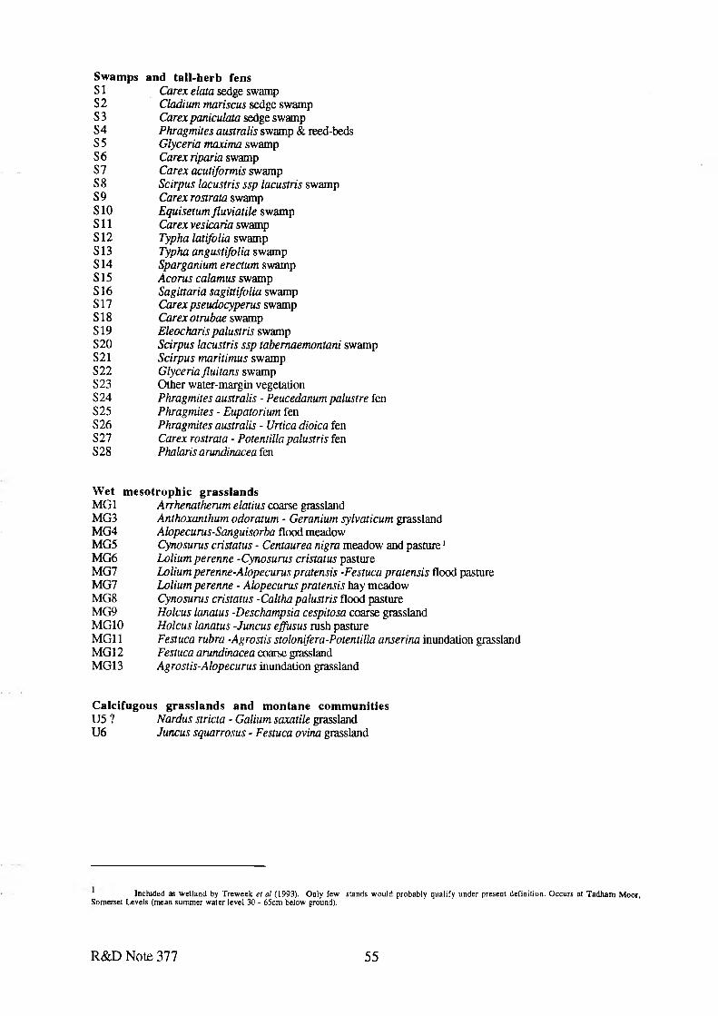
Swamps and tall-herb fensSI Carex elata sedge swampS2 Cladium mariscus sedge swampS3 Carex paniculata sedge swampS4 Phragmites australis swamp & reed-bedsS5 Glyceria maxima swampS6 Carex riparia swampS7 Carex acutiformis swampS8 Scirpus lacustris ssp lacustris swampS9 Carex rostrata swampS10 Equisetum fluviatile swampS l l Carex vesicaria swampS12 Typha latifolia swampS13 Typha angustifolia swampS14 Sparganium erectum swampS15 Acorns calamus swampS16 Sagittaria sagittifolia swampS17 Carex pseudocyperus swampS18 Carex otrubae swampS19 Eleocharis palustris swampS20 Scirpus lacustris ssp tabemaemontani swampS21 Scirpus maritimus swampS22 Glyceria fluitans swampS23 Other water-margin vegetationS24 Phragmites australis - Peucedanum palustre fenS25 Phragmites - Eupatorium fenS26 Phragmites australis - Urtica dioica fenS27 Carex rostrata - Potentilla palustris fenS28 Phalaris arundinacea fen
Wet mesotrophic grasslandsMG 1 A rrhenatherum elatius coarse grasslandMG3 Anthoxanthum odoratum - Geranium sylvaticum grasslandMG4 Alopecurus-Sanguisorba flood meadowMG5 Cynosurus cristatus - Centaurea nigra meadow and pasture1MG6 Loliumperenne -Cynosurus cristatus pastureMG7 Lolium perenne-Alopecurus pratensis -Festuca pratensis flood pastureMG7 Lolium perenne - Alopecurus pratensis hay meadowMG8 Cynosurus cristatus -Caltha palustris flood pastureMG9 Holcus lanatus -Deschampsia cespitosa coarse grasslandMG10 Holcus lanatus -Juncus effusus rush pastureMG11 Festuca rubra -Agrostis stolonifera-Potentilla anserina inundation grasslandMG12 Festuca arundinacea coarse grasslandMG13 Agrostis-Alopecurus inundation grassland
Calcifugous grasslands and montane communitiesU5 ? Nardus stricta - Galium saxatile grasslandU6 Juncus squarrosus - Festuca ovina grassland
Included as wetland by Treweek et al (1993). Only few stands would probably qualify under present definition. Occurs at Tadham Moor, Somerset Levels (mean summer water level 30 - 65cm below ground).
R&D Note 377 55
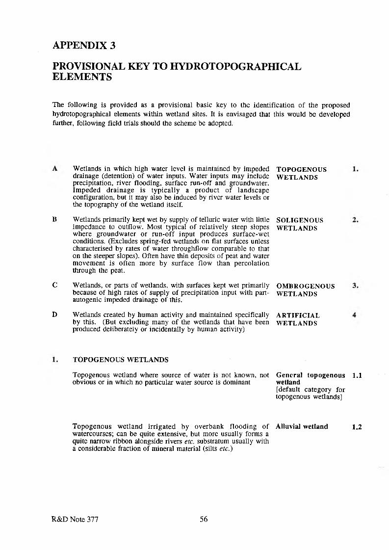
A P P E N D I X 3
P R O V I S I O N A L K E Y T O H Y D R O T O P O G R A P H I C A L E L E M E N T S
The following is provided as a provisional basic key to the identification o f the proposed hydrotopographical elements within wetland sites. It is envisaged that this would be developed further, following field trials should the scheme be adopted.
W etlands in which high water level is maintained by impeded drainage (detention) o f water inputs. W ater inputs may include precipitation, river flooding, surface run-off and groundwater. Im peded drainage is typ ica lly a product o f landscape configuration, but it may also be induced by river water levels or the topography of the wetland itself.
TOPOGENOUSW ETLANDS
B Wetlands primarily kept wet by supply of telluric water with little impedance to outflow. Most typical o f relatively steep slopes where groundw ater or run -o ff input produces surface-w et conditions. (Excludes spring-fed wetlands on flat surfaces unless characterised by rates of water throughflow comparable to that on the steeper slopes). Often have thin deposits o f peat and water m ovem ent is often more by surface flow than percolation through the peat.
C W etlands, or parts of wetlands, with surfaces kept wet primarily because of high rates of supply o f precipitation input with part- autogenic impeded drainage o f this.
D W etlands created by human activity and maintained specifically by this. (But excluding many o f the wetlands that have been produced deliberately or incidentally by human activity)
SOLIGENOUSW ETLANDS
OM BROGENOUSW ETLANDS
A R TIFIC IA LW ETLANDS
TO PO G EN O U S W ETLANDS
Topogenous wetland where source of water is not known, not obvious or in which no particular water source is dominant
G enera l topogenous 1.1 wetland[default category for topogenous wetlands]
Topogenous w etland irriga ted by overbank flooding o f Alluvial w etland 1.2watercourses; can be quite extensive, but more usually forms a quite narrow ribbon alongside rivers etc. substratum usually with a considerable fraction of mineral material (silts etc.)
R& D Note 377 56
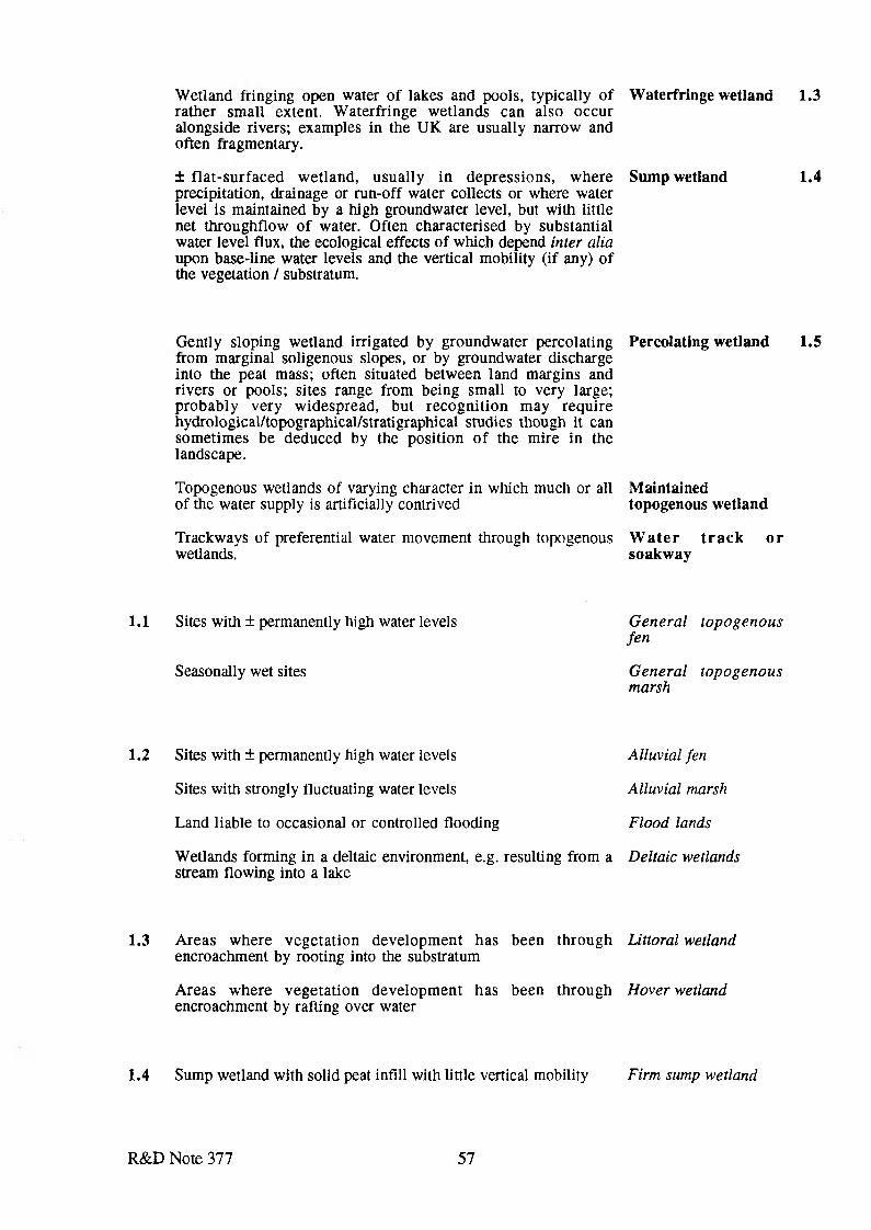
Wetland fringing open water of lakes and pools, typically of Waterfringe wetland 1.3 rather small extent. Waterfringe wetlands can also occur alongside rivers; examples in the UK are usually narrow and often fragmentary.
± flat-surfaced wetland, usually in depressions, where precipitation, drainage or run-off water collects or where water level is maintained by a high groundwater level, but with little net throughflow of water. Often characterised by substantial water level flux, the ecological effects of which depend inter alia upon base-line water levels and the vertical mobility (if any) of the vegetation / substratum.
Sump wetland 1.4
Gently sloping wetland irrigated by groundwater percolating Percolating wetland 1.5from marginal soligenous slopes, or by groundwater dischargeinto the peat mass; often situated between land margins andrivers or pools; sites range from being small to very large;probably very widespread, but recognition may requirehydrological/topographical/stratigraphical studies though it cansometimes be deduced by the position of the mire in thelandscape.
Topogenous wetlands of varying character in which much or all Maintainedof the water supply is artificially contrived topogenous wetland
Trackways of preferential water movement through topogenous W ater track or wetlands. soakway
1.1 Sites with ± permanently high water levels
Seasonally wet sites
General topogenous fen
General topogenous marsh
1.2 Sites with ± permanently high water levels
Sites with strongly fluctuating water levels
Land liable to occasional or controlled flooding
Alluvial fen
Alluvial marsh
Flood lands
Wetlands forming in a deltaic environment, e.g. resulting from a Deltaic wetlands stream flowing into a lake
1.3 Areas where vegetation development has been through Littoral wetland encroachment by rooting into the substratum
Areas where vegetation development has been through Hover wetland encroachment by rafting over water
1.4 Sump wetland with solid peat infill with little vertical mobility Firm sump wetland
R&D Note 377 57
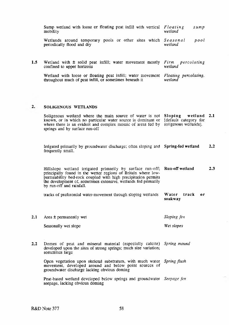
Sump wetland with loose or floating peat infill with vertical F l o a t i n g s u m p m obility wetland
W etlands around tem porary pools or other sites which S e a s o n a l p o o l periodically flood and dry wetland
1.5 W etland with ± solid peat infill; water movem ent m ostly F irm p e r c o la t in gconfined to upper horizons wetland
W etland with loose or floating peat infill; water movem ent F loating percolating.throughout much of peat infill, or sometimes beneath it wetland
SOLIGENOUS WETLANDS
Soligenous wetland where the main source o f water is not S lo p in g w e t la n d 2.1 known, or in which no particular water source is dominant or [default category for where there is an evident and complex mosaic o f areas fed by soligenous wetlands], springs and by surface run-off
Irrigated primarily by groundwater discharge; often sloping and frequently small.
Spring-fed wetland 2.2
H illslope w etland irrigated prim arily by surface run-off; Run-off wetland 2.3principally found in the wetter regions of Britain where low-perm eability bed-rock coupled with high precipitation permitsthe development of, sometimes extensive, wetlands fed primarilyby run-off and rainfall.
tracks o f preferential water-movement through sloping wetlands W a te r t r a c k o rsoakw ay
2.1 Area ± permanently wet Sloping fen
Seasonally wet slope Wet slopes
2.2 Dom es o f peat and m ineral m aterial (especially calcite) Spring mound developed upon the sites of strong springs; much size variation; sometimes large
Open vegetation upon skeletal substratum, with much water Spring flush m ovem ent, developed around and below point sources o f groundwater discharge lacking obvious doming
Peat-based wetland developed below springs and groundwater Seepage fen seepage, lacking obvious doming
R& D Note 377 58
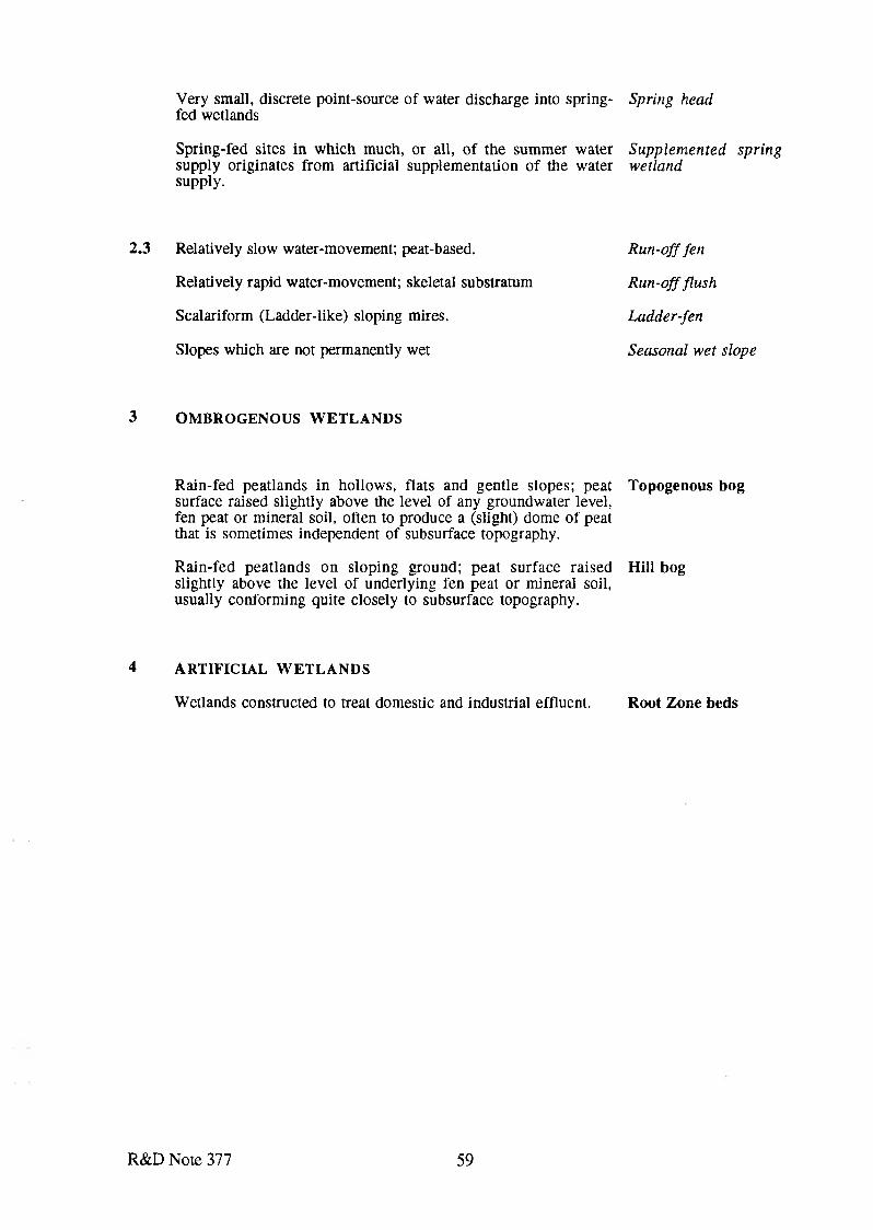
Very small, discrete point-source of water discharge into spring- fed wetlands
Spring-fed sites in which much, or all, of the summer water supply originates from artificial supplementation of the water supply.
2.3 Relatively slow water-movement; peat-based.
Relatively rapid water-movement; skeletal substratum
Scalariform (Ladder-like) sloping mires.
Slopes which are not permanently wet
3 O M BRO G ENO US W E T L A N D S
Rain-fed peatlands in hollows, flats and gentle slopes; peat surface raised slightly above the level of any groundwater level, fen peat or mineral soil, often to produce a (slight) dome of peat that is sometimes independent of subsurface topography.
Rain-fed peatlands on sloping ground; peat surface raised slightly above the level of underlying fen peat or mineral soil, usually conforming quite closely to subsurface topography.
4 A R TIFIC IA L W E T L A N D S
W etlands constructed to treat dom estic and industrial effluent.
Spring head
Supplemented spring wetland
Run-off fen
Run-off flush
Ladder-fen
Seasonal wet slope
Topogenous bog
Hill bog
Root Zone beds
R&D Note 377 59
APPENDIX 4
SOURCES OF WETLAND RESOURCE DATA
A4.1 Introduction
The extent to which the NRA and other organisations hold information on the wetland resource of England and Wales has been investigated with a view to assessing current knowledge on the location and geographical extent of wetland habitats.
A4.2 English Nature
English Nature is the main government funded body set up by the Environmental Protection Act 1990 charged with promoting the conservation of England's wildlife and natural features. EN advises the government on policies relating to and affecting nature conservation in England, and its responsibilities include scheduling Sites of Special Scientific Interest (SSSIs) and establishing and managing National Nature Reserves (NNRs). English Nature therefore represents a vital source of ecological (ie wetland) information. Staff at English Nature HQ (Peterborough) were consulted with regard to the current project.
A 4.2.1 Habitat Surveys (Phase 1 and 2)
Much of England has been covered by Phase 1 habitat survey either by EN or other bodies which may prove to be a useful source of information in identifying actual and potential wetlands. Phase 1 (and extended Phase 1) habitat maps often also contain target note information relating to wetland interest of small geographical extent which would be likely to be overlooked by other forms of habitat evaluation. Phase 1 habitat maps identify wetlands into four broad habitat categories with finer sub-divisions: marsh/marshy grassland; mire (blanket bog, raised bog, wet modified bog, dry modified bog, flush and spring (acid/neutral, basic or bryophyte dominated), fen (valley mire, basin mire, floodplain mire or bare peat); swamp, marginal and inundation and open water (including standing water and running water).
Ideally, complete Phase 1 coverage of England would be available prior to development of a wetland resource inventory to facilitate efficient identification and mapping of wetland sites. However, an assessment of Phase 1 data currently held by all EN regions for the current project found coverage to be patchy in its geographical distribution and inconsistent in its quality. Some of the data held are considered out of date by EN staff, and it is apparently little used in EN casework.
The Phase 1 data usually takes the form of hand-annotated hard copy maps at 1:10 000 scale, and very little has yet been digitised. There is no central repository for all Phase 1 habitat maps and no central record of which areas have been surveyed to Phase 1 or Phase 2 is available. Some regions of English Nature have expressed a reluctance to release copies of Phase I habitat survey maps due to worries over data quality.
Phase 2 habitat surveys are on the whole targeted towards areas of actual or potential NNR's and SSSI's.
R&D Note 377 60
A 4.2 .2 Designated Areas (SSSIs, NNRs, SPAs, SACs, Ramsar)
Details of Sites of Special Scientific Interest (SSSIs) including areas designated, at least in part, for their wetland interest are available from EN at regional level. Some information relating to SSSIs is commercially available in digital form and is held by MR Datagraffix, Cleveland. This includes: grid reference; boundary; area (ha); site name, county and district. The whole of England, comprising some 3,100 sites is covered. The specific information relating to reasons for designation and therefore the wetland interest of each site may have to be sought from each EN region individually. It is highly likely that the NRA will already be aware of the SSSIs designated primarily for their wetland interest in each region.
EN also hold a comprehensive list of sites proposed and designated Special Protection Areas (SPA'S) under European Community Directive 79/409 on the Conservation of Wild Birds. Information held includes site location, site name and reference to the papers which outline the reasons for designation. Similar data are also held on all proposed and designated Wetlands of International Importance under the Ramsar Convention (ie Ramsar sites). Of particular relevance are 'wet grassland' sites which form a substantial number of SPA/Ramsar designated areas (NCC, 1990). A number of sites qualifying as SPAs and Ramsar sites remain to be designated and information is still being reviewed or collected from additional sites. A joint report (RSPB, EN, CCW, SNH and Joint Nature Conservation Committee) on Important Bird Areas in the United Kingdom, includes further details on existing and proposed SPAs and Ramsar sites.
A4 .2 .3 Lowland Wet Grasslands
English Nature's Lowland Wet Grassland project could represent a useful source of wetland information. However, the constraints of this information must be appreciated, and in particular the inclusion of non-wetland habitats.
The Lowland Wet Grassland survey is an on-going phased project covering most of England. Phase 1 (1992/3) identified areas of probable interest >10ha via aerial photos and ground surveys. The second phase (1993/4) aims to superimpose areas of interest with English Nature Phase 2 survey details (to be completed by June 1994). The final stage is to develop a conservation strategy for lowland wet grasslands. The project was due for completion by July 1994. It is to be expected that English Nature would make available to the NRA any relevant results. The final mapped output will be at 1:50,000 scale, but the accuracy will only be as good as the existing information upon which it is based; some of which may be outdated.
A4.3 Countryside Council for Wales (CCW)
The Countryside Council for Wales (CCW), equivalent to English Nature, deals with countryside matters in Wales on behalf of the government. The Council is responsible for conserving the natural features and wildlife of Wales and the intrinsic quality of the landscape. CCW were consulted with regard to projects in relation to wetland identification and assessment.
There are a number of potentially useful sources of wetland information available from CCW. Approximately two thirds of Wales has been covered by Phase 1 habitat survey, and CCW have this information at 1:10 000 scale as standard Phase 1 habitat maps, with some additional
R&D Note 377 61
details (eg dominant species coding). CCW has the intention of placing the Phase 1 habitat maps onto a GIS in the future.
CCW has carried out a grassland survey including M olin ia /Juncus pastures and wet meadow/fen meadows. Approximately 600 sites have already been covered including National Vegetation Classification level of mapping on selected sites.
The Lowland Peatland Survey, also held by CCW, contains valuable information but is based upon grid references rather than mapped information. However, the sites were revisited as part of the CCW Phase 1 habitat survey of Wales and should cross-reference on the Phase 1 maps.
A 4.4 Scottish Natural Heritage (NPRI)
The National Peatland Resource Inventory (NPRI) was established by the former Nature Conservancy Council (NCC) and is now run by Scottish Natural Heritage (SNH) on behalf of all the official nature conservation agencies (including EN and CCW).
The main aim of the NPRI was to provide a baseline account of the extent and variety of Britain’s peatlands from which a rolling programme of environmental audit would subsequently be possible (Lindsay, 1993). As such, the NPRI dataset could provide a useful overlay for a wetland resource inventory. Information on the extent of peatlands and some details of current condition are included, although to date the main focus has been on ombrotrophic bog habitats.
The baseline data source used was the digitised boundaries of peat soils identified from British Geological Survey Maps (1:50,000 and 1" scale), which includes some fen areas, supplemented by information from several other sources. One major limitation for the current project is that the BGS maps only show peat over lm depth, and therefore excludes many wetland areas.
SNH have confirmed that the NPRI data will be made available to interested parties. Costs of producing the computer files or 'hard-copy' output in the desired formats will be negotiable, but likely to be 'at cost' or on a data-exchange basis. The data is held in a PC-GIS system (using ARC/INFO, FastCad, AREV, Quattro), and providing suitable files should be no problem if the user has the same GIS system; although converting for other systems might be more time consuming (and hence more costly).
A 4.5 Royal Society for the Protection of Birds (RSPB)
The RSPB is Europe's largest wildlife conservation charity. It promotes conservation through land purchase, land management, research initiatives, development of action programmes for rare species and campaigning at all levels for decisions sympathetic to wildlife.
An important survey by the RSPB produced an inventory of reedbeds (Everett, 1989). This study (1979-80) detailed the number, distribution, size and type of reedbeds, and identified 109 reedbeds of 2ha or more in England & Wales; with a total area of 2,300ha. Five kinds of reedbed were distinguished: transitional short-lived reedbeds; lake margin reedbeds; lowland floodplain reedbeds; coastal floodplain reedbeds protected from incursion by saline waters, and reedbeds in the tidal reaches of rivers.
R&D Note 377 62
A major limitation of this survey is the lack of mapped information: data is stored as a flat-file database. A 2ha cut-off on reedbed sites or even finer has been used to delimit areas subsequently mapped with management quality information. This information to date is not available on a GIS.
In addition to published reports, RSPB regional staff may also represent a good source of local information on the location of wetlands within their area. Such information could best be collected at NRA regional or area level, as part of desk studies prior to field investigations.
A 4.6 Institute of Terrestrial Ecology
The Environment Information Centre (EIC) is the section of ITE concerned with the analysis and interpretation of remotely-sensed imagery, digital mapping and GIS in relation to the creation and management of large databases in ecology and land evaluation. Of potential interest to the NRA and this wetlands initiative is ITE's Land Cover Map. This recent and possibly valuable source of information is a 25-class land cover map that has been derived by multispectral classification of Landsat TM images. It has a grid size of 25 metres and can be supplied as a digital data set for input to a Geographic Information System; giving the dominant habitat type for each 25m cell of the British national grid including identification of three wetland types.
If some classes of the Land Cover Map had been chosen to identify the range of wetland types, it would be a simple matter of extracting them. However, the only potentially relevant Land Cover Categories are 'inland water', 'bog (herbaceous)', and 'rough/marsh grass'. A project which aims to identify the relationship between the Land Cover Classes and existing habitat classifications is to be published shortly by ITE, and should provide a guide to the usefulness of the information.
A digital map showing a composite representation of Winter and Summer imagery using data from Landsat satellite gathered between 1989 and 1992 can be purchased from EIC. The data set covers the whole of Great Britain showing a 17 class summary (including the inland water, rough/marsh grass and herbaceous bog categories) or all 25 Target Classes of land cover (subdividing herbaceous bog to upland or lowland) is available with greater flexibility of use. The full resolution data is mapped onto a 25 metre grid which can be changed according to the specific needs of the project for maximum flexibility or a 1 km dataset is available for more general applications. Data can be provided in a number of formats compatible with most operating systems and analysis packages. Hard copy statistical information providing figures for each of the Land cover classes can be obtained for a given area which may be specified to such an area as a catchment.
A4.7 Soil Survey and Land Research Centre
Soil maps can be used to identify wetlands and to identify areas which were once wetter than present. However, use of soils maps has its limitations as they are outdated and changes may have occurred e.g. drainage or flooding. The main categorisation will probably be based on soil types which are affected by water (which is not always a clear distinction), and it must also be appreciated that wetlands may develop on marine sands and shingles as well as the more classic organic peat soils and river alluviums.
R&D Note 377 63
The main source of soils information for England and Wales is the 1:250,000 National Soil Map. The Map was derived from observations of the upper 1 m soil at an average frequency of 250 observations per 100 Km2. Soil boundaries were positioned using aerial photographs, geological maps and local knowledge of the terrain where available. The minimum map area shown on the soil map is 0.5 Km2, thus transitional zones (which are a key characteristic of wetlands) will not necessarily be clear. Also, the units actually mapped may include several soil types. This means that as far as the boundary definition of wetland soil types is concerned, the Soil Survey of England and Wales divisions will not be very accurate and will not meet the criteria given by the working definition. However, the available soils information will be valuable in providing a rough guide or starting point for further, more detailed, investigations.
It should be appreciated that the emphasis of the national soil survey was on soil use for agriculture. Thus, the criteria adopted in distinguishing wetland soil types (eg Robson and Thomasson, 1977) relate primarily to their drainage potential and not to their current hydrological regime - which may be more useful for the purposes of inventory development
The Soil Survey of England and Wales (R. Burton, pers. comm.) has expressed an interest in collaborating with the NRA in developing the Wetland Resource Inventory using their unpublished data sets for the identification of wetlands using soil criteria. Availability of more detailed and / or digitally based soil maps is currently very limited. The sampling procedure used in the production of the original hard copy soil maps and thus the limited accuracy of these and scale must also be appreciated.
A4.8 Agricultural Development and Advisory Service (ADAS)
ADAS is a national advisory body concerned with food, farming, land and leisure. Current work includes a programme of Monitoring Environmentally Sensitive Areas (ESAs). ESA's target areas where traditional farming practises have created and maintained sites important to wildlife or landscape. The scheme makes payments to farmers to follow a particular set of management prescriptions. ADAS is gradually working through the ESAs producing information in the form of habitat maps showing primarily those features that are important within the specific ESA sites including wetland habitats. Existing survey information, aerial photographs and satellite derived information are all used where possible in the production of maps of the ESA's. The proposed output is of paper and digital maps at 1:10,000 scale.
R&D Note 377 64
A 4 .9 B roads A u thority
Amongst the National Parks the Broads is the one primarily concerned with wetlands; being the controlling body of some of the prime lowland wetland sites in England.
The Broads Authority (together with English Nature) has commissioned a four year project to survey and evaluate the fen resource of the entire Broads Executive Area. Now in its fourth year, the work is being undertaken by ECUS, University of Sheffield, and will present the survey and management information as both hard copy and GIS. The GIS's interactive database details the English Nature Phase 2 fen survey information for the fen sites. The GIS also contains information on present and past management on the fen and non-fen sites, fertility, pH and conductivity details, peat transects and areas of past peat cuttings. The GIS thus holds the most up to date information relating to location, extent and value of all fen sites within the Broadlands.
The Broads Authority also hold mapped information on the location of grazing marshes of SSSI quality.
Other National Parks are also likely to hold information on the location of wetlands in their areas. For example, Northumberland National Park, in undertaking a Phase 1 habitat survey in 1992, calculated the total areas of each wetland (sub-) community in the National Park.
A4.10 Countryside Commission
The Countryside Commission is concerned primarily with landscape management and public access to the countryside.
Recent work commissioned by the Countryside Commission has assessed landuse/landscape changes in National Parks, (Silsoe, 1991.). Information was gained from a combination of maps and aerial photos with some ground-truthing. Satellite derived information was also utilised. Five 'wetland' categories were recognised: i) open water coastal; ii) open water inland; iii) peat bog, iv) freshwater marsh and v) salt marsh. Although a potentially useful source of wetland information, the limitations, as regards this project, are apparent - as coastal habitats and open water >2m depth are excluded from the current project. Full coverage of all National Parks is available in various outputs including computer generated maps (SPANS GIS). The Countryside Commission may be willing to negotiate access to this data.
A 4 . l l Countv Wildlife Trusts
County Wildlife Trusts, partners within the Royal Society for Nature Conservation (RSNC), are voluntary organisations concerned with safeguarding wildlife and natural habitats by acquiring and managing sites of national, regional and local significance.
A wide range of survey work has been undertaken at County Trust level incorporating large projects part-funded by the NRA. For example, the recently repeated Shropshire Wildlife Trust and Severn-Trent NRA survey of wetlands. Also, grant holding bodies such as the EC may partly fund large projects. For example, Cornwall Wildlife Trust are carrying out a survey of
R&D Note 377 65

habitat loss including wetlands via on the ground survey and aerial photographs (1988-1995), the information from which is to be digitised.
Trusts hold information relating to a wide range of wetland types which are impinged on by the NRA but the quantity, quality and format of material would need to be determined at a local level. Trusts will also hold information relating to wetlands below SSSI status e.g. Sussex Wildlife Trust hold a major dataset of all Sites of Nature Conservation Importance (SNCI's) in that region. Compilation of an exhaustive bibliography of existing work done on wetlands at County Trust level could be best undertaken at the regional or sub-regional level of the NRA by contacting the relevant Trust during the desk study phase of development of the wetland resource inventory: thus taking full advantage of local knowledge in identifying wetland areas and planning field reconnaissance.
A4.12 Local Authorities / Biological Records Centres
Local Authorities (including Borough, Metropolitan, City and County Councils) may hold a variety of wetland related information, including some reasonably detailed survey information. Although staff are rarely dedicated to wetland work, specific projects and initiatives have produced useful results. For example, floodplain maps of rivers Adur and Arun are held by West Sussex County Council. An inventory of peatland location and condition is held by Cheshire County Council who have also carried out a wetland archaeological survey. East Hampshire District Council recently commissioned study of all water resources within the District, and Kent County Council are undertaking a Phase 1 survey of the county during 1994.
Biological Records Centres are often based in museums, National Parks and local authorities, and can represent important sources of collated information on wildlife and habitats. However, the emphasis here tends to be upon species recording rather than habitat information. These centres act as the focus for wildlife recording in the region and, as such can also represent an important source of local knowledge and contacts.
Information collated in the form of 'County Floras' and other species atlas's may also assist location and, to a certain extent, classification of wetlands. However, such data is usually of low spatial resolution; often based upon 1km2 recording units, which would be of only limited use in developing the resource inventory.
A4.13 Wildfowl and Wetlands Trust
The Wildfowl and Wetlands Trust (WWT) is a national voluntary body, founded by Sir Peter Scott, which aims to further conservation, management and promotion of wetland bird habitats.
WWT hold a database of wetland characteristics, including information from national waterfowl counts database and disturbance information on wetlands, which can be available to the NRA. WWT aims to be able to identify wetland sites of importance for birds using this database (plus other information sources).
As with a number of other organisations, WWT has expressed an interest in working with the NRA on developing a wetland resource inventory.
R&D Note 377 66
Much of the archaeological and palaeoecological record associated with wetlands has been lost or damaged along with the ecological interest. In order to document some of the remaining resource English Heritage has supported four major surveys and excavations of wetland areas (see Table A4.1); the aim being to characterise and/or protect the remaining sites of archaeological interest. Within these areas, archaeological data produced will assist in assessing the geographical extent of current, and perhaps pre-existing, wetland. However, it should be recognised that wetland mapping per se was not the primary aim of these projects, and some data interpretation will be required for use in developing the wetland resource inventory.
A 4.14 English Heritage
Table A4.1 Major archaeological surveys supported by English Heritage (adapted from Coles, 1995).
A rea surveyed Survey period D ata availability
SOMERSET LEVELS & MOORS.
1973-1989 Results appeared in ‘Somerset Levels Papers' nos. 1-15.
FENLAND PROJECT Cambridgeshire, Lincolnshire and Norfolk.
1976-1996 Results published in 'East Anglian Archaeology', and 'Fenland, Research'.
NW WETLAND PROJECT Cumbria, Lancashire, Merseyside, Greater Manchester, Cheshire, Shropshire and Staffordshire.
1989-1998 Results appearing as a series of 'North W est Wetlands Survey' monographs.
HUMBER WETLAND PROJECTHoldemess, Hull Valley, Lincolnshire Marsh, Ancholme Valley, Humberhead Levels and the Vale of York.
1992- Results are to appear in a series of 'Wetland H eritage ' monographs.
A 4.15 Remote sensing
For an introduction of how remote sensing works the reader is referred to a report specially prepared for the NRA in which the basis on which it operates is well described (Briggs et al, 1992; R&D Note 28). Potential applications relevant to the NRA are documented in the report although wetland habitat mapping receives no special treatment.
For the purposes of the current report a brief introduction to the basis of remote sensing is included that seeks to emphasise its fundamental limitations.
R&D Note 377 67
Remote sensing works by measuring the return of electromagnetic radiation from the surface in question to the sensor onboard an aircraft or satellite. Surfaces may either reflect radiation, as in the visible and near infrared wavelengths, or emit it, as heat for example. How much radiation is returned and in which wavelengths is principally dependent upon the nature and characteristics of the surface. This enables different surfaces to be distinguished on the basis of their radiance. It also produces a physical limitation that restricts what remote sensing can and cannot detect. It is only possible to differentiate between surfaces, for example a reed-bed and clear water, if they reflect or emit radiation in different proportions, or put in remote sensing terms, if they have different spectral signatures. These physical limitations mean that many wetland types are not distinguishable by means of remote sensing.
Already described are the physical limitations that cannot be overcome. Of more pressing importance at any given time are the logistical limitations that are in periodic change as new higher specification satellites are launched. There are three main factors that limit the utility of an image data set, and these relate to the technology with which the data were acquired.
The spectral resolution is the first. Different sensors are designed to detect different portions of the electromagnetic spectrum, and they do this in discrete wavebands. The position and spectral width of specific wavebands is crucial, and will determine if certain spectral signatures can be distinguished.
The spatial resolution can be taken in simple terms to be the size of measured unit on the Earth's surface; the pixel size. Pixel sizes vary between 10 by 10 metres for a sensor onboard the SPOT satellite to 80 by 80 metres for the Landsat Multispectral scanner. The pixel size provides a simple guide as to the smallest size of feature that can be detected, although the exact relationship is somewhat more complicated (Townsend, 1981).
The temporal resolution is the revisit period or time it takes before the same area is viewed again. This is crucial in monitoring exercises. For airborne sensors this is dependent upon when flights are scheduled, which are not usually regular or frequent. For satellites it is dependent upon the orbit parameters. The Landsat series of satellites orbit the earth once every one and a half hours and with the continuous rotation of the planet inside the path of the orbit, are able to view the same piece of ground at 16-18 day intervals. It is thus possible to build up a time series that monitors change. However, there is a major problem: cloud cover. Although Landsat can image the same area every 16-18 days, the chances of obtaining a view that is not obscured by clouds may reduce the effective revisit period to months or even years.
The logistical limitations in terms of the resolutions outlined above are under continuous change, and as new sensors are launched the potential capabilities of remote sensing continue to improve. This report however, focuses on current technology rather than on what might be possible in the future. It is possible to gain spatial, spectral and temporal resolution by using Multispectoral sensors mounted on aircraft. Imagery from such airborne campaign would have considerable detection advantages in almost every respect except that of cost. To acquire imagery of England and Wales at a spatial resolution of 5 metres per pixel and at current commercial rates would cost of the order of £10M.
It is fortunate for this investigation that American concern over the loss of wetland habitats has preceded those of the UK, as we can learn from the approach they adopted. In the USA this concern led to the founding of the National Wetland Inventory (NWI) in 1975. This and other federal wetland mapping campaigns have used remote sensing to provide nation-wide
R&D Note 377 68

inventories of wetland type and geographical extent. The numerous academic publications and governmental reports that arose from this work represent a considerable resource of information for guidance in this report and in any future work. A thorough review of this literature was conducted which has assisted in preparing the strategies presented in this report.
Investigations using remote sensing specifically for British wetlands are extremely limited. The most useful study was undertaken to identify previously unmapped areas of peat in the lowland wetlands of north-west Cumbria. Unfortunately a quantitative accuracy assessment of the results was not performed.
In summary, although 'wetlands' is a convenient term for a wide range of habitats, it is apparent that there is no unique spectral signature that covers this range, i.e., to detect wetlands from remote sensing (satellite images) requires that many habitat types would need to be investigated as separate entities. Errors within such work are widely claimed to be of the order of 10-20%, and it is clear that remote sensing would not assist classification of individual wetlands (Chapter 3) within the resource inventory.
R&D Note 377 69

APPENDIX 5
GEOGRAPHICAL INFORMATION SYSTEMS
Chapter 4 of this report summarised the general concept of GIS with respect to its potential use in the establishment of a Wetland Resource Inventory. Based on the experience of other environmental bodies the main tasks to which GIS have been put are discussed in more detail below; some of the more technical aspects of GIS operation are also provided.
A 5.1 Storage and Management of Environmental Data
Fundamental to the operation of any GIS is the ability to store spatial data on the computer. The main advantage of GIS is the ability to store information on a wide range of environmental factors, probably derived from different sources, in a single system in a way which allows them to be displayed and analysed together. Recent years have seen the growth in the development of environmental databases at a range of scales. One of the earliest was CORINE which assembled a range of environmental data on the EEC (Mounsey 1991) and which is still used by the EC in making decisions on environmental matters (Thewessen et al 1992). At the global scale there is the United Nations funded GRID project (Rhind 1990), and the World Conservation Monitoring Centre which includes data from the IUCN wetlands atlas (Rhind 1993).
Almost all environmental databases consist of two main components:
1. Information on the particular environmental parameters of interest;2. General topographic data. At the simplest level this will be some form of 'base-map' to
help locate other information. For more complex use it may include factors such as topography and drainage for use in modelling.
Each of these can be stored as either vector or raster, which are the two basic data models used by GIS (Burrough 1986). In a vector GIS, objects are classified as either point (e.g. borehole), line (river) or area (marsh). The definition can depend on scale - for example a lOha marsh will be defined as an area if working at large scales, but can be treated as a point on a map of the whole UK. The location of each object is stored, together with any attributes of interest - in the case of a wetland these could include wetland type, ownership of land, ecological data.
In a raster GIS, space is divided into small square pixels, and information of interest is recorded for each pixel. Thus to record the extent of a wetland area, each pixel occupied by the wetland might contain a value of 1, and all others a value of 0. To store a second environmental variable - rainfall, soil pH etc. - a second raster layer is used. The values stored in the pixels are generally one of three types: a code denoting simple presence/absence (e.g. 1/0), a code representing a value in a classification, such as soil type, or a real value indicating the value of some variable at that point, such as soil pH or altitude.
R&D Note 377 70
In general terms both methods can be used to store and analyse spatial information, but each has particular strengths.
Vector:1. Good for handling identifiable 'objects' e.g. rivers, pipelines etc;2. High precision for storing the position of objects;3. High accuracy for calculating areas, perimeters etc.
Raster:1. Good for storing information on phenomena which vary continuously over space e.g.
altitude, soil characteristics;2. Good for analysis which involves combining information from different sources;3. Very easy to use with Remote Sensing data.
In the case of the background information, there is another possibility which is the scanned map. This is also a raster format, but is simply a computer 'picture' of the map, and not a way of storing the actual data portrayed on the map. In a scanned image, each pixel contains a value which relates to the colour of the map at that point - an A-road on an OS map will therefore be represented by a series of shades of red, each represented by a different pixel value. In a raster GIS layer, the A-road would be represented by pixels of the same value e.g. 1. When plotted on screen, these pixels can be coloured red, resembling the original map, but they can also be analysed to calculate the length of the road or measure its distance from an area of wetland, which cannot be done with the scanned map.
The choice between raster and vector depends on a number of factors, not least of which is the intended application of the final system as will become clear in some of the later examples. Some of the other factors are:
What data already exists in digital form, and which format are they in?
What software will be used (especially if this is already in use before the project)?
What are the characteristics of the phenomenon being studied? For example, with a database of national wetland sites, these could be viewed as points or small areas, and hence stored in a vector database. A raster structure would be possible, but would make it more difficult to identify particular sites (each would be stored as several pixels) and would make it harder to display these sites on top of basic topographic information. For a particular wetland area on the other hand, some of the information may consist of surveys of the ecological, pedological or hydrological conditions across the area. A natural way of storing such information is to divide the area into grid cells and to store the characteristic of each grid cell (a method often used in traditional ecological surveys) which can then be stored in a raster GIS. The relevant topographic information might be the location of paths, water courses or roads, which could be stored as vector lines and drawn over the raster data, or converted to raster form for the purpose of analysis.
R&D Note 377 71
A5.2 Data Display and Map Production
One of the simplest and yet most powerful features of GIS is its ability to display spatial data on screen and to produce hard copy maps. GIS are not simply mapping systems, as will become clear from some of the other possible applications, but for many organisations the map production capabilities of GIS are among the most heavily used (Campbell 1991).
Some of the strengths of computer systems in this respect can be summarised as follows:
'Seamless mapping' - once digitised, spatial data is no longer organised in terms of map sheets. Any area of interest can be displayed, up to the limits of the display screen or hard copy device. If the total dataset will not fit on screen, then it is possible to pan across it, or to zoom in to areas of interest.
Flexibility - data can be selected at will. Thus given a database of wetland areas plus general topographic data, the wetland boundaries can be shown on their own or in conjunction with any combination of other information.
Data integration - data from several sources can be combined on one map.
However there are still limitations with computer mapping.
Although digital data are not bound by sheet edges, they still retain the characteristics of the scale of the original data source. Thus although it is technically possible to zoom in on a digitised 1:250000 scale map there will be no more detail there than there was on the original map sheet. Similarly, data derived from different scale documents can be combined on a single map or display, but there are still problems in making sensible interpretations - thus if wetland areas are mapped at 1:10000, but the only geological data is from a 1:250000 sheet, it is extremely dubious to combine these together for display or analysis.
In theory it should be possible to derive all the data from large scale mapping, and simplify it if a broad overview is needed, a process known as generalisation. This was the intention of the original Ordnance Survey digitising programme, but automatic generalisation has proved a very difficult problem, and for the moment if an application requires both a broad overview and detailed information about small areas, each scale will require a separate set of data.
The GIS can still be used to view both sets of data (but not at the same time) and it would be possible with many systems to write an interface which allowed the user to view a national scale map of wetland locations, and then zoom in to see the detailed data for any particular area. The software would be set up to switch to the set of data for the appropriate scale of working.
A 5.3 Inventory and Simple Query
As well as displaying the basic spatial information in map form, the GIS allows the user to query and retrieve some of the associated attribute data. With vector systems, this often takes the form of identifying a particular feature on-screen and requesting information - for example given a map of UK wetland locations, requesting information about one in particular. Queries can also identify those objects which satisfy certain criteria. Which wetlands fall in a given
R&D Note 377 72
classification? Which are above a certain altitude? Which are within a certain distance of settlements or roads?
Many of these queries are also possible with raster systems, although those which relate to identifiable objects do not translate so naturally to raster as they do to vector.
A5.4 Change detection
A common requirement of environmental applications is the detection of change over time. This is very difficult to accomplish using manual methods, but is relatively straightforward once the data for the two time periods have been loaded into the GIS. As a simple example, consider two maps of the extent of wetlands over the country at two time periods. To look at the change manually would require drawing both sets of data onto a single map at the same scale and then further manual measurement to assess the amount of change.
Using a GIS, each set of data is captured and stored in a separate layer. The two layers are then overlayed, and the GIS can calculate the area of change or produce a map showing the location of changed areas. This form of simple analysis was used in a project which assessed the loss of hedgerows in the National Parks of England and Wales (Bird 1993).
Of course change detection can be more sophisticated than this. If the data at the two time periods is, say, a detailed ecological survey of a particular wetland, then a more sophisticated analysis of the pattern of change becomes possible - looking for successional changes, or changes in particular areas possibly caused by pollution or changes in management practice.
A 5.5 Modelling effects of change
Another form of analysis is to predict the likely effects of changes. In its simplest form, this can be the calculation of the loss of wetland likely by a proposed planning application - not only the simple area lost but the species likely to be affected etc. More sophisticated analyses are possible if the data are available to support them.
A relevant example is the study by Haines-Young et al (1990) of the likely effect of afforestation on the distribution of dunlins in the Flow Country of Scotland. Analysis of the distribution of this species indicated that it favoured wet moorland, avoiding large water bodies, woodland and agricultural land. The model was tested using information derived from Remote Sensing which could identify those areas most suitable for the dunlin, and the predicted bird distribution was confirmed by a field survey. The model could then be used to assess the likely effects of loss of habitat with afforestation of the area.
A 5.6 Modelling Environmental Processes
The final application area, and one which is currently receiving a good deal of attention in the academic literature, is the use of GIS linked to models of environmental processes (Goodchild et al 1993). A large number of environmental models have been developed over the years ranging in scale from the local to the global and in complexity from simple empirical models
R&D Note 377 73
such as the Universal Soil Loss Equation to complex, process-based models such as Global Circulation Models. Many of these models require large amounts of spatially distributed data for their input, and produce predictions in the form of maps showing patterns of soil loss, runoff etc. It has therefore been a natural development to link such models to GIS, which can provide the input data from their databases, and have the capabilities to produce the maps of the results.
An example which is pertinent here is the Water Information System (WIS), developed by the Institute of Hydrology (R. Moore, pers comm). At the heart of this is a database containing the digitised drainage network of England and Wales, plus a representation of the terrain height from which it is possible to calculate the area upstream of any point. This information has been linked with the equations produced from the Flood Studies Report and Low Row Studies Reports (NERC 1975, NERC 1980) - the system can automatically calculate all the parameters for the predictive equations in these studies from its stored data, and hence derive predicted flow characteristics for any point on any drainage channel in the country.
A 5.7 Limitations of GIS
Having outlined some of the potential uses of GIS, there needs to be balanced against this some of the problems associated with the technology.
So far, the discussion has all been about technical matters, but there is a growing body of evidence that the success or failure of GIS in any given context is dependent on organisational rather than technical factors. This was pointed out in the Chorley Report (DoE 1987) and has been confirmed by studies such as Campbell's work on GIS in UK local government (Campbell 1991).
GIS, like any other new technology, has the ability to change the way things are done in an organisation - to do existing tasks in a different way and to make new tasks possible. This will clearly affect the jobs of those working in the organisation - some may find themselves 'replaced' by GIS and need to retrain, others may be required to train to do their existing job using GIS. This has a number of implications:
1. GIS will only succeed if it is doing something useful for the organisation;2. Staff at all levels must be convinced of the advantages GIS will bring if they are to
tolerate the costs of setting up the system, learning how to use it etc;3. In planning for the introduction of GIS, allowance must be made for staff involvement in
the system design, and the cost of staff training.
In addition to the organisational problems, there are a series of technical problems, of which the main one is data capture. Numerous studies have shown that the single major cost of many GIS projects is not the hardware or software but the data. In many cases, 80% of the total project costs have come from converting existing datasets to digital form. Even where digital data exists, this can be expensive, and there is the time and cost of converting it to the correct format - Stewart (1993) reporting on a successful pilot test of GIS in the Forestry Commission that one of the biggest headaches was converting a variety of digital datasets into the correct format.
R&D Note 377 74
A 5.8 Case Studies
Reference has already been made to relevant work by other environmental agencies, especially in the UK. Here a few relevant examples are described to give an idea of the range of possibilities. Only one is explicitly concerned with wetlands but several relate to the capture and management of information.
A 5 .8 .1 US National Wetlands Inventory
This is a project which was initiated in the USA to produce maps of the nation's wetlands at a scale of 1:24000 (Pywell and Wilen). The initial work was based on air photo interpretation to identify the extent and type of wetlands, with the information being transcribed to 1:24000 maps. These draft maps were then redrawn after checking and a final set of maps at this scale produced.
A later stage in this project has been to digitize the 1:24000 maps in order to provide a digital form of the data.
Although it may seem wasteful of time and resources to produce hard copy maps which are then digitized the same approach was used by Williams and Lyon (1991) in a study of change in wetlands around Lake Nicolet. The extent and type of wetlands was derived from air photographs taken on 7 different occasions between 1939 and 1985, at scales varying from 1:12000 to 1:58000. Although it would be technically possible to capture information from these digitally and use a GIS to make the necessary changes to scale, correct for distortions etc., it is actually far easier to do the interpretation manually and record the results on an existing topographic map. Once the maps had been produced, they were digitised in vector format, and then converted to raster in order to do the comparison between the years - again even when raster data is required it is often easier to first digitise in vector and then convert to raster later.
A 5.8.2 Countryside Information System
This was a DoE sponsored project undertaken by the Institute for Terrestrial Ecology (Haines- Young et al 1993). The aim of the project was to provide policy makers with information about the state of the countryside, and in particular give easy access to the results of the 1990 Countryside Survey. A key element in this project was that the system was designed with the needs of the prospective users in mind - in particular what was needed was a system which presented the data in a way which was relevant to national policy concerns, which could be used by staff with normal office IT skills and which could be accessed rapidly.
The solution which was adopted was to summarise the various environmental variables for lx l km squares covering the country. This relatively coarse raster approach will lose some of the detail, but provides a good overview of phenomena at national scale and can be easily displayed using Windows-based software on a PC.
R&D Note 377 75

The Welsh Office have a need to map and monitor the Environmentally Sensitive Areas in Wales, for which they use a digital mapping system (Brown 1993). Because of the importance of linear features (walls, hedges, field boundaries) in the landscape, and the need to be able to identify particular land parcels a vector approach has been taken. The initial data was captured by digitising from field sheets on digitising tables - subsequent changes have been digitised by scanning the maps, displaying the scanned image on screen and digitising using the mouse.
Among the benefits of the digital approach are the accuracy of area and length measurements, the flexibility for map production and the ability to deal with data from a variety of scales. Future developments include a move to add database functionality thus moving away from simple map production to more sophisticated GIS capabilities.
A 5.8 .3 Mapping ESAs in Wales
R&D Note 377 76