ward area profile grange - gloucester and property/ward... · grange ward lies to the south of the...
TRANSCRIPT
Ward Area Profile
Grange
Spring 2013


Ward Area Profile: Grange
1
Overview Contents
Ward Councillors
Cllr Chris Chatterton - [email protected]
No address provided on City council website
Cllr Nigel Hanman - [email protected]
171 Bodiam Avenue
Gloucester
GL4 0TN
Summary
Grange ward lies to the south of the City and is a predominantly self contained and
established residential ward lying within the boundaries of the mainline railway, the A38 Cole
Avenue and the Daniel’s Brook.
The ward has two primary schools, a secondary school, local retail centre, library,
community centre, sports centre including swimming pool and three places of worship,
despite being the second smallest ward in the City for population. The level of service
provision reflects the fact that historically the services in the ward have also provided for the
populations of Podsmead ward to the north of the A38, Tuffley ward to the east of the railway
and in more recent years Quedgeley Fieldcourt to the south.
The ward has low educational achievement at the end of Key Stage 4 in comparison to other
wards in the City, a low level of household income and high levels of existing illness in the
westernmost lower super output areas.
Given the number of community and sports facilities in the ward and the strong presence of
faith communities it is considered that the ward is well placed to engage in community
development programmes and extended school provision to help address the deprivation
indicators that present as issues in this area.
Strengths
Two primary schools & one secondary
school within the ward
Local retail centre with low vacancy rates
Large amount of public open space
Weaknesses
Low percentage of 16 year olds gaining
5 GCSE A-C’s including maths &
English compared to rest of City
High level of existing illness’s within
LSOA’s across ward

Ward Area Profile: Grange
2
Local sports centre within ward
High percentage of owner occupied
dwellings
High percentage of people are satisfied
with the area in which they live
Low level of average household income
across ward
Opportunities
To improve green infrastructure and
watercourses in the ward
To provide more public playing pitches
To provide more local play areas for
children
To improve health in the ward
To improve educational achievement in
the ward and improve skill development
amongst adults
To improve average household income
across the ward
Threats
Flooding from freak rainfall events
Structural change to the national
economy resulting in increased
unemployment.
Appendix 1
1.0 Physical Character of the Area
1.1 Location
Grange is located to the south of the City and comprises a triangular ward bounded by the
A38 Cole Avenue to the north, the mainline Birmingham to Bristol railway to the east and
Daniels Brook to the west and south. The ward has a mix of twentieth century house types
comprising a range of design styles, including terraced and semi detached housing and
dormer bungalows. Holmleigh Park and the Beaufort Community School campus are located
in the middle of the ward. There is an area of employment land to the north west of the ward
fronting onto Cole Avenue.

Ward Area Profile: Grange
3
Figure 1: Location of Grange Ward within the City of Gloucester

Ward Area Profile: Grange
4
1.2 The Historical Development of Grange
This ward is defined on its eastern side by the north-south line of the Midland Railway. The
1st edition Ordnance Survey map of 1880 shows the ward as being predominantly open
farmland (with a distinctive dog-leg field pattern indicative of medieval strip field cultivation).
Orchards are also visible – mostly along the sides of Grange Road or around Witcombe
Farm. The term grange refers to an outlying farm or estate belonging to a monastery and it
is assumed that Tuffley Grange was one such establishment during the medieval period. It
is unclear which ecclesiastical house it was owned by (although Llanthony Priory were
significant owners in the area). The 1st Edition OS shows three main settlements;
Quedgeley Court, Tuffley Grange and Witcombe Farm – none of which now survives.
By 1923 maps show considerable housing development along Grange Road although the
area is otherwise unchanged. Major development within the ward appears to have taken
place between the 1930s and 1955 with large housing developments extending throughout
the majority of the ward – with the only green space surviving in Homeleigh Park. The same
period also sees extensive industrial development in what is now the central trading estate.
The ward is now largely unchanged from the 1950s, the majority of the earlier landscape and
settlement pattern has been entirely removed. The earliest elements of the historic
landscape which still survive are the historic routes along Grange Road and Tuffley Avenue.
Figure 2: Historic map of Grange

Ward Area Profile: Grange
5
1.3 Character of the area
The built form of Grange ward is characterised predominantly by semi detached and
terraced housing. It is a popular area of the City for families and for older people as there is
a substantial amount of bungalow development in the south eastern sector of the ward.
There is a local centre at Windsor Drive that comprises a convenience store , pharmacy,
take aways, hairdressers, pets hop and pub. Opposite the local centre is a library.
Figure 3: Grange Ward
Grange Road is the oldest route way through the ward which originally led to Whaddon from
Tuffley Lane. Some of the oldest dwellings in the ward can be found along this routeway.
Grange Road enjoys a pleasant character with street trees and the mature tree lined
avenues of Nympsfield and Randwick Road leading from it. There is a mix of age and type
of housing development along Grange Road. Some older properties with larger rear
gardens now benefit from permission to infill with new housing development to the rear, this
will change the spacious character of this area over time.

Ward Area Profile: Grange
6
Tuffley Lane provides a routeway through the north and west of the ward and Bodiam
Avenue follows the route of the Daniels Brook to the south and west of the ward. Holmleigh
Road, Windsor Drive and Chatsworth Avenue provide permeability through the ward.
Routes out of the ward are provided by Tuffley Lane and Grange Road into Tuffley ward to
the east, Bodiam Avenue to the west and Epney Road to the north onto Cole Avenue.
Much housing development took place in the ward during the 1930’s and 1950’s including a
large area of dormer bungalow housing at Bodiam Avenue and off Chatsworth Avenue. This
area is quite densely developed but houses have off street parking and front and rear
gardens.

Ward Area Profile: Grange
7
Local authority housing was provided in the area known as the Holmleigh Estate between
1965 and 1974, this area comprises a series of dense Radburn style layout closes accessed
from Holmleigh Road and Tuffley Lane in the north of the ward.
More recently new housing has been built since 2005 at Meredith Way, the site of the former
Grange Infants School and at Tolsey Gardens, a town house development in the north of the
ward off Tuffley Lane. These are higher density developments built to the highway design
guides of the era.

Ward Area Profile: Grange
8
A major feature in the ward is Holmleigh Park, a large public open space. Beaufort
Community School is situated in the south eastern corner of the park adjacent to Harewood
Primary School. The library and community centre is also located on the edge of the open
space to the north of the Beaufort Campus. Holmleigh Park is spacious and predominantly
laid to playing pitches with informal open space around the edges.
Grange Primary School is located in the north of the ward and accessed from Holmleigh
Road, the school has good playing fields.
Additional public open space can be found between Randwick Park and the railway.
To the north of the ward is an employment area with a car showroom and trade counter uses
accessed from Cole Avenue and Shepherd Road. Most recently the former County Council
depot in this area, which backed onto Tuffley Lane, has been redeveloped as a community
training centre for the Fire service with the site being re-orientated to access from Tuffley
Lane.
In the very north east of the ward is a small static caravan park, it is well screened from
Green hill Drive but is situated some way from the local shops and services at Windsor
Drive.
1.4 Hierarchy of Routes
The main route in the ward is the A38 Cole Avenue which lies to the very north of the ward.
Grange Road and Tuffely Lane provide connectivity through the ward with Bodiam Avenue,
Chatsworth Drive Avenue, and Windsor Drive and Homleigh Road providing internal
distributor roads within the ward.

Ward Area Profile: Grange
9
2.0 Demographics
2.1 Population
The 2011 Census demonstrates that Grange ward has a population of 5,839 people. This
accounts for 4.79% of the population of the City making it the third smallest ward after
Elmbridge and Podsmead. (Source: Census 2011).
2.2 Age
The breakdown of age cohorts is provided in Figure 4 below.
Figure 4: Breakdown of Population by age
Source: Census 2011
Figure 4 clearly shows more people in the ward aged between 60 and 69 than any other
cohort and a significant number of people aged 40-44. There are also more teenagers in the
ward than children aged 0-9. With regard to adults the ward has an older age profile than
other wards in the City.
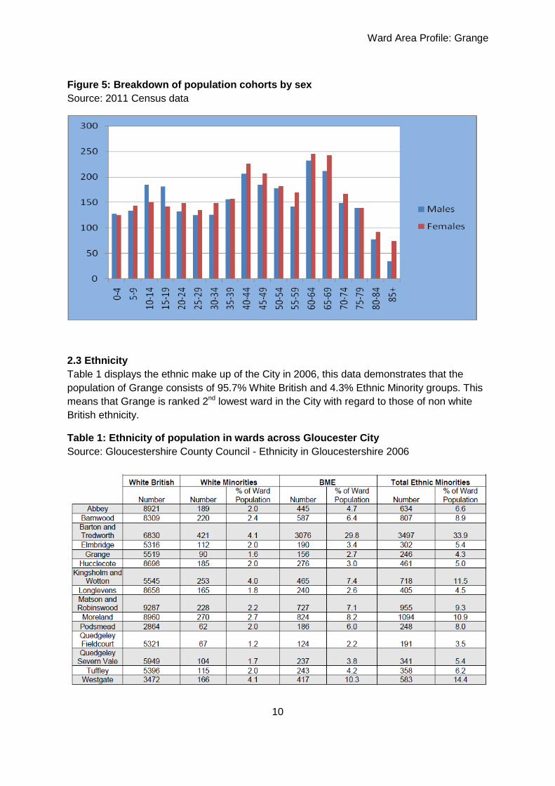
The breakdown of population by cohorts by sex is illustrated in Figure 5 below. The graph
shows a similar number of boys and girls up to the age of 9, but significantly more male
teenagers in the ward. There are then more women than men living in the ward for all
remaining age cohorts. Of particular note are the numbers of women aged 60-69 in the
ward. From the age of 60 there are more women than men in each cohort, reflecting the
national trend of women living longer than men.
Ward Area Profile: Grange
10
Figure 5: Breakdown of population cohorts by sex
Source: 2011 Census data
2.3 Ethnicity
Table 1 displays the ethnic make up of the City in 2006, this data demonstrates that the
population of Grange consists of 95.7% White British and 4.3% Ethnic Minority groups. This
means that Grange is ranked 2nd lowest ward in the City with regard to those of non white
British ethnicity.
Table 1: Ethnicity of population in wards across Gloucester City
Source: Gloucestershire County Council - Ethnicity in Gloucestershire 2006
Ward Area Profile: Grange
11
2.4 Gender
The discussion under Figure 5 clearly highlights the discrepancies between genders within
the ward. What is clear is that teenage boys out number teenage girls. However from the
age of 20 onwards there are more women than men in the ward for every cohort.
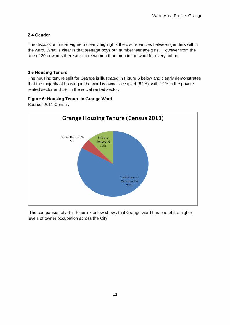
2.5 Housing Tenure
The housing tenure split for Grange is illustrated in Figure 6 below and clearly demonstrates
that the majority of housing in the ward is owner occupied (82%), with 12% in the private
rented sector and 5% in the social rented sector.
Figure 6: Housing Tenure in Grange Ward
Source: 2011 Census
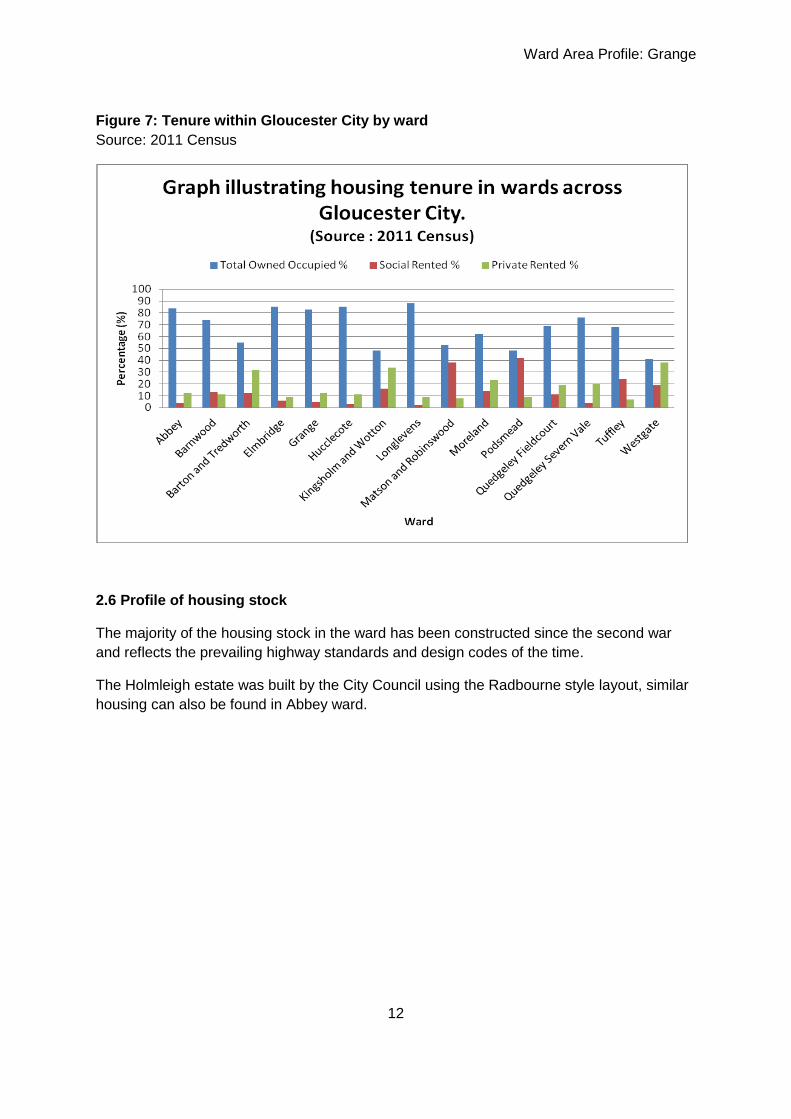
The comparison chart in Figure 7 below shows that Grange ward has one of the higher
levels of owner occupation across the City.
Ward Area Profile: Grange
12
Figure 7: Tenure within Gloucester City by ward
Source: 2011 Census
2.6 Profile of housing stock
The majority of the housing stock in the ward has been constructed since the second war
and reflects the prevailing highway standards and design codes of the time.
The Holmleigh estate was built by the City Council using the Radbourne style layout, similar
housing can also be found in Abbey ward.

Ward Area Profile: Grange
13
The majority of housing in the ward is suitable for families but there is also a large area of
bungalow development suitable for the elderly, although not all of this development is
located in close proximity to the local centre with its local shops and services.
Grange has a higher than average percentage of houses and bungalows at 92% compared
to the average for Gloucester at 83%. In turn, Grange has a lower than average percentage
of flats at 6% compared to the district average of 16%. Grange has a high percentage of
caravans and mobile homes at 3%.
Grange has a lower than City average percentage of one, four and five bedroom properties
but a higher than City average percentage of two and three bedroom properties. Grange
has a lower than average percentage of properties in Council Tax Bands A, D and E but
higher than average percentage in bands B and C.
Grange has a high percentage of houses and bungalows which are privately owned. This
has resulted in a shortage of flats and housing for rent. The ward should focus on
developing more social housing to address the imbalance.
2.7 Energy efficiency of housing stock
Thermal imaging of the housing stock in the ward demonstrates that housing in the south
eastern sector of the ward and older housing stock along Grange Road is more thermally
efficient than the majority of other housing elsewhere in the ward.
A household is deemed to be in Fuel Poverty if they spend more than 10% of their income of
heating their home; the table below shows the percentage of households who are defined as
being in fuel poverty. 5.0% of households in Grange are in fuel poverty, which is lower than
the local authority average of 5.5%.

Ward Area Profile: Grange
14
2.8 Housing Need
The 2009 Fordham Research Gloucestershire household survey idenitifed Grange as lying
in the south central sub area of the city which has a cumulative total of 10,730 households.
Of these 3.8% are households in unsuitable housing and 1.9% are in current housing need.
3.0 Community Facilities
3.1 Healthcare
The ward has one doctors surgery at Warwick Avenue which is a branch surgery of
Heathville Road Medical Centre in the City. This branch surgery has pre- bookable
appointments, same day appointments and some provision for emergencies.
There is a dental surgery located at 29 Windsor Drive.
3.2 Libraries
Tuffley Library is located on Windsor Drive opposite the local centre at the end of the drive
that leads to Beaufort Community School.
The library is open as follows;
Monday 10am – 1pm 2pm -5pm
Tuesday - 2pm-5pm
Wednesday Closed
Thursday 10am-1pm 2pm-5pm
Friday - 2pm-5pm
Saturday 10am-1pm
The library offers the following sessions;
Baby Bounce and Rhyme
Housebound Library Service
Library Club
PC’s with internet access
Parking for those with access needs and flat access with automatic doors

Ward Area Profile: Grange
15
3.3 Places of Worship
St. Georges Tuffley
St. George’s is an Anglican Church that is located on Grange Road and built in 1956 to
serve the ever expanding estate of Tuffley. The church has Sunday Services and runs a
coffee club and a luncheon club. The church hall is well used by the local community
including Scout and Guide groups, mother and toddlers and Blood Donor sessions.
English Martyrs Church
English Martyrs Church is a Roman Catholic Church located on Tuffley Lane. Mass is held

Ward Area Profile: Grange
16
on Sunday, Tuesday and Friday. Children are welcome at the services, the parish is linked
with St. Augustine’s at Matson.
Grange Baptist Church
This Baptist Church, built in 1950 is located towards the northern end of Grange Road, it
runs Sunday services which cater for children and young people as well as other activities
including toddlers club, a kids club for primary school aged children, a youth group and a
ladies meeting.
3.4 Community Facilities
The Gloucester City Draft Community Facility Audit (Autumn 2012) identifies Grange as
having more than the national recommended level of community facility provision. The
facilities listed include the following;
Beaufort Community School Murrary Hall Library Grange Baptist St Georges
Ward Area Profile: Grange
17
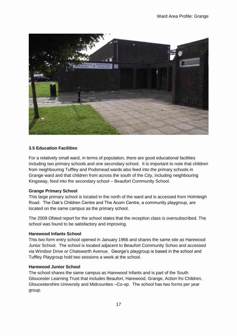
3.5 Education Facilities
For a relatively small ward, in terms of population, there are good educational facilities
including two primary schools and one secondary school. It is important to note that children
from neighbouring Tuffley and Podsmead wards also feed into the primary schools in
Grange ward and that children from across the south of the City, including neighbouring
Kingsway, feed into the secondary school – Beaufort Community School.
Grange Primary School
This large primary school is located in the north of the ward and is accessed from Holmleigh
Road. The Oak’s Children Centre and The Acorn Centre, a community playgroup, are
located on the same campus as the primary school.
The 2009 Ofsted report for the school states that the reception class is oversubscribed. The
school was found to be satisfactory and improving.
Harewood Infants School
This two form entry school opened in January 1966 and shares the same site as Harewood
Junior School. The school is located adjacent to Beaufort Community Schoo and accessed
via Windsor Drive or Chatsworth Avenue. George’s playgroup is based in the school and
Tuffley Playgroup hold two sessions a week at the school.
Harewood Junior School
The school shares the same campus as Harewood Infants and is part of the South
Gloucester Learning Trust that includes Beaufort, Harewood, Grange, Action fro Children,
Gloucestershire University and Midcounties –Co-op. The school has two forms per year
group.

Ward Area Profile: Grange
18
Beaufort Community School
This is a purpose built comprehensive school serving the southern part of the City of
Gloucester. The school is set in a large open site within the grounds of Holmleigh Park.
There are 1200 students on roll of which 180 are in the sixth form. The new sixth form
centre was opened in 2010. The main school building dates from 1971, new developments
include a new library and ICT suite, Business studies rooms and refurbished technology
facilities. A performing arts centre was opened in 1997 including music rooms and recording
studios and performance space.
The school has a large community sports centre including a swimming pool, sports hall,
gym, squash courts and fitness suite, this facility is extensively used by the community
during the evening and at weekends.
The school contains the county’s Centre for Hearing Impaired Pupils of secondary school
age with 20 places for hearing impaired students.
The school is regarded as one of the most successful and improved within the local
authority. There is a focus on the quality of teaching and learning to raise pupil achievement
throughout the school supported by a strong pastoral structure.
In September 2010 the school became a member of The South Gloucester Learning Trust.
The aim of the Trust is to promote the education and well being of young people and their
families in the South of Gloucester, particularly Tuffley, Grange and Podsmead.
The school was inspected by Ofsted in January 2011 and was found to be ‘satisfactory’, with
a good capacity for sustained improvement. A further report in November 2012 identified
‘serious weaknesses ’ at the school.
3.6 Leisure Facilities
The Beaufort Sports complex, opened in September 1974 is the main leisure resource in the
ward, as described above it has sports facilities as well as a swimming pool and is widely
used by the community and clubs during evenings and weekends. The facility was
refurbished in 2012. The centre provides swimming lessons for children as well as
recreational swimming, aqua aerobics and life guard training. Other clubs run from the
centre include five a side, Zumba, Karate, Cricket & Tennis.
Jed’s Gym is located in the north of the ward on land at the Tuffley Rovers junior teams
sports pitches off Tuffley Lane.
3.7 Cultural Facilities
A cultural facility is defined as any building or structure used for programs or activities
involving the arts or other endeavours that encourage refinement or development of the
mind. In Grange the facilities include the library at Tuffley.
3.8 Community Groups and Services

Ward Area Profile: Grange
19

Ward Area Profile: Grange
20
4.0 Deprivation Index
4.1 Deprivation table
The deprivation rate is compared to the County norm of 1. A rate of 0.5 represents half the
County average rate, a rate of 2 would show the locality has double the norm.
Hot indicates the locality is in top 10% (or bottom 10% when marked with an *) of localities in
Gloucestershire (therefore this is an issue within the City). Warm indicates the locality is in
the next 25% of localities in the County (therefore this indicator is an issue when compared
to the County). Cold indicates a ‘cool’ rating compared to other localities in the County (this
indicator is not an issue).
Table 2: Deprivation Indicators for Grange Ward
(Source: Data from Maiden multi agency information database for neighbourhoods 2012 &
2007)
Source MAIDeN Number Hot, Warm or Cool
Health
Social work assessments 2011 5 Cool
Mental Health Assessments 2011 15 Cool
Weekly alcohol spend £s CACI 2006 20618 Cool
Children and Young People
Accident Admissions of under 5’s 2012 20 Warm
Accident Admissions of under 17’s 2012 65 Warm
Children in need 2011 25 Cool
Crime victims under 20 years old 2010-11 35 Warm
Lone parent benefit claimants August 2008 53 Warm
Key stage 4 – Pupils not achieving 5+ A*-C grades inc English * maths 2011-2012
30 Warm
Free School Meals – Pupils eligible 2012 80 Warm
Pupils with English as an additional language where first language known
725 Hot
Crime
Victims of crime (all) 2010-11 285 Warm
Anti Social Behaviour Incidents recorded by the Police 2010-11
290 Warm
Theft victims 2010-11 115 Cool
Violence victims 2010-11 70 Warm
Burglary victims 2010-11 45 Warm
Hate Crime/incidents 2010-11 10 Cool
Serious and Fatal Road Traffic Collisions 2007-10 5 Cool
Criminal damage victims 2010-11 45 Warm
Arson recorded by Fire and Rescue 2008-11 10 Cool
Ward Area Profile: Grange
21
Economy
Mean household income 2007 £k* 28,644 Hot
Working-age benefit claimants Aug 2008 361 Warm
Job seeker claimants Aug 2008 58 Warm
Incapacity Benefit claimants 2008 137 Warm
Lone parent benefit claimants Aug 2008 53 Warm
Carer claimants Aug 2008 24 Warm
Disabled claimants Aug 2008 29 Warm
Households with broadband internet 2008* 2214 Cool
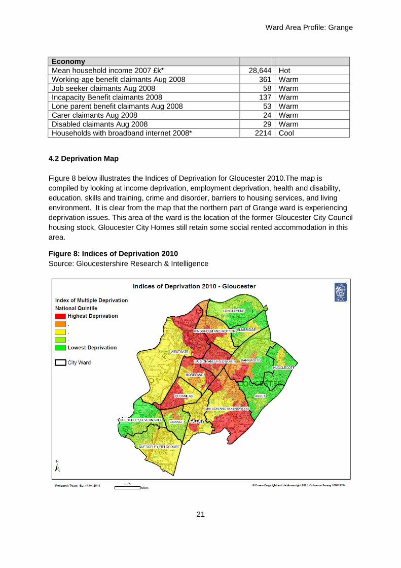
4.2 Deprivation Map
Figure 8 below illustrates the Indices of Deprivation for Gloucester 2010.The map is
compiled by looking at income deprivation, employment deprivation, health and disability,
education, skills and training, crime and disorder, barriers to housing services, and living
environment. It is clear from the map that the northern part of Grange ward is experiencing
deprivation issues. This area of the ward is the location of the former Gloucester City Council
housing stock, Gloucester City Homes still retain some social rented accommodation in this
area.
Figure 8: Indices of Deprivation 2010
Source: Gloucestershire Research & Intelligence

Ward Area Profile: Grange
22
4.3 Headline Indicators
The indicators above show that issues for Grange ward include low average household
income and a low level of adult e-learning. Low average household income could be
explained by the higher numbers of older households than in other parts of the City, but
could also reflect the fact that there are many low income households living in the ward.
The northern part of the ward suffers most severely from low educational achievement, skills
and training, but other factors which are highlighted for this area include access to housing,
income deprivation affecting children and employment deprivation. Significantly the west of
the ward suffers from geographical access to services.
4.4 Health
The Director of Public Health’s report for Gloucester from 2009 – 2010 identifies those areas
with existing health problems including angina, heart attack, new cases of diabetes, high
blood pressure and high cholesterol. The map splits the ward into Lower Super Output
Areas (LSOA’s) of approximately 650 households. The existing health problem map for the
City shows that Grange ward is split into four LSOA’s of which the two westernmost areas
each have 101-200 households with existing health problems. The two easternmost LSOA’s
each have 51-100 households with existing health problems. This data demonstrates the
high number of households in the ward with existing health problems and is illustrated in the
map below.

Ward Area Profile: Grange
23
The same report indicates that there are no parts of the ward that are harbouring future
health problems, this is illustrated in the map below.
Community Health trainers operate in the ward. Community Health Trainers offer support,
information and guidance to people who want to make changes to their lifestyle. They offer
realistic and practical help with:
Improving wellbeing, reducing stress and feeling better about yourself
Healthy eating and weight management
Stopping smoking
Sensible drinking
Becoming more physically active
The service is free, non-judgemental, confidential and quick and easy to access.

Ward Area Profile: Grange
24
4.5 Crime
Based on data recorded between 1st April 2009 and 31st March 2010 Grange ward has no
crime hotspots identified for incidents of ‘all crime’ in and around the ward. However
recorded incidents for serious crime include the area around Tuffley Lane between Bodiam
Avenue and English Martyrs Church and the eastern end of the local centre at Windsor
Drive, Chatsworth Avenue.
Data from Gloucester City Community Safety Partnership for 2012 demonstrate an overall
decrease in crime for 2011/12 compared to 2010/11 in the ward. All recorded burglary and
theft have decreased in the ward over this reporting period but there was a slight increase in
criminal damage.
4.6 Car ownership
Generally car ownership levels in the ward are high with only a small area in the north west
of the ward with 18 – 37% of households without a car or van.

Ward Area Profile: Grange
25
Figure 9: Proportion of Households without a car or van
Source: ONS 2001 Census

Ward Area Profile: Grange
26
5.0 Economics
5.1 Employment
Source: Gloucestershire County Council Unemployment Bulletin November 2012
In November 2012 Grange was ranked 97th out of 142 wards in the County with regard to
unemployment base on an analysis of claimant counts. With a rate of 2.5 the ward is in the
third quartile of claimants in the County, the City having an average unemployment rate of
4.1.
Table 3 – Claimant Count in Gloucester by Ward November 2012
Source: Gloucestershire County Council
5.2 Average Household Income
Data from 2007 shows that compared to the rest of the County mean average household
income in Grange of £28,644 was in the lowest 10% for income in all wards or parishes in
Gloucestershire. The level of benefit claimant counts and the numbers of children eligible for
free school meals point to the fact that the ward is one where low household income is an

Ward Area Profile: Grange
27
issue and where any further decreases in average household income would start to be
reflected in increases in deprivation indicators in other areas.
5.3 Educational Achievement
Data provided from the County for 2010/11demonstrates that within the ward, of 72 pupils at
the end of Key Stage 4, 41 (57%) achieved 5 GCSE’s including maths and English while 63
(87%) achieved 5 GCSE’s. The comparison of achievement of pupils in Grange ward
against the rest of the City can be seen in Figure 9 below.
Figure 9 demonstrates that in 2012 the ward was second highest in the City for pupils
achieving 5 GCSE’s but 7th highest in the City (out of 15 wards) for 5 GCSE’s including
maths and English, this demonstrates that numeracy and literacy skills in the ward for young
people aged 16 in the summer of 2012 are not as high as other skills that young people may
have, or as high as other wards in the City.
Figure 10: Educational attainment at GCSE across the City
Source: Gloucestershire County Council 2012
5.4 Retail
Grange ward has a local shopping centre on Windsor Drive which is split into two parts,
Homleigh Parade can be found opposite the library and community centre and main access
to the Beaufort School Campus. This shopping parade which consists of 9 retail units
contains amongst others a convenience store, a chip shop, a pet shop, a bakery and a
hairdresser’s.

Ward Area Profile: Grange
28
The second half of the local centre is found at the junction of Windsor Drive and Chatsworth
Avenue adjacent to the public house. This shopping parade has a hairdresser’s, an estate
agents and a Chinese takeaway.
The local centre caters for top up convenience shopping and everyday or specialist shopping
requirements, it does not provide for a weekly shop. The closest larger supermarkets can be
found at Quedgeley and Gloucester Quays.

Ward Area Profile: Grange
29
5.5 Public Transport
Grange ward is served by the no. 10 bus service which provides connectivity to Gloucester
City and Cheltenham via Brockworth. The bus travels along Tuffley lane, Bodiam Avenue
and Windsor Drive before returning to the City via Podsmead Drive and Seymour Road.
As part of the Kingsway development to the south west of the ward in Quedgeley Fieldcourt,
infrastructure has been provided to allow for bus connectivity between Brize Avenue,
Kingsway and Chatsworth Avenue in Grange Ward. At the time of writing this ward profile
there are no bus services using this road link. The link is only available to be used by buses
and is not open to other traffic, other than pedestrians and cyclists.
5.6 Cycleways
The 2002 Gloucester City Local Plan identifies cycleways running through the ward along
Tuffley Lane and Bodiam Avenue. Off road routes include adjacent to Holmleigh Avenue and
across Holmleigh Park.
5.7 Congestion
The A38 Cole Avenue, which lies to the north of the ward, experiences congestion during
both morning and evening peak hours with more congestion experienced during the evening
that the morning (Gloucestershire County Council Congestion Monitoring report 2010/11).
This road is identified as having between 20,000 and 50,000 vehicular movements per day
as it comprises part of the A38 eastern routeway through the City.
Ward Area Profile: Grange
30
6.0 Land use Issues
6.1 Conservation
There are no known Conservation Areas or listed buildings within the ward.
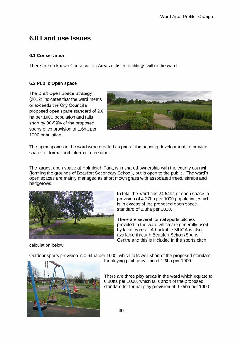
6.2 Public Open space
The Draft Open Space Strategy
(2012) indicates that the ward meets
or exceeds the City Council’s
proposed open space standard of 2.8
ha per 1000 population and falls
short by 30-59% of the proposed
sports pitch provision of 1.6ha per
1000 population.
The open spaces in the ward were created as part of the housing development, to provide
space for formal and informal recreation.
The largest open space at Holmleigh Park, is in shared ownership with the county council (forming the grounds of Beaufort Secondary School), but is open to the public. The ward’s open spaces are mainly managed as short mown grass with associated trees, shrubs and hedgerows.
In total the ward has 24.54ha of open space, a provision of 4.37ha per 1000 population, which is in excess of the proposed open space standard of 2.8ha per 1000. There are several formal sports pitches provided in the ward which are generally used by local teams. A bookable MUGA is also available through Beaufort School/Sports Centre and this is included in the sports pitch
calculation below. Outdoor sports provision is 0.64ha per 1000, which falls well short of the proposed standard
for playing pitch provision of 1.6ha per 1000. There are three play areas in the ward which equate to 0.10ha per 1000, which falls short of the proposed standard for formal play provision of 0.25ha per 1000.

Ward Area Profile: Grange
31
Figure 11: Public Open Space in Grange Ward
Ref. Name Size Description (see list of open space types)
GR1 Chatsworth Avenue 0.42 B
GR2 Tuffley Community Centre 1.82 J + B 1 adult football
GR3 Denham Close/Chatsworth Ave 0.38 B
GR4 Tuffley Lane (The Gladiator) 0.63 I
GR5 Holmleigh Park 16.15 J + B + H 2 adult football, LEAP
GR6 Randwick Park (majority) 4.61 A + H NEAP, MUGA, skate Includes site TU3 in this calc
GR7 Windsor Drive 0.12 B
GR8 Grange Road (public space, but privately managed)
0.21 B + H LEAP
GR9 Tolsey Gardens (upper site) 0.2 B
GR10 Tolsey Gardens (lower site) (yet to be adopted)
new B (0.06ha)
Total: 24.54ha

Ward Area Profile: Grange
32
Figure 12: Map of Public Open Space in Grange Ward

Ward Area Profile: Grange
33
Grange ward meets the council’s adopted standard for open space quantity, but many sites fall short of the expected standard in terms of quality of park infrastructure and facilities. Improvements in provision should therefore concentrate providing high quality play and sports facilities and ensuring optimum maintenance and usage of sports pitches on existing sites. The feasibility of creating a site for allotment provision in the ward, by converting an underused part of an existing open space, could be explored. Other local priorities will be developed in consultation with the local community as part of the development of the Grange Ward Open Space Action Plan. 6.3 Green Infrastructure The Draft City of Gloucester Green Infrastructure plan identifies the Whaddon and Daniels Brooks as existing open watercourse and wildlife corridors running through the ward. The Ward enjoys a number of green corridors in the form of strategic cycle ways and footpaths, as well as larger open spaces. Recommendations for the ward include;
1. Providing a direct pedestrian/cycle path across Holmleigh Park to link with the Whaddon
Brook
2. Breaking the Whaddon Brook out of a concrete channel through Windsor Drive and
Tuffley Lane.
The Green Infrastructure Plan for the ward can be found at Figure 13 below.
Figure 13: Green Infrastructure of Grange Ward

Ward Area Profile: Grange
34
There are no sites of nature conservation importance identified on the 2001 First Deposit
Local Plan Proposals map.
6.4 Water
A characteristic of the ward are the tributaries of the River Severn that flow from the
Cotswold escarpment towards the river to the south of the City and consequently pass east
–west through Grange ward, these include the Whaddon Brook and the Daniels Brook.
The Daniels Brook follows a natural drainage chanel and comprises the southern boundary
of the ward while the Whaddon Brook follows a mix of natural and concrete culverted
chanels through the ward.
Both of these watercourses feed directly into the Gloucester to Sharpness Canal at Lower
Hempsted.
6.5 Sustainability
Other than the City Council kerbside collection service there are no recycling facilities
available in the ward.
7.0 Previously Identified Issues
What our residents have previously said about this area?
7.1 City Plan City Vision Issues and Options Consultation Summer 2011
Three Bridges Neighbourhood Partnership Meeting 18.05.11
No comments made that related to the ward
Written comments to consultation
None

Ward Area Profile: Grange
35
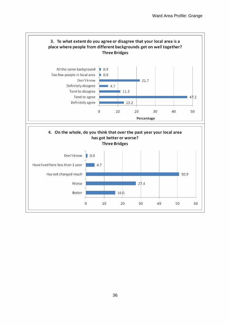
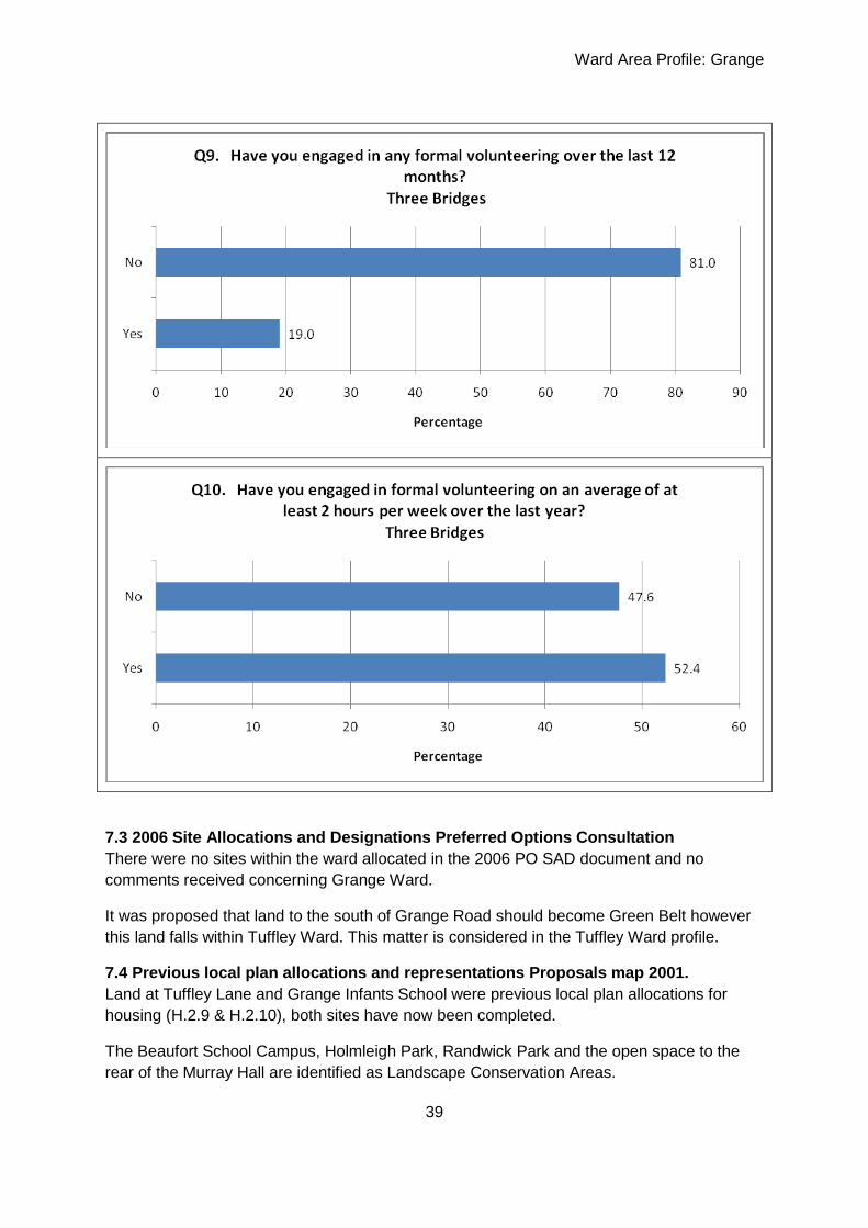
7.2 Small Area Survey 2008 - Three Bridges
Ward Area Profile: Grange
36

Ward Area Profile: Grange
37
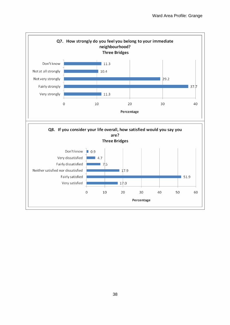
Ward Area Profile: Grange
38
Ward Area Profile: Grange
39
7.3 2006 Site Allocations and Designations Preferred Options Consultation
There were no sites within the ward allocated in the 2006 PO SAD document and no
comments received concerning Grange Ward.
It was proposed that land to the south of Grange Road should become Green Belt however
this land falls within Tuffley Ward. This matter is considered in the Tuffley Ward profile.
7.4 Previous local plan allocations and representations Proposals map 2001.
Land at Tuffley Lane and Grange Infants School were previous local plan allocations for
housing (H.2.9 & H.2.10), both sites have now been completed.
The Beaufort School Campus, Holmleigh Park, Randwick Park and the open space to the
rear of the Murray Hall are identified as Landscape Conservation Areas.

Ward Area Profile: Grange
40
Cycle routes are identified along Cole Avenue, Bodiam Avenue, across Holmleigh Park and
along Tuffley Lane and Randwick Road.
7.5 Extant major permissions
There are no major extant permissions in the ward.