water sharing plan for the gwydir unregulated and alluvial ...€¦ · water sharing plan for the...
TRANSCRIPT
Water Sharing Plan for the Gwydir Unregulated and Alluvial Water Sources
Background document
Publisher: NSW Department of Primary Industries, Office of Water
Water Sharing Plan Gwydir Unregulated and Alluvial Water Sources: Background document
First published November 2012
ISBN 978 1 74256 404 3
More information
www.water.nsw.gov.au
11615
© State of New South Wales through the Department of Trade and Investment, Regional Infrastructure and Services 2012. You may copy, distribute and otherwise freely deal with this publication for any purpose, provided that you attribute the NSW Department of Primary Industries as the owner.
Disclaimer: The information contained in this publication is based on knowledge and understanding at the time of writing (November 2012).
However, because of advances in knowledge, users are reminded of the need to ensure that information upon which they rely is up to date and to
check currency of the information with the appropriate officer of the Department of Primary Industries or the user’s independent adviser.
Water Sharing Plan for the Gwydir Unregulated and Alluvial Water Sources
Contents Introduction............................................................................................................................... 1
4
4
5
5
6
7
7
8
10
11
12
13
14
14
Policy framework ....................................................................................................................15
15
15
15
16
16
17
17
18
18
19
19
19
20
20
20
Purpose of the plan ..................................................................................................................3
Why are water sharing plans being prepared? .....................................................................3
Benefits for water users ........................................................................................................3
Environmental considerations...............................................................................................3
Unregulated water sources ...............................................................................................
Alluvial groundwater sources ............................................................................................
Scope of the plan .....................................................................................................................
Water management units......................................................................................................
Description of the plan area .....................................................................................................
High environmental value areas ...........................................................................................
Land use history ...................................................................................................................
Climate..................................................................................................................................
Stream flows .......................................................................................................................
Groundwater .......................................................................................................................
Entitlement and use ............................................................................................................
Water extraction in the unregulated water sources.........................................................
Water extraction in the alluvial groundwater sources......................................................
Local water utility requirements ..........................................................................................
State Interagency Panel..................................................................................................
State Groundwater Panel................................................................................................
Interagency Regional Panel ............................................................................................
Policy ..................................................................................................................................
National Water Initiative ..................................................................................................
Water Management Act 2000 .........................................................................................
Access Licence Dealing Principles Order 2004 ..............................................................
Murray-Darling Basin Cap Agreement ............................................................................
The Basin Plan (Commonwealth Water Act 2007)..........................................................
Natural Resource Commission’s statewide targets.........................................................
Border Rivers-Gwydir Catchment Action Plan ................................................................
Other considerations...........................................................................................................
Protecting pools, lagoons and lakes ...............................................................................
Managing surface water and groundwater connectivity ..................................................
Protecting basic landholder rights ...................................................................................
iii | NSW Office of Water, November 2012
Water Sharing Plan for the Gwydir Unregulated and Alluvial Water Sources
Protecting town water supply access .............................................................................. 21
21
22
23
23
24
24
25
25
25
26
26
27
27
28
29
29
29
29
30
30
31
31
31
32
32
33
33
34
35
35
35
36
36
37
39
Protecting Aboriginal Values ...........................................................................................
Water interception activities ............................................................................................
Developing the plan................................................................................................................
Consultation to inform rule development ............................................................................
Targeted consultation on the draft rules..........................................................................
Public exhibition of the draft water sharing plan..............................................................
Related water sharing plans............................................................................................
Water sharing rules for unregulated water sources ............................................................
Classification method..........................................................................................................
Protecting high instream values ......................................................................................
Access rules....................................................................................................................
Dealing rules ...................................................................................................................
Refining the rules for local circumstances ..........................................................................
Exemptions to access rules ............................................................................................
Managing extraction ...........................................................................................................
Long term average annual extraction limit ......................................................................
Growth in use ..................................................................................................................
Available water determination .........................................................................................
Carryover and water accounts ........................................................................................
Example of unregulated river access licence three year accounting rules .....................
Water sharing rules for alluvial groundwater sources.........................................................
Managing Connectivity....................................................................................................
Rules for water supply works approvals..........................................................................
Managing Extraction ...........................................................................................................
Long term average annual extraction limit (LTAAEL) .....................................................
Growth in use ..................................................................................................................
Available water determination .........................................................................................
Carryover and water accounts ........................................................................................
Adaptive management ...........................................................................................................
Amendment Provisions.......................................................................................................
Evaluation of plan performance ..........................................................................................
Performance indicators.......................................................................................................
Plan review .........................................................................................................................
Glossary .................................................................................................................................
References .............................................................................................................................
iv | NSW Office of Water, November 2012
Water Sharing Plan for the Gwydir Unregulated and Alluvial Water Sources
v | NSW Office of Water, November 2012
Appendices............................................................................................................................. 40
41
41
42
43
44
45
46
47
49
51
5
10
12
15
24
26
30
6
8
8
11
Appendix 1: Water sharing plan maps................................................................................
Map 1. Overview of Plan Area ........................................................................................
Map 2. Upper Gwydir River Water Source Trading Zones..............................................
Map 3. Copeton Dam Water Source and Moredun Creek Water Source Trading Zones........................................................................................................................................
Map 4. Halls Creek Water Source Management Zones..................................................
Map 5. Mehi River Water Source Trading Zones............................................................
Map 6. Gingham Watercourse Water Source Management Zones ................................
Appendix 2: Identified threatened species and ecological communities.............................
Appendix 3: Interagency regional panel and support staff..................................................
Appendix 4: Interagency regional panel reference materials..............................................
Tables Table 1 Surface Water and Groundwater Sources........................................................................
Table 2 Gauging sites in the Gwydir catchment ..........................................................................
Table 3 Entitlement* and licence numbers in each water source................................................
Table 4 Town water supplies, location and entitlement volume in the plan area ........................
Table 5 Key groups consulted in the Plan area as part of the targeted consultation ..................
Table 6 Generic access rules for rivers and creeks under the refined approach ........................
Table 7 Example of unregulated river access licence accounting rules ......................................
Figures Figure 1 Topography and elevation of the Gwydir catchment ........................................................
Figure 2 Land use in the Gwydir catchment ...................................................................................
Figure 3 Average annual rainfall in the Gwydir catchment .............................................................
Figure 4 Groundwater aquifer types in the Gwydir catchment......................................................
Water Sharing Plan for the Gwydir Unregulated and Alluvial Water Sources
1 | NSW Office of Water, November 2012
Introduction
Water sharing plans (plans) are being progressively developed for rivers and groundwater systems across New South Wales (NSW) following the introduction of the Water Management Act 2000 (WMA 2000). These plans protect the health of our rivers and groundwater while also providing water users with perpetual access licences, equitable conditions, and increased opportunities to trade water through separation of land and water. In July 2004, 31 plans commenced in NSW, bringing these water sources and some 80 per cent of water extracted in NSW under the management and licensing provisions of the WMA 2000.
In recent years, plans for the unregulated1 rivers and groundwater systems have been completed using a “macro” or broader-scale river catchment or aquifer2 system approach. Over 95 per cent of the water extracted in NSW is now covered by the WMA 2000. The macro planning process is designed to develop water sharing plans covering most of the remaining water sources across NSW. Each macro plan covers a large river basin rather than a single subcatchment, or in the case of groundwater systems, covers a particular type of aquifer (for example alluvial). These river basin or aquifer macro plans will generally apply to catchments or aquifers where there is less intensive water use.
The Water Sharing Plan for the Gwydir Unregulated and Alluvial Water Sources 2012 (the Plan) covers 27 unregulated river surface water sources that are grouped into one extraction management unit (EMU) and the Upper Gwydir Alluvial groundwater source (refer Map 1 of Appendix 1).
This document provides background to the development of the rules in the plan and includes:
the purpose of the statutory plan
a physical description of the Gwydir catchment including land and water use
the process of plan development including scope, history and basis for decisions
the activities associated with implementation, monitoring and review of the plan.
This document is part of a range of material available specifically on the Plan including:
the Water Sharing Plan for the Gwydir Unregulated and Alluvial Water Sources 2012 – a legal instrument written in its required statutory format
the Water sharing plans – Inland unregulated and alluvial water sources – Overview – a plain English version of the plan explaining the key sections and rules
rule summary sheets for each water source detailing the management rules.
In addition, general information on the macro planning process is available under water management in the water sharing plans section on the NSW Office of Water website www.water.nsw.gov.au. Information available for download or viewing includes:
Macro water sharing plans – the approach for unregulated rivers. A report to assist community consultation - explains the method used to classify and set water sharing rules for unregulated streams across the state.
Macro water sharing plans – the approach for unregulated rivers. Setting access and trading rules for pools – explains the method used to set water sharing rules for pools in unregulated water sources across the state.
1 The supply of water in unregulated rivers is typically not controlled by releases of water from dams but rather is dependent on rainfall and natural river flows. 2 An aquifer is an underground layer of water-bearing permeable rock or unconsolidated materials (gravel, sand, silt or clay) from which groundwater can be usefully extracted.
Water Sharing Plan for the Gwydir Unregulated and Alluvial Water Sources
Macro water sharing plans – the approach for groundwater to assist community consultation – explains the method used to classify and set water sharing rules for groundwater sources across the state.
Setting rules for water sharing plans – information outlining the key steps for developing the rules.
2 | NSW Office of Water, November 2012
Water Sharing Plan for the Gwydir Unregulated and Alluvial Water Sources
3 | NSW Office of Water, November 2012
Purpose of the plan
Why are water sharing plans being prepared? Expansion of water extraction across NSW in the 20th century has placed most valleys at or close to the limit of sustainable water extraction. This has seen increasing competition between water users (towns, farmers, industries and irrigators) for access to water. This has also placed pressure on the health and biological diversity of our rivers and aquifers.
Under the WMA 2000, the sharing of water must protect the water source and its dependent ecosystems and must protect basic landholder rights (BLR). Sharing or extraction of water under any other right must not prejudice these rights. Therefore, sharing water to licensed water users is effectively the next priority for water sharing. Among licensed water users, priority is given to water utilities and licensed stock and domestic use, ahead of commercial purposes such as irrigation and other industries. Plans provide a legal basis for sharing water between the environment and consumptive purposes.
Plans also recognise the economic benefits that commercial users such as irrigation and industry can bring to a region. Upon a plans commencement access licences held under the Water Act 1912 are converted to access licences under the WMA 2000 and land and water rights are separated. This facilitates the trade of access licences and can encourage more efficient use of water resources. It also allows new industries to develop as water can move to its highest value use.
In conjunction with the WMA 2000, plans also set rules that permit commercial users to continue to operate productively. In general, commercial licences under the WMA 2000 are granted in perpetuity, providing greater commercial security of water access entitlements. Plans also define the access rules for commercial users for 10 years providing all users with greater certainty regarding sharing arrangements3.
Benefits for water users With the introduction of the plan, a number of benefits will flow to water users including:
greater certainty for water users – the plan sets out the water sharing arrangements for a 10 year period
clear trading and access rules which will help foster trading
automatic conversion of licences in the plan area to perpetual water access licences providing greater security for water users – meaning the volumetric water access licences do not have to be renewed, however approvals for the works used to extract water under these access licences will need to be renewed.
Environmental considerations Plans are required to reserve water for the overall health of the river and to protect specific ecosystems that depend on river flows, such as wetlands, lakes and floodplains. This share of water reserved for the environment is intended to sustain the river system’s aquatic fauna and flora.
3 Security versus reliability: These terms are used differently across different jurisdictions, often interchangeably. The National Water Commission encourages the adoption of nationally consistent terminology based on the National Water Initiative. The definitions in the glossary relate to NWI-consistent use of these terms. In summary, security provides better tenure for an entitlement and does not necessarily provide greater reliability as this is determined by seasonal and climatic conditions.
Water Sharing Plan for the Gwydir Unregulated and Alluvial Water Sources
4 | NSW Office of Water, November 2012
Unregulated water sources
To be healthy and reproduce successfully, the plants and animals that live in rivers and streams need floods (very high flows), freshes (high flows) and dry spells (very low flows). The plan’s environmental flow rules are designed to ensure the plants and animals in streams continue to experience all these different types of flow conditions.
There is evidence to suggest that low flows are essential for maintaining water quality, allowing fish and other fauna passage over riffles to pools used for drought refuge, and maintaining those parts of aquatic ecosystems that are most productive. For example, the faster flowing riffle areas between pools usually contain the highest abundance and diversity of aquatic fauna.
In order to protect a proportion of these low flows for the benefit of the environment, the plan imposes new access restrictions on days when flows are low. This is achieved by establishing ‘cease-to-pump’ rules that require users to stop taking water when flow declines below a set level. When the plan commences, surface water licences in all unregulated water sources will be subject to cease-to-pump rules (excluding licences held by town water suppliers, local water utilities, licensed stock and domestic users, and licences used for food safety and essential dairy care4).
In addition, ‘commence-to-pump’ rules applied in some water sources ensure that freshes are available to the environment by requiring users to only recommence taking water once flow has increased above a specified level.
Each unregulated water source was classified as having either high, medium or low instream values. Appendix 2 details the threatened species considered when assessing the water source values that are impacted by extraction. High instream value water sources are, by default, protected by the plan by not allowing any trades in. Trades are allowed into some water sources with lower value in order to encourage the movement of extraction from high to lower environmental value areas.
Alluvial groundwater sources
An aquifer is an underground layer of water-bearing permeable rock or unconsolidated materials (gravel, sand, silt or clay) from which groundwater can be usefully extracted. Aquifers can store large volumes of water, often accumulated over thousands, or even tens of thousands of years; this is referred to as ‘storage’.
The volume of water in storage is recharged in a number of ways depending on the type of the groundwater system. Recharge usually comes from rainfall, surface water bodies such as rivers, or via flow from adjacent aquifers. Under the plan, only a proportion of recharge is available for extraction. The remainder of recharge is reserved for the environment. Limiting the volume of use to a proportion of recharge is intended to reduce the risk of unsustainable groundwater extraction in the long term.
Some groundwater sources are highly connected to surface water, so that taking water from one source affects the other. In groundwater systems defined as ‘highly connected’, environmental water may also be provided through linked cease-to-pump rules to ensure taking groundwater does not adversely affect surface water flows.
The plan also includes rules on the location of new works and extraction from existing works to protect high priority groundwater dependent ecosystems, high priority karst systems and other environmentally sensitive areas such as rivers or streams.
4 There are limited exemptions for licensed stock and domestic and town water supply purposes which allow access to very low flows. See section “Access to very low flow”
Water Sharing Plan for the Gwydir Unregulated and Alluvial Water Sources
Scope of the plan
The plan covers two separate water resources, within what is known as the Gwydir water management area (refer to Map 1 of Appendix 1). Incorporating all of these resources into the one plan recognises their interaction and allows for the development of water sharing rules that are linked and are equitable within and between these resources.
The two water resources (located within the Murray-Darling Basin) are:
the unregulated rivers – these cover the remaining rivers in the Gwydir River catchment (Table 1)
the Upper Gwydir alluvial groundwater source i.e the groundwater in the remaining major alluvial aquifer not already covered by a water sharing plan.
The remaining, less highly connected aquifers are covered by separate water sharing plans, including the:
Water Sharing Plan for the Lower Gwydir Groundwater Source
Water Sharing Plan for the NSW Great Artesian Basin Groundwater Sources
Water Sharing Plan for the NSW Great Artesian Basin Shallow Groundwater Sources
Water Sharing Plan for the NSW Murray-Darling Basin Porous Rock Groundwater Sources
Water Sharing Plan for the NSW Murray-Darling Basin Fractured Rock Groundwater Sources.
The plan does not include waters contained in the Gwydir Regulated River Water Source, which is covered by the Water Sharing Plan for the Gwydir Regulated River Water Source 2002. The plan does not include waters contained in the Rocky Creek, Cobbadah, Upper Horton and Lower Horton Water Sources, this is covered by the Water Sharing Plan for the Rocky Creek, Cobbadah, Upper Horton and Lower Horton Water Source 2003.
Table 1 Surface Water and Groundwater Sources
Surface Water Sources
Roumalla Creek Copeton Dam Mosquito Creek
Rocky River Halls Creek Moree
Boorolong Creek Mackenzies Flat Gil Gil Creek
Upper Gwydir River Myall Creek Thalaba Creek
Laura Creek Gurley Creek Mehi River
Bakers Creek Tycannah Creek Gwydir
Georges Creek Warialda Creek Carole Creek
Moredun Creek Millie Creek Gingham Watercourse
Keera Creek Slaughterhouse Creek Barwon
Alluvial Groundwater Source
Upper Gwydir Alluvium
Water management units Water sharing plans include the following hydrological units:
Where appropriate, an extraction management unit (EMU), consisting of one or several water sources, is specified for the purpose of establishing a geographic area over which the long-term average annual extraction limit (LTAAEL) applies. The plan contains one EMU for the unregulated rivers.
5 | NSW Office of Water, November 2012
Water Sharing Plan for the Gwydir Unregulated and Alluvial Water Sources
The Gwydir EMU was established in the Water Sharing Plan for the Rocky Creek, Cobbadah, Upper Horton and Lower Horton Water Source 2003 (the Rocky Creek WSP).
For the Upper Gwydir Alluvial Groundwater Water Source there is no EMU specified which means the LTAAEL applies to the water source and any growth in extraction above the LTAAEL is then managed at the water source level.
Water sources are used to define where water sharing rules apply. The Gwydir EMU is divided into 27 water sources. Their spatial extent is shown in Map 1 of Appendix 1.
A management zone or trading zone, representing a portion of a water source, may then be specified so that more refined implementation of management or trading rules can be applied, if required. Two unregulated water sources covered by the plan have been spilt into management zones and four unregulated water sources into trading zones. Refer also to Maps 2–6 of Appendix 1 where the zones are depicted spatially.
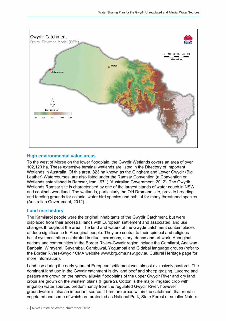
Description of the plan area
The Gwydir catchment covers an area of over 26,000 km² and represents about 2 per cent of the Murray-Darling Basin. The headwaters of the Gwydir River are in the tablelands in the east of the catchment around Guyra and Uralla, up to around 1,200 m above sea level. From here the Gwydir River flows north-west through steep sided valleys. It is joined by the Horton River, the largest tributary flowing north from the Nandewar Range, before it enters the plains near Gravesend. West of Pallamallawa the valley widens into an almost completely flat floodplain, where the elevation is generally less than 200 m (Figure 1. Through this flat landscape the Gwydir River flows slowly westward between low natural levee banks towards the Barwon River. The Gwydir catchment has three main landform types – tablelands in the east, central slopes and the western floodplains and wetlands.
The catchment is bordered in the north by the Masterman Range and Macintyre (Border Rivers) catchment, and to the south, the Nandewar Range and the Namoi River catchment.
Figure 1 Topography and elevation of the Gwydir catchment
6 | NSW Office of Water, November 2012
Water Sharing Plan for the Gwydir Unregulated and Alluvial Water Sources
High environmental value areas To the west of Moree on the lower floodplain, the Gwydir Wetlands covers an area of over 102,120 ha. These extensive terminal wetlands are listed in the Directory of Important Wetlands in Australia. Of this area, 823 ha known as the Gingham and Lower Gwydir (Big Leather) Watercourses, are also listed under the Ramsar Convention (a Convention on Wetlands established in Ramsar, Iran 1971) (Australian Government, 2012). The Gwydir Wetlands Ramsar site is characterised by one of the largest stands of water couch in NSW and coolibah woodland. The wetlands, particularly the Old Dromana site, provide breeding and feeding grounds for colonial water bird species and habitat for many threatened species (Australian Government, 2012).
Land use history
The Kamilaroi people were the original inhabitants of the Gwydir Catchment, but were displaced from their ancestral lands with European settlement and associated land use changes throughout the area. The land and waters of the Gwydir catchment contain places of deep significance to Aboriginal people. They are central to their spiritual and religious belief systems, often celebrated in ritual, ceremony, story, dance and art work. Aboriginal nations and communities in the Border Rivers-Gwydir region include the Gamilaroi, Anaiwan, Banbain, Wirayarai, Guyambal, Gambuwal, Yogumbal and Gidabal language groups (refer to the Border Rivers-Gwydir CMA website www.brg.cma.nsw.gov.au Cultural Heritage page for more information).
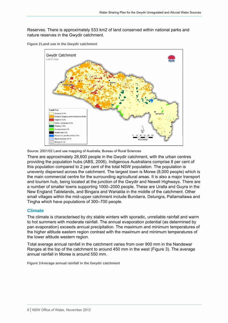
Land use during the early years of European settlement was almost exclusively pastoral. The dominant land use in the Gwydir catchment is dry land beef and sheep grazing. Lucerne and pasture are grown on the narrow alluvial floodplains of the upper Gwydir River and dry land crops are grown on the western plains (Figure 2). Cotton is the major irrigated crop with irrigation water sourced predominantly from the regulated Gwydir River, however groundwater is also an important source. There are areas within the catchment that remain vegetated and some of which are protected as National Park, State Forest or smaller Nature
7 | NSW Office of Water, November 2012
Water Sharing Plan for the Gwydir Unregulated and Alluvial Water Sources
Reserves. There is approximately 533 km2 of land conserved within national parks and nature reserves in the Gwydir catchment.
Figure 2 Land use in the Gwydir catchment
Source: 2001/02 Land use mapping of Australia, Bureau of Rural Sciences
There are approximately 28,600 people in the Gwydir catchment, with the urban centres providing the population hubs (ABS, 2006). Indigenous Australians comprise 8 per cent of this population compared to 2 per cent of the total NSW population. The population is unevenly dispersed across the catchment. The largest town is Moree (8,000 people) which is the main commercial centre for the surrounding agricultural areas. It is also a major transport and tourism hub, being located at the junction of the Gwydir and Newell Highways. There are a number of smaller towns supporting 1000–2000 people. These are Uralla and Guyra in the New England Tablelands, and Bingara and Warialda in the middle of the catchment. Other small villages within the mid-upper catchment include Bundarra, Delungra, Pallamallawa and Tingha which have populations of 300–700 people.
Climate The climate is characterised by dry stable winters with sporadic, unreliable rainfall and warm to hot summers with moderate rainfall. The annual evaporation potential (as determined by pan evaporation) exceeds annual precipitation. The maximum and minimum temperatures of the higher altitude eastern region contrast with the maximum and minimum temperatures of the lower altitude western region.
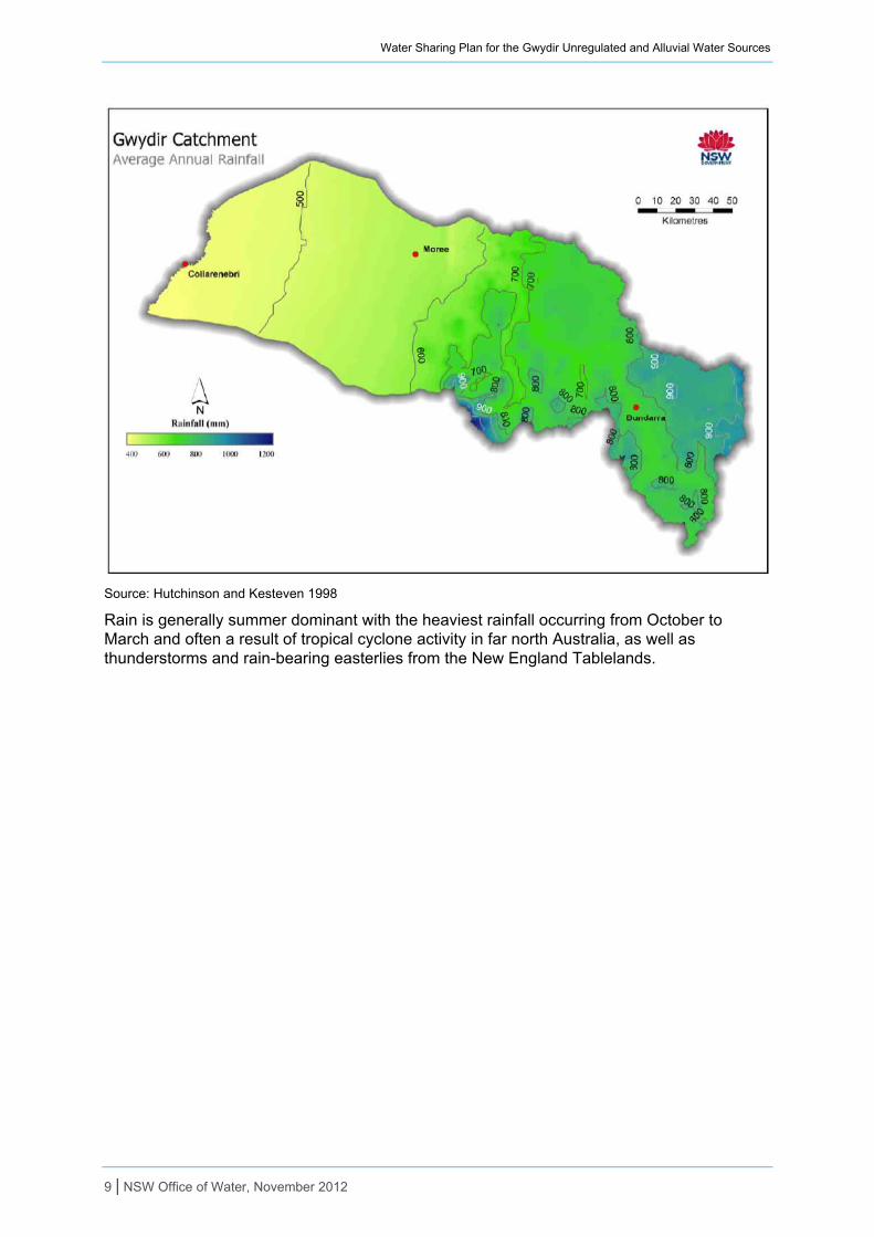
Total average annual rainfall in the catchment varies from over 900 mm in the Nandewar Ranges at the top of the catchment to around 450 mm in the west (Figure 3). The average annual rainfall in Moree is around 550 mm.
Figure 3 Average annual rainfall in the Gwydir catchment
8 | NSW Office of Water, November 2012
Water Sharing Plan for the Gwydir Unregulated and Alluvial Water Sources
Source: Hutchinson and Kesteven 1998
Rain is generally summer dominant with the heaviest rainfall occurring from October to March and often a result of tropical cyclone activity in far north Australia, as well as thunderstorms and rain-bearing easterlies from the New England Tablelands.
9 | NSW Office of Water, November 2012
Water Sharing Plan for the Gwydir Unregulated and Alluvial Water Sources
January and February receive the most rain with both months averaging 68 mm across the catchment. Storms in summer months may cause severe flooding and erosion, and winter flooding may also occur if soils remain saturated after summer rains. Autumn and winter rainfall generally varies between 30–45 mm per month across the catchment. Very low rainfall in the western region can lead to drought conditions and low river flows. Snow can occur occasionally at the top of the catchment around Guyra and Uralla.
Average annual maximum temperatures in Moree range from 17 to 19°C in the winter to 33°C in the summer months. Peak evapo-transpiration occurs in the summer months. Refer to the Australian Government website http://www.bom.gov.au/climate climate statistics page for additional information on rainfall and temperature in the catchment.
Stream flows There are few gauges in the catchment and most unregulated streams in the plan area are considered to be non-perennial. The majority of stream flow information is gathered in the regulated rivers including the Gwydir and Mehi Rivers. The catchment is characterised by more reliable flows in the east and less reliable and highly variable flows in the west. Flows are generally greatest in the summer months when seasonal rainfall is greatest.
Stream flow records are minimal in the planning area but records are available for some sites, including the 15 gauging stations listed in Table 2. Records from these gauges and others gauges with limited data were used to assist with the development of the plan.
Table 2 Gauging sites in the Gwydir catchment
Period of record Station name Water source
Station no.
Catchment (km2) Start Finish
Roumalla Creek at Kingstown Gauge Roumalla 418024 558 1/08/1965 16/01/1989
Gwydir River at Yarrowyck Gauge Rocky River 418014 560 17/12/1954 Ongoing
Boorolong Creek at Yarrowyck Gauge Boorolong 418020 292 30/06/1965 15/09/1987
Laura Creek at Laura Gauge Laura Cree 418021 819 4/06/1965 Ongoing
Bakers Creek at Bundarra Gauge Bakers Creek 418033 238 31/05/1972 5/02/1993
Georges Creek at Clerkness Gauge Georges Creek 418022 543 7/06/1965 20/04/1989
Moredun Creek at Bundarra Gauge Moredun Creek 418023 698 9/06/1965 13/05/1988
Keera Creek at Keera Gauge Keera Creek 418018 609 11/05/1964 16/03/1989
Copes Creek at Kimberly Gauge Copeton Dam 418005 1006 18/04/1929 Ongoing
Halls Creek at Bingara Gauge Halls Creek 418025 184 15/06/1965 Ongoing
Myall Creek at Molroy Myall Creek 418017 983 10/05/1964 Ongoing
Tycannah Creek at Horseshoe Lagoon
Tycannah Creek
418032 1273 2/06/1971 Ongoing
Warialda Creek at Warialda No.3 Warialda Creek 418016 235 8/02/1972 5/01/2005
Gil Gil Creek at Boolataroo Gil Gil Creek 416054 2573 5/12/1996 Ongoing
Grawan Creek at Old Pokataroo Barwon 422018 429 19/06/1965 Ongoing
The regulated Gwydir River reaches maximum capacity at Pallamallawa upstream of Moree where the mean daily flow is 2,053 ML/d. After this the main channel of the Gwydir River begins to lose its flow to the many anabranches and effluent channels that characterise the lower part of the catchment. The channel capacity at Pallamallawa is greater than the combined capacity of the four major distributaries (Gwydir River, Mehi River, Moomin Creek and Carole Creek) and so even small rises at Pallamallawa can cause overbank flow downstream (Pietsch 2006).
10 | NSW Office of Water, November 2012
Water Sharing Plan for the Gwydir Unregulated and Alluvial Water Sources
The flow regime of the Gwydir River has been substantially altered by the construction of Copeton Dam and the various weirs and regulators that divert water to irrigators along distributor channels such as the Mehi River, Moomin Creek and Carole Creek. Regulation of the river system has caused significant reduction in moderate to high flows in the lower Gwydir. It has also contributed to an increase in the average period between large flows, and a reduction in the average volume of large flows (CSIRO 2007).
Flows have been recorded in the upper Gwydir River at Bundarra since 1937 and provide a good long term record of natural stream flow patterns in the Gwydir catchment. Bundarra is in the upper catchment where the flows are not regulated by Copeton Dam. The long term average annual flow at Bundarra is 336,300 ML.
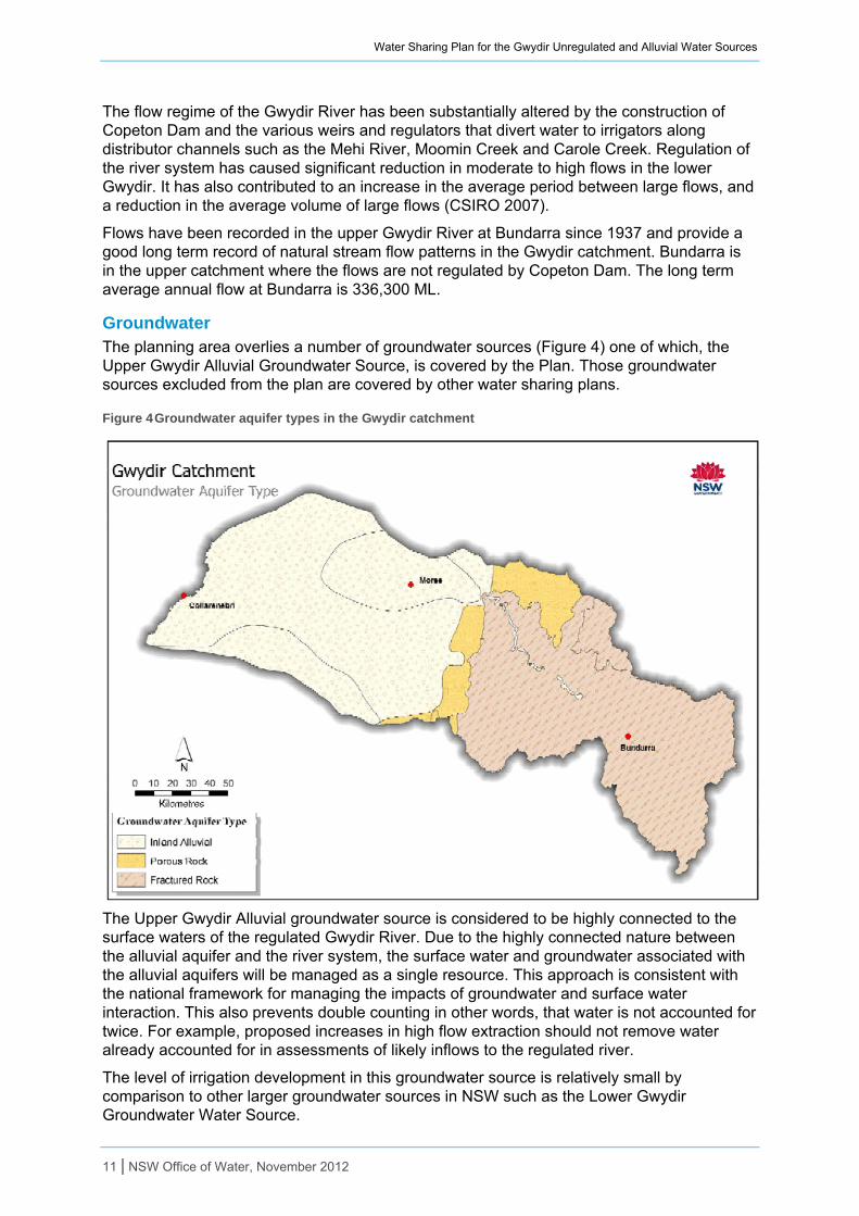
Groundwater The planning area overlies a number of groundwater sources (Figure 4) one of which, the Upper Gwydir Alluvial Groundwater Source, is covered by the Plan. Those groundwater sources excluded from the plan are covered by other water sharing plans.
Figure 4 Groundwater aquifer types in the Gwydir catchment
The Upper Gwydir Alluvial groundwater source is considered to be highly connected to the surface waters of the regulated Gwydir River. Due to the highly connected nature between the alluvial aquifer and the river system, the surface water and groundwater associated with the alluvial aquifers will be managed as a single resource. This approach is consistent with the national framework for managing the impacts of groundwater and surface water interaction. This also prevents double counting in other words, that water is not accounted for twice. For example, proposed increases in high flow extraction should not remove water already accounted for in assessments of likely inflows to the regulated river.
The level of irrigation development in this groundwater source is relatively small by comparison to other larger groundwater sources in NSW such as the Lower Gwydir Groundwater Water Source.
11 | NSW Office of Water, November 2012
Water Sharing Plan for the Gwydir Unregulated and Alluvial Water Sources
This relates to a number of factors including the relatively low yield of the source (up to 11 litres per second for the Upper Gwydir Alluvium) and the presence of more reliable and cheaper to access supplies from regulated river flow and other underlying groundwater aquifers.
The water quality of the groundwater source is relatively good and suitable for most agricultural purposes. Aquifer recharge is provided by a combination of rainfall recharge, side slope run-on and, most importantly, leakage of surface water from the regulated Gwydir River. The Upper Gwydir Alluvium Groundwater Source is considered to be highly connected to the Gwydir Regulated River water source because approximately 70 per cent of the volume of groundwater pumped during an irrigation season is derived from the surface water source.
There are no groundwater monitoring bores in the Upper Gwydir Alluvial Groundwater Source.
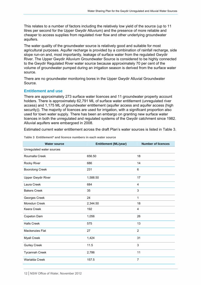
Entitlement and use There are approximately 273 surface water licences and 11 groundwater property account holders. There is approximately 62,791 ML of surface water entitlement (unregulated river access) and 1,175 ML of groundwater entitlement (aquifer access and aquifer access (high security)). The majority of licences are used for irrigation, with a significant proportion also used for town water supply. There has been an embargo on granting new surface water licences in both the unregulated and regulated systems of the Gwydir catchment since 1982. Alluvial aquifers were embargoed in 2008.
Estimated current water entitlement across the draft Plan’s water sources is listed in Table 3.
Table 3 Entitlement* and licence numbers in each water source
Water source Entitlement (ML/year) Number of licences
Unregulated water sources
Roumalla Creek 656.50 18
Rocky River 686 14
Boorolong Creek 231 6
Upper Gwydir River 1,588.50 17
Laura Creek 684 4
Bakers Creek 35 3
Georges Creek 24 1
Moredun Creek 2,344.50 18
Keera Creek 192 4
Copeton Dam 1,056 26
Halls Creek 575 13
Mackenzies Flat 27 2
Myall Creek 1,424 31
Gurley Creek 11.5 3
Tycannah Creek 2,786 11
Warialda Creek 157.5 7
12 | NSW Office of Water, November 2012
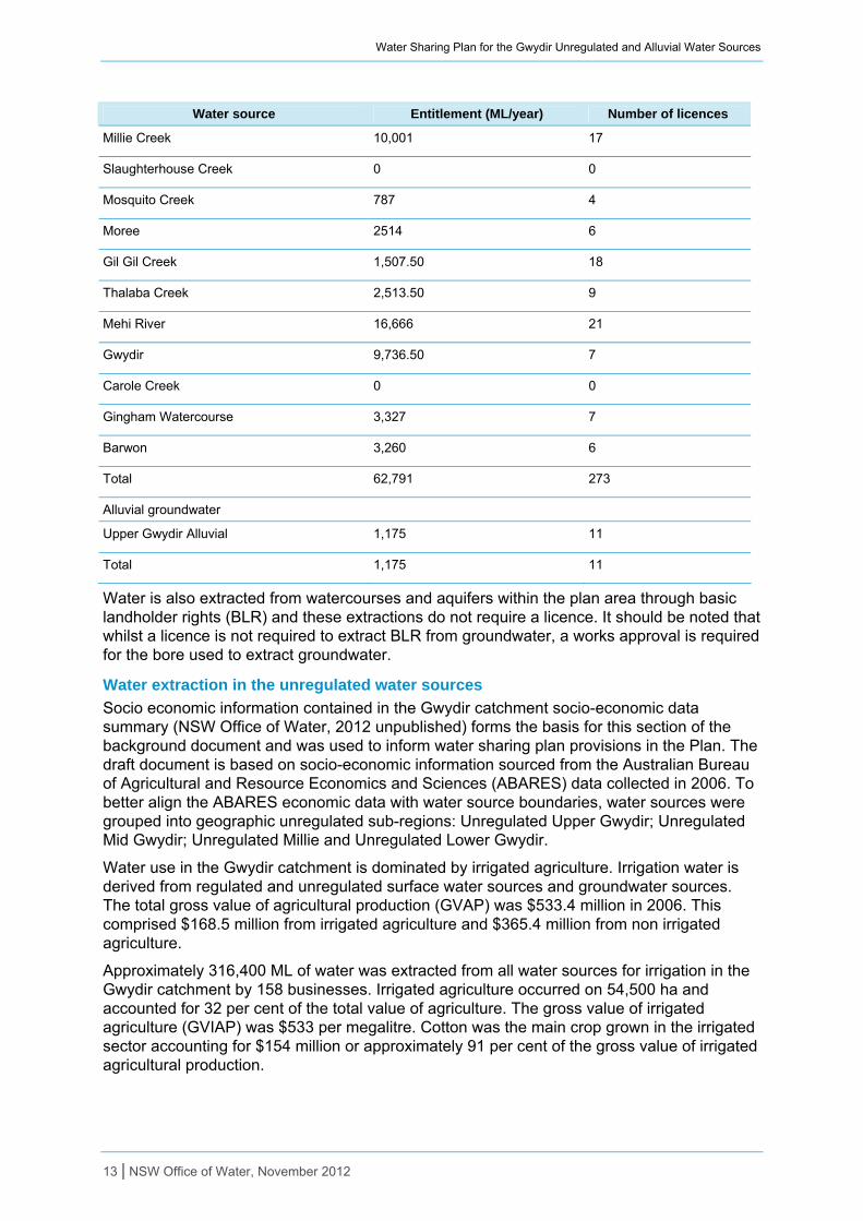
Water Sharing Plan for the Gwydir Unregulated and Alluvial Water Sources
13 | NSW Office of Water, November 2012
Water source Entitlement (ML/year) Number of licences
Millie Creek 10,001 17
Slaughterhouse Creek 0 0
Mosquito Creek 787 4
Moree 2514 6
Gil Gil Creek 1,507.50 18
Thalaba Creek 2,513.50 9
Mehi River 16,666 21
Gwydir 9,736.50 7
Carole Creek 0 0
Gingham Watercourse 3,327 7
Barwon 3,260 6
Total 62,791 273
Alluvial groundwater
Upper Gwydir Alluvial 1,175 11
Total 1,175 11
Water is also extracted from watercourses and aquifers within the plan area through basic landholder rights (BLR) and these extractions do not require a licence. It should be noted that whilst a licence is not required to extract BLR from groundwater, a works approval is required for the bore used to extract groundwater.
Water extraction in the unregulated water sources
Socio economic information contained in the Gwydir catchment socio-economic data summary (NSW Office of Water, 2012 unpublished) forms the basis for this section of the background document and was used to inform water sharing plan provisions in the Plan. The draft document is based on socio-economic information sourced from the Australian Bureau of Agricultural and Resource Economics and Sciences (ABARES) data collected in 2006. To better align the ABARES economic data with water source boundaries, water sources were grouped into geographic unregulated sub-regions: Unregulated Upper Gwydir; Unregulated Mid Gwydir; Unregulated Millie and Unregulated Lower Gwydir.
Water use in the Gwydir catchment is dominated by irrigated agriculture. Irrigation water is derived from regulated and unregulated surface water sources and groundwater sources. The total gross value of agricultural production (GVAP) was $533.4 million in 2006. This comprised $168.5 million from irrigated agriculture and $365.4 million from non irrigated agriculture.
Approximately 316,400 ML of water was extracted from all water sources for irrigation in the Gwydir catchment by 158 businesses. Irrigated agriculture occurred on 54,500 ha and accounted for 32 per cent of the total value of agriculture. The gross value of irrigated agriculture (GVIAP) was $533 per megalitre. Cotton was the main crop grown in the irrigated sector accounting for $154 million or approximately 91 per cent of the gross value of irrigated agricultural production.
Water Sharing Plan for the Gwydir Unregulated and Alluvial Water Sources
Dryland production occurred on 2,290,000 ha and involved 1,464 businesses. The main output from the non irrigated sector was cereals and grain as well as meat cattle accounting for $274 million. Seventy per cent of irrigation water use and 68 per cent of irrigated area occurs in the regulated Gwydir River. Significant irrigation also occurs in the Unregulated Lower Gwydir and Unregulated Millie sub-regions. Surface water accounts for approximately 89 per cent irrigation water with 11 per cent from groundwater.
Unregulated Upper Gwydir
Approximately 626 ML of water is licensed for irrigation use by 14 businesses. Irrigated agriculture occurred on 343 ha and accounted for 3 per cent of the total value of agriculture. Intensive animal production and sheep and other livestock accounted for the other 97 per cent. Dryland production occurred on over 430,500 ha and involved 481 businesses. The main dry land outputs from Unregulated Upper Gwydir were meat cattle and sheep and other livestock.
Unregulated Mid Gwydir
Approximately 639 ML of water is licensed for irrigation use by nine businesses. Irrigated agriculture occurred on 690 ha. The irrigated production occurred on an area representing less than 1 per cent of the total area under crops and pasture. Dryland production occurred on over 364,600 ha and involved 376 businesses. The main outputs from Unregulated Mid Gwydir were meat cattle.
Unregulated Millie
Approximately 22,000 ML of water is licensed for irrigation use by 22 businesses. Irrigated agriculture occurred on 4,580 ha and accounted for 12 per cent of the total value of agriculture. Cotton was the main crop in the irrigated sector. Dryland production occurred on over 346,000 ha and involved 202 businesses. The main outputs from Unregulated Mille were cereals.
Unregulated Lower
Approximately 74,900 ML of water is licensed for irrigation use by 35 businesses. Irrigated agriculture occurred on 11,425 ha and accounted for 29 per cent of the total value of agriculture. Cotton was the main crop in the irrigated sector. Dryland production occurred over 476,703 ha involving 143 businesses. The main outputs from the non irrigated sector were cereals, grain and meat cattle.
Water extraction in the alluvial groundwater sources
The alluvial groundwater licences in the Upper Gwydir Alluvial are scattered along the main trunk of the regulated Gwydir River between Gravesend and Mackenzies Flat, with the majority of licences in the vicinity of Bingara. In 2008 an embargo was placed on the granting of new access licences in the alluvial aquifers in the Gwydir Catchment.
The majority of groundwater entitlement is used for irrigation, stock and domestic purposes. A small amount is used for town water supply purposes.
Detailed water use is not available for the Upper Gwydir Alluvial because there is not yet broad scale metering in this water source. However, it is estimated that usage corresponds to 646 ML/y. The Office of Water is currently expanding the coverage of irrigation meters.
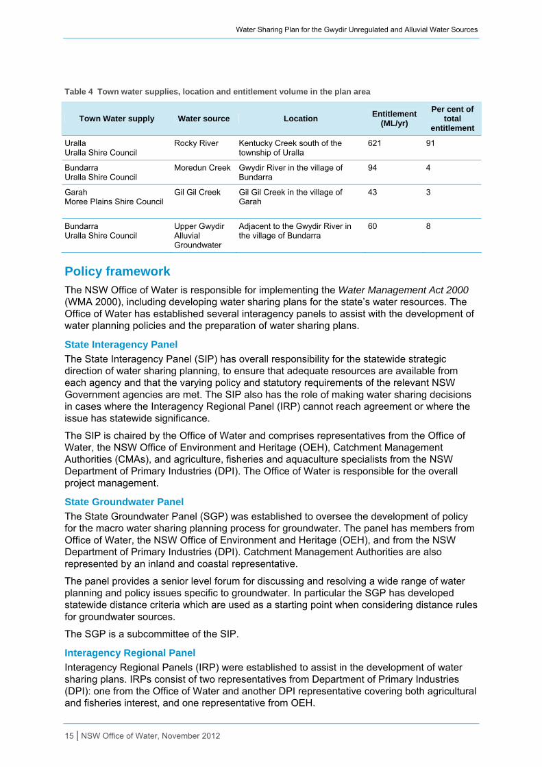
Local water utility requirements There are four town water supplies located within the plan area. The main towns serviced by these supplies include Uralla (Rocky River Water Source), Bundarra (Moredun Creek Water Source), Bundarra (Upper Gwydir Alluvial Groundwater Source) and Garah (Gil Gil Creek Water Source).
Town water supplies occurring in the Gwydir Unregulated Catchment are shown in Table 4. Town water supplies are generally exempt from surface water cease-to-pump rules.
14 | NSW Office of Water, November 2012
Water Sharing Plan for the Gwydir Unregulated and Alluvial Water Sources
Table 4 Town water supplies, location and entitlement volume in the plan area
Town Water supply Water source Location Entitlement
(ML/yr)
Per cent of total
entitlement
Uralla Uralla Shire Council
Rocky River Kentucky Creek south of the township of Uralla
621 91
Bundarra Uralla Shire Council
Moredun Creek Gwydir River in the village of Bundarra
94 4
Garah Moree Plains Shire Council
Gil Gil Creek Gil Gil Creek in the village of Garah
43 3
Bundarra Uralla Shire Council
Upper Gwydir Alluvial Groundwater
Adjacent to the Gwydir River in the village of Bundarra
60 8
Policy framework
The NSW Office of Water is responsible for implementing the Water Management Act 2000 (WMA 2000), including developing water sharing plans for the state’s water resources. The Office of Water has established several interagency panels to assist with the development of water planning policies and the preparation of water sharing plans.
State Interagency Panel
The State Interagency Panel (SIP) has overall responsibility for the statewide strategic direction of water sharing planning, to ensure that adequate resources are available from each agency and that the varying policy and statutory requirements of the relevant NSW Government agencies are met. The SIP also has the role of making water sharing decisions in cases where the Interagency Regional Panel (IRP) cannot reach agreement or where the issue has statewide significance.
The SIP is chaired by the Office of Water and comprises representatives from the Office of Water, the NSW Office of Environment and Heritage (OEH), Catchment Management Authorities (CMAs), and agriculture, fisheries and aquaculture specialists from the NSW Department of Primary Industries (DPI). The Office of Water is responsible for the overall project management.
State Groundwater Panel
The State Groundwater Panel (SGP) was established to oversee the development of policy for the macro water sharing planning process for groundwater. The panel has members from Office of Water, the NSW Office of Environment and Heritage (OEH), and from the NSW Department of Primary Industries (DPI). Catchment Management Authorities are also represented by an inland and coastal representative.
The panel provides a senior level forum for discussing and resolving a wide range of water planning and policy issues specific to groundwater. In particular the SGP has developed statewide distance criteria which are used as a starting point when considering distance rules for groundwater sources.
The SGP is a subcommittee of the SIP.
Interagency Regional Panel
Interagency Regional Panels (IRP) were established to assist in the development of water sharing plans. IRPs consist of two representatives from Department of Primary Industries (DPI): one from the Office of Water and another DPI representative covering both agricultural and fisheries interest, and one representative from OEH.
15 | NSW Office of Water, November 2012
Water Sharing Plan for the Gwydir Unregulated and Alluvial Water Sources
16 | NSW Office of Water, November 2012
A representative from the relevant CMA(s) also attended meetings (as an observer) so that they can provide advice on consultation issues and other matters within their areas of expertise.
Appendix 3 lists the names of the Gwydir IRP representatives and their areas of expertise, and also lists their colleagues who provided specific technical and scientific information.
The key responsibilities of the IRP are to:
consider relevant policy matters and ensure water sharing rules are consistent with state policy
review the hydrological (water management) units provided by the Office of Water
assign economic, social and environmental values and undertake risk and value assessments to classify each unregulated water source
review existing and generic water sharing rules as to their applicability5
make recommendations on the water access and dealing (trading) rules for each water source
assist the CMA with consultation on the proposed rules
review submissions from targeted consultation and public exhibition and make changes where necessary to the water sharing rules.
IRPs use local knowledge and expertise in developing and recommending the water sharing rules through a consensus decision making approach.
Policy There are a number of legislative and policy documents that impact on and direct the development of plans. These include:
National Water Initiative
Water Management Act 2000
Access Licence Dealing Principles Order 2004
Murray-Darling Basin Cap Agreement
The Basin Plan (Commonwealth Water Act 2007)
Natural Resource Commission’s statewide targets
Border Rivers-Gwydir Catchment Action Plan.
National Water Initiative
The NSW Government is a partner to the National Water Initiative (NWI) which was signed by the Council of Australian Governments (COAG) in June 2004. The NWI recognises the continuing imperative to increase the productivity and efficiency of Australia’s water use, the need to service rural and urban communities, and to ensure the health of river and groundwater systems by establishing clear pathways to return all systems to environmentally sustainable levels of extraction.
The NWI sets out guidelines, outcomes and timelines for water plans and planning processes. The National Water Commission is an independent statutory body responsible for providing advice to COAG on the implementation of the NWI and national water issues and undertakes a biennial assessment of each state’s progress with implementing the NWI for this purpose.
5 This includes reviewing water access conditions imposed on users through announcements or orders under the Water Act 1912 during low flow conditions.
Water Sharing Plan for the Gwydir Unregulated and Alluvial Water Sources
Water Management Act 2000
The object of the Water Management Act 2000 (WMA 2000) is the sustainable and integrated management of the state's water for the benefit of both present and future generations.
The WMA 2000 was passed by the NSW Parliament in December 2000, establishing a completely new statutory framework for managing water in NSW. For the first time NSW had comprehensive water legislation to guide its water management activities.
The WMA 2000 is based on the concept of ecologically sustainable development – development which aims to meet the needs of today, while conserving our ecosystems for the benefit of future generations
The preparation of the WMA 2000 was driven by the need for NSW to secure a sustainable basis for water management.
During the 1990s, NSW was at the limits of its available water resources. New licences for commercial purposes could no longer be issued across most of NSW and a limit had been placed on the total volume of water that can be extracted across the inland of NSW under the Murray-Darling Basin Cap.
Additionally, the decline in the health of our rivers, groundwater, floodplains and estuaries was being seen through increasing water quality problems, loss of species, wetland decline and habitat loss.
As a result the WMA 2000 recognises the need to allocate and provide water for the environmental health of our rivers and groundwater systems, while also providing licence holders with more secure access to water and greater opportunities to trade water through the separation of water licences from land. The main tool the Act provides for managing the state's water resources are water sharing plans. These are used to set out the rules for the sharing of water in a particular water source between water users and the environment and rules for the trading of water in a particular water source.
Because of the major changes required by the legislation, the Act has been progressively implemented. Since 1 July 2004 the new licensing and approvals system has been in effect in those areas of NSW covered by operational water sharing plans. These areas cover most of the state's major regulated river systems and therefore the largest areas of water extraction as the rest of the state finalises water sharing plans, the licensing provisions of the Act are introduced. These provisions provide benefits for the environment through defined environmental rules for perpetual water licence holders and greater opportunities for water trading.
The latest copy of the Water Management Act 2000 is available from the NSW Government legislation web site.
Access Licence Dealing Principles Order 2004
The Access Licence Dealing Principles Order (commonly referred to as the Ministers Dealing Principles) commenced in 2004. It draws on the objects and water management principles of the Water Management Act 2000 and provides state wide guidance and rules for applications to undertake water dealings including trade.
The Minister's Dealing Principles specify that dealings must consider:
the impacts on other water users
the impacts on the water source
the impacts on Indigenous, cultural, heritage and spiritual matters
maximising social and economic benefits.
17 | NSW Office of Water, November 2012
Water Sharing Plan for the Gwydir Unregulated and Alluvial Water Sources
Rules for specific types of access licence dealings (such as conversion to a new category, subdivision, consolidation, assignment of rights or allocation, changing water sources, amending extraction components and interstate dealings) are also included. The Minister's Dealing Principles specify when a dealing is prohibited and what requirements must be met in order for a dealing to be permitted.
Water sharing plans must be consistent to the Minister’s Dealing Principles. Water sharing plans can also put additional restrictions in place such as restricting trade into a particular area due to its environmental value or hydrological stress.
Murray-Darling Basin Cap Agreement
In 1994, the Murray-Darling Basin Ministerial Council (MDBMC) undertook an assessment of water diversions across the Murray-Darling Basin. This found that the levels of diversions at that time were placing stress on both the environmental health of our river systems and the reliability of supply to water users; and that diversions were continuing to increase. In response, the MDBMC introduced a diversion limit known as the Cap in 1995.
Schedule F of the Murray-Darling Basin Agreement (the Agreement) was then introduced in 1996 and set the operating framework for the Cap. In NSW, the Cap is defined as the average yearly volume of water that would have been diverted under 1993–94 levels of development and management rules. There is no MDBMC cap on groundwater diversions.
Under the Agreement, plans are required to be developed to ensure consistency with the Cap. This means that the long term average annual extraction limit (LTAAEL) for regulated and unregulated water sources must be equal to or less than the Cap. NSW has chosen to divide the Cap into unregulated and regulated components.
In regulated water sources, licences were volume based and diversions were metered with good records of past use for establishing the Cap. In unregulated water sources licences were area based and not metered so the assessment of the Cap is more difficult. As part of a volumetric conversion process, irrigation licence holders were surveyed as to the area that they had irrigated over the six year period from 1993–94 and conversion rates developed to establish licensed entitlements and derive average levels of water use. There was no pattern of growth in irrigated areas over the survey period in any of the river systems, so the Cap is based on the information calculated as an average of the yearly assessments over the survey period.
The combined Gwydir region covers 2.7 per cent of the total area of the Basin and is subject to agreements and statutes which cover water management within the Basin. The plan for the Gwydir unregulated rivers therefore has to be developed within the context of the Basin and existing commitments to water sharing.
The Cap for unregulated surface water in the Gwydir is assessed and reported on at the valley scale and any growth management actions required will also be applied at this scale.
The Basin Plan (Commonwealth Water Act 2007)
The Commonwealth Water Act 2007 requires the Murray-Darling Basin Authority (MDBA) to prepare and oversee a Basin Plan. This plan is a legally enforceable document that provides for the integrated management of all the Basin’s water resources. Some of the main functions of the Basin Plan will be to:
set and enforce environmentally sustainable limits on the quantities of surface water and groundwater that may be taken from Basin water resources
set Basin wide environmental objectives and water quality and salinity objectives
develop efficient water trading regimes across the Basin
set requirements that must be met by state water resource plans
improve water security for all uses of the Basin water resources.
18 | NSW Office of Water, November 2012
Water Sharing Plan for the Gwydir Unregulated and Alluvial Water Sources
The Basin Plan will provide the new foundation for managing the Basin’s water resources in accordance with any rules and plan accreditation criteria established by the MDBA.
At the heart of the Basin Plan will be limits on the quantities of surface water and groundwater that can be taken from the Basin’s water resources. These are known as sustainable diversion limits (SDLs). As the SDLs come into effect, they will replace the current Murray-Darling Basin Ministerial Council Cap on diversions in the Basin. They will set limits on the taking of both groundwater and surface water from the Basin. At the time of publishing this document, NSW was still engaged in negotiations with the MDBA in regard to bringing the SDLs into effect.
Further details can be found on the MDBA website www.mdba.gov.au in the Basin Plan section.
Natural Resource Commission’s statewide targets
Water sharing plans also comply with the Natural Resources Commission’s (NRC) Strategic Plan 2011 – 2014 and contribute to the relevant statewide targets such as Targets 5 and 6 (see www.nrc.nsw.gov.au for details) which is a requirement under Goal 22 of NSW 2021 (see www.20120.nsw.gov.au for details).
The NRC was established in 2003 to provide the NSW Government with independent advice on natural resource management issues. To achieve this it has developed and recommended a Standard for Quality Natural Resource Management and 13 statewide targets for natural resource management in NSW, which have been embedded in the NSW 2021. As with the National Water Initiative, the components of the State Standard focus on the use of the best available knowledge, use of appropriate information management systems, delivery of integrated outcomes, engagement of the community and regular monitoring, measuring, evaluation and reporting to specify how delivery of the targets is progressing. The NRC reviews plans against this Standard and its associated targets.
Border Rivers-Gwydir Catchment Action Plan
This plan is consistent with and contributes to the Border Rivers-Gwydir Catchment Action Plan (CAP). The CAP can be found on the Border Rivers-Gwydir CMA website www.brg.cma.nsw.gov.au. The Border Rivers-Gwydir CAP water theme includes two catchment strategies:
improve hydrological function of the landscape to secure water regimes appropriate to maintaining aquatic habitats and important water assets
manage threatening processes to improve water quantity and quality for aquatic biodiversity and other ecosystem services.
The plan will contribute to achieving the water catchment targets by:
setting a defined share of water for riverine ecosystems
protecting very low flows
implementing trading rules to maintain or reduce entitlement in high conservation value streams
adopting an adaptive management approach, giving the Minister the ability to adjust rules once information becomes available, or upon remake of the next plan.
One of the CMA’s responsibilities, as observer, is to provide the Interagency Regional Panel with advice on the alignment of the proposed classification and extraction limits and rules with the priorities in their CAP.
Other considerations There are a number of state policy issues that require consideration with the development of this Plan and the associated water sharing rules.
19 | NSW Office of Water, November 2012
Water Sharing Plan for the Gwydir Unregulated and Alluvial Water Sources
Protecting pools, lagoons and lakes
Pools in NSW can provide an important source of water for licence holders, landholders and communities. Pools also have a key ecological function as a critical refuge and habitat for flora and fauna.
Pools include lentic water bodies (standing water) in or associated with unregulated rivers, including anything falling within the definition of a “lake” found in the dictionary of the Water Management Act 2000, except for tidal pools and estuaries.
‘Macro water sharing plans – the approach for unregulated rivers. Access and trading rules for pools’ can be found on the Office of Water website www.water.nsw.gov.au. This document has been developed to provide additional guidance for IRPs in setting water access and trading rules for pools that are covered by unregulated river water sharing plans.
The approach uses an assessment of the environmental values of the pools to select rules that adequately protect these values while not having a disproportionate effect on water availability for extraction. Because it is not practical to identify and create site specific rules for every natural pool in a water sharing plan area, the focus of the approach adopted is to establish a default access rule of no draw down below full pool capacity for the majority of natural pools. ‘Full capacity’ can be approximated by the greatest pool volume where there is no visible flow out of that pool. The default rule may then be modified by IRPs in specific circumstances if it is justifiable and feasible to do so to allow limited access to pools based on local hydrological, environmental and socio-economic considerations.
Different default rules apply depending on the pool type. Artificial pools created by structures are treated differently to natural pools. Generally the default rule for artificial pools is to adopt the existing licence conditions, however there may be some circumstances where the default rule may not be appropriate and alternate rules will need to be developed.
Managing surface water and groundwater connectivity
A key objective of the National Water Initiative is ‘recognition of the connectivity between surface and groundwater resources and connected systems managed as a single resource’.
Most alluvial aquifers have some level of connectivity with their associated surface water sources. Accordingly, most alluvial water sources are included in a water sharing plan that covers both surface water and its connected alluvial groundwater. Conversely, most porous rock, fractured rock and coastal sands aquifers are considered to have a lesser degree of connectivity and are covered by groundwater specific plans.
In the Murray-Darling Basin, it is generally not practical for groundwater and surface water to be treated as one water source due to the Murray-Darling Basin Ministerial Council Cap, as the Cap does not apply to groundwater sources within the Basin.
Consistent with the statewide approach, extraction from highly connected aquifer access licences that relate more closely to the regulated river will be managed annually via available water determinations (AWDs). Highly connected aquifer access licences that related more closely to unregulated water sources may be managed daily, for example by linking to unregulated river commence to pump (CtPs) (see below “access rules”).
For information about the principles used to develop water sharing rules for groundwater sources refer to the Macro water sharing plans – the approach for groundwater. A report to assist community consultation.
Protecting basic landholder rights
Under the Water Management Act 2000 (WMA 2000), basic landholder rights (BLR) are made up of domestic and stock rights, harvestable rights and native title rights. Water may be extracted under these rights without the need for a water access licence, although in the case of accessing groundwater under a domestic and stock right, the bore must still be approved by the Office of Water.
20 | NSW Office of Water, November 2012
Water Sharing Plan for the Gwydir Unregulated and Alluvial Water Sources
The principles of the WMA 2000 require that water sharing must protect BLR. The plan does this by identifying the water requirements for domestic and stock and native title rights at the start of the plan and taking these requirements into consideration when designing rules for licensed water extractions. As the access rules for water access licences do not apply to BLR users. This provides these users with a higher level priority of water access. The requirements of harvestable rights have been inherently considered as the design of access rules is also based on river flows that result after harvestable rights extractions have occurred. There are currently no extractions for native title rights. However, these rights may be activated during the Plan’s ten year term.
Domestic and stock rights can be restricted by the Minister to protect the environment or public health, or to preserve existing BLR. These restrictions are outside the framework of the Plan.
The Plan provides an estimate of the water requirements for domestic and stock rights within each of the water sources, noting that these rights may increase during the life of the plan. The plan cannot limit or restrict these rights, but the WMA 2000 itself provides for restrictions on BLR, through the development of mandatory guidelines.
Protecting town water supply access
Towns have a higher priority for access to water than commercial licences. Water sharing plans recognise this priority by ensuring that a full share of water is allocated for annual town water supplies except where exceptional drought conditions prevent this. The annual share for every town water supply will be specified on the town’s licence. Towns may be able to sell part of their annual account water to other towns but, unlike commercial users, will not be able to sell the licence outright.
In unregulated surface water and groundwater sources, towns will not need to change their existing water access arrangements unless their infrastructure is upgraded. In this case, when a major augmentation of the works occurs, town water utilities will need to meet conditions specified in the Plan to ensure that there is enough water flowing to protect the environment and consider any potential impacts on other consumptive users.
Any development of new water storages in the plan area must be undertaken within the bounds of the plan. The plan is not prescriptive in endorsing any particular option since economic considerations vary over time. Instead, the Plan sets a framework within which development of future water supplies can occur in a sustainable manner.
Protecting Aboriginal Values
Aboriginal people have a spiritual, customary and economic relationship with land and water that provides an important insight into natural resource management. The NSW Government is determined to ensure that Aboriginal culture is maintained across the state and that Aboriginal communities benefit from the new opportunities that the water market will bring.
Macro plans recognise the importance of rivers and groundwater to Aboriginal culture. The plans will allow Aboriginal communities to apply for a water access licence for cultural purposes such as manufacturing traditional artefacts, hunting, fishing, gathering, recreation, and for cultural and ceremonial purposes. An Aboriginal cultural licence can also be used for drinking, food preparation, washing and watering domestic gardens. These cultural licences are limited to 10ML/y per application.
Further input is sought from the Aboriginal community during the development of the Plan to identify water dependent cultural assets which may be relevant for consideration in the development of the Plan, or to determine the level of interest in licences for cultural use. For more information, see the fact sheet Macro water sharing plans - Information for Aboriginal water users, which is available on the Office of Water web site www.water.nsw.gov.au.
21 | NSW Office of Water, November 2012

Water Sharing Plan for the Gwydir Unregulated and Alluvial Water Sources
Water interception activities
A change in land use activities can potentially result in the interception of significant quantities of water. Examples of activities that can impact on water quantity include increased farm dam capacity or the development of significant areas of new forestry plantations in a catchment. Under the National Water Initiative (NWI), significant interception activities should be accounted for within a plan’s extraction limit.
Acknowledgement of floodplain harvesting activities
Floodplain harvesting is the collection, extraction or impoundment of water flowing across floodplains, excluding the following types of water extraction:
taking of water under any other type of water access licence that is not a floodplain harvesting access licence or an applicable water access licence exemption
taking of water under a basic landholder right, including the harvesting of rainwater runoff
runoff of irrigation water and stormwater which is subsequently captured in tailwater return systems or other means in accordance with licence conditions or methods which have been approved by the Office of Water.
Floodplain harvesting works can generally be put into two categories:
Purpose built works specifically built to facilitate floodplain harvesting including pumps, structures or other works that divert water into or from storages, supply channels, depressions or otherwise impound flows.
Works built for multiple purposes that have the effect of facilitating floodplain harvesting, such as:
o levees, conveying works and off-river storages constructed in billabongs or depressions
o below-ground level channels from which the water is delivered into storages.
Floodplain flows can originate from local runoff that has not yet entered the main channel of a river, or from water that has overflowed from the main channel of a stream during a flood.
In unregulated river water sources, floodplain harvesting has generally already been recognised and licensed as part of the process that converted area based water licences to volume based licences.
However, further volumetric entitlements, measurement and long term limits for floodplain harvesting may be established in the future under the NSW Floodplain Harvesting Policy which was under development at the time of publishing.
Risk of interception through forestry expansion
The projected growth in commercial forestry plantations in the Gwydir is considered negligible (CSIRO 2007).
In river dams
Under the NSW weirs policy on river dams on third order streams or greater are permitted subject to:
the Farm Dams Policy (harvestable rights)
the NSW Weirs Policy
a minimal harm test under the Water Management Act 2000.
Under the Farm Dams Policy, a farm dam that is less than the maximum harvestable rights dam capacity is considered a basic landholder right (BLR) and can be built on a first or second order stream without the need for a water access licence.
22 | NSW Office of Water, November 2012
Water Sharing Plan for the Gwydir Unregulated and Alluvial Water Sources
23 | NSW Office of Water, November 2012
Under the NSW Weirs Policy, the construction of new weirs is discouraged, but can be done where “it can be demonstrated that the primary component of the proposal is necessary to maintaining the essential social and economic needs of the affected community” (DLWC 1997).
Assuming the instream storage can meet these criteria then an application could be made and these would be assessed against the minimal harm test under the Water Management Act 2000.
Exemptions for farm dams
Farm dams currently require an access licence when:
they are located on a third order (or greater) river, irrespective of the dam capacity or purpose
they exceed the maximum harvestable right dam capacity for the property, which enables the capture of 10 per cent of the mean annual run-off from the property
they are on a permanent (spring fed) first or second order stream..
Unlicensed extraction from farm dams that doesn’t match any of the above criteria is permitted as a component of the BLR, called the harvestable right. The full activation of harvestable rights within the area of the Plan is considered highly unlikely. The Plan cannot actually limit these rights. The provisions relating to harvestable rights are unaffected by any of the rules identified in the Plan.
Developing the plan
The plan rules were developed by the Gwydir Interagency Regional Panel based on consensus decision making. The approach used for setting the plan rules involved the consideration of government policy and then rule refinement according to local knowledge and expertise.
Different methods were used to develop water sharing rules for surface water and groundwater sources. Information about how rules were developed for surface water and groundwater systems is provided below, as well as how these rules were modified by the IRP or changed as result of consultation.
Consultation to inform rule development The Interagency Regional Panel’s (IRP) initial draft rules underwent targeted consultation with specific interest groups6 and water users where significant changes in management were proposed before the Plan was drafted. Formal public exhibition7 of the draft Plan ensured wider public consultation.
While developing the Plan, the participating agencies (the Office of Water, OEH, DPI and the CMAs) identified areas where better data was needed for making future water planning decisions. Similarly, the community might have suggested areas where further analysis or data gathering was required.
CMAs helped with the public consultation process, to ensure that all stakeholders and interested parties have an opportunity to examine and comment on the proposed water sharing rules.
6 Targeted consultation refers to informal consultation held with key stakeholders to test the suitability of the proposed water sharing rules and provide feedback on the rules potential impacts. 7 Public exhibition is the formal exhibition of a draft Plan where the Minister invites submissions on the draft Plan and in particular will seek comment on a range of key issues.
Water Sharing Plan for the Gwydir Unregulated and Alluvial Water Sources
In particular, stakeholders were encouraged to provide:
local knowledge and expertise – for example, there may be other natural or socio-economic values that have not yet been considered by the IRP
feedback on the practical elements of the proposed water sharing rules to ensure they are easily implemented by the licence holders
confirmation that there are no unintended outcomes from the Plan – it is essential that this be given due consideration before the Plan is finalised
specific comments on the Minister’s notes included in the draft Plan.
Targeted consultation on the draft rules
Targeted consultation on the proposed rules for the draft Plan was carried out in October–November 2010 (see Table 5). The objectives of this consultation were:
to provide background for key stakeholders as to why the plans were being developed, how they were developed, what rules were proposed in the various areas and how stakeholders could provide feedback
to provide an initial opportunity to informally consult and to test the suitability of the proposed water sources and management zones, flow reference points and access and trading rules where significant changes were proposed from current management.
Table 5 Key groups consulted in the Plan area as part of the targeted consultation
Date Group Location/means
October 2010 Border Rivers-Gwydir CMA Aboriginal reference group
Newsletter article
November 2010 Inland Rivers Network Sydney
November 2010 Uralla, Guyra, Gwydir and Moree Shire Councils in Gwydir catchment
Inverell
Public exhibition of the draft water sharing plan
Public exhibition of the draft water sharing plan was held from 5 September to 14 October 2011, with three public meetings held across the plan area. The objectives of this consultation were:
to provide background to stakeholders as to why the water sharing plan was being developed, how it has been developed to date, what rules were proposed in the various areas and how stakeholders could provide feedback
to formally consult with a broad range of stakeholders to explain the proposed water sharing rules and how they will be implemented
to seek feedback in writing from stakeholders and the general community about the proposed water sharing rules.
Seven written submissions were received from stakeholders. The IRP reviewed the submissions and consequently made changes to the proposed draft water sharing rules. During this review process, if updated data became available it was also incorporated into the planning process. Information about how the rules were refined is detailed in ‘Refining the rules for local circumstances’ below.
Negotiated Outcomes
A critical aspect of developing water sharing rules is talking to stakeholders about the proposed rules and how they will affect water users and local communities. This local input was essential in developing the final recommendations for the Gwydir and Gingham Water Sources. In this case, water users worked with Office of Water staff, providing local flow and
24 | NSW Office of Water, November 2012
Water Sharing Plan for the Gwydir Unregulated and Alluvial Water Sources
25 | NSW Office of Water, November 2012
usage information, and discussing management options and possible impacts before final recommendations were made.
Related water sharing plans
Water sharing plans are in place for Rocky Creek, Cobbadah, Upper Horton and Lower Horton, the Regulated Gwydir River waters and the Lower Gwydir Groundwater alluvial. The Water Sharing Plan for the Rocky Creek, Cobbadah, Upper Horton and Lower Horton Water Source 2003 (the Rocky Creek Plan) covers the Rocky Creek, Cobbadah, Upper Horton and Lower Horton Water Sources and the Water Sharing Plan for the Gwydir Regulated River Water Source 2002 (the Regulated Plan) covers Gwydir regulated waters. The Gwydir Rivers Unregulated Extraction Management Unit (EMU) was established in the Rocky Creek Plan.
Provisions of the Plan are required to be as consistent as possible with the Regulated and Rocky Creek Plans as well as any adjoining water sharing plans including, the Water Sharing Plan for the NSW Border Rivers Unregulated and Alluvial Water Sources 2012 and the Water Sharing Plan for the Namoi Unregulated and Alluvial Water Sources 2012.
Water sharing rules for unregulated water sources Water sharing rules that the Interagency Regional Panel focused on:
rules for the protection of a specific environmental asset
access rules – which determine at what flow levels, river heights, proportion of full capacity of a pool or times extraction can occur
dealing rules – which control the trade of water (both permanent transfer of access licence entitlements and temporary assignment of water allocation between access licences, the change of water sources and the location for extraction).
Other management rules that were considered in the development of the Plan include:
extraction limits – which set the total volume of water that can be extracted on a long term average annual basis from the water source
rules for granting new entitlement – what types of access licences may be granted
rules for granting works approvals – what types of set back conditions are required
rules for the protection of a specific environmental asset.
These rules form the basis of mandatory conditions on water access licences and approvals.
Classification method The ‘macro planning’ process is the approach used by the Office of Water to develop plans for unregulated rivers and is described in the document Macro water sharing plans – the approach for unregulated rivers. A report to assist community consultation8 (the manual).
The process for the development of the water sharing rules involves weighing up the risk to instream natural values against community dependence on irrigated agriculture for each water source. The assessment also included hydrologic stress, which is the amount of water extracted relative to river flow.
The macro approach has been used to guide the IRP in its development of water sharing rules that consist of:
access rules – which determine at what flow levels, river heights, proportion of full capacity of a pool or times extraction can occur
8 The document is available on the Office website www.water.nsw.gov.au in the macro water sharing plan section
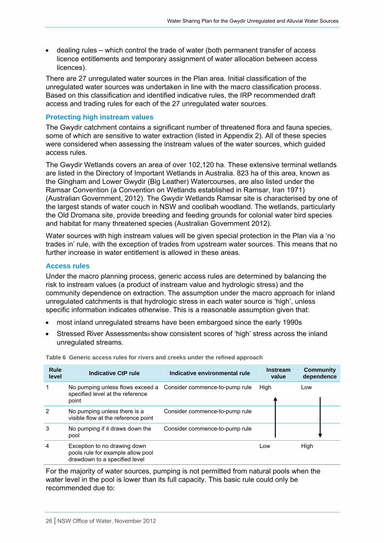
Water Sharing Plan for the Gwydir Unregulated and Alluvial Water Sources
dealing rules – which control the trade of water (both permanent transfer of access licence entitlements and temporary assignment of water allocation between access licences).
There are 27 unregulated water sources in the Plan area. Initial classification of the unregulated water sources was undertaken in line with the macro classification process. Based on this classification and identified indicative rules, the IRP recommended draft access and trading rules for each of the 27 unregulated water sources.
Protecting high instream values
The Gwydir catchment contains a significant number of threatened flora and fauna species, some of which are sensitive to water extraction (listed in Appendix 2). All of these species were considered when assessing the instream values of the water sources, which guided access rules.
The Gwydir Wetlands covers an area of over 102,120 ha. These extensive terminal wetlands are listed in the Directory of Important Wetlands in Australia. 823 ha of this area, known as the Gingham and Lower Gwydir (Big Leather) Watercourses, are also listed under the Ramsar Convention (a Convention on Wetlands established in Ramsar, Iran 1971) (Australian Government, 2012). The Gwydir Wetlands Ramsar site is characterised by one of the largest stands of water couch in NSW and coolibah woodland. The wetlands, particularly the Old Dromana site, provide breeding and feeding grounds for colonial water bird species and habitat for many threatened species (Australian Government 2012).
Water sources with high instream values will be given special protection in the Plan via a ‘no trades in’ rule, with the exception of trades from upstream water sources. This means that no further increase in water entitlement is allowed in these areas.
Access rules
Under the macro planning process, generic access rules are determined by balancing the risk to instream values (a product of instream value and hydrologic stress) and the community dependence on extraction. The assumption under the macro approach for inland unregulated catchments is that hydrologic stress in each water source is ‘high’, unless specific information indicates otherwise. This is a reasonable assumption given that:
most inland unregulated streams have been embargoed since the early 1990s
Stressed River Assessments9 show consistent scores of ‘high’ stress across the inland unregulated streams.
Table 6 Generic access rules for rivers and creeks under the refined approach
Rule level
Indicative CtP rule Indicative environmental rule Instream
value Community dependence
1 No pumping unless flows exceed a specified level at the reference point
Consider commence-to-pump rule High Low
2 No pumping unless there is a visible flow at the reference point
Consider commence-to-pump rule
3 No pumping if it draws down the pool
Consider commence-to-pump rule
4 Exception to no drawing down pools rule for example allow pool drawdown to a specified level
Low High
For the majority of water sources, pumping is not permitted from natural pools when the water level in the pool is lower than its full capacity. This basic rule could only be recommended due to:
26 | NSW Office of Water, November 2012
Water Sharing Plan for the Gwydir Unregulated and Alluvial Water Sources
many existing licences have no access rules therefore any change to access should be incremental to allow irrigators time to adjust
lack of appropriate reference points (for example river gauges) other than the pump site.
This access rule provides protection of natural pools which are important for drought refuge, as well as domestic and stock water supplies.
Dealing rules
Trading rules under the macro planning process for inland catchments are guided by the following principles:
Where instream values are considered high, no trades are permitted into that water source.
Where a water source is under high hydrologic stress (which is a default assumption, because of the lack of flow and usage data available) no trades are permitted into the water source.
Trades into downstream water sources are permitted regardless of stress or instream value, as long as the water sources have a direct hydrologic connection.
Trades through a regulated river are not permitted, for example a licence cannot be traded from an unregulated water source upstream of the regulated reach to a water source downstream of the regulated reach.
Trading within water sources is generally permitted, however in some areas trading may be restricted to protect high value areas or to limit demand in areas where competition for water is already high.
As a result of these principles, trades are not permitted into many unregulated water sources across the plan area.
It is important to note that the macro approach is used only as a tool to develop indicative rules and it’s an important role of the Interagency Regional Panel to use the local knowledge of panel members to check whether these rules are realistic.
Refining the rules for local circumstances Some water sources have unique circumstances that require additional consideration and negotiation. Often these water sources are split into management zones to allow better management of specific areas. The water sources listed below have water sharing rules that differ from the default approach, and have been designed specifically for that area. In some cases these rules were developed by the Interagency Regional Panel (IRP), however in many cases the initial rule was changed as a result of feedback received during consultation.
Upper Gwydir River Water Source
The Upper Gwydir River Water Source is considered to have high instream value coupled with high hydrological stress. In recognition of this the IRP recommended that no trades be permitted into the water source to protect the higher value areas and minimise the impact on existing water users.
Trades are permitted within the water source, subject to assessment.
Moredun Creek Water Source
The Moredun Creek Water Source is considered to have high instream value coupled with high hydrological stress. In recognition of this the IRP recommended that no trades be permitted into the water source to protect the higher value areas and minimise the impact on existing water users.
Trades are permitted within the water source, subject to assessment.
Copeton Dam Water Source
27 | NSW Office of Water, November 2012
Water Sharing Plan for the Gwydir Unregulated and Alluvial Water Sources
The Copeton Dam Water Source is considered to have high instream value coupled with high hydrological stress. In recognition of this the IRP recommended that no trades be permitted into the water source to protect the higher value areas and minimise the impact on existing water users.
Trades are permitted within the water source, subject to assessment.
Halls Creek Water Source
The Halls Creek Water Source is considered to have high instream value coupled with high hydrological stress. In recognition of this the IRP recommended that no trades be permitted into the water source to protect the higher value areas and minimise the impact on existing water users.
Trades are permitted within the water source, subject to assessment.
Mehi River Water Source
The Mehi River Water Source is considered to have high instream value coupled with high hydrological stress. In recognition of this the IRP recommended that no trades be permitted into the water source to protect the higher value areas and minimise the impact on existing water users. In addition, the assignment of allocation is not permitted into the Mehi River Tributaries Trading Zone.
Trades are permitted within the water source, subject to assessment.
Gingham Watercourse Water Source
The Gingham Watercourse Water Source is considered to have a very high environmental value due to the presence of the Ramsar listed Gwydir Wetlands. In recognition of this the IRP, after extensive consultation, recommended the following suite of commence to pump rules:
Commence to pump at 250 ML/day measured at Tillaloo Gauge.
Minimum flow depth of 1m on the Gingham Bridge Gauge and a cumulative flow of 4000 ML past the Gingham Bridge and a visible flow at Morialta Road.
Establishment of planned environmental water class commence to pump.
The justification for the above recommendations were the protection of environmental water, including releases delivered from the regulated Gwydir River, whilst continuing to provide irrigation opportunities for unregulated water users.
Gwydir Water Source
The Gwydir Water Source is considered to have a very high environmental value due to the presence of the Ramsar listed Gwydir Wetlands. In recognition of this the IRP, after extensive consultation, recommended the following suite of commence to pump rules:
Commence-to-pump at 250 ML/day measured at Millewa Gauge.
Establishment of planned environmental water class commence-to-pump.
The justification for the above recommendations were the protection of environmental water, including releases delivered from the regulated Gwydir River, whilst continuing to provide irrigation opportunities for unregulated water users.
Exemptions to access rules
Access to very low flow
Those activities that are considered critical human needs or animal health requirements are permitted to continue to access water when the commence-to-pump or cease-to-pump applies. Licences with access to very low flows include:
domestic supply
28 | NSW Office of Water, November 2012
Water Sharing Plan for the Gwydir Unregulated and Alluvial Water Sources
stock supply for first five years of the plan, after which the commence-to-pump and cease-to-pump rules will apply
town water supply, until major augmentation of the schemes infrastructure occurs
fruit washing
cleaning of dairy plant and processing equipment for the purpose of hygiene
poultry washing and misting
cleaning of enclosures used for intensive animal production for the purposes of hygiene.
Users of basic landholders rights are also exempt from the commence-to-pump and cease-to-pump rules.
Managing extraction
Long term average annual extraction limit
Unregulated extraction is managed at the Extraction Management Unit (EMU) level. The Gwydir Unregulated EMU, which includes the 27 unregulated water sources within the Gwydir catchment, was established in the Water Sharing Plan for the Rocky Creek, Cobbadah, Upper Horton and Lower Horton Water Source 2003. The Rocky Creek, Cobbadah, Upper Horton and Lower Horton Water Source is included in the EMU but covered by the Water Sharing Plan for the Rocky Creek, Cobbadah, Upper Horton and Lower Horton Water Source 2003. Collectively this EMU covers the whole of the Gwydir catchment.
Extractions from all unregulated water sources are managed according to a long term average annual extraction limit (LTAAEL). The LTAAEL for the Gwydir Unregulated Rivers EMU is equivalent to the Cap level. The Cap level for the EMU is equal to the total of the estimated annual extraction of water averaged over the period from July 1993 to June 1999 for those entitlements issued under Part 2 of the Water Act 1912, immediately prior to the commencement of Part 2 of Chapter 3 of the Water Management Act 2000; plus an estimate of annual extraction of water under domestic and stock rights and native title rights for the EMU.
A growth in use response will be triggered in the EMU if average annual usage over three years from all water sources within the EMU, exceeds the LTAAEL by more than 5 per cent.
Growth in use
To protect the water set aside for the environment and the supply to existing users, it is important to control any growth in water used over time that is above the limit specified in the plan, that is growth in extractions above the LTAAEL. The Interagency Regional Panel had some scope in determining how growth was assessed for each EMU including the period of time extractions are averaged over, and the amount of tolerance permitted in order to allow for climatic variations.
For the Gwydir Unregulated Rivers EMU a growth in use response will be triggered if the average annual usage over five years exceeds the LTAAEL by more than 5 per cent.
This decision was based on the knowledge that rivers and streams in the western slopes and plains experience high variability in flows which results in high variability in extraction. Increasing the period of time extractions are averaged over minimizes the impacts of climatic variability and the risk of growth being falsely triggered. Based on this principle a five year averaging period, rather than a three year averaging period was chosen for the EMU.
Available water determination
Available Water Determinations (AWD) are primarily used to credit water into a licence’s water allocation account. Specific purpose access licences such as domestic and stock or local water utility access licences, will generally receive 100 per cent of their share
29 | NSW Office of Water, November 2012
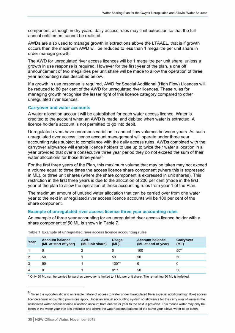
Water Sharing Plan for the Gwydir Unregulated and Alluvial Water Sources
30 | NSW Office of Water, November 2012
component, although in dry years, daily access rules may limit extraction so that the full annual entitlement cannot be realised.
AWDs are also used to manage growth in extractions above the LTAAEL, that is if growth occurs then the maximum AWD will be reduced to less than 1 megalitre per unit share in order manage growth.
The AWD for unregulated river access licences will be 1 megalitre per unit share, unless a growth in use response is required. However for the first year of the plan, a one off announcement of two megalitres per unit share will be made to allow the operation of three year accounting rules described below.
If a growth in use response is required, AWD for Special Additional (High Flow) Licences will be reduced to 80 per cent of the AWD for unregulated river licences. These rules for managing growth recognise the lesser right of this licence category compared to other unregulated river licences.
Carryover and water accounts
A water allocation account will be established for each water access licence. Water is credited to the account when an AWD is made, and debited when water is extracted. A licence holder’s account is not permitted to go into debit.
Unregulated rivers have enormous variation in annual flow volumes between years. As such unregulated river access licence account management will operate under three year accounting rules subject to compliance with the daily access rules. AWDs combined with the carryover allowance will enable licence holders to use up to twice their water allocation in a year provided that over a consecutive three year period they do not exceed the sum of their water allocations for those three years9.
For the first three years of the Plan, this maximum volume that may be taken may not exceed a volume equal to three times the access licence share component (where this is expressed in ML), or three unit shares (where the share component is expressed in unit shares). This restriction in the first three years is due to the allocation of 200 per cent (made in the first year of the plan to allow the operation of these accounting rules from year 1 of the Plan.
The maximum amount of unused water allocation that can be carried over from one water year to the next in unregulated river access licence accounts will be 100 per cent of the share component.
Example of unregulated river access licence three year accounting rules
An example of three year accounting for an unregulated river access licence holder with a share component of 50 ML is shown in Table 7.
Table 7 Example of unregulated river access licence accounting rules
Year Account balance (ML at start of year)
AWD (ML/unit share)
Usage (ML)
Account balance (ML at end of year)
Carryover (ML)
1 0 2 0 100 50*
2 50 1 50 50 50
3 50 1 100** 0 0
4 0 1 0*** 50 50
* Only 50 ML can be carried forward as carryover is limited to 1 ML per unit share. The remaining 50 ML is forfeited.
9 Given the opportunistic and unreliable nature of access to water under Unregulated River (special additional high flow) access
licence annual accounting provisions apply. Under an annual accounting system no allowance for the carry over of water in the
associated water access licence allocation account from one water year to the next is provided. This means water may only be
taken in the water year that it is available and where the water account balance of the same year allows water to be taken.
Water Sharing Plan for the Gwydir Unregulated and Alluvial Water Sources
** 100 ML is also the maximum that can be extracted in this year i.e. twice the allocation for the year which is 2x 50 ML = 100 ML.
*** Although with the AWD there is 50 ML in the account, no water is available for extraction as the maximum extraction over three years is the sum of AWDs in those three years which in this example is 150 ML and this was extracted in year two and three so no extraction can occur in year 4.
Water sharing rules for alluvial groundwater sources Water sharing rules that the Interagency Regional Panel focused on:
access rules – for highly connected groundwater sources, access rules linked to surface water rules may apply
dealing rules – which control the trade of water (both permanent transfer of access licence entitlements and temporary assignment of water allocation between access licences, the change of water sources and the location for extraction)
extraction limits – which set the total volume of water that can be extracted on a long term average annual basis from the water source.
Other management rules that were considered in the development of the plan include:
assessing growth – how growth in diversions are assessed
rules for granting works approvals – what types of set back conditions are required
rules for the protection of a specific environmental asset.
These rules form the basis of mandatory conditions on water access licences and approvals.
Managing Connectivity
For the purposes of developing plans for inland aquifer systems in NSW, the Office of Water has defined a highly connected system as a system in which “70 per cent or more of the groundwater extraction volume is derived from stream flow within a single irrigation season”. This is a simplified version of, but still reasonably consistent with, the key findings and conclusions circulated for discussion amongst state jurisdictions by the Murray-Darling Basin Commission (MDBC) in their report “Evaluation of the connectivity between surface water and groundwater in the Murray-Darling Basin” (MDBC, 2008).
Using the above definitions of connectivity, the Upper Gwydir Alluvial Groundwater Source will be treated as ‘highly connected’.
Access Rules
For highly connected water sources, specific rules that recognise that the same water resource is both above and below the ground surface may be applied. Aquifers that are highly connected to unregulated surface water sources may be linked to the surface waters daily access rules. Aquifers highly connected to regulated surface water sources may be linked to annual management through linked available water determinations.
In unregulated water sources, groundwater extraction can be linked to the adjacent surface water access rule, with a time lag of between 14 and 28 days. The time lag recognises the delayed impact that groundwater pumping has on river flows.
Dealings
Dealings (trading) rules are intended to provide for efficient water markets whilst recognising and protecting the needs of the environment and third party interests. In most macro plans, dealings are allowed within a groundwater source but not into or out of the groundwater source.
Consistent with the Ministers’ dealing principles there is no trading permitted into the Upper Gwydir Alluvial Groundwater Source.
Rules for water supply works approvals
31 | NSW Office of Water, November 2012
Water Sharing Plan for the Gwydir Unregulated and Alluvial Water Sources
In accordance with the principles of the Water Management Act 2000, the plan sets rules to minimise the cumulative impacts resulting from groundwater extraction. To do this, the plan specifies rules which prohibit new or amended works from extracting water within certain distances of other water users, contaminated sites, groundwater dependent ecosystems (GDE) and groundwater dependent culturally significant sites. This is to prevent unacceptable or damaging levels of draw down of water occurring in the local vicinity of these users and sites.
A standard set of distance criteria for common groundwater aquifer types (for example fractured rock, alluvium, coastal sands and porous rock) was produced by comparing the various rules in similar geological provinces. The standard rules were then endorsed by the State Groundwater Panel.
This process has resulted in consistent rules across aquifer types being considered as the most current thinking in terms of managing local impacts of extraction and protecting GDEs. However, the plan development process allows for changes to the rules to cater for local conditions. The distance criteria may be altered due to a number of different factors, such as lot size where property sizes may lead to different interference distance criteria, aspects of the local hydrology and groundwater dependence of town water.
Regional staff made draft recommendations on rules for the Plan which were then compared against the standard rules. The Interagency Regional Panel then made a final decision as to which rules would be adopted, striving to remain consistent with the standard rules where possible while being sensitive to any unique attributes of the groundwater sources in the plan area.
For new works there are rules to:
minimise interference between neighbouring works
locate works away from contaminated sites
protect water levels in groundwater dependent ecosystems
protect groundwater dependent culturally significant sites
manage surface and groundwater connectivity
manage temporary local impacts that may affect water levels, water quality and aquifer integrity.
Groundwater dependent ecosystems
Groundwater dependent ecosystems (GDEs) are ecosystems which have their species composition and natural ecological processes determined to some extent by the availability of groundwater. GDEs can include cave systems, springs, wetlands and groundwater dependent Endangered Ecological Communities (EECs).
High priority GDEs are identified during the planning process and are listed in a schedule to the plan. The Interagency Regional Panel then has the opportunity to review and amend the GDE list as well as the rules that have been developed to protect them based on their expertise.
The list of high priority GDEs compiled at this stage can either be amended after year five of the plan as further GDEs are identified or during the life of the plan on submission to and approval by the Minister.
No GDE’s have been identified for the alluvial groundwater source included in the Gwydir Unregulated and Alluvial Water Sharing Plan.
Managing Extraction
Long term average annual extraction limit (LTAAEL)
32 | NSW Office of Water, November 2012
Water Sharing Plan for the Gwydir Unregulated and Alluvial Water Sources
For this and other similar plan areas, NSW has resolved that the long term average annual extraction limit (LTAAEL) for highly connected and alluvial groundwater resources within NSW’s portion of the Murray-Darling Basin will be set equal to current average usage. This is based on the principle that current levels of groundwater pumping are considered to be having acceptable impacts on surface water sources. Any extraction beyond this level will result in additional impact on the rivers, groundwater dependent ecosystems and other users of these connected water resources.
The LTAAEL for the Upper Gwydir Alluvium is equal to 721 ML/y, defined by the sum of:
average usage (1998–99 to 2007–08) from bores metered by State Water; plus
an estimate of usage by the current utilisation of basic landholder rights; plus
the amount of entitlement in megalitres held by local water utilities.
Growth in use
Extractions are managed to the LTAAEL. Should growth in extraction above the LTAAEL be assessed to have occurred, an appropriate growth in use response will be taken. The current statewide position is to set the LTAAEL for highly connected and alluvial systems at current average usage. Therefore the growth in use response described in the Plan allows for the ‘peaks’ and ‘troughs’ of usage above and below the average, over the period from which the LTAAEL has been defined, to be replicated.
In the Gwydir catchment where flows and consequently, the recharging of alluvial aquifers vary considerably, a five year averaging period and an exceedance threshold of 10 per cent was recommended by the Interagency Regional Panel (IRP). The longer averaging period and increased threshold was chosen by the IRP to minimise the impacts of climatic variability.
As such, a response is triggered if the average annual usage over a period of five years exceeds the LTAAEL by more than 10 per cent.
Available water determination
Available water determinations (AWD) are primarily used to credit water into a licence’s water allocation account.
The AWD for a water source is used to manage growth in extractions above the LTAAEL. If growth is assessed to have occurred, then maximum AWD will be reduced to respond to this growth. That is a maximum AWD of less than one megalitre per unit share.
To recognise the connection between the Upper Gwydir Alluvial Groundwater Source and the regulated Gwydir River, the AWD for licences within the groundwater source has two components:
A river recharge component (this is based on the percentage of the Upper Gwydir Alluvial Groundwater Source LTAAEL derived from river recharge) that will fluctuate in accordance with the availability of resources in the regulated river.
A rainfall and other recharge component (this is based on the percentage of the LTAAEL derived from rainfall/other sources of recharge) that will be consistently available on a long term average basis.
The river recharge component will be linked to the AWD for regulated Gwydir River (high security) access licences. This is in recognition of the need to not increase regulated river losses during periods of reduced surface water availability. If these losses were allowed to exacerbate reduced water availability, then this potentially impacts future allocations for high priority surface water licences. Linking AWDs will therefore protect against increasing losses from the regulated Gwydir River to the groundwater during times of reduced allocations for the regulated Gwydir River.
33 | NSW Office of Water, November 2012

Water Sharing Plan for the Gwydir Unregulated and Alluvial Water Sources
34 | NSW Office of Water, November 2012
The linking of the Upper Gwydir Alluvial groundwater source AWD is a change from current management, but is believed to have limited impacts as the AWD for the Gwydir Regulated River (high security) access licences are rarely less than one megalitre per unit share.
Carryover and water accounts
No carryover of entitlement from one year to the next is allowed in any of the groundwater sources and the maximum amount of water permitted to be taken from this water source in any one water year is equal to the water allocation accrued in the water access licence account for that water year. There are two reasons for this approach:
These alluvial groundwater have a relatively small storage volume to entitlement to LTAAEL ratio.
The water sources are fully committed in terms of the level of entitlements compared to the LTAAEL. Consequently the total volume of water credited into accounts at the start of each water year is much greater than the LTAAEL and individuals are able to pump more than their individual proportion of the LTAAEL due to the number of unused licences.
Water Sharing Plan for the Gwydir Unregulated and Alluvial Water Sources
Adaptive management
Adaptive management is an important part of a water sharing plan. Adaptive management refers to the process of ongoing data collection monitoring, evaluation and review during the life of the plan that either enables plan amendment or remaking of a better plan after ten years. Adaptive management is a requirement of both the Water Management Act 2000 and the National Water Initiative, and has been allowed for during the life of the Plan through amending provisions and establishment of ‘limits of change’ to the Plan.
Where adaptive management is identified further studies may be undertaken within agencies or by external organisations which may assist in informing the review of plan provisions.
Amendment Provisions There are a number of amendment provisions which allow the Plan to be changed as a result of further studies or to allow implementation of specific rules. The amendment provisions detailed in this section were part of the rule development process undertaken by the Interagency Regional Panel. There may be other general amendment provisions included in the Plan which are not mentioned in this document. Please refer to the Plan for a full list of amendment provisions.
Protection of Regulated Releases
The Water Sharing Plan for the Gwydir Regulated River Water Source (the Regulated Plan), commenced in 2004. The Regulated Plan contains provisions for the delivery of environmental water, as well as stock and domestic replenishment flows to unregulated water sources below the regulated river, which the plan must protect. Under the Water Act 1912, the regulated releases are protected by various methods, including through licence conditions, by formal order and various ad hoc arrangements where licence holders contact State Water prior to pumping.
To ensure these flows are protected, the Minister may make an order under Section 324 of the Act to temporarily restrict or suspend the taking of water if the Minister is satisfied that it is the public interests to do so.
Exemption for stock watering
Stock and domestic access licences are exempt from the cease-to-pump rules for the first five years of the Plan when water is being taken for the purpose of stock watering. The Plan includes an amendment provision which allows this exemption to be extended beyond the five year period. The Plan may be amended if the outcomes of a review demonstrate the cease-to-pump rules will cause unacceptable socio-economic impacts.
Evaluation of plan performance The evaluation framework for water sharing plans is currently being developed. The objectives of the project are:
Inform the community of the results from the 10 year operation of water sharing plans
Collate the results of the various legislatively required evaluations, along with other relevant learning’s to inform the remake of water sharing plans.
The evaluation framework will use a system of ’program logic’ to organise the inputs, outputs and outcomes from water sharing plans and their operation. Evaluation questions and monitoring indicators allow assessment of these steps to rate a water sharing plan for its:
Process of development (appropriateness)
Performance during operation (efficiency)
Socio-economic environmental and cultural outcomes (effectiveness).
35 | NSW Office of Water, November 2012
Water Sharing Plan for the Gwydir Unregulated and Alluvial Water Sources
36 | NSW Office of Water, November 2012
The Office of Water’s approach conforms to NSW and Commonwealth government guidelines for monitoring, evaluation and reporting, and demonstrates the adaptive management approach to water planning required under the principles of the NSW Water Management Act 2000. The Office of Water has also chosen to organise the evaluation questions and monitoring indicators using the NSW Natural Resource Commission’s auditable standard for natural resource management
Performance indicators The Plan includes a number of performance indicators that will be monitored over the ten year life of the Plan.
It is not practicable to monitor all issues in all water sources. The performance indicators identify that monitoring will be undertaken for specific issues in key water sources. The actual procedure for monitoring each indicator may change over the period of the Plan as improved methods are developed.
The Water Sharing Plans Environmental Flows Monitoring and Modelling program has been designed to make the results of environmental flows studies more transferable between water sources and to develop more generic relationships between flow, hydraulics and ecological responses. In adopting this approach it enables a more efficient and effective evidence based approach to support monitoring and evaluation requirements of NSW water sharing plans and identifies specific knowledge gaps to allow further investigative work to be prioritised.
Plan review Under the Water Management Act 2000, the Natural Resources Commission is required to undertake a review of this Plan prior to any decision to extend its term or to make a new plan.
The evaluation framework developed will consider the statutory requirements for the different types of evaluation:
An audit of the Plan, at intervals of no more than five years, for the purpose of ascertaining whether its provisions have been given effect to. This audit is to be carried out by the State Interagency Panel, which has now been appointed by the Minister for Water.
An audit of the Plan by the Natural Resources Commission to assess to what extent the water sharing provisions have contributed to the relevant state wide targets, and natural resource standards and targets in the relevant catchment management area. The Natural Resources Commission will call for public submissions when undertaking its review.
Water Sharing Plan for the Gwydir Unregulated and Alluvial Water Sources
Glossary
Many of the terms in this document are defined in the Water Management Act 2000 and are therefore not redefined here. However, there are some terms that are not and have therefore been defined below to assist with understanding the water sharing plan.
Account water: The balance in an access licence water allocation account at a particular time. An access licence water allocation account records water allocations accrued under the licence as well as water allocations taken, assigned or re-credited. The operation of the account is also governed by rules for the carrying over of credits from one accounting period to the next and rules for the maximum credit that may be allowed to accumulate in the account as established in a water sharing plan.
Alluvial, alluvium: Sediment deposited by a stream of running water, in particular along riverbeds or flood plains.
Aquifer: An underground layer of water-bearing permeable rock or unconsolidated materials (gravel, sand, silt or clay) from which groundwater can be usefully extracted. The volume of water stored in an aquifer, the rate at which water can recharge, the volume of water extracted from it, and the rate at which water can move through the aquifer are all controlled by the geologic nature of the aquifer.
Ecological values: The intrinsic or core attributes associated with naturalness, diversity, rarity and special features, but excluding representativeness used to classify water sources for apportioning water management rules.
Endangered ecological communities: Ecological communities listed in Schedule 1 of the Threatened Species Conservation Act 1995 or Schedule 4 of the Fisheries Management Act 1994.
Extraction of water: Removal of water from a river for off-stream storage or consumptive use.
Extraction management unit (EMU): A group of water sources; defined for the purpose of managing long-term annual average extraction.
Flow classes: The range of daily flow rates in a river which provides the framework for sharing water on a daily basis.
Flow duration curve: A plot that shows the percentage of time that flow in a stream is likely to equal or exceed some specified value of interest.
Flow gauging station: A device used to measure the height of a river, from which the flow in the river can be calculated.
Flow reference point: The site from which the flow data is calculated to determine the rates associated with a flow class and then to implement the daily access rules during the life of the plan.
Full capacity: The volume of water that is impounded in the pool, lagoon or lake when the level of water in the pool, lagoon or lake is at the highest water level where there is no visible flow out of that pool.
Groundwater: The water beneath the earth’s surface that has filtered down to the zone where the earth or rocks are fully saturated.
Groundwater dependent ecosystems (GDEs): Ecosystems that rely on groundwater for their species composition and their natural ecological processes.
Long-term average annual extraction limit (LTAAEL): The target for total extractions (under all water access licences plus an estimate of basic landholder rights within an EMU) which is used to assess whether growth in use has occurred. The actual annual extractions
37 | NSW Office of Water, November 2012
Water Sharing Plan for the Gwydir Unregulated and Alluvial Water Sources
(metered plus estimated) are averaged over a fixed period of time defined by the water sharing plan when comparing with the LTAAEL. If the fixed period of time is greater than one water year, then in any one water year, extractions can exceed the LTAAEL without triggering a growth-in-use response.
Macro water sharing plans: Plans which apply to a number of water sources across catchments or different types of aquifers. The macro planning process is designed to develop broader scale plans covering most of the remaining water sources in NSW.
Management zone: An area within a water source used for defining the location of applicability of water sharing rules, but secondary to the water source. A management zone is more likely to be designated where ‘cease-to-pump’ rules for works approvals apply.
Pools: Lentic water bodies (standing water), including anything falling within the definition of a “lake” found in the Dictionary of the Water Management Act 2000, except for tidal pools and estuaries.
Regulated river: A river that is declared by the Minister, by order published in the Gazette, to be a regulated river. Typically rivers where state owned storages catch water during wetter periods and the river is used to supply stored water to meet downstream users’ orders during dry times are regulated rivers.
Riparian: Relating to or living or located on the bank of a natural watercourse, such as a river or stream.
Trading zone: An area within a water source used for defining the location of applicability of access water sharing rules, but secondary to the water source. A trading zone is more likely to be designated where local dealing restrictions are in place.
Visible flow: The continuous downstream movement of water that is perceptible to the eye.
Water sharing plan: A plan made under the Water Management Act 2000, which sets out the rules for sharing water between the environment and water users within whole or part of a water management area or water source.
Water year: The 12 months running from 1 July to 30 June each year.
38 | NSW Office of Water, November 2012

Water Sharing Plan for the Gwydir Unregulated and Alluvial Water Sources
References ABS, 2006, Population and Housing Census, Australian Bureau of Statistics, Canberra
ABS, 2009, Irrigation production statistics, Australian Bureau of Statistics, Canberra
Australian Government, 2012, Gwydir Wetlands: Gingham and Lower Gwydir (Big Leather) Watercourses, Commonwealth of Australia, viewed 2012, http://www.environment.gov.au/cgi-bin/wetlands/ramsardetails.pl?refcode=50
Border Rivers-Gwydir Catchment Management Authority, 2007, Border Rivers-Gwydir Catchment Action Plan 2006 – 2016, Border Rivers-Gwydir Catchment Management Authority, Inverell
Broadstock, B., 2009, Impact of groundwater pumping on a regulated river, a conceptual model of a shallow highly connected aquifer-stream, NSW Office of Water, Sydney
Bureau of Meteorology, 2011, Climate Data, Commonwealth of Australia, viewed November 2011, http://www.bom.gov.au/climate/data
CSIRO, 2007, Climate Change in the Border Rivers-Gwydir Catchment, Prepared for the NSW Government by the CSIRO, Australia
CSIRO, 2007, Water availability in the Gwydir: A report to the Australian Government from the CSIRO Murray Darling Sustainable Yields Project, CSIRO, Australia
DLWC, 1997, NSW weirs policy, www.water.nsw.gov.au/ArticleDocuments/34/nsw_weir_policy.pdf.aspx
Green D., Burrell M., Petrovic J., Moss P, (2011) Water resources and management overview – Gwydir catchment, NSW Office of Water, Sydney
Hutchinson M.F. and Kesteven J.L., 1998, Monthly mean climate surfaces for Australia. Australian National University, Australia
NSW Agriculture, (2003), Gwydir Catchment Irrigation Profile, Report prepared by NSW Agriculture for the Water Efficiency Advisory Unit, Dubbo
NSW Office of Water, 2012, Gwydir catchment socio-economic data summary, unpublished report, Tamworth
NSW Office of Water, 2011, Macro water sharing plans – the approach for unregulated rivers: A report to assist community consultation, NSW Government, Sydney
NSW State Groundwater Dependent Ecosystem Policy (DLWC, 2002
Pietsch TJ., 2006, Fluvial geomorphology and late quaternary geochronology of the Gwydir fan-plain, PhD thesis, School of Earth and Environmental Science, University of Wollongong
39 | NSW Office of Water, November 2012
Water Sharing Plan for the Gwydir Unregulated and Alluvial Water Sources
40 | NSW Office of Water, November 2012
Appendices
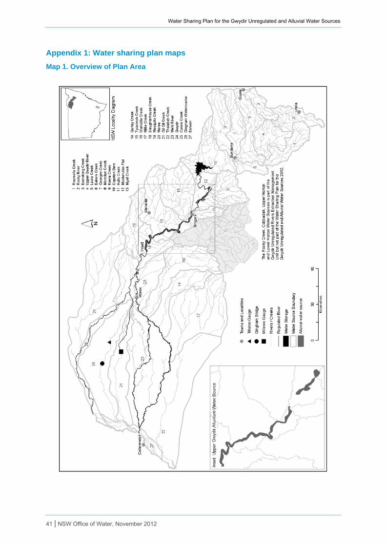
Water Sharing Plan for the Gwydir Unregulated and Alluvial Water Sources
Appendix 1: Water sharing plan maps
Map 1. Overview of Plan Area
41 | NSW Office of Water, November 2012
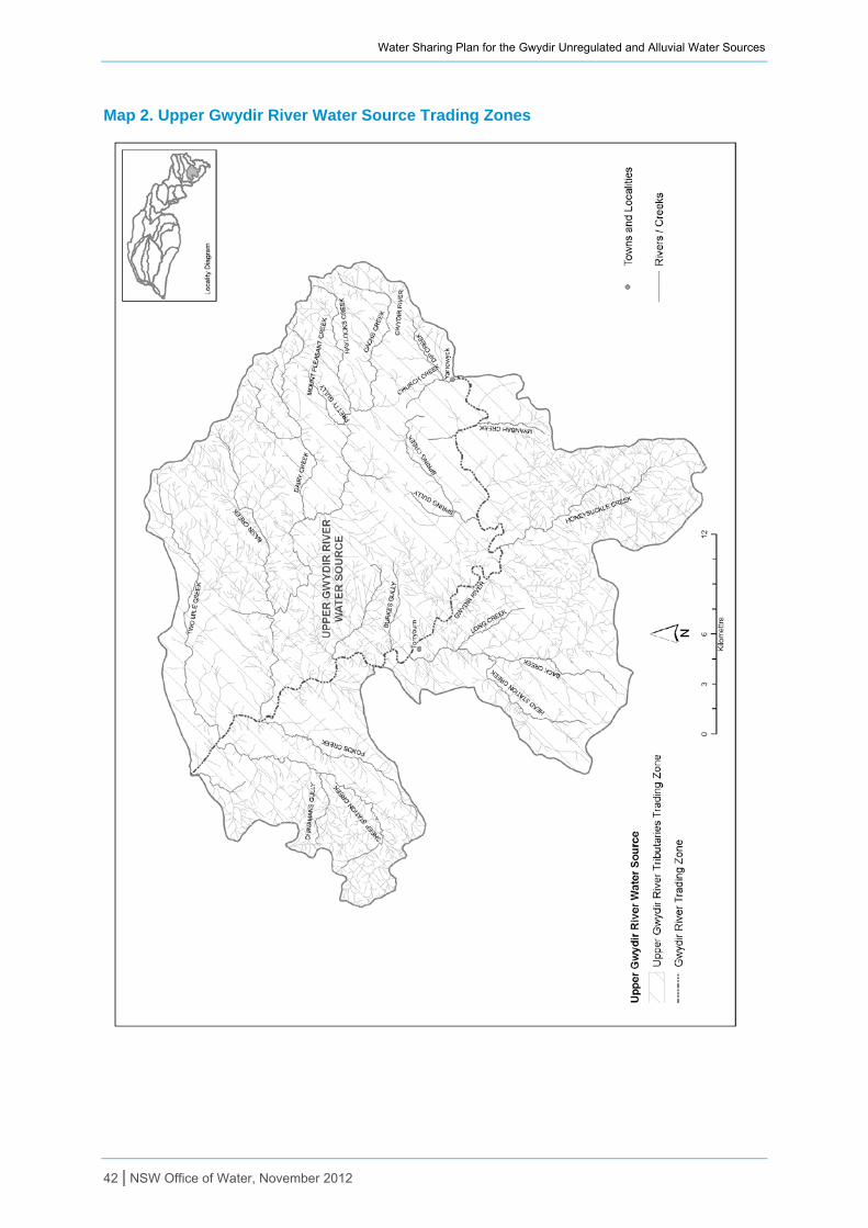
Water Sharing Plan for the Gwydir Unregulated and Alluvial Water Sources
Map 2. Upper Gwydir River Water Source Trading Zones
42 | NSW Office of Water, November 2012
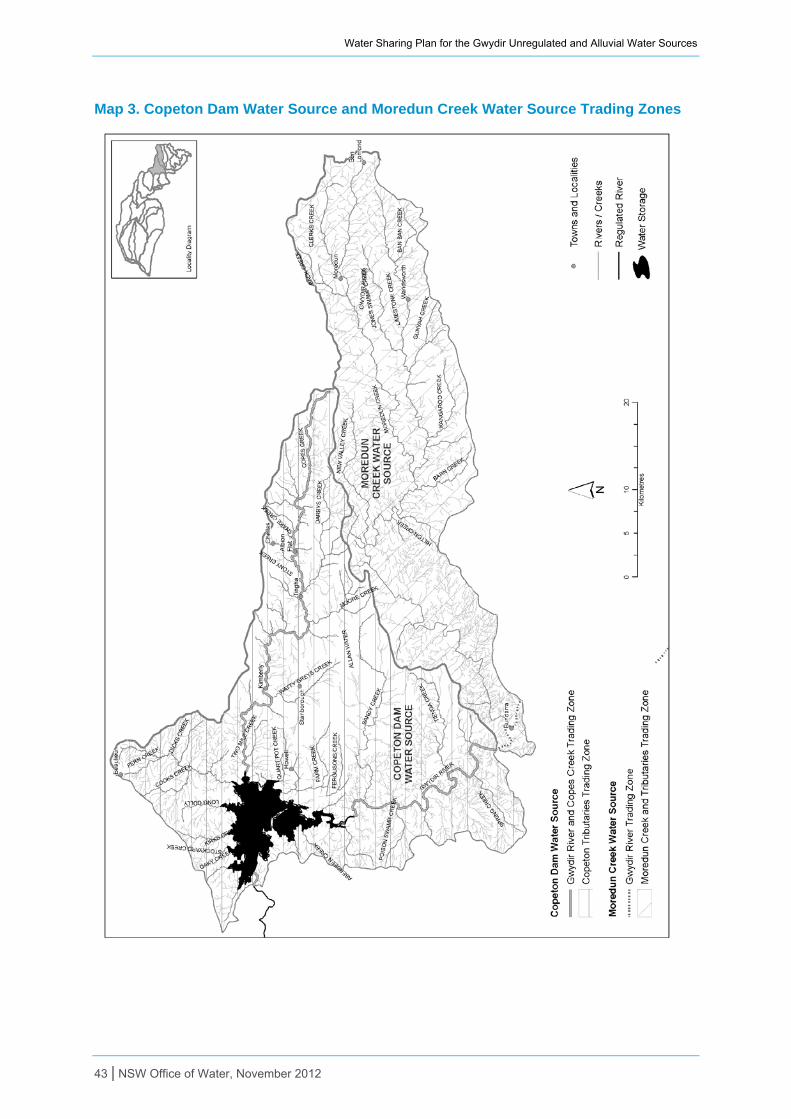
Water Sharing Plan for the Gwydir Unregulated and Alluvial Water Sources
Map 3. Copeton Dam Water Source and Moredun Creek Water Source Trading Zones
43 | NSW Office of Water, November 2012
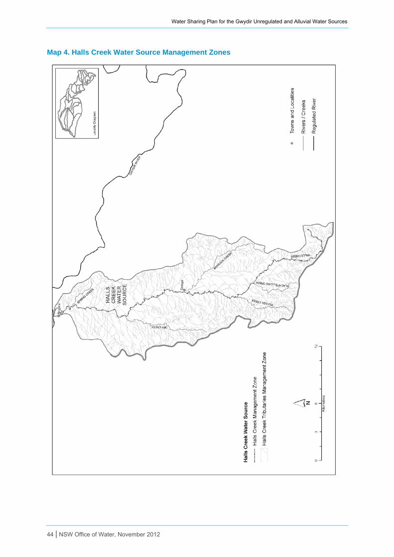
Water Sharing Plan for the Gwydir Unregulated and Alluvial Water Sources
Map 4. Halls Creek Water Source Management Zones
44 | NSW Office of Water, November 2012

Water Sharing Plan for the Gwydir Unregulated and Alluvial Water Sources
Map 5. Mehi River Water Source Trading Zones
45 | NSW Office of Water, November 2012
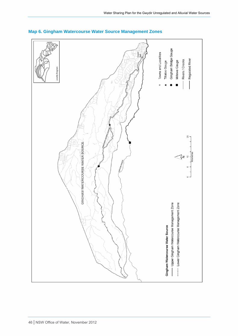
Water Sharing Plan for the Gwydir Unregulated and Alluvial Water Sources
Map 6. Gingham Watercourse Water Source Management Zones
46 | NSW Office of Water, November 2012
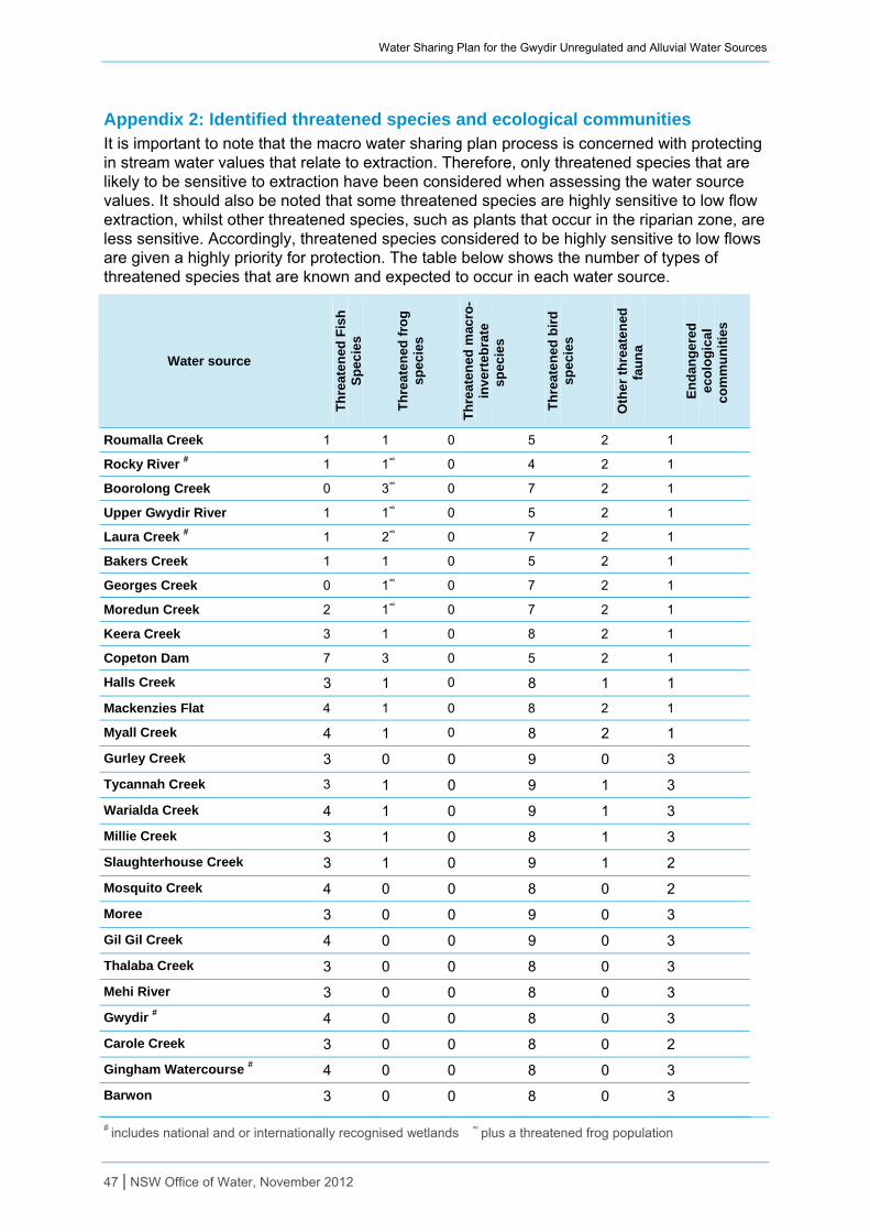
Water Sharing Plan for the Gwydir Unregulated and Alluvial Water Sources
Appendix 2: Identified threatened species and ecological communities It is important to note that the macro water sharing plan process is concerned with protecting in stream water values that relate to extraction. Therefore, only threatened species that are likely to be sensitive to extraction have been considered when assessing the water source values. It should also be noted that some threatened species are highly sensitive to low flow extraction, whilst other threatened species, such as plants that occur in the riparian zone, are less sensitive. Accordingly, threatened species considered to be highly sensitive to low flows are given a highly priority for protection. The table below shows the number of types of threatened species that are known and expected to occur in each water source.
Water source
Th
reat
ened
Fis
h
Sp
ecie
s
Th
reat
ened
fro
g
spec
ies
Th
reat
ened
mac
ro-
inve
rteb
rate
sp
ecie
s
Th
reat
ened
bir
d
spec
ies
Oth
er t
hre
ate
ned
fa
un
a
En
dan
ger
ed
eco
log
ical
co
mm
un
itie
s
Roumalla Creek 1 1 0 5 2 1
Rocky River # 1 1∞ 0 4 2 1
Boorolong Creek 0 3∞ 0 7 2 1
Upper Gwydir River 1 1∞ 0 5 2 1
Laura Creek # 1 2∞ 0 7 2 1
Bakers Creek 1 1 0 5 2 1
Georges Creek 0 1∞ 0 7 2 1
Moredun Creek 2 1∞ 0 7 2 1
Keera Creek 3 1 0 8 2 1
Copeton Dam 7 3 0 5 2 1
Halls Creek 3 1 0 8 1 1
Mackenzies Flat 4 1 0 8 2 1
Myall Creek 4 1 0 8 2 1
Gurley Creek 3 0 0 9 0 3
Tycannah Creek 3 1 0 9 1 3
Warialda Creek 4 1 0 9 1 3
Millie Creek 3 1 0 8 1 3
Slaughterhouse Creek 3 1 0 9 1 2
Mosquito Creek 4 0 0 8 0 2
Moree 3 0 0 9 0 3
Gil Gil Creek 4 0 0 9 0 3
Thalaba Creek 3 0 0 8 0 3
Mehi River 3 0 0 8 0 3
Gwydir # 4 0 0 8 0 3
Carole Creek 3 0 0 8 0 2
Gingham Watercourse # 4 0 0 8 0 3
Barwon 3 0 0 8 0 3
# includes national and or internationally recognised wetlands ∞ plus a threatened frog population
47 | NSW Office of Water, November 2012
Water Sharing Plan for the Gwydir Unregulated and Alluvial Water Sources
48 | NSW Office of Water, November 2012
Disclaimer The Office of Environment and Heritage (OEH) has provided assessments on the presence of threatened species and their sensitivity to extraction to inform the classification of water sources through the macro water sharing planning process. The assessments were undertaken for the specific purpose of developing an initial classification of water sources. They were based on the most accurate and relevant data/information sourced and analysed at the time.
Initial classifications were a first step to inform panel deliberations. The Panels considered a range of information and used local knowledge in determining a final classification. The assessments are not absolute – for example the absence of threatened species for an assessment does not necessarily mean the threatened species are not present. These assessments should not be used for any purpose other than classification of catchment management units as part of the macro water sharing planning process.

Water Sharing Plan for the Gwydir Unregulated and Alluvial Water Sources
Appendix 3: Interagency regional panel and support staff
Name Agency Role Expertise
Interagency Regional Panel
Dave Miller NSW Office of Water
Agency Representative
Water planning/administration/policy. Geomorphology. Riparian management. Stream ecology/restoration.
Pam Welsh DPI Agency Representative
Regional experience in water reform programs, water quality problems, inland agricultural industries, catchment management and interagency coordination.
Daryl Albertson, Jane Humphries
OEH Agency Representative
Regional experience in water reform programs, catchment plans and investments, biodiversity and threatened species management planning.
Liz Savage, Geoff Rayson
CMA Observer Broad range of experience in catchment management, community liaison and engagement.
Support Staff
Tara Schalk NSW Office of Water
Plan coordinator Water policy and planning, plan development and implementation, facilitation and project management
Karen Hearnden NSW Office of Water
Plan support Water planning, natural resource management
Emily Turner NSW Office of Water
Plan support Classification process, access and trading rules
Chayna Moldrich NSW Office of Water
Plan writer, policy support
Water policy and planning, environmental science, environmental law
Anthony Colvin NSW Office of Water
Technical Support (licensing)
Licensing officer, local knowledge of water users, water users associations, local access arrangements and reference point, compliance
Peter Cuell NSW Office of Water
Technical Support (licensing)
Licensing officer, local knowledge of water users, water users associations, local access arrangements and reference point, compliance
Robert Albert NSW Office of Water
Technical Support (licensing)
Licensing officer, local knowledge of water users, water users associations, local access arrangements and reference point, compliance
David Thomas NSW Office of Water
Technical Support (licensing)
Licensing officer, local knowledge of water users, water users associations, local access arrangements and reference point, compliance
Cate Barrett
NSW Office of Water
Plan Technical Support (hydrogeology)
Hydrogeology, local knowledge of groundwater sources
Andrew Cutler NSW Office of Water
Technical support (hydrometrics)
Hydrometrics, water monitoring
Neeraj Maini, Marina Sivkova
NSW Office of Water
Technical support (hydrology)
Hydrology, IQQM
Neal Foster NSW Office of Water
Technical support (ecology)
Aquatic ecology, local environment knowledge
Tim O’Connor NSW Office of Water
Plan Technical Support (mapping)
Spatial data systems, mapping
Noel Flavel, Brinta NSW Technical support Socio-economic data, impacts of water sharing rules
49 | NSW Office of Water, November 2012
Water Sharing Plan for the Gwydir Unregulated and Alluvial Water Sources
50 | NSW Office of Water, November 2012
Name Agency Role Expertise
Nandy, Graham Carter
Office of Water
(socio-economics)
Anne Brook NSW Office of Water
Planning support (media)
Community relations and media
Andrew Scott DPI Alternate agency representative
Resource management, farm systems and enterprises, farm management and economics, irrigation systems and management, extension and communications
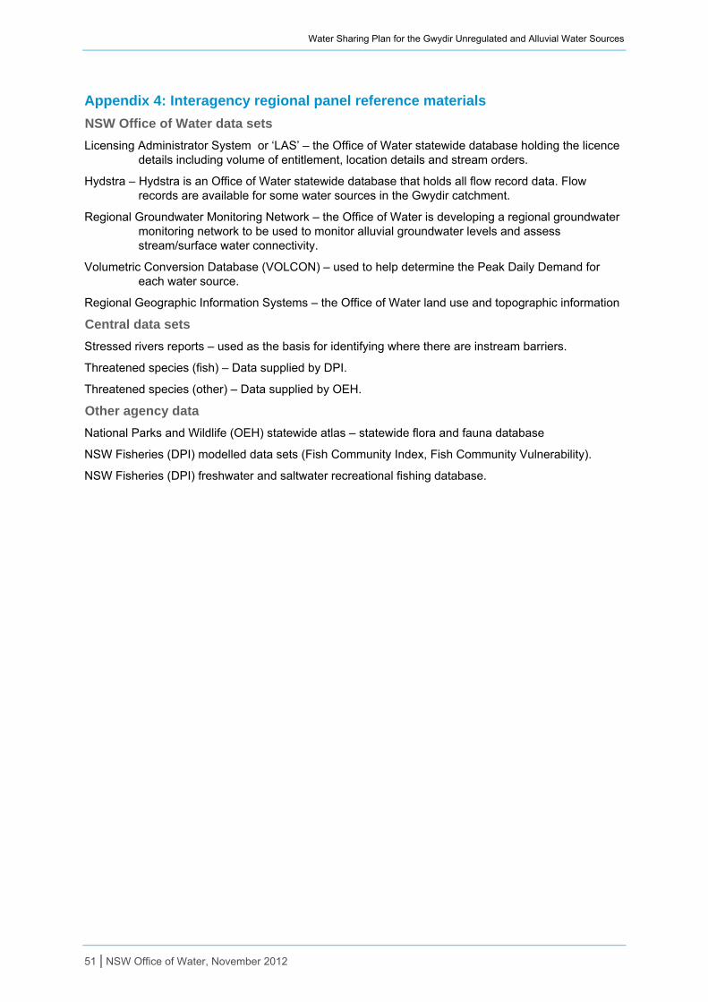
Water Sharing Plan for the Gwydir Unregulated and Alluvial Water Sources
Appendix 4: Interagency regional panel reference materials
NSW Office of Water data sets
Licensing Administrator System or ‘LAS’ – the Office of Water statewide database holding the licence details including volume of entitlement, location details and stream orders.
Hydstra – Hydstra is an Office of Water statewide database that holds all flow record data. Flow records are available for some water sources in the Gwydir catchment.
Regional Groundwater Monitoring Network – the Office of Water is developing a regional groundwater monitoring network to be used to monitor alluvial groundwater levels and assess stream/surface water connectivity.
Volumetric Conversion Database (VOLCON) – used to help determine the Peak Daily Demand for each water source.
Regional Geographic Information Systems – the Office of Water land use and topographic information
Central data sets
Stressed rivers reports – used as the basis for identifying where there are instream barriers.
Threatened species (fish) – Data supplied by DPI.
Threatened species (other) – Data supplied by OEH.
Other agency data
National Parks and Wildlife (OEH) statewide atlas – statewide flora and fauna database
NSW Fisheries (DPI) modelled data sets (Fish Community Index, Fish Community Vulnerability).
NSW Fisheries (DPI) freshwater and saltwater recreational fishing database.
51 | NSW Office of Water, November 2012