water supply plan - garfield county, colorado
TRANSCRIPT
WATER SUPPLY PLAN RIVER EDGE COLORADO
GARFIELD COUNTY, COLORADO
O W N E R / A P P L I C A N T :
C A R B O N D A L E I N V E S T M E N T S , L L C
7 9 9 9 H W Y 8 2
C A R B O N D A L E C O 8 1 6 2 3
9 7 0 - 4 5 6 - 5 3 2 5
C O N S U L T A N T :
8 1 4 0 P A R T N E R S , L L C
P O B O X 0 4 2 6
E A G L E , C O 8 1 6 3 1
J A N U A R Y 1 4 , 2 0 1 1
Water Supply Plan River Edge Colorado, Garfield County, Colorado
2
WAT E R S U P P LY P L A N
RIVER EDGE COLORADO GARFIELD COUNTY, COLORADO
TABLE OF CONTENTS
I . INTRODUCTION .... . . . . . . . . . . . . . . . . . . . . . . . . . . . . . . . . . . . . . . . . . . . . . . . . . . . . . . . . . . . . . . . . . . . . . . . 4
A. BASIS .................................................................................................... 4
B. PURPOSE AND SCOPE OF REPORT .......................................................... 4
C. FINDINGS .............................................................................................. 5
I I . PROJECT LOCATION AND DESCRIPTION .... . . . . . . . . . . . . . . . . . . . . . . . . . . . . . . . . . . . . . . 5
A. PROJECT LOCATION ............................................................................... 5
B. PROJECT DESCRIPTION .......................................................................... 6
I I I . EVIDENCE OF ADEQUATE WATER SUPPLY ... . . . . . . . . . . . . . . . . . . . . . . . . . . . . . . . . . . . . . 7
A. WATER SUPPLY REQUIREMENTS FOR THE PROJECT THROUGH BUILD-OUT CONDITIONS .................................................................................................... 7
1. POTABLE WATER DEMAND ........................................................................ 7
2. RAW WATER DEMAND ............................................................................... 8
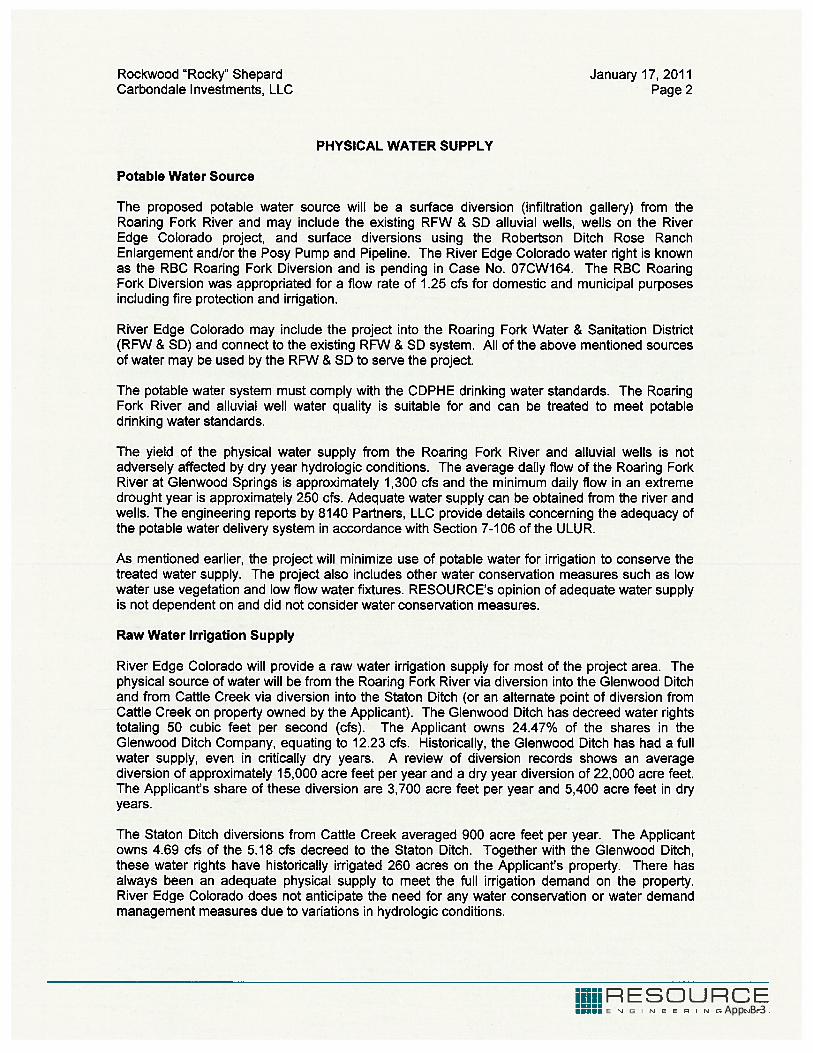
B. PHYSICAL SOURCE OF WATER SUPPLY ..................................................... 8
1. POTABLE WATER ........................................................................................ 8
2. IRRIGATION WATER ................................................................................... 8
C. ABILITY OF THE SUPPLY TO MEET WATER QUALITY REQUIREMENTS ......... 9
1. POTABLE WATER ........................................................................................ 9
2. IRRIGATION WATER ................................................................................... 9
D. ESTIMATED YIELD UNDER VARIOUS HYDROLOGIC CONDITIONS ............... 9
E. WATER CONSERVATION MEASURES ........................................................ 9
F. WATER DEMAND MANAGEMENT MEASURES ........................................ 10
G. PROOF OF A LEGAL WATER SUPPLY ...................................................... 10
1. POTABLE SUPPLY ...................................................................................... 10
2. IRRIGATION WATER ................................................................................. 10
IV. ADEQUATE CENTRAL WATER DISTRIBUTION SYSTEM .... . . . . . . . . . . . . . . . . . . 11

Water Supply Plan River Edge Colorado, Garfield County, Colorado
3
APPENDICES
APPENDIX A: VICINITY MAP AND PROJECT SITE MAP
APPENDIX B: RESOURCES ENGINEERING REPORT

Water Supply Plan River Edge Colorado, Garfield County, Colorado
4
I . INTRODUCTION
A. BASIS
This Water Supply Plan ("Plan") has been prepared in support of an application for PUD Plan Review ("Rezoning") and Subdivision Review ("Preliminary Plan") for the proposed River Edge Colorado ("Project", "REC", or "REC PUD") in accordance with the requirements of the Garfield County Unified Land Use Resolution of 2008 ("ULUR"), as amended. This Plan specifically addresses the requirements of Section 7-105 of the ULUR, and along with the Water Treatment and Distribution System Design Report and Raw Water Supply and Distribution Plan document that a water supply meeting the criteria of 7-105 of the ULUR is available or can be designed and constructed to serve the Project including adequate water supply. This Plan is supported by other referenced documents submitted as part of the REC rezoning and preliminary plan applications including the River Edge Colorado PUD and Subdivision Drawing Package ("Drawing Package").
This Plan is designed to provide Garfield County with evidence that provision has been made for an adequate water supply for the Project and. With respect to water delivery within the Project Site (herein after defined), the design of the raw and potable water treatment and distribution systems are documented in the Raw Water Supply and Distribution Plan and Water Treatment and Distribution System Design Report which are included as part of the REC rezoning and preliminary plan applications. The referenced reports conclude that both a potable treatment and distribution system and raw water distribution system can be designed and constructed to support the development of the Project in accordance with generally accepted practices.
Once built, the potable water system will be dedicated to, owned and operated by the Roaring Fork Water and Sanitation District ("RFWSD") or the REC Property Owners Association, Inc. ("POA"). Potable water will be supplied from RFWSD water supply and treatment facilities or a surface water intake located along the Roaring Fork River adjacent to the Project Site. This Plan concludes that the either the RFWSD or POA [under Carbondale Investments, LLC ("CI")] is capable of providing a potable water supply adequate to support the Project. The raw water distribution system will be owned and operated by the River Edge Colorado Property Owners Association, Inc. (POA).
B. PURPOSE AND SCOPE OF REPORT
The primary purpose of this Plan is to provide evidence that provision has been made for adequate water supply to serve the Project in accordance with Section 7-105 of the ULUR. Adequate water treatment and distribution facilities are available to serve the Project in accordance with Section 7-106.A of the ULUR as documented in the Water Treatment and Distribution Design Report and Raw Water Supply and Distribution Plan submitted concurrently with this Plan as part of the REC rezoning and preliminary plan application.
Pursuant to Section 7-105, this includes the following:

Water Supply Plan River Edge Colorado, Garfield County, Colorado
5
An estimate of the water supply requirements for the proposed development through build-out conditions;
A description of the physical source of water supply that will be used to serve the proposed development;
A description documenting the ability of the supply to meet water quality requirements;
An estimate of the amount of water yield projected from the proposed water supply under various hydrologic conditions;
Water conservation measures, if any, that may be implemented within the development;
Water demand management measures, if any, that may be implemented within the development to account for hydrologic variability; and
Proof of a legal water supply.
C. FINDINGS
Michael J. Erion, P.E. Resources Engineering, Inc. has conducted an assessment of the water supply available to serve the Project in accordance with Section 7-105 of the ULUR, and determined that the Project has adequate legal water and sources to support the proposed development and irrigation demands. William S. Otero P.E. (Colorado Registration #32163), in accordance with Section 7-106 of the ULUR, has conducted an independent review of the water rights, Project demands and water treatment and distribution facilities and determined that the Project can be adequately served by the RFWSD or POA based on the general scope of the distribution system improvements proposed within the Project as part of the Water Treatment and Distribution System Design Report, submitted concurrently with this Water Supply Plan. William S. Otero P.E. has further concluded that the raw water distribution system is adequate as proposed in the Raw Water Supply and Distribution Plan to supplement the potable water distribution system and meet the irrigation water demands associated with the Project as required by the water rights adjudications proposed to meet the potable water demands associated with the Project.
I I . PROJECT LOCATION AND DESCRIPTION
A. PROJECT LOCATION
The Project is located along State Highway 82 ("SH 82") between the City of Glenwood Springs and Town of Carbondale near the junction of County Road 110/113 ("CR 113") and SH 82. The property is located almost entirely west of the Roaring Fork Transit Authority ("RFTA") right-of-way and east the Roaring Fork River and the Roaring Fork Conservancy ("RFC") Conservation Easement (i.e., Grant of Conservation Easement dated February 3, 2000, recorded at Reception Number 559036 and survey map,
Water Supply Plan River Edge Colorado, Garfield County, Colorado
6
recorded December 24th, 2008, recorded at Reception Number 760571 in the real property records of Garfield County, Colorado). The Project straddles Cattle Creek which is also located within the RFC Conservation Easement. A vicinity map is provided as Exhibit 1 in Appendix A1. The Project covers approximately 160 acres ("Project Site") as shown and described on the Project Site drawing [Exhibit 2(a-d), Appendix A1].
B. PROJECT DESCRIPTION
The Project is a proposal to create a walkable clustered-form of residential development with neighborhood amenities including naturalized open space and enhanced wildlife habitat, community recreation, parks, and neighborhood agriculture that is designed to serve the residents and preserve and provide reference to the rural character and agricultural roots of the Roaring Fork Valley. The Project aims to have a strong historic identity back to the days of ‘old Colorado’ when compact neighborhoods formed with a strong sense of community based on the land and surrounding landscape. The REC landscape aesthetic will be simple, informal, and place emphasis in the use of plant and landscape materials local, adaptable and appropriate to the climate and environment of the area. The Project will include approximately 366 residential units of various sizes and types including 55 affordable homes and one exclusive executive lot for a custom home. Housing types will range from attached homes to small single family attached and detached garden homes, village homes, and larger estate homes. Smaller garden homes are anticipated to be designed for younger residents that are looking for their first home in the County, while village homes and estate homes will provide move up opportunities for growing families. Densities in the Project are proposed at less than 2½ units per acre. Lot sizes will vary from over 1 acre to approximately 5,000 square feet for single family homes, and 1,700-5000 square feet of lot area for each garden home. Most of the units back to either proposed active parks or reclaimed open space to help enhance the connection to the land. The REC layout and design is depicted in the PUD Plan, PUD01-03 Series and the Preliminary Plan PRPN01-03 Series of the Drawing Package.
The architectural theme will be complementary to the traditional architecture of the valley. Generally, exterior materials will include wood, stone, brick, stucco and cement board siding. Varied roof heights and articulation of the front elevations will be used to break up the massing and provide street-level appeal. Front porches and covered stoops are included on homes to emphasize the entry and connection to the sidewalk and street. Roofing will include dimensional shingles, metal, or other materials appropriate to the building style and that roofs will generally be pitched. Gables, wall plane and roofline articulation, bays, balconies, porches, canopies and arcades will be used in the design of various buildings. The selection of materials will minimize the exterior maintenance of the homes to help maintain a quality appearance for the long term.
The street pattern and pedestrian network are designed to facilitate community interaction. Streets have detached sidewalks with designated cross walks at major intersections and landscaped areas that create a comfortable environment for walking. On‐street parking in most areas will further buffer vehicular and pedestrian uses. Internal circulation is maximized and dead‐end streets are limited. Alleys are used where appropriate to enhance the streetscape and achieve a mix of housing styles. A
Water Supply Plan River Edge Colorado, Garfield County, Colorado
7
soft trail system is used to connect open spaces and other common elements with the sidewalk network. The homes are placed close to the streets to help define the streetscape space and provide visual interest to pedestrians. Street trees and plantings are proposed to enhance the aesthetics of the street.
The community is served with a variety of recreational facilities and a neighborhood center that could include meeting room(s), fitness room, offices, kitchen, restrooms, recreational facilities, and limited community service use such as a day care facility, deli/coffee shop, or health club. Parks will provide informal recreational opportunities within the community and will likely include tot lots, playfields, and trail system. The west portion of the property is generally set aside as the naturalized area that buffers the RFC Conservation Easement along the Roaring Fork River. The soft trails around the property allow residents to enjoy the river and wetland areas without disrupting the environment in conformance with the terms of the RFC Conservation Easement. More than the minimum open space requirements will be met by the project. Nearly 50% of the Project Site is in some form of open space, common area or park. Finally, opportunities for productive and edible landscapes, including community gardens and neighborhood orchards are integrated and dispersed in between the residential land uses as gathering and focal places for residents connecting REC to its agricultural heritage.
The combination of trails, recreation areas, and open space system with the ability to engage in ‘interactive community agriculture’ on a small scale will make REC a very desirable place to live, filling a unique niche not yet met in Garfield County. This unique combination will help establish a sense of place, foster community, and engage residents with their immediate environment. It is intended this overall outdoor focus will set the tone and become a major driver of the identity of REC.
I I I . EVIDENCE OF ADEQUATE WATER SUPPLY
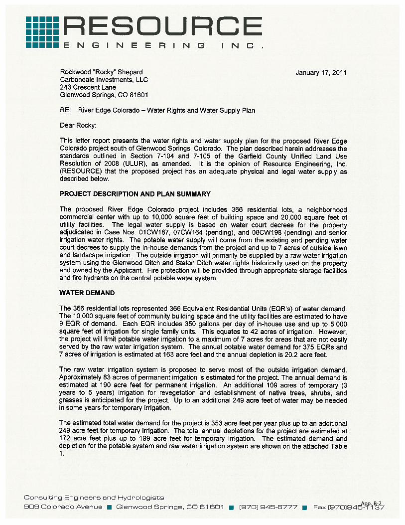
The following is drawn from a letter report prepared by Water Resources Engineer Michael J. Erion, P.E. of Resources Engineering, Inc. ("Resources Engineering Report") which presents the water rights and water supply plan for the Project (Appendix B).
A. WATER SUPPLY REQUIREMENTS FOR THE PROJECT THROUGH BUILD-OUT CONDITIONS
1. POTABLE WATER DEMAND
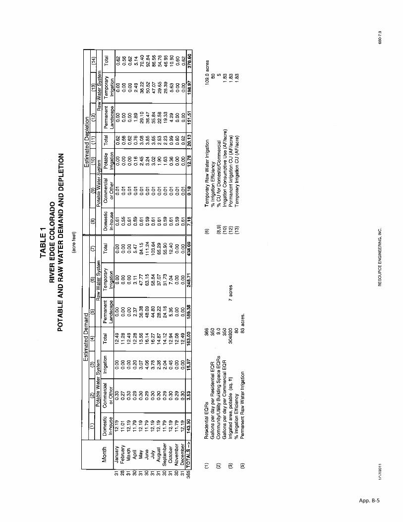
The potable water demand includes the indoor demand associated with 366 residential units, a neighborhood center of up to 10,000 square feet and 20,000 square feet of utility facilities. This equates to 366 EQRs (Residential Equivalents) for residential uses and 9 EQRs associated with non-residential uses for a total of 375 EQRs. An EQR represents 350 gallons/day in demand. The resulting potable water demand is shown in Table 1 of the Resources Engineering Report (Appendix B) is 163 acre feet.

Water Supply Plan River Edge Colorado, Garfield County, Colorado
8
2. RAW WATER DEMAND
The raw water demand includes both the outdoor residential and community space demands for irrigation water between April and October. The outdoor irrigated area is assumed to be 83 acres of permanent irrigated area and supplemental water for up to 109 acres during periods of revegetation of disturbed areas. Many of these areas are naturalized spaces which will not receive irrigation water on an ongoing basis. The estimated water demand for permanent irrigation as shown in Table 1 of the Resources Engineering Report (Appendix B) is 190 acre feet. Supplemental water demand associated with revegetation of disturbed areas is estimated at 249 acre feet. It should be noted that the permanent irrigation areas are shown at buildout conditions and that supplemental water is no longer demanded at that time. So the amount of water demanded is not totally cumulative. As areas are developed, supplemental water is decreased accordingly. As a result, there are never more than approximately 150 acres under irrigation at any one time during development.
B. PHYSICAL SOURCE OF WATER SUPPLY
1. POTABLE WATER
The potable water supply will be provided by the RFWSD alluvial wells located in the Aspen Glen and Coryell Ranch subdivision and surface diversions from the Roaring Fork River using the Robertson Ditch Rose Ranch Enlargement, Posy Pump and Pipeline (Iron Bridge Subdivision), or the RBC Roaring Fork Diversion (REC) water rights if the development is served by the RFWSD. If served by the POA, the potable water supply will e met by a surface water diversion at the RBC Roaring Fork Diversion (REC). Resource Engineering, Inc. notes that the yield of the physical water supply from the RFWSD alluvial wells and from the Roaring Fork River are not affected by dry year hydrologic conditions. The RBC Roaring Fork Diversion was appropriated for a flow rate of 1.25 cfs for domestic and municipal purposes including fire protection and irrigation.
2. IRRIGATION WATER
The physical source of water will be from the Roaring Fork River via diversion into the Glenwood Ditch and from Cattle Creek via diversion into the Staton Ditch. The Glenwood Ditch has decreed water rights totaling 50 cubic feet per second (cfs). CI owns 24.47% of the Glenwood Ditch decree equating to approximately 12.23 cfs. Historically, the Glenwood Ditch has had a full water supply, even in critically dry years.
The Staton Ditch diversion from Cattle Creek averaged 900 acre feet per year. CI owns 4.69 cfs of the 5.18 cfs of decreed Staton Ditch water.

Water Supply Plan River Edge Colorado, Garfield County, Colorado
9
C. ABILITY OF THE SUPPLY TO MEET WATER QUALITY REQUIREMENTS
1. POTABLE WATER
Potable water will be supplied by the RFWSD water distribution system from sources at their current alluvial wells or surface water diversions of the Project is served by the RFWSD. These sources and the treatment/ distribution system currently meet drinking water quality standards. If it is determined that surface water sources are necessary either through a supply from the RFWSD or POA, the surface water sources will be treated to drinking water standards utilizing a water treatment plant to be located on the Water and Wastewater Utility Tract (Tract AO or AR) within the Project Site. The treatment methods are discussed in the Water Treatment and Distribution Design Report, which accompanies this Plan as part of the REC rezoning and preliminary plan application. No specific or unusual treatment issues associated with utilizing the Roaring Fork River as a source are anticipated.
2. IRRIGATION WATER
The current source of irrigation water is anticipated to require basic filtering prior to distribution through the raw water irrigation system. The treatment and distribution system is discussed in the Raw Water Supply and Distribution Plan that accompanies the REC rezoning and preliminary plan applications. Cross connection controls and education/signage are important in ensuring the proper use of the irrigation water and limiting potential effects to users caused by improper use.
D. ESTIMATED YIELD UNDER VARIOUS HYDROLOGIC CONDITIONS
As discussed in the Resource Engineering Report, the sources of supply do not appear to be effected by drought conditions.
E. WATER CONSERVATION MEASURES
In house water conservation measures are not specifically proposed as part of the Project although low flush toilets and showerheads may be required. However, landscape plans are dominated by native and low water use species to reduce outdoor demand while maintaining a comfortable environment for residents. It is anticipated that the waterwise landscaping approach utilized will result in reducing demand by nearly at least twenty-five percent of that projected in Appendix B. In addition, community areas will be watered utilizing advanced temperature and precipitation sensitive irrigation systems to limit water supplies to the optimal supply based on landscape type and soils.
Finally, household use of raw water will be controlled through an incentive-based water rate policy that provides highly competitive water rates based on the water demands associated with the desired landscape forms with rates exponentially increasing above the desired application rates. This method, while not fully constraining the water demand, will result in reduced application rates and better landscape selection. It is

Water Supply Plan River Edge Colorado, Garfield County, Colorado
10
anticipated that these rate measures could reduce application rates by as much as fifteen percent of those estimated to determined irrigation demand.
F. WATER DEMAND MANAGEMENT MEASURES
Water demand management measures will be consistent with any demand management strategies implemented by the RFWSD or State of Colorado. No specific additional measures are proposed within the Project. As noted by Resources Engineering, Inc., the water supply sources have limited risk with respect to yield as a result of hydrologic conditions including the most severe droughts historically measured in the region.
G. PROOF OF A LEGAL WATER SUPPLY
1. POTABLE SUPPLY
As documented in the Resources Engineering Report, the legal water supply for the potable water system is based on the water court decrees in Case No. 01CW187, 07CW164 (pending) and 08CW198 (pending). In Case No. 01 CW187, a legal water supply for 349.55 EQR's and 3 acres of irrigation was adjudicated. The decree utilizes 62.6 acre feet of BWCD contract water for diversion at the RFWSD Aspen Glen Well Nos. 1-7, Coryell Ranch Well Nos. 1-14, and the Coryell Ranch Roaring Fork Diversion. The pending decree in Case No. 07CW164 provides for an additional 850.45 EQR's and 4 acres of irrigation to be diverted from the RBC Roaring Fork Diversion (River Edge Colorado), Well Field (River Edge Colorado) as well as the Robertson Ditch, Posy Pump and Pipeline, and the existing RFW & SD wells. The pending decree in Case No. 08CW198 provides for the 349.55 EQRs and 3 acres of irrigation to be diverted at the additional points of diversion identified in Case No. 07CW164. River Edge Colorado has amended BWCD Contract No. 381 for a total of 74.9 acre feet as required for all three water court decrees.
The three decrees and the BWCD contract provide a legal water supply for 1,200 EQRs and 7 acres of irrigation, which is more than adequate for the proposed 375 EQRs and up to 7 acres of irrigation.
2. IRRIGATION WATER
Also as documented in the Resources Engineering Report, the Glenwood Ditch is decreed for 12.23 cfs for irrigation uses and Staton Ditch is decreed for 4.69 cfs for irrigation uses. The water court Case No. W-2206 for the Unocal Sanders Ranch determined that the historic consumptive use is 439 acre feet on 260 irrigated acres of which the Project Site represents approximately 150 acres of the total irrigated areas. REC will require approximately 83 acres of permanent irrigation and 109 acres of temporary (3 to 5 years) irrigation. The senior irrigation water rights owned by REC are more than adequate for the proposed Project's raw water irrigation requirements.

Water Supply Plan River Edge Colorado, Garfield County, Colorado
11
IV. ADEQUATE CENTRAL WATER DISTRIBUTION SYSTEM
The distribution and treatment systems are discussed in the Potable Water Treatment and Distribution Design Report and Raw Water Supply and Distribution Report submitted concurrently with this Plan as part of the REC rezoning and preliminary plan applications. Both reports document the feasibility of serving the Project with water meeting the requirements of the ULUR.
Water Supply Plan River Edge Colorado, Garfield County, Colorado
APPENDIX A: VICINITY MAP AND PROJECT SITE MAP
App. A-1

12/01/10VICINITY MAP
Exhibit:
Date:
8140 Partners, LLC
Title:
Prepared by:
Owner/Developer:
Carbondale Investments, LLC7999 HWY 82Carbondale, CO 81623
Phone No:970.456.5325
App. A-2

Exhibit:
Date:
8140 Partners, LLC
Title:
Prepared by:
Owner/Developer:
Carbondale Investments, LLC7999 HWY 82Carbondale, CO 81623
Phone No:970.456.5325
12/01/10
App. A-3
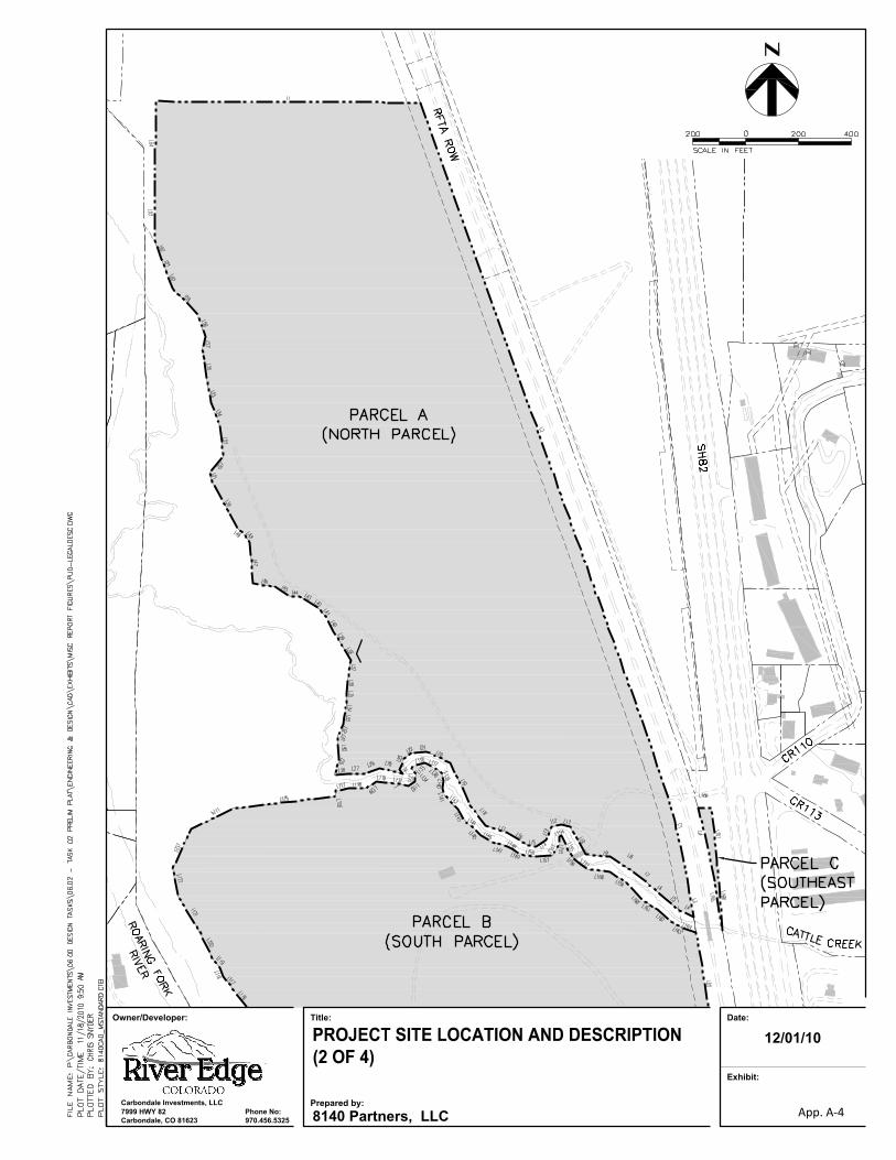
Exhibit:
Date:
8140 Partners, LLC
Title:
Prepared by:
Owner/Developer:
Carbondale Investments, LLC7999 HWY 82Carbondale, CO 81623
Phone No:970.456.5325
12/01/10
App. A-4

Exhibit:
Date:
8140 Partners, LLC
Title:
Prepared by:
Owner/Developer:
Carbondale Investments, LLC7999 HWY 82Carbondale, CO 81623
Phone No:970.456.5325
12/01/10
App. A-5
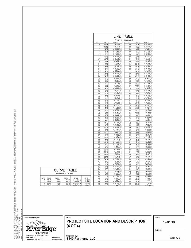
Exhibit:
Date:
8140 Partners, LLC
Title:
Prepared by:
Owner/Developer:
Carbondale Investments, LLC7999 HWY 82Carbondale, CO 81623
Phone No:970.456.5325
12/01/10
App. A-6

Water Supply Plan River Edge Colorado, Garfield County, Colorado
APPENDIX B: RESOURCES ENGINEERING REPORT
App. B-1
App. B-2
App. B-3

App. B-4
App. B-5