web based gis package for small area using open source software
TRANSCRIPT
Abstract—Geographic Information System is a collection of
hardware, software and data which is used for capturing and
managing geographically referenced information. It allows users to
view and interpret data in forms of maps, reports and charts etc.
Open Source refers to any program whose source code is made
available for use or modification as users or developers see fit. It is
usually developed as a public collaboration and made freely
available. The main purpose of the project is to develop a web based
GIS package for a small area using Open Source softwares, which
can be used as a service to store, add, edit or delete Road features
overlayed over a base map. The web service created will provide a
UI design where users can place mark any road feature on the Google
map and add information to that feature like Name, Width, and Type.
In addition to this a user can also edit and delete previously existing
features on the map. Client-Server architecture is used in this
application where Open Layers (A Java Script library for displaying
map data) is used on the client side and Python and CherryPy on the
server side. Apache has been used as the web server with Google
maps as the base layer and ZODB as the database.
Keywords—GIS, Open Source, Web Service, Map Features.
I. INTRODUCTION
HE application of Geographical Information System
(GIS) has been widely demonstrated in varied areas over
the years. GIS is a tool which helps users to view and interpret
data in form of maps, reports and charts etc. [1] With the
advent of new technologies, Commerce and Industry
discovered the huge potential of GIS, and started using it as a
great application tool. [2] The Geographic Information
Systems (GIS) has been developed for decades and
commercial software packages have been successfully
developed, for instance, ArcView, ArcGIS and MapInfo etc.
In the last few years, there has been a significant development
in the area of free and open source geospatial software e.g.
OpenStreetMap, Map Server, Open Layers etc. The purpose
of this work is to create a web based GIS package for small
area using Open Source Software, which can be used as a web
service to add, store, edit and update any feature layer ( like
road, landuse, administrative boundary, drainage etc ) over a
map and that can serve for small city, campus, locality or
Roheet Bhatnagar is working as Professor & Head, Department of
Computer Science & Engineering in Manipal University Jaipur, Rajasthan
(+91 8003897115; e-mail: [email protected]).
Gagan Bansal is working as an Architect, GIS division, Rediff, Mumbai,
India (e-mail: [email protected]).
village. We have focused on the road layer. A user can tag any
road (add Name, Type and Width of the road) over the map.
The user can also edit and delete the road features on the map.
A person who is new to the locality can benefit greatly with
this application as he will get information regarding different
locations in the campus with one look at the map. To achieve
this task client-server architecture [3] was employed where
JavaScript and HTML were used for client side coding and
python with cherrypy for the server side. Open Layers [4] is
an Open Source map viewing framework written in JavaScript
for displaying map data in most modern web browsers and
implements a JavaScript API for building rich web-based
geographic applications, similar to the Google Maps and MSN
Web based GIS package for small area Using Open Source
Software Virtual Earth APIs, with one important difference -
OpenLayers is Open Source Software. Python is object
oriented programming language and cherrypy and routes are
used here to create web service. We have used Apache as the
web server and ZODB as database. ZODB is an object
oriented database for storing python objects. As a reference
the campus GIS of Oregon University, USA was studied. The
interactive map of University of Oregon shows a campus map
with various layers like Level, construction, bus Stop, Road,
Parking etc. The users are allowed to select from the options
of various layers. Once the layers are selected, that layer of the
map is highlighted. The users can use the navigation tools to
browse the map, and can also use the search box to find
information and locations of key features, buildings, and
resources.
A. Geographic Information System
Geographical Information System or Geo Informatics
System can be defined as a collection of hardware, software
and data which is used for capturing and managing of
geographically referenced information. GIS allows us to view
and interpret data in many ways in forms of maps, reports and
charts etc. [1] One can answer questions and solve problems
by looking at the data in a way that is quickly understood and
easily shared with the help of GIS. In a general sense, the term
describes any information system that integrates, stores
analyzes geographic information for informing decision
making. The application of GIS has been widely demonstrated
in varied areas over the years. Initially, such application was
limited to the realm of natural resources where most of the
input sources predominantly consisted of spatial data such as
satellite images, aerial photographs and conventional paper
Web based GIS Package for Small Area Using
Open Source Software
Roheet Bhatnagar, and Gagan Bansal
T
International Journal of Computer Science and Electronics Engineering (IJCSEE) Volume 2, Issue 1 (2014) ISSN 2320-401X; EISSN 2320-4028
15

maps. In course of time, with the advent of new technologies,
commerce and industry discovered the huge potential of GIS,
and started using it as a great application tool. [2] Recent
studies concerning GIS show that it is the fastest growing
segment (both hardware & software) of the graphical
computer market.
B. Web Services
A web service can be defined as a method of
communication between two devices over a network. It is a
software system which supports two interoperable machines to
interact over network. Web services are published, found and
used through web. Web applications are simple applications
that run on the web. These are built around the web browser
standards and can be used by any browser or any platform. By
using web services our application can publish its function or
message to the rest of the world. With Web services we can
exchange data between different applications and different
platforms.
Web Services offer many advantages over other types of
distributed computing architectures. [5]
Interoperability - Web Services typically work
outside of private networks, offering developers a
non-proprietary route to their solutions. Moreover,
Web Services are virtually platform-independent.
Web based GIS package for small area Using Open
Source Softwares
Usability - This gives your applications the freedom
to choose the Web Services that they need. This
allows us to develop services and/or client-side code
using the languages and tools that we want.
Reusability - This makes it easy to reuse Web
Service components as appropriate in other services.
It also makes it easy to deploy legacy code as a Web
Service.
Disadvantages of Web service:-
Web services use plain text protocols. This means
that Web service requests are larger than requests
encoded with a binary protocol. The extra size is
really only an issue over low-speed connections, or
over extremely busy connections.
Although HTTP and HTTPS (the core Web
protocols) are simple, they weren't really meant for
long-term sessions. Typically, a browser makes an
HTTP connection, requests a Web page and maybe
some images, and then disconnects. The interaction is
difficult with Web services.
The problem with HTTP and HTTPS when it comes
to Web services is that these protocols are
"stateless"—the interaction between the server and
client is typically brief and when there is no data
being exchanged, the server and client have no
knowledge of each other. More specifically, if a
client makes a request to the server, receives some
information, and then immediately crashes due to a
power outage, the server never knows that the client
is no longer active. The server needs a way to keep
track of what a client is doing and also to determine
when a client is no longer active.
C. Open Source Technology
In general, open source refers to any program whose source
code is made available for use or modification as users or
other developers see fit. Open source software is usually
developed as a public collaboration and made freely available.
Open source gained hold with the rise of the Internet, and the
attendant need for massive retooling of the computing source
code. Opening the source code enables a self-enhancing
diversity of production models, communication paths, and
interactive communities which is very helpful in the easy and
fast development. Developing software using an open-source
model is becoming increasingly popular. The main advantages
that open-source software has over proprietary (closed-source)
software are:
Lower development cost. Individuals and smaller
companies may aid in developing the software,
reducing the number of programmers you have to
pay yourself.
Bug detection and correction. With more people
viewing your code from more diverse backgrounds,
bugs will be found and fixed faster. This is often
referred to as "Linus' Law": 'Given enough eyeballs,
all bugs are shallow."
Reuse of code and shorter development time. Code
from an older or different project can be incorporated
into your new project, reducing the time it takes to
create and develop it.
More independence - with a closed source project,
you will have great problems Web based GIS
package for small area Using Open Source Softwares
if the developer goes out of business and you need
your software updated or fixed. With the code open,
any company can step in to fill the void. There may
be some disadvantages to open-source software from
a development perspective, though rarely any from
the end-user perspective.
The main problems are:
Disclosure of trade secrets. Having the code for a
program available implies revealing how it works.
This includes disclosure of algorithms and how a
device with a unique design might function.
Revealing this information to others may cause
duplication and loss of financial advantage.
Loss of revenue through traditional sales. If the
source is available, then it is unlikely that consumers
will pay a large amount for a CD or license. Revenue
must instead be garnered through support
agreements.
D. Open Layers
Open Layers [6] is a pure JavaScript library for displaying
map data in most modern web browsers, with no server-side
dependencies. Open Layers implements a JavaScript API for
building rich web-based geographic applications, similar to
the Google Maps and MSN Virtual Earth APIs, with one
International Journal of Computer Science and Electronics Engineering (IJCSEE) Volume 2, Issue 1 (2014) ISSN 2320-401X; EISSN 2320-4028
16

important difference - Open Layers is Open Source Software.
Furthermore, Open Layers implements industry-standard
methods for geographic data access, such as the OpenGIS
Consortium's Web Mapping Service (WMS) and Web Feature
Service (WFS) protocols. Open Layers is written in object
oriented JavaScript. Open Layers is intended to separate map
tools from map data so that all the tools can operate on all the
data sources. Open Layers makes it easy to put a dynamic map
in any web page. It can display map tiles and markers loaded
from any source. Open Layers is developed and supported by
a number of organizations around the world. Open Layers also
has capability for vector data editing at client side for all
geometry types.
E. Apache
Apache [7] is web server software notable for playing a key
role in the initial growth of the World Wide Web. In 2009 it
became the first web server software to surpass the 100
million web site milestone. It has evolved as a rival to other
web servers in terms of functionality and performance.
Apache supports a variety of features, many implemented as
compiled modules which extend the core functionality. These
can range from server side programming language support to
authentication schemes. Some common language interfaces
support Perl, Python and PHP. Apache features configurable
error messages, DBMS-based authentication databases, and
content negotiation. It is also supported by several graphical
user interfaces (GUIs). Although the main design goal of
Apache is not to be the "fastest" web server, Apache does
have performance comparable to other "high-performance"
web servers. Apache is developed and maintained by an open
community of developers under the auspices of the Apache
Software Foundation.
F. Python
Python is an object-oriented high-level programming
language with dynamic semantics that lets us work more
quickly and integrate our systems more effectively. Its high-
level built in data structures, combined with dynamic typing
and dynamic binding, making it very attractive for Rapid
Application Development, as well as for use as a scripting or
glue language to connect existing components together.
Python's simple, easy to learn syntax emphasizes readability
and therefore reduces the cost of program maintenance. It
helps in immediate gains in productivity and lower
maintenance costs. Python is a remarkably powerful dynamic
programming language that is used in a wide variety of
application domains. Python runs on Windows, Linux/Unix,
Mac OS X, and has been ported to the Java and .NET virtual
machines. Python is free to use, even for commercial
products, because of its OSI-approved open source license.
II. METHODOLOGY
A. Scope of Research
The scope of our research aimed at developing a web based
GIS package for a small city, campus, locality or village,
which can be used as a web service to add, store, edit and
update the features over a map.
The GIS package developed should be capable of serving the
following purposes:-
Creation of new features like Roads over the map,
and setting its attributes.
Retrieval of information from Road layer e.g. road
data from „road layer‟.
Edit the Geometry and attributes of a feature.
Use customized queries for locating a specific
feature.
Posting the modifications in feature data from client
to server.
Updating the existing information in the DB.
In this application, a user will be initially provided with a
map of a small region with Navigation tools shown over the
map. The user will be provided with different buttons named
Navigation, New, Edit, Delete, Query and Save just above the
map. Different buttons will be having different strategies
associated to them. The users can use the navigation tools to
browse the map. Once the user selects the New button, the
draw control will be activated and user can draw roads over
the map. Just after a user finishes drawing the road, a Sidebar
will open at the right side of the map with a form for entering
the attributes of the feature drawn. After the user clicks on the
Submit button, the attributes values will be set for that feature.
When the user clicks on Edit button, select control will be
activated i.e. user can select a feature that he/she wants to edit.
On the selection of a feature on the map, the attribute form
showing attribute values will open at the right side of map.
The user can edit the Geometry as well as attribute values of
the selected feature. When the user clicks on the Delete button
and selects the feature to be deleted, the feature will be deleted
from the map. The user can also locate feature by framing
customized queries with the help of Query button provide in
the interface. After making any changes to the geometry
and/or attribute values of a feature, user can use the Save
button to save the changes made. Also after deleting a feature
from the map, user should use the Save buttons to
permanently delete the feature data from DB.
The GIS package thus developed can be used as a web
service to add, store, edit, delete and update the different
layers over a base map, and its feature attributes (e.g. Road
layer in the present case). OpenLayers is used as the
framework for viewing the Open Source map. The application
developed is based on Client-Server architecture. The client
side coding was done using JavaScript, HTML, and
OpenLayers library. The server side coding was done using
Python with Cherrypy. Apache is used as the web-server, with
ZODB serving as the database for storing the features on the
map. The GUI for the application has been kept very simple,
interactive and user friendly so that it can cater to the needs of
both novice and the expert users of Geo Informatics System.
B. Implementation Goals
The GIS package is designed and developed in such a way
that it can be used as a simple web service for storing and
International Journal of Computer Science and Electronics Engineering (IJCSEE) Volume 2, Issue 1 (2014) ISSN 2320-401X; EISSN 2320-4028
17
managing the features over a map. For the initial version,
Google maps are used as a base layer. The revisions to the
application would include more base layers like OSM and
Bing, and they can be integrated together to provide a better
interface. Currently only one layer, Road layer is overlayed
over the map; later versions would include more layers like
Building layer, Water-bodies layer, Boundary layer etc. The
subsequent revisions of the application would incorporate
separate user and admin modules so that users can only post
the changes in features to administrator. The administrator in
turn, after verification, should post the request to server, to
make suitable changes in the DB.
C. Proposed solution architecture
For the problem stated above, Open Layers was used as a
framework for viewing the maps and rendering the features
like Roads over it. GET method is used by the client for
retrieving data from the server. POST method is used for
posting data from client to server. Since Open Layers is a pure
JavaScript Library which helps us to store and manage spatial
data, the client side coding for creating GUI was done with the
help of JavaScript and HTML. Google maps were used as the
base layer and Road layer was added to the map with the help
of vector-editing for managing the features and their
attributes. Apache was used as the web server for rendering
the maps and features in the browser. Server-side coding was
done in Python with Cherrypy. [8] For storing the features and
the associated data, ZODB (Zope Object Data Base) was used
as the database.
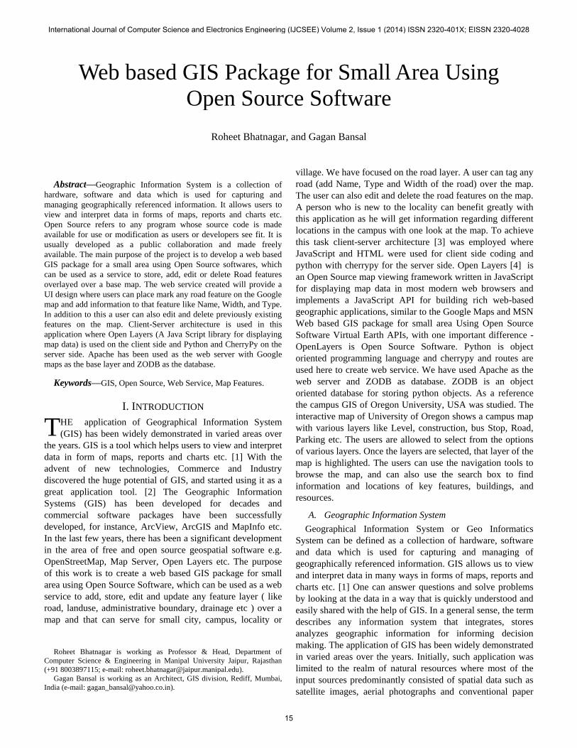
The architecture of the system has been shown in Fig 1.
Fig. 1 Overall System Architecture
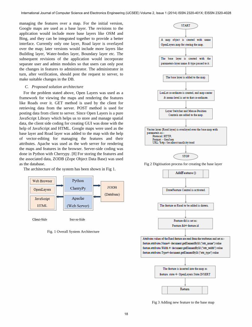
Fig 2 Digitisation process for creating the base layer
Fig 3 Adding new feature to the base map
International Journal of Computer Science and Electronics Engineering (IJCSEE) Volume 2, Issue 1 (2014) ISSN 2320-401X; EISSN 2320-4028
18

Fig 4 Editing the feature in the base map
Fig 5 Saving the feature in the base map
Fig. 6 Querying the feature from the base map
International Journal of Computer Science and Electronics Engineering (IJCSEE) Volume 2, Issue 1 (2014) ISSN 2320-401X; EISSN 2320-4028
19

B. Pseudocode
Init() Module
/*
In this module the base map is created. We are using
Google maps as the bas map. After that a vector is overlared
over it to form the road layer
*/
Steps:
1. Begin
2. Map new OpenLayers.Map('map')
3. gsat new OpenLayers.Layer.Google("Base Layer")
4. map.projection "EPSG:900913"
5. saveStrategy new OpenLayers.Strategy.Save()
6. vectors new OpenLayers.Layer.Vector("Layer
Name”, strategies, protocol_Name(url,format) )
7. map.addLayers ([gsat, vectors])
8. map.addControl ( OpenLayers.Control.LayerSwitcher())
9.map.addControl(new OpenLayers.Control.MousePosition())
10.New Open.Layers.Control.DrawFeature(vectors,Handler_type)
11. Edit OpenLayers.Control.ModifyFeature(vectors,Handler_type)
12. Delete OpenLayers.Control.DeleteFeature(vectors,Handler_type)
13. map.setCenter(new OpenLayers.LonLat(latitude,
longitude), zoom_level)
AddFeature() Module
/*
This modules is used for creation of a features with the help
of vector editing.
*/
Steps:
1. feature map.featureToEdit;
2. feature.fid feature.id
3.feature.attributes.Name document.getElementById("attr_name").value
4.feature.attributes.Width document.getElementById("attr_width").value
5.feature.attributes.Type document.getElementById("attr_type").value
6. feature.state OpenLayers.State.INSERT
7. map.featureToEdit null
8. Return
EditFeature() Module
/*
This module deals with edittiong the existing features of the
map.
*/
Steps:
1. feature map.featureToEdit;
2. feature.attributes.Name document.getElementById("attr_name").value
3. feature.attributes.Width document.getElementById("attr_width").value
4. feature.attributes.Type document.getElementById("attr_type").value
5. feature.state OpenLayers.State.INSERT
6. map.featureToEdit null
7. Return
DeleteFeature(feature) Module
/*
This module implements the deletion of a feature from the
map.
*/
Steps:
1. If feature.fid = undefined, then
2. this.layer.destroyFeatures([feature])
3. else
4. feature.state OpenLayers.State.DELETE
5. feature.renderIntent "select"
6. this.layer.drawFeature(feature)
7. End if
8. Return.
Query() Module
/*
This module deals with the steps needed to use customized
queries based on user
requirements.
*/
Steps: 1. layer map.getLayersByName("Road Layer")[0]
2. features layer.features
3. selectedFeatures [ ]
4. for I 0 to features.length, do
5. var feature = features[i];
6. if(feature.attributes.Name/Width/Type== require_value, then
7. selectedFeatures.push(feature);
8. layer.selectedFeatures
layer.selectedFeatures.concat(selectedFeatures)
9. End if.
10. End for.
11. for I 0 to selectedFeatures.length, do
12. selectedFeatures[i].renderIntent = "select";
13. vectors.redraw();
14. bounds selectedFeatures[i].geometry.getBounds();
15. End for.
16.
map.setCenter(bounds.getCenterLonLat(),map.getZoomForExtent(bounds));
17. Return
III. RESULTS AND DISCUSSIONS
The modules of the application were tested for their
functionalities and they were found to be up to the mark vis-à-
vis functionality. The working web based GIS package for
small area thus can be used as a service to add, store, edit,
delete and update the road feature and the associated details.
The user interface provides nice and easy approach for the
user and system interaction showing the power of open source
technologies. A very simple GUI developed is easy to
understand and allows the user to explore different
functionalities of the package. Appropriate warning messages
to indicate the errors have been provided when erroneous
input is given by the users. These error handling features
guide the user at each step while using the application. The
user is prompted to re-enter the corresponding correct input
value, when improper input is entered. The GIS package
developed is very user-friendly, and provides a very
convenient method to manage the information related to the
roads of a small area.
This package can be used for any small city, campus or
International Journal of Computer Science and Electronics Engineering (IJCSEE) Volume 2, Issue 1 (2014) ISSN 2320-401X; EISSN 2320-4028
20
locality.
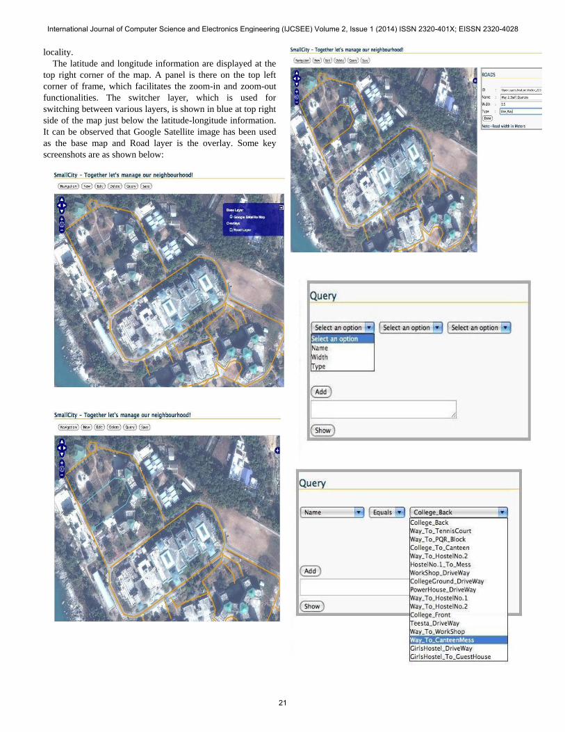
The latitude and longitude information are displayed at the
top right corner of the map. A panel is there on the top left
corner of frame, which facilitates the zoom-in and zoom-out
functionalities. The switcher layer, which is used for
switching between various layers, is shown in blue at top right
side of the map just below the latitude-longitude information.
It can be observed that Google Satellite image has been used
as the base map and Road layer is the overlay. Some key
screenshots are as shown below:
International Journal of Computer Science and Electronics Engineering (IJCSEE) Volume 2, Issue 1 (2014) ISSN 2320-401X; EISSN 2320-4028
21

IV. FUTURE SCOPE
The system still has immense scope for expansions and
some of them are enlisted below:-
More base layers can be added like Virtual Earth,
Bing, and MSN.
More vector layers like Building layer, boundary
layer, water body layer can be added.
Separate user and admin modules should be
implemented for better functionality and
maintainability.
To make it scalable the GET strategy need to be
changed, features should be accessed within the
bounding box or tile wise.
Notice publishing feature can be included where
users can put up notices indicating recent changes in
the features like „Road block for some specific
reason‟.
Further the customization of the web service to
provide for localized services can be done.
ACKNOWLEDGEMENT
Authors would like to acknowledge and thank Mr. Vineet
Kumar, Mr. Suraj Pratap Singh and Mr. Adarsh Sameer
Sharma ex-students of Sikkim Manipal Institute of
Technology, Sikkim, India for the implementation of the idea.
REFERENCES
[1] C. P. Lo & Albert K. W. Yeung, “Concepts and Techniques of
Geographic Information Systems”, 2nd edition, Prentice Hall, Aug 2006
[2] Ian Heywood, Sarah Cornelius, Steve Carver & Srinivasa Raju, “An
Introduction to Geographical Information Systems”, 3rd edition,
Pearson, 2010.
[3] Peter Robins, “Using OpenLayers: Editing Vectors”, April 2010,
[available online http://www.peterrobins.co.uk/it/oledit.html]
[4] Client Server Architecture, June 16, 2009, [available online
http://www.roseindia.net/java/network/client-server.shtml]
[5] Advantages and Disadvantages of Webservices, November 19, 2007,
[available online http://social.msdn.microsoft.com/forums/en-
US/asmxandxml/thread/435f43a9-ee17-4700-8c9d-d9c3ba57b5ef/]
[6] OpenLayers Documentation:Controls, [available online
http://docs.openlayers.org/library/controls.html]
[7] Apache HTTP Server Version 2.2 Documentation, [available online
http://httpd.apache.org/docs/2.2/]
[8] CherryPy Tutorials, [available online http://www.cherrypy.
org/wiki/CherryPyTutorial]
Dr. Roheet Bhatnagar Received his B.Tech. in
Computer Science and Engineering and M.Tech. in
Remote Sensing from Birla Institute of Technology,
Mesra, Ranchi, India in 1996 and 2004 respectively. He
did his PhD in Computer Science & Engineering from
Sikkim Manipal Institute of Technology under Sikkim
Manipal University, India. He is having more than 16.5
years of varied experience in the software industries and academics. He had
worked in multinationals viz; Xerox Modicorp Ltd., Samsung SDS India Pvt.
Ltd. and USHA Soft (a software subsidiary of USHA Martin Ltd.) in Gurgaon
from 1997 till 2003 just after his graduation. During his stint in the industry he
had a good exposure to software development executing many projects with
different roles and responsibilities. He joined Department of Remote Sensing
at BIT Mesra, Ranchi in the year 2003 and worked as Assistant Professor till
2008. He joined as an Associate Professor in Sikkim Manipal Institute of
Technology (SMIT) - a constituent college of Sikkim Manipal University
(SMU) in 2008 and is presently serving as Professor & Head in the
Department of Computer Science and Engineering at Manipal University
Jaipur. He has a number of publications in indexed international journals and
national and international conferences. He is a life member of professional
societies like Indian Society of Remote Sensing (ISRS), Indian Society of
Technical Education (ISTE), and International Association of Engineers
(IAENG). His current areas of interest are, soft computing, fuzzy and neural
networks, database management systems, data mining and knowledge
discovery, Remote Sensing and Geographical Information Systems (RS-GIS),
and software engineering. He can be reached at [email protected]
Gagan Bansal is working as an Architect Rediff Maps
(Application Development) at Rediff.com, Mumbai. He
received his Engineering Degree in Civil Engineering
from GZS College of Engineering and Technology,
Bathinda, Punjab, India. He did his MTech in Remote
Sensing from BIT Mesra, Ranchi and is vastly
Experienced Professional. Prior to joining Rediff, he has worked with NRSA,
Hyderabad and Reliance, Mumbai.
International Journal of Computer Science and Electronics Engineering (IJCSEE) Volume 2, Issue 1 (2014) ISSN 2320-401X; EISSN 2320-4028
22