welcome to flying in the bristol area - fly...
TRANSCRIPT

1
WELCOME TO FLYING IN THE BRISTOL AREA
Introduction
The object of this guide is to assist with flying below, around, and through Bristol Controlled Airspace (EGGD) - CLASS D. Previously Bristol Airspace was an island in the FIR now it is connected to Cardiff Airspace and the Airways system. There are many options to route around or through the airspace (transit through the CTR and CTA’s is subject to permission, traffic and weather). We will endeavour to accommodate your requests as much as we can, but sometimes that will not be possible without delay so it may be better i.e. quicker, to plan to go around or below, to save your time and money; however if you are having ANY weather or navigation problems please do not be frightened to say so. We want to help. Irrespective of the challenges posed by the airspace there are many additional hazards in the Bristol area; some marked on the chart, some not. Marked Hazards Unmarked Hazards Bird Reserves Hot Air Balloons Gliding Sites Gliders Small Airfields/Airstrips Paragliders / Paramotors Military Units Hangliders ATZs Farm Strips Danger Areas Fast Military Jets Restricted Areas Microlights High Ground Model Aircraft Masts UAVs
All of these require planning and a good scan of the air and ground whilst en-route, be careful not to get sucked into the cockpit with all your gadgets! In VFR flying the windows need maximum usage. ENJOY THE VIEW Version 6: Updated 1st March 2016 Changes: Published LARS hours, minor text changes Also available at www.flyontrack.co.uk
List
enin
g Sq
uaw
k 5
07
7
Mo
nit
or
Bri
sto
l Rad
ar 1
25
.65
0

2
Planning and Local ATC Procedures Guide Due to the close proximity of other air traffic control units in the Bristol area e.g. , Cardiff, Yeovilton, it is likely that you will be talking to them first and also held on their frequency until very close to Bristol controlled airspace; however it is your responsibility to remain outside controlled airspace until a clearance has been issued for entry. So if you are planning to ask for airspace transit please ask early and be prepared to descend, climb or deviate. Your transit will require planning by us as well as you. Remember if you are VFR you must remain VMC within controlled airspace, but get permission before deviating from your clearance. Transition Altitude The transition altitude for all flights within or below Bristol controlled airspace is: 6000ft Altitude – Bristol QNH Bristol QNH can be obtained from Bristol ATIS 126.025 Lower Airspace Radar Service (LARS) LARS is available in the area from: 10:00-18:00 LOCAL TIME Bristol Radar – Frequency 125.650 Offering the following types of service, all available to VFR & IFR
Deconfliction Service (IFR only)
Traffic Service
Basic Service
Alerting Service Controlled Airspace There are a number of airspace base changes within the Bristol area: always refer to the current Southern England ½ mil or ¼ mil aeronautical chart . The ¼ mil chart can give much more information on local villages & towns for possible easier navigation. When flying in the Bristol area it is wise to give yourselves a margin for error/distraction both vertically and horizontally.

3
Frequency Monitoring Code (Listening Squawk) Bristol Radar has a listening squawk: 5077. This is to be used by aircraft flying in the vicinity of Bristol airspace who are monitoring frequency 125.650 but who do not require entry to Controlled airspace or who do not wish to communicate with the controller. When leaving the area pilots must squawk 7000, with Mode C, if available. A listening squawk does NOT
clear you into controlled airspace, or
mean you are receiving any ATC service. Pilots remain responsible for their own navigation and in particular for obtaining permission to enter the Bristol Controlled airspace. The controller may call you to identify yourself and request your intentions. Further details are available. UK AIP ENR Operating procedures-Monitoring Codes or www.flyontrack.co.uk Approaching From South of Bristol Providing a LARS service just to the south of Bristol controlled airspace is Yeovilton Naval Air Station “YEOVIL RADAR” 127.350: generally open Monday - Friday but sometimes gliding on the weekends. The Yeovilton AIAA (Area of Intense Aerial Activity) is notified from surface to altitude 6000ft (Portland regional QNH) within Class G airspace. Despite the Sea Harriers previously based there having been decommissioned the base is still busy with helicopters and there are lots of fast jets from Boscombe Down and other UK military airfields manoeuvring in the area.
KEEP A SHARP LOOKOUT
Approaching From Northwest and West Of Bristol
Providing a LARS to the west of Bristol is Cardiff. “CARDIFF RADAR”119.150 There are a number of airspace base changes within the Cardiff area: always refer to the current Southern England ½ mil or ¼ mil aeronautical chart. YOU MUST NOT ENTER CARDIFF AIRSPACE WITHOUT PERMISSION Despite the Bristol and Cardiff airspace being adjoined at certain points, transit clearance through the airspace of one unit does not give permission to enter the controlled airspace of the other, please be specific with your request. If your routeing requires entry clearance into adjacent controlled airspace and you are unsure that you have received permission please clarify with the controller that they are arranging it on your behalf. Once more due to the proximity of this airspace, there may well be a last minute frequency change. PLEASE BE READY

4
Approaching From North and East of Bristol
Filton Airfield ,ATC and ATZ is now closed.(31/12/12). There remains however a Police helicopter and Air ambulance helicopter operating regularly from the Filton site. The likelihood is that you will have spoken to one of these agencies before contacting Bristol
Gloucester 128.550
Brize Radar 124.275
Kemble 118.900
FIR South 124.750
Farnborough Radar 125.250 You now have several options. Talk to Bristol for a service Choose not to talk to Bristol but avoid the Controlled airspace Talk to Bristol for an airspace transit BE ORGANISED with your navigation AND/OR BE PROACTIVE ON THE RADIO
Caution the following airspace and activities:
Colerne ATZ 2593ft Regional QNH
Lyneham ATZ 2513ft Regional QNH(active by notam only)
Keevil gliding site
Hullavington gliding site
Salisbury Danger Areas ,contact “SALISBURY OPS” 122.750 There are lots of aircraft of all kinds transiting North and South below airway L9 and to the east of Bristol controlled airspace. This area is covered in more depth in the VRP sections for:
M4 Junction18
Bath Racecourse
Chippenham
Devizes
Radstock
Frome
…. later in this guide.

5
Visual Reference Points (VRP) The following VRP have been established to assist your navigation in the vicinity of Bristol controlled airspace: DME is available 110.15
Barrow Tanks Reservoirs (512423N 0023946W) 2 nm / BRI 056° MAG
Bath Racecourse (512501N 0022415W) 12 nm / BRI 083° MAG
Cheddar Reservoir (511647N 0024805W) 7 nm / BRI 211° MAG
Chew Valley (511930N 0023542W) 5 nm / BRI 129° MAG
Clifton Suspension Bridge (512718N 0023740W) BCN 126°/28.8nm
Chippenham (512736N 0020724W) CPT 269°/34 nm
Churchill (512000N 0024736W) 4 nm / BRI 229° MAG
Clevedon (512621N 0025105W) 6 nm /BRI 308° MAG
Devizes (512048N 0015918W) CPT256°/30 nm
East Nailsea (512548N 0024406W) 2 nm / BRI 352° MAG
Frome (511347N 0021913W) 17 nm /BRI 124° MAG
M4 Junction 18 (513007N 0022100W) 15 nm / BRI 066° MAG
M5 Sedgemoor Services (511608N 0025517W) 10 nm / BRI 232° MAG
M5 Avon Bridge (512920N 0024135W) 6 nm / BRI 012° MAG
Old Severn Bridge (M48) (513640N 0023837W) 14 nm / BRI 015° MAG
Radstock (511732N 0022655W) 11 nm /BRI 121° MAG
Wells Mast (511413N 0023731W) 9 nm / BRI 161° MAG
Weston Aerodrome (512016N 0025633W) 8 nm / BRI 256° MAG
Note: The Wells Mast is referred to as the Mendip mast at AIP ENR 5.4.1. Pilots are advised to use caution when routing via this VRP due to the nature of this lighted Air Navigation Obstacle at height 1009 ft agl, 2003 ft amsl

6
Visual Reference Points (VRP) (cont) All VRPs are for reference only. PLEASE DO NOT FLY OR HOLD EXACTLY OVER VRPS: IF YOU HAVE TO, KEEP A SHARP LOOKOUT. The X-section profile shows suggested routeings around or below Bristol controlled airspace. All of these routes require caution and a good lookout as unfortunately (due to the nature of the airspace) aircraft tend to be funnelled into these areas. You may encounter multiple aircraft; some with no radio, or no engine and often not communicating with ATC.
BRISTOL CONTROLLED AIRSPACE UPPER LEVEL FL105
4500 ft
Cardiff CTA
Class D
Bristol CTA
Class D
Bristol CTR Class D
1000 ft 1500 ft 1500 ft 1500 ft
2000 ft 2000 ft
3500 ft
Airway L9 FL 65
CLEVEDON
M5 SEDGEMOOR
THORNBURY
WELLS MAST
YATE
RADSTOCK
M4
JUNC 18
FROME
BADMINTON
FROME
Bristol CTA
Class D
Lyneham ATZ
2513 ft *NOTAM
ONLY
Colerne ATZ
2593 ft

7
Suggested Routeings For Flying Around/Below/Outside Bristol Airspace
West of the Airspace NORTH M5 AVON BRIDGE WESTON (Remaining west of the M5) M5 SEDGEMOOR SERVICES Below 1500ft Bristol QNH SOUTH East of the Airspace NORTH THORNBURY BATH RACE M4JUNCTION18 BADMINTON COURSE CHEW VALLEY COLERNE CAUTION COLERNE ATZ 2593’ AMSL
WELLS MAST RADSTOCK FROME FROME CAUTION 2003’AMSL 1009’AGL LIT BY RED LIGHTS
Below1500ft Below2000ft QNH Below3500ft QNH Below4500ft QNH Bristol QNH Better Route Even Better Even Better For Altitude Route Route SOUTH

8
VRP GUIDE
Routeing to the West
Plan to route along the coast:
M5 AVON BRIDGE (CAUTION LOTS OF VFR TRAFFIC)
CLEVEDON (CAUTION AERIALS 377’ QNH)
WESTON DISUSED (CAUTION HELICOPTERS OPERATING FROM THE MUSEUM)
M5 SEDGEMOOR SERVICES The land is much lower here not always attracting the low cloud that the Mendip Hills (to the south of the airport stretching from Weston to Frome) or the airport do: however to remain outside controlled airspace on this route you must remain below 1500ft Bristol QNH.

9
M5 Avon Bridge (¼ mil map) Referred to as VRP M5 bridge on the ½ mil map
If you are following the M5 motorway you can’t miss this VRP as it is the M5 bridge across the River Avon on a north /south axis, but here you may meet a lot of VFR aircraft, (helicopters, fixed wing, and microlights) some holding inbound to Bristol and some just passing. From the south you will have just routed under the Bristol CTA. From the north you may have just spoken to Brize Radar ,Gloucester, Kemble or FIR South . Filton is now closed (31/12/12), however Police and Air ambulance helicopters still operate regularly day and night from this site. If you have not changed frequency by now ASK. You are responsible for monitoring your position outside controlled airspace.
M5 Avon Bridge Looking North

10
Clevedon
The small coastal town is most easily spotted by the pier but watch out for the masts on the south side of town, only 377ft Bristol QNH, but you will be flying below 1500ft Bristol QNH. KEEP A GOOD SCAN FOR TRAFFIC D121 is now closed and has been removed from the charts since 2013. Fly below 1500ft Bristol QNH to remain outside the CTA.
Looking north the pier can easily be seen & also the M5 running through the cutting.

11
Weston Aerodrome (Disused)
The old aerodrome is the VRP: although this is disused for fixed wing traffic, helicopters often operate from here in association with the helicopter museum.
KEEP A GOOD LOOK OUT Fly below 1500ft Bristol QNH to remain outside the CTA.
Weston Disused Airfield as seen following the M5 northbound. Note the railway line. CAUTION-Soon new houses will be built and it will become less defined.

12
M5 Sedgemoor Services
This motorway service station is on both sides of the motorway just to the northeast of the prominent hillock – Brent Knoll (449ft amsl). This VRP lies beneath the CTA. Fly below 3000ft Bristol QNH to remain outside the CTA. Just to the north of this VRP the base of the CTA is 1500ft Bristol QNH.
Sedgemoor Services viewed from the south.

13
Cheddar Reservoir
This circular reservoir is easy to see from all directions. If there is a southerly wind there is a possibility when holding that you may be blown (northwards) into the airspace. Halesland gliding site is just to the east of and very close to this VRP, look out for gliders soaring the ridge. This VRP lies beneath the CTA. Fly below 3000ft Bristol QNH to remain outside the CTA. Just to the north of this VRP the base of the CTA is 1500ft Bristol QNH.
Cheddar Reservoir looking south

14
Routeing to The East
Caution this map shows Airway L9 to the north of Bristol airspace Note the change in airway base level just east of Kemble FL65 Kemble and west base FL75 This is only shown on the ½ mil chart not on the ¼ mil Too high? In the airway? Check! Commencing 1st October 2011 airspace to the east of Bristol has changed radically for the private pilot making navigation around the area much easier. The Lyneham CTA/CTR has been removed permanently and all that remains is the Lyneham ATZ , however this is to be only activated by notam on an irregular basis.

15
M4 Junction 18
Approaching this junction from the north you may have just spoken to Brize Radar,Gloucester,Kemble or FIR South. There is more altitude available here to transit below and outside the Bristol controlled airspace, but also more hazards:
Hot air balloons
Garston Farm strip
Private farm strips not marked
Gliders transiting from gliding airfields north and south of the airspace
Grob115 Tutor aircraft from Colerne 120.075 (ask Bristol if they are open & contact them if you think you are going to infringe their ATZ). Don’t forget to advise Bristol of leaving the frequency.
There are also microlights and model aircraft at the disused airfield at Charmy Down.
PLEASE KEEP A SHARP LOOKOUT
M4 Junction 18 as seen from the Northwest flying southbound.

16
Bath Racecourse
The Bath racecourse VRP is situated exactly on the edge of Bristol airspace where the base level drops to 2000ft Bristol QNH. The airspace is really complicated in the vicinity of Bath, so watch your altitude as you transit here. CAUTION - POSITION:
Too far East – you are in the Colerne ATZ
Too far West – you are in Bristol controlled airspace CAUTION – ALTITUDE:
Too High - you are in Bristol controlled airspace or L9 PLEASE KEEP A SHARP LOOKOUT Watch Out For The X-Section Step Down Of Airspace
Remember this is the VRP not the City of Bath.
4500 ft
1500 ft
2000 ft
3500 ft
Bath Racecourse 780ft amsl
Colerne ATZ
2593 ft
Lyneham ATZ
2513 ft
*Notam only
Airway L9
FL65 Bristol CTA
Class D

17
Radstock
At this town you are very close to the edge of Bristol controlled airspace: watch out here for gliders, fast jets, balloons and all other aircraft. Just to the north of this VRP the base of the CTA is 2000ft Bristol QNH.
Radstock with Chew Valley reservoir in the background.
FL 65

18
Frome
Watch out here for the Salisbury Plain Danger Areas (Bristol Radar 125.650 will have the activity status information). Keep a good lookout for fast jets from Boscombe Down, gliders routeing to and from the The Park and Keevil gliding sites, and paragliders and hanggliders at Westbury. If you are northbound with no crossing clearance then you must be:
Below 3500ft Bristol QNH (towards Junction 18), or
Below 4500ft Bristol QNH (towards Colerne) caution ATZ 2593ft QNH Check the map and X-section for guidance.
Frome looking southeast toward Warminster and the Salisbury Plain Danger Areas. To the East north east of Frome the Westbury White Horse is distant, but obvious on a clear day.

19
Wells Mast
Look out for this large mast (lit by red lights) and make sure you have it in sight from a good distance. It is the largest man made obstruction in the area at 2003ft QNH. Watch out here for gliders on the ridge from Halesland gliding site; also for hang-gliders and paragliders. If routeing northbound up the east side of the airspace take care as the base drops from 3000ft quickly to 1500ft Bristol QNH here. Remain Outside Controlled Airspace Unless You Have a Clearance
Wells Mast as seen flying northbound. Note: This can sometimes be difficult to see; lookout for the cables supporting it.

20
Chippenham
Quite a sprawling town with an escarpment to the east and a railway line running through the centre, axis southwest-northeast.
Chippenham looking from the north.

21
Devizes A small market town identified easily on the western side by the flight of locks clearly shown in the picture below.
There are several farm strips in this area, keep a good lookout . To the south the Salisbury plain Danger areas are close by.

22
TRANSIT CLEARANCE THROUGH BRISTOL AIRSPACE
OR ENTRY TO LAND
We will endeavour to clear you through the airspace as discussed in the introduction: however this will depend on the runway in use and you will normally be asked route slightly to the east or west of the airfield to avoid arriving or departing traffic. Keep a good lookout and listen out at all times, deviation from your track may be required if an inbound has to go around for any reason. You may be asked to route via one of the VRPs for transit, simply given a direct track, or routed as above to the east or west. A transit clearance may be issued in several ways:
Not above a certain altitude e.g. not above 3000ft QNH (make sure you set the Bristol QNH given).
To maintain an altitude (remember the Bristol transition altitude is now 6000ft so at this or below you will be flying on our QNH unless specifically instructed to use another pressure setting).
If you are VFR and you anticipate that you will unable to maintain VMC at a given level or heading, notify ATC for an alternative clearance. If you are IFR & need to deviate also ask first. REMEMBER NO CLEARANCE, NO ENTRY. IF YOU ARE UNSURE OF THE CLEARANCE PLEASE CHECK. If inbound to land expect to be given no entry clearance by Radar only an instruction to remain outside controlled airspace. The clearance to enter will normally be given by the tower controller with circuit joining instructions for the runway in use, or clearance to an intermediate VRP. The standard clearance to expect is VFR not above 2000ft Bristol QNH, but CAUTION NEAR THE ENTRY VRPS THE BASE MAYBE 1500ft QNH. REMAIN OUTSIDE CONTROLLED AIRSPACE UNTIL YOU RECEIVE ENTRY CLEARANCE. There are no specific entry/exit lanes but expect to route via the VRPs listed below.

23
East Nailsea
A small conurbation NNW of the airfield, either left base for runway 09 or downwind right-hand for runway 27.
One of several villages here, routeing from M5 Avon Bridge to the airfield. Once you have passed across the railway line you will have passed East Nailsea.

24
Clifton suspension Bridge This is our newest VRP, although it has been around since 1864, so many of you will have seen it or at least heard of it. The purpose of this introduction and the removal of Hicksgate Roundabout is mainly to keep aircraft away from the 27 centreline, where aircraft could become very adjacent to arrivals and departures. Furthermore it is a good reference point for those aircraft who wish to request transit through the Bristol airspace in a north/south direction, for example from here to Cheddar possibly holding at the Barrow tanks reservoirs if required or if coming the other way perhaps holding at Churchill.
Balloons are regularly seen here, departing from nearby Ashton Court, mostly in the early morning and evening.

25
Churchill
This is not an easy VRP to find, but it is a crossroads junction of the A38; the photo will help. This is approaching right base for runway 09 or downwind left-hand for runway 27
This photo may help….. But it is difficult to see!a good clue nearby is Blagdon Lake just over a mile to the east.

26
Barrow Tanks Reservoirs
A small group of reservoirs on right base for 27 easily seen, but CAUTION here as you are very close to the masts on Dundry hill 962ft AMSL east north east of the airfield and you will normally be VFR not above 2000ft Bristol QNH.
A view looking toward the northeast
27
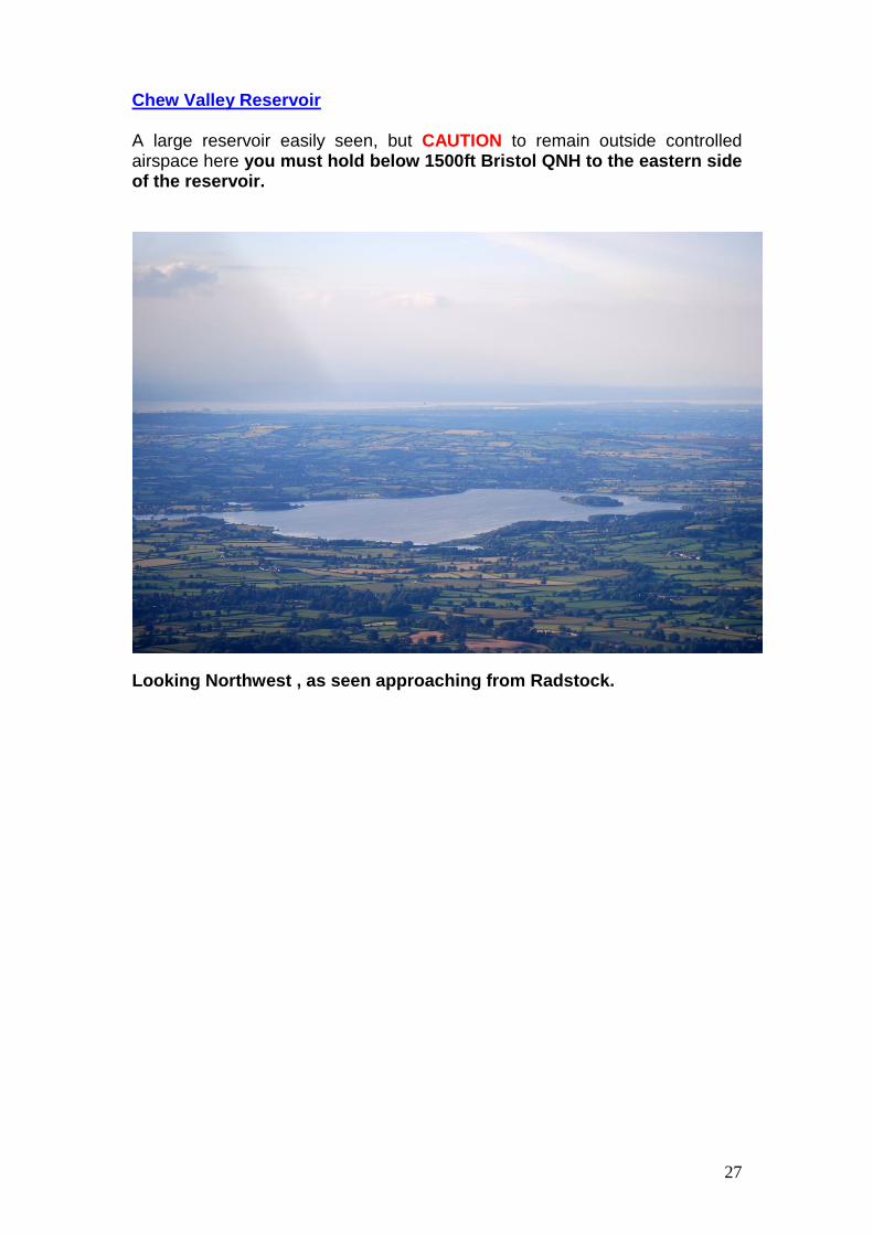
Chew Valley Reservoir
A large reservoir easily seen, but CAUTION to remain outside controlled airspace here you must hold below 1500ft Bristol QNH to the eastern side of the reservoir.
Looking Northwest , as seen approaching from Radstock.

28
VFR Entry For 27 And 09 THERE ARE NO SPECIFIC ENTRY /EXIT LANES - JUST VRPs
BRISTOL EGGD
27 09
EAST NAILSEA BARROW TANKS
CLIFTON SUSPENSION BRIDGE
CHEW VALLEY
CHURCHILL
CHEDDAR RESERVOIR
RADSTOCK
M5 AVON BRIDGE
List
enin
g Sq
uaw
k 5
07
7
Mo
nit
or
Bri
sto
l Rad
ar 1
25
.65
0