west pointe a la hache freshwater …1.pdf · the west point a la hache (ba-04) project is a cost...
TRANSCRIPT
WEST POINTE A LA HACHE FRESHWATER DIVERSION (BA-04) State Funded
I.INTRODUCTION
I.1. Project Description The West Point a la Hache (BA-04) project is a cost shared project by the state of Louisiana (75%) and Plaquemines Parish (25%). Constructed in 1992, the project is located within the Barataria Basin in Plaquemines Parish and is bounded by Lake Judge Perez to the northwest, Bayou Grand Cheniere to the south, Socola Canal to the southeast, and the Mississippi River back protection levee to the north (Figure 1). The area comprises approximately 9,300 ac (3,765 ha) of open water and 7,600 ac (3,076 ha) of brackish marsh, much of which is privately owned. Freshwater is re-introduced into the project area through a diversion structure, located on the Mississippi River at river mile 48.9 Above Head of Passes. The structure consists of a vacuum piping system with eight 6-ft (1.8 m) diameter siphon tubes, which cross over the west levee of the river. The quantity of flow passing through the siphons depends on the relative elevations of the river and tail water, but the design flow at normal high water exceeds 2,000 cubic feet per second (cfs). River water discharges from the siphons into a discharge pond, which has four outfall channels to distribute the siphoned water (Brown & Root, Inc. 1992). The BA-04 siphon system became operational in January 1993. The project was designed by Prescott Follette & Associates, with assistance from conceptual studies conducted by the Natural Resources Conservation Service, Soil Conservation Service [(USDA-SCS) 1991] and by Brown and Root, Inc (1990). During the planning and design phase of this project, several modifications were considered or were made to the project design. Most notably, the number and lengths of the outfall channels radiating from the discharge pond were reduced, because several landowners refused to allow dredging on their property. Another option considered was enlargement of the diversion structure. The conceptual design in the feasibility study included a duplicate set of siphon tubes just north of the current structure. Rather than diverting the additional water directly into the marsh, the water would have been diverted into an existing canal to be used as a conduit to distribute the extra capacity further “downstream” to other areas of deteriorating marsh (Brown and Root 1990). However, state project managers decided to defer expansion of the siphon system until experience operating the 8-pipe siphon was gained. To date, that option was never revisited.
State Funded (BA-04) Page 1 Revised September 23, 2002

Figure 1. Location of the West Pointe a la Hache (BA-04) project area.Figure 1. Location of the West Pointe a la Hache (BA-04) project area.
State Funded (BA-04) Page 2 Revised September 23, 2002

I.2. Project Personnel Project Phase Name Position Agency Conceptual/Planning
Ken Faust Engineer Brown & Root, Inc
Conceptual/Planning
Faye Talbot Resource Conservationist
NRCS
Conceptual/Planning & Design
Prescott Follette James Tocho
Engineer Engineer
Prescott Follett & Associates
Conceptual/Planning
Gerry Duszynski Administrative DNR
Construction ------- ------ River Road Construction Const. Oversight James Tocho Engineer Prescott Follett & Assoc. Const. Oversight Carrol Clark Engineer DNR Operations Planning Dr. David Vigh Engineer Brown & Root, Inc. Operations Planning & Operations
Greg Steyer Van Cook
Biologist Engineer
DNR
Operations Planning & Operations
JoAnn McMichael Administrator Plaquemines Parish
Operations Pete Jones Lonnie Serpas Albertine Kimble
Operations Staff
Plaquemines Parish
Operations Vickie Caridas Administrator Plaquemines Parish Operations and Monitoring
Ed Haywood Biologist DNR
Monitoring Bill Boshart Biologist DNR
II. PLANNING
II.1 Causes of Loss What was assumed to be the major cause of land loss in the project area? Past research indicated that a contributing cause of freshwater wetland loss in the Barataria Basin was saltwater intrusion (Sasser et al. 1986), and this was assumed to be the major cause of land loss in the project area (Brown and Root 1992). What were assumed to be the additional causes of land loss in the project area? Other causes were lack of sediment input, increased tidal exchange and volume, soil erosion, nutria herbivory, and tropical storms (USDA - SCS 1991). Most of the loss was attributed to various human activities in the estuarine zone (USDA - SCS 1991). For example, construction of the Mississippi River levees cut off the area from annual flooding of freshwater and sediment. Construction of the Texaco Pipeline canal through the natural ridges in the project area caused an
State Funded (BA-04) Page 3 Revised September 23, 2002
increase in daily tidal exchange. In addition, construction of other oil field channels and slips increased tidal volume and exchange, resulting in erosion of fragile soils in the project area.
II.2 Background Freshwater re-introductions are intended to replace some of the ecological functions supported by periodic over-bank flooding that occurred prior to the placement of the flood-control levee system. Re-introductions may be controlled, in the case of siphons and direct diversions, or uncontrolled intentional breaches in the levee system. The first controlled freshwater re-introduction was built at Bayou Lamoque in 1956 to divert freshwater into lower California Bay in the Breton Basin to enhance oyster production (Bowman et al. 1995). In 1963, the first siphon was constructed at White’s Ditch near Belaire, Louisiana, to enhance muskrat habitat (USDA-SCS 1992). Subsequently, a small siphon was constructed at Violet, Louisiana in 1979. Based on the limited experience gained from these first (smaller) diversions, three larger diversions were constructed in the early 1990’s. The Caernarvon diversion, which was a gated structure, was completed in 1991 (Villarrrubia pers comm), followed by the West Pointe-a-la-Hache (Boshart and MacInnes 2000) and Naomi siphons in 1992 (Boshart 1998).
II.3 Project Goals and Objectives The goals and objectives from all parties involved for this project from the planning documents to the final monitoring plan are presented below in their original format: Feasibility Report (USDA-SCS 1991): Goals and objectives 1. Regulate water fluctuations. 2. Increase freshwater into the area. 3. Stabilize salinity. 4. Control erosion and reclaim eroded areas to emergent vegetation. Areas that
could be reclaimed are those with water depths from marsh level to 1.0 ft. below marsh level.
5. Encourage growth of submergent vegetation especially in the deeper (1.0 ft below marsh level and deeper) open water areas.
6. Allow ingress/egress of marine organisms to the extent possible without compromising the integrity of the management system.
7. Enhance habitat conditions for wildlife and fisheries 8. Provide optimum growing conditions for increased densities of the target
vegetation Spartina patens (marshhay cordgrass). 9. Maximize the distribution of freshwater through overland flow. 10. Maintain adequate means of accessibility to the project area.
State Funded (BA-04) Page 4 Revised September 23, 2002

11. Improve water quality. 12. Increase sediments and nutrients in the project area. Management, Operation, and Monitoring plan (Brown and Root 1992): Goals 1. Protect the area from continued degradation. 2. Increase and maintain vegetative composition. Objectives 1. Increase freshwater into the area. 2. Increase land to water ratios. 3. Provide optimum growing conditions for target plant species. 4. Restore more favorable salinity regimes LDNR Monitoring Plan (LDNR 1992): Objectives (should be labeled Goals) 5. Protect the project area from continued degradation by introducing into the
area freshwater from the west bank of the Mississippi River. 6. In doing so the project also seeks to increase the inflow of sediment and
nutrients into the project area and to improve growing conditions for the target plant species, marshhay cordgrass.
Goals (should be labeled Objectives) 1. Increase marsh to open-water ratio 2. Reduce mean project area salinity. 3. Improve growing conditions for and increase relative abundance of target
plant species, marshhay cordgrass. How were the goals and objectives for the project determined? The goals and objectives were developed during the planning and construction phase and were based on projected or desired effects that the freshwater diversion would have primarily on Spartina patens and secondarily on fish and wildlife productivity. Due to budget constraints, it was not feasible to monitor every goal. Therefore, goals and objectives were reduced in number or altered (re-worded) from the original feasibility study to the final monitoring plan developed by LDNR. Are the goals clearly stated and unambiguous?
State Funded (BA-04) Page 5 Revised September 23, 2002
Overall, the goals were ambiguous and could have been improved by quantifying the goals by setting a target value or a range of values. For example, the goal to “reduce mean project area salinity” could have been given a target salinity (or range) to attain for a given location within the impacted marsh. This target could have been the 5 ppt isohaline and the 15 ppt isohaline predicted in the TABS2 model, which was designed to predict the effect that the project would have on salinity at a given volume through the siphons (Brown and Root 1992). It should be noted that the TABS2 model was developed during the planning/construction phase and was not calibrated with actual flows from the diversion structure after it was constructed (Rasi 1992). It may prove useful to calibrate the model with
actual flow data and to set targets to be used for future operation of the structure. Are the goals and objectives attainable? The goals and objectives are attainable. However, they can be improved (i.e., more meaningful) by adding targets as discussed above. The project addresses the causes of land loss (as stated in original documents). It attempts to mimic historic over-bank flooding in the estuary to counter saltwater intrusion, lack of sediment input, and soil erosion. However, the project cannot completely ameliorate the effects of herbivory and the continual dredging of oil field canals, which caused increased tidal exchange and volume.
III ENGINEERING
III.1. Design Feature(s) What construction features were used to address the major causes and additional causes of land loss in the project area? As designed, the project consisted of a siphon piping system, a vacuum system for creating and maintaining the siphoning action, an armored discharge pond, and a conveyance system of four outfall channels 15 feet wide and varying in length from 315 to 2180 feet. Although a diversion structure passing straight through the levee, such as at Caernarvon, would be more hydraulically efficient than a siphon, the risks associated with compromising the mainline levee prohibited this approach. As a result, eight identical steel pipes, each six feet in diameter, draw river water from an invert elevation of 4 ft. NGVD, transport river water over the top of the levee and under Highway 23, and discharge the water into an armored channel at an invert elevation of 8 ft. NGVD, which leads to a ponding area (Prescott & Follette 1990). The siphons are primed using a manifold piping system that allows a trailer-mounted vacuum pump to draw a vacuum at the crest of each pipe. That same pump then draws a vacuum from the storage tank. This tank and an associated system of float valves and check valves were designed to maintain the siphoning action by drawing off dissolved gases that can accumulate at high-points in piping systems. The need for a vacuum-maintenance system was identified by the designer, Prescott Follette. Prescott Follette & Associates designed the White’s Ditch and Violet siphons and observed that at low river levels, the siphons tended to lose their prime. The vacuum maintenance system was an attempt to extend the operational schedule of the siphons into lower-flow stages of the river. What kind of data was gathered to engineer the features and what engineering targets were the features trying to achieve? Flow through the siphons depends on the head differential between the river and ponding area. The range of anticipated flows through the system was expected to
State Funded (BA-04) Page 6 Revised September 23, 2002
be from about 1232 cfs in October to about 2144 cfs in April. The average discharge during annual high Mississippi River stage was expected to exceed 2,400 cfs (Brown & Root 1990). Once discharged into the ponding area, river water is distributed to the project area through conveyance channels. Design criteria for these channels included maintaining velocities high enough to keep sediments in suspension, generally considered to be in the 2.0 to 3.0 feet per second range, but not so high as to create erosive conditions in the channel, in excess of about 3.5 feet per second (Chow, 1957). Modeling studies of the channel design indicated velocities in the range of 0.64 feet per second if the structure was operating at 2,144 cfs (Brown & Root, 1992). Thus, erosion was not considered a threat, but siltation could occur and future dredging of the outfall channels was considered. Another design concern was excessive marsh inundation due to high water levels in the vicinity of the outfall. A modeling study by Brown & Root (1992) consisting of HEC-2 water surface modeling of the outfall channel, linked with TABS-2 modeling of the entire study area, indicated that an increase in water surface elevation of 19.2 inches would occur at the discharge pond, with over 10 inches of increase in water surface elevation a mile from the discharge pond (Brown & Root, 1992). As a result, Brown & Root recommended an operational scheme that provided for full operation of the structure (all 8 pipes operating) only during the fall and winter, when marsh plants would not be as sensitive to higher water levels. Concerns regarding water surface elevation proved to be unwarranted. Monitoring data collected during siphon operation indicated that water levels were significantly higher due to the siphon only at the monitoring station nearest the outfall structure (site 1). During high-flow conditions (>1000 cfs), water level was an average of 14 inches above the average water level measured during no-flow conditions.(Boshart and MacInnes 2000). Water surface elevations dissipated, however, rapidly with distance from the discharge area, and mean water levels for the remaining monitoring stations were not significantly different between high-flow and no-flow conditions. The operational significance is that year-around operation was not likely to be problematic for marsh inundation. Dredging of the distribution channels was accomplished with a small cutterhead dredge, and the dredged materials were beneficially placed in a thin layer over the adjacent marsh using the technique of spray dredging. That technique was chosen, because it did not create spoil banks, which can reduce or alter sheet flow over the marsh. In addition to the information presented above, various types of data and other information were gathered to plan and design the siphon features and to determine operating procedures:
1. Soils analysis (USDA- SCS 1991)
State Funded (BA-04) Page 7 Revised September 23, 2002 2. Geotechnical soil analysis (Plaquemine Parish Government)

3. Historic salinity data (Boshart and MacInnes 2000) 4. Historic marsh habitat changes (Boshart and MacInnes2000) 5. Past siphon design experience of Prescott Follett who previously
designed the Violet and White’s Ditch siphon systems 6. Discussions with COE regarding siphon vs gated diversion 7. Capacity studies (Brown and Root 1990) 8. River stage data (Brown and Root 1992) 9. TABS 2 modeling (Brown and Root 1992)
III.2 Implementation of Design Feature(s) Were construction features built as designed? If not, which features were altered and why? Project features were built as designed with one major exception. Because of land rights issues, one of five planned channels had to be deleted and length of the remaining channels had to be shortened. The channel lengths were originally conceived to be up to 4,000 ft each. Subsequently, they were shortened to 2,500 ft before construction began. However, as the project entered the construction phase, the lengths were reduced again due to continued land rights problems. The final lengths were 2,180, 1,838, 651, & 315 ft.
III.3 Operation and Maintenance Were the structures operated as planned? If not, why not? Siphon operations were planned by Plaquemines Parish Government (PPG) in accordance with an operations scheme developed by Brown and Root Inc. (1992), and revised in 1993 by PPG and the LDNR/CRD. The revised operations plan called for the structure to have all eight pipes operating for all months except March and April when only two pipes are to be in operation. In practice, operations fell short of the planned amount of freshwater to be re-introduced into the project area (Figure 2) due to several constraints: marine fisheries, low river stages, tropical storms, oil spills, maintenance problems, and staffing limitations within PPG. Marine fisheries limitations were in the form of lawsuits brought about by the commercial oyster industry and concern in the first year of operation regarding over-freshening during critical life-stage development of brown shrimp. Both of these concerns resulted in shutdown periods of the structure. Low river stages were natural occurrences that caused the siphons to loose the required head differential for flowing thus the siphons shut down until water levels in the Mississippi River became higher. In addition, oil spills along with tropical storms or hurricanes caused the siphons to be closed on several occasions.
State Funded (BA-04) Page 8 Revised September 23, 2002

0
200
400
600
800
1000
1200
1400
1600
1800
1993
1994
1995
1996
1997
1998
1999
2000
2001
AVERAGE 1992
-2001
Y
CFS Actual Siphon Flow May - February
Actual Siphon Flow March - April
Mean flow with eight siphons in operation
Mean flow with two siphons in operation
Figure 2. Average siphon flow for two operation time periods from 1993 through 2001.
AVERAGE represents the average of all years. Dotted lines represent average flow over all years when only two or eight siphons were in operation (i.e., planned operation).
Maintenance problems seldom resulted in a complete shutdown of the structure, but often resulted in lower flows. Valve corrosion and problems with the vacuum system resulted either in loss of prime or complete non-operational status of the siphon pipes, even in the early years of operation. Moreover, maintenance problems with the siphons resulted in an increased need for PPG personnel to check, and often re-prime, the siphons. This resulted in additional down time. As a result of the limited capability to deliver design flows, the operational plan was abandoned, and instead PPG operated all available siphon pipes whenever river stage allowed operation. While the target average flow specified by the Operation and Maintenance Plan (Brown & Root 1992) was set at just over 1,000 cfs, the actual discharge was much less. Through 2001, the structure was in operation 74% of the time and averaged only 898 cfs when operating (figure 2). In addition, flows were mostly highest in the spring period, which was opposite than planned. As illustrated in figure 2, significantly higher flows would have been attained with all eight siphons operating during the May – February time frame, and significantly lower flows realized with only two siphons in operation.
State Funded (BA-04) Page 9 Revised September 23, 2002

Are the structures still functioning as designed? If not, why not? Was maintenance performed? Because of the numerous problems keeping the siphons primed, the original valves and vacuum piping were replaced with improved valves and new vacuum piping in 2001. The benefits of the maintenance were substantial, as it has enabled the siphon system to be operated at or near full capacity during normal river stages. Operation of the siphons at very low river stages continues to be problematic due to loss of prime.
IV PHYSICAL RESPONSE
IV.1 Project Goals Do the monitoring goals match the project goals and objectives? The goals and objectives for physical response variables that were addressed in the LDNR monitoring plan were to 1) increase marsh to open-water ratio, 2) reduce and stabilize mean salinity (LDNR 1992). These goals are fewer in number and do not match verbatim those listed in the project planning documents (listed in section II.1). However, the monitoring goals consolidate the ideas of multiple goals and objectives listed in the planning references. For example, the monitoring goal of reducing mean salinity can be translated into the project goal of increasing freshwater into the area, regulating water fluctuations (i.e. salinity spikes), and restoring more favorable salinity conditions. As discussed earlier in this document, all goals and objectives were somewhat ambiguous and could have been improved by quantifying the goals based on planning documents. IV.2.1 Elevation In contrast to a sediment diversion, which is designed more for building land, the BA-04 project was designed as a freshwater diversion. Thus, its primary use is to re-introduce freshwater to the project area to control salinity. Moreover, the addition of sediments to the project area, via the diverted river water, is a secondary benefit of freshwater diversions. Thus, if the siphons are operated as planned, the area should not only freshen, but it should also accrete enough sediment to help maintain or increase marsh elevation. Therefore, even though no target elevation was planned, one of the goals was to the increase the land-to-water ratio of the project area. What is the range of elevations that supports healthy marshes in different marsh types? Does the project elevation fall within the range for its marsh type? Average marsh elevation was determined in 1997 in the immediate area surrounding five hydrologic monitoring stations (Figure 3). Elevation ranged between 0.60 and 1.10 ft (NAVD88) among the stations (LDNR BA-05 monitoring file). This elevation range is similar to elevations in other marshes (e.g. Naomi project area) in the area.
State Funded (BA-04) Page 10 Revised September 23, 2002

Figure 3. Location of sampling stations for the West Point a la Hache Freshwater Diversion
project.
State Funded (BA-04) Page 11 Revised September 23, 2002
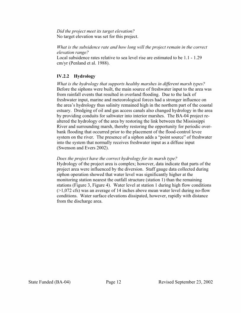
Did the project meet its target elevation? No target elevation was set for this project. What is the subsidence rate and how long will the project remain in the correct elevation range? Local subsidence rates relative to sea level rise are estimated to be 1.1 - 1.29 cm/yr (Penland et al. 1988). IV.2.2 Hydrology What is the hydrology that supports healthy marshes in different marsh types? Before the siphons were built, the main source of freshwater input to the area was from rainfall events that resulted in overland flooding. Due to the lack of freshwater input, marine and meteorological forces had a stronger influence on the area’s hydrology thus salinity remained high in the northern part of the coastal estuary. Dredging of oil and gas access canals also changed hydrology in the area by providing conduits for saltwater into interior marshes. The BA-04 project re-altered the hydrology of the area by restoring the link between the Mississippi River and surrounding marsh, thereby restoring the opportunity for periodic over-bank flooding that occurred prior to the placement of the flood-control levee system on the river. The presence of a siphon adds a “point source” of freshwater into the system that normally receives freshwater input as a diffuse input (Swenson and Evers 2002). Does the project have the correct hydrology for its marsh type? Hydrology of the project area is complex; however, data indicate that parts of the project area were influenced by the diversion. Staff gauge data collected during siphon operation showed that water level was significantly higher at the monitoring station nearest the outfall structure (station 1) than the remaining stations (Figure 3, Figure 4). Water level at station 1 during high flow conditions (>1,072 cfs) was an average of 14 inches above mean water level during no-flow conditions. Water surface elevations dissipated, however, rapidly with distance from the discharge area.
State Funded (BA-04) Page 12 Revised September 23, 2002
0
0.2
0.4
0.6
0.8
1
1.2
1.4
1.6
1.8
2
1 2 3 5 6 MeanStation
Wat
er L
evel
(ft N
AVD
)
MajorMinorNoflow
Figure 4. Water levels (NAVD) comparisons among major >1072 cfs, minor 0-1072 cfs and
noflow 0 cfs discharge at West Pointe a la Hache project area from 1993 - 1998. Station “mean” represents mean water level of stations 1, 2, 3, 5 and 6 combined.
Comparison of water level between high and low flow (< 1072 cfs) conditions at continuous recorders stations (hourly data) showed that water levels were significantly higher at 3 of the 5 stations during periods of minor flow (Boshart and MacInnes 2000). Those differences may be explained by marine and meteorological forcings, such as tidal events and prevailing winds, and location of the stations within the estuary and time of sampling (Boshart and MacInnes 2000). This is supported by regression analyses that indicated 49 to 87 percent of the water level at an individual site can be explained by the water level at Grand Isle (on an monthly averaged basis) and that an additional 5 to 10 percent of the water level at individual sites can be explained by precipitation (on a monthly averaged basis; Swenson and Evers 2002). What were the hydrology targets for the project and were they met? The targets were to achieve a given flow through the siphons for a given time of year (see section III.3 for details). No target was given as to the frequency and duration of flooding in the project area.
State Funded (BA-04) Page 13 Revised September 23, 2002

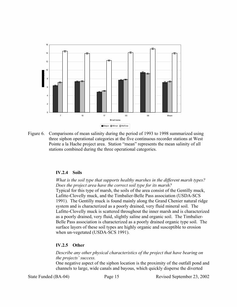
IV.2.3 Salinity What is the salinity regime that supports healthy marshes in the different marsh types? Does the project have the correct salinity for its marsh type? Marsh vegetation types (Visser et al 1998, 2000) vary in the entire project area from fresh to polyhaline (saline). However, one of the goals of the project was to reduce and stabilize mean salinity and improve growing conditions for and increase relative abundance of Spartina patens (Ait.) Muhl. (marshhay cordgrass), which thrives best in intermediate/brackish marsh with salinity levels between 8 and 14 ppt (Palmisano, A. W., and R. H. Chabreck 1972). Depending on the freshwater output of the siphons, salinity regime for the southwest and southeast ends of the project varied between mean 7 – 10 ppt, which is within the range for marshhay cordgrass. In contrast, when siphons are not in operation salinity levels can exceed 16 ppt. What were the salinity targets and were they met? With the exception of “to reduce and stabilize mean salinity”, no specific target was given. Average salinity for the project between 1993 and 2001 varied between 9 –17 ppt during fall and winter months and 4 –10 ppt during the spring and summer with lowest salinities occurring during periods when siphons were operating near 900 cfs (Figure 5). Mean salinity reduction occurred at LDNR sonde stations during periods when all siphons were in either partial or full operation (Figure 6). Thus, the data indicate that the siphons are capable of reducing salinity in the project area.
0
2
4
6
8
10
12
14
16
18
20
Janu
ary
Februa
ryMarc
hApri
lMay
June Ju
ly
Augus
t
Septem
ber
Octobe
r
Novem
ber
Decem
ber
Months
0
200
400
600
800
1000
1200
Station 7
Station 10
Station 17
Station 55
Station 56
Mean CFS
Figure 5. Mean salinity patterns by month for continuous recorder station 7, 10, 17, 55 and 56
and mean cfs over the period 1993 -2001 at West Pointe a la Hache project area.
State Funded (BA-04) Page 14 Revised September 23, 2002
0
2
4
6
8
10
12
14
16
7 10 17 55 56 Mean
S t a t i ons
Major Minor Nof low
Figure 6. Comparisons of mean salinity during the period of 1993 to 1998 summarized using
three siphon operational categories at the five continuous recorder stations at West Pointe a la Hache project area. Station “mean” represents the mean salinity of all stations combined during the three operational categories.
IV.2.4 Soils What is the soil type that supports healthy marshes in the different marsh types? Does the project area have the correct soil type for its marsh? Typical for this type of marsh, the soils of the area consist of the Gentilly muck, Lafitte-Clovelly muck, and the Timbalier-Belle Pass association (USDA-SCS 1991). The Gentilly muck is found mainly along the Grand Chenier natural ridge system and is characterized as a poorly drained, very fluid mineral soil. The Lafitte-Clovelly muck is scattered throughout the inner marsh and is characterized as a poorly drained, very fluid, slightly saline and organic soil. The Timbalier-Belle Pass association is characterized as a poorly drained organic type soil. The surface layers of these soil types are highly organic and susceptible to erosion when un-vegetated (USDA-SCS 1991).
IV.2.5 Other Describe any other physical characteristics of the project that have bearing on the projects’ success. One negative aspect of the siphon location is the proximity of the outfall pond and channels to large, wide canals and bayous, which quickly disperse the diverted
State Funded (BA-04) Page 15 Revised September 23, 2002

water. The disadvantage of this is that river water is diverted away, instead of over, the surface of the marsh as would happen without close proximity to large channels. Thus river water may not be retained in the marsh for any length of time. Although the flow of water over the marsh was thus reduced, it should be noted that substantial salinity reduction (of water) occurred throughout the project area indicating the presence of the channels did not interfere with salinity reduction and may have been a positive factor in the reduction. This observation by the monitoring effort may have significance in the outfall management for this project and future diversion projects that contain large streams and channels in their project area.
IV.3 Suggestions for physical response monitoring Are there other variables that could be monitored to substantially increase the ability to understand the results of the project? Soil salinity, borings, and accretion data should be collected throughout the project area in conjunction with vegetation surveys. Soil salinity would provide a better measure of salinity in the marsh and better explain changes in marsh vegetation.
V. BIOLOGICAL RESPONSE
V.1. Project Goals Specific goals pertaining to the biological response were to improve growing conditions for and increase relative abundance of marshhay cordgrass. V.2.1. Vegetation Does the project have the correct species composition and cover for its type? Vegetation surveys were conducted for this project in 1992 (preconstruction), 1995, 1997 and 2001. Unfortunately, different methodologies and different sites were used for the 1992 and 1995 surveys, than were used for the 1997 and 2001 survey. Thus, no statistical comparison of those data sets was performed. Figure 7 shows the average cover values for the dominant (in cover) species. Further analyses (non-statistical) of the vegetation data were done by Evers and Sasser (2002). Sites were classified by vegetation type following the Visser et al (1998) vegetation type classification scheme, and the project area was divided into four areas based on the 1992 vegetation classification, along with preliminary evaluation of vegetation and land/water signatures in imagery of the area. Results indicated that, overall, vegetation types within the project area showed a freshening between 1992 and 1995. Between 1997 and 2001, vegetation type at many sites remained the same; however, some sites became more saline, and some became fresher (Evers and Sasser 2002).
State Funded (BA-04) Page 16 Revised September 23, 2002

47.38
17.86
19.91
21.18
38.33
47.81
26.08
23.59
39.23
19.97
25.89
13.15
5.77
8.97
9.50
19.72
8.24
13.29
24.29
1.05
0 20 40 60 80 100 120 140 160
1992
1995
1997
2001
Percent Cover
Spartina alterniflora Loisel.
Spartina patens (Ait.) Muhl.
Distichlis spicata (L.) Greene
Vigna luteola (Jacq.) Benth.
Polygonum punctatum Ell.
Others
Figure 7. Comparison of mean percent cover (across entire project area) of most common
species for 1992, 1995, 1997, and 2001 vegetation surveys of West Pointe a la Hache. Different survey methods were used for the 1992 and 1995 surveys, than were used for the 1997 and 2001 surveys. A greater number of sites over a larger area were surveyed in 1997 and 2001.
Drought conditions from 1998-2000 were most likely the cause for some sites reverting to more saline vegetation types. Results also indicated that vegetation species diversity increased in the project area to include more and fresher species in 1997 and 2001. These results show that the diversion has been effective at changing the vegetation towards a fresher and more diverse community overall. However, areas furthest from the diversion site are influenced less by the diversion waters. V.2.2 Landscape Is the project changing in the direction of the optimal landscape? If not, what is the most likely reason? The land loss rate for the project area taken from the Pointe a la Hache Quadrangle was 1.29% per year between 1983-1990 (Dunbar et al. 1992). Although numerous problems made comparison of the pre- and post-construction aerial photograph difficult, a comparison was made (Boshart and MacInnes 2000). The land to water ratio of the project area between 1991 and 1999 showed
State Funded (BA-04) Page 17 Revised September 23, 2002
a decrease in land in the project area from 6,409.3 ac (2,563.7ha) in 1991 to 5,948.9 ac (2,379.6 ha) in 1999 and a corresponding increase in water from 9,978.9 ac (3,991.6 ha) in 1991 to 10,434.5 (4,173.8 ha) in 1999 (Boshart and MacInnes 2000). These data indicate a conversion of 460.4 ac (184.2 ha) of land to water in the 8 year period. This represents a loss of 7.2% of land present in 1991 or 1.03% per year. Although the diversion has been partially successful at reducing salinities, the continued loss of land in the project area suggests that an insufficient amount of sediment is reaching or being retained in the area marshes to maintain elevation. Even with the overall loss, it is possible that land is being maintained or possibly gained in the immediate outfall area nearest the siphon discharge. Data from the Caernarvon diversion showed this pattern of landscape change has occurred in the Breton Basin (reference). However, without an analysis to show where land is being lost or gained (change analysis), it is difficult to determine if the BA-04 siphon is working towards maintaining the landscape. This type of analysis could not be performed, because of the differences in aerial photographs. Future aerial photographs and subsequent land-to-water analyses are scheduled for this project (LDNR 1992) and will aid in determining changes in the project area at the landscape scale.
V.3 Suggestions for biological response monitoring Are there any other variables that could be monitored to substantially increase the ability to understand the results of the project? To measure large-scale changes in marsh communities, habitat analysis should be included with the land water analysis. Also, more frequent photography should be flown and analyzed.
VI. ADAPTIVE MANAGEMENT
VI.1. Existing improvements What has already been done to improve the project? Most importantly, an outfall management plan is being developed by the NRCS to redirect flows in the BA-04 project area to distribute more water into the marsh and retain water in the marsh for longer periods. Installation of an improved valve and small vacuum piping system in 2001 increased the efficiency and sustainability of the siphons. In addition, a coastwide nutria control project is being developed to significantly increase harvest of nutria (Myocaster coypus) in the hopes of controlling herbivory damage to coastal marshes across Louisiana, including the BA-04 project area (LDNR 2002).
State Funded (BA-04) Page 18 Revised September 23, 2002

VI.2. Project effectiveness Are we able to determine if the project has performed as planned? If not, why? And what should be the success criteria for this project? Considering the ambiguous manner in which the BA-04 project and monitoring goals were written, determining project effectiveness was simple. If the project reduced average salinity, it was effective; if the project increased (or decreased) land to water ratios in the project area, it was effective (or not); if the project increased relative abundance of marshhay cordgrass, it was effective. As is seen, none of the goals, from project planning through monitoring, were quantified and all could have been improved (i.e., more meaningful) by including specific targets. The example given earlier in this document (section II.3), illustrates that to set a target salinity for a given location in the project area (e.g., 5 ppt isohaline) would have been more meaningful than to “decrease mean salinity”. In this case, effectiveness could have been clearly decided by determining the average salinity at the proposed 5ppt isohaline. This lesson seems to have been learned, because operation of the Davis Pond diversion will be based on this same type of scenario (Chuck Villarrubia, LDNR, personal communication). An example of well-written, quantified goals is found in the monitoring plan for the LaBranche Wetland Restoration Project (LDNR 1998). Those goals quantify the planned acres of land to create and the marsh-to-open water ratio targets for a given time frame. Not only is the absence of quantifiable goals in CWPPRA and state projects a chronic problem and obstacle to determining project effectiveness, the continuing mind set that project benefits are realized “overnight” also seems to be a hindrance to evaluation of project effectiveness. In many instances, projects are labeled a success or failure three years after construction, when in reality, it will take many years to determine if the project was effective or not. In the case of the BA-04 project, nine years of data collection is most likely sufficient to determine if the desired physical and biological responses are being achieved. However, lack of operation may have limited the effective results.
VI.3 Recommended improvements What can be done to improve the project? 1. Maintenance had been very poor until recent installation of the new valve and
piping system. A preventative maintenance plan needs to be developed. 2. An improved security system needs to be implemented. There is virtually
none at the present time. The siphon is at the mercy of anyone who wants vandalize it.
3. A simplified priming system (i.e. fixed vacuum pump) needs to be installed to allow the individual pipes to be quickly placed back in service when they lose prime. Output from the siphon would be increased substantially. Also, the siphon would then be available for service during much of the low river season when they are often not available. It should be noted that DNR has retained an engineering firm to provide recommendations on installation of
State Funded (BA-04) Page 19 Revised September 23, 2002
such a system and on installation of instrumentation on the siphons. The firm will also provide recommendations regarding the feasibility of enriching the water intake stream with additional fine sediment.
4. Instrumentation, such as flow meters and gauges possibly online, should be installed to actually measure the flow values rather than the calculated spreadsheet values that are currently used to generate data. Current calculations are based on values from a logbook kept by Plaquemines Parish Government (PPG) personnel and then mailed to DNR. The details of the logs are inconsistent. Records are entered only when PPG personnel visit the siphons.
5. The current plan for operations is to run siphons at all times except when conditions such as loss of prime, oil spills, and tropical storms prohibit flow. A consistent plan for operation of the siphons operations is needed.
6. An outfall management system needs to be implemented.
VI.4. Lessons learned 1. The effectiveness of siphon systems in mimicking the action of the river’s
over bank flooding was shown. 2. Concerns over soil erosion from such a system apparently did not materialize.
This had been a major concern during the conception stage 3. Need for a maintenance plan has again proven to be necessary. 4. Need for a security system is recognized from severe vandalism that has
occurred at other projects. At present, serious vandalism has not occurred at the West Pointe siphons but may be probable without safety measures. One instance of moderate vandalism recently occurred when someone closed all eight-siphon pipes thereby shutting the siphon system down.
5. Politics have an important role in operations. Concern about lawsuits involving this and other diversion projects contributed substantially to the failure to implement a maintenance plan as both the State and Parish were reluctant for a period of time to be involved with the project. It certainly shows how lawsuits can detrimentally affect decision-making.
6. The presence of large efficient bayous and canals in the project and the resulting lack of direct over-marsh flow of siphon water did not prevent water salinities throughout the project area from being lowered substantially. Many restoration projects contain such canals. Their presence may prevent over-marsh flow but may not impede lowering of project salinities.
7. Project goals should be quantified as much as possible to aid evaluation of project effectiveness.
8. A range of flow should be used in modeling not just with or without flow. 9. Consider outfall management from the beginning planning stages. 10. Reference areas were not included during the project planning or
developmental stages but could be addressed in the future with the Coastwide Reference Monitoring System (CRMS).
11. Gated structures provide for greater flexibility in operations and should be the preferred technique for freshwater diversions.
State Funded (BA-04) Page 20 Revised September 23, 2002
VII. SUPPORTING DOCUMENTATION Boshart, W. M. 1998. Monitoring Series No. BA-03-MSTY-1098-1. Naomi Freshwater Diversion BA-03. Louisiana Department of Natural Resources, Baton Rouge,
La. 21pp. Boshart, W. W., and A. D. MacInnes 2000. Monitoring Series No. BA-04-MSTY-1298-
3. West Pointe A La Hache Freshwater Diversion BA-04. Louisiana Department of Natural Resources, Baton Rouge, La. 29pp.
Bowman, P. E., W. S. Perret, and J. E. Roussel 1995. Freshwater introduction and implications for fisheries production in Louisiana. Baton Rouge, LA: Department of Wildlife and Fisheries. 8 pp.
Brown and Root, Inc. 1990. Enlargement of the West Pointe A La Hache Freshwater Diversion. Unpublished report for the Louisiana Department of Natural Resources, Baton Rouge, La: Brown and Root, Inc. 12pp.
Brown and Root, Inc. 1992. West Pointe a la Hache freshwater diversion siphon. A management, operation, and monitoring plan. Unpublished final report prepared for Plaquemines Parish government, Department of Health and Hospitals. Belle Chasse, La.: Brown and Root, Inc. 60 pp.
Chow, Ven Te; Open Channel Hydraulics; In Mcgraw-Hill, New York, 1959. Dunbar, J. B., L. D. Britsch, and E. B. Kemp III 1992. Land Loss Rates Report 3:
Louisiana Coastal Plain. Technical Report GL-90-2. Vicksburg, Miss. U.S. Army Corps of Engineers. 65 pp.
Ensminger, A. B. 1992. Vegetative delineations for the West Pointe a la Hache freshwater diversion outfall area project No. BA-04. Unpublished final report prepared for the Louisiana Department of Natural Resources/Coastal Restoration Division. Belle Chasse, La.: Wetlands and Wildlife Management Co. 26 pp.
Evers, D. E., and C. E. Sasser 2002. CWPPRA Adaptive Management Review BA-04 (West Pointe a la Hache) Vegetation. Unpublished report prepared for the Louisiana Department of Natural Resources/Coastal Restoration Division. Baton Rouge, LA: Coastal Ecology Institute.
Louisiana Department of Natural Resources (LDNR) 1993. Bayou La Branche (PO-17) Monitoring Plan. Unpublished monitoring plan. Baton Rouge: Coastal Restoration Division, Biological Monitoring Section. 7 pp.
Louisiana Department of Natural Resources (LDNR) 1996. West Pointe a la Hache Freshwater Diversion (BA-04) Monitoring Plan. Unpublished monitoring plan. Baton Rouge: Coastal Restoration Division, Biological Monitoring Section. 8 pp.
Louisiana Department of Natural Resources (LDNR) 2002. Coastwide nutria control program (LA-3b) Monitoring Plan. Unpublished monitoring plan. Baton Rouge: Coastal Restoration Division, Biological Monitoring Section. 8 pp.
Palmisano, A. W., and R. H. Chabreck 1972. The relationship of plant communities and soils of the Louisiana coastal marshes. Louisiana State U. Ag. Exp. Sta. Bull. 664. Louisiana State University. 42 pp.
Penland, S., K. E. Ramsey, R. A. McBride, J. T. Mestayer, and L. A. Westphal, 1988. Relative Sea-Level Rise, Delta Plain Development Subsidence, and Wetland Sedimentation in the Teche and Lafourche Delta Complexes: Terrebonne Parish
State Funded (BA-04) Page 21 Revised September 23, 2002

Region, Louisiana. Coastal; Geology Bulletin Number 2, Louisiana Geological Survey, Baton Rouge, Louisiana, 130p.
Prescott & Follette & Assocaties 1990. Plans & Specifications Sasser, C. E., M. D. Dozier, J. G. Gosselink, and J. M. Hill 1986. Spatial and temporal
changes in Louisiana’s Barataria Basin marshes, 1945-1980. Environmental Management 10(5): 671-680.
Swenson, E. M. and D. E. Evers 2002. CWPPRA Adaptive Management Review BA-04 (West Pointe a la Hache) Hydrology. Unpublished report prepared for the Louisiana Department of Natural Resources/Coastal Restoration Division. Baton Rouge, LA: Coastal Ecology Institute. 28 pp.
Rasi John 1992. Memorandum to the BA-04 files. Schroeder, W. W., and W. J. Wiseman Jr. 1986. Low-Frequency shelf-estuarine
exchange processes in Mobil Bay and other estuarine systems on the northern Gulf of Mexico. pp. 355-67 in D. A. Wolfe (ed) in Estuarine Variability, Academic Press, New York.
United States Department of Agriculture/Soil Conservation Service [USDA-SCS]1991. Feasibility Report for Project No. BA-4: West Pointe a la Hache Diversion Siphon, Plaquemines Parish, Louisiana. Unpublished report prepared for the Louisiana Department of Natural Resources/Coastal Restoration Division. Alexandria, La.: U.S. Department of Agriculture, Soil Conservation Service. 30pp.
USDS-SCS 1992. Feasibility Report for Project No. BS-4: White’s Ditch Diversion Siphon Outfall Management Plan, Plaquemines Parish, La. Unpublished report prepared for the Louisiana Department of Natural Resources/Coastal Restoration Division. Alexandria, La.: U.S. Department of Agriculture, Soil Conservation Service. 34pp.
Visser, J. M., C. E. Sasser, R. H. Chabreck, and R. G. Linscombe. 1998. Marsh vegetation types of the Mississippi River Deltaic Plain, USA. Estuaries 21:818-828.
Visser, J. M., C. E. Sasser, R. H. Chabreck, and R. G. Linscombe. 2000. Marsh vegetation types of the Chenier Plain, Louisiana, USA. Estuaries 23:318-327.
State Funded (BA-04) Page 22 Revised September 23, 2002

State Funded (BA-04) Page 23 Revised September 23, 2002
APPENDIX A: INFORMATION CHECK SHEET Project Name and Number: BA-04 West Pointe a la Hache Date: March 8, 2002 INFORMATION TYPE YE
S NO N/A SOURCE
Fact Sheet X State Restoration Plan/ NRCS Feasibility Study/ Brown and Root Report/ Outfall Management Report
Project Description X State Restoration Plan/ NRCS Feasibility Study/ Brown and Root Report/ Outfall Management Report
Project Information Sheet X State Restoration Plan/ NRCS Feasibility Study/ Brown and Root Report/ Outfall Management Report
Wetland Value Assessment X State Restoration Plan/ NRCS Feasibility Study/ Brown and Root Report/ Outfall Management Report
Environmental Assessment X State Restoration Plan/ NRCS Feasibility Study/ own and Root Report/ Outfall Management Report
Project Boundary X DNR Monitoring Plan/ DNR GIS/ Brown and Root Report
Planning Data X Prescott-Follett/ Brown and Root Report/ Plaquemines Parish/ HNTB Report
Landrights X DNR Correspondence/ Plaquemines Parish Preliminary Engineering Design X Prescott-Follett/ Brown and Root/ Plaquemines
Parish Geotechnical X Prescott-Follett/ Brown andRoot/ DOTD Engineering Design X Prescott-Follett/ Brown and Root/ Plaquemines
Parish As-built Drawings X DNR/ Plaquemines Parish Modeling Output X Brown and Root Construction Completion Report X Brown and Root/ Prescott-Follett Engineering Data X Brown and Root/ DNR/ Fenstemaker Monitoring Plan X DNR Monitoring Plan Monitoring Reports X Supporting Literature X DNR/ CEI/ MRSNFS/ Day/ Visser Monitoring Data X Swenson Isohaline Report/ Lane SET/ Day/ Aerial
Photo/ DNR Operations Plan X Brown and Root/ DNR/ Plaquemines Parish/ Meeting
Notes Steyer Plan Changes Operations Data X Plaquemines Parish Operational Log/ DNR Maintenance Plan X Inspection Reports/ Brown and Root/ DNR Valve
Repair Maintenance Data X Correspondence/ Haywood/ Emails O&M Reports X Other
DHH / Plaquemines Parish Fecal Coliform/ HAB Occurance/ USGS Water Quality/ DNR Rasi Sediment/ Cultural Resources NRCS/ Endandered Species LDWF
Oysters X DNR GIS/ LDWF Permits X DNR / Plaquemines Parish