what happened after the 7th century ad a different perspective on post roman anatolia
DESCRIPTION
7thc AD AnatoliaTRANSCRIPT

ARCHAEOLOGY OF THE COUNTRYSIDE IN MEDIEVAL ANA TOLIA
ED. T. VORDERSTRASSE AND 1. ROODENBERG. PIHANS 113, 2009
What Happened after the 7th century AD? A different Perspective on Post-Roman Rural Anatolia
Hannelore Vanhaverbeke1, Athanasios K. Vionis, Jeroen Poblome and Marc Waelkens
Introduction: the premise What is 'Medieval' Anatolia ? This was our first reaction to the title of the (highly successful) symposium organised by the NINO. Scrolling through the programme, titles contained chronological references such as 'Late Antiquity', 'Byzantine', and, indeed, 'Medieval'. However, it was clear that the organisers had deliberately opted for 'Medieval', to "leave the chronological issue open".
The fact that such issues have to be left open -entirely beyond the responsibility of the symposium organisers- is symptomatic for the state of research in post-Roman Anatolia. There is no coherent research agenda, although there are many valuable attempts at synthetic (historical) overviews and in-depth case-studies2• As a consequence, there is even no consensus on the terminology for the period after ca. the (middle of) ih century AD, a time when many cities changed in appearance3. For this paper, we have considered 'Medieval' to refer to the period between the changes in urban fabric, and the rise of the Ottoman empire in the 14th century AD.
However, this is 'just' a matter of terminology. Of a more pressing concern is the relative lack of (archaeological) data upon which to base any generalising views on the Medieval Anatolian countryside. Browsing the annual proceedings of excavation and survey research in Turkey (the Kazz and Ara~tzrma Sonurlarz), it is clear that this scarcity is relative indeed. Many people are involved in studying one or more aspects of rural Anatolia in this period, but the overall database is extremely scattered. It not only refers to a wide geographical scope, the data stem from divergent research aims (e.g. art historical vs ceramological). The binding matrix, which a coherent research agenda would constitute, is lacking.
This paper presents a very moderate attempt at initiating a research agenda, by deliberately taking an explicit, and optimistic stand on the post-ih century AD fate of rural Anatolia, in order to provoke discussion.
Its premise is that nothing much changed in the countryside after the ih century AD. Life continued as it was, centred on villages, hamlets and farms, but these functioned in a 'decapitated' landscape; a landscape in which most former cities were abandoned, reduced in size to 'kastra' or had become mere villages. Evidence from Imperial legislation and casual references in hagiographies, dated between the 81h and 11th centuries, show
1 Hannelore Vanhaverbeke is a postdoctoral research fellow at the Katholieke Universiteit Leuven; [email protected] 2 E.g. Vryonis 1971; Foss 1976, 1977, 1979, 1994, 1996; Mango 1988; Brown 1989; Christie and Loseby 1996; Whittow 1996; Haldon 1999, 2000; Brogiolo, Gauthier and Christie 2000; Bowersock, Brown and Grabar 2001; Christie 2004. 3 We explicitly want to avoid the term decline, which, as will be indicated below, needs to be exactly defined.

178 H. V ANHA VERBEKE ET AL.
indeed that by that time the village had become the fundamental centre of the state's fiscal interests and of rural societ/.
In fact, already in 1993 Anatolia-specialist Stephen Mitchell wrote that "the foundation of cities, which flourished only for a relatively brief period in the long evolution of Anatolian history, modified but did nolt supersede the indigenous pattern of settlement which has, in many respects, persisted until the present day"5.
This may seem a completely obvious statement, but surprisingly little research has been devoted to actually finding corroborating evidence. It seems as if scientific interest has fallen into the luring trap posed by the monumental remains of classical (HellenisticRoman) towns and villages - monumental not only in the sense of being furnished by monuments (of whatever nature), but also in terms of the obtrusive nature of most of their surface remains (pottery, bricks and tiles, metal, glass ... ). In fact, being classical archaeologists, whether we realise it or not, we are spoiled by the quantity and quality of our data. What Anatolia needs as well is an undivided attention to the often smaller-scale and less obvious traces which Medieval rural communities have left in the landscape6, as will be shown below.
This is our premise then, that of a resilient countryside with a high degree of continuation in rural exploitation after the ih century AD. It is in this light that the available evidence will be presented. The focus is on the region near Sagalassos (SW Turkey), as this is where the main research of most of the authors has taken place in the past decades, but it is hoped that the implications of this paper range beyond this rather limited geographical scope.
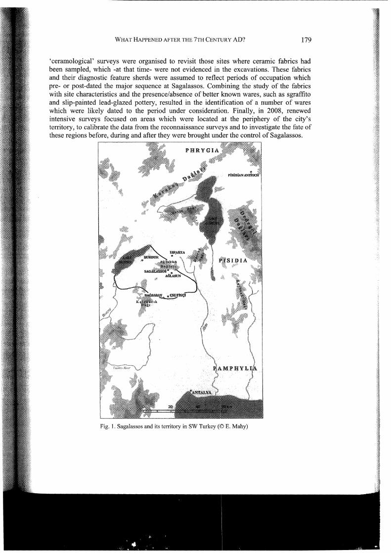
The setting Sagalassos and its territory are located in the western Taurus Mountains, ca. 100 km north of the southern coast of Turkey, in ancient Pisidia (Fig. 1 ). At its apex in Roman times, the city's territory extended over ca. 1200 km27• Initiated within the framework of Stephen Mitchell's 'Pisidia Project', the current Belgian interdisciplinary excavation project at Sagalassos began in 1990, and was soon expanded by surveys and restoration activities8.
From 1993 to 1998 reconnaissance surveys were carried out in the territory of the city, resulting in a corpus of more than 250 sites, ranging in size from isolated ceramic finds to large village sites, and in date from the Epipalaeolithic to the Late Ottoman period9. In 1999, a programme of intensive surveys was initiated, both in the city and its suburban area, to document chronological and functional changes in the relationship between the city and its vicinity from Hellenistic through Early Byzantine times, and to investigate what transpired before the urbanisation of Sagalassos in the Hellenistic period and after the major occupation at Sagalassos ended after the ih century AD. So-called
4 Brandes and Haldon 2000. 5 Mitchelll993: 9. 6 Similar studies are available for the British Isles (Hamerow 2004), Italy (Francovich and Hodges 2003; La Rocca 2002) and Greece (Lock and Sanders 1996; and regional survey projects such as the Boeotia survey (first volume by Bintliffand Howard 2007) and the Keos survey (Cherry, Davis and Mantzourani 1991)). 7 Waelkens eta!. 1997: 97-99; Waelkens et al. 2000: 40, 175-76, 187-88, 211. 8 Waelkens 1993a; Waelkens and Poblome 1993; Waelkens and Poblome 1995; Waelkens and Poblome 1997; Waelkens and Loots 2000; Degryse and Waelkens 2008; Waelkens in press a-b. 9 Waelkens 1995; Waelkens et al. 1997; Waelkens et al. 2000; Vanhaverbeke and Waelkens 2003.
-----------------·-- ---·----~-~------
WHAT HAPPENED AFTER THE 7TH CENTURY AD? 179
'ceramological' surveys were organised to revisit those sites where ceramic fabrics had been sampled, which -at that time- were not evidenced in the excavations. These fabrics and their diagnostic feature sherds were assumed to reflect periods of occupation which pre- or post-dated the major sequence at Sagalassos. Combining the study of the fabrics with site characteristics and the presence/absence of better known wares, such as sgraffito and slip-painted lead-glazed pottery, resulted in the identification of a number of wares which were likely dated to the period under consideration. Finally, in 2008, renewed intensive surveys focused on areas which were located at the periphery of the city's territory, to calibrate the data from the reconnaissance sunreys and to investigate the fate of these regions before, during and after they were brought under the control of Sagalassos.
Fig. 1. Sagalassos and its territory in SW Turkey (<g E. Mahy)
180 H. V ANHA VERBEKE ET AL.
This is the database at our disposal to discuss the Sagalassian countryside after the 7th century AD. The sequence of events at Sagaiassos itself will not be repeated here, as it has been published in detail elsewhere10• Suffice to say that the city maintained its religious administrative function for the region, seeing that it continued to be mentioned as the seat of a bishop. Economically, however, it never reached the level of supremacy over the countryside which it had enjoyed before. By the end of the ?'h century AD, the economic role of villages, on the contrary, had increased. Production now took place in the countryside, rather than near the city, possibly with the aim to supply the villages, instead of primarily the city11 •
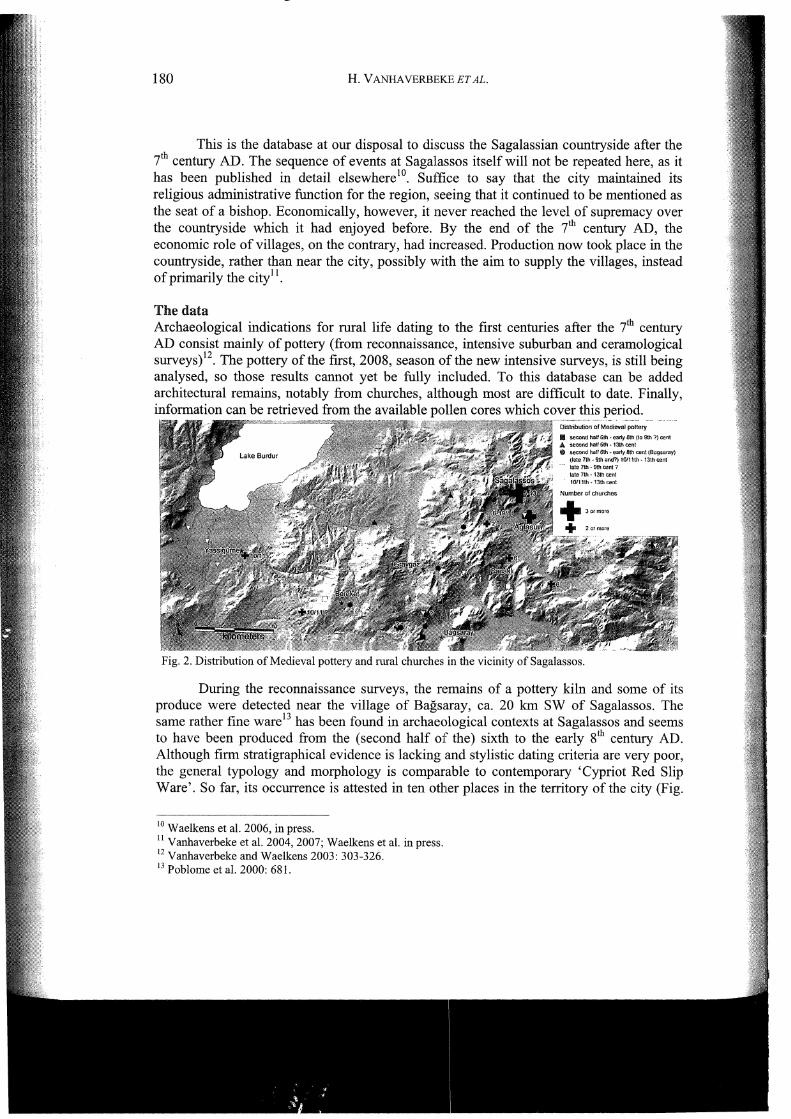
The data Archaeological indications for rural life dating to the first centuries after the ?'h century AD consist mainly of pottery (from reconnaissance, intensive suburban and ceramological surveys)12. The pottery ofthe first, 2008, season of the new intensive surveys, is still being analysed, so those results cannot yet be fully !included. To this database can be added architectural remains, notably from churches, although most are difficult to date. Finally, information can be retrieved from the available pollen cores which cover this period.
1111 second hatr G!h ·early 6111 (Ia Sth ?) cenl A !lecood t!DJI 6th· f3U~ cent $ .second half 6th - eilriy 8th coni (Btlg!;>!ll'ay}
(tale 7Ul • 9ttumd?) 10111th- 1J.th cent
!ate 7th - 9th ~nt ? !ate 7th- 13th cent
Fig. 2. Distribution of Medieval pottery and rural churches in the vicinity of Sagalassos.
During the reconnaissance surveys, the remains of a pottery kiln and some of its produce were detected near the village of Bagsaray, ca. 20 km SW of Sagalassos. The same rather fine ware13 has been found in archaeological contexts at Sagalassos and seems to have been produced from the (second half of the) sixth to the early 81h century AD. Although firm stratigraphical evidence is lacking and stylistic dating criteria are very poor, the general typology and morphology is comparable to contemporary 'Cypriot Red Slip Ware'. So far, its occurrence is attested in ten other places in the territory of the city (Fig.
10 Waelkens eta!. 2006, in press. 11 Vanhaverbeke eta!. 2004, 2007; Waelkens eta!. in press. 12 Vanhaverbeke and Waelkens 2003: 303-326. 13 Poblome eta!. 2000: 681.

WHAT HAPPENED AFTER THE 7TH CENTURY AD? 181
2), in particular in its eastern half, where the extent of associated earlier surface remains suggests the location of farms, hamlets or villages in Roman times. It is, however, unclear to what degree the size of these settlements was maintained during the mid-fh to early 8th century AD. Equally, no ready explanation for their distribution is at hand. Whatever the nature of these sites is, it is striking that they are all located in remote valleys, or on hill/mountain slopes.
As a result of the ceramological surveys, ten coarse fabrics which bear upon the period under investigation were distinguished. Some of these fabrics had initially been attributed a terminology according to their find-spot location, and were correctly considered post-Roman in date14. Systematic study in 2005 and 2007 of the post .. Roman assemblages excavated at sites within the city of Sagalassos, revealed that nearly an of the post-Roman pottery collected through extensive survey from the surrounding territory (and studied in 2008) is identical in terms of fabric and form, to dated assemblages from three sites at Sagalassos: the Sanctuary of Apollo Klarios, the Temple of Hadrian and Antoninus Pius and Alexander's Hill. For the purpose of this paper two main ceramic periods/phases can be distinguished in Medieval times: an early phase dating from the end of the i to 9th century AD ('Early Medieval' or 'Byzantine Dark Ages' 15) and a later phase dating from the lOth/11th to the mid-13th century AD ('Middle Byzantine'). It is beyond the scope of this paper to describe these fabrics in great detail here16• It is worth noting, however, that five common-ware fabric types from the survey area are attributed to the early and five to the later period. All of these were used for making specific wares associated with permanent or seasonal occupation, e.g. cooking pots, undecorated 'table' jugs, storage and transport vessels.
The late fh to 9th century AD wares identified in the survey territory are also present, as mentioned above, at Sagalassos, representing an assemblage completely different to the earlier, 4th to 7th century AD, and later, lOth;uth to mid-13th century AD, ceramic types and forms 17• This assemblage is comprised of (a) handmade (or made on a slow wheel) non-kiln-fired cooking pots in a coarse-grained brown fabric, (b) wheel-made kiln-fired cooking pots of the 'Cypriotic' tradition in a hard coarse-gritty reddish fabric, (c) closed vessels ('table' jugs) in micaceous reddish-brown compact fabrics, and (d) the socalled 'pattern-burnished wares' Uugs and jars) in a coarse-grained yellowish-red fabric, their exterior surface being ornamented with vertical and diagonal burnished lines. The systematic lack of any associated lead-glazed wares strengthens the suggestion that the aforementioned fabrics were in use before the latter became more common in the 11 th .. 13 th centuries AD. To date, the number of places (9) where these wares have been recognised is slightly more limited than is the case for the Bagsaray ware (Fig. 2). The nature of the sites where it was found also differs. The pottery density is very low, and sherds are thinly scattered. This may point to small-scale (farms) or a less intensive (not year-round?) occupations. These sites are located along natural corridors, or on hill/mountain slopes.
The later common wares identified in the survey territory are also present at the excavated site of the so-called 'Alexander's Hill' in Sagalassos, where they were more
14 Vanhaverbeke and Waelkens 2003: 141-142. 15 Following Vionis, Poblome and Waelkens (this volume). 16 Vionis, Poblome and Waelkens (in press); Vionis, Poblome and Waelkens (submitted); Vionis, Poblome and Waelkens (this volume). 17 Vionis, Poblome and Waelkens (in press).

182 H. V ANHA VERBEKE ET AL.
securely dated on the basis of their association with coin- and glazed-ware evidence to the 1oth I 11th - 13th century AD. The most common fabric identified in the survey area is a hardfired reddish-yellow fabric with some schist, mica, and black specks, and it is used for the production of a wide range of plain vessels, such as unglazed cups and bowls, dishes, jugs, cooking pots, transport and storage jars. The commonest shapes represented in the countryside are (a) a flat-bottomed single-handled cooking pot with a thickened rounded rim and (b) a jar or standing costrel with a flat base, two opposed oval or strap handles, and an upright simple rim. These common-ware fabrics have been identified on nine fmd-spots, while five of them have also produced lead-glazed wares of the 1ih-13th and l31h-14th centuries.
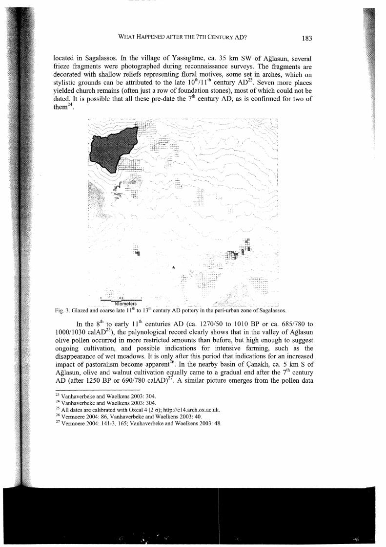
In general these glazed wares are better attested in the territory, because of their obtrusive nature. There are five main lead-glazed decorated pottery types identified in the survey territory to date, namely Slip Painted, Green and Brown Painted, Fine Sgra[fito, Incised Sgraffito/Champleve, and Plain Glazed wares, all dated to between the late 11 t and the mid-13th century AD. The typical shape of all these lead-glazed decorated types is a rather thick-walled dish with a low ring-base and a plain or slightly everted rim. They all seem very similar in form and decoration (as well as in fabric) to examples of published lead-glazed table-wares from the west coast of Anatolia, the Aegean coasts and islands, and Cyprus 18, although no specific pottery workshop can be identified with certainty at the moment, apart from a few sherds possibly originating from Corinth19• Several fragments were collected during the reconnaissance surveys, and later during the intensive prospections near the city. In the former they have only been found in association with more abundant Roman remains, and their status in terms of the nature of occupation linked to them is not clear. For the suburban survey, however, the distribution of glazed sherds is clearly clustered (Fig. 3). These small clusters are interpreted as representing the remains of hamlets or less-intensive (seasonal ?) occupations. In the li11 - 13th century AD, possibly a Byzantine garrison was stationed on the fortified Alexander Hill just south of Sagalassos20, and the clusters of sherds may relate to this occupation. Alternatively the Seljuk han which was established in Aglasun during the reign of Giyaseddin Kayhosrau II (1237-1246 AD), the hamam of which is preserved until this day21 , may have constituted the core (marketplace) of several of these outlying small-scale permanent or temporary settlements.
Several churches are preserved in Sagalassos itself, which were erected and modified in the centuries between the first half of the 5111 and the 13th century AD22 (Fig. 2). The suburban surveys also yielded architectural church fragments. At least one 6th century AD church was located in present-day Aglasun, underneath one of the village's cemeteries, where elements of its mosaic floor paving remain in situ. Other fragments were kept in one of the depots of the village. One capital is of 6th century date AD, while a carved plaque, as well as elements of an architrave and of a frieze, can be dated to the late 10111 or (early) 11th century AD. These are spolia, however, and it cannot be excluded that they were originally
18 Vionis 2001. 19 Sanders 2000. 20 Waelkens et al. 2006, in press. 21 Vanhaverbeke et al. 2005. 22 Waelkens et al. 2006, in press; Ta!loen 2003; Jacobs 2008: 206-219, 256-259.
WHAT HAPPENED AFTER THE 7TH CENTURY AD? 183
located in Sagalassos. In the village of Yass1giime, ca. 35 Ian SW of Aglasun, several frieze fragments were photographed during reconnaissance surveys. The fragments are decorated with shallow reliefs representing floral motives, some set in arches, which on stylistic grounds can be attributed to the late 101h/ll th century AD23 • Seven more places yielded church remains (often just a row of foundation stones), most of which could not be dated. It is possible that all these pre-date the ih century AD, as is confirmed for two of them24.
*
kilorll~lers .. Fig. 3. Glazed andc~arse late-11 1h to13'h c~ntucy AD pottery in the peri-urban zon~ ofS~ga1~~sos.
In the 81h to early ll1h centuries AD (ca. 1270/50 to 1010 BP or ca. 685/780 to 1000/1030 calAD25), the palynological record clearly shows that in the valley of Aglasun olive pollen occurred in more restricted amounts than before, but high enough to suggest ongoing cultivation, and possible indications for intensive farming, such as the disappearance of wet meadows. It is onl~ after this period that indications for an increased impact of pastoralism become apparent 6 . In the nearby basin of <;anakh, ca. 5 Ian S of Aglasun, olive and walnut cultivation e~ually came to a gradual end after the ih century AD (after 1250 BP or 690/780 calAD)2 • A similar picture emerges from the pollen data
23 Vanhaverbeke and Waelkens 2003: 304. 24 Vanhaverbeke and Waelkens 2003: 304. 25 All dates are calibrated with Oxcal4 (2 cr); http://cl4.arch.ox.ac.uk. 26 Vermoere 2004: 86, Vanhaverbeke and Waelkens 2003: 40. 27 Vermoere 2004: 141-3, 165; Vanhaverbeke and Waelkens 2003: 48.
184 H. V ANHA VERBEKE ET AL.
retrieved in the basin of Gravgaz, ca. 14 km SW of Aglasun (Fig. 2). Here, small-scale cereal cultivation continued in the period ca. 1480-930 BP (ca. 560/610 to 1040/1155 calAD), followed by indications for increased pastoral economy after 930 BP (ca. 1040/1155 ca1AD)28 . The recently studied pollen sequence at Bereket, ca. 25 km SW of Aglasun (Fig. 2) displays the same sequence of a phase of limited cultivation after ca. 650 calAD, followed by extensive grazing and conversion from fallow to pasture land29 •
A new perspective Let us now fit these data into the framework proposed by the premise of rural life continuing beyond the ih century AD. Based on the archaeological and palynological evidence for the Sagalassos region, the period from ca. the (second half of the) 6th to the early 8th century AD, represented by the Bagsaray ware and most of the datable rural churches, is characterised by a possible continuation of the varied array ofmral settlements (farms, hamlets and villages) of the previous centuries. Whatever their scale, these settlements are primarily located in less accessible areas, a trend which was noticeable from Late Roman times onwards30. Occupation associated with pottery dating to the later ih to 9th centuries AD seems to have been less intensive or large-scale in nature, centred on elevated spots in the landscape, or along natural routes. Rural churches are still attested during this period.
In general, the material evidence for the mid-ih to 9th centuries AD centres on the eastern part of the former territory of Sagalassos for reasons which are as yet unclear. While the cultivation of highly intensive cash-crops, such as olives, ceased in some areas, this was not the case for the immediate vicinity of Sagalassos (valley of Aglasun), where olive cultivation seems to have been continued for some time still. Elsewhere, as in Gravgaz and Bereket, less intensive cereal cultivation was practised. It makes sense to assume that the increased emphasis on sheep and goats (instead of on cattle), attested in the excavated faunal record at Sagalassos31 , would have continued, resulting in a combination of cereal cultivation and local pastoralism.
After the lOth to 11th centuries AD, the construction or modification of mral churches seems to have ceased. Settlement nuclei are small permanent or temporary establishments, and occur mainly in the western part of the area. Pollen records for this period suggest that the main economic focus was on pastoralism. If indeed some of these sites are temporary in nature, they could represent part of a system of small-distance transhumance, with summer pastures (yay las) and winter sites. This system was well established, and occurred over long distances from the Ii11 century AD onwards, and has only recently been nearly completely dissolved in the face of increasing state control (already under the Ottoman sultans), population pressure and technical innovations in agricultural practice32 .
28 Vermoere 2004: 140; Vanhaverbeke and Waelkens 2003:.31-32. 29 Kaniewski et a!. 2007a-b, 2008. 30 Vanhaverbeke eta!. 2004, 2007; Waelkens eta!. in press. 31 De Cupere 2001: 139, fig. 99; Vanhaverbeke eta!. 2004, 2007; Waelkens eta!. in press. 32 Vanhaverbeke and Waelkens 2003: 309-314; an ov,:rview of the traditional routes of transhumant pastoralists is provided by De Planhol 1958: 190-233.
----·----------------·----
WHAT HAPPENED AFTER THE 7TH CENTURY AD? 185
Several observations can be made First, there is no need to speak of an occupational gap after the ih century AD. Although the dots on the map in Fig. 2 are, at this stage, only indications for some form of occupation/exploitation, the scale of which is not always clear, this is not an empty landscape. Obviously in terms of number of sites, a decrease is observed. From twenty sites for the period from the second half of the 61h to the 91h century AD ( 5. 71100 yrs ), to nine sites for the lih and 131h centuries AD (or 4.5/100 yrs).
However, these figures need to be handled with care. Site numbers do not equate population numbers. Although many sites seem to have been abandoned after the ih century AD, instead of immediately referring to decline or its consorts, the socio-economic background against which this decrease took place needs to be evaluated33 . New sites were established, but these were located in less obvious places and are not characterised by extensive surface remains (see below). Since reconnaissance surveys and ceramological surveys form the core of our database, it has to be kept in mind that the latter has focused on a limited number of sites, while it is very likely that the former did not pick up the kind of traces which seem to be 'typical' for the period after the ih century AD. Therefore, the material traces of an economy not, or only weakly, associated with permanent occupation, such as a more pastoral way of living, will be less visible during surveys. Possibly as many artefacts were in use as was the case before, but due to their being less clustered, and constituted by less obtrusive wares, their number is seriously underrepresented in reconnaissance surveys.
How bad the situation actually may be, can be illustrated by the very preliminary results of the 2008 intensive survey. This survey took place in a small basin where 8 km2
has been covered, some 25 km SW from Sagalassos. Earlier reconnaissance surveys had detected one Hellenistic-Roman village and a probable protohistoric fortress34. Nothing archaeologically was known on the period after the ih century AD. The new survey, however, located a small post-ih century AD (farm?) site in a remote side valley, and a control post possibly of the same late date on one of the mountain flanks overlooking the natural access to the basin. The pottery was not associated with any glazed wares. Although further research is needed, it seems not unwarranted to allocate both sites to the period ca. ih - 11th century AD. Thus, from a complete lack of post-ih century AD artefacts, the situation has changed after one survey season to one in which there are at least two, small, foci of activity.
If we extrapolate this observation -as an intellectual exercise merely- to the whole of the ancient territory of Sagalassos (ca. 1200 km2), this would mean that 300 potential sites have escaped attention. Even if this figure is inflated, it is clear that we have just breached the top of the proverbial iceberg of research into Medieval Anatolia.
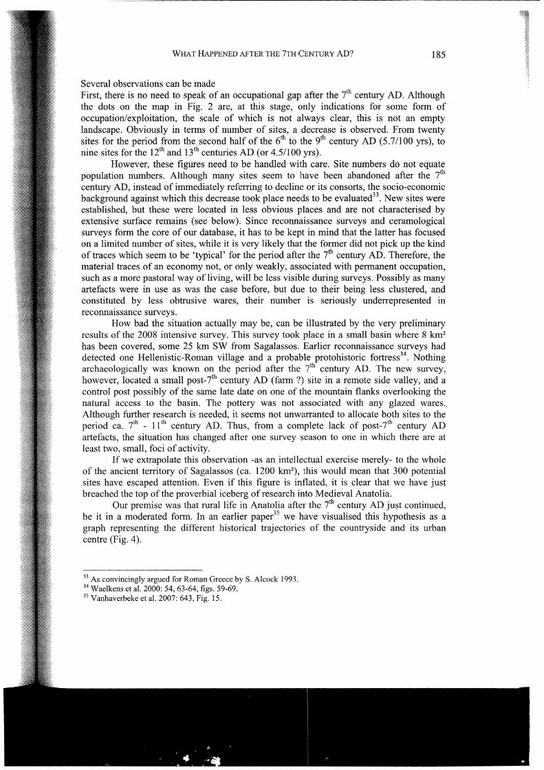
Our premise was that rural life in Anatolia after the ih century AD just continued, be it in a moderated form. In an earlier paper35 we have visualised this hypothesis as a graph representing the different historical trajectories of the countryside and its urban centre (Fig. 4).
33 As convincingly argued for Roman Greece by S. Alcock 1993. 34 Waelkens et al. 2000: 54, 63-64, figs. 59-69. 35 Vanhaverbeke et al. 2007: 643, Fig. 15.
186 H. V ANHA VERBEKE ET AL.
At the time of the conference which lay at the basis of that publication, in 2003, this scheme was highly tentative, based as it was on some very preliminary indications. The curve for the countryside was rather swelled for the Hellenistic to Early Byzantine period (until ca. 550 AD) because it was assumed that the countryside then was much denser occupied than it was both before and after, and that its evolution during this period closely corresponded to the fate of the city.
This graph can now be updated in two ways First, concrete evidence has come to light to support our claim that the picture for the countryside after the ih century AD is not so bleak indeed. After the collapse of complex urban life at Sagalassos from the later 6th century AD onwards36, the countryside went back to what it had been most of the time, a landscape organised around peer villages. By that time, rural communities had established ways of taking care of themselves in becoming self-reliant. In the ih to 9th centuries AD in particular, villages may have remained in use, especially near Sagalassos, which itself remained inhabited in the shape of several hamlets, while smaller-sized communities continued to function in the lOth to 11th centuries AD. These communities were often located in proximity to a rural church.
45
40
35
30
25
20
15
10 country
EIA Hell Rom Ebyz 550 post 7th
Fig. 4. Sagalassos: schematic representation of the different trajectories of city and country (nrs. on Y -axis are relative indicators of density and monumentality of material remains)
Although most communities are now rather small (hamlet size at the most; possibly not occupied year-round), in terms of number of sites, the pattern does not change much after the 11th century AD. However, the sites which seem to have been in use only now (light blue dots in Fig. 2) are located in more accessible places, notably plains or along natural routes. In view of the fact that sites were small and possibly temporary in nature,
36 Waelkens et al. 2006, in press.
WHAT HAPPENED AFTER THE 7TH CENTURY AD? 187
can they be related to pastoral groups? It is around this time that indications for increased pastoralism appear in the pollen diagrams of the region37. Are we then to link these remains with local pastoral groups on or are they, for the later part of the period, the archaeological manifestations of Seljuk groups? At Sagalassos itself, a Byzantine garrison was probably stationed on the Alexander Hill in the 101h/ll th to 131h centuries AD38, while early in the 13th century AD the Seljuk hamam in Aglasun was constructed. At some point the Byzantine locals and the foreign immigrants must have met. The establishment of a han in Aglasun visualises the outcome of the process, in that ultimately the area was conquered by the Seljuks, but for some time both groups must have interacted in some way. Unfortunately, it is much too early to provide an answer to these questions -if an answer is possible at all. The main point is that the landscape continued to be occupied and exploited, seemingly continuously between the 7th and the 13th century AD. Unfortunately, the nature of this use was such that it left less visible archaeological traces. Still, these traces are present and retrievable with adequate methods, such as intensive surveys which venture out into more remote areas.
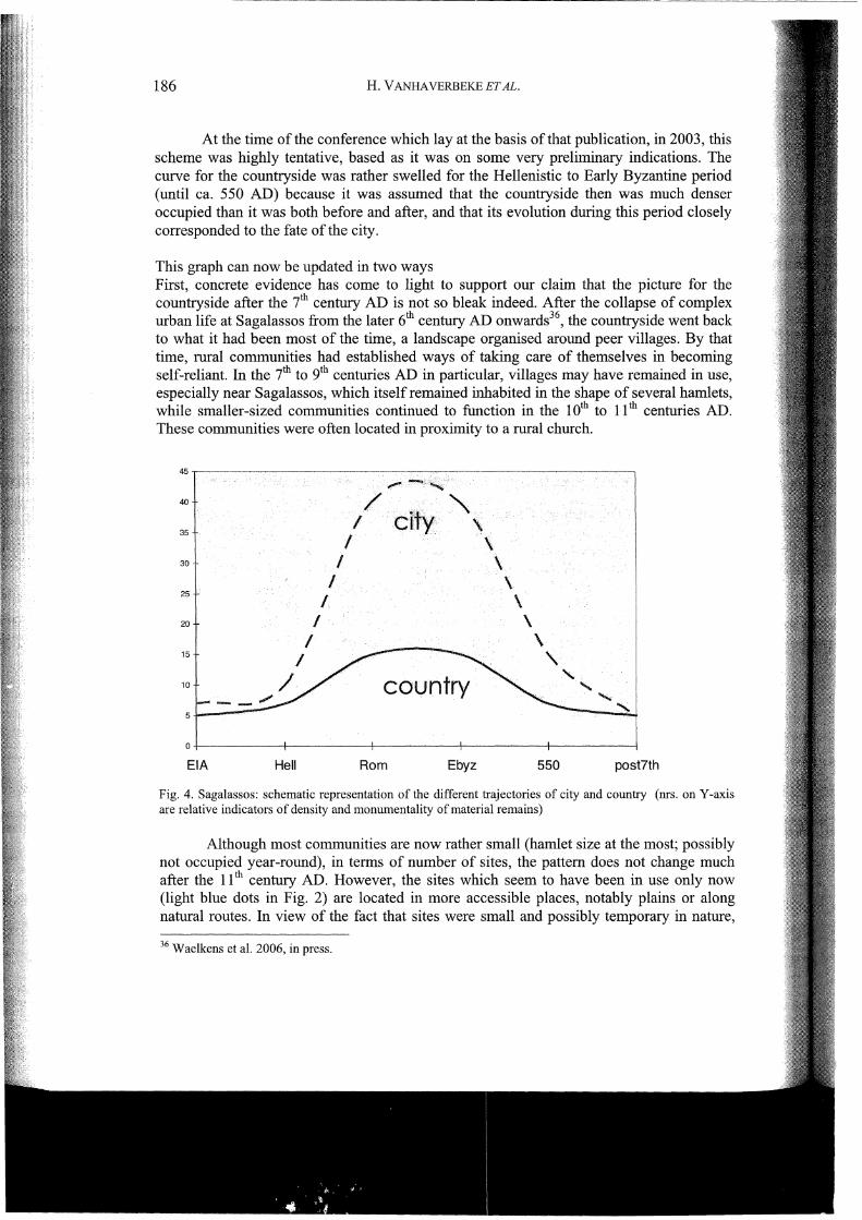
This is our second point: new intensive surveys have clearly indicated what one misses when limiting research to easily accessible areas which are more rather scanned. In that sense, the original 'country curve' expressed a rather pessimistic view for the period after the ih century AD (Fig. 4). In the updated version of the graph (Fig. 5), the downward tip of the curve has been modified in a way which, in our view, more accurately
1. 39 represents rea tty .
40
35
30
25
20
15
10
/
/ /
/
country 5.L:.-----O+----------+----------+----------+----------;
EIA Hell Rom Ebyz post 7th
Fig. 5. Sagalassos: modified schematic representation of the different trc\iectmies of city and country (nrs. on Y -axis are relative indicators of density and monumentality of material remains)
37 Vermoere 2004: 86, 140-3, 165; Kaniewski eta!. 2007a-b, 2008. 38 W aelkens et a!. 2006, in press. 39 The curve for the city has been modified for the pre-Hellenistic period since the discovery of the ArchaicClassic urban predecessor of Sagalassos (V anhaverbeke et a!. accepted).

188 H. V ANHA VERBEKE ET AL.
Conclusion Our premise was that the Anatolian countryside continued to be occupied and exploited pretty much undisturbed after the ih century AD. Changes are noticeable after the 9th century AD, and again in the lth to 13th centuries AD, but at no point in time was the landscape 'empty'. The focus on monumental remains has badly misled research into Medieval rural Anatolia, and with more realistic and accurate expectations in mind, a research method can be devised which results in a new hitherto untapped reservoir of data. Intensive surveys are the tool to investigate the Medieval countryside with its myriad of small, unobtrusive and often temporarily occupied sites, which replaced the clustered and highly visible landscape of classical times. Any research agenda dealing with the Medieval Anatolian countryside will have to rely in part on survey methods for the establishment of a reliable database and the construction of new hypotheses.
Bibliography Alcock, S., 1993- Graecia capta: the landscapes of Roman Greece, Cambridge.
Bintliff, J.L. and Howard, P., 2007- Testing the Hinterland. the work of the Boeotia Survey (1989-1991) in the southern approaches of the city ofThespiai, Cambridge.
Bowersock, G.W., Brown, P. and Grabar, 0., 2001 - Interpreting Late Antiquity. Essays on the Postclassical World, Cambridge, Mass. and London.
Brandes, W. and Haldon, J., 2000 - Towns, tax and transformation : State, cities and their hinterland in the East Roman world, c. 500-800. In G.P. Broglioglo, N.Gauthier and N.Christie (eds.), Towns and their Territory between Late Antiquity and the Early Middle Ages. Leiden, Boston, and Koln, 141-172.
Broglioglo, G.P., Gauthier, N. and Christie, N. (eds), 2000 - Towns and their Territory between Late Antiquity and the Early Middle Ages, Leiden, Boston, and Koln, 141-172.
Brown, P., 1989- The World of Late Antiquity, AD 150-750, London.
Cherry, J.F., Davis, J.L., Mantzourani, E. (eds.), 1991 - Landscape Archaeology as Long-Term History. Northern Keos in the Cycladic Islands from Earliest Settlement until Modem Times, Los Angeles.
Christie, N., and Loseby, S.T., 1996- Towns in Transition. Urban Evolution in Late Antiquity and the Early Middle Ages, Aldershot and Brookfield.
Christie, N. (ed.), 2004- Landscapes of Change. Rural Evolutions in Late Antiquity and the Early Middle Ages, Aldershot.
De Cupere, B., 2001 - Animals at Ancient Sagalassos. Evidence of the Faunal Remains. Studies in Eastem Mediteranean Archaeology 4, Tumhout.
Degryse, P., and Waelkens, M. 2008 - Sagalassos VI. Geo- and Bio-Archaeo1ogy at Sagalassos and in its Tenitory, Leuven.
De Planho1, X., 1958 -De !a plaine pamphylienne au lacs pisidiens, Paris.
Foss, C., 1976 - Byzantine and Turkish Sardis, Cambridge, Mass. and London.
Foss, C., 1977- Late-antique and Byzantine Ankara. In: Dumbarton Oaks Papers 31, 28 .. 87.
Foss, C., 1979- Ephesus after Antiquity. A late antique, Byzantine and Turkish City, Cambridge, Mass.
Foss, C., 1994- The Lycian coast in the Byzantine age. In: Dumbarton Oaks Papers 48, 1-52.
Foss, C., 1996 - The cities of Pamphylia in the Byzantine age, first publication. In: C. Foss (ed.), Cities, Fortresses and Villages of Byzantine Asia Minor. Variorum Collected studies Series CS 538, Aldershot, 1-62.
------~~-----~~--~~~~
WHAT HAPPENED AFTER THE 7TH CENTURY AD? 189
Francovich, R., and Hodges, R. 2003 - Villa to Village. The Transformation of the Roman Countryside in Italy c. 400-1000, London.
Haldon, J.F., 1999- Warfare, State and Society in the Byzantine World, 565 -1204, London.
Ha1don, J.F., 2000- Byzantium. A History, Stroud.
Hamerow, H., 2004- Early Medieval Settlements. The Archaeology of Rural Communities in North-West Europe 400-900, Oxford.
Jacobs, I., 2008 - The Aesthetic Maintenance of Civic Space in Asia Minor from the 4th to the 7th Century AD. A Contribution to the Discussion About the "Transformation" or "Decline" of the Ancient City, Unpublished PhD dissertation, K.U.Leuven.
Kaniewski, D., Paulissen, E., De Laet, V., Dossche, K., and Waelkens., M., 2007a- A high-resolution Late Holocene landscape ecological history inferred from an intramontane basin in the Western Taurus Mountains, Turkey. In: Quaternary Science Reviews 26, 2201-2218.
Kaniewski, D., De Laet, V., Paulissen, E. and Waelkens, M., 2007b - Long-term effects of human impact on mountainous ecosystems, western Taurus Mountains, Turkey. In: Journal of Biogeography, 34.11, 1975-1997.
Kaniewski, D., Paulissen, E., De Laet, V., and Waelkens, 1111., 2008 -Late Holocene fire impact and post-fi;.: regeneration from the Bereket basin, Taurus Mountains, Southwest Turkey. In: Quaternary Research 70.2, 228-239.
La Rocca, C. (ed.), 2002- Italy in the Early Middle Ages, 476-1000, Oxford.
Lock, P., and Sanders, G.D.R. (eds.), 1996- The Archaeology ofMedieva1 Greece, Oxford.
Mango, C., 1988- Byzantium. The Empire ofthe New Rome, London.
Poblome, J., Ekinci, H.A., Ozttirk, I., Degryse, P., Viaene, W., en Waelkens, M., 2000- An Early Byzantine tile and lime kiln in the territory of Saga1assos. M. Waelkens and L. Loots ( eds.), Sagalassos V. Report on the Excavation Campaigns of 1996 and 1997. Acta Archaeo1ogica Lovaniensia Monographiae 11 B, Leuven, 669-683.
Sanders, G.D.R., 2000 - New relative and absolute chronologies for 9th to 13th century glazed wares at Corinth: methodology and social conclusions. In: K. Belke, F. Hild, J. Koder and P. Soustal (eds.), Byzanz als Raum. Zu Methoden und Inhalten der Historischen Geographie des Ostlichen Mittelmeerraumes. Vienna, 153-173.
Talloen, P., 2003 -Cult in Pisidia. Religious Practice in Southwestern Asia Minor from the Hellenistic to the Early Byzantine Period, Unpublished PhD dissertation, K.U.Leuven.
Vanhaverbeke, H., and Waelkens, M., 2003 - The Chora of Sagalassos. The Evolution of the Settlement Pattern in the Territory of Sagalassos from Prehistoric until Recent Times. Studies in Eastern Mediterranean Archaeology 5, Turnhout.
Vanhaverbeke, H., Martens, F., Waelkens, M., and Poblome, J., 2004 - Late Antiquity in the territory of Sagalassos (Pisidia, SW Turkey). In: W. Bowden, L. Lavan and C. Machado (eds.), Recent Research on the Late Antique Countryside. Late Antique Archaeology 2, Aldershot, 247-9.
Vanhaverbeke, H., Ba~agar,;, 6., and Paul, K., 2005- A Selr,;uk hamam at Aglasun, Burdur Province, Turkey. In: Turcica 37, 309-336.
Vanhaverbeke, H., Martens, F., and Waelkens, M., 2007- Another view on late Antiquity. Sagalassos (SW Anatolia), the suburbium and the countryside in Late Antiquity. In: A. Poulter (ed.), The Transition to Late Antiquit on the Danube and Beyond. Oxford, 611-648.
Vanhaverbeke, H., Waelkens, M., Vyncke, K., De Laet, V., Aydal, S., Music, B., De Cupere, B., Braekmans, D., Degryse, P., Marinova, E., Poblome, J., Verstraeten, G., Van Neer, W., Slapsak, B., Medaric, I, Ekinci,

--------
190 H. V ANHA VERBEKE ET AL.
H.A. and Erbay, M.O., accepted - Emerging urbanism in Pisidia (southwest Anatolia). The origins of Sagalassus at Tepe Duzen, Anatolian Studies.
Vionis, A.K., 2001 - Post-Roman pottery unearthed: Medieval ceramics and pottery research in Greece. In: Medieval Ceramics 25, 84-98.
Vionis, A.K., Poblome, J. and Waelkens, M., in press- The hidden material culture of the Dark Ages: early medieval ceramics at Sagalassos (Turkey); new evidence (ca. 650-800 AD). In: Anatolian Studies 59.
Vionis, A.K., Poblome, J. and Waelkens, M., in peer review - What did the Byzantines Eat? A Middle Byzantine pottery assemblage at Sagalassos, Turkey. In: Hesperia.
Waelkens, M., Vanhaverbeke, H., Erbay, M., Paulissen, E., De Cupere, B., Ekinci, H.A., Poblome, J. and Degeest, R., 2000 - The 1996 and 1997 Surveys on the territory of Sagalassos. In: M. Waelkens and L. Loots (eds.), Sagalassos V. Report on the Excavation Campaigns of 1996 and 1997. Acta Archaeologica Lovaniensia Monographiae 11 A, Leuven, 17-216.
Waelkens, M., Vanhaverbeke, H., Martens, F., Talloen, P., Poblome, J., Uytterhoeven, I., Kellens, N., Putzeys, T., Degryse, P., Van Thuyne, T., and Van Neer, W., 2006- The Late Antique to Early Byzantine city in Southwest Anatolia. Sagalassos and its territory: A case study. In: J.-U. Krause and C. Witschel (eds.), Die Stadt in der Spatantike- Niederganr; oder Wandel? Akten des Intemationalen Kolloquiums in Munchen am 30. und 31. Mai 2003. Stuttgart, 199-255.
Wae1kens, M. (ed.), in press - Sagalassos VII. The Bouleuterion Complex and Porticoes of the Upper and Lower Agora.
Waelkens, M. ( ed. ), in press - Sagalassos Vlll. Preliminary Results of the Excavations and Survey Seasons from 1998 to 2004.
Waelkens, M., Martens, F., Vanhaverbeke, H., Talloen, P., Poblome, J., Kellens, N., Lauwers, V., Putzeys, T., Van Neer, W., and Van Thuyne, T., in press - The fifth to tenth century AD in Southwest Anatolia: Transformation or decline. A case-study: Sagalassos and its Chora. In: M.A. Talbot-Rice (ed.) Urban and Rural Settlement in Anatolia and the Levant 500-1000 AD: New Evidence from Archaeology, April 22-24, 2005 Dumbarton Oaks (Dumbarton Oaks Papers).
Whittow, M., 1996- The Making of Orthodox Byzantium, 606-1025, London.