what makes a complex society complex? -...
TRANSCRIPT

WhatMakesaComplexSocietyComplex?
TheDresdenCodex.Publicdomain.
SupportingQuestions
1. HowdidtheMayausewritingtorepresentactivitiesintheirculture?2. WhatdidtheAztecsdotomastertheirwateryenvironment?3. WhywereroadsimportanttotheIncaEmpire?

1
SupportingQuestion1FeaturedSource SourceA:MarkPitts,bookexploringMayawriting,Book1:WritinginMayaGlyphs:Names,
Places&SimpleSentences—ANon-TechnicalIntroductiontoMayaGlyphs(excerpt),2008
THE BASICS OF ANCIENT MAYA WRITING
Maya writing is composed of various signs and symbol. These signs and symbols are often called ‘hieroglyphs,’ or more simply ‘glyphs.’ To most of us, these glyphs look like pictures, but it is often hard to say what they are pictures of…. Unlike European languages, like English and Spanish, the ancient Maya writing did not use letters to spell words. Instead, they used a combination of glyphs that stood either for syllables, or for whole words. We will call the glyphs that stood for syllables ‘syllable glyphs,’ and we’ll call the glyphs that stood for whole words ‘logos.’ (The technically correct terms are ‘syllabogram’ and ‘logogram.’) It may seem complicated to use a combination of sounds and signs to make words, but we do the very same thing all the time. For example, you have seen this sign:
©iStock/©jswinborne Everyone knows that this sign means “one way to the right.” The “one way” part is spelled out in letters, as usual. But the “to the right” part is given only by the arrow pointing to the right. Thus, this street sign is a combination of words and pictures that is very much like the way the Maya wrote things. After all, when a picture is worth a thousand words, why spell it out?
WritinginMayaGlyphs:Names,Places&SimpleSentences—ANon-TechnicalIntroductiontoMayGlyphsfromtheAidandEducationProject.Inc.©2008.UsedwithpermissionfromMarkPitts.http://www.famsi.org/research/pitts/MayaGlyphsBook1Sect1.pdf

2
SupportingQuestion1FeaturedSource SourceB:Ancient-symbols.com,chartshowinglogogramstheMayausedtoexpresswordsand
ideas,“MayaSymbolsandGlyphs,”2014
Copyright©2014Ancient-Symbols.com.http://www.ancient-symbols.com/mayan_symbols.html.

3
SupportingQuestion1
FeaturedSources SourceC:ColorrenditionofapageoftheDresdenCodex,an11th-centuryMayatext,fromVuesdesCordillères,publishedbyAlexandervonHumboldt,1810
The Dresden Codex is thought to be a copy of an 11th-century Mayan book (or codex) that was created in the 15th century. The codex is the oldest known book from the Americas and was brought to Europe by Spanish conquerors. Five pages of the document were reproduced in the first Western publication of the codex, an 1810 book on the Americas published by Alexander von Humboldt.
Publicdomain.http://en.wikipedia.org/wiki/Dresden_Codex#mediaviewer/File:Humboldt_1810_pp_47_48_50_51_52.jpg.

4
SupportingQuestion2FeaturedSources SourceA:DescriptionoftheAztecchinampasystem,2015
Aquaculture
Chinampas were a creative and productive approach to agriculture developed by the Aztec civilization. They consisted of a series of alternating canals and narrow artificial islands. All parts of the chinampas were used to produce food.
� The land was used to grow vegetables, trees, chickens, etc. � The surface of the water was used to raise ducks and grow floating plants, such as lotuses. � The middle of the water was used for fish and aquatic plants. � The bottom of the water was used for prawns, catfish, etc. � The edge between the water and the land was used to grow reeds, taro, typha (as chicken feed), etc. � Vines above the water were used to grow grapes, strawberries, and other vine fruits while shading the water.
Each part of the chinampas worked with the other. The vines dropped nutrients into the water. The water provided nutrients for reed crops, which in turn fed land-based animals. Aztec chinampas were fertilized with compost and with mud brought up from the bottom of the lake. The water flowing around the island created a microclimate in which extremes of temperature were mitigated. AdaptedfortheNewYorkStateK–12SocialStudiesToolkitbyBinghamtonUniversityfrom“Aquaculture,”OpenSourceEcologywebsite.Publicdomain.http://opensourceecology.org/wiki/Aquaculture.

5
SupportingQuestion2FeaturedSource SourceB:Artistunknown,Illustrationofthechinampasraised-bedAztecstyleofagriculture,no
date
Publicdomain.ReproducedfromtheOpenSourceEcologywebsite.http://opensourceecology.org/wiki/Aquaculture.
6
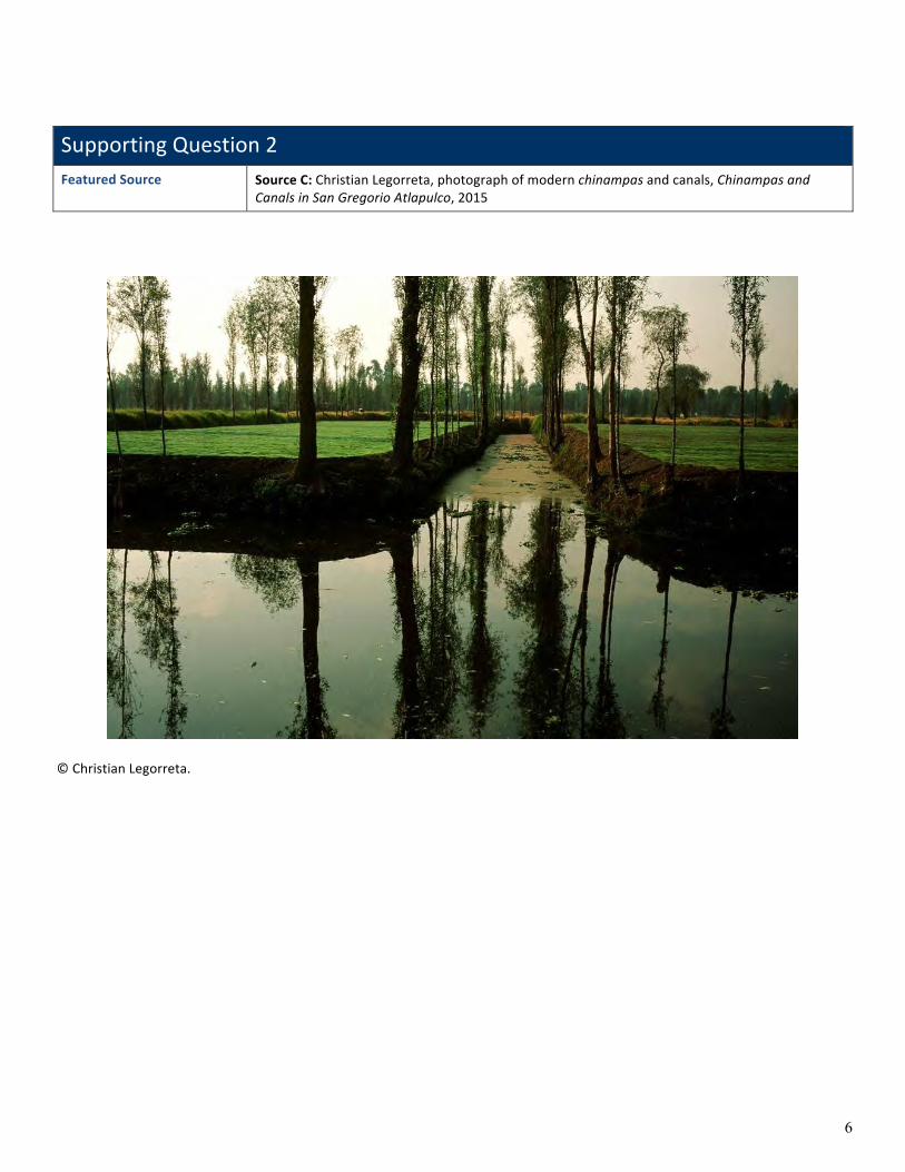
SupportingQuestion2FeaturedSource SourceC:ChristianLegorreta,photographofmodernchinampasandcanals,Chinampasand
CanalsinSanGregorioAtlapulco,2015
©ChristianLegorreta.

7
Inca Roads and Chasquis
The Incas were magnificent engineers. They built the most elaborate network of roads and bridges of any ancient culture. The success of its empire was partly due to being able to reach and control each corner of their territory. Inca engineers used and improved roads left by earlier cultures such as the Chimu, Wari and Tiwanaku among others.
The Incas built more than 14,000 miles/22,530 km of paved roads. There were two main roads, both connected the territory north to south extending along the coast and another along the Andes. Both roads were connected by a shorter network of roads. Along the coast they built a 3,000 m/4,830 km road that connected the Gulf of Guayaquil, Ecuador in the north to the Maule River, Chile in the south. The Andean royal road constructed in the highlands extended along the Andes Mountains. It reached Quito, Ecuador in the north, passed through Cajamarca and Cusco and ended near Tucuman, Argentina. The Andean Royal road was over 3,500 miles long, longer than the longest Roman road.
The Incas did not know the wheel and did not have horses either. Most of the transportation was done by foot using llamas to carry goods from one part of the empire to another. Roads were used by messengers or chasquis carrying messages across the empire.
The Incas developed techniques to overcome the difficult territory of the Andes. Many roads crossed high mountains. On steep slopes they built stone steps resembling giant flights of stairs. In desert areas they built low walls to keep the sand from drifting over the road.
Bridges were built all across the empire. They built spectacular suspension bridges or rope bridges using natural fibers. These fibers were woven together creating a rope as long as the desired length of the bridge. Three of these ropes were woven together creating a thicker and longer rope; they would continue braiding the ropes until they had reached the desired width, length and strength. The ropes were then tied together with branches of trees and pieces of wood were added to the floor creating a cable floor of at least four to five feet wide. The finished cable floor was then attached to abutments supporting the ends on each side. They also attached ropes on both sides of the bridge that served as handrails. The last existing Inca suspension bridge is located near Cusco in the town of Huinchiri.
Because the Inca Empire controlled such a vast territory they needed a way to communicate with all its corners. They set up a network of messengers by which important messages would be conveyed. These messengers were known as Chasquis and were chosen from the strongest and fittest male youngsters. They ran many miles a day to relay messages. They lived in cabins or tambos along the roads usually in groups of four or six. When a chasqui was spotted, another one would run to meet him. He would run beside the incoming messenger trying to listen and to memorize the message, he would also relay the quipu if he was carrying one. The tired chasqui would stay and rest in the cabin while the other one will run to the next relay station. In this way messages could travel over 250 miles a day.
In case of an invasion or a rebellion an emergency message was sent through a chain of bonfires. As each group of chasquis saw the smoke they would lit a bonfire that could be seen by the next cabin or tambo. The Sapa Inca would send his army toward the bonfire before the cause was known, usually on his way he would meet a messenger and learn from him the exact nature of the emergency.
Archeological findings show that some tambos or relay stations were more elaborate than others. They were probably used as a place for officials or the Sapa Inca to stay during their traveling across the empire.
DiscoverPeruwebsite,PeruCulturalSociety.AccessedJuly7,2015.http://www.discover-peru.org.
SupportingQuestion3FeaturedSource SourceA:PeruCulturalSociety,articledescribingtheIncaroadandmessengersystem,“Inca
RoadsandChasquis,”nodate

8
SupportingQuestion3FeaturedSource SourceB:Imagebank:Incaroadways
Image 1: Territory of the Inca Empire showing the Inca highway and its infrastructure architecture. CreatedbyMancoCapac.Publicdomain.http://commons.wikimedia.org/wiki/File:Inca_road_system_map-en.svg.

9
Image 2:The Inca's engineering of roadways and agricultural terraces in mountainous terrain was one key to the expansion of the empire. ©istock/©v0v.

10
SupportingQuestion3
FeaturedSource
Source C: IllustrationofanIncaChasquirunner,basedonthe17th-centurydocumentElPrimerNuevaCorónicayBuenGobierno[TheFirstNewChroniclleandGoodGovernment]byHuamanPomaAyala,aQuechuannoblemanwhocriticizedtheSpanish,nodate
NOTE: The Chasqui was a messenger in Inca society
IllustrationcreatedbyAgate(2015)basedonDrawing138:Couriersofgreaterandlesserrank;hatunchaski,chiefcourier;churumulluchaski,thecourierwhocarriesatrumpetshellfromElPrimerNuevaCorónicayBuenGobierno,1615.Publicdomain.http://www.kb.dk/permalink/2006/poma/352/en/text/?open=id2974973.