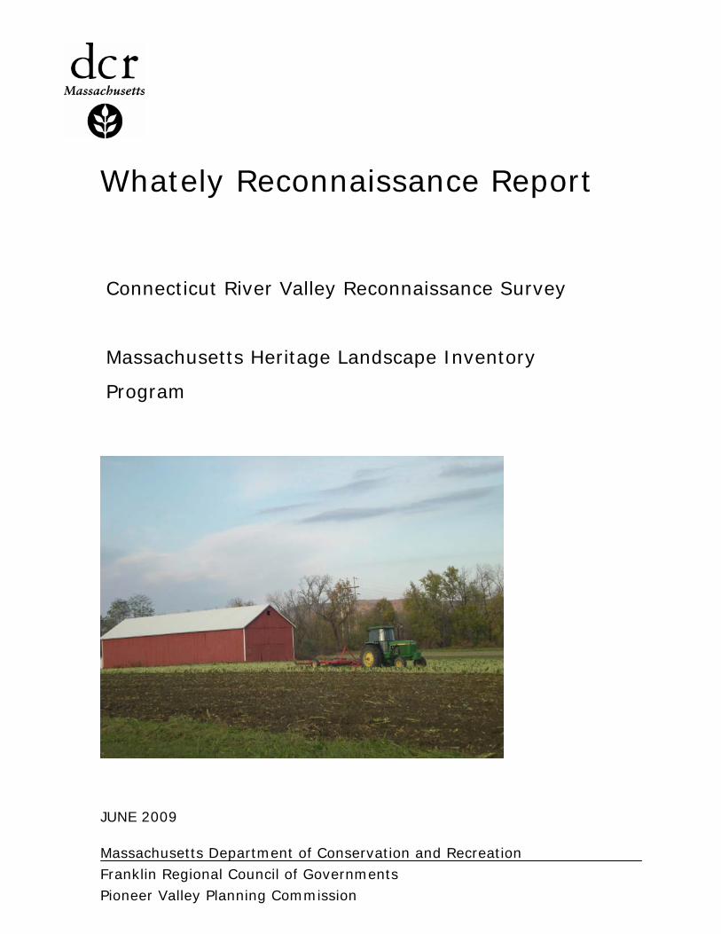
whately reconnaissance report - mass
TRANSCRIPT
Connecticut River Valley Reconnaissance Survey
Massachusetts Heritage Landscape Inventory
Program
Massachusetts Department of Conservation and Recreation Franklin Regional Council of Governments Pioneer Valley Planning Commission
Whately Reconnaissance Report
JUNE 2009

COMMONWEALTH OF MASSACHUSETTS · EXECUTIVE OFFICE OF ENERGY & ENVIRONMENTAL AFFAIRS
Department of Conservation and Recreation 251 Causeway Street, Suite 600 Boston MA 02114-2119 617-626-1250 617-626-1351 Fax www.mass.gov/dcr
Deval L. Patrick Governor Timothy P. Murray Lt. Governor
Ian A. Bowles, Secretary, Executive Office of Energy & Environmental Affairs
Richard K. Sullivan, Jr., Commissioner Department of Conservation & Recreation
PROJECT TEAM Massachusetts Department of Conservation and Recreation Richard K. Sullivan, Jr, Commissioner Joe Orfant, Director, Bureau of Planning & Resource Protection Patrice Kish, Director, Office of Cultural Resources Wendy Pearl, Director, Historic Landscape Preservation Initiative Jessica Rowcroft, Preservation Planner, Heritage Landscape Inventory Program Regional Partners & Project Consultants: Franklin Regional Council of Governments Margaret Sloan, Director of Planning & Development Melissa Adams, Land Use Program Manager Kimberly Noake MacPhee, Natural Resources Program Manager Patricia Smith, Land Use Planner Ryan Clary, GIS Specialist Pioneer Valley Planning Commission Bonnie Parsons, Principal Planner and Manager of Historic Preservation Programs Anne Capra, Principal Planner Jim Scace, Senior Planner/GIS Specialist Local Project Coordinator Alan McArdle, Chair, Whately Historical Commission Local Heritage Landscape Participants Jeannine Atkins Adelia Bardwell, Whately Historical Society Fred Bardwell, Whately Planning Board and Cemetery Commission Michele Barker, Preservation Massachusetts Robert Duda, Library Trustee Jonathan Edwards, Board of Selectman Nicholas Jones, Whately Water District and Planning Board Jeanne Kocsb Judy Markland, Whately Planning Board and Historical Commission Jessica Monti Paul Newlin, Selectman Alan Sanderson, Jr., Chair, Board of Selectman Bill Saunders, Library Trustee Lynn Sibley, Whately Town Administrator Darcy Tozier, Whately Historical Commission John Wroblewski

Massachusetts Heritage Landscape Inventory Program 1 Whately Reconnaissance Report
INTRODUCTION Heritage landscapes are special places created by human interaction with the natural environment that help define the character of a community and reflect its past. They are dynamic and evolving, reflect the history of a community and provide a sense of place. They show the natural ecology that influenced land use patterns and often have scenic qualities. This wealth of landscapes is central to each community’s character, yet heritage landscapes are vulnerable and ever changing. For this reason it is important to take the first step toward their preservation by identifying those landscapes that are particularly valued by the community – a favorite local farm, a distinctive neighborhood or mill village, a unique natural feature or an important river corridor. To this end, the Massachusetts Department of Conservation and Recreation (DCR) and its regional partners, the Franklin Regional Council of Governments (FRCOG) and the Pioneer Valley Planning Commission (PVPC), have collaborated to bring the Heritage Landscape Inventory Program to twelve communities in the Connecticut River Valley region of Massachusetts. The goals of the program are to help communities identify a wide range of landscape resources, particularly those that are significant and unprotected, and to provide communities with strategies for preserving heritage landscapes. The communities within the Connecticut River valley region of Massachusetts are diverse in their settlement patterns and economic histories. What they hold in common is a foundation built on agriculture that was carried out in communities traversed by a series of major waterways and tributaries, from the Connecticut River to the Deerfield, Sawmill, Green, Millers, Quaboag, Swift, Mill and Ware Rivers. This region contains significant cultural and historic resources and uncommon natural beauty. For some of the communities, industry developed alongside agriculture, so that today the heritage landscapes reflect both agrarian and industrial pasts while providing recreational and educational opportunities. From scenic town commons and natural areas, to civic buildings and burial grounds, the heritage landscapes within the region collectively tell the story of their varied and often complex history.
Connecticut River Valley Heritage Landscape Inventory project area
Massachusetts Heritage Landscape Inventory Program 2 Whately Reconnaissance Report
Methodology The methodology for the Heritage Landscape Inventory Program was developed in a pilot project conducted in southeast Massachusetts. It is outlined in the DCR publication Reading the Land, which has provided guidance for the program since its inception. In summary, each community organized a heritage landscape identification meeting during which residents and town officials identified and prioritized the natural and cultural landscapes within town that embody the community’s unique character. This meeting was followed by a fieldwork session led by the project team, including the local project coordinator and staff of FRCOG or PVPC, accompanied by interested community members. During the fieldwork session the Priority Heritage Landscapes were assessed and opportunities for preservation were explored and discussed. The final product for each community is an individualized Heritage Landscape Reconnaissance Report. This report outlines the community’s landscape history, describes the Priority Heritage Landscapes along with associated opportunities, issues, and recommendations, and concludes with implementation strategies. PART I: HERITAGE LANDSCAPE INVENTORY LOCAL HISTORY
"I never see The Street under its double rows of trees but I bless the man who planted them. Nor go the River Road with Sugarloaf ahead but a thrill runs up my back to see it there." Fred B. Bardwell, 1883-1968
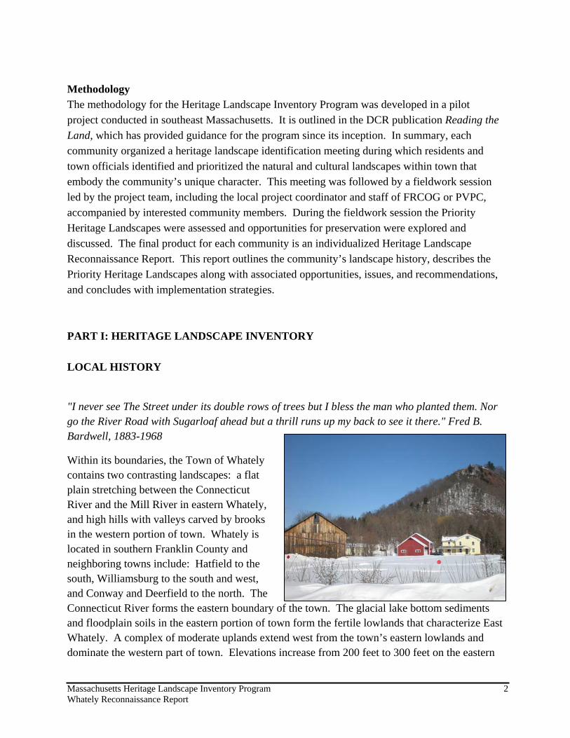
Within its boundaries, the Town of Whately contains two contrasting landscapes: a flat plain stretching between the Connecticut River and the Mill River in eastern Whately, and high hills with valleys carved by brooks in the western portion of town. Whately is located in southern Franklin County and neighboring towns include: Hatfield to the south, Williamsburg to the south and west, and Conway and Deerfield to the north. The Connecticut River forms the eastern boundary of the town. The glacial lake bottom sediments and floodplain soils in the eastern portion of town form the fertile lowlands that characterize East Whately. A complex of moderate uplands extend west from the town’s eastern lowlands and dominate the western part of town. Elevations increase from 200 feet to 300 feet on the eastern

Massachusetts Heritage Landscape Inventory Program 3 Whately Reconnaissance Report
border of the uplands to between 800 and 1,000 feet near the Whately/Williamsburg border. The predominant uplands in Whately are Mount Esther, Chestnut Mountain, and Dry Hill, all part of the eastern foothills of the Green Mountains. The Mill River bisects the town and drains a portion of East Whately and the hills of West Whately via Roaring Brook, Esther Brook and West Brook and their tributaries. Most of the lowlands of East Whately drain to the Connecticut River.
Whately’s fertile soils, abundant water resources and wildlife-filled uplands provided Native Americans adequate subsistence resources. Native settlements were probably concentrated in Whately’s eastern lowlands, particularly near the Mill River and the Connecticut River, in an area that belonged to the Norwottucks, or Fresh Water Indians, and their Sagamore (leader), Quonquont. The land within the Town of Whately’s borders was once North Hatfield. The land had been purchased by Hatfield in 1695 from Quonquont's widow and children. Whately was incorporated in 1771 and named by then Massachusetts Governor Hutchinson for Thomas Whately, a political mentor of his who was a member of the British Parliament.
Early colonial settlers grew crops in the valley and uplands, hunted in the forests, and built mills along the many brooks. Pits of red clay, rich in iron deposits, made good bricks and provided material for twenty-one potters in Whately between 1778 and 1861. Beds of lead, potash, umber, and sienna supplied incomes for many in the late 1800's. Whately’s abundant and powerful streams powered numerous mills in the 18th and 19th centuries, including: grist mills, sawmills, woolen mills and furniture mills. The neighboring towns of Northampton and Deerfield take their drinking water from Whately's two largest streams, West Brook and Roaring Brook, respectively.
Whately's three by six-mile area includes some of the most fertile river valley land in New England and is one of the few areas where the high quality Sumatra tobacco can be grown outside of Indonesia. Tobacco has been a cash crop in town since the mid-1800’s and was a particularly large source of income and a way of life in
Whately from the 1940's through the 1960's. Agriculture is still a vital element of the economy. In addition to tobacco, other primary crops produced in Whately are vegetables, nursery plants, apples, berries, and maple syrup. Today, Whately's farms include innovative institutions such as Nourse Farms, renowned as a small fruit nursery; Nasami Farm, home to the New England Wildflower Society; and Quonquont Farm, an orchard with a farmstand and “pick-your-own” operation. In addition, there are several Certified Organic vegetable farms in town.

Massachusetts Heritage Landscape Inventory Program 4 Whately Reconnaissance Report
Whately's main street, Chestnut Plain Road, is lined with historic buildings such as the Town Hall and the Congregational Church, as well as many historic houses. With its large trees set back from the road, it is said to be one of the finest main streets in New England. The Whately Historical Society and Historical Commission are both active in town, with public events in the spring and fall.
Whately’s current residents are farmers, college professors, tradesmen, teachers, artists, health workers and construction contractors. According to the U.S. 2000 Census data, the top two employment destinations for Whately residents are Whately and Northampton, each with 17.4% of the workers in town. The largest employment sector for Whately residents is educational, health and social services, with 27.9% of all workers. This is not surprising given the proximity of the Five College area and several private and public secondary schools.
Today more residents commute to jobs outside Whately than in the past, yet Whately residents are proud of and committed to their community. Whately's community spirit is sustained by residents’ high level of participation at Town Meeting and in volunteer positions on critical town boards, school and recreational organizations.
Although Whately retains much of its rural and historic character, scenic landscapes, and abundant natural resources, only approximately 10% of the land in town is permanently protected from development.1 The town is working to keep these cherished elements of the past as it strides into its fifth century. The adoption of strategies and tools for heritage landscape preservation will help to maintain the rural and historic character of the town while accommodating new development.
PRIORITY HERITAGE LANDSCAPES In the public identification meeting held at Town Hall on December 16, 2008, participants identified landscapes within Whately that define the heritage of the community. These heritage landscapes provide a cross section of the types of landscapes that contributed to the historical development of the town and together tell the story of Whately’s past. Meeting attendees then voted to identify 6 Priority Heritage Landscapes for the focus of this project. The following text describes the unique value that each of these landscapes provides to the community and a set of recommendations for its preservation and protection. The recommendations are meant as a starting point for discussion among community members. It is up to town staff, boards and residents to decide which tools and techniques will fit with community goals and then work towards their implementation. Six Priority Landscapes were identified in Whately, including: Whately Center, Cemeteries, North Street Corridor, Tobacco Barns, and West Brook Mill Corridor. 1 Whately Open Space and Recreation Plan, 2006.

Massachusetts Heritage Landscape Inventory Program 5 Whately Reconnaissance Report

Massachusetts Heritage Landscape Inventory Program 6 Whately Reconnaissance Report
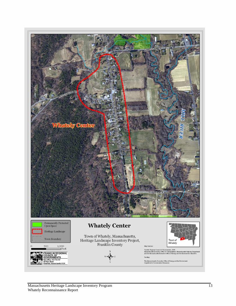
Whately Center Many of the buildings and historic sites in Whately Center are the embodiment of the town’s early history while newer buildings and iconic features reflect the town’s growth over several centuries and into the 21st century. In the late 1660’s, when this area of Whately was still North Hatfield, the first settlers in the area built homes on the lowlands along the Connecticut River and some ventured further west to higher ground and built their homes on Chestnut Plain Road. In 1684, much of the land was held collectively as the “Commons”, and used as pasture for livestock. Over the next several decades, the Commons were divided and apportioned among the settlers. By the 1720’s, there were a scattering of settlements in Whately, including the area of Chestnut Plain Road. This settlement evolved through the 18th and early 19th centuries to become the civic center of the community. Whately Center now includes civic buildings, churches, an inn and post office, and residences, surrounded by farms and open fields with beautiful views. In many parts of Whately, including Whately Center, historic landscapes blend with scenic “viewsheds”, or landscapes visible from a fixed vantage point. Scenic roads, which traverse landscapes and viewsheds, can provide a way for residents and visitors to access these special places. Within Whately Center, Chestnut Plain Road and Haydenville Road are designated Scenic Roads. Two locations along Chestnut Plain Road, behind the Center School and the S. White Dickinson Library, offer magnificent views of the farms and open land of the Connecticut River lowlands, Mt. Sugarloaf, Mt. Toby, and beyond. In 2003, a length of Chestnut Plain Road from the Jehu Dickinson House, located at 155 Chestnut Plain Road, to the Center School and a portion of Haydenville Road from the intersection with Chestnut Plain Road to just past the Banister Morton House (1824), was listed on the National Register of Historic Places. This designation honors the historic agricultural, architectural, commercial, educational, political and religious significance of the various buildings in Whately Center. The National Register of Historic Places designation is honorary in nature and does not provide any protective measures for the heritage landscapes and historic buildings within the Whately Center district. While the residences and farms contribute to the rural character of Whately Center, this area was identified as a Priority Heritage Landscape primarily due to its role as a civic core of the community, and issues relating to the use and maintenance of municipally owned buildings. Discussed in more detail in this section are the Town Pound, Town Hall, Post Office, S. White Dickinson Memorial Library, Whately Center School (town offices), and Whately Center Cemetery, all town owned properties that contribute to the character of Whately Center. The Whately Inn and U.S. Post Office, while not owned by the town, also contribute to the built

Massachusetts Heritage Landscape Inventory Program 7 Whately Reconnaissance Report
infrastructure and overall character of the Center so are mentioned as well. The Whately Water District, which provides water services to an area encompassing Whately Center, is also discussed in this section, as it was identified by the community as an important natural resource the supports the town center. Whately Town Pound Just a few days after the town was incorporated in 1771, the residents voted to build a pound to keep livestock found to be roaming “at large”. A suitable location for the pound was found on the north side of West Lane (now Haydenville Road), just west of Chestnut Plain Road. The stone walls of the pound enclosed an area 40 feet square and access was accommodated by a wooden gate at the southeast corner. For almost 150 years, the pound keeper was an elected official of the town. But the need for a pound waned in the 20th century and the structure fell in to disrepair. In 1940, Whately’s road superintendent, Arthur Strippe, restored the pound by rebuilding the walls, clearing the enclosure of brush and building a replica of the original gate. Mr. Strippe attached a sign to the gate that reads “Whately Pound 1771”. Whately Town Hall Before Whately’s Town House was built in 1844, town meetings were held in Daniel Morton’s tavern and later at the home of Reverend Rufus Wells. In 1871, the first floor of the 43 x 34 foot town house was raised up to become the 2nd floor and a new first floor was added underneath. The footprint of the building was also lengthened by 12 feet. The first floor accommodated Town offices, a library and a school while the second floor was used for Town Meetings. By 1900, the Town House was referred to as the Town Hall. Over the years, the second floor has been used for a variety of community gatherings, including basketball games, auctions, and wrestling matches. In 1967, the building underwent significant renovation, which included
adding plumbing, wiring and heating to the interior of the building and new steps and landscaping outside. Today, the stately Town Hall still houses Town offices and offers a meeting room used by the Grange and other community organizations. The impacts of the French and Indian War on the settlement of Whately Center are commemorated by a beautiful quartz boulder that was placed as a memorial in 1888 to mark the location of the stockade built in 1754 to protect the settlers and their livestock from Native Americans allied with the French. This boulder and its plaque, which reads “Site of Stockade, 1754-1888”, is on the east side of Chestnut Plain Road several hundred feet south of the Town Hall. There
Whately Town Hall
Massachusetts Heritage Landscape Inventory Program 8 Whately Reconnaissance Report
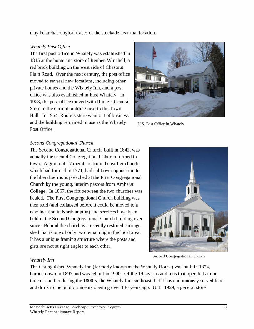
may be archaeological traces of the stockade near that location. Whately Post Office The first post office in Whately was established in 1815 at the home and store of Reuben Winchell, a red brick building on the west side of Chestnut Plain Road. Over the next century, the post office moved to several new locations, including other private homes and the Whately Inn, and a post office was also established in East Whately. In 1928, the post office moved with Roote’s General Store to the current building next to the Town Hall. In 1964, Roote’s store went out of business and the building remained in use as the Whately Post Office. Second Congregational Church The Second Congregational Church, built in 1842, was actually the second Congregational Church formed in town. A group of 17 members from the earlier church, which had formed in 1771, had split over opposition to the liberal sermons preached at the First Congregational Church by the young, interim pastors from Amherst College. In 1867, the rift between the two churches was healed. The First Congregational Church building was then sold (and collapsed before it could be moved to a new location in Northampton) and services have been held in the Second Congregational Church building ever since. Behind the church is a recently restored carriage shed that is one of only two remaining in the local area. It has a unique framing structure where the posts and girts are not at right angles to each other. Whately Inn The distinguished Whately Inn (formerly known as the Whately House) was built in 1874, burned down in 1897 and was rebuilt in 1900. Of the 19 taverns and inns that operated at one time or another during the 1800’s, the Whately Inn can boast that it has continuously served food and drink to the public since its opening over 130 years ago. Until 1929, a general store
Second Congregational Church
U.S. Post Office in Whately

Massachusetts Heritage Landscape Inventory Program 9 Whately Reconnaissance Report
occupied the north end of the building, which also housed the Post Office and the telephone switchboard. The building is used as an inn and restaurant as well as a banquet hall.
S. White Dickinson Memorial Library Not many years after the town was incorporated, Whately’s first library was formed in 1790 and was financed by forty-seven of the town's prominent citizens. Over the next 80 years, several more small libraries were established and then closed. In 1874, town meeting voted to establish a town library, and a room on the first floor of the
Town Hall was stocked with books. By 1898 the library’s collection had grown to 2279 volumes, which necessitated the expansion of the room at the Town Hall. Salmon White Dickinson (1822-1920) left his entire estate to his daughter, Anna, with instructions that it be given to the town to build a library in his memory. In 1945, Howard R. Waite deeded the town 7 acres on the east side of Chestnut Plain Road to be used as the site of the S. White Dickinson Memorial Library. Walter P. Crabtree, an architect from West Hartford, Connecticut, designed the building and construction began in 1949.
The elegant Georgian style building has pride of place on the crest of a hill with a commanding view eastward across the Connecticut River valley. The library is an integral part of the Whately community, providing a variety of programs for residents and a Community Room that is used for educational, cultural or charitable activities. The Community Room accommodates approximately 30 people and is equipped with a small kitchen. However, there is a serious, ongoing problem with drainage around the building and flooding of the basement. In addition, the building does not have adequate handicap access.
Scenic views behind the S. White Dickinson Library
S. White Dickinson Memorial Library

Massachusetts Heritage Landscape Inventory Program 10 Whately Reconnaissance Report
Whately Center School The brick Center School, built in 1910 and closed in 1991, currently houses the Whately Historical Society and the offices of the Town Administrator and Board of Selectmen. The building is in need of major renovations including access and climate control. There is no climate control for the space that the Historical Society occupies, which threatens the integrity of the archives.
A Whately icon, the Quonquont milk bottle, sits proudly on the lawn in front of the former school, across from Quonquont Farm, a fitting location considering the many children who enjoyed the fresh, raw milk from the Quonquont Dairy and later the homemade ice cream from the Quonquont Dairy Bar on State Road. Whately Center Cemetery Across from the Center School is the Whately Center Cemetery, whose timeworn grave markers and white picket fence anchor the north end of Whately Center with quiet
dignity. Of the three cemeteries in town, the Center Cemetery is the largest and likely the oldest, based on the date carved on the headstone of Esther Bardwell, who died October 27, 1762. The headstones, many of which are slate, have suffered some deterioration due to acid rain and being hit by tree limbs. A tobacco barn sits at the southern end of the cemetery, another icon of Whately’s history. This bright yellow barn has unusual design for a tobacco barn, with both horizontal and vertical slats on the sides that can be opened to air the tobacco. The barn is currently owned by the town.
Quonquont Milk Bottle in Whately Center
Whately Center Cemetery
Whately Center School

Massachusetts Heritage Landscape Inventory Program 11 Whately Reconnaissance Report
During the off-season, the town uses the barn to store equipment while during the growing season, the barn is leased by a local tobacco farmer. Whately Water District Water, the lifeblood of the Center, was not always abundant. The shallow wells dug by residents often ran dry in late summer and early fall and then water had to be hauled from brooks, springs or the deeper wells of neighbors. In 1898, Irving Allis founded the Allis Water Works which served 35 families from the south corner of Chestnut Plain Road and Christian Lane all the way down to Claverack Road. Mr. Allis’ pastures on the south slope of Mt. Esther were crisscrossed with springs, which he tapped, piping the water to a reservoir on the east side of town letting gravity do the rest, sending water to households along Chestnut Plain Road. By 1952, the flow from the Allis Water Works could not keep up with the demands of modern life – washing machines, dishwashers, flush toilets and daily baths. All of the families agreed to help pay for a new artesian well, which served them for 19 more years. In 1970, the Allis Water Works regretfully notified the families that there was insufficient money to maintain or replace the infrastructure, so the families banded together and formed the Whately Water District in 1971. Today, the Whately Water District has three deep wells located off of Haydenville Road, two of which are currently on-line, and 42 connections. The District is owned and financially supported by the member families, a tradition that dates back over a century. Opportunities: • Whately Center is a fine example of early New England architecture and settlement
patterns. There are forty-four 18th and 19th century structures, including one of the earliest houses in town built along Chestnut Plain Road, the Oliver Morton Farmhouse, built in 1760, and the Samuel Grimes House and Store, built in 1795.
• Whately Center is listed as an Historic District on the National Register of Historic Places, so the municipal properties are all eligible to apply for Massachusetts Preservation Projects Fund grants.
• Several buildings in Whately Center provide places for community gatherings, including the Town Hall, the S. White Dickinson Library and the Second Congregational Church (now commonly referred to as the First Congregational Church). The grounds behind the library provide opportunities for residents and visitors to enjoy scenic views across the Connecticut River valley and are a favorite gathering spot for picnicking and weddings.
• The Whately Historical Society maintains a treasured and well-tended collection of artifacts and memorabilia in a room at the Center School building.
Issues: • The library has serious maintenance and accessibility issues that are expected to be costly
to address.

Massachusetts Heritage Landscape Inventory Program 12 Whately Reconnaissance Report
• Most of the land within the viewshed of the library is in private ownership and not permanently protected from development.
• The Center School building is plagued by mold and dampness problems, is not handicapped accessible, and needs major renovations.
• Public buildings are costly to maintain and heat. There are ongoing discussions about consolidating all of the town offices either at the Town Hall, which has limited parking available, or constructing a new municipal building. If the town offices were moved from the Center School building, this would affect the location of the Historical Society.
• The third well owned by the Whately Water District cannot be brought on-line until the district owns or controls all of the land within the Zone I wellhead protection area around the well. The current landowners are not interested in relinquishing control of the land.
Recommendations: 1. The Town should consider designating Whately Center as a Local Historic District, the
strongest form of protection for the preservation of historic resources. This designation, adopted by a 2/3 vote at Town Meeting, would preserve and protect the distinctive characteristics of buildings and places and would be administered by a district commission appointed by the Board of Selectmen.
2. The Town should consider using Community Preservation Act funds to preserve, repair
and upgrade the community’s historic civic structures, such as the Town Hall, the S. White Dickinson Memorial Library and the Whately Center School building, and preserve the artifacts of the Whately Historical Society.
3. The Town Hall needs a structural assessment to determine the condition of the building
and provide recommendations for any necessary repairs. 4. Consider the adoption of a Demolition Delay Bylaw that will allow for the pursuit of
alternatives to demolition of historic buildings. 5. The town should initiate discussions with the current owners of the land around the
library to explore options for protecting the land from development to protect views. 6. The Whately Water District should continue efforts to secure ownership or control of the
land in the Zone I of their third well. 7. The town may want to consider updating their Master Plan. One area to explore would
be the efficient use and reuse of public buildings, including parking needs.
Massachusetts Heritage Landscape Inventory Program 13 Whately Reconnaissance Report

Massachusetts Heritage Landscape Inventory Program 14 Whately Reconnaissance Report
Cemeteries There are three town-owned cemeteries in Whately: the Center Cemetery, (discussed above), the East Cemetery and the West Whately Cemetery. The East Whately Cemetery is located on Hopewell Hill along the south side of Christian Lane. The earliest grave marker in the East Whately Cemetery is that of Joseph Sanderson, who died on March 20, 1772. The earliest headstone in the West Whately Cemetery,
which is located off of Webber Road, is that of Clarissa Bardwell, who died on December 15, 1776. The cemeteries in Whately are a vital link
to the past, full of social, historic, architectural and archeological artifacts that tell the stories of the early years of the town. However, the grave markers, especially those made from relatively soft rock like slate, have suffered major damage and degradation, likely from acid rain. Grave markers contain important historical and genealogical information that is being lost as time and weather erode and discolor the stones. All three of the cemeteries are still open and active, providing a final resting place for town residents and a dignified place of solitude, which melds the past with the present and future. Opportunities: • The three cemeteries have adequate room for expansion for the foreseeable future. • The cemeteries are well maintained.
East Whately Cemetery
West Whately Cemetery

Massachusetts Heritage Landscape Inventory Program 15 Whately Reconnaissance Report
• The cemeteries contain a wealth of historically significant information and are integral to the heritage landscapes in Whately.
• Cemeteries located within a National Register District are eligible for grant funds from the Massachusetts Historic Commission’s (MHC) Massachusetts Preservation Projects Fund (MPPF).
Issues: • Many of the gravestone markers in the three cemeteries are in need of repair. • The Center Cemetery has also suffered gravestone damage from tree falls. • The trees in all three cemeteries are aging and in need of arborist assessment and care. Recommendations: 1. The town or volunteers could conduct an inventory of the number of grave markers in
need of restoration so that an estimate of the cost of restoring and stabilizing the stones can be calculated.
2. In 1999, the Massachusetts Department of Conservation Resources’ (DCR) Historic Landscape Preservation Initiative produced a guidebook entitled, Preservation Guidelines for Municipally Owned Historic Burial Grounds and Cemeteries, which can be ordered from the DCR website www.mass.gov/dcr/stewardship/histland/cemeteryprog.htm. This guidebook contains a wealth of information, including general recommendations pertaining to a variety of elements related to historic cemeteries, such as landscape character and vegetation, grave marker conservation and repair, fences and gates. There is also a methodology for inventorying grave markers, including sample forms, in the appendix.
3. Volunteers could work with the Whately Historical Society to systematically inventory, photograph and document the location of and information on deteriorated grave markers as well as intact ones to preserve the historical and genealogical significance of the stones.
4. A certified arborist should be hired to inventory and remove diseased or damaged trees. 5. The Whately Cemetery Commission and/or Historic Commission should pursue grant
funding from the Massachusetts Historic Commission’s (MHC) Massachusetts Preservation Projects Fund (MPPF) for renovation and maintenance projects for the East and West Cemeteries, as both are within National Register Districts making them eligible for these grants.

Massachusetts Heritage Landscape Inventory Program 16 Whately Reconnaissance Report
6.
Massachusetts Heritage Landscape Inventory Program 17 Whately Reconnaissance Report
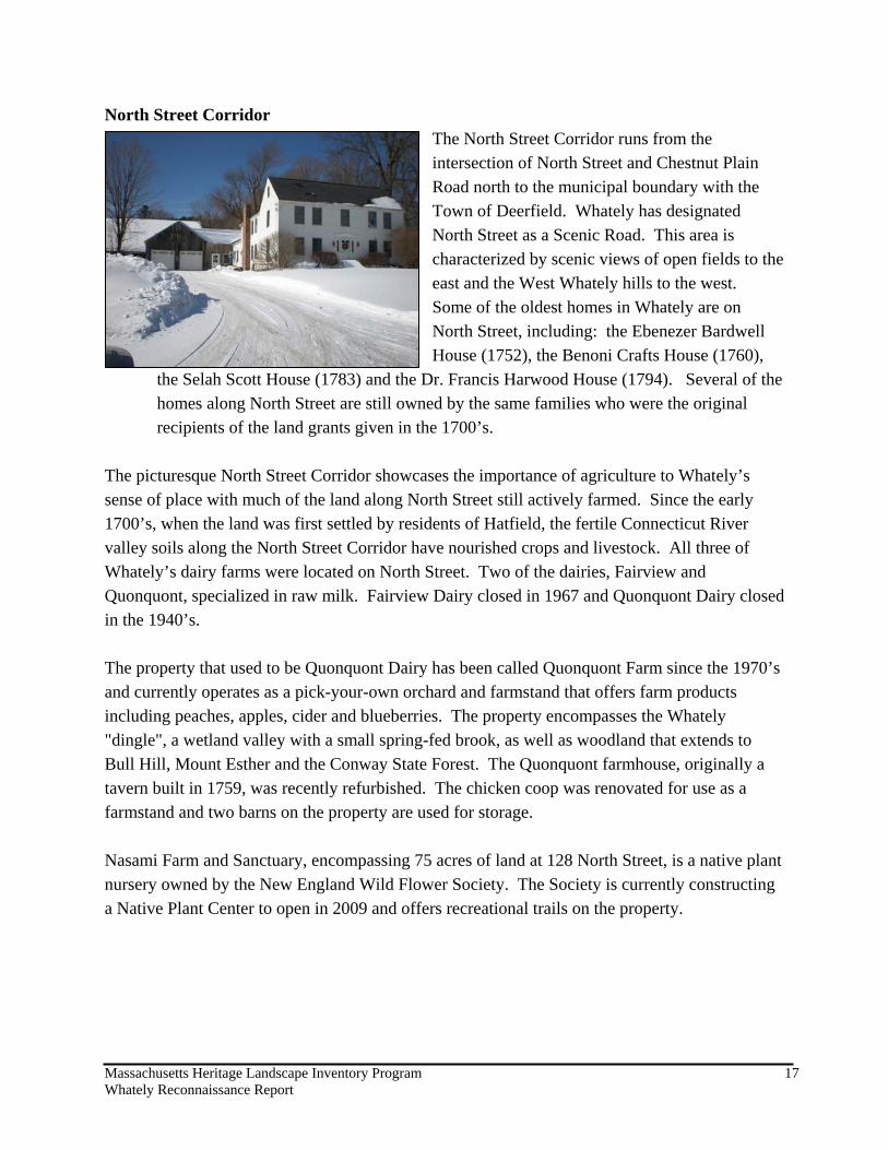
North Street Corridor The North Street Corridor runs from the intersection of North Street and Chestnut Plain Road north to the municipal boundary with the Town of Deerfield. Whately has designated North Street as a Scenic Road. This area is characterized by scenic views of open fields to the east and the West Whately hills to the west. Some of the oldest homes in Whately are on North Street, including: the Ebenezer Bardwell House (1752), the Benoni Crafts House (1760),
the Selah Scott House (1783) and the Dr. Francis Harwood House (1794). Several of the homes along North Street are still owned by the same families who were the original recipients of the land grants given in the 1700’s.
The picturesque North Street Corridor showcases the importance of agriculture to Whately’s sense of place with much of the land along North Street still actively farmed. Since the early 1700’s, when the land was first settled by residents of Hatfield, the fertile Connecticut River valley soils along the North Street Corridor have nourished crops and livestock. All three of Whately’s dairy farms were located on North Street. Two of the dairies, Fairview and Quonquont, specialized in raw milk. Fairview Dairy closed in 1967 and Quonquont Dairy closed in the 1940’s. The property that used to be Quonquont Dairy has been called Quonquont Farm since the 1970’s and currently operates as a pick-your-own orchard and farmstand that offers farm products including peaches, apples, cider and blueberries. The property encompasses the Whately "dingle", a wetland valley with a small spring-fed brook, as well as woodland that extends to Bull Hill, Mount Esther and the Conway State Forest. The Quonquont farmhouse, originally a tavern built in 1759, was recently refurbished. The chicken coop was renovated for use as a farmstand and two barns on the property are used for storage. Nasami Farm and Sanctuary, encompassing 75 acres of land at 128 North Street, is a native plant nursery owned by the New England Wild Flower Society. The Society is currently constructing a Native Plant Center to open in 2009 and offers recreational trails on the property.

Massachusetts Heritage Landscape Inventory Program 18 Whately Reconnaissance Report
Hillside Farm, located at the upper end of North Street, was operated by the Baronas family for approximately 50 years until the late 1960’s. Opportunities: • The North Street Corridor offers
scenic views to the east, across the meadows and farmland, and to the west, to the forested uplands of West Mountain.
• The 18th and 19th century farm houses, barns and other outbuildings along North Street complement the scenic views and farmland to create an important agricultural heritage landscape.
• Many of the agricultural areas in the North Street Corridor have remained undeveloped because they are actively farmed. These areas represent a considerable percentage of the large, undeveloped tracts of agricultural land in Whately. The farms and agricultural landscapes are significant economic, scenic and natural resources that are valued by the land owners and residents of Whately.
• The town has formed an Agricultural Commission to help preserve agriculture and promote the needs of farmers in Whately.
• The Quonquont farm house was recently restored. This building, along with four other structures on the property, including a garage, farm equipment shed, hay-tobacco barn and another house, are documented on MHC inventory forms. These buildings, along with the land, which is actively farmed, are an important heritage landscape for the community.
Issues: • The land in the North Street Corridor is vulnerable to development pressures if land
owners are not able to continue viable agricultural production on their property. The long-term sustainability of many small, family farms is a challenge with rising production costs and the costs associated with the maintenance of farm infrastructure and equipment.
• Most of the historic homes, barns and other agricultural structures in the North Street Corridor have not been inventoried and documented to the same extent as other historic areas in Whately. Some structures are succumbing to age and the elements, like the Hillside Dairy barn, and may soon be gone from the landscape without maintenance and
Hillside Farm Barn
Massachusetts Heritage Landscape Inventory Program 19 Whately Reconnaissance Report
renovation in the near future. The history and the resources of this area should be documented before they are lost.
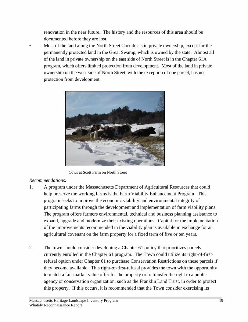
• Most of the land along the North Street Corridor is in private ownership, except for the permanently protected land in the Great Swamp, which is owned by the state. Almost all of the land in private ownership on the east side of North Street is in the Chapter 61A program, which offers limited protection from development. Most of the land in private ownership on the west side of North Street, with the exception of one parcel, has no protection from development.
Recommendations: 1. A program under the Massachusetts Department of Agricultural Resources that could
help preserve the working farms is the Farm Viability Enhancement Program. This program seeks to improve the economic viability and environmental integrity of participating farms through the development and implementation of farm viability plans. The program offers farmers environmental, technical and business planning assistance to expand, upgrade and modernize their existing operations. Capital for the implementation of the improvements recommended in the viability plan is available in exchange for an agricultural covenant on the farm property for a fixed term of five or ten years.
2. The town should consider developing a Chapter 61 policy that prioritizes parcels
currently enrolled in the Chapter 61 program. The Town could utilize its right-of-first-refusal option under Chapter 61 to purchase Conservation Restrictions on these parcels if they become available. This right-of-first-refusal provides the town with the opportunity to match a fair market value offer for the property or to transfer the right to a public agency or conservation organization, such as the Franklin Land Trust, in order to protect this property. If this occurs, it is recommended that the Town consider exercising its
Cows at Scott Farm on North Street
Massachusetts Heritage Landscape Inventory Program 20 Whately Reconnaissance Report
right or transferring the right to a local land trust or the Massachusetts Department of Agricultural Resources in order to place an Agricultural Preservation Restriction (APR) or a conservation easement on the property.
3. Interested landowners could work with the Massachusetts Department of Agricultural
Resources or the Franklin Land Trust to consider placing an Agricultural Preservation Restriction (APR) on active agricultural properties to permanently protect the land, and help keep the land in agricultural use in the future.
4. The town could protect the scenic quality of the area along North Street by establishing a
Scenic Overlay District, which protects the scenic qualities of the landscape by requiring additional design criteria for new construction in visually sensitive areas.
5. The Whately Historical Commission should work with Whately Historical Society
members, interested landowners and other volunteers to inventory and document the history of the buildings and landscapes in the North Street Corridor on MHC forms.
6. Once the inventory is completed, the Town could pursue National Register Historic
District designation for the North Street Corridor. 7. The Town should consider designating the North Street Corridor as a Local Historic
District (LHD), the strongest form of protection for the preservation of historic resources. This designation, adopted by a 2/3 vote at Town Meeting, would preserve and protect the distinctive characteristics of buildings and places and would be administered by a district commission appointed by the Board of Selectmen. Alternatively, an Architectural Preservation District (APD) should be explored, to help protect the overall scale and character of the buildings within the corridor. APDs are less formal than LHDs in that recommendations made regarding key architectural elements and massing, scale, and setback, in an effort to preserve the overall character-defining features of the area, are advisory in nature.
8. Land owners could consider placing historic preservation restrictions on their structures
to preserve them.

Massachusetts Heritage Landscape Inventory Program 21 Whately Reconnaissance Report
8.

Massachusetts Heritage Landscape Inventory Program 22 Whately Reconnaissance Report
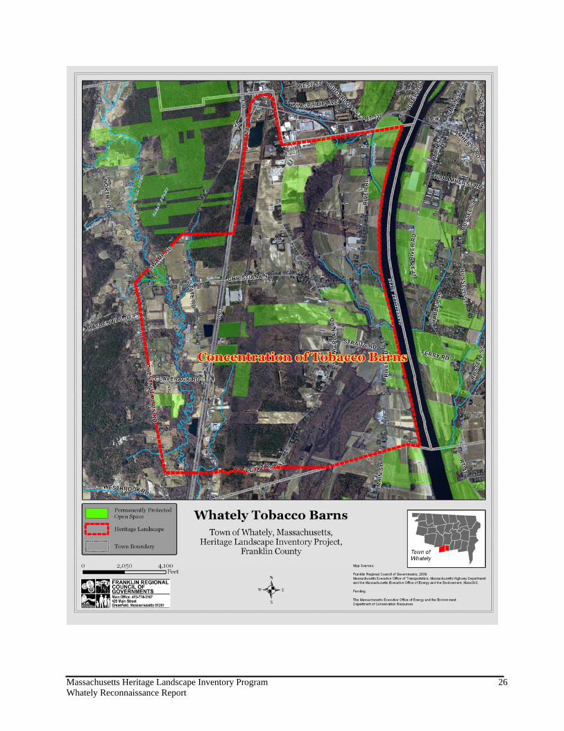
Tobacco Barns The history of tobacco farming in Whately is as old as the town itself. For over two centuries tobacco has been grown on Whately’s soil, primarily in the lowlands of East Whately along River Road and Long Plain Road. In 1771, Whately’s first minister raised a large crop of tobacco, which he sold at a sixpence per pound. In the late 1700’s, the Beldens, Crafts and Wells were the largest tobacco growers in town,
with 15 acres in cultivation. With the growing popularity of pressed tobacco (plug tobacco) from Virginia, the demand for the broadleaf Havana field tobacco grown in Whately declined and for several decades other crops were grown instead. In 1843, Stephen Belden planted some Connecticut field tobacco seed, which was a broadleaf, fragrant smoking tobacco, and shipped it to New York along with the corn brooms he made. His profitable venture convinced others to plant tobacco. By 1855, there were 97 of the iconic tobacco barns in town, each massive structure measuring 75 to 100 feet long by 30 feet or more wide, and by 1865, there were 300 acres of tobacco in Whately. Over the years, Sumatra shade grown tobacco, which required more equipment and more tending, was grown in addition to the field tobacco (Havana and Connecticut Broadleaf) in Whately. Over the next century, the profit margin of the tobacco crop had its highs and lows, but the unique weather and soil conditions for growing tobacco in the Connecticut River Valley and the perseverance of Whately farmers prevailed. Whately tobacco is used for making the finest cigars – the shade grown tobacco is used for wrappers and the field tobacco is used for fillers and binders. Opportunities: • There are still approximately 80 tobacco barns in Whately, which is high relative to other
communities. Approximately 60 of these are still being used for tobacco while the remainder are being used for other purposes.
• The open fields surrounding the tobacco barns are an integral part of this heritage landscape in Whately. Most of these fields are still actively farmed, either for tobacco or another crop.
• Some of the tobacco farms in Whately have been documented on Massachusetts Historical Commission (MHC) forms, including Christian Lane Tobacco Barns; Long

Massachusetts Heritage Landscape Inventory Program 23 Whately Reconnaissance Report
Plain Road Tobacco Barns; General Cigar Company Tobacco Sorting House at 203 Long Plain Road; and the Thomas Crafts Tobacco Barn at 1 Lasalle Drive. These MHC forms, and the resulting listing in the MACRIS database, serve as recognition of the historic value of these properties.
Issues: • The farmland surrounding the
tobacco barns may be vulnerable to development pressures if the tobacco crop or other crops can no longer generate sufficient income.
• Tobacco barns, which are iconic elements of the Whately landscape, may also be vulnerable to demolition or disrepair if the surrounding land is developed rather than farmed, if tobacco is no longer grown, or if maintenance costs are higher than the revenue generated by the tobacco crop.
Recommendations: Many of the recommendations to preserve the agricultural landscape of the North Street Corridor are relevant to the tobacco barns and surrounding farmland. 1. A program under the
Massachusetts Department of Agricultural Resources that could help preserve the working farms adjacent to and associated with the tobacco barns is the Farm Viability Enhancement Program. This program seeks to improve the economic viability and environmental integrity of participating farms through the provision of technical assistance to improve operations and the development and implementation of business plans. Capital for the implementation of the improvements recommended in the viability plan is available in exchange for an agricultural covenant on the farm property for a fixed term of five or ten years.

Massachusetts Heritage Landscape Inventory Program 24 Whately Reconnaissance Report
2. The Town could exercise its right-of-first-refusal to purchase conservation restrictions on
parcels with tobacco barns, if they become available. This right-of-first-refusal provides the town with the opportunity to match a fair market value offer for the property. If this occurs, it is recommended that the Town consider exercising its right or transferring the right to a local land trust or the Massachusetts Department of Agricultural Resources in order to place an Agricultural Preservation Restriction (APR) or conservation restriction on the property. If the town develops a Chapter 61 policy to prioritize parcels currently in the program, particular attention could be given to chapter lands with tobacco barns.
3. The town could consider adopting zoning provisions to encourage the adaptive reuse of
tobacco barns if the structures are no longer in agricultural use. Examples of adaptive reuse include: event space for weddings and other functions, studio space for artists or musicians, or other commercial use that is compatible with the surrounding landscape.
4. The Whately Historical Commission should work with Whately Historical Society
members, interested landowners and other volunteers to inventory and document the history of the tobacco barns in town on Massachusetts Historical Commission (MHC) forms.
5. The Whately Agricultural Commission could develop a public awareness program to
celebrate the contribution of tobacco barns to Whately’s agricultural heritage, perhaps with workshops, tours or a photo contest.
6. Landowners could work with the Massachusetts Department of Agricultural Resources or
the Franklin Land Trust to place an Agricultural Preservation Restriction (APR) on the property to permanently protect the land, and help keep the land in agricultural use in the future.

Massachusetts Heritage Landscape Inventory Program 25 Whately Reconnaissance Report
7. Tobacco barn owners could consider placing preservation restrictions on their structures to preserve them. The town could consider using Community Preservation Act (CPA) funds to restore or repair tobacco barns in exchange for the owners placing preservation restrictions on the structure.
Massachusetts Heritage Landscape Inventory Program 26 Whately Reconnaissance Report
8.

Massachusetts Heritage Landscape Inventory Program 27 Whately Reconnaissance Report
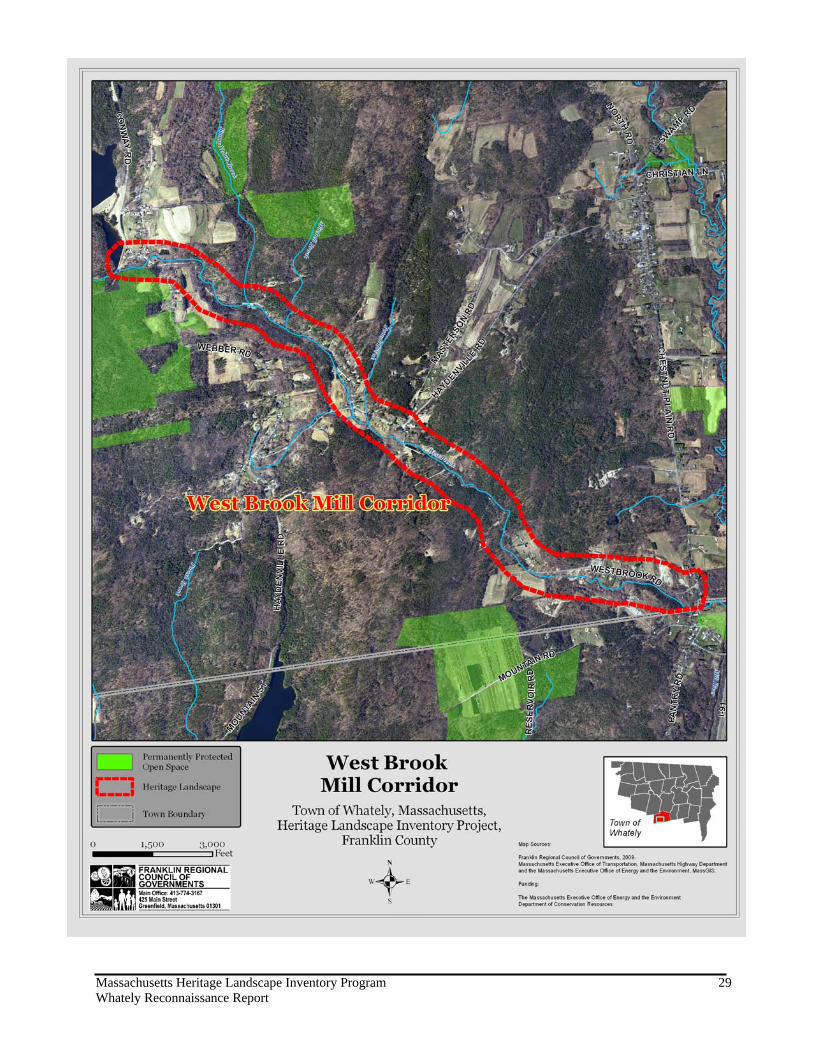
West Brook Mill Corridor The early settlers of Whately harnessed the great power of West Brook, which along its 3 mile length dropped 350 feet in elevation as it flowed from Williamsburg down through Whately to the Hatfield town line. West Brook supplied water power for 16 “privileges”, among them were grist mills, saw mills, turning mills, cider mills, weaving mills, a distillery, iron smelting, pottery and wool spinning. In 1901, the ability of the West Brook to power the many mills along its length was all but eliminated when a dam was built to collect the headwaters of the brook to feed a 25 million gallon drinking water reservoir for the residents of Northampton. On October 10, 2003, a portion of West Whately was designated a National Register Historic District. This district includes 72 historic resources on portions of Conway Road, Poplar Hill Road, Webber Road, Dry Hill Road, Williamsburg Road and Haydenville Road. However, only a few mill sites located in the upper reaches of West Brook were included in this district. Some of the mill ruins along the lower reaches of West Brook are still visible from West Brook Road. The remnants of the industrial activity represent an important Industrial heritage landscape that provided an economic livelihood for early residents and defined the settlement patterns of West Whately. Opportunities:
• The mill ruins and mill sites along West Brook are an important part of Whately’s 18th and 19th century industrial heritage. • The mill ruins have been preserved, in part because of their location within and adjacent to a water resource (West Brook) that is protected by state water quality regulations. Issues: • The mill ruins are vulnerable to damage from time and the weather. • Some of the mill ruins may be located on private land and/or be inaccessible. • Local residents’ lack of knowledge about the ruins and

Massachusetts Heritage Landscape Inventory Program 28 Whately Reconnaissance Report
the industrial past that they represent may put these structures at risk for damage and/or loss.
Recommendations: 1. Using CPA funds, the town should hire a team of professional archaeologists to conduct
an archaeological survey of the area and update the Massachusetts Historical Commission inventory forms.
2. The Whately Historical Society and other interested parties could establish a partnership
with the private landowners of the mill ruins to develop strategies for the preservation, protection and interpretation of the sites.
3. Link a mill ruin protection plan with preservation plans and public outreach plans for
other cultural and historical resources in West Whately, including the West Whately Historic District.
4. The Town could work with private landowners to create interpretive signage and
educational programs for the mill ruins. 5. The town could protect the scenic quality of the area along West Brook by establishing a
Scenic Vista Protection Overlay District and/or designating West Brook Road as a Scenic Road.
Massachusetts Heritage Landscape Inventory Program 29 Whately Reconnaissance Report
Massachusetts Heritage Landscape Inventory Program 30 Whately Reconnaissance Report
PART II: PLANNING FOR HERITAGE LANDSCAPES INVENTORY AND DOCUMENTATION 1. Massachusetts Historical Commission Records We cannot advocate for something until we clearly identify it, which in this case are the physical characteristics and historical development of the town’s historic and archeological resources. The necessary first step is to record information about the resources at the Massachusetts Historical Commission. The Massachusetts Historical Commission’s (MHC) Inventory of Historic and Archaeological Assets is a statewide list that identifies significant historic resources throughout the Commonwealth. In order to be included in the inventory, a property must be documented on an MHC inventory form, which is then entered into the MHC database. This searchable database, known as the Massachusetts Cultural Resource Information System (MACRIS), is now available online at http://www.sec.state.ma.us/mhc . Current Listings: According to the MHC, Whately’s inventory documents 291 cultural resources from the mid 18th century to the 20th century ranging from individual homes and civic buildings to mills and tobacco barns. Many heritage landscapes identified by the community as Priority resources are on this list, including Whately Center, the Town’s three cemeteries, and portions of the North Street Corridor. Whately Center has 82 cultural resources including, the Center School (1910), the Whately Inn, the Samuel Brooks White Store and House (1848), the Second Congregational Church of Whately (1843), the Town Hall (1844), the U.S. Post Office, the S. White Dickinson Memorial Library, Whately Center Cemetery and the Town Pound (1771). Over 24 historic homes in Whately Center, some dating back to the late 18th century and 19th century, are also included in the MHC listing. The Quonquont Dairy farmhouse (1759) and outbuildings (1920’s) and the Frederick U. Wells house (1926) at 12 North Street are within the North Street Corridor Priority Heritage Landscape area and are also listed on the MHC Inventory. In the Claverack section of Whately, which includes portions of State Road, Lasalle Drive and Claverack Road, there are 16 cultural resources listed in the MHC Inventory, including: the Thomas Crafts barn, farmhouse, farmstead, shed, garage and tobacco barn at 1 LaSalle Drive, which date from 1802 along with the Erastus Graves House (1827), the South Center School (1825), the Jeremiah Waite House (1809) and the Lewis Wells House (1854).

Massachusetts Heritage Landscape Inventory Program 31 Whately Reconnaissance Report
The MHC Inventory lists 12 cultural resources along Long Plain Road in the Straits section of Whately. The Joel Waite-Luther Sylvester Wilcox House (1809), Pease House (1823) and the General Cigar Company Tobacco Sorting House (1927) are among the resources listed. In East Whately, the MHC Inventory lists 11 cultural resources on Christian Lane, including the Christian Lane Tobacco Barns; the East Whately Cemetery (1772), the Asa Marsh, Jr. House (1782) and the William Powers House (1820), among others. The Canterbury section of Whately includes four cultural resources along a short section of River Road, including: the Abraham Parker House (1749), the Elijah Sanderson House (1805) and the Levi Alexander House (1831). There are 72 cultural resources listed in the MACRIS database for West Whately, including: the Lt. John Brown House (1772), Noah Field House (1773), West Whately Schoolhouse (1813), the Dexter Morton Mill Stone Dam (1850), the West Whately Cemetery (1776), and the West Whately Congregational Chapel (1896). Recommendations: The Whately Historical Commission should review the current MHC listings to determine if there are cultural resources that are not yet included in the listing but should be documented. For example, a comprehensive survey should be completed for the historic mill ruins along West Brook, the tobacco barns throughout town, and the houses and agricultural buildings along the North Street Corridor. Funding assistance for this effort may be available from the MHC Survey and Planning grants, as well as from CPA funding. Trained volunteers, such as college or graduate students, could also be used to help the Whately Historical Commission with completion of inventory forms if funding is not available. 2. National and State Register Listing The National Register of Historic Places is the official federal list of districts, sites, buildings, structures and objects that have been determined to be significant in American history, architecture, archaeology, engineering and culture. Listing brings a number of benefits including recognition, consideration when federally-or state-funded projects may impact the resource, eligibility for tax credits, and qualification for certain grant programs. Resources on the National Register are automatically added to the State Register of Historic Places. Current Listings: The Whately Center Historic District is listed with the National Register of Historic Places (NRHP). It was listed on September 11, 2003 and extends in a north-south direction from 155 to 215 Chestnut Plain Road and in an east-west direction from 330 -348 Haydenville Road. There are 63 resources listed in the historic district, including many historic homes ranging in age from the Morton Oliver Farmhouse (1760) to the William Moses Jewitt
Massachusetts Heritage Landscape Inventory Program 32 Whately Reconnaissance Report
House (1889), the Center Cemetery (1771), the Town Hall (1844), Second Congregational Church (1843), and the Oliver Morton tobacco barn, sheds and tobacco sorting shed (1830). The West Whately Historic District was listed on the National Register of Historic Places on October 10, 2003. The West Whately Historic District includes 88 contributing properties, including 52 buildings, 32 sites and 4 structures located on Poplar Hill Road, Webber Road, Conway Road, Dry Hill Road, Haydenville Road, and Williamsburg Road. These resources include historic agricultural resources, such as the sheds, cattle house, and tobacco barn of Poplar Hill Farm, historic homes, early 19th century mill sites, and civic buildings. A listing of the individual resources within the two National Register Districts is not available on the National Park Service database but can be found on the MACRIS database. http://mhc-macris.net/ Recommended Listings: The Whately Historical Commission should consider working with MHC to list the North Street Corridor and additional tobacco barns in East Whately with the National Register of Historic Places. The oldest house in Whately, located at 323 River Road in East Whately, could also be listed. 3. Heritage Landscape Inventory List from Local Identification Meeting Each town involved in the Connecticut River Valley Heritage Landscape Inventory held a local identification meeting to solicit input from a range of community members to identify potential heritage landscapes throughout the town. The lists were prioritized by the community, with help from the consultants, to create a list of six priority areas, which were described in Part I of this report. The complete list of the 51 heritage landscapes identified at the meeting is included as Appendix A of this report and provides a sound resource list for future documentation activities and potential funding opportunities. Whately’s meeting was held on December 16, 2008 with 16 community members present. The historic, vernacular, ethnographic and/or designed landscapes of the town were grouped into the following categories: • Agricultural • Archaeological • Burial • Civic • Commercial • Historical • Institutional • Industrial • Natural • Open Space and Recreation • Residential • Transportation

Massachusetts Heritage Landscape Inventory Program 33 Whately Reconnaissance Report
TOWNWIDE PLANNING AND ZONING TOOLS AND TECHNIQUES Detailed descriptions of planning tools and techniques can be found in the Department of Conservation and Recreation publication Terra Firma #7 - Taking Action: A Toolkit for Protecting Community Character (2009). This document includes the following sections: Municipal Roles in Landscape Preservation, Thinking in Context: Comprehensive and Open Space Planning; Engaging the Public; and Defending the Resources: Laws, Bylaws and Regulations. This document should be used in conjunction with this report, as a guide to acting on specific recommendations for the Priority Heritage Landscapes included in Part I. This following Community Planning Checklist provides an overview of planning and zoning that currently exists within the Town of Whately, zoning changes that are currently underway, and recommendations for further changes that were included in this report and other planning documents.

Massachusetts Heritage Landscape Inventory Program 34 Whately Reconnaissance Report
COMMUNITY PLANNING CHECKLIST
TOWN OF WHATELY
IMPLEMENTATION STATUS
BUILDING BLOCK NOTES
Traditional Neighborhood Development (TND)
Transit Oriented Development (TOD)
Mixed Use Village Districts Commercial District (qualified under CommCap)
Planned Unit Development (PUD) Planned Industrial District* Adaptive Reuse and Infill
Development To help preserve Tobacco Barns
Tax Incentive Programs and Business Improvement Districts
Open Space Residential Development Open Space/Cluster Developments
Accessory Apartments Converted dwellings **
Exclusionary Zoning
Home Based Business Bylaw Home occupations
Brownfields Inventory Former Fox Fertilizer on Old State Road assessed
Brownfields Redevelopment Projects
Transfer of Development Rights
Agricultural Commissions
Right to Farm Bylaws
River Protection Overlay District
Community Preservation Act 2008 Scenic Vista Protection Overlay
District North Street Corridor and West Brook
Bike and Pedestrian Features
Traffic Calming Measures
Water Supply Protection District Aquifer Protection Overlay District
Low Impact Development
Stormwater and Erosion Control Bylaw
Stormwater Utilities
Commercial Site Plan Review ***
Residential Site Plan Review ***
Commercial Performance Standards
Urban Growth Boundaries / Limits of Sewer and Water Extensions
Green Building Standards
Municipally Owned Renewable Energy
Other Energy Efficiency Measures ESCO (regional energy efficiency contract)
Smart Growth Zoning Districts (Ch. 40R)
Intergovernmental Compact Annual MOA with Franklin County Solid Waste Management District
Historic District (Local or National) Whately Center National Register District (9/11/2003) and West Whately National Register District
(10/10/2003). Consider Local Historic Districts for Whately Center and North Street Corridor

Massachusetts Heritage Landscape Inventory Program 35 Whately Reconnaissance Report
IMPLEMENTATION STATUS
BUILDING BLOCK NOTES
Demolition Delay Bylaw Whately Center and North Street Corridor Scenic Road Bylaw Whately adopted the provisions of the state Scenic
Roads Act and designated North St., Haydenville Rd., Chestnut Plain Rd., Conway Rd. as Scenic Roads. The Historical Commission is currently working to
develop a more comprehensive Scenic Roads Bylaw. Downtown Revitalization District
Phased Growth Bylaw Growth Control Bylaw
Back Lot Development with Open Space Set-Aside
Flag Lots
Flood Plain Overlay District Flood Hazard Overlay District Scenic Overlay District Recommended in the North Street Corridor Agricultural Overlay Protection
District Recommended for consideration in North Street and
River Road areas Other Planning Tools Hazardous Materials Bylaw; Water Use Restriction
Bylaw (2002) Successfully Implemented Currently Adopting Should Consider Adopting
*Industrial Planned Unit Developments are allowed under ~171-28.1(H) under a Special Permit from the Planning Board. At least 25% of an industrial PUD must be set aside as permanently protected open space. **The converted dwellings bylaw allows for the creation of up to 3 dwelling units within a single-family structure that has been in existence for at least 10 years, with a Special Permit from the Board of Appeals. One of the dwelling units must be owner-occupied and no external additions to the existing structure to accommodate dwelling units is allowed, except to the extent that such improvements are directly related to required ingress and egress. ***SPR is required for all residential, commercial, industrial, or institutional use allowed by right or special permit in any district including subdivisions (single-family dwellings and normal agricultural uses are exempt). Under ~ 171-17B, Large Development Review is required for any project in which the total enclosed floor area is over 10,000 sq. ft. or any development which will require the subdivision of a parcel of land into 10 or more lots, or the creation of 10 or more dwelling units in one year. An impact statement is required for large developments.
Town Planning Documents:
• Whately Wellhead Protection Plan (2003) • Town of Whately Community Development Plan (2004) • Whately Natural Hazard Mitigation Plan (2005) • Whately Open Space and Recreation Plan (2006)
Massachusetts Heritage Landscape Inventory Program 36 Whately Reconnaissance Report
1. Comprehensive, Open Space and other Planning Documents It is important that Open Space Plans, Comprehensive or Master Plans, and other planning documents address heritage landscapes as vital features of the community, contributing not only to unique sense of place but also to environmental, recreational and economic health. Current Plans: Whately completed a Community Development Plan in 2004, which includes sections on open space and natural resources, housing, economic development and transportation. Whately completed an Open Space and Recreation Plan (OSRP) in 2006. To complete the OSRP, the Whately Open Space Committee mailed surveys to 650 households and conducted a Public Forum to solicit feedback from residents to develop the town’s goals and objectives for open space and recreation including: preserving the rural and agricultural character of the town; protecting and preserving the town’s natural resources; and providing opportunities for recreational uses of the town’s natural resources. The 2006 Whately Open Space and Recreation Plan summarizes information about the natural and cultural resources of the town, reviews the concerns and desires of citizens who responded during the planning process, and outlines specific objectives for each of the town’s open space and recreation goals along with a five-year action plan outlining steps for accomplishing these objectives. From these two recent planning projects, the following vision was established for the Town:
Our vision for the Town of Whately is to preserve our valued agricultural landscapes and working farms, to protect the beauty and unique rural character of our community, to protect our water resources and drinking water supplies, to preserve contiguous tracts of forested land, and to support sustainable economic development that protects our natural, historic, and cultural resources, strengthens the tax base, provides services, and provides a diverse mix of housing opportunities for residents. We envision a proactive planning process that encourages land uses that sustain the health of our waters, forests, wildlife and working farms, preserves historic resources, and helps the Town to permanently protect its most valued open spaces.
We envision a process in which the Town actively assists landowners and developers in designing projects that sustain and enhance our community’s shared assets and character. This Open Space and Recreation Plan and the 2004 Community Development Plan are vital components of a proactive, sustainable land planning and development process which will strive to effectively and equitably manage the growth pressures facing Whately while preserving natural resources and wildlife habitat, historic features, scenic roads and vistas, and recreational opportunities for current and future residents of our town.
Recommended Plans: Comprehensive or Master Plans provide an important frame of reference for land use decisions, and incorporate all of a community’s issues including economic development, housing and transportation into an integrated plan. Heritage landscapes need to be
Massachusetts Heritage Landscape Inventory Program 37 Whately Reconnaissance Report
considered as the Town uses these plans to move forward with implementation efforts related to community character, historic preservation, environmental health, and economic viability and growth. Their future and the values they contribute should be addressed within these multiple perspectives, not solely as historical assets of the community. It is recommended that Whately update their Master Plan. 2. Zoning Bylaws and Ordinances Effective and innovative preservation tools exist in the legal and regulatory realm. These range from a wide array of zoning, bylaw and ordinance mechanisms, to incentive programs and owner-generated restrictions on land use. Current Zoning Bylaws and Ordinances: The Town of Whately’s Zoning Bylaws were recently amended on April 24, 2007. The purpose of the Town’s Zoning Bylaw is to promote the health, safety and general welfare of the inhabitants of Whately; to conserve the value of land and buildings, including the protection of natural resources and the prevention of pollution; to encourage the most appropriate use of land throughout the town; to facilitate the adequate provision of public services; to secure safety from fire, flood and other dangers; to encourage housing for residents of all income levels; and to provide for all other purposes authorized under the Zoning Act. The town is divided into five districts, including: Agricultural/Residential District; Commercial District; Commercial-Industrial District; Industrial District; and Flood Hazard Overlay District. There are several sections of the zoning bylaw that are protective of Whately’s heritage landscapes. These sections are described, below. 1) Accessory Uses - Under the Accessory Uses section, the bylaw allows the leasing of agricultural structures for commercial storage purposes. This provision allows income to be generated from tobacco barns during the off season, thereby helping to preserve this icon of Whately’s Heritage Landscapes. 2) Site Plan Review and Review of Large Developments - The purpose of the Site Plan Review and Review of Large Developments provision in Whately’s zoning bylaw is to “ensure that new development is designed in a manner which reasonably protects the visual, environmental and aesthetic qualities of the neighborhood and the town”, which will help to protect the Town’s heritage landscapes. Any residential, commercial, industrial or institutional use allowed by right or special permit in any district, including subdivisions, must undergo Site Plan Review, except that single-family dwellings on individual lots and normal agricultural uses are exempt. Large developments are defined as a development in which the total enclosed floor area is over 10,000 square feet, or any development that will require the subdivision of a parcel of land into 10 or more lots, whether a subdivision or not, or the creation of 10 or more dwelling units within one year is proposed. An Impact Statement for Large Developments is required and the project
Massachusetts Heritage Landscape Inventory Program 38 Whately Reconnaissance Report
proponent must address historic resources, blocking of views, and harmony with the character of surrounding development. 3) Converted Dwellings - In order to conserve the existing character of the town and previous resource investment, a dwelling structure in existence for at least 10 years at the date of application may be granted a Special Permit from the Board of Appeals for conversion to multifamily use, provided that certain conditions are met. 4) Open Space/Cluster Developments - In this type of development, houses are clustered together into one or more groups on the lot and separated from each other and adjacent properties by undeveloped land. The purpose of cluster development is to: promote a more efficient use of land in harmony with its natural features; encourage a less sprawling form of development that consumes less open land; and encourage the permanent preservation of open space, agricultural lands and other natural resources. 5) Growth Control Bylaw - The purpose of the Growth Control Bylaw is to promote orderly growth in the Town of Whately, consistent with the rate of growth over the last 10 calendar years, to phase growth so that it will not unduly strain the community's ability to provide basic public facilities and services, to provide the Town, its boards and its agencies information, time and capacity to incorporate such growth into a master plan for the community and the regulations of the community and to preserve and enhance existing community character and the value of property. 6) Scenic Road Bylaw - The Town adopted the Massachusetts Scenic Roads Act, General Laws Chapter 40, Section 15C in 1973, designating three scenic roads: Chestnut Plain Road (which, at the time, included what is now called North Street), Haydenville Road, and Conway Road. Recommended Bylaws: 1) Demolition Delay Bylaw - It is recommended that the Town and its Historical Commission work with the MHC to consider a Demolition Delay Bylaw that would suit the town. The Town could work with municipal boards and residents to publicize the advantages of a Demolition Delay Bylaw to the community. Demolition Delay Bylaws provide a time period in which towns can consider alternatives to demolition of historic buildings and structures. The most common delay of demolition is six months; however many communities are finding that a one-year delay is more effective. A Demolition Delay Bylaw must be adopted by a majority vote at Town Meeting. This historic preservation tool will be invaluable throughout the town to protect historic resources such as the tobacco barns and the historic homes and other buildings in the Town Center and the North Street Corridor Priority Heritage Landscapes. 2) Wetlands Protection Bylaw - The Town should consider adopting a local Wetlands Protection Bylaw that would provide stronger regulations than those mandated in The Wetlands Protection Act (MGL Chapter 131, Section 40) in order to increase protection of water resources within the Town. This would benefit West Brook, the Mill River and other water resources in town,

Massachusetts Heritage Landscape Inventory Program 39 Whately Reconnaissance Report
helping to decrease the negative impact of development on biodiversity and water quality within Whately. 3) Scenic Vista Protection Bylaw - This is a preservation planning tool that seeks to protect the scenic qualities of mountains, hills and rolling terrain by requiring additional design criteria for new construction in these visually sensitive areas. A Scenic Vista Protection Bylaw can be created in the form of a scenic overlay district or address specific portions of a viewshed such as above a designated elevation and visible from public areas. A Scenic Vista Protection Bylaw is generally administered through site plan review and the development application process. 4) Local Historic District - Local Historic Districts are designated through the adoption of a local ordinance that recognizes special areas within a community where the distinctive characteristics of buildings and places are preserved and protected by the designation. These districts are the strongest form of protection for the preservation of historic resources. They are adopted by a 2/3 vote of Town Meeting and are administered by a district commission appointed by the Board of Selectmen. Whately should consider designating Whately Center and the North Street Corridor Heritage Landscapes as Local Historic Districts. 5) Agricultural Protection Overlay District – An Agricultural Protection Overlay District could be established to recognize important farmland in town. It could be designated to encompass farmland in East Whately and along the North Street Corridor. Within the overlay district, some strategies the Town could use to help protect farmland include: open space/cluster development by-right with site plan review; reducing density in the district by increasing minimum lot size and frontage requirements; and Back Lot Bylaw with Farmland Set-Aside for Approval Not Required (ANR) development. Transfer of Development Rights and/or density bonuses would be an additional incentive for developers to locate new development elsewhere in town in order to protect farmland in town. IMPLEMENTATION STRATEGIES Outreach, Education and Interpretation In order to create a community of advocates, we need to raise public awareness and broaden the base of support. This includes developing opportunities to learn about and celebrate the places and history of the town, as well as to care for them. Collaboration Protecting community character, respecting history, and promoting smart growth are interrelated concerns that impact heritage landscapes and require collaboration across a broad spectrum of the community. This includes communication among town boards and departments, as well as public-private partnerships.

Massachusetts Heritage Landscape Inventory Program 40 Whately Reconnaissance Report
Technical Assistance Regulations and creative solutions for heritage landscapes are constantly changing and emerging. Public and private agencies offer technical assistance with the many issues to be addressed, including the Massachusetts Department of Conservation and Recreation (DCR), the Massachusetts Historical Commission (MHC), and the Franklin Regional Council of Governments (FRCOG). Funding Opportunities Funding rarely comes from a single source, more often depending on collaborative underwriting by private, municipal, and regional sources. Each town also has a variety of funding sources that are locally-based and sometimes site-specific. As a CPA community, these funds are a valuable resource for Whately for many of the recommendations within this report. CONCLUSION The Heritage Landscape Reconnaissance Report for Whately provides an initial preservation-planning document that identifies Priority Heritage Landscapes and discusses strategies for their long-term protection. Whately contains a rich diversity of heritage landscape types ranging from the historic structures in Whately Center to mill ruins to tobacco barns and family farms. These landscapes reflect the strong history and character of the community and are tangible pieces of the Whately story. This Report provides a starting point for preservation strategies but the Heritage Landscapes identified, especially the Priority Heritage Landscapes, will need additional research and documentation including the preparation of additional MHC inventory forms and survey work. The information provided and further research will allow for better consensus building and the support of the broader community in order to successfully implement the recommendations for these landscapes. Ultimately, implementation of the recommendations will likely require a collaboration of local boards and commissions, regional and state agencies and non-profit entities. Many in Whately are already moving forward with a variety of initiatives and projects that advance the celebration and preservation of its Heritage Landscapes. Whately completed a Community Development Plan in 2004, which includes sections on open space and natural resources, housing, economic development and transportation and identifies a vision for the Town based on community feedback. The Whately Open Space Committee also completed an Open Space and Recreation Plan in 2006 based on community input about natural and cultural

Massachusetts Heritage Landscape Inventory Program 41 Whately Reconnaissance Report
resources of the town. The Community Preservation Act (CPA) was adopted in 2008, creating a local funding source that can be used to help preserve open space and historic sites. Distribution of this Reconnaissance Report to various municipal boards and commissions involved in making land use decisions will assist Whately with an overall strategy for the preservation of its community’s character. The breadth of action steps outlined in this document will require a cooperative effort and a variety of local groups to take the lead on implementation. Some recommendations for heritage landscape preservation within this report are customized for particular Priority Heritage Landscapes and others address townwide planning and preservation techniques that will strengthen the efforts that the Town has already accomplished. This report should be used in conjunction with Terra Firma #7 - Taking Action: A Toolkit for Protecting Community Character (2009), which provides more detail about specific tools available. The top three recommendations for heritage landscape preservation for Whately include: (1) working with the Massachusetts Historical Commission to prepare National Register of Historic Places nominations for the North Street Corridor, more tobacco barns in East Whately and the oldest house in Whately, located at 323 River Road in East Whately; (2) the establishment of a Local Historic District Ordinance for Whately Center and the North Street Corridor; and (3) adopting zoning provisions, such as an Adaptive Reuse Bylaw, to encourage the appropriate reuse of tobacco barns if the structures are no longer in agricultural use. Additional recommendations include the adoption of a Demolition Delay Bylaw, an Agricultural Preservation Overlay District, and a Scenic Overlay District. These are regulatory tools that not only allow for the preservation of historic and scenic resources but provide guidelines for compatible new development that will not detract from the community character. Dissemination of information about the community’s heritage landscape resources to the general public is also an important tool for increasing awareness and support for protection of these landscapes. This report provides an important step for Whately’s preservation planning program and can provide the foundation for future historic preservation, conservation and recreation planning activities. Whately’s residents place a high value on the agricultural lands and historic character of the landscape, including the many historic homes, mill ruins and tobacco barns. The Town’s heritage landscapes represent the essence of Whately.
Massachusetts Heritage Landscape Inventory Program 42 Whately Reconnaissance Report
RESOURCES: Cane, Ena M. Whately Massachusetts 1771-1971: A New England Portrait, 1972. Heritage Landscape Inventory Program. Department of Conservation and Recreation. http://www.mass.gov/dcr/stewardship/histland/Inventoryprog.htm
Reading the Land: Massachusetts Heritage Landscapes: A Guide to Identification and Protection. Department of Conservation and Recreation, 2004.
Translations: The First Chapter of the Heritage Landscape Inventory Program. Department of Conservation and Recreation, 2008.
Terra Firma: Putting Historic Preservation on Solid Ground, Taking Action: A Toolkit for Protection Community Character. Department of Conservation and Recreation, 2008.
Massachusetts Cultural Resource Information System (MACRIS). http://www.sec.state.ma.us/mhc Massachusetts Department of Agriculture. http://www.mass.gov/agr/programs/index.htm Massachusetts Historic Commission Reconnaissance Survey Town Report Whately, 1982. National Register of Historic Places website (National Park Service). http://www.nps.gov/history/nr/research/nris.htm New England Wild Flower Society Nasami Farm and Sanctuary website http://www.newenglandwild.org/visit Town of Whately Community Development Plan, 2004. Town of Whately Official Website. www.whately.org Town of Whately Open Space and Recreation Plan, 2006. Quonquont Farm website http://www.quonquont.com/

Massachusetts Heritage Landscape Inventory Program 43 Whately Reconnaissance Report
APPENDIX A: WHATELY HERITAGE LANDSCAPES
Note: Landscapes marked with an asterisk (*) have been designated “Priority Heritage Landscapes” by the town. LANDSCAPE NAME NOTES
Agricultural
*North Street Maple sugaring; pasture; historic farms
*“Scottville” Area of agriculture and residences historically owned by the Scott family on North Street
*Quonquont Farm Historic farmhouse currently under renovation. Two barns and farmstand. Active agricultural use - orchard.
*The Dingle Triangular lowland area that is bounded by Rte. 5, Chestnut Plain Road, Swamp Road, and North Street; also Natural Resources
*Tobacco barns Long Plain Road; River Road; North Street
River Road Concentration of active agriculture
Cemetery
*Cemeteries Discoloration of grave markers
*Center Cemetery Chestnut Plain Road. Damage from tree falls; within Whately Center National Register Historic District
*West Whately Cemetery Off Webber Road; within West Whately National Register Historic District
*East Cemetery Christian Lane
Civic
*Whately Center Historic District National Register Historic District Chestnut Plain Road is a Scenic Road
*First Congregational Church
*Town Hall
*Post Office
*Town Pound
*Historic homes Also Residential
*Stockade Monument Marker noting site of former stockade – archaeological potential. Also Civic and Historical
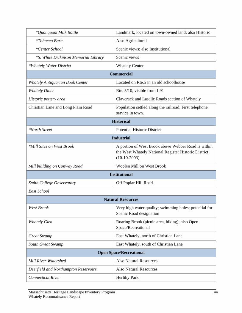
Massachusetts Heritage Landscape Inventory Program 44 Whately Reconnaissance Report
*Quonquont Milk Bottle Landmark, located on town-owned land; also Historic
*Tobacco Barn Also Agricultural
*Center School Scenic views; also Institutional
*S. White Dickinson Memorial Library Scenic views
*Whately Water District Whately Center
Commercial
Whately Antiquarian Book Center Located on Rte.5 in an old schoolhouse
Whately Diner Rte. 5/10; visible from I-91
Historic pottery area Claverack and Lasalle Roads section of Whately
Christian Lane and Long Plain Road Population settled along the railroad; First telephone service in town.
Historical
*North Street Potential Historic District
Industrial
*Mill Sites on West Brook A portion of West Brook above Webber Road is within the West Whately National Register Historic District (10-10-2003)
Mill building on Conway Road Woolen Mill on West Brook
Institutional
Smith College Observatory Off Poplar Hill Road
East School
Natural Resources
West Brook Very high water quality; swimming holes; potential for Scenic Road designation
Whately Glen Roaring Brook (picnic area, hiking); also Open Space/Recreational
Great Swamp East Whately, north of Christian Lane
South Great Swamp East Whately, south of Christian Lane
Open Space/Recreational
Mill River Watershed Also Natural Resources
Deerfield and Northampton Reservoirs Also Natural Resources
Connecticut River Herlihy Park
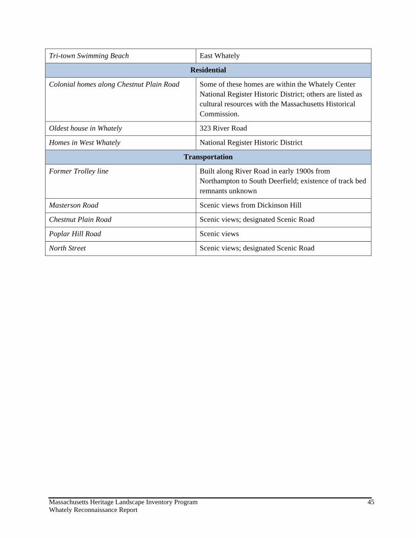
Massachusetts Heritage Landscape Inventory Program 45 Whately Reconnaissance Report
Tri-town Swimming Beach East Whately
Residential
Colonial homes along Chestnut Plain Road Some of these homes are within the Whately Center National Register Historic District; others are listed as cultural resources with the Massachusetts Historical Commission.
Oldest house in Whately 323 River Road
Homes in West Whately National Register Historic District
Transportation
Former Trolley line Built along River Road in early 1900s from Northampton to South Deerfield; existence of track bed remnants unknown
Masterson Road Scenic views from Dickinson Hill
Chestnut Plain Road Scenic views; designated Scenic Road
Poplar Hill Road Scenic views
North Street Scenic views; designated Scenic Road