whitehaven town centre and high street conservation areas
TRANSCRIPT
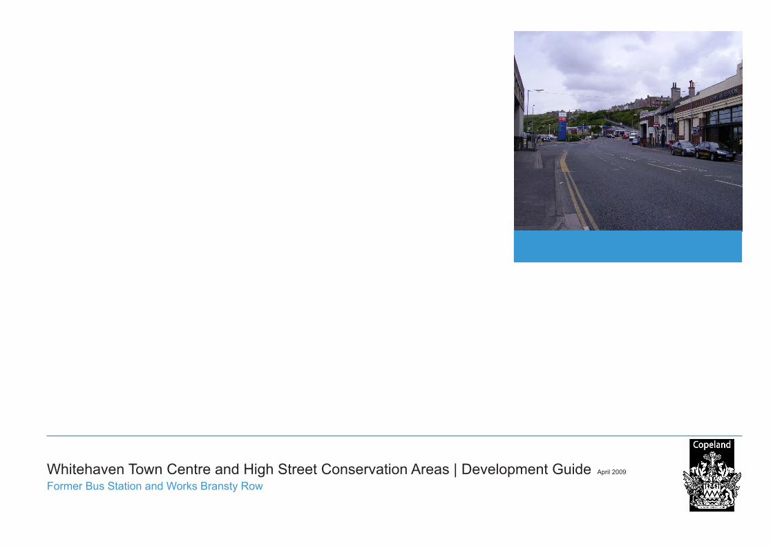
Whitehaven Town Centre and High Street Conservation Areas | Development Guide April 2009
Former Bus Station and Works Bransty Row
2
Acknowledgements
We are grateful to the people of Whitehaven who provided invaluable local knowledge and encouragement during the preparation of this report, in particular Cllr John Kane, Cllr Jeanette Williams, Cllr Henry Wormstrup, John Crewdson of the Whitehaven and District Civic Society, Michael Moon of the Whitehaven Heritage Action Group and Celia McKenzie of the Whitehaven Harbour Commission.
Thanks are also due to the staff at the Whitehaven Record Offi ce and Local Studies Library who provided helpful assistance and to the Lowther Estate who kindly permitted the reproduction of several of the plans within this document.
Whitehaven Town Centre Heritage and Design Series
This document is part of the Whitehaven Town Centre Heritage and Design Series. This series has prepared on behalf of Copeland Borough Council to ensure that all development proposals in, or adjacent to, Whitehaven town centre’s conservation areas are well-considered, of high quality and have regard to their historical context.
This series is addressed to:
Residents and businesses; ■The local community; ■Ward members; ■Council departments, including planning, land ■and property and highways;Potential public and private sector developers; ■Statutory service providers, and; ■Relevant professionals, including builders, ■architects and planners.
Documents in this series are:
Whitehaven Town Centre and High Street ■Conservation Areas Character Appraisal
This character appraisal identifi es and explains the special historical and architectural character of Whitehaven town centre’s conservation areas.
Whitehaven Town Centre and High Street ■Conservation Areas Managment Plan
This management plan programmes short, medium and long-term actions to preserve and enhance the conservation areas.
Whitehaven Town Centre Development Guide ■
This development guide outlines the urban design principles and criteria to be applied in the town centre.
Whitehaven Town Centre Site Development ■Guides:
Site 1: Former YMCA Building Irish Street -Site 2: Albion Street South -Site 3: Albion Street North -Site 4: Quay Street Car Park -Site 5: Bardywell Lane -Site 6: Gough’s Car Park, Strand Street/ -Malborough StreetSite 7: Mark House, the former Victorian public -baths and the Paul Jones Pub, Strand StreetSite 8: Former Bus Depot, Bransty Row -Site 9: Former Bus Station and Works, Bransty -Row
These site development guides are to be read in conjunction with the Whitehaven Town Centre Devleopment Guide and indicate the degree and type of development that will be acceptable on each development site.
Whitehaven Town Centre Public Realm ■Appraisal
This public realm appraisal provides guidance on the degree and type of surface materials and street structures that will be acceptable in the town centre.
Whitehaven Town Centre | Development Guide 3
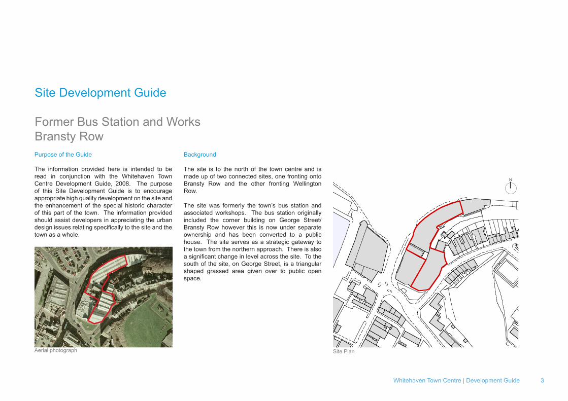
Site Development Guide
Former Bus Station and WorksBransty RowPurpose of the Guide
The information provided here is intended to be read in conjunction with the Whitehaven Town Centre Development Guide, 2008. The purpose of this Site Development Guide is to encourage appropriate high quality development on the site and the enhancement of the special historic character of this part of the town. The information provided should assist developers in appreciating the urban design issues relating specifically to the site and the town as a whole.
Background
The site is to the north of the town centre and is made up of two connected sites, one fronting onto Bransty Row and the other fronting Wellington Row.
The site was formerly the town’s bus station and associated workshops. The bus station originally included the corner building on George Street/Bransty Row however this is now under separate ownership and has been converted to a public house. The site serves as a strategic gateway to the town from the northern approach. There is also a significant change in level across the site. To the south of the site, on George Street, is a triangular shaped grassed area given over to public open space.
Site PlanAerial photograph
N
4
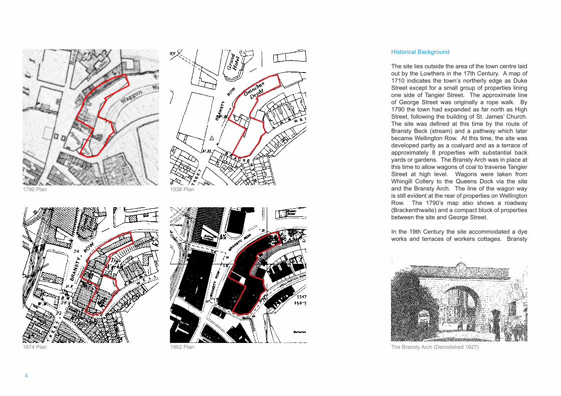
1790 Plan
Historical Background
The site lies outside the area of the town centre laid out by the Lowthers in the 17th Century. A map of 1710 indicates the town’s northerly edge as Duke Street except for a small group of properties lining one side of Tangier Street. The approximate line of George Street was originally a rope walk. By 1790 the town had expanded as far north as High Street, following the building of St. James’ Church. The site was defined at this time by the route of Bransty Beck (stream) and a pathway which later became Wellington Row. At this time, the site was developed partly as a coalyard and as a terrace of approximately 8 properties with substantial back yards or gardens. The Bransty Arch was in place at this time to allow wagons of coal to traverse Tangier Street at high level. Wagons were taken from Whingill Collery to the Queens Dock via the site and the Bransty Arch. The line of the wagon way is still evident at the rear of properties on Wellington Row. The 1790’s map also shows a roadway (Brackenthwaite) and a compact block of properties between the site and George Street.
In the 19th Century the site accommodated a dye works and terraces of workers cottages. Bransty
The Bransty Arch (Demolished 1927)1874 Plan
1938 Plan
1962 Plan
Whitehaven Town Centre | Development Guide 5
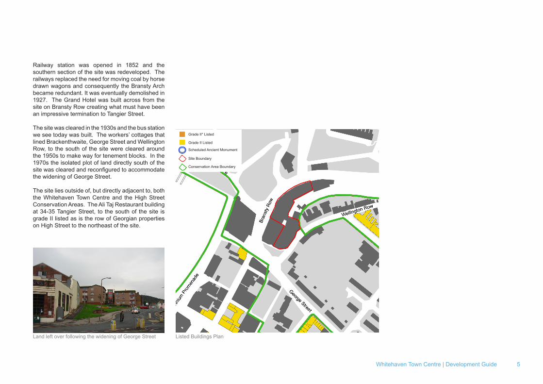
Listed Building Plan
Grade II* Listed
Grade II Listed
Scheduled Ancient Monument
Site Boundary
Conservation Area Boundary
Listed Buildings PlanLand left over following the widening of George Street
Railway station was opened in 1852 and the southern section of the site was redeveloped. The railways replaced the need for moving coal by horse drawn wagons and consequently the Bransty Arch became redundant. It was eventually demolished in 1927. The Grand Hotel was built across from the site on Bransty Row creating what must have been an impressive termination to Tangier Street.
The site was cleared in the 1930s and the bus station we see today was built. The workers’ cottages that lined Brackenthwaite, George Street and Wellington Row, to the south of the site were cleared around the 1950s to make way for tenement blocks. In the 1970s the isolated plot of land directly south of the site was cleared and reconfigured to accommodate the widening of George Street.
The site lies outside of, but directly adjacent to, both the Whitehaven Town Centre and the High Street Conservation Areas. The Ali Taj Restaurant building at 34-35 Tangier Street, to the south of the site is grade II listed as is the row of Georgian properties on High Street to the northeast of the site.
6
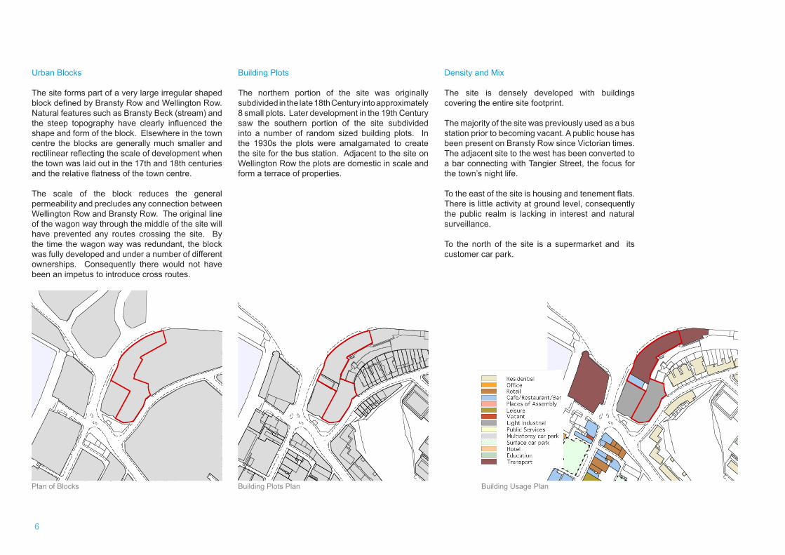
Density and Mix
The site is densely developed with buildings covering the entire site footprint.
The majority of the site was previously used as a bus station prior to becoming vacant. A public house has been present on Bransty Row since Victorian times. The adjacent site to the west has been converted to a bar connecting with Tangier Street, the focus for the town’s night life.
To the east of the site is housing and tenement flats. There is little activity at ground level, consequently the public realm is lacking in interest and natural surveillance.
To the north of the site is a supermarket and its customer car park.
Building Plots
The northern portion of the site was originally subdivided in the late 18th Century into approximately 8 small plots. Later development in the 19th Century saw the southern portion of the site subdivided into a number of random sized building plots. In the 1930s the plots were amalgamated to create the site for the bus station. Adjacent to the site on Wellington Row the plots are domestic in scale and form a terrace of properties.
Building Plots Plan Building Usage Plan
Dock
Dock
Surface car park
Residential Office Retail Cafe/Restaurant/Bar Places of Assembly Leisure Vacant Light Industrial Public Services
Multistorey car park
Hotel Education Transport
Plan of Blocks
Urban Blocks
The site forms part of a very large irregular shaped block defined by Bransty Row and Wellington Row. Natural features such as Bransty Beck (stream) and the steep topography have clearly influenced the shape and form of the block. Elsewhere in the town centre the blocks are generally much smaller and rectilinear reflecting the scale of development when the town was laid out in the 17th and 18th centuries and the relative flatness of the town centre.
The scale of the block reduces the general permeability and precludes any connection between Wellington Row and Bransty Row. The original line of the wagon way through the middle of the site will have prevented any routes crossing the site. By the time the wagon way was redundant, the block was fully developed and under a number of different ownerships. Consequently there would not have been an impetus to introduce cross routes.
Whitehaven Town Centre | Development Guide 7
Building HeightsWellington Row
Bransty Row
Street Activity Plan
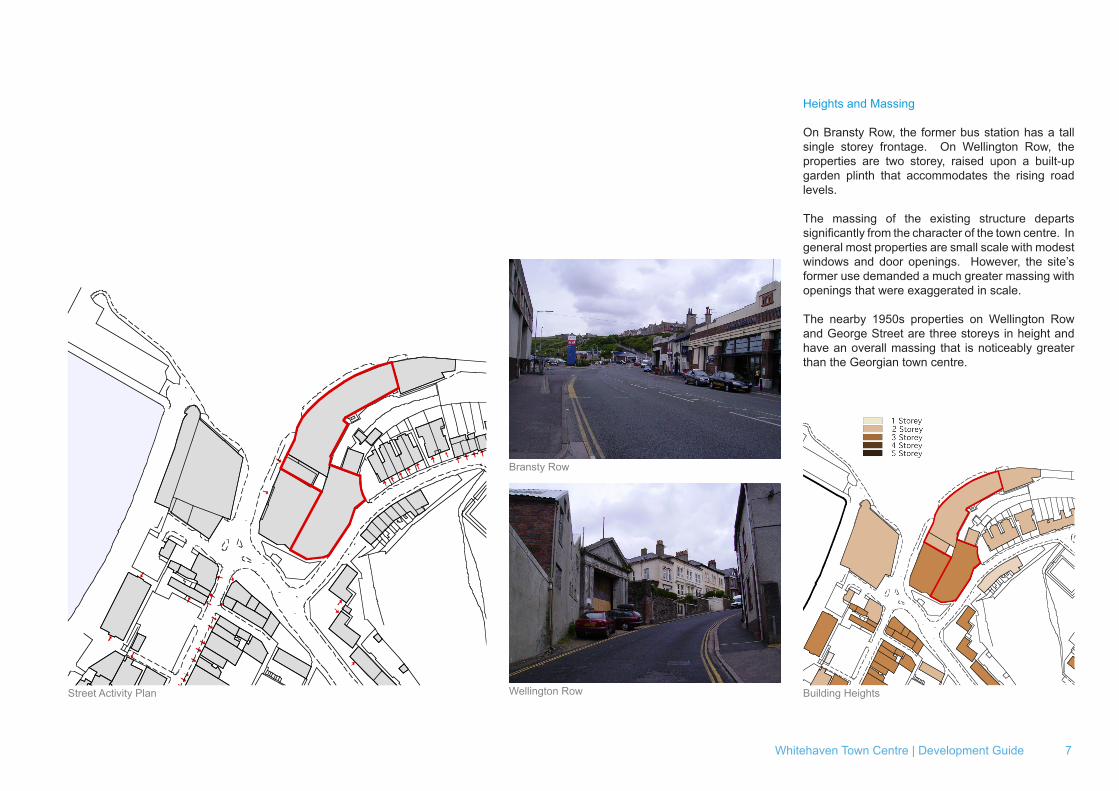
Heights and Massing
On Bransty Row, the former bus station has a tall single storey frontage. On Wellington Row, the properties are two storey, raised upon a built-up garden plinth that accommodates the rising road levels.
The massing of the existing structure departs significantly from the character of the town centre. In general most properties are small scale with modest windows and door openings. However, the site’s former use demanded a much greater massing with openings that were exaggerated in scale.
The nearby 1950s properties on Wellington Row and George Street are three storeys in height and have an overall massing that is noticeably greater than the Georgian town centre.
1 Storey 2 Storey 3 Storey 4 Storey 5 Storey
8
Building Type
The floor plate of the former bus station is significantly larger than that found in the historic town centre and provides an example of a new use introduced in the 1930s that demanded a change in the typical building type.
The sites’ buildings sit somewhat uncomfortably with their neighbours, particularly on Wellington Row where an amalgamation of low grade utilitarian structures that have little or no relationship with the town’s overall character.
The buildings on Bransty Row face directly onto the street. On Wellington Row the line of the buildings is faceted, following the street line, with the exception of the northern-most structure that is set back, presumably to assist vehicle access.
The south east corner of the site fronts a footpath and a somewhat forlorn patch of soft landscaping.
At roof level the site’s buildings have a mix of roof forms and were clearly not designed to be visible.
Façade and Interface
On Bransty Row the facade openings have large window and entrance doorways, which reflect the building’s former use. The adjacent former offices and the Shipwright’s Arms are more domestic in scale. On Wellington Row there is a classical porticoed entrance alongside primarily blank façades with a few adhoc window openings.
At street level on Bransty Row the building is taken up to the back of the footpath. On Wellington Row the buildings back directly onto the roadway, with no footpath provision. This creates a rather awkward termination to the otherwise attractive streetscape
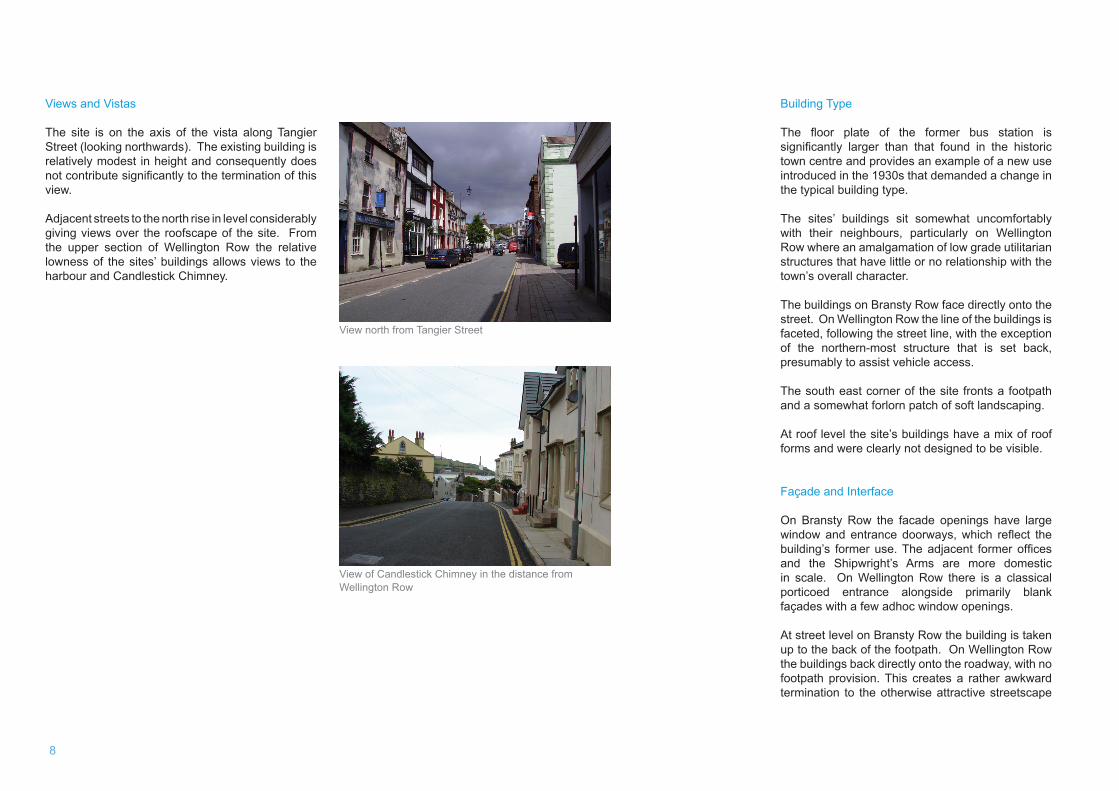
Views and Vistas
The site is on the axis of the vista along Tangier Street (looking northwards). The existing building is relatively modest in height and consequently does not contribute significantly to the termination of this view.
Adjacent streets to the north rise in level considerably giving views over the roofscape of the site. From the upper section of Wellington Row the relative lowness of the sites’ buildings allows views to the harbour and Candlestick Chimney.
View north from Tangier Street
View of Candlestick Chimney in the distance from Wellington Row
Whitehaven Town Centre | Development Guide 9
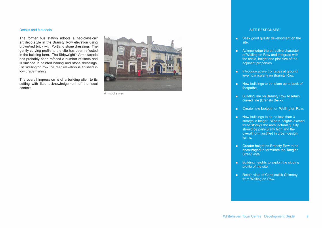
Details and Materials
The former bus station adopts a neo-classical/art deco style in the Bransty Row elevation using brown/red brick with Portland stone dressings. The gently curving profile to the site has been reflected in the building form. The Shipwright’s Arms façade has probably been refaced a number of times and is finished in painted harling and stone dressings. On Wellington row the rear elevation is finished in low grade harling.
The overall impression is of a building alien to its setting with little acknowledgement of the local context.
A mix of styles
SITE RESPONSES
■ Seek good quality development on the site.
■ Acknowledge the attractive character of Wellington Row and integrate with the scale, height and plot size of the adjacent properties.
■ Introduce active frontages at ground level, particularly on Bransty Row.
■ New buildings to be taken up to back of footpaths.
■ Building line on Bransty Row to retain curved line (Bransty Beck).
■ Create new footpath on Wellington Row.
■ New buildings to be no less than 3 storeys in height. Where heights exceed three storeys the architectural quality should be particularly high and the overall form justified in urban design terms.
■ Greater height on Bransty Row to be encouraged to terminate the Tangier Street vista.
■ Building heights to exploit the sloping profile of the site.
■ Retain vista of Candlestick Chimney from Wellington Row.