wind river formation geologic background
TRANSCRIPT

B Y
S C O T T Q U I L L I N A N
B R E T T W O R M A N
F R E D M C L A U G H L I N
A L A N V E R P L O E G
Geologic BackgroundWind River Formation
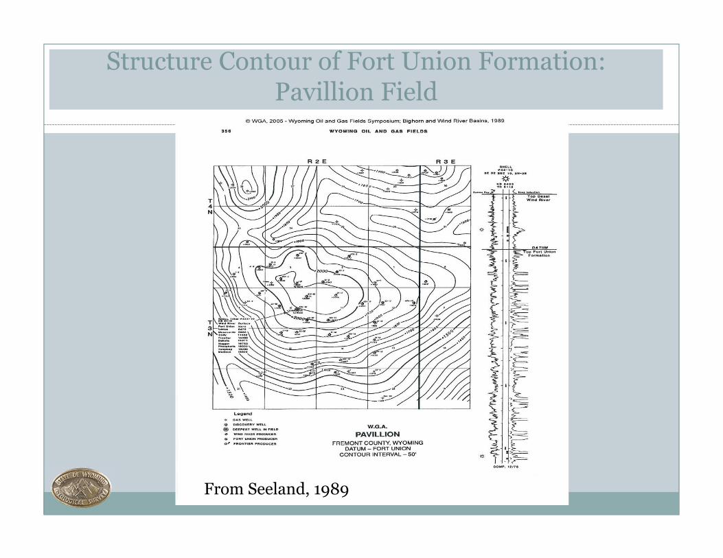
Structure Contour of Fort Union Formation: Pavillion Field
From Seeland, 1989

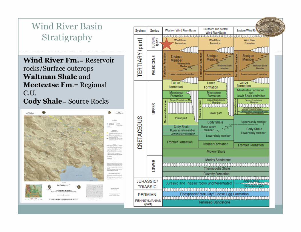
Wind River Basin Stratigraphy
Wind River Fm.= Reservoir rocks/Surface outcropsWaltman Shale and Meeteetse Fm.= Regional C.U. Cody Shale= Source Rocks
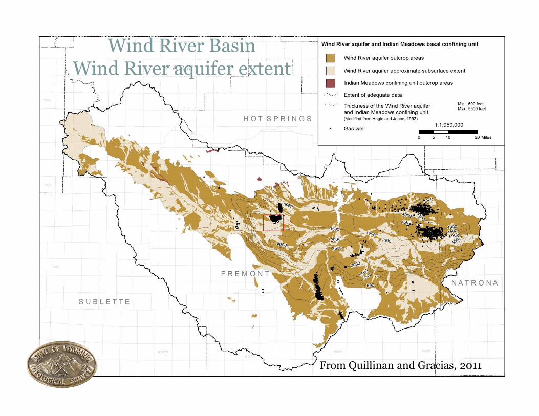
Wind River BasinWind River aquifer extent
From Quillinan and Gracias, 2011
Wind River Aquifer
� Wind River Aquifer is composed of the Eocene Wind River formation
� Wells completed in the Wind River Aquifer are generally for stock and domestic, characterized by relatively low yields and poorer water quality (Morris et al. 1959; Whitcomb and Lowry, 1968; McGreevy et al., 1969; Libra et al. 1981; Daddow, 1996).
� The aquifer -lenticular SS beds and conglomerates � Vary widely in thickness and geometry
� Differing tranmissivites and hydraulic isolation
� Lenses are considered individual aquifers on a local scale
� Often discontinuous and separated by less-permeable fine grained rocks
� Generally unconfined above 100 ft (Daddow, 1996)
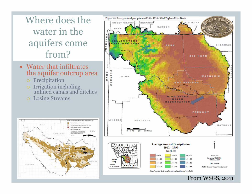
Where does the water in the
aquifers come from?
� Water that infiltrates the aquifer outcrop area� Precipitation� Irrigation including
unlined canals and ditches� Losing Streams
From WSGS, 2011
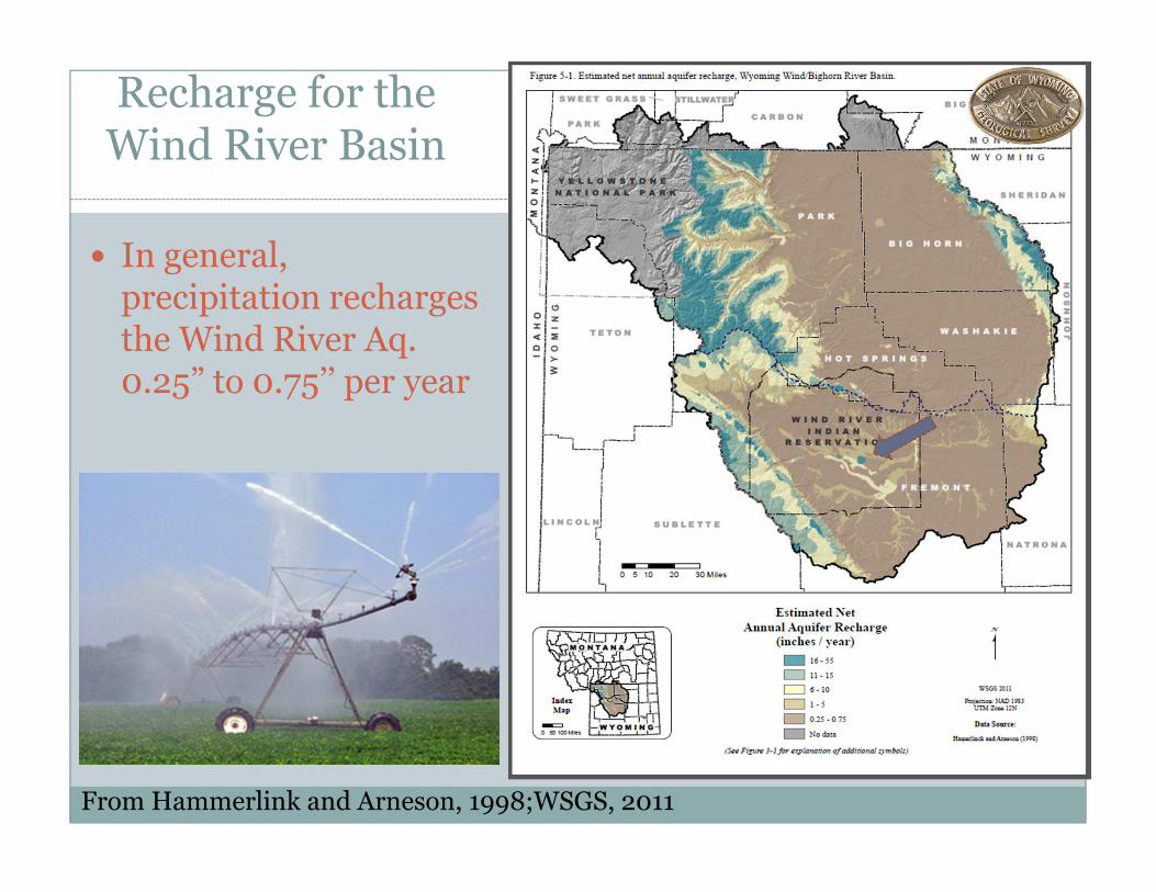
Recharge for the Wind River Basin
� In general, precipitation recharges the Wind River Aq. 0.25” to 0.75’’ per year
From Hammerlink and Arneson, 1998;WSGS, 2011
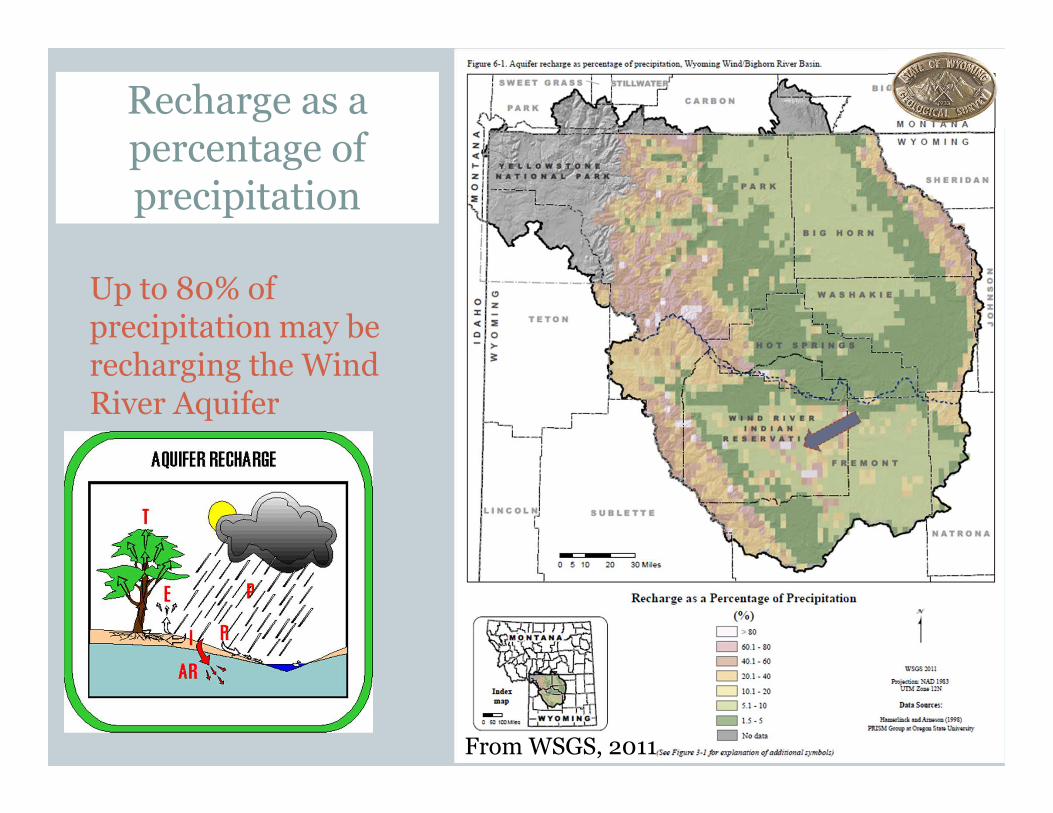
Recharge as a percentage of precipitation
Up to 80% of precipitation may be recharging the Wind River Aquifer
From WSGS, 2011

Aquifer Sensitivity
� The Wind River aquifer has a higher sensitivity rating
Data from Hammerlink and Arneson1998; WSGS, 2011

� WDEQ Water Quality Division:� Known contaminated sites under the Groundwater Pollution Control Program� Class I, III, IV, V injection wells under the Underground Injection Control (UIC)
Program� Wyoming Pollutant Discharge Elimination System (WYPDES) and National
Pollutant Discharge Elimination System (NPDES) discharge points � Public Owned Treatment Works (POTWs) and septic systems (Water and
Wastewater Program)� Concentrated Animal Feeding Operations (CAFOs)� Pesticides / herbicides (Nonpoint Source Program)
� WDEQ Solid and Hazardous Waste Division:� Known contaminated sites under the Voluntary Remediation Program (VRP)� Permitted disposal pits and other small Treatment Storage and Disposal (TSD)
facilities� Landfills� Above and underground storage tanks
� WDEQ Land Quality and Abandoned Mine Land Division:� Active and inactive mines (LQD/AML)� Gravel Pits, Quarries, etc.
� Wyoming Oil & Gas Conservation Commission:� Class II disposal wells� Produced water pits
Potential Contaminates
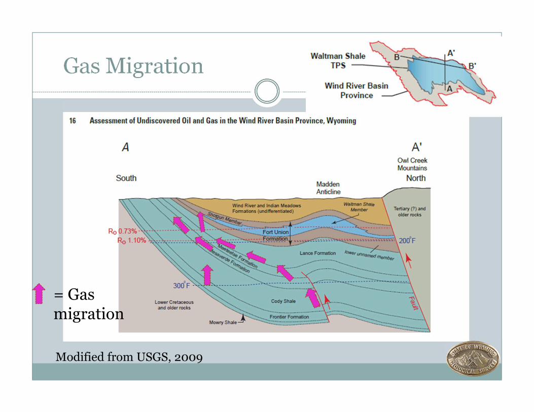
Gas Migration
= Gas migration
Modified from USGS, 2009

Wind River Formation Depositional History
� Dominantly fluvial environments and sediments, and also contains lacustrine, swamp, soil, and alluvial fan deposits
� Abundant fluvial channels. Seeland (1978) defined the course of the paleo-Wind River as flowing through the Pavillion area. � Paleo-channel was established by Eocene
� The Eocene basin was at least 1km less than current elevation � Eocene paleo-fluvial environment and climate (Fan et al.,
2011)� low sinuosity� combination of gravel-bedded braided rivers (proximal to uplift) and
meandering channels� well developed flood plains and paleosols� period of high precipitation (relative)� seasonal climate � fluvial gradient decreased with distance from uplifts

Wind River Formation Lithology and Source
� Variegated sands, silts, and clays
� Sandstones are coarse- to fine-grained and often juvenile (arkosic) (Seeland, 1978; Fan et al., 2011)
� Little to no deformation (post-Laramide)
� Zircon studies indicate approximately 80% of Wind River Formation sediment is from the recycling of older (Meso- and Paleozoic) sediments, 20% from Precambrian
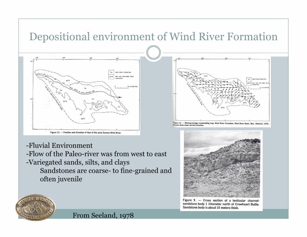
Depositional environment of Wind River Formation
From Seeland, 1978
-Fluvial Environment-Flow of the Paleo-river was from west to east -Variegated sands, silts, and clays
Sandstones are coarse- to fine-grained and often juvenile

Fluvial depositionfrom the text book
From Selley, 1970; Fielding and Crane, 1987; Harms et al., 1982

Fluvial environment in the rock record
From USGS, 2007

Geophysics and Lithology
From Fielding and Crane, 1987
Well from Pavillion Field (Doles Unit 44-15)
Channel
Flood basin
Levee
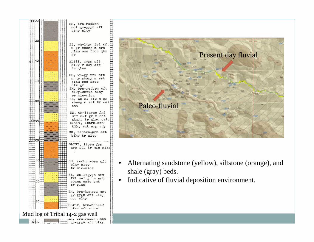
• Alternating sandstone (yellow), siltstone (orange), and shale (gray) beds.
• Indicative of fluvial deposition environment.
Mud log of Tribal 14-2 gas well
Paleo-fluvial
Present day fluvial

Hinckley Consulting, 2011
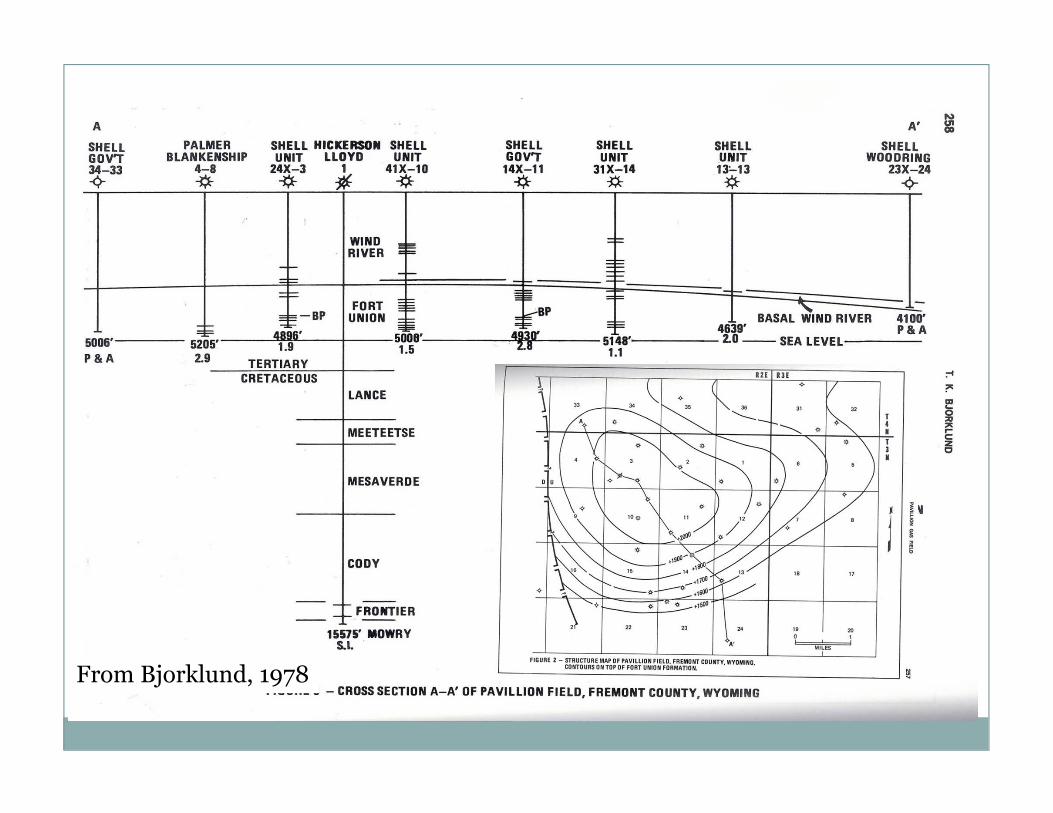
From Bjorklund, 1978

A
B’
A’
B
South-North Cross-section through Pavillion Field

A
B’
A’
B
West-East Cross-section through Pavillion Field
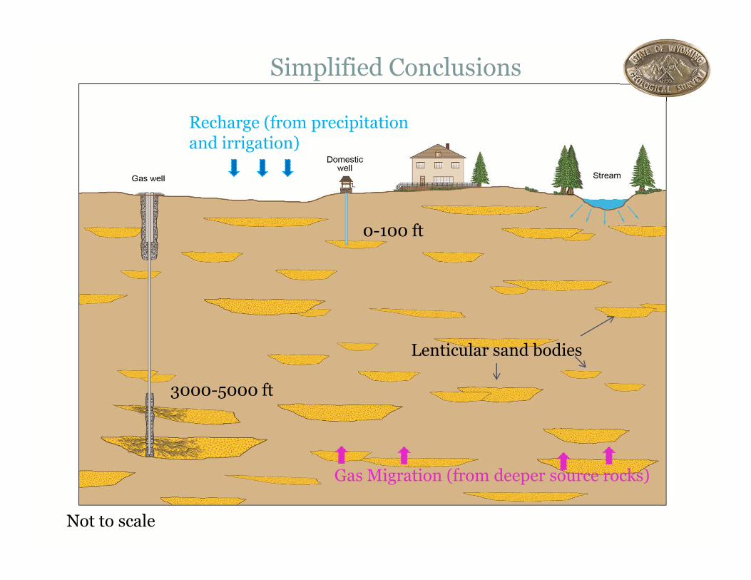
Simplified Conclusions
0-100 ft
3000-5000 ft
Recharge (from precipitation and irrigation)
Lenticular sand bodies
Gas Migration (from deeper source rocks)
Not to scale
S C O T T Q U I L L I N A N
G E O L O G I S T
W Y O M I N G S TAT E G E O L O G I C A L S U R V E Y
( 3 0 7 ) 7 6 6 - 2 2 8 6
S C O T T. Q U I L L I N A N @ W Y O . G O V
Thank You!