wolverhampton city council open decision item
TRANSCRIPT
Agenda Item No: 6
Wolverhampton City Council OPEN DECISION ITEM Committee / Panel PLANNING COMMITTEE Date: 17th April 2007 Originating Service Group(s) REGENERATION AND TRANSPORTATION Contact Officer(s) Stephen Alexander (Head of Development Control) Telephone Number(s) (01902) 555610 Title/Subject Matter PLANNING APPLICATIONS Recommendation That Members determine the submitted applications according to the recommendation made in respect of each one.
2
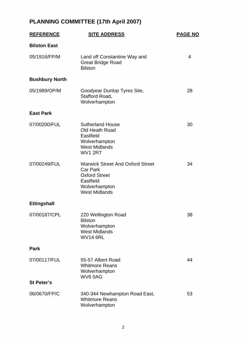
PLANNING COMMITTEE (17th April 2007) REFERENCE SITE ADDRESS PAGE NO Bilston East 05/1916/FP/M Land off Constantine Way and
Great Bridge Road Bilston
4
Bushbury North 05/1989/OP/M Goodyear Dunlop Tyres Site,
Stafford Road, Wolverhampton
28
East Park 07/00200/FUL Sutherland House
Old Heath Road Eastfield Wolverhampton West Midlands WV1 2RT
30
07/00249/FUL Warwick Street And Oxford Street
Car Park Oxford Street Eastfield Wolverhampton West Midlands
34
Ettingshall 07/00187/CPL 220 Wellington Road
Bilston Wolverhampton West Midlands WV14 6RL
38
Park 07/00117/FUL 55-57 Albert Road
Whitmore Reans Wolverhampton WV6 0AG
44
St Peter’s 06/0670/FP/C 340-344 Newhampton Road East,
Whitmore Reans Wolverhampton
53
3
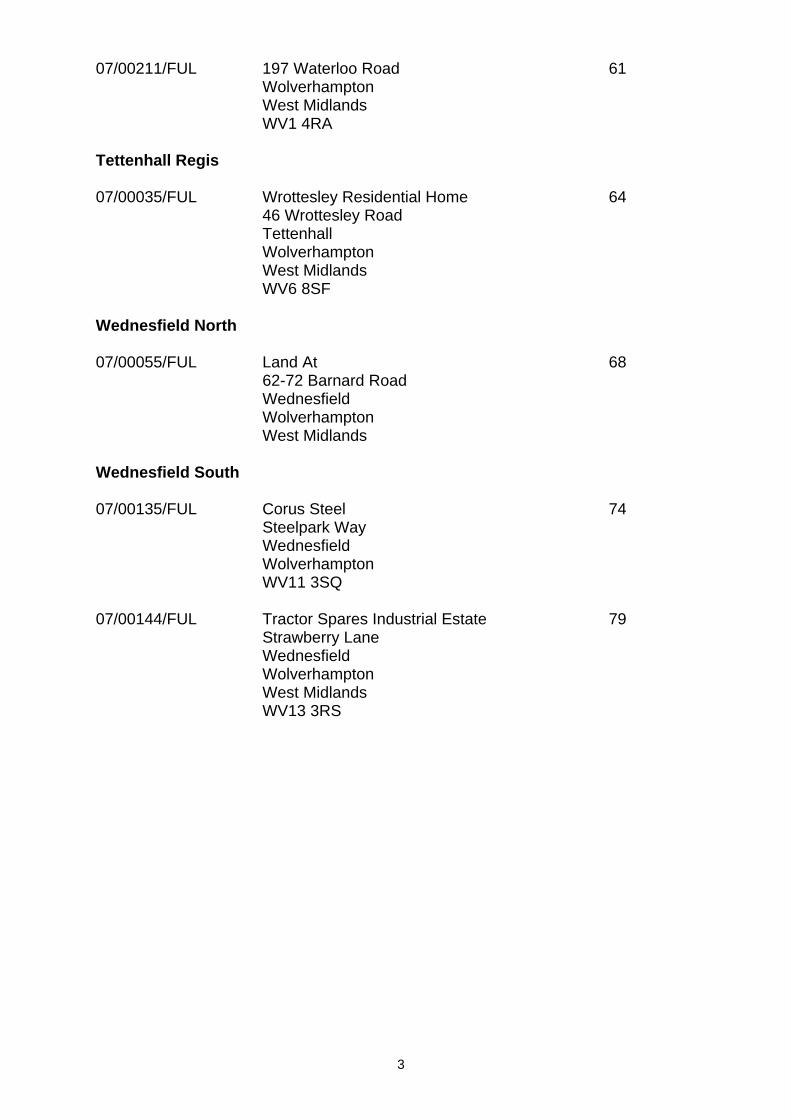
07/00211/FUL 197 Waterloo Road Wolverhampton West Midlands WV1 4RA
61
Tettenhall Regis 07/00035/FUL Wrottesley Residential Home
46 Wrottesley Road Tettenhall Wolverhampton West Midlands WV6 8SF
64
Wednesfield North 07/00055/FUL Land At
62-72 Barnard Road Wednesfield Wolverhampton West Midlands
68
Wednesfield South 07/00135/FUL Corus Steel
Steelpark Way Wednesfield Wolverhampton WV11 3SQ
74
07/00144/FUL Tractor Spares Industrial Estate
Strawberry Lane Wednesfield Wolverhampton West Midlands WV13 3RS
79
4
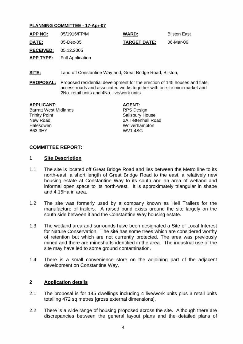
PLANNING COMMITTEE - 17-Apr-07
COMMITTEE REPORT:
1 Site Description 1.1 The site is located off Great Bridge Road and lies between the Metro line to its
north-east, a short length of Great Bridge Road to the east, a relatively new housing estate at Constantine Way to its south and an area of wetland and informal open space to its north-west. It is approximately triangular in shape and 4.15Ha in area.
1.2 The site was formerly used by a company known as Heil Trailers for the
manufacture of trailers. A raised bund exists around the site largely on the south side between it and the Constantine Way housing estate.
1.3 The wetland area and surrounds have been designated a Site of Local Interest
for Nature Conservation. The site has some trees which are considered worthy of retention but which are not currently protected. The area was previously mined and there are mineshafts identified in the area. The industrial use of the site may have led to some ground contamination.
1.4 There is a small convenience store on the adjoining part of the adjacent
development on Constantine Way. 2 Application details 2.1 The proposal is for 145 dwellings including 4 live/work units plus 3 retail units
totalling 472 sq metres [gross external dimensions]. 2.2 There is a wide range of housing proposed across the site. Although there are
discrepancies between the general layout plans and the detailed plans of
APP NO: 05/1916/FP/M WARD: Bilston East
DATE: 05-Dec-05 TARGET DATE: 06-Mar-06
RECEIVED: 05.12.2005 APP TYPE: Full Application SITE: Land off Constantine Way and, Great Bridge Road, Bilston,
PROPOSAL: Proposed residential development for the erection of 145 houses and flats, access roads and associated works together with on-site mini-market and 2No. retail units and 4No. live/work units
APPLICANT: Barratt West Midlands Trinity Point New Road Halesowen B63 3HY
AGENT: RPS Design Salisbury House 2A Tettenhall Road Wolverhampton WV1 4SG
5
housing types provided it seems that the application proposes:- 9 no. 4 bedroom, 62 no. 3 bedroom, 14 no. 2 bedroom houses, 59 no. 2 bedroom flats, 1 no. 1 bedroom flat.
2.3 Three retail units described as a mini-market and two smaller units totalling
approximately 426sq metres with a service court and associated parking proposed, to the north-east corner of the site alongside and fronting Great Bridge Road and accessed from Constantine Way. On the opposite side of the parking court 4 no. live/work units comprising 3 x 55 sq metres and 1 x 60sq metres floor area with the commercial/employment area beneath and flats above are proposed. This block is linked to an adjoining apartment building.
2.4 The majority of the proposed residential part of the development is laid out in 3
perimeter blocks with some rear gardens and dwellings facing out onto access roads and rear courtyard parking with gate controlled access. The largest central block is partially made up of more traditional terraced properties with gardens backing onto gardens.
2.5 The main area of flats is located at the northern corner of the site with a rear
parking court backing onto the Metro line. 2.6 An area of open space of approximately 0.2Ha is proposed between the
apartments and the retail/live-work unit part of the proposal immediately south-west of the Metro line. An additional smaller, linear strip of open space is proposed adjacent to the existing bund on the western side of the site.
2.7 Four paths are proposed between the proposed new housing development and
the existing adjacent residential estate, to be cut through the existing raised earth bund.
2.8 Vehicular access to the proposed development would be from Constantine Way
also cut through the existing raised earth bund. 2.9 Public Art is proposed in the detail of railings and features in the buildings. The
design statement also refers to a freestanding artwork on the Great Bridge Road frontage.
3 Planning History 3.1 05/0058/FP/M for Demolition of existing factory and offices for erection of 157
no. 1 and 2 bedroom flats, 2, 3 and 4 bedroom houses, garages, access roads and associated works, refused dated 08.04.2005.
4 Constraints 4.1 Authorised Process on current industrial site.
British Coal - Historical - British Coal Sites & Monuments - Historical - Sites and Monuments
6
5 Relevant policies 5.1 Relevant UDP policies are:
D1 - Design Quality D3 - Urban Structure D4 - Urban Grain D5 - Public Realm Public Open Private Space D6 - Townscape and Landscape D7 - Scale - Height D8 - Scale - Massing D9 - Appearance D10 - Community Safety D11 - Access for People with Disabilities part D12 - Nature Conservation and Natural Features D13 - Sustainable Development Natural Energy D14 - The Provision of Public Art EP6 - Protection of Ground Water, Watercourses, Canals EP1 - Pollution Control EP9 - Sustainable Drainage Arrangements for Developments EP11 - Development on Contaminated Unstable Land EP16 - Energy Conservation HE1 - Preservation of Local Character and Dist N1 - Promotion of Nature Conservation N2 - Access to Natural Green Space N5 - Protection of Sites of Local Importance for Nature Conservation B5 - Design Standards for Employment Sites B10 - Redevelopment of Business Land and Prem. SH3 - Need and the Sequential Approach SH9 - Local Shops and Centre Uses R1 - Local Standards for Open Space, Sport R4 - Development Adjacent to Open Spaces R7 - Open Space Requirements for New Develop. H1 - Housing H3 - Housing Site Assessment Criteria H4 - Housing Allocations H6 - Design of Housing Development H10 - Affordable Housing AM1 - Access, Motability and New Development AM6 - Transport Assessments AM7 - Travel Plans AM9 - Provision for Pedestrians AM10 - Provision for Cyclists AM12 - Parking and Servicing Provision AM15 - Road Safety and Personal Security IMR2 - Planning Obligations
5.2 Relevant Supplementary Planning Guidance and Documents:
SPG 3 – Residential Development SPD – Affordable Housing
7
5.3 Relevant national policies and guidance are as follows:
PPS1 – Sustainable Development PPS3 – Housing PPS6 – Town Centres PPG13 - Transport
PPG14 – Development on Unstable Land PPG17 – Sport and Recreation Department of Transport, Manual for Streets 2007
5.4 Relevant West Midlands Regional Spatial Strategy policies are as follows: UR1 (A) CF1 (A) QE3 6 Publicity 6.1 The application was publicised in the following ways:
Site Notice Press Notice Neighbourhood notification letters.
7 Neighbour notification and representations 7.1 Two petitions have been received with 22 signatures and 166 signatures
respectively. These present objections to the following: - the amount of retail provision, as it attracts anti-social behaviour and encourages youths to congregate and there is already a store on the wider site; the bund should be flattened not retained; and lighting is required to discourage anti-social behaviour.
7.2 Two letters of objection have been received both objecting to the level of retail
proposed on the site, sale of alcohol and anti-social behaviour magnet of retail element. They raise concerns regarding the additional traffic created either during the development or as a result of occupation of the development and seek improvements to the junction between Constantine Way and Great Bridge Road.
7.3 One letter of support received in which a neighbour will be pleased to lose the
eyesore that the Heil Trailers site has become. 8 Internal consultees 8.1 Transportation Development
There are outstanding concerns about the accuracy of the public transport
information supplied; but no objection to the principle of the development. All retail units and live to work units should be included in the Peak Hour
Analysis, not discounted as stated in assessment.
8
Trip generation predictions for the proposal are not sufficient to assess the impact on the affected junctions.
Walsall MBC has not commented on the impact of the development on the road junction which lies outside Wolverhampton.
Failed to demonstrate ease of access to public transport and local facilities as crude distances rather than route distances have been used.
Full accident analysis of access and junctions needs to be provided. No commitment to provision of Metro stop has been demonstrated. It is recommended that garage dimensions need to be increased to minimum
2.6m wide. Parking areas - drive widths and depths need to be increased in some areas. Paths to doors in some parts of proposal are inadequate. Access ways and gate set backs need to be amended in dimensions in some
plots. Welcome closure of vehicle accesses onto Great Bridge Road but layout will
encourage parking on that road. Cycle storage at one per flat required. Some awkward car and motorcycle parking arrangements which need
amendment. Would require a Residential Travel Plan Mineshafts under proposed adopted highway therefore full geotechnical report
required. Concludes - Unable to support proposal for reasons given.
8.2 Sustainability Unit
Accept the principle of change of use and density at approx 39/Ha and sustainable mix of dwelling types and sizes.
Concern regarding the bund which does not currently provide adequate open space or a wildlife corridor and should be entirely levelled.
Landscape Strategy is required for whole site and should explore inclusion of Sustainable Urban Drainage Scheme [SUDS].
Is electricity substation to stay or go? Design Statement indicates EcoHomes rating of 'pass to good' standard
proposed which is not considered adequate as social housing providers are expected to provide housing at 'very good' as a minimum standard and 'excellent' in some cases.
Reference to Solar Gain is insufficient to deal with climate change issues. A Climate Change Adaptation Strategy is required for the development. Waste Management Strategy required for the development phase of the
proposal. Concludes - unless the above issues are addressed, the Sustainability Unit is
unable to support the proposal. 8.3 Neighbourhood Renewal
On the basis of no. of housing units being provided 25% Affordable Housing should include 24 units for rent - 9 no. 2 bedroom flats, 7 no. 2 bedroom houses and 8 no. 3 bedroom houses.
12 shared ownership or shared equity dwellings - 6 no. 3 bedroom houses and 6 no. 2 bedroom houses.
9
8.4 Planning Policy
Loss of employment land Principle of loss of employment site as set out in policy B10 has been
established as existing site was purpose designed for Heil Trailers and is poorly located in terms of the Strategic Highways network and surrounding residential land use would restrict potential range of employment uses. General residential development issues.
Suitable for residential-led development subject to other policy designations. Proposed density and capacity target of 30 to 50 dwellings per Ha has been
met at 35dwgs/Ha. Policy H8 - S106 for Open Space Sport and Recreation Requirements for New
Housing Developments to ensure adequate provision/improvement of off-site facilities for 422 new residents equivalent to 1.1Ha.
Size of development generates a requirement for the equivalent of 0.4 of a Locally Equipped Play Area [LEAP] and 10 years maintenance [towards an equivalent proportion of such a facility].
Size of development generates a requirement for the provision of 0.21 of a Multi-Use Ball Games Area [MUGA] or equivalent and maintenance towards an equivalent proportion of such a facility
On-site amenity space – provision of area under 0.25Ha fulfils function as amenity open space rather than recreational open space however it is counted as making a contribution towards the open space requirement subject to being preserved for this use in perpetuity. [i.e. cannot be counted and then become parking for a future Metro stop] A commuted sum for maintenance of on-site amenity space will be required through S106.
The bund was primarily an acoustic mitigation device between manufacturing and residential land uses. It now requires integration with off-site open space and should be largely levelled taking account of protection of wetland and ensuring improved integration with adjoining residential development. The bund is already designated ROS in UDP but has not been adopted as in its current form with steep sloping sides it is difficult to maintain and makes limited contribution to ROS; therefore it is excluded from usable open space provision. If levelled and integrated as suggested could provide equivalent additional 0.5Ha ROS.
Layout and enhancement of on site open space needs to be demonstrated as part of the planning application. Financial contributions in relation to open space, recreation and play provision.
£345,672 equivalent cost of provision and £78,716 for equivalent of 10 years maintenance of recreational open space in development (including maintenance of 2000 sq m of on-site open space);
£27,869 LEAP contribution and £24,279 for equivalent of 10 years maintenance £15,834 MUGA contribution and £8,128 for equivalent of 10 years maintenance Total £500,499 subject to index linked increases. [£389,375 provision and
£111,124 maintenance] Contributions should be used for provision and maintenance of a new play
facilities and enhancements to other public open space(s) in the vicinity All prices subject to BCIS.
10
Affordable Housing 36 [25%] of 145 proposed dwellings to be affordable; mix as follows 24 for rent
[9 x 2bed flats, 7 x 2bed houses, 8 x 3bed houses]. 12 shared equity [6 x 3bed houses, 6 x 2bed houses] The units should be evenly distributed across the site, should not be grouped together in the development and should have no visible design differences. They should also be identified on one of the planning application drawings in line with these requirements.
Nature Conservation - ecological survey submitted is missing plan showing
defined habitat areas and comprehensive species list; a spring time amphibian survey is required; bat and badger impact survey required. Protective measures and enhancement of the ecological value of the wetland area would be expected to compensate for the loss of approx 9000 sq m of SLINC as shown on the 1993 adopted UDP Proposals Map.
Retail – Policy SH3 would select Bradley Local Centre as the sequentially
preferred location for additional retail provision of the scale proposed. Policy SH8 sets out that the role of local centres is to provide day to day shopping needs. Bilston Town Centre is 2.4km away with good public transport links from Bradley Local Centre [Metro stop] and buses on Great Bridge Road. Bradley local centre is 1.35km distant as the crow flies. Policy SH9 requires that proposals for new local shops and centre uses located outside of local centres are supported by an assessment of need, scale, sequential test, accessibility and impact.
West Midlands Regional Spatial Strategy – subject to review
Promotes quality design in major urban areas: raise the quality of urban design, architecture, public art and spaces; creation of attractive urban communities; emphasises need for high density, high quality housing and high quality built environment for all.
Phase 1 review carries forward these themes and recommendations from the Black Country Study and continues to emphasise the need to secure quality development.
8.5 Environmental Services
Noise.
Live-work units - noise mitigation measures required. Implementation of the recommendation of Noise Report - ref:2259 R1 - to be
conditioned. Where windows need to remain closed to achieve acoustic ratings, alternative
methods of ventilation will need to be provided. Live-work units require similar acoustic attenuation schemes. Additional measures to reduce noise nuisance in rooms overlooking retail
service accesses. Restrictions to be imposed on delivery/collection/unloading times 7am to 8pm
Mon-Fri and 8am to 6pm Sat/Sun/Bank Hols. Remove permission for authorised processes under previous use.
Contaminated Land
Prior to commencement of demolition and clearance a methodology for carrying out further site investigation to be submitted to take account of source of odours
11
and chemical contamination and other potential hazardous waste and conditions associated with previous use.
8.6 Trees
Lombardy poplars to be retained in proposal. Trees of some street scene and ecological value at the existing entrance off
Great Bridge Road - should not be removed by the proposal - 2 cypresses, 1 oak and 1 holly.
Some of sycamores on site proposed for removal may be worthy of retention. Tree protection required prior to any site works commencing.
8.7 Archaeology
No archaeological constraints.
8.8 Building Control Access for fire appears ok. Insufficient information to evaluate compliance with Part M.
8.9 Structures Section
Mineshaft locations need to be accurately identified on the site and treated and capped appropriately. A stand off area is required once treatment complete. Establish the depth of local coal seam beneath the site before development commences to ensure appropriate foundations.
Some concern regarding combustible, volatile and expansive material remaining on site and in top layers of soil which may require removal or treatment.
Concern regarding stability of embankment [bund] where it remains following development. Independent assessment of stability of the impact of proposed development on the embankment to the Metro line and the bund would be expected.
9 External consultees 9.1 Sandwell MBC
Have no objection to the development in principle. The retail element is unlikely to impact on any existing centres.
9.2 Walsall MBC have not responded. 9.3 Severn Trent Water Ltd
Will require conditions relating to system for disposal of surface and foul sewage.
Public sewers cross the site and therefore need to be taken into account when designing the development.
9.4 Environment Agency - No response recorded. 9.5 Wildlife Trust for Birmingham And The Black Country - No response recorded.
12
9.6 Centro Site is served by bus line 560 on Great Bridge Road and Metro Line No.1. Aspirational discussion has taken place with Centro on provision of additional
Metro stop adjacent to the site therefore a pedestrian link to the stop location would be welcome as long as it complies with accessibility standards.
Suggest inclusion of requirement for a Residential Travel Plan . 9.7 Police
Have concerns regarding elements of the proposal which will not meet ‘Secured by Design’ standards and recommend that the developer has dialogue with them to ensure that the whole scheme is designed for better security.
10. Appraisal 10.1 The key issues to be considered are set out below:
The principle of housing on the site; The loss of employment land; Mix of housing types; Provision of affordable housing; Transportation, parking and access issues; Design and layout; Assessment of retail need and live/work units; Landscape, nature conservation and trees; Representations from the public; Ground conditions and noise issues; and Public Art
Principle of housing.
10.2 A Planning Brief was written for this and the adjoining site in 1994 which set out
the appropriate uses as Housing and B1 – office use. Subsequent to that brief being written significant changes have taken place in the immediate and wider vicinity. The intention of the brief was to establish that housing would be acceptable on the site incorporating noise mitigation measures to enable the industrial use of the site to continue without undue detrimental impact on the amenity of the occupants of the residential area. Since that time Heil Trailers have relocated out of the country, transport links across the Black Country have changed significantly and the adjoining site has been developed for housing.
10.3 The site is adjoined by Great Bridge Road (a significant distributor road) a
housing development, the Midland Metro line, open space and the area opposite on Great Bridge Road is largely residential therefore, it is considered appropriate for housing development. Loss of employment land.
10.4 Heil Trailers, has relocated to Poland and the site is not ideally situated for the needs of modern manufacturing or commercial use. Therefore it has been accepted that a manufacturing business is unlikely to locate on this site. However, the new development should provide a small element of employment, in the interests of sustainable communities.
13
Mix of housing.
10.5 There is a wide range of housing proposed across the site. Although there are discrepancies between the general layout plans provided and the detailed plans of housing types provided, it seems that the application proposes a small number of four bedroom houses [9], the biggest provision is for three bedroom houses [62] and two bedroom flats [58] and the remainder is two bedroom houses [15] and a single one bedroom flat.
10.6 The original brief placed emphasis on the provision of family homes some of
which have been provided in the adjoining development on Constantine Way. 10.7 A number of the plots proposed in the development have less than the
minimum acceptable garden space, as set out in guidance, which would fail to provide an adequate level of residential amenity.
Provision of Affordable Housing.
10.8 Housing developments of more than 24 dwelling units are required to provide
an element of affordable housing as set out in Policy H10 of the adopted Unitary Development Plan. The proposal does not identify the affordable housing which should be an appropriate mix of dwelling types and tenures and should be distributed through the development in groups of no more than 10 units for rented properties and singly for shared equity. There should be no visible design differences between the affordable housing units and others, in the interests of creating a cohesive community across the development. The applicant has not indicated where affordable housing would be provided.
10.9 The development of 145 dwellings would be expected to provide 36 affordable
housing units in the following split: 24 units for rent – 9 x 2 bedroom flats and 7 x 2 bedroom houses; 12 shared equity units – 6 x 3 bedroom houses and 6 x 2 bedroom houses.
Transportation, parking and access issues. 10.10 A new Metro stop has been shown on the application plans. This is merely
aspirational. No financial contribution has been proposed by the applicant to encourage or facilitate its provision.
10.11 A Metro stop would be likely to generate a demand for parking which has not
been accommodated in the proposal. However, this would be subject to a separate planning application.
10.12 A Residential Travel Plan would be required for this site. 10.13 The facilities survey provided with the application does not demonstrate fully
the site’s accessibility as it does not truly address, in line with existing research and guidance, the routes which are or would be used, nor the journey times taken to and from these facilities or the public transport available to them. PPG13 sets out that only a small proportion of people will walk distances of over 1.6km. The severance effect of the metro line needs to be taken into account in assessing walking and cycling journey times. 400m is an additional

14
threshold for heavily laden or elderly people and no public transport facilities have been shown within this distance of most of the development. No part of the site lies within 300m of a bus stop.
10.14 The site is not well served by public transport as asserted in the report
accompanying the application. 10.15 The data supplied with the Technical Note job no. P152300 dated November
2005 and TRICS outputs are insufficient to assess the residential trip rates. No data has been provided for the retail units and work/live units in the peak hour analysis which is an unacceptable omission. Therefore the impact on the affected junctions cannot be assessed.
10.16 There are several outstanding issues with the proposed access roads which
would preclude their adoption as the application currently stands. 10.17 Clear strategies for safe, connected cycle and pedestrian routes need to be
demonstrated by the applicant. Currently this is not the case. 10.18 There are detailed issues with the dimensions of garages which are
recommended to have an internal width of 2.6m and length of 5.5m. Driveways used for parking should provide 5.5m, preferably 6m, for a single vehicle and 11.5m for two vehicle tandem parking. 2.6m minimum width is required for driveways, 3.2m if incorporating a path. These dimensions should be met across the whole of the development.
10.19 Visibility splays need to take account of structures over 600mm in height which
may obstruct views. Parking levels do not match likely demand for larger properties which is likely to generate on-street parking and reduce safety and security of vehicles. Access drives to the flats should be 4.1m wide with gates set back a minimum of 5.5m from the highway.
10.20 The parking and garaging for individual plots within the development are not all
acceptable and a detailed schedule of failings has been provided by Transportation Strategy.
10.21 The closure of the accesses from the Heil Trailers site onto Great Bridge Road
is welcomed. However the creation of a retail frontage onto Great Bridge Road is likely to encourage parking and therefore obstruction and reduction in visibility from its junction with Constantine Way. No accident analysis has been provided to assist with the assessment of this element of the application.
10.22 Details of how service vehicles would access the retail and work/live units
would need to be provided, establishing restrictions on loading from Great Bridge Road.
10.23 There is apparent conflict between the car parking for the retail units and the
flats above the live/work units. The use of the parking in this area would need to be clearly explained and managed.
10.24 Storage for cycles, motorcycles and storage and access for communal and
commercial bins in the retail area need to be given detailed consideration.

15
Design and Layout 10.25 The West Midlands Regional Spatial Strategy emphasises the need to create
high density, high quality housing developments in Wolverhampton as one of the Major Urban Areas, by raising the quality of urban design, architecture, public art and spaces as a key element of achieving urban renaissance and in so doing create attractive urban communities and living environments.
10.26 A design statement has been prepared by a Consultant (copy appended) to
support the summary comments which follow. 10.27 The principle of building perimeter blocks with interconnecting roads which
have a clear hierarchy, the provision of open space where it functions as a focal point in the development and the inclusion of a small element of commercial uses is considered to be the correct approach to the design and general layout of the site.
10.28 However, the design fails to take account of several key issues, including the
principles of Secured by Design, by inclusion of gated rear access parking courts which are susceptible to crime, break the continuity of enclosure formed by the perimeter block and reduce the activity on the front elevations of those blocks when people use their back doors which are closer to parked cars.
10.29 The frontage buildings of the perimeter blocks fail to create strong streets as
they do not adhere to a defined building line and corner buildings are poorly designed so as to create awkward shapes rather than strong architectural statements at turning points.
10.30 The retail/commercial element of the proposal fails to create a notable
landmark on the Great Bridge Road frontage and the single storey buildings are of a domestic scale and undistinguished design. Increased heights of buildings and more appropriate massing should be provided in this location with apartments above.
10.31 It is unclear what the function of the parking court to the commercial area is, as
the layout creates competition between residents and customers and a poor outlook for residents of the flats. As a result there would be poor security to this area.
10.32 The design layout of the apartment units adjacent to the metro line is particular
poor in terms of its amenity and outlook. 10.33 There are some detailed issues with the dimensions of private rear gardens,
garages, distances between buildings and pedestrian accesses which are unacceptable.
10.34 The architecture and layout of the proposed dwellings does not create
distinction of design quality and local distinctiveness and uses features and details many of which are crude and incongruous.
10.35 There are outstanding issues with the detail of house types in relation to
sustainable design.
16
10.36 The open space element of the proposal is not well addressed. The existing bund between the application site and the adjoining development must be removed to create a more formal linear open space, improve the accessibility and usability of the available space and the integration of the site with the adjoining housing. A clear strategy for enhancing the existing open space and the wildlife value of the site should be included.
Assessment of retail need and live/work units.
10.37 The document entitled Retail Assessment received 23rd March 2006, provided by RPS in respect of the application states at paragraph 1.29 “Given the modest scale of the proposed convenience floorspace, RPS has not carried out a detailed quantitative assessment of need.” This is not consistent with the UDP which requires applicants to demonstrate that there is a local need that cannot be met by existing provision in the area or by development on an available site in a local centre or the use of suitable vacant premises in the area.
10.38 The application proposes 426sq metres of retail space including one unit of
294sq metres. Due to the scale of residential development proposed there is likely to be an associated increase in the need for local retail provision. However, without a full assessment of need it is not possible to assess whether the scale of retail proposed by the applicant is appropriate. It may be that the existing convenience store on Constantine Way is sufficient to satisfy this need.
10.39 The proposed retail element would generate customer and delivery traffic and
associated parking problems both from, and on, Great Bridge Road. 10.40 The provision of live/work units on the site would be welcome to generate some
employment and daytime activity. The position and layout of these units would need to be given careful consideration so as not to create design and security issues.
Open Space, Landscape, nature conservation and trees.
10.41 Given retention of the bund, the development provides insufficient on-site
recreational open space to serve residents of the new development. In particular, there is no appropriate location for a Local Equipped Area for Play, which is necessary to serve new residents in the light of local deficiencies in such provision.
10.42 A clear landscape strategy which sets out principles and methodology for
achieving the creation and enhancement of good open space and which takes account of the ecology and wildlife of the SLINC needs to be provided by the applicant.
10.43 The application was accompanied by an ecological assessment but which is
not considered to be complete. The wetland area and open grassland supports species which are not necessarily always visibly present and this needs to be taken into account in the enhancement of the wildlife conservation value of the SLINC.
17
10.44 Trees on the site are of more value than has been implied in the application. Some of the sycamores could be retained in the proposal with careful consideration to give the landscape some maturity and continuity of ecological value.
Representations from the public.
10.45 The petitions and letters of objection received are largely in line with the
planning concerns expressed above. 10.46 The letter of support is largely concerned with removal of the existing buildings.
Ground conditions and noise issues. 10.47 Environmental Services and Structures Section have raised concerns regarding
the exact position of mineshafts which may impact on the design and layout of the development and on the impact of the development on the tramway embankment and the bund. A site investigation needs to establish this. This could be required by condition.
10.48 Previous use of the site is likely to have led to ground contamination and
therefore a comprehensive site investigation will be required and remediation carried out. This could be required by condition.
10.49 Noise mitigation measures will need to be incorporated into the design where
road traffic noise, wheel squeal from the Metro and disturbance from service vehicles to commercial units may be experienced. Some noise transmission mitigation may be required where residential units abut the work units. This could be required by condition.
Public Art
10.50 Public art provision is required up to 1% of the construction costs of the development. Strong focal points would be expected in two or three locations to generate local identity and landmarks of local interest.
11. Conclusion 11.1 The proposal in its current form is unacceptable for the following reasons. 11.2 The bund separating the site from the adjoining residential area should be
removed and be incorporated into a comprehensive landscape strategy, which takes account of the SLINC status of the wetland and grassland area and retains more of the existing trees on the site
11.3 The design of the housing does not meet ‘Designing Out Crime’ and ‘Secure by
Design’ standards as a result of the inclusion of rear parking courts and the poor layout and position of the proposed apartments.
11.4 An acceptable Retail Assessment has not been provided with the application
and the scale, layout and position of the proposed retail provision has therefore not been justified.
18
11.5 There is insufficient information provided to make a full and proper assessment
of the impact of the proposal on traffic and road safety in the local area. 11.6 An acceptable proposal for affordable housing provision on the site has not
been provided, which should take the form of mixed housing types and tenure distributed across the site for reasons of social inclusion – 36 units as described above in paragraph 10.8
11.7 The architectural and design detail of the proposal does not create a sense of
place nor local identity nor even meet the basic requirements of design as set out in Policy D1 of the Unitary Development Plan and is not in accordance with national or other local policies.
11.8 The provision of public art on the site should be of a more appropriate form in
accordance with Policy D14 and assist in creating a sense of place in one or more focal areas.
11.9 There is insufficient on-site formal open space proposed for the scale of the
development. 11.10 Acoustic reports and mitigation measures are required. 11.11 A Residential Travel Plan is required. 11.12 There is insufficient information to determine the impact of the proposal on
embankment and bund structures and to establish whether the position of mineshafts will affect the proposed layout.
12. Recommendation
Refuse for the following reasons:
The proposed development would represent poor design by reason of its reliance on rear parking courts which would result in a development that is inherently insecure, would encourage on-street parking, would divert activity to the rear of dwellings, thereby diminishing activity on and surveillance of the street, would not provide sufficient on-site formal open space and would not provide adequate circulation within, or linkages to, the site. Contrary to Policies D1, D5, D6, D10, H6, H8, AM9, AM10 and R7 of the Unitary Development Plan.
The proposal would not integrate with the adjoining residential development
due to the retention of the landscape bund. Contrary to Policies D1, D3 and H6.
There has been insufficient information provided to assess the impact of traffic on the adjoining road networks. Contrary to Policies AM6.
The proposal fails to provide affordable housing of an appropriate tenure, type
and location. Contrary to Policy H10 of the Unitary Development Plan.
19
There has been insufficient information provided to assess the need and impact of the retail element of the proposal. Contrary to Policies SH3 and SH9 of the Unitary Development Plan.
The proposal fails to make adequate provision for formal recreational open
space. Contrary to Policies H8 and R7 of the Unitary Development Plan.
The proposal fails to provide a Residential Travel Plan. Contrary to Policy AM7 of the Unitary Development Plan.
The parking provision in the proposal for cars, motorcycles and cycles is
inadequate and therefore likely to lead to on-street parking which would be detrimental to highway’s safety and the free flow of traffic. Within the development. Contrary to Policies AM10, AM12 and AM15 of the Unitary Development Plan.
Case Officer : Mizzy Marshall Telephone No : 551123 Head of Development Control – Stephen Alexander
20
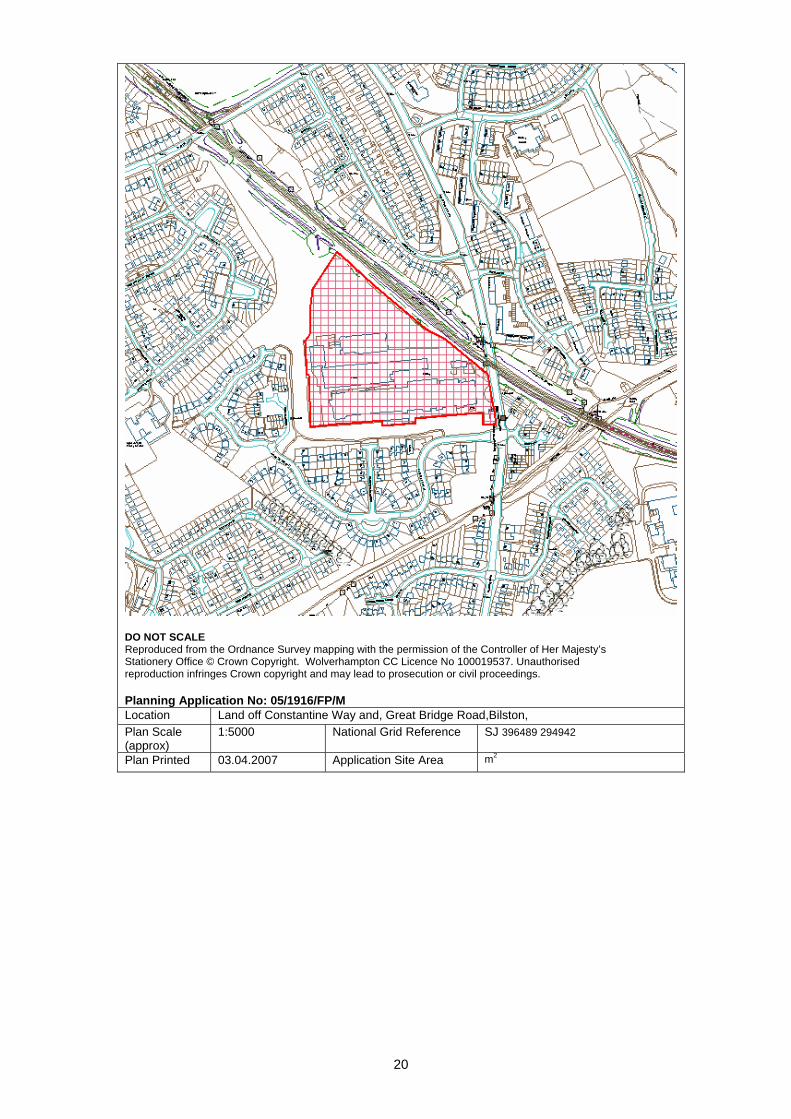
DO NOT SCALE Reproduced from the Ordnance Survey mapping with the permission of the Controller of Her Majesty’s Stationery Office © Crown Copyright. Wolverhampton CC Licence No 100019537. Unauthorised reproduction infringes Crown copyright and may lead to prosecution or civil proceedings. Planning Application No: 05/1916/FP/M Location Land off Constantine Way and, Great Bridge Road,Bilston, Plan Scale (approx)
1:5000 National Grid Reference SJ 396489 294942
Plan Printed 03.04.2007 Application Site Area m2
21
APPENDIX A
DESIGN APPRAISAL
Planning Application Number 05/1916/FP/M – Development of former Heil Trailers Site, off Great Bridge Road/Constantine Way, Bilston, by Barratt Homes (West Midlands) Ltd. 1.0 General 1.1 In general, the broad arrangement of the layout consisting of perimeter block
development with interconnected, through local access roads incorporating traffic calming measures, is considered to be along the right lines.
1.2 The location of an element of Public Open Space as a focal point below, and
accessible from the Metro stop above, is appropriate (even though of insufficient area to serve the needs generated by the whole development). The provision and broad location of the mixed use of local retail/services and live-work units near the entrance to the site fronting Great Bridge Road, is appropriate.
!.3 However, the proposals are unsatisfactory in terms of urban and architectural
design quality and in terms of several functional aspects, particularly the rear parking courts for the houses, the access and servicing to the retail/services/ live-work units, and the treatment, accessibility and usability of the Linear Public Open Space, currently occupied by a bund.
2.0 Urban Design 2.1 The arrangement of buildings along street frontages does not follow orderly
building lines but juts backwards and forwards haphazardly for no valid townscape reasons. Corner buildings are arranged at odd angles, not following but protruding into building lines, resulting in oddly shaped forecourts. Consequently, the coherence and attractiveness of the street scene suffers.
2.2 Whereas buildings should be designed to visually turn corners and act as focal
points, this is not satisfactorily achieved in the case of the dwelling houses, and only partially achieved in the case of the apartments. A big failure of the proposals is to create a strong turning point and a landmark building in the case of the retail/services mixed use development at the entrance to the site, on the corner of Great Bridge Road and Constantine Way.
2.3 The single storey, domestic scale buildings proposed are of a weak and
undistinguished design and lack the massing and height necessary to perform this important townscape function. If the proposed buildings further down the site are 2-3 storeys high, the buildings at the entrance to the site fronting the main road should be 3-4 storeys high. Apartments above the ground floor retail/service uses would no only be appropriate but would also increase site density, resulting in more efficient use of land.
3.0 Architectural Design
22
3.1 The architectural design quality of individual buildings ranges from the mediocre and banal to the downright poor.
3.2 The design idiom used is an ungainly mix of ill-understood and badly handled
elements of classical architecture and vernacular architecture (e.g. traditional cottage architecture). This ill-fitting mish-mash of adulterated and ill fitting architectural elements is commonly referred to as ‘pastiche’. CABE, The Commission of Architecture and the Built Environment, advises that this approach should be avoided as it does no result in good design and produces poor quality environments, lacking in integrity and local distinctiveness. High Quality design and local distinctiveness are required by Government policies, which are also reflected in the approved Wolverhampton Unitary Development Plan.
3.3 Poorly proportioned and detailed and badly related architectural elements, such
as walling and fenestration, poor articulation and handling of the elements of architectural composition, characterise the submitted building designs, to a greater or lesser extent. For example, some of the dwelling types show window heads without visible lintols directly underneath the eaves/gutter line, the visual effect being of the roof crushing down or compressing the elevation below. The flatted block of proposed affordable housing is particularly poor in terms of architectural quality. It is meanly proportioned and detailed, reminiscent of a barracks block. This is considered unfortunate in terms of social cohesion and would be likely to place a stigma on the future residents of this type of accommodation.
3.4 The detailing of many building elements and external works elements is
mediocre or poor. Few large scale details have been supplied. Of those which have been, some are insufficiently robust, and likely to be easily damaged and/or require excessive maintenance, leading to a deterioration of the visual appearance of the public realm. For example, the forecourt railings proposed are only 16mm in diameter, therefore likely to be easily damaged by impact or vandalism. They should be at least 20 mm in diameter.
4.0 Sense of Place and Local Distinctiveness 4.1 PPS1 – Delivering Sustainable Development, sets a key objective for
development under paragraph 36, to create or reinforce local distinctiveness. ‘By Design’ publication defines local distinctiveness as: “The positive features of a place and its communities which contribute to its special character and sense of place”. Local distinctiveness is a key element of sustainable development. The proposals fall far short from creating a ‘Sense of Place’ and ‘Local Distinctiveness’. The use of off-the-peg standardised type plans and architectural expression of mediocre or low quality, which is built anywhere, does not meet the attributes of good design and sustainable development, as required by Government and Council policies.
4.2 In their ‘Design Statement’ the agents for Barratts state: “Because of the close proximity and obvious connections with the existing Barratts development, some of the design ethos reflects and builds upon that which already exists”. They go on to list the “Replication of some elements of the existing development” including “use of similar materials/colours/combinations; use of a mixture of similar dwelling types and sizes and use of a similar landscape theme”.
23
4.3 Whereas it is proper to take cognisance of the surrounding context and
environment, it is not satisfactory to replicate the designs and standards of a bygone period, which fall short of the higher quality standards and expectations set down by the Government and the Local Planning Authority today. The Government policies state that it is not simply sufficient to produce developments which are not poor, but ones which are of positively good design.
4.4 The adjoining Barratts development referred to was granted planning
permission over 10 years ago, and was, at the time, an improvement on the original very poor quality submission. However, both the government and the Council now expect and require a step change in design quality and sustainability for new applications, in the public interest.
4.5 In fact, the design quality of some buildings in the proposed scheme is worse
than the earlier Barratts development, particularly the block of social/affordable flats.
5.0 Access and Parking Arrangements: Garage Courts, Forecourts and Road
Space 5.1 The most unsatisfactory aspects of the proposed parking arrangements in
terms of functionality, safety, security and impact on the environment, is the use of back land garage and parking courts.
5.2 In terms of ‘Secure by Design’ and ‘Designing out Crime’ considerations, the
local Police Crime Prevention Officers constantly advise the Local Planning Authority to avoid such parking arrangements as they have proved to be problematic. Although the entrances are to be controlled by gates, security can be breached by someone leaving the gates unlocked or the gates malfunctioning. People with ill intent could gain access through rear garden alleyway gates being left unlocked and then jumping over other people’s garden fences into garage courts or gardens and houses.
5.3 Due to the enclosed nature of the garage/parking courts by buildings and high
fences, surveillance is severely restricted. This has a negative impact on property security and personal safety. The narrow alleyways leading to back gardens and courts are very unsatisfactory in terms of security, safety and environmental quality.
5.4 The environmental quality of the proposed garage/parking courts is poor. They
are harsh and unrelieved spaces, fronted by garage doors, blank walls and close boarded fencing. The latter does not meet the standards in the Council’s SPG3 – Residential Development, which require robust masonry walls in such locations (e.g. brick). The short lifespan of the close boarded fencing and the absence of safety, kerbed margins alongside would lead to impact damage by vehicles, deterioration and poor visual appearance over time. The one bedroom ‘Ashton’ type flat over garages is only accessible via a garage court and then through a narrow alleyway. This is not an environmentally acceptable or secure arrangement.
5.5 The RPS Design Statement says that the “Development complies with the
principles of ‘Secure by Design’ by the use of back to back
24
development……..and provision of well overlooked car parks and defensible space”. Quite clearly this statement is the exact opposite of what is shown on the submitted drawings, as pointed out in the above section.
5.6 Several narrow fronted houses are unduly dominated by forecourt parking and
drives, contrary to the stipulations of PPG3. For example, the Sutton type house has a 4.53 metres frontage and incorporates an integral ground floor garage, with a drive 2.6 metres wide. When a one metre wide access footpath is added, a planting strip of only 0.93 metres would be left (the submitted drawings are misleading and do not show the pedestrian access path, which would be necessary, as the garage access way would often be parked on, inhibiting pedestrian circulation).
5.7 Problems are likely to occur with car owners and visitors not taking the trouble
to go and park within the inconvenient rear garage/parking courts and leaving their cars in the street instead. Whereas a 5.5 metre wide residential road would normally suffice, if a vehicle parks opposite a house drive, access and egress of cars to and from this drive would become problematic. This would lead to parking on pavements, to the detriment of pedestrian movement and safety. No suitable car lay-byes for visitors and casual parking have been provided. The consequence of all the above shortcomings would be a car dominated street scene to the detriment of the residential environment and pedestrian safety.
6.0 Inadequate privacy distances in several cases 6.1 The Council’s SPG3 – Residential Development, sets out a minimum privacy
distance of 22 metres between facing habitable rooms. The proposed layout, in several instances, shows distances well below this figure, as low as 14.5 metres. Whereas a marginal adjustment to the 22 metres standard may be considered if there are valid reasons and compensating factors, the proposed departures are unacceptably great and would cause serious overlooking and privacy problems.
7.0 Inadequate size and awkward shape gardens for many family houses 7.1 SPG3 sets a minimum garden size of 50 square metres for small family houses
and expects larger minimum size gardens for larger family houses. The intention of PPG3 is not to make the minimum size the norm, but rather to provide a ‘safety net’ to ensure that the basic needs of families for garden uses and activities are not compromised. The expectation is that the great majority of gardens would be above the minimum, safety net size.
7.2 A large number of family houses in the submitted scheme fall unacceptably
below the safety net minima stipulated. Many gardens are of unwieldy, awkward shape, which impairs their usability.
8.0 Sustainable Design Issues 8.1 Reasonable orientation has been achieved for the majority of the proposed
dwellings in accordance with the requirements of PPG3. There are a few dwellings whose orientation is unsatisfactory or should be improved. There is
25
no good reason why every dwelling should not be designed to benefit in terms of amenity, passive solar gain and energy conservation (lower heating bills).
8.2 However, the overall concept and design of the proposed dwellings is not such
that it makes a step change in addressing sustainability. For example, good utilisation of passive solar gain would require larger, south facing fenestration and specially designed heat trap elements. The small, hole- in- the- wall windows in the submitted scheme would not be very efficient for this purpose. There is no serious, if any, attempt to address climate change through design. For example, the proposed designs do no incorporate large, overhanging eaves, to cut out the high, hot summer sun but to let in the beneficial low winter sun.
9.0 The retail/local services and live-work unit proposals 9.1 This mixed use element is very welcome and appropriate and would provide
useful facilities and services for the wider locality, within convenient walking distance. Valuable local employment would also be generated.
9.2 No pedestrian crossing facility is proposed on Great Bridge Road to the mixed
use facilities and to the Public Open Spaces and the Metro stop. It is considered essential to provide a safe, well-located crossing for the benefit of the communities on both sides of the busy Great Bridge Road.
9.3 The pedestrian walk-through gateway to the rear parking area of the
retail/service units and live-work units is unsatisfactory. It is routed through a pair of bin stores on either side and would be very uninviting in terms of smell and visual appearance. Bin stores fronting the main elevation of the development to Great Bridge Road are inappropriate.
10.0 Linear Public Open Space through the wider site. 10.1 The developers propose to leave this space, from the edge of Great Bridge
Road all the way along to the wider Public Open space system beyond, in its current form as a bund, which they euphemistically describe as a ‘wildlife corridor’.
10.2 The bund was constructed in conjunction with the earlier Barratts housing to the
south-east, as a visual and noise barrier to the industrial use of the former Thompson-Carmichael boiler factory next door (now the Heil Trailers site). Barratts never met their planning obligations to properly landscape this space and consequently the Council never took over its maintenance. The bund was always intended to be a temporary measure pending the redevelopment of the adjoining industrial site and its integration with the wider area.
10.3 It is considered very unsatisfactory to leave the bund as it stands. Firstly there
is a need to visually and functionally integrate the two residential developments, but also to link them and the Public Open Space system to the communities across Great Bridge Road to the north-east and to the communities to the south-west.
26
10.4 Secondly, the usefulness of the bund as Public Open Space is limited due to its steeply sloping form and associated difficulties of access for people with disabilities, the elderly and for active recreation.
10.5 It is considered essential that the bund is removed, the area levelled and
properly landscaped for early access and usage, which is safe and inviting. 10.6 If the bund were to be removed and the area suitably landscaped, this could
count towards the shortfall in Public Open Space in the current planning application.
11.0 Public Art provision 11.1 The application makes no specific provision for Public Art. The suggestions in
the RPS Design Statement that architectural features such as wrought iron circles on railings and different colours of brickwork be, in themselves, be considered as Public Art are not tenable. PPG 16 – provision of Public Art, makes it clear that such elements, good though they may be in themselves, do not fall under the definition of Public Art.
12.0 Relevant Design Policies and Guidelines 12.1 The application falls well short in satisfying the following key policy documents
and guidelines:
• Wolverhampton Unitary Development Plan • PPS1 – Delivering Sustainable Communities • PPS3 – Housing • By Design – CABE • Secure by Design – Association of Chief Police Officers • Safer Places – The Planning System and Crime. ODPM/Home Office • PPG3 – Residential Development • PPG1 – Access for People with Disabilities • PPG16 – Provision of Public Art
Costas Georghiou CNG Planning Consultancy April 2007 Revision 2

27
DO NOT SCALE Reproduced from the Ordnance Survey mapping with the permission of the Controller of Her Majesty’s Stationery Office © Crown Copyright. Wolverhampton CC Licence No 100019537. Unauthorised reproduction infringes Crown copyright and may lead to prosecution or civil proceedings. Planning Application No: 05/1916/FP/M Location Land off Constantine Way and, Great Bridge Road,Bilston, Plan Scale (approx)
1:5000 National Grid Reference SJ 396489 294942
Plan Printed 03.04.2007 Application Site Area m2
28
PLANNING COMMITTEE - 17-Apr-07
REPORT TO FOLLOW
APP NO: 05/1989/OP/M WARD: Bushbury North
DATE: 06-Dec-05 TARGET DATE: 07-Mar-06
RECEIVED: 06.12.2005 APP TYPE: Outline Application SITE: Goodyear Dunlop Tyres Site,, Stafford Road,, Wolverhampton, PROPOSAL: Mixed use development comprising residential, local retail, community and
ancillary uses APPLICANT: Goodyear Dunlop Tyres (UK) Ltd St.Modwen Developments
AGENT: CB Richard Ellis 4th Floor Cornwall Court 19 Cornwall Street Birmingham B3 2DT

29
DO NOT SCALE Reproduced from the Ordnance Survey mapping with the permission of the Controller of Her Majesty’s Stationery Office © Crown Copyright. Wolverhampton CC Licence No 100019537. Unauthorised reproduction infringes Crown copyright and may lead to prosecution or civil proceedings. Planning Application No: 05/1989/OP/M Location Goodyear Dunlop Tyres Site,, Stafford Road,,Wolverhampton, Plan Scale (approx)
1:10000 National Grid Reference sj 391440 301483
Plan Printed 05.04.2007 Application Site Area m2
30
PLANNING COMMITTEE - 17-Apr-07
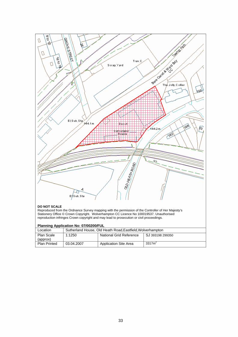
COMMITTEE REPORT: 1. Site Description 1.1 Existing industrial/warehouse building and yard with associated office building. Access
from Old Heath Road. The yard has a boundary with the Wyrley and Essington Canal. Until recently these premises were used for the servicing, repair and supply of fork lift vehicles, which would have been primarily a Class B2 Industrial Use. The premises are now vacant and remain in good condition. Housing and the Jolly Collier public house lie adjacent to and opposite this site.
2. Application Detail 2.1 Use of the premises for the reception, sorting, bailing and recycling of non ferrous
metals. The company deal in brass, copper, aluminium, stainless steel, nickel and lead. Metal discarded from manufacturing processes from other firms will be contained in stillages (metal containers approximately 1 metre by 1 metre by 0.5 metres), and delivered by 16 ton curtain side lorries, the applicants estimate two or three deliveries per day. The lorries will be unloaded in the warehouse by a fork lift truck.
2.2 The metal has to be stored and sorted in the building because of its value and client
specifications for the processed metal. Metals are hand sorted into stillages and put in a bailing machine by hand. The machine produces bails of metal approximately 2 feet x 1 foot which are secured by a steel band. Bails are stacked on pallets, ready to be reloaded by forklift onto a lorry in the warehouse. The applicants estimate collection by five lorries per week.
2.3 No cleaning process is involved, most metals are new production by-products from
aluminium and stainless steel manufacturers. The applicants’ stress that all work will be done in the warehouse. For security, health and safety and amenity reasons metal
APP NO: 07/00200/FUL WARD: East Park
DATE: 07-Feb-07 TARGET DATE: 04-Apr-07
RECEIVED: 07.02.2007 APP TYPE: Full Application SITE: Sutherland House, Old Heath Road, Eastfield, Wolverhampton PROPOSAL: Use of premises for metals trading - reception, sorting, bailing and recycling
of metals APPLICANT: Manholme Asset Management Church View Front Street Laxton Goole East Yorkshire DN14 7TS
AGENT: Garfield Davis Architectural Ltd 193 Wolverhampton Street Dudley West Midlands DY1 1DU
31
will not be stored in the yard. The yard will only be used for vehicle parking and circulation.
2.4 The proposed operating times are Monday to Friday 8.00am to 5.00pm, Saturday
8.00am to 12.00 noon. The business has the potential to employ 15 staff. 3. Planning History 3.1 Planning records indicate use of these premises since 1977 for forklift truck
engineering, repair and distribution. A 1972 planning permission was for vehicle repairs.
4. Planning Policies 4.1 Environmental Protection Policies EP1: Pollution Control and EP5: Noise Pollution.
Business and industry Policy B5: Design Standards for Employment Sites. 5. Publicity 5.1 This application has been advertised by neighbour letter to 29 surrounding properties
and by site notice. No responses have been received at the time of writing. 6. Internal Consultations 6.1 Environmental Services.
The site is located in a mixed residential and commercial area. Planning permission for a flats development has been granted for the derelict former scrapyard site opposite, on the other side of the canal. The application site includes a large yard which would be in view of many of these proposed residential units. Other residences are located within 20 metres of the site and also above the Jolly Collier public house.
Information provided by the applicant suggests that they do not propose wholesale
tipping and sorting of scrap outside, as some degree of sorting will take place prior to the metal arriving on site.
Experience shows that the movement and storage of scrap metal and scrap metal
containers such as skips, stillages etc can generate significant amounts of noise. Impact noise from the filling of bins or containers or from tipping is particularly noticeable and disturbing in the case of scrap metal. The roof of the storage building is constructed from sheet material with pvc corrugated sheet lights, it is not expected that the roof would provide a significant level of noise insulation.
Planning conditions could be imposed to restrict activities on the site. These would
need to be detailed and enforceable in order to prevent any deterioration. However, it is difficult to envisage that all potential impacts from the proposed activity (which could be significant) can be adequately mitigated by such means. There is concern that a change of use of this site could be a precedent for increased scrap handling activities and general intensification of the use.
On balance, Environmental Services are unable to support this application, and
recommend refusal. If the Planning Committee are minded to approve, then any consent will require specific conditions to mitigate noise and other impacts.

32
6.2 Planning Policy. Any change of use within Class B would need to give consideration of amenity issues likely to affect the surrounding residential area as stated in Policy B5: Design Standards for Employment Sites. Any planning permission should be conditional to restrict the use for only the collection, bailing, storage and distribution of metals.
7. External Consultations 7.1 Network Rail – no objections, the existing boundary wall to the railway embankment
must be retained. 7.2 The Police have been consulted, any comments will be reported verbally. 8. Appraisal 8.1 These existing industrial/warehouse premises are capable of continued Class B2
General Industrial Use without planning permission. There are no restrictions in terms of conditions on old planning permissions for this site.
8.2 The proposal for waste metals recycling is a growing industry and reflects the value
and scarcity of non-ferrous metals. Re-use of metal is a sustainable business. From the information provided, this proposal is very different from a “traditional” scrapyard.
8.3 The derelict Grove Street site on the opposite side of the canal is the subject of an
approved scheme (06/1230) for 56 flats, subject to a Section 106 legal agreement. Some of the flats would overlook the application site. Any continued lawful industrial use of this building has the potential to conflict with the living conditions of nearby residents. The concerns of Environmental Services are acknowledged in this context. However, this proposal provides an opportunity to control future use of this site in recognition of residential amenity. Provided this activity can be contained within the building and controlled by conditions, it is considered it would be an acceptable use of these premises.
8.4 The Applicant advises that this proposed business has the potential to provide 15 jobs. 8.5 The security of the premises has been considered by the Applicants; the existing
boundary walls, fencing and gates are reinforced by electric fencing to deter intruders. Any advice from the Police will be reported verbally and passed on to the Applicants.
9. Recommendation 9.1 Permit, subject to conditions which will include;
Restriction to the use applied for. Operating hours 8.00am to 6.00pm Monday to Friday, Saturdays 8.00am to
1.00pm, no Sunday or Bank Holiday working. No storage of metals, stillages or skips in the yard. No tipping of bulk delivered metal anywhere on the site. No melting of metal. Noise limiting conditions to be advised by Environmental Services which can
be measured at the site boundary and enforced. Boundary wall to railway embankment to be retained.
Case Officer: Ken Harrop Telephone No : 555649 Head of Development Control – Stephen Alexander
33
DO NOT SCALE Reproduced from the Ordnance Survey mapping with the permission of the Controller of Her Majesty’s Stationery Office © Crown Copyright. Wolverhampton CC Licence No 100019537. Unauthorised reproduction infringes Crown copyright and may lead to prosecution or civil proceedings. Planning Application No: 07/00200/FUL Location Sutherland House, Old Heath Road,Eastfield,Wolverhampton Plan Scale (approx)
1:1250 National Grid Reference SJ 393198 299350
Plan Printed 03.04.2007 Application Site Area 3317m2
34
PLANNING COMMITTEE - 17-Apr-07
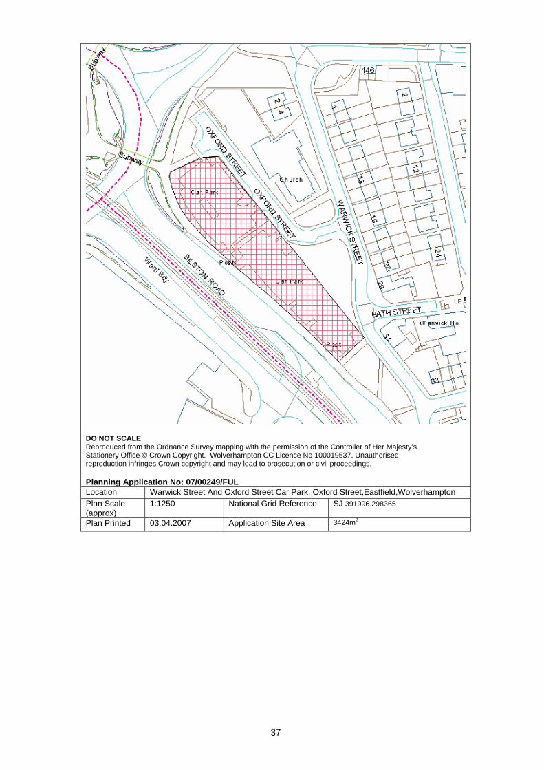
COMMITTEE REPORT: 1. Site Description 1.1 The application site is within the City Centre boundary near to the St Georges Ring
Road to the east of the city with pedestrian access from the roundabout to the car park.
1.2 The site fronts the Bilston Road Dual Carriageway, however there is no access to it or
from it. The car park is accessed through a slip road (Sharrock Street) off the dual carriageway.
1.3 Opposite the car park is the Seventh Day Adventist Church which has railings
surrounding it. There is parking available on the streets leading up to the car park ( no return within 2 hours )
1.4 The area is a mixture of uses with industry and residential properties in close
proximity. 2. Application details 2.1 The application will alter the current layout so that two previously separate car parks
can be entered from a single point, which would allow control of the car park by an attendant. The central landscaped area will be removed for better surveillance.
APP NO: 07/00249/FUL WARD: East Park
DATE: 12-Mar-07 TARGET DATE: 07-May-07
RECEIVED: 21.02.2007 APP TYPE: Full Application SITE: Warwick Street And Oxford Street Car Park, Oxford Street, Eastfield,
Wolverhampton PROPOSAL: Alterations to existing car park to enable better surveillance and control of
traffic entering and leaving. And to provide staff accommodation APPLICANT: Mr Mike Swain The Community Centre All Saints Road Wolverhampton WV2 1EL
AGENT: Mr Timothy Richardson Studio 605B The Big Peg 120 Vyse Street Jewellery Quarter Hockley Birmingham B18 6NF
35
3. Planning History 3.1 A/C/2130/82 for Car park for WMPTE, Granted,dated 15.03.1983. 3.2 A/D/0112/85 for Formation of a car park and vehicular access, Granted,dated 13.05.1985. 4. Constraints 4. Authorised Processes 5. Relevant policies
AM1 - Access, Motabaility and New Development AM12 - Parking and Servicing Provision AM14 - Minimising the Effect of Traffic on Com.
6. Publicity 6.1 The application has been publicised by letters sent to neighbouring properties and by
posting three site notices. The overall expiry date is 13/4/07. 6.2 So far there have been 28 e-mails which object to the application their comments can
be summarised as:
• Concerned about the change to a fee paying car park currently it is free to park there. • Improvements are not required as security at present is adequate • Cause congestion within the city centre, ring road and to local residents living nearby.
8. Internal consultees 8.1 Transportation Development
• There are no details supplied regarding how the applicant intends to operate the car park i.e. pay and display or ticket office with barrier.
• No disabled parking provision, or motorcycle or cycle parking indicated. • No details of type of security to be used. • Clear signage is needed from Horseley Fields as well as Bilston Road..
8.2 Environmental Services
• No Observations. 9. Appraisal 9.1 The proposal seeks to improve the access to the car park and allow better surveillance
for it, however the application does not clarify the type of surveillance that will be used. It also does not state what type of fee paying facility will be introduced. (this being the main point that current users are against).
36
9.2 The car park is used mostly by people working in the city centre as well as shoppers. Currently there are two entrances to the site which divide the car park into two. The application proposes to remove this element of landscaping and to rearrange the current parking.
9.3 The Transportation Officer has requested further details and these are awaited. These
are likely to create more parking spaces and better surveillance for users of the car park.
9.4 Whilst some of the existing users will be displaced if charges for car parking are
introduced the knock-on effect on overall parking levels within the city centre or streets surrounding the site would not be sufficient to warrant a refusal of planning consent.
10. Conclusion 10.1 The alterations and changes to the car park are satisfactory, however there are points
that still need to be clarified. 10.2 The proposal with awaited amended plans will improve the current situation as at
present cars are parked randomly with users parking at their own risk. 12. Recommendation 12.1 Delegated Authority to the Director of Sustainable Communities to grant permission
subject to;
• Satisfactory amended plans addressing the matters of concern by highways • Standard conditions including: landscaping; materials.
Case Officer : Nussarat Malik Telephone No : 551132 Head of Development Control – Stephen Alexander
37
DO NOT SCALE Reproduced from the Ordnance Survey mapping with the permission of the Controller of Her Majesty’s Stationery Office © Crown Copyright. Wolverhampton CC Licence No 100019537. Unauthorised reproduction infringes Crown copyright and may lead to prosecution or civil proceedings. Planning Application No: 07/00249/FUL Location Warwick Street And Oxford Street Car Park, Oxford Street,Eastfield,Wolverhampton Plan Scale (approx)
1:1250 National Grid Reference SJ 391996 298365
Plan Printed 03.04.2007 Application Site Area 3424m2
38
PLANNING COMMITTEE - 17-Apr-07
COMMITTEE REPORT: 1. Site Description 1.1 The application site contains a vacant four bedroom detached house with associated
car parking space and amenity area to the rear. The street scene is characterised by a mix of large detached residential properties and terrace row housing, although the adjacent premises operates as a Dentists (218 Wellington Road). It is proposed to use the application premises as a children’s care home. The ground floor would have a lounge, kitchen, dining room, wash room/WC and a room to be used as an office. The first floor would contain four bedrooms, bathroom and staff room.
1.2 The site is situated approximately 2.8 miles to the south east of Wolverhampton City
Centre and within one mile of Bilston Town Centre. The application house is located fronting onto the Wellington Road, a busy vehicular route into and out of the City.
2. Application Details 2.1 The application is for a Certificate of Lawfulness under Section 192 of the Town and
Country Planning Act 1990, for a proposed use as a children’s care home. It is not a planning application for this proposed use. The purpose is to establish whether or not this house can be used as a small care home without planning permission.
2.2 The applicant has provided the following information to support this application:
a) A supporting statement sets out that the premises were previously used as a residential dwelling for five people with four cars.
b) No physical alterations to the property are proposed. c) The property would be used as a residence for a maximum of four children at any one
time and each child would reside at the property for approximately three months.
d) The children who would reside at the property would be aged between thirteen and seventeen.
APP NO: 07/00187/CPL WARD: Ettingshall
DATE: 21-Feb-07 TARGET DATE: 18-Apr-07
RECEIVED: 05.02.2007 APP TYPE: Certificate Proposed Lawful Use/Dev SITE: 220 Wellington Road, Bilston, Wolverhampton, Bilston PROPOSAL: Application for a certificate of proposed lawful use, to use property as a
childrens care home APPLICANT: Elijah Collins 9 Paganel Drive Dudley DY1 4AZ
AGENT:
39
e) The applicant has provided very little information as to the anticipated service users
that would be referred to the care home other than to state that these would comprise;
I. The young and vulnerable including children who are temporarily homeless as a result of parental illness;
II. Orphans.
f) Staff would support the service users to become independent. The support would be
provided by 12 members of staff to the 4 service users. 2 members of staff would supervise the children at any one time. It is proposed that the staff would provide twenty four hour care of the children. The shift patterns would be 7 am – 3pm, 2pm – 10pm and 9pm – 7.30am.
g) Two staff would cover each shift. A maximum of three cars would be expected to be
parked near the property. There is a garage next to the property and off road parking.
h) Education for the children who reside at the premises would be off-site.
i) A social worker would visit each of the children who would reside at the property once per month. The duration of the social workers stay would be a maximum of three hours. It is not expected that all, or indeed any, of the children would require the services of psychologists.
j) Visits to the home, for maintenance and deliveries, are not expected to occur more
frequently than once per month. 3. Planning History 3.1 94/0925/FP for Conversion of five dwellings into 1 No. self contained dwelling, Granted - 18.10.1994. 3.2 95/0269/FP for Double garage extension. Granted - 27.04.1995. 3.3 C/0894/89 for Demolish existing house and erect a block of 5 flats. Granted -
23.08.1989. 3.4 C/1916/91 for Change of use and conversion of property to form 5no. units 1 no. 2 bed and 4no. 1 bed. Granted - 24.12.1991. 3.5 C/2141/90 for Change of use from offices to hairdressers at ground floor with flat
above. Granted - 24.09.1990. 4. Constraints 4.1 Authorised Processes 4.2 Landfill Gas Zones 4.3 Mining Area
40
5. Relevant Policies 5.1 As this is an application for a Certificate of Lawfulness, the planning merits or demerits
cannot be considered. Unitary Development Plan Policies are not therefore a material consideration. The assessment is based on the facts of the case and planning law.
5.2 Town and Country Planning (Use Classes) Order 1987;
• Class C2 Residential Institutions includes use for the provision of residential accommodation and care to people in need of care (other than a use within Class C3 dwelling houses).
• Class C3 dwelling houses, includes use by not more than six residents living
together as a single household (including a household where care is provided for residents).
5.3 The following extracts are taken from the supporting Government Circular 03/2005 to
the Use Classes Order;
• Class C3: Dwelling Houses ….. “The key element in the use of a dwelling house for non family purposes is the concept of a single household. The single household concept will provide more certainty over the planning position of small group homes which play a major role in the Government’s community care policy which is aimed at enabling disabled and mentally disordered people to live as normal lives as possible in touch with the community. In the case of small residential care homes or nursing homes, staff and residents will probably not live as a single household and the use will therefore fall into the residential institutions class, regardless of the size of the home”.
6. Neighbour notification and representations 6.1 There is no legal requirement to publicise an application for a Certificate of
Lawfulness. Government Circular 10/97 advises that any views on the planning merits of the case are not relevant.
6.2 However, in the interests of open government, and in line with previous recent cases,
surrounding neighbours and Ward Councillors have been notified. 6.3 Site Notice Expiry Date – 4.4.2007 6.4 Neighbour letter Expiry Date – 2.4.2007 6.5 144 letters of objection have been received at the time of writing. Views are
summarised as;
• Detriment to property values in the area • Unsuitable use adjacent to schools, colleges and temples • Proposed use is motivated by financial and not altruistic gain • The proposed use would result in detriment to safety of those living in the area and
give rise to criminal activity, noise and vandalism • There are a number of other institutions in the area similar to that proposed • Potential to generate racial tensions • Proposals would give rise to parking problems and result in a detriment to
pedestrian and highway safety • The statement supporting the application is inaccurate and vague
41
7. Internal consultees 7.1 Environmental Services – No reply at the time of writing this report. 7.2 CSCI – No reply at the time of writing this report. 7.3 Legal Services – The applicant has provided some information against which to consider the application
but given this information is vague and not substantiated in any way on balance it is considered that further information is required. It would be useful to be provided with further information about the ages of the previous residents and whether they were in employment as this would be relevant in being able to judge as to whether the proposed use would result in an increased amount of vehicle movements.
7.4 Transportation Development – No reply at the time of writing this report. 7.5 Children and Young People Resource -
There are a number of concerns in locating a children's home at this site. There are currently 2 other children's homes in the area with a possible 3rd operated by the local authority. A probation hostel is also close by. This would also have an impact on local schools and placements for young people.
8. External consultees 8.1 Police – No objection. 9. Appraisal 9.1 The main considerations with this case are;
(a) Whether or not the proposal for a small children’s care home is a change of use from the existing use of No 220 Wellington Road as a private house, and
(b) if it is determined that there is a change of use from Class C3, dwelling houses, whether this change is material enough in planning terms to be considered as development requiring planning permission.
9.2 It is proposed that the there would be a maximum of four children residing at the house
as their temporary home. The care staff would not live with the children but would be essential to provide care and supervision. From the advice in Circular 3/2005 and planning case law it would appear that this could not be regarded as a single household and the proposed use would therefore fall within Class C2: Residential Institutions.
9.3 The leading case on this matter can be referred to. North Devon District Council v The First Secretary of State (2003) determined that children are not capable of forming their own household. In order for it to be a proper functioning household (and by
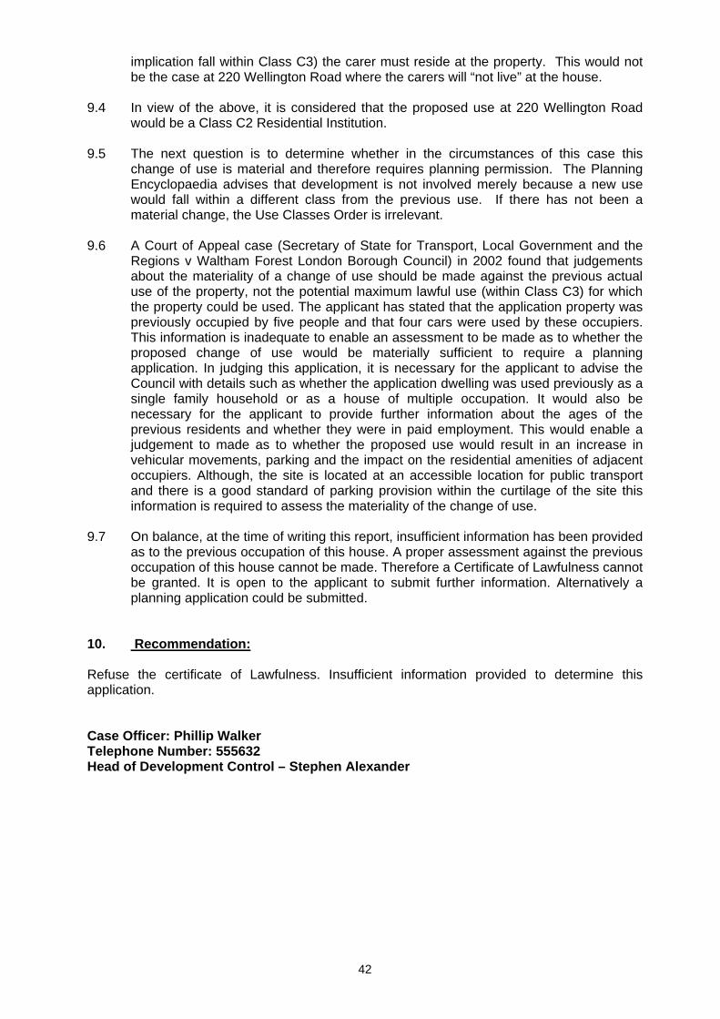
42
implication fall within Class C3) the carer must reside at the property. This would not be the case at 220 Wellington Road where the carers will “not live” at the house.
9.4 In view of the above, it is considered that the proposed use at 220 Wellington Road
would be a Class C2 Residential Institution. 9.5 The next question is to determine whether in the circumstances of this case this
change of use is material and therefore requires planning permission. The Planning Encyclopaedia advises that development is not involved merely because a new use would fall within a different class from the previous use. If there has not been a material change, the Use Classes Order is irrelevant.
9.6 A Court of Appeal case (Secretary of State for Transport, Local Government and the
Regions v Waltham Forest London Borough Council) in 2002 found that judgements about the materiality of a change of use should be made against the previous actual use of the property, not the potential maximum lawful use (within Class C3) for which the property could be used. The applicant has stated that the application property was previously occupied by five people and that four cars were used by these occupiers. This information is inadequate to enable an assessment to be made as to whether the proposed change of use would be materially sufficient to require a planning application. In judging this application, it is necessary for the applicant to advise the Council with details such as whether the application dwelling was used previously as a single family household or as a house of multiple occupation. It would also be necessary for the applicant to provide further information about the ages of the previous residents and whether they were in paid employment. This would enable a judgement to made as to whether the proposed use would result in an increase in vehicular movements, parking and the impact on the residential amenities of adjacent occupiers. Although, the site is located at an accessible location for public transport and there is a good standard of parking provision within the curtilage of the site this information is required to assess the materiality of the change of use.
9.7 On balance, at the time of writing this report, insufficient information has been provided
as to the previous occupation of this house. A proper assessment against the previous occupation of this house cannot be made. Therefore a Certificate of Lawfulness cannot be granted. It is open to the applicant to submit further information. Alternatively a planning application could be submitted.
10. Recommendation: Refuse the certificate of Lawfulness. Insufficient information provided to determine this application. Case Officer: Phillip Walker Telephone Number: 555632 Head of Development Control – Stephen Alexander
43
DO NOT SCALE Reproduced from the Ordnance Survey mapping with the permission of the Controller of Her Majesty’s Stationery Office © Crown Copyright. Wolverhampton CC Licence No 100019537. Unauthorised reproduction infringes Crown copyright and may lead to prosecution or civil proceedings. Planning Application No: 07/00187/CPL Location 220 Wellington Road, Bilston,Wolverhampton,Bilston Plan Scale (approx)
1:1250 National Grid Reference SJ 393894 297014
Plan Printed 03.04.2007 Application Site Area 417m2
44
PLANNING COMMITTEE - 17-Apr-07
COMMITTEE REPORT: 1. Site Background and Findings 1.1 The proposal site is located on Albert Road, approximately 1 mile north-west of
Wolverhampton City Centre, close to West Park and north east of the A41 Tettenhall Road. Albert Road is an attractive, wide, tree lined street featuring predominately residential buildings set back from the road. Parking provision is generally off-street, in private driveways and streets. The architectural character of the existing buildings ranges from the late nineteenth century to the mid-late twentieth century.
1.2 The site is within the Park Conservation Area and is approximately 0.3 hectares in
area. The site is currently occupied by two existing period buildings, No’s 55 and 57 Albert Road. No.55 was formerly used as a care home for the elderly. No.57 was last used as a dwelling house. The site also contains a single storey link building between No.’s 55 and 57 and a detached single storey garage. There are modern extensions at the rear of No.55. The ancillary buildings are later additions to the adjoining traditional houses and Conservation Area Consent (07/00118) has recently been granted to allow for the demolition of these ancillary buildings and extensions.
1.3 The existing buildings have been empty and unused for some time and have been
subject to vandalism, arson and illegal occupancy. 1.4 The site is characterised by a mature landscape, including the presence of a large,
distinctive London Plane tree on the footway between No.’s 55 and 57. There are also a number of significant mature trees that are the subject of Tree Preservation Orders within the site boundary.
APP NO: 07/00117/FUL WARD: Park
DATE: 25-Jan-07 TARGET DATE: 26-Apr-07
RECEIVED: 25.01.2007 APP TYPE: Full Application SITE: 55-57 Albert Road, Whitmore Reans, Wolverhampton, West Midlands PROPOSAL: Demolition (partial) to rear of No.55 and No.57. Demolition of link building
(former care home) between No.'s 55 & 57 and demolition of single storey detached garage. Erection of two storey rear extension, conversion and refurbishment of No.57 Albert Road to provide 4 No. two bedroom apartments. External alterations, conversion and refurbishment of No.55 Albert Road to provide 5 No. two bedroom apartments. Erection of two storey apartment block (5 No. two bedroom apartments).
APPLICANT: Mr S Pawar 6 Grasmere Avenue Sutton Coldfield B74 3DG
AGENT: Mr Michael Roper Lathams St Michaels Queen Street Derby DE1
45
1.5 The two existing buildings differ in character and appearance, whilst also complementing one another. No.55 Albert Road is late Victorian / early Edwardian in character and No.57 is a slightly later building in the Arts and Crafts style. The building materials in the area are predominately red brick, combined with coloured render and terracotta detailing.
1.6 There are existing vehicular access points / private driveways to No.55 and No.57,
providing off street parking. 2. Planning History 2.1 07/00118/CON Demolition (partial) to rear of No.55 and No.57. Demolition of link
building (former care home) between No.'s 55 & 57 and demolition of single storey detached garage. Granted – 21.03.2007
2.2 02/1383/FP for Demolition of no's. 55 & 57 and construction of 20 No. new apartments
in two blocks. (Re-submission of 02/1000/FP). Refused -01.10.2003. Appeal dismissed.
3. Application Details 3.1 The proposed development involves demolition (partial) to the rear of No.’s 55 and 57
Albert Road. The link building (former care home) between No.'s 55 & 57 would also be demolished as would the existing single storey detached garage. The proposals also include the conversion and refurbishment of 55 and 57, and the erection of a two storey extension to the rear of 57. Number 55 would accommodate 5 two bedroom apartments, with 4 two bedroom apartments in number 57. The proposals include the erection of a new two storey apartment building to be positioned between number 55 and 57 (five bedroom, dual aspect apartments). Fourteen new two bedroom apartments are proposed in all, in an attractive garden setting, with 21 car parking spaces provided in a secure parking court.
4. Constraints 4.1 Park Conservation Area 4.2 Tree Preservation Order - TPO Ref: 06/00388/TPO 5. Relevant policies 5.1 UDP Policies
D1: Design Quality D2: Design Statement D3 Urban Structure D4: Urban Grain D5 Public Realm D6 Townscape and Landscape D7: Scale – Height D8: Scale – Massing D9: Appearance D10 Community Safety D11 Access for People with Disabilities D12 Nature Conservation and Natural Features
46
HE3 Preservation and Enhancement of Conservation Areas HE4 Proposals Affecting a Conservation Area HE5 Control of Development in a Conservation Area HE6 Demolition of Buildings or Structures in a Conservation Area HE8 Encouragement of Appropriate Redevelopment in Conservation Areas H1 Housing H6 Design of Housing Development H8 Open Space, Sport and Recreation Requirements for New Housing Developments H9 Housing Density and Mix AM9 Provision for Pedestrians AM10 Provision for Cyclists AM12 Parking and Servicing Provision
5.2 Supplementary Planning Guidance
SPG No.3 – Residential Development SPG No.4 – Extension to Houses 6. Publicity 6.1 The application has been publicised by site notice, press notice and neighbour letters.
The expiry time for public consultation was 9.03.2007. Three letters of objection have been received as a result of this public consultation.
6.2 The following comments were raised by the occupiers of the neighbouring houses, 53
and 51 Albert Road;
• Due to its position, scale (height and massing) the proposed two storey rear extension to 55 would be detrimental to the amenities, such as enjoyment of garden space, outlook and sunlight, enjoyed by the occupiers of No.53. This proposed extension would therefore be contrary to UDP policy advice. The Local Planning Authority should consider making a request to the applicant that this element of the scheme be removed or remodelled to ensure against a loss of amenity to No.53. This amendment could be satisfactorily made without reducing the number of proposed units.
• Further to the above, the occupier of No.53 has specifically pointed out that two new first floor windows are proposed to the side facing wall of the east elevation of No.55. These windows would face onto the neighbouring house No.53 and result in a loss of privacy to that house. In order to overcome this objection a condition of any prospective planning permission should be that one of the windows be obscure glazed and the other removed from the proposals.
• The Council are asked to consider a condition requiring that the proposals be begun before the expiration of two years from the date of the decision notice. This condition should be applied because there are exceptional circumstances surrounding this site. These are: the location in a conservation area; the blight that currently exists; the proven difficulty of securing the site; the risk of further occurrence of fire and; the fact that the properties have remained empty and derelict for some time.
6.3 The following objections were raised by the occupier of a neighbouring house, No.68
Albert Road; • The existing character of the area needs to be maintained. • Extensions to No 55 and 57 would set a precedent for further development at Albert
Road and break up the feel and integrity of this boulevard road. • The height and bulk of the proposed new apartment block is out of context and
intrusive as a result. The height of the front elevation should be reduced and the elevation treatment softened. The architectural elements should be made more elegant.
• The proposals constitute back land development which is of an intrusive nature.
47
• Proposals will alter character of the street / conservation area 7. Internal consultees 7.1 Urban Design – No objection to proposed demolition and development. New build
element appears to have proper regard for context. Joinery details and materials to be a condition. Proposals will enhance character and appearance of the Conservation Area.
7.2 Planning Policy Section - Residential use of the site is acceptable in principle. As
more than ten dwellings are proposed, the site is subject to an open space and play contribution under UDP Policy H8. Contribution amount would be £38,294, to be secured through a Section 106 Agreement.
7.3 Environmental Services - Comments include request that hours of construction,
including commercial vehicle movements be restricted to 08.00 to 18.00 Monday to Friday and 08.00 to 12.00 Saturday, and at no time on Sundays or Bank and Public Holidays.
7.4 Trees:
• No tree survey submitted. • In the rear garden of No.55 there is a TPO Ash Tree. • The proposed car parking is shown only three metres from the trunk of this tree. This is
too close and would be detrimental to the tree. • Any change in existing ground levels at the rear of the garden need to be shown and
commented upon. 7.5 Transportation Development:
• Request revised access point(s) from the highway to negate the visibility problems associated by the location of a mature tree on the footway. The driveway/access width to the rear car park needs to be a minimum of 4.1 metre wide.
• The parking ratio of 1:1.5 is acceptable. However, the two car parking bays to the West of the site should be moved to the west slightly so that vehicles can access adjacent bays with ease.
• The disabled car parking bay to the front of the site is substandard, being only 5 metres in length. The bay should be 6m in length. The location and configuration of the disabled car parking bay should be re-considered to allow sufficient manoeuvring space.
• The provision of cycle parking is commended. However, more information in regard to storage detail is requested.
7.6 Access Officer - Comments on several Building Regulations matters, including need
for the entrance to the dwellings to be accessible, and ground floor WC to have doors opening outwards and clear access space for wheelchair users.
7.7 Legal Services – No reply or response received at the time of writing this report. Oral
update at Committee. 7.8 Landscape -No reply or response received at the time of writing this report. Oral update
at Committee.
48
8. External consultees 8.1 Wolverhampton History and Heritage Society:
• The application is welcomed and strongly supported. • The proposals promise a great improvement to the current dilapidated state of the site,
and considerable account and care would appear to have been taken to ensure that the proposals fit in with the character of the neighbouring buildings and the Conservation Area more widely.
• The design statement that accompanies the application is laid out, written and illustrated in a most effective way, and with unusual clarity.
• The adoption of a contemporary style design is supported. 8.2 Wolverhampton Civic Society – No reply or response received at the time of writing
this report. Oral update at Committee. 9. Appraisal 9.1 The determining issues are considered to be as follows:
• Design and Layout • Impact on the appearance and character of the street scene and the Park
Conservation Area. • Impact on residential amenities of future occupants and neighbouring properties • Amenity space • Impact on Trees • Access and Parking • Public Open Space
Design and Layout 9.2 The layout and design of the development is largely acceptable. However there are
some points of detail that need to be addressed. 9.3 In restoring and refurbishing both existing buildings (55 and 57) it is clear that much
care has been taken to ensure that all period features and details have been retained where possible. The new extension to the rear of No.57 has been designed to reflect the Arts and Crafts tradition of the main building and this is welcomed. This proposed two storey rear extension includes careful detailing at its junction and the creation of a glazed transitional zone which makes a clear distinction between the ‘old’ and the ‘new’. This proposed extension follows the rear building line of the street and is a scale and mass that integrates well with the surroundings in terms of design and visual appearance.
9.4 The proposed new apartment building seeks to unite the predominate architecture of
the street and in particular respond to the Arts and Crafts style of No.55 Albert Road and the Edwardian style of No.57 Albert Road. Whilst the style of the proposed building is quite clearly deliberately ‘modern’, it respects the form, building line, scale and massing of the surrounding buildings and context.
9.5 The proposed new apartment building, which has been conceived as a large detached
‘villa’, is to be placed between No.55 and 57 and would respect the current building line in terms of main façade elements. The spaces between the existing buildings
49
within the street scene equates to approximately 2.5 metres between gables. This spacing has been maintained in order to continue the rhythm of the street.
9.6 The proposed building deliberately incorporates elements from both No.55 and No.57
Albert Road. This can be seen in the two storey glazed element and the central entrance area with its covered porch.
9.7 The proposed new building has been organised and composed as a contemporary
detached dwelling, rather than a traditional, high density apartment building and this approach is welcomed. Dual aspect residential units are arranged either side of a central hallway and common stair. Apartments are long and narrow but have been carefully considered in terms of critical room widths and proportions.
9.8 In order to provide light to the bedrooms within the centre of building where
overlooking would be unacceptable, a dramatic cantilever arrangement has been proposed, to provide dual aspect windows in almost all cases. Generally all apartments are arranged with the principal living areas to the street elevation (facing south) and main bedroom to the quieter garden side (north). This approach is welcomed and reflects an appreciation of the need for new development proposals to be sustainable.
9.9 The proposed new building incorporates some of the richness found within the
historical styles of the existing developments within the street scene, in particular, by introducing a reinterpreted terracotta frieze to the coping of the new balcony, which relates to the stringcourse of the neighbouring Edwardian building. The fenestration to the two storey glazed bay is made up of primary and secondary elements reflecting the character of both No.55 and No.57. The new building includes a combination of red brick, white render, timber and terracotta styles, to match with the adjacent buildings. The second floor element of the new building would relate to the rendered gables of the adjacent Arts and Crafts building.
9.10 Car parking would be to the rear of the site and would be integrated with hard and soft
landscaping in order to minimise its impact and provide a safe, traffic calmed, and visually pleasant environment. Landscaping is also proposed to the front of the site. Details of the landscaping and boundary treatments, which should be dwarf walls and metal bar railings can be the subject of a condition. The main entrance driveway and rear parking court would be surfaced in block paving and the submission of samples should also be the subject of a condition.
Impact on the street scene and the Conservation Area.
9.11 The proposed new apartment building, whilst of a contemporary design, respects the
form, building line, scale and massing of the surrounding buildings and context. It is therefore an appropriate addition to the street scene and Conservation Area. The architectural detailing and external materials demonstrate an understanding of the surrounding context and pattern of development. As regards to the proposed rear extension to No.57, this integrates well with the existing scale, mass and appearance of the main building and surrounding development.
Impact on Residential Amenities
9.12 The proposed new apartment building would be sited so as to avoid undue overlooking
of adjoining properties and loss of light. The scale and mass of the development would be such that together with its siting, would result in a development that would integrate successfully with surrounding developments.
9.13 The siting of the car parking to the rear of the site and the provision of satisfactory
verdant landscaping and planting, should minimise disturbance to neighbours.
50
9.14 The proposed two storey rear extension to No.57 would significantly increase the
footprint of the existing dwelling but respect front and rear building lines, and be of a similar mass and scale of surrounding development. The east and western elevations of the proposed extension would include windows that face onto neighbouring properties. There are suitable distances between neighbouring properties, with no direct overlooking or loss of privacy. There would be no detriment to neighbouring amenities such as loss of outlook or light.
9.15 The scheme as originally submitted included a two storey extension to the rear of
No.55 Albert Road. However that proposed extension has been removed from the proposals to reduce the impact of the works on number 53.
9.16 It is proposed to introduce two new first floor windows to the side facing wall of the
east elevation of 55. These windows would face onto the neighbouring house 53 and result in a loss of privacy to that house. The proposed first floor window to the northern end of the gable to the eastern elevation of number 55 would have to be removed and the proposed first floor dining area window in the eastern elevation of number 55 would have to be obscure glazed so as not to provide direct views across into the neighbouring property at No.53 Albert Road. This would need to be required by a condition.
Amenity Space 9.17 The proposed rear private shared amenity space, for up to 56 residents would be
approximately 650 square metres. This would be less than the SPG No.3 specification of 850 square metres. The proposed rear private shared amenity space would include landscaping and planting. The garden areas would be of usable shapes and have clear visual and physical links to the dwellings. The site is also within close proximity of West Park. It is considered that the need to bring the existing buildings back into use and also take the opportunity to enhance the character and appearance of the Conservation Area justifies accepting the shortfall in shared private amenity space in this case.
Impact on Trees
9.18 The site has set within it, significant mature trees. In the rear garden of number 55
there is a TPO Ash Tree. The trees are mentioned within the Landscaping section of the submitted Design and Access Statement. It is stated that it is intended to retain all suitable trees and carry out minor pruning works as part of the proposals. Details could be required by a condition. The proposed car parking provision is shown only three metres from the trunk of the protected tree. This is too close and would be detrimental to the tree. The agent has been asked to provide an amended layout which would safeguard the tree.
Access and Parking 9.19 Almost all of the car parking provision would be to the rear of the site. The car parking
ratio would be 1:1.5 and this is acceptable at this location since it is within walking distance of well established and good quality public transport services. A point of detail however, is that the two parking bays to the west of the site should be moved to the west slightly so that vehicles can access adjacent bays with ease.
9.20 The proposal would involve the retention of the existing access point to 57 Albert Road
and utilise this as the primary means of access and egress to/from the secure parking area at the rear of the development. The access point to the site is located close to a mature London Plain tree. Despite the presence of this tree it is considered that visibility from the access point is acceptable.
51
9.21 The access from the highway is approximately 3.4 metres wide. Where it passes under
the building it would be 2.9 metres in width. An increase in the highway access and the width of driveway space to the front and rear of the under-building access is required, to allow one vehicle to wait whilst another passes in the opposite direction.
9.22 The disabled car parking bay to the front of the site is substandard, being only 5
metres in length. The bay should be 6m in length. The location and configuration of the disabled car parking bay should be re-considered to allow sufficient manoeuvring space.
9.23 The agent has been asked to provide an amended layout plan that overcomes the
issues identified above. 9.24 The provision of cycle parking is acceptable. However, more information in
regard to storage detail is requested. Public Open Space 9.25 The site falls within the remit of UDP Policy H8 ‘Open Space, Sport and Recreation
Requirements for New Housing Developments’, and section 2 of Appendix 2 (“10-39 dwellings”). In such cases, planning permission should not be granted until a Section 106 is signed, requiring the payment of a contribution for open space and play which is proportionate to the number of residents to be accommodated in the final scheme, payable before commencement of development, or earlier if achievable.
9.26 The total number of residents the scheme is likely to accommodate is fifty six. Using
the assumptions set out in Appendix 2 of the UDP the total off-site public open space provision / enhancement contribution payable amounts to £38,294. Annual cost increases will apply to contributions.
10. Recommendation: 10.1 Grant subject to the completion of the Section 106 Agreement for a financial
contribution towards off-site public open space provision / enhancement, submission of amended car parking layout and subject to conditions relating to the following:
• Approval of external joinery details and external materials (including sample panel) • Landscaping • The hours of construction condition as recommended by Environmental Services • Approval of drainage details • Retention of protected trees and submission of tree protection measures • Cycle parking details • Removal of proposed first floor window to the northern end of the gable in the eastern
elevation of No.55 Albert Road. Obscure glaze the proposed first floor dining area window in the eastern elevation of No.55.
• Details of boundary treatments • No flues, vents, meter boxes, antennas or other fixtures shall be fixed to or installed on
the exterior of the buildings without prior written approval • Provision and retention of parking
Case Officer: Phillip Walker Telephone No : 555632 Head of Development Control – Stephen Alexander
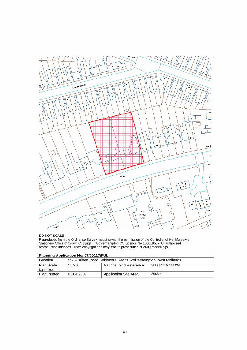
52
DO NOT SCALE Reproduced from the Ordnance Survey mapping with the permission of the Controller of Her Majesty’s Stationery Office © Crown Copyright. Wolverhampton CC Licence No 100019537. Unauthorised reproduction infringes Crown copyright and may lead to prosecution or civil proceedings. Planning Application No: 07/00117/FUL Location 55-57 Albert Road, Whitmore Reans,Wolverhampton,West Midlands Plan Scale (approx)
1:1250 National Grid Reference SJ 390119 299324
Plan Printed 03.04.2007 Application Site Area 2966m2
53
PLANNING COMMITTEE - 17-Apr-07
COMMITTEE REPORT: 1. Site Description and relevant background 1.1 The Ramgarhia Sabha Temple at 343 and 344 Newhampton Road East has occupied
these former town houses since 1985. Planning permission was granted at this time for a large rear two-storey extension to create a dining hall and worship hall.
1.2 The present Temple consists principally of a dining hall of 168 square metres with a
kitchen, toilets, ancillary office on the ground floor and an assembly/worship hall of 183 square metres on the first floor. Total assembly room and dining hall space is 352m2. There is a single car width access drive at the side leading to a parking area at the rear, with space for approx. 10 -11cars.
1.3 Nos. 340, 341 and 342 Newhampton Road East are the adjoining former terraced
houses that the Temple proposes to extend into. They are vacant and appear semi derelict. With respect to other adjoining properties; No. 337 Newhampton Road has been converted to flats, No.338 is an office premises and No.339 (also formerly flats) is empty. The houses on the opposite side of the road are occupied, with the exception of one which is boarded up.
1.4 There are waiting restrictions on both sides of this stretch of Newhampton Road East
extending to the junction of Waterloo Road. There are parking bays marked on the carriageway outside Nos. 339 to 342. On the opposite side of the road there are “no waiting” restrictions Monday to Saturday 8.00 am to 6.30 pm.
2. Constraints 2.1 These buildings are within Park Conservation Area. A line of TPO horse chestnut
trees stand on adjacent property close to the rear of the site.
APP NO: 06/0670/FP/C WARD: St Peter's
DATE: 11-May-06 TARGET DATE: 06-Jul-06
RECEIVED: 11.05.2006 APP TYPE: Full Application SITE: 340-344 Newhampton Road East, Whitmore Reans, Wolverhampton, , PROPOSAL: Extension of existing Temple into Nos 340-342 Newhampton Road East,
extensions to provide ground floor and first floor meeting halls, extension of car park at rear.(Amended Description)
APPLICANT: Ramgarhia Sabha 343 & 344 Newhampton Road East Wolverhampton WV1 4AD
AGENT: Andrews & Hazzard Newlyn House 2 All Saints Road Kings Heath Birmingham B14 7LL
54
3. Application detail 3.1 The proposal is for a significant increase in the size of the Temple by conversion of
and expansion into the adjoining numbers 340, 341 and 342 Newhampton Road East. A two-storey rear extension is also proposed.
(a) Proposed ground floor; main entrance, lobby, lift and stairs, multi-purpose
hall of 191 square metres, conference room, kitchen and toilets. Assembly room space on the ground floor including the existing dining hall would be 357 square metres.
(b) Proposed first floor; prayer/assembly hall of 300 square metres, day room/
library, Temple shop, priests room. Assembly room space on the first floor including the existing prayer hall would be 482 square metres. On both floors the internal and rear walls of the existing houses would be removed.
(c) Total assembly and dining hall floor space is 840m2. (d) The front elevation of the houses would be retained together with chimneys
and roof dormers. Temple symbols, signs, two flagpoles, canopy (GRP) over the new main front entrance are proposed.
(d) At the rear, the existing car park is to be enlarged to create 24 parking
spaces. 4. Relevant Policies 4.1 National Planning Policy; Planning (Listed buildings and Conservation Areas) Act
1990. Section 72 states that in determining planning applications in conservation areas, Local Authorities should give special attention to the desirability of preserving or enhancing the character or appearance of the conservation area. This is reinforced by Planning Policy Guidance No.15: Planning and the Historic Environment.
4.2 Unitary Development Plan Policy : Within Park Conservation Area. The following historic environment policies apply; HE1 Preservation of local character and distinctiveness, HE3 Preservation and enhancement of conservation areas, HE5 Control of development in a conservation area. Design Policies ; D1 Design quality, D4 Urban grain, D6 Townscape and landscape. Access and Mobility Policy AM12 parking and servicing provision. The standards
included in this Policy are maximum levels of provision, not levels that should necessarily should be achieved.
4.3 Wolverhampton City Council Supplementary Planning Guidance on places of worship.
55
5. Publicity 5.1 This application has been advertised by press and site notice and neighbour letter to
115 surrounding properties. Three responses have been received. Views are summarised as;
• Welcome the buildings being brought back into use, • Metal window screens should be removed from existing Temple windows, • Removal of string of light bulbs from the front of the building, one flagpole only,
reduce size of lettering and canopy, • Special occasions at the Temple cause disruption to the street, crowds block the
road, • Proposal will spoil this neighbourhood, • An increase in size can only add to congestion and parking problems for
residents. Previous approvals were based on the understanding that the site had sufficient parking. Local residents are unable to get off their drives because of being blocked in by Temple users parking in the street.
• Festivals generate increased noise often lasting several days, this is bound to increase,
• The houses are supposed to be in a conservation area, the properties have been left in a state of disrepair,
• The properties have been acquired for development in the longer term. 5.2 Rob Marris MP has written in support of the application. He requests that the
application is viewed sympathetically, because this is an important Gurdwara who wish to invest in their local area.
6. Internal Consultations 6.1 Urban Design and Conservation – the site includes an imposing terrace of late 19th
Century houses which makes a positive contribution to the character of the Park Conservation Area. The buildings are in a poor state of repair. The proposal to bring the buildings back into use is welcomed in principle.
The front elevations should be properly restored with traditional materials and
detailing, to include the repair/reinstatement of the timber double hung sashes, panelled doors; cast iron rainwater goods etc.
The proposed solid double entrance doors are inappropriate and would have an
adverse impact on the character and appearance of the Conservation Area. The existing chimney stacks and dormers must be retained and restored. The character of the buildings will be seriously compromised if these details were to be removed.
The roof covering should be natural Welsh slate. Details of the proposed canopy; flagpoles; signage and illumination should be
submitted for approval. The removal of the existing internal walls will have significant structural implications
which must be properly considered in order to avoid any adverse impact on the external appearance. The removal of all the internal supporting walls would, for example, necessitate the unacceptable removal of the stacks and dormers.
The scale of the proposed rear extension is significant and the detailed design lacks
the qualities inherent in the original building. Planning Policy Guidance 15; Planning and the Historic Environment paragraph 4.18 states “…. Special regard should be had for such matters as scale, height, form, massing, respect for the traditional pattern of
56
frontages, vertical or horizontal emphasis, and detailed design eg the scale and spacing of window openings and the nature and quality of materials”.
The design of the rear elevation of the extension should be revised to better reflect the
character of the existing buildings. The rear elevations of properties of this period are typically characterised by narrow projections. The scale of the proposed block would do little to enhance the character and appearance of the Conservation Area. The scale should be broken down, possibly through the use of gabled projections. The proposed design lacks the quality of detail that is characteristic of the existing building. Greater articulation and modelling is necessary to create interest within the rear elevation. Window proportions should be revised to better reflect the character of the existing building. Sill and head details should be included.
6.2 Environmental Services - if significant food preparation is to take place, a system for
the effective control of cooking odours must be installed. Control of noise and vibration from such equipment should be part of the specification. A complaint of noise from a tannoy system at the premises is being investigated.
6.3 Transport Strategy - information is required to support this application as follows:
• Numbers of people that each of the four large halls is designed to accommodate.
• A guide to how the whole building would be used i.e. how many of the halls and other rooms would be used simultaneously.
• The maximum number of people that the complex is designed to accommodate for special events.
• A travel plan to illustrate how visitors could get to and from the building in a sustainable manner. A mini-bus service provided by the Temple is stated but more details are required.
The existing parking and attendance figures suggest that Sunday is the busiest day
which would have the least conflict with other parking demands - except when there was a Sunday football match.
Other concerns are: a) the access road is narrow and would not allow two vehicles to pass for a length
of 30 metres. b) The amount of manoeuvring space between rows of parking bays is
substandard, either some bays would have to be removed or the layout re-designed.
c) There are no cycle or motor-cycle bays illustrated. d) The layout plan still does not indicate the necessary visibility splays at the
access point. e) It is not clear from the layout whether there is an intention to use the access
between Drummond Street and the car park. The extent of the proposed internal floor space has fallen from 907m2 to 840m2 but this
is still a considerable increase (138%) from the existing assembly room floor space of 352m2. As there are existing parking problems, I am concerned that the proposed parking provision would not be adequate for the likely traffic generation. The deficiency would be particularly noticeable when special events at the Temple coincided with football matches at Molineux Stadium or events at West Park.

57
This latest submission cannot be supported because it does not include any of the information requested and has not addressed parking provision issues (with the exception of provision of disabled parking bays). Unless these issues are addressed it is recommended that the application is refused.
6.4 Planning Policy - Policy C1 of the UDP; Health, Education and other Community
Services, supports the expansion and improvement of existing community facilities. The site is within the Park Conservation Area, the proposed development should conform with the policies in chapter 6; Historic Environment.
6.5 Trees - extension and resurfacing of the existing car park will have implications for the
line of TPO horse chestnut trees along the rear boundary on the adjacent property. A trial trench would be needed along this boundary to establish root growth and protective measures.
7. External Consultations 7.1 Fire Officer – satisfactory access for Fire appliances. 7.2 West Midlands Police – Historically there are no problems associated with this Temple,
consultation with neighbourhood officers confirms this. The extension will considerably increase assembly and worship space, is there likely
to be an equivalent increase in visitors? What functions are proposed and how many people will the halls accommodate? Will the proposed parking space suffice for an increase in visitors? Parking is usually available at West Park, except when there are events or when there is a football match at the Molineux.
8. Appraisal 8.1 Main issues with this application are:
• Conservation and urban design issues; • Capacity of existing and proposed Temple and parking provision;
8.2 Conservation and urban design issues 1 Criticisms have been set out in the Conservation Officer’s comments in
paragraph 6.1 of this report. It is stressed that the Park Conservation Area boundary includes the full extent of this site, it does not just include the street frontage.
2 The Council’s Supplementary Planning Guidance on Places of Worship advises
at paragraph 3.2 that … “the quality of design, layout and materials is of critical importance, to reflect and respect not only the religion concerned but to enable the building to be satisfactorily accommodated in the proposed location”.
3 Restoration of the front elevation as shown on the drawings will, if properly
implemented, bring about a welcome improvement in the appearance of these buildings to the benefit of the Conservation Area. Some of the details shown, eg windows and doors and proposed front canopy, are poorly drawn, details will need to be required by condition on any permission.
4 The design of the rear elevation remains unsatisfactory. Improvements are
required as a concession to the Conservation Area. It is considered that there are ways of doing this without seriously compromising the proposed floor space.
58
8.3 Capacity of Existing and proposed Temple and parking provision 1. At pre-application stage, in discussions with the applicants and in numerous
letters it was made clear that information such as accurate floor areas, how the building is to function, the numbers of people it is designed to accommodate etc would be required. This has not been provided. The floor space figures provided in this report have been calculated from the drawings.
2. Existing Temple. The ground floor and first floor halls of the existing Temple have a combined
floor space of 352 square metres. Sunday is the normal worship day, with approximately 100 people attending between 6.00 am and 12 noon. Thursday is also identified as a day when attendance can reach 100 people. Numbers of cars attracted to the Temple at these busy times is in the region of 25 - 30 cars, which exceeds the capacity of the existing car park. At other times attendance is lower, typically 20 to 50 people. Applying the S.P.G. parking guidelines of one car space for every 5 - 10 people that can be accommodated produces a requirement of 10 - 20 spaces for the existing Temple. Typical Sunday use of a Gurdwara is that people gather in the assembly/prayer hall for worship and afterwards gather in the dining hall.
3. Proposed Temple. The conversion and rear extension creates two additional large halls, a ground
floor multi-use hall of 191 square metres and a first floor prayer hall of 300 square metres. Total assembly room floor space on both floors rises from 352 square metres to 840 square metres, an increase of 138%. The car park is enlarged to the limits of the site boundaries to provide 24 spaces including two disabled spaces. A plan has also been submitted showing an ‘extraordinary’ parking layout, with almost all available space providing 39 parking spaces. This is not a satisfactory or practical arrangement.
4. It is assumed that at times of special occasions and festivals there will be
increases in the numbers of people using the Temple. If both prayer halls were used together (483m2) with 60% of floor space being used, this could accommodate some 580 people. The Council’s Supplementary Planning Guidance on Places of Worship advises a need for parking provision in the range of 60 to 150 spaces to support this. There is no scope for further enlargement of the car park beyond the 24 spaces shown, or for widening the access drive.
5 Parking provision is available around West Park, at its nearest approximately
250 metres away from the Temple, requiring a walk along Park Avenue. This would normally be available at week-ends. The Applicants state that a mini-bus taxi service provided by the Temple will be available to ferry people from West Park, and ….. “ for normal use the existing car park provision is adequate as most people using the Gurdwara come on foot or are dropped off at the roadside without vehicles entering the site”.
6. Taking into account the proposed amount of floor space, possible person
capacity, size of car park and the inadequate single car width access, it is considered that there is a risk on occasions of localised traffic congestion in this part of Newhampton Road East and adjoining roads. The numbers of people gathering outside or waiting to enter the Temple on busy occasions may pose a safety risk. It is difficult to predict, in absence of information, how often this may occur.

59
9. Conclusion 9.1 It is recognised that this Temple provides an important function for its members and
congregation. Such religious organisations are vital to the health and well being of the communities they serve. The restoration and use by the Temple of the three vacant houses is welcomed provided the detail of design and restoration pays respect to the existing buildings and Conservation Area principles of design. Whilst it
is accepted that the on-site parking will be insufficient to accommodate likely demand for special occasions and will create local parking and traffic difficulties this is considered to be outweighed by these other considerations in this instance.
10. Recommendation Delegated authority to the Director to permit when satisfactory design and detailing of
the rear elevation is received. Conditions will include;
• Details of restoration of front elevation. • Materials of construction. • Layout of enlarged car park before the new floor space is brought into use. • Submission and implementation of a travel plan. • Details of air extraction system from the new kitchen.
Case Officer : Ken Harrop Telephone No : 55549 Head of Development Control – Stephen Alexander
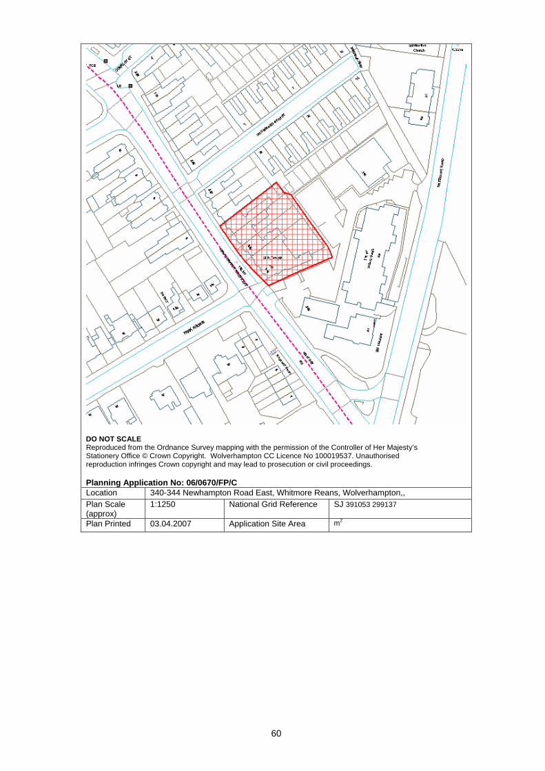
60
DO NOT SCALE Reproduced from the Ordnance Survey mapping with the permission of the Controller of Her Majesty’s Stationery Office © Crown Copyright. Wolverhampton CC Licence No 100019537. Unauthorised reproduction infringes Crown copyright and may lead to prosecution or civil proceedings. Planning Application No: 06/0670/FP/C Location 340-344 Newhampton Road East, Whitmore Reans, Wolverhampton,, Plan Scale (approx)
1:1250 National Grid Reference SJ 391053 299137
Plan Printed 03.04.2007 Application Site Area m2
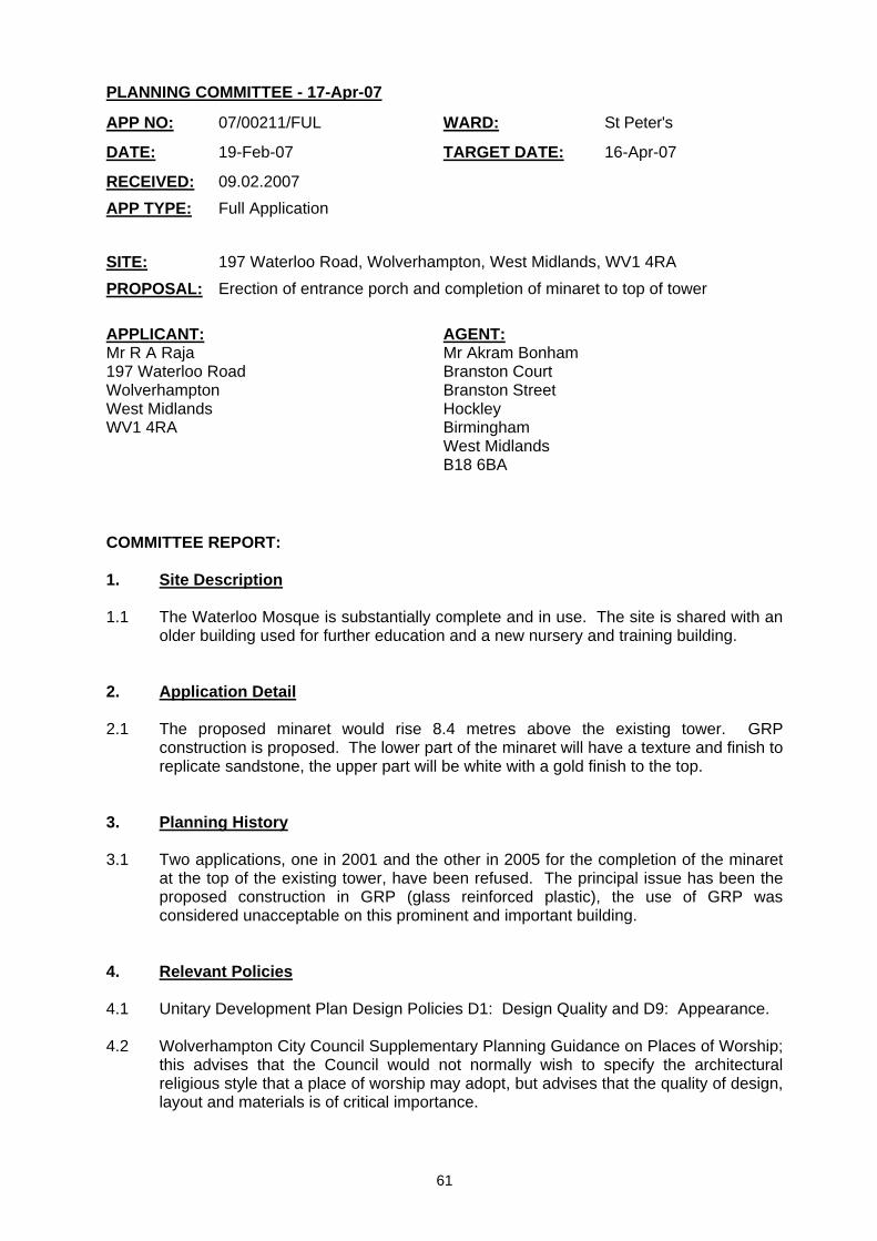
61
PLANNING COMMITTEE - 17-Apr-07
COMMITTEE REPORT: 1. Site Description 1.1 The Waterloo Mosque is substantially complete and in use. The site is shared with an
older building used for further education and a new nursery and training building. 2. Application Detail 2.1 The proposed minaret would rise 8.4 metres above the existing tower. GRP
construction is proposed. The lower part of the minaret will have a texture and finish to replicate sandstone, the upper part will be white with a gold finish to the top.
3. Planning History 3.1 Two applications, one in 2001 and the other in 2005 for the completion of the minaret
at the top of the existing tower, have been refused. The principal issue has been the proposed construction in GRP (glass reinforced plastic), the use of GRP was considered unacceptable on this prominent and important building.
4. Relevant Policies 4.1 Unitary Development Plan Design Policies D1: Design Quality and D9: Appearance. 4.2 Wolverhampton City Council Supplementary Planning Guidance on Places of Worship;
this advises that the Council would not normally wish to specify the architectural religious style that a place of worship may adopt, but advises that the quality of design, layout and materials is of critical importance.
APP NO: 07/00211/FUL WARD: St Peter's
DATE: 19-Feb-07 TARGET DATE: 16-Apr-07
RECEIVED: 09.02.2007 APP TYPE: Full Application SITE: 197 Waterloo Road, Wolverhampton, West Midlands, WV1 4RA PROPOSAL: Erection of entrance porch and completion of minaret to top of tower APPLICANT: Mr R A Raja 197 Waterloo Road Wolverhampton West Midlands WV1 4RA
AGENT: Mr Akram Bonham Branston Court Branston Street Hockley Birmingham West Midlands B18 6BA

62
5. Publicity 5.1 The application has been advertised by site and press notice and neighbour letter.
One response has been received, concern expressed about parking problems associated with the mosque, objection to this proposal.
6. Appraisal 6.1 The key issue is the design of the minaret and appropriateness of materials at this
prominent Wolverhampton Mosque. 6.2 The design and proportion of the minaret is satisfactory, it will complement the existing
mosque and “finish off” the tower. 6.3 A different view is now taken of proposed GRP construction. Many mosques and
temples now have domes and finials constructed of this material. In Wednesfield the new Well Lane temple has GRP domes, the general view is that this is a successful building in architectural terms. The Birmingham Central mosque has a minaret top made from GRP. To consistently oppose the use of GRP at the Waterloo Road mosque now seems out of step with practice elsewhere.
6.4 At 21 metres above ground level, it is unlikely that a casual observer would perceive a
difference in materials of construction. It will be prominent and contrast with the stone and brick tower, this is part of the religious symbolism of the minaret.
6.5 The surrounding buildings at this location are very mixed, it is not considered that the
proposed minaret will appear out of place in this location. 6.6 The original planning permission for this mosque had a condition to the effect that no
electronic amplification of calls to prayer should be made from the building. This condition should be repeated on any permission.
7. Recommendation 7.1 Permit, conditions; no electronic amplification from the minaret. Case Officer : Ken Harrop Telephone No : 55549 Head of Development Control – Stephen Alexander
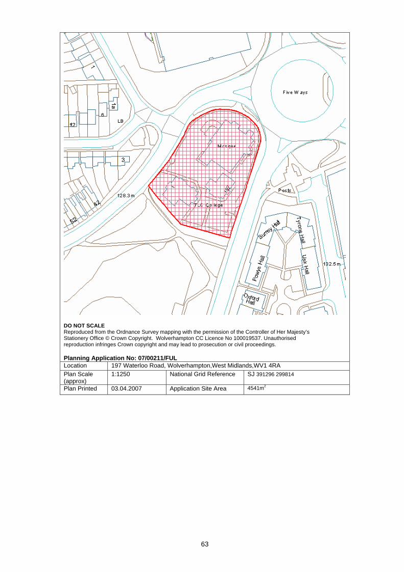
63
DO NOT SCALE Reproduced from the Ordnance Survey mapping with the permission of the Controller of Her Majesty’s Stationery Office © Crown Copyright. Wolverhampton CC Licence No 100019537. Unauthorised reproduction infringes Crown copyright and may lead to prosecution or civil proceedings. Planning Application No: 07/00211/FUL Location 197 Waterloo Road, Wolverhampton,West Midlands,WV1 4RA Plan Scale (approx)
1:1250 National Grid Reference SJ 391296 299814
Plan Printed 03.04.2007 Application Site Area 4541m2

64
PLANNING COMMITTEE - 17-Apr-07
COMMITTEE REPORT: 1.0 Site Description 1.1 The application relates to the Wrottesley Residential Home. The site has a carpark at
the front and a large building located approximately 20m back from the highway. The building is situated approximately 10m from the rear boundary, creating a private rear garden of approximately 440m2. Boundary treatment includes a 1.8m high close-boarded fence on the rear boundary and a 1.8m high brick wall (approximately) along the western boundary. Both the side and rear boundary have high dense vegetation.
1.2 The existing front elevation of the Home connects approximately flush to the existing
rear elevation of the dwelling at 48 Wrottesley Road (No. 48). No. 48 has a kitchen window in the side ground floor side elevation.
2.0 Application details 2.1 The application is for a front ground floor and first floor extension and a rear
conservatory. 2.2 The front ground floor extension converts two existing bedrooms into three and
extends the existing hall and lobby by projecting forward of the existing front elevation approximately 2m. The extension has a lean-to roof with a maximum height of 3.5m.
2.3 The first storey extension converts an existing bedroom and landing into two bedrooms
by projecting forward 3.2m. This first storey extension will be set back approximately 0.8m from the first storey front projection and have a pitched roof with a front gable.
2.4 The rear conservatory projects approximately 3.5m to the rear of the existing rear
elevation, to be approximately 6.5m from the rear boundary.
APP NO: 07/00035/FUL WARD: Tettenhall Regis
DATE: 01-Feb-07 TARGET DATE: 29-Mar-07
RECEIVED: 09.01.2007 APP TYPE: Full Application SITE: Wrottesley Residential Home, 46 Wrottesley Road, Tettenhall,
Wolverhampton PROPOSAL: Front and rear extension APPLICANT: Wrottesley House Ltd Wrottesley Residential Home 46 Wrottesley Road Tettenhall Wolverhampton West Midlands WV6 8SF
AGENT: Thorne Architecture Ltd Creative Industries Centre Glaisher Drive Wolverhampton WV10 9TG
65
2.5 The extension increases the capacity of the home from 18 to 19 persons. It is understood that there will be no increase in the number of existing staff.
3.0 Planning History 3.1 The following planning history is relevant to the proposal:
• C/1303/92 - Extension and alterations to extend and update existing accommodation. Granted 1993.
• C/1878/89 - Extension and alterations, elderly peoples home. Granted 1989. • C/0754/88 - Alteration to first floor bedroom to form single bedroom and tv
recreational room, two added windows (residential home). Granted 1988. • C/0756/88 - Alterations to form additional bedrooms and bathroom from garage
conversion (residential home). Granted 1988. • C/2433/87 - Convert garage to bedroom, divide bedrooms at first floor (existing
old persons home). Refused 1988. Refused due to windows in side elevation reducing privacy at 48 Wrottesley Road.
• A/C/1190/85 - Change of use to elderly persons' home. Granted 1985. 4.0 Constraints 4.1 The following relevant constraints are recorded:
• Landfill Gas Zones • Tree Preservation Orders
5.0 Relevant policies 5.1 Relevant policies from the Adopted UDP included below:
• D1 - Design Quality; • D4 - Urban Grain; • D7 - Scale – Height; • D8 - Scale – Massing; and • D9 – Appearance.
5.2 Supplementary Planning Guidance Note 4 “Extension to Houses” also relevant. 6.0 Publicity 6.1 The nature of the proposal did not require the application be the subject of press
advertisement nor did it require a site notice to be posted. 7.0 Neighbour notification and representations 7.1 Letters were sent out to the surrounding neighbours. Objections were received from
48 Wrottesley Road and 7 Saxon Court. The comments can be summarised as follows:
• Concerns over the ‘creeping development’ of the residential home; and • Reduction in privacy due to the closeness of the conservatory to the rear
boundary of 7 Saxon Court.
66
8.0 Internal consultees 8.1 The following were consulted and comments summarised:
• Environmental Services: Comments - No observations. • Access Officer: Comments - Must comply with Part M of Building Regs. • CSCI: Comments – No response received to date. • Building Control: Comments - No objections (Access for Fire).
9.0 Appraisal 9.1 Design
The design of the extension is in keeping with the style and character of the existing building. The proposed front gable is complementary to the existing two gables, while creating a visually interesting undulating design. The proposed rear conservatory is complementary to the existing building.
9.2 Neighbour Effects
The neighbours concerns are addressed as follows:
9.2.1 Reduction in privacy Although the conservatory is proposed to be approximately 6.5m from the rear boundary, there is a 1.8m high close-boarded fence and dense vegetation along the rear boundary which completely shelters the rear garden of 7 Saxon Court from sight. The conservatory would be approximately 18m away from the existing rear elevation at 7 Saxon Court. It is considered that the proposed conservatory is acceptable.
9.2.2 Creeping Development
The proposed extension increases the capacity of the residential home by one to a total of 19 persons. The provision of carparking and private garden area is considered to be adequate for this increase. Although the ground floor extension projects 2m forward of the existing front elevation, it still remains behind the existing building line. The dwelling at No. 48 is approximately 3m from the proposed extension. The kitchen at No. 48 is orientated towards the application site has a number of windows and consequently the proposed extension will not block out a significant amount of natural light, nor will it create an overbearing effect on the outlook.
10.0 Recommendation: 10.1 Grant subject to the following conditions:
• Matching materials. Case Officer : Sarah Luxmoore Telephone No : 555607 Head of Development Control – Stephen Alexander
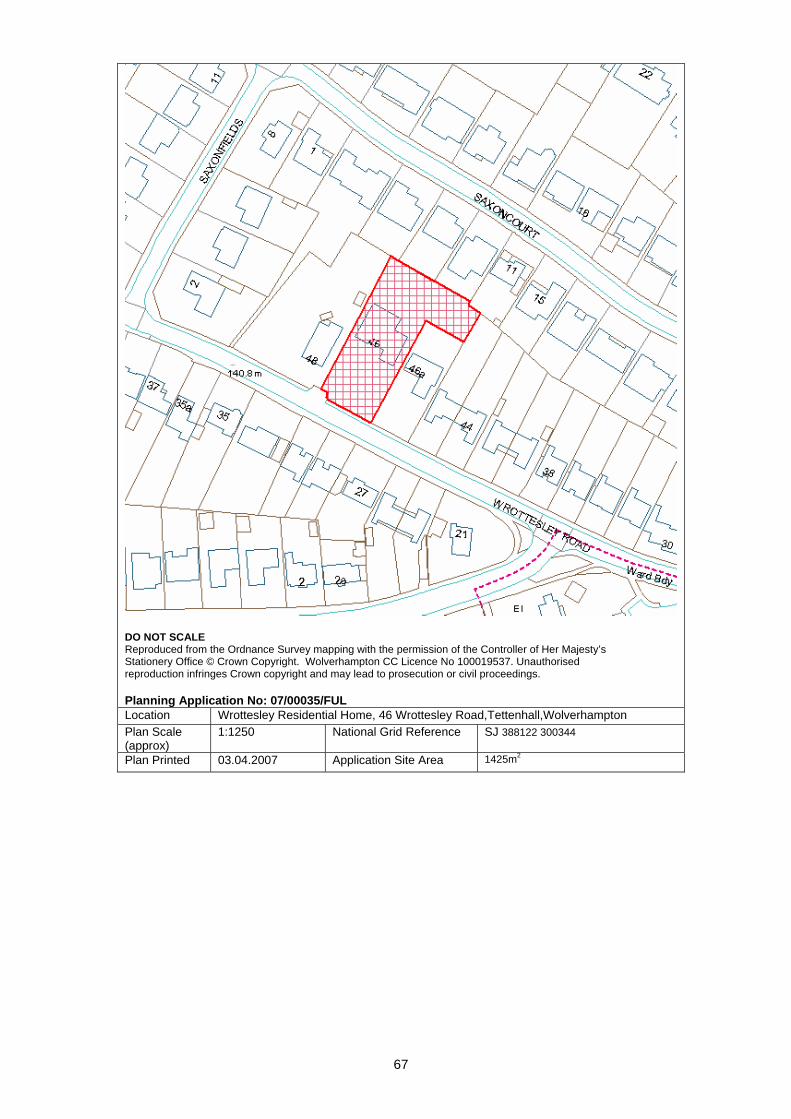
67
DO NOT SCALE Reproduced from the Ordnance Survey mapping with the permission of the Controller of Her Majesty’s Stationery Office © Crown Copyright. Wolverhampton CC Licence No 100019537. Unauthorised reproduction infringes Crown copyright and may lead to prosecution or civil proceedings. Planning Application No: 07/00035/FUL Location Wrottesley Residential Home, 46 Wrottesley Road,Tettenhall,Wolverhampton Plan Scale (approx)
1:1250 National Grid Reference SJ 388122 300344
Plan Printed 03.04.2007 Application Site Area 1425m2
68
PLANNING COMMITTEE - 17-Apr-07
COMMITTEE REPORT: 1. Site Description 1.1 The site is an area of open space which is rectangular shaped, slightly sloping north to
south. It measures approx. 40m x 33m and is located on the east side of Barnard Road, a residential street of semi-detached houses in regular shaped rectangular plots. To the south is a pair of semi-detached houses, 58 and 60 Barnard Road and to the north a similar pair of houses, 74 and 76 Barnard Road. There is a lay-by directly in front of the application site but outside the site boundary.
1.2 To the rear of the site is a raised bank beyond which is a large area of recreational open space. There are 1.8m high railings along this boundary at the same level as the application site. 1.3 The site contains various tree specimens including willow, black and grey poplar, Lombardy poplar and young oaks on the perimeter and hedgerows in and on the perimeter of the site. 2. Planning History 2.1 06/0427/DW - Residential Development (outline) - Granted 29th August 2006. 3. Constraints 3.1 Landfill Gas and Coal Mining Area 4. Application details 4.1 The proposal is for a two storey residential care home of 11 bedrooms for young adults with learning difficulties.
APP NO: 07/00055/FUL WARD: Wednesfield North
DATE: 31-Jan-07 TARGET DATE: 28-Mar-07
RECEIVED: 12.01.2007 APP TYPE: Full Application SITE: Land At , 62-72 Barnard Road, Wednesfield, Wolverhampton PROPOSAL: Construction of 11 bed residential care home for young adults with learning
disabilities. (Amended Plans) APPLICANT: Milbury Voyage Garrick House 2 Queen Street Lichfield Staffordshire
AGENT: Homewood Design Ltd 2-3 Mitchells Court Lower Gungate Tamworth Staffordshire B79 7AF
69
4.2 The building would comprise a 34.6m wide frontage with 4 projecting gables and two front entrances and hipped roof to match the existing properties. The height of the ridge would be level with 74 and 76 Barnard Road and 1m higher than the ridge of 58 and 60 Barnard Road. A two storey wing is proposed on the rear elevation which would project 6.4m and would be 10m from the boundary with no 60 Barnard Road, the nearest residential boundary. A single storey rear projection of 5.5m is proposed which would be 4.4m from the boundary with 74 Barnard Road. 4.3 Access is proposed to a new rear parking area adjacent to 74 Barnard Road and seven parking spaces are proposed. One disabled parking bay is proposed on the front. 4.4 There would be a private rear garden area with minimum depth of 11.3m. 4.5 The building would provide a lounge, dining room, kitchen, laundry, activity room and office with 2 no bedrooms and 2 self-contained units on the ground floor. The first floor would provide 6 bedrooms, a staff bedroom, assisted bathroom, quiet room and one self contained unit. A lift is also provided. 4.6 The applicants anticipate that the service users referred to the care home would be local people who have family in the surrounding area who are keen to see them living in the area to enable regular visiting and short stays and holidays at home. The service users would comprise: (a) Adults who have been placed in specialist facilities in other areas due to lack of local provision; (b) Younger people who are due to finish their education in special schools and who cannot return home to live with their parents; (c) People whose current placements have failed as they need to live in a more sensitively designed environment and be supported by a highly trained staff team; (d) People who are living at home with ageing carers and who need to move due to the inability of their carers to cope indefinitely. 4.7 Staff will support the service users to become involved in all aspects of household maintenance and to assess community based educational and leisure facilities. The support will be provided by 5 members of staff to 8 service users, supplemented with 1-1 support for at least 5 hours per day across the service. Night support would be provided by 2 waking night support workers. 5. Relevant policies
AM12 - Parking and Servicing Provision D1 - Design Quality D4 - Urban Grain D5 - Public Realm Public Open Private Space D6 - Townscape and Landscape D8 - Scale - Massing D9 - Appearance D10 - Community Safety D11 - Access for People with Disabilities (part) H11 - Special Needs Accommodation R3 - Protection of Open Space, Sport and Rec. D14 – The Provision of Public Art Supplementary Planning Guidance No 2: Access & Facilities for people with Disabilities

70
Supplementary Planning Guidance No 3 - Residential Development Supplementary Planning Guidance No 16 – The Provision of Public Art
6. Publicity 6.1 A site notice was posted on 1st March 2007 and expired on 21st March 2007. 7. Neighbour notification and representations 7.1 Standard letters were sent to 36 properties. One petition of objection of 900+ signatures received; 30 individual letters/emails received. A summary of the objections and comments are as follows: -
• Concern regarding the use of the home by people with behavioural difficulties or young people generally. Concern that such uses may be introduced in the future even if not currently intended.
• Unacceptable increase in traffic noise, parking and congestion • Over intensive use of site • Commercial activity in residential location
8. Internal consultees 8.1 Transport Strategy – 2.4m x 2.4m pedestrian visibility required and covered cycle parking 8.2 Trees – No objections – Prefer to retain two grey poplars if possible 8.3 Access Officer - Acceptable 8.4 Environmental Services – Food Safety – Extraction details required Contaminated Land – Site investigation works required in respect of landfill gas; Environmental Protection – Concerns about noise disturbance which could be overcome by provision of an acoustic enclosure and suggested hours for deliveries 8.5 Parks and Contracts – Loss of Open Space would require a S106 to acquire payment of a POS contribution before any implementation works are commenced. 9. External consultees 9.1 Commission for Social Care Inspection – No comments received 9.2 Police – No Objections but secured gates required near front of the building. 9.3 Wolverhampton Health Authority – No comments received 9.4 Fire Department – Satisfactory access
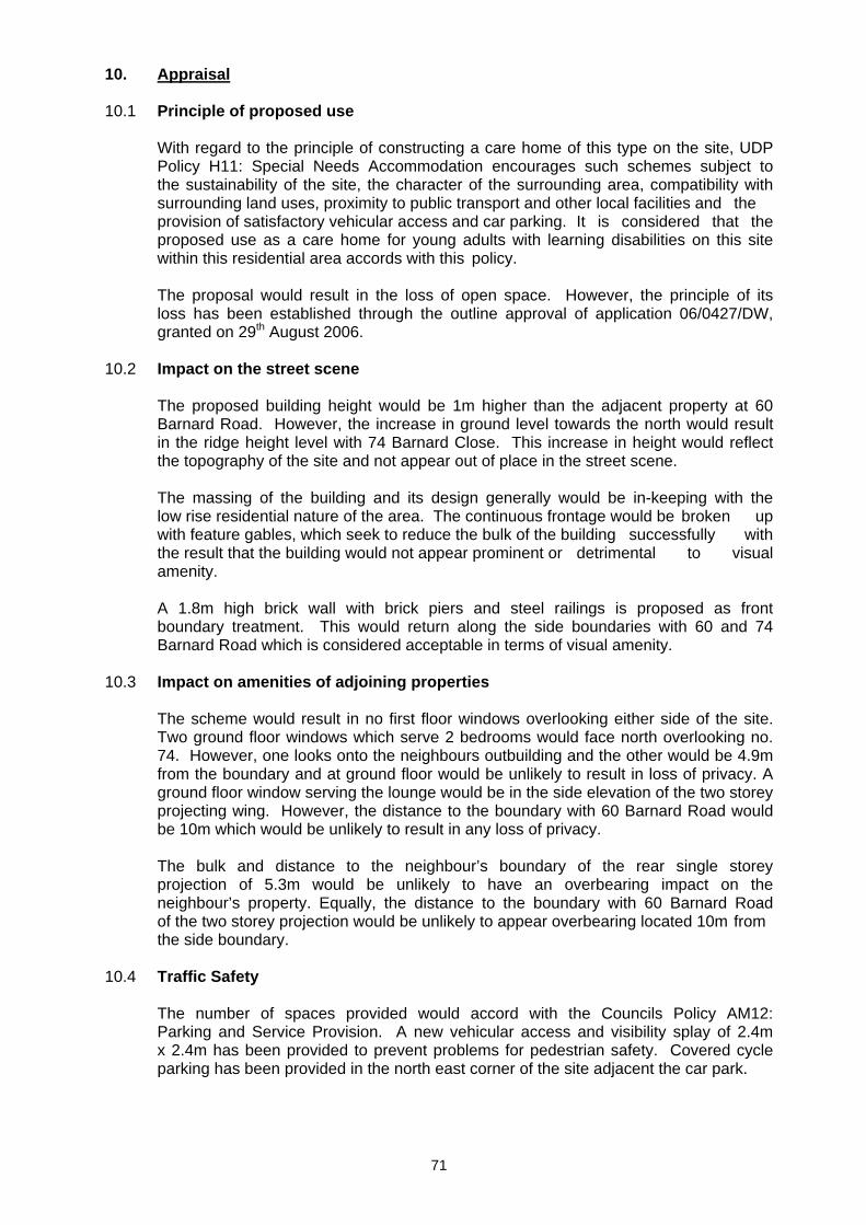
71
10. Appraisal 10.1 Principle of proposed use With regard to the principle of constructing a care home of this type on the site, UDP Policy H11: Special Needs Accommodation encourages such schemes subject to the sustainability of the site, the character of the surrounding area, compatibility with surrounding land uses, proximity to public transport and other local facilities and the provision of satisfactory vehicular access and car parking. It is considered that the proposed use as a care home for young adults with learning disabilities on this site within this residential area accords with this policy. The proposal would result in the loss of open space. However, the principle of its loss has been established through the outline approval of application 06/0427/DW, granted on 29th August 2006. 10.2 Impact on the street scene The proposed building height would be 1m higher than the adjacent property at 60 Barnard Road. However, the increase in ground level towards the north would result in the ridge height level with 74 Barnard Close. This increase in height would reflect the topography of the site and not appear out of place in the street scene. The massing of the building and its design generally would be in-keeping with the low rise residential nature of the area. The continuous frontage would be broken up with feature gables, which seek to reduce the bulk of the building successfully with the result that the building would not appear prominent or detrimental to visual amenity. A 1.8m high brick wall with brick piers and steel railings is proposed as front boundary treatment. This would return along the side boundaries with 60 and 74 Barnard Road which is considered acceptable in terms of visual amenity. 10.3 Impact on amenities of adjoining properties The scheme would result in no first floor windows overlooking either side of the site. Two ground floor windows which serve 2 bedrooms would face north overlooking no. 74. However, one looks onto the neighbours outbuilding and the other would be 4.9m from the boundary and at ground floor would be unlikely to result in loss of privacy. A ground floor window serving the lounge would be in the side elevation of the two storey projecting wing. However, the distance to the boundary with 60 Barnard Road would be 10m which would be unlikely to result in any loss of privacy. The bulk and distance to the neighbour’s boundary of the rear single storey projection of 5.3m would be unlikely to have an overbearing impact on the neighbour’s property. Equally, the distance to the boundary with 60 Barnard Road of the two storey projection would be unlikely to appear overbearing located 10m from the side boundary. 10.4 Traffic Safety The number of spaces provided would accord with the Councils Policy AM12: Parking and Service Provision. A new vehicular access and visibility splay of 2.4m x 2.4m has been provided to prevent problems for pedestrian safety. Covered cycle parking has been provided in the north east corner of the site adjacent the car park.
72
10.5 Other matters A 1.8m high close boarded fence is proposed along the boundary with 60 Barnard Road and a 1.8m high screen brick wall on the boundary with 74 Barnard Close. This wall would be adjacent the access road to the rear car park and would seek to reduce the impact of noise created by vehicle movements in this area. A new 2m high timber panel fence is proposed on the rear boundary with the Public Recreation Area. Several trees would be removed to accommodate the proposal. Two good examples of grey poplars positioned in the north east area of the site, would be removed to provide the car park. The trees are not covered by a tree preservation order and their loss whilst unfortunate would not be harmful to the overall environmental improvements achieved by the development as a whole. The bin store is located off the access road to the car park, 4.8m from the side boundary with 74 Barnard Road. 11. Conclusion 11.1 The proposal is considered to be acceptable and would make an effective contribution to the street scene whilst providing a much needed facility for use by local persons with learning disabilities. 12. Recommendation: 12.1 Grant permission Delegated Authority be given to the Director Subject to:
1. The signing of a S106 Public Open Space contribution, payable before implementation works are carried out to the sum of £66,066 subject to BCIS annual increases from January 2008.
A Percent for Art feature, to be provided before the development is occupied
2. The following conditions: - - The use being restricted to a care home for adults with learning disabilities - Landscaping - Submission of materials - Implementation and retention of car park - Extraction facilities - Delivery Hours limited to: - 08.00hrs – 18.00hrs Mon-Fri 08.00hrs – 13.00hrs Sat None on Sundays and Bank Holidays - Submission of Site Investigation Report
- Other standard Conditions Case Officer: Jenny Davies Telephone No : 555608 Head of Development Control – Stephen Alexander
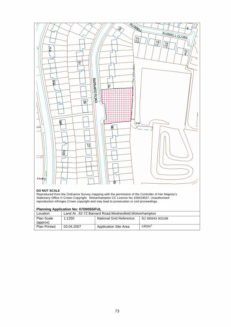
73
DO NOT SCALE Reproduced from the Ordnance Survey mapping with the permission of the Controller of Her Majesty’s Stationery Office © Crown Copyright. Wolverhampton CC Licence No 100019537. Unauthorised reproduction infringes Crown copyright and may lead to prosecution or civil proceedings. Planning Application No: 07/00055/FUL Location Land At , 62-72 Barnard Road,Wednesfield,Wolverhampton Plan Scale (approx)
1:1250 National Grid Reference SJ 395943 302188
Plan Printed 03.04.2007 Application Site Area 1453m2

74
PLANNING COMMITTEE - 17-Apr-07
COMMITTEE REPORT: 1. Site Description 1.1 The application site is the area of open land on the western side of the Corus site,
bounded by Steelpark Way, Wednesfield Way and Waddens Brook Lane. 1.2 Within the immediate vicinity of the Corus site the land use is a mixture of industrial
and residential. To the immediate north the site is bounded by Waddens Brook Lane a predominantly residential road. To the west, there are a number of residential dwellings on Hart Road, set off Wednesfield Way.
1.3 Located to the east, of the area of open land proposed in the application, is the
remainder of the Corus site. 2. Application details 2.1 The application is for a proposed change of use for the outside storage of steel
products (Class B8).The current lawful use of the land is unclear. The application also proposes a saw cutting area enclosure, this will measure 11.2m by 10.1m and 4m high. It is proposed that the structure will be ‘Blockwork clad in close boarded timber’.
2.2 The proposed change of use would allow for the storage, loading and unloading of
steel products. This product would be accessed by side loaders and placed on flat bed vehicles for distribution.
2.3 The application proposes the creation of perimeter bunds sited adjacent to
Wednesfield Way, Steelpark Way and at the rear of houses in Waddens Brook Lane. The bund at the rear of the houses would be approximately 5m high. The others would be approximately 3-6m high. A 2.5m high sound fence is also proposed at the rear of the homes on Waddens Brook Lane.
2.4 The Corus Company manufactures, processes and distributes metal products. The
company have various centres located across Europe. It is the Corus Distribution and Building Systems site that is located within the Wednesfield area of Wolverhampton.
APP NO: 07/00135/FUL WARD: Wednesfield South
DATE: 07-Feb-07 TARGET DATE: 09-May-07
RECEIVED: 29.01.2007 APP TYPE: Full Application SITE: Corus Steel, Steelpark Way, Wednesfield, Wolverhampton PROPOSAL: Change of use to open storage of steel products APPLICANT: Corus Steelpark Way Wednesfield WV11 3FR
AGENT: Building Design Practice Ltd 132 Compton Road Wolverhampton WV3 9QB
75
2.5 The agents explain that in order to remain competitive in the storage and distribution market, Corus has recognised the need to store materials externally to avoid the cost of storing internally.
2.6 Therefore Corus has sanctioned a £10m investment for its distribution arm. Corus has
selected the Wednesfield distribution site as an ideal location for this facility as the site is already home to Corus’ largest UK distribution facility and is well placed for distribution around the UK.
3. Planning History 3.1 There is a large and varied planning history to this site. The most recent application
was for a steel gantry with overhead cranes, this was granted planning permission on 13th January 2006.
4. Constraints 4.1 Mining areas and Landfill Gas Zones 5. Relevant policies 5.1 Relevant UDP policies: B1 - Economic Prosperity
B3 - Business Development Allocations B4 - Expansion of Existing Businesses B5 - Design Standards for Employment Sites D1 - Design Quality D4 - Urban Grain D9 - Appearance AM12 - Parking and Servicing Provision
5.2 SPG 1 – Business, Industrial and Warehousing Development 6. Publicity 6.1 Site and press notices and letters to local residents. 6.2 The consultation period expires on 6th April 2007. At the time of writing no letters of
representation had been received. 7. Internal Consultees 7.1 Access Officer – No objections 7.2 Archaeology – No archaeological implications 7.3 Environmental Services – Requested an assessment to determine the impact of noise
on the nearby residential properties in Hart Road and Waddens Brook Lane. 7.4 Transportation Development – To be reported verbally at Committee.

76
8. Appraisal 8.1 The main issues related to this application are:
• Noise Pollution – affecting adjacent residential amenity. • Visual Amenity and Landscape and Boundary Treatments • Appropriate Business Expansion • Transport and Highways
Noise Pollution
8.1 Environmental Services raised concerns regarding the effectiveness of the earth
bunds around the perimeter of the site and an enclosure around the saw cut area. In particular the gaps in the bund that may allow noise from the loading area to adversely affect residential amenity. The applicants were requested to submit an assessment to determine the impact of noise on nearby residential amenity, this has now been received.
8.2 Following discussions with the Environmental Services Officer, amended plans have
been received which show additional sound attenuation fencing, between the bund and the boundary to the north of the site, adjacent to the houses in Waddens Brook Lane, and across the gates to Wednesfield Way. The revised drawings also provide additional sound attenuation fencing around the proposed saw cutting enclosure. The amended plans and noise assessment survey have been submitted to Environmental Services for their comments, which will be reported verbally at Committee.
Visual Amenity
8.3 As the site is bounded by dwellings along Waddens Brook Lane and Wednesfield
Way, maintaining or improving visual amenity is imperative. The application proposes to erect landscape bunding around the perimeter of the site, approximately 3-6m high. The application states that storage height will be limited to 2.5m. With an adequate landscape planting scheme it is considered that the proposals would be sufficient to avoid the proposal being detrimental to visual amenity.
Appropriate Business Expansion 8.4 The proposed site is designated as a Business Development Allocation. These sites
are primarily safeguarded for Class B employment uses. The proposed use would fall within this class.
8.5 It is stated that a successful application will provide an additional 23 industrial jobs at
the site. There are currently 700 people employed at this site. Transport and Highways
8.6 Their comments will be reported to Committee verbally. 9. Conclusion 9.1 The proposed change of use is acceptable in principle. The land highlighted is
designated for a Class B use and the proposed storage and distribution use would fall within this class. The land is currently undeveloped and is not in active employment use. Therefore it is considered that the proposed expansion of the Corus business would be beneficial to the City, providing more jobs, as well as maintaining those currently employed on the site.

77
9.2 Due to the close proximity of the site to dwellings, maintaining good residential amenity in terms of visual appearance and noise is essential. The application is recommended for approval subject to receiving confirmation from Environmental Services that the Noise Survey Report provides adequate evidence to show that noise levels will not adversely affect residential amenity for neighbouring residents.
10. Recommendation 10.1 Grant, subject to receiving no adverse comments from Environmental Services and
Transportation. 10.2 Also subject to conditions to include:
1. The provision of bunds and noise fencing prior to commencement of the use, and their retention and maintenance. 2. Stored goods and items not to exceed 2.5m in height. 3. Submission and implementation of landscape details, including boundary
treatment. 4. Provision and retention of parking. 5. Provision and retention of cycle parking 6. Conditions as recommended by Environmental Services 7. Conditions as recommended by Transportation Development 8. Notes for information “Within a Coal Mining Area” and “Within a Landfill Gas
Zone”. Case Officer: Mark Elliot Telephone No.: 555648 Head of Development Control – Stephen Alexander
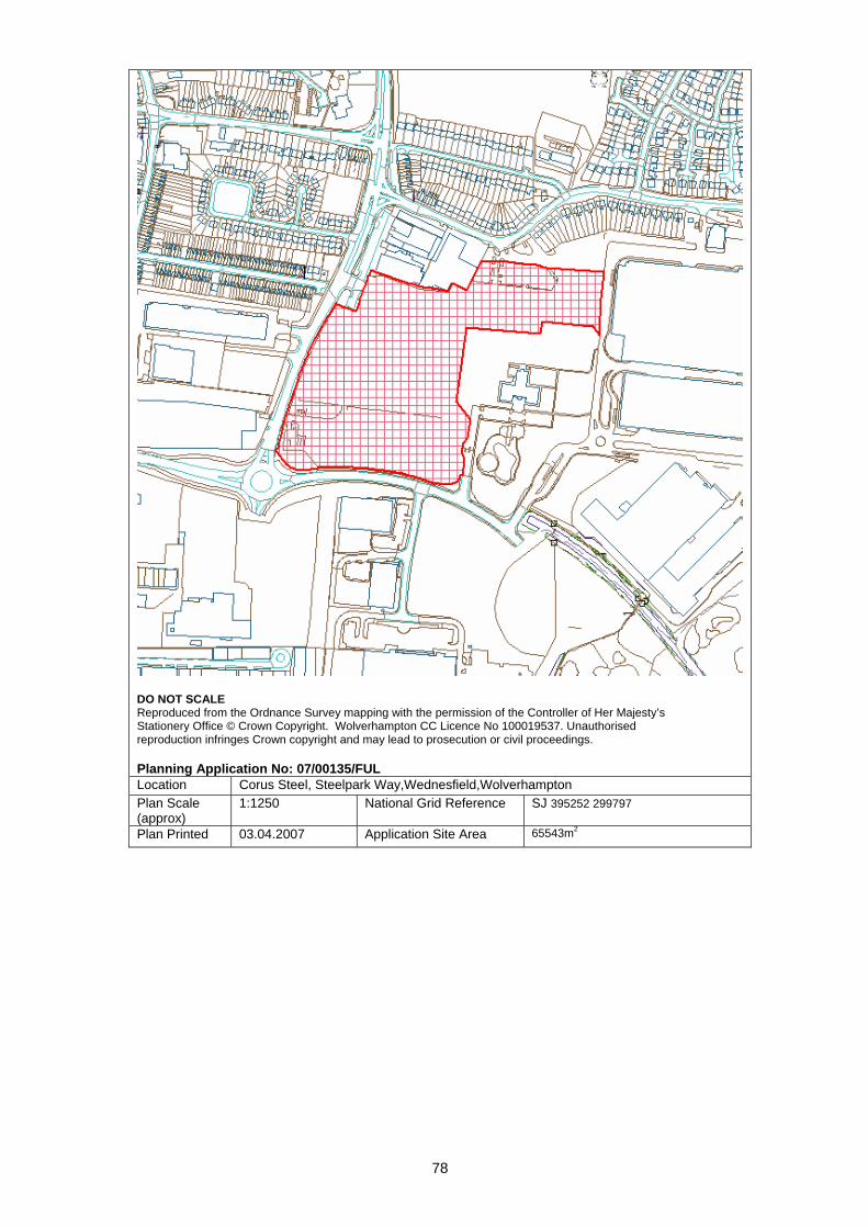
78
DO NOT SCALE Reproduced from the Ordnance Survey mapping with the permission of the Controller of Her Majesty’s Stationery Office © Crown Copyright. Wolverhampton CC Licence No 100019537. Unauthorised reproduction infringes Crown copyright and may lead to prosecution or civil proceedings. Planning Application No: 07/00135/FUL Location Corus Steel, Steelpark Way,Wednesfield,Wolverhampton Plan Scale (approx)
1:1250 National Grid Reference SJ 395252 299797
Plan Printed 03.04.2007 Application Site Area 65543m2
79
PLANNING COMMITTEE - 17-Apr-07
COMMITTEE REPORT: 1. Site Description 1.1 This 2.8ha application site comprises two relatively large industrial buildings along with
several smaller, ancillary ones. The site is located within a Defined Business Area as allocated in the adopted UDP. Access to the site is from Strawberry Lane, which runs along the northern boundary of the site. The proposed workshops would be located along the southern boundary of the site, adjacent to a railway embankment.
1.2 The accompanying design & access statement states that the units will be for the
expansion of an existing occupier of the estate who manufacture road signs. 2. Application details 2.1 The application seeks consent for a total of approximately 1464 sqm of new industrial
floor space. This would be divided between two units. 2.2 Unit 1, which is the larger of the two units, is approximately 42m long and 22m wide. It
would have a ridged roof with a maximum height of 8.5m. The internal layout would consist primarily of workshop space although there would also be an ancillary office space, a staff room and toilet facilities.
2.3 Unit 2, would be 36m long and 15 wide. It would also have a ridged roof with a
maximum height of 6.5m. The internal layout shows the building as consisting only of workshop space.
3. Constraints
Mining
APP NO: 07/00144/FUL WARD: Wednesfield South
DATE: 19-Feb-07 TARGET DATE: 21-May-07
RECEIVED: 29.01.2007 APP TYPE: Full Application SITE: Tractor Spares Industrial Estate, Strawberry Lane, Wednesfield,
Wolverhampton PROPOSAL: Erection of two workshops APPLICANT: Tractor Spares Ltd Tractor Spares Industrial Estate Strawberry Lane Wednesfield Wolverhampton West Midlands WV13 3RS
AGENT: Roger Latham 12 School Road Brewood Staffordshire ST19 9DS
80
4. Relevant policies
D1 - Design Quality D7 - Scale - Height D8 - Scale - Massing D9 - Appearance B1 - Economic Prosperity B4 - Expansion of Existing Businesses B5 - Design Standards for Employment Sites B9 - Defined Business Areas B11 - Ancillary Uses in Employment Areas Prem. AM12 - Parking and Servicing Provision AM15 - Road Safety and Personal Security
5. Publicity and neighbour notification 5.1 The application has been publicised by site and press notices and letters were sent to
neighbouring occupiers. No letters of objection have, so far, been received. 6. Internal Consultees 6.1 Transportation – they have no objections to the application as they believe there to
be sufficient existing and proposed parking to cope with any increase in demand created by the new application.
6.2 Planning Policy – the site is within an established Industrial Estate within a Defined
Business Area. Policy B9 of the adopted UDP seeks to restrict uses within these areas to ones which predominantly fall within Class B.
6.3 The construction of two additional B Class workshops is appropriate. 6.4 Environmental Services recommend conditions to control noise, dust and fumes and
to deal with any land contamination. There are two permitted processes within 250m of the site.
7. External Consultees 7.1 Network Rail – awaiting comments 8. Appraisal 8.1 The application seeks to extend the existing operations on the site. Policy B4:
Expansion of Existing Businesses states that “the extension or expansion of existing business will be permitted providing that the proposal can be satisfactorily accommodated within the existing site…subject to other UDP policies”.
8.2 The new workshops would have a fairly standard industrial design which matches
those of the existing units. However, the mass of the units would be broken up by the introduction of vehicular and pedestrian access points along the ‘main’ elevations.
8.3 Given that the units would be hidden from the public realm, the nature of the proposed
use and the nature of the surrounding area, there is no objection, in principle, to the proposal.
81
8.4 Further information, provided by the applicant, has stated that the scheme will create in the region of 40 new jobs and represent an investment of approximately £500,000. They hope to begin work on the scheme as soon as possible.
9. Recommendation Grant subject to condition to include:
• External materials • Contaminated land investigation and mitigation • Details of the treatment of grit, dust, fume, gas or mist and a method of
controlling noise/vibration/odour from any ventilation system • Details of noise and vibration control for plant/machinery • Cycle
Case Officer: Richard Pitt Telephone No.: 551674 Head of Development Control – Stephen Alexander
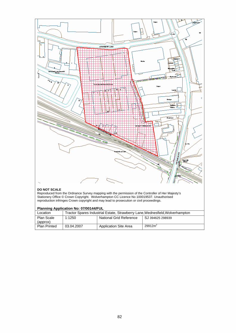
82
DO NOT SCALE Reproduced from the Ordnance Survey mapping with the permission of the Controller of Her Majesty’s Stationery Office © Crown Copyright. Wolverhampton CC Licence No 100019537. Unauthorised reproduction infringes Crown copyright and may lead to prosecution or civil proceedings. Planning Application No: 07/00144/FUL Location Tractor Spares Industrial Estate, Strawberry Lane,Wednesfield,Wolverhampton Plan Scale (approx)
1:1250 National Grid Reference SJ 394625 298939
Plan Printed 03.04.2007 Application Site Area 29912m2