working on the elizabeth river university of...
TRANSCRIPT

Working on the Elizabeth RiverPHOEBE CRISMAN
University of Virginia
A fragile and contaminated ecosystem, intense industrial activity, and human inhabitation struggle
to coexist along the Elizabeth River. In three intertwined projects, we have developed translatable
urban and architectural strategies interdependent with ecological regeneration, while demonstrat-
ing the didactic value of design in public environmental education. This design research model
operates at multiple scales, reaches out to diverse communities, plans for varying, overlapping
periods of time, and makes positive change in the world.
I have been working on the Elizabeth River in two
projects with Crisman1Petrus Architects and
one with students at the University of Virginia.
Together, they demonstrate an integrated analytic
and design methodology that reveals spatial,
environmental, and temporal connections and
operates across scales—from the Elizabeth River
watershed, to the Money Point district, to a
floating environmental field station. Each project
is in collaboration with the Elizabeth River Project
(ERP), a nonprofit, environmental organization
that has been working with government, business,
and community partners since 1992 to regenerate
the river’s ecology after more than a century of
industrial impact.1 The Elizabeth River is a highly
polluted tributary of the Chesapeake Bay joining
the cities of Norfolk, Portsmouth, Virginia Beach,
and Chesapeake, Virginia (Figure 1). Home to the
U.S. Navy’s Atlantic Fleet, the river is a major world
port with a devastated ecosystem that threatens
human health and well-being.These grant-funded
initiatives were not responses to international com-
petitions or paying clients but emerged from the idea
of a grassroots architectural practice that identifies
opportunities and acts. Ultimately, each project
develops a proactive model of design research in
both university-based service learning and profes-
sional practice.
Money Point Sustainability StudyMoney Point is a 330-acre contaminated and
neglected peninsula on the Elizabeth River in
Chesapeake, Virginia. A tight-knit African American
residential community coexists with scrapyards and
petroleum businesses (Figure 2). In 1967, a cata-
strophic fire released vast quantities of creosote
that resulted in high levels of toxins in soil,
groundwater, and river sediment. The City of
Chesapeake had given up on Money Point as
a polluted industrial zone not worthy of consider-
ation as a place, while disenfranchised residents
lived with poor city services and tragic environ-
mental conditions. When funds finally became
available to clean up the toxic river sediment in
2004, a task force of community residents and
businesses, nonprofit organizations, academics,
design professionals, and federal, state, and local
agencies was formed to envision a 10-year plan.
Together, we engaged in a two-year public
process to imagine and implement an environ-
mentally, socially, and economically sustaining
future for this non-place. As part of my larger
investigation into overlooked and environmentally
degraded urban conditions, this design research
articulated four strategies for operating on
these sites: creating a role for design, establishing
vital public/private alliances, collaborating with
diverse disciplines, and employing methods of
analysis and design that reveal unseen connections
over time.1. Southern Branch of the Elizabeth River with Learning Barge route. (Image
by the Learning Barge studio.)
Journal of Architectural Education,
pp. 84–91 ª 2007 ACSA
Working on the Elizabeth River 84

The process fostered a sense of shared mission
and stewardship, the plan received a 2007 Envi-
ronmental Design Research Association (EDRA)/
Places Planning Award, and nearly $15 million has
been secured for implementation. Crisman1Petrus’
design proposed an integrated sidewalk and
bioswale storm water system using native plants
to filter runoff, create wildlife habitat, and make
walking safe and pleasant (Figure 3). Businesses
donated land for community spaces, riparian buf-
fers, and wetlands to sustain native wildlife, and an
urban forest of 1,200 trees has been planted to
clean up toxic soils through phytoremediation.
Currently, the Elizabeth River and her shores are
largely unseen visually and cognitively by area
residents, since industry often forms an impene-
trable physical barrier between the neighborhoods
and the riverfront (Figure 4). In response to this
condition, we conceived of a nomadic site—the
Learning Barge—that would provide education and
public access to the
inaccessible river.
The Learning BargeSince January 2006, I have led an interdisciplinary
team of University of Virginia students to research,
design, and build a self-sustaining classroom that
demonstrates the didactic value of design for
environmental education (Figures 5 and 6). Unlike
field stations located in pristine ‘‘nature,’’ the
nomadic Learning Barge will seek out marginalized
sites. As ERP cleans the river, ‘‘One Creek at
a Time,’’ the Learning Barge will be a work platform
to stage operations and provide interactive K-16
and adult education about the tidal estuary eco-
system and ongoing sediment remediation, wetland
and oyster restoration efforts. The Barge’s mobility
is an architectural strategy that supports ERP’s
approach of initiating several smaller projects that
proceed over time, rather than singular, big-budget
remediation projects. The Barge will enter the
public realm as a highly visible symbolic element
revealing the common purpose that unites resto-
ration sites along the river.
The Learning Barge has been designed to
teach through example by harnessing energy from
sun and wind, collecting rainwater, filtering gray
water in a contained bed wetland using native
plants, and using recycled materials and green
technologies (Figure 7). ERP will own and operate
the Barge, which will support environmental
research, public outreach, and education to the
large population of economically disadvantaged
2. View from the cement silos at Money Point. (Photo by Phoebe
Crisman.)
3. Analysis of existing transportation infrastructure and impervious
surfaces at Money Point (left). Proposed biological overlay with
integrated water and habitat networks (right). (Crisman1Petrus
Architects.)
3
2
85 CRISMAN

and educationally underperforming children who
live in the Elizabeth River watershed. The project
scope includes the barge and its revealed systems
and site-specific curriculum, the expanded context
of the river including the sites that the barge
engages, and the national significance of a new
model for addressing environmental contamination
at the scale of the region.
ProcessSupported by grants from the U.S. Environmental
Protection Agency (EPA), the Virginia Environ-
mental Endowment, and private foundations, the
Learning Barge project was developed in several
University of Virginia courses that employed an
intertwined research and design methodology. The
first course, a Spring 2006 interdisciplinary grad-
uate studio, included four cycles of paired research
and design documented in a 170-page studio
book. Research areas included estuarine ecology,
contamination analysis, regeneration strategies,
wind and solar power, gray water filtration pro-
cesses, and onboard planting. Specific mooring
sites were identified by talking with people who
know the river, creating a many-layered GIS-based
map, making reconnaissance trips by boat, and
scanning the terrain with commercial software. We
also contended with the poetic challenge of
building upon water, as well as the structural,
ecological, aesthetic, and phenomenological
implications. Our conclusions that semester were
that the river offers both a site and a purpose and,
although the river is in desperate need of repair,
the Learning Barge teaches that the smallest
efforts to respond to this enormous condition
could affect exponential reverberations in the
future river landscape. Graduate and undergradu-
ate architecture students in the Fall 2006 tech-
nology seminar developed the schematic design.
The Spring 2007 studio, again composed of
graduate and undergraduate architecture students,
finished detailing and executing the first of two
construction phases (Figure 10). Students in the
4. No Entrance to the waterfront. (Photo by Phoebe Crisman.) 5. Storytelling steps make a place for gathering. (Image by the
Learning Barge studio.)
6. Learning Barge model with solar and wind energy systems, planted filtration basins, and classroom. (Image by the Learning Barge studio.)
Working on the Elizabeth River 86
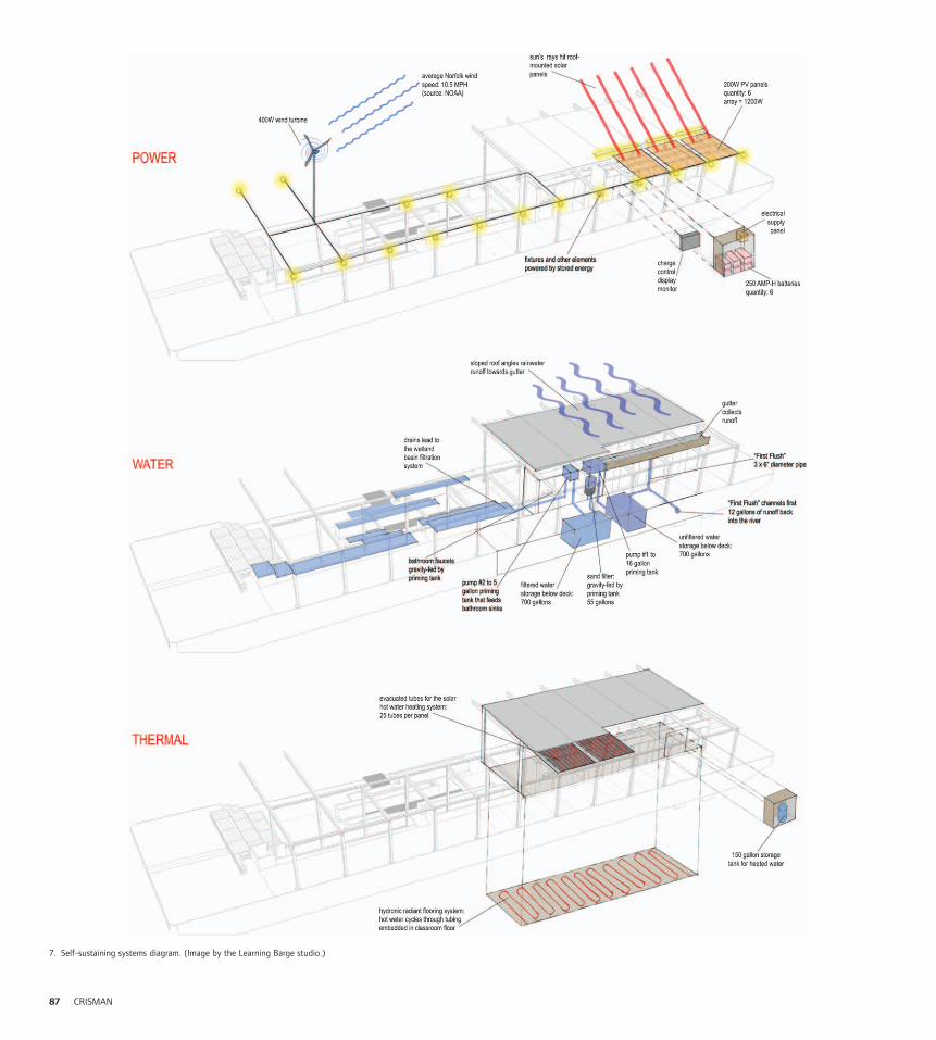
7. Self-sustaining systems diagram. (Image by the Learning Barge studio.)
87 CRISMAN
Spring 2008 studio will complete the final construc-
tion phase and assemble the prefabricated compo-
nents at a Norfolk shipyard that summer.
EducationAlong with the ERP, we partnered with the Ches-
apeake Bay Foundation, National Oceanic and
Atmospheric Association (NOAA), and three school
districts to articulate the program and onboard
curriculum. The Use Plan estimates that this semi-
nomadic field station will touch the lives of more
than 19,000 people each year via school field trips,
university research, teacher training, and volunteer
wetland plantings, public workshops, and major
events. Architecture and Landscape Architecture
students collaborated with Engineering and Edu-
cation students to visualize the occupation of the
barge and create a curriculum embodied within the
Barge itself. The equation Curriculum ¼ Site 1
Module 1 Sequence yielded a specific, yet flexible
curriculum that responds to the qualities of specific
sites, Standards of Learning modules, and temporal
cycles. A layered navigation drawing maps the
Barge’s movement based on the curricular oppor-
tunities of our chosen sites (Figure 11). Six local
teachers are now writing lesson plans based on this
place/study area/time strategy. Through education
and direct experience, the Learning Barge seeks to
inspire stewards of the Elizabeth’s cultural and
environmental ecologies. Visitors will learn about
wind and solar energy, rainwater collection and fil-
tration systems, and other green building practices
that can be translated to their own homes. At the
same time, the barge facilitates the tangible habitat
restoration of the river through wetland plantings,
the cultivation of new oyster reefs, soil and water
testing, and other regenerative efforts.
Sustainable Guidelines for DegradedUrban WatershedsIn a third collaboration with ERP and several public
and private partners, Crisman1Petrus Architects
are creating guidelines and three demonstration
8. Upper deck with steel armature frame. (Image by the Learning
Barge studio.)
9. Classroom is defined by a thick armature wall and opens to the
onboard wetland beyond. (Image by the Learning Barge studio.)
10. UVA students building in March 2007. (Image by the Learning
Barge studio.)
11. Navigation drawing charts Barge’s movement based on curricular
opportunities at each site. (Image by the Learning Barge studio.)
12. Learning Barge exhibit at the Charlottesville Community Design
Center (February 2007). (Image by the Learning Barge studio.)
13. Sections depicting barge hull profile and river landscape with
industrial artifacts. (Image by the Learning Barge studio.)
8
9
10
Working on the Elizabeth River 88

projects for the sustainable (re)development of the
Elizabeth River’s uplands. Ranging from riparian
buffer and bioswale networks to green building
construction techniques, our objectives, data,
and methods will be incorporated into a Regional
Action Plan for reducing toxins in the Elizabeth
River and the Chesapeake Bay (Figures 15 and 16).
Funded by the EPA, our study will be an educa-
tional device and model to encourage voluntary
industrial stewardship in other urban watersheds
throughout the nation.
Design as ScholarshipThese interconnected design research projects
along the Elizabeth River demonstrate a method of
generating architectural knowledge through design
and subsequent dissemination. In each case, the
design process offered an important method of
formulating ideas about the discipline of architec-
ture, while written speculation on ideas that can
generate physical form was equally critical. For
instance, this essay and an earlier one entitled
‘‘Money Point: A Model of Urban Practice’’2
provided the opportunity to reflect on design
research in process. Writing and drawing are
mutually beneficial. Adjudication through blind,
peer-reviewed awards and publications is a crucial
aspect of this approach (Figure 17). The Learning
Barge project has received numerous national
awards, including the 2006 Student Collaborative
Design Award from the American Society of Land-
scape Architects, a 2007 NCARB Prize for the Cre-
ative Integration of Practice and Education in the
Academy by the National Council of Architectural
Registration Boards, a 2007 P3 Sustainability
Award from the U.S. EPA, and the 2007 Youth
Council for Sustainable Science and Technology
Design Award from the American Institute of
Chemical Engineers. What is most gratifying in this
list is the broad range of disciplines and professional12
11
13
89 CRISMAN

organizations that have acknowledged both the
breadth and the depth of this design research.
ConclusionThe Learning Barge initiative, Money Point
Sustainability Study, and Elizabeth River Water-
shed projects represent the future of urbanism
and architecture toward greater synthesis with
environment and ecology—achieved through
integration, both in phases of research and
design, and a way of working across scales.
Gerald McCarthy, Director of the Virginia Envi-
ronmental Endowment, described the Learning
Barge initiative as ‘‘exactly the kind of scholar-
ship and research that makes beneficial change
happen in the real world. Students learn, faculty
develop, and communities benefit.’’ While dem-
onstrating the didactic value of architecture to
public environmental education and manifesting
an ethical commitment to the public realm and
environmental stewardship, these intertwined
projects establish a proactive model of design
scholarship.
14
17
17. UVA students assembling Learning Barge components for
the EPA P3 Sustainability Competition on the Mall in Washington,
DC in April 2007. (Photo by Phoebe Crisman.)
16. Design for integrated green building and site systems the
Scott’s Creek demonstration project for the Urban Watersheds
Study (Drawing by Crisman1Petrus Architects.)
15. Elizabeth River watershed plan. (Image by the Learning Barge
studio.)
14. Roof plan of the Learning Barge with rainwater collection
system, photovoltaic panels, evacuated tube solar hot water panels,
and planted filtration basins. (Image by the Learning Barge studio.)
1615
Working on the Elizabeth River 90

The Learning Barge: UVA Student TeamErin Binney, Laura Bandara, Kim Barnett, Neil
Budzinski, Ama Cobbina, Andrew Daley, Eliza Davis,
Kevin Day, Lauren DiBianca, Adam Donovan, Erin
Dorr, Zoe Edgecomb, Ayman El-Barasi, Matt Hural,
Kate Lafsky, Matt McClelland, Kelly McConnaha,
Molly O’Donnell, Farhad Omar, Katherine
Pabody, James Pint, Phoebe Richbourg, Jayme
Schwartzberg, Clark Tate, Nora White, and Danielle
Willkens. Project Director: Phoebe Crisman.
Community PartnersERP, Chesapeake Bay Foundation, Public School
Districts of Portsmouth, Chesapeake and Virginia
Beach, and NOAA Chesapeake Bay Office.
ConsultantsEric Matherne, Michael Petrus, Dennis Moler, and
Biohabitats, Inc.
SponsorsVirginia Environmental Endowment, U.S. EPA,
Hanbury Evans Wright Vlattus 1 Company, Lowe’s
Educational & Charitable Foundation, and the
National Council of Architectural Registration
Boards.
Money Point Sustainability StudyCrisman1Petrus Architects.
Sustainable Guidelines for DegradedUrban WatershedsCrisman1Petrus Architects.
Notes
1. For a complete description of the mission and proposed actions, see
ERP, Restoration and Conservation: A Watershed Action Plan (2002). Also
see http://www.elizabethriver.org.
2. Phoebe Crisman, ‘‘Money Point: A Model of Urban Practice,’’ in Renee
Cheng and Patrick Tripeny, eds., Getting Real. Design Ethos Now.
(Washington, DC: ACSA Press, 2005), pp. 251–59.
18
19
18. Gangway approach to the Learning Barge. (Image by the
Learning Barge studio.)
19. Child testing a manual pump that transfers filtered rainwater
to a tank above the Learning Barge’s sinks. The clear tank is laser
cut with gallon marks so that children see the water level drop as
they wash their hands and experience the energy necessary to pump
the water. (Photo by Phoebe Crisman.)
91 CRISMAN