working paper potential schemes (volume 1 report)
TRANSCRIPT

Job No: CE344
File:/docs/O’Briens Tributary.doc
Date: April 2015
Rev No: 4.0
Author: BWL
Principal: BWL
WEDDIN SHIRE COUNCIL
O’BRIEN TRIBUTARY DRAINAGE IMPROVEMENTS
WORKING PAPER POTENTIAL SCHEMES
(VOLUME 1 – REPORT)
APRIL 2015
Prepared by: Lyall & Associates Consulting Water Engineers Level 1, 26 Ridge Street North Sydney NSW 2060 Tel: (02) 9929 4466 Fax: (02) 9929 4458 Email: [email protected]

Weddin Shire Council O’Brien Tributary Drainage Improvements
O’Brien Tributary.doc i Lyall & Associates
April, 2015 Rev. 4.0 Consulting Water Engineers
TABLE OF CONTENTS Page No
S1 KEY FINDINGS OF THE WORKING PAPER ....................................................................... S1
S1.1 Scope of Investigation ............................................................................................... S1 S1.2 Key Findings ............................................................................................................. S1
1 INTRODUCTION ...................................................................................................................... 1
1.1 Background ................................................................................................................. 1 1.2 Drainage Upgrade Options Considered in the Working Paper ................................... 2 1.3 Scope of Working Paper ............................................................................................. 3 1.4 The O’Brien Tributary Catchment and Drainage System ........................................... 3 1.5 Results of Flood Modelling – Present Day Conditions ................................................ 4
1.6 Impacts of Flooding on Urban Development in the Warraderry Street Area .............. 5 1.7 History of Flooding at the Oliver Court Development ................................................. 5
2 DATA COLLECTION AND FORMULATION OF POTENTIAL SCHEMES ............................ 7
2.1 Site Surveys ................................................................................................................ 7 2.2 Survey of Potential Retarding Basin ........................................................................... 7 2.3 Alternative Schemes for Drainage Improvements ...................................................... 7
2.4 Summary of Initial Screening of Schemes ................................................................ 11
3 HYDROLOGIC AND HYDRAULIC MODELLING ................................................................. 13
3.1 Hydrologic Modelling Approach ............................................................................... 13
3.2 Present Day Conditions ............................................................................................ 13
3.3 Retarding Basin at Brickfield Road ........................................................................... 13 3.3.1 Basin Objectives .......................................................................................... 13
3.4 Results of Hydrologic Modelling of the Retarding Basin ........................................... 13
3.5 Hydraulic Modelling of Post - Retarding Basin Conditions (Scheme 4) .................... 14 3.6 Reduction in Flooding in Warraderry Street Area - Post-Retarding Basin ................ 15
4 DESIGN CONCEPT FOR RETARDING BASIN (SCHEME 4) ............................................. 16
4.1 Layout of Basin and Indicative Cost .......................................................................... 16 4.1.1 Layout .......................................................................................................... 16
4.1.2 Indicative Cost of Basin ............................................................................... 16
5 CATERING FOR RESIDUAL FLOWS IN OLIVER COURT AND WARRADERRY STREET17
5.1 Scheme 5 – Retarding Basin Plus Swale and Pipeline in Warraderry Street ........... 17 5.2 Scheme 5A – Retarding Basin Plus Clearing Obstructions to Flow in 30 Warraderry
Street and Pipeline in Warraderry Street ............................................................................... 18 5.3 Scheme 6 – Retarding Basin + Pipe Scheme 3B (Lot 41 Through 30 Warraderry
Street to Camp Street) ........................................................................................................... 18 5.4 Scheme 7 – Retarding Basin + Pipeline from Lot 41 Through Oliver Court to Camp
Street ……………………………………………………………………………………………….20
6 ECONOMIC ANALYSIS OF SCHEMES ............................................................................... 21
6.1 Estimated Flood Damages ........................................................................................ 21 6.2 Present Worth Value of Scheme Benefits ................................................................ 21
6.3 Indicative Cost-Benefit Analysis ................................................................................ 22
Cont'd Over

Weddin Shire Council O’Brien Tributary Drainage Improvements
O’Brien Tributary.doc ii Lyall & Associates
April, 2015 Rev. 4.0 Consulting Water Engineers
7 SUMMARY AND FINDINGS ................................................................................................. 24
7.1 Summary ................................................................................................................... 24 7.2 Findings ..................................................................................................................... 24
7.2.1 Piped Schemes 1 to 3B ............................................................................... 24 7.2.2 Retarding Basin in Isolation (Scheme 4) ..................................................... 25 7.2.3 Scheme 5 - Retarding Basin + Drainage Swale in 30 Warraderry Street +
Pipeline to Camp Street ............................................................................................ 25 7.2.4 Scheme 5A - Retarding Basin + Easement in 30 Warraderry Street + Pipeline
in Warraderry Street to Camp Street ........................................................................ 25 7.2.5 Scheme 6 - Retarding Basin + Pipeline Through 30 Warraderry Street to
Camp Street .............................................................................................................. 25 7.2.6 Scheme 7 - Retarding Basin + Pipeline Through Oliver Court to Camp Street
26
7.3 Recommendations for Consideration by Floodplain Management Committee ........ 26 7.4 Proceeding to Detailed Design ................................................................................. 26
ANNEXURES (BOUND IN VOLUME 1)
A. PHOTOGRAPHS OF THE STUDY AREA B. INDICATIVE COSTS OF SCHEMES

Weddin Shire Council O’Brien Tributary Drainage Improvements
O’Brien Tributary.doc iii Lyall & Associates
April, 2015 Rev. 4.0 Consulting Water Engineers
LIST OF FIGURES (BOUND IN VOLUME 2)
1.1 Location Plan and Services in Warraderry Street
1.2 Pipeline Through Oliver Court (Scheme 1)
1.3 November 2010 Flooding in Oliver Court
1.4 Flooding at Oliver Court and Warraderry Street Present Day Conditions – 100 Year ARI
2.1 Site Survey in the Warraderry Street Area
2.2 Site Survey in the Brickfield Road Area
2.3 Potential Drainage Improvement Schemes (Sheets 1 to 3)
2.4 Longitudinal Section Scheme 1
2.5 Longitudinal Section Scheme 3B
2.6 Longitudinal Section Pipeline in Warraderry Street (Part of Scheme 5)
2.7 Longitudinal Section Pipeline Lot 41 via Oliver Court to Camp Street (Part of Scheme 7)
3.1 DRAINS Model Sub-Catchment Layout
3.2 Discharge Hydrographs in the Drainage System
3.3 Pre- and Post-Basin Discharge Hydrographs
3.4 Flooding at Oliver Court and Warraderry Street. Scheme 4 (Post-Basin) Conditions
– 100 year ARI
4.1 Plan of Potential Flood Retarding Basin Brickfield Road
4.2 Cross Section of Flood Retarding Basin Brickfield Road
5.1 Flooding at Oliver Court and Warraderry Street – Scheme 5 (Including Retarding Basin)
– 100 year ARI
5.2 Flooding at Oliver Court and Warraderry Street – Scheme 6 (Including Retarding Basin)
– 100 year ARI
5.3 Flooding at Oliver Court and Warraderry Street – Scheme 7 (Including Retarding Basin)
– 100 year ARI

Weddin Shire Council O’Brien Tributary Drainage Improvements
O’Brien Tributary.doc S1 Lyall & Associates
April, 2015 Rev. 4.0 Consulting Water Engineers
S1 KEY FINDINGS OF THE WORKING PAPER
S1.1 Scope of Investigation
1. This Working Paper reviewed options for mitigating flooding in residential properties in Oliver
Court and Warraderry Street due to overland flows generated by storms on the O’Brien
Tributary catchment. The area is located in a “floodway”, according to the hydraulic
categorisation carried out in the Emu Creek Floodplain Risk Management Study. Figure 1.4
shows the results of hydraulic modelling and Table 1.1 shows the distribution of peak flows
under present day conditions for flood events ranging between 5 and 100 year Average
Recurrence Interval (ARI). At the 100 year ARI, two residential properties on the western side
of Warraderry Street, as well as all of the individual units in Oliver Court (No. 26 –
28 Warraderry Street) and the next door residence in 30 Warraderry Street would be flooded
to above–floor level. It is likely that residential development on the O’Brien Tributary overland
flow path downstream of Warraderry Street in the East Street area would also be flooded,
although without the benefit of detailed site survey it is not possible to provide quantitative
information on the number of properties affected.
2. The options considered comprised various piped schemes in the area between Lot 41 in
O’Brien Street and the intersection of Warraderry Street and Camp Street (ref. Figure 2.3,
Sheets 1 to 5). The potential reduction in downstream flows and depths of flooding achieved
by the construction of a retarding basin on the eastern side of Brickfield Road was also
assessed. Hydraulic modelling was undertaken using the TUFLOW two-dimensional
modelling software of present day and post-scheme conditions. Indicative cost estimates
were prepared for several piped options, as well as for the retarding basin (ref. Annexure B).
3. The economic benefits of the feasible schemes were computed. These benefits are
represented by the reduction in flood damages to the residential developments in Warraderry
Street, compared with present day conditions. Flood damages were assessed using
recommended Office of Environment and Heritage (OEH) procedures and converted to
present worth values using discount rates nominated in NSW Government Guidelines for the
economic analysis of infrastructure projects. Indicative cost-benefit analysis was then carried.
These results are shown in Tables 6.1 to 6.5.
S1.2 Key Findings
4. Peak flows generated by the catchment during major storms are too large to be conveyed by
pipelines through Oliver Court and along Warraderry Street. The feasible maximum pipe size
is limited to between 900 mm and 1200 mm, and is controlled by the available gradient and
minimum cover considerations, as well as by the presence of sewers in Warraderry Street.
Consequently, upgrading the drainage system by pipelines in isolation is not effective in
solving existing flooding problems in residential developments in the Warraderry Street area
and is not recommended. The reduction in downstream peak flows by the construction of a
retarding basin in the catchment headwaters is required for pipelines to be effective in
mitigating overland flows at Warraderry Street.
5. A large reduction in peak flows arriving at the eastern boundary of Oliver Court could be
achieved by construction of the basin at Brickfield Road (Scheme 4). The basin, in
conjunction with a drainage swale in the existing southern easement of Oliver Court would
convey flows up to 5 year ARI across Oliver Court, with a small residual flow over the
Weddin Shire Council O’Brien Tributary Drainage Improvements
O’Brien Tributary.doc S2 Lyall & Associates
April, 2015 Rev. 4.0 Consulting Water Engineers
driveway, extending into 30 Warraderry Street. Figure 3.4 shows the results of hydraulic
modelling Scheme 4 and Table 3.1 shows the distribution of peak flows under post-basin
conditions for the range of flood events. (Table S2 over page summarises the reduction in
flows achieved by the various schemes for the 100 year ARI flood). Construction of the basin
would eliminate above-floor inundation in properties on the western side of Warraderry Street
under 100 year ARI conditions, although the properties would continue to experience shallow
overland flow at that frequency. One of the units in Oliver Court may be subject to shallow
above-floor flooding of up to 80 mm, which could be mitigated by some minor flood proofing
works at the entrance to the property. The indicative cost of the retarding basin is $716,000,
including an allowance of $320,000 for the purchase of land in the proposed storage area.
The retarding basin is a necessary component of the drainage improvements scheme for
O’Brien Tributary.
6. Although the retarding basin will achieve a major reduction in downstream flows as far as
Camp Street, in the event of a 100 year ARI flood supplementary measures would be
required to capture “residual” (i.e. post-basin) overland flows continuing to traverse Oliver
Court, 30 Warraderry Street and residential properties in Warraderry Street.
Capture of the residual overland flow in a drainage swale in 30 Warraderry Street, together
with piping northwards along Warraderry Street to the intersection with Camp Street, would
reduce overland flow in the street. This scheme is denoted Scheme 5 and would require the
voluntary acquisition of the 30 Warraderry Street property by Council. Figure 5.1 shows the
results of hydraulic modelling this scheme and Table 5.1 shows the distribution of peak flows.
The indicative cost of the Scheme 5 swale and downstream pipeline is $784,000. Together
with the basin, the total cost would be $1,500,000. Scheme 5 would eliminate above-floor
inundation in properties on the western side of Warraderry Street under 100 year ARI
conditions, although several of the properties would continue to experience shallow overland
flow at that frequency. No units in Oliver Court would be subject to above-floor flooding1.
7. Other schemes have also been considered for catering for residual flows in the event that the
voluntary purchase required for Scheme 5 does not proceed. They are denoted
Schemes 5A, 6 and 7 and are summarised in Tables S1 and S2.
8. Scheme 5A would replace Scheme 5’s swale in 30 Warraderry Street by an easement for
drainage along the northern side of the property which, together with the existing easement in
Oliver Court, would be cleared of obstructions to flow (including removal of the existing
diversion bank in 30 Warraderry Street – ref. Figure 2.1) to allow residual flows to be
conveyed overland to Warraderry Street and then piped to Camp Street. It is estimated to
cost $1,246,000, including the cost of the retarding basin. Scheme 5A has not been
hydraulically modelled, but patterns of flow would be similar to those shown on Figure 5.1 for
Scheme 5.
9. Scheme 6 involves construction of a 900 mm diameter pipeline from Lot 41 in O’Brien Street
through 30 Warraderry Street to Camp Street, following the same route as Scheme 3B
1 The voluntary purchase and removal of flood prone residential property from floodway areas (as required for
Scheme 5), is supported by NSW Government flood policy, as set out in the Floodplain Development Manual.
Scheme 5 was incorporated in the scope of work for this report by the Technical Committee for the project.
However, Council has decided at this time not to proceed with negotiations for voluntary purchase of the property
in 30 Warraderry Street. This has led to the consideration of alternative Schemes 5A, 6 and 7.

Weddin Shire Council O’Brien Tributary Drainage Improvements
O’Brien Tributary.doc S3 Lyall & Associates
April, 2015 Rev. 4.0 Consulting Water Engineers
(Figure 2.3, Sheet 4). It would reduce the portion of residual flow which would be conveyed
overland across properties downstream of Lot 41. Results of hydraulic modelling of
Scheme 6 are shown on Figure 5.2 and Table 5.2 shows the distribution of peak flows. It is
estimated to cost $1,619,000, including the cost of the retarding basin.
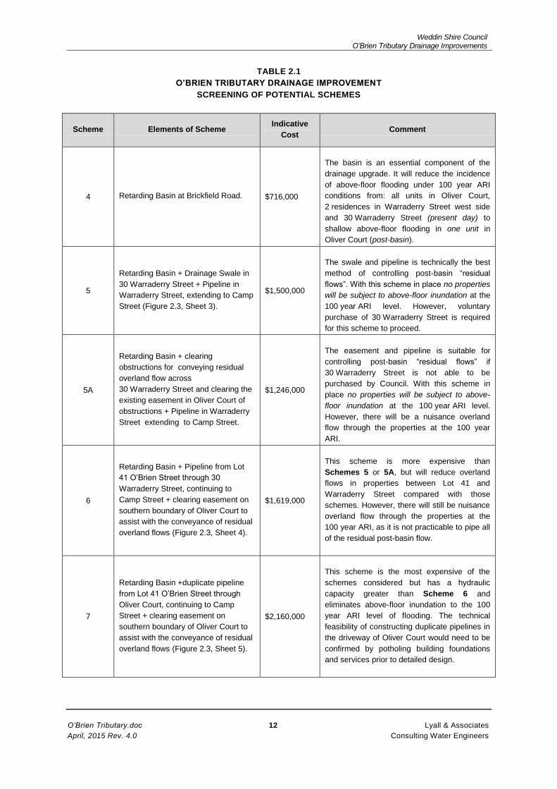
10. Scheme 7 is the most expensive of the schemes for catering for residual flows and involves
duplicate pipelines from Lot 41 through Oliver Court to Camp Street (Figure 2.5, Sheet 5).
Results of hydraulic modelling of Scheme 7 are shown on Figure 5.3 and Table 5.3 shows
the distribution of peak flows. It is estimated to cost $2,160,000, including the cost of the
retarding basin. Scheme 7 requires duplicate pipelines through the Oliver Court property.
Potholing to locate services and building foundations is required to confirm there is sufficient
room for laying the pipelines.
S1.3 Recommendations for Consideration by the Floodplain Management Committee
11. The retarding basin (Scheme 4) is an essential component of the drainage improvements for
O’Brien Tributary and will achieve a substantial reduction in downstream flooding, particularly
for the minor (5 year ARI) and medium (20 year ARI) floods. Proceeding to the geotechnical
investigation and design phases for the basin is recommended at the first stage of the
Drainage Improvements Project.
12. The decision whether or not to adopt the drainage swale through 30 Warraderry Street and
pipeline in Warraderry Street for controlling residual flows (i.e. Scheme 5), would depend
upon negotiations with the owner of 30 Warraderry Street, as purchase and clearing of this
property is required. In the event that voluntary purchase does not proceed, Scheme 5A
could be considered, but requires an easement for conveying overland flow through the
30 Warraderry Street property as well as the clearing of obstructions to flow in that property
and the existing easement in Oliver Court.
13. Alternatively, Scheme 6 which comprises the retarding basin plus the single 900 mm
diameter pipeline associated with Scheme 3B could be considered, but at greater cost than
Scheme 5A. This scheme reduces overland flows through properties downstream of Lot 41
O’Brien Street as far as Camp Street but not by the same amount as Scheme 7 below.
14. Scheme 7 (which includes the duplicate pipeline from Lot 41, through Oliver Court to Camp
Street) is the most expensive scheme, but has the highest hydraulic capacity and is the best
option for mitigating overland flooding from Brickfield Road to Camp Street. The technical
feasibility of constructing dual pipelines through the restricted space available in Oliver Court
would need to be confirmed by accurate location of the building foundations and services
prior to commencing detailed design.
Weddin Shire Council O’Brien Tributary Drainage Improvements
O’Brien Tributary.doc S4 Lyall & Associates
April, 2015 Rev. 4.0 Consulting Water Engineers
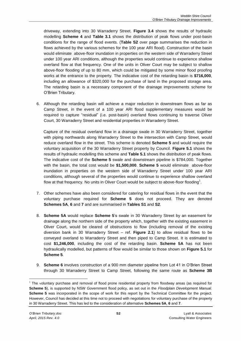
TABLE S1
SUMMARY OF POTENTIAL SCHEMES
Scheme
Elements of Scheme Indicative Cost Comment Report Reference
4
Retarding Basin at Brickfield Road. $716,000
The basin is an essential component of the drainage upgrade. It will reduce the incidence of
above-floor flooding under 100 year ARI conditions from: all units in Oliver Court, 2 residences
in Warraderry Street west side and 30 Warraderry Street (present day); to: shallow above-floor
flooding in one unit in Oliver Court (post-basin).
Chapters 3 and 4.
Figure 3.4 (hydraulic modelling).
Figures 4.1, 4.2 (layout drawings).
Table 6.1 (economic analysis).
Table 3.1 (peak flows)
5
Retarding Basin + Drainage Swale in
30 Warraderry Street + Pipeline in Warraderry
Street, extending to Camp Street.
$1,500,000
The swale and pipeline is the best technical method of controlling post-basin “residual flows”.
With this scheme in place no properties will be subject to above-floor inundation at the
100 year ARI level. However, voluntary purchase of 30 Warraderry Street is required.
Section 5.1.
Figure 5.1 (hydraulic modelling).
Figure 2.3, Sheet 3 and Figure 2.6 (pipeline layout).
Table 6.2 (economic analysis).
Table 5.1 (peak flows).
5A
Retarding Basin + Drainage Easement for
conveying residual overland flow across
30 Warraderry Street; clearing the easement
and existing easement in Oliver Court of
obstructions to flow + Pipeline in Warraderry
Street, extending to Camp Street.
$1,246,000
This easement and pipeline scheme is suitable for controlling post-basin “residual flows” in the
event that Scheme 5 does not proceed. With this scheme in place no properties will be subject
to above-floor inundation at the 100 year ARI level. However, there will be a nuisance overland
flow through the properties at the 100 year ARI.
Section 5.2.
Scheme not modelled hydraulically, but would perform
similarly to Scheme 5.
Pipeline in Warraderry Street as for Scheme 5.
Table 6.3 (economic analysis).
6
Retarding Basin + Pipeline from Lot 41 O’Brien
Street through 30 Warraderry Street, continuing
to Camp Street + clearing easement on
southern boundary of Oliver Court to assist with
the conveyance of residual overland flows.
$1,619,000
This scheme is more expensive than Schemes 5 or 5A, but will reduce overland flows in
properties between Lot 41 and Warraderry Street compared with those schemes. However,
there will still be nuisance overland flow through the properties at the 100 year ARI, as it is not
practicable to pipe all of the residual flow under post-basin conditions.
Section 5.3.
Figure 5.2 (hydraulic modelling).
Pipeline as for Scheme 3B (Figure 2.3, Sheet 4).
Table 6.4 (economic analysis).
Table 5.2 (peak flows).
7
Retarding Basin + Pipeline from Lot 41 O’Brien
Street through Oliver Court, continuing to
Camp Street + clearing easement on southern
boundary of Oliver Court to assist with the
conveyance of residual overland flows.
$2,160,000
This scheme is the most expensive of the schemes considered. The duplicate pipeline would
convey post-basin flows up to 20 year ARI across through Oliver Court. Residual overland
flows between Lot 41 and Camp Street are less than for the other schemes. However, the
technical feasibility of constructing duplicate pipelines in the driveway of Oliver would need to
be confirmed by accurate location of building foundations and services prior to commencing
detailed design.
Section 5.4.
Pipeline extends from Lot 41 O’Brien Street to Camp Street
through Oliver Court
Figure 2.3, Sheet 5 and Figure 2.7 (pipeline layout).
Table 6.5 (economic analysis).
Table 5.3 (peak flows).

Weddin Shire Council O’Brien Tributary Drainage Improvements
O’Brien Tributary.doc S5 Lyall & Associates
April, 2015 Rev. 4.0 Consulting Water Engineers
TABLE S2
PEAK FLOWS OLIVER COURT AND WARRADERRY STREET AREA
100 YEAR ARI
(m3/s)
ID(1) Location Present Day
Conditions(1) Scheme 4(1) Scheme 5(1) Scheme 6(1) Scheme 7(1)
A Flow Through Lot 41
O’Brien St. 8.9 3.4 3.4 3.4 3.4
B
Southern Easement
26-28 and 30
Warraderry St.
4.5 1.7 3.4 2.0 0.7
C Driveway 26-28
Warraderry St. 2.0 1.0 0 0.0 0.4
D Northern Easement
26-28 Warrderry St. 1.8 0.5 0 0.0 0.2
E
Surcharge through 27,
29, 31, 33 and 35
Warraderry St.
8.2 3.9 3.2 2.9 2.3
F
Surcharge through Lot
2 and west along
Camp St.
0.4 0.2 0.8 1.1 2.0
G
(Piped
Flow)
Flow in existing 900
RCP in Camp St. 1.9 1.8 2.0 1.9 1.9
H
(Piped
Flow)
Flow in new pipe in
Warraderry St - - 1.2 1.2 2.0
Notes:
(1) Refer Figures 1.4, 3.4 and 5.1 to 5.3 for Locations and results of hydraulic modelling.

Weddin Shire Council O’Brien Tributary Drainage Improvements
O’Brien Tributary.doc 1 Lyall & Associates
April, 2015 Rev. 4.0 Consulting Water Engineers
1 INTRODUCTION
1.1 Background
Weddin Shire Council issued the Brief for the design of improvements to the stormwater drainage
system of the O’Brien Tributary at the Oliver Court residential unit development (No. 26 –
28 Warraderry Street), located on the eastern side of that street about 100 m south of the intersection
with Camp Street (ref. Figure 1.1). The works which were the subject of the Brief comprised
Measure 5 of the Emu Creek Floodplain Risk Management Study (FRMS) and involved the collection
and piping of flows across the unit development, with provision for safely conveying residual flood
flows which exceeded the capacity of the upgraded system as overland flow across the property.
The scheme was intended to solve local drainage problems in the development and initially terminate
at Council’s drainage system at the front of the property in Warraderry Street. It comprised the first
stage of the upgrade of the O’Brien Tributary drainage system. A future stage would extend
northwards along Warraderry Street to the intersection with Camp Street. Ultimately, it was intended
that the upgrade would extend downstream of Camp Street to the junction of O’Brien Tributary with
Emu Creek.
The proposal developed in the FRMS and incorporated in Council’s Brief (refer Figure 1.2, taken from
the FRMS report) comprised the following elements and is denoted Scheme 1 in this Working Paper:
1. An earth mound and drainage swale to capture overland flow and direct it to a large grated
intake pit about 2.5 m deep in private property on the eastern boundary of Oliver Court.
2. A pipeline (preliminary sizing 1200 mm diameter) about 100 m total length traversing the
Oliver Court allotment and connecting to the existing piped drainage system in Warraderry
Street. For initial planning, the proposed route followed the driveways of Oliver Court, as there
appeared to be insufficient space available to locate the pipeline in either of the narrow 4 and
3 m wide drainage easements on the northern and southern boundaries of the property
respectively. These easements are denoted “de 4w” and “de 3w” on Figure 1.2.
3. A large grated pit in Warraderry Street at the front of the property, with a short section of line
connecting the new pipeline to Council’s existing stormwater system. Because of the
restricted capacity of the existing stormwater line in Warraderry Street, which is only 525 mm
diameter, the pit would initially function as a “surcharge pit” during periods of heavy rainfall
pending completion of the next stage to Camp Street.
Flows in the new pipeline which exceed the capacity of the existing 525 mm pipeline in Warraderry
Street would travel northwards along Warraderry Street as overland flow and pond in the low lying
area between that street and Camp Street, as occurs at present. The ponding will be evacuated over
time via the existing grated pit on the eastern gutter of Warraderry Street at the intersection. During
significant storms, the overland flow along Warraderry Street is likely to surcharge the western
boundary of the street, with the flows being conveyed overland through residential allotments and the
service station at the north-west corner of Warraderry and Camp Street (Lot 2). Figure 1.1 shows the
existing drainage system and the directions of overland flow approaching Oliver Court and in the
Warraderry Street area.
The overland flow which surcharges the drainage system in Warraderry Street will continue to East
Street and across Camp Street, before turning westwards and flowing through the commercial part of
town along Melyra Street to Emu Creek. Council’s piped stormwater system from East Street to Emu

Weddin Shire Council O’Brien Tributary Drainage Improvements
O’Brien Tributary.doc 2 Lyall & Associates
April, 2015 Rev. 4.0 Consulting Water Engineers
Creek is of uncertain size and therefore it is not possible to assess its capacity. It is known, however,
that the system surcharged during the April 1990 storm resulting in severe flooding in the commercial
area of Grenfell.
The intended hydraulic capacity of the proposed pipeline through Oliver Court in the FRMS was equal
to the 20 year Average Recurrence Interval (ARI), leaving a “gap flow” for the 100 year ARI, to be
conveyed as overland flow through the allotment. As the driveway would need to be reinstated after
the pipeline is laid, it was intended that the design could incorporate some adjustments to its profile to
assist with the conveyance of overland flows which surcharged the capacity of the new pipeline.
A modification to Scheme 1 involved locating the route of the pipeline through Oliver Court as above,
in conjunction with a drainage swale in the southern easement to carry flows exceeding the pipe
capacity. However, the hydraulic capacity of the swale would be limited by the narrow (3 m) width of
the easement. This scheme is denoted Scheme 1A in this Working Paper. Figure 2.3, Sheet 1 shows
the works comprising Schemes 1 and 1A. The works comprising Scheme 1 are shown in a solid
yellow colour and the works comprising Scheme 1A are shown in orange.
1.2 Drainage Upgrade Options Considered in the Working Paper
This Working Paper has been prepared following the Inception Meeting of the Floodplain
Management Committee (FMC), where objections to Scheme 1 by one of the landowners on the
eastern boundary to Oliver Court were discussed. In correspondence to Council, the landowner had
objected to the possible location of the large intake pit required for this scheme either within or near to
his property.
In particular, the landowner was concerned about potential blockage of the pit due to the debris load
associated with flood events and the resulting water logging of his property. The owner identified the
occurrence of three recent flood events which had resulted in water logging in his property due to
overland flows from the O’Brien Tributary and considered that this would be exacerbated following the
construction of the proposed works (i.e. either Scheme 1 or Scheme 1A).
Accordingly, it was decided at the meeting to extend the scope of the investigation to cover the reach
of the O’Brien Tributary from Brickfield Road upstream of Oliver Court, to the intersection of
Warraderry Street and Camp Street. The intention was to investigate the feasibility of schemes which
eliminated the need for a large intake pit on the eastern side of Oliver Court. These schemes could
involve the capture of overland flows and their conveyance to Warraderry Street via a pipeline through
allotments to the south (i.e. upstream) of Oliver Court. The construction of a retarding basin on the
headwaters of O’Brien Tributary which would result in a reduction in downstream peak flows and
hence the size of pipeline required was also to be investigated.
Bringing forward the upgrading of the stormwater system in Warraderry Street by continuing the new
line to the Camp – Warraderry Street intersection, rather than terminating the works at the front of
Oliver Court, was also added to the scope of the investigation.

Weddin Shire Council O’Brien Tributary Drainage Improvements
O’Brien Tributary.doc 3 Lyall & Associates
April, 2015 Rev. 4.0 Consulting Water Engineers
1.3 Scope of Working Paper
The Working Paper has been prepared to provide information necessary for the FMC to make a
decision on the scheme to be adopted for detailed design and documentation. It covers the following
items:
1. The results of initial data collection involving site inspections and field survey and appraisal of
the feasibility of Schemes 1 and 1A.
2. Development of alternative piped schemes to Schemes 1 and 1A, extending both upstream
of the proposed intake pit at the eastern boundary of Oliver Court (shown on Figure 2.3,
Sheet 1) and downstream of the proposed surcharge pit in Warraderry Street.
3. Review of the feasibility of providing a retarding basin on the O’Brien Tributary upstream of
Oliver Court to reduce downstream flows and hence reduce the size of drainage works
required to control “residual” overland flows.
4. Screening of the potential schemes (advantages and disadvantages) and selection of feasible
schemes for more detailed evaluation.
5. Hydraulic modelling of feasible schemes, together with the preparation of design concepts,
costs and benefits (in terms of reduction in flooding in residential properties) for consideration
by the FMC.
1.4 The O’Brien Tributary Catchment and Drainage System
The O’Brien Tributary catchment rises in the rural area to the east of Brickfield Road. Runoff from the
catchment flows westwards as overland flow across rural land, before turning northwards to flow
along the eastern boundary of the residential properties in Warraderry Street. (ref. Figure 1.1 and
also Figure 3.1 of Chapter 3 which deals with flood hydrology. These diagrams show the layout of
the various sub-catchments contributing to flows in the O’Brien Tributary.)
Flows are conveyed as shallow overland flow to the eastern boundary of Oliver Court where the
catchment contributing to flows comprises sub-areas A to F of Figure 3.1, amounting to a total area of
80.8 ha. They then flow through the allotment as surface flow to Warraderry Street along the internal
driveway and the drainage easements on the northern and southern property boundaries. The piped
drainage system only caters for runoff generated by the allotment and is therefore of very limited
capacity. Consequently, overland flows through the property are frequent occurrences during periods
of heavy rainfall. Hydraulic modelling undertaken during this investigation (see Figure 1.4 and
discussion below) shows that a portion of the overland flow arriving at the eastern boundary of the
properties in Warraderry Street would also discharge to that street as overland flow through the
property on the southern side of Oliver Court (No 30 Warraderry Street).
Photographs showing the most recent occurrence of overland flows through the property on
29 November 2010 are attached as Figure 1.3. From the hydrologic analysis of this storm, reported in
Appendix D of the FRMS report, the intensity of rainfall varied across the Grenfell creek system.
Peak flows were greater than 20 year ARI on Company Dam Overflow to the west of O’Brien
Tributary, about 20 year ARI on Star Gully and the upper reaches of Emu Creek to the north and of
lesser magnitude on O’Brien Tributary. The best estimate of the severity of flows evident in the
photographs was that they approximated a 5 year ARI. Considerable overland flow was reported
through Oliver Court and along Warraderry Street for this (comparatively minor) flood event. Under

Weddin Shire Council O’Brien Tributary Drainage Improvements
O’Brien Tributary.doc 4 Lyall & Associates
April, 2015 Rev. 4.0 Consulting Water Engineers
100 year ARI conditions, the peak flow would be expected to be three times the 5 year ARI flow and
would result in above-floor inundation in residential properties in Oliver Court, 30 Warraderry Street
and on the western side of Warraderry Street.
1.5 Results of Flood Modelling – Present Day Conditions
Figure 1.4 shows the indicative extents and depths of inundation resulting from the design 5 year and
100 year ARI floods under present day conditions. These diagrams were derived from TUFLOW two-
dimensional hydraulic modelling, which used the site survey undertaken for this present investigation
to describe natural surface levels and features controlling the pattern of flooding (see Section 2.1 and
Figure 2.1 for details). The survey extended to the front boundary of the residential properties on the
western side of Warraderry Street and therefore provided data on the magnitude of flows entering
these properties. Hydrologic modelling of the catchment based on the RAFTS – DRAINS rainfall -
runoff catchment modelling system assessed discharge hydrographs approaching Oliver Court and
travelling north along Warraderry Street, which were applied to the upstream boundaries of the
TUFLOW model (ref. Chapter 3).
The TUFLOW results show the colour coded depths of inundation over the modelled area, as well as
the directions of flow, which are indicated by “velocity vector” arrows. The peak flows along the
various flow paths at locations A to F of Figure 1.4 are presented in Table 1.1. The model predicts
overland flows being conveyed through Oliver Court via three flow paths: the southern and northern
easements (B and D) and along the internal driveway (C). Flow path B also includes flow in
30 Warraderry Street. The TUFLOW model did not include the various fences and other obstructions
to flow in the easements in Oliver Court and may therefore slightly overestimate the magnitude of
flows in the easements and underestimate the flow in the driveway.
TABLE 1.1
PEAK FLOWS OLIVER COURT
AND WARRADERRY STREET AREA
PRESENT DAY CONDITIONS
(m3/s)
ID (Figure 1.4)
Location
5 year ARI
20 year ARI
100 year ARI
A Flow Through Lot
41 O’Brien St. 2.6 5.1 8.9
B
Southern Easement
26-28 and 30
Warraderry St.
1.3 2.6 4.5
C Driveway 26-28
Warraderry St. 0.7 1.3 2.0
D Northern Easement
26-28 Warrderry St. 0.4 0.8 1.8
E
Surcharge through
27, 29, 31, 33 and
35 Warraderry St.
1.4 4.0 8.2
F
Surcharge through
Lot 2 and west
along Camp St.
0.1 0.3 0.4
G Flow in existing 900
RCP in Camp St. 1.6 1.8 1.9

Weddin Shire Council O’Brien Tributary Drainage Improvements
O’Brien Tributary.doc 5 Lyall & Associates
April, 2015 Rev. 4.0 Consulting Water Engineers
It is also to be noted from Table 1.1 that at the 5 year ARI level of flooding about 1.4 m3/s flows over
the western gutter into residential properties in Warraderry Street (at location E), increasing to
8.2 m3/s for the 100 year ARI event.
The escape of overland flows westwards through the residential properties reduces the overland flow
arriving at the northern end of Warraderry Street at the intersection with Camp Street and the
magnitude of residual overland flow discharging through the service station at the north-west corner
(location F of Figure 1.4).
Landowners adjoining Oliver Court on the eastern side of Warraderry Street have over the years
undertaken works to divert these overland flows away from their properties, thereby increasing the
magnitude of flows traversing Oliver Court. For example, as shown on the survey plan of Figure 2.1
and Photo 10 of Annexure A, a diversion bank constructed in No. 30 Warraderry Street was intended
to protect residential development in that property, but directs overland flow towards the Oliver Court
allotment. However, under design flood conditions Figure 1.4 shows that the bank would be
overtopped and flooding would occur in No. 30 Warraderry Street.
1.6 Impacts of Flooding on Urban Development in the Warraderry Street Area
The results of the more detailed TUFLOW modelling undertaken for the Working Paper confirm the
analysis undertaken in the FRMS investigation which showed that the Oliver Court – Warraderry
Street area was located in the “floodway” of the O’Brien Tributary, according to the procedures
outlined in the Floodplain Development Manual, 2005 for the hydraulic categorisation of the floodplain.
It is predicted from the results of the flood modelling that damaging flooding would commence at the
5 year ARI level of flooding with two residences in Warraderry Street experiencing above-floor
inundation. At the 100 year ARI, the two residential properties on the western side of Warraderry
Street, as well as all of the individual units in Oliver Court and the residence in 30 Warraderry Street
would be flooded to above–floor level. It is likely that residential development on the O’Brien Tributary
overland flow path downstream of Warraderry Street in the East Street area would also be flooded,
although without the benefit of detailed site survey it is not possible to provide quantitative information
on the number of properties affected.
1.7 History of Flooding at the Oliver Court Development
The Warraderry Street area has suffered from problems due to overland flows from the O’Brien
Tributary catchment for many years. The approval of the Oliver Court development, which lay astride
the historic overland flow path, was subject to easements being provided (4 m and 3 m wide
respectively) along the northern and southern boundaries for the drainage of stormwater. Council also
supported the construction by the developer of a pipeline and drainage swale along the southern
easement to capture overland flows from upstream. However, these measures were not incorporated
in the finished development. The as-constructed allotment stormwater system comprises a small
intake pit in the grassed area at the north-east side of the site, with lines of 150 mm diameter to
capture allotment and roof runoff. The hydraulic capacity of this system is insignificant compared with
the magnitude of overland flows developed from the O’Brien Tributary catchment.
Over time, the residents of Oliver Court have constructed works in the easements such as a shed at
the north-east boundary, colour-bond dividing fences between the units, a water tank on the southern
easement and paving along the northern boundary. These existing works, together with difficulties of

Weddin Shire Council O’Brien Tributary Drainage Improvements
O’Brien Tributary.doc 6 Lyall & Associates
April, 2015 Rev. 4.0 Consulting Water Engineers
access for construction equipment in the narrow easements and the potential impact on the building
foundations, which according to the design drawings of the building, comprise strip footings about
600 mm deep along the southern boundary, would preclude the retro-fitting of the piped drainage
works formerly proposed by Council. Access for construction of the pipeline along the southern
boundary of Oliver Court would require the easement being cleared and extended in width and
combined with a new easement taken along the northern boundary of the adjacent property,
No. 30 Warraderry Street.

Weddin Shire Council O’Brien Tributary Drainage Improvements
O’Brien Tributary.doc 7 Lyall & Associates
April, 2015 Rev. 4.0 Consulting Water Engineers
2 DATA COLLECTION AND FORMULATION OF POTENTIAL SCHEMES
2.1 Site Surveys
The preliminary site survey of Oliver Court undertaken for the FRMS report (shown on Figure 1.2)
was refined to provide natural surface levels in the property on its eastern boundary where the
approaching overland flow would be collected by the proposed diversion bank/ inlet pit system. The
survey which is presented on Figure 2.1 was extended southwards to the presently undeveloped
Lot 41. The survey also extended into 30 Warraderry Street. The bank diverting overland flows
towards Oliver Court is located in the north-east corner of this allotment and extends to the southern
boundary of Oliver Court.
The survey was extended along Warraderry Street to the intersection with Camp Street to allow the
assessment of the direction and depth of surcharge flow exceeding the capacity of the existing
525 mm diameter stormwater line.
2.2 Survey of Potential Retarding Basin
Figure 2.2 shows the contour survey of the potential retarding basin site in the rural area upstream of
Brickfield Road. The site is located on the overland flow path of the O’Briens Tributary in the five
portions of land totalling 3.8 ha in area on the eastern side of the road and is bounded by laneways to
the north and south. The results of hydrologic modelling of the catchment to assess the potential
reductions in peak flow achieved by the temporary storage of floodwaters in the basin are presented
in Chapter 3 of the Working Paper.
2.3 Alternative Schemes for Drainage Improvements
A preliminary evaluation of the schemes considered for the upgrade of the drainage system, listing the
components of the schemes and their advantages and disadvantages is presented in this section of
the report. Figure 2.3, Sheets 1 to 5 shows the locations of the elements comprising the schemes.
Table 2.1 at the end of this Chapter summarises the results. The following discussion supplements
information presented in Table 2.1.
1 Schemes 1, 1A and 2 (ref. Figure 2.3, Sheet 1) all terminate at the front of Oliver Court, with
a surcharge pit in the street and a temporary connection to the existing piped stormwater
system in Warraderry Street. These schemes would only provide localised improvements to
the drainage system, at Oliver Court. In the interim period pending future amplification of the
system in Warraderry Street, overland flows in that street may be slightly higher than under
present day conditions due to the concentration of flows resulting from the upstream drainage
improvements. The length of pipeline required would range between 106 m for Schemes 1
and 1A, and 91 m for Scheme 2.
2 Schemes 1 and 1A have been strongly opposed by residents in O’Brien Street in responses
to the exhibition of the FRMS. Scheme 2 which involves construction of the pipeline in the
adjacent property to the south (No. 30 Warraderry Street) rather than in Oliver Court would be
similarly opposed. The basis for their objections is the increase in flows across their properties
which results from the closure of the existing “escape” routes for overland flows into upstream
properties fronting Warraderry Street prior to their arrival at the large intake pit to the new
pipe. The potential for increased ponding and waterlogging due to potential blockage of the
inlet pit grate would also be a concern of landowners.

Weddin Shire Council O’Brien Tributary Drainage Improvements
O’Brien Tributary.doc 8 Lyall & Associates
April, 2015 Rev. 4.0 Consulting Water Engineers
3 Scheme 2 is hydraulically more efficient than the route through Oliver Court envisaged for
Schemes 1 and 1A as there are fewer bends in the line. The longitudinal section of
Scheme 1 shown on Figure 2.4 shows that Council’s sewer in Warraderry Street could act as
a constraint on the grading of the pipe. The sewers would similarly constrain the grading of
Scheme 2. None of these schemes is capable of conveying more than about 1.2 m3/s out of
the 8.2 m3/s of overland flow presently traversing Oliver Court under 100 year ARI conditions
and would not mitigate existing flooding problems on the western side of Warraderry Street.
Tables B1 and B2 in Annexure B show indicative costs for Schemes 1 and 2 ($424,000 and
$467,000 respectively). None of these three schemes is cost-effective and they are not
recommended for further consideration.
4 Scheme 3 (ref. Figure 2.3, Sheet 2) is intended to mitigate the objections of residents in
O’Brien Street to the above schemes by the capture and piping of the overland flows at a
location further to the south, by relocating the intake to the pipeline to Lot 41 O’Brien Street,
which is privately owned but undeveloped land. The overland flow across the eastern
boundaries of the properties in O’Brien Street would therefore be reduced by piping some of
the flow. Easements would need to be taken over the route of the pipeline, which may raise
objections by affected landowners (i.e. the owners of Lot 41, 5 and 7 O’Brien Street; and
30 Warraderry Street). The total length of pipeline required for Scheme 3, which also
terminates in a surcharge pit in Warraderry Street, is 145 m.
The hydraulic head required to drive the flow through the pipe would be provided with a
headwall and banking in Lot 41 to capture the approaching overland flow. The capacity of the
pipeline would be up to 1.5 m3/s. However, as the 100 year ARI overland flow approaching
the headwall amounts to 8.2 m3/s (ref. Table 1.1), most of the flow would surcharge the pipe
and would be conveyed as overland flow, as occurs at present. As is the case with the above
schemes, Scheme 3 is not cost-effective and is not recommended for further consideration.
5 Scheme 3A (ref. Figure 2.3, Sheet 2) commences at Lot 41 O’Brien Street and runs
westwards through 32 Warraderry Street. After provision for a surcharge pit in the street, it
connects with the existing 450 mm stormwater pipe. It does not require works in 5 and
7 O’Brien Street. However, it is less hydraulically efficient than Scheme 3 due to the bends in
the pipeline through the property. An easement would need to be taken over the route of the
pipeline, which may raise objections by the affected landowner (the owner of 32 Warraderry
Street). The total length of pipeline required is about 115 m. As for the previous schemes,
most of the 100 year ARI discharge would surcharge the pipe and would be conveyed as
overland flow as at present. Scheme 3A is not cost effective and is not recommended for
further consideration.
6 Schemes 3B (ref. Figure 2.3, Sheet 2) is an extension of Scheme 3, by continuing the
pipeline along Warraderry Street to connect with the existing drainage pit in the eastern gutter
near the intersection with Camp Street. There is no interim connection required to the existing
pipeline in Warraderry Street with this scheme, because the pipeline would be constructed in
a single stage. The total length of pipeline from Lot 41 O’Brien Street to Camp Street would
be about 258 m.
A preliminary longitudinal section is shown on Figure 2.5. There are two crossings of
Council’s sewer for this scheme. The first crossing is a constraint on the grade of the line. The
pipeline could be raised to miss the pipe, at the expense of a reduction in cover. The
hydraulic capacity of the pipeline is about 1.5 m3/s. Most of the 100 year ARI discharge would
therefore surcharge the pipe and be conveyed as overland flow along Warraderry Street.
Table B3 in Annexure B gives an indicative cost estimate of $903,000 for the scheme.

Weddin Shire Council O’Brien Tributary Drainage Improvements
O’Brien Tributary.doc 9 Lyall & Associates
April, 2015 Rev. 4.0 Consulting Water Engineers
Scheme 3B in isolation (i.e. without the reduction in flows achieved by an upstream retarding
basin) is not cost-effective and is not recommended for further consideration.
7 Scheme 4 (ref. Figures 4.1 and 4.2) involves the construction of the retarding basin at
Brickfield Road. The intention is to reduce downstream flood peaks by the temporary storage
of runoff in the basin storage, followed by a slow release via the low level outlet pipe in the
basin embankment. From the results of modelling of the catchment described in Chapter 3, a
considerable reduction in downstream peak flows in the Oliver Court – Warraderry Street area
could be achieved. A preliminary layout of the basin is presented in Chapter 4. It has an
indicative cost estimate of $716,000, including the cost of purchase of land in the storage
area, (Table B4 of Annexure B). The retarding basin is a cost-effective measure for
mitigating the downstream flooding problem and is considered an essential component of the
drainage upgrade (subject to a geotechnical investigation of the site).
Analysis and concept design of the basin is presented in Chapters 3 and 4 of the Working
Paper. Supplementary drainage works downstream of the basin (e.g. Scheme 5 below) were
evaluated which would control residual “post-basin” flows and further reduce downstream
flooding conditions in Oliver Court and Warraderry Street.
8 Scheme 5 (ref. Figure 2.3, Sheet 3) comprises the retarding basin at Brickfield Road in
conjunction with downstream measures for controlling residual flow, as follows:
8.1 Council’s voluntary purchase of the flood prone residential property No. 30 Warraderry
Street located on the southern side of Oliver Court and its conversion to an “open space”
with a drainage swale conveying overland flows from the eastern side of the property to
Warraderry Street. The alternative solution of creating the drainage swale by purchasing
and demolishing three units on the southern side of Oliver Court could also be
considered. This would be a more expensive solution than purchasing No. 30 Warraderry
Street and would require extensive amendments to the layout of the existing driveway
and infrastructure in the Oliver Court allotment. Council officers would need to undertake
initial discussions with the landowners of both properties to gauge reactions regarding the
proposal.
8.2 Capture of the overland flows leaving the downstream end of the swale and their
conveyance in a new 900 mm diameter pipeline about 135 m in length, running along the
eastern gutter of Warraderry Street, from Oliver Court to connect with the existing system
at the intersection with Camp Street. Overland flows would be collected and directed into
the pipe via several pits in the street. Council’s sewer in Warraderry Street
(ref. Figure 2.3, Sheet 3) would have to be crossed. The “best estimate” of the elevation
of the sewer is shown in the longitudinal section Figure 2.6, but would have to be
confirmed by potholing to be carried out by Council prior to the commencement of
detailed design.
8.3 Addition of the amounts in Tables B4 and B5 in Annexure B gives a total indicative cost
estimate of $1,500,000 for Scheme 5. This amount includes the costs of the retarding
basin (including purchase of the land in the storage area), the purchase of
No. 30 Warraderry Street and the cost of constructing the swale in that property, together
with the cost of the pipeline in Warraderry Street. On technical grounds Scheme 5 would
capture all of the post-basin residual flow between the eastern boundary of Oliver Court
and Warraderry Street. However, it requires the voluntary purchase of the
No. 30 Warraderry Street property by Council.

Weddin Shire Council O’Brien Tributary Drainage Improvements
O’Brien Tributary.doc 10 Lyall & Associates
April, 2015 Rev. 4.0 Consulting Water Engineers
9 Scheme 5A is a variation of Scheme 5 which could be considered in the event that Council
does not acquire 30 Warraderry Street and converts the allotment to open space for the
swale. The scheme would comprise the retarding basin at Brickfield Road in conjunction with
downstream measures for controlling residual flow, as follows:
9.1 Council’s acquisition of an easement along the northern side of 30 Warraderry Street
and removal of existing obstructions to the conveyance of overland flow, including the
diversion bank which currently directs flow towards Oliver Court (ref. Figure 2.1).
The new easement, together with the existing easement on the southern boundary of
Oliver Court, which would also need to be cleared of obstructions, would form a flow
path for the conveyance of overland flows to Warraderry Street. As for Scheme 5,
Council officers will need to undertake initial discussions with the landowners of both
properties to gauge reactions regarding the proposal.
9.2 Capture of the overland flows leaving the downstream end of the easement and their
conveyance in a new 900 mm diameter pipeline about 135 m in length, running along
the eastern gutter of Warraderry Street, from Oliver Court to connect with the existing
system at the intersection with Camp Street. Overland flows would be collected and
directed into the pipe via several pits in the street. The longitudinal profile of the
pipeline in Warraderry Street would be similar to that of Scheme 5 (shown on
Figure 2.6).
9.3 Addition of the amounts in Tables B4 and B6 in Annexure B gives an indicative cost
estimate of $1,246,000 for Scheme 5A. This amount includes the costs of the
retarding basin (including purchase of the land in the storage area), the easement in
No. 30 Warraderry Street and removal of obstructions to create a surface overland
flow path in that property and Oliver Court, together with the cost of the pipeline in
Warraderry Street.
10 Schemes 6 and 7 are variations of the piped schemes considered above and are intended to
reduce the magnitude of overland flow through 30 Warraderry Street and Oliver Court under
post-basin conditions by capturing the “residual flows”. Under 100 year ARI conditions, there
is a “residual flow” of about 3.2 m3/s travelling as overland flow downstream of the basin and
arriving at the eastern boundaries of these properties.
11 Scheme 6 follows the same route as piped Scheme 3B and is shown on Figure 2.3, Sheet 4.
Due to the limited capacity of the pipeline it is not practicable to capture all of the “residual
flow”. Under 100 year ARI conditions there will be a flow of around 1.5 to 2 m3/s which will still
flow overland to Warraderry Street. Some of this flow could be captured by formalising an
overland flow path in the existing drainage easement on the southern boundary of Oliver
Court. The remainder would flow along the driveways of the two properties, but is not likely to
result in damaging flooding. The scheme is considerably more expensive than Schemes 5
and 5A.
12 Scheme 7 also commences at Lot 41 in O’Brien Street, but follows the same route as
Scheme 1 through Oliver Court and is shown on Figure 2.3, Sheet 5. Scheme 7 involves the
construction of duplicate pipelines under the driveways of Oliver Court. No “as constructed”
information is available to confirm the locations of building foundations and services.
Potholing would be required if this scheme proceeds. However, it has been retained in this
screening process for further consideration.

Weddin Shire Council O’Brien Tributary Drainage Improvements
O’Brien Tributary.doc 11 Lyall & Associates
April, 2015 Rev. 4.0 Consulting Water Engineers
2.4 Summary of Initial Screening of Schemes
From the results of the preliminary screening, Scheme 4, which comprises the retarding basin at
Brickfield Road is an essential component of the drainage improvements. Schemes 5 to 7 include
supplementary pipework to capture post-basin residual flows. They are subject to further analysis
and evaluation in subsequent Chapters of the report. Table 2.1 (at the end of this Chapter)
summarises indicative costs and benefits in terms of mitigation of flooding in residential
properties. Indicative cost-benefit analysis is presented in Chapter 6.
As an alternative to conveying post-basin “residual flows” overland through 30 Warraderry Street,
flows could be the piped through the property.This scheme includes the retarding basin and is
denoted Scheme 6 in Table 2.1. However, it is considerably more expensive than the other
options and as mentioned in the previous section, it is not practicable to capture all of the flow in
the pipeline under 100 year ARI conditions. The indicative cost of Scheme 6 including the basin
is $1,619,000. Further details of its hydraulic performance are given in Section 5.2
Alternatively, construction in 30 Warraderry Street may be avoided with duplicate pipelines
commencing at Lot 41, running through the Oliver Court unit block to Warraderry Street and then
along that street to Camp Street. This scheme includes the retarding basin and is denoted
Scheme 7 in Table 2.1.The pipeline through Oliver Court follows the route of Scheme 1 (ref.
Figure 2.4, Sheet 5) with two 90 degree bends. In order to compensate for the resulting loss in
hydraulic capacity, it is proposed to duplicate sections of the 900 mm diameter pipe, upgrading
section of the line to 1200 mm diameter and clearing the easement on the southern side of the
property to achieve additional capacity. This scheme would be the most expensive of the
schemes considered and as mentioned, there is uncertainty about its constructability in the
confined spaces through the Oliver Court allotment. Scheme 7 is estimated to cost $2,160,000.
Weddin Shire Council O’Brien Tributary Drainage Improvements
O’Brien Tributary.doc 12 Lyall & Associates
April, 2015 Rev. 4.0 Consulting Water Engineers
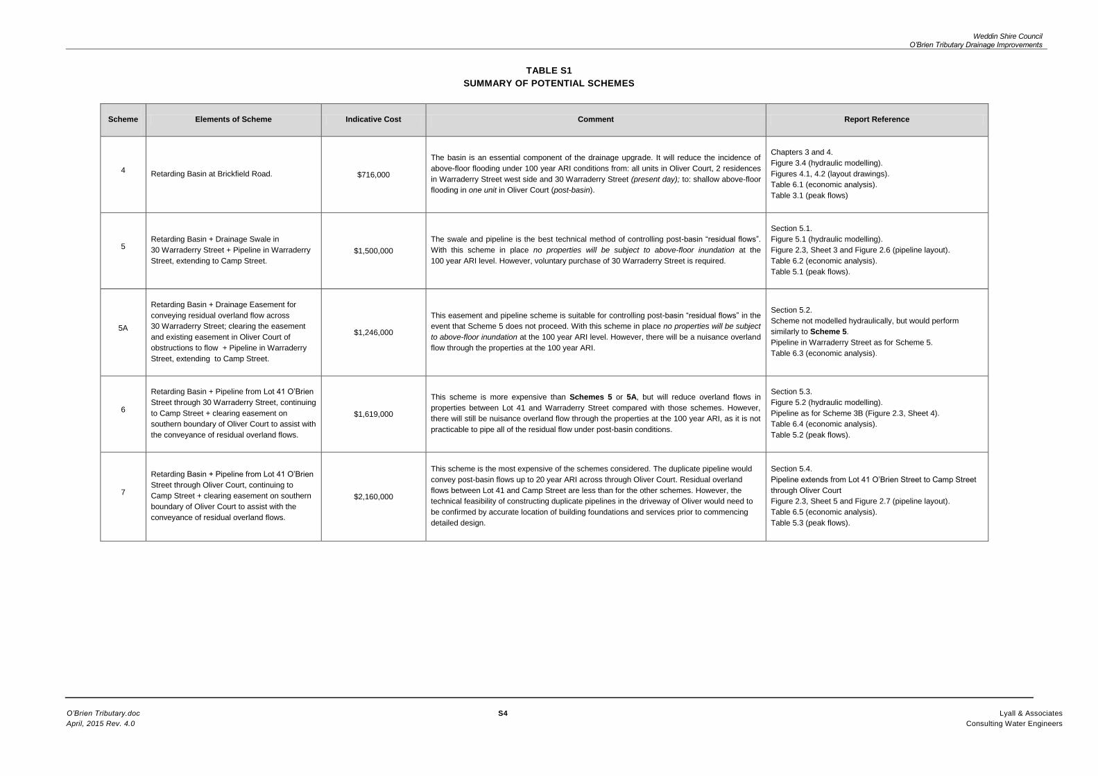
TABLE 2.1
O’BRIEN TRIBUTARY DRAINAGE IMPROVEMENT
SCREENING OF POTENTIAL SCHEMES
Scheme
Elements of Scheme Indicative
Cost Comment
4
Retarding Basin at Brickfield Road. $716,000
The basin is an essential component of the
drainage upgrade. It will reduce the incidence
of above-floor flooding under 100 year ARI
conditions from: all units in Oliver Court,
2 residences in Warraderry Street west side
and 30 Warraderry Street (present day) to
shallow above-floor flooding in one unit in
Oliver Court (post-basin).
5
Retarding Basin + Drainage Swale in
30 Warraderry Street + Pipeline in
Warraderry Street, extending to Camp
Street (Figure 2.3, Sheet 3).
$1,500,000
The swale and pipeline is technically the best
method of controlling post-basin “residual
flows”. With this scheme in place no properties
will be subject to above-floor inundation at the
100 year ARI level. However, voluntary
purchase of 30 Warraderry Street is required
for this scheme to proceed.
5A
Retarding Basin + clearing
obstructions for conveying residual
overland flow across
30 Warraderry Street and clearing the
existing easement in Oliver Court of
obstructions + Pipeline in Warraderry
Street extending to Camp Street.
$1,246,000
The easement and pipeline is suitable for
controlling post-basin “residual flows” if
30 Warraderry Street is not able to be
purchased by Council. With this scheme in
place no properties will be subject to above-
floor inundation at the 100 year ARI level.
However, there will be a nuisance overland
flow through the properties at the 100 year
ARI.
6
Retarding Basin + Pipeline from Lot
41 O’Brien Street through 30
Warraderry Street, continuing to
Camp Street + clearing easement on
southern boundary of Oliver Court to
assist with the conveyance of residual
overland flows (Figure 2.3, Sheet 4).
$1,619,000
This scheme is more expensive than
Schemes 5 or 5A, but will reduce overland
flows in properties between Lot 41 and
Warraderry Street compared with those
schemes. However, there will still be nuisance
overland flow through the properties at the
100 year ARI, as it is not practicable to pipe all
of the residual post-basin flow.
7
Retarding Basin +duplicate pipeline
from Lot 41 O’Brien Street through
Oliver Court, continuing to Camp
Street + clearing easement on
southern boundary of Oliver Court to
assist with the conveyance of residual
overland flows (Figure 2.3, Sheet 5).
$2,160,000
This scheme is the most expensive of the
schemes considered but has a hydraulic
capacity greater than Scheme 6 and
eliminates above-floor inundation to the 100
year ARI level of flooding. The technical
feasibility of constructing duplicate pipelines in
the driveway of Oliver Court would need to be
confirmed by potholing building foundations
and services prior to detailed design.

Weddin Shire Council O’Brien Tributary Drainage Improvements
O’Brien Tributary.doc 13 Lyall & Associates
April, 2015 Rev. 4.0 Consulting Water Engineers
3 HYDROLOGIC AND HYDRAULIC MODELLING
3.1 Hydrologic Modelling Approach
The RAFTS - DRAINS rainfall-runoff modelling software was adopted for deriving discharge
hydrographs generated by the O’Brien Tributary catchment. Figure 3.1 shows the sub-catchments
comprising the O’Brien Tributary catchment. Discharge hydrographs were required for input to the
TUFLOW hydraulic model to determine flooding patterns in the Oliver Court – Warraderry Street area
under present day conditions. The RAFTS - DRAINS model was also used to route discharge
hydrographs through the storage of a possible retarding basin at Brickfield Road and determine post-
basin hydrographs at the upstream boundary of the TUFLOW model.
3.2 Present Day Conditions
Figure 3.2 shows discharge hydrographs generated by the RAFTS – DRAINS model for flood
frequencies ranging between 5 and 100 year ARI. Although the RAFTS – DRAINS model extends to
the northern end of Warraderry Street and incorporates all of the sub-catchments upstream of that
location, it does not incorporate the ability of modelling the flows passing over the western side of
Warraderry Street. The TUFLOW hydraulic model which converts flows to flood levels and flooding
patterns based on the site survey achieves this objective. Consequently, the discharge hydrographs
shown in Figure 3.2 overestimate the flow arriving at the intersection with Camp Street. The
distribution of peak flows downstream of the eastern boundary of Oliver Court is shown on Table 3.1,
(over page) which is based on the TUFLOW results.
3.3 Retarding Basin at Brickfield Road
3.3.1 Basin Objectives
Retarding basins provide a temporary storage of floodwaters additional to that contained in the natural
floodplain, which can reduce the flood peak in downstream reaches of the creek. The basin should be
located in the reaches of the catchment, sufficiently close to the area intended to be protected, that its
attenuating effects over flood peaks is not negated by downstream tributary inflows. Typically the
basin should command in excess of 50 per cent of the total catchment at the urban centre to be
protected. The basin site on the eastern side of Brickfield Road controls a catchment of 55 ha, about
68 per cent of the 80.8 ha catchment at the eastern boundary of Oliver Court.
Another requirement is that the basin be of sufficient size to store a significant percentage of runoff
from the design storm. Basins attenuate the flood peak (i.e. reduce the downstream peak rate of
runoff) by temporarily storing the incoming discharge hydrograph and releasing it at a controlled rate.
To be effective basins storage volumes about 40 per cent of the volume of runoff of the incoming flood
event are required. A storage volume of 19,000 m3
is capable of being developed at the Brickfield
Road site. This volume is equivalent to 35 mm of surface runoff from the 55 ha catchment. This
storage is about 80 per cent of the runoff generated by a 100 year ARI storm of 1 hour’s duration.
3.4 Results of Hydrologic Modelling of the Retarding Basin
Figure 3.3 shows pre- and post-basin discharge hydrographs for 20 and 100 year ARI flows
assuming a low level pipe outlet of 450 mm diameter. At the upstream boundary of Oliver Court –
location Q2 on Figure 3.1, peak flows would be reduced to about 3.4 m3/s for the 100 year ARI flood.

Weddin Shire Council O’Brien Tributary Drainage Improvements
O’Brien Tributary.doc 14 Lyall & Associates
April, 2015 Rev. 4.0 Consulting Water Engineers
3.5 Hydraulic Modelling of Post - Retarding Basin Conditions (Scheme 4)
The discharge hydrographs at location Q2, as well as at Q3 which represents flow from sub-
catchments H and I flowing northwards along Warraderry Street, were applied to the TUFLOW model
to determine post-basin flood levels and flooding patterns.
The results are presented in Figure 3.4. Peak flows at key locations are shown on Table 3.1. A
comparison with corresponding values on Table 1.1 shows the effects of the basin in attenuating
downstream flows. The following effects are to be noted:
Overland flows would be considerably reduced at Oliver Court and 30 Warraderry Street.
Under 5 year ARI conditions the total discharge flowing through Oliver Court (locations B, C
and D) would be reduced from 2.4 m3/s to 0.9 m
3/s; and under 100 year conditions from
8.3 m3/s to 3.2 m
3/s. Construction of a drainage swale in the 3 m wide easement on the
southern boundary of Oliver Court would reduce the flow in the driveway and northern
easement (locations C and D), at the expense of a slightly larger discharge at location B (the
southern easement).
Flows over the western gutter of Warraderry Street into the residential properties (location E)
would be similarly reduced. Under 5 year ARI conditions, the flow would be reduced from
1.4 m3/s to 0.5 m
3/s; and under 100 year conditions from 8.2 m
3/s to 3.9 m
3/s.
TABLE 3.1
SCHEME 4 - (POST- RETARDING BASIN) PEAK FLOWS
OLIVER COURT AND WARRADERRY STREET AREA
(m3/s)
ID (Figure 3.4)
Location
5 year ARI
20 year ARI
100 year ARI
A Flow Through Lot
41 O’Brien St. 1.0 2.0 3.4
B
Southern Easement
26-28 and 30
Warraderry St.
0.5 1.0 1.7
C Driveway 26-28
Warraderry St. 0.3 0.5 1.0
D Northern Easement
26-28 Warrderry St. 0.1 0.3 0.5
E
Surcharge through
27, 29, 31, 33 and
35 Warraderry St.
0.5 1.7 3.9
F
Surcharge through
Lot 2 and west
along Camp St.
0.0 0.1 0.2
G Flow in existing 900
RCP in Camp St. 1.4 1.7 1.8
Notes: (1) The above results apply for construction of retarding basin (Scheme 4) with no additional works.
(2) Compare these flows with Present Day flows shown in Table 1.1.

Weddin Shire Council O’Brien Tributary Drainage Improvements
O’Brien Tributary.doc 15 Lyall & Associates
April, 2015 Rev. 4.0 Consulting Water Engineers
3.6 Reduction in Flooding in Warraderry Street Area - Post-Retarding Basin
It is predicted from the results of the flood modelling that construction of the basin would eliminate
above-floor inundation in properties on the western side of Warraderry Street under 100 year ARI
conditions, although the allotments may continue to experience shallow overland flow at that
frequency. One of the units in Oliver Court may be subject to shallow above-floor flooding of around
80 mm depth which could be mitigated by some minor flood proofing at the entrance.

Weddin Shire Council O’Brien Tributary Drainage Improvements
O’Brien Tributary.doc 16 Lyall & Associates
April, 2015 Rev. 4.0 Consulting Water Engineers
4 DESIGN CONCEPT FOR RETARDING BASIN (SCHEME 4)
4.1 Layout of Basin and Indicative Cost
4.1.1 Layout
The preliminary layout for a retarding basin is shown on Figures 4.1 and 4.2. It involves the
construction of an embankment running along the eastern side of Brickfield Road for about 175 m
before turning eastwards and continuing for about 90 m.
The storage characteristics of the basin were estimated from the recent survey of the site. For initial
sizing, the basin was sized to store runoff to a peak depth of about 2.3 m. An allowance of 1.0 m in
height would be provided between the 100 year ARI storage level and the embankment crest
elevation. This freeboard incorporates allowances for the head over the spillway crest necessary to
convey floods larger than the 100 year ARI, plus an allowance for wave action. An embankment up to
3.3 m in height would therefore be required.
The volume of storage could be increased by excavation within the storage area, which would also
lower the peak storage level and reduce the potential for backwater flooding in areas upstream of the
basin site. This excavation would also provide fill for the embankment, subject to future geotechnical
testing if the basin proceeded beyond the concept stage. The geotechnical investigation would also
be needed to confirm that the embankment and storage did not lie within the extent of former mining
activities, which are evident downstream of Brickfield Road.
4.1.2 Indicative Cost of Basin
The indicative cost of the basin (Scheme 4), including an allowance for land acquisition and
geotechnical investigation is $716,000. Table B4 in Annexure B provides further details.

Weddin Shire Council O’Brien Tributary Drainage Improvements
O’Brien Tributary.doc 17 Lyall & Associates
April, 2015 Rev. 4.0 Consulting Water Engineers
5 CATERING FOR RESIDUAL FLOWS IN OLIVER COURT AND WARRADERRY STREET
5.1 Scheme 5 – Retarding Basin Plus Swale and Pipeline in Warraderry Street
Figure 5.1 shows the results of hydraulic modelling of the post-basin case together with the drainage
swale through 30 Warraderry Street and the 900 mm diameter pipeline from the downstream end of
the swale to Camp Street. Table 5.1 shows the corresponding distribution of peak flows in the
modelled area.
TABLE 5.1
PEAK FLOWS
OLIVER COURT AND WARRADERRY STREET
SCHEME 5 – RETARDING BASIN + SWALE IN 30 WARRADERRY STREET +
PIPELINE IN WARRADERRY STREET
(m3/s)
ID (Figure 5.2)
Location
5 year ARI
20 year ARI
100 year ARI
A Flow Through Lot
41 O’Brien St. 1.0 2.0 3.4
B Drainage Swale in
30 Warraderry St. 1.0 2.0 3.4
C Driveway 26-28
Warraderry St. 0.0 0.0 0.0
D Northern Easement
26-28 Warrderry St. 0.0 0.0 0.0
E
Surcharge through
27, 29, 31, 33 and
35 Warraderry St.
0.4 1.2 3.2
F
Surcharge through
Lot 2 and west
along Camp St.
0.0 0.4 0.8
G Flow in existing 900
RCP in Camp St. 1.4 2.0 2.0
H Flow in new pipe in
Warraderry Street 1.0 1.1 1.2
Notes:
(1) The above results apply for retarding basin (Scheme 4) plus swale in 30 Warraderry Street and pipeline in Warraderry
Street.
(2) Compare these flows with Present Day flows shown in Table 1.1 and retarding basin only (Scheme 4) in Table 3.1.
It is predicted from the results of the flood modelling that construction of the basin and Scheme 5
swale and pipeline would eliminate above-floor inundation in properties on the western side of
Warraderry Street under 100 year ARI conditions, although the properties may continue to experience
shallow overland flow at that frequency. All of the units in Oliver Court would be above flood level.
This scheme is estimated to cost $1,500,000 made up of $716,000 for the retarding basin and
$784,000 for downstream works, including the purchase of 30 Warraderry Street and construction of
the pipeline in Warraderry Street to Camp Street (ref. Table B5).

Weddin Shire Council O’Brien Tributary Drainage Improvements
O’Brien Tributary.doc 18 Lyall & Associates
April, 2015 Rev. 4.0 Consulting Water Engineers
5.2 Scheme 5A – Retarding Basin Plus Clearing Obstructions to Flow in 30 Warraderry
Street and Pipeline in Warraderry Street
As noted in Section 2.3, Scheme 5A is a variation of Scheme 5 which could be considered in the
event that Council does not acquire 30 Warraderry Street and converts the allotment to open space
for the swale.
The scheme would comprise the retarding basin at Brickfield Road in conjunction with Council’s
acquisition of an easement along the northern side of 30 Warraderry Street and its conversion to an
“open space”. The new easement, together with the existing easement on the southern boundary of
Oliver Court, which would need to be cleared of obstructions, would form a flow path for the
conveyance of overland flows to Warraderry Street.
Overland flows leaving the downstream end of the easement would be captured by a large inlet pit at
the front of 30 Warraderry Street and conveyed in a new 900 mm diameter pipeline about 135 m in
length, running along the eastern gutter of Warraderry Street, to connect with the existing system at
the intersection with Camp Street.
The longitudinal profile of the pipeline would be similar to that of Scheme 5. As for Scheme 5, Council
officers will need to undertake initial discussions with the landowners of both properties to gauge
reactions regarding the proposal.
The scheme would perform similarly to Scheme 5 in terms of mitigating flooding.
The indicative cost of the scheme is $1,246,000, made up of $716,000 for the retarding basin and
$530,000 for clearing obstructions in 30 Warraderry Street and construction of the pipeline in
Warraderry Street to Camp Street (ref. Table B6).
5.3 Scheme 6 – Retarding Basin + Pipe Scheme 3B (Lot 41 Through 30 Warraderry Street to
Camp Street)
Although the basin associated with the retarding basin (Scheme 4) would be very effective in
throttling flows from its upstream catchment, there is an uncontrolled catchment of about 25 ha
downstream of Brickfield Road (sub-areas D, E and F of Figure 3.1) which will generate “residual
flows” at Oliver Court. In addition there will be flows from the 16.2 ha uncontrolled catchment
discharging to the northern end of Warraderry Street (sub-areas H and I).
Figure 5.2 shows the results of hydraulic modelling of the post-basin case together with the
900 mm diameter pipeline from Lot 41 to Camp Street. Table 5.2 over the page shows the
corresponding distribution of peak flows in the modelled area.

Weddin Shire Council O’Brien Tributary Drainage Improvements
O’Brien Tributary.doc 19 Lyall & Associates
April, 2015 Rev. 4.0 Consulting Water Engineers
TABLE 5.2
PEAK FLOWS
OLIVER COURT AND WARRADERRY STREET
SCHEME 6 – RETARDING BASIN +
PIPE SCHEME 3B LOT 41 TO CAMP STREET
(m3/s)
ID (Figure 5.1)
Location
5 year ARI
20 year ARI
100 year ARI
A Flow Through Lot
41 O’Brien St. 1.0 2.0 3.4
B
Southern Easement
26-28 and 30
Warraderry St.
0.0 0.7 2.0
C Driveway 26-28
Warraderry St. 0.0 0.0 0.0
D Northern Easement
26-28 Warrderry St. 0.0 0.0 0.0
E
Surcharge through
27, 29, 31, 33 and
35 Warraderry St.
0.4 1.0 2.9
F
Surcharge through
Lot 2 and west
along Camp St.
0.0 0.5 1.1
G Flow in existing 900
RCP in Camp St. 1.5 1.9 1.9
H Flow in new pipe in
Warraderry Street 1.0 1.2 1.2
Notes:
(1) The above results apply for construction of retarding basin (Scheme 4) plus Pipeline 3B.
(2) Compare these flows with Present Day flows shown in Table 1.1.
With this scheme, there would be no flow across Oliver Court for minor flood events (5 year ARI) and
only minor flows at the 20 year ARI level, which could be captured by a swale along the southern
easement of that property. Similarly the flows escaping over the western footpath of Warraderry Street
into the residential properties would be reduced to levels below floor level for the 100 year ARI flood.
However, the pipeline does not have sufficient capacity to capture all of the overland flow traversing
30 Warraderry Street and the depth of flow would just surcharge the floor level. Minor re-shaping of
natural surface levels would be required to direct flows away from the building.
As shown on Table B3 of Annexure B, the indicative cost of the Scheme 3B pipeline is $903,000,
giving a total indicative cost of $1,619,000 with the cost of the basin included.
Weddin Shire Council O’Brien Tributary Drainage Improvements
O’Brien Tributary.doc 20 Lyall & Associates
April, 2015 Rev. 4.0 Consulting Water Engineers
5.4 Scheme 7 – Retarding Basin + Pipeline from Lot 41 Through Oliver Court to Camp Street
Figure 5.3 shows the results of hydraulic modelling of the post-basin case together with the duplicate
900 mm diameter pipelines from Lot 41 to Camp Street. Table 5.3 shows the corresponding
distribution of peak flows in the modelled area.
TABLE 5.3
PEAK FLOWS
OLIVER COURT AND WARRADERRY STREET
SCHEME 7 – RETARDING BASIN +
DUPLICATE PIPELINE LOT 41 THROUGH OLIVER COURT TO CAMP STREET
(m3/s)
ID (Figure 5.1)
Location
5 year ARI
20 year ARI
100 year ARI
A Flow Through Lot
41 O’Brien St. 1.0 2.0 3.4
B
Southern Easement
26-28 and 30
Warraderry St.
0.0 0.0 0.7
C Driveway 26-28
Warraderry St. 0.0 0.0 0.4
D Northern Easement
26-28 Warrderry St. 0.0 0.0 0.2
E
Surcharge through
27, 29, 31, 33 and
35 Warraderry St.
0.4 1.0 2.3
F
Surcharge through
Lot 2 and west
along Camp St.
0.0 0.6 2.0
G Flow in existing 900
RCP in Camp St. 1.5 1.9 1.9
H Flow in new pipe in
Warraderry Street 1.0 1.9 2.0
Notes:
(1) The above results apply for construction of retarding basin (Scheme 4) plus Pipeline from Lot 41 to Camp Street.
(2) Compare these flows with Present Day flows shown in Table 1.1.
With this scheme, there would be no flow across Oliver Court for medium flood events (20 year ARI)
and only minor flows at the 100 year ARI level, which could be captured by a swale along the
southern easement of that property. Flows escaping over the western footpath of Warraderry Street
into the residential properties would be reduced compared with Scheme 6. The duplicate pipeline
reduces overland flows through properties downstream of Lot 41and the depth and extent of
inundation. The depth of overland flow traversing 30 Warraderry Street would be reduced to below the
floor level. As shown on Table B7 of Annexure B, the indicative cost of the Scheme 3B pipeline is
$903,000, giving a total indicative cost of $2,160,000 with the cost of the basin included.

Weddin Shire Council O’Brien Tributary Drainage Improvements
O’Brien Tributary.doc 21 Lyall & Associates
April, 2015 Rev. 4.0 Consulting Water Engineers
6 ECONOMIC ANALYSIS OF SCHEMES
6.1 Estimated Flood Damages
Estimation of flood damages to residential development bordering the O’Brien Tributary system in
the Warraderry Street area was carried out to assess the impact of flooding under present day
and post-scheme conditions. The objectives were to allow an economic assessment of the
schemes to be carried out. Damages were assessed for floods ranging between the 5 year ARI
and 100 year ARI events. The 5 year ARI is the threshold flood at which significant damages are
experienced in the area.
There were no quantitative data available on historic flood damages at Grenfell. The analysis was
carried out using the residential flood damages model attached to “Floodplain Risk Management
Guideline No 4 - Residential Flood Damages”. This publication was prepared by DECCW (now
OEH) to allow the consistent assessment of residential damages across NSW for the economic
comparison of flood management projects.
In Guideline No 4, damage assessments undertaken after major flooding in other urban centres
were adjusted and used to estimate damages likely to be experienced to typical residential
development in NSW. Data for the flood damages model comprised the depths of inundation over
the floodplain, as well as information on the unit values of damages to residential property. The
depths of inundation were determined from the results of the TUFLOW hydraulic modelling and
from surveyed floor levels and representative natural surface levels at each allotment. The type
of structure and potential for property damage were assessed from a visual inspection.
The procedures in Guideline Number 4 allow for structural damage to the building, damage to
internals and contents, external damages and clean-up costs. The level of flood awareness and
available warning time are taken into account by factors which are used to reduce “potential”
damages to contents to “actual” damages. “Potential” damages represent losses likely to be
experienced if no action were taken by residents to mitigate impacts. A reduction in the potential
damages to "actual" damages is usually made to allow for property evacuation and raising
valuables above floor level, which would reduce the damages actually experienced. The ability of
residents to take action to reduce flood losses is mainly limited to reductions in damages to
contents, as damages to the structure and clean-up costs are not usually capable of significant
mitigation.
6.2 Present Worth Value of Scheme Benefits
The areas under the damage versus frequency curves for both present day and post -scheme
conditions were integrated and converted to present worth values for the three discount rates
nominated in NSW Government Treasury Guidelines for the economic assessment of projects.
These discount rates are 7 per cent (best estimate) with sensitivity studies for 3 per cent and
10 percent.
The benefits of each project are represented by the reduction in flood damages, which are
calculated by subtracting post-project damages from present day values. From a knowledge of
the cost of each project, the benefit-cost ration may be calculated and the projects ranked in a
strictly economic sense. The results are summarised in Tables 6.1 to 6.5 over page.

Weddin Shire Council O’Brien Tributary Drainage Improvements
O’Brien Tributary.doc 22 Lyall & Associates
April, 2015 Rev. 4.0 Consulting Water Engineers
6.3 Indicative Cost-Benefit Analysis
TABLE 6.1
ECONOMIC ANALYSIS – SCHEME 4 (RETARDING BASIN)
($Million)
Discount Rate % 4 7 10
Present Worth Value of Benefits
(Damages Prevented) $ x 106
0.58 0.45 0.36
Cost of scheme $ x 106 0.716 0.716 0.716
Benefit/Cost Ratio 0.81 0.63 0.51
TABLE 6.2
ECONOMIC ANALYSIS – SCHEME 5
RETARDING BASIN + DRAINAGE SWALE IN 30 WARRADERRY ST
+ PIPELINE TO CAMP ST
($Million)
Discount Rate % 4 7 10
Present Worth Value of Benefits
(Damages Prevented) $ x 106
0.82 0.64 0.52
Cost of scheme $ x 106 1.50 1.50 1.50
Benefit/Cost Ratio 0.55 0.43 0.35
TABLE 6.3
ECONOMIC ANALYSIS – SCHEME 5A
RETARDING BASIN + CLEARING OBSTRUCTIONS TO FLOW IN 30 WARRADERRY ST
+ PIPELINE TO CAMP ST
($Million)
Discount Rate % 4 7 10
Present Worth Value of Benefits
(Damages Prevented) $ x 106
0.82 0.64 0.52
Cost of scheme $ x 106 1.246 1.246 1.246
Benefit/Cost Ratio 0.66 0.51 0.42

Weddin Shire Council O’Brien Tributary Drainage Improvements
O’Brien Tributary.doc 23 Lyall & Associates
April, 2015 Rev. 4.0 Consulting Water Engineers
TABLE 6.4
ECONOMIC ANALYSIS – SCHEME 6
RETARDING BASIN + SCHEME 3B PIPELINE TO CAMP ST
($Million)
Discount Rate % 4 7 10
Present Worth Value of Benefits
(Damages Prevented) $ x 106
0.8 0.64 0.52
Cost of scheme $ x 106 1.619 1.619 1.619
Benefit/Cost Ratio 0.49 0.40 0.32
TABLE 6.5
ECONOMIC ANALYSIS – SCHEME 7
RETARDING BASIN + DUPLICATE PIPELINE
LOT 41 THROUGH OLIVER COURT TO CAMP ST
($Million)
Discount Rate % 4 7 10
Present Worth Value of Benefits
(Damages Prevented) $ x 106
0.8 0.62 0.50
Cost of scheme $ x 106 2.16 2.16 2.16
Benefit/Cost Ratio 0.37 0.29 0.23

Weddin Shire Council O’Brien Tributary Drainage Improvements
O’Brien Tributary.doc 24 Lyall & Associates
April, 2015 Rev. 4.0 Consulting Water Engineers
7 SUMMARY AND FINDINGS
7.1 Summary
This Working Paper reviewed potential measures for mitigating flooding in residential properties in
Oliver Court and Warraderry Street due to overland flows generated by the O’Brien Tributary
catchment. The area is located in a “floodway” according to the hydraulic categorisation carried out in
the Emu Creek Floodplain Risk Management Study.
At present there is no formal stormwater system to capture and convey flows across the Oliver Court
property. The stormwater system commences in Warraderry Street and comprises a pipeline of only
450 and 525 mm diameter in that street, which is of limited hydraulic capacity and capable of
conveying runoff from only minor storms . Historically Oliver Court and Warraderry Street area have
been subject to frequent flooding, most recently in the November 2010 storm which had a return
period of about 5 year ARI on the O’Brien Tributary. Figure 1.1 shows overland flow paths.
The Working Paper formulated and reviewed options for capturing overland flows on or upstream of
the eastern boundary of Oliver Court and conveying them through the property to Warraderry Street.
The options comprise various piped schemes in the reach between Lot 41 in O’Brien Street and the
intersection of Warraderry Street and Camp Street (ref. Figure 2.3, Sheets 1 to 5). The potential
reduction in downstream flows and depths of flooding achieved by the construction of a retarding
basin on the eastern side of Brickfield Road was also assessed. Figures 4.1 and 4.2 show the
concept design of the basin.
Hydraulic modelling was undertaken using the TUFLOW two-dimensional modelling software of
present day and post-scheme conditions. Indicative cost estimates were prepared for several piped
options, as well as for the retarding basin (ref. the various tables in Annexure B).
The economic benefits of the more viable schemes were computed. These benefits are represented
by the reduction in flood damages to the residential developments in Warraderry Street compared
with present day conditions. Flood damages were assessed using recommended OEH procedures
and converted to present worth values using discount rates nominated in NSW Government
Guidelines for the economic analysis of infrastructure projects. Indicative cost-benefit analysis was
then carried out for feasible schemes.
7.2 Findings
7.2.1 Piped Schemes 1 to 3B
Peak flows generated by the catchment during major storms are too large to be conveyed by pipelines
through Oliver Court and along Warraderry Street. The feasible maximum pipe size is limited to
900 mm, and is controlled by the available gradient and minimum cover considerations, as well as by
the presence of Council’s sewers in Warraderry Street.
Consequently, upgrading the drainage system by pipelines in isolation is not cost-effective in solving
existing flooding problems in residential developments in the Warraderry Street area and is not
recommended.

Weddin Shire Council O’Brien Tributary Drainage Improvements
O’Brien Tributary.doc 25 Lyall & Associates
April, 2015 Rev. 4.0 Consulting Water Engineers
7.2.2 Retarding Basin in Isolation (Scheme 4)
A large reduction in peak flows arriving at the eastern boundary of Oliver Court could be achieved by
the retarding basin at Brickfield Road. The basin in conjunction with a drainage swale in the existing
southern easement of Oliver Court would convey 5 year ARI flows across Oliver Court with a small
surcharge over the driveway. Figure 3.4 shows the results of hydraulic modelling and Table 3.1
shows the distribution of peak flows under post-basin conditions. The indicative cost of the basin is
$716,000, including an allowance of $320,000 for the purchase of land in the proposed storage area.
Construction of the basin would eliminate above-floor inundation in properties on the western side of
Warraderry Street under 100 year ARI conditions, although the properties may continue to experience
shallow overland flow at that frequency. One of the units in Oliver Court may be subject to shallow
above-floor flooding of up to 80 mm which could be mitigated by some minor flood proofing works at
the entrance to the property.
7.2.3 Scheme 5 - Retarding Basin + Drainage Swale in 30 Warraderry Street + Pipeline to
Camp Street
Although the retarding basin will achieve a major reduction in downstream flows as far as Camp
Street, supplementary measures would be required to capture “residual” overland flows continuing to
traverse Oliver Court, 30 Warraderry Street and residential properties in Warraderry Street.
The retarding basin plus capture of overland flows in a drainage swale in 30 Warraderry Street (which
would be voluntary acquired and cleared) and piped northwards along Warraderry Street to the
intersection with Camp Street (Figure 2.3, Sheet 3) would reduce overland flooding. Figure 5.1
shows the results of hydraulic modelling and Table 5.1 shows the distribution of peak flows. The
indicative cost of the Scheme 5 swale and pipeline works is $784,000. In conjunction with the basin,
the total cost would be $1,500,000.
Construction of the basin and the downstream works would eliminate above-floor inundation in
properties on the western side of Warraderry Street under 100 year ARI conditions, although several
of the properties may continue to experience shallow overland flow at that frequency. No units in
Oliver Court would be subject to above-floor flooding.
7.2.4 Scheme 5A - Retarding Basin + Easement in 30 Warraderry Street + Pipeline in
Warraderry Street to Camp Street
The retarding basin plus a drainage easement in 30 Warraderry Street in conjunction with the existing
easement in Oliver Court, together with a pipeline in Warraderry Street to Camp Street (Scheme 5A)
would also reduce overland flooding similar to Scheme 5, but at less cost. The indicative cost of the
easement and pipeline is $530,000. In conjunction with the basin, the total cost would be $1,246,000.
Construction of the basin and associated works would have the same mitigation benefits as
Scheme 5 above.
7.2.5 Scheme 6 - Retarding Basin + Pipeline Through 30 Warraderry Street to Camp Street
As an alternative to conveying post-basin flows overland through 30 Warraderry Street, flows
could be the piped through the property with the Scheme 3B pipeline, as described in
Section 5.3. Figure 5.2 shows the results of hydraulic modelling and Table 5.2 shows the

Weddin Shire Council O’Brien Tributary Drainage Improvements
O’Brien Tributary.doc 26 Lyall & Associates
April, 2015 Rev. 4.0 Consulting Water Engineers
distribution of peak flows. However, it is considerably more expensive than the other options. The
indicative cost of that scheme including the basin is $1,619,000, including the retarding basin.
7.2.6 Scheme 7 - Retarding Basin + Pipeline Through Oliver Court to Camp Street
Construction in 30 Warraderry Street may be avoided with a pipeline commencing at Lot 41
O’Brien Street, continuing to Oliver Court and then running through the unit block to Warraderry
Street and then on to Camp Street. The pipeline through Oliver Court follows the route shown on
Figure 2.3, Sheet 5. Figure 5.3 shows the results of hydraulic modelling and Table 5.3 shows the
distribution of peak flows. In order to compensate for the loss in hydraulic capacity resulting from
the two 90 degree bends in Oliver Court and reduce overland flows, it is proposed to duplicate
the 900 mm diameter pipe, upgrade section of the line to 1200 mm diameter and clear the
easement on the southern side of the property to maximise hydraulic capacity. This scheme
would be the most expensive of the schemes considered and would cost around $2,160,000
including the retarding basin.
7.3 Recommendations for Consideration by Floodplain Management Committee
The retarding basin (Scheme 4) is an essential component of the drainage improvements for O’Brien
Tributary and as noted above will achieve a substantial reduction in downstream flooding, particularly
for the minor (5 year ARI) and medium (20 year ARI) floods. Proceeding to the geotechnical
investigation and design phases for the basin is recommended.
The decision whether or not to adopt the drainage swale through 30 Warraderry Street and pipeline in
Warraderry Street as the favoured option for controlling residual flows (i.e. Scheme 5), would depend
upon negotiations with the owner of 30 Warraderry Street, as purchase and clearing of this property is
required.
In the event that voluntary purchase of 30 Warraderry Street is not achievable, Scheme 5A could be
considered which requires an easement for overland flow through the property, well as clearing the
existing easement in Oliver Court from obstructions to flow.
Alternatively, Scheme 6 or Scheme 7 could be considered at greater cost (and noting the
requirement for accurate location of building foundations and services for Scheme 7).
7.4 Proceeding to Detailed Design
Detailed design of the basin and measures to control downstream residual flows will involve the
following sequence of activities:
13 Floodplain Management Committee to confirm the scheme to be adopted.
Geotechnical Investigation and testing of the basin foundation and in the storage area to
assess the suitability of the material as fill for the embankment.
Potholing in Warraderry Street (and Oliver Court in the case of Scheme 7) to confirm the
depths of the sewers at the crossing locations of the new drainage pipeline.
Refining the design concepts included in this Working Paper to the stage of a detailed design
and the preparation of working drawings for the basin.

Weddin Shire Council O’Brien Tributary Drainage Improvements
O’Brien Tributary.doc 27 Lyall & Associates
April, 2015 Rev. 4.0 Consulting Water Engineers
Negotiation with the owner of the basin site once the requirements for land acquisition have
been determined for the design studies.
Negotiation with the owner of 30 Warraderry Street to acquire the property for the drainage
swale - Scheme 5, (or alternatively, negotiation with the owner for an easement –
Schemes 5A and 6), or negotiations with the owners of Oliver Court (Scheme 7).
Design of the adopted scheme and preparation of working drawings.
Refinement of indicative costings to the standard of pre-construction cost estimates.
Provision of standard clauses in Contract Documentation for the works.
Supply of Specifications for the various work items.
Preparing a Review of Environmental Factors for the selected scheme.

ANNEXURE A
PHOTOGRAPHS OF THE STUDY AREA

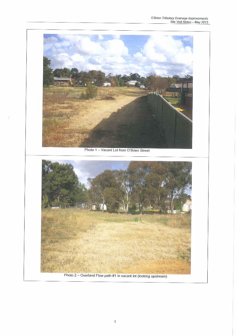


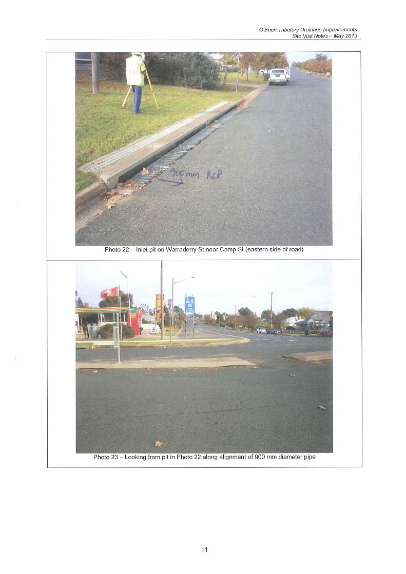

ANNEXURE B
INDICATIVE COSTS OF SCHEMES

Table B1 Indicative Cost of Pipeline - Scheme 1
Item Description Unit Rate Quantity Amount
1
Establish Easements along Route of pipeline in Private Property in O'Brien St. and in Oliver Court Item 20,000.00$ 1 20,000$
2 Drainage swale in existing easement along Southern Boundary of Oliver Court Item 20,000.00$ 1 20,000$
3Establishment and Traffic Control in Warraderry Street Item 2,500.00$ 1 2,500$
4 Intake Pit and banking in 5 O'Brien Street Item 10,000.00$ 1 10,000$
5Demolish pavment and landscaping in driveway along route of pipeline m 2 40.00$ 400 16,000$
6 Supply, Lay, Joint 900 RCP m 1,570.00$ 106 166,420$
7 Provide 2 junction pits along route of pipeline Item 2,500.00$ 2 5,000$
8Surcharge Pit in Warraderry Street and connection to existing pipeline Item 8,000.00$ 1 8,000$
9Reinstate driveway and landscaping in Oliver Court m2 80.00$ 400 32,000$
10 Reinstate Services Item 15,000.00$ 1 15,000$
Sub-Total 294,920$
Unestimated Items and Contingencies 25% 73,730$
Sub-Total 368,650$
Survey, Investigation and Design 15% 55,298$
Total 423,948$

Table B2
Indicative Cost of Pipeline - Scheme 2
Item Description Unit Rate Quantity Amount
1
Establish Easements along Route of pipeline in
private Property in O'Brien St., 30 Warraderry
St.and in Oliver Court Item 20,000.00$ 1 20,000$
2
Banking and Drainage swale in existing easement
along Southern Boundary of Oliver Court Item 20,000.00$ 1 20,000$
3
Establishment and Traffic Control in Warraderry
Street Item 2,500.00$ 1 2,500$
4 Intake Pit in 7 O'Brien Street Item 10,000.00$ 1 10,000$
5
Demolish pavment and landscaping along route
of pipeline in 30 Warraderry St. m2
40.00$ 450 18,000$
6 Supply, Lay, Joint 900 RCP m 1,570.00$ 90 141,300$
7
Surcharge Pit in Warraderry Street and
connection to existing pipeline Item 8,000.00$ 1 8,000$
8
Reinstate pavement and landscaping along route
of pipeline m2
200.00$ 450 90,000$
9 Reinstate Services Item 15,000.00$ 1 15,000$
Sub-Total 324,800$
Unestimated Items and Contingencies 25% 81,200$
Sub-Total 406,000$
Survey, Investigation and Design 15% 60,900$
Total 466,900$

Table B3 Indicative Cost of Pipeline - Scheme 3B
Item Description Unit Rate Quantity Amount
1
Establish Easements along Route of pipeline in private property in O'Brien St. and 30 Warraderry St. & flood prone portion of Lot 41 Item 45,000.00$ 1 100,000$
2 Drainage swale in existing easement along Southern Boundary of Oliver Court Item 20,000.00$ 1 20,000$
3Establishment and Traffic Control in Warraderry Street Item 5,000.00$ 1 5,000$
4 Headwall and Banking in Lot 41 Item 10,000.00$ 1 10,000$
5Demolish pavment and landscaping in private property along route of pipeline m 2 40.00$ 450 18,000$
6 Supply, Lay, Joint 900 RCP m 1,570.00$ 258 405,060$
7Reinstate pavement and landscaping in private property along route of pipeline m 2 80.00$ 450 36,000$
8 Provide 3 junction pits along route of pipeline Item 2,500.00$ 3 7,500$
9Reinstate pavement in Warraderry Street along route of pipeline m2 30.00$ 400 12,000$
10 Reinstate Services Item 15,000.00$ 1 15,000$
Sub-Total 628,560$
Unestimated Items and Contingencies 25% 157,140$
Sub-Total 785,700$
Survey, Investigation and Design 15% 117,855$
Total 903,555$

Table B4
Indicative Cost of Detention Basin
Brickfield Road
(Scheme 4)
Item Description Unit Rate Quantity Amount
1 Acquisition of Land Item 1 320,000$
2
Geotechnical Investigation and
testing Item 1 15,000$
3
Site Establishment and Set out
works by registered surveyor Item 1 2,500$
4
Erosion Control and Care of Creek
during construction Item 1 5,000$
5
Strip topsoil (300mm) over
embankment footprint m2
1.50$ 5,500 8,250$
6
Excavate additional earthworks for
cut off trench m3
5.00$ 300 1,500$
7
Proof roll embankment foundation
and cutoff trench m2
0.60$ 5,500 3,300$
8
Excavate storage area; place and
compact fill for embankment m3
18.00$ 6,300 113,400$
9
Place topsoil over embankment
surface, grass seed and rehabilitate m2
5.00$ 6,000 30,000$
10 Scour Protection Spillway Item 20,000$
11
Supply, Lay Joint RCP Low Level
Outlet Pipes: 1 x 450 mm, Class 4 m 450.00$ 30 13,500$
12 RC Headwalls Low Level Outlets Item 1,000.00$ 2 2,000$
13
Energy Dissipation at Outlets (300
mm Reno mattress) m2
60.00$ 30 1,800$
Sub-Total 536,250$
Unestimated Items and
Contingencies 25% 134,063$
Sub-Total 670,313$
Survey, Investigation and Design
(excluding acquisition of land) 15% 45,347$
Total 715,659$

Table B5Indicative Cost
Drainage Swale in 30 Warraderry Street and Pipeline in Warraderry Street(Part of Scheme 5)
Item Description Unit Rate Quantity Amount
1 Purchase 30 Warraderry Street Item 300,000.00$ 1 300,000$
2Clear site and construct Drainage Swale in 30 Warraderry Street Item 25,000.00$ 1 25,000$
3Establishment and Traffic Control in Warraderry Street Item 5,000.00$ 1 5,000$
4Headwall to 900 RCP at western end of Drainage Swale in 30 Warraderry Street Item 8,000.00$ 1 8,000$
5 Supply, Lay, Joint 900 RCP in Warraderry Street m 1,570.00$ 135 211,950$
6 Provide 3 junction pits along route of pipeline Item 2,500.00$ 3 7,500$
7Reinstate pavement in Warraderry Street along route of pipeline m2 30.00$ 400 12,000$
8 Reinstate services Item 15,000.00$ 1 15,000$
Sub-Total 584,450$
Unestimated Items and Contingencies 25% 146,113$
Sub-Total 730,563$
Survey, Investigation and Design (excluding purchase of 30 Warraderry Street property) 15% 53,334$
Total 783,897$

Table B6Indicative Cost
Easement to Create Overland Flow Path in 30 Warraderry Street+ Pipeline in Warraderry Street ( Part of Scheme 5A)
Item Description Unit Rate Quantity Amount
1 Negotiate Easement in 30 Warraderry Street Item 30,000.00$ 1 30,000$
2Demolish pavment and landscaping in 30 warraderry Street Item 15,000.00$ 1 15,000$
3Reinstate pavement and landscaping in 30 Warraderry Street m2 80.00$ 450 36,000$
4
Clear and incorporate existing easement on southern boundary of Oliver Court with easement in 30 Warraderry Street into one drainage path m2 80.00$ 360 28,800$
5Provide large entry pit and grating at front of Oliver Court and 30 Warraderry Street Item 15,000.00$ 1 15,000$
6Establishment and Traffic Control in Warraderry Street Item 5,000.00$ 1 5,000$
7 Supply, Lay, Joint 900 RCP in Warraderry Street m 1,570.00$ 135 211,950$
8Provide 3 junction pits along route of pipeline in Warraderry Street Item 5,000.00$ 3 15,000$
9Reinstate pavement in Warraderry Street along route of pipeline m2 30.00$ 400 12,000$
Sub-Total 368,750$
Unestimated Items and Contingencies 25% 92,188$
Sub-Total 460,938$
Survey, Investigation and Design 15% 69,141$ Total 530,078$

Table B7 Indicative Cost of Pipeline - (Part of Scheme 7)
Item Description Unit Rate Quantity Amount
1
Establish Easements along Route of pipeline in private property in O'Brien St., Oliver Court and flood prone portion of Lot 41 Item 45,000.00$ 1 100,000$
2 Drainage swale in existing easement along Southern Boundary of Oliver Court Item 20,000.00$ 1 20,000$
3Establishment and Traffic Control in Warraderry Street Item 5,000.00$ 1 5,000$
4 Headwall and Banking in Lot 41 Item 10,000.00$ 1 10,000$
5Demolish pavment and landscaping in private property along route of pipeline m 2 40.00$ 600 24,000$
6 Supply, Lay, Joint 900 RCP m 1,570.00$ 450 706,500$
7 Supply, Lay, Joint 1200 RCP m 2,090.00$ 20 41,800$
8Reinstate pavement and landscaping in private property along route of pipeline m 2 80.00$ 600 48,000$
9 Provide 5 junction pits along route of pipeline Item 5,000.00$ 5 25,000$
10Reinstate pavement in Warraderry Street along route of pipeline m2 30.00$ 320 9,600$
11 Reinstate Services Item 15,000.00$ 1 15,000$
Sub-Total 1,004,900$
Unestimated Items and Contingencies 25% 251,225$
Sub-Total 1,256,125$
Survey, Investigation and Design 15% 188,419$
Total 1,444,544$