yangon region final
TRANSCRIPT

[Socio-Economic Development of Yangon Region] Page 1
YANGON INSTITUTE OF ECONOMICS
CENTRE FOR HUMAN RESOURCE DEVELOPMENT
Diploma in Development Studies Programme
A STUDY ON
SOCIO-ECONOMIC DEVELOPMENT
OF
YANGON REGION
(1990-2009)
GROUP-11
March 2012

2
YANGON INSTITUTE OF ECONOMICS
CENTRE FOR HUMAN RESOURCE DEVELOPMENT
Diploma in Development Studies Programme
A STUDY ON SOCIO-ECONOMIC DEVELOPMENT OF
YANGON REGION (1999-2011)
Supervised by : Prepared by:
Associated Professor Daw May Hnin Tin
Course (10), 2011-12, Group (11)
Mg Aung Lwin (Dip.DS- 126)
Ma Nyein Nyein Pyae Son (Dip.DS- 127)
Ma Hnin Po Po Maung (Dip.DS- 128)
Ma Thuzar Nwe (Dip.DS- 129)
Ma Ni Ni San (Dip.DS- 130)
Ma Ei Ei Phyo (Dip.DS- 131)
Ma Kay Thi Nwe (Dip.DS- 132)
Ma Hnin Wai Htwe (Dip.DS- 133)
Ma Khin Su Su Hlaing (Dip.DS- 134)

3
Abstract
In order to have balancing of development in long-lasting sustainability for a nation
especially in the developing countries, policy makers need to undertake various sectors of the
whole country. The overall strategies cannot be perfect that it might be none of the country has
homogenous regions. So, it is impossible to neglect the Regional Economics because nations
formed by various regions (14 states and regions in Myanmar). A region is a major division of
a country that delimited by certain criteria such as geography, economics, political and racial.
Regional economics is concerned with spatial distribution of economic activity and
spatial variation in levels of economic performance. It should study through macro and micro
levels and rural and urban economics. Regional macroeconomics can be compared the
economics performance with other regions and also Regional microeconomics is much more
concerned with eh location and interaction of particular economic activities.
By the study of the States and Regions, the State has to lay down Plans and projects
concerned where effective investment could boost the growth of the region for the developing
on the area, size population, the development level and resource potential for development in
all the regions.
Myanmar is going through the above balancing development process of the nation.
Yangon region has gained momentum in its achievement concerning socio-economic
development.
In this term paper, the data of Yangon region , the secondary data, collected from C.S.O
(2009), Chronicle of National Development Comparison (2010), and internet website.
Through this term paper, Yangon region is the most developed region in Myanmar.

4
Acknowledgements
First of all we would like to express our sincere gratitude to the Yangon Institute of
Economics, Centre for Human Resource Development and Diploma in Development Studies
Programme committee and, Yangon Institute of Economics Rector Doctor Khin San Yee,
professors, lecturers, and all staff for providing this opportunity to study this useful and
applicable knowledge.
We would like to acknowledge and deep gratitude to Professor Daw Phyu Phyu Ei who
taught us three important majors in all of three semesters.
It is a great pleasure to express our and special gratitude to our supervisor Associate
Professor Daw May Hnin Tin for her suggestions, guidance and editing of this study paper.
Moreover, we would like to gratitude and grateful thanks to all the lecturers who taught
in the Diploma in Development Studies Programme by excellent teaching for this valuable
knowledge, idea, and applicable in our own lives and also for national development.
Finally, we also would to thank to all persons who contribute data, information,
references books, guidance, and suggestion, gave directly or indirectly to study this paper.
However, group (11), all of us will take final responsibility for what we have written.
Group (11) Members,

5
Table of Contents
Abstract 3
Acknowledgements 4
Table of Contents 5
List of Tables 7
List of Figures 8
Chapter (1) Introduction
1.1 Rational of the study 9
1.2 Objective 10
1.3 Method of the study 10
1.4 Scope of limitation 10
1.5 Organization of the study 10
Chapter (2) Profile of the Yangon Region 11
2.1 Historical Background of Yangon Region 11
2.2 Geographical Location 11
2.3 Climatic condition 14
2.4 Population and Ethnic 14
Chapter (3) Development of Social Sectors
3.1 Education 16
3.2 Science and Technology 21
3.3 Health Care 22
Chapter (4) Development of Goods Sectors
4.1 Labor Force 24
4.2 Agriculture 25
4.3 Livestock and fisheries 29
4.4 Industries 31
4.5 Forestry 33
4.6 Electricity 34

6
4.7 Energy 36
4.8 Mining 36
Chapter (5) Development of Service sectors
5.1 Transportation 37
5.2 Communication 40
5.3 Hotel & Tourism 42
5.4 Finance and Banking 43
5.5 Social Welfare 43
Chapter (6) Conclusion 44

7
List of Table
Name of Table Page
2.01 Name of Townships by District
2.02 Estimate Population of Yangon Region
3.01 Development of Basic Education
3.02 School Enrollment and Wastage
3.03 Development of Education Sector
3.04 Higher Education
3.05 Number of Degree College and University
3.06 Monastic Primary Schools
3.07 Monastic Middle Schools
3.08 Non- Formal Community Centre
3.09 Development of Science and Technology
3.10 Hospital and Dispensaries
3.11 Maternal Mortality Rate
3.12 Malnutrition
4.01 Economic Active Population
4.02 Registered Employees
4.03 Sown Acreage of Crops
4.04 Dams and Sluice gates
4.05 Development of Agriculture
4.06 Production of Fish and Prawn
4.07 Development of Livestock
4.08 Development of Industry
4.09 Types of Industries
4.10 Development of Forestry
4.11 Permanent Forestry Estate
4.12 Development of Electric Power
4.13 Development of Electicity
4.14 Development of Energy
5.01 Arterial Highway
5.02 Development in Transportation
5.03 Development in Communication

8
5.04 Hotel, Motel in Yangon Region
5.05 No. of Business in Tourism
5.06 No. of Tourism arrival
List of Figures
Name of Figure Page
2.01 Map of Yangon
4.01 Meat and Fish Supply in Yangon

9
Chapter (1)
Introduction
1.1 Rationale of the study
The underlying principle of this study could be critical to understand the situations and
conditions of the region through interpretation each sector’s involvement in the development of
the region.
Yangon Region is one of the developed regions in country. Yangon region has
significant characteristics for social and economic development. Yangon has the third
population and highest population density (1 sq mile-1768 people in 2009) but has smallest
area among the states and regions.
According to the official statistics, Yangon’s nominal GDP was 2.38 trillion kyats ($2
billion) in 2007. Yangon is a commercial center of the country. And Yangon is the country’s
main center of trade, industry, real estate, media entertainment and tourism.
In social sector, Yangon is a main domestic and international hub by air, rail, sea and
ground transportation. Yangon is the most developed region in the country by highest school
enrollment rate (99.78%) in 2008 , adult literacy rate (98.75%) in 2008, accessibility of higher
education, university and teacher, and also other accessibility of vocational, and gets
opportunities from the private education services for studying abroad. Similarly, health care
service accessibility, highest number of health care staffs and sixth position in the number of
hospitals.
In economic sector, Agriculture, Yangon is the sixth position in paddy production and
livestock and fishery sector production is increasing year by year. Industrial sector, Yangon
has the largest number of industries and factories.
Yangon is also developed in services sector, such as banking sector, hotel and tourism,
trade with abroad and domestic, export -import enterprises and other services areas cause of eh
location and open land geographical condition of Yangon. So through this paper, can overview
the socio-economic development of Yangon region and also can see which sector has weak
points.

10
1.2 Objective
The primary objective of this term paper is to study the central development of Yangon Region
from 1990 to 2009. This study is also aimed at to obtain thorough understanding of historical
facts, geographic position, and tradition of Yangon Region and to highlight the findings and
recommendations for the betterment of the Region.
1.3 Method of Study
This term paper is used descriptive method and based on the secondary data from
libraries, statistical data collected from the Statistical Year Books of C.S.O (2009), Chronicle
of National Development Comparison (2010), and also from the internet website.
1.4 Scope and the limitation
Scope and limitation is duration from 1990 to 2009. In this term paper not study about social
and cultural development of Yangong region.
1.5 Organization of the study
This term paper is in order to identify the social and economic development of the
Yangon Region, organized with (6) Chapters. Chapter one describe introduction, rational of the
study, objective, method of study, scope and limitation and organization of the study. In
chapter two, the historical background, location, population and climate of Yangon region.
Chapter three is consist of social sector development of Yangon region , which contain
education , science and technology ,health care and social welfare. Chapter four is discussed
about the goods sector, including agriculture, livestock and fisheries, industry, forestry,
electricity, construction, energy and mining. In chapter five, the development of service sector
including transportation, communication, finance, hotel and tourism. Chapter six is the
conclusion which discussed about the suggestion and development of Yangon region.

11
Chapter (2)
Profile of the Yangon Region
2.1 Historical background of Yangon Region
Yangon was founded as Dagon in the early 11th century (c. 1028–1043) by the Mon,
who dominated Lower Burma at that time. Dagon was a small fishing village centered about
the Shwedagon Pagoda. In 1755, King Alaungpaya conquered Dagon, renamed it "Yangon",
and added settlements around Dagon. The British captured Yangon during the First Anglo-
Burmese War (1824–26) but returned it to Burmese administration after the war.
In 1989, Rangoon changed the name to "Yangon", along with many other changes in
English transliteration of Burmese names. Successive governments have built satellite towns
such as Thaketa, North Okkalapa and South Okkalapa in the 1950s to Hlaingthaya, Shwepyitha
and South Dagon in the 1980s. Today, Greater Yangon encompasses an area covering nearly
600 km².
In November 2005, the military government designated Naypyidaw, 200 miles
(322 km) north of Yangon, as the new administrative capital, and subsequently moved much of
the government to the newly developed city. At any rate, Yangon remains the largest city, and
the most important commercial center of Burma.
2.2 Geographical Location
Yangon metropolitan area, is located in the heart of Lower Burma (Myanmar) at the
convergence of the southernmost part of the central plain of Myanmar. Yangon and Bago
Rivers about 19 miles (30 km) away from the Gulf of Martaban at 16°48' North, 96°09' East
(16.8, 96.15). Its standard time zone is UTC/GMT +6:30 hours.
The region is bordered by Bago Region in the north and east, the Gulf of
Martaban(Mottama) in the south, and Ayeyarwady Region in the west. Yangon Region is
dominated by its capital city of Yangon, the former national capital and the largest city in the
country. The division is the most developed region of the country and the main international
gateway.
The city's area has steadily increased from 72.52 square kilometres (28.00 sq mi) in
1901 to 86.2 square kilometres (33.3 sq mi) in 1940 to 208.51 square kilometres (80.51 sq mi)
in 1974, to 598.75 square kilometers (231.18mi) in 2008. The division measures 10,170km2
(3.926.7sq mi) in 2011.
12
Bago Yoma mountain range stretches from north to south in Yangon Region, and so
there are small literate hills in Thanlyin, Twantay and Kyngyangon townships. Passing through
the eastern part of Yangon Region, Bago River empties into the Yangon River. In the western
part, Bawle Riverand Panhlaing River meet Hlaing River into Yangon River. According to its
geographical features, Yangon Region is designated as a delta. Yangon City lies at the
confluence of Yangon River and Bago River, 21 miles from the Sea.
Until the mid 1990s, Yangon remained largely constrained to its traditional peninsula
setting between the Bago, Yangon and Hlaing rivers. People moved in, but little of the city
moved out. Since the late 1980s, however, the city began a rapid spread north to where Yangon
International airport now stands.
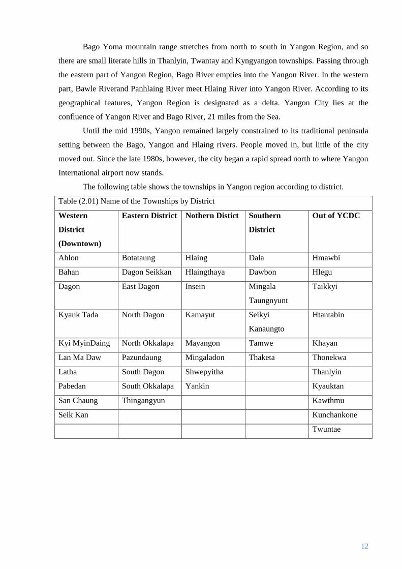
The following table shows the townships in Yangon region according to district.
Table (2.01) Name of the Townships by District
Western
District
(Downtown)
Eastern District Nothern Distict Southern
District
Out of YCDC
Ahlon Botataung Hlaing Dala Hmawbi
Bahan Dagon Seikkan Hlaingthaya Dawbon Hlegu
Dagon East Dagon Insein Mingala
Taungnyunt
Taikkyi
Kyauk Tada North Dagon Kamayut Seikyi
Kanaungto
Htantabin
Kyi MyinDaing North Okkalapa Mayangon Tamwe Khayan
Lan Ma Daw Pazundaung Mingaladon Thaketa Thonekwa
Latha South Dagon Shwepyitha Thanlyin
Pabedan South Okkalapa Yankin Kyauktan
San Chaung Thingangyun Kawthmu
Seik Kan Kunchankone
Twuntae

13
Fig. 2.1. Map of Yangon Region

14
2.3 Climatic condition
Yangon has a tropical monsoon climate under the Köppen climate classification system.
The city features a lengthy rainy season from April through November where a substantial
amount of rainfall is received and a relatively short, dry season from December through March,
where little rainfall is seen. It's primarily due to the heavy precipitation received during the
rainy season that Yangon falls under the tropical monsoon climate category. During the course
of the year, average temperatures show little variance, with average highs ranging from 29 to
36 °C (84 to 97 °F) and average ranging from 18 to 25 °C (64 to 77 °F). According to the
monthly temperature of Yangon region from1999 to 2008, in the month of May has highest
temperature (30.4°C) and December has the lowest temperature of (24.9°C).
2.4 Population and Ethnic
Yangon is the most populous city by far in Myanmar although estimates of the size of
its population vary widely. According to CSO data, Yangon Region is thirds city of high
population after Mandalay Region and Ayeyarwaddy Region. The city's population grew
sharply after 1948 as many people (mainly, the indigenous Burmese) from other parts of the
country moved into the newly built satellite towns of North Okkalapa, South Okkalapa, and
Thaketa in the 1950s and East Dagon, North Dagon and South Dagon in the 1990s. The
government's decision to move the nation's administrative capital to Naypyidaw has drained an
unknown number of civil servants away from Yangon.
Yangon is the most ethnically diverse city in the country. Majority of the
population is of Bamar (Burman). Large communities of Indians/South Asians and the Chinese
still exist especially in the traditional downtown neighborhoods. Intermarriage between ethnic
groups—especially between the Bamar and the Chinese, and the Bamar and other indigenous
Burmese—is common. A large number of Rakhine and Karen live in the city.
Burmese is the principal language of the city. English is by far the preferred second
language of the educated class.
15
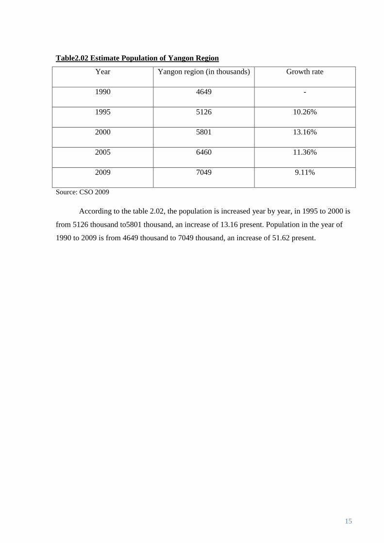
Table2.02 Estimate Population of Yangon Region
Year Yangon region (in thousands) Growth rate
1990 4649 -
1995 5126 10.26%
2000 5801 13.16%
2005 6460 11.36%
2009 7049 9.11%
Source: CSO 2009
According to the table 2.02, the population is increased year by year, in 1995 to 2000 is
from 5126 thousand to5801 thousand, an increase of 13.16 present. Population in the year of
1990 to 2009 is from 4649 thousand to 7049 thousand, an increase of 51.62 present.

16
Chapter (3)
Social Sectors Development of the Yangon Region
3.1 Education
Education and health are basic objectives of development; they are important ends in
themselves. Education plays a key role in the ability of a developing county to absorb modern
technology and to develop the capacity for self-sustaining growth and development. Human
capital is the term for education, health and other human capacities that can raise productivity
when increased.
Vision of the Myanmar Education is “to create an education system that will generate a
learning society capable of facing the challenges of the Knowledge Age” and motto is “
Building a modern developed nation through education”.
Basic Education
Tasks that have been implemented in the Basic Education Sub-sector from 1988 to
present:
(a) Ensuring accessibility to education
(b) Raising the quality of education
Yangon Region has attained the achievement in education sector among the states and
regions within 20 years.
Table (3.1) Development in the Basic Education sector of Yangon Region
Subject Count 1988 2009 Progress
Preprimary school level
Number of school school 0 97 97
Number of student student 0 4206 4206
Pre-primary is the important role in the early childhood development and also very
effectiveness to the primary education that fundamental factor. Table 3.1 shows the progress of
the preprimary school that no preschools and no students before 1988(Exceptionally, daily
child care centers under the department of social welfare) but becomes 97 schools and 4206
students in 2009.

17
According to the CSO data of 2009, the primary school enrolment rate of Yangon
Region has risen to 99.78 percent and the adult literacy rate, 98.75 percent. The table shows
the division’s progress of the education sector. Wastage and drop-out rate in 28.23 in primary
level and 39.93 in 1988 but 5.56 in primary and 5.39 in middle in 2009 shows the reducing of
these dropout rate is a kind of achievement.
Table (3.02) School enrolment rate and wastage in Yangon Region
Subject Count 1988 2009 Progress
Grade 1 enrolment rate (KG intake rate) percent 70.45 99.78 29.33
Adult literacy rate percent 90.5 98.75 8.25
Wastage 0
Primary level percent 28.23 5.56 -22.67
Middle level percent 39.93 5.39 -34.54
Table (3.03) Development in the Education sector of Yangon Region
Subject Count 1988 2009 Progress
Basic education level
Number of school School 2374 2675 301
High school School 126 239 113
Middle school School 183 244 61
Post primary school School 0 361 361
Primary school School 2065 1831 -234
Multi media classroom room 0 373 373
e-learning centre centre 0 77 77
Number of teacher teacher 28859 33276 4417
Number of student student 776162 1005108 228946
Before 1988, Yangon region has about 2000 primary and 183 middle schools and 126
high schools. As the first task of implementing in education sector, government create more
accessibility in villages and ward (rural and urban) by established 361 post-primary schools
Some primary schools upgrade as the post primary level by means children are getting easy
accessible to learn up to middle school level in their villages or neighbor villages. Moreover,
there were established 61 middle schools and 113 high schools that become 2675 schools in

18
total. Now, there are over 1 million basic education students in Yangon Region in 2009. As a
Knowledge Age of 21 century, Information and Technology play in the main role that
government established 373 multimedia classrooms and 77 e- learning centre in Yangon
region. By this way, teachers and students are familiar with the modern IT and getting better
learning condition.
Higher Education
Higher education is a major role of the national economy because nation’s human capital and
productivity relies on the education. With respect to the higher education sector, in Yangon
Region, Yangon is home to over 20 universities and colleges. a total of over 110000 students
are attend at these Universities. Dagon University in North Dagon and the University of East
Yangon in Thanlyin, University of West Yangon in Htantabin are among the largest
undergraduate universities in the country.
Moreover, there are many professional Universities in Yangon Region. The University
of Medicine 1, University of Medicine 2, Yangon Technological University, University of
Computer Studies and Myanmar Maritime University are the most selective in the country.
Yangon Institute of Economics, Yangon Institute o Education, Yangon Unuversity of Distance
Education, Yangon University of Foreign Languages, National Management College, Yankin
Education College, Hlegu Education College and Thingangyun Education College, Officers
Training School in Hmawbi are major institutions of higher education in Greater Yangon.
Yangon has the best educational facilities and the highest number of qualified teachers in the
country.
Table (3.04) Higher education progress in Yangon Region
Subject Count 1988 2009 Progress
Upgrading of higher education
University, degree college college num 9 12 3
e-Learning Centre centre 0 15 15
Teaching programmes num 76 207 131
Number of teacher teacher 2927 3493 566
Number of student student 90092 112259 22167
Human Resource Development Centre centre 0 8 8

19
Table (3.05) Number of degree colleges and universities in Yangon and Union
Sr.No State/ Region 1988 2011 Progress
Increase
(%)
12 Yangon 10 33 23 230.0%
Union Total 32 161 129 403.1%
Source; Education Development in Myanmar, Oct 2011, MOE
According to the Ministry of Education data, 230% increase in higher education sector
in Yangon Region.
Monastic Education
Under the Department of Promotion& Propagation of eh Sasana, Monastic Education
plays in important of Educaiotn. These school emphasize for poor children that mostly
located in semi-urban townships and outskirt townships Shwe Pyi Thar, Hlaing Thar Yar,
Dagon Myohthit, Mingalardon, Hmawbi, Hlegu etc.
Normally, government Basic Education schools are low cost, especially free education
in primary level but still other expenses such as stationaries, uniform etc. This monastic
schools education is effectiveness to poor children especially can not effort to attend at public
school, difficult access to go to public school. Most of the monastic schools are free of charge,
provide stationary, food etc. Following table (3.06) and table (3.07) shows the status of
primary and middle Monastic schools in Yangon Region.
Table (3.06) Monastic Primary schools Education in Yangon Region
Year Primary
School
Novices Nuns Boys Girls Total
2005-06 159 2556 379 14411 12038 29384
2006-07 133 2667 356 14269 12072 29364
2007-08 126 2814 494 14285 12025 29618
2008-09 130 2113 643 14830 12852 30438

20
Table (3.07) Monastic Middle schools Education in Yangon Region
Year Middle
School
Novices Nuns Boys Girls Total
2005-06 10 947 295 1194 1037 3473
2006-07 28 1204 298 1409 1212 4123
2007-08 36 1369 423 1712 1559 5063
2008-09 35 1463 396 2031 1847 5737
According to CSO 2009 data, there is no Monastic High School in Yangon. It can
consider as very few monastic schools in Yangon Region that compare with the union means
Yangon Region population can afford to attend the formal schools than the other states and
regions. There are 1066 Primary, 302 Middle and 2 High Monastic schools in the whole
country.
Non-Formal Education
According to Ministry of Education,2011 data, there are seven Non-Formal Education
Centre in Yangon. This programme implement with UNICEF and Local NGO Pyin Nyar
Dazaung under the supervision of Ministry of Educaiton. This program aim for the dropout
children and over age childeren to join back to the school. It can consider as very few NFE
Centre in Yangon Region that compare with the union means Yangon Region childern attend
the formal schools regularly than the other states and regions. There are 2742 centers in the
whole country.
Table (3.08) No of Non-formal Community learning centers in
Yangon Region 2011
Sr.no Region/State 2011
12 Yangon 7
Union Total 2742

21
3.2 Science and Technology
For the prosperity of the national people, we should not satisfy only in local food
sufficient (agriculture, mineral and natural resources); it should be established to develop in
industrial and service sectors. But the setting up of an industrialized nation needs a large
number of qualified human resources.
Subject Count 1988 2010 Progress
Yangon Technological University university 1 1 0
Number of student (graduate) student 0 28454 28454
Number of student (current) student 0 126 126
Technological University (West Yangon) university 0 1 1
Number of student (graduate) student 0 8606 8606
Number of student (current) student 0 10908 10908
Technological University (Hmawbi) university 0 1 1
Number of student (graduate) student 0 15929 15929
Number of student (current) student 0 6694 6694
Technological University (Thanlyin) university 0 1 1
Number of student (graduate) student 0 19211 19211
Number of student (current) student 0 10274 10274
Yangon Computer University university 0 1 1
Number of student (graduate) student 0 15563 15563
Number of student (current) student 0 3671 3671
Government Technological Institute
(Insein) Institute 1 0
Table (3.09)Development in the Science and Technology sector of Yangon Region
Remark: There are 5 Government Technological High schools in Yangon Region (No.1,No.2,
Ywarma, Aung San, Lakokekone)
After 1989, government established 24 development zones, the project covering the
task to develop human resources simultaneously in the entire nation. The rural development
tasks are being attached to the project for development of all regions of the nation. Now, all the
nationalities have the opportunity to get access to science and technological studies in their
own regions.
As old saying goes, ‘the taller the person, the longer his shade’, the task to build an
industrial nation will be swifter and speedier. Now, concerted efforts are being made to
produce qualified human resources to build a modern, developed nation. The table shows the
number of universities related to science and technology built in Yangon Region.

22
The Table (3.09) shows the development of science and technology school in Yangon
region in the period of 1988-2010. The numbers of students, the schools and universities also
increased year by year as in table.
3.3 Health sector
Poor health conditions in developing countries harm the productivity of adults.
Measuring with infant survival rates and life expectancy can be very misleading. The World
Health Organization, prominently displays its definition of health on its webpage: “ A state of
complete physical, mental, and social wellbeing and not merely the absence of disease and
infirmity.” And a health system is “ all the activities whose primary purpose is to promote,
restore, or maintain health.” Health systems include public health departments, hospitals and
clinics and offices of doctors and paramedics, and also informal network utilized by many
poorer citizens such as traditional healers, acupuncture etc. Education and health are basic
objectives of development; Health is central to well-being and a prerequisite fro increases in
productivity, while successful education relies on adequate health as well.
Yangon Region has obtained than others state and region in achieving health goals.
Health care is nominally free in public clinics and hospitals, but if patients can pay for
medicine share cost for other poor. Yangon Region has the best medical facilities and
personnel available in the country. The following is a summary of the public health system in
the region.
Source: DOH
Table (3.10) Hospitals and dispensaries in Yangon Region
Year Specialist
Hospital
General Hospital Total Dispensaries
with special
service
other Station
2004-05 10 8 26 24 68 64
2005-06 10 8 29 26 73 63
2006-07 11 8 28 26 73 60
2007-08 12 8 31 24 75 60
2008-09 12 8 31 26 77 63

23
Table (3.11) Maternal Mortality Ratio by Yangon and Union
Sr.
No
Region/ Union Urban Rural Total
1 Yangon 1.41 3.48 1.70
2 Region 1.78 2.81 2.55
Source: Central Statistical Organization
According to CSO 2009, Maternal mortality ratio of Yangon Region 1.70 per 1000 live
births while 2.55 in union. For more detail, Urban 1.41 and Rural 3.48 compared with 1.78
(union/urban) and 2.81 (union urban). It can draw a conclusion that rural MMR rate is still high
even in Yangon Region. The table shows the maternal mortality ratio of Yangon region
compare with union. The maternal mortality rate of Yangon region is 0.85% less than union
maternal mortality rate. But for rural , Yangon region is more 0.67% than union , because of
lack health care education and health care facilities in rural area of Yangon region.
Table (3.12) malnutrition under 3 years children
1994 National Nutrition
Survey
1997 Food& Nutrition Survey
Total
Examined
Mal %
<-2SD
Severe
Mal%
<-3SD
Total
Examined
Mal %
<-2SD
Severe
Mal%
<-3SD
Yangon
Region
432 37 9.3 354 38.14 9.89
Union Total/
Average
5994 30.9 8.2 5198 28.22 7.79
Source; National Nutrition Centre, Department of Health
Note; SD= Standard Deviation
Although, Yangon is the Capital of Myanmar, there are many malnutration case (7
more than union average)and 1more severe malnutrition in 1994 survey. Even another survey
in 1997 there are still high in Malnutrition. 10 more in mild malnutration case than union
average and 2 more severe malnutrition. It shows inediquate food and natritional status of the
children and also inequlity of economy.

24
Chapter (4)
Development of Goods Sectors
Yangon Region is the most developed region in the country. According to the
government's official statistics for FY 2010–2011, the size of the economy of Yangon Region
was 8.93 trillion kyat, or 23% of the national GDP. Yangon is the country’s main center for
trade, industry, real estate, media, entertainment and tourism. The city alone represents about
one fifth of the national economy. Yangon is Lower Myanmar’s main trading hub for all kinds
of merchandise. There are many wholesale markets and retail shops in Yangon’s Townships.
As open-land region, much of the country’s legal imports and exports go through Thanlyin's
Thilawa and Yangon ports. Outskirt of Yangon, paddy fields remain predominant. Other
important crops include jute, pulses, rubber, sugarcane, and groundnut. Construction is a major
source of employment.
4.1 Labour Force
Labour force take place as a main role in the economic development. Yangon Region is
also create job opportunity and basic of human resource capital. According to the CSO,
Department of Labour, Labour Force Survey 1990, 40.9% of the male and 30.7% of female
labour of the country. This data shows that Yangon has more job opportunity than other States
and Regions.
Table(4.01) Economically Active Population by Yangon and Union (1990)
Urban Rural Total
Male Femal Both Male Femal Both Male Femal Both
Thousands of persons
Yangon 828 325 1153 313 142 455 1141 467 1608
Union 2025 1060 3085 5779 2485 8264 7804 3545 11349
Percent Distribution
Yangon 40.9% 30.7% 37.4% 5.4% 5.7% 5.5% 14.6% 13.2% 14.2%
Source: CSO; 2009, Department of Labour
Yangon is as a commercial capital, various economic sectors Yangon region. daily
workers and merchants are large proportions of working people at Yangon. Casual labors are

25
also large number. Other kinds of occupations such as: brokers, private tuition teachers, actors,
singers, models, small own business, vendors and shopkeepers. They are largest share of
working people at Yangon. Yangon has many chance of job and education opportunities, so
people from other states and regions pulls up to Yangon by opportunities and hope.
Table (4.02) Registered Employees by Yangon Region and Union
Yangon 1990 1995 2000 2005 2009
Male 124249 123079 140782 134664 124336
Female 33737 57399 162058 131341 135737
Union
Male 259755 241624 283753 284835 268655
Female 70135 98696 225124 209550 216865
% by union Male 48% 51% 50% 47% 46%
% by union Female 48% 58% 72% 63% 63%
Source: CSO 2009, (Social Security Board)
Table (4.02) shows registered employees the progress of labour source year by year. In
1990 48% of male and 48% of female labour of the country. Male labour progress is increase
but not too much 51%, 50%, 47% and 46%. There are many female labour increase year by
year 58%, 72% , 63% and 63%. It means highest female job opportunity and highest gender
equity than other States and Regions.
4.2 Agriculture
Myanmar is the Agricultural base country, thus, Yangon Region also play in the
agricultural sector and implemented the economic objective; Development of agriculture as
the base and for all-round development of other sectors of economy as well. Clusters of
infrastructures have already been built in all necessary places. Because of eh energetic efforts
to extend sown acreage, increase per acre yield and introduce new crops species. As a result
that nation now is enjoying surplus rice.

26
Yangon Region is surrounded by fertile rural regions. In the past, the region could not
cultivate crops at its full capacity because there were no large dams in the region. So, the
government had to fulfil the region’s needs of food sufficiency, extended cultivation of beans
and pulses, and growing of industrial crops and perennial crops.
In table (4.03 ) shows the rate of production of crops in Yangon region. For paddy, increase in
production rate of 98% from the year of 2000 to 2009. And also most of the other types of
crops are increasing in production between 2000 to 2009.
Yangon is geographically located in the Delta, that suitable soil condition for
agriculture. Rice is the major crop in Yangon Region. There are 1373,000 acre of paddy field
in 2000 and 1390,000 acre in 2009. Yangon region various kind of crops such as cereals, oil
seeds, Pulses, spices, vegetables and fruits and other miscellaneous crops. Agriculture is not
only local consumption but also export to other regions and abroad. Farmers and cultivators
has advantage in market opportunity because nearly 7 million population is a huge market for
them.
Table (4.03) shows there have been constructed 19dams in 21 years. It has constructed
23 river water pumping stations and task under implementation is 9in the region so as to extend
multiple cropping. Table show some achieved record of dams and sluice gates.
Table(4.03)Sown Acreage of Crops by Yangon Region(thousands of acre)
Year Cereals
Paddy Groundnut Sesamum Blackgram Greengram Cow Pea Duffin bean Pelum
2000 1373 7 5 41 26 2 4 4
2005 1367 8 4 41 33 4 3 5
2009 1390 11 4 46 35 2 3 5
Table(4.03)Sown Acreage of Crops by Yangon Region(thousands of acre)
Year Spices
Chillie Vegetables Fruits Rubber Coconut
2000 1.1 33 87 28 6.1
2005 1.2 49 90 31 9.6
2009 1.6 53 78 32 9.2
Miscellaneous
Medicinal plants
0.1
3.4
2.5
Oil seeds Pulses
Vegetables and Fruits

27
Table (4.04) Dams and Sluice gates in Yangon Region (up to 2010)
Name of Dam Year of implementation Benefits acres of
farmland
Located Township
Taung lon Myaung 1993 NA
Ngamoeyeik 1995 70,000 Hlegu
Tabuhla NA 52,000 Taikkyi
Zamani NA 1,000 Thanlyin
Zee Byu Gon Sluice
Gate
NA 7,500 Twantay
Kungyangon Sluice
Gate
2000 21,400 Kungyangon
Moe Ma Kha Sluice
Gate
2000 40,000 Twantay
La Gun Byin Dam 2001 22,000 Hlegu
Ka Li Htaw Dam 2003 9,000 Hlegu
Mahuyar Dam 2004 NA Hlegu
Paung Laung Dam 2004 NA Hlegu
Kayan Sluice Gate NA 30,000 Kayan/Thanlyin
Two Thone Gwa
Sluice gates
NA 29,000 Thongwa
Kadatpana Sluice Gate 2009 15,000 Kyauktan
Since 1990, the living standard of Yangonites became higher and its population was on
the increase. Therefore, the government established more new towns and villages. On the other
hand, need to fulfill the food security of the population. In the agricultural sector, It is need to
fulfill the infrastructure, create or maintain or upgrade the water source for firms production.
However, the government managed to speed up the agricultural work in the region, so the
multiple cropping has increased five times.

28
Table (4.05) Development in the agriculture sector of Yangon
Region
Subject Count 1988 2009 Progress
Land resource
Sown acreage acre 1452471 2213843 761372
Virgin and vacant land acre 342837 47748 -295089
Water supply task
Dam, Lake , Reservoir, Drain
Task completed num na 19 19
Benefited area acre na 304395 304395
River wate pumping project
Task completed num - 23 23
Task under implementation num - 9 9
Benefited area acre - 29955 29955
125 125
Damming Creek num - 26968 26968
Benefited area acre -
Artesian wells num - 566 566
Benefited area area - 4131 4131
Total benefited area acre - 365449 365449
Double cropping acreage acre 124970 648849 523879
Crop Cultivation
Extended paddy cultivation
Moonsoon paddy acreage acre 1197955 1200009 2054
Regional rice sufficiency percent 100 103 3
Surgarcane acreage acre 1689 6566 4877
Rubber acreage acre 4040 33777 29737
Oil palm acreage acre - 85 85
pepper acreage acre - 411 411
Physic nut acre - 84755 84755
Lan reformation by machine acreturn 250630 14547249 14296619
Tractor station station 4 4 -

29
Table (4.05) shows development in the agriculture sector of Yangon Region 1988 to
2009. Firstly, to increase the natural resource, Land upgrade and change from the virgin or
vacant land to sow able land about 761372 acre. Secondly, Water is essential for the
agriculture that creates the infrastructures such as dams, reservoir, water pumping, damming
creeks and artesian wells. By means of that progress, there are increasing double cropping
acreage about 500,000 and also increasing other crops productivity. Now, Yangon Region’s
regional rice sufficiency becomes 103%.
4.3 Livestock and Fisheries
The fisheries and livestock sector plays a vital role in the culture and socio-economic
life of Myanmar. In most traditional farming systems, livestock consume little grain, and meat
production is often one of the least important roles of livestock. Of course livestock make an
important contribution to extending the quality of the diet as well, by providing meat, milk, and
eggs. Small amounts of these high-protein foods can have a significant impact on human
health.
Table (4.06) Production of Fish and Prawns by Yangon Region and Union Total
1990 1995 2000 2005 2009
Yangon 24890 34789 40163 149619 179009
Union 449050 412385 785495 1580051 2153141
% of 6% 8% 5% 9% 8%
Source; CSO 2009, Department of Fisheries
Fig; 4.1 Meat and Fish supply in Yangon

30
Marine fisheries in Myanmar accounts for about 75 percent of the total fish production,
with the rest coming from fresh waters. Traditionally Myanmar people prefer freshwater fish to
marine fish. With the population of Myanmar 50 million in the year 2000 the per caput fish
consumption was 21 kg/year. The fish and marine products sector stands at second in
Myanmar’s export. Therefore, the government has placed much emphasis on the production of
aquatic products to meet local demand and boost export.
Table (4.07) Development in the livestock breeding sector of Yangon Region
Subject Count 1988 2009 Progress
Extended livestock breeding
Cattle head 492184 518297 89113
Sheep/goat head 32421 82494 50073
Pig head 276012 756402 480390
Chicken head 4157277 24740233 20582956
Duck head 1597249 2488343 891094
Turkey, Goose, Muscovy duck head 197427 219349 21922
Quail head 220317 220317
Fish and prawn breeding
Fish breeding pond acre 928 59870 58942
Prawn breeding pond acre 0 10230 10230
Crab breeding pond acre 0 1099 1099
Honey Production
Bee-hives num 100 1163 1063
Honey Production pound 1500 70800 69300
Pollination service acre 2993 10200 7207
31
Now, Yangon Region is extending the breeding of fish and prawn to provide sufficient
fish and prawn for the local people. In 1988, there were 928 acres of fish breeding ponds, there
re 59870 acres of fish breeding ponds. There was no shrimp farming in the past but nowadays,
10230 acres of land have been operational under shrimp farming. Honey production has
increased by 69300 ponds, compared with that of 1988. Livestock breeding sector has increase
year by year to food secure of the regional consumption and exporting to local and abroad.
Moreover, Yangon Region has bee-hives stations that are producing honey and pollination
service. The table indicates the progress of its livestock and fishery sector.
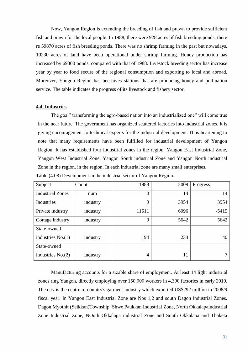
4.4 Industries
The goal” transforming the agro-based nation into an industrialized one” will come true
in the near future. The government has organized scattered factories into industrial zones. It is
giving encouragement to technical experts for the industrial development. IT is heartening to
note that many requirements have been fulfilled for industrial development of Yangon
Region. It has established four industrial zones in the region. Yangon East Industrial Zone,
Yangon West Industrial Zone, Yangon South industrial Zone and Yangon North industrial
Zone in the region. in the region. In each industrial zone are many small enterprises.
Table (4.08) Development in the industrial sector of Yangon Region.
Subject Count 1988 2009 Progress
Industrial Zones num 0 14 14
Industries industry 0 3954 3954
Private industry industry 11511 6096 -5415
Cottage industry industry 0 5642 5642
State-owned
industries No.(1) industry 194 234 40
State-owned
industries No.(2) industry 4 11 7
Manufacturing accounts for a sizable share of employment. At least 14 light industrial
zones ring Yangon, directly employing over 150,000 workers in 4,300 factories in early 2010.
The city is the centre of country's garment industry which exported US$292 million in 2008/9
fiscal year. In Yangon East Industrial Zone are Nos 1,2 and south Dagon industrial Zones.
Dagon Myothit (Seikkan)Township, Shwe Paukkan Industrial Zone, North Okkalapaindustrial
Zone Industrial Zone, NOuth Okkalapa industrial Zone and South Okkalapa and Thaketa

32
industrial Zone. In Yangon West industrial Zone, There are Mayangon, Hlaing and Kamayut
industrial Zone. In Yangon south Thanlyin, Kyauktan, and Kayan Industrial Zones; In North,
Hlainethaya, Shwepyitha and Mingaladon industrial Zones. The table compared the region’s
project of the industrial sector in 1988 and 2009.
Table (4.09) Types of industries in industrail zones in Yangon Region
Type of industry Industrial zones
Hlaing
Tharyar
Dagon Dagon
2
Dagon
Seikkan
Shwe
Pyi tha
Total
Construcation material 19 2 11 2 0 34
Consumer and household
good
74 16 35 4 22 151
Chemical 12 0 0 1 2 15
Electrical 6 25 63 2 3 99
Food processign and
beverages
72 4 13 0 39 128
Garment 83 10 14 6 40 153
Iron, metal nad machineries 12 17 175 1 6 211
Paper and related works 7 6 68 2 5 88
Plastic 0 20 98 0 0 118
Rubber and related works 0 7 18 0 0 25
Wood and forest based 27 8 39 10 14 98
Others 104 20 23 4 6 157
Total 416 135 557 32 137 1277
Soruce; Industrial Zone Management Committees, 2002
Table (4.09) describe the types of indrustries by industrial zone. These industrial zone
are made up of 3954 industries. The region has 60% private run factories and 5642 cottage
industries alongside 234 State owned factories (industries 1) and 11 State owned factories
(Industry 2). There are many economists recommended that Industrialization is the important
role to the national development. However, Yangon Region is on the way of achievement in
the national economic planning.

33
4.5 Forestry
Forests contribute 52 per cent of the total land area of Myanmar. Forest resources
significantly contribute towards national development and economic growth. So, forest
resources are to be exploited efficiently and conserved systematically. Respective villages have
established local people-owned tree plantations, village-owned tree plantations for firewood.
Forests and trees are reliable for national economic growth. Government recognized that in
environmental degradation, deforestation by illegal woodcutting and depletion of forest
resources.
In order to prevent depletion of forest resources, conservation and protection of natural
forests, raising forest nurseries, prohibition of forest encroachment, restriction of felling trees
and cutting timber. Yangon Region is protecting and conserving its forests by Regional
greening tasks in the 13 arid districts of Myanmar. Since 2004-5 fiscal years; it has been
implementing a five-year plan and establishing watershed areas extensively for greening of
Bago Mountain Range, where teak and various species of hardwood grow densely including
Northern Yangon region. Regarding the forestry sector tables are following.
Table (4.10) Development in the forestry sector of Yangon Region.
Subject Count 1988 2009 Progress
Reserved forest Sq/mile 468 425.36 -42.64
Natural land area Sq/mile 2.41 2.41 0
Establishment of forest plantation acre 5935 88634 82699
Teak special plantation acre 0 8000 8000
Commercial plantation acre 1500 24389 22889
Village firewood acre 4335 29837 25502
Industrial plantation acre 500 500 0
Watershed plantation acre 100 25908 25808
Establishment of private forest
plantation acre 0 1060 1060
Private teak plantation acre 0 100 100
Private hard wood plantation acre 0 960 960
Mass tree planting
tree (in
million) 0.9 19.44 18.54
Forest Training School number 1 1 0

34
Due to forest policy of Myanmar, sustainable management of the forests is practiced to
ensure perpetuity, the level of benefit both tangible and intangible for future generations.
Following table (4.10) shows the permanent forest estate of Yangon Region.
4.6 Electricity
Electrical power plays an essential role for developing countries. In Myanmar, the
government tries to apply innovating to full tap the country’s rich natural resources for serving
the interest of posterity. Electricity is an essential need for increasing number of industrial
zones and factories in he region. Thus, the government constructed a large power plant for
energy sector. The government fulfilled energy requirement, such as hydro power, wind power,
gas turbine plant, bio-diesel energy and innovated possible project as solar plants.
Table (4.12) Electric Power Generation by Yangon Region (million kwh)
1990 1995 2000 2005 2009
Yangon
Region
122.8 1141.18 2224.9 1953.85 1756.4
The table represents progress of the electricity sector of Yangon Region. According to
CSO 2009 data, Electricity consumption is sharply increased 1990 to 2000 because of
increasing population, business, industrial zones and going up more urbanization. But since
2005, 2009 decline because government made safety energy policies such as reducing power
especially in government offices.
Year Total Land Area Reserved Forest Protected Area System Total
2005 3927 428 2.41 430
2006 3927 428 2.41 430
2007 3927 427 2.41 430
2008 3927 427 2.41 430
2009 3927 426 2.41 429
Table(4.11)Permanent Forest Estate By Yangon Region(square mile)

35
Table (4.13)Development in the Electricity sector of Yangon Region
Subject Count 1988 2009 Progress
Electricity consumpiong unit( in million) 757.9 4131.95
Maxinum power megawatt 127.1 522.5 395.4
Total installed power megawatt 110.716 471.279 360.563
Electric power plants 0
Combined cycle power plant plant 0 4 4
Natural gas/ Diesel powered plant plant 1 5 4
Diesel-used plant plant 0 3 3
Department -owned plant 0 3 3
Plant fuelled by paddyhusk and
coconut palm leaf plant 0 3 3
Department -owned plant 0 0
Main Sub-station MVA 260 1597 1337
(1) 230 KV substation MVA 260 940 680
(2) 66KV substation MVA 0 657 657
Distribution Sub-stations MVA 3837.49 3997.67 160.187
1)33 KV substation MVA 1150.2 1614.38 464.176
2) 11 KV substation MVA 662 929.392 267.392
3)6.6 KV substation MVA 1021.92 1451.05 429.131
4) 3.3 KV substation MVA 2.85 2.85 0
Distribution Lines mile 3739.16 5135.96 1396.8
1)33KV line mile 567.408 690.51 123.102
2) 11 KV line mile 678.531 794.45 115.919
1)6.6KV linr mile 408.86 644.83 235.97
4)3.3KV line mile 2 2 0
5) 0.4 KV line mile 2082.33 3004.17 921.84
Metering Completion mile 253379 786740 533361
The living standard of local people has become higher to a certain degree. In The past
on average a household could use an electric apparatus, and now a citizen can use close to the
rate of an electric apparatus. The careful analysis of increasing number of industrial zones an

36
factories in the region will reveal the electricity requirement that is interrelated with the
nation’s improvement an changes for the better. Table (4.11) shows the development in the
electrical sector between 1998 to 2009.
4.7 Energy
There have emerged onshore oilfields in Yangon Region. The table shows production of gas
and oil of the oilfield.
Table (4.14) Development in the energy sector of Yangon Region
Subject Count 1988 2009 Progress
Oilfield (Inland) Field 0 2 2
Length of oil and gas pipeline mile 32.6 290.77 258.17
Inland mile 32.6 290.77 258.17
Crude Oil Production barrel 0 2823 2823
Inland barrel 0 2823 2823
Natural Gas Production cubic ft (in million) 0 865.96 865.96
Inland cubic ft (in million) 0 865.96 865.96
Refining of Crude Oil Gallon (in millions) 37.92 93.86 55.94
Filling station station 49 56 7
CNG station 2 41 39
Plants plant 1 4 3
Oil Refinery (Thanlyin) plant 1 1 0
Tar plant (Thanlyin) plant 0 1 1
Carbondioxide plant (Thanlyin) plant 0 1 1
Fertilizer plant (Myaungtakar) plant 0 1 1
Moreover, there are two natural gas fields in under implementation
1. Aphyauk natural gas
2. Indine natural gas
4.8 Mining
In the 47th
anniversary of Yangon Gem showroom sold that 7326 pair of Jade, 36 pair
of Gems, and also in special promotion sold 9471 pair of Jade, 42 pair of Gems,. There were
produced 3312.205 metric tons of led, 250 tons of salt, 4.2 million of packet of ORS.

37
Chapter (5)
Development of Service Sector
5.1 Transportation
Yangon is main domestic and international hub for air freights, rail, local and
international sea and road transportation. Yangon Region has the best transportation
infrastructure in the country.
Air freights
Yangon International Airport is not only the central airport for abroad especially
ASEAN and other countries but also local routes connected to other cities, towns and regions
as a network. There are many private Myanmar Air Lines, government airlines and also
international air line agencies.
Railways
Yangon has also the centre of railway transportation that connected to the other states
and region. Railways lines in Yangon as a web, one connected to the East Bago,
Mawalamyaing, and Kayin, Tanitharyi etc and the other one to the North that Mandalay,
Naypyitaw, upper Myanmar etc and other one to Pyi that connected to Ayeyarwaddy and
western. Moreover, Yangon local routine railway system is very effective for the population
of the suburb and outskirt townships.
Port, Inland transportation and Marine
Monsoons weather has dominated in the Bay of Bengal in Myanmar area between May
to October gradually. The very warm damp south-west monsoon blows, often with
considerable strength, and there are long periods of clouds and rain.
Yangon is the major port and it is outside the stockade on the river bank and there were
3 wooden wharves leading down to the river. In 1954 as Yangon Port Administrative Board
was established, 1972 as Port Corporation and 1989 as Myanmar Port Authority were formed.
The volume of exports increased rapidly and thus, vessels calling to Yangon Port an cargo
volume were also increased. The port of Yangon is principle trading center of Myanmar.
In 1988-89, the port of Yangon had 12 wharves, catering to international traffic for sea
going vessels. These were located along the 6 kilo meters of quay front Kyimiyndine to
Pazundaung creek along the strand road and Yangon ports wharves.
Yangon is surrounded by Adam sea( Bay of Bengal) in South, Yangon River, Hlaing
River, PanHlaing River in West and Bago River in East. So, Inland Transportation and
Marine is also important for Yangon Region. Under the Myanmar Port Authority, Yangon

38
Port and Thilawa International Port are major port of the country. Yangon has four main
passenger jetties; all located on or near downtown waterfront, mainly serve local ferries across
the river to Dala and Thanlyin, and regional ferries to the Irrawaddy delta. The 22-mile
(35 km) Twante Canal was the quickest route from Yangon to the Irrawaddy delta until the
1990s when roads between Yangon and the Irrawaddy Division became usable year round.
Twante Canal, which links Yangon to Ayeyarwaddy Region, is also widely used for both
transport and commerce.
People have to rely on ferry services in the region as it is teeming with many rivers and
creeks. Thanlyin Bridge is one an only facility that links Yangon East and West. Transport
had been poor for a long time before 1988.
Hlaing River Crossing bridges, BaYint Naung Bridge, Aung Zay Ya Bridge and Shwe
Pyi Thar Bridge and new road to directly link the region with Ayeyawady Region.
All transport to and from the rest of the country (and the world) goes through Yangon.
Five "highways" link Yangon to the rest of the country. There have emerged town to town
roads and village to village roads such as Kaddapana-Khanaung- Zwebar Konetan- Kwani-
Kamar kalok road in Kyauk Tan Township.
A total of 37 bridges, each of which is more than 180 feet long, including 10 large
bridges under special project have emerged in the region.
1. Aungzeyua Bridge (Insein)
2. Maha Bandoola Bridge (Paqundaung),
3. Hlaing River crossing bridge (Myochaung),
4. Bawle River crossing bridge (Yebawthaung),
5. Dagon Bridge (Seikan township),
6. Panhlaing Bridge
Yangon Region 1990 1995 2000 2005 2009
Length of
Roads(miles) 272 441 511 543 595
Bituminous 234 255 305 328 393
Metal led 18 32 53 63 65
Surface 20 25 59 73 61
Earth N/A 129 94 79 76
Table(5.01)Arterial highways of Yangon

39
7. Panhlaing Bridge
8. Twantay Bridge
9. Ngamoeyeik Bridge (Thingangyun),
10. Ngamoeyeik (Kamar kyi),
These large bridges are contributed towards better transport of the region. On
completion of the one bridge project, local people can travel by car to all parts of the country.
The table indicates progress of the region’s transport sector.
Table (5.02 )Development in the transportation sector of Yangon Region
Subject Count 1988 2009 Progress
Railways
Route Mile mile 109.25 157.57 48.32
Track Mile person (in thousand) 195.45 252.56 57.11
Passenger mile 22774.4 43159 20384.6
Passenger Mile mile 377434 798047 420613
Goods (1x 10000) tons 326.6 650 323.4
Goods Mile (1x 10000) mile 59591 162611 103020
Statioin (1x 10000) station 45 74 29
Rail bridge bridge 358 469 111
Bridge (above 60feet) bridge 24 28 4
Bridge (under 60 feet) bridge 334 441 107
Airways 0
Airfield field 3 3 0
above 10000 ft runway airfield field 0 1 1
above 5000 ft runway airfield field 2 1 -1
under 5000 ft runway airfield field 1 1 0
Water Transport 0
Jetty (inland) jetty 57 71 14
Jetty (MV) jetty 13 26 13
Extension of motor road mile 243 595 352
Bituminous road mile 228 393 165
Metalled road mile 9 64 55
Gravel road mile 6 60 54
Earth road mile 0 76 76
Construction of Bridge 0
Public Works 0
Above 180 feet bridge 7 38 31
Completed bridge bridge 7 37 30
Bridge under construction bridge 0 1 1
Under 180 feet bridge 45 111 66

40
5.2 Communication
In the study of a region’s socio economic development, communication is also
important. It is including post, telegraph, telephone, internet etc. Under the Ministry of Post
and Telecommunication, Central post office and telegraph office is located in downtown. All
of the townships have the post office, and 82 telephone offices in 2009 and 92 exchange
including auto exchange, manual exchange and rural exchange.
There is 34340 line capacity in 1988 but 947269 in 2009 means 912929 line capacity
progresses. Moreover, 35357 direct line in 1988 but 461418 direct line capacity in 2009. So,
nearly 150000 lines can be use at the same time. In the progress of the number of telephone,
there has only 35357 of auto/ manual telephone in 1988. But about 700,000 of telephone
including auto/ manual, ARTS, DECT, CDMA, Mobile, D-AMPS, GSM, and WCDMA etc.
There are 6 micro-web stations in 1988 to 18 in 2009 that increase 12 stations. There
are 5666 email and internet lines by MPT, Myanmar Post and Telecommunication and
Yadanarpon Teleport. There are nearly 2000 satellite channel and nearly 5000 sub-marine
channel, fiber cable line and oversea channel in Yangon Region.
Moreover, there are many private post and telecommunication companies such as
Royal mail, DHL etc.
However, Yangon Region is the most developed Region in the county in
communication, information and Technology.
The following table (5.05) shows the development of the communication sector of
Yangon Region.

41
Table (5.03) Development in the communication sector of Yangon Region
Subject Count 1988 2009 Progress
Telephone service
Telephone office office 22 82 60
auto exchange exchange 11 46 35
manual exchange exchange 11 16 5
rural exchange exchange 0 20 20
number of line capacity line 34340 947269 912929
direct line line 35357 461418 426061
auto /manual phone phone 35357 187491 152134
ARTS ration telephone phone 0 1970 1970
DECT ration telephone phone 0 450 450
CDMA (fixed telephone phone 0 18237 18237
Mobile telephone phone 0 253270 253270
CDMA(mobile) telephone phone 0 27738 27738
D-AMPS telephone phone 0 13116 13116
GSM telephone phone 0 205007 205007
WCDMA telephone phone 0 7409 7409
Micro web station station 6 18 12
Email/ interned line 0 5666 5666
Local satellite ground station 0
MPT Satellite Terminal station 6 182 176
Local satellite Channel 0
MPT Satellite Terminal channel 0 728 728
Overseas satellite ground station station 1 2 1
Overseas satellite channel channel 26 924 898
Overseas submarine cable channel channel 0 1486 1486
Fibre cable linkage num 0 659 659
Overseas telephone channel channel 26 3069 3043

42
5.3 Hotel and Tourism
Yangon is the former capital of Myanmar and also entrance of the foreign arrival. So
Hotel and tourism is also source of the finding the foreign currency. There are many attractive
place in Yangon such as Shwedagon Pagoda, Sule, Botataung, KabarAye pagoda and Yangon
zoological garden, Kandawgyi lake, Inya lake etc. Tourism represents a major source of
foreign currency for the city although by Southeast Asian standards the actual number of
foreign visitors to Yangon. Cyclone Nargis dampened tourism even farther. The 2008 tourist
arrivals at Yangon International are down to less than 50% from the previous year. Yangon's
international standard hotels, built with foreign investment in the 1990s. There are many
famous large hotels are Traders Hotel, Sedona Hotel, Inya Lake Hotel, Park Royal, Yangon
Hotel etc.
Table (5.04) Hotels, Motels, in Yangon Region
No. of Hotel, Motel
1990 1995 2000 2005 2009
State owned 7 8 5 3 -
Private owned - 22 155 160 161
Union total 7 96 514 606 630
Table (5.05) No.of Business in Tourism in Yangon Region
1990 1995 2000 2005 2009
Tourist Enterprises - 455 601 678 723
Tourist Transport
business
- 1283 423 442 213
Tour guide business - 1407 5019 4157 4804
Sources: CSO: 2009; Directorite of Hotels and Tourism
Table (5.06) No.of Tourism per year arrival to Yangon
Year 1990 1995 2000 2005 2009
No.of
Tourism
8446 81428 121016 144628 100439
Sources; CSO 2009, Department of Immigration and National Registration

43
5.4 Finance and banking
As a commercial city of Myanmar, Yangon, there are many commercial and business
companies increase year by year. Yangon is the centre of economics of Myanmar, many
foreign enterprises are invested in Yangon. According to the geographical condition, Yangon
has open land city that trade to abroad and other regions.
Central Bank of Myanmar is located in Yangon downtown. There are many government
banks in most of the townships. Other types of banks such as livestock and fisheries bank etc
are also in downtown. There are many private banks are also in Yangon Region such as Innwa
bank, Asia Green Development bank, Yoma bank, MOB, CB bank etc. Only one Foreign
exchange currency bank, Myanmar Foreign Trade bank is located in downtown of Yangon.
5.5 Social welfare
Social welfare services are provided through the department of social welfare (DSW) in
Yangon region. In Yangon region, there are child services such as pre-primary school, child
care centers are being opened to facilitate the public youth centers and vocational schools are
also provided with assistance of social welfare developments. Yangon Youth Training School
located in Kabaraye Pagoda Road and Nghet Aw San Youth Training Center in Twunte. These
are especially for boys. Malikha Center is especially for girls under 18. National Rehabilitation
Centre for Disable person is located in Mayangone Township. Some Social Welfare Clinic are
still in some townships. For age’s people who have no one to look after them, as Hninsigone
Ages Home is a famous one in Yangon region.
44
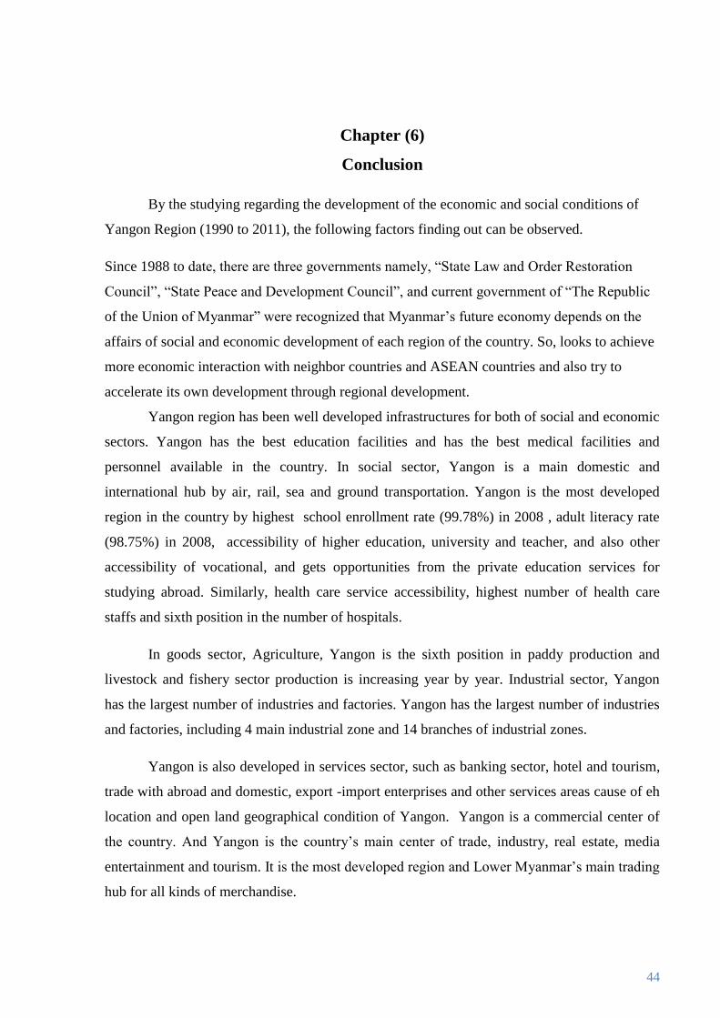
Chapter (6)
Conclusion
By the studying regarding the development of the economic and social conditions of
Yangon Region (1990 to 2011), the following factors finding out can be observed.
Since 1988 to date, there are three governments namely, “State Law and Order Restoration
Council”, “State Peace and Development Council”, and current government of “The Republic
of the Union of Myanmar” were recognized that Myanmar’s future economy depends on the
affairs of social and economic development of each region of the country. So, looks to achieve
more economic interaction with neighbor countries and ASEAN countries and also try to
accelerate its own development through regional development.
Yangon region has been well developed infrastructures for both of social and economic
sectors. Yangon has the best education facilities and has the best medical facilities and
personnel available in the country. In social sector, Yangon is a main domestic and
international hub by air, rail, sea and ground transportation. Yangon is the most developed
region in the country by highest school enrollment rate (99.78%) in 2008 , adult literacy rate
(98.75%) in 2008, accessibility of higher education, university and teacher, and also other
accessibility of vocational, and gets opportunities from the private education services for
studying abroad. Similarly, health care service accessibility, highest number of health care
staffs and sixth position in the number of hospitals.
In goods sector, Agriculture, Yangon is the sixth position in paddy production and
livestock and fishery sector production is increasing year by year. Industrial sector, Yangon
has the largest number of industries and factories. Yangon has the largest number of industries
and factories, including 4 main industrial zone and 14 branches of industrial zones.
Yangon is also developed in services sector, such as banking sector, hotel and tourism,
trade with abroad and domestic, export -import enterprises and other services areas cause of eh
location and open land geographical condition of Yangon. Yangon is a commercial center of
the country. And Yangon is the country’s main center of trade, industry, real estate, media
entertainment and tourism. It is the most developed region and Lower Myanmar’s main trading
hub for all kinds of merchandise.

45
According to the data from previous chapters, Yangon is making great progress in both
economic, social and service sectors. That shows the Yangon region has speed of development.
Consumption of electricity in Yangon is high, thus needed to produce more electricity. There is
high density of populations thus occur accident by traffic-jams and reducing environmental
sustainability by pollutions. To measure the development of Yangon region is difficult,
because of data available and taking time. Thus this paper overview is draft analysis for
development of Yangon Region.
Exceptionally after November 2005, before establish new administrative capital
Naypyidaw, however, Yangon still stands as the largest city, and the most important
commercial center of Myanmar than the other states and regions.