- short note - glacial deposits in the rio del … · c) clasto de andesita de 1.5 m (a en la foto)...
TRANSCRIPT

37
(C) Asociación Argentina de Sedimentología - ISSN 1669 7316
LATIN AMERICAN JOURNAL OF SEDIMENTOLOGY AND BASIN ANALYSIS | VOL. 15 (1) 2008, 37-42
- SHORT NOTE -GLACIAL DEPOSITS IN THE RIO DEL PEÑON FORMATION
(LATE CARBONIFEROUS), RIO BLANCO BASIN,NORTHWESTERN ARGENTINA
E. GULBRANSON 3; C.O. LIMARINO 1,2; S. MARENSSI 1,2; I. MONTANEZ 3;N. TABOR 4; V. DAVYDOV 5 and C. COLOMBI 1,2
1Department of Geology, University of Buenos Aires, Ciudad Universitaria, Bs. As., Argentina. [email protected]. 3Department of Geology, University of California Davis, One Shields Ave, Davis, CA 95616, EE.UU.
4Department of Geological Sciences, Southern Methodist University, Dedman College, Dallas, TX 75275, EE.UU.5Department of Geosciences, Boise State University, Boise, ID, 83725, EE.UU.
Received: March 12, 2007 - Accepted: May 25, 2008
INTRODUCTION
The Río del Peñón Formation (Borrello, 1955 nom.subst. González y Bossi, 1986) forms the upper part ofthe late Paleozoic outcropping in the Río Blanco anti-cline (northwest Precordillera, La Rioja Province). Thisunit is predominantly composed of a thick (1270 m.)sandstone and mudstone sequence including thin lev-els of coal and scarce conglomerates (Scalabrini Ortiz,1972; Scalabrini Ortiz and Arrondo, 1973; Gonzálezand Bossi, 1986). These deposits represent a complexinterfingering of shallow marine and fluvial depositsrecording relative sea-level fluctuations during the LateCarboniferous-Early Permian. The Río del Peñón For-mation overlies andesites and volcanic breccias of thePunta del Agua Formation (Fig. 1 and 2a).
Despite well known Late Carboniferous glacigenicdeposits from different localities within the Precordillera(López Gamundí, 1987, 1997; López Gamundí andMartinez, 2000; Marenssi et al., 2004; Limarino andSpalletti, 2006; Henry et al., in press), glaciogenic de-posits have not been reported from the Río del PeñónFormation. This documentation of glacial-related sedi-ments in this succession serves to further constrainour knowledge of the temporal and paleogeographicdistribution of Gondwanan glacial deposits.
THE GLACIGENIC DEPOSTIS
Previous studies have interpreted the Río del Peñonsuccesion as deposited in fluvial, transitional and ma-
rine environments (Scalabrini Ortiz and Arrondo, 1973,González and Bossi, 1986; Limarino et al., 1996). Thisassociation of facies appropriately characterizes mostof the formation and, indeed, describes the whole ofthe sequence to the South of the del Peñón River. How-ever, to the North, the basal part of the Rio del Peñonsuccession is composed of diamictites and shales (Fig.1). These basal units compose the glacigenic intervaldescribed in this paper and they were likely over-looked previously because diamictites are lacking orpoorly exposed to the South of the del Peñón River.The glacial interval is well exposed to the North of thestudy area but progressively thins towards the Southwhere a high-relief erosive surface separates the dia-mictitic interval below from shallow marine and flu-vial sediments above (Fig. 1). In this way, to the Northof the del Peñon River, the glacial interval reaches amaximum thickness of 80 m but it thins progressivelyto the South due to truncation. The erosive surfaceeroding the glacial interval (Fig. 2b) cuts stratigraph-ically downward to the South where it is developedon fine-grained shallow marine sandstones overlainby medium and coarse-grained fluvial sandstones.
The glacigenic and early post-glacial deposits canbe informally divided into four major components: (1)various diamictite types, (2) pebbly mudstones, (3)laminated shales, and (4) interbedded mudstones andsandstones. Overall, the glacigenic interval was depos-ited in a marine environment as indicated by the pres-ence of marine invertebrates, thick levels of laminatedshales and wave-cross laminated sandstones.

38
E. GULBRANSON, C.O. LIMARINO, S. MARENSSI, I. MONTANEZ, N. TABOR, V. DAVYDOV and C. COLOMBI
LATIN AMERICAN JOURNAL OF SEDIMENTOLOGY AND BASIN ANALYSIS | VOL. 15 (1) 2008, 37-42
Diamictites: The basal deposits of the Rio del PeñónFormation are composed of massive matrix-supporteddiamictites, stratified matrix-supported diamictites,stratified clast-supported diamictites and laminatedpebbly mudstones. Massive matrix-supported diamic-tites are the more abundant lithology forming irregu-lar, occasionally amalgamated beds up to 2 m thick.Clasts to matrix (clay and silt) ratio ranges from 0.25 to
0.40 including locally derived (andesitic) boulders upto 1.5 m in length (Fig. 2c). Smaller, granite, sandstoneand low-grade metamorphic clasts were also recognizedbut are less common (Fig. 2d). Although striated clastsare rare, the presence of faceted and/or polygonal clastsis commonly observed. Characteristically, stratificationfeatures are lacking in this type of diamictite.
Stratified matrix-supported diamictites occur as tab-
Figure 1. Geologic map showing the distribution of the glacial interval.Figura 1. Mapa geológico mostrando la distribución del intervalo glacigénico.
Glacial deposits in the Río del Peñón Formation (late carboniferous), Río Blanco Basin, northwestern Argentina
39LATIN AMERICAN JOURNAL OF SEDIMENTOLOGY AND BASIN ANALYSIS | VOL. 15 (1) 2008, 37-42
ular isolated beds up to 0.5 m thick showing smallerclast-size diameters (up to 20 cm) and higher clast tomatrix ratio (from 0.30 to 0.70). Another feature of thistype of diamictite is a tendency to a more diverse clastcomposition. Indeed, clasts of sandstone, volcanic andlower-grade metamorphic rocks occur in subordinatequantities together with minor proportions of graniticand quartzose clasts. Despite a predominance of sub-rounded to rounded clast textures, faceted polygonalclasts are also common. Beds exhibit two main typesof stratification, first, normally graded layers and sec-ond, poorly defined horizontal (or low-angle) stratifi-cation that consist of alternating matrix-rich and clast-rich laminae.
Stratified clast-supported diamictites are less com-mon, they define irregular or lenticular beds (up to 40cm thick) composed of up to 20 cm maximum-diam-eter clasts immersed in a fine-grained sandy to siltymatrix. Matrix to clast ratio is higher than 0.70 and theclast composition is similar to the previously describedmatrix-supported stratified diamictites. These depos-its exhibit diffuse horizontal stratification and normallygraded layers.
Diamictites can be roughly grouped into two differ-ent genetic types. Genetic type-1, deposited directlyby ice action without measurable reworking of clasts,consists of the massive matrix-supported diamictites.Massive diamictites can form by a number of differentprocesses in glacigenic settings. These include subgla-cially (where they are often sheared and the clast arepreferentially oriented parallel to flow), from abundant(ice proximal) rainout (combination of settling frommeltwater plumes and ice berg rafting), abundant iceraft-ing, debris flow, and iceberg or sea ice keel turbation.However, at least part of the massive matrix-supporteddiamictites recorded at the Rio del Peñon can be inter-preted to be tillites deposited in a subaqueous envi-ronment. The second group consists of stratified ma-trix- and clast-supported diamictites. Stratified diamic-tites can also form from a number of different processesin glacigenic settings. These include rain out (combi-nation of settling from meltwater plumes and ice bergrafting), ice rafting (ice berg and sea ice), debris flow,and from a combination of ice rafting and bottom cur-rents. The stratification features indicate subaqueousreworking by currents and/or gravity processes as re-corded by horizontal (or low-angle) stratification, gradedlayers, increase in the clast/matrix ratio, and the over-all coarser grain-size of the matrix fraction (very finesand to silt).
Pebbly mudstones: laminated pebbly mudstones oc-cur as repeated stratigraphic intervals intercalated withthe various diamictite types. This facies forms tabularand occasionally deformed beds ranging in thicknessfrom 10 cm to 100 cm. The deposits consist of lami-nated mudstones with isolated large clasts of up to 10cm in diameter (dropstones) that deform or interruptthe lamination (Fig. 2e,f). Clast proportion varies from2 to 15%, and pass gradationally into the aforemen-tioned stratified matrix-supported diamictites. Thisgradation might suggest that these two are related pos-sibly due an increase in rain out for the stratifiedsiamictites (closer to the ice front) vs. laminated mud-stones occurring either farther from the front or in ar-eas protected from icebergs.
These pebbly mudstones are interpreted to havebeen formed by two different processes. Subtle changesin the rate of settling of fine particles in a low energyenvironment formed laminated layers. Sporadic inputof large clasts from icebergs or sea-ice impacted thebottom deforming or interrupting the horizontal lami-nation.
Laminated shales: Fine-grained laminated sedimentswithout dropstones overlie various diamictite types andpebbly mudstones. Laminated shales are composed ofhomogeneous fine-grained deposits reaching a maxi-mum thickness of 30 meters. Within this interval, thin(< 5 cm thick) tabular beds of very fine-grained lami-nated or massive sandstones and massive marls aresporadically intercalated.
Interbedded sandstones and mudstones: The num-ber and thickness of individual fine-grained sandstonesand laminated shales increases progressively upwardinto the overlying coarsening-upward succession ofinterbedded sandstones and mudstones. The coarsen-ing-upward successions, up to 50 m thick, consist ofmassive, wave cross-laminated or rarely cross-bedded,fine to medium-grained sandstones stratified in tabu-lar beds up to 15 cm thick. Poorly preserved plant re-mains occur rarely in sandy beds. Bioturbated sand-stone deposits occur in the upper part of the succes-sion.
Mudstones form both massive and laminated bedsranging in thickness from few centimeters up to 40cm. Marine invertebrates and palynomorph assemblageshave been recovered from these rocks.
The rhythmic alternation of sandstones and mud-stones beds, the coarsening-upward pattern of these

40
E. GULBRANSON, C.O. LIMARINO, S. MARENSSI, I. MONTANEZ, N. TABOR, V. DAVYDOV and C. COLOMBI
LATIN AMERICAN JOURNAL OF SEDIMENTOLOGY AND BASIN ANALYSIS | VOL. 15 (1) 2008, 37-42
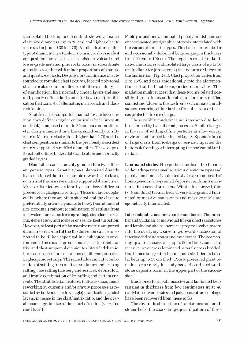
Figure 2. a) General view of the Punta del Agua section at the south of the del Peñón river (references, (a) Punta del Agua Formation,(b) conglomerates and shales, (c) fluvial sediments covering the incision surface described in the text and (d) transgressive marinedeposits. b) View at the north of the del Peñón river of the glacigenic interval (a), succeeded by shales and interbedded sandstones andmudstones (b) exhibiting erosion by the incision surface (arrows). Note shallow marine and fluvial sandstones covering the erosivesurface (c). c) Large andesitic clasts (a, up to 1.5 m), of the underlying Punta del Agua Formation, within chaotic diamictitic levels d)Massive matrix-supported diamictites showing granitic clasts. e) Two levels of massive matrix-supported diamictites (a and c)separated by a thin interval of laminated pebbly mudstones bearing dropstones (b). f) Detail of the outcrop shown in E exhibitingdropstones interrupting and deforming laminae (arrows).Figura 2. a) Vista general del perfil de Punta del Agua al sur del río del Peñon (referencias, (a) Formación Punta del Agua, (b)conglomerados y pelitas, (c) sedimentitas fluviales cubriendo la superficie de incisión descripta en el texto, y (d) depósitos marinostransgresivos. b) Vista del intervalo glacigénico hacia el norte del río del Peñon (a), seguido por pelitas e interestratificación de areniscasy pelitas (b) mostrando erosión producida por la superficie de incisión (flechas) (c). c) Clasto de andesita de 1.5 m (a en la foto)proveniente de la infrayacente Formación Punta del Agua dentro de niveles diamictíticos caóticos. d) Diamictitas masivas, matrizsoportadas incluyendo clastos graníticos. e) Niveles (a y c) de diamictitas masivas, matriz soportadas separadas por un delgadointervalo de fangolitas guijarrosas con cadilitos (b). f) Detalle del afloramiento mostrado en E donde se observan cadilitos interrumpiendoy deformando la laminación (flechas).

Glacial deposits in the Río del Peñón Formation (late carboniferous), Río Blanco Basin, northwestern Argentina
41LATIN AMERICAN JOURNAL OF SEDIMENTOLOGY AND BASIN ANALYSIS | VOL. 15 (1) 2008, 37-42
deposits and the existence of marine invertebrates to-gether with poorly preserved (reworked) plant remains,suggest deposition during a progradational depositionalphase. Sandy beds may represent distal mouth bardeposits generated by subaqueous currents coming fromlandward while mudstones were likely deposited fromsuspension or by highly diluted low-energy currents.
DISCUSSION
Glacial deposits described in this paper were veryprobably deposited in a proximal glacimarine environ-ment including both true tillites (part of the massivematrix-supported diamictites) and resedimented dia-mictites. The latter are characterized by the existenceof stratification features such as horizontal laminationand graded layers, which are common in stratified andgraded matrix-supported diamictites as well as in strati-fied clast-supported ones. The existence of faceted, pen-tagonal and occasional striated clasts supports the pro-posed glacial or inherited glacial origin. On the otherhand, laminated mudstones bearing dropstones (Fig.2f) are characteristic of glaciomarine deposits suggest-ing periods of ice-front retreat (calving). Interestingly,the glacial deposits described in this paper are differ-ent from others described in the basin where only aunique basal level of diamictites has been found. Inthe del Peñón river area at least four levels of diamictitesoccur intercalated with repeated intervals of pebblymudstones bearing dropstones (Fig. 2e). This couldindicate different episodes of glacial advance and re-treat as has been described in in the Guandacol Forma-tion from the adjacent Los Pozuelos creek region (Maren-ssi et al., 2004).
The laminated shale interval (Fig. 1) is characteris-tic of many Late Paleozoic glacial sequences describedin the Precordillera and Sierras Pampeanas. These lev-els may mark the Namurian post-glacial maximumflooding interval registered throughout the major partof the western basins of Argentina (Limarino et al,2002). Lastly, the interbedded sandstones-mudstonessequence probably reflects high-sea level conditionsand high sediment input that favored the progradationof shoreline deposits.
It is also interesting to speculate on the origin ofthe incision surface that cross-cuts the glacial depositsacross the paleo-landscape. This erosive event couldbe related to the Westphalian regression recognized inmost of the Late Paleozoic basins of western and north-western Argentina (Limarino et al., 2006).
Another important aspect of results presented herelies in the stratigraphic distribution of the diamictitesand their age. Recently, Gutierrez and Limarino (2006)reported palynological assemblages from deposits thatimmediately (?) overlie the incision surface in the basalpart of the studied succession at the South of the delPeñón river study area (level “A” of Gutierrez and Lima-rino, 2006). The palynomorphs, that appear above theincision surface and therefore in higher stratigraphiclevels than the glacial interval, belong to the Raistrickiadensa-Convolutispora muriornata of Late Mississippian-Pennsylavnian age (Césari and Gutierrez, 2001). More-over, radiometric ages obtained from the underlyingPunta del Agua Formation (Aceñolaza et al., 1971,Fauqué et al., 1999; Coughlin, 2000), though of lowprecision, suggest that Punta del Agua volcanic rocksare not younger than Mississipian age. This arguesstrongly for a Namurian to early Westphalian age forthe glacial interval reported here, an age similar to thosepreviously reported for the glacial event in this part ofGondwana.
Acknowledgments
This research was supported by a grant (EAR-0545654) from NSF’s Sedimentary Geology and Pale-ontology Program and by the project PICT 20752 ofthe Agencia Nacional de Promoción Científica yTecnológica de Argentina.
REFERENCES
Aceñolaza, F.G., A.J. Toselli and A. Bernasconi, 1971. La Precor-dillera de Jagüe, La Rioja, Argentina. Su importancia geológica yestructural. Acta Geológica Lilloana 11:259-300.
Borrelo, A., 1955. Los conglomerados del cerro Punta Negra, al oestede Jagüé. Revista de la Asociación Geológica Argentina 10:46-53.
Césari, S.N. and P.R. Gutierrez, 2001. Palynostratigraphic study ofthe Upper Paleozoic central-western Argentina sequences.Palynology 24:113-146.
Coughlin, T.J., 2000. Linked origen-oblique zones in the centralArgentine Andes: the basis of a new model for Andean orogene-sis and metallogenesis. University of Queensland, UnpublishedThesis, 145 pp.
Fauqué, L., C.O. Limarino, C. Cingolani and R. Varela, 1999. Losmovimientos intracarboníferos en la Precordillera Riojana. 14ºCongreso Geológico Argentino, Actas 1:421-424.
González, C.R. and G.E. Bossi, 1986. Los depósitos carbónicos aloeste de Jaguel, La Rioja. 4 Congreso Argentino de Paleontologíay Bioestratigrafía (Mendoza), Actas 1:231-236.
Gutierrez, P.R. and C.O. Limarino, 2006. El perfil del sinclinal delRincón Blanco (noroeste de La Rioja): el límite Carbonífero-Pérmico en el noroeste argentino. Ameghiniana 43:687-703.
Henry, L.C., J.L. Isbell and C.O. Limarino, in press, Carboniferous

42
E. GULBRANSON, C.O. LIMARINO, S. MARENSSI, I. MONTANEZ, N. TABOR, V. DAVYDOV and C. COLOMBI
LATIN AMERICAN JOURNAL OF SEDIMENTOLOGY AND BASIN ANALYSIS | VOL. 15 (1) 2008, 37-42
glacigenic deposits of the Protoprecordillera of west centralArgentina. In C.R. Fielding, T.D. Frank and J.L. Isbell (eds.)Resolving the Late Paleozoic Ice Age in Time and Space. GeologicalSociety of America Special Paper 441.
Limarino, C.O., R.L. Caminos and L. Fauqué, 1996. Caracterizaciónlitoestratigráfica y correlación regional de la Formación Ranchillos(Carbonífero Superior-Pérmico), Cordillera Frontal de La Rioja.XIII Congreso Geológico Argentino, Actas 1:513-530.
Limarino, C.O., S.N. Césari, L.I. Net, S.A. Marenssi, P.R. Gutierrezand A.Tripaldi, 2002. The Upper Carboniferous postglacial trans-gression in the Paganzo and Río Blanco Basins (northwesternArgentina): facies and stratigraphic signiûcance. Journal of SouthAmerican Earth Sciences 15:445-460.
Limarino, C.O. and L. Spaletti, 2006. Paleogeography of the upperPaleozoic basins of southern South America: An overview. Jour-nal of South American Earth Sciences 22:134-155.
Limarino, C., A. Tripaldi, S. Marenssi and L. Fauqué, 2006. Tecto-nic, sea-level and climatic controls on Late Paleozoic sedimen-tation in the western basins of Argentina. Journal of SouthAmerican Earth Sciences 22:205-226.
López Gamundí, O.R.,1987. Depositional models for the glaciomari-ne sequences of Andean Late Paleozoic basins of Argentina.
Sedimentary Geology 52:109-126.López Gamundí, O.R., 1997. Glacial-postglacial transition in the
Late Paleozoic basins of southern South America. In: I.P. Martini(ed.) Late Glacial and Postglacial Environmental Changes-Quaternary, Carboniferous-Permian and Proterozoic. OxfordUniversity Press, New York, pp.147-168.
López Gamundí, O.R. and M. Martínez, 2000. Evidence of glacialabrasion in the Calingasta-Uspallata and western Paganzo basins,mid-Carboniferous of western Argentina. Palaeogeography,Palaeoclimatology and Palaeoecology 159:145-165.
Marenssi, S., A. Tripaldi, C.O. Limarino and A.T. Caselli, 2004.Facies and architecture of a Carboniferous grounding-line systemfrom the Guandacol Formation, Paganzo Basin, northwesternArgentina. Gondwana Research 8:187-202.
Scalabrini Ortiz, J., 1972. La Cuenca Rio Blanco en el sector nortede la Precordilera argentina y su relación con las sedimentitas delGrupo Paganzo. Anais da Academia Brasileira da Ciencias 44:313-320.
Scalabrini Ortiz, J. and O.G. Arrondo, 1973. Contribución al cono-cimiento del Carbónico de los perfiles del cerro Veladero y del ríodel Peñon (Precordilera de La Rioja). Revista del Museo de LaPlata (n.s.) 8:257-279.