002e/06/1709gis.geosurv.gov.nl.ca/geofilepdfs/batch2016/002e_1709.pdf · this report outlines work...
TRANSCRIPT

������������� ������������������������������� ���������������
�����������������
�������������������
���������������
����������������
���������� ��
������� �������������� ������� ���������� �������� �������������!"��#���
��$��������
%��������&���
'��(�����
�)���#
������������� �����������������*�������
'�������#�+����,���������-������������������ .��'� '*'� ���� ������ "�#����#�� + ��� �����������������
�������'���
���� ����� ����
�����
��� � � ������ ��������� � � ������ ����
�����
�����
✔
✔
✔
002E/06/1709
First Year Assessment Report on
Prospecting, Rock and Stream Sediment Sampling
on the
Charles Brook Property, Licences 018399M and 018400M, NTS 02E/06,
North-central Newfoundland and Labrador
Submitted by
David Walsh
for licence holders
David Walsh, Russell White and Robert Roche
May 2012
Work Year: 1 Total Claims: 12
Total Expenditure: $6501.73
TableofContents
Introduction ................................................................................................................................. 3
Location and Access ................................................................................................................... 3
Geology ....................................................................................................................................... 3
Previous Work and Mineralization ............................................................................................. 5
Work and Results 2011 ............................................................................................................... 5
Conclusions and Recommendations ........................................................................................... 6
ListofTables Table 1. Mineral Licence Details. .................................................................................................. 3 Table 2. Sample Locations .............................................................................................................. 6
ListofFigures Figure 1. Property Location. .......................................................................................................... 4 Figure 2. Claims Location. ……………………………………………………………………….5 Figure 3. Property Geology. ……………………………………………………………………...6 Figure 4. Sample Locations. ……………………………………………………………………7
Confidential
2
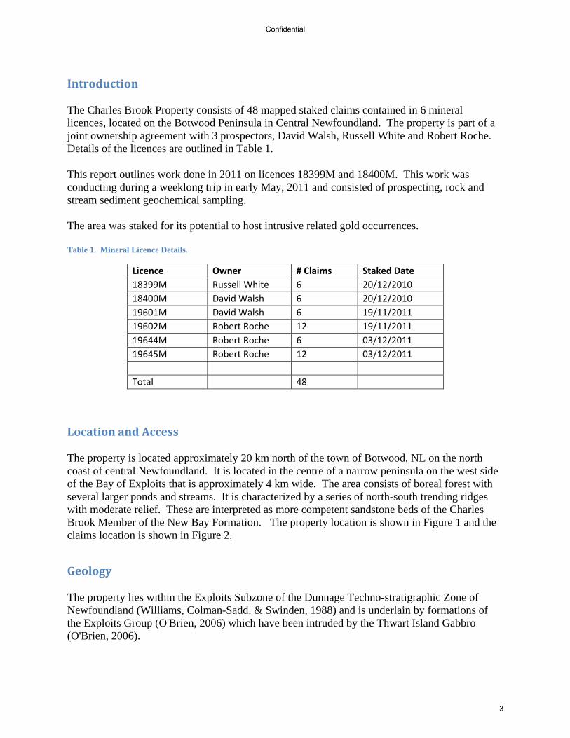
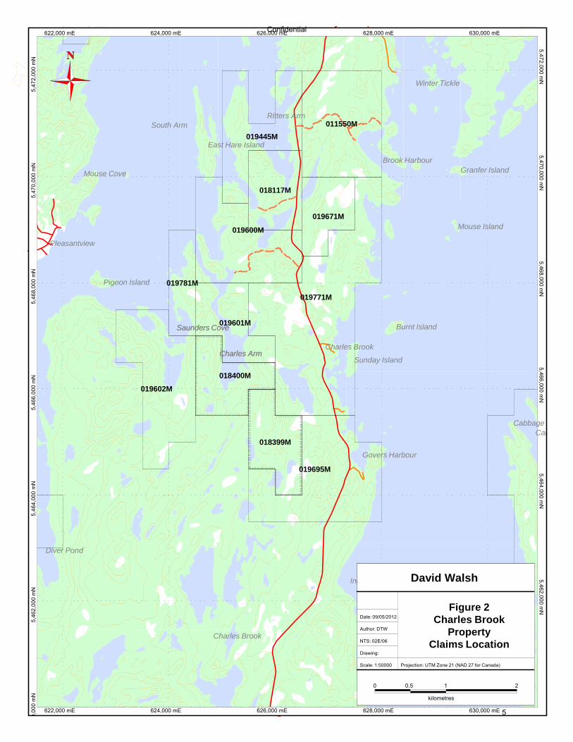
Introduction The Charles Brook Property consists of 48 mapped staked claims contained in 6 mineral licences, located on the Botwood Peninsula in Central Newfoundland. The property is part of a joint ownership agreement with 3 prospectors, David Walsh, Russell White and Robert Roche. Details of the licences are outlined in Table 1. This report outlines work done in 2011 on licences 18399M and 18400M. This work was conducting during a weeklong trip in early May, 2011 and consisted of prospecting, rock and stream sediment geochemical sampling. The area was staked for its potential to host intrusive related gold occurrences. Table 1. Mineral Licence Details.
Licence Owner # Claims Staked Date
18399M Russell White 6 20/12/2010
18400M David Walsh 6 20/12/2010
19601M David Walsh 6 19/11/2011
19602M Robert Roche 12 19/11/2011
19644M Robert Roche 6 03/12/2011
19645M Robert Roche 12 03/12/2011
Total 48
LocationandAccess The property is located approximately 20 km north of the town of Botwood, NL on the north coast of central Newfoundland. It is located in the centre of a narrow peninsula on the west side of the Bay of Exploits that is approximately 4 km wide. The area consists of boreal forest with several larger ponds and streams. It is characterized by a series of north-south trending ridges with moderate relief. These are interpreted as more competent sandstone beds of the Charles Brook Member of the New Bay Formation. The property location is shown in Figure 1 and the claims location is shown in Figure 2.
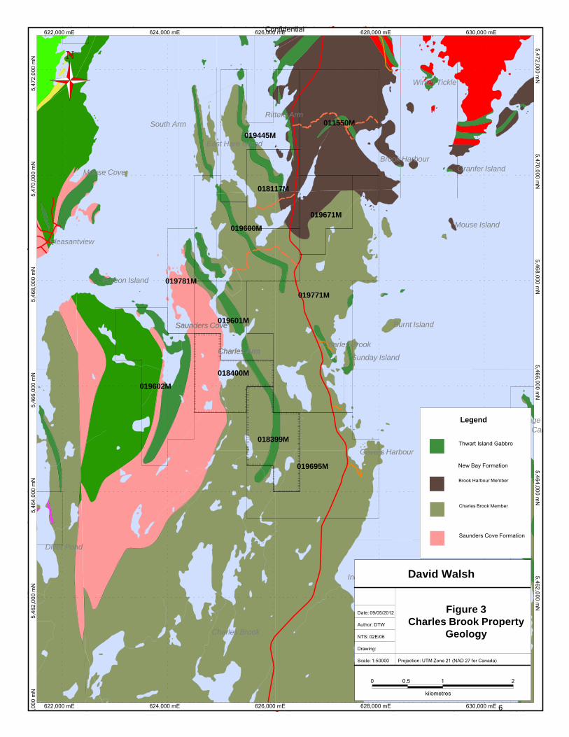
Geology The property lies within the Exploits Subzone of the Dunnage Techno-stratigraphic Zone of Newfoundland (Williams, Colman-Sadd, & Swinden, 1988) and is underlain by formations of the Exploits Group (O'Brien, 2006) which have been intruded by the Thwart Island Gabbro (O'Brien, 2006).
Confidential
3
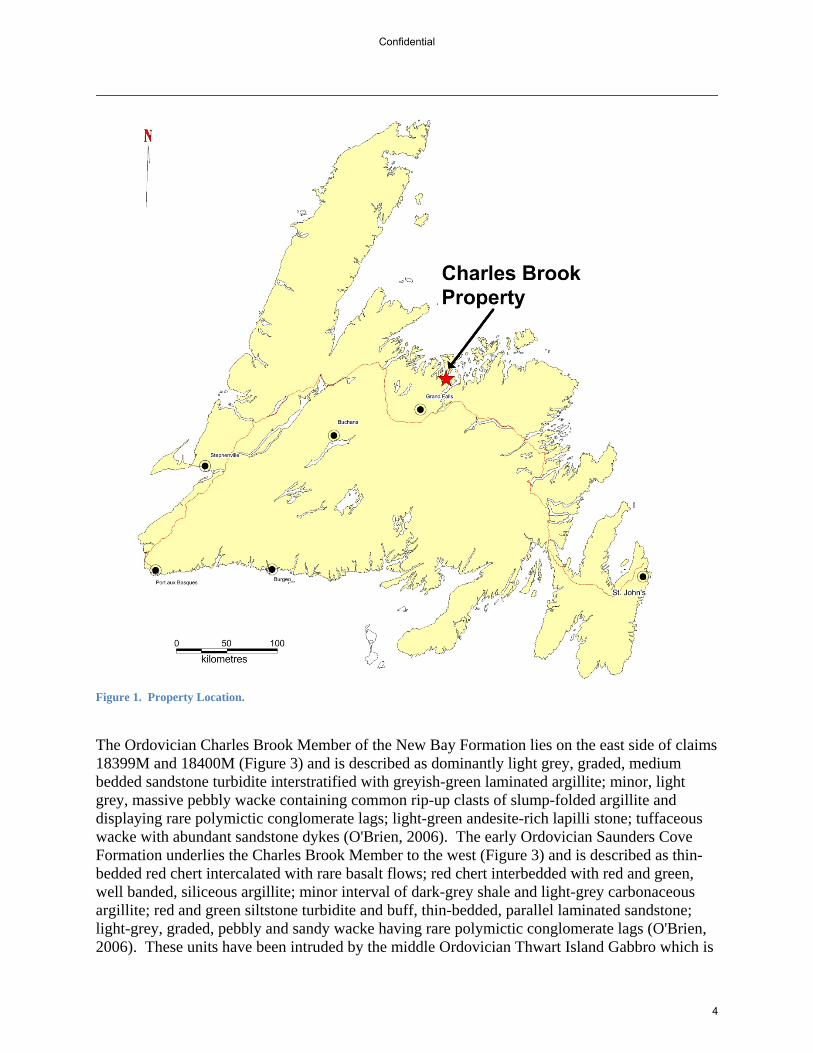
Figure 1. Property Location.
The Ordovician Charles Brook Member of the New Bay Formation lies on the east side of claims 18399M and 18400M (Figure 3) and is described as dominantly light grey, graded, medium bedded sandstone turbidite interstratified with greyish-green laminated argillite; minor, light grey, massive pebbly wacke containing common rip-up clasts of slump-folded argillite and displaying rare polymictic conglomerate lags; light-green andesite-rich lapilli stone; tuffaceous wacke with abundant sandstone dykes (O'Brien, 2006). The early Ordovician Saunders Cove Formation underlies the Charles Brook Member to the west (Figure 3) and is described as thin-bedded red chert intercalated with rare basalt flows; red chert interbedded with red and green, well banded, siliceous argillite; minor interval of dark-grey shale and light-grey carbonaceous argillite; red and green siltstone turbidite and buff, thin-bedded, parallel laminated sandstone; light-grey, graded, pebbly and sandy wacke having rare polymictic conglomerate lags (O'Brien, 2006). These units have been intruded by the middle Ordovician Thwart Island Gabbro which is
Confidential
4
630,000 mE628,000 mE626,000 mE
5,466,000 mN
5,47
2,00
0 m
N5,472,000 m
N5,470,000 m
N5,
470,
000
mN
5,46
6,00
0 m
N5,
468,
000
mN
5,468,000 mN
626,000 mE622,000 mE 624,000 mE 628,000 mE 630,000 mE5,464,000 m
N5,
464,
000
mN
0,00
0 m
N5,
462,
000
mN
5,462,000 mN
622,000 mE 624,000 mE
Saunders Cove
Charles Arm
Saunders Cove
Charles Arm
Mouse Cove
Pleasantview
Pigeon Island
Cabbage Harbour Head
Govers Harbour
Cabbage Harbour
Diver Pond
Indian Cove
Brook Harbour
Granfer Island
Winter Tickle
Ritters Arm
Mouse Island
East Hare Island
South Arm
Charles Brook
Burnt Island
Sunday Island
Charles Brook
Indian Cove Island
Cutnows Cove
Sandy Cove
011550M
018117M
018399M
018400M
019445M
019600M
019601M
019602M
019671M
019695M
019771M
019781M
David Walsh
1
kilometres
20.5
Drawing:
Scale: 1:50000
0
Projection: UTM Zone 21 (NAD 27 for Canada)
Date: 09/05/2012
Author: DTW
NTS: 02E/06
Figure 2Charles Brook
PropertyClaims Location
Confidential
5
5,466,000 mN
628,000 mE626,000 mE
5,464,000 mN
630,000 mE
622,000 mE 624,000 mE
5,470,000 mN
5,46
8,00
0 m
N5,468,000 m
N5,
470,
000
mN
5,47
2,00
0 m
N5,472,000 m
N626,000 mE622,000 mE 624,000 mE 628,000 mE
5,46
4,00
0 m
N5,
462,
000
mN
630,000 mE
0,00
0 m
N5,462,000 m
N5,
466,
000
mN
Saunders Cove
Charles Arm
Saunders Cove
Charles Arm
Mouse Cove
Pleasantview
Pigeon Island
Cabbage Harbour Head
Govers Harbour
Cabbage Harbour
Diver Pond
Indian Cove
Brook Harbour
Granfer Island
Winter Tickle
Ritters Arm
Mouse Island
East Hare Island
South Arm
Charles Brook
Burnt Island
Sunday Island
Charles Brook
Indian Cove Island
Cutnows Cove
Sandy Cove
011550M
018117M
018399M
018400M
019445M
019600M
019601M
019602M
019671M
019695M
019771M
019781M
0 0.5 1
kilometres
2
Drawing:
David Walsh
Scale: 1:50000 Projection: UTM Zone 21 (NAD 27 for Canada)
Date: 09/05/2012
Author: DTW
NTS: 02E/06
Figure 3Charles Brook Property
Geology
Legend
Thwart Island Gabbro
Brook Harbour Member
Charles Brook Member
Saunders Cove Formation
New Bay Formation
Confidential
6
described as layered or massive, medium- to coarse-grained, hornblende-pyroxene gabbro laccoliths; quartz diorite sills and diabase dykes; hornblende-bearing pegmatite (O'Brien, 2006).
PreviousWorkandMineralization Previous geological work on the property is well summarized by O’Brien (2006) and complied in GSNL Map 2006-04 (O'Brien, 2006). References for this previous work can be found in that publication. Previous industry work in the area has been limited. “Exmar Resources Limited and Gary Lewis conducted some exploration in the immediate area of the Saunders Cove copper showing (002E/06/Cu 002). Their work consisted mainly of reconnaissance prospecting, soil sampling and sampling old muck piles in a limited area around the showing. Anomalous copper in-soil values were noted around the showing but were of limited extent and sporadic. Au in-soil values of up to 116 ppb Au were also noted in the immediate area” (Lohman, 1988). Lewis (1998) reported that there were quartz veins noted along the shoreline but none were sampled and that a sample of quartz float returned an assay of 191 ppb Au. Cornerstone Resources conducted prospecting and rock and stream sediment sampling over the area in 2004. Several float samples with anomalous gold values were discovered in the Charles Arm area. Two samples assayed 2093 and 5570 ppb Au and reported to be within qtz veining with arsenopyrite and pyrite. Several stream sediment anomalies were also discovered in the Charles Brook area with one sample assaying 427 ppb (Hussey, 2005). This showing is registered in the MODS database as 02E/06/Au 012.
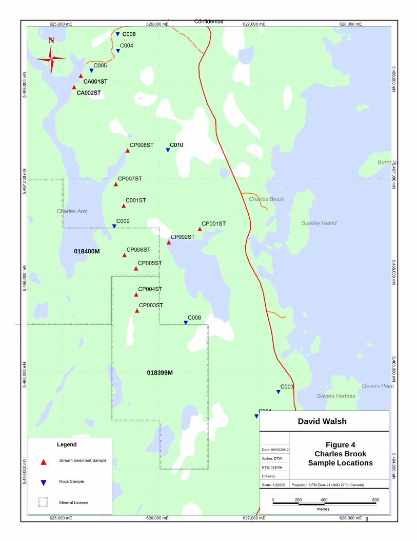
WorkandResults2011 Work in 2011 occurred during May 4–9th, 2011 and consisted of prospecting, stream sediment and rock geochemical sampling. Weather conditions were poor during the work period with cold temperatures, wind, rain and snow. Abnormally high water conditions made sampling of larger streams impossible so reported anomalies could not be confirmed and work was restricted to smaller streams. In total 8 rock samples and 11 stream sediment samples were collected. All samples were sent to Eastern Analytical Laboratories in Springdale, NL for fire assay Au analysis as well as an ICP 30 element package. Results are included in appendix i. All rock samples were grab samples of potential mineralized vein + host rock material. Samples were manually split with half going to the lab and the other half kept for a reference. Stream sediment samples were classified in the field to -60 mesh with a small classifier. In some cases a large amount of material (+ 2 kg) had to be classified in order to obtain a sufficient sample size. Sample locations are outlined in Table 2 and plotted in Figure 4. Results were disappointing but one stream sediment sample, CA007ST, returned a value of 70 ppb Au confirming anomalous gold within the claim area.
Confidential
7
628,000 mE627,000 mE5,
466,
000
mN
5,466,000 mN
5,465,000 mN
5,464,000 mN
5,46
5,00
0 m
N5,
468,
000
mN
5,46
7,00
0 m
N5,467,000 m
N5,468,000 m
N5,
464,
000
mN
626,000 mE625,000 mE 627,000 mE 628,000 mE
625,000 mE 626,000 mE
Charles Arm
C010
CA002ST
CA001ST
C006
Charles Arm
Govers Harbour
Govers Point
Charles Brook
Burnt Island
Sunday Island
C010
CA002ST
CA001ST
C006
C001ST
CP001ST
CP002ST
CP003ST
CP004ST
CP005ST
CP006ST
CP007ST
CP008ST
C001
C003
C004
C005
C008
C009
018399M
018400M
Date: 09/05/2012
Scale: 1:20000 Projection: UTM Zone 21 (NAD 27 for Canada)
Drawing:
Author: DTW
David Walsh
800
Figure 4Charles Brook
Sample Locations
0 200 400
metres
NTS: 02E/06
Stream Sediment Sample
Rock Sample
Legend
Mineral Licence
Confidential
8

Table 2. Sample Locations
Sample Type UTM_Zone X_NAD27 Y_NAD27
C001ST stream 21 625628.2729 5466718.986
CP001ST stream 21 626416 5466478.846
CP002ST stream 21 626095 5466340.766
CP003ST stream 21 625766 5465634.825
CP004ST stream 21 625758 5465801.929
CP005ST stream 21 625755 5466071.682
CP006ST stream 21 625637 5466210.013
CP007ST stream 21 625548 5466944.148
CP008ST stream 21 625670 5467291.185
CA001ST stream 21 625185.04 5468062.48
CA002ST stream 21 625115.59 5467946.59
C001 rock 21 627001.9406 5464539.166
C003 rock 21 627229.3679 5464792.793
C004 rock 21 625569.9977 5468320.927
C005 rock 21 625295.0811 5468114.211
C006 rock 21 625566.724 5468492.581
C008 rock 21 626269.9923 5465506.932
C009 rock 21 625530.367 5466503.751
C010 rock 21 626085.4447 5467292.484
ConclusionsandRecommendations Prospecting in 2011 failed to delineate the source of the anomalous float discovered by Cornerstone Resources in 2004. This was mainly due to the poor weather conditions, high surface water levels and insufficient coverage of the claim area. Stream sediment sampling did discover an anomalous sample, confirming the presence of gold within the geology. Further detailed prospecting is recommended within the claim area, especially to the west, which is up-ice from the anomalies. Focus should be paid to the gabbroic intrusions in the area. The source for the 5 g/t float sample discovered by Cornerstone Resources should also be a focus of any future exploration program. Respectfully submitted, David Walsh Geologist
Confidential
9
References Hussey, A. H. (2005). First Year Assessment Report of Prospecting, Rock and Stream Sediment
Sampling on Licences 9815M, 9816M, 9817M, 9818M and 9819M, Norte Dame Bay Gold Project, NTS 2E/06, Bay of Exploits Area, NL. Newfoundland and Labrador Geological Survey, Assessment File 02E/06/1438, 52 pages.
Lewis, G. (1998). First year assessment report on prospecting and geochemical exploration for
licence 5590m on claims in the Saunders Cove area, South Arm, New Bay, Newfoundland. Newfoundland and Labrador Geological Survey, Assessment File 02E/06/1028, 24 pages.
Lohman, G. (1988). Second year assessment report on geological and geochemical exploration
for licence 2922 on claim block 4562 in the Tea Arm south and Saunders Cove areas, north-central Newfoundland. Newfoundland and Labrador Geological Survey, Assessment File 02E/06/0619, 39 pages.
McBride, D., & Baker, C. (1988). First year assessment report on geological and geochemical
exploration for licence 2922 on claim block 4562 in the Tea Arm and South Arm areas, north-central Newfoundland. Newfoundland and Labrador Geological Survey, Assessment File 02E/06/0574, 18 pages.
O'Brien, B. H. (2006). Geology of the Bay of Exploits - New Bay area (parts of NTS 2E/5, 6, 7,
11), north-central Newfoundland. Scale 1:50 000. Newfoundland and Labrador Department of Natural Resources, Geological Survey, Map 2006-04. Open File 002E/1483.
Williams, H., Colman-Sadd, S., & Swinden, H. (1988). Tectonic - stratigraphic subdivisions of
the central Newfoundland. Current Research, Geological Survey of Canada, 91-98.
Confidential
10
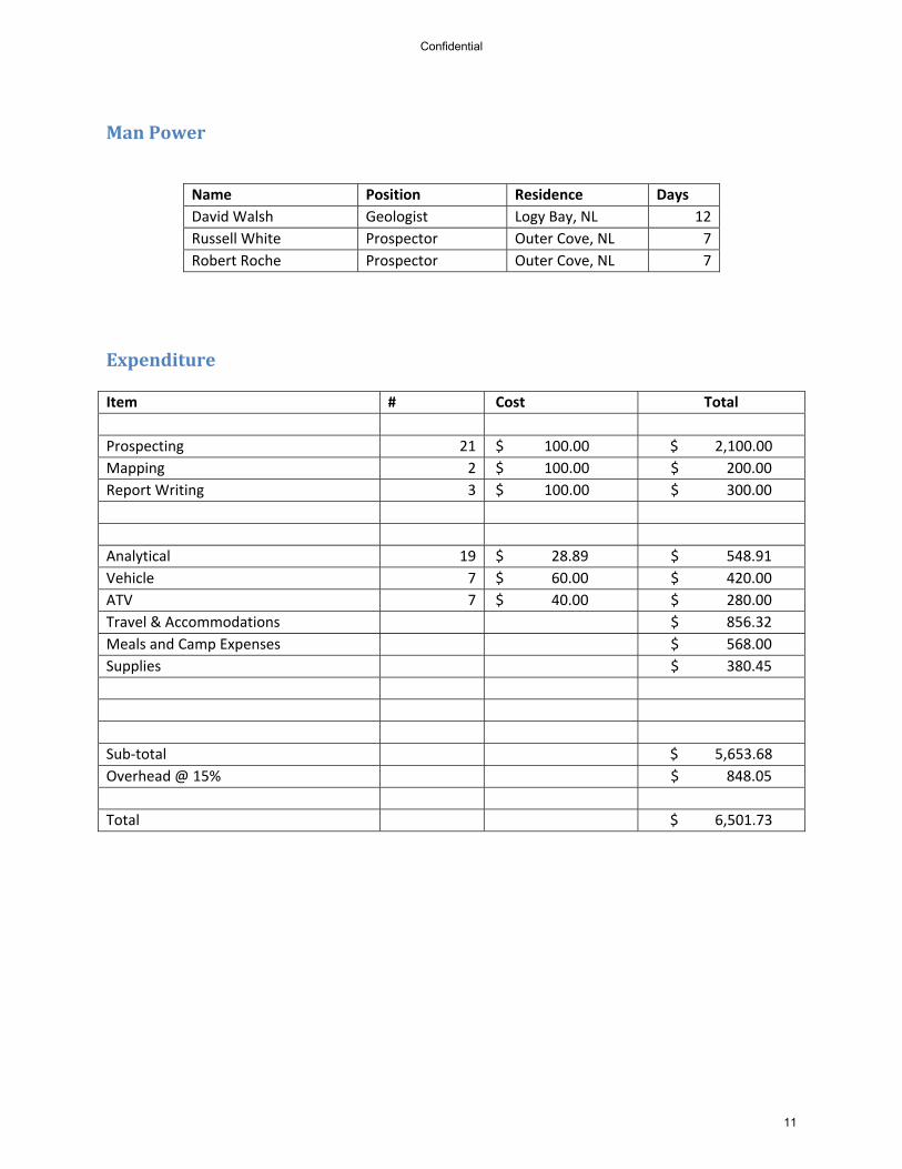
ManPower
Name Position Residence Days
David Walsh Geologist Logy Bay, NL 12
Russell White Prospector Outer Cove, NL 7
Robert Roche Prospector Outer Cove, NL 7
Expenditure Item # Cost Total
Prospecting 21 $ 100.00 $ 2,100.00
Mapping 2 $ 100.00 $ 200.00
Report Writing 3 $ 100.00 $ 300.00
Analytical 19 $ 28.89 $ 548.91
Vehicle 7 $ 60.00 $ 420.00
ATV 7 $ 40.00 $ 280.00
Travel & Accommodations $ 856.32
Meals and Camp Expenses $ 568.00
Supplies $ 380.45
Sub‐total $ 5,653.68
Overhead @ 15% $ 848.05
Total $ 6,501.73
Confidential
11
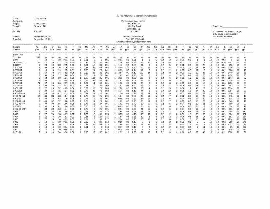
Au Fire Assay/ICP Geochemistry CertificateClient: David WalshGeologist: Eastern Analytical LimitedProject: Charles Arm P.O. Box 187Sample: Stream / Till Little Bay Road Signed by:______________________
Springdale, NLDskFile: 1101430 A0J 1T0 (Concentrations in assay range
may cause interferences in DateIn: September 02, 2011 Phone: 709-673-3909 associated elements.)DateOut: September 16, 2011 Fax: 709-673-3408
Email:[email protected] --------- --------- --------- --------- --------- --------- --------- --------- --------- --------- --------- --------- --------- --------- --------- --------- --------- --------- --------- --------- --------- --------- --------- --------- --------- --------- --------- --------- --------- --------- --------- --------Sample Au Ce Sr Ba Fe P Hg Mg As V Na Mo Al Be Ca Zn Cu Sb Ag Pb Bi Ti Cd Co Ni W La K Mn Sn CrNumber ppb ppm ppm ppm % % ppm % ppm ppm % ppm % ppm % ppm ppm ppm ppm ppm ppm % ppm ppm ppm ppm ppm % ppm ppm ppm----------------------------- --------- --------- --------- --------- --------- --------- --------- --------- --------- --------- --------- --------- --------- --------- --------- --------- --------- --------- --------- --------- --------- --------- --------- --------- --------- --------- --------- --------- --------- --------- --------- --------Blank - Au 5 --- --- --- --- --- --- --- --- --- --- --- --- --- --- --- --- --- --- --- --- --- --- --- --- --- --- --- --- --- ---Std - Au 398 --- --- --- --- --- --- --- --- --- --- --- --- --- --- --- --- --- --- --- --- --- --- --- --- --- --- --- --- --- ---Blank --- 10 1 10 0.01 0.01 1 0.01 5 1 0.01 1 0.01 0.5 0.01 1 1 5 0.2 2 2 0.01 0.5 1 1 10 10 0.01 5 20 1LKSD-2-STD --- 112 20 171 2.75 0.10 1 0.49 7 32 0.02 1 1.26 0.6 0.45 183 30 5 0.8 28 2 0.03 1.3 15 17 10 30 0.16 1391 20 23C001ST 5 28 10 23 2.15 0.03 1 0.61 13 33 0.01 1 1.43 0.5 0.33 47 9 5 0.2 5 2 0.06 0.6 12 22 10 10 0.04 698 20 28CP001ST 5 65 29 25 4.76 0.11 1 0.58 48 58 0.02 3 4.00 1.9 0.60 99 27 5 0.2 5 2 0.04 1.3 35 37 10 10 0.05 2016 20 46CP002ST 5 13 5 19 1.75 0.01 1 0.50 11 23 0.01 1 0.99 0.5 0.14 41 2 5 0.2 2 2 0.05 0.5 12 15 10 10 0.02 866 20 18CP003ST 5 67 8 34 4.62 0.05 1 0.69 33 31 0.01 2 2.64 0.7 0.17 109 24 5 0.2 8 2 0.01 1.2 30 46 10 10 0.04 2440 20 38CP004ST 5 34 6 12 2.88 0.04 1 0.66 7 28 0.01 1 1.63 0.5 0.20 51 6 5 0.2 4 2 0.03 0.7 13 20 10 10 0.03 1436 20 25CP005ST 5 53 12 60 4.14 0.06 1 0.67 183 35 0.01 1 2.35 0.6 0.33 107 9 5 0.2 6 2 0.01 1.2 22 28 10 10 0.04 8147 20 32CP006ST 5 53 17 74 3.45 0.06 1 0.56 138 42 0.01 1 1.87 0.6 0.49 74 11 5 0.2 10 2 0.03 1.1 25 22 10 10 0.04 10430 20 32CP007ST 74 27 10 26 2.87 0.03 1 0.52 14 58 0.01 1 1.72 0.6 0.22 36 8 5 0.2 8 2 0.05 0.7 17 16 10 10 0.04 1470 20 38CP008ST 5 29 10 14 2.07 0.04 1 0.61 9 35 0.02 1 1.03 0.5 0.32 36 9 5 0.2 4 2 0.05 0.5 11 16 10 10 0.05 802 20 25CA001ST 5 27 23 32 4.65 0.04 1 0.72 103 78 0.03 10 1.76 0.5 0.22 58 4 5 0.2 13 2 0.06 1.2 46 17 10 10 0.06 2914 20 36CA002ST 5 24 14 15 4.27 0.03 1 0.70 42 71 0.02 4 1.74 0.5 0.18 44 9 5 0.2 12 2 0.08 1.0 34 20 10 10 0.06 2284 20 38BH01-20+40 5 45 38 81 2.03 0.05 1 0.81 14 27 0.01 1 1.10 0.6 2.36 45 23 5 0.2 9 2 0.03 0.6 14 25 10 10 0.06 630 20 21BH01-40+60 12 39 33 68 1.84 0.05 1 0.78 10 25 0.01 1 1.04 0.5 1.95 40 19 5 0.2 7 2 0.03 0.5 13 23 10 10 0.05 545 20 19BH01-60 5 36 28 63 1.79 0.05 1 0.73 9 26 0.01 1 0.96 0.5 1.67 37 17 5 0.2 6 2 0.04 0.5 12 20 10 10 0.04 514 20 18BH02-20+40 5 40 32 72 1.88 0.05 1 0.76 11 26 0.01 1 1.02 0.5 1.95 38 19 5 0.2 7 2 0.03 0.5 13 22 10 10 0.05 546 20 19BH02-40+60 5 39 30 55 1.86 0.05 1 0.78 8 27 0.01 1 1.02 0.5 1.79 38 15 5 0.2 5 2 0.04 0.5 12 21 10 10 0.04 500 20 20BH02-60 5 38 29 61 1.80 0.05 1 0.70 9 28 0.01 1 0.95 0.5 1.69 36 16 5 0.2 6 2 0.04 0.5 13 19 10 10 0.05 520 20 19BH02-60 DUP --- 38 28 63 1.74 0.05 1 0.70 9 26 0.01 1 0.94 0.5 1.70 41 16 5 0.2 6 2 0.04 0.5 12 19 10 10 0.05 506 20 19C001 5 10 5 10 1.99 0.01 1 0.97 5 32 0.32 1 1.68 0.5 0.96 25 16 5 0.2 2 2 0.06 0.5 13 24 10 10 0.01 299 20 310C003 5 27 76 16 4.87 0.05 1 2.69 5 95 0.23 1 3.55 0.8 4.16 46 53 5 0.2 2 2 0.01 1.3 33 30 10 10 0.21 624 20 137C004 5 10 4 10 1.61 0.02 1 0.81 5 29 0.15 1 1.64 0.5 1.36 19 8 5 0.2 2 2 0.06 0.5 11 14 10 10 0.01 191 20 234C005 5 27 9 10 4.03 0.03 1 1.54 5 138 0.17 2 2.74 0.6 1.25 65 42 5 0.2 6 2 0.06 1.0 18 44 10 10 0.02 1214 20 147C006 5 10 1 10 0.81 0.01 1 0.33 5 20 0.13 1 0.50 0.5 0.17 8 3 5 0.2 2 2 0.02 0.5 3 6 10 10 0.02 250 20 241C008 5 23 30 10 4.13 0.08 1 0.91 55 69 0.18 1 2.66 0.5 3.76 47 36 5 0.2 4 2 0.12 1.1 23 13 10 10 0.05 2072 20 97C009 5 10 4 10 0.34 0.01 1 0.11 5 3 0.13 1 0.37 0.5 1.15 3 2 5 0.2 2 2 0.01 0.5 2 11 10 10 0.01 65 20 242C010 5 10 2 10 0.58 0.01 1 0.09 5 15 0.19 1 0.78 0.5 0.95 4 5 5 0.2 2 2 0.01 0.5 2 8 10 10 0.01 119 20 362CH01-20 5 110 14 58 3.06 0.08 1 1.08 10 57 0.02 1 2.33 1.0 0.39 61 96 5 0.2 8 2 0.12 0.8 30 40 10 10 0.12 1088 20 51