0cs-6-- lib*. 8 - bsee data center of the pltn end er (public records) slneoroly yours. a. dcnaid...
TRANSCRIPT

0CS-6-- Lib*. 8
Iu
r ly Refer Toi FO-2-1 Moveweer 30, 1907
Union Exploration Partners, Ltd, Attentloni Kr. Ted Russell Pott otf tc* Box suae lafayette, Lou1stent 7060S
QMtlOMOl reference U mUm to your In i t ia l Plon of ixploratlon and lovt ro FOMI w t t i Report received Wwooc r 16* 1907, onoftcjod Novtoetr 20, I9e7, for looses OCS-C 6026 *jnd 0*29, il«cfct 206 too 209, respectively, foot Cause ron Aroo, Toft plon include* too act ivi t ies propeled for Moll E In 01ock 206 end Moll B lo Slock 209,
"n accordance with SO CPR 250.94, revised Oto tot tr 13, 1979* end oor lottor otto* January 29, 1979, thtt plon 1s hereby dole mined to 00 ooejplote ond U ooo being conaidered for too revel .
Yoor plon controi oooOor lo M--29S4 tod tooolt bo referenced lo yoor ccesttnl-cot loo ond correspondence con,-em tns to It plon.
bect Lotto OCS-Q 6428 (OPS-3-2) (PILE ROOM) Loooo OCS-G 9629 (OPS-3-2) (FILE ROOM)
(OPS-3-4 0/Pwbllc Info. Copy of the pltn end ER (PUBLIC RECORDS)
Slneoroly yours.
A. Dcnaid Giroir Pot J . Bourgeois
Rejleeel Soptrv1sor FloW Ooorttloot
ADGoberticcki 11/17/971 poeco*

U.S. Department of tho Interior Minerals Management Servico 1201 Elmwood Park Boulevard New Orleans, Louisiana 70123
Re: Plan of Exploration Leases OCS-G 6628 and 6629 East Cameron Blocks 208 and 209 East Cameron Block 209 Field
Gentlemen:
In reference to the subjeot Plan of Exploration dated November 4, 1987, please change the name or the OCS-G 0*28 Well No. A to OCS-G 6628 Woll No. E. This was discussed with the Minerals Managemsnt Servioe*s Ms. Angle Gobert on November 1H, 1987.
Thank you for your assistance in this matter.
Very truly yours,
UNION EXPLORATION PARTNERS, LTD., LIMITED PARTNERSHIP By: Union Oil Company of California,
Managing General Partner
Ted Russell District Drilling Superintendent
JTR/ghb
Enclosures
I
Unocal Corporation 1018 Harding Stroot. P O BOK 513S8. O C S Lafayatta. Louisiana 70505-1380 Taiapnona (318) 232 9724
UNOCAL® November. 4, 1987
U. S. Department of the Interior Minerals Management Sorvice 1201 Elmwood Park Boulevard New Orleans, Louisiana 70123
Ro: Plan of Exploration Leases OCS-Q 6628 and 6629 Well Nos. A and B East Cameron Blocks 208 and 209 East Car >rCn Block 209 Field
Gentlemen:
Enclosed for your approval is Union Exploration Partners, Ltd.'s Plan of Exploration for OCS-G 6628 well No. A and OCS-G 6629 Well No. B, East Camaron Blocks 208 and 209, Offshore Louisiana. As directed, five (5) of the nine (9) copies attached include proprietary information.
Yours very truly,
UNION EXPLORATION PARTNERS, LTD., By: Union Oil Coapany of California,
Managing General Partner
Ted Russell District Drilling Superintendent
JHM/JTR/ghb
Enclosures
UNION EXPLORATION PARTNERS, LTD. PLAN OP EXPLORATION
OCS-O 6626 mL NO A AND OCS-G 6629 WELL NO. B
EAST CAMERON BLOCK 209 FIELD
In accordance with the Oil and Gaa Operating Regulations 30 CFR 250.3*4 attended September 14, 1979, and with thtt Outer Continental Shelf Land Acts Amendments of 1973, Public Law 95-372, Union Exploration Partners, Ltd. respectfully submits the following initial Plan of Exploration for approval.
SECTION 250.34-1 (a)(1)(i)
Drilling operations in East Cameron Blocks 208 and 209, Leases OCS-G 6628 and 6629 will begin on or about December 15, 1987. This start-up date will bo dependent on hydrocarbon market availability. If the wells are drilled as planned and the drilling program is continuous, tho project should take 150 days to complete. A breakdown of the estimated time to drill each well ig as follows:
OCS-G 6628 Well No. A 75 Days OCS-O 6629 Well No. B 75 Daya
150 Days
SECTION 250.34-1 (a)(1)(H)
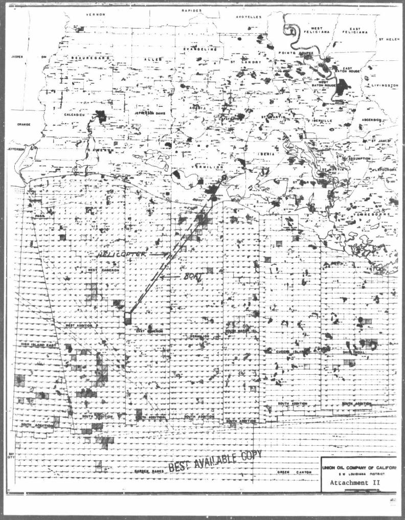
The wells will be drilled with a jack-up rig, Griffin-Alexander Drilling Company's Rig No. 6, or a comparable rig (see Attachment I ) . This rig is a diesel-electric drilling unit which is equipped with pans/sumps to collect pollutants. The pollutants will be contained and properly disposed of. The drilling operations will be serviced from Union's Shore Base located at Intracoastal City, Louisiana. This facility, comprised of approximately 22 acres, ls looated adjacent to the Vermilion River 1/2 mile north of the intersection of the Intracoastal Canal and the Vermilion River. The facility consists of an offioe complex, pipe yard, fuel and storage tanks, loading and unloading dock, and general storage area for production and drilling equipment and supplies. Union Explorations Partners, Ltd. maintains a support transportation pool consisting of five (5) helicopters and seven (7) offshore boats. Base personnel are on 24-hour duty and are in communication (telephone/radio) with all offshore manned platforms and drilling rigs (oeo Attachment I I ) .
Union Exploration Partners, Ltd. has filed an Oil Spill Contingency Plan with the United States Departmant of the Interior, Minerals Management Servioe in accordance with OCS Order No. 7. This plan contains the names and telephone numbers of company personnel who will form an emergency response team ln the event of an oil spill. This plan contains procedures for reporting a spill and for responding to a reported spill.
^ GENERAL
J
PLAN OF EXPLORATION OCS-G 6628 WELL NO. A AND OCS-G 6629 WELL NO. B EAST CAMERON BLOCK 209 FIELD PAGE 2
'SECTION 250.34-1 (a)(1)(H) (CONTINUED)
ion Exploration Partners, Ltd. ls a member pf Clean Gulf Associates. This association provides for the purchase and maintenance of equipment and materials for use by its members in cleaning up of an oil spill. Equipment is presently looated at Galveston and Freeport, Texas; Cameron, Intracoastal City, Grand Isle, and Venice, Louisiana. Some of the equipment available includes a shallow water skimmer system with a 40-barrel storage capacity, a fast response open sea and bay system with two (2) 180-barrel tanks used in skimming and storing, and a high volume open sea skimmer with 1,000-barrel storage capacity. The amount of time required to get to the spill area will vary on location of work boats for immediate charter. The time may vary anywhere from a minimum of five (5) hours to a maximum of 24 hours.
SECTIONS 250.34-1 (a)(lli) AND (250.34-1 (a)(v)
A Shallow Hazards Drilling Report (see Attachment III) is encloseo for the wells. The report includes an Archaeological Statement, a Shallow Drilling Hazards Statement, and a Structure Map indicating the well locations. The Multi-Sensor Engineering Survey (Shallow Hazards Survey) of East Cameron Blocks 208 and 209 was mailed February 11, 1985, to the Minerals Management Servioe in Metairie, Louisiana. A copy of the high resolution survey data from the two lines closest to the proposed well locations is attached to the copy of this Plan of Exploration to the Minerals Management Servioe ln Lake Charlea, Louisiana.
SECTION 250.34-1 (a)(lv)
OCS-G 6628 Well No. A and OCS-O 6629 Well No. B will be drilled in East Cameron Blocks 208 and 209 as per the following table which gives the surface and bottom hole locatir- „ true vertical depth, and the measured depth eaoh well:
Lease and Well Surface Looatlon/Bottom Hole Location
OCS-O 6628 Well No. A 4,300* FVL and 2,000* FNL (Blk 209)
OCS-O 6629 Well No. B 5,100* FWL and 650* FNL
Attachment IV-A is a plat which shows the proposed surface and bottom hole location for each well detailed in this Initial Plan of Exploration.
Attachment I I shows East Cameron Blocks 208 and 209 relative to the shoreline of Louisiana.

PLAN OF EXPLORATION OCS-G 6628 WELL NO. A AND OCS-G 6629 WELL NO. B EAST CAMERON BLOCK 209 FIELD PAGE 3 »
f
Jhe water depth at the proposed well location is +106'.
SECTION 250.34-1 (a)-vi) Attachment V ia a detailed l i s t of mud components and additivss, including the common trade name of each. In accordance with Air Qiality Regulations 30 CFR 250.57, an Air Quality Statement for each well is attached (see Attachments VI, and VII) .
Attachment VIII is the Consistency Certification Statement required by the Coastal Zone Management Agency.
SECTION 250.34-1 (a)(2)(l)
An Environmental Report (see Attachment IX) is submitted in accordance with the guidelines established for preparing Outer Continental Shelf Environmental Reports and pursuant to the provisions of 30 CFR Section 250.34-3.
JrkVJTR/ghb
Attachments
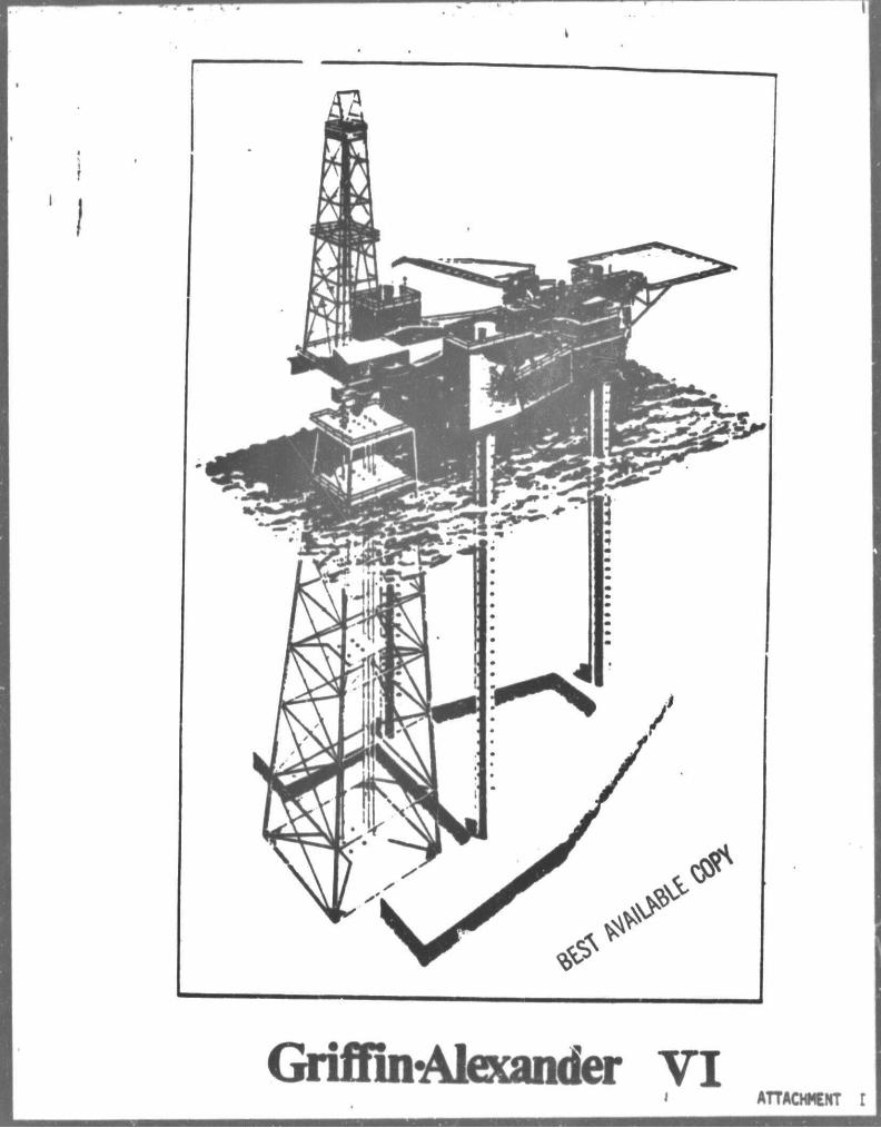
Griffin-Alexander VI ' ATTACH1CHT

I
MAJOR EQUIPMENT:
Owner G ft A Limited I
Rig namt Gnffin-Alexander II
Certification: American Bureau of Shipping and Tha United Statea Coaat Guard
Maximum Water Depth: 200 Peat
Minimum Water Depth: 12 Ptat
Drilling Capacity: 25.000 Pan
Drawwofkj Derrick
Rotary
Traveling Block
Katy
Moaa
Mid Continent 1/-I220 E l Elect re-Row Dra* Branham Universal I4T high with 30 * 30 Base nai Capacily I 392.000 LIS. Gardner Denver JTVJ in. powered by D?9 E!ec Motor tara 2 spaad Gardner Denver Transm.ss McKissick Typt RP N09I4 ratad for 550 tons lyron-Jackson Modal 5300 rated f*» » 9 tons Oilwell Mo. PC500 rated for 500 tone. laaah-Aoss Tri-Kelly 5V4 in. modal ITP-6 Byron-Jackson MIS-273 Combination Power ! aad Matter Bushing Assembly 3 IMD Ditaot SR12EW ratad at 1430 H P etc pulling 2 D79 generators atch plua ont generate: skid with a thru shaft pulling a Columbia 400K
1 Caterpillar 0353 Turbo Charged engine with KW Columbia generator. 2 Cameron I3H in. Type U double 10.000 PSI I Shaffer UK in. Annular 3000 PSI W.P. I Ragen KFL-J 30 in. 2000 PSI Diverter
DIMENSIONS:
— 1ST long a 132* wide x 11**1 Mai - 220* long a 113* wide x IO*
deep* rskirt Slot in Mai ~ 591-long x 110* wide Column* - ll' O.D. x 269' long Skid Unit - to* long a 30- wide x 23' •iMiipinj Peat-efx TVT
(Designed for S-e I) Quarters - 50
Choke and KU Ail
Mnd
10.000 PSI w.p.
manifold* treated for H2S 2 Gardner Denver PZ-11 triplex 1600H.P powen 2 D79 KMD motors per pump. I — Brandt Dual Tandem Shaker I - Swat* Mud Dtgneior 4 — Brandt Mad Agitators I - Brandt SRJ Desander 1500 OPM I — Brandt Dual Mud Cleaner 100 GPM capac 1 — Swaco Mud Gaa Separator 2 — Saa King modal 1400 Manna Crane with IC Booms. ABS certified for cargo handling. 1 MICO P t l 300 M3B Water Maker 2 Whittaker 30 Man Survival Capsules.
Bulk Mud ft Cement Storage Q260 Cu Bag Storage 3000 S : Activt Mud 1500 BB
Below Deck 4500 Sq. ft Offlct Spact 5000 Sq.
Drilling Water Storage 5900 IB 1000 BB
. . . 2019 I I 2040 IB 4200 Sq. 3000 Sq. 140 Sq.
Total Variable Load* - Moving 2300 kip* Drilling 4300 kipa
Noa* ft Set lack Load* - I MM It*. # JS* # center lint 790 M laa. # 45J* <* cantar lint
UMON OIL COMPANY OP CALrORF • • I M M U NtTftlCT
Attachment I I

OPEN 2 8 4 liocs-Ci ob28
t 2 0 8 i OPEN 2 0 7
OPEN 2 8 5
< UJ oc <
o cc LU
< O
r-co
QPEN 2 8 6
U X P 50.00 5,000 Acs. 5 /31/89
S . 1 0 0
• 50 ~7!Z A "
2 0 9 1 OPEN 2 1 0
4 , 3 0 0 '
OCS-C 6629
U X P 50.00% 5,000 Acs. 6 /30/89
QPEN 2 2 6
4 5 7
< LU OC <
z o oc UJ
<
o
< UJ
QPEN 2 2 5
o • 4,0 0 0 ' 0 , 0 0 0 '
6»*»MtC SCSlf
U N O C A L * )
t rrrre csr
S.C. 209 Attachment IV B
OFFtHOWI, LOUI8IAWA

BAROID
Baroid
Aquagel Zeogel
Q-Broxin
Carbonox
UATER-BASE LIGNOSULFONATE MUO SYSTEM LOMVETITIVE MUO PRODUCTS
IMC
Imco Bar
IMCO Gel
IMCO Brinegel
Imco Best
IMCO VC-10 Imco Lig
MAGCOBAR MILCHEM
Weighting Material
Magcobar Mil-Bar
Clays (V iscos i f i e rs )
Magcogel Sal t Gel
Mil-Gel Sa l t Water Gel
Super Visbestos
Thinners
Spersene Tannathin
Unical Ligco
Sodium Chromate Sodium Chromate Sodiun Chromate Sodium Chromate
Cellex
M ( u U ^ o s i s ^ p « t r o ^ O £ n t s
Imco-CMC Magco-CMC Milcnem CMC
REVISED 03/12/80
PESCRI 'TION
Bar i te (Barium Sul fate)
Wyoming Bentonite A t tapu lg i te clay
fo r s a l t water nuds.
Asbestos Material
Ferrochrome Lignosulfonate
Chrone L1gnr*ulfonate Processed L i t e Sodiun Chromate
(Chrom Addi t ive fo r CLS Products)
.odium Carboxymethylcel lu lose
Line Caustic Soda
S. A. P. P.
Bicarbonate of Soda
Aluminum Stearate
Micatex Wall Nut
TRADE NAME
CLS
Ori spec
Flosal
Lima Caustic Scda
A l k a l i n i t y . pH Control Addit ives
Ome Caustic Soda
Calcium Removers
Imco Phos (SAPP) S. A. P. P.
Bicarbonate o f Soda
Aluminum Stearate
IMCO M1ca Inco Plug
COMPANY
Bicarbonate of Soda
Defoamer
Aluminum SUa rate
U m -Caustic Soda
S. A. P. P.
Bicarbonate of Sooa
Aluminum Stearate
Lost C i rcu la t ion Ma t e r n .s
Magco Mica Nut Pit
Mil Mica M11 Plug
MISCELLANEOUS PRODUCTS
Louisiana Mud
D r i l l i n g Spec ia l t i e s , Inc .
D r i l l i n g Spec ia l t i e s , Inc.
DESCRIPTION
Hydrated Lian Sodiun Hydroxide
Sodiun A d d Pyrophosphate
Sodiun Bicarbonate
Aluni nun Stearate
Mica Flakes (Graded) Ground Walnut Hul ls
(Graded)
Chrone Lignosulfonate - Thinner Polyanionic Cel lulose - F lu id Loss
Control Asbestos Mater ial - V i scos i f i e r
Attachment V

AIR QUAL ITT .7TATEM5NT
The Plan of Operation for tho drilling of OCS-G 6628 Well No. A at Eaat Cameron Block 208 is as follows:
It is expected to take seventy-five (75) days to drill and complete the well. The rig to bo used to drill this well will be the Griffin-Alexander Drilling Co. Rig No. 6 or a comparable rig. The normal fuel consumption p*r day forthis rig Is approximately 2,000 gallona of diesel. Tne onshore support base for this activity will be the Union Exploration Partners, Ltd's Shore Base located at Intracoastal City, Louisiana. All transportation, boats, and helicopters will be handled from this base.
All air emission calculations a.-e based on the aforementioned drilling and installation time frame.
The projected emissions are based on data from "Compilation of Air Pollutant Emission Factors1* third edition AP-42, E A 1977, Table 3.3.3-1 and Table 3.2.1-3.
Attachment VI

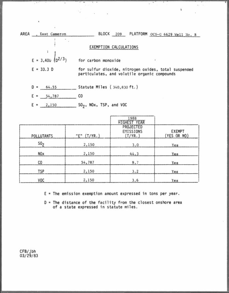
ARrA East Cameron BLOCK 208 PLATFORM OCS-G 6628 Well No. A
I I
J,, E -I 3,400 (D 2 / 3)
E • 33.3 0
EXEMPTION CALCULATIONS
for carbon monoxide
for sulfur dioxide, nitrogen oxides, total suspended particulates, and volatile organic compounds
D - 64.85
E - 54,957
E - 2,160
Statute Miles (342,400 ft.)
CO
S02. NOx, TSP, and VOC
1988
HIGHEST YEAR
POLLUTANTS "E" (T/YR.)
PROJECTED EMISSIONS (T/YR.)
EXEMPT PES OR NO)
so2 2,160 3.0 Yea
NOx 2,160 44.3 Yes
CO 54,957 9.7 Yes
TSP 2,160 3.2 Yes
VOC 2,160 3.6 Yes
E • The emission exemption amount expressed in tons per year.
D * The distance of the facility from the closest onshore area of a state expressed in statute miles.
CFB/jbh 03/29/83
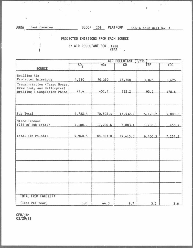
AREA East Cameron BLOCK 208 PLATFORM OCS-G 6628 Well No. A
PROJECTED EMISSIONS FROM EACH SOURCE
BY AIR POLLUTANT FOR 1988
SOURCE
Alft POLLUTANT r r/YR.)
SOURCE S02 NOx CO TSP VOC
D r i l l i n g Rig Projected Emissions 4,680 70,350 15,300 5.025 5.625 Transportation (Cargo Boats, Crew Boat, and Helicopter) Drilling & Completion Phna.* 72.4 452.4 232.2 95.2 178.6
Sub Total 4.752.4 70.802.4 15.532.2 5.120.2 5r«m.fi
Miscellaneous (25* of Sub Total) 1,188.. 17.700.6 3.883.1 1.280.1 1.450.9
Total (In Pounds) 5,940.5 88.503.0 19.415.3 6.400.3 7.254.5
TOTAL PROM FACILITY (Tons Per Year) 3.0 44.3 9.7 3.2 3.6
CFB/jbh 03/29/83
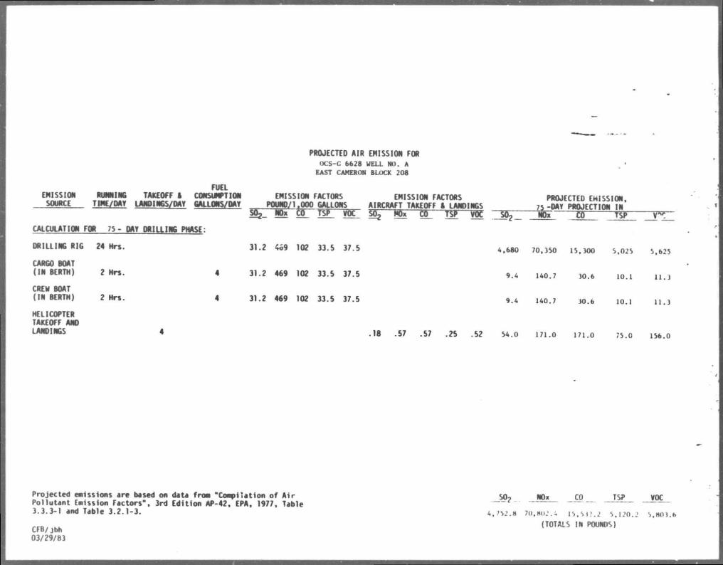
PROJECTED AIR EMISSION FOR OCS-C 6628 UELL HO. A EAST CAMERON BLOCK 208
FUEL EMISSION RUNNING TAKEOFF I CONSUMPTION EMISSION FACTORS EMISSION FACTORS PROJECTED EMISSION, _SOURCE TIME/OAT LANDINGS/DAY GALLONS/DAY POUND/1 OOP GALLONS AIRCRAFT TAKEOFF 1 LANDINGS 75 -DAY PROJECTI CN IN POUWD/1.000 GALLONS AIRCRAFT TAKEOFF 1 LANDINGS 7S -I
g NOV dfl Ts* rOC ^ Wx tt_ TSP vtt So? fc ~ co ~7sT CALCULATION FOR 75- DAY DRILLING PHASE:
DRILLING RIG 24 Mrs. 31.2 469 102 33.S 37.5 4.680 70.350 15.300 5.025 5.625
CARGO BOAT
(IN BERTH) 2 Mrs. 4 31.2 469 102 33.5 37.5 9.4 u o . 7 30.6 10.1 n . j
CREW BOAT (IN BERTH) 2 Hrs. 4 31.2 469 102 33.5 37.5 9.4 140.7 30.6 10.1 u . j
HELICOPTER TAKEOFF AND LANDINGS 4 .18 .57 .57 .25 .52 54.0 171.0 171.0 75.0 156.0
Projected emissions ere besed on date froa "Compilation of Air Pollutant Emission Factors", 3rd Edition AP-42. EPA. 1977, Table 3.3.3-1 end Table 3.2.1-3.
CFB/jbh 03/29/83
NOx CO TSP
4,752.8 70.802.4 15,512.2 5,120.2 (TOTALS IN POUNDS)
jroc_ 5.HO ) .6

AIR QUALITY STATEMENT
The Plan of Operation for the drilling of OCS-G 6629 Well No. B at Eaat Cameron Block 209 is as follows:
It is expected to take seventy-five (75) days to dri l l and complete the well. The rig to be used to dril l this well will be the Griffin-Alexander Drilling Co. Rig No. 6 or a comparable rig. The normal fuel conaumption per day for this rig ls approximately 2,000 gallons of diesel. The onshore support base for this activity will be the Union Exploration Partners, Ltd's Shore Base located at Intracoastal City, Louisiana. All transportation, boats, and helicopters will be handled from this base.
All air emission calculations are based on the aforementioned drilling and installation time frame.
The projected emissions are based m data from "Compilation of Air Pollutant Emission Factors" third edition AP-42, EPA 1977, Table 3.3.3-1 and Table 3.2.1-3.
Attachment VII
AREA East Cameron BLOCK 209 PLATFORM ocs-C 6629 Well No. B
{ EXEMPTION CALCULATIONS
E - 3,400 ( D 2 / 3 )
E • 33.3 D
for carbon monoxide
for sulfur dioxide, nitrogen oxides, total suspended particulates, and volatile organic compounds
64.55
E « 54,787
E - 2.J50
Statute Miles ( 340,830 ft.)
CO
S02, NOx, TSP, and VOC
1988
HIGHEST YEAR
POLLUTANTS "E" (T/YR.)
PROJECTED EMISSIONS (T/YR.)
EXEMPT (YES OR NO)
SO* 2,150 3.0 Yea
NOx 2,150 44.3 Yea
CO 54,787 9.7 Yea
TSP 2,150 3.2 Yea
VOC 2,150 3.6 Yes
E * The emission exemption amount expressed in tons per year.
D • The distance of the facility from the closest onshore area of a state expressed in statute miles.
CFB/jbh 03/29/83

AREA East Cameron BLOCK 209 PLATFORM OCS-G 6629 Well No. B
PROJECTED EMISSIONS FROM EACH SOURCE
BY AIR POLLUTANT FOR 1988
TTATT •
SOURCE
AIR WLLUTANT (T/YR.)
SOURCE so2 NOx CO TSP VOC
D r i l l i n g Rig P r o j e c t e d Emissions 4,680 70,350 15,300 5,025 5,625 Transpor ta t ion (Cargo Boat, Crew Boat, and H e l i c o p t e r ) D r i l l i n g & Completion Phase 72.4 452.4 232.2 95.2 178.6
Sub T o t a l 4.752.4 70,802.4 15.532.2 5.120.2 5.803.6
Miscellaneous (25% of Sub Total) 1.188.1 17,700.6 3.883.1 1.280.1 1.450.9
T o t a l ( I n Pounds) 5,940.5 08,503.0 19,415.3 6.400.3 7.254.5
TOTAL FROM FACILITY (Tone Per Year) 3.0 44.3 9.7 3.2 3.6
CFB/jbh 03/29/83
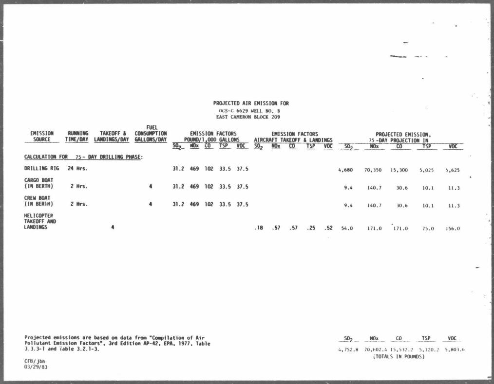
PROJECTED AIR EMISSION FOR OCS-C 6629 UELL HO. B EAST CAMERON BLOCK 209
FUEL EMISSION RUNNING TAKEOFF A CONSUMPTION EMISSION FACTORS EMISSION FACTORS PROJECTED EMISSION. SOURCE TIME/DAY LANDINGS/DAY GALLONS/DAY POUND/1,000 GALLONS AIRCRAFT TAKEOFF A LANDINGS 75 -DAY PROJECTION IN
sOg wW co TSP voc 55 m gr w~W ^ no» to TSP VM CALCULATION FOR 75- OAT DRILLING PHASE:
ORILLING RIG 24 Hrs. 31.2 469 102 33.5 37.5 4.680 70.350 1 5.300 5.025 5.625
CARGO BOAT ( IN BERTH) 2 Hrs. 4 31.2 469 102 33.5 37.5 9.4 140.7 30.6 10.1 11.3
CREW BOAT (IN BER1H) 2 Mrs. 4 31.2 469 1 02 33.5 37.5 9.4 140.7 30.6 10.l l l . J
HELICOPTER TAKEOFF ANO LANDINGS 4 .18 .57 .57 .25 .52 54.0 171.0 171.0 75.0 156.0
Projected emissions ere besed on dete from "Compilation of Air Pollutant Emission Factors", 3rd Edition AP-42. EPA. 1977. Table 3.3.3-1 aod Table 3.2.1-3.
CFB/jbh 03/29/83
- * 2 NOx CO TSP
4, 752.8 70,M)2.4 15.512.2 5, 120.2
ITOTALS IN POUNOS)
VOC
5,803.b

COASTAL ZONE MANAGQdT
CONSISTENCY CERTIFICATION
PLAM OF KPLORATTON Type of Plan
EAST CAMERON BLOCKS 208 k 209 Area and Block
OCS-O 6226 4 OCS-O 6229 Lease Number
The proposed ac t iv i t i e s described in de t a i l i n the Plan comply with
Louisiana's approved Coastal Management Program(s) and w i l l be conducted in a
manner consistent with such Program(s).
Arrangements have been made with the State-Times in Baton Rouge, Louisiana to
publish a public notice of the proposed activitiea no later than December 2,
1987.
Ctaion ExplorationPartners. Ltd. Leaaee or Operator
Date
Attachment V I I I

ENVIRONMENTAL REPORT
FOR COASTAL MANAGEMENT CONSISTENCY DETERMINATION
PLAN OF EXPLORATION
GULF OF MEXICO
FOR
EAST CAMERON AREA BLOCK 209 (OCS-G-6629)
SUBMITTED TO:
MR. TED RUSSELL
DISTRICT DRILLING SUPERINTENDENT
UNION EXPLORATION PARTNERS, LTD.
P. 0. BOX 51388
LAFAYETTE, LOUISIANA 70505
(318/232-9724)
NOVEMBER 5, 1987
PREPARED BY:
JOHN E. CHANCE ft ASSOCIATES, INC.
REGULATORY ft ENVIRONMENTAL DIVISION
PROJECT #87-8162
— J o h n £ C h o n c e & A s s o c . , Inc. Attachment IX
Table of Contents
i
ENVIRONMENTAL REPORT
11 ' Page
I . T i t l e Page 1
Table of Contents 11
List of Figures Iv
I I . Description of the Proposed Action 1
A. Travel Modes, Routes, and Frequencies 3
B. Support Base and New Personnel 3
C. New Support Facilities ... 4
D. New or Unusual Technology 4
E. Location of the Proposed Activities 4
I I I . Description of the Affected Environment and Impacts 6
A. Physical and Environmental 6
1. Commercial Fishing 6
2. Shipping 12
3. Recreation 12
4. Cultural Resources 13
5. Ecologically Sensitive Features 14
6. Exist ing Pipelines and Cables 14
7. Other Mineral Uses 15
8. Ocean Dut ping 15
i i
John £. Chance A Assoc., inc.

9. Endangered or Threatened Speclec 15
B. Soclo-Econonlc Impacts 16
IV. Unavoidable Adverse Inipacts 18
l v.. Literature Cited 22
/
Coastal Zone Management Consistency Certificate 24
111
John EL Chance et Assoc., Inc.

LIST OF FIGURES
I
FIGURE I p a g e
1 — V l t l n l t y Map of East Caiaeron Area Bloclc 209 . . . " 2
iv
John E. Chance £ Assoc. inc.
: .
I I . Description of the Proposed Action
Thfis report addresses the ac t i v i t y proposed by Union Exploration
Partners, L td . for East Cameron Area Block 209 (OCS-6-6629). The
approximate locat ion of the a c t i v i t y 1s presented 1n Figure 1 , a general
v ic in i t y map of the Outer Continental Shelf (OCS) lease areas o f f the coast
of Louisiana.
I t 1s anticipated that a Jack-up type r i g w i l l be u t i l i zed to d r i l l two
wells. The ac t i v i t i e s proposed by Union Exploration Partners, Ltd. for th is
block are addressed In the attached Plan of Exploration.
The proposed ac t i v i t i es w i l l be carried out by Union Exploration
Partners, Ltd. with a guarantee of the fol lowing:
1. The best available and safest technologies w i l l be u t i l i zed
throughout the pro ject . This Includes meeting a l l applicable
requirements for equipment typ*s, general project layout,
safety systems, equipment and monitoring systems.
2. A l l operations w i l l be covered by M.M.S. approved 011 Sp i l l
Contingency Plan.
3. A l l applicable Federal, State, and local requirements
regarding a i r emissions, water qua l i ty , and discharge for
the proposed a c t i v i t i e s , as well as any other permit condit ions,
w i l l be complied w i th .
•Allan E. Chance et Assoc., Ino.

MISSISSIPPI ALABAMA
CAST 1 * 1 * 1 1
M M I H S A N S S S S S A 6SCCM CANYON A M A
MOBILE SOUTH UNION EXPL. PARTNER* LTO.
V ICINITY MAP BLOCK 209
E A S T CAMERON AREA
40 I E
80mi
3
JOHN E CHANCE a ASSOC.. INC • WY, 3. 1987
. ;
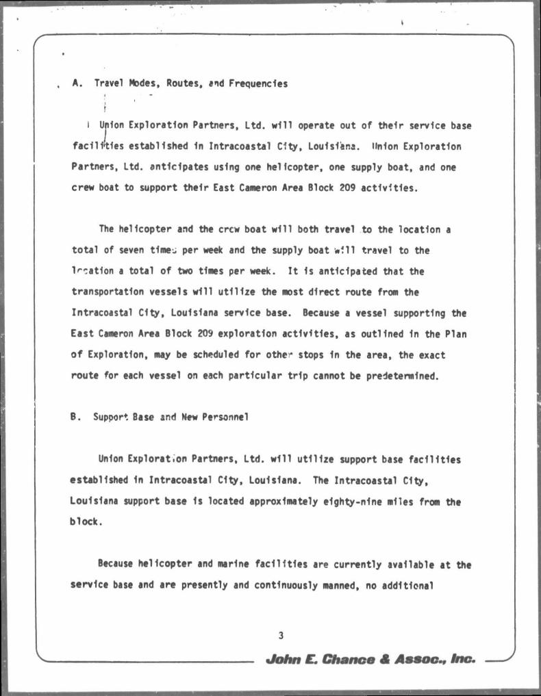
A. Travel Modes, Routes, and Frequencies
i I Union Exploration Partners, L td . w i l l operate out of thei r service base
f a c i l i t i e s established 1n Intracoastal Ci ty , Louisiana. Union Exploration
Partners, Ltd. ant ic ipates using ono hel icopter, one supply boat, and one
crew boat to support the i r East Cameron Area Block 209 a c t i v i t i e s .
The helicopter and the crew boat w i l l both travel to the location a
t o t a l of seven t lmej per week and the supply boat w f l l travel to the
location a tota l of two times per week. I t Is anticipated that the
transportation vessels w i l l u t i l i z e the most d i rect route from the
Intracoastal C i ty , Louisiana service base. Because a vessel supporting the
East Cameron Area Block 209 explorat ion a c t i v i t i e s , as outl ined In the Plan
o f Exploration, may be scheduled fo r other stops In the area, the exact
route for each vessel on each par t icu lar t r i p cannot be predetermined.
B. Support Base and New Personnel
Union Exploration Partners, L td . w i l l u t i l i z e support base f a c i l i t i e s
established 1n Intracoastal Ci ty , Louisiana. The Intracoastal Ci ty ,
Louisiana support base Is located approximately e1ghty-n1ne miles from the
block.
Because hel icopter and marine f a c i l i t i e s are current ly available at the
service base and are presently and continuously manned, no additional
3
John E. Chmnom at Assoc., Ino.

: ; ^
onshore employment 1s expected to be generated as a resul t of these
ac t i v i t i es . i
1 ' ' fhe I n i t i a l OCS Socio-Economic Data Base Report for the service base
f a c i l i t i e s u t i l i z e d by Union Exploration Partners, L td . w i l l be prepared fer
submission pursuant to the specif ic parameters to be established by the
DOI/MMS and scheduled to be Issued at a later date.
C. Mew Support Fac i l i t i e s
The proposed exploration a c t i v i t i e s for East Cameron Area Block 209
w i l l not require the development of any new support f a c i l i t i e s .
0. New or Unusual Technology
The exploration ac t i v i t i es for East Cameron Area Block 209 w i l l not
warrant u t i l i z i n g any nt* or unusual technology that may af fect coastal
waters.
E. Location of the Proposed Ac t i v i t i e s
East Cameron Area Block 209 1s located approximately eighty-nine miles
fror Intracoastal C i ty , Louisiana and approximately s ixty- three miles from
the Louisiana coast of Cameron Parish. Figure 1 presents the locat ion of
the block in re la t ion to the Louisiana coast, as well as the geographic
4
John E. Chance et Assoc., Inc.
relationship between East Cameron Area Block 209 and the other OCS lease
. areas. 4
j I
5
John E. Chance af Assoc., Inc.
»
. I I I . DESCRIPTION OF THE AFFECTED ENVIRONMENT AND IMPACTS
A. Physical and Environmental
11 1. ' ConwtTclal Fishing
The Mississippi Delta area Is known as the "Fer t i l e Fisheries Crescent"
because I t 1s one of the most productive commercial f ishery grounds In the
world. As a r e s u l t , Louisiana Is t ' I t iona l ly one of the top states 1n the
nation In terms of commercial f i sher ies , which amounted to 1,834,884,407
pounds worth $118,754,742 In 1984 and 1,822,321,060 pounds worth
5109,765,223 1n 1983 (USDC, Nf^S, 1985). Ten species of f i n f i sh and
she l l f i sh represent 99 percent of Louisiana's commercial fishery landings:
brown shrimp (Penaeus aztecus), white shrimp (P. se t i fe rus) , blue crab
(CWncc tes sapidus), oysters (Crassostrea v l r g l n l ca ) , Gulf menhaden
(Brevoortia patronus), red snapper (Lutjanus campechanus), black drum
(Pogonlas cromls), red drum (Sclanops ocel latus), spotted seatrout
(Cynosclon nebulosus), and str iped mullet (Mugil cephalus). A l l but one of
these species are estuarine dependent.
The most valuable species to Louisiana are the brown shrimp and white
shrimp, which together produce by fa r the greatest shrimp harvest In the
Gulf of Mexico. Louisiana shrimp fishermen harvested 106,681,071 pounds
(heads-on) of shrimp worth $143,116,739 1n 1984 (USDC, NMFS, 1985).
Although harvest data for these species are not separated for s ta t i s t i ca l
purposes, the brown shrimp dominates the Louisiana shrimp harvest, as I t Is
6
John Em Chance et Assoc., Inc.
the most abundant species 1n that region of the gu l f (White and Boudreaux,
1977). Both of these shrimp are estuarine dependent and have simi lar l i f e
histor ies, wi th the major dif ferences being the time and location that the
virions l i f e stages begin and reach their maximum levels. Generally,
spawning occurs offshore with the result ing larvae migrating Inshore to
develop in estuar ies. Brown shrimp spawn from November to Apr i l in 30 to
120 meters of water, while white shrimp spawn from March to October In 8 to
34 meters (Benson, 1982). Juvenile and adult brown shrimp migrate offshore
from May to Ju l y , and white shrimp migrate between June and November
(Benson, 1982).
The East Cameron Area under consideration f a l l s within the "high to
moderate brown shrimp product iv i ty area" (USDOI, MMS, 1986, Visual No. 2)
wherein the poss ib i l i t y of shrimp f ishing ac t i v i t y exists. Some documented
Impacts of petroleum exploration and production on the shrimp f ishery
Include the removal of trawling space during the d r i l l i n g and exploration
phases and the poss ib i l i t y of f ish ing g<?ar con f l i c t s with exist ing well
heads. These con f l i c t s could resu l t In loss of catch, loss of or damage to
nets, vessel damage, and/or f i sh ing downtime losses. Additional discussion
of the Impacts on the commercial f ishing Industry Is contained In the Final
Regional Fr./Ironmental Impact Statement, Gul* of Mexico, Volume 1, pages 327
to 332 (USDOI, MMS, 1983).
The Gulf menhaden or "pogy" fishery Is Louisiana's second most valuable
f ishery, accounting for 1,756,^5,058 pounds worth $68,801,io6 In 1984
(USDC, NMFS, 1985). Gulf menhaden spawn offshore from m1d-0ctober through
7
John E. Chance A Assoc., Inc.

March In 40 to 140 meters of water, with the larvae subsequently moving Into
• shallow, low sa l in i t y estuaries from February to May (Benson, 1982). Here
in the shallow estuaries, the larvae metamorphose into juveniles and change
from1 being carnivores to f l l t e r - feed ing omnlvores. The juveniles and
subadulxs migrate from the estuaries Into offshore waters from December
through February (Benson, 1982). The adults only rarely venture far
offshore (Hoese and Moore, 1977); Indeed, about 93 percent of the commercial
f ishing e f f o r t occurs within ten miles of shore (USDOI, MMS, 1983).
The a c t i v i t i e s as proposed are unl ikely to have any adverse ef fect on
the menhaden f ish ing as East Cameron Area Block 209 l i es outside the
"Principle Menhaden Harvest Area" (USDOI, MMS, 1986, Visual No. 2 ) .
The Eastern oyster Is most abundant in the Gulf of Mexico from Aransas
Bay, Texas, to Apalachicola Bay, Florida (Beccasio et a l . , 1982). Louisiana
oystermen landed 13,488,274 pounds of oysters worth $24,476,569 In 1984,
making oysters Louis: ana's th i rd most valuable f ishery (USDC, NMFS, 1985).
Oysters thr ive at sa l in i t i es between 5 and 15 parts per thousand and water
depths of 2.5 to 8 meters (Beccasio et a l . , 1982). Oysters spawn Inshore
during the sumner, and the free-swimming larvae attach and develop In the
same estuarine habitat. The proposed ac t i v i t i e s In East Cameron Area Block
209 are not expected to have any Impact on the oyster f ishery In Louisiana.
The blue crab ranges from Nova Scotia to Uruguay and supports the
largest crab f ishery In the United States (Marine Experiment Stat ion, 1973).
In 1934. 29,692,067 pounds of crabs worth $8,395,002 were landed 1n
8
John E. Chance A Assoc-, Inc.
: _
Louisiana (USOC, NMFS, 1985). Blue crabs Inhabit shallow water and can hs
found In high sa l in i t y sounds, bays, and channels where they spawn from
March through November, with a peak from May to September (Benson, 1982).
The result ing planktonic larvae pass through several molts and stages before
the juveniles drop to the bottom of the estuarine nurseries, where they
remain throughout the year (Benson, 1982). The f ishery fo r blue crabs 1s
unlikely to be s ign i f icant ly affected by exploration a c t i v i t i e s as th is
block 1 ; located offshore of the coastal and estuarine waters 1n which th is
fishery occurs.
Red snapper landings In Louisiana amounted to 1,487,456 pounds worth
$2,479,817 In 1984 (USDC, NMFS, 1985). Snappers are demersal predatory f i sh
that are common c e r or near banks, coral reefs and ' x rops , submarine
ridges, rocks, and man-made structures such as shipwrecks and offshore
d r i l l i ng plat forms, especially offshore Louisiana (Benson, 1982; Hardy,
1978). Red snapper spawn In the Gulf of Mexico from June to Mid-September,
1n water depths of 16-37 meters, over bottoms of hard sand and shell with
rocky reef areas; spawning may actual ly take place at the surface (Hardy,
1978). L i t t l e or no Information 1s available about larval red snapper, but
Juveniles are typ ica l l y found Inshore In high sa l i n i t y (24 to 40 ppt) water
9-91 meters In depth (Benson, 1982). The proposed a c t i v i t i e s should create
a suitable hab i ta t for red snapper.
The drums (Sclanldae) are one of the three most abundant famil ies of
fishes In the Gulf of Mexico In terms of biomass, and they outnumber a l l
o'Jier fam1l1es 1n the number of species (Hoese and Moore, 1977). Three
John E. Chance & Assoc., Inc.

species of drums are commercial ly Important to Louisiana. These Include
black.drum, red drum, and spotted seatrout. In 1984, Louisiana lanJed a
to ta l of 5,557,259 pounds of drums worth $4,290,068 (USDC, NMFS, 1985). The
red drum ftshejry 1s the most valuable, accounting for 51 percent of the
t o t a l drum catch while the spotted seatrout and black drrm account for equal
amounts of the remainder.
Typically, scianids are euryhallne species that spawn in shallow
nearshore Gulf waters, producing larvae that enter coastal estuaries for
development (Benson, 1982; Johnson, 1978; Hoese and Moore, 1977). Spotted
seatrout spawn at night in deep channels and depressions adjacent to shallow
f l a t s , grass beds, and bayous In the estuary, from March to September with a
peak from Apr i l through July (Benson, 1982). The larvae associate with
bottom vegetation (predominantly sea grasses) or shell rubble In channel
bottoms (Johnson, 1978). The juveni les spend at least the i r f i r s t 6 to 8
weeks on the nursery grounds, usually within 50 meters of the shoreline,
u n t i l late f a l l when they move Into the deeper parts of the estuary (Benson,
1982). Adult spotted seatrout rarely leave the estuaries (Benson, 1982).
Blac': drum spawn from February to Apr i l In or near t ida l passes and in
open bays and estuarfes (Benson, 1982). The larvae are transported to
shallow estuarine marshes, but may move to deeper estuarine waters or
shallow waters o f f sandy beaches as large Juveniles (Johnson, 1978). Adult
migration 1s largely restr icted to spring and f a l l movement through the
passes between estuaries and nearshore environments (Beccasio e t a l . , 1982).
10
John E. Chance £ Assoc., Inc.

*
/ " 1 ; \
Red drum Inhabi t estuaries and coastal waters out to 22 kilometers from
. shore, at depths up to 40 meters (Becasslo et a l . , 1982). Spawning occurs
In the fa l l and winter , pr imari ly from September to November, .nd the larvae
are banMed by currents Into shallow estuaries and bays where they tend to
associate with seagrassef ;nd marshes (Johnson, 1978). They usually remain
In or near estuaries unt i l they are three years o ld , but some leave at the
end of their f i r s t year, migrating Into the Gulf In the f a l l (Benson, 1982).
Louisiana harvested 3,157,215 pounds of mullet worth $999,936 In 1984
(USDC, NMFS, 1985). Mullets are one of the most abundant fishes In the Gulf
o f Mexico (Koese and Moore, 1977). Mullet have been observed In Alabama
Inland as far as 607 kilometers from the Gulf, and offshore as far as 80
kilometer* and as deep tV ,385 meters (Benson, 1982). Mullet spawn from
October to May, and soi, - ma u s snawn more than once In a season (Benson,
1982). Larvae move Inshore in the spring and the juveniles are found 1n the
shallow areas c f the estuaries. Offshore movement from the esiuarles occurs
during the f a l l (Beccasio et a l . , 1982).
Overall, commercial fishermen have benefited from the growth of the
petroleum Industry In the OCS waters of the Gulf of Mexico. While
technological Improvements have enabled commercial fishermen to Increase the
volume of landings, development of the petroleum Industry has also had a
posi t ive Impact on f ish ing. Because OCS petroleum development Is dependent
on extensive marine vessel u t i l i z a t i o n , harbors and ports have been
Improved, port access waterways have been expanded and Improved, and the
ava i l ab i l i t y and qua l i ty of marine vessel maintenance and repair f a c i l i t i e s
l l
John £. Chance & Assoc., inc.

have Increased s ign i f i can t l y . These improvements have de f in i te ly had a
posit ive e f fec t on flshe.men (Lassi ter, 1980).
<
2. Shipping
A designated shipping fairway Is located approximately eleven miles
west of East Cameron Area Block 209. I t Is unl ikely that marine vessels
supporting th is block w i l l u t i l i z e the shipping fairway to gain access to
the support base; therefore, 1t Is unl ikely that the marine vessels w i l l
have a s ign i f icant e f fec t on fairway t r a f f i c . The d r i l l i n g r i g and each of
the marine vessels w i l l be equipped with a l l U. S. Coast Guard required
navigational safety aids.
3. Recreation
The open Gulf encompasses a broad expanse of saltwater which Is
u t i l i zed by numerous sports fishermen and a small but rapidly Increasing
number of SCUBA divers. Many fishermen charter boats to deep-sea f ish and
sport dive In the northern Gulf. The states of Alabama, Mississippi , and
Louisiana support approximately 120 charter boats which conduct a majority
of their flshlnc, a c t i v i t i e s In the waters of the OCS (USDOI, MMS, 1983).
Petrol'.urn platforms In the northern Gulf provide recreation for fishermen
and scuba divers because they act as a r t i f i c i a l reefs a t t ract ing and
establishing aquatic communities Including highly sought a f te r food and
sport fishes. The reef e f fec t created by petroleum platforms Is well known
12
John E. Chance A Assoc., tno.

: , ;
and Is evidenced by the numerous private boat owners who regularly v i s i t
•offshore f a c i l i t i e s to harvest food and sport f ishes.
i 'Frequently, offshore r igs and platforms serve as navigation points for
small commercial and recreational marine c r a f t . Manned d r i l l i n g r igs and
platforms can also provide a haven for small c r a f t operators forced to
abandon the i r vessels during storms or fol lowing boat accidents. The
ins ta l la t ion and use of navigational aids, l i fesaving equipment, and other
safety requirements pursuant to Coast Guard regulations are standard
procedure for d r i l l i n g r igs and marine vessels u t i l i zed by Union Exploration
Partners, L td .
4. Cultural Resources
Visual No. 4 from the Final Environmental Impact Statement (USDOI, MMS,
1986) Indicates that East Cameron Area Bloclc 209 f a l l s within the zone
designated as an area with a high probabi l i ty of h is tor ic and pre-hlstor lcal
cultural resources. A Potent ial Geologic Hazards Survey and Cultural
Resources Report for East Cameron Area Block 209 was prepared by Intersea
Research (1985). A single generation paleochannel system and a chenier were
detected 1n the subbottom p r o f i l e r records. The bank and margin features of
the channel appear to have been eroded away, possibly during a period of
lower sea level when th is area was exposed to aerial erosion (Intersea
Research, 1985). Tho poss ib i l i t y exists that Paleo-Indians may have
u t i l i zed the area 14,000 - 23,000 years B.P. and l e f t some records of their
material remains. The apparent erosion of the bank and margin features
13
John E. Chance et Assoc., Inc.
seems to drastically limit the possibility of preservation of any cultural
material (Intersea Research, 1985). The chenier feature 1s apparently very
old in terms of New World archaeology and is thought to hold very l i t t l e
potentla' fbr dultural resource site occurrence or preservation (Intersea
Research, 1985). No shipwrecks or other historic cultural resources were
located during thu survey (Intersea Research, 1985).
5. Ecologically Sensitive Features
East Cameron Area Block 209 1s located approximately fifty-one miles
northwest of Bouma Bank (USDOI, MMS, 1986, Visual No. 4) . There are nc
other known ecologically sensitive areas near East Cameron Area Block 209.
The Intracoastal City, Louisiana support base which will be utilized as
the operations base for the East Cameron Area Block 209 exploration
activities Is located approximately twenty-three miles northeast of
Rockefeller State Refuge and approximately sixteen miles northwest of Marsh
Island Wildlife Refuge (USDOI, MMS, 1986, Visual No. 3) .
In general I f a l l act iv i t ies are executed as planned, encountering no
unusual circumstances, the environmentally sensitive areas will not be
affected.
6. Existing Pipelines and Cables
A review of company f i le data Indicated that there are no known
pipelines or cables located in East Cameron Area Block 209.
14
— John E. Chp nee A Assoc., inc.
4
7. Other Miner*! Uses
I Iher* are no other known mineral resources locatea In or near East
Cameron Area Block 209.
6. Ocean Dumping
The major sources of ocean dumping related to OCS petroleum exploration
act iv i ty are d r i l l i n g f l u ids , or "muds," and d r i l l cut t ings. Af ter the
exploratory d r i l l i n g In East Cameron Area Block 209 Is completed, Union
Exploration Partners, Ltd. does ant ic ipate dumping he i r excess water-based
d r i l l i n g f lu ids (approximately 750 bb ls . /we l l ) . I f any oil-based mud Is
used 1n the d r i l l i n g operations, 1t w i l l be transported to shore for proper
disposal.
Dr i l l cut t ings are brought up by the d r i l l i n g mud and range In size
from grains of sand t * pebbles. These cutt ings are separated and s i f ted and
then disposed overboard. Treated domestic wastes and d r i l l waters w i l l ?lso
be ti.cosed at the proposed d r i l l i n g s i t e . There w i l l be no Intentional
discharge of any o i l y or hazardous materia is In v io la t ion of DOI or EPA
regulations.
9. Endangered or Threatened Species
Endangered or threatened species which might occur In East Cameron Area
Block 209 are blue whale (Balaenoptera musculus). finback whale
15
— John aT. Chance af Assoc., inc. s

I
(Balaenoptera physalus), humpback whale (Megaptera r.ovaeangl lae) . set whale
(Balaenoptera borealis), sperm whale (Physeter catodon). Kemp's ridley
turtle (Lepidochelys kempii). green turtle (Chelonia mydas), hawksbill
turtle *(Eretmochelys Imbricata), leatherback turtle (Dermochelys coriacea),
and loggerhead turtle (Caretta caretta) (US00I, Region IV Endangered Species
Notebook).
Endangered and threatened species expected to occur 1n the vicinity of
the onshore base are Arctic peregrine falcon (Falco peregrlnus tundrius) and
American alligator (Alligator mississippiensis) (USDI, Reqion IV Endangered
Species Notebook). Arctic peregrine falcons are migrants through the area
and are not considered a component of the resident bird population. The
American all igator is classif ied as threatened In Louisiana due to
similarity of appearance. This species Is neither endangered nor threatened
biologically In Louisiana and a regulated harvest Is permitted under State
Law (USDI, Region IV Endangered Species Notebook). No Impacts on American
alligators are expected. The presence of marine mammals In coastal
Louisiana 1s considered sporadic and probably no resident populations exist.
I t Is unlikely that onshore or exploration activit ies related to East
Cameron Area Block 209 wil l have any effect on the previously named species.
B. Soc1o-Econom1c Impacts
In accordance with DOI/MMS guidelines (OS-7-01), dated November 20,
1980, the In i t ia l OCS Data Base Report will be developed for submission on
or before the prescribed due date. Subsequent Environmental Reports
16
John E. Chance S Assoc., inc.
provided by Union Exploration Partners, Ltd. w i l l address this data and
related act ivi ty Impacts as required.
17
John E. Chonce £ Assoc , inc.

IV. UNAVOIDABLE ADVERSE WACTS
.The greatest threat to the natural environment Is caused by Inadequate
open tional safeguards that may cause or contribute to an o i l s p i l l or well
blowout. These accidents can be greatly reduced In number by u t i l i z i n g
t ra ined operational personnel and employing a l l available safety and
po l lu t ion control systems. These measures are standard operating procedure
f o r Union Exploration Partners, L td . Union Exploration Partners, Ltd. has
an approved 011 S p i l l Contingency Plan.
I t should be noted that most large crude o i l and refined products
s p i l l s have occurred during transportation and not during d r i l l i n g or
production operations. Furthermore, the probabi l i ty of an o i l s p i l l
occurring during exploratory d r i l l i n g operations 1s low (Danenberger, 1976).
Transportation and r i ve r runoff contr ibute an estimated 34.9 percent and
26.2 percent, respect ively, to the hydrocarbon contamination of the world's
oceans while offshore production a c t i v i t i e s account for only 1.3 percent
(National Academy of Sciences, 1975). Natural seeps of petroleum and
natura l gas, which occur throughout the northern Gulf of Mexico (Zo B e l l ,
1954; Geyer, 1979), contr ibute an estimated 9.8 percent to the contamination
o f the world's oceans (National Academy of Sciences, 1975). Addi t ional ly ,
I t was noted In the executive summary of a recent study of petroleum
production platforms In the central Gulf of Mexico (Bedinger, 1981), that
natura l disturbances ( I . e . r iver f looding and storms) can more greatly
a f f e c t normal b io log ica l communities than the current Industr ia l development
o f the Louisiana OCS. The preceding discussion 1s not Intended to minimize
the signif icant, o f major o i l sp i l l s result ing frcm petroleum exploration
18
John E. Chance A Assoc., inc.

*
and production activit ies but 1s provided to establish a perspective
relative to their probable occurrence. t -
Thirteen of the forty-six blow-outs on the UCS between 1971 and 1978
were associated with exploratory dril l ing act iv i t ies, none of which released
any oil to the marine environment (Danenberger, 1980). The IXTOC I spil l of
1979, however, demonstrates that advanced dri l l ing technology and available
safety and pollution control systems are not Infal l ible. Most spi l ls are
subjected to Immediate containment and cleanup efforts. The ultimate fate
of oil spilled In the marine environment 1s generally considered to be one
or a combination of the following: evaporation and decomposition 1n the
atmosphere, dispersal 1n the water column, Incorporation Into sediments, and
oxidation by chemical or biological means (National Academy of Sciences,
1975).
The unavoidable adverse Impacts that will occur as a result of the
exploratory dr i l l ing and discharging of d i l l ing fluids, and treated sewage
will be few In number and temporary 1n nature. The primary adverse Impacts
Include a localized degradation of water and air quality In the vicinity of
the drilling s i te , the potential obstruction to commercial and recreational
fishing vessels, and the disruption and/or ki l l ing of benthic and/or pelagic
o. ganisms during location of the dril l ing rig and during disposal of muds,
cuttings, and domestic wastes and sewage.
Discharging from the dr i l l site Is Inevitable during OCS operations,
particularly during exploration. Any materials that may contain oil or
other hazardous materials, and therefore would have a much greater adverse
19
John E. Chance & Assoc., Ine.

4 , :
Impact on the envlromeent, wil l not be discharged Intentionally. Any
discharging wi l l be done pursuant to al l DOI and EPA regulations. The
discharges to be disposed overboard as a result of the exploration activity
will Unci ade domestic waste and sewage that Is treated on the rig before
discharging, d r i l l cuttings, and excess water-based mud.
The environmental fate and effects of dr i l l ing muds and cuttings has
been extensively addressed 1n a recent symposium (See Ayers et a l . , 1980 for
detailed discussions). The discharging of dr i l l cuttings and water-based
mud will result In an Increase In water turbidity, burial of benthic
organisms, and possible toxic effects on marine organisms in the immediate
vicinity of the dril l ing rig. A reduction 1n photosynthetic activity and
plankton populations can also be expected as a result of discharging. I t Is
expected, however, that pelagic anc benthic organisms will repopulate the
area rapidly after discharging 1f the effects are minimal and Intermittent
as expected.
Offshore act ivi t ies generate a small but significant amount of a ir
pollutants due to the emissions of diesel engines; therefore, the
deterioration of a i r quality 1s unavoidable In an OCS operation area. In
most Instances, these emissions affect only the Immediate exploration
activity site and are rapidly dissipated by the atmosphere depending upon
climatic conditions. An A1r Quality Review Report has been prepared for
East Cameron Area Block 209 and Is Included as an attachment to the Plan of
Exploration.
20
John E. Chance & Assoc., inc.

Commercial and recreational f ishing would be affected by OCS
development, but primari ly In terms of Inconvenience and Interference.
Although the unavoidable adverse Impacts could Include some smothering of
shel l f ish, Snagging of trawl nets, reduction of area presently used for
unrestricted f i sh ing , and minimal f i n f i sh k i l l i n g , commercial f ishing
ac t i v i t ies would not be s ign i f i can t ly effected, except In the unl ikely event
of an o i l s p i l l . An o i l s p i l l would result In serious economic losses due
to the contamination of commercial f ish species over a large area.
There 1s a remote poss ib i l i t y that offshore areas of h i s t o r i c a l ,
cu l tu ra l , or biological signif icance could be damaged or destroyed by OCS
exploration operations. Visual No. 3 from the Final Environmental Impact
Statement (USDOI, MMS, 1986) Indicates that no archeological, c u l t u r a l , or
histor ic areas are In the v i c i n i t y of East Cameron Area Block 209. Union
Exploration Partners, Ltd. w i l l make every e f f o r t to avoid disturbing any
h i s to r i ca l l y , cu l t u ra l l y , or b io log ica l ly s ign i f icant feature.
21
John Cm Chance £ Assoc., Inc.

LITERATURE CITED
Ayers, R. ,C , H L. Richards and J . R. Gould 1980 proceedings of a symposium. Research on environmental fate
and e f fec ts of d r i l l i n g f lu ids and cut t ings. Washington, D.C. i *.122 PP.
Beccasio,'A. D., N. Fotherlngham, A. E. Redfleld, e t . a l . 1982 Gulf coast ecological Inventory: user's guide and Information base.
Biological Services Program, U. S. F1sh and Wi ld l i fe Service, Washington, D.C.: FWS/OBS-82/55. 191 pp.
Bedinger, C. A. , J r . 1981 Ecological investigations of petroleum production platforms in
the central Gulf of Mexico. Yolume I I I : Executive Summary. Submitted to the Bureau of Land Management, New Orleans, Louisiana. Contract No. AA551-CT8-17. 29 pp.
Benson, N. G., ed. 1982 Li fe h istory requirements of selected f i n f i s h and she l l f i sh In
Mississippi Sound and adjacent areas. U. S. F1sh and Wi ld l i f e Service, Off ice of Biological Services, Washington, D.C.: FWS/OBS-81/51. 97 pp.
Danenberger, E. P. 1976 Oil s p i l l s , 1971 - 1975, Gulf of Mexico Outer Continental Shelf.
Geological Survey Circular 741. 47 pp.
Danenberger, E. P. 1980 Outer Continental Shelf Oi l and Gas Blowouts. U.S.G.S. Open-File
Report. 80-101. 15pp.
Geyer, R. A. 1979 Natural ly occurring hydrocarbon seeps 1n the Gulf of Mexico and
Caribbean Sea. College Stat ion, Texas: Texas H N University Press.
Haro>, J . D. J r . 1978 Development of fishes of the M1d-Atlant1c Bight. Yolume I I I :
Aphredoderidae through Rachycentrldae. U. S. F1sh and Wi l d l i f e Service, Off ice of Biological Services, Washington, D. C.: FWS/OBS-78/12. 394 pp.
Hoese, H. D. and R. H. Moore 1977 Fishes of the Gulf of Mexico. Texas A S M University Press,
College Stat ion, Texas. 327 pp.
Intersea Research 1985 Potential geologic hazards survey and cul tura l resources report
of East Cameron area, block 209, OCS no. g-6629, prepared for Union Oi l Company of Ca l i fo rn ia .
22
John E. Chance & Assoc., Inc.
i
Johnson, 6. D. 1978 Development of f ishes of the M1d-Atlant1c 81ght. Yolume IY:
Carangldae through Eph1rp1dae. U. S. Fish and Wi ld l i fe Service, ; Of f ice of Biological Services, Washington, D. C : FWS/OBS-78/112.
314 pp.
Lassiter, Ronald C. 1980 The Georges Bank: Fish and Fuel. Ninth Annual Sea Grant Lecture,
MIT, Cambridge, Massachusetts.
Marine Experiment Station 1973 Coastal and offshore environmental Inventory Cape Hateras to
Nantucket Sheiis. Marine Publication Series No. 2, University of Rhode Island.
National Academy of Sciences 1975 Petroleum In the marine environment. Washington, D.C. 107 pp.
U. S. Department of Commerce, National Marine Fisheries Service 1985 Louisiana landings In 1984 and 1983. Unpublished report. Natlona'
Marine Fisheries Service, New Orleans, LA.
U. S. Department of the In te r i o r , F1sh and Wi ld l i fe Service • ' r 6 Endangered and threatened species of the southeastern United States.
Region IV, At lanta, Georgia (per iodical ly updated).
U. S. Department of the In te r i o r , Minerals Management Service 1983 Final Regional Environmental Impact Statement, Gulf of Mexico.
Vo l . 1 . Prepared by Minerals Management Service, Gulf of Mexico OCS Region, Metair ie, Louisiana. 527 pp.
U. S. Department of the In te r i o r , Minerals Management Service 1986 Final Environmental Impact Statement, Proposed Oil and Gas Lease
Sales 110 and 112, Gulf of Mexico OCS Region, Prepared by Minerals Management Service, Gulf of Mexico OCS Region, New Orleans, Louisiana.
White, C. J . and C. J . Boudreaux 1977 Development of an areal aanagement concept for Gulf penaeld shrimp.
Louisiana Wi ld l i fe and Fisheries Commission, Technical Bu l le t in No. 22.
Zo Be l l , C. E. 1954 Marine bacteria and fungi , Fisheries Bul le t in 55 (89): 217 - 222.
23
John E. Chat cc & Assoc., Inc.
V .. » : , .
APPENDIX 1
COASTAL ZONE HANAGEMENT
CONSISTENCY CERTiriCATE
24
John £T. Chance A Ameoc., inc.
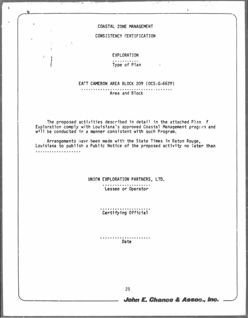
COASTAL ZONE MANAGEMENT
CONSISTENCY CERTIFICATION
EXPLORATION
Type of Plan
EAT CAMERON AREA BLOCK 209 (OCS-G-6629)
Area and Block
The proposed ac t i v i t i es described 1n detai l 1n the attached Plsn f Exploration comply with Louisiana's approved Coastal Management program and w<11 be conducted 1n a manner consistent with such Program.
Arrangements iiavp been made with the State Times In Baton Rouge, Louisiana to publish a Public Notice of the proposed ac t i v i t y no la ter than
UNICN EXPLORATION PARTNERS, LTD.
Lessee or Operator
Cer t i fy ing Of f i c ia l
Date
25
John E. Chance et Assoc., Inc.