12 ecology & nature conservation - transport scotland · chapter 12: ecology & nature...
TRANSCRIPT
A9 Dualling Programme: Pitlochry to Killiecrankie
DMRB Stage 3 Environmental Statement
Chapter 12: Ecology & Nature Conservation
Page 1 of Chapter 12
12 Ecology & Nature ConservationThis chapter considers the potential impacts of the proposed scheme on terrestrial and freshwaterspecies, habitats and ecosystems. The approach to this assessment is based on DMRB guidanceand draws on the Chartered Institute for Ecology and Environmental Management’s (CIEEM)Guidelines for Ecological Impact Assessment in the UK and Ireland.
Baseline conditions for ecological features were established through desk-based assessment,consultation and site surveys. This process identified ecological features that could potentially beimpacted by the proposed scheme, including two statutory designated sites (the River Tay SpecialArea of Conservation and the Pass of Killiecrankie Site of Special Scientific Interest). Aquatic andterrestrial species and habitats that could potentially be impacted included, amongst others,Ancient Woodland Inventory (AWI) sites, otter, red squirrel, badger, bats, freshwater pearl musseland the notable plant species northern marsh-orchid.
Assessment of impacts and their significance took into account the nature and magnitude ofpotential impacts and their consequent effects on important ecological features. Prior to thedevelopment and application of mitigation, potential significant impacts on ecological featureswere identified for the construction and operation phases of the proposed scheme.
A hierarchical approach to mitigation was followed to address potential impacts. The primaryapproach has been to use the flexibility available within the early design stages to avoid significantimpacts. For example, a roundabout on the southbound merge/diverge at the Pitlochry NorthJunction has been incorporated during the design development to substantially reduce the land-take and associated loss of habitat listed on the AWI in this area, compared with initial proposals,which required significant earthworks. An iterative design process has been undertaken anddesign principles have been discussed with SNH, SEPA and other relevant stakeholders.
Where avoidance of impacts has not been possible, mitigation measures to reduce significantadverse impacts have been identified. Such measures include implementation of commitments andbest working practices during the construction phase. During operation, compensatory planting,habitat creation, mammal fencing and provision of crossing structures has been proposed tomitigate potential impacts.
No significant residual impacts are anticipated from construction of the proposed scheme. Asignificant residual impact from the operation phase is anticipated from the permanent loss ofhabitat designated as part of the AWI. Compensation planting is proposed, however this cannotmitigate for the permanent loss of the biodiversity and intrinsic importance of ancient woodlandhabitats. As the habitat matures, however, woodland corridors will grow to connect currentlyfragmented areas and the planting will therefore mitigate for the functions and importance of thewoodland in respect of habitat connectivity and carrying capacity for other species. In the long-term, significant residual impacts are therefore predicted to reduce.
A potential beneficial impact is anticipated as a result of the proposed scheme through increasedpermeability of the A9 for species compared with that of the existing A9. This is expected forspecies including badger and otter through provision of crossing structures.
12.1 Introduction
12.1.1 This chapter presents the DMRB Stage 3 Ecological Impact Assessment (EcIA) for the proposedscheme (Chapter 5: The Proposed Scheme), which considers the potential impacts on terrestrial andfreshwater species, habitats and ecosystems.
12.1.2 The chapter is supported by the following appendices, which are cross-referenced where relevant:
Appendix A12.1: Scientific Names;
Appendix A12.2: Baseline Data and Detailed Survey Methods; and
Appendix A12.3: Confidential Ecology Features.
12.1.3 Appendix A12.3 (Confidential Ecology Features) is not published with the ES due to the potential riskto protected species from locational data being publicly available. However, these data will besubmitted to SNH, Transport Scotland, and Perth & Kinross Council (PKC).
12.1.4 The assessment is derived from a review of available information, including:
the DMRB Stage 2 assessment (Transport Scotland, 2016a);

A9 Dualling Programme: Pitlochry to Killiecrankie
DMRB Stage 3 Environmental Statement
Chapter 12: Ecology & Nature Conservation
Page 2 of Chapter 12
targeted site surveys; and
supplementary consultation to take into account design features of the preferred option selectedduring the DMRB Stage 2 assessment process.
12.1.5 This DMRB Stage 3 assessment is presented in the context of the A9 dualling programme. Thismeans that many potential impacts on ecological features, associated with road operations, arealready experienced by the species and habitats in the area of the existing A9.
12.2 Approach and Methods
12.2.1 The approach to this assessment is based on the guidance provided by:
DMRB Volume 11, Section 3, Part 4: Ecology and Nature Conservation (Highways Agency et al.,1993);
CIEEM’s Guidelines for Ecological Impact Assessment in the UK and Ireland (CIEEM, 2016); and
DMRB Interim Advice Note 130/10 ‘Ecology and Nature Conservation: Criteria for ImpactAssessment’ (Highways Agency et al., 2010) (hereafter referred to as IAN 130/10).
12.2.2 In addition to DMRB guidance, other policy documents and published guidance taken into account inthe preparation of this chapter include:
Scottish Transport Appraisal Guidance (STAG) (Transport Scotland, 2015a);
SNH, A handbook on environmental impact assessment (SNH, 2013a);
A9 Dualling Programme, Strategic Environmental Assessment (SEA) (Transport Scotland, 2013);
A9 Dualling Programme, Strategic Environmental Assessment (SEA) Report Addendum (TransportScotland, 2014a); and
A9 Dualling Programme, Strategic Environmental Assessment (SEA) Post-Adoption SEAStatement (Transport Scotland, 2014b).
12.2.3 The approach and methods employed have been informed by the recommendations made in the A9Dualling Programme SEA (Transport Scotland, 2013) and by the DMRB Stage 2 assessment process.For ecology and nature conservation, recommendations related primarily to early engagement withSNH regarding key constraints identified in the SEA, specifically Sites of Special Scientific Interest(SSSIs), Special Areas of Conservation (SACs), and ancient woodland.
12.2.4 Additional policy and guidance documents are discussed in Chapter 19 (Policies and Plans).
Study Area
12.2.5 The study area comprised an area up to 500m from the extents of the proposed scheme, whichincludes all aspects of the design, as shown on Figure 12.1. This excludes proposed signage locationswhich lie up to 1km beyond the northern and southern extents of the section to be dualled, as thesewill require only minor works and are associated with the ongoing works required by the trunk roadoperating company.
12.2.6 Where reference is made to the footprint of the proposed scheme, this includes the design of theproposed scheme and the areas required for construction.
12.2.7 Following consultation with consultees listed in paragraph 12.2.21 and, where relevant, in line withstandard survey guidance for protected species, variations were made to the study area. Suchvariations were ecology feature-specific, according to their sensitivity, mobility and habitat, asdescribed in Table 12.1.
12.2.8 National Biodiversity Network (NBN) desk-based searches extended beyond the study area. Searcheswere undertaken up to 10km from the existing A9 in order to take into account the highly mobile natureof some species and the level at which some data are available (10km grid square).
A9 Dualling Programme: Pitlochry to Killiecrankie
DMRB Stage 3 Environmental Statement
Chapter 12: Ecology & Nature Conservation
Page 3 of Chapter 12
Baseline Conditions
Desk-based Assessment
12.2.9 The desk-based assessment consisted of a review of existing relevant literature, along with onlinesearches for ecological information within the study area, including:
A9 Dualling Programme route-wide Phase 1 habitat survey (Transport Scotland, 2015b);
A9 Dualling Programme, SEA Environmental Report Addendum (Transport Scotland, 2014a);
A9 Dualling Programme, SEA Post Adoption SEA Statement (Transport Scotland 2014b);
A9 Dualling Programme, Habitats Regulations Appraisal (HRA), Programme Level AppropriateAssessment (AA) (Transport Scotland, 2015c);
survey data from Scottish Badgers (received 2015, 2016 and 2017) (Appendix A12.3: ConfidentialEcology Features);
data provided by Heritage Environmental Ltd. (HEL) as part of surveys prior to ground investigationworks1 (HEL, 2016); and
protected species information from SNH (received 2015) (Appendix A12.3: Confidential EcologyFeatures).
12.2.10 Information for the desk-based assessment was obtained from the following online resources:
Joint Nature Conservation Committee (JNCC) website (JNCC, 2016a);
NBN gateway website (NBN, 2016);
Scotland’s Environment website (Scotland’s Environment Web Partnership, 2016);
SEPA website (SEPA, 2016); and
SNH Information Service (SNH, 2016a).
12.2.11 Data responses from the following also formed part of the desk-based assessment:
British Trust for Ornithology (BTO);
Forestry Commission Scotland;
Marine Scotland (at Pitlochry);
Perth Museum Biological Records Centre;
Royal Society for the Protection of Birds (RSPB);
Saving Scotland’s Red Squirrels (SSRS);
SSE (trading as Scottish Hydro);
Scottish Wildlife Trust;
Tayside Bat Group;
Tayside Biodiversity Partnership;
Tay District Salmon Fisheries Board (TDSFB); and
Tayside Raptor Study Group.
1 Ground Investigation works were undertaken for the A9 dualling programme. Ecology surveys included those for bats and otter
(September – October 2016).

A9 Dualling Programme: Pitlochry to Killiecrankie
DMRB Stage 3 Environmental Statement
Chapter 12: Ecology & Nature Conservation
Page 4 of Chapter 12
Wildcat Assessment Methods
12.2.12 A habitat network approach was agreed through consultation with SNH and the Cairngorms NationalPark Authority (CNPA), and was adopted to identify wildcat potential habitat (Transport Scotland,2015d). The approach utilised visual habitat analysis with geographic information system (GIS)mapping, based on three key datasets:
SNH’s Wildcat Habitat Suitability Model (Bryce and Mattisson, 2012), displaying wildcat cover andmovement habitats, and moorland and grassland prey habitats;
CNPA’s wildcat observer sightings (Hetherington and Campbell, 2012); and
current and proposed structures of suitable permeability for wildcat (Transport Scotland, 2015d).
12.2.13 The visual habitat analysis involved determining important areas of connectivity across the proposedscheme, accounting for natural barriers, such as large watercourses, and assessing current andproposed migration porosity via structures, such as bridges and dry mammal underpasses. Smallerroads travelled by only a few hundred cars per day are a negligible barrier to wildcat movement andtherefore side roads and access roads were not included in this analysis (Klar et al., 2009).
12.2.14 A traffic light scoring system was established to assign porosity values to the existing A9 structures, todetermine current permeability for wildcat (Transport Scotland, 2015d). The scoring system assigneda ‘green’ value to structures which currently provide good permeability for a range of species. An‘amber’ score was assigned to those that could be used currently but which could potentially beimproved via dualling works. A ‘red’ score was assigned to crossing features that were not consideredto provide good permeability, such as narrow diameter drainage pipes and culverts with catch pits orlong drops.
12.2.15 The above information was used to inform this assessment and identify mitigation required to reducehabitat fragmentation.
Site Surveys
12.2.16 Ecology surveys were undertaken as described in Table 12.1 and in Appendix A12.2 (Baseline Dataand Detailed Survey Methods).
12.2.17 All surveys were undertaken in accordance with the Outline approach to consistency in A9 ecologysurvey extents (Transport Scotland, 2015e) as agreed by statutory consultees forming the A9Environmental Steering Group (ESG).
12.2.18 All surveys were undertaken in 2015 and 2016 (Table 12.1) and baseline results represent conditionsat that time. Any limitations experienced during site surveys are detailed in Table 12.1.
A9 Dualling Programme: Pitlochry to Killiecrankie
DMRB Stage 3 Environmental Statement
Chapter 12: Ecology & Nature Conservation
Page 5 of Chapter 12
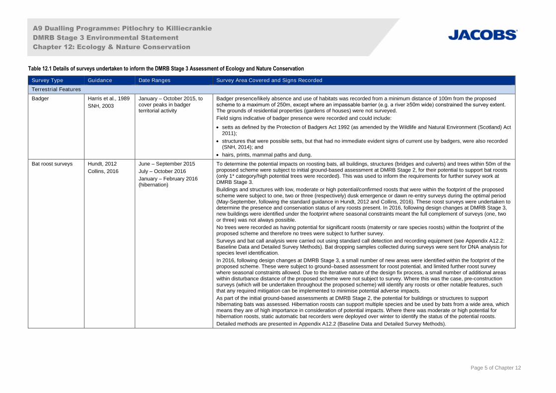
Table 12.1 Details of surveys undertaken to inform the DMRB Stage 3 Assessment of Ecology and Nature Conservation
Survey Type Guidance Date Ranges Survey Area Covered and Signs Recorded
Terrestrial Features
Badger Harris et al., 1989
SNH, 2003
January – October 2015, tocover peaks in badgerterritorial activity
Badger presence/likely absence and use of habitats was recorded from a minimum distance of 100m from the proposedscheme to a maximum of 250m, except where an impassable barrier (e.g. a river ≥50m wide) constrained the survey extent. The grounds of residential properties (gardens of houses) were not surveyed.
Field signs indicative of badger presence were recorded and could include:
setts as defined by the Protection of Badgers Act 1992 (as amended by the Wildlife and Natural Environment (Scotland) Act2011);
structures that were possible setts, but that had no immediate evident signs of current use by badgers, were also recorded(SNH, 2014); and
hairs, prints, mammal paths and dung.
Bat roost surveys Hundt, 2012
Collins, 2016
June – September 2015
July – October 2016
January – February 2016(hibernation)
To determine the potential impacts on roosting bats, all buildings, structures (bridges and culverts) and trees within 50m of theproposed scheme were subject to initial ground-based assessment at DMRB Stage 2, for their potential to support bat roosts(only 1* category/high potential trees were recorded). This was used to inform the requirements for further survey work atDMRB Stage 3.
Buildings and structures with low, moderate or high potential/confirmed roosts that were within the footprint of the proposedscheme were subject to one, two or three (respectively) dusk emergence or dawn re-entry surveys during the optimal period(May-September, following the standard guidance in Hundt, 2012 and Collins, 2016). These roost surveys were undertaken todetermine the presence and conservation status of any roosts present. In 2016, following design changes at DMRB Stage 3,new buildings were identified under the footprint where seasonal constraints meant the full complement of surveys (one, twoor three) was not always possible.
No trees were recorded as having potential for significant roosts (maternity or rare species roosts) within the footprint of theproposed scheme and therefore no trees were subject to further survey.
Surveys and bat call analysis were carried out using standard call detection and recording equipment (see Appendix A12.2:Baseline Data and Detailed Survey Methods). Bat dropping samples collected during surveys were sent for DNA analysis forspecies level identification.
In 2016, following design changes at DMRB Stage 3, a small number of new areas were identified within the footprint of theproposed scheme. These were subject to ground–based assessment for roost potential, and limited further roost surveywhere seasonal constraints allowed. Due to the iterative nature of the design fix process, a small number of additional areaswithin disturbance distance of the proposed scheme were not subject to survey. Where this was the case, pre-constructionsurveys (which will be undertaken throughout the proposed scheme) will identify any roosts or other notable features, suchthat any required mitigation can be implemented to minimise potential adverse impacts.
As part of the initial ground-based assessments at DMRB Stage 2, the potential for buildings or structures to supporthibernating bats was assessed. Hibernation roosts can support multiple species and be used by bats from a wide area, whichmeans they are of high importance in consideration of potential impacts. Where there was moderate or high potential forhibernation roosts, static automatic bat recorders were deployed over winter to identify the status of the potential roosts.
Detailed methods are presented in Appendix A12.2 (Baseline Data and Detailed Survey Methods).
A9 Dualling Programme: Pitlochry to Killiecrankie
DMRB Stage 3 Environmental Statement
Chapter 12: Ecology & Nature Conservation
Page 6 of Chapter 12
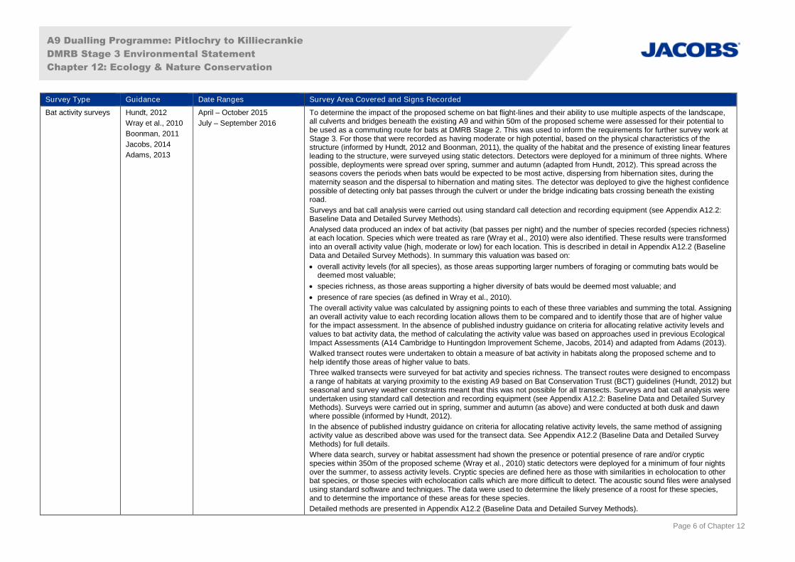
Survey Type Guidance Date Ranges Survey Area Covered and Signs Recorded
Bat activity surveys Hundt, 2012
Wray et al., 2010
Boonman, 2011
Jacobs, 2014
Adams, 2013
April – October 2015
July – September 2016
To determine the impact of the proposed scheme on bat flight-lines and their ability to use multiple aspects of the landscape,all culverts and bridges beneath the existing A9 and within 50m of the proposed scheme were assessed for their potential tobe used as a commuting route for bats at DMRB Stage 2. This was used to inform the requirements for further survey work atStage 3. For those that were recorded as having moderate or high potential, based on the physical characteristics of thestructure (informed by Hundt, 2012 and Boonman, 2011), the quality of the habitat and the presence of existing linear featuresleading to the structure, were surveyed using static detectors. Detectors were deployed for a minimum of three nights. Wherepossible, deployments were spread over spring, summer and autumn (adapted from Hundt, 2012). This spread across theseasons covers the periods when bats would be expected to be most active, dispersing from hibernation sites, during thematernity season and the dispersal to hibernation and mating sites. The detector was deployed to give the highest confidencepossible of detecting only bat passes through the culvert or under the bridge indicating bats crossing beneath the existingroad.
Surveys and bat call analysis were carried out using standard call detection and recording equipment (see Appendix A12.2:Baseline Data and Detailed Survey Methods).
Analysed data produced an index of bat activity (bat passes per night) and the number of species recorded (species richness)at each location. Species which were treated as rare (Wray et al., 2010) were also identified. These results were transformedinto an overall activity value (high, moderate or low) for each location. This is described in detail in Appendix A12.2 (BaselineData and Detailed Survey Methods). In summary this valuation was based on:
overall activity levels (for all species), as those areas supporting larger numbers of foraging or commuting bats would bedeemed most valuable;
species richness, as those areas supporting a higher diversity of bats would be deemed most valuable; and
presence of rare species (as defined in Wray et al., 2010).
The overall activity value was calculated by assigning points to each of these three variables and summing the total. Assigningan overall activity value to each recording location allows them to be compared and to identify those that are of higher valuefor the impact assessment. In the absence of published industry guidance on criteria for allocating relative activity levels andvalues to bat activity data, the method of calculating the activity value was based on approaches used in previous EcologicalImpact Assessments (A14 Cambridge to Huntingdon Improvement Scheme, Jacobs, 2014) and adapted from Adams (2013).
Walked transect routes were undertaken to obtain a measure of bat activity in habitats along the proposed scheme and tohelp identify those areas of higher value to bats.
Three walked transects were surveyed for bat activity and species richness. The transect routes were designed to encompassa range of habitats at varying proximity to the existing A9 based on Bat Conservation Trust (BCT) guidelines (Hundt, 2012) butseasonal and survey weather constraints meant that this was not possible for all transects. Surveys and bat call analysis wereundertaken using standard call detection and recording equipment (see Appendix A12.2: Baseline Data and Detailed SurveyMethods). Surveys were carried out in spring, summer and autumn (as above) and were conducted at both dusk and dawnwhere possible (informed by Hundt, 2012).
In the absence of published industry guidance on criteria for allocating relative activity levels, the same method of assigningactivity value as described above was used for the transect data. See Appendix A12.2 (Baseline Data and Detailed SurveyMethods) for full details.
Where data search, survey or habitat assessment had shown the presence or potential presence of rare and/or crypticspecies within 350m of the proposed scheme (Wray et al., 2010) static detectors were deployed for a minimum of four nightsover the summer, to assess activity levels. Cryptic species are defined here as those with similarities in echolocation to otherbat species, or those species with echolocation calls which are more difficult to detect. The acoustic sound files were analysedusing standard software and techniques. The data were used to determine the likely presence of a roost for these species,and to determine the importance of these areas for these species.
Detailed methods are presented in Appendix A12.2 (Baseline Data and Detailed Survey Methods).

A9 Dualling Programme: Pitlochry to Killiecrankie
DMRB Stage 3 Environmental Statement
Chapter 12: Ecology & Nature Conservation
Page 7 of Chapter 12
Survey Type Guidance Date Ranges Survey Area Covered and Signs Recorded
Breeding birds:modified CommonBird Census
Bibby et al., 2000
Highways Agencyet al., 2001
July 2015; dawn to noon BST The Breeding Bird Survey (BBS) methodology was adapted to comprise a single visit in July, in order to cover the large areaand gain an indication of the species assemblage present across all habitat types. The survey extended up to 150m from themainline of the proposed scheme.
All farmland, woodland, upland, copse and scrub boundaries, hedgerows, ditches, rivers and streams were surveyed forlocation, species and activity of every individual bird observed (sight and/or sound) within or flying over the survey area usingstandard BTO conventions (Bibby et al., 2000). This approach also maximised the chances of seeing birds and so mitigatedfor reduction in ability to hear birds due to road noise.
Detailed methods are presented in Appendix A12.2 (Baseline Data and Detailed Survey Methods).
Otter Chanin, 2003 February – November 2015
February – March 2016
Otter presence/likely absence, and use of habitats affected by the proposed scheme were surveyed. Surveys were conductedalong watercourses considered, by suitably experienced surveyors, to be valuable in terms of potential to support foraging andresting otter, from a minimum of 100m and to a maximum of 250m from the proposed scheme. Surveys extended to 50m fromwater’s edge.
Thirteen suitable watercourses (as identified at DMRB Stage 2) were surveyed for otter shelters, which were categorised andphotographed. In addition, field signs indicative of otter presence were recorded and could include:
spraints, prints, slides or other well-used access points to watercourses;
feeding remains; and
sightings (including wildlife vehicle incidents (WVIs)).
Where appropriate, infra-red camera traps were also deployed under licence from SNH (licence number: 54909) to monitorotter resting sites, for example to determine if any were natal holts.
Short (up to 5m) stretches of steep, heavily vegetated or rocky banks could not be surveyed safely in some locations, but thisdid not preclude full assessment of otter use of the survey area.
Water vole Strachan et al.,2011
Dean et al., 2016
June – November 2015 Water vole presence/likely absence, and use of habitats affected by the proposed scheme were surveyed. Surveys wereconducted along watercourses up to 100m from the proposed scheme. Surveys extended to 2m from water’s edge.
Ten suitable watercourses were surveyed (as identified at DMRB Stage 2), where habitats were considered valuable, in termsof potential to support water vole populations, by suitably experienced surveyors.
Field signs indicative of water vole presence were recorded and could include:
droppings and latrines;
a network of bankside burrows (categorised and photographed as appropriate);
feeding signs of neat vegetation piles; and
covered runs through vegetation.
Pine marten, redsquirrel and wildcat
Croose et al.,2013
Gurnell et al.,2009
SNH, undated-a
January 2015 – August 2016 Evidence was recorded as incidental sightings/signs found during other habitat and species surveys.
Desk-based data, for example data obtained from the assessment for wildcat as detailed in paragraphs 12.2.12 to 12.2.15,were used in combination with the above to assess the potential presence of these species.
A9 Dualling Programme: Pitlochry to Killiecrankie
DMRB Stage 3 Environmental Statement
Chapter 12: Ecology & Nature Conservation
Page 8 of Chapter 12
Survey Type Guidance Date Ranges Survey Area Covered and Signs Recorded
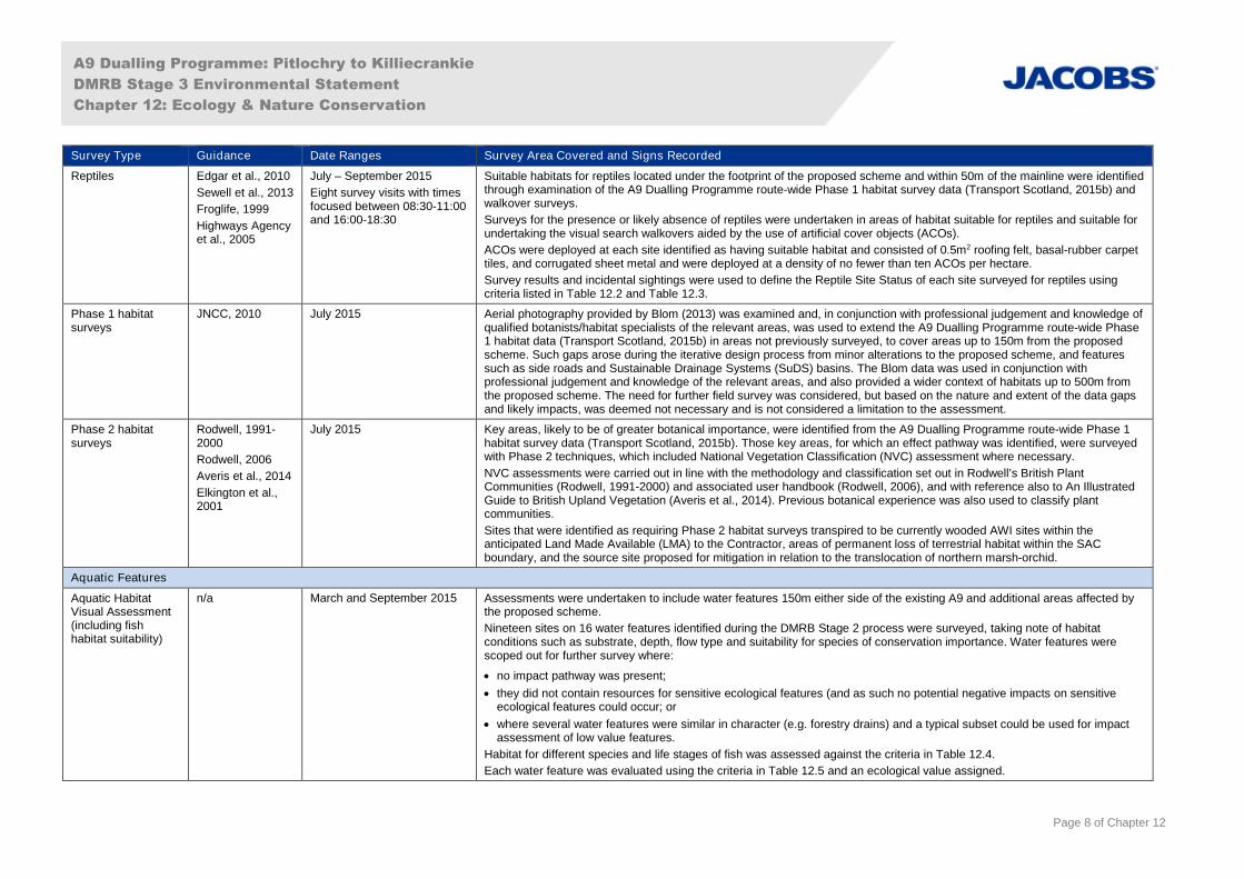
Reptiles Edgar et al., 2010
Sewell et al., 2013
Froglife, 1999
Highways Agencyet al., 2005
July – September 2015
Eight survey visits with timesfocused between 08:30-11:00and 16:00-18:30
Suitable habitats for reptiles located under the footprint of the proposed scheme and within 50m of the mainline were identifiedthrough examination of the A9 Dualling Programme route-wide Phase 1 habitat survey data (Transport Scotland, 2015b) andwalkover surveys.
Surveys for the presence or likely absence of reptiles were undertaken in areas of habitat suitable for reptiles and suitable forundertaking the visual search walkovers aided by the use of artificial cover objects (ACOs).
ACOs were deployed at each site identified as having suitable habitat and consisted of 0.5m2 roofing felt, basal-rubber carpettiles, and corrugated sheet metal and were deployed at a density of no fewer than ten ACOs per hectare.
Survey results and incidental sightings were used to define the Reptile Site Status of each site surveyed for reptiles usingcriteria listed in Table 12.2 and Table 12.3.
Phase 1 habitatsurveys
JNCC, 2010 July 2015 Aerial photography provided by Blom (2013) was examined and, in conjunction with professional judgement and knowledge ofqualified botanists/habitat specialists of the relevant areas, was used to extend the A9 Dualling Programme route-wide Phase1 habitat data (Transport Scotland, 2015b) in areas not previously surveyed, to cover areas up to 150m from the proposedscheme. Such gaps arose during the iterative design process from minor alterations to the proposed scheme, and featuressuch as side roads and Sustainable Drainage Systems (SuDS) basins. The Blom data was used in conjunction withprofessional judgement and knowledge of the relevant areas, and also provided a wider context of habitats up to 500m fromthe proposed scheme. The need for further field survey was considered, but based on the nature and extent of the data gapsand likely impacts, was deemed not necessary and is not considered a limitation to the assessment.
Phase 2 habitatsurveys
Rodwell, 1991-2000
Rodwell, 2006
Averis et al., 2014
Elkington et al.,2001
July 2015 Key areas, likely to be of greater botanical importance, were identified from the A9 Dualling Programme route-wide Phase 1habitat survey data (Transport Scotland, 2015b). Those key areas, for which an effect pathway was identified, were surveyedwith Phase 2 techniques, which included National Vegetation Classification (NVC) assessment where necessary.
NVC assessments were carried out in line with the methodology and classification set out in Rodwell’s British PlantCommunities (Rodwell, 1991-2000) and associated user handbook (Rodwell, 2006), and with reference also to An IllustratedGuide to British Upland Vegetation (Averis et al., 2014). Previous botanical experience was also used to classify plantcommunities.
Sites that were identified as requiring Phase 2 habitat surveys transpired to be currently wooded AWI sites within theanticipated Land Made Available (LMA) to the Contractor, areas of permanent loss of terrestrial habitat within the SACboundary, and the source site proposed for mitigation in relation to the translocation of northern marsh-orchid.
Aquatic Features
Aquatic HabitatVisual Assessment(including fishhabitat suitability)
n/a March and September 2015 Assessments were undertaken to include water features 150m either side of the existing A9 and additional areas affected bythe proposed scheme.
Nineteen sites on 16 water features identified during the DMRB Stage 2 process were surveyed, taking note of habitatconditions such as substrate, depth, flow type and suitability for species of conservation importance. Water features werescoped out for further survey where:
no impact pathway was present;
they did not contain resources for sensitive ecological features (and as such no potential negative impacts on sensitiveecological features could occur; or
where several water features were similar in character (e.g. forestry drains) and a typical subset could be used for impactassessment of low value features.
Habitat for different species and life stages of fish was assessed against the criteria in Table 12.4.
Each water feature was evaluated using the criteria in Table 12.5 and an ecological value assigned.
A9 Dualling Programme: Pitlochry to Killiecrankie
DMRB Stage 3 Environmental Statement
Chapter 12: Ecology & Nature Conservation
Page 9 of Chapter 12
Survey Type Guidance Date Ranges Survey Area Covered and Signs Recorded
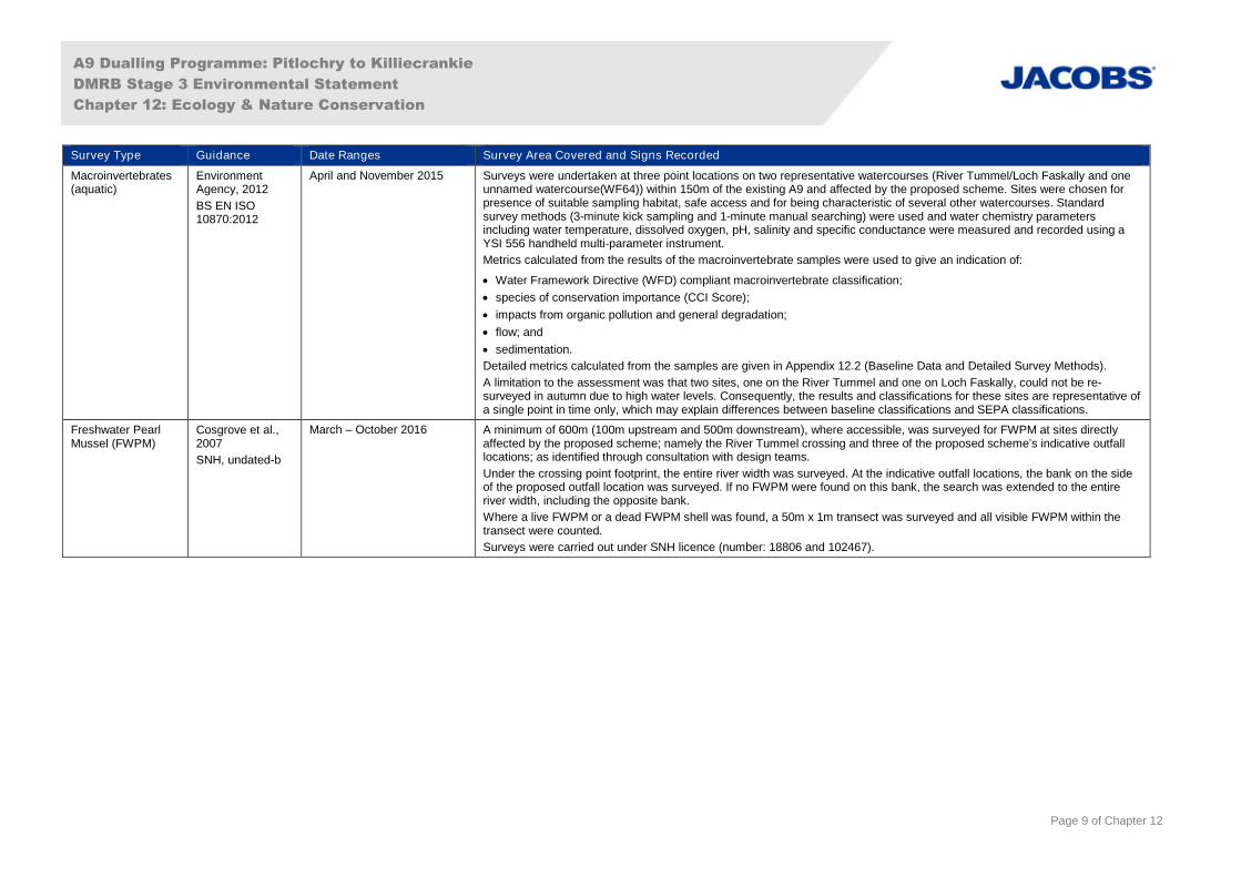
Macroinvertebrates(aquatic)
EnvironmentAgency, 2012
BS EN ISO10870:2012
April and November 2015 Surveys were undertaken at three point locations on two representative watercourses (River Tummel/Loch Faskally and oneunnamed watercourse(WF64)) within 150m of the existing A9 and affected by the proposed scheme. Sites were chosen forpresence of suitable sampling habitat, safe access and for being characteristic of several other watercourses. Standardsurvey methods (3-minute kick sampling and 1-minute manual searching) were used and water chemistry parametersincluding water temperature, dissolved oxygen, pH, salinity and specific conductance were measured and recorded using aYSI 556 handheld multi-parameter instrument.
Metrics calculated from the results of the macroinvertebrate samples were used to give an indication of:
Water Framework Directive (WFD) compliant macroinvertebrate classification;
species of conservation importance (CCI Score);
impacts from organic pollution and general degradation;
flow; and
sedimentation.
Detailed metrics calculated from the samples are given in Appendix 12.2 (Baseline Data and Detailed Survey Methods).
A limitation to the assessment was that two sites, one on the River Tummel and one on Loch Faskally, could not be re-surveyed in autumn due to high water levels. Consequently, the results and classifications for these sites are representative ofa single point in time only, which may explain differences between baseline classifications and SEPA classifications.
Freshwater PearlMussel (FWPM)
Cosgrove et al.,2007
SNH, undated-b
March – October 2016 A minimum of 600m (100m upstream and 500m downstream), where accessible, was surveyed for FWPM at sites directlyaffected by the proposed scheme; namely the River Tummel crossing and three of the proposed scheme’s indicative outfalllocations; as identified through consultation with design teams.
Under the crossing point footprint, the entire river width was surveyed. At the indicative outfall locations, the bank on the sideof the proposed outfall location was surveyed. If no FWPM were found on this bank, the search was extended to the entireriver width, including the opposite bank.
Where a live FWPM or a dead FWPM shell was found, a 50m x 1m transect was surveyed and all visible FWPM within thetransect were counted.
Surveys were carried out under SNH licence (number: 18806 and 102467).
A9 Dualling Programme: Pitlochry to Killiecrankie
DMRB Stage 3 Environmental Statement
Chapter 12: Ecology & Nature Conservation
Page 10 of Chapter 12
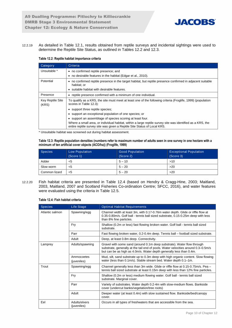
12.2.19 As detailed in Table 12.1, results obtained from reptile surveys and incidental sightings were used todetermine the Reptile Site Status, as outlined in Tables 12.2 and 12.3.
Table 12.2: Reptile habitat importance criteria
Category Criteria
Unsuitable * no confirmed reptile presence; and
no desirable features in the habitat (Edgar et al., 2010).
Potential no confirmed reptile presence in the target habitat, but reptile presence confirmed in adjacent suitablehabitat; or
suitable habitat with desirable features.
Presence reptile presence confirmed with a minimum of one individual.
Key Reptile Site
(KRS)
To qualify as a KRS, the site must meet at least one of the following criteria (Froglife, 1999) (populationscores in Table 12.3):
support three reptile species;
support an exceptional population of one species; or
support an assemblage of species scoring at least four.
Where a small area, or individual habitat, within a large reptile survey site was identified as a KRS, theentire reptile survey site was given a Reptile Site Status of Local KRS.
* Unsuitable habitat was screened out during habitat assessment.
Table 12.3: Reptile population densities (numbers refer to maximum number of adults seen in one survey in one hectare with aminimum of ten artificial cover objects (ACO/ha)) (Froglife, 1999)
Species Low Population
(Score 1)
Good Population
(Score 2)
Exceptional Population
(Score 3)
Adder <5 5 – 10 >10
Slow worm <5 5 – 20 >20
Common lizard <5 5 – 20 >20
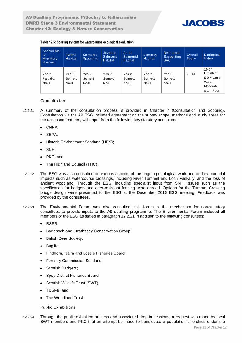
12.2.20 Fish habitat criteria are presented in Table 12.4 (based on Hendry & Cragg-Hine, 2003; Maitland,2003, Maitland, 2007 and Scotland Fisheries Co-ordination Centre; SFCC, 2016), and water featureswere evaluated using the criteria in Table 12.5.
Table 12.4: Fish habitat criteria
Species Life Stage Optimal Habitat Requirements
Atlantic salmon Spawning/egg Channel width at least 3m, with 0.17-0.76m water depth. Glide or riffle flow at0.35-0.80m/s. Golf ball - tennis ball sized substrate, 0.15-0.25m deep with lessthan 8% fine particles.
Fry Shallow (0.2m or less) fast flowing broken water. Golf ball - tennis ball sizedsubstrate.
Parr Fast flowing broken water, 0.2-0.4m deep. Tennis ball – football sized substrate.
Adult Deep, at least 0.8m deep. Connectivity.
Lamprey Adults/spawning Gravel with some sand (around 0.1m deep substrate). Water flow throughsubstrate, generally at the tail end of pools. Water velocities around 0.3–0.5m/sbut can be as high as 4.0m/s. Water depth generally less than 0.4m.
Ammocoetes
(juveniles)
Mud, silt, sand substrate up to 0.3m deep with high organic content. Slow flowingwater (less than 0.1m/s). Stable stream bed. Water depth 0.1–1m.
Trout Spawning/egg Channel generally less than 3m wide. Glide or riffle flow at 0.15-0.75m/s. Pea –tennis ball sized substrate at least 0.15m deep with less than 12% fine particles.
Fry Shallow (0.2m or less) medium flowing water. Golf ball - tennis ball sizedsubstrate. Marginal cover.
Parr Variety of substrates. Water depth 0.2-4m with slow-medium flows. Banksidecover (undercut banks/vegetation/tree roots)
Adult Deeper water (at least 0.4m) with slow sustained flow. Bankside/bed/canopycover.
Eel Adults/elvers(juveniles)
Occurs in all types of freshwaters that are accessible from the sea.
A9 Dualling Programme: Pitlochry to Killiecrankie
DMRB Stage 3 Environmental Statement
Chapter 12: Ecology & Nature Conservation
Page 11 of Chapter 12
Table 12.5: Scoring system for watercourse ecological evaluation
AccessibletoMigratorySpecies
FWPMHabitat
SalmonidSpawning
JuvenileSalmonidHabitat
AdultSalmonidHabitat
LampreyHabitat
ResourcesSupportingSAC
OverallScore
EcologicalValue
Yes-2
Partial-1
No-0
Yes-2
Some-1
No-0
Yes-2
Some-1
No-0
Yes-2
Some-1
No-0
Yes-2
Some-1
No-0
Yes-2
Some-1
No-0
Yes-2
Some-1
No-0
0 - 14
10-14 =Excellent
5-9 = Good
2-4 =Moderate
0-1 = Poor
Consultation
12.2.21 A summary of the consultation process is provided in Chapter 7 (Consultation and Scoping).Consultation via the A9 ESG included agreement on the survey scope, methods and study areas forthe assessed features, with input from the following key statutory consultees:
CNPA;
SEPA;
Historic Environment Scotland (HES);
SNH;
PKC; and
The Highland Council (THC).
12.2.22 The ESG was also consulted on various aspects of the ongoing ecological work and on key potentialimpacts such as watercourse crossings, including River Tummel and Loch Faskally, and the loss ofancient woodland. Through the ESG, including specialist input from SNH, issues such as thespecification for badger- and otter-resistant fencing were agreed. Options for the Tummel Crossingbridge design were presented to the ESG at the December 2016 ESG meeting. Feedback wasprovided by the consultees.
12.2.23 The Environmental Forum was also consulted; this forum is the mechanism for non-statutoryconsultees to provide inputs to the A9 dualling programme. The Environmental Forum included allmembers of the ESG as stated in paragraph 12.2.21 in addition to the following consultees:
RSPB;
Badenoch and Strathspey Conservation Group;
British Deer Society;
Buglife;
Findhorn, Nairn and Lossie Fisheries Board;
Forestry Commission Scotland;
Scottish Badgers;
Spey District Fisheries Board;
Scottish Wildlife Trust (SWT);
TDSFB; and
The Woodland Trust.
Public Exhibitions
12.2.24 Through the public exhibition process and associated drop-in sessions, a request was made by localSWT members and PKC that an attempt be made to translocate a population of orchids under the
A9 Dualling Programme: Pitlochry to Killiecrankie
DMRB Stage 3 Environmental Statement
Chapter 12: Ecology & Nature Conservation
Page 12 of Chapter 12
footprint of the proposed scheme in advance of construction. These orchids had been identified duringsite surveys as northern marsh-orchid.
Impact Assessment
12.2.25 Impact significance was assessed taking into account the nature and magnitude of potential impacts(including duration, extent and reversibility) and their consequent effects on important ecologicalfeatures, using criteria as set out below.
12.2.26 The importance of a feature was defined using criteria set out in Table 12.6 and paragraphs 12.2.27-12.2.30. Impact characterisation criteria are defined in Table 12.7, and in paragraphs 12.2.32-12.2.33.
Importance
12.2.27 The general approach to defining the importance of ecological features follows that of CIEEM (2016).The approach is also in line with advice given in DMRB Interim Advice Note 130/10 ‘Ecology andNature Conservation: Criteria for Impact Assessment’ (Highways Agency et al., 2010).
12.2.28 Ecosystems, habitats and species are assigned levels of importance for nature conservation based onthe criteria set out in Table 12.6.
12.2.29 The rarity, ability to resist or recover from environmental change, and uniqueness of an ecologicalfeature, functioning/role within an ecosystem, and level of legal protection or designation afforded to agiven ecological feature are all factors taken into account in determining its importance.
12.2.30 Only important ecological features are subject to impact assessment. Therefore, features that havebeen identified during the collection of the baseline that do not meet the criteria for at least localimportance are not considered in detail in this assessment (see Table 12.6).
Table 12.6: Importance criteria for ecological features
Importance Criteria
International Ecosystems and Habitats
Ecosystems or habitats essential for the maintenance of:
internationally designated areas or undesignated areas that meet the criteria for designation; and/or
viable populations of species of international conservation concern.
Species
Species whose presence contributes to:
the maintenance of qualifying habitats, communities and assemblages that occur within internationallydesignated sites or within undesignated areas that meet the criteria for such designation.
National Ecosystems and Habitats
Ecosystems or habitats essential for the maintenance of:
qualifying communities and assemblages that occur within nationally designated sites or withinundesignated areas that meet the criteria for such designation; and/or
viable populations of species of national conservation concern.
Species
Species whose presence contributes to:
the maintenance of qualifying habitats, communities and assemblages that occur within nationallydesignated sites or within undesignated areas that meet the criteria for such designation; or
the maintenance and restoration of biodiversity and ecosystems at a national level, as defined in theScottish Biodiversity Strategy (SBS) (Scottish Government, 2013, 2015).
Regional Ecosystems and Habitats
Ecosystems or habitats essential for the maintenance of:
communities and assemblages that occur within regionally important sites or localities listed as being ofconservation importance in the Tayside Biodiversity Action Plan (BAP) or Cairngorms Nature Action Plan(CNAP) (including Local Nature Reserves) or within undesignated areas that meet the criteria for suchdesignation; and/or
viable populations of species of regional conservation concern.
Species
A9 Dualling Programme: Pitlochry to Killiecrankie
DMRB Stage 3 Environmental Statement
Chapter 12: Ecology & Nature Conservation
Page 13 of Chapter 12
Importance Criteria
Species whose presence contributes to:
the maintenance and restoration of biodiversity and ecosystems at a regional level, as defined in theTayside BAP or CNAP.
AuthorityArea
Ecosystems and Habitats
Ecosystems or habitats essential for the maintenance of:
populations of species of conservation concern within the authority area.
Species
Species whose presence contributes to:
the maintenance and restoration of biodiversity and ecosystems within a relevant area such as Perth andKinross within the Tayside BAP, or Aviemore in the CNAP.
Local Ecosystems and Habitats
Ecosystems or habitats essential for the maintenance of:
populations of species of conservation concern within the local area (for example a Local Nature Reserve(LNR)).
Species
Species whose presence contributes to:
the maintenance and restoration of biodiversity and ecosystems at a local level.
Less thanLocal
Ecosystems and Habitats
Ecosystems or habitats that do not meet the above criteria.
Species
Species that do not meet the above criteria.
12.2.31 In accordance with DMRB IAN 130/10, deer and invasive non-native species (INNS) were scoped outfrom ecological evaluation due to their lack of conservation status. Deer are discussed in this chapterin the context of potential for vehicle collisions during the operational phase of the proposed scheme,which could have implications regarding human safety and animal welfare. INNS are discussed in thecontext of their potential as a risk to biodiversity and, under the Wildlife and Countryside Act 1981 (asamended) (WCA), legal responsibilities to prevent their transfer. The impact of transfer of INNS hastherefore been assessed in this chapter (Table 12.12). Beaver are discussed where relevant in linewith the recent Scottish Government decision to accord the species protection in line with the EUHabitats Directive (Scottish Government, 2016) and have also been assessed in Table 12.12.
Impact Characterisation
12.2.32 For the purposes of this assessment, the impact descriptors in Table 12.7 are taken to summarise theoverall characterisation of positive or negative impacts in accordance with CIEEM (2016), including:
impact extent/scale (e.g. entire habitat loss, partial habitat loss or indication over specific areaaffected);
direct or indirect impact (e.g. direct mortality of individuals from vehicle collisions, or indirectmortality of individuals from reduced prey resources due to pollution of watercourses);
reversibility of impact (reversible or irreversible);
frequency of impact (single event, recurring or constant);
duration of impact (short-term, medium-term, long-term or permanent); and
likelihood of occurrence (certain/near certain, probable, unlikely or extremely unlikely).
12.2.33 The character of impacts is defined using the criteria set out in Table 12.7. Impact character wasidentified as high, medium, low or negligible, following the above impact characterisation approach.
A9 Dualling Programme: Pitlochry to Killiecrankie
DMRB Stage 3 Environmental Statement
Chapter 12: Ecology & Nature Conservation
Page 14 of Chapter 12
Table 12.7: Impact descriptors and characterisation for ecological features
ImpactDescriptor
Impact Characterisation
High An impact resulting in a permanent effect on the distribution and/or abundance of a habitat, speciesassemblage/community or population, in such a way as to alter the integrity of the feature and itsconservation status. If negative this type of effect would reduce the integrity of the feature and itsconservation status. If positive, it would result in an improvement to the conservation status of the feature.
Medium An impact resulting in a long-term but reversible effect on the distribution and/or abundance of a habitat,species assemblage/community or population. If negative this type of effect would have neutral long-termimplications for the integrity of the feature or its conservation status. If positive, it would not alter the long-term conservation status of the feature.
Low An impact resulting in a short-term reversible effect on the distribution and/or abundance of a habitat, speciesassemblage/community or population.
Negligible No discernible impact on the distribution and/or abundance of a habitat, species assemblage/community orpopulation.
Impact Significance
12.2.34 Each feature’s importance and the potential impacts upon it have been determined through the abovedescribed collection of data and consultation; and also from prior project experience, to provide arobust basis for making a professional decision on the appropriate focus of the impact assessment.The assessment is then focused on those impacts that result in potentially significant effects onimportant ecological features. For example, an area of amenity grassland would not meet the criteriafor local ecological importance and would not progress through the assessment process, as theassessment only includes features of local importance or above. However, any impact on a SSSIwould progress through the assessment process as such sites are designated as nationally important.
12.2.35 CIEEM (2016) notes that impacts that are likely to be relevant in an assessment are those that arepredicted to lead to significant effects (negative or positive) on important ecological features.Significant effects are those that are sufficiently important to support or undermine the conservationstatus2 of important ecological features. Knowledge and assessment of construction methods andoperational activities, together with professional judgement by experienced ecologists with experienceof similar large-scale infrastructure projects, has been used to identify the potential impacts of theproject on ecological features.
12.2.36 Following the above approach, the assessment aims to characterise ecological impacts rather thanplacing a reliance only on magnitude. The character of an impact is used to inform the determinationof whether or not the impact on the feature in question is a significant one.
12.2.37 Where impacts on internationally, nationally or regionally important ecological features arecharacterised as ‘medium’ or ‘high’, they are considered to be potentially significant under the terms ofthe EIA Regulations.
12.2.38 Impacts on internationally important features characterised as ‘low’, and ‘high’ impacts on features ofauthority area importance, can also be potentially significant. In addition, there may be a number ofimpacts on a feature that, whilst not of a character to be significant in themselves, may cumulativelyresult in a significant effect on that feature.
12.2.39 Under the terms of the EIA Regulations, where significant impacts are identified, mitigation will bedeveloped to reduce impacts where feasible.
2 Conservation status for habitats is determined by the sum of the influences acting on the habitat and its typical species that may affect its
long-term distribution, structure and function as well as the long-term distribution and abundance of its population within a given
geographical area. Conservation status for species is determined by the sum of influences acting on the species concerned that may affect
the long-term distribution and abundance of its population within a given geographical area (CIEEM, 2016).

A9 Dualling Programme: Pitlochry to Killiecrankie
DMRB Stage 3 Environmental Statement
Chapter 12: Ecology & Nature Conservation
Page 15 of Chapter 12
12.2.40 The mitigation measures described within the EcIA have been incorporated into the design andoperational phasing programme and taken into account in the assessment of the significance ofeffects. The mitigation aims to avoid or negate impacts on ecological features in accordance with bestpractice guidance and UK, Scottish and local government environmental impact, planning andsustainability policies.
12.2.41 Impacts that are not significant (including those where compliance with regulation is required) wouldbe expected to be avoided or reduced through the application of the standard mitigation commitmentsand best working practice (e.g. mitigation of potential pollution impacts through adherence to standardbest practice and guidelines). Significant ecological impacts are expected to be mitigated through acombination of best practice/typical mitigation methods and also mitigation targeted to specificlocations and features as described in this assessment.
12.2.42 Mitigation is also designed to produce a net gain for biodiversity where practicable, in line with policyand guidelines (CIEEM, 2016). Further details of relevant policies are provided in Chapter 19: Policyand Plans.
12.3 Baseline Conditions
Desk-based Assessment
Designated Sites
12.3.1 Two statutory designated sites (for their biological interest) lie within the study area and are shown onFigure 12.1:
River Tay SAC (SNH, 2016b) (SNH site code 8366, EU site code UK0030312); and
Pass of Killiecrankie SSSI (SNH, 2016c) (SNH site code 1274).
12.3.2 The Pitlochry to Killiecrankie section of the existing A9 crosses the River Tay SAC site twice: at thesouthern end of the section where the A9 crosses the River Tummel, and at the Clunie Underbridgewhere the A9 crosses Loch Faskally. An area of the Pass of Killiecrankie SSSI falls within the studyarea at the northern end of this section of the existing A9, at a distance of 200m at the closest point.
12.3.3 A detailed consideration of the potential effects on the River Tay SAC, a European site, in the contextof The Conservation (Natural Habitats, & c.) Regulations 1994 (referred to as the Habitat Regulations),has been undertaken in a Habitat Regulations Appraisal (HRA) for the proposed scheme.
12.3.4 There are no known locally designated sites of nature conservation interest (such as Local NatureReserves) within the study area.
Ancient and Native Woodland
12.3.5 Thirty-nine sites listed on the Ancient Woodland Inventory (AWI) (categories 1a, 2a, 2b and 3)equalling 289ha (SNH, 2008a; undated-c) were identified in the 500m desk-based assessment studyarea (Figure 12.1). Approximately 64% of the habitat listed on the AWI is Category 2b woodland (long-established woodlands of plantation origin) but there are also smaller areas of Category 1a, 2a (bothancient woodland) and 3 (other woodland on ‘Roy’ maps3) present. In addition, 89 pockets of nativewoodland categorised as part of the Native Woodland Survey of Scotland (NWSS) (Patterson et al.,2014) were identified in the 500m desk-based assessment study area (Figure 12.1); some of thesesites are coincident or overlapping with AWI sites.
12.3.6 The AWI includes some areas which were previously wooded, but which have since been modified forother uses such as intensive agriculture, or have been developed. Some non-wooded AWI sites couldpotentially retain remnants of ancient woodland habitats, for example in the soil bank and ground flora.
3 Roy maps (c.1750) from the Roy Military Survey of Scotland, 1747-1755, and the 1st edition Ordnance Survey map (c.1860) were used to
derive the AWI. Available at http://www.nls.uk/ (accessed January 2017).
A9 Dualling Programme: Pitlochry to Killiecrankie
DMRB Stage 3 Environmental Statement
Chapter 12: Ecology & Nature Conservation
Page 16 of Chapter 12
Biodiversity Action Plans
12.3.7 The study area is located within the areas covered by the Tayside Local BAP (Tayside BiodiversityPartnership, 2016). The Tayside Local BAP identifies objectives and targets for the conservation of sixecosystems, including the habitats and species present within them, which are:
Water and Wetland;
Coastal and Marine;
Urban;
Upland;
Farmland; and
Woodland.
Terrestrial Habitats
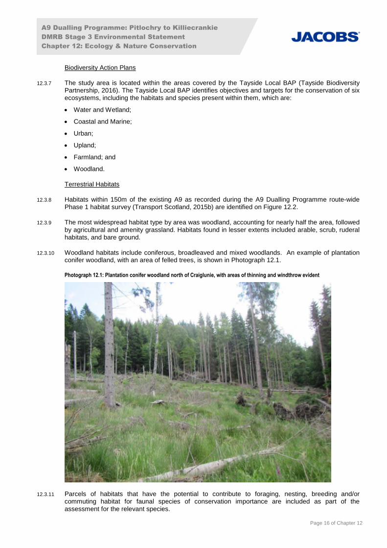
12.3.8 Habitats within 150m of the existing A9 as recorded during the A9 Dualling Programme route-widePhase 1 habitat survey (Transport Scotland, 2015b) are identified on Figure 12.2.
12.3.9 The most widespread habitat type by area was woodland, accounting for nearly half the area, followedby agricultural and amenity grassland. Habitats found in lesser extents included arable, scrub, ruderalhabitats, and bare ground.
12.3.10 Woodland habitats include coniferous, broadleaved and mixed woodlands. An example of plantationconifer woodland, with an area of felled trees, is shown in Photograph 12.1.
Photograph 12.1: Plantation conifer woodland north of Craiglunie, with areas of thinning and windthrow evident
12.3.11 Parcels of habitats that have the potential to contribute to foraging, nesting, breeding and/orcommuting habitat for faunal species of conservation importance are included as part of theassessment for the relevant species.
A9 Dualling Programme: Pitlochry to Killiecrankie
DMRB Stage 3 Environmental Statement
Chapter 12: Ecology & Nature Conservation
Page 17 of Chapter 12
Aquatic Habitats
12.3.12 The River Tummel is the main watercourse in the area and runs parallel to the existing A9 throughoutthe length of the proposed scheme, transitioning into Loch Faskally at Pitlochry Dam. It is also joinedby the River Garry at the upstream end. There are a further 14 smaller watercourses within the studyarea 150m either side of the existing A9: Allt an Aghastair and 13 unnamed, which are crossed by orbeside the existing A9. The watercourses considered for aquatic ecology do not include minorephemeral drains, which are discussed in Chapter 11 (Road Drainage and the Water Environment).Loch Dunmore and two unnamed ponds were also identified within the ecology and natureconservation study area. One of the unnamed ponds, located at Overton of Fonab, was scoped out forsurvey due to being artificial.
12.3.13 Loch Faskally and the sections of the River Tummel and River Garry within the proposed schemehave been classified by SEPA as part of the River Basin Management Plan (RBMP) and all areclassified as having Good Ecological Potential (SEPA, 2016). Whilst the RBMP was published in2016, the most recent classifications are from the 2015 monitoring cycle.
12.3.14 The River Tummel, including Loch Faskally, and the River Garry, up to the confluence with ErrochtyWater, form part of the River Tay SAC, which has been designated for otter, Atlantic salmon, andthree species of lamprey, in addition to clear-water lakes or lochs with aquatic vegetation and poor tomoderate nutrient levels (SNH, 2016b).
12.3.15 Consultation with SSE confirmed that Loch Faskally is deep (20m) with steeply sloping sides and largeamounts of silt (A. Stephen, pers. comm., 26 April 2016).
12.3.16 Many of the smaller unnamed watercourses in the study area are of limited value to aquatic speciesdue to their small size and impassable culverts.
Protected Species
12.3.17 Data obtained during the desk-based assessment, as described in paragraphs 12.2.9 to 12.2.15, andthe results of field work carried out for the DMRB Stage 2 assessment (Transport Scotland, 2016a),identified the potential presence of the following protected species within the study area:
badger: Scottish Badgers provided records in 2015, 2016 and 2017 of badger presence in thestudy area and setts were recorded during DMRB Stage 2 assessment (Transport Scotland,2016a);
bats: six trees and 19 buildings with high roost potential were identified during DMRB Stage 2Assessment (Transport Scotland, 2016a). Locations of four roosts in trees within 50m of theproposed scheme were identified during surveys undertaken by HEL prior to ground investigationworks (HEL, 2016);
beaver: records from NBN from 2012 onwards, and potential beaver woodland, including somepotential core beaver woodland, has been identified within the study area (SNH, 2015). Potentialbeaver woodland has certain characteristics in terms of habitat, location and gradient of water,whilst potential core woodland has additional characteristics and are those areas predicted as mostlikely to be utilised as part of a territory due to their size and connectivity;
bird species on Schedule 1 of the Wildlife and Countryside Act 1981 (as amended): records ofSchedule 1 species within the study area were provided by the TRSG, RSPB and BTO (received2015 and 2016);
breeding birds: suitable habitat was recorded during DMRB Stage 2 assessment, notably inwoodland, agricultural grassland and scrub (Transport Scotland, 2016a). RSPB consultation data(received 2015 and 2016) included records within 2km of the proposed scheme;
breeding and wintering birds: species recorded during the BTO Atlas 2007-2011 in two 10km2 gridsquares which cover the study area (received 2016);
black grouse: a review of RSPB data (received 2016) from the past ten years identified no recordsof black grouse within 2km of the proposed scheme;
A9 Dualling Programme: Pitlochry to Killiecrankie
DMRB Stage 3 Environmental Statement
Chapter 12: Ecology & Nature Conservation
Page 18 of Chapter 12
otter: evidence recorded during DMRB Stage 2 assessment (Transport Scotland, 2016a). Holtmonitoring undertaken by HEL prior to ground investigation works identified seven holts (HEL,2016);
pine marten: NBN (2016) records of pine marten within the study area. In a recent study, thespecies was considered to be expanding its range in Tayside (Croose et al., 2014);
red squirrel: records noted within the study area (Transport Scotland, 2015b). During DMRB Stage2 assessment six sightings, a drey and an anecdotal record of the species were noted (TransportScotland, 2016a);
reptiles: common lizard was recorded during DMRB Stage 2 site surveys (Transport Scotland,2016a). Adder and slow worm have been recorded within 10km of the existing A9 (NBN, 2016).DMRB Stage 2 assessment walkover surveys in 2015 indicated some suitable habitat for all threespecies (Transport Scotland, 2016a);
water vole: the species is undergoing widespread decline (SNH, 2016d) and NBN (2016) indicatesno records within 10km radius of the existing A9 from within the past 30 years. No field signsrecorded during DMRB Stage 2 assessment, although suitable habitat was identified (TransportScotland, 2016a);
Atlantic salmon: TDSFB (A9 ESG, 2015) advise that the species is found throughout the River Taycatchment, and suitable habitat was identified in the River Tay catchment during site surveys(Transport Scotland, 2016a). The River Tay SAC has favourable conservation status for Atlanticsalmon (Rivers and Fisheries Trusts of Scotland, 2014). Approximately 600,000 hatchery-rearedova and fry are stocked at various locations throughout the Tay catchment each year (TDSFB,2016). Although none of the stocking locations are currently within the study area it is possible thatstocked fish make a contribution to the Atlantic salmon population within the study area;
freshwater pearl mussel: data provided by SNH (received January 2016, June 2016) indicated thatFWPM have been recorded in the study area;
river, brook and sea lamprey: records of lamprey species including sea lamprey within the studyarea and considered as having favourable conservation status within the River Tay SAC (Watt etal., 2008). Suitable habitat identified in River Tay catchment during DMRB Stage 2 assessment(Transport Scotland, 2016a). D. Summers, at TSDFB, confirmed sea and river lamprey cannotpass Pitlochry Dam (D. Summers, meeting with Jacobs, 25 November 2015);
trout (brown/sea): TDSFB (TDSFB, 2009) state that trout are present throughout the study area,and suitable habitat was identified in the River Tay catchment during DMRB Stage 2 assessment(Transport Scotland, 2016a); and
European eel: suitable habitat was identified in the River Tay catchment during DMRB Stage 2assessment (Transport Scotland, 2016a). SSE confirmed that eel cannot pass the Pitlochry Dam(A. Stephen, pers. comm., 26 April 2016).
Wildcat
12.3.18 As shown on Figure 12.3, the Wildcat Habitat Suitability Model (Bryce and Mattisson, 2012) showsextensive areas around the proposed scheme which are suitable as: cover habitat for wildcats;moorland and grassland prey habitats; and habitats through which wildcat can move. Large areas ofcover habitat are found north of Loch Faskally on either side of the existing A9. Prey habitat andhabitats suitable for wildcat to move through are distributed throughout the proposed scheme,particularly around Pitlochry, between Dunfallandy and Middleton/Overton of Fonab, and at Dalshian.Current permeability across the existing A9 is classified as ‘good’ or ‘possible’ at regular intervals of atleast approximately 1.2km along the road.
12.3.19 Movement of wildcat east and west is likely restricted, but not prevented entirely, by the natural barrierpresented by the River Tummel and Loch Faskally, which run parallel to the existing A9 along much ofthe length of the proposed scheme. The close proximity of the road, river and railway line result inmostly relatively small strips of suitable habitat in the study area.
12.3.20 CNPA’s records (Hetherington and Campbell, 2012) indicate confirmed wildcat to the north of BlairAtholl, the closest record being 7.5km to the north of the proposed scheme.
A9 Dualling Programme: Pitlochry to Killiecrankie
DMRB Stage 3 Environmental Statement
Chapter 12: Ecology & Nature Conservation
Page 19 of Chapter 12
Other Species of Interest
CNPA Priority Non-protected Species
12.3.21 As well as the 26 key species identified in the CNAP (CNPA, 2015), the CNPA presented a draft list of360 priority non-protected species, notably invertebrates, plants, fungi and lichens, which have beencategorised into relevant broad habitat types. Inclusion on this list is based on the rarity of the speciesand is informed by specialists and/or interest groups (Transport Scotland, 2015f).
12.3.22 The A9 dualling programme route-wide Phase 1 habitat survey data (Transport Scotland, 2015b) wasused to highlight areas where key and draft priority non-protected species are in relation to theproposed scheme. A habitat-based approach has been undertaken to assess potential impacts of theproposed scheme on habitats that support key species and priority non-protected species.
12.3.23 One habitat with confirmed records of key species and priority non-protected species was identified; apond northwest of the existing Clunie Underbridge had records of northern damselfly and amphibians.
Deer
12.3.24 Deer have been recorded in the study area and were sighted incidentally during DMRB Stage 2assessment (Transport Scotland, 2016a). They are not legally protected for nature conservationreasons; although roe deer are listed on the Tayside BAP protected species list (Tayside BiodiversityPartnership, 2016). They are of concern to the project due to vehicle collisions and their protectionunder animal welfare legislation.
Invasive Non-Native species (INNS)
12.3.25 INNS present a threat to biodiversity (Department for Environment, Food & Rural Affairs (DEFRA),2015). Japanese knotweed was recorded in the study area during the A9 Dualling Programme route-wide Phase 1 habitat survey (Transport Scotland, 2015b). Rhododendron and cotoneaster were alsoidentified within the study area during site surveys. Further details are provided in Table 16 ofAppendix A12.2 (Baseline Data and Detailed Survey Methods).
Grayling
12.3.26 Grayling have been recorded in the River Tummel and in Loch Faskally (The Grayling Society, 2015).Grayling are listed on Annex V of Council Directive 92/43/EEC but are not considered native toScotland and therefore are not considered further in this assessment. Other than being licensed forangling, they are not subject to any conservation measures. Their habitat requirements and life cycleare broadly similar to other salmonids, thus mitigation for Atlantic salmon and trout would mitigatepotential impacts on grayling.
Site Surveys
Terrestrial Features
Badger
12.3.27 Four outlier setts were recorded within the study area, as well as dung pits (Figure 12.4). Full surveyresults are provided in a confidential appendix to the authorities listed in paragraph 12.1.3 (AppendixA12.3: Confidential Ecological Features).
Bat Roost Surveys
12.3.28 Four buildings and one structure within 50m of the proposed scheme were found to contain acombination of possible maternity roosts, summer roosts and transitional roosts. A suspected feedingperch was also identified at one of the buildings. All five roosts are shown on Figure 12.5. Noconfirmed roosts in trees were identified within 50m of the proposed scheme. Please see AppendixA12.2 (Baseline Data and Detailed Survey Methods) for full survey results.
A9 Dualling Programme: Pitlochry to Killiecrankie
DMRB Stage 3 Environmental Statement
Chapter 12: Ecology & Nature Conservation
Page 20 of Chapter 12
12.3.29 Hibernation surveys were undertaken at two structures (BS 4.4 and BS 4.7). No evidence of bats wasfound during ground-based inspections, and these surveys did not identify the presence of bats withinthe structures. Please see Appendix A12.2 (Baseline Data and Detailed Survey Methods) for furtherinformation.
Bat Activity Surveys
12.3.30 Four structures (BS 4.1, BS 4.7, BS 4.11 and BS 4.20) were identified to have an overall value of high(Collins, 2016). Two had an overall value of moderate, and two structures had an overall value of low,as shown on Figure 12.6 (Table 6 in Appendix A12.2: Baseline Data and Detailed Survey Methods).
12.3.31 Two transects had an overall activity value of moderate, and one of low (Table 8 in Appendix A12.2:Baseline Data and Detailed Survey Methods), as shown on Figure 12.6.
12.3.32 As described in Table 12.1, cryptic species are those with similarities in echolocation to other batspecies, and species with echolocation calls which are more difficult to detect. Of the two sites forwhich cryptic species overall activity was assessed, Loch Dunmore had an activity value of high andno cryptic species were recorded at Loch Faskally (Table 10 in Appendix A12.2: Baseline Data andDetailed Survey Methods) and as shown on Figure 12.6.
Breeding Birds
12.3.33 In total, 389 records of birds were logged during site surveys. Of these, 244 represented breedingrecords (birds recorded nesting, singing, acting territorially and in family groups). A total of 43 specieswere recorded during the site surveys, of which 29 species were confirmed to have bred. A completelist of species recorded as breeding is shown in Table 11 in Appendix A12.2 (Baseline Data andDetailed Survey Methods).
12.3.34 Of the 29 breeding species identified during site surveys, eight were listed as birds of conservationconcern, either red-listed or amber-listed (Eaton et al., 2015), as shown on Figure 12.7. Six specieswere listed on the Scottish Biodiversity List (SBL) (Scottish Government, 2013), 11 on the TaysideLocal BAP (Tayside Biodiversity Partnership, 2016) and one species, common crossbill, is onSchedule 1 of the Wildlife and Countryside Act 1981 (as amended). Further information is provided inTable 11 of Appendix A12.2 (Baseline Data and Detailed Survey Methods).
Incidental Bird Records
12.3.35 Incidental evidence of barn owl (a Schedule 1 species) was recorded in April 2015 during surveys forother species, as detailed in Table 8 in Appendix A12.3 (Confidential Ecological Features).
Otter
12.3.36 Seven holts and six couches were recorded within the study area, as well as field signs includingspraints and prints (Figure 12.8). Full survey results are provided in a confidential appendix to theauthorities listed in paragraph 12.1.3 (Appendix A12.3: Confidential Ecological Features).
Water vole
12.3.37 During DMRB Stage 3 site surveys no field signs of water vole were recorded. Suitable habitat wasidentified along two watercourses (WF61 and WF69, at Middlehaugh of Dalshian, and Clunie-Fossunderbridge, respectively) (Table 12, Appendix A12.2: Baseline Data and Detailed Survey Methods).
Pine Marten, Red Squirrel and Wildcat
12.3.38 Incidental recordings of evidence of red squirrel are detailed in Table 13 in Appendix A12.2 (BaselineData and Detailed Survey Methods). There were 12 sightings of red squirrel, one on an infra-redcamera recording, as well as one drey and two possible dreys (Figure 12.9). No incidental recordingsof pine marten or wildcat were made.

A9 Dualling Programme: Pitlochry to Killiecrankie
DMRB Stage 3 Environmental Statement
Chapter 12: Ecology & Nature Conservation
Page 21 of Chapter 12
Reptiles
12.3.39 Following assessments of habitat suitability, two sites were identified as potentially suitable for reptilesand were selected for artificial cover object (ACO) and walkover surveys, as shown in Figure 12.10.
12.3.40 Reptile presence was confirmed at both sites; one adult common lizard at Site 1 and eleven juvenilecommon lizards at Site 2. However, neither site was categorised as a Key Reptile Site (KRS) or LocalKRS (whereby a small area or individual habitat within a large reptile survey area is identified as aKRS, as described in Table 12.2). Results of the reptile surveys conducted are presented in Table 14in Appendix A12.2 (Baseline Data and Detailed Survey Methods). Photograph 12.2 shows a juvenilecommon lizard found in the study area (see Table 14, Appendix A12.2: Baseline Data and DetailedSurvey Methods).
12.3.41 In addition, incidental sightings along the proposed scheme confirmed reptile presence in locations notincluded in surveys (Table 15, Appendix A12.2: Baseline Data and Detailed Survey Methods).Incidental and ACO survey results were used to establish the Reptile Site Status (Figure 12.10). Threeareas were identified as Presence habitat.
Photograph 12.2: Juvenile common lizard found in Site 2
Phase 1 Habitat Surveys
12.3.42 Diagram 12.1 summarises all habitats identified within 150m of the existing A9, and considers datarecorded during Phase 1 habitat surveys (Transport Scotland, 2015b) and complemented with Blom(2013) data (Figure 12.11). Aerial photography provided by Blom (2013) was examined to providecontext on habitats up to 500m from the proposed scheme (Figure 12.11).
A9 Dualling Programme: Pitlochry to Killiecrankie
DMRB Stage 3 Environmental Statement
Chapter 12: Ecology & Nature Conservation
Page 22 of Chapter 12
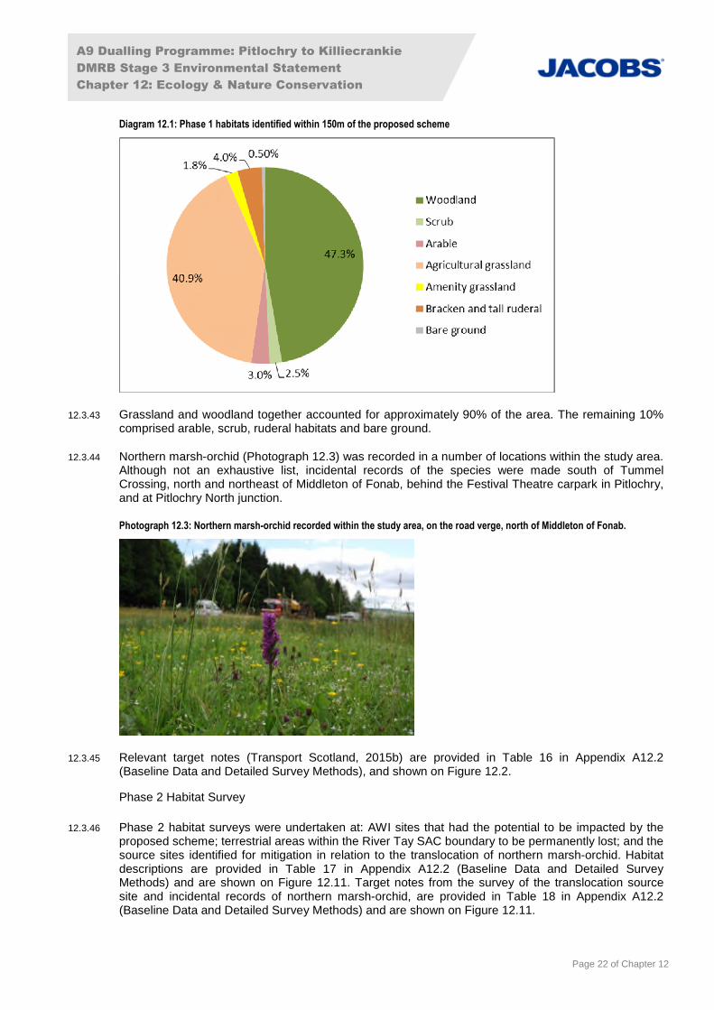
Diagram 12.1: Phase 1 habitats identified within 150m of the proposed scheme
12.3.43 Grassland and woodland together accounted for approximately 90% of the area. The remaining 10%comprised arable, scrub, ruderal habitats and bare ground.
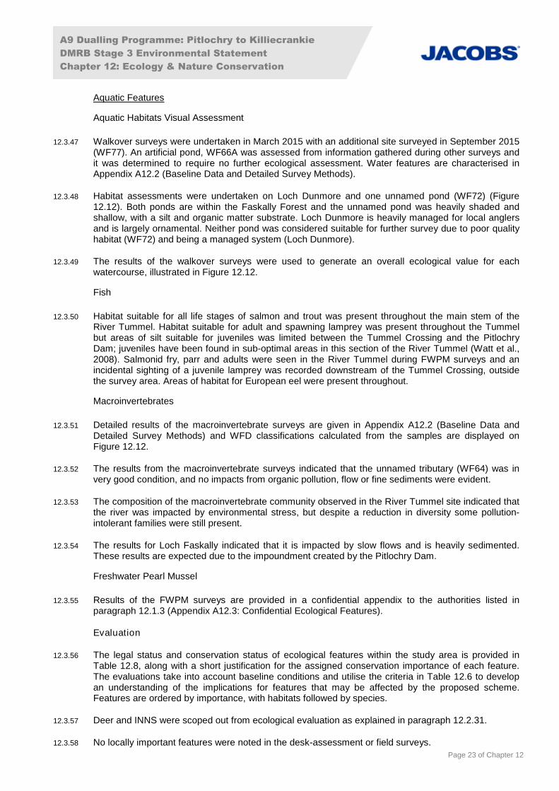
12.3.44 Northern marsh-orchid (Photograph 12.3) was recorded in a number of locations within the study area.Although not an exhaustive list, incidental records of the species were made south of TummelCrossing, north and northeast of Middleton of Fonab, behind the Festival Theatre carpark in Pitlochry,and at Pitlochry North junction.
Photograph 12.3: Northern marsh-orchid recorded within the study area, on the road verge, north of Middleton of Fonab.
12.3.45 Relevant target notes (Transport Scotland, 2015b) are provided in Table 16 in Appendix A12.2(Baseline Data and Detailed Survey Methods), and shown on Figure 12.2.
Phase 2 Habitat Survey
12.3.46 Phase 2 habitat surveys were undertaken at: AWI sites that had the potential to be impacted by theproposed scheme; terrestrial areas within the River Tay SAC boundary to be permanently lost; and thesource sites identified for mitigation in relation to the translocation of northern marsh-orchid. Habitatdescriptions are provided in Table 17 in Appendix A12.2 (Baseline Data and Detailed SurveyMethods) and are shown on Figure 12.11. Target notes from the survey of the translocation sourcesite and incidental records of northern marsh-orchid, are provided in Table 18 in Appendix A12.2(Baseline Data and Detailed Survey Methods) and are shown on Figure 12.11.
A9 Dualling Programme: Pitlochry to Killiecrankie
DMRB Stage 3 Environmental Statement
Chapter 12: Ecology & Nature Conservation
Page 23 of Chapter 12
Aquatic Features
Aquatic Habitats Visual Assessment
12.3.47 Walkover surveys were undertaken in March 2015 with an additional site surveyed in September 2015(WF77). An artificial pond, WF66A was assessed from information gathered during other surveys andit was determined to require no further ecological assessment. Water features are characterised inAppendix A12.2 (Baseline Data and Detailed Survey Methods).
12.3.48 Habitat assessments were undertaken on Loch Dunmore and one unnamed pond (WF72) (Figure12.12). Both ponds are within the Faskally Forest and the unnamed pond was heavily shaded andshallow, with a silt and organic matter substrate. Loch Dunmore is heavily managed for local anglersand is largely ornamental. Neither pond was considered suitable for further survey due to poor qualityhabitat (WF72) and being a managed system (Loch Dunmore).
12.3.49 The results of the walkover surveys were used to generate an overall ecological value for eachwatercourse, illustrated in Figure 12.12.
Fish
12.3.50 Habitat suitable for all life stages of salmon and trout was present throughout the main stem of theRiver Tummel. Habitat suitable for adult and spawning lamprey was present throughout the Tummelbut areas of silt suitable for juveniles was limited between the Tummel Crossing and the PitlochryDam; juveniles have been found in sub-optimal areas in this section of the River Tummel (Watt et al.,2008). Salmonid fry, parr and adults were seen in the River Tummel during FWPM surveys and anincidental sighting of a juvenile lamprey was recorded downstream of the Tummel Crossing, outsidethe survey area. Areas of habitat for European eel were present throughout.
Macroinvertebrates
12.3.51 Detailed results of the macroinvertebrate surveys are given in Appendix A12.2 (Baseline Data andDetailed Survey Methods) and WFD classifications calculated from the samples are displayed onFigure 12.12.
12.3.52 The results from the macroinvertebrate surveys indicated that the unnamed tributary (WF64) was invery good condition, and no impacts from organic pollution, flow or fine sediments were evident.
12.3.53 The composition of the macroinvertebrate community observed in the River Tummel site indicated thatthe river was impacted by environmental stress, but despite a reduction in diversity some pollution-intolerant families were still present.
12.3.54 The results for Loch Faskally indicated that it is impacted by slow flows and is heavily sedimented.These results are expected due to the impoundment created by the Pitlochry Dam.
Freshwater Pearl Mussel
12.3.55 Results of the FWPM surveys are provided in a confidential appendix to the authorities listed inparagraph 12.1.3 (Appendix A12.3: Confidential Ecological Features).
Evaluation
12.3.56 The legal status and conservation status of ecological features within the study area is provided inTable 12.8, along with a short justification for the assigned conservation importance of each feature.The evaluations take into account baseline conditions and utilise the criteria in Table 12.6 to developan understanding of the implications for features that may be affected by the proposed scheme.Features are ordered by importance, with habitats followed by species.
12.3.57 Deer and INNS were scoped out from ecological evaluation as explained in paragraph 12.2.31.
12.3.58 No locally important features were noted in the desk-assessment or field surveys.

A9 Dualling Programme: Pitlochry to Killiecrankie
DMRB Stage 3 Environmental Statement
Chapter 12: Ecology & Nature Conservation
Page 24 of Chapter 12
12.3.59 The following features are unlikely to be affected by the proposed scheme as, based on currentlyavailable desk study and/or site survey data, they are either not known to be present within the studyarea, or no effects pathways have been identified. These features will therefore not be discussedfurther:
Pass of Killiecrankie SSSI at NN 917 624 (SNH, 2016c), although nationally important no effectspathway was identified from the proposed scheme. Designated under the Nature Conservation(Scotland) Act 2004, it lies predominantly to the north and uphill of this section of the proposedscheme and is also on the far side of the B8079 and railway.
Scottish wildcat, internationally important, in decline and protected under the Conservation (NaturalHabitats &c.) Regulations 1994 (as amended), however there is no data to indicate presence in thestudy area. The Wildcat Habitat Suitability Model shows extensive wildcat cover habitat to thesouth and the north east of the proposed scheme, however natural barriers to movement (the RiverTummel and Loch Faskally), and the urban area of Pitlochry, reduce the likelihood of wildcatpresence close to the proposed scheme. Current permeability across the A9 into Faskally Wood isonly facilitated by the span underneath the existing Clunie Underbridge. Due to the high level ofhuman activity throughout Faskally Wood, it is considered unlikely that wildcat would be presentdue to the disturbance created.
Water vole, regionally important and protected under the WCA. Suitable habitat was present alongtwo watercourses based on DMRB Stage 2 assessment, but no evidence of the species wasidentified in the study area during the DMRB Stage 3 field surveys.
Slow worm and adder, regionally important and protected under the WCA. Desk study datareported presence within 10km of the existing A9, and DMRB Stage 2 assessment indicated somesuitable habitat in the study area, however DMRB Stage 3 field surveys did not report presence inthe study area.
Black grouse, red-listed Species of Conservation Concern (Eaton et al., 2015), and listed on theSBL and Tayside BAP protected species list. Data received through the consultation processidentified no records of black grouse from the past ten years within 2km of the proposed scheme(RSPB, received 2016).
CNPA priority non-protected species, pond with northern damselfly and amphibians. Northerndamselfly is also listed on the SBL and is a protected species on the Tayside LBAP, and has beenidentified as undergoing decline due to loss of suitable habitat and climatic pressures. The pondwill not be impacted by the proposed scheme and no effects pathway was identified.

A9 Dualling Programme: Pitlochry to Killiecrankie
DMRB Stage 3 Environmental Statement
Chapter 12: Ecology & Nature Conservation
Page 25 of Chapter 12
Table 12.8: Legal status, baseline and evaluation of terrestrial and aquatic features
Ecological Feature Legal/BAP Status Baseline Justification Importance
Designated Sites
River Tay SAC
(UK0030312)
Natura 2000 site under Conservation(Natural Habitats &c.) Regulations 1994 (asamended).
WFD watercourse.
Listed as a key site in the Tayside BAP(Water and Wetland Ecosystems).
Statutory designated site within the study area likelyto be affected by the proposed scheme.
All life stages of salmonids and lamprey present.
Designated for its clear-water lakes, Atlantic salmon,river lamprey, brook lamprey, sea lamprey and otter.
International
Ancient woodland
Categories: ancient ofsemi-natural origin (1aand 2a); longestablished ofplantation origin (2b)and other (3; on Roymap)
SBL priority habitat (including a variety ofsemi-natural broadleaved woodland types).
Some areas fit the criteria for designation asTayside BAP priority habitats.
Approximately 289ha of woodland listed on the AWIfalls within the study area, of which 47% is category1a or 2a (ancient of semi-natural origin).
Ancient woodland and plantation woodland of ancientorigin have intrinsic importance because of their agewhich means they are not readily replaceable if lost. Inaddition to their intrinsic importance, such habitats haveimportance for the species they support, and for habitatconnectivity. There are some AWI areas which werepreviously wooded, but which may retain biodiversityvalue. SNH has asked that all AWI sites, whether theycurrently support ancient woodland or not, be treatedas protected (Transport Scotland, 2015b).
National
Habitats and Ecosystems
Broadleaved, mixed orconiferous semi-natural woodland (notAWI)
Lowland mixed deciduous woodland, nativepine woodlands, upland birchwoods, uplandmixed ashwoods and upland oakwoods arelisted in the SBL.
Lowland mixed broadleaved woodland andwet woodland are listed as priority habitats inthe Tayside BAP (Woodland Ecosystems).
Areas of non-AWI semi-natural woodland, includingNWSS sites, occur across the study area (Diagram12.1 and paragraphs 12.3.8 to 12.3.11).
This habitat can provide important habitat for speciessuch as pine marten and red squirrel.
Regional
Broadleaved, mixed orconiferous plantationwoodland (not AWI)
Lowland mixed deciduous woodland, uplandbirchwoods, upland mixed ashwoods andupland oakwoods are listed in the SBL.
Planted coniferous woodlands and lowlandmixed broadleaved woodland are listed aspriority habitats in the Tayside BAP(Woodland Ecosystems).
Areas of non-AWI plantation woodland, includingNWSS sites, occur across the study area (Diagram12.1 and paragraphs 12.3.8 to 12.3.11).
Plantation woodland is generally of low diversity, with apoorly developed ground flora and shrub layer. It iswidespread in the area but can also provide importanthabitat for species such as pine marten and red squirrelin the area.
Regional
Allt an Aghastair andunnamedwatercourses
Listed as priority habitat in the Tayside BAP(Water and Wetland Ecosystems).
Up to 1m wide and 5-10cm deep with mixed sand,gravel and pebble substrate, flowing throughwoodland and into the main river.
Regionally notable macroinvertebrate speciespresent in the sampled watercourse.
Flow into River Tay SAC but provide no suitable fishhabitat.
Authority area

A9 Dualling Programme: Pitlochry to Killiecrankie
DMRB Stage 3 Environmental Statement
Chapter 12: Ecology & Nature Conservation
Page 26 of Chapter 12
Ecological Feature Legal/BAP Status Baseline Justification Importance
Species
Atlantic salmon Salmon and Freshwater Fisheries(Consolidation) (Scotland) Act 2003.
Schedule 3 species under the Conservation(Natural Habitats &c.) Regulations 1994 (asamended).
Listed under Annex II and V of CouncilDirective 92/43/EEC.
A qualifying feature of the River Tay SAC.
Listed on the SBL and as a key species inthe Tayside BAP.
Suitable habitat for all life stages available.
Present throughout the River Tummel.
Species of conservation importance found in the RiverTummel.
Host species for FWPM.
Favourable conservation status for both adults andjuveniles in River Tay SAC (Rivers and Fisheries Trustsof Scotland, 2014).
International
Lamprey species Salmon and Freshwater Fisheries(Consolidation) (Scotland) Act 2003.
Listed under Annex II and V of CouncilDirective 92/43/EEC.
A qualifying feature of the River Tay SAC.
Listed as protected species under theConservation (Natural Habitats &c.)Regulations 1994 (as amended) Schedule 3(river lamprey only).
Listed on the SBL and on the Tayside BAPprotected species list.
All species present in the River Tummel belowPitlochry Dam, brook lamprey also present abovePitlochry Dam.
Adult and spawning habitat available, juvenile habitatlimited with sub-optimal areas being used byjuveniles (Watt et al., 2008).
Species of conservation importance found in the RiverTummel.
Favourable conservation status for River Tay SAC(Watt et al., 2008).
International
Brown trout/sea trout Salmon and Freshwater Fisheries(Consolidation) (Scotland) Act 2003.
Brown trout listed on the Tayside BAPprotected species list and sea trout listed onthe SBL.
Found throughout the River Tummel. Species of conservation importance found in the RiverTummel.
Host species for FWPM.
International
European eel Salmon and Freshwater Fisheries(Consolidation) (Scotland) Act 2003.
European Commission (2007) CouncilRegulation (1100/2007/EC) Establishingmeasures for the recovery of the stock ofEuropean eel.
Listed on the SBL.
Suitable habitat present below the Pitlochry Dam. Widespread in Tay catchment below dam at Pitlochry.Has undergone major decline in numbers.
Listed Critically Endangered on International Union forConservation of Nature (IUCN, 2016) Red List.
International
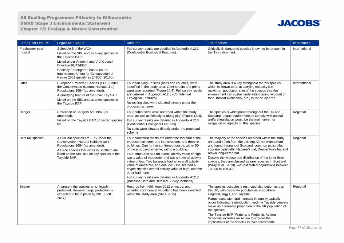
A9 Dualling Programme: Pitlochry to Killiecrankie
DMRB Stage 3 Environmental Statement
Chapter 12: Ecology & Nature Conservation
Page 27 of Chapter 12
Ecological Feature Legal/BAP Status Baseline Justification Importance
Freshwater pearlmussel
Schedule 5 of the WCA.
Listed on the SBL and as a key species inthe Tayside BAP.
Listed under Annex II and V of CouncilDirective 92/43/EEC.
Critically Endangered based on theInternational Union for Conservation ofNature 2001 guidelines (JNCC, 2016b).
Full survey results are detailed in Appendix A12.3(Confidential Ecological Features).
Critically Endangered species known to be present inthe Tay catchment.
International
Otter European Protected Species (EPS) underthe Conservation (Natural Habitats &c.)Regulations 1994 (as amended).
A qualifying feature of the River Tay SAC.
Listed on the SBL and as a key species inthe Tayside BAP.
Fourteen lying-up sites (holts and couches) wereidentified in the study area. Otter spraint and printswere also recorded (Figure 12.8). Full survey resultsare detailed in Appendix A12.3 (ConfidentialEcological Features).
No resting sites were situated directly under theproposed scheme.
The study area is a key stronghold for this specieswhich is known to be at carrying capacity (i.e.maximum population size of the species that theenvironment can sustain indefinitely taking account offood, habitat availability, etc.) in the study area.
International
Badger Protection of Badgers Act 1992 (asamended).
Listed on the Tayside BAP protected specieslist.
Four outlier setts were recorded within the studyarea, as well as field signs (dung pits) (Figure 12.4).
Full survey results are detailed in Appendix A12.3(Confidential Ecological Features).
No setts were situated directly under the proposedscheme.
The species is widespread throughout the UK andScotland. Legal requirements to comply with animalwelfare legislation would be the main driver formitigation of impacts on this species.
Regional
Bats (all species) All UK bat species are EPS under theConservation (Natural Habitats &c.)Regulations 1994 (as amended).
All nine species that occur in Scotland arelisted on the SBL and as key species in theTayside BAP.
Four confirmed roosts are under the footprint of theproposed scheme; one in a structure, and three inbuildings. One further confirmed roost is within 50mof the proposed scheme, within a building.
Four structures had an overall activity value of high,two a value of moderate, and two an overall activityvalue of low. Two transects had an overall activityvalue of moderate, and one low. One site had acryptic species overall activity value of high, and theother had none.
Full survey results are detailed in Appendix A12.2(Baseline Data and Detailed Survey Methods).
The majority of the species recorded within the studyarea and 10km from the existing A9 are widespreadand found throughout Scotland: common pipistrelle,soprano pipistrelle, Natterer’s bat, Daubenton’s bat andbrown long-eared bat.
Despite the widespread distribution of the latter threespecies, they are classed as rarer species in Scotland(Wray et al., 2010), with estimated populations between10,000 to 100,000.
Regional
Beaver At present the species is not legallyprotected. However, legal protection isexpected to be in place by 2018 (SNH,2017).
Records from NBN from 2012 onwards, andpotential core beaver woodland has been identifiedwithin the study area (SNH, 2015).
The species occupies a restricted distribution acrossthe UK, with disparate populations in southernEngland, Argyll, and Tayside.
Range expansion and increase in density typicallyoccur following reintroduction, and the Tayside beaversmake up a sizeable proportion of the UK population ofthe species.
The Tayside BAP ‘Water and Wetlands ActionsSchedule’ includes an Action to explore theimplications of the species in river catchments.
Regional

A9 Dualling Programme: Pitlochry to Killiecrankie
DMRB Stage 3 Environmental Statement
Chapter 12: Ecology & Nature Conservation
Page 28 of Chapter 12
Ecological Feature Legal/BAP Status Baseline Justification Importance
Breeding birds Species of Conservation Concern (Eaton etal., 2015).
Species listed on the SBL and on theTayside BAP protected species list.
Linnet, house sparrow and swallow listed askey species in Tayside BAP.
Schedule 1 of the WCA.
A total of 43 species were recorded during the sitesurveys, of which 29 species were confirmed to havebred. Full survey results are detailed in AppendixA12.2 (Baseline Data and Detailed Survey Methods).
A further 45 species were recorded during the BTOAtlas 2007-2011 surveys, including breeding andwintering records.
RSPB (2015, 2016) data indicated breeding recordsof a further two species of conservation concern.
Records of the Schedule 1 species common crossbillrecorded during surveys are detailed in ConfidentialAppendix A12.3 (Confidential Ecological Features).
Of the 29 breeding species identified during sitesurveys, eight are listed as species of conservationconcern, either red-listed or amber-listed, six are listedon the SBL, 11 are listed on the Tayside BAP protectedspecies list, and one species on Schedule 1 of theWCA.
Of the 45 additional species not recorded during sitesurveys, 27 are listed as species of conservationconcern, either red-listed or amber-listed.
RSPB data included one red-listed and one amber-listed species, both of which are listed on the SBL andon the Tayside BAP.
Regional
Pine marten Schedule 5 of the WCA.
Listed on the SBL and as a key species inthe Tayside BAP.
Desk study records within the study area and thespecies is expanding its range in Tayside (Croose etal., 2014).
Pine marten have been recorded within the study area.The species is widespread throughout Scotland andhas continued to expand its range throughoutPerthshire and Tayside.
Regional
Red squirrel Schedule 5 of the WCA.
Listed on the SBL as a species for whichconservation action is needed, and as a keyspecies in the Tayside BAP.
There were twelve incidental sightings of redsquirrel, as well as one drey and two possible dreys.
Full survey results are detailed in Appendix A12.2(Baseline Data and Detailed Survey Methods).
Red squirrel is widespread within most parts ofScotland, although there has been widespread declinein population and range.
The species has been recorded within the study area.Priority woodland has been identified at Faskally(NN 932 552).
Regional
Common lizard Schedule 5 of the WCA.
Listed on the SBL and a key species in theTayside BAP.
Reptile presence was confirmed at two sites, thoughneither was categorised as a Key Reptile Site. Threefurther sightings were made as incidental surveys.
Full survey results are detailed in Appendix A12.2(Baseline Data and Detailed Survey Methods).
Recorded within the study area and within thesurrounding 10km.
Authority area
Northern marsh-orchid Listed as a key species in the Tayside BAP. Species recorded incidentally in a number oflocations within the proposed scheme. Records aredetailed in Appendix A12.2 (Baseline Data andDetailed Survey Methods).
Listed in the Vascular Plant Red Data List for GreatBritain (Cheffings and Farrell, 2005) as of LeastConcern but with 25% of the European and worldpopulations in the UK. Relatively widespread inScotland.
Authority area
A9 Dualling Programme: Pitlochry to Killiecrankie
DMRB Stage 3 Environmental Statement
Chapter 12: Ecology & Nature Conservation
Page 29 of Chapter 12
12.4 Potential Impacts
Introduction
12.4.1 General potential impacts on ecological features for the proposed scheme are described below, andspecific potential impacts on ecological features are set out in Table 12.12 (Section 12.6: ResidualImpacts).
12.4.2 Where a potential impact was assessed as not significant, it was not considered further, unlessmeasures are required to comply with relevant legislation. Standard construction and design bestpractices would mitigate non-significant impacts.
12.4.3 Where an impact is initiated in construction but also occurs throughout operation (e.g. permanenthabitat removal), it is discussed only within operational impacts.
12.4.4 As stated in Chapter 16 (Air Quality), although the River Tay SAC may be nitrogen-sensitive, thecontribution of nitrogen from road transport via nitrogen deposition is unlikely to give rise to significanteffects on the SAC. Effects associated with changes in air quality and nitrogen deposition on the RiverTay SAC are therefore not considered further in this assessment.
12.4.5 The impacts of road salt on the water environment were highlighted as a concern by SNH and theSpey Fishery Board. The salt assessment detailed in Appendix A11.6 (Water Quality) indicates thatsalt levels are not expected to exceed the threshold for the most sensitive species within the River TaySAC and other larger watercourses. Therefore, the impacts of salt on the water environment is notconsidered further.
12.4.6 Potential impacts detailed in this assessment are based on the current baseline. Due to the mobilenature of animals and changes in distribution of plant species, surveys to update the baseline will beundertaken prior to construction.
Construction
12.4.7 Impacts may be incurred as a result of the construction of two major structures that crosswatercourses as part of the proposed scheme, namely the Tummel Crossing and new ClunieUnderbridge over Loch Faskally.
12.4.8 The detailed construction methods and programme for both structures are necessarily still underdetailed development. For the purposes of this impact assessment, a precautionary approach hasbeen taken, with timescales and land take areas quoted as the largest expected. A summary of theconstruction methods expected to be used for each structure is provided within Appendix A5.1(Construction Information).
Tummel Crossing
12.4.9 A new crossing will be constructed adjacent to the existing crossing at the River Tummel for thenorthbound carriageway. The existing structure will be retained as the southbound carriageway. Thenew structure will be a ‘bowstring’ design, and will be clear-span across the River Tay SAC. Duringconstruction, temporary piers will be required, which will be within the SAC on the south side.
12.4.10 Two options were considered for the construction of the Tummel Underbridge:
Option 1: slide the bridge into place on a temporary launching system; and
Option 2: lift the bridge in pieces onto temporary supports.
12.4.11 Both options require the temporary support systems. In both cases no structures would be locatedwithin the main channel of the River Tummel, but would be positioned within the terrestrial (high-flow)area of the River Tummel within the River Tay SAC boundary. The footprint(s) of the temporarysupports would be of a similar magnitude.
A9 Dualling Programme: Pitlochry to Killiecrankie
DMRB Stage 3 Environmental Statement
Chapter 12: Ecology & Nature Conservation
Page 30 of Chapter 12
12.4.12 The temporary supports would comprise a large concrete foundation with a steel supporting systemfor the arch. The foundation blocks would be constructed in situ prior to the construction of thesupporting system and would be removed once construction was complete. The existing shingle wouldbe removed to create a firm footing for the supports. To limit the risk to these temporary structures,their construction and use would most likely take place during the period of lower flows in the RiverTummel i.e. the summer months. It is likely that some form of bunding would be required to protect thefoundations during their construction from inundation during high water events. However, this wouldbe removed once works are completed.
12.4.13 The construction of the new ‘bowstring’ arch structure is anticipated to last approximately 21 months,with approximately a further three months for the refurbishment of the existing bridge, followingtransfer of traffic to the new structure.
12.4.14 The temporary support pier on the south side will be sited within an area of 0.33ha of the SAC, andnot in the water at normal flows. The actual footprint of the temporary support is likely to be less thanthis but the worst case scenario has been assumed for the assessment. Indicative designs for thetemporary supports show an area within the River Tay SAC of approximately 100-200m2 (0.01-0.02ha).
12.4.15 All works will be undertaken outwith the watercourse at normal flows. The temporary support structuremay require sheet piling for scour protection due to its location in the SAC.
Clunie Underbridge
12.4.16 At Clunie Underbridge, where the proposed scheme crosses Loch Faskally, the existing crossing willbe retained as the northbound carriageway, and a new crossing constructed adjacent to it toaccommodate the southbound carriageway. The piers will align with those of the existing structure,and will be within the terrestrial part of the River Tay SAC on the northern side.
12.4.17 The size of the pier foundations for the new structure cannot be finalised at this stage of the project,however the structure is expected to be similar in nature to the existing structure’s pier foundations,but wider to accommodate the wider deck, the dimensions would be of the order of 60m2 (northabutment, within the SAC) and 90m2 (south abutment, outwith the SAC).
12.4.18 The duration of work in the area of the pier foundations is likely to be of the order of four months.
12.4.19 Potential impacts associated with the construction of the two major structures above are detailedwithin Table 12.12. The impact assessment and mitigation are provided in line with the informationavailable at present.
12.4.20 Other potential construction impacts throughout the proposed scheme may include:
injury or mortality of protected species due to in-stream works, vegetation removal, vehiclemovements or becoming trapped in uncovered holes and pipes;
disturbance to protected species from noise, vibration, lighting, movement of vehicles, andincreased human activity;
temporary habitat fragmentation due to disturbance activities;
sediment release and run-off from construction works; and
generation of dust from use of haul routes, earth movement and soil storage.
Operation
12.4.21 Potential operational impacts may include:
injury and mortality of protected species from vehicle collisions;
permanent loss of habitats, such as woodland and other terrestrial habitats, and shading ofaquatic habitats, under the footprint of the proposed scheme;
A9 Dualling Programme: Pitlochry to Killiecrankie
DMRB Stage 3 Environmental Statement
Chapter 12: Ecology & Nature Conservation
Page 31 of Chapter 12
fragmentation and severance of habitats;
pollution from road run-off; and
hydrological changes from run-off and structures.
12.5 Mitigation
Introduction
12.5.1 Mitigation will follow a hierarchical approach, in the following order (CIEEM, 2016; SNH, 2013a):
avoid adverse impacts in the first instance;
where avoidance is not possible, reduce the adverse impacts through mitigation; and,
where significant adverse residual impacts remain, measures to offset the adverse impacts at asite-specific level may be required (compensation).
12.5.2 The proposed mitigation is designed to enhance and produce a net gain for biodiversity wherepracticable in line with policy and guidelines (CIEEM, 2016).
12.5.3 This section includes mitigation that aims to avoid or negate impacts on ecological features inaccordance with best practice guidance and European, UK, Scottish and local governmentenvironmental impact, planning and sustainability policies. Where these impacts can be fully mitigatedthey would not be considered to be significant under the terms of the EIA Regulations.
12.5.4 It is expected that the majority of non-significant impacts would be mitigated through the application ofstandard mitigation and best working practice (e.g. mitigation of potential pollution impacts throughadherence to standard best practice and guidelines, such as SEPA Guidance for Pollution Prevention(GPP) (SEPA, 2017)) (Table 12.12).
12.5.5 Potential significant ecological impacts as shown in Table 12.12 are expected to be mitigated througha combination of best practice/typical mitigation methods and mitigation targeted to specific locations.
12.5.6 This chapter makes reference to overarching standard measures applicable across all A9 duallingprojects (‘SMC’ Mitigation Item references), and also to project-specific measures (‘P04’ MitigationItem references). Those that specifically relate to ecology and nature conservation are assigned an ‘E’reference.
Embedded Mitigation
12.5.7 Embedded mitigation has been developed through an iterative process and consultation with SNH,SEPA and other relevant stakeholders. This has included careful alignment of the proposed schemeto: avoid or reduce loss of habitat, including a focus on avoiding woodland loss as far as practicable;reduce impacts on aquatic environments; and avoid encroachment into designated and high valuesites/areas. Further information is provided in Chapter 4 (Iterative Design Development).
12.5.8 Road surface run-off from the mainline carriageway and side road connections will be subject to twolevels of treatment via sustainable drainage systems (SuDS). Tier 3 accesses (private and/oragricultural accesses) will be treated via ‘over the edge’ drainage that will be dispersed overvegetation with subsequent infiltration into groundwater.
12.5.9 The water quality and geomorphological design of SuDS features are discussed in Chapter 11 (RoadDrainage and the Water Environment). Table 11.19 of Chapter 11 sets out the treatment levels thatare proposed and have been agreed with SEPA.
Ecological Clerk of Works
12.5.10 A suitably qualified (or team of suitably qualified) Ecological Clerk of Works (ECoW) will be appointedby the Contractor to supervise the construction works, undertake pre-construction surveys forprotected species in the areas identified by the proposed scheme and ensure mitigation measures are
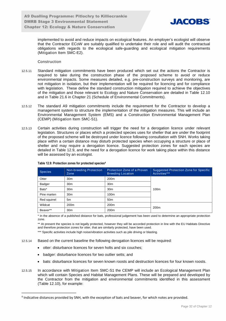
A9 Dualling Programme: Pitlochry to Killiecrankie
DMRB Stage 3 Environmental Statement
Chapter 12: Ecology & Nature Conservation
Page 32 of Chapter 12
implemented to avoid and reduce impacts on ecological features. An employer’s ecologist will observethat the Contractor ECoW are suitably qualified to undertake their role and will audit the contractualobligations with regards to the ecological safe-guarding and ecological mitigation requirements(Mitigation Item SMC-E2).
Construction
12.5.11 Standard mitigation commitments have been produced which set out the actions the Contractor isrequired to take during the construction phase of the proposed scheme to avoid or reduceenvironmental impacts. Some measures detailed, e.g. pre-construction surveys and monitoring, arenot mitigation in isolation, but their implementation will be required for licencing and for compliancewith legislation. These define the standard construction mitigation required to achieve the objectivesof the mitigation and those relevant to Ecology and Nature Conservation are detailed in Table 12.10and in Table 21.6 in Chapter 21 (Schedule of Environmental Commitments).
12.5.12 The standard A9 mitigation commitments include the requirement for the Contractor to develop amanagement system to structure the implementation of the mitigation measures. This will include anEnvironmental Management System (EMS) and a Construction Environmental Management Plan(CEMP) (Mitigation Item SMC-S1).
12.5.13 Certain activities during construction will trigger the need for a derogation licence under relevantlegislation. Structures or places which a protected species uses for shelter that are under the footprintof the proposed scheme will be destroyed under licence following consultation with SNH. Works takingplace within a certain distance may disturb protected species when occupying a structure or place ofshelter and may require a derogation licence. Suggested protection zones for each species aredetailed in Table 12.9, and the need for a derogation licence for work taking place within this distancewill be assessed by an ecologist.
Table 12.9: Protection zones for protected species4
SpeciesNon-breeding ProtectionZone
Protection Zone of a ProvenBreeding Location
Suggested Protection Zone for SpecificActivities***
Otter 30m 200m
100m
Badger 30m 30m
Bats* 30m 30m
Pine marten 30m 100m
Red squirrel 5m 50m
Wildcat 200m 200m200m
Beaver** 30m 200m
* In the absence of a published distance for bats, professional judgement has been used to determine an appropriate protectionzone.
** At present the species is not legally protected, however they will be accorded protection in line with the EU Habitats Directiveand therefore protection zones for otter, that are similarly protected, have been used.
*** Specific activities include high noise/vibration activities such as pile driving or blasting.
12.5.14 Based on the current baseline the following derogation licences will be required:
otter: disturbance licences for seven holts and six couches;
badger: disturbance licences for two outlier setts; and
bats: disturbance licences for seven known roosts and destruction licences for four known roosts.
12.5.15 In accordance with Mitigation Item SMC-S1 the CEMP will include an Ecological Management Planwhich will contain Species and Habitat Management Plans. These will be prepared and developed bythe Contractor from the mitigation and environmental commitments identified in this assessment(Table 12.10), for example:
4 Indicative distances provided by SNH, with the exception of bats and beaver, for which notes are provided.
A9 Dualling Programme: Pitlochry to Killiecrankie
DMRB Stage 3 Environmental Statement
Chapter 12: Ecology & Nature Conservation
Page 33 of Chapter 12
details of proposed protection measures and exclusion zones to avoid any unnecessaryencroachment into adjoining areas of nature conservation;
a programme for undertaking pre-construction surveys prior to and during construction;
restrictions on the timing of construction works, for example during site clearance and works withinwatercourses;
appropriate watching briefs during construction; and
relocation or translocation of species.
12.5.16 An AWI-specific Habitat Management Plan, which will be provided as part of the CEMP, will beprepared and implemented prior to construction, and will detail soil retrieval, storage and deploymentmethods.
12.5.17 The Species Protection Plans and Habitat Management Plans will be prepared to ensure thatessential mitigation strategies required for safeguarding protected species and habitats areimplemented as part of the contract. These will be updated as appropriate if any additional licencesand mitigation measures or amendments to the agreed mitigation are identified through pre-construction surveys or watching briefs. The plans will be developed in consultation with relevantstakeholders including SNH.
12.5.18 As part of the Species Protection Plan for FWPM a Silt Control Management Plan (SCMP) will beproduced, taking into consideration the following recommended mitigation:
controls for site runoff and sedimentation (Mitigation Item SMC-W3), appropriate storage of oilsand fuels and spill response (Mitigation Item SMC-W7) and regular inspection and monitoring ofreceiving water features;
the use of silt curtains around FWPM which have the potential to be impacted by sediment release;
regular monitoring and sampling for suspended solids concentrations during construction (inconjunction with Mitigation Item P04-W20). Samples will be taken from fixed locations up anddownstream of the works and analysed by a UK Accreditation Service accredited laboratory.Where sediments exceed safe thresholds for FWPM an emergency action plan detailing howmussels will be protected, rapid installation of temporary barriers or temporary removal of FWPM(under licence) for example, will be enacted; and
monitoring of weather and river levels and postponement of works during heavy rainfall or whenhigh flows or spate conditions are expected. If works cannot be avoided, sediment levels will bemonitored by the ECoW on a daily basis.
12.5.19 Adherence to Species Management Plans will avoid potential breaches of conservation legislationarising from mortality or disturbance. Adherence to the Ecological Management Plan will also mitigatefor potential animal welfare issues during construction.
12.5.20 It will be the contractual responsibility of the Contractor to ensure that mitigation is implemented duringthe works and that all relevant licences, should they be required, are in place prior to commencementof works.
12.5.21 It is expected that the majority of impacts during construction will be mitigated through the applicationof the standard mitigation commitments. Where required, additional mitigation for feature-specificimpacts during construction are described in Table 12.12.
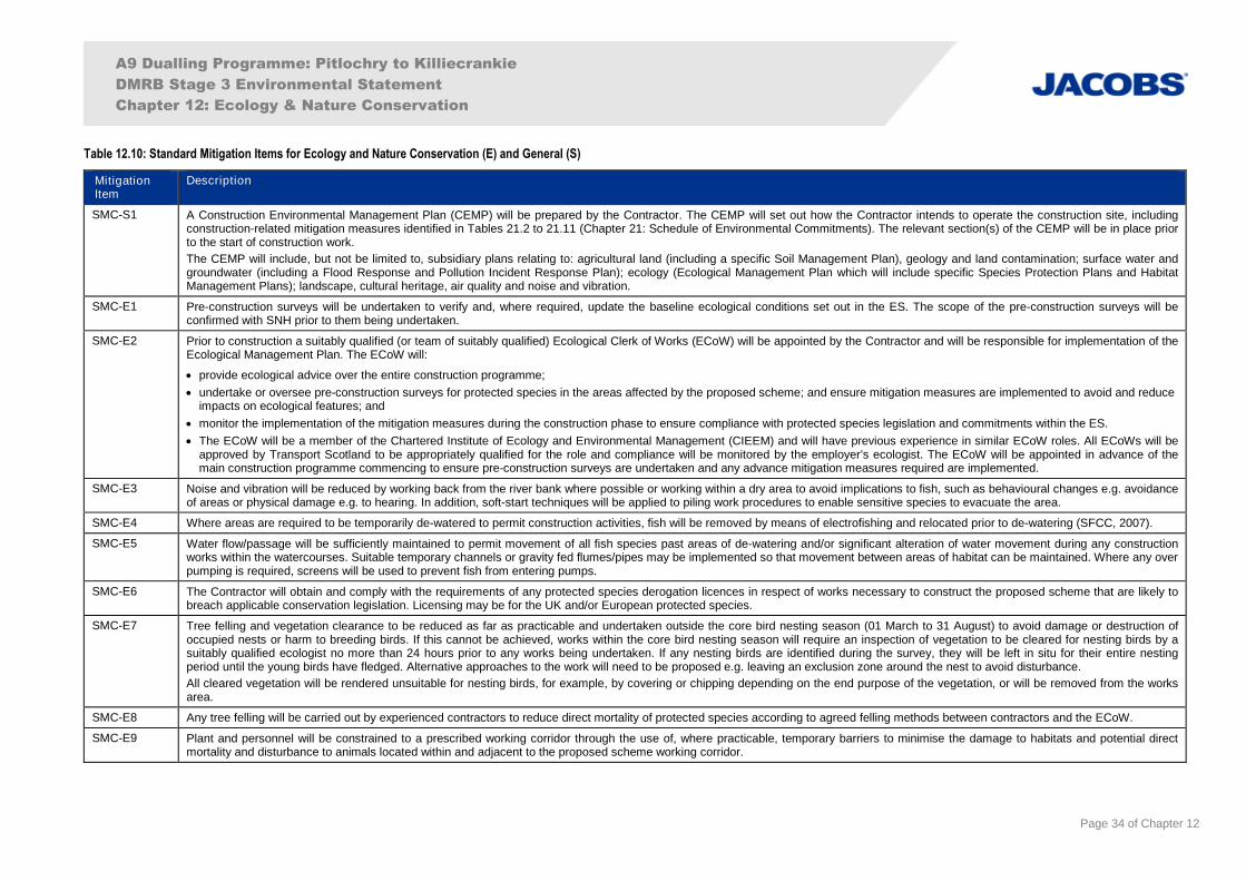
A9 Dualling Programme: Pitlochry to Killiecrankie
DMRB Stage 3 Environmental Statement
Chapter 12: Ecology & Nature Conservation
Page 34 of Chapter 12
Table 12.10: Standard Mitigation Items for Ecology and Nature Conservation (E) and General (S)
MitigationItem
Description
SMC-S1 A Construction Environmental Management Plan (CEMP) will be prepared by the Contractor. The CEMP will set out how the Contractor intends to operate the construction site, includingconstruction-related mitigation measures identified in Tables 21.2 to 21.11 (Chapter 21: Schedule of Environmental Commitments). The relevant section(s) of the CEMP will be in place priorto the start of construction work.
The CEMP will include, but not be limited to, subsidiary plans relating to: agricultural land (including a specific Soil Management Plan), geology and land contamination; surface water andgroundwater (including a Flood Response and Pollution Incident Response Plan); ecology (Ecological Management Plan which will include specific Species Protection Plans and HabitatManagement Plans); landscape, cultural heritage, air quality and noise and vibration.
SMC-E1 Pre-construction surveys will be undertaken to verify and, where required, update the baseline ecological conditions set out in the ES. The scope of the pre-construction surveys will beconfirmed with SNH prior to them being undertaken.
SMC-E2 Prior to construction a suitably qualified (or team of suitably qualified) Ecological Clerk of Works (ECoW) will be appointed by the Contractor and will be responsible for implementation of theEcological Management Plan. The ECoW will:
provide ecological advice over the entire construction programme;
undertake or oversee pre-construction surveys for protected species in the areas affected by the proposed scheme; and ensure mitigation measures are implemented to avoid and reduceimpacts on ecological features; and
monitor the implementation of the mitigation measures during the construction phase to ensure compliance with protected species legislation and commitments within the ES.
The ECoW will be a member of the Chartered Institute of Ecology and Environmental Management (CIEEM) and will have previous experience in similar ECoW roles. All ECoWs will beapproved by Transport Scotland to be appropriately qualified for the role and compliance will be monitored by the employer’s ecologist. The ECoW will be appointed in advance of themain construction programme commencing to ensure pre-construction surveys are undertaken and any advance mitigation measures required are implemented.
SMC-E3 Noise and vibration will be reduced by working back from the river bank where possible or working within a dry area to avoid implications to fish, such as behavioural changes e.g. avoidanceof areas or physical damage e.g. to hearing. In addition, soft-start techniques will be applied to piling work procedures to enable sensitive species to evacuate the area.
SMC-E4 Where areas are required to be temporarily de-watered to permit construction activities, fish will be removed by means of electrofishing and relocated prior to de-watering (SFCC, 2007).
SMC-E5 Water flow/passage will be sufficiently maintained to permit movement of all fish species past areas of de-watering and/or significant alteration of water movement during any constructionworks within the watercourses. Suitable temporary channels or gravity fed flumes/pipes may be implemented so that movement between areas of habitat can be maintained. Where any overpumping is required, screens will be used to prevent fish from entering pumps.
SMC-E6 The Contractor will obtain and comply with the requirements of any protected species derogation licences in respect of works necessary to construct the proposed scheme that are likely tobreach applicable conservation legislation. Licensing may be for the UK and/or European protected species.
SMC-E7 Tree felling and vegetation clearance to be reduced as far as practicable and undertaken outside the core bird nesting season (01 March to 31 August) to avoid damage or destruction ofoccupied nests or harm to breeding birds. If this cannot be achieved, works within the core bird nesting season will require an inspection of vegetation to be cleared for nesting birds by asuitably qualified ecologist no more than 24 hours prior to any works being undertaken. If any nesting birds are identified during the survey, they will be left in situ for their entire nestingperiod until the young birds have fledged. Alternative approaches to the work will need to be proposed e.g. leaving an exclusion zone around the nest to avoid disturbance.
All cleared vegetation will be rendered unsuitable for nesting birds, for example, by covering or chipping depending on the end purpose of the vegetation, or will be removed from the worksarea.
SMC-E8 Any tree felling will be carried out by experienced contractors to reduce direct mortality of protected species according to agreed felling methods between contractors and the ECoW.
SMC-E9 Plant and personnel will be constrained to a prescribed working corridor through the use of, where practicable, temporary barriers to minimise the damage to habitats and potential directmortality and disturbance to animals located within and adjacent to the proposed scheme working corridor.
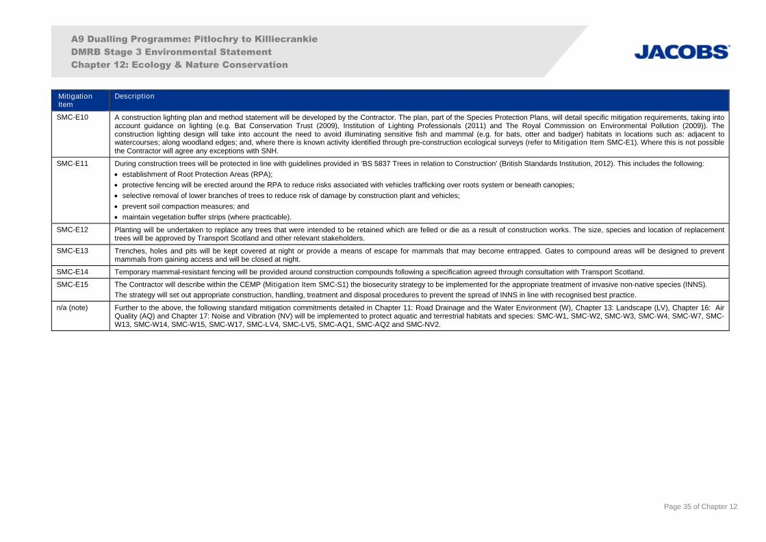
A9 Dualling Programme: Pitlochry to Killiecrankie
DMRB Stage 3 Environmental Statement
Chapter 12: Ecology & Nature Conservation
Page 35 of Chapter 12
MitigationItem
Description
SMC-E10 A construction lighting plan and method statement will be developed by the Contractor. The plan, part of the Species Protection Plans, will detail specific mitigation requirements, taking intoaccount guidance on lighting (e.g. Bat Conservation Trust (2009), Institution of Lighting Professionals (2011) and The Royal Commission on Environmental Pollution (2009)). Theconstruction lighting design will take into account the need to avoid illuminating sensitive fish and mammal (e.g. for bats, otter and badger) habitats in locations such as: adjacent towatercourses; along woodland edges; and, where there is known activity identified through pre-construction ecological surveys (refer to Mitigation Item SMC-E1). Where this is not possiblethe Contractor will agree any exceptions with SNH.
SMC-E11 During construction trees will be protected in line with guidelines provided in ‘BS 5837 Trees in relation to Construction’ (British Standards Institution, 2012). This includes the following:
establishment of Root Protection Areas (RPA);
protective fencing will be erected around the RPA to reduce risks associated with vehicles trafficking over roots system or beneath canopies;
selective removal of lower branches of trees to reduce risk of damage by construction plant and vehicles;
prevent soil compaction measures; and
maintain vegetation buffer strips (where practicable).
SMC-E12 Planting will be undertaken to replace any trees that were intended to be retained which are felled or die as a result of construction works. The size, species and location of replacementtrees will be approved by Transport Scotland and other relevant stakeholders.
SMC-E13 Trenches, holes and pits will be kept covered at night or provide a means of escape for mammals that may become entrapped. Gates to compound areas will be designed to preventmammals from gaining access and will be closed at night.
SMC-E14 Temporary mammal-resistant fencing will be provided around construction compounds following a specification agreed through consultation with Transport Scotland.
SMC-E15 The Contractor will describe within the CEMP (Mitigation Item SMC-S1) the biosecurity strategy to be implemented for the appropriate treatment of invasive non-native species (INNS).
The strategy will set out appropriate construction, handling, treatment and disposal procedures to prevent the spread of INNS in line with recognised best practice.
n/a (note) Further to the above, the following standard mitigation commitments detailed in Chapter 11: Road Drainage and the Water Environment (W), Chapter 13: Landscape (LV), Chapter 16: AirQuality (AQ) and Chapter 17: Noise and Vibration (NV) will be implemented to protect aquatic and terrestrial habitats and species: SMC-W1, SMC-W2, SMC-W3, SMC-W4, SMC-W7, SMC-W13, SMC-W14, SMC-W15, SMC-W17, SMC-LV4, SMC-LV5, SMC-AQ1, SMC-AQ2 and SMC-NV2.
A9 Dualling Programme: Pitlochry to Killiecrankie
DMRB Stage 3 Environmental Statement
Chapter 12: Ecology & Nature Conservation
Page 36 of Chapter 12
Operation
Mitigation for Ancient Woodland
12.5.22 Avoiding and reducing woodland loss has been a key consideration during the design process, asexplained in Chapter 4 (Iterative Design Development). Where avoidance of habitats (including AWI,other woodland and important habitats for protected species) has not been achievable through theiterative design process, mechanisms for landscape-scale mitigation have been designed tocompensate for this loss.
12.5.23 The full extent of habitats listed on the AWI under the footprint of the proposed scheme is calculatedas 23.3ha. The extent of those habitats which are currently wooded was determined based on theoutputs from the Woodland Connectivity – Ancient Woodland Compensation Strategy (TransportScotland, 2016b) as 16.8ha (Figure 12.14). This document sets out the agreed approach tocompensation for the loss of sites listed on the AWI, which is consistent across the A9 programme.The approach taken mapped 2014/2015 Forestry Commission Scotland National Forest Inventory(Forestry Commission Scotland, 2015), NWSS (Patterson et al., 2014) and currently wooded siteslisted on the AWI, and overlaid the design information for the proposed scheme to identify affectedareas of woodland. This was also used as the basis from which to explore opportunities for areas ofcompensatory planting, utilising non-wooded AWI sites in proximity to those areas affected.
12.5.24 Candidate sites for compensatory woodland planting (Mitigation Item P04-E37) have been identifiedto maximise the biodiversity benefit of planting, maintain connectivity of existing AWI sites, andmaximise opportunities to maintain functionality of local ancient woodland communities throughout theroute corridor. Soils will be re-used to maintain fungal and invertebrate biodiversity and provide aseed bank, and will be taken from an identified large, contiguous area of AWI to be lost (Table12.11a). Within this area, soils of low quality will not be re-used, for example from areas within theexisting highway boundary, under non-native plantation woodland and areas dominated by bracken.
12.5.25 The AWI-specific Habitat Management Plan provided as part of the CEMP (Mitigation Item SMC-S1),which will be prepared and implemented prior to construction as noted in paragraph 12.5.16, will detailthe following:
the retrieval, storage and deployment methods of suitable ancient woodland soil that will be re-used to conserve fungal and invertebrate biodiversity and provide a seed bank to promote the re-establishment of ancient woodland ground flora;
monitoring of re-used woodland soils (such as using invertebrate sampling and DNA meta-barcoding) to demonstrate the success of their use;
species mixes that will reflect native woodland mixes to replace non-native plantations andmaximise biodiversity benefit;
monitoring and management strategies, which will include maintenance and replacement of theplanting, including missing and damaged trees, or those that are failing to make satisfactory growthduring operation of the proposed scheme (see Mitigation Item SMC-LV5 for more details); and
management strategies that will be undertaken in AWI woodland that is to be retained within theCompulsory Purchase Order (CPO) area during the course of the construction contract andmaintenance and establishment period. These will include the retention of dead and fallen wood,and will be the responsibility of the Contractor and, in the longer term, of the trunk road operatingcompany.
12.5.26 As stated above, compensatory planting is intended to maintain or reconnect existing AWI sites andlocations have been determined based on current understanding of known forestry managementplans. Therefore, in order to achieve the desired connectivity, the extent of sites identified forcompensatory woodland planting is more than the extent of wooded AWI lost, with the final area ofcompensatory planting totalling 18.55ha. The locations proposed for compensatory planting aredistributed along the proposed scheme in a range of sizes, as shown on Figure 12.14 and detailed inTable 12.11b.
A9 Dualling Programme: Pitlochry to Killiecrankie
DMRB Stage 3 Environmental Statement
Chapter 12: Ecology & Nature Conservation
Page 37 of Chapter 12
Table 12.11a: Details of currently wooded AWI loss
Chainage Area (ha) AWI category (as detailed in paragraph 12.3.5)
ch1980-ch2140 0.24 2a
ch1990-ch2400 0.49 1a
ch2140-ch2400 0.11 1a, 3
ch2500-ch2530 0.01 3
ch2530-ch2570 <0.01 3
ch2710-ch2760 <0.01 3
ch2860-ch2880 0.01 3
ch3210-ch3240 0.04 2b
ch3210-ch3270 0.01 2b
ch3370-ch3600 0.29 2b
ch3480-ch3510 0.01 2b
ch3540-ch3560 <0.01 2b
ch3600-ch3620 0.02 2b
ch3670-ch3770 0.09 2b
ch3670-ch3780 <0.01 2b
ch3760-ch3980 0.19 2b
ch3960-ch3980 <0.01 2b
ch3980-ch4220 0.14 2b
ch4200-ch4240 0.07 2b
ch4550-ch4700 0.46 2b
ch4590-ch4650 0.29 2b
ch4690-ch5400 3.37 2b
ch4930-ch5020 0.12 2b
ch5090-ch5120 <0.01 2b
ch5100-ch5400 0.12 2b
ch5190-ch6050 * 9.53 2b
ch5220-ch5470 0.94 2b
ch5480-ch5500 <0.01 2b
ch6080-ch6300 0.17 2b
ch6900-ch7000 <0.01 1a
Total Loss 16.8
*Soil from this large, contiguous area will be re-used in compensation areas where applicable.
Table 12.11b: Details of locations of AWI compensation
Chainage Area (ha) Figure reference
ch1870-ch1970 0.57 12.14a
ch1870-ch2210 0.87 12.14a
ch2350-ch2580 1.30 12.14a
ch5990-ch6160 1.07 12.14c
ch6190-6280 0.27 12.14c
ch6080-ch6650 9.86 12.14c
ch6650-ch7000 4.61 12.14c
Total 18.55
Mitigation for Other Habitats
12.5.27 All new native planting should be nursery grown from local native seeds collected from withinappropriate provenance zones and designed using outputs from the Woodland Connectivity – AncientWoodland Compensation Strategy (Transport Scotland, 2016b) to help identify areas to plant in order
A9 Dualling Programme: Pitlochry to Killiecrankie
DMRB Stage 3 Environmental Statement
Chapter 12: Ecology & Nature Conservation
Page 38 of Chapter 12
to maintain ecological functionality. In addition, turves from areas of high botanical importance will beretained to relocate ground flora (Figure 13.5).
12.5.28 The areas around SuDS will be seeded with native grasses and wildflowers, as appropriate, to provideadded wildlife habitat. The margins of SuDS retention ponds will be planted with native aquatic,emergent and marginal plant species (Mitigation Item P04-LV9), and species-rich grassland mixeswill consist of native, non-invasive grasses and wildflower species (Mitigation Item P04-LV18), toenhance biodiversity for example by planting species that are favoured by invertebrates as food.
12.5.29 As noted in Section 12.3 (Baseline Conditions), an HRA has been undertaken for potentially affectedEuropean sites, to meet requirements of the Habitat Regulations. Through this process theassessments have informed the construction programme and methods for provision of the newTummel and Clunie Underbridges. Whilst the HRA provides more detailed information, this EScontains mitigation measures that are consistent with the HRA requirements.
Mitigation for Protected Species
12.5.30 Species permeability is an overarching design theme for the A9 dualling programme and the provisionof suitable crossing structures (Mitigation Item P04-E40) to reduce barrier effects and collision risk,and also maintain, and where possible enhance, habitat connectivity, are detailed in this assessment.The locations of these crossing structures, which include dry mammal underpasses, are shown onFigure 13.5. The structures offer multi-species benefits and will provide passage for otter, badger andbats, amongst others.
12.5.31 Otter and badger fencing will be provided to prevent access onto the A9 carriageway and will bepositioned to direct animals to safe crossing points. Otter fencing has been proposed alongwatercourses with known otter presence and/or suitable habitat, and badger fencing has beenproposed at key areas adjacent to known setts and locations of multiple wildlife vehicle incidents(WVIs). The fencing specifications will follow SNH guidance (SNH, 2001; SNH, 2008b) and will bedesigned to prevent animals being trapped on the road and tie into crossing structures where possible.In locations where engineering constraints are such that a means of mammal passage is desirable butcannot be incorporated within the structures’ design, fencing is designed to direct animals away fromthe carriageway. The indicative location of mammal fencing is shown on Figure 13.5.
Mitigation for Other Species of Ecological Interest
12.5.32 To reduce the potential risk of deer vehicle collisions (DVCs), a suitable distance between the roadand planting has been incorporated into the landscape and ecological mitigation planting design.Woodland will be set back 5m and shrub planting will be set back 3m from the carriageway. This willimprove line of sight for drivers and limit the attraction of deer to verges.
12.5.33 In addition, although not designed specifically for deer passage, suitable crossing structures will beconstructed as part of the proposed scheme that have a multi-species benefit approach, providingpassage for mammals, including deer (Mitigation Item P04-E40).
12.5.34 As noted in paragraph 12.3.23, northern damselfly is a CNPA priority non-protected species, and apond was identified through desk study data as having records of the species. The pond will not beimpacted by the proposed scheme; however, as part of the A9 dualling programme it was proposed tocreate a network of wet SuDS spanning the scheme in order to provide ‘stepping stone’ habitats forthe species. These would connect isolated populations and facilitate movement longitudinally, andthus provide some resilience from the effects of climate change. The design of SuDS and surroundingplanting has therefore been designed with northern damselfly in mind.
12.5.35 Mitigation for potential impacts on specific ecological features during operation is described in Table12.12 in Section 12.6, for example the translocation of northern marsh-orchid and creation of apurpose-built bat building.
A9 Dualling Programme: Pitlochry to Killiecrankie
DMRB Stage 3 Environmental Statement
Chapter 12: Ecology & Nature Conservation
Page 39 of Chapter 12
Monitoring
12.5.36 The Contractor’s ECoW will be responsible for ensuring compliance with protected species legislationand commitments stated in this assessment during construction. This will include adherence toSpecies Management Plans, Habitat Management Plans and the standard mitigation commitments.Compliance will be monitored by the employer’s ecologist.
12.5.37 Post-construction monitoring will be undertaken in accordance with Table 12.12, the Species andHabitat Management Plans and any derogation licences required for the proposed scheme. Thismonitoring will determine the effectiveness of the mitigation employed and inform whether furthermitigation, maintenance or changes in mitigation approach are required to maintain the conservationstatus of ecological features is maintained. Post-construction monitoring will be the responsibility ofthe Contractor and, in the longer term, of the trunk road operating company.
12.6 Residual Impacts
12.6.1 Potential impacts on ecological features without mitigation, mitigation measures and a summary ofresidual impacts are set out in Table 12.12.
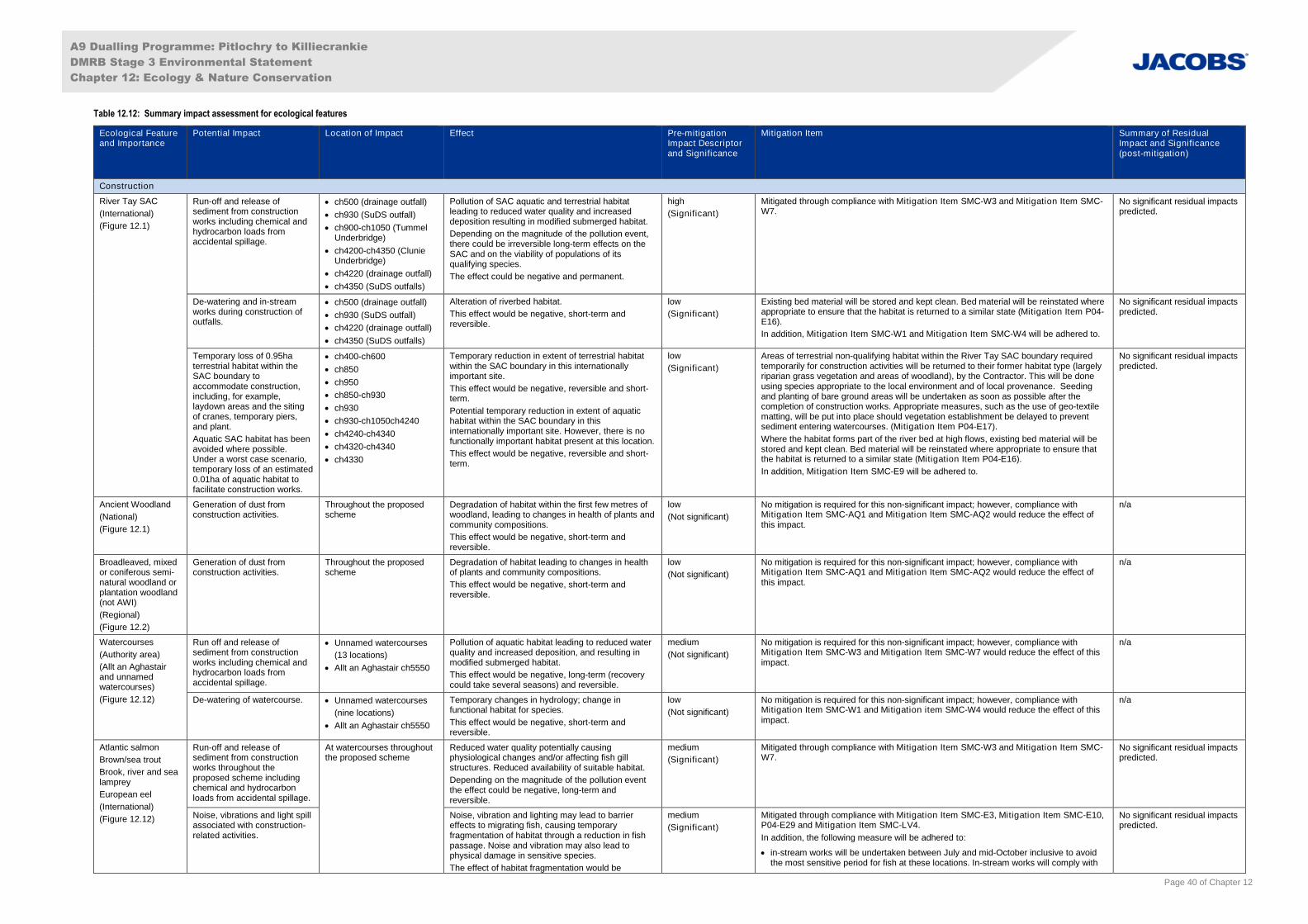
A9 Dualling Programme: Pitlochry to Killiecrankie
DMRB Stage 3 Environmental Statement
Chapter 12: Ecology & Nature Conservation
Page 40 of Chapter 12
Table 12.12: Summary impact assessment for ecological features
Ecological Featureand Importance
Potential Impact Location of Impact Effect Pre-mitigationImpact Descriptorand Significance
Mitigation Item Summary of ResidualImpact and Significance(post-mitigation)
Construction
River Tay SAC
(International)
(Figure 12.1)
Run-off and release ofsediment from constructionworks including chemical andhydrocarbon loads fromaccidental spillage.
ch500 (drainage outfall)
ch930 (SuDS outfall)
ch900-ch1050 (TummelUnderbridge)
ch4200-ch4350 (ClunieUnderbridge)
ch4220 (drainage outfall)
ch4350 (SuDS outfalls)
Pollution of SAC aquatic and terrestrial habitatleading to reduced water quality and increaseddeposition resulting in modified submerged habitat.
Depending on the magnitude of the pollution event,there could be irreversible long-term effects on theSAC and on the viability of populations of itsqualifying species.
The effect could be negative and permanent.
high
(Significant)
Mitigated through compliance with Mitigation Item SMC-W3 and Mitigation Item SMC-W7.
No significant residual impactspredicted.
De-watering and in-streamworks during construction ofoutfalls.
ch500 (drainage outfall)
ch930 (SuDS outfall)
ch4220 (drainage outfall)
ch4350 (SuDS outfalls)
Alteration of riverbed habitat.
This effect would be negative, short-term andreversible.
low
(Significant)
Existing bed material will be stored and kept clean. Bed material will be reinstated whereappropriate to ensure that the habitat is returned to a similar state (Mitigation Item P04-E16).
In addition, Mitigation Item SMC-W1 and Mitigation Item SMC-W4 will be adhered to.
No significant residual impactspredicted.
Temporary loss of 0.95haterrestrial habitat within theSAC boundary toaccommodate construction,including, for example,laydown areas and the sitingof cranes, temporary piers,and plant.
Aquatic SAC habitat has beenavoided where possible.Under a worst case scenario,temporary loss of an estimated0.01ha of aquatic habitat tofacilitate construction works.
ch400-ch600
ch850
ch950
ch850-ch930
ch930
ch930-ch1050ch4240
ch4240-ch4340
ch4320-ch4340
ch4330
Temporary reduction in extent of terrestrial habitatwithin the SAC boundary in this internationallyimportant site.
This effect would be negative, reversible and short-term.
Potential temporary reduction in extent of aquatichabitat within the SAC boundary in thisinternationally important site. However, there is nofunctionally important habitat present at this location.
This effect would be negative, reversible and short-term.
low
(Significant)
Areas of terrestrial non-qualifying habitat within the River Tay SAC boundary requiredtemporarily for construction activities will be returned to their former habitat type (largelyriparian grass vegetation and areas of woodland), by the Contractor. This will be doneusing species appropriate to the local environment and of local provenance. Seedingand planting of bare ground areas will be undertaken as soon as possible after thecompletion of construction works. Appropriate measures, such as the use of geo-textilematting, will be put into place should vegetation establishment be delayed to preventsediment entering watercourses. (Mitigation Item P04-E17).
Where the habitat forms part of the river bed at high flows, existing bed material will bestored and kept clean. Bed material will be reinstated where appropriate to ensure thatthe habitat is returned to a similar state (Mitigation Item P04-E16).
In addition, Mitigation Item SMC-E9 will be adhered to.
No significant residual impactspredicted.
Ancient Woodland
(National)
(Figure 12.1)
Generation of dust fromconstruction activities.
Throughout the proposedscheme
Degradation of habitat within the first few metres ofwoodland, leading to changes in health of plants andcommunity compositions.
This effect would be negative, short-term andreversible.
low
(Not significant)
No mitigation is required for this non-significant impact; however, compliance withMitigation Item SMC-AQ1 and Mitigation Item SMC-AQ2 would reduce the effect ofthis impact.
n/a
Broadleaved, mixedor coniferous semi-natural woodland orplantation woodland(not AWI)
(Regional)
(Figure 12.2)
Generation of dust fromconstruction activities.
Throughout the proposedscheme
Degradation of habitat leading to changes in healthof plants and community compositions.
This effect would be negative, short-term andreversible.
low
(Not significant)
No mitigation is required for this non-significant impact; however, compliance withMitigation Item SMC-AQ1 and Mitigation Item SMC-AQ2 would reduce the effect ofthis impact.
n/a
Watercourses
(Authority area)
(Allt an Aghastairand unnamedwatercourses)
(Figure 12.12)
Run off and release ofsediment from constructionworks including chemical andhydrocarbon loads fromaccidental spillage.
Unnamed watercourses
(13 locations)
Allt an Aghastair ch5550
Pollution of aquatic habitat leading to reduced waterquality and increased deposition, and resulting inmodified submerged habitat.
This effect would be negative, long-term (recoverycould take several seasons) and reversible.
medium
(Not significant)
No mitigation is required for this non-significant impact; however, compliance withMitigation Item SMC-W3 and Mitigation Item SMC-W7 would reduce the effect of thisimpact.
n/a
De-watering of watercourse. Unnamed watercourses
(nine locations)
Allt an Aghastair ch5550
Temporary changes in hydrology; change infunctional habitat for species.
This effect would be negative, short-term andreversible.
low
(Not significant)
No mitigation is required for this non-significant impact; however, compliance withMitigation Item SMC-W1 and Mitigation item SMC-W4 would reduce the effect of thisimpact.
n/a
Atlantic salmon
Brown/sea trout
Brook, river and sealamprey
European eel
(International)
(Figure 12.12)
Run-off and release ofsediment from constructionworks throughout theproposed scheme includingchemical and hydrocarbonloads from accidental spillage.
At watercourses throughoutthe proposed scheme
Reduced water quality potentially causingphysiological changes and/or affecting fish gillstructures. Reduced availability of suitable habitat.
Depending on the magnitude of the pollution eventthe effect could be negative, long-term andreversible.
medium
(Significant)
Mitigated through compliance with Mitigation Item SMC-W3 and Mitigation Item SMC-W7.
No significant residual impactspredicted.
Noise, vibrations and light spillassociated with construction-related activities.
Noise, vibration and lighting may lead to barriereffects to migrating fish, causing temporaryfragmentation of habitat through a reduction in fishpassage. Noise and vibration may also lead tophysical damage in sensitive species.
The effect of habitat fragmentation would be
medium
(Significant)
Mitigated through compliance with Mitigation Item SMC-E3, Mitigation Item SMC-E10,P04-E29 and Mitigation Item SMC-LV4.
In addition, the following measure will be adhered to:
in-stream works will be undertaken between July and mid-October inclusive to avoidthe most sensitive period for fish at these locations. In-stream works will comply with
No significant residual impactspredicted.
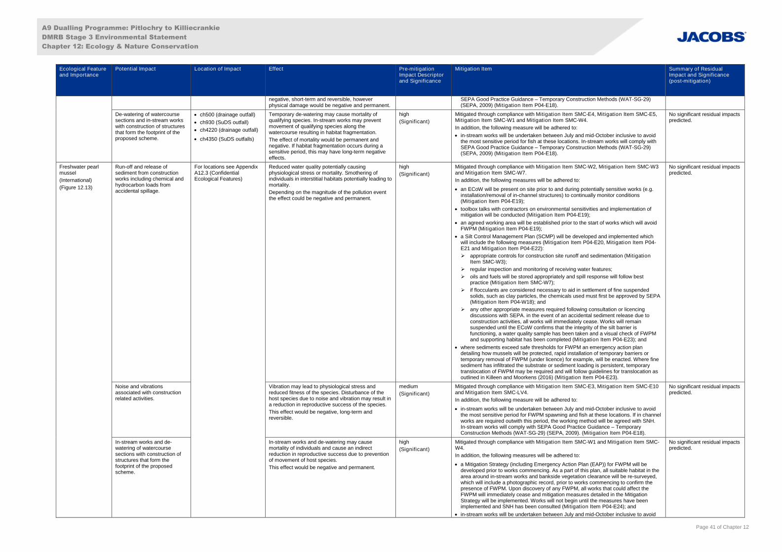
A9 Dualling Programme: Pitlochry to Killiecrankie
DMRB Stage 3 Environmental Statement
Chapter 12: Ecology & Nature Conservation
Page 41 of Chapter 12
Ecological Featureand Importance
Potential Impact Location of Impact Effect Pre-mitigationImpact Descriptorand Significance
Mitigation Item Summary of ResidualImpact and Significance(post-mitigation)
negative, short-term and reversible, howeverphysical damage would be negative and permanent.
SEPA Good Practice Guidance – Temporary Construction Methods (WAT-SG-29)(SEPA, 2009) (Mitigation Item P04-E18).
De-watering of watercoursesections and in-stream workswith construction of structuresthat form the footprint of theproposed scheme.
ch500 (drainage outfall)
ch930 (SuDS outfall)
ch4220 (drainage outfall)
ch4350 (SuDS outfalls)
Temporary de-watering may cause mortality ofqualifying species. In-stream works may preventmovement of qualifying species along thewatercourse resulting in habitat fragmentation.
The effect of mortality would be permanent andnegative. If habitat fragmentation occurs during asensitive period, this may have long-term negativeeffects.
high
(Significant)
Mitigated through compliance with Mitigation Item SMC-E4, Mitigation Item SMC-E5,Mitigation Item SMC-W1 and Mitigation Item SMC-W4.
In addition, the following measure will be adhered to:
in-stream works will be undertaken between July and mid-October inclusive to avoidthe most sensitive period for fish at these locations. In-stream works will comply withSEPA Good Practice Guidance – Temporary Construction Methods (WAT-SG-29)(SEPA, 2009) (Mitigation Item P04-E18).
No significant residual impactspredicted.
Freshwater pearlmussel
(International)
(Figure 12.13)
Run-off and release ofsediment from constructionworks including chemical andhydrocarbon loads fromaccidental spillage.
For locations see AppendixA12.3 (ConfidentialEcological Features)
Reduced water quality potentially causingphysiological stress or mortality. Smothering ofindividuals in interstitial habitats potentially leading tomortality.
Depending on the magnitude of the pollution eventthe effect could be negative and permanent.
high
(Significant)
Mitigated through compliance with Mitigation Item SMC-W2, Mitigation Item SMC-W3and Mitigation Item SMC-W7.
In addition, the following measures will be adhered to:
an ECoW will be present on site prior to and during potentially sensitive works (e.g.installation/removal of in-channel structures) to continually monitor conditions(Mitigation Item P04-E19);
toolbox talks with contractors on environmental sensitivities and implementation ofmitigation will be conducted (Mitigation Item P04-E19);
an agreed working area will be established prior to the start of works which will avoidFWPM (Mitigation Item P04-E19);
a Silt Control Management Plan (SCMP) will be developed and implemented whichwill include the following measures (Mitigation Item P04-E20, Mitigation Item P04-E21 and Mitigation Item P04-E22):
appropriate controls for construction site runoff and sedimentation (MitigationItem SMC-W3);
regular inspection and monitoring of receiving water features;
oils and fuels will be stored appropriately and spill response will follow bestpractice (Mitigation Item SMC-W7);
if flocculants are considered necessary to aid in settlement of fine suspendedsolids, such as clay particles, the chemicals used must first be approved by SEPA(Mitigation Item P04-W18); and
any other appropriate measures required following consultation or licencingdiscussions with SEPA. in the event of an accidental sediment release due toconstruction activities, all works will immediately cease. Works will remainsuspended until the ECoW confirms that the integrity of the silt barrier isfunctioning, a water quality sample has been taken and a visual check of FWPMand supporting habitat has been completed (Mitigation Item P04-E23); and
where sediments exceed safe thresholds for FWPM an emergency action plandetailing how mussels will be protected, rapid installation of temporary barriers ortemporary removal of FWPM (under licence) for example, will be enacted. Where finesediment has infiltrated the substrate or sediment loading is persistent, temporarytranslocation of FWPM may be required and will follow guidelines for translocation asoutlined in Killeen and Moorkens (2016) (Mitigation Item P04-E23).
No significant residual impactspredicted.
Noise and vibrationsassociated with constructionrelated activities.
Vibration may lead to physiological stress andreduced fitness of the species. Disturbance of thehost species due to noise and vibration may result ina reduction in reproductive success of the species.
This effect would be negative, long-term andreversible.
medium
(Significant)
Mitigated through compliance with Mitigation Item SMC-E3, Mitigation Item SMC-E10and Mitigation Item SMC-LV4.
In addition, the following measure will be adhered to:
in-stream works will be undertaken between July and mid-October inclusive to avoidthe most sensitive period for FWPM spawning and fish at these locations. If in channelworks are required outwith this period, the working method will be agreed with SNH.In-stream works will comply with SEPA Good Practice Guidance – TemporaryConstruction Methods (WAT-SG-29) (SEPA, 2009). (Mitigation Item P04-E18).
No significant residual impactspredicted.
In-stream works and de-watering of watercoursesections with construction ofstructures that form thefootprint of the proposedscheme.
In-stream works and de-watering may causemortality of individuals and cause an indirectreduction in reproductive success due to preventionof movement of host species.
This effect would be negative and permanent.
high
(Significant)
Mitigated through compliance with Mitigation Item SMC-W1 and Mitigation Item SMC-W4.
In addition, the following measures will be adhered to:
a Mitigation Strategy (including Emergency Action Plan (EAP)) for FWPM will bedeveloped prior to works commencing. As a part of this plan, all suitable habitat in thearea around in-stream works and bankside vegetation clearance will be re-surveyed,which will include a photographic record, prior to works commencing to confirm thepresence of FWPM. Upon discovery of any FWPM, all works that could affect theFWPM will immediately cease and mitigation measures detailed in the MitigationStrategy will be implemented. Works will not begin until the measures have beenimplemented and SNH has been consulted (Mitigation Item P04-E24); and
in-stream works will be undertaken between July and mid-October inclusive to avoid
No significant residual impactspredicted.
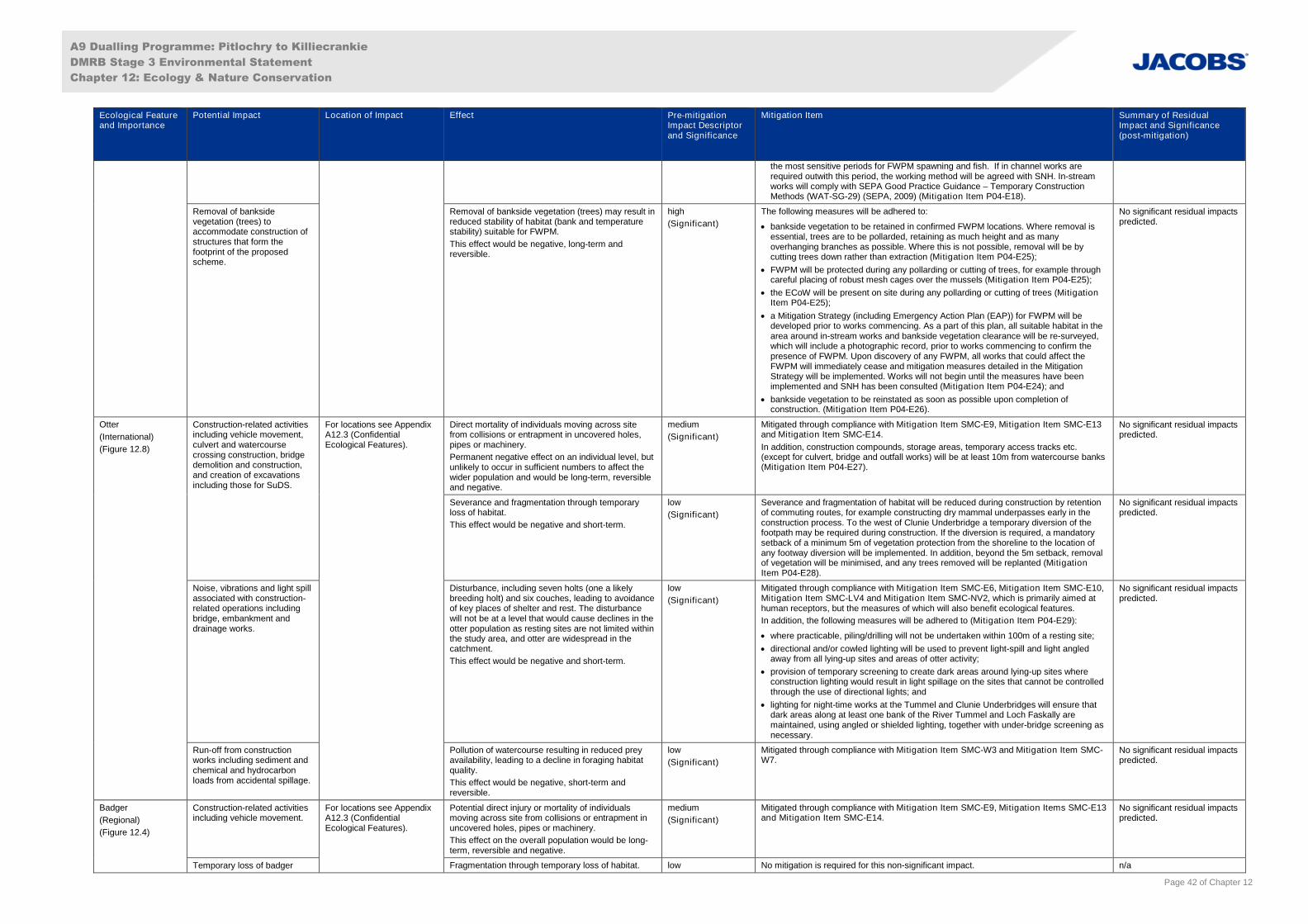
A9 Dualling Programme: Pitlochry to Killiecrankie
DMRB Stage 3 Environmental Statement
Chapter 12: Ecology & Nature Conservation
Page 42 of Chapter 12
Ecological Featureand Importance
Potential Impact Location of Impact Effect Pre-mitigationImpact Descriptorand Significance
Mitigation Item Summary of ResidualImpact and Significance(post-mitigation)
the most sensitive periods for FWPM spawning and fish. If in channel works arerequired outwith this period, the working method will be agreed with SNH. In-streamworks will comply with SEPA Good Practice Guidance – Temporary ConstructionMethods (WAT-SG-29) (SEPA, 2009) (Mitigation Item P04-E18).
Removal of banksidevegetation (trees) toaccommodate construction ofstructures that form thefootprint of the proposedscheme.
Removal of bankside vegetation (trees) may result inreduced stability of habitat (bank and temperaturestability) suitable for FWPM.
This effect would be negative, long-term andreversible.
high
(Significant)
The following measures will be adhered to:
bankside vegetation to be retained in confirmed FWPM locations. Where removal isessential, trees are to be pollarded, retaining as much height and as manyoverhanging branches as possible. Where this is not possible, removal will be bycutting trees down rather than extraction (Mitigation Item P04-E25);
FWPM will be protected during any pollarding or cutting of trees, for example throughcareful placing of robust mesh cages over the mussels (Mitigation Item P04-E25);
the ECoW will be present on site during any pollarding or cutting of trees (MitigationItem P04-E25);
a Mitigation Strategy (including Emergency Action Plan (EAP)) for FWPM will bedeveloped prior to works commencing. As a part of this plan, all suitable habitat in thearea around in-stream works and bankside vegetation clearance will be re-surveyed,which will include a photographic record, prior to works commencing to confirm thepresence of FWPM. Upon discovery of any FWPM, all works that could affect theFWPM will immediately cease and mitigation measures detailed in the MitigationStrategy will be implemented. Works will not begin until the measures have beenimplemented and SNH has been consulted (Mitigation Item P04-E24); and
bankside vegetation to be reinstated as soon as possible upon completion ofconstruction. (Mitigation Item P04-E26).
No significant residual impactspredicted.
Otter
(International)
(Figure 12.8)
Construction-related activitiesincluding vehicle movement,culvert and watercoursecrossing construction, bridgedemolition and construction,and creation of excavationsincluding those for SuDS.
For locations see AppendixA12.3 (ConfidentialEcological Features).
Direct mortality of individuals moving across sitefrom collisions or entrapment in uncovered holes,pipes or machinery.
Permanent negative effect on an individual level, butunlikely to occur in sufficient numbers to affect thewider population and would be long-term, reversibleand negative.
medium
(Significant)
Mitigated through compliance with Mitigation Item SMC-E9, Mitigation Item SMC-E13and Mitigation Item SMC-E14.
In addition, construction compounds, storage areas, temporary access tracks etc.(except for culvert, bridge and outfall works) will be at least 10m from watercourse banks(Mitigation Item P04-E27).
No significant residual impactspredicted.
Severance and fragmentation through temporaryloss of habitat.
This effect would be negative and short-term.
low
(Significant)
Severance and fragmentation of habitat will be reduced during construction by retentionof commuting routes, for example constructing dry mammal underpasses early in theconstruction process. To the west of Clunie Underbridge a temporary diversion of thefootpath may be required during construction. If the diversion is required, a mandatorysetback of a minimum 5m of vegetation protection from the shoreline to the location ofany footway diversion will be implemented. In addition, beyond the 5m setback, removalof vegetation will be minimised, and any trees removed will be replanted (MitigationItem P04-E28).
No significant residual impactspredicted.
Noise, vibrations and light spillassociated with construction-related operations includingbridge, embankment anddrainage works.
Disturbance, including seven holts (one a likelybreeding holt) and six couches, leading to avoidanceof key places of shelter and rest. The disturbancewill not be at a level that would cause declines in theotter population as resting sites are not limited withinthe study area, and otter are widespread in thecatchment.
This effect would be negative and short-term.
low
(Significant)
Mitigated through compliance with Mitigation Item SMC-E6, Mitigation Item SMC-E10,Mitigation Item SMC-LV4 and Mitigation Item SMC-NV2, which is primarily aimed athuman receptors, but the measures of which will also benefit ecological features.
In addition, the following measures will be adhered to (Mitigation Item P04-E29):
where practicable, piling/drilling will not be undertaken within 100m of a resting site;
directional and/or cowled lighting will be used to prevent light-spill and light angledaway from all lying-up sites and areas of otter activity;
provision of temporary screening to create dark areas around lying-up sites whereconstruction lighting would result in light spillage on the sites that cannot be controlledthrough the use of directional lights; and
lighting for night-time works at the Tummel and Clunie Underbridges will ensure thatdark areas along at least one bank of the River Tummel and Loch Faskally aremaintained, using angled or shielded lighting, together with under-bridge screening asnecessary.
No significant residual impactspredicted.
Run-off from constructionworks including sediment andchemical and hydrocarbonloads from accidental spillage.
Pollution of watercourse resulting in reduced preyavailability, leading to a decline in foraging habitatquality.
This effect would be negative, short-term andreversible.
low
(Significant)
Mitigated through compliance with Mitigation Item SMC-W3 and Mitigation Item SMC-W7.
No significant residual impactspredicted.
Badger
(Regional)
(Figure 12.4)
Construction-related activitiesincluding vehicle movement.
For locations see AppendixA12.3 (ConfidentialEcological Features).
Potential direct injury or mortality of individualsmoving across site from collisions or entrapment inuncovered holes, pipes or machinery.
This effect on the overall population would be long-term, reversible and negative.
medium
(Significant)
Mitigated through compliance with Mitigation Item SMC-E9, Mitigation Items SMC-E13and Mitigation Item SMC-E14.
No significant residual impactspredicted.
Temporary loss of badger Fragmentation through temporary loss of habitat. low No mitigation is required for this non-significant impact. n/a
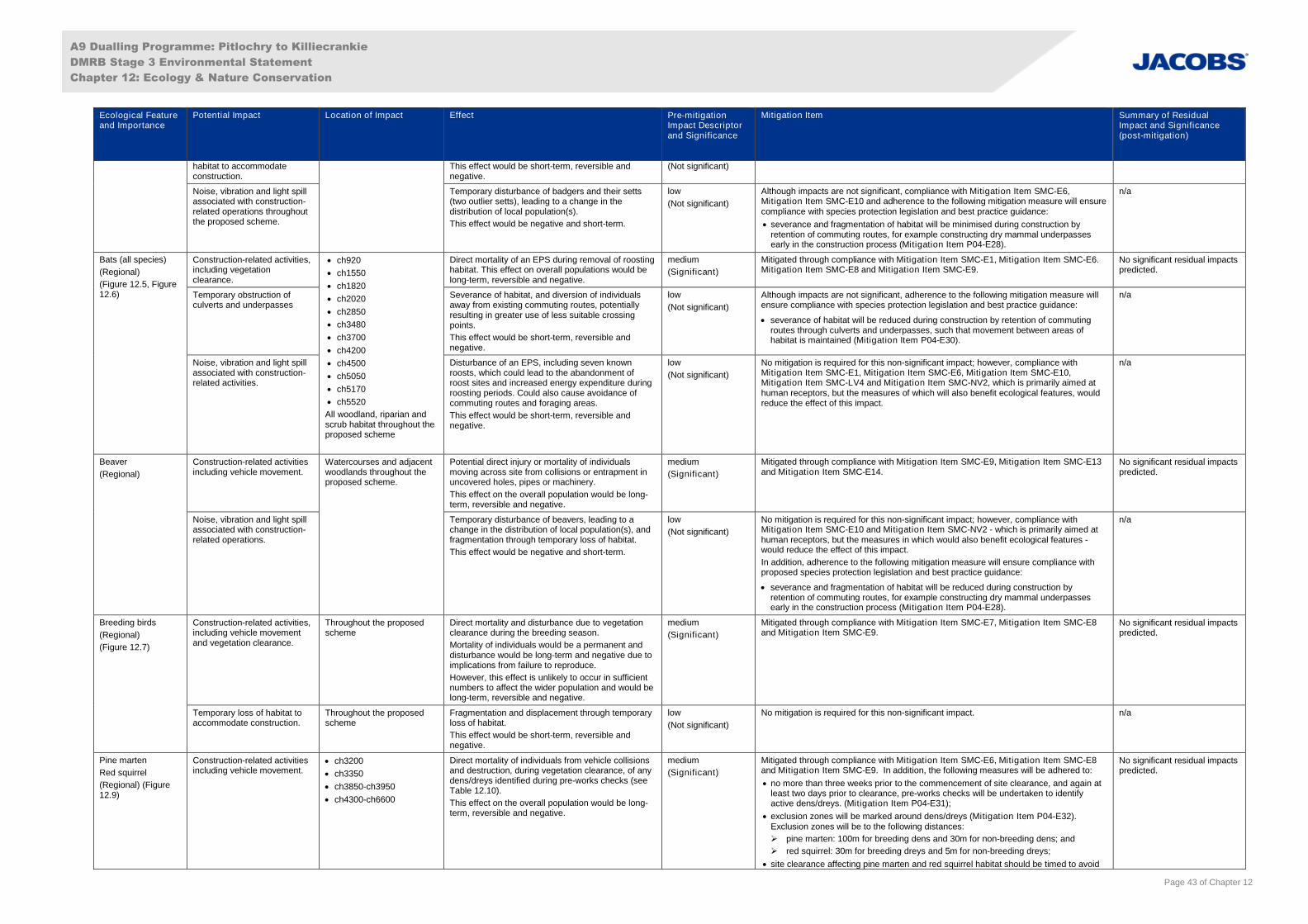
A9 Dualling Programme: Pitlochry to Killiecrankie
DMRB Stage 3 Environmental Statement
Chapter 12: Ecology & Nature Conservation
Page 43 of Chapter 12
Ecological Featureand Importance
Potential Impact Location of Impact Effect Pre-mitigationImpact Descriptorand Significance
Mitigation Item Summary of ResidualImpact and Significance(post-mitigation)
habitat to accommodateconstruction.
This effect would be short-term, reversible andnegative.
(Not significant)
Noise, vibration and light spillassociated with construction-related operations throughoutthe proposed scheme.
Temporary disturbance of badgers and their setts(two outlier setts), leading to a change in thedistribution of local population(s).
This effect would be negative and short-term.
low
(Not significant)
Although impacts are not significant, compliance with Mitigation Item SMC-E6,Mitigation Item SMC-E10 and adherence to the following mitigation measure will ensurecompliance with species protection legislation and best practice guidance:
severance and fragmentation of habitat will be minimised during construction byretention of commuting routes, for example constructing dry mammal underpassesearly in the construction process (Mitigation Item P04-E28).
n/a
Bats (all species)
(Regional)
(Figure 12.5, Figure12.6)
Construction-related activities,including vegetationclearance.
ch920
ch1550
ch1820
ch2020
ch2850
ch3480
ch3700
ch4200
ch4500
ch5050
ch5170
ch5520
All woodland, riparian andscrub habitat throughout theproposed scheme
Direct mortality of an EPS during removal of roostinghabitat. This effect on overall populations would belong-term, reversible and negative.
medium
(Significant)
Mitigated through compliance with Mitigation Item SMC-E1, Mitigation Item SMC-E6.Mitigation Item SMC-E8 and Mitigation Item SMC-E9.
No significant residual impactspredicted.
Temporary obstruction ofculverts and underpasses
Severance of habitat, and diversion of individualsaway from existing commuting routes, potentiallyresulting in greater use of less suitable crossingpoints.
This effect would be short-term, reversible andnegative.
low
(Not significant)
Although impacts are not significant, adherence to the following mitigation measure willensure compliance with species protection legislation and best practice guidance:
severance of habitat will be reduced during construction by retention of commutingroutes through culverts and underpasses, such that movement between areas ofhabitat is maintained (Mitigation Item P04-E30).
n/a
Noise, vibration and light spillassociated with construction-related activities.
Disturbance of an EPS, including seven knownroosts, which could lead to the abandonment ofroost sites and increased energy expenditure duringroosting periods. Could also cause avoidance ofcommuting routes and foraging areas.
This effect would be short-term, reversible andnegative.
low
(Not significant)
No mitigation is required for this non-significant impact; however, compliance withMitigation Item SMC-E1, Mitigation Item SMC-E6, Mitigation Item SMC-E10,Mitigation Item SMC-LV4 and Mitigation Item SMC-NV2, which is primarily aimed athuman receptors, but the measures of which will also benefit ecological features, wouldreduce the effect of this impact.
n/a
Beaver
(Regional)
Construction-related activitiesincluding vehicle movement.
Watercourses and adjacentwoodlands throughout theproposed scheme.
Potential direct injury or mortality of individualsmoving across site from collisions or entrapment inuncovered holes, pipes or machinery.
This effect on the overall population would be long-term, reversible and negative.
medium
(Significant)
Mitigated through compliance with Mitigation Item SMC-E9, Mitigation Item SMC-E13and Mitigation Item SMC-E14.
No significant residual impactspredicted.
Noise, vibration and light spillassociated with construction-related operations.
Temporary disturbance of beavers, leading to achange in the distribution of local population(s), andfragmentation through temporary loss of habitat.
This effect would be negative and short-term.
low
(Not significant)
No mitigation is required for this non-significant impact; however, compliance withMitigation Item SMC-E10 and Mitigation Item SMC-NV2 - which is primarily aimed athuman receptors, but the measures in which would also benefit ecological features -would reduce the effect of this impact.
In addition, adherence to the following mitigation measure will ensure compliance withproposed species protection legislation and best practice guidance:
severance and fragmentation of habitat will be reduced during construction byretention of commuting routes, for example constructing dry mammal underpassesearly in the construction process (Mitigation Item P04-E28).
n/a
Breeding birds
(Regional)
(Figure 12.7)
Construction-related activities,including vehicle movementand vegetation clearance.
Throughout the proposedscheme
Direct mortality and disturbance due to vegetationclearance during the breeding season.
Mortality of individuals would be a permanent anddisturbance would be long-term and negative due toimplications from failure to reproduce.
However, this effect is unlikely to occur in sufficientnumbers to affect the wider population and would belong-term, reversible and negative.
medium
(Significant)
Mitigated through compliance with Mitigation Item SMC-E7, Mitigation Item SMC-E8and Mitigation Item SMC-E9.
No significant residual impactspredicted.
Temporary loss of habitat toaccommodate construction.
Throughout the proposedscheme
Fragmentation and displacement through temporaryloss of habitat.
This effect would be short-term, reversible andnegative.
low
(Not significant)
No mitigation is required for this non-significant impact. n/a
Pine marten
Red squirrel
(Regional) (Figure12.9)
Construction-related activitiesincluding vehicle movement.
ch3200
ch3350
ch3850-ch3950
ch4300-ch6600
Direct mortality of individuals from vehicle collisionsand destruction, during vegetation clearance, of anydens/dreys identified during pre-works checks (seeTable 12.10).
This effect on the overall population would be long-term, reversible and negative.
medium
(Significant)
Mitigated through compliance with Mitigation Item SMC-E6, Mitigation Item SMC-E8and Mitigation Item SMC-E9. In addition, the following measures will be adhered to:
no more than three weeks prior to the commencement of site clearance, and again atleast two days prior to clearance, pre-works checks will be undertaken to identifyactive dens/dreys. (Mitigation Item P04-E31);
exclusion zones will be marked around dens/dreys (Mitigation Item P04-E32).Exclusion zones will be to the following distances:
pine marten: 100m for breeding dens and 30m for non-breeding dens; and
red squirrel: 30m for breeding dreys and 5m for non-breeding dreys;
site clearance affecting pine marten and red squirrel habitat should be timed to avoid
No significant residual impactspredicted.
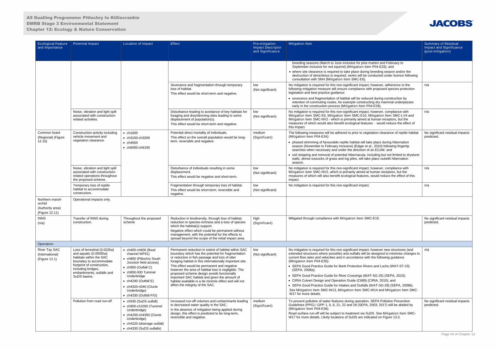
A9 Dualling Programme: Pitlochry to Killiecrankie
DMRB Stage 3 Environmental Statement
Chapter 12: Ecology & Nature Conservation
Page 44 of Chapter 12
Ecological Featureand Importance
Potential Impact Location of Impact Effect Pre-mitigationImpact Descriptorand Significance
Mitigation Item Summary of ResidualImpact and Significance(post-mitigation)
breeding seasons (March to June inclusive for pine marten and February toSeptember inclusive for red squirrel) (Mitigation Item P04-E33); and
where site clearance is required to take place during breeding season and/or thedestruction of dens/dreys is required, works will be conducted under licence followingconsultation with SNH (Mitigation Item SMC-E6).
Severance and fragmentation through temporaryloss of habitat.
This effect would be short-term and negative.
low
(Not significant)
No mitigation is required for this non-significant impact; however, adherence to thefollowing mitigation measure will ensure compliance with proposed species protectionlegislation and best practice guidance:
severance and fragmentation of habitat will be reduced during construction byretention of commuting routes, for example constructing dry mammal underpassesearly in the construction process (Mitigation Item P04-E28).
n/a
Noise, vibration and light spillassociated with construction-related activities.
Disturbance leading to avoidance of key habitats forforaging and drey/denning sites leading to somedisplacement of population(s).
This effect would be short-term and negative.
low
(Not significant)
No mitigation is required for this non-significant impact; however, compliance withMitigation Item SMC-E6, Mitigation Item SMC-E10, Mitigation Item SMC-LV4 andMitigation Item SMC-NV2 - which is primarily aimed at human receptors, but themeasures of which would also benefit ecological features - would reduce the effect ofthis impact.
n/a
Common lizard
(Regional) (Figure12.10)
Construction activity includingvehicle movement andvegetation clearance.
ch1600
ch3150-ch3200
ch4500
ch6050-ch6160
Potential direct mortality of individuals.
This effect on the overall population would be long-term, reversible and negative.
medium
(Significant)
The following measures will be adhered to prior to vegetation clearance of reptile habitat(Mitigation Item P04-E34):
phased strimming of favourable reptile habitat will take place during hibernationseason (November to February inclusive) (Edgar et al., 2010) following fingertipsearches when necessary and under the direction of an ECoW; and
soil stripping and removal of potential hibernacula, including but not limited to drystonewalls, dense tussocks of grass and log piles, will take place outwith hibernationseason.
No significant residual impactspredicted.
Noise, vibration and light spillassociated with construction-related operations throughoutthe proposed scheme.
Disturbance of individuals resulting in somedisplacement.
This effect would be negative and short-term.
low
(Not significant)
No mitigation is required for this non-significant impact; however, compliance withMitigation Item SMC-NV2, which is primarily aimed at human receptors, but themeasures of which will also benefit ecological features, would reduce the effect of thisimpact.
n/a
Temporary loss of reptilehabitat to accommodateconstruction.
Fragmentation through temporary loss of habitat.
This effect would be short-term, reversible andnegative.
low
(Not significant)
No mitigation is required for this non-significant impact. n/a
Northern marsh-orchid
(Authority area)
(Figure 12.11)
Operational impacts only.
INNS
(n/a)
Transfer of INNS duringconstruction.
Throughout the proposedscheme
Reduction in biodiversity, through loss of habitat,reduction in species-richness and a loss of specieswhich the habitat(s) support.
Negative effect which could be permanent withoutmanagement, with the potential for the effects tospread beyond the scope of the initial impact area.
high
(Significant)
Mitigated through compliance with Mitigation Item SMC-E15. No significant residual impactspredicted.
Operation
River Tay SAC
(International)
(Figure 12.1)
Loss of terrestrial (0.022ha)and aquatic (0.0005ha)habitats within the SACboundary to accommodatefootprint of construction,including bridges,embankments, outfalls andSuDS basins.
ch400-ch600 (floodchannel WF61)
ch850 (Pitlochry SouthJunction field access)
ch950 (Outfall C)
ch850-930 TummelUnderbridge
ch4240 (Outfall E)
ch4320-4340 (ClunieUnderbridge)
ch4330 (Outfall F/G)
Permanent reduction in extent of habitat within SACboundary which has the potential for fragmentationor reduction in fish passage and loss of otterforaging habitat in this internationally important site.
This effect would be permanent and negativehowever the area of habitat loss is negligible. Theproposed scheme design avoids functionallyimportant SAC habitat and given the amount ofhabitat available is a de minimis effect and will notaffect the integrity of the SAC.
low
(Not significant)
No mitigation is required for this non-significant impact; however new structures (andextended structures where possible) and outfalls will be designed to minimise changes tocurrent flow rates and velocities and in accordance with the following guidance(Mitigation Item P04-E35):
SEPA Good Practice Guide for Bank Protection Rivers and Lochs (WAT-ST-23)(SEPA, 2008a);
SEPA Good Practice Guide for River Crossings (WAT-SG-25) (SEPA, 2010);
CIRIA Culvert Design and Operation Guide (C689) (CIRIA, 2010); and
SEPA Good Practice Guide for Intakes and Outfalls (WAT-SG-28) (SEPA, 2008b).
See Mitigation Item SMC-W13, Mitigation Item SMC-W14 and Mitigation Item SMC-W17 for more details.
n/a
Pollution from road run-off. ch930 (SuDS outfall)
ch900-ch1050 (TummelUnderbridge)
ch4200-ch4350 (ClunieUnderbridge)
ch4220 (drainage outfall)
ch4330 (SuDS outfalls)
Increased run-off volumes and contaminants leadingto decreased water quality in the SAC.
In the absence of mitigation being applied duringdesign, this effect is predicted to be long-term,reversible and negative.
medium
(Significant)
To prevent pollution of water features during operation, SEPA Pollution PreventionGuidelines (PPG) / GPP 1, 5, 6, 21, 22 and 26 (SEPA, 2003; 2017) will be abided by(Mitigation Item P04-E36).
Road surface run-off will be subject to treatment via SuDS. See Mitigation Item SMC-W17 for more details. Likely locations of SuDS are indicated on Figure 13.5.
No significant residual impactspredicted.
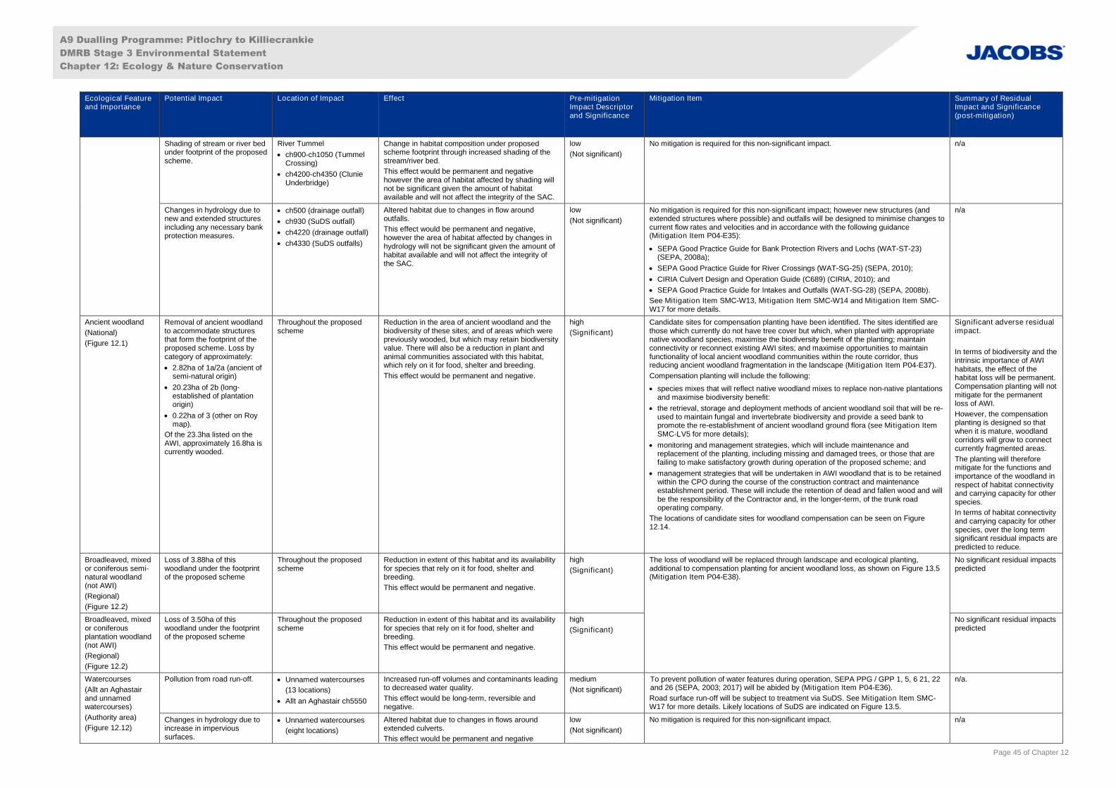
A9 Dualling Programme: Pitlochry to Killiecrankie
DMRB Stage 3 Environmental Statement
Chapter 12: Ecology & Nature Conservation
Page 45 of Chapter 12
Ecological Featureand Importance
Potential Impact Location of Impact Effect Pre-mitigationImpact Descriptorand Significance
Mitigation Item Summary of ResidualImpact and Significance(post-mitigation)
Shading of stream or river bedunder footprint of the proposedscheme.
River Tummel
ch900-ch1050 (TummelCrossing)
ch4200-ch4350 (ClunieUnderbridge)
Change in habitat composition under proposedscheme footprint through increased shading of thestream/river bed.
This effect would be permanent and negativehowever the area of habitat affected by shading willnot be significant given the amount of habitatavailable and will not affect the integrity of the SAC.
low
(Not significant)
No mitigation is required for this non-significant impact. n/a
Changes in hydrology due tonew and extended structuresincluding any necessary bankprotection measures.
ch500 (drainage outfall)
ch930 (SuDS outfall)
ch4220 (drainage outfall)
ch4330 (SuDS outfalls)
Altered habitat due to changes in flow aroundoutfalls.
This effect would be permanent and negative,however the area of habitat affected by changes inhydrology will not be significant given the amount ofhabitat available and will not affect the integrity ofthe SAC.
low
(Not significant)
No mitigation is required for this non-significant impact; however new structures (andextended structures where possible) and outfalls will be designed to minimise changes tocurrent flow rates and velocities and in accordance with the following guidance(Mitigation Item P04-E35):
SEPA Good Practice Guide for Bank Protection Rivers and Lochs (WAT-ST-23)(SEPA, 2008a);
SEPA Good Practice Guide for River Crossings (WAT-SG-25) (SEPA, 2010);
CIRIA Culvert Design and Operation Guide (C689) (CIRIA, 2010); and
SEPA Good Practice Guide for Intakes and Outfalls (WAT-SG-28) (SEPA, 2008b).
See Mitigation Item SMC-W13, Mitigation Item SMC-W14 and Mitigation Item SMC-W17 for more details.
n/a
Ancient woodland
(National)
(Figure 12.1)
Removal of ancient woodlandto accommodate structuresthat form the footprint of theproposed scheme. Loss bycategory of approximately:
2.82ha of 1a/2a (ancient ofsemi-natural origin)
20.23ha of 2b (long-established of plantationorigin)
0.22ha of 3 (other on Roymap).
Of the 23.3ha listed on theAWI, approximately 16.8ha iscurrently wooded.
Throughout the proposedscheme
Reduction in the area of ancient woodland and thebiodiversity of these sites; and of areas which werepreviously wooded, but which may retain biodiversityvalue. There will also be a reduction in plant andanimal communities associated with this habitat,which rely on it for food, shelter and breeding.
This effect would be permanent and negative.
high
(Significant)
Candidate sites for compensation planting have been identified. The sites identified arethose which currently do not have tree cover but which, when planted with appropriatenative woodland species, maximise the biodiversity benefit of the planting; maintainconnectivity or reconnect existing AWI sites; and maximise opportunities to maintainfunctionality of local ancient woodland communities within the route corridor, thusreducing ancient woodland fragmentation in the landscape (Mitigation Item P04-E37).
Compensation planting will include the following:
species mixes that will reflect native woodland mixes to replace non-native plantationsand maximise biodiversity benefit:
the retrieval, storage and deployment methods of ancient woodland soil that will be re-used to maintain fungal and invertebrate biodiversity and provide a seed bank topromote the re-establishment of ancient woodland ground flora (see Mitigation ItemSMC-LV5 for more details);
monitoring and management strategies, which will include maintenance andreplacement of the planting, including missing and damaged trees, or those that arefailing to make satisfactory growth during operation of the proposed scheme; and
management strategies that will be undertaken in AWI woodland that is to be retainedwithin the CPO during the course of the construction contract and maintenanceestablishment period. These will include the retention of dead and fallen wood and willbe the responsibility of the Contractor and, in the longer-term, of the trunk roadoperating company.
The locations of candidate sites for woodland compensation can be seen on Figure12.14.
Significant adverse residualimpact.
In terms of biodiversity and theintrinsic importance of AWIhabitats, the effect of thehabitat loss will be permanent.Compensation planting will notmitigate for the permanentloss of AWI.
However, the compensationplanting is designed so thatwhen it is mature, woodlandcorridors will grow to connectcurrently fragmented areas.
The planting will thereforemitigate for the functions andimportance of the woodland inrespect of habitat connectivityand carrying capacity for otherspecies.
In terms of habitat connectivityand carrying capacity for otherspecies, over the long termsignificant residual impacts arepredicted to reduce.
Broadleaved, mixedor coniferous semi-natural woodland(not AWI)
(Regional)
(Figure 12.2)
Loss of 3.88ha of thiswoodland under the footprintof the proposed scheme
Throughout the proposedscheme
Reduction in extent of this habitat and its availabilityfor species that rely on it for food, shelter andbreeding.
This effect would be permanent and negative.
high
(Significant)
The loss of woodland will be replaced through landscape and ecological planting,additional to compensation planting for ancient woodland loss, as shown on Figure 13.5(Mitigation Item P04-E38).
No significant residual impactspredicted
Broadleaved, mixedor coniferousplantation woodland(not AWI)
(Regional)
(Figure 12.2)
Loss of 3.50ha of thiswoodland under the footprintof the proposed scheme
Throughout the proposedscheme
Reduction in extent of this habitat and its availabilityfor species that rely on it for food, shelter andbreeding.
This effect would be permanent and negative.
high
(Significant)
No significant residual impactspredicted
Watercourses
(Allt an Aghastairand unnamedwatercourses)
(Authority area)
(Figure 12.12)
Pollution from road run-off. Unnamed watercourses
(13 locations)
Allt an Aghastair ch5550
Increased run-off volumes and contaminants leadingto decreased water quality.
This effect would be long-term, reversible andnegative.
medium
(Not significant)
To prevent pollution of water features during operation, SEPA PPG / GPP 1, 5, 6 21, 22and 26 (SEPA, 2003; 2017) will be abided by (Mitigation Item P04-E36).
Road surface run-off will be subject to treatment via SuDS. See Mitigation Item SMC-W17 for more details. Likely locations of SuDS are indicated on Figure 13.5.
n/a.
Changes in hydrology due toincrease in impervioussurfaces.
Unnamed watercourses
(eight locations)
Altered habitat due to changes in flows aroundextended culverts.
This effect would be permanent and negative
low
(Not significant)
No mitigation is required for this non-significant impact. n/a
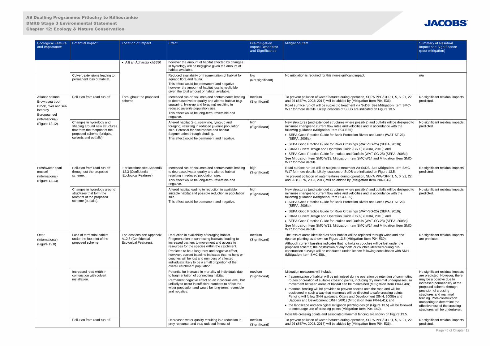
A9 Dualling Programme: Pitlochry to Killiecrankie
DMRB Stage 3 Environmental Statement
Chapter 12: Ecology & Nature Conservation
Page 46 of Chapter 12
Ecological Featureand Importance
Potential Impact Location of Impact Effect Pre-mitigationImpact Descriptorand Significance
Mitigation Item Summary of ResidualImpact and Significance(post-mitigation)
Allt an Aghastair ch5550 however the amount of habitat affected by changesin hydrology will be negligible given the amount ofhabitat available.
Culvert extensions leading topermanent loss of habitat.
Reduced availability or fragmentation of habitat foraquatic flora and fauna.
This effect would be permanent and negativehowever the amount of habitat loss is negligiblegiven the total amount of habitat available.
low
(Not significant)
No mitigation is required for this non-significant impact. n/a
Atlantic salmon
Brown/sea trout
Brook, river and sealamprey
European eel
(International)
(Figure 12.12)
Pollution from road run-off Throughout the proposedscheme
Increased run-off volumes and contaminants leadingto decreased water quality and altered habitat (e.g.spawning, lying-up and foraging) resulting inreduced juvenile population size.
This effect would be long-term, reversible andnegative.
medium
(Significant)
To prevent pollution of water features during operation, SEPA PPG/GPP 1, 5, 6, 21, 22and 26 (SEPA, 2003; 2017) will be abided by (Mitigation Item P04-E36).
Road surface run-off will be subject to treatment via SuDS. See Mitigation Item SMC-W17 for more details. Likely locations of SuDS are indicated on Figure 13.5.
No significant residual impactspredicted.
Changes in hydrology andshading around new structuresthat form the footprint of theproposed scheme (bridges,culverts and outfalls).
Altered habitat (e.g. spawning, lying-up andforaging) resulting in reduced juvenile populationsize. Potential for disturbance and habitatfragmentation through shading.
This effect would be permanent and negative.
high
(Significant)
New structures (and extended structures where possible) and outfalls will be designed tominimise changes to current flow rates and velocities and in accordance with thefollowing guidance (Mitigation Item P04-E35):
SEPA Good Practice Guide for Bank Protection Rivers and Lochs (WAT-ST-23)(SEPA, 2008a);
SEPA Good Practice Guide for River Crossings (WAT-SG-25) (SEPA, 2010);
CIRIA Culvert Design and Operation Guide (C689) (CIRIA, 2010); and
SEPA Good Practice Guide for Intakes and Outfalls (WAT-SG-28) (SEPA, 2008b).
See Mitigation Item SMC-W13, Mitigation Item SMC-W14 and Mitigation Item SMC-W17 for more details.
No significant residual impactspredicted.
Freshwater pearlmussel
(International)
(Figure 12.13)
Pollution from road run-offthroughout the proposedscheme.
For locations see Appendix12.3 (ConfidentialEcological Features).
Increased run-off volumes and contaminants leadingto decreased water quality and altered habitatresulting in reduced population size.
This effect would be long-term, reversible andnegative.
high
(Significant)
Road surface run-off will be subject to treatment via SuDS. See Mitigation Item SMC-W17 for more details. Likely locations of SuDS are indicated on Figure 13.5.
To prevent pollution of water features during operation, SEPA PPG/GPP 1, 5, 6, 21, 22and 26 (SEPA, 2003, 2017) will be abided by (Mitigation Item P04-E36).
No significant residual impactspredicted.
Changes in hydrology aroundstructures that form thefootprint of the proposedscheme (outfalls).
Altered habitat leading to reduction in availablesuitable habitat and possible reduction in populationsize.
This effect would be permanent and negative.
high
(Significant)
New structures (and extended structures where possible) and outfalls will be designed tominimise changes to current flow rates and velocities and in accordance with thefollowing guidance (Mitigation Item P04-E35)
SEPA Good Practice Guide for Bank Protection Rivers and Lochs (WAT-ST-23)(SEPA, 2008a);
SEPA Good Practice Guide for River Crossings (WAT-SG-25) (SEPA, 2010);
CIRIA Culvert Design and Operation Guide (C689) (CIRIA, 2010); and
SEPA Good Practice Guide for Intakes and Outfalls (WAT-SG-28) (SEPA, 2008b).
See Mitigation Item SMC-W13, Mitigation Item SMC-W14 and Mitigation Item SMC-W17 for more details.
No significant residual impactspredicted.
Otter
(International)
(Figure 12.8)
Loss of terrestrial habitatunder the footprint of theproposed scheme
For locations see AppendixA12.3 (ConfidentialEcological Features).
Reduction in availability of foraging habitat.Fragmentation of connecting habitats, leading toincreased barriers to movement and access toresources for the species within the catchment.
Predicted to be a long-term and negative effect,however, current baseline indicates that no holts orcouches will be lost and numbers of affectedindividuals likely to be a small proportion of theoverall catchment population.
medium
(Significant)
The loss of areas identified as otter habitat will be replaced through woodland andriparian planting as shown on Figure 13.5 (Mitigation Item P04-E39).
Although current baseline indicates that no holts or couches will be lost under theproposed scheme; the destruction of any holts or couches identified during pre-construction surveys will be conducted under licence following consultation with SNH(Mitigation Item SMC-E6).
No significant residual impactsare predicted.
Increased road width inconjunction with culvertinstallation.
Potential for increase in mortality of individuals dueto fragmentation of connecting habitat.
Permanent negative effect on an individual level, butunlikely to occur in sufficient numbers to affect thewider population and would be long-term, reversibleand negative.
medium
(Significant)
Mitigation measures will include:
fragmentation of habitat will be minimised during operation by retention of commutingroutes or creation of suitable crossing points, including dry mammal underpasses, somovement between areas of habitat can be maintained (Mitigation Item P04-E40);
mammal fencing will be provided to prevent access onto the road and will bepositioned in such a way that mammals will be directed to safe crossing points.Fencing will follow SNH guidance, Otters and Development (SNH, 2008b) andBadgers and Development (SNH, 2001) (Mitigation Item P04-E41); and
the landscape and ecological mitigation planting design (Figure 13.5) will be followedto encourage use of crossing points (Mitigation Item P04-E42).
Possible crossing points and associated mammal fencing are shown on Figure 13.5.
No significant residual impactsare predicted. However, theremay be a positive due toincreased permeability of theproposed scheme throughprovision of crossingstructures and mammalfencing. Post-constructionmonitoring to determine theeffectiveness of the crossingstructures will be undertaken.
Pollution from road run-off. Decreased water quality resulting in a reduction inprey resource, and thus reduced fitness of
medium
(Significant)
To prevent pollution of water features during operation, SEPA PPG/GPP 1, 5, 6, 21, 22and 26 (SEPA, 2003, 2017) will be abided by (Mitigation Item P04-E36).
No significant residual impactspredicted.
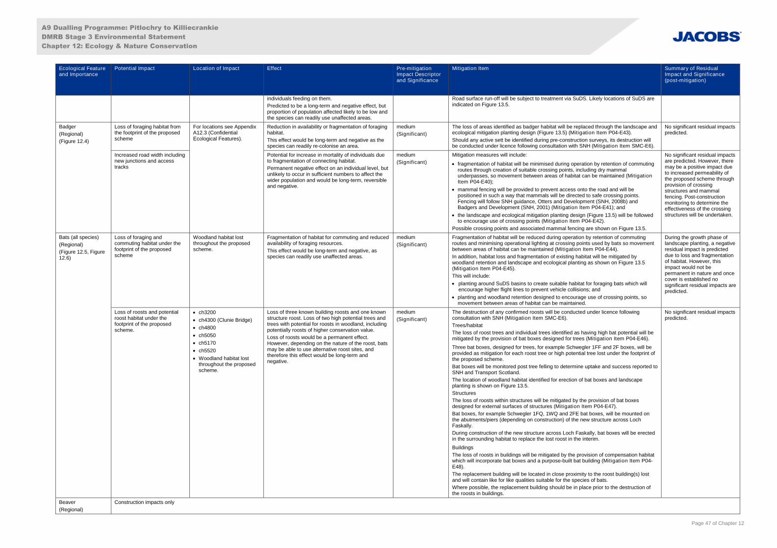
A9 Dualling Programme: Pitlochry to Killiecrankie
DMRB Stage 3 Environmental Statement
Chapter 12: Ecology & Nature Conservation
Page 47 of Chapter 12
Ecological Featureand Importance
Potential Impact Location of Impact Effect Pre-mitigationImpact Descriptorand Significance
Mitigation Item Summary of ResidualImpact and Significance(post-mitigation)
individuals feeding on them.
Predicted to be a long-term and negative effect, butproportion of population affected likely to be low andthe species can readily use unaffected areas.
Road surface run-off will be subject to treatment via SuDS. Likely locations of SuDS areindicated on Figure 13.5.
Badger
(Regional)
(Figure 12.4)
Loss of foraging habitat fromthe footprint of the proposedscheme
For locations see AppendixA12.3 (ConfidentialEcological Features).
Reduction in availability or fragmentation of foraginghabitat.
This effect would be long-term and negative as thespecies can readily re-colonise an area.
medium
(Significant)
The loss of areas identified as badger habitat will be replaced through the landscape andecological mitigation planting design (Figure 13.5) (Mitigation Item P04-E43).
Should any active sett be identified during pre-construction surveys, its destruction willbe conducted under licence following consultation with SNH (Mitigation Item SMC-E6).
No significant residual impactspredicted.
Increased road width includingnew junctions and accesstracks
Potential for increase in mortality of individuals dueto fragmentation of connecting habitat.
Permanent negative effect on an individual level, butunlikely to occur in sufficient numbers to affect thewider population and would be long-term, reversibleand negative.
medium
(Significant)
Mitigation measures will include:
fragmentation of habitat will be minimised during operation by retention of commutingroutes through creation of suitable crossing points, including dry mammalunderpasses, so movement between areas of habitat can be maintained (MitigationItem P04-E40);
mammal fencing will be provided to prevent access onto the road and will bepositioned in such a way that mammals will be directed to safe crossing points.Fencing will follow SNH guidance, Otters and Development (SNH, 2008b) andBadgers and Development (SNH, 2001) (Mitigation Item P04-E41); and
the landscape and ecological mitigation planting design (Figure 13.5) will be followedto encourage use of crossing points (Mitigation Item P04-E42).
Possible crossing points and associated mammal fencing are shown on Figure 13.5.
No significant residual impactsare predicted. However, theremay be a positive impact dueto increased permeability ofthe proposed scheme throughprovision of crossingstructures and mammalfencing. Post-constructionmonitoring to determine theeffectiveness of the crossingstructures will be undertaken.
Bats (all species)
(Regional)
(Figure 12.5, Figure12.6)
Loss of foraging andcommuting habitat under thefootprint of the proposedscheme
Woodland habitat lostthroughout the proposedscheme.
Fragmentation of habitat for commuting and reducedavailability of foraging resources.
This effect would be long-term and negative, asspecies can readily use unaffected areas.
medium
(Significant)
Fragmentation of habitat will be reduced during operation by retention of commutingroutes and minimising operational lighting at crossing points used by bats so movementbetween areas of habitat can be maintained (Mitigation Item P04-E44).
In addition, habitat loss and fragmentation of existing habitat will be mitigated bywoodland retention and landscape and ecological planting as shown on Figure 13.5(Mitigation Item P04-E45).
This will include:
planting around SuDS basins to create suitable habitat for foraging bats which willencourage higher flight lines to prevent vehicle collisions; and
planting and woodland retention designed to encourage use of crossing points, somovement between areas of habitat can be maintained.
During the growth phase oflandscape planting, a negativeresidual impact is predicteddue to loss and fragmentationof habitat. However, thisimpact would not bepermanent in nature and oncecover is established nosignificant residual impacts arepredicted.
Loss of roosts and potentialroost habitat under thefootprint of the proposedscheme.
ch3200
ch4300 (Clunie Bridge)
ch4800
ch5050
ch5170
ch5520
Woodland habitat lostthroughout the proposedscheme.
Loss of three known building roosts and one knownstructure roost. Loss of two high potential trees andtrees with potential for roosts in woodland, includingpotentially roosts of higher conservation value.
Loss of roosts would be a permanent effect.However, depending on the nature of the roost, batsmay be able to use alternative roost sites, andtherefore this effect would be long-term andnegative.
medium
(Significant)
The destruction of any confirmed roosts will be conducted under licence followingconsultation with SNH (Mitigation Item SMC-E6).
Trees/habitat
The loss of roost trees and individual trees identified as having high bat potential will bemitigated by the provision of bat boxes designed for trees (Mitigation Item P04-E46).
Three bat boxes, designed for trees, for example Schwegler 1FF and 2F boxes, will beprovided as mitigation for each roost tree or high potential tree lost under the footprint ofthe proposed scheme.
Bat boxes will be monitored post tree felling to determine uptake and success reported toSNH and Transport Scotland.
The location of woodland habitat identified for erection of bat boxes and landscapeplanting is shown on Figure 13.5.
Structures
The loss of roosts within structures will be mitigated by the provision of bat boxesdesigned for external surfaces of structures (Mitigation Item P04-E47).
Bat boxes, for example Schwegler 1FQ, 1WQ and 2FE bat boxes, will be mounted onthe abutments/piers (depending on construction) of the new structure across LochFaskally.
During construction of the new structure across Loch Faskally, bat boxes will be erectedin the surrounding habitat to replace the lost roost in the interim.
Buildings
The loss of roosts in buildings will be mitigated by the provision of compensation habitatwhich will incorporate bat boxes and a purpose-built bat building (Mitigation Item P04-E48).
The replacement building will be located in close proximity to the roost building(s) lostand will contain like for like qualities suitable for the species of bats.
Where possible, the replacement building should be in place prior to the destruction ofthe roosts in buildings.
No significant residual impactspredicted.
Beaver
(Regional)
Construction impacts only

A9 Dualling Programme: Pitlochry to Killiecrankie
DMRB Stage 3 Environmental Statement
Chapter 12: Ecology & Nature Conservation
Page 48 of Chapter 12
Ecological Featureand Importance
Potential Impact Location of Impact Effect Pre-mitigationImpact Descriptorand Significance
Mitigation Item Summary of ResidualImpact and Significance(post-mitigation)
Breeding birds
(Regional)
(Figure 12.7)
Increased road footprint Throughout the proposedscheme
Direct mortality of individuals throughout theproposed scheme through road-traffic relatedincidents.
Mortality would be a permanent effect on individuals.However, this would affect a low number ofindividuals and is unlikely to affect the overallbreeding bird assemblage. This effect would beshort-term and negative.
low
(Not significant)
No mitigation is required for this non-significant impact; however, planting proposed asmitigation for bats (Mitigation Item P04-E45) would further reduce the effect of thisimpact.
n/a
Loss of habitat under thefootprint of the proposedscheme
Loss of suitable breeding and foraging habitat whichcould result in reduced breeding success.
This effect would be long-term and negative, asspecies can re-colonise an area.
medium
(Significant)
The loss of breeding bird habitat will be replaced through the landscape and ecologicalmitigation planting design (Figure 13.5). The design has incorporated a variety ofbreeding bird habitats including the planting of woodland, scrub, hedgerow and speciesrich grassland, as shown on Figure 13.5 (Mitigation Item P04-E49).
During the growth phase oflandscape planting, a negativeresidual impact is predicteddue to loss and fragmentationof habitat. However, thisimpact would be temporary innature and once cover isestablished no significantresidual impacts are predicted.
Pine marten
Red squirrel
(Regional)
(Figure 12.9)
Loss of habitat under thefootprint of the proposedscheme.
ch3200
ch3350
ch3850-ch3950
ch4300-ch6600
Destruction of any dens/dreys identified during pre-works checks and permanent reduction in availabilityof this habitat to red squirrel and pine marten thatrely on it for food, shelter and breeding.
This effect would be long-term and negative as thespecies can readily use unaffected areas and re-colonise a habitat.
medium
(Significant)
The loss of areas identified as pine marten and red squirrel habitat will be replacedthrough the landscape and ecological mitigation planting design (Figure 13.5).
Trees of different age and species composition will be planted, for example Scots pine,birch and alder, as appropriate, and incorporated into Habitat Management Plans(Mitigation Item P04-E50).
The destruction of pine marten dens and red squirrel dreys will be conducted underlicence following consultation with SNH (Mitigation Item SMC-E6).
Each lost pine marten den will be replaced by a breeding box (Mitigation Item P04-E51).
Each lost drey will be replaced by one red squirrel nest box (Mitigation Item P04-E52).
The replacement breeding and nest boxes will be:
erected and positioned under direction of an ECoW prior to tree felling;
erected in suitable areas of pine marten and red squirrel woodland habitat; and
monitored post-tree-felling to determine uptake and success reported to SNH andTransport Scotland.
The location of woodland habitat identified for erection of replacement breeding and nestboxes is shown on Figure 13.5.
During the growth phase oflandscape planting, a negativeresidual impact is predicteddue to loss and fragmentationof habitat. However, thisimpact would be temporary innature and once cover isestablished no significantresidual impacts are predicted.
Common lizard
(Regional)
(Figure 12.10)
Loss of 16.52ha of reptilehabitat under the footprint ofthe proposed scheme.
ch1600
ch3150-ch3200
ch4500
ch6050-ch6160
Reduction in extent of habitat.
This effect would be permanent and negative.
high
(Significant)
No KRS were identified in the study area and thus no replacement habitat is required to
mitigate impacts on the species. Nevertheless, where possible, areas of habitat suitable
for reptiles have been included in the landscape and ecological planting design
(Mitigation Item P04-E53).
Planting suitable for reptiles may include features such as:
areas of insolation (sun exposure) with varied topography;
areas sheltered from the elements, such as wind breaks consisting of woodlandedges, wet and dry habitats, gullies and ditches;
hibernation sites such as gorse/birch root systems, rocky crevices and purple moor-grass tussocks;
habitats that support prey species for reptiles, for example insects, soft bodiedinvertebrates and small mammals;
areas sheltered from predators;
breeding habitat that is structurally diverse;
areas that support habitat connectivity; and
ecotones (interfaces between habitats and transitional zones).
Landscape planting suitable for reptiles is shown on Figure 13.5.
No significant residual impactspredicted.
Northern marsh-orchid
(Authority area)
(Figure 12.11)
Loss of habitat under thefootprint of the proposedscheme.
ch1200
ch2100
ch2300-ch2500
ch2550
ch4500-ch4600
Loss of approximately 3200 individual plants, leadingto a long-term, negative effect (reduction) on thepopulation until numbers become re-established.
high
(Significant)
To mitigate for the loss of habitat and northern marsh orchid, measures to protect theplants will be implemented and will be detailed in a Species Management Plan(Mitigation Item P04-E54). Areas identified for translocation are shown on Figure 13.5.
The Species Management Plan could include details to:
translocate dormant tubers, and/or translocate turves; and
monitor translocation area(s).
The construction timetable of the proposed scheme will dictate when the above will beundertaken. Temporary storage of turves will be near the translocation area at
No significant residual impactsare predicted. Whilst anytranslocation carries a slightrisk, with implementation ofthe Species ManagementPlan, no significant residualimpacts are predicted on theauthority area population.
A9 Dualling Programme: Pitlochry to Killiecrankie
DMRB Stage 3 Environmental Statement
Chapter 12: Ecology & Nature Conservation
Page 49 of Chapter 12
Ecological Featureand Importance
Potential Impact Location of Impact Effect Pre-mitigationImpact Descriptorand Significance
Mitigation Item Summary of ResidualImpact and Significance(post-mitigation)
approximately ch6100.
INNS
(n/a)
Construction impacts only
A9 Dualling Programme: Pitlochry to Killiecrankie
DMRB Stage 3 Environmental Statement
Chapter 12: Ecology & Nature Conservation
Page 50 of Chapter 12
12.7 Statement of Significance
12.7.1 No residual impacts during the construction phase of the proposed scheme are considered to besignificant in terms of the EIA Regulations.
12.7.2 During operation, the proposed scheme is predicted to result in a significant adverse residual impactfrom the loss of 23.3ha of habitat designated as AWI, of which 16.8ha is currently wooded. Measuressuch as compensation planting of native species in candidate sites (Figure 12.14 and Figure 13.5) willbe implemented to minimise the extent of the resulting significant residual impact. The AWI candidateplanting sites will be prepared with appropriately stored soil from areas to be lost to maintain themicrobial biodiversity and seedbank as described in Table 12.12.
12.7.3 The planting will not mitigate for the permanent loss of intrinsic biodiversity value as a result of theproposed scheme, and a significant adverse residual impact is predicted, but at a reduced extent tothat prior to compensation. The planted habitat will mature and woodland corridors will grow toconnect currently fragmented areas. Thus, in terms of habitat connectivity and the carrying capacity ofthe habitat for other species, no significant residual impacts are predicted in the longer-term.
12.7.4 It is considered certain that the identified activities and associated protected species scenarios arelicensable. A beneficial impact is anticipated resulting from increased permeability of the A9 followingdualling for species, including badger and otter, through provision of suitably designed crossingstructures and mammal fencing at appropriate locations, as shown on Figure 13.5. Post-constructionmonitoring to determine the effectiveness of the crossing structures will be undertaken and it ispredicted that barrier effects and vehicle collision risks for wildlife will be reduced.
12.8 References
A9 Environmental Steering Group (ESG) (2015). Meeting conducted on 1 September 2015.
Adams, A. M., (2013). Assessing and Analyzing Bat Activity with Acoustic Monitoring: Challenges andInterpretations. Electronic Thesis and Dissertation Repository. Paper 1333.
Averis, A., Averis, B., Birks, J., Horsfield, D., Thompson, D., and Yeo, M. (2014) An Illustrated Guideto British Upland Vegetation. Pelagic Publishing Ltd.
Bibby, C., Burgess, N.D., Hill, D., and Mustoe, S. (2000). Bird Census Techniques. Second Edition,Academic Press, London, England.
Blom Survey (2013). Transport Scotland A9/A96 Geodetic Survey, Aerial Photography, Topographyand Orthography.
Boonman, M. (2011). Factors determining the use of culverts underneath highways and railway tracksby bats in lowland areas. Lutra, 54: 3-16.
British Standards Institution (2012). BS 5837:2012 Trees in relation to design, demolition andconstruction – Recommendations. BSI Standards Limited 2012.
Bryce, J. and Mattisson, A. (2012). Model for Identifying Potential Habitat for Scottish Wildcats.Scottish Natural Heritage Draft Paper.BS EN ISO 10870:2012 (2012). Water Quality – Guidelines forthe selection of sampling methods and devices for benthic macroinvertebrates in fresh water.
Chanin, P. (2003). Ecology of the European Otter. Conserving Natura 2000 Rivers. Ecology SeriesNo.10. English Nature, Peterborough.
Chartered Institute of Ecology and Environmental Management CIEEM (2016). Guidelines forEcological Impact Assessment in the UK and Ireland: Terrestrial, Freshwater and Coastal, 2nd edition.Chartered Institute of Ecology and Environmental Management, Winchester.
Cheffings, C., and Farrell, L. (2005). The Vascular Plant Red Data List for Great Britain, ISSN 1473-
A9 Dualling Programme: Pitlochry to Killiecrankie
DMRB Stage 3 Environmental Statement
Chapter 12: Ecology & Nature Conservation
Page 51 of Chapter 12
0154.
CIRIA (2010). Culvert Design and Operation Guide Report C689.
CNPA (2015). Consultation data: A9 Dualling Non-Protected Cairngorms Priority Species.
Collins, J. (ed.) (2016). Bat Surveys for Professional Ecologists: Good Practice Guidelines (3rdEdition). The Bat Conservation Trust, London.
Cosgrove, P., Hastie, L., MacDougall, K. and Kelly, A. (2007). Development of a Remote Deep-WaterSurvey Method for Freshwater Pearl Mussels. Scottish Natural Heritage Commissioned Report No.263.
Croose, E., Birks, J.D.S. and Schofield, H.W. (2013). Expansion zone survey of pine marten (Martesmartes) distribution in Scotland. Scottish Natural Heritage Commissioned Report No. 520.
Croose, E., Birks, J.D.S., Schofield, H.W. and O’Reilly, C. (2014). Distribution of the pine marten(Martes martes) in southern Scotland in 2013. Scottish Natural Heritage Commissioned Report No.740.
Dean, M., Strachan, R., Gow, D. and Andrews, R. (2016). The Water Vole Mitigation Handbook (TheMammal Society Mitigation Guidance Series). Eds Fiona Matthews and Paul Chanin. The MammalSociety, London.
Department for Environment, Food & Rural Affairs (DEFRA) (2015). The Great Britain invasive non-native species strategy. Available at: https://www.gov.uk/government/publications/the-great-britain-invasive-non-native-species-strategy [Accessed January 2017].
Eaton, M., Aebischer, N., Brown, A., Hearn, R., Lock, L., Musgrove, A., Noble, D.G., Stroud, D, andGregory, R. (2015). Birds of Conservation Concern 4: The population status of birds in the UnitedKingdom, Channel Islands and the Isle of Man. British Birds. 108, p.708–746.
Edgar, P., Foster, J. & Baker, J. (2010). Reptile Habitat Management Handbook – Amphibian andReptile Conservation, Bournemouth.
Elkington, T., Dayton, N., Jackson, D.L. and Strachan, I.M. (2001). National Vegetation Classificationfield guide to mires and heaths. Joint Nature Conservation Committee, Peterborough.
Environment Agency (2012). Freshwater macro-invertebrate sampling in rivers. Operationalinstruction. Document no. 018_08.
Forestry Commission Scotland (2015) National Forest Inventory. Available at:https://www.forestry.gov.uk/fr/beeh-a3gf9u [Accessed November 2017].
Froglife (1999). Reptile survey: an introduction to planning, conducting and interpreting surveys forsnake and lizard conservation. Froglife Advice Sheet 10. Froglife, Halesworth.
Gurnell, J., Lurz, P., Macdonald, R. and Pepper, H. (2009). Practical techniques for surveying andmonitoring squirrels. Forestry Commission Practice Note. Forestry Commission, Edinburgh.
Harris, S., Creswell. P. & Jefferies, D.J. (1989). Surveying badgers – The Mammal Society, London.
Hastie, L. C., and Young, M. R. (2003). Timing of spawning and glochidial release in Scottishfreshwater pearl mussel (Margaritifera margaritifera) populations. Freshwater Biology 38, 2107-2117.
HEL (2016). Findings of ecological surveys associated with ground investigation works, provided byemail to Jacobs.
Hendry, K. and Cragg-Hine, D. (2003). Ecology of the Atlantic Salmon. Conserving Natura 2000Rivers Ecology Series No. 7. English Nature, Peterborough.

A9 Dualling Programme: Pitlochry to Killiecrankie
DMRB Stage 3 Environmental Statement
Chapter 12: Ecology & Nature Conservation
Page 52 of Chapter 12
Hetherington D., and Campbell, R. (2012). The Cairngorms Wildcat Project Final Report. Report toCairngorms National Park Authority, Scottish Natural Heritage, Royal Zoological Society of Scotland,Scottish Gamekeepers Association and Forestry Commission Scotland
Highways Agency, Scottish Executive Development Department, The National Assembly for Walesand the Department for Regional Development Northern Ireland (2001). Design Manual for Roads andBridges, Volume 10, Section 4, Part 1. Nature Conservation and Biodiversity.
Highways Agency, Scottish Executive Development Department, The National Assembly for Walesand the Department of Regional Development Northern Ireland.et al. (2005). Design Manual for Roadsand Bridges, Volume 10, Section 4, Part 7. Nature conservation advice in relation to reptiles.
Highways Agency, Scottish Executive Development Department, The National Assembly for Walesand the Department of Regional Development Northern Ireland.et al. (2010). Interim Advice Note130/10 ‘Ecology and Nature Conservation: Criteria for Impact Assessment’.
Hundt, L. (2012). Bat Surveys: Good Practice Guidelines – 2nd Edition, Bat Conservation Trust,London.
IUCN. (2016). The IUCN Red List of Threatened Species. Version 2016-1. Available at:www.iucnredlist.org [Accessed August 2016].
Jacobs (2014). A14 Cambridge to Huntingdon Improvement Scheme Environmental Statement.
Joint Nature Conservation Committee (JNCC) (2010). Handbook for Phase 1 Habitat Survey - aTechnique for Environmental Audit – Reprinted by JNCC, Peterborough.
Joint Nature Conservation Committee (JNCC) (2016a). Website. Available at: http://jncc.defra.gov.uk/[Accessed August 2016].
Joint Nature Conservation Committee (JNCC) (2016b). Conservation Designations Spreadsheet(updated 11 May 2016). Available at: http://jncc.defra.gov.uk/page-3408 [Accessed August 2016]
Killeen, I. and Moorkens, E. (2016). The translocation of freshwater pearl mussels: a review ofreasons, methods and success and a new protocol for England. Natural England CommissionedReports, Number 229.
Klar, N., Herrmann, M., and Kramer-Schadt, S. (2009). Effects and Mitigation of Road Impacts onIndividual Movement Behaviour of Wildcats. The Journal of Wildlife Management. 73 (5): 631-638.
Maitland, P. (2003). Ecology of the river, brook and sea lamprey. Conserving Natura 2000 riversEcology Series No.5. English Nature, Peterborough.
Maitland, P. (2007). Scotland’s Freshwater Fish: Ecology, Conservation and Folklore. First edition.Trafford Publishing.
National Biodiversity Network (NBN) (2016). National Biodiversity Network (NBN) gateway. Availableat: http://data.nbn.org.uk [Accessed August 2016].
Patterson, G., Nelson, D., Robertson, P. and Tullis, J. (2014). Scotland’s Native Woodlands, Resultsfrom the Native Woodland Survey of Scotland. Forestry Commission, Edinburgh.
Rivers and Fisheries Trusts of Scotland. (2014). Data supporting site condition monitoring of Atlanticsalmon SACs. Scottish Natural Heritage Commissioned Report No. 755.
Rodwell, J. S. (ed.) (1992). British Plant Communities. Volume 3. Grassland and montanecommunities. Cambridge University Press.
Rodwell, J.S. (2006). National Vegetation Classification: Users’ handbook. JNCC. Peterborough
A9 Dualling Programme: Pitlochry to Killiecrankie
DMRB Stage 3 Environmental Statement
Chapter 12: Ecology & Nature Conservation
Page 53 of Chapter 12
Rodwell, J.S. (ed.) (1991a). British Plant Communities. Volume 1. Woodlands and scrub. CambridgeUniversity Press.
Rodwell, J.S. (ed.) (1991b). British Plant Communities. Volume 2. Mires and heath. CambridgeUniversity Press.
Rodwell, J.S. (ed.) (1995). British Plant Communities. Volume 4. Aquatic communities, swamps andtall-herb fens. Cambridge University Press.
Rodwell, J.S. (ed.) (2000). British plant communities. Volume 5. Maritime communities and vegetationof open habitats. Cambridge University Press.
Scotland’s Environment Web Partnership (2016). Scotland’s Environment. Available at:http://www.environment.scotland.gov.uk/ [Accessed August 2016]
Scottish Fisheries Co-ordination Centre (SFCC) (2007). Introductory Electrofishing Training Manual.Available at: http://www.gov.scot/Topics/marine/science/sfcc/Protocols/Electrofishing1 [Accessed July2017].
Scottish Fisheries Co-ordination Centre (SFCC) (2016). Salmonid Fish Habitat. Available athttp://www.sfcc.co.uk/resources/habitat-surveying.html [Accessed August 2016].
Scottish Government (2013). 2020 Challenge for Scotland’s Biodiversity (18 June 2013 version).Available at: http://www.gov.scot/Publications/2013/06/5538/downloads [Accessed August 2016].
Scottish Government (2015). Scottish Biodiversity List (SBL) (22 April 2013 version). Available at:http://www.scotland.gov.uk/Topics/Environment/Wildlife-Habitats/16118/Biodiversitylist/SBL [AccessedAugust 2016]
Scottish Government (2016). Beavers to remain in Scotland. Scottish Government Newsroom article.Available at: http://news.gov.scot/news/beavers-to-remain-in-scotland [Accessed December 2016].
SEPA (2003). Pollution Prevention Guidance. Available at:http://www.sepa.org.uk/about_us/publications/guidance/ppgs.aspx [Accessed June 2016].
SEPA (2008a). Engineering in the water environment good practice guide – Bank Protection Riversand Lochs. Available at: https://www.sepa.org.uk/media/150971/wat_sg_23.pdf [Accessed August2017].
SEPA (2008b). Engineering in the water environment good practice guide – Intakes and outfalls.Available at: https://www.sepa.org.uk/media/150984/wat_sg_28.pdf [Accessed September 2016].
SEPA (2009). Engineering in the water environment: good practice guide – Temporary ConstructionMethods. Available at: https://www.sepa.org.uk/media/150997/wat_sg_29.pdf [Accessed August2017].
SEPA (2010). Engineering in the water environment: good practice guide - River crossings. Availableat: http://www.sepa.org.uk/media/151036/wat-sg-25.pdf [Accessed August 2016]
SEPA (2016) Website. Available at https://www.sepa.org.uk/ [Accessed November 2016].
SEPA (2017) Guidance for Pollution Prevention (GPPs) – Full list. Available athttp://www.netregs.org.uk/environmental-topics/pollution-prevention-guidelines-ppgs-and-replacement-series/guidance-for-pollution-prevention-gpps-full-list/ [Accessed March 2017]
Sewell, D., Griffiths, R.A., Beebee, T.J.C., Foster, J. & Wilkinson, J.W. (2013). Survey Protocols forthe British Herpetofauna Version 1.0. Website. Available at:http://narrs.org.uk/documents/Survey_protocols_for_the_British_herpetofauna.pdf [Accessed August2016].
A9 Dualling Programme: Pitlochry to Killiecrankie
DMRB Stage 3 Environmental Statement
Chapter 12: Ecology & Nature Conservation
Page 54 of Chapter 12
SNH (2001). Scotland’s Wildlife: Badgers and Development. Scottish Natural Heritage, Battleby,Perth.
SNH (2003). Best Practice Badger Survey Guidance Note. Website. Available at:http://www.snh.gov.uk/docs/B957619.pdf [Accessed August 2016].
SNH (2008a). Ancient Woodland Inventory. Scottish Natural Heritage, Inverness.
SNH (2008b). Otters and Development. Available at: http://www.snh.org.uk/publications/on-line/wildlife/otters/default.asp [Accessed March 2017].
SNH (2013a). A handbook on environmental impact assessment: Guidance for Competent Authorities,Consultees and others involved in the Environmental Impact Assessment Process in Scotland. 4thEdition. Scottish Natural Heritage, Battleby, Perth.
SNH (2013b). Workshop held at SNH offices, Battleby, Perth on 30th July 2013.
SNH (2014). Licensing Guidance: What is a badger sett? Scottish Natural Heritage, Inverness.
SNH (2015). Beavers in Scotland: A Report to the Scottish Government. Scottish Natural Heritage,Inverness.
SNH (2016a). Scottish Natural Heritage Information Service, Sitelink. Available athttp://gateway.snh.gov.uk/sitelink/ [Accessed August 2016].
SNH (2016b). Conservation Objectives: River Tay Special Area of Conservation. Available at:http://gateway.snh.gov.uk/sitelink/siteinfo.jsp?pa_code=8366 [Accessed June August 2016].
SNH (2016c). Conservation Objectives: Pass of Killiecrankie Site of Special Scientific Interest.Available at http://gateway.snh.gov.uk/sitelink/siteinfo.jsp?pa_code=1274 [Accessed August 2016].
SNH (2016d). Water Voles. Available at: http://www.snh.gov.uk/about-scotlands-nature/species/mammals/land-mammals/water-voles/ [Accessed August 2016].
SNH (2017). Interim Beaver Management Advice – October 2017. Available at:https://www.snh.scot/professional-advice/safeguarding-protected-areas-and-species/protected-species/protected-species-z-guide/protected-species-beaver/interim-beaver [Accessed November2017].
SNH (undated-a). Wildcat Survey Methods. Available from: http://www.snh.gov.uk/docs/A1267895.pdf[Accessed August 2016].
SNH (undated-b). Freshwater pearl mussel survey protocol for use in site-specific projects. Availablefrom: http://www.snh.gov.uk/docs/A372955.pdf. [Accessed August 2016].
SNH (undated-c). A guide to understanding the Scottish Ancient Woodland Inventory (AWI). ScottishNatural Heritage.
Stephen, A. (2016). Telephone call between S. Coyle, Jacobs Principal Aquatic Ecologist and A.Stephen, SSE Biologist on 26 April 2016.
Strachan, R., Moorhouse, T. & Gelling, M. (2011). Water Vole Conservation Handbook – 3rd Edition,Wildlife Conservation Research Unit, Oxford.
Tayside Biodiversity Partnership (2016) Tayside Local Biodiversity Action Plan. 2nd edition 2016-2026.
TDSFB (2009). Tay District Fisheries Management Plan 2009-2015.
A9 Dualling Programme: Pitlochry to Killiecrankie
DMRB Stage 3 Environmental Statement
Chapter 12: Ecology & Nature Conservation
Page 55 of Chapter 12
TDSFB (2016). Annual Report 2015/2016.
The Grayling Society (2015). Letter to A. Ross dated 8 April 2015, A9 Road Development –Environmental Assessment.
Highways Agency et al. (1993). Design Manual for Roads and Bridges, Volume 11, Section 3, Part 4.Ecology and Nature Conservation. The Highways Agency, Scottish Executive DevelopmentDepartment, The National Assembly for Wales and the Department of Regional DevelopmentNorthern Ireland.
The Royal Commission on Environmental Pollution (2009). Artificial Light in the Environment. TheStationery Office, Norwich, UK.
Transport Scotland (2013). A9 Dualling Programme, Strategic Environmental Assessment (SEA).
Transport Scotland (2014b). A9 Dualling Programme, Strategic Environmental Assessment (SEA)Environmental Report Addendum.
Transport Scotland (2014c). A9 Dualling Programme, Strategic Environmental Assessment (SEA)Post Adoption SEA Statement.
Transport Scotland (2015a). Scottish Transport Appraisal Guidance (STAG): Technical Database,Volume 7.
Transport Scotland (2015b). A9 Dualling Programme Strategic Study Report. Preliminary EcologicalAppraisal, South Scheme, Tay Crossing to Glen Garry. Report to Transport Scotland, January 2015.
Transport Scotland (2015c). A9 Dualling Programme, Habitat Regulations Appraisal (HRA),Programme Level Appropriate Assessment (AA). Revised Issue January 2015.
Transport Scotland (2015d). Wildcat crossings and surveys – discussion paper. TechnicalMemorandum, April 2015.
Transport Scotland (2015e). Outline approach to consistency in A9 ecology survey extents. TechnicalMemorandum, May 2015.
Transport Scotland (2015f). Approach to CNPA Draft Priority Non-Protected Species List. BriefingNote, December 2015.
Transport Scotland (2016a). A9 Dualling: Pitlochry to Killiecrankie. DMRB Stage 2 Assessment:Chapter 11 (Ecology and Nature Conservation).
Transport Scotland (2016b). Woodland Connectivity – Ancient Woodland Compensation Strategy.November 2016.
Watt, J., Ravenscroft, N.O.M. and Seed, M. (2008). Site condition monitoring of lamprey in the RiverTay Special Area of Conservation. Scottish Natural Heritage Commissioned Report No. 292 (ROAMENo. R07AC606).
Wray, S., Wells, D., Long, E. and Mitchell-Jones, T. (2010). Valuing bats in Ecological ImpactAssessment. In Practice, 70: 23-25