14 community nodes - mississauga.ca
TRANSCRIPT

Mississauga Official Plan – Part 3 August 1, 2018 Community Nodes 14-1
14 Community Nodes
14.1 Introduction
There are nine Community Node Character Areas in Mississauga:
● Clarkson Village;
● Dixie-Dundas;
● Malton;
● Meadowvale;
● Port Credit;
● Rathwood-Applewood;
● Sheridan;
● South Common; and
● Streetsville.
This section identifies the modifications to the General Land Use designations in Chapter 11 that apply to all Community Nodes.
Map 14-1: City Structure – Community Node

14-2 Community Nodes March 11, 2016 Mississauga Official Plan – Part 3
14.1.1 General
14.1.1.1 Proponents of development applications within a Community Node may be required to demonstrate how the new development contributes to the achievement of the residents and jobs density target and the population to employment ratio.
14.1.1.2 For lands within a Community Node a minimum building height of two storeys to a maximum building height of four storeys will apply, unless Character Area policies specify alternative building height requirements or until such time as alternative building heights are determined through the review of Character Area policies.
14.1.1.3 Proposals for heights less than two storeys, more than four storeys or different than established in the Character Area policies will only be considered where it can be demonstrated to the City’s satisfaction, that:
a. an appropriate transition in heights that respects the surrounding context will be achieved;
b. the development proposal enhances the existing or planned development;
c. the City Structure hierarchy is maintained; and
d. the development proposal is consistent with the policies of this Plan.
14.1.2 Residential
14.1.2.1 The Residential Low Density I and Residential Low Density II designations will not be permitted, except for lands designated Low Density I and Residential Low Density II at the time this Plan comes into effect.
14.1.2.2 Notwithstanding the Residential Medium Density policies of this Plan, the following additional uses will be permitted:
a. low-rise apartment dwellings.
14.1.2.3 Proposals for additional development on lands with existing apartment buildings will, as a
condition of development, demonstrate the following:
● that the site in its entirety meets site plan and landscaping requirements;
● compliance with the property standards by-law; and
● compliance with the applicable building code and fire code (i.e. the code in effect when the building was constructed).
14.1.3 Office
14.1.3.1 Notwithstanding the Office policies of this Plan, the following additional uses will be permitted:
a. Post-secondary educational facilities.
14.1.4 Motor Vehicle Commercial
14.1.4.1 The Motor Vehicle Commercial designation will not be permitted, except for lands designated Motor Vehicle Commercial at the time this Plan comes into effect.
14.1.5 Business Employment
14.1.5.1 The Business Employment designation will not be permitted, except lands designated Business Employment at the time this Plan comes into effect.
14.1.5.2 Notwithstanding the Business Employment policies of this Plan, the following uses will not be permitted:
a. adult entertainment establishment;
b. animal boarding establishment;
c. body rub establishment;
d. cardlock fuel dispensing;
e. composting facilities;
f. motor vehicle body repair facility;
g. Motor Vehicle Commercial;

Mississauga Official Plan – Part 3 April 8, 2021 Community Nodes 14-3
h. outdoor storage and display areas related to a permitted manufacturing use;
i. transportation facilities;
j. trucking terminals;
k. self storage facilities; and
l. waste processing stations or waste transfer
stations.
14.1.6 Industrial
14.1.6.1 The Industrial designation will not be permitted.
14.1.7 Mall-based Community
Nodes
The Malton, Meadowvale, Rathwood-Applewood, Sheridan and South Common Community Nodes were all created around an indoor shopping mall and have a concentration of retail and service commercial uses and community facilities. Community Nodes are expected to evolve and change as they intensify, however, their planned function as the focal point of commercial, community and transit uses serving the existing and planned residential and employment community within the Nodes and surrounding residential neighbourhoods, is to remain.
Many of the indoor shopping malls have undergone significant changes since they were initially built in terms of the mix of tenants, uses, physical size and layout. Common to all the shopping malls are large areas of surface parking and a variety of single storey small and large format retail stores that have developed surrounding the malls.
The mall-based Community Nodes will evolve into healthy sustainable complete communities with:
● their role as the centre of community life for persons of all abilities, incomes and ages preserved and enhanced through the provision of amenities, facilities, social spaces and an attractive public realm
● their planned function as a focal point for retail and service commercial uses, community facilities and transit facilities retained
● the provision of a mixture of residential built forms and tenures suitable to a variety of income levels and household types including below-market priced housing
● active transportation modes that are prioritized within the Nodes and connect to the surrounding residential neighbourhoods
● public transit that is prioritized over vehicular traffic and connects to the surrounding regional communities
● densities and a mix of uses that allow people to meet many of their needs locally and within walking distance
● attractive and well-connected built environments that promote physically active lifestyles
● environmentally resilient development that includes the use of stormwater best
management practices and green
infrastructure.
14.1.7.1 General
14.1.7.1.1 Community infrastructure within the Nodes should be retained and, where appropriate, enhanced to meet the needs of the existing and planned residential population of the Nodes and surrounding neighbourhoods.
14.1.7.1.2 Public and private elements, including cultural uses, public art and the design of buildings and spaces should be unified and create a sense of place that is accessible, age friendly, comfortable and welcoming at all times of the year and contributes to a unique identity for each Node.
14.1.7.1.3 Parkland should be designed and located to create a central focus for the Node. Parkland may also provide gathering spaces and linear connections throughout the Node, to existing open spaces,

14-4 Community Nodes April 8, 2021 Mississauga Official Plan – Part 3
commercial developments, community facilities and to surrounding neighbourhoods.
14.1.7.1.4 A minimum of one playground should be provided in a central location within the Node.
14.1.7.1.5 Privately owned publicly accessible space that enhances and connects the public open space system is encouraged.
14.1.7.1.6 Tactical urbanism is encouraged to enliven Nodes on a temporary basis or to test ideas for long term changes.
14.1.7.1.7 Transit infrastructure and service within the Node should be retained and, where appropriate, enhanced to meet the needs of the ridership demand of the Node in alignment with MiWay standards.
14.1.7.2 Height and Density
14.1.7.2.1 A minimum building height of three storeys and a maximum building height of 15 storeys will apply. Buildings without a residential component will have a minimum height of two storeys.
14.1.7.2.2 A maximum Floor Space Index (FSI) of 2.25 to be calculated across the entire area of the Node, excluding public and private roads, will apply.
14.1.7.2.3 Individual properties will not exceed an Floor Space Index (FSI) of 2.25 unless it can be demonstrated to the satisfaction of the City that the FSI for the entire Node will not be exceeded and the development potential of other lands within the Node has been considered.
14.1.7.2.4 A gross density of between 150 and 250 residents and jobs combined per hectare measured across the Node will be achieved.
14.1.7.2.5 A combination of residential and employment uses are encouraged.
14.1.7.3 Urban Design
14.1.7.3.1 Development will provide for a range of building types and heights, including mid-rise
buildings to create diversity of urban form and
housing choice. For the purposes of these policies, Mid-rise Building means a building having a height that is greater than four storeys and less than the width of the street on which it fronts but not greater than 12 storeys. A mid-rise building cannot be structurally connected to a tall building.
14.1.7.3.2 Buildings will be designed and located to:
a. frame and animate streets and public spaces;
b. create a coherent built environment;
c. provide setbacks along internal roads that provide a consistent building edge and relate to the scale of buildings and width of roads;
d. provide reduced building setbacks on internal roads with grade; related retail and service commercial uses, where appropriate;
e. provide significant and consistent setbacks along collector and arterial streets to promote landscape boulevards that enhance the pedestrian experience; and
f. create a street-wall along collector and arterial streets with appropriate openings for street-facing courtyards that provide usable landscape areas for residents and pedestrians
14.1.7.3.3 Tall buildings should have podiums and be located along arterial or collector roads or near transit stations.
14.1.7.3.4 In order to maximize natural light, sky views and privacy, the following will be required:
a. a. appropriate transitions between buildings, to open spaces and to adjacent neighbourhoods;
b. b. a minimum separation distance of 40 metres between any portions of buildings that are greater than six storeys in height within the Meadowvale Community Node to prevent clustering; and
c. c. generous separation distances between tall buildings within the Malton, Rathwood-Applewood, Sheridan and South Common Community Nodes to prevent clustering.
Mississauga Official Plan – Part 3 April 8, 2021 Community Nodes 14-5
14.1.7.4 Residential Uses
14.1.7.4.1 Residential development permitted by any land use designation will include:
a. a minimum 10 percent of housing units that are below-market for each development application proposing more than 50 residential units within the Meadowvale, Sheridan and South Common Community Nodes. This will be comprised of units targeted for a range of middle income households.
Approximately half of these units will be larger, family-sized dwellings containing more than one bedroom. For the purposesof this section:
● middle income is defined as Mississauga households with annual earnings between the lowest 40 to 60 percent of income distribution
● below-market ownership housing means housing for which the purchase price results in annual accommodation costs which do not exceed 30 percent of gross annual household income
● below-market rental housing means a unit for which the rent does not exceed 30 percent of gross annual household income
14.1.7.4.2 Affordable housing for low income households will be encouraged. It is recognized that affordable housing provision is subject to landowners being able to secure access to adequate funding and collaboration with the Region of Peel as Service Manager for subsidized housing.
14.1.7.4.3 Reduced parking requirements will be considered for the below-market and affordable housing units described in policies 14.1.7.4.1 and 14.1.7.4.2 as an incentive to encourage their development.
14.1.7.4.4 The below-market housing units described in policy 14.1.7.4.1 are to be comprised of a mix of both below-market rental and below-market ownership housing when considered across the Node. Individual development applications are encouraged wherever possible to include a mix of
both below-market rental and below-market ownership housing.
14.1.7.4.5 Land conveyance to a non-profit housing provider such as the Region of Peel will be considered in lieu of the direct provision of some or all of the below-market housing units described in policy 14.1.7.4.1. Land parcel size, configuration, location, estimated unit yield and adherence to all other polices of this Plan will be included in this consideration.
14.1.7.4.6 Any existing below-market rental housing units that are retained under the provisions of the City’s Rental Housing Protection By-law will count towards the below-market housing unit requirements described in Policy 14.1.7.4.1.
14.1.7.4.7 Residential built forms, unit types and sizes will accommodate the needs of a diverse population. This includes people at all stages of life and ability, particularly older adults, families and those with special needs.
14.1.7.4.8 Notwithstanding the Residential Medium Density policies of this Plan, low-rise and mid-rise apartment buildings are also permitted.
14.1.7.5 Mixed Use Designation
14.1.7.5.1 Lands designated Mixed Use will provide a variety of retail and service commercial uses that meet the needs of everyday living for people residing and working within each Node and those living in surrounding neighbourhoods.
14.1.7.5.2 Retail and service commercial uses will be located to animate streets and public spaces.
14.1.7.5.3 Retail and service commercial uses are required on at least a portion of the ground floor of buildings on lands designated Mixed Use.
14.1.7.5.4 Official plan amendments for the redesignation of lands designated Mixed Use may be considered provided the planned function of the non-residential uses is maintained.
14.1.7.5.5 Redevelopment that results in a loss of retail and service commercial floor space will not be

14-6 Community Nodes April 8, 2021 Mississauga Official Plan – Part 3
permitted unless it can be demonstrated that the planned function of the existing non-residential component will be maintained.
14.1.7.5.6 For the purposes of the policies in this section, maintenance of the non-residential planned function of the Mixed Use designation means:
a. the role of the Community Node in the City Structure hierarchy is maintained
b. community facilities and gathering space functions are maintained;
c. significant concentration of convenient, easily accessible retail and service commercial uses that meet the needs of the local population is maintained; and
d. a grocery store use is maintained within the Node.
14.1.7.6 Office Uses
14.1.7.6.1 Redevelopment that results in the loss of office space will be discouraged.
14.1.7.6.2 Office development may be excluded from the calculation of maximum FSI requirements without an amendment to this Plan.
14.1.7.7 Environment
14.1.7.7.1 To achieve a sustainable community and reduce reliance on fossil fuels, development will be designed to include sustainable measures such as:
a. designing and orienting buildings to be “solar ready” and to take advantage of passive heating and cooling;
b. connecting to district energy systems, where available;
c. using renewable energy sources such as solar or geothermal energy;
d. managing stormwater run-off through innovative methods including stormwater best
management practices and green
infrastructure; and
e. installing green roofs or white roofs.
14.1.7.8 Transportation
14.1.7.8.1 A road system with numerous intersections will be required to provide connectivity and encourage walking and cycling as the predominate modes of transportation within the Nodes.
14.1.7.8.2 Block sizes will be a maximum of 80 by 180 metres or an equivalent perimeter. Roads surrounding blocks will be public and meet City right-of-way and design standards.
14.1.7.8.3 A limited number of private roads may be permitted instead of a public road to facilitate underground services such as deliveries and parking, subject to the following:
a. public easements will be required;
b. required right-of-way widths will be provided; and
c. appropriate terminus may be required for maintenance and operations where a public road connects with a private road.
14.1.7.8.4 New roads will connect and align with existing roads in surrounding neighbourhoods.
14.1.7.8.5 New roads will be designed as complete
streets. Existing arterial and collector roads within and surrounding the Node will be redesigned as complete streets, as appropriate.
14.1.7.8.6 Landscaping, street furniture and building setbacks will be used to animate roads and create a positive pedestrian, cycling and transit oriented experience.
14.1.7.8.7 Vehicular access from roads will be coordinated and consolidated in order to minimize driveways and disruption to pedestrians, cyclists and transit.
14.1.7.8.8 Pedestrian and cycling connections to transit facilities will be prioritized.

Mississauga Official Plan – Part 3 April 8, 2021 Community Nodes 14-7
14.1.7.8.9 Transit services will be enhanced as ridership demands increase. Transit stations and facilities will be incorporated into redevelopment plans adhering to MiWay standards.
14.1.7.8.10 Bicycle parking will be required and will be located throughout the Nodes and at transit facilities.
14.1.7.8.11 On-street parking will be provided as appropriate and integrated into the streetscape design, balancing the needs of all modes of transportation and the public realm elements that share the right-of-way.
14.1.7.8.12 Surface parking areas will be replaced by structured parking. Limited surface parking will be permitted to accommodate matters such as accessibility parking spaces, car-share spaces and pick-up/drop-off point delivery services.
14.1.7.8.13 Where surface parking is permitted its impact should be minimized by being located at the rear or side of buildings, by using screening and employing low impact development techniques, and by providing pedestrian amenities, where appropriate.
14.1.7.8.14 Underground parking structures are preferred, however, where above grade parking structures are permitted they will be screened in such a manner that vehicles are not visible from public view and have appropriate direction signage to the structure. Along prominent streets, parking structures should be screened by liner buildings that incorporate a mix of uses between the parking structure and the street.
14.1.7.9 Implementation
14.1.7.9.1 The need for a development master plan will be determined through a pre-application meeting and in consultation with staff prior to application submission. Redevelopment of the existing mall properties will require a development master plan. Matters to be addressed by the development master plan may, among other matters, include the following:
a. delineation of development blocks;
b. road alignment and characteristics;
c. distribution of density;
d. building heights and massing;
e. land uses and estimated number of people and jobs;
f. phasing plans ;
g. relationship to surrounding areas;
h. servicing requirements;
i. a public realm plan, including parkland;
j. vehicular and active transportation circulation plan;
k. vehicular and bicycle parking;
l. animation at grade, particularly for retail focus areas and in proximity to transit services and along major roads;
m. environmentally sustainable measures;
n. existing and proposed transit infrastructure; and
o. pedestrian Network Plan
14.1.7.9.2 The City will work with development proponents to integrate public and private investments to achieve the objectives of this Plan including the provision of a focal point for the residents and employees within each Node and surrounding neighbourhoods, housing choices for people of various income levels and household types and improvements to multi-modal transportation assets and facilities.
14.1.7.9.3 The City may require a retail and service needs assessment study when development applications propose a reduction of existing commercial space. The study will address how the planned function of the Node as the focal point for retail and service commercial uses and community facilities for existing and planned residents of the Node and surrounding neighbourhoods is retained.
14-8 Community Nodes April 8, 2021 Mississauga Official Plan – Part 3
14.1.7.9.4 Where the redevelopment of retail and service commercial uses is proposed, phasing of development may be required to ensure that the planned function of the Node is maintained during redevelopment.
14.1.7.9.5 When a public road is required or a private road is permitted instead of a required public road, development will occur by way of plan of subdivision to secure the location and size of development blocks and the alignment of roads.
14.1.7.9.6 Applicants are encouraged to prepare development master plans jointly with other landowners in the Node. Where joint plans are not prepared, City staff may consult with other landowners in the Node.
14.1.7.9.7 Applications proposing densities above a FSI of 2.25 will be required to demonstrate how the maximum density will not be exceeded across the Node and applicants may be required to enter into a development agreement and include lower density lands in the development proposal.

Mississauga Official Plan – Part 3 March 11, 2016 Community Nodes-Clarkson Village 14-9
14.2 Clarkson Village
14.2.1 Urban Design Policies
Shared Community Vision and Focus
14.2.1.1 Clarkson Village Community Node is to transition into a pedestrian friendly and transit supportive community full of activity places and gathering spaces, with a mainstreet atmosphere found amidst new, contemporary, mixed use, development paying tribute to the Village's heritage and character.
14.2.1.2 The Clarkson Village Community Node will be the focus of activity for the surrounding Clarkson-Lorne Park Neighbourhood, combining residential uses, cultural activities, shopping, dining, commerce and recreation.
14.2.1.3 Precincts have been identified as shown on Map 14-2.1: Precinct Areas – Clarkson Village Community Node, to reflect the character of
different areas and permitted heights within the Community Node.
14.2.1.4 Development will be compatible with and enhance the Village character as a distinct established community by integrating with and transitioning to the adjacent Clarkson-Lorne Park Neighbourhood.
14.2.1.5 Development will incorporate a high level of urban design, pedestrian amenity, landscaping and will be of a compact form to ensure a strong sense of place, a high quality streetscape and reinforce the Clarkson Village Community Node as the centre of activity for the area.
Map 14-2: Clarkson Village Community Node Character Area

14-10 Community Nodes-Clarkson Village March 11, 2016 Mississauga Official Plan – Part 3
14.2.1.6 Development will be in accordance with minimum and maximum height limits as shown on Map 14-2.1: Precinct Areas – Clarkson Village Community Node.
14.2.1.7 Built form will be located close to the street, with a two to three storey streetwall. Where additional height is permitted, it will be stepped back from the streetwall to minimize shadowing, maximize skyviews, maintain a desirable streetscape and ensure new development is consistent and compatible with the existing building fabric.
14.2.1.8 Where mixed use buildings are proposed, non-residential floor space will be excluded from the calculation of floor space index (FSI).
14.2.1.9 New development along Lakeshore Road West will be located close to the street and promote a continuous street wall.
14.2.1.10 On-site parking will not be permitted between the streetwall and the street.
14.2.1.11 Mississauga will encourage on-street lay-by parking and the provision of well lit, on-site
parking located at the rear of buildings with clear visibility and sight lines through to Lakeshore Road West.
Historic Village Precinct
14.2.1.12 New development will encourage a pedestrian oriented streetscape and a walkable community, preserve elements along the edge of Turtle Creek to connect to the parking areas and the shopping street and to encourage the visual enjoyment and surveillance of this natural creek feature.
14.2.1.13 Residential uses will not be permitted on the ground floor adjacent to Lakeshore Road West.
14.2.1.14 Large format retail development will be discouraged.
14.2.1.15 Lands located at the northwest corner of Lakeshore Road West and Clarkson Road North are encouraged to redevelop as a focal point of the Clarkson Village Community Node.
14.2.1.16 Within the Core area, as shown on Map 14-2: Clarkson Village Community Node Character
Map 14-2.1: Precinct Areas-Clarkson Village Community Node

Mississauga Official Plan – Part 3 March 11, 2016 Community Nodes-Clarkson Village 14-11
Area, required parking for new development with a floor space index (FSI) greater than 1.0 will be within an underground structure.
14.2.1.17 Within the Outer Core area, as shown on Map 14-2 Clarkson Village Community Node Character Area, required parking for new development with a floor space index (FSI) greater than 1.0 will be within a parking structure located either above or below grade. Where an above grade structure is provided, it will be located to the rear of an active building facade, will be no more than two storeys in height and will not be visible from public roads. Where above grade parking structures are visible from adjacent lands, they will utilize appropriate finish materials and be of a high architectural quality.
West Gateway Precinct
14.2.1.18 New development will maintain the existing height transition with the highest built form at the west end, closest to the Clarkson GO Transit Station, and lowest building heights at the east end, adjacent to the CN Rail overpass and the Historic Village Precinct.
14.2.1.19 Mixed use buildings will be located close to the street to ensure a pedestrian oriented environment.
14.2.1.20 Mississauga will encourage a symbolic gateway feature on Lakeshore Road West, east of Southdown Road to define the entry and exit from Clarkson Village Community Node.
East Gateway Precinct
14.2.1.21 Mississauga will encourage a symbolic gateway feature on Lakeshore Road West, west of Johnson's Lane to define the entry and exit from the Clarkson Village Community Node.
14.2.1.22 At grade, street related retail, commercial, restaurants and office uses are encouraged. Mixed use buildings will be located close to the street to ensure a pedestrian oriented environment.
14.2.2 Land Use
14.2.2.1 Notwithstanding the policies of this Plan, drive-through facilities will not be permitted.
14.2.3 Transportation, Access and
Parking
14.2.3.1 No major changes to Clarkson Road will be undertaken except minor channelization, reconstruction, bus-bay construction, and improvements of a similar nature.
14.2.3.2 Notwithstanding the classification of Clarkson Road, this road will be limited to no more than two through lanes.
14.2.3.3 Mississauga will encourage and promote better utilization of the existing parking inventory within the Clarkson Village Community Node through discussions with the members of the Clarkson Village Business Improvement Area.
14.2.3.4 Development within the Clarkson Village Community Node will implement the general intent of Map 14-2.2: Access Management Plan - Clarkson Village Community Node and will:
a. eliminate and/or consolidate vehicular access connections to and from Lakeshore Road West to reduce vehicle turning movements onto and direct traffic towards signalized intersections;
b. facilitate the creation of a publicly accessible laneway system by granting public use easements over internal driveways to facilitate access to and from abutting lands to the east and west and to consolidate vehicular access connections to Lakeshore Road West;
c. contribute a proportionate share towards the construction of a continuous centre median along Lakeshore Road West; and

14-12 Community Nodes-Clarkson Village March 11, 2016 Mississauga Official Plan – Part 3
d. where the ultimate condition cannot be accommodated, interim solutions will be accommodated to ensure that vehicular access rights are maintained and appropriate interim agreement will be executed to ensure the ultimate condition will be achieved.
14.2.3.5 Where surface parking is being provided at the rear of buildings, communal parking spaces accessed from the public laneway system will be encouraged.
14.2.3.6 Through the development review and approval process, developers will be responsible for the construction of on-street lay-by parking in accordance with the Clarkson Village Transportation/Urban Design Study – Final Report.
14.2.3.7 A dedicated cycling route will be provided along Lakeshore Road West.
Map 14-2.2: Access Management Plan-Clarkson Village Community Node Character Area
Mississauga Official Plan – Part 3 March 11, 2016 Community Nodes-Clarkson Village 14-13
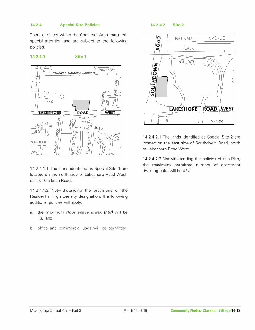
14.2.4 Special Site Policies
There are sites within the Character Area that merit special attention and are subject to the following policies.
14.2.4.1 Site 1
14.2.4.1.1 The lands identified as Special Site 1 are located on the north side of Lakeshore Road West, east of Clarkson Road.
14.2.4.1.2 Notwithstanding the provisions of the Residential High Density designation, the following additional policies will apply:
a. the maximum floor space index (FSI) will be 1.8; and
b. office and commercial uses will be permitted.
14.2.4.2 Site 2
14.2.4.2.1 The lands identified as Special Site 2 are located on the east side of Southdown Road, north of Lakeshore Road West.
14.2.4.2.2 Notwithstanding the policies of this Plan, the maximum permitted number of apartment dwelling units will be 424.

14-14 Community Nodes – Clarkson Village March 3, 2015 Mississauga Official Plan – Part 3
14.2.4.3 Site 3
14.2.4.3.1 The lands identified as Special Site 3 are located on the north side of Lakeshore Road West between Birchwood Park and Clarkson Road North.
14.2.4.3.2 The lands are encumbered by slope stability issues associated with Turtle Creek. Satisfactory technical reports addressing these issues are required prior to any development of these lands.
14.2.4.4 Site 4
14.2.4.4.1 The lands identified as Special Site 4 are located on the southeast corner of Lakeshore Road West and Southdown Road.
14.2.4.4.2 Notwithstanding the policies of this Plan, a maximum of two detached dwellings will be permitted.

Mississauga Official Plan – Part 3 March 11, 2016 Community Nodes – Clarkson Village 14-15
14.2.4.5 Site 5
14.2.4.5.1 The lands identified as Special Site 5 are located on the northeast corner of Lakeshore Road West and Walden Circle.
14.2.4.5.2 Notwithstanding the policies of this Plan, a 15 storey apartment building with a maximum floor space index (FSI) of 3.3 will be permitted.
14.2.4.6 Site 6
14.2.4.6.1 The lands identified as Special Site 6 are located on the north side of Lakeshore Road West, west of Clarkson Road North and east of the railway tracks, and are municipally known as 1865 Lakeshore Road West.
14.2.4.6.2 Notwithstanding the policies of this Plan, existing uses will be permitted as they existed on the day these policies come into effect in their current location. Alterations and minor expansions to existing uses in their current location/configuration will be permitted.
14.2.4.6.3 In accordance to Map 14-2.2: Access Management Plan – Clarkson Village Community Node Character Area within the policies of this Plan, a publicly accessible driveway easement will be provided to facilitate laneway access between 1865 Lakeshore Road West and the lands municipally known as 1829 Lakeshore Road West.
14.2.4.6.4 Notwithstanding the policies in this Plan, the following additional policies will apply to development:
a. the maximum residential floor space index
(FSI) will be 2.5; and
b. the maximum height will be eight storeys
14-16 Community Nodes – Dixie-Dundas August 11, 2015 Mississauga Official Plan – Part 3
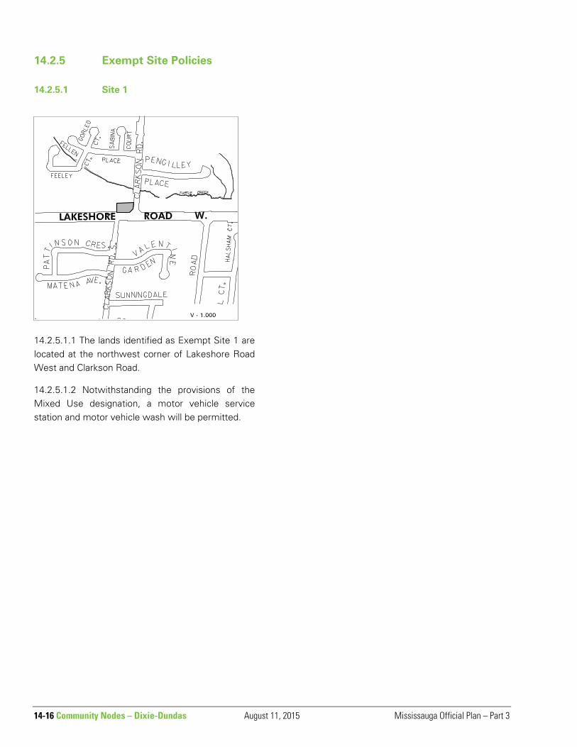
14.2.5 Exempt Site Policies
14.2.5.1 Site 1
14.2.5.1.1 The lands identified as Exempt Site 1 are located at the northwest corner of Lakeshore Road West and Clarkson Road.
14.2.5.1.2 Notwithstanding the provisions of the Mixed Use designation, a motor vehicle service station and motor vehicle wash will be permitted.

Mississauga Official Plan – Part 3 August 11, 2015 Community Nodes – Clarkson Village 14-17
14.3 Dixie-Dundas
The boundary of and official plan policies for lands within the Dixie-Dundas Community Node will be determined through a Local Area Plan review. Until such time as the Local Area Plan review is completed, the official plan policies are contained in the Dixie Employment Area Character Area Policies.
Map 14-3: Dixie-Dundas Community Node Character Area
14-18 Community Nodes – Malton April 8, 2021 Mississauga Official Plan – Part 3
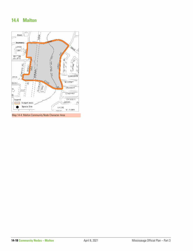
14.4 Malton
Map 14-4: Malton Community Node Character Area
Mississauga Official Plan – Part 3 April 8, 2021 Community Nodes – Meadowvale 14-19
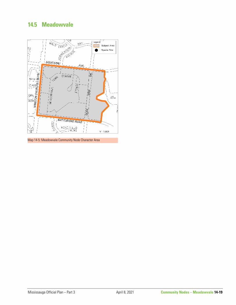
Map 14-5: Meadowvale Community Node Character Area
14.5 Meadowvale
14-20 Community Nodes - Port Credit August 11, 2015 Mississauga Official Plan – Part 3
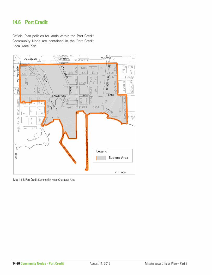
14.6 Port Credit
Official Plan policies for lands within the Port Credit Community Node are contained in the Port Credit Local Area Plan.
Map 14-6: Port Credit Community Node Character Area

Mississauga Official Plan – Part 3 April 8, 2021 Community Nodes - Rathwood-Applewood 14-21
14.7 Rathwood-Applewood 14.7.2 Special Site Policies
There are sites within the Character Area that merit special attention and are subject to the following policies.
14.7.2.1 Site 1
14.7.2.1.1 The lands identified as Special Site 1 are located north of Rathburn Road East and east of Dixie Road.
14.7.2.1.2 Notwithstanding the provisions of this Plan, townhouse dwellings will be permitted. The maximum floor space index (FSI) permitted for all development will be 2.56 and the maximum permitted height will be 20 storeys.
Map 14-7: Rathwood-Applewood Community Node Character Area

14-22 Community Nodes - Sheridan April 8, 2021 Mississauga Official Plan – Part 3
14.8 Sheridan
Map 14-8: Sheridan Community Node Character Area

Mississauga Official Plan – Part 3 April 8, 2021 Community Nodes – South Common 14-23
14.9 South Common
14.9.1 Special Site Policies
There are sites within the Character Area that merit special attention and are subject to the following policies.
14.9.9.1 Site 1
14.9.1.1.1 The lands identified as Special Site 1 are located on the north side of South Millway, west of Erin Mills Parkway.
14.9.1.1.2 Notwithstanding the policies of this Plan, townhouse dwellings will be permitted.
Map 14-9: South Common Community Node Character Area

14-24 Community Nodes - Streetsville August 11, 2015 Mississauga Official Plan – Part 3
14.10 Streetsville
14.10.1 Urban Design Policies
Community Identity and Focus
14.10.1.1 Development will be compatible with and enhance the village character of Streetsville as a distinct established community by integrating with the surrounding area.
14.10.1.2 Development with a high level of urban design, pedestrian amenity, landscaping and compact built form will be encouraged to create a strong sense of place and reinforce the role of the Community Node as the centre of activity for the surrounding community.
14.10.1.3 Queen Street South will remain the focus of the commercial core within the Streetsville Community Node.
14.10.1.4 The development of symbolic gateways to define entry to and exit from the Streetsville Community Node will be encouraged.
Historic Character14.10.1.1.2,
14.10.1.5 Alterations to heritage structures, including building repairs and additions, and/or alterations to existing vegetation which is part of the cultural heritage landscape, will be in keeping with the original character of the heritage resources to be preserved.
14.10.1.6 Designs for new buildings and additions will enhance the historic character and heritage context of the Streetsville Community Node through appropriate height, massing, architectural pattern, proportions, set back and general appearance.
14.10.1.7 Commercial signs will reflect the historic village character in the Streetsville Community Node. Hand painted wooden signs, projecting signs as permitted by municipal by-laws and other signs which reflect late nineteenth or early twentieth century practices will be encouraged.
14.10.1.8 The established residential character of the areas generally located along Queen Street South, south of Barry Avenue, will be maintained
Map 14-10: Streetsville Community Node Character Area
Mississauga Official Plan – Part 3 August 11, 2015 Community Nodes - Streetsville 14-25
through appropriate building masses, setbacks, intensive landscaping, streetscapes with many mature trees, and a regular street grid pattern.
14.10.1.9 The following will apply to lands designated Mixed Use:
a. development with a mix of residential and office uses on upper floors and street related commercial uses in closely spaced storefronts lining the street, will be encouraged along the principal streets in the Streetsville Community Node to promote an active pedestrian environment;
b. new buildings will be at least two storeys but not more than three storeys in height. Building additions will not be more than three storeys in height and will be generally harmonious in style and massing with the buildings to which they are attached;
c. the apparent height of new buildings will be reduced through massing and design;
d. new development will be encouraged to reflect the original lot pattern and setback dimensions of surrounding properties. The front setback of new buildings should match the setback of adjacent buildings so as to create a uniform street wall. Where the building setbacks on either side are not equal, the lesser setback should be used;
e. integrated parking opportunities, which may include rear lane access to combined parking areas and the development of private pay parking lots, will be encouraged where appropriate; and
f. development which enhances the streetscape through landscaping and the provision of pedestrian amenities will be encouraged along the principal streets within the Streetsville Community Node.
Public Realm
14.10.1.10 The placement of parking areas to the rear of buildings and the consolidation of driveways
will be encouraged along principal street frontages in the Streetsville Community Node to increase the area available for planting and public amenity.
14.10.1.11 The rear façades of developments which back onto places accessible to the public, including parking areas or laneways, should be designed to provide a level of detail, fenestration, and direct access appropriate to their role as secondary frontages.
14.10.2 Land Use
14.10.2.1 Notwithstanding the Residential Low Density I policies of this Plan, the Residential Low Density I designation permits only detached dwellings.
14.10.2.2 For lands designated Residential High Density a maximum building height of seven storeys is permitted.
14.10.2.3 In addition to the uses permitted by the Land Use Policies of this Plan, bed and breakfast establishments are permitted provided that they front upon Queen Street South, Main Street, Thomas Street or Church Street.
14.10.3 Heritage
14.10.3.1 Heritage resources will include those properties listed on the City's Heritage Register, but will not be restricted to the list.
14.10.3.2 Mississauga will encourage the investigation of the Streetsville historic core area as an area to be examined for future designation as a Heritage Conservation District in accordance with the Ontario Heritage Act.
14.10.4 Stormwater Management
14.10..4.1 A stormwater drainage report will be required to ensure that the existing drainage system has the capability to convey the increased storm flow from redevelopment in accordance with current City drainage standards.
14-26 Community Nodes - Streetsville August 11, 2015 Mississauga Official Plan – Part 3
14.10.5 Transportation
14.10.5.1 The maximum pavement width of Queen Street South, from Britannia Road West to the St. Lawrence and Hudson Railway, will not exceed a basic two lane cross-section, except for bus bays, on-street parking lanes, turning lanes at intersections and bicycle and pedestrian routes.
14.10.5.2 Main Street between Queen Street South and Church Street will not be widened to accommodate additional through traffic lanes. Minor modifications to this roadway for on-street parking, safety or maintenance will be permitted, however, major modifications which would have an adverse effect on the character of the roadway, will require an amendment to this Plan.
14.10.5.3 The City will continue to encourage and promote better utilization of the existing and future parking inventory through discussions with the members of the Streetsville Business Improvement Area (BIA), with a goal of developing a self-sufficient parking operation through measures such as parking charges.
14.10.6 Special Site Policies
There are sites within the Character Area that merit special attention and are subject to the following policies.
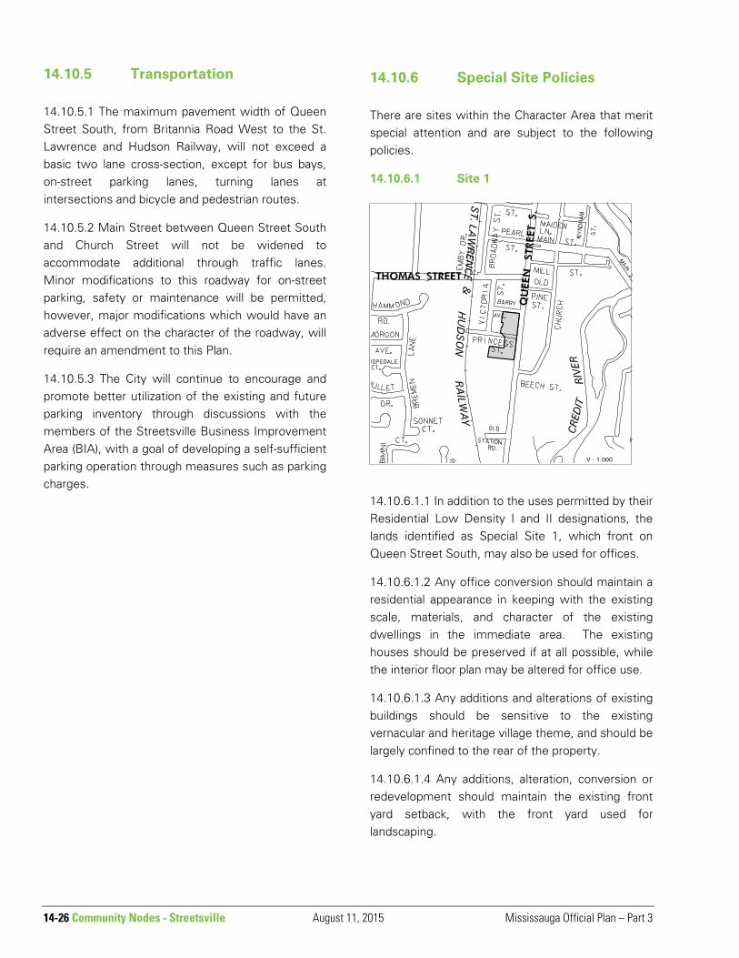
14.10.6.1 Site 1
14.10.6.1.1 In addition to the uses permitted by their Residential Low Density I and II designations, the lands identified as Special Site 1, which front on Queen Street South, may also be used for offices.
14.10.6.1.2 Any office conversion should maintain a residential appearance in keeping with the existing scale, materials, and character of the existing dwellings in the immediate area. The existing houses should be preserved if at all possible, while the interior floor plan may be altered for office use.
14.10.6.1.3 Any additions and alterations of existing buildings should be sensitive to the existing vernacular and heritage village theme, and should be largely confined to the rear of the property.
14.10.6.1.4 Any additions, alteration, conversion or redevelopment should maintain the existing front yard setback, with the front yard used for landscaping.

Mississauga Official Plan – Part 3 August 11, 2015 Community Nodes - Streetsville 14-27
14.10.6.1.5 Sufficient on-site parking, which will consist of only surface parking, as required by the Zoning By-law, should be provided in the rear yard only at grade without removal of existing trees, except at the discretion of the City arborist.
14.10.6.1.6 Vehicular entrances should be combined to minimize the number of access points on Queen Street South.
14.10.6.1.7 Minimal signage will be permitted. The design of such signage and external lighting should be compatible with the residential character of the area.
14.10.6.1.8 Existing lot sizes should be retained.
14.10.6.1.9 Rear yard drainage will be provided to the satisfaction of the City.
14.10.6.2 Site 2
14.11.6.2.1 The lands identified as Special Site 2 are located south of Tannery Street, north of Old Station Road, east of Joymar Drive and west of the St. Lawrence and Hudson Railway.
14.11.6.2.2 Notwithstanding the provisions of the Residential High Density, Residential Medium Density and Greenlands designations, the following additional policies will apply:
a. the determination of the area suitable for redevelopment will have regard for the extent of the "regulatory storm" floodplain and the erosion hazards associated with Mullet Creek, whichever is greater. The extent of areas required for conservation purposes will be determined to the satisfaction of Credit Valley Conservation and the City; and
b. building forms should consist of low profile buildings ranging in height from three storeys near Mullet Creek to six storeys near the railway tracks.
14.11.6.2.3 Redevelopment of Area A should include provision for a public road connecting Thomas Street and Tannery Street west of the St. Lawrence and Hudson Railway right-of-way.

14-28 Community Nodes - Streetsville August 11, 2015 Mississauga Official Plan – Part 3
14.10.6.3 Site 3
14.10.6.3.1 The lands identified as Special Site 3 are located north of Tannery Street, west of the St. Lawrence & Hudson Railway.
14.10.6.3.2 Notwithstanding the provisions of the Residential High Density designation, the following additional policies will apply:
a. the determination of the area suitable for redevelopment will have regard for the extent of the "regulatory storm" floodplain and the erosion hazards associated with Mullet Creek, whichever is greater. The extent of areas required for conservation purposes will be determined to the satisfaction of Credit Valley Conservation and the City;
b. redevelopment will include provision of a connecting public road between Rutledge Road and Tannery Street; and
c. a maximum of 397 dwelling units are permitted in a building form consisting of low profile buildings ranging in height from three storeys near Mullet Creek to six storeys near the railway tracks.
14.10.6.4 Site 4
14.10.6.4.1 The lands identified as Special Site 4 are located on the north side of Tannery Street, east of Crumbie Street.
14.10.6.4.2 Notwithstanding the provisions of the Residential High Density designation, an apartment building with a maximum floor space index (FSI) of 3.1 will be permitted.

Mississauga Official Plan – Part 3 August 11, 2015 Community Nodes - Streetsville 14-29
14.10.6.5 Site 5
14.10.6.5.1 The lands identified as Special Site 5 are located on the east and west sides of Queen Street South, the south side of Tannery Street, the east and west side of Broadway Street, the south side of
Pearl Street and the north and south sides of Thomas Street.
14.11.6.5.2 Notwithstanding the provisions of the Mixed Use designations, drive-through facilities will not be permitted.
14.10.6.6 Site 6
14.10.6.6.1 The lands identified as Special Site 6 are located on the west side of Queen Street South, north of Tannery Street.
14.10.6.6.2 Notwithstanding the provisions of the Mixed Use designation, lands identified as Area B and Area C will be permitted to develop for a residential apartment building ranging in height from three storeys to seven storeys with ground floor commercial uses.
14.10.6.6.3 Notwithstanding the provisions of the Mixed Use designation, drive-through facilities will not be permitted for lands identified as Area C and Area D.
14.10.6.6.4 Prior to development of lands identified as Area A and Area D, a concept plan will be required to address among other matters:

14-30 Community Nodes – Streetsville August 11, 2015 Mississauga Official Plan – Part 3
a. a connecting public road network linking Queen Street South with Crumbie Street and William Street; and
b. the location of additional public open space for recreational and library purposes.
14.10.7 Exempt Site Policies
14.10.7.1 Site 1
14.10.7.1.1 The lands identified as Exempt Site 1 are located east of the St. Lawrence and Hudson Railway tracks and north of Crumbie Street.
14.10.7.1.2 Notwithstanding the provisions of the Mixed Use designation, motor vehicle repair facilities will also be permitted.
14.10.7.1.3 Prior to development of lands, a concept plan will be required to address among other matters:
a. a connecting public road network linking Queen Street south with Crumble Street and William Street; and
b. the location of additional public open space for recreational and library purposes.
14.10.7.2 Site 2
14.10.7.2.1 The lands identified as Exempt Site 2 are located on the east side of Queen Street South, south of Mill Street.
14.10.7.2.2 Notwithstanding the provisions of the Mixed Use designation, motor vehicle repair
facilities will also be permitted.
Mississauga Official Plan – Part 3 August 11, 2015 Community Nodes - Streetsville 14-31
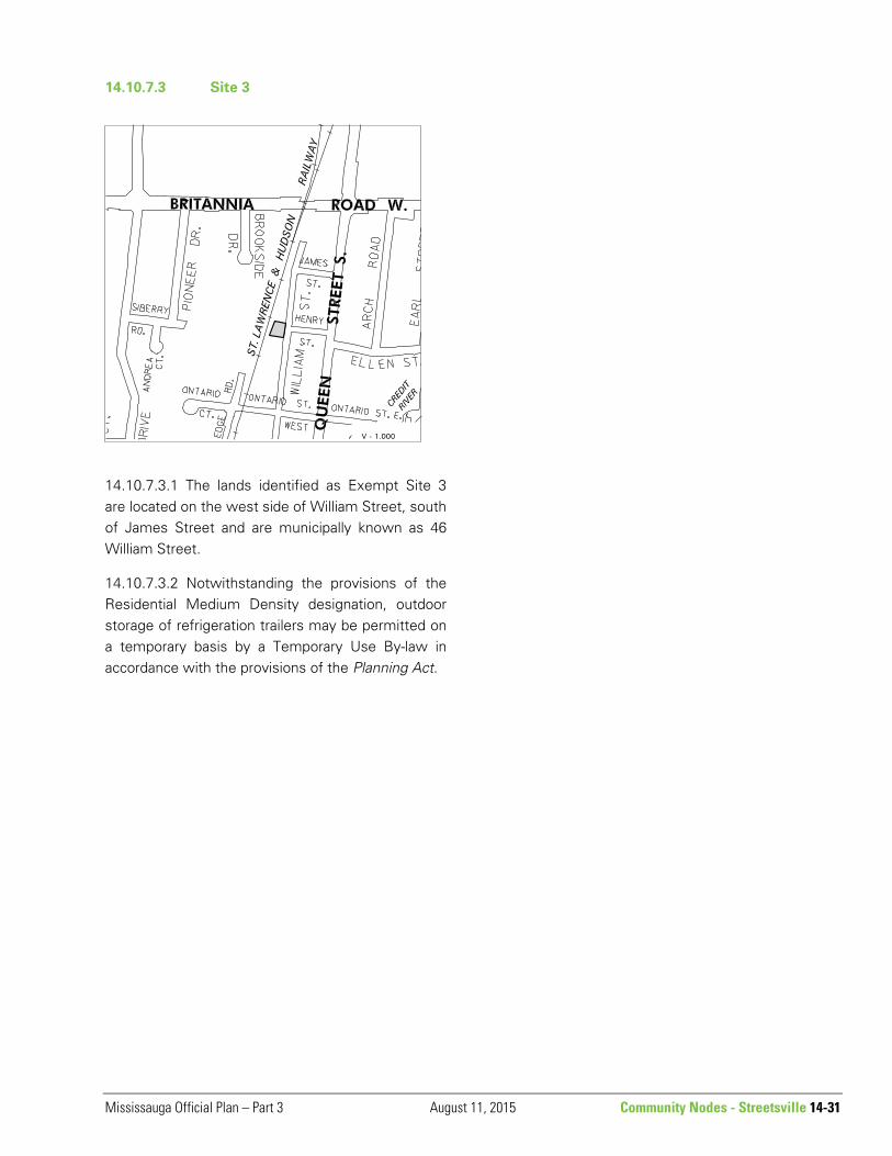
14.10.7.3 Site 3
14.10.7.3.1 The lands identified as Exempt Site 3 are located on the west side of William Street, south of James Street and are municipally known as 46 William Street.
14.10.7.3.2 Notwithstanding the provisions of the Residential Medium Density designation, outdoor storage of refrigeration trailers may be permitted on a temporary basis by a Temporary Use By-law in accordance with the provisions of the Planning Act.