2 alternatives 2.1 introduction - california
TRANSCRIPT

Chapter 2 Alternatives
California High-Speed Rail Authority May 2020
Burbank to Los Angeles Project Section Draft EIR/EIS Page | 2-1
2 ALTERNATIVES 2.1 Introduction This chapter describes the background and development of the California High-Speed Rail (HSR) System and its individual components. It also describes the background, development, and details of the alternatives preliminarily considered for the Burbank to Los Angeles Project Section of the HSR system and the reasons for selecting the alternatives to be studied in detail in this Environmental Impact Report/Environmental Impact Statement (EIR/EIS). Both of the alternatives discussed in this chapter are based on the alternatives selected by the California High-Speed Rail Authority (Authority) and the Federal Railroad Administration (FRA) at the conclusion of the Tier 1 EIR/EIS processes for the HSR system (Section 1.1.2, The Decision to Develop a Statewide High-Speed Rail System).
The Authority sought to identify reasonable and feasible project alternatives that would meet the purpose and need for the project (Chapter 1, Purpose, Need, and Objectives). Through the alternatives development process, the Authority identified those alternatives where environmental constraints or engineering challenges would justify dropping alternatives from further analysis, while retaining those alternatives that would be expected to avoid and/or minimize impacts on environmental and community resources. The process also provided comparative information and data highlighting similarities and differences between alternatives by using applicable state and federal standards, environmental impact criteria, design criteria, and construction/operational factors.
The Authority worked with community and agency stakeholders to vet the conceptual alternatives and to gather information used in developing and comparing alternatives, as follows.
The Authority and FRA selected the existing railroad right-of-way as the preferred corridor for the development of alignment alternatives between Sylmar and Los Angeles Union Station (LAUS) in the Final Program EIR/EIS for the Proposed California High-Speed Train System (2005 Statewide Program EIR/EIS; Authority and FRA 2005). The Sylmar to Los Angeles Tier 1 corridor included Burbank, which is to the southeast of Sylmar. Therefore, the Project EIR/EIS for the Burbank to Los Angeles Project Section focuses on alignment alternatives within and along the existing railroad corridor, as selected in 2005.
The Burbank to Los Angeles Project Section was initially considered as part of the Palmdale to Los Angeles Project Section. The Authority and FRA announced their intention to prepare a joint EIR/EIS for the Palmdale to Los Angeles Project Section in March 2007. Over the next several years, the Authority and FRA conducted scoping and prepared alternatives analysis documents for that section. In July 2014, the Authority released a Notice of Preparation and the FRA published a Notice of Intent to prepare separate EIR/EIS documents for the Palmdale to Burbank and Burbank to Los Angeles project sections.
In April 2016, the Authority released the Burbank to Los Angeles Project Section Supplemental Alternatives Analysis (SAA) and the Palmdale to Burbank Project Section SAA (Authority 2016a, 2016b), each of which covered a portion of the Burbank to Los Angeles Project Section. The portion from Alameda Avenue in Burbank to LAUS in Los Angeles was studied in the Burbank to Los Angeles Project Section SAA. The Burbank to Los Angeles Project Section SAA recommended carrying forward one HSR Build Alternative along with the No Project Alternative.
The portion from the Burbank Airport Station to Alameda Avenue was studied in the 2016 Palmdale to Burbank Project Section SAA (Authority 2016b). This SAA refined the concepts at the Burbank Airport Station and the alignments from south of the Burbank Airport Station to Alameda Avenue in the city of Burbank. The report proposed two station options and two alignment options from Burbank Airport to Alameda Avenue.
Project design refinements continued following the 2016 SAAs. The surface options from Burbank Airport to Alameda Avenue (Alignment Option A and Station Option A) were eliminated from consideration due to right-of-way impacts. The below-grade options from the Burbank Airport

Chapter 2 Alternatives
May 2020 California High-Speed Rail Authority
Page | 2-2 Burbank to Los Angeles Project Section Draft EIR/EIS
Station to Alameda Avenue (Alignment Option B and Station Option B) were refined further to minimize potential environmental impacts and reduce cost. While the two SAA documents effectively considered the Burbank to Los Angeles Project Section as two portions, this EIR/EIS analyzes the entirety of the Burbank to Los Angeles Project Section, from the Burbank Airport Station to LAUS. The design drawings that support the alternatives’ descriptions are included as Volume 3 (Alignments and Other Plans). This EIR/EIS analyzes the environmental impacts of implementing the Burbank to Los Angeles Project Section of the HSR system, including alternatives, direct and indirect impacts, cumulative impacts, indirect effects, and mitigation measures. The following appendices provide more detailed information on Burbank to Los Angeles Project Section characteristics: • Appendix 2-A, Roadway Crossings • Appendix 2-B, Impact Avoidance and Minimization Features • Appendix 2-C, Operations and Service Plan Summary • Appendix 2-D, Applicable Design Standards • Appendix 2-E, California High-Speed Rail Station Access and Egress Southern California
Mode Share Adjustment Methodology
Visit the Authority website (www.hsr.ca.gov) to view and download the EIR/EIS, request a CD-ROM EIR/EIS, or locate a library to review a printed copy of the environmental document. Printed copies of the EIR/EIS have been placed in public libraries in the following cities and communities: Sacramento, Burbank, Glendale, and Los Angeles. The following documents are also available at the Authority’s website: alternative analyses preceding preparation of the Project EIR/EIS; materials prepared for coordination with the U.S. Army Corps of Engineers (USACE) and the U.S. Environmental Protection Agency (USEPA) in compliance with Clean Water Act Section 404(b)(1) requirements; and technical reports developed for the environmental analyses presented in Chapter 3.
2.1.1 Independent Utility As discussed in Chapter 1, the Authority and FRA divided the HSR system they established with Tier 1 decisions into individual project sections for Tier 2 planning, environmental review, and decision making (Figure 1-2). The FRA, consistent with regulations issued by the Federal Highway Administration (FHWA), considers three criteria when determining the scope of a project to be considered in an EIS: (1) whether it connects “logical termini” and has “sufficient length to address environmental matters on a broad scope”; (2) whether it has “independent utility or independent significance,” meaning that it will “be usable and be a reasonable expenditure even if no additional transportation improvements in the area are made”; and (3) whether it will “restrict consideration of alternatives for other reasonably foreseeable transportation improvements” (23 Code of Federal Regulations 771.111(f)). “Logical termini” is defined by the FHWA as the rational starting and ending points for a transportation improvement project and for review of the environmental impacts of the project (FHWA 1993).1 The Burbank to Los Angeles Project Section connects logical termini at planned passenger stations where HSR service would be provided, at the Burbank Airport Station to the north and at LAUS to the south. If other sections of the HSR system are not completed, the infrastructure could be used by other passenger rail services to improve their capacity, reliability, and performance (Authority 2009). 1 The FHWA criteria for determining project scope, as established in 23 Code of Federal Regulations Part 771.111(f), do not specifically address the scope of individual projects considered in the second tier of a tiered National Environmental Policy Act (NEPA) process. With the tiered NEPA process, the same general principles apply, but they are applied in the context of the decisions made in Tier 1—in this case, the decision to build the HSR system as a whole. Therefore, in determining the scope of individual project sections for Tier 2 studies, the Authority has focused primarily on determining whether each project section could serve a useful transportation purpose on its own, and ensuring that a decision in one project section does not limit consideration of reasonable alternatives for completing the HSR system in an adjacent section for which the NEPA process has not yet been completed.

Chapter 2 Alternatives
California High-Speed Rail Authority May 2020
Burbank to Los Angeles Project Section Draft EIR/EIS Page | 2-3
The Burbank to Los Angeles Project Section would have independent utility if it is able to operate as a standalone project in the event the other project sections of the HSR system are not constructed. As none of the four types of maintenance facilities would be located within the limits of the Burbank to Los Angeles Project Section, all maintenance functions for vehicles and infrastructure would be handled through an independent contractor to achieve independent utility. For system power, one potential location for a traction power substation (TPSS) have been preliminarily identified within the project section. Because the addition of a TPSS would alter the spacing of the other system facilities, further design and environmental study would be required to environmentally clear the TPSS site and the alteration of the other system facilities in the absence of the Palmdale to Burbank and Los Angeles to Anaheim project sections being built and operated. Any electrical interconnections between a potential future TPSS site and existing utility providers would also have to be environmentally evaluated and cleared in subsequent documentation.
2.2 Background of the Burbank to Los Angeles Project Section EIR/EIS The Burbank to Los Angeles Project Section would be a critical link in the Phase 1 HSR system connecting San Francisco and the Bay Area to Los Angeles and Anaheim. The Authority and FRA relied on Program EIR/EIS documents (Section 1.1.2, The Decision to Develop a Statewide High-Speed Rail System) to select the existing railroad right-of-way as the preferred corridor for the development of alignment alternatives between Sylmar (to the east of Burbank) and LAUS in the 2005 Statewide Program EIR/EIS (Authority and FRA 2005). Therefore, the Burbank to Los Angeles Project Section EIR/EIS focuses on alignment alternatives within and along the existing railroad corridor. The Authority has actively engaged local representatives and public agencies, business interests, the general public, and the communities along the corridor in the development of the Burbank to Los Angeles Project Section. As part of this outreach, the Authority and the FRA in July 2014 began a project-level environmental review of the Burbank to Los Angeles Project Section consistent with California Environmental Quality Act (CEQA) and National Environmental Policy Act (NEPA) requirements. Scoping meetings were held in August 2014 to receive input on the scope of issues that should be analyzed in the EIR/EIS. A scoping report documenting the results of this process was published in November 2014, and 2014 Scoping Report Errata were published in April 2015.
2.3 High-Speed Rail System Infrastructure This section provides general information about the performance criteria, infrastructure components and systems, and function of the proposed HSR system as a whole. Section 2.5.2 provides detailed information on the HSR Build Alternative in the Burbank to Los Angeles Project Section, including alignment, traction power, and utility power locations. The Burbank to Los Angeles Project Section is in a dense, urban environment within an existing railroad corridor, and in many cases has several unique infrastructure needs that differ from the rest of the HSR system. The HSR system is envisioned as a state-of-the-art, electrically powered, high-speed, steel-wheel-on-steel-rail technology, and would employ the latest technology, safety, signaling, and automatic train control systems. The trains would be capable of operating at speeds of up to 220 miles per hour over fully grade-separated, dedicated track, with lower speeds in some areas with blended operations. On most of the HSR system, HSR trains would operate on dedicated and fully grade-separated tracks. In this project section, HSR trains would share new and upgraded tracks with passenger rail currently operating in the Los Angeles–San Diego–San Luis Obispo Rail (LOSSAN) Corridor. This shared-track arrangement is known as a “blended system and operations.”2 Freight rail would not operate on the shared track (unless under exceptional
2 The California HSR Business Plans (www.hsr.ca.gov/About/Business_Plans/) suggest blended railroad systems and operations. These terms refer to integrating the HSR system with existing intercity and commuter and regional rail systems through coordinated infrastructure (blended systems), including shared tracks and scheduling, ticketing, and other means (blended operations).

Chapter 2 Alternatives
May 2020 California High-Speed Rail Authority
Page | 2-4 Burbank to Los Angeles Project Section Draft EIR/EIS
cases). Instead, it would operate primarily on the non-electrified tracks, although the electrified tracks could accommodate freight rail if necessary.
The HSR infrastructure and systems of the HSR system consist of trains (rolling stock), tracks, grade-separated right-of-way, stations, train control, power systems, and maintenance facilities. The design of the HSR system includes a double-track rail system to accommodate planned project operational needs for high-capacity rail movement. Additionally, the HSR system safety criteria require avoidance of surface intersections on dedicated HSR alignments. Therefore, the system must be grade-separated3 from any other transportation system. This means that planning the HSR system would also require grade-separated overcrossings or undercrossings for roadways or roadway closures as well as modifications to existing systems that do not span the planned right-of-way.
2.3.1 System Design Performance, Safety, and Security The proposed California HSR System has been designed for optimal performance and to conform to industry standards and federal and state safety regulations (Table 2-1). The Burbank to Los Angeles Project Section of the HSR system would be a grade-separated and access-controlled guideway with intrusion protection (access-restricted fencing) along the railroad right-of-way. This means that the HSR infrastructure (e.g., mainline tracks and maintenance and storage facilities) would be designed to prevent access by unauthorized vehicles, persons, animals, and objects. The capital cost estimates, presented in Chapter 6 of this EIR/EIS, include allowances for appropriate intrusion protection (fences and walls), state-of-the-art communication, and access control. The design of the guideway would keep persons, animals, and obstructions off the tracks, and the ends of the HSR trainsets (train cars) would include a collision response management system to minimize the effects of a collision. All aspects of the HSR system would conform to the latest federal requirements regarding transportation security. The HSR trainsets would be pressure-sealed to maintain passenger comfort regardless of aerodynamic change, much like an airplane body does. Additional information regarding system safety and security is provided in Section 2.5.2.6 of this EIR/EIS.
HSR operation would follow safety and security plans developed by the Authority in cooperation with FRA. These plans include the following:
• A System Safety Program Plan, including a Safety and Security Certification Program, which would be developed during the preliminary engineering phase and refined during the final design and construction phases to address safety, security, and emergency response as it relates to the day-to-day operation of the system.
• A Threat and Vulnerability Assessment for security and a Preliminary Hazard Analysis and Vehicle Hazard Analysis for safety. These plans would be developed during the preliminary engineering phase to produce comprehensive design criteria for safety and security requirements mandated by local, state, or federal regulations and industry best practices.
• A Fire/Life Safety Program and a System Security Plan, which would be developed during the preliminary engineering phase. Under federal and state guidelines and criteria, the Fire/Life Safety Plan would address the safety of passengers and employees as it relates to emergency response. The System Security Plan would address design features of the project intended to maintain security at the stations, within the trackwork right-of-way, and onboard trains. Compliance with these measures would maximize the safety and security of passengers and employees of the HSR system so that adverse safety and security impacts would be less than significant.
3 In some instances, the HSR tracks would not be fully grade-separated, and the design would limit the speed of the trains to 110 miles per hour. This is the case within the neighboring Los Angeles to Anaheim Project Section.

Chapter 2 Alternatives
California High-Speed Rail Authority May 2020
Burbank to Los Angeles Project Section Draft EIR/EIS Page | 2-5
Table 2-1 High-Speed Rail Performance Criteria for Blended Project Sections
Category Criteria
System Design Criteria
▪ Electric propulsion system
▪ Fully grade-separated guideway (dedicated project sections); fully or partially grade-separated guideways (blended project sections)
▪ Fully access-controlled guideway with intrusion monitoring systems where required (dedicated project sections); limited-access guideway with intrusion monitoring and/or intrusion protection where required (blended project sections)
▪ Track geometry to maintain passenger comfort criteria (i.e., smoothness of ride, lateral or vertical acceleration less than 0.1 g)
System Capabilities
▪ Capable of traveling from San Francisco to Los Angeles in approximately 2 hours and 40 minutes
▪ All-weather/all-season operation
▪ Capable of a sustained vertical gradient of 2.5 percent without considerable degradation in performance
▪ Capable of operating parcel and special freight service as a secondary use
▪ Capable of safe, comfortable, and efficient operation at speeds over 200 miles per hour
▪ Capable of maintaining operations at three-minute headways
▪ Equipped with high-capacity and redundant communications systems capable of supporting fully automatic train control
System Capacity
▪ Fully dual-track mainline with off-line station stopping tracks (dedicated project sections); mixed-track configuration for project sections with blended systems/operations
▪ Capable of accommodating a wide range of passenger demand (up to 20,000 passengers per hour per direction)
▪ Capable of accommodating normal maintenance activities without disruption to daily operations
Level of Service ▪ Capable of accommodating a wide range of service types (express, semi-express/limited-stop, and local)
g = acceleration due to gravity HSR = high-speed rail
Design criteria would address FRA safety standards and requirements, as well as a possible Petition for Rule of Particular Applicability, which provides specifications for key design elements for the system. FRA is currently developing safety requirements for HSR systems for use in the U.S. and will require that the HSR safety regulations be met prior to revenue service operations. The following section describes those system components pertinent to the Burbank to Los Angeles Project Section.
2.3.2 Vehicles Although the exact vehicle type has not yet been selected, the environmental analyses considered the impacts associated with any of the HSR vehicles produced in the world that meet the Authority’s criteria. All of the world’s HSR systems in operation today use electric propulsion with power supplied by an overhead system. These include, among many others, the Train à Grande Vitesse in France, the Shinkansen in Japan and Taiwan, and the InterCity Express in Germany. Figure 2-1 shows examples of typical HSR systems.

Chapter 2 Alternatives
May 2020 California High-Speed Rail Authority
Page | 2-6 Burbank to Los Angeles Project Section Draft EIR/EIS
Figure 2-1 Examples of Japanese Shinkansen High-Speed Trains
The Authority is considering an electric multiple-unit concept that would equip several train cars (including both end cars) with traction motors, as compared to a locomotive-hauled train (i.e., one engine in the front and one in the rear). Each train car would have an active suspension, and each powered car would have an independent regenerative braking system (which returns power to the power system). The body would be made of lightweight but strong materials and would have an aerodynamic shape to minimize air resistance, much like a curved airplane body.
A typical train would be 9 to 11 feet wide, consisting of two trainsets, each approximately 660 feet long and consisting of eight cars. A train of two trainsets would seat up to 1,000 passengers and be approximately 1,320 feet long with 16 cars. Power would be distributed to each train car via the overhead contact system (OCS) (a series of wires strung above the tracks) and through a pair of pantographs4 that reach like antennae above the train (Figure 2-2). Each trainset would have a train control system that could be independently monitored with override control while also communicating with the systemwide Operations Control Center. Phase 1 HSR service is expected to require up to 78 sets of trains in 2040, depending on the HSR fares charged.
Figure 2-2 Example of an At-Grade Profile Showing Contact Wire System and Vertical
Arms of the Pantograph Power Pickups
Figure Error! No text of specified
style in document.-1 Example of an at-grade profile showing
contact wire system and vertical
arms of the pantograph power
4 A pantograph is a jointed framework conveying a current to a train, streetcar, or other electric vehicle from overhead wires.
pickups

Chapter 2 Alternatives
California High-Speed Rail Authority May 2020
Burbank to Los Angeles Project Section Draft EIR/EIS Page | 2-7
2.3.3 Stations The design of the station areas would provide intermodal connectivity, drop-off facilities, an entry plaza, a station building area for ticketing and support services, an indoor station room where passengers wait and access the HSR, and parking facilities. Station design has not progressed beyond the conceptual stage. Figure 2-3 shows examples of station components from existing systems overseas; Figure 2-4 shows a potential “functional” station and a plan view of various station components. The functional station is a basic design that could be more elaborate with cooperation from the local jurisdiction; the station has the potential to be an iconic building that would help define the downtown transit core.
Station Parking Facilities
Parking demand estimates are based on HSR system ridership forecasts that assume initial parking availability is unconstrained (i.e., 100 percent of parking demand is met). These projections provide a “high” starting point to inform discussions with cities where stations are proposed. Based on a constraints analysis undertaken in consultation with station cities, this project EIR/EIS identifies locations for parking facilities needed to satisfy the maximum forecast constrained demand. Station access facilities are anticipated to be developed over time in phases while also prioritizing access to the HSR system through modes such as transit, which could lead to lower parking demand. See the discussion on HSR system ridership and station area parking in Section 2.6.3 for additional information.
Figure 2-3 Examples of Existing Stations
Preliminary station planning and design are based on dimensional data from the Station Platform Geometric Design guidance (Authority 2010b) and volumetric data from the Station Program Design Guidelines (Authority 2011b), and incorporate the Authority’s Urban Design Guidelines (Authority 2011c). All stations would be designed in accordance with Americans with Disabilities Act accessibility guidelines. The Burbank to Los Angeles Project Section would include HSR stations near Hollywood Burbank Airport and at LAUS.

Chapter 2 Alternatives
May 2020 California High-Speed Rail Authority
Page | 2-8 Burbank to Los Angeles Project Section Draft EIR/EIS
Figure 2-4 Simulated and Plan Views of a Functional Station and Its Various Components

Chapter 2 Alternatives
California High-Speed Rail Authority May 2020
Burbank to Los Angeles Project Section Draft EIR/EIS Page | 2-9
2.3.3.1 Station Platforms and Trackway (Station Box) The station would provide platforms with sheltered areas and accessible circulation elements (e.g., stairs, elevators, and escalators) for passenger loading and unloading. Of the four tracks passing through the station, the two express (bypass) tracks (for trains that do not stop at the station) would be separated from those that stop at the station platforms. To allow enough distance for safe deceleration of trains, a platform track would diverge from each mainline track beginning 3,000 feet from the center of the 1,410-foot station platform. The acceleration track requires a reduced separation from platform to mainline. An additional stub-end refuge track would be provided to temporarily store HSR trains in the case of mechanical difficulty, for special scheduling purposes, and for daytime storage of maintenance-of-way work trains during periods when station and/or adjacent track maintenance is being performed. The combination of deceleration, acceleration, and refuge track extends the wider footprint of the four-track section up to a total distance of 6,000 feet.
Maintenance of Way
A train industry term that refers to repair and maintenance activity concerning the right-of-way and track, including track and roadway, buildings, signals, and communication and power facilities.
2.3.3.2 Station Building The station building would be adjacent to the primary entrance and plazas. The station building would be open to both patrons and visitors. Services within the station building may include initial ticketing and check-in, traveler’s aid and local information services, and concessions. Circulation linkages between the station building and the station platforms may include hallways, an access bridge to cross over railroad tracks, stairs, escalators, elevators, and moving sidewalks.
2.3.4 Infrastructure Components The infrastructure needed to operate high-speed trains has more stringent alignment requirements than those needed for lower-speed trains. The HSR Build Alternative for the Burbank to Los Angeles Project Section would use three different track profiles. These track types have varying profiles: low, near-the-ground tracks are at-grade; higher tracks are on retained fill (earth); and below-grade tracks are in a tunnel or trench. Types of bridges that might be built include full channel spans; large box culverts; or, for some wider river crossings, limited piers within the ordinary high-water channel. The various track profiles for the HSR system are described below.
2.3.4.1 At-Grade Profile At-grade profiles (Figure 2-5) are best suited for areas where the ground is relatively flat and where interference with local roadways is infrequent. The at-grade track would be built on compacted soil and ballast material (a thick bed of angular rock) to prevent subsidence or changes in the track surface from soil movement. To avoid potential disruption of service from floodwater, the rail would generally be built above the 100-year floodplain or higher in rural areas or small communities, or above the 200-year floodplain in urban or urbanizing areas. The height of the at-grade profile may vary to accommodate slight changes in topography and provide clearance for stormwater culverts and structures in order to allow water flow as well as occasional wildlife movement.

Chapter 2 Alternatives
May 2020 California High-Speed Rail Authority
Page | 2-10 Burbank to Los Angeles Project Section Draft EIR/EIS
Figure 2-5 Typical At-Grade Cross-Section
2.3.4.2 Retained Fill Profile Retained-fill profiles (Figure 2-6) are used when it is necessary to narrow the right-of-way within a constrained corridor to minimize property acquisition, or to transition between at-grade and elevated profiles. The guideway and tracks would be raised above the existing ground on a retained fill platform made of reinforced walls, much like a freeway ramp. Short retaining walls would protect the adjacent properties from a slope extending beyond the rail guideway.
Figure 2-6 Retained-Fill Typical Cross-Section

Chapter 2 Alternatives
California High-Speed Rail Authority May 2020
Burbank to Los Angeles Project Section Draft EIR/EIS Page | 2-11
2.3.4.3 Retained-Cut Profile Retained-cut profiles (Figure 2-7) are used when the rail alignment crosses under existing rail tracks, roads, highways, or in mountainous regions. This profile type is used only for short distances in highly urbanized and constrained situations. In some cases, it is less disruptive to the existing traffic network to depress the rail profile under these crossing roadways. Retaining walls would typically be needed to protect the adjacent properties from a cut slope extending beyond the rail guideway. Retained-cut profiles are also used for roads or highways when it is more desirable to depress the roadway underneath a surface HSR alignment.
Figure 2-7 Retained-Cut Typical Cross-Section
2.3.4.4 Tunnel Profile Tunnel profiles (Figure 2-8 and Figure 2-9) are used when the rail alignment traverses highly variable topography or highly constrained, densely developed urban situations. Tunnel profiles reduce track distance and curvature needed to maintain acceptable vertical grades and horizontal curvature in mountainous terrain. Tunnels may be used in dense urban settings to avoid land use or traffic disruptions.
The primary methods for tunnel construction in the Burbank to Los Angeles Project Section are sequential excavation method (SEM) and cut-and-cover. An SEM tunnel allows for minimal surface disruption during construction. Surface disruption is limited to the tunnel entry and exit points. A cut-and-cover tunnel is constructed by open-cut methods to construct the tunnel in open air and then bury it with soil to create a tunnel.

Chapter 2 Alternatives
May 2020 California High-Speed Rail Authority
Page | 2-12 Burbank to Los Angeles Project Section Draft EIR/EIS
Figure 2-8 Typical Tunnel Cross-Section
Figure 2-9 Cut-and-Cover Tunnel Typical Cross-Section
Chapter 2 Alternatives
California High-Speed Rail Authority May 2020
Burbank to Los Angeles Project Section Draft EIR/EIS Page | 2-13
2.3.4.5 Elevated Profile Elevated profiles can be used in urban areas where extensive road networks must be maintained. An elevated profile must have a minimum clearance of approximately 16.5 feet over roadways and approximately 24 feet over railroads. Pier supports are typically approximately 10 feet in diameter at the ground. Such structures could also be used to cross waterbodies; even though the trackway might be at-grade on either side, the width of the water channel could require a bridge at the same level, which would be built in the same way as the elevated profile. Elevated profiles are included within some project sections of the HSR system, but the Burbank to Los Angeles Project Section does not contain an elevated trackway.
2.3.5 Grade Separations An optimal operating HSR system consists of a fully grade-separated and access-controlled guideway. The following list describes possible scenarios throughout the HSR system for HSR grade separations for roadways, irrigation and drainage facilities, and wildlife:
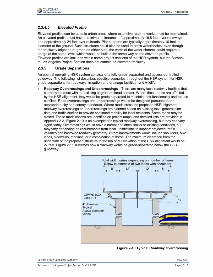
• Roadway Overcrossings and Undercrossings—There are many local roadway facilities that currently intersect with the existing at-grade railroad corridor. Where these roads are affected by the HSR alignment, they would be grade-separated to maintain their functionality and reduce conflicts. Road overcrossings and undercrossings would be designed pursuant to the appropriate city and county standards. Where roads cross the proposed HSR alignment, roadway overcrossings or undercrossings are planned based on existing local general plan data and traffic studies to provide continued mobility for local residents. Some roads may be closed. These modifications are identified on project maps, and detailed lists are provided in Appendix 2-A. Figure 2-10 is an example of a typical roadway overcrossing, but they can vary significantly. Overcrossings would have a number of lanes similar to existing conditions, but may vary depending on requirements from local jurisdictions to support projected traffic volumes and improved roadway geometry. Street improvements would include shoulders, bike lanes, sidewalks, medians, or a combination of these. The minimum clearance from the underside of the proposed structure to the top of rail elevation of the HSR alignment would be 27 feet. Figure 2-11 illustrates how a roadway would be grade-separated below the HSR guideway.
Figure 2-10 Typical Roadway Overcrossing

Chapter 2 Alternatives
May 2020 California High-Speed Rail Authority
Page | 2-14 Burbank to Los Angeles Project Section Draft EIR/EIS
Figure 2-11 Typical Cross-Section of Roadway Grade-Separated Beneath the
High-Speed Rail Guideway
• Irrigation and Drainage Facilities—The HSR alignment would affect some existing irrigation and drainage facilities. Depending on the extent of the impact, existing facilities would be modified, improved, or replaced as needed to maintain existing irrigation and drainage functions and support HSR drainage requirements. Types of drainage crossings that might be built include drainage overcrossings (bridges); large box culverts; or, for some wider river crossings, limited piers within the ordinary high-water channel.
• Wildlife Crossing Structures—Wildlife crossing opportunities would be available through a variety of engineered structures. In addition to dedicated wildlife crossing structures, wildlife crossing opportunities would also be available via combined roadway and wildlife overcrossings, combined drainage and wildlife overcrossings, and undercrossings.
Because it is a densely populated urban area and the proposed design would not impede wildlife movements, no dedicated wildlife crossing structures would be provided for the Burbank to Los Angeles Project Section.
2.3.6 Traction Power Distribution California’s electricity grid would power the proposed HSR system. The HSR system is expected to require less than 1 percent of the state’s future electricity consumption. In 2008, a study performed by Navigant Consulting, Inc. found that while the HSR system would be supplied with energy from the California grid, it is not feasible to physically control the flow of electricity from particular sources (Navigant Consulting, Inc. 2008). However, it would be feasible for the Authority to obtain the quantity of power required for the HSR system from 100 percent clean, renewable energy sources through a variety of mechanisms, such as paying a clean-energy premium for the electricity consumed. In 2014, the Authority verified the feasibility of powering the HSR system with 100 percent renewable energy (Authority 2014a).

Chapter 2 Alternatives
California High-Speed Rail Authority May 2020
Burbank to Los Angeles Project Section Draft EIR/EIS Page | 2-15
The project would not include the construction of a separate power source, although it would include the extension of underground or overhead power transmission lines to a series of power substations positioned along the HSR corridor. These power substations are needed to even out the power feed to the train system. Working in coordination with power supply companies, and per design requirements, the Authority has identified frequency and right-of-way requirements for these facilities.
Trains would draw electric power from an OCS, with the running rails acting as the other conductor. The OCS would consist of a series of mast poles approximately 23.5 feet higher than the top of the rail, with contact wires suspended from the mast poles between 17 and 19 feet from the top of the rail. The train would have an arm, called a pantograph, to maintain contact with this wire to provide power to the train. The mast poles would be spaced approximately every 200 feet along straight portions of the track and every 70 feet in tight-turn track areas. The OCS would be connected to the substations, which are required at approximately 30-mile intervals. Statewide, the power supply would consist of a 2-by-25-kilovolt OCS for all electrified portions of the statewide system.
2.3.6.1 Traction Power Substations Based on the HSR system’s estimated power needs, TPSSs would each need to be approximately 32,000 square feet (200 feet by 160 feet) and be located at approximately 30-mile intervals. Figure 2-12 shows a typical TPSS. Figure 2-13 shows a typical TPSS OCS feeder gantry.
Figure 2-12 Traction Power Substation

Chapter 2 Alternatives
May 2020 California High-Speed Rail Authority
Page | 2-16 Burbank to Los Angeles Project Section Draft EIR/EIS
Figure 2-13 Traction Power Substation Overhead Contact System Gantry
TPSSs would require a buffer area around them for safety purposes. Electrical substations would be built where high-voltage power lines cross near the HSR alignment. The TPSSs and associated feeder gantries could be screened from view with a perimeter wall or fence. Each TPSS site would have a 20-foot-wide access road (or easement) from the street access point to the protective fence perimeter at each parcel location. Each site would require a parcel of up to 2 acres.
A TPSS is not required for the Burbank to Los Angeles Project Section because of the HSR-required spacing requirements. TPSSs in adjacent sections would service the Burbank to Los Angeles Project Section. TPSSs would be within the adjacent Palmdale to Burbank and Los Angeles to Anaheim project sections, near Sun Valley and the city of Vernon, respectively. For purposes of independent utility, however, three potential locations for a TPSS have been preliminarily identified within the Burbank to Los Angeles Project Section. Because the addition of a TPSS would alter the spacing of the other system facilities, further design and environmental study would be required to environmentally clear the TPSS site, electrical interconnections, and the alteration of the other system facilities in the Burbank to Los Angeles Project Section if the adjacent project sections were not built and in operation.
2.3.6.2 Switching and Paralleling Stations Switching and paralleling stations work together to balance the electrical load between tracks and to switch power off or on to either track in the event of an emergency. Switching stations (Figure 2-14) would be required at approximately 15-mile intervals, midway between the TPSSs. These stations would need to be approximately 14,400 square feet (160 feet by 90 feet) in size. A switching station is proposed for the Burbank to Los Angeles Project Section in the city of Los Angeles, south of Verdant Street and west of the railroad right-of-way.

Chapter 2 Alternatives
California High-Speed Rail Authority May 2020
Burbank to Los Angeles Project Section Draft EIR/EIS Page | 2-17
Figure 2-14 Switching Station
Paralleling stations (Figure 2-15 and Figure 2-16) would be required at approximately 5-mile intervals between the switching stations and the TPSSs. The paralleling stations would need to be approximately 9,600 square feet (120 feet by 80 feet) in size. Each station would include an approximately 450-square-foot (18 feet by 25 feet) control room. A paralleling station is proposed for the Burbank to Los Angeles Project Section in the city of Los Angeles south of Main Street between the railroad right-of-way and Los Angeles River.
Figure 2-15 Paralleling Station

Chapter 2 Alternatives
May 2020 California High-Speed Rail Authority
Page | 2-18 Burbank to Los Angeles Project Section Draft EIR/EIS
Figure 2-16 Paralleling Station Overhead Contact System Gantry
The switching and paralleling stations and associated feeder gantries could be screened from view with a perimeter wall or fence. TPSSs, traction power switching, and paralleling stations are included in each alternative design as appropriate.
2.3.6.3 Backup and Emergency Power Supply Sources for Stations and Facilities
During normal system operations, power would be provided by the local utility service (Burbank Water and Power, Glendale Water and Power, and the Los Angeles Department of Water and Power), or from the TPSS. Should the flow of power be interrupted, the system will automatically switch to a backup power source through use of an emergency standby generator, an uninterruptable power supply, or a direct-current battery system.
For the Burbank to Los Angeles Project Section, permanent emergency standby generators are anticipated to be located at maintenance facilities. These standby generators are required to be tested (typically once per month for a short duration) in accordance with National Fire Protection Association 110/111 to ensure their readiness for backup and emergency use. If needed, portable generators could also be transported to other trackside facilities to reduce the impact on system operations.
2.3.6.4 Electric Power Utility Improvements Providers of electric power service, such as Southern California Edison or the Los Angeles Department of Water and Power, will provide the necessary electrical service, including high-voltage electrical lines and substations, for the operation of the HSR system. Electric power providers have indicated that new lines and facilities need to be built and that existing lines and facilities need to be upgraded or reconductored to serve the system. The work required in constructing, upgrading, or reconductoring high-voltage electrical lines and/or substations may include the installation of new equipment, support structures, and power poles/structures. When electrifying the HSR system, electric power providers will design and implement changes to the system’s high-voltage electrical lines, including height clearances of the existing electrical lines, and constructing or upgrading utility switching stations and/or utility substations. The project description and the HSR Build Alternative analyzed in this EIR/EIS have incorporated preliminary utility system improvements provided by electric power providers.

Chapter 2 Alternatives
California High-Speed Rail Authority May 2020
Burbank to Los Angeles Project Section Draft EIR/EIS Page | 2-19
This environmental document will support the electric power providers’ permit application or notice of construction to the California Public Utilities Commission for a permit/concurrence for regulated utilities prior to construction. The locations of electrical improvements were determined through a preliminary engineering assessment. In the absence of formal agreements between the Authority and utility providers, assumptions about capacity and site access have been made. Where electrical improvements are anticipated to be necessary for the Burbank to Los Angeles Project Section, construction activities would occur within existing substations and electrical line areas. Existing electrical facilities would not need to be relocated or require additional lands for electrical improvements. The locations of electrical improvements were determined based on known parameters and system spacing requirements, and are subject to future coordination with the utility provider. The proposed locations are described in more detail in Section 2.5.2.5.
Elements of electric power utility improvements include, but are not limited to:
• Reconductoring—Upgrading electric wires maintains transmission efficiency over time and can increase the capacity of an existing line. This is accomplished by renewing the old conductor (line refurbishment) or replacing standard conductors with those of the latest generation (line improvement). This includes necessary structural reinforcements and/or replacements.
• Switching Station—This is a substation without transformers and operating at a single voltage level. There are collector and distribution stations that are sometimes used for switching the current to backup lines or for parallelizing circuits in the event of a failure. Note that switching stations will typically be designed by the Authority and therefore not under the purview of the California Public Utilities Commission.
• Substation Upgrade—Upgrades will enable existing substations to transform voltage from high to low, or the reverse.
2.3.7 Signaling and Train-Control Elements In order to reduce the safety risks associated with freight and passenger trains, the National Transportation Safety Board, FRA, and other agencies have mandated positive train control (PTC). PTC is a train safety system designed to automatically implement safety protocols and provide communication with other trains to reduce the risk of a potential collision. The U.S. Rail Safety Improvement Act of 2008 requires the implementation of PTC technology across most railroad systems; in October 2015, Congress extended the deadline for implementation to December 31, 2018. The FRA published the Final Rule regarding PTC regulations on January 15, 2010.
Communication towers and ancillary facilities are included in the project section to implement the FRA PTC requirements. PTC infrastructure consists of integrated command, control, communications, and information systems for controlling train movements that improve railroad safety by significantly reducing the probability of collisions between trains, casualties to roadway workers and equipment, and over-speed accidents. PTC is especially important in “blended” corridors where passenger and freight trains need to safely share the same tracks. In the Burbank to Los Angeles Project Section, freight rail would not operate on the shared track (unless under exceptional cases). Instead, it would operate primarily on the non-electrified tracks, although the electrified tracks could accommodate freight rail if necessary.
PTC in the HSR system would use a radio-based communications network that would include a fiber optic backbone and communications towers approximately every 2 to 3 miles, depending on the terrain and selected radio frequency. The towers would be in the fenced HSR corridor in a fenced area of approximately 25 feet by 40 feet, including a 10-foot-by-8-foot communications shelter and a 6- to 8-foot diameter, 100-foot-tall communications pole. These communications facilities could be co-located within the TPSSs. Where communications towers cannot be located with TPSSs or other HSR facilities, the communications facilities would be near the HSR corridor in a fenced area of approximately 25 feet by 40 feet.

Chapter 2 Alternatives
May 2020 California High-Speed Rail Authority
Page | 2-20 Burbank to Los Angeles Project Section Draft EIR/EIS
Metrolink has implemented PTC throughout its entire network with the help of funding from the Authority. Within the Burbank to Los Angeles Project Section, HSR would share right-of-way and/or tracks with Metrolink.
2.3.8 Track Structure The track structure would consist of either a direct fixation system (with track, rail fasteners, and slab) or ballasted track, depending on local conditions and decisions to be made in later design. Ballasted track requires more frequent maintenance than slab track, but is less expensive to install.
For purposes of environmental review, slab track is assumed for tunnel and trench sections and ballasted track is assumed for all other sections, except where clearance requirements restrict the type of track construction assumed.
2.3.9 Maintenance Facilities The California HSR System includes four types of maintenance facilities: maintenance of infrastructure facilities (MOIF), maintenance of infrastructure siding facilities (MOIS), heavy maintenance facilities (HMF), and light maintenance facilities (LMF). These four types of facilities are described below. The HSR system would require only one HMF, which would be in the Central Valley. The design and spacing of maintenance facilities along the HSR system would not require the Burbank to Los Angeles Project Section to include any of the maintenance facilities within the limits of the project section.
For purposes of environmental analysis, the Authority has defined each project section to have the capability to operate as a standalone project in the event that other project sections of the HSR system are not constructed. Because this project section does not provide an HMF or MOIF, an independent contractor would need to be retained to handle all maintenance functions for vehicles and infrastructure if this project section were built as a standalone project.
2.3.9.1 Maintenance of Infrastructure Facilities The HSR system’s infrastructure would be maintained from regional MOIFs located at approximately 150-mile intervals. Each MOIF is estimated to be approximately 28 acres in size and would provide a location for regional maintenance machinery servicing storage, materials storage, and maintenance and administration. The MOIFs could be co-located with the MOIS within each 75-mile segment. The MOIFs would be located outside the Burbank to Los Angeles Project Section. Additionally, maintenance-of-way facilities, where HSR trains would be inspected and some maintenance/repair activities would take place, would be located in other HSR sections.
2.3.9.2 Maintenance of Infrastructure Siding Facilities The MOIS would be centrally located within the 75-mile maintenance sections on either side of each MOIF, outside the Burbank to Los Angeles Project Section. Each MOIS would support MOIF activities by providing a layover location for maintenance of infrastructure equipment and temporary storage of materials. The MOIS is estimated to be about 4 acres in size.
2.3.9.3 Heavy Maintenance Facility Only one HMF would be required for the HSR system and it would be within either the Merced to Fresno Project Section or the Fresno to Bakersfield Project Section. The HMF would include all activities associated with train fleet assembly, disassembly, and complete rehabilitation; all on-board components of the trainsets; and overnight layover accommodations and servicing facilities. The site would include a maintenance shop, a yard Operations Control Center building, one TPSS, other support facilities, and a train interior cleaning platform.
Chapter 2 Alternatives
California High-Speed Rail Authority May 2020
Burbank to Los Angeles Project Section Draft EIR/EIS Page | 2-21
2.3.9.4 Light Maintenance Facility An LMF would be used for all activities associated with fleet storage, cleaning, repair, overnight layover accommodations, and servicing facilities. The LMF closest to the Burbank to Los Angeles Project Section would be sited in proximity to LAUS within the Los Angeles to Anaheim Project Section.
2.4 Alternatives Considered during the Alternatives Screening Process The range of alternatives was developed using a tiered approach, which began with the 2005 Statewide Program EIR/EIS (Authority and FRA 2005). The following regulations and guidance support this approach:
• CEQ NEPA Implementing Procedures Section 1502.14 (Alternatives including the proposed action) and Section 1502.20 (Tiering)
• Procedures for Considering Environmental Impacts (FRA 1999) • CEQA Guidelines Section 15126.6 (Consideration and Discussion of Alternatives to the
Proposed Project) and Section 15152 (Tiering) • California Public Resources Code Section 21068.5 (Tiering or Tier) • FRA High-Speed Intercity Passenger Rail Program Guidance5
Following the program-level decisions based on the 2005 Statewide Program EIR/EIS (see Section 1.1.2, The Decision to Develop a Statewide High-Speed Rail System), the Authority, in cooperation with the FRA, began the environmental review process for the Burbank to Los Angeles Project Section of the California HSR Project.
The Burbank to Los Angeles Project Section was initially considered as part of the Palmdale to Los Angeles Project Section. The Authority and FRA announced their intention to prepare a joint Tier 2 EIR/EIS for the Palmdale to Los Angeles Project Section in March 2007. Over the next several years, the Authority and FRA conducted scoping and prepared alternatives analysis documents for that section. As described further below, the Authority and the FRA elected to split the Palmdale to Los Angeles Project Section, resulting in the currently proposed Burbank to Los Angeles Project Section.
The environmental review process for the Burbank to Los Angeles Project Section included publication of a NEPA Notice of Intent and CEQA Notice of Preparation (published July 24, 2014), and an agency and public scoping process. After analysts with the Authority identified the initial group of potential alternatives, they developed alignment plans, preliminary profile concepts, and cross-sections. They also informed the development of initial alternatives for the screening evaluation. Initial alternatives were developed and screened in coordination with the NEPA/404/408 Integration process.
The following summarizes the Burbank to Los Angeles Project Section alternatives development and analysis process and results.
2.4.1 High-Speed Rail Project-Level Alternatives Development Process The purpose of the Alternatives Analysis is to determine a reasonable range of HSR alternatives that the EIR/EIS will analyze in detail. A number of project alternatives were preliminarily developed and analyzed in the Alternatives Analysis Process described below to determine which alternatives would be carried forward into the EIR/EIS for detailed evaluation.
5 Federal Railroad Administration, “HSIPR NEPA Guidance and Table,” www.fra.dot.gov/Page/P0262 (accessed March 20, 2017).

Chapter 2 Alternatives
May 2020 California High-Speed Rail Authority
Page | 2-22 Burbank to Los Angeles Project Section Draft EIR/EIS
2.4.1.1 Project Definition Framework and Alternative Development HSR project definition begins with the corridor and station locations selected by the Authority and FRA in the 2005 Statewide Program EIR/EIS (Authority and FRA 2005) and concludes with the identification of the Preferred Alternative in this EIR/EIS.
2.4.1.2 Summary of High-Speed Rail Project-Level Alternatives Development Process
An EIR/EIS is required to analyze the potential impacts of a range of reasonable alternatives (California Code of Regulations Title 14, §15126.6; Code of Federal Regulations Title 40, Part 1502.14(a)). Under CEQA, the alternatives are to include a No Project Alternative and a range of potentially feasible alternatives that would (1) meet most of the project’s basic objectives and (2) avoid or substantially lessen one or more of the project’s significant adverse effects (14 California Code of Regulations Title 14, § 15126.6(c)). In determining the alternatives to be examined in the EIR, the lead agency must describe its reasons for excluding other potential alternatives. There is no ironclad rule governing the range of alternatives to be studied in an EIR other than the “rule of reason.” Under the “rule of reason,” an EIR is required to study a sufficient range of alternatives in order to permit a reasoned choice (California Code of Regulations Title 14, § 15126.6(f)). It is not required that all possible alternatives be studied.
Under NEPA, an EIR/EIS is required to analyze reasonable alternatives to the proposed action, including the No Action Alternative (40 Code of Federal Regulations § 1502.14). Pursuant to Section 14(l) of the FRA’s Procedures for Considering Environmental Impacts (FRA 1999), these include “all reasonable alternative courses of action that could satisfy the [project’s] purpose and need” (Federal Register, Volume 64, Page 28546). The range of alternatives should include those that are technically and economically practical and feasible. There is no minimum number of alternatives that must be considered in an EIS, and consideration of a single build alternative is permissible when there are no other reasonable alternatives.
The development of project-level alternatives followed the process described in Alternatives Analysis Methods for Project-Level EIR/EIS, Version 3 (Authority 2010a). The assessment of potential alternatives involved both qualitative and quantitative measures that address applicable policy and technical considerations. These included the following:
• Field inspections of corridors
• Project team input and review considering local issues that could affect alignments
• Qualitative assessment of constructability, accessibility, operations, maintenance, right-of-way, public infrastructure impacts, railway infrastructure impacts, and environmental impacts
• Engineering assessment of project length, travel time, and configuration of key features of the alignment, such as the presence of existing infrastructure
• Geographic-information-system-based analysis of impacts on farmland, water resources, wetlands, threatened and endangered species, cultural resources, current urban development, and infrastructure
The potential alternatives were evaluated against the HSR system performance criteria contained in the Authority’s Technical Memorandum for the Alternatives Analysis Methods for Project EIR/EIS (i.e., travel, time, route length, intermodal connections, capital costs, operating costs, and maintenance costs) (Authority 2009). Screening also included environmental criteria to measure the potential effects of the proposed alternatives on the natural and human environment. The land use criteria measured the extent to which a station alternative supports transit use; is consistent with existing adopted local, regional, and state plans; and is supported by existing and future growth areas. Constructability measured the feasibility of construction and the extent to which right-of-way is obtainable or constrained. Community impacts measured the extent of disruption to neighborhoods and communities, such as the potential to minimize (1) right-of-way acquisitions, (2) dividing an established community, and (3) conflicts with community resources. Environmental resources and quality measured the extent to which an alternative minimizes impacts on natural resources.

Chapter 2 Alternatives
California High-Speed Rail Authority May 2020
Burbank to Los Angeles Project Section Draft EIR/EIS Page | 2-23
The Authority and FRA considered the input of the public and interested resource agencies when developing the reasonable range of alternatives. Pursuant to NEPA and CEQA, scoping meetings were held to invite public participation in defining the scope of the analysis, including the range of reasonable alternatives.
2.4.2 Range of Potential Alternatives Considered and Findings The California HSR Authority Burbank to Los Angeles Project Section Staff Report on the Preferred Alternative (Authority 2018a) describes the range of potential alternatives considered and findings for the Burbank to Los Angeles Project Section. This section summarizes the finding of that Staff Report and describes the background, development, and details of the alternatives preliminarily considered for the Burbank to Los Angeles Project Section and the reasons for selecting the alternatives to be studied in detail in this EIR/EIS. The HSR Build Alternative discussed in this section is based on the corridor alternative selected by the Authority and FRA at the conclusion of the Tier 1 EIR/EIS processes.
The Burbank to Los Angeles Project Section begins at the Burbank Airport Station (at Hollywood Burbank Airport) and crosses the cities of Burbank, Glendale, and Los Angeles before terminating at LAUS in downtown Los Angeles, primarily within an existing, active railroad right-of-way. This existing railroad right-of-way is 14 miles long and is currently owned by the Los Angeles County Metropolitan Transportation Authority (Metro), while the National Railroad Passenger Corporation (Amtrak), Metrolink (governed by the Southern California Regional Rail Authority), and Union Pacific Railroad (UPRR) operate passenger and freight service along the corridor. The Burbank to Los Angeles Project Section shares this railroad corridor. This project section would be within a narrow and constrained urban environment, crossing major streets and highways, and in some areas would be adjacent to the Los Angeles River. In Los Angeles County, Metro owns the railroad right-of-way, the Southern California Regional Rail Authority owns the track and operates the Metrolink commuter rail service, Amtrak provides intercity passenger service, and UPRR holds track access rights and operates freight trains. Figure 2-21, provided later in this chapter, shows an overview of this project section. Section 2.5.2 includes details and figures for this project section.
The Burbank to Los Angeles Project Section was originally part of the larger Palmdale to Los Angeles Project Section. Various corridor alternatives for the Palmdale to Los Angeles Project Section were evaluated in the 2005 Statewide Program EIR/EIS (Authority and FRA 2005). Of the various corridor alternatives considered, the existing Metro/Metrolink rail corridor was ultimately selected as the preferred corridor for the Los Angeles Basin portion of the Palmdale to Los Angeles Project Section. In the subsequent 2010 Preliminary Alternatives Analysis (PAA) and 2011 Palmdale to Los Angeles Supplemental Alternatives Analysis (SAA), specific alignment alternatives within or in the vicinity of the existing Metro/Metrolink rail corridor were introduced, evaluated, and either withdrawn or carried forward (Authority 2010c, 2011d). The 2010 PAA recommended alignment alternatives and station options in the Los Angeles Basin based on refinements to the program-level corridor selected in 2005. The SAA focused specifically on the subsections from the community of Sylmar to LAUS.
In 2014, the Palmdale to Los Angeles Project Section was split into two project sections: Palmdale to Burbank and Burbank to Los Angeles. The split was in response to the 2014 Business Plan, which proposed an initial operating segment as a part of the implementation strategy, with service beginning between the Central Valley and San Fernando Valley. The Authority and FRA determined that the Burbank station would be the logical terminus in the San Fernando Valley, and that it would be beneficial to prepare separate environmental documentation for the split sections. Additionally, the Authority and FRA determined that separate environmental documents would be more beneficial to address environmental impacts and conduct stakeholder outreach. On July 24, 2014, the Authority released a CEQA Notice of Preparation, and the FRA published a NEPA Notice of Intent to prepare separate EIR/EIS documents for the Palmdale to Burbank and Burbank to Los Angeles project sections.
The Authority conducted further planning studies to continue to analyze potential alignments between Burbank and Los Angeles, which were presented in the 2016 Burbank to Los Angeles

Chapter 2 Alternatives
May 2020 California High-Speed Rail Authority
Page | 2-24 Burbank to Los Angeles Project Section Draft EIR/EIS
SAA (Authority 2016a). The 2016 SAA, which refined the alignments for the subsection between Alameda Avenue in the city of Burbank and LAUS, recommended one Project Alternative. The subsection between the Burbank Airport Station and Alameda Avenue was studied in the 2016 Palmdale to Burbank SAA (Authority 2016b), which proposed two station options near the Hollywood Burbank Airport and two alignment options for the subsection.
The alternative analysis documents were prepared with extensive public engagement, including engagement of environmental justice populations. Starting in 2017, after stakeholder input and based on concerns about community impacts, further refinement of the station options at Hollywood Burbank Airport was completed. The refinement included withdrawing one at-grade station option that would have significant community effects, and revising alignments and the depth of the below-ground station option such that the intensity of construction would be reduced. The refined below-ground station would be adjacent to the relocated Hollywood Burbank Airport terminal, which would allow for the opportunity to directly link these two important transportation hubs.
2.4.2.1 Corridor Selection Unlike some of the HSR project sections in rural areas of California, the Los Angeles Basin portion of the Burbank to Los Angeles Project Section is substantially constrained by dense urban development and restricted linear rights-of-way. The 2005 Statewide Program EIR/EIS (Authority and FRA 2005) evaluated corridors that could potentially accommodate the engineering needs of the HSR system and utilize, to the feasible extent, an existing transportation corridor. Due to the required speeds of the HSR system mandated by the requirements of Proposition 1A, the geometry (or physical shape) of these corridors needed to be considered. The corridors evaluated were the following:
• Interstate (I) 405 corridor with a Los Angeles International Airport (LAX) terminus station (not LAUS)
• I-5 corridor with LAUS terminus station
• Metro-Metrolink rail corridor with LAUS terminus station
• Combined I-5 and Metro-Metrolink rail corridor with LAUS terminus station
Ultimately, even though similar population density would exist either along the I-405 or I-5 corridors, there was substantial existing multimodal connectivity at LAUS that was not planned for the LAX area. Therefore, the I-405 corridor with an LAX terminus station was withdrawn from further consideration.
At the end of the 2005 Statewide Program EIR/EIS process, a decision was made to only carry forward one rail corridor in the subsequent Tier 2 documents for the Los Angeles Basin portion of the Palmdale to Los Angeles Project Section (the other portion being the Antelope Valley). In the same document, various station options in the San Fernando Valley were identified for further study, including two in the city of Burbank (Sun Valley and downtown Burbank). For the approach to LAUS, there were several routes studied and three were ultimately chosen for further study in the Tier 2 process (Figure 2-17).

Chapter 2 Alternatives
California High-Speed Rail Authority May 2020
Burbank to Los Angeles Project Section Draft EIR/EIS Page | 2-25
Source: California High-Speed Rail Authority, 2015
Figure 2-17 Los Angeles Basin Alignment and Station Options Carried forward from 2005 Program EIR/EIS
Chapter 2 Alternatives
May 2020 California High-Speed Rail Authority
Page | 2-26 Burbank to Los Angeles Project Section Draft EIR/EIS
2.4.2.2 Development of Alignment Alternatives and Station Options In 2007, the Tier 2 process began with the CEQA Notice of Preparation and NEPA Notice of Intent for the Palmdale to Los Angeles Project Section EIR/EIS. Due to the complexity of the urban development along the existing railroad right-of-way, the Authority and FRA began developing several alternatives within and adjacent to the corridor. Starting in 2009, several studies were prepared as part of the planning process, as well as corresponding community outreach processes. Various components of the current Burbank to Los Angeles Project Section have been developed over time as part of Alternatives Analyses for Palmdale to Los Angeles, Los Angeles to Anaheim, and Palmdale to Burbank project sections, as well as for the Burbank to Los Angeles Project Section.
In order to provide the history of the Burbank to Los Angeles Project Section planning process, the development of the alignment alternatives is discussed first, followed by the development of the Burbank Airport Station options, and finally, by the development of the LAUS options.
Development of Alignment Alternatives The Burbank to Los Angeles Project Section is within an entirely urban corridor; over the course of alternatives development and refinement, efforts have focused on refining the in-corridor concept and optimizing the design to minimize impacts. The Authority and FRA selected the existing railroad right-of-way as the preferred corridor for the development of alignment alternatives between Sylmar and LAUS in the 2005 Statewide Program EIR/EIS (Authority and FRA 2005). Therefore, the Burbank to Los Angeles Project Section EIR/EIS focuses on alignment alternatives along the existing railroad corridor. The development of the alignment alternative in the Burbank to Los Angeles Project Section began with the 2010 Palmdale to Los Angeles PAA that explored various alternatives and station locations and concluded with the 2016 Burbank to Los Angeles SAA that identified station options and described ongoing design refinements to minimize impacts. Figure 2-18 illustrates the evolution of proposed alignment and stations through the alternatives analysis process, and Table 2-2 lists all of the alternatives considered.
2010 Palmdale to Los Angeles Preliminary Alternatives Analysis
The 2010 Palmdale to Los Angeles PAA (Authority 2010) established the alternatives in the area covered in the Burbank to Los Angeles Project Section. In addition, alternatives were evaluated related to operational and design parameters that would affect how the alignments would operate in this corridor. Generally, the 2010 Palmdale to Los Angeles PAA:
• Established design speeds in the corridor:
− 140 miles per hour between Burbank and State Route (SR) 2 − Less than or equal to 140 miles per hour between SR 2 and LAUS.
• Introduced tunnel alternatives on the southern portion of the corridor. • Considered various San Fernando Valley station locations and design options for each. • Evaluated a mixture of in-corridor and out-of-corridor alignments, primarily at-grade.
From LAUS north to the existing Metrolink Central Maintenance Facility (CMF), the 2010 Palmdale to Los Angeles PAA introduced three surface and/or elevated alignment alternatives and three below-ground alignment alternatives. Even though this PAA established speeds of less than 140 miles per hour for this area, the design would still need speeds to be above 125 miles per hour to maintain the overall travel time objective for the project. The 2010 PAA determined that in order to maintain the higher design speeds, the geometry of the existing corridor did not allow for the entire alignment to be within the existing railroad right-of-way, as the curves limit the train’s speeds to less than 30 miles per hour in some areas, such as the area approaching LAUS. At this time, the primary option for LAUS was an elevated station option, which, given the constraints of the urban development in downtown Los Angeles, led to the proposal of various alternatives. To the north of the Metrolink CMF, the 2010 PAA evaluated two alignment alternatives: one within the existing rail corridor, and one along San Fernando Road in a trench, similar to the existing Alameda Corridor freight train trench.

Chapter 2 Alternatives
California High-Speed Rail Authority May 2020
Burbank to Los Angeles Project Section Draft EIR/EIS Page | 2-27
Source: California High-Speed Rail Authority, 2016a
Figure 2-18 Evolution of Alternatives throughout the Alternatives Analysis Process

Chapter 2 Alternatives
May 2020 California High-Speed Rail Authority
Page | 2-28 Burbank to Los Angeles Project Section Draft EIR/EIS
Table 2-2 Burbank to Los Angeles Alignment Alternatives and Station Options Studied throughout the Alternatives Analysis Process
Subsections and Stations Alternatives and Station Options Carried Forward Withdrawn
2010 PAA, 2011 SAA, and 2014 SAA for Palmdale to Los Angeles Project Section
LAUS to Metrolink CMF LAPT1 (tunnel) All Alternatives Analyses –
LAPT2 (tunnel) – 2011 SAA
LAPT3 (tunnel) All Alternatives Analyses –
LAP1A (surface) – 2010 PAA
LAP1B (surface) – 2010 PAA
LAP1C (surface) All Alternatives Analyses (renamed Surface in 2014 SAA)
–
Metrolink CMF to SR 2 Metrolink at-grade 2011 and 2014 SAAs (withdrawn in 2010 PAA, but reintroduced in 2011)
–
Metrolink in trench – 2011 SAA
San Fernando Road in trench – 2011 SAA
SR 2 to Sylmar HSR on east side of right-of-way All Alternatives Analyses –
HSR on west side of right-of-way 2014 SAA (withdrawn in 2010 PAA, but reintroduced in 2014)
–
LAUS Platform Elevated All Alternatives Analyses –
At-Grade All Alternatives Analyses –
2016 SAA for Palmdale to Burbank Project Section
Burbank Airport Station to Alameda Avenue
SR 14/E1 Alignment Option X –
E2 Alignment Option X –
E3 Alignment Option – X
Burbank Airport Station Option A (in corridor at-grade) X –
Option B (outside corridor, underground)
X –
Option C (outside corridor underground)
– X
2016 SAA for Burbank to Los Angeles Project Section
Alameda Avenue to SR 2 HSR on east side of right-of-way – X
HSR on west side of right-of-way X –
SR 2 to LAUS LAPT1 – X
LAPT3 – X
Surface (refined to include two at-grade options)
X –
LAUS Platform Options Elevated – X
At-Grade X –
Sources: California High-Speed Rail Authority, 2010, 2014b, 2016a, 2016b, 2017a CMF = Central Maintenance Facility HSR = high-speed rail LAPT = Los Angeles-Palmdale Tunnel LAUS = Los Angeles Union Station
PAA = Preliminary Alternatives Analysis SAA = Supplemental Alternatives Analysis SR = State Route
Chapter 2 Alternatives
California High-Speed Rail Authority May 2020
Burbank to Los Angeles Project Section Draft EIR/EIS Page | 2-29
2011 Palmdale to Los Angeles Supplemental Alternatives Analysis
The 2011 Palmdale to Los Angeles SAA (Authority 2011d) evaluated the alternatives carried forward in the 2010 PAA, taking into consideration refinements made based on stakeholder input, as well as decisions on the LAUS options from the 2010 Los Angeles to Anaheim SAA. The 2011 SAA considered design speeds, length of the alignment options, potential environmental impacts, and compatibility with an elevated station at LAUS. Based on these factors, two surface alternatives and one tunnel alternative were withdrawn. In addition, the option to have the alignment trenched along San Fernando Road was withdrawn due to constructability concerns and potential traffic and community impacts, given the regional importance of San Fernando Road. At the end of this SAA, one surface alignment and two tunnel alignments were carried forward.
2014 Palmdale to Los Angeles Supplemental Alternatives Analysis
The 2014 Palmdale to Los Angeles SAA (Authority 2014) reevaluated the entire project section, incorporating the conclusions from the previous alternatives analysis reports, and recommended the following:
• Divide the Palmdale to Los Angeles Project Section into two separate HSR project sections: Palmdale to Burbank and Burbank to Los Angeles.
• Reintroduce an HSR alignment along the west side of the railroad right-of-way, with Metrolink tracks along the east side, throughout the San Fernando Valley.
• Withdraw both the Branford Street and San Fernando station options in the San Fernando Valley, and carry forward the Burbank Airport Station Option.
• Slightly shift the tunnel approach alternative alignment east to accommodate an at-grade or elevated connection to LAUS.
2016 Burbank to Los Angeles Supplemental Alternatives Analysis
The 2016 refinement work incorporated new technical information, and the 2016 Burbank to Los Angeles SAA (Authority 2016a) recommended carrying forward one at-grade alignment from Alameda Avenue to LAUS, with two design options from SR 2 to LAUS. This SAA also recommended withdrawing any tunnel alternative in the LAUS area because the allowable operational speed facilitated staying within the existing rail corridor geometry. The preferred LAUS option was at grade with the existing yard, given the reduced speed variance that allows HSR to use the existing rail corridor.
Design Refinements Following the 2016 Supplemental Alternatives Analysis
Following the 2016 Burbank to Los Angeles SAA and Palmdale to Los Angeles SAA (Authority 2016a, 2016b), the Authority continued to refine the designs. Between SR 2 and LAUS, the designs for the shared track option were improved to eliminate the conflict between HSR and Metrolink tracks, and therefore a Metrolink flyover structure was no longer needed. As the shared track option provided greater flexibility to the other passenger and freight operators within the corridor, the dedicated HSR option was eliminated from consideration.
Ultimately, these changes resulted in one HSR Build Alternative for the Burbank to Los Angeles Project Section, with a below-grade station at Burbank Airport and one alignment option between the Burbank Airport Station and LAUS.
Development of Station Options Along with the alignment development, both stations for the Burbank to Los Angeles Project Section evolved between 2005 and 2018, including Burbank Airport Station on the northern terminus and LAUS on the southern terminus. Both stations would be within entirely urban communities. Burbank Airport Station would be a newly constructed station and LAUS is an existing station that would be modified to accommodate HSR operations.

Chapter 2 Alternatives
May 2020 California High-Speed Rail Authority
Page | 2-30 Burbank to Los Angeles Project Section Draft EIR/EIS
Burbank Airport Station
The 2005 Statewide Program EIR/EIS (Authority and FRA 2005) selected three possible locations for the station originally identified as the San Fernando Valley Station: Sylmar, Burbank Airport (Sun Valley), and Burbank Metrolink/Media City. After the 2005 Statewide Program EIR/EIS, the 2010 Palmdale to Los Angeles PAA presented various station options throughout the San Fernando Valley. Among those recommended to move forward was one in the vicinity of the Hollywood Burbank Airport, as well as ones in the northern San Fernando Valley. The options that were withdrawn were those primarily with less multimodal connectivity and/or substantial right-of-way needs.
Since the 2010 PAA, there have been continued iterative and refined station options under development. The 2014 Palmdale to Los Angeles SAA withdrew the Sylmar/San Fernando and Branford Station options due to the introduction of the East Corridor in the Palmdale to Burbank Project Section and instead advanced Burbank/Buena Vista (Authority 2014). The Burbank Airport Station options were not included in the 2016 Burbank to Los Angeles SAA, but they were analyzed in the 2016 Palmdale to Burbank SAA. The 2016 Palmdale to Burbank SAA introduced three new station options in Burbank (Figure 2-19):
• Option A—Mostly at-grade and above-grade facilities within the city of Burbank and the Sun Valley community (associated with Palmdale to Burbank alignments SR14 and E1)
• Option B—Both at-grade and underground facilities entirely within the city of Burbank (associated with Palmdale to Burbank alignments SR14, E1, and E2)
• Option C—Both at-grade and underground facilities aligned in a north-south orientation parallel to North Hollywood Way, entirely within the city of Burbank (associated only with Palmdale to Burbank alignment E3)
Upon further evaluation of the three Burbank Airport Station options, the 2016 Palmdale to Burbank SAA carried forward Option A and Option B due to corresponding Palmdale to Burbank alignment alternatives carried forward, whereas Option C was withdrawn, as the associated Palmdale to Burbank alignment alternative was also withdrawn in this SAA (Authority 2016b).
Since the 2016 SAA, the Burbank Airport Station was further developed to refine and minimize impacts of Station Options A and B. The engineering within the Palmdale to Burbank Project Section was advanced sufficiently to make it practical for the proposed Palmdale to Burbank alignment alternatives to connect to either Burbank Airport Station Platform Configuration Option A or Option B. Therefore, in 2018, the Burbank Airport Station Option Screening Report withdrew Option A primarily due to community and potential environmental justice concerns. Option A had the greatest amount of residential and business displacements and noise/vibration and visual impacts, and it also had the worst intermodal connections. Station Option B was carried forward as part of the HSR Build Alternative, and then further refined to minimize impacts (Figure 2-20). Option B Refined was designed to locate the platforms closer to the relocated Hollywood Burbank Airport terminal, reduce the station depth, improve constructability, reduce commercial and industrial property takes, and eliminate the tunnel length underneath residential neighborhoods to the south.

Chapter 2 Alternatives
California High-Speed Rail Authority May 2020
Burbank to Los Angeles Project Section Draft EIR/EIS Page | 2-31
Source: California High-Speed Rail Authority, 2016b
Figure 2-19 Burbank Airport Station Options Carried Forward in 2016 Supplemental Alternatives Analysis

Chapter 2 Alternatives
May 2020 California High-Speed Rail Authority
Page | 2-32 Burbank to Los Angeles Project Section Draft EIR/EIS
Source: California High-Speed Rail Authority, 2018
Figure 2-20 Evaluation of Burbank Airport Station Options Since 2016
Los Angeles Union Station
For the southern terminus of the Burbank to Los Angeles Project Section, LAUS has also developed similarly to the Burbank Airport Station in the same time frame. The 2005 Statewide Program EIR/EIS (Authority and FRA 2005) initially selected three possible locations:
• Existing LAUS—The station would be integrated into the existing LAUS campus.
• LAUS South—The station would be just south of the U.S. Route 101.
• Los Angeles River East—The station would be on the east side of the Los Angeles River, approximately within the existing railyard.
Since 2005, there have been ongoing project refinements and potential options for connection to LAUS and surrounding areas. Most recently, the 2016 Burbank to Los Angeles SAA withdrew an elevated station option primarily due to cost/constructability, visual impacts, and cultural resource impacts, while the at-grade LAUS option was carried forward for further analysis (Authority 2016a). The preferred LAUS option (as illustrated in Section 2.5.2.3) was determined to be at grade with the existing yard, with the reduced speed variance that allows HSR to use the existing rail corridor. Since the 2016 Burbank to Los Angles SAA, the Authority has had ongoing coordination with Metro in regards to LAUS as part of the Link Union Station (Link US) Project, which is further addressed in this EIR/EIS.
2.5 Alignment and Station Alternatives Evaluated in This Project EIR/EIS This section describes the project alternatives, including the No Project Alternative, that are evaluated in the Burbank to Los Angeles Project Section EIR/EIS.

Chapter 2 Alternatives
California High-Speed Rail Authority May 2020
Burbank to Los Angeles Project Section Draft EIR/EIS Page | 2-33
2.5.1 No Project Alternative—Planned Improvements NEPA requires the evaluation of a no action alternative in an EIS (CEQ Regulations § 1502.14(d)). Similarly, CEQA requires that an EIR include the evaluation of a no project alternative (CEQA Guidelines § 15126.6(e)). The No Project Alternative (synonymous with the No Action Alternative) represents the condition of the Burbank to Los Angeles Project Section as it existed in 2015 and the conditions that would occur in the forecast year (in this case, 2040) if the proposed action (in this case, the Burbank to Los Angeles Project Section) were not implemented.
The No Project Alternative assumes that all currently known programmed and funded improvements to the intercity transportation system (highway, rail, and transit) and reasonably foreseeable local land development projects (with funding sources identified) would be developed by 2040. The No Project Alternative is based on a review of the following: regional transportation plans for all modes of travel; the State Transportation Improvement Program; the Federal Transportation Improvement Program; Southern California Regional Rail Authority strategic plans, transportation plans, and programs for Los Angeles County; airport master plans; and city and county general plans.
2.5.1.1 Planned Land Use From 2010 to 2040, Los Angeles County is projected to grow at a somewhat slower rate (17 percent increase in population) than California as a whole (26 percent). Table 2-3 shows the projected population growth and employment projections for the county and cities, as obtained from the relevant regional transportation plan, the 2016 Southern California Association of Governments (SCAG) Regional Transportation Plan/Sustainable Communities Strategy (RTP/SCS), and growth forecast updates. The 2040 projections show an increase of over 1.6 million inhabitants and 0.5 million jobs in the county.
Table 2-3 Regional Projected Population and Employment
County/City 20101/20122 Estimates 2040 Projected2 Increment and Percentage
Change
Population
Los Angeles County 9,818,6051 11,514,000 +1,695,395 (17.3%)
City of Burbank 103,3401 118,700 +15,360 (14.9%)
City of Glendale 191,7191 214,000 +22,281 (11.6%)
City of Los Angeles 3,792,6211 4,609,400 +816,779 (21.5%)
Employment
Los Angeles County 4,140,0002 5,226,000 +1,086,000 (26.2%)
City of Burbank 106,8002 145,000 +38,200 (35.8%)
City of Glendale 111,3002 127,000 +15,700 (14.1%)
City of Los Angeles 1,696,4002 2,169,100 +472,700 (27.9%)
Sources: 1 U.S. Census Bureau, 2010 2 Southern California Association of Governments, 2016
The SCAG RTP/SCS indicates that the average occupancy of housing units in Los Angeles County has been approximately three persons per dwelling in recent years. Applying this occupancy to 1.6 million residents implies the county will need to provide approximately 565,000 new dwelling units by 2040.
In addition to the RTP/SCS, general plans for the cities in the area were reviewed for information about growth and transportation policies in the communities covered. Key general plans reviewed include those for the cities of Burbank, Glendale, and Los Angeles. The HSR system is consistent with the policies in these general plans.

Chapter 2 Alternatives
May 2020 California High-Speed Rail Authority
Page | 2-34 Burbank to Los Angeles Project Section Draft EIR/EIS
The No Project Alternative includes planned transportation, housing, commercial, and other development projects by 2040. The notable, larger planned residential projects in the region that have been identified are listed in Table 2-4. Appendix 3.19-A, Cumulative Projects, provides an expanded list of development and transportation projects.
Table 2-4 Planned Residential Development Projects within the Burbank to Los Angeles Area
General Location Project Name Planned Number of Dwelling Units
Total Number of Units
City of Burbank First Street Village Mixed Use Project
N 1st St (between 1st St and Interstate 5), and E Magnolia Blvd and the alley southeast of Palm Ave
261 1,509
Burbank Town Center
600 San Fernando Blvd
1094
The Premier on First
103 E Verdugo Ave
154
City of Glendale Glendale Link Project
3901–3915 San Fernando Rd
Unknown 315+
Tropico Apartments
435 W Los Feliz Rd
225
Mixed Use Development
507–525 W Colorado St
90
City of Los Angeles College Station
924 N Spring St
770 1,461+
Bow Tie Yard Lofts
2750–2800 W Casitas Ave
419
LA Lofts Chinatown Project
1101 N Main St
272
Mangrove Estates Mixed Use Project
200 N Alameda St
Unknown
TOTAL 3,285+
Sources: City of Burbank 2016, 2017a, 2017b; City of Glendale, 2013a, 2013b, 2014; City of Los Angeles, 2007, 2010, 2016, 2017; and Office of Planning and Research, 2014
Although the pending development projects listed in Appendix 3.19-A illustrate the sizes (in terms of number of new dwelling units) of some of the larger projects, the list does not represent the entire scope of likely or potential development in the area around the Burbank to Los Angeles Project Section study area through the 2040 horizon. Rather, it is a list of “reasonably foreseeable future projects,” which are defined as those likely to occur within the 2040 planning horizon for the HSR Build Alternative. Under the No Project Alternative, the 2016 RTP/SCS adopted by SCAG is expected to encourage both compact development and greater investment in local transit modes as a means of reducing greenhouse gas emissions.
Transportation projects in Burbank, Glendale, and Los Angeles may result in the conversion of existing and planned land uses to transportation uses, but to a smaller degree than that of the HSR Build Alternative. There may be conflicts between planned developments under the No Project Alternative due to construction timing, but if the planned developments described in Appendix 3.19-A are all in the cities’ planning pipelines, then no single project is likely to preclude
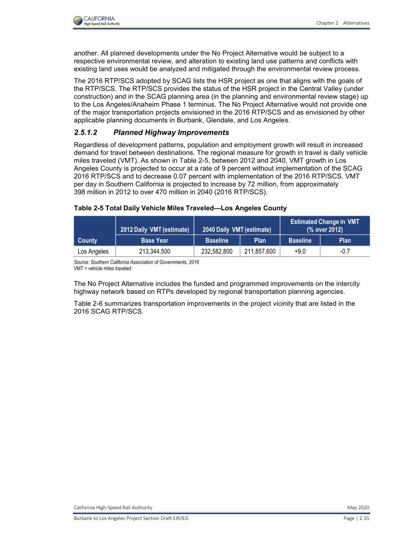
Chapter 2 Alternatives
California High-Speed Rail Authority May 2020
Burbank to Los Angeles Project Section Draft EIR/EIS Page | 2-35
another. All planned developments under the No Project Alternative would be subject to a respective environmental review, and alteration to existing land use patterns and conflicts with existing land uses would be analyzed and mitigated through the environmental review process.
The 2016 RTP/SCS adopted by SCAG lists the HSR project as one that aligns with the goals of the RTP/SCS. The RTP/SCS provides the status of the HSR project in the Central Valley (under construction) and in the SCAG planning area (in the planning and environmental review stage) up to the Los Angeles/Anaheim Phase 1 terminus. The No Project Alternative would not provide one of the major transportation projects envisioned in the 2016 RTP/SCS and as envisioned by other applicable planning documents in Burbank, Glendale, and Los Angeles.
2.5.1.2 Planned Highway Improvements Regardless of development patterns, population and employment growth will result in increased demand for travel between destinations. The regional measure for growth in travel is daily vehicle miles traveled (VMT). As shown in Table 2-5, between 2012 and 2040, VMT growth in Los Angeles County is projected to occur at a rate of 9 percent without implementation of the SCAG 2016 RTP/SCS and to decrease 0.07 percent with implementation of the 2016 RTP/SCS. VMT per day in Southern California is projected to increase by 72 million, from approximately 398 million in 2012 to over 470 million in 2040 (2016 RTP/SCS).
Table 2-5 Total Daily Vehicle Miles Traveled—Los Angeles County
County
2012 Daily VMT (estimate) 2040 Daily VMT (estimate) Estimated Change in VMT
(% over 2012)
Base Year Baseline Plan Baseline Plan
Los Angeles 213,344,500 232,582,800 211,857,600 +9.0 -0.7
Source: Southern California Association of Governments, 2016 VMT = vehicle miles traveled
The No Project Alternative includes the funded and programmed improvements on the intercity highway network based on RTPs developed by regional transportation planning agencies.
Table 2-6 summarizes transportation improvements in the project vicinity that are listed in the 2016 SCAG RTP/SCS.

Chapter 2 Alternatives
May 2020 California High-Speed Rail Authority
Page | 2-36 Burbank to Los Angeles Project Section Draft EIR/EIS
Table 2-6 Planned Highway Improvements within Project Vicinity
Route Planned Improvements RTP ID Lead
Agency Completion Year
SR 2 Route 2 from 0.5 mile south of Branden St to I-5/SR 2 Interchange: Modify terminus, soundwalls, landscaping, installing detector loops and ramp meters, restriping (with no lane addition) and improving arterial streets (restriping – no increase in capacity, and removing and widening sidewalk).
LA990351-LA0G692
Caltrans Phase 1A completed in November 2013.
Phase 2 currently unfunded.
I-5 I-5 from Route 134 to Route 170 HOV lanes (8 to 10 lanes). Construct modified interchange at I-5 Empire Ave, auxiliary lanes northbound and southbound between Burbank Blvd and Empire Ave; and modify existing structures. Add auxiliary lane between Alameda and Olive from PM 28.43 to PM 29.78.
LA000358 Caltrans Early 2020
Source: Southern California Association of Governments, 2016 Caltrans = California Department of Transportation HOV = high-occupancy vehicle I = Interstate ID = identification
PM = post mile RTP = Regional Transportation Plan SR = State Route
2.5.1.3 Planned Aviation Improvements City of Burbank voters approved the Hollywood Burbank Airport Terminal Replacement project under Measure B in November 2016. The terminal replacement project would develop surplus airport property into commercial uses. However, the project does not propose to increase the number of gates, the overall size of the airport, or the number of daily flights. The airport therefore will have limited growth in new vehicle trips to and from the site as a result of the improvements.
The Environmental Impact Report for a Replacement Airline Passenger Terminal at Burbank Bob Hope Airport (RS&H, Inc. 2016) indicates that the forecast for passenger activity within the upcoming 10-year period (the study horizon) will not exceed the maximum levels experienced in 2008. The SCAG 2012–2035 RTP has estimated that annual activity at the airport would reach 9.4 million passengers by 2035 (SCAG 2012). This growth would be from regional growth trends over the 24-year forecast period.
The separate but adjacent commercial project at Hollywood Burbank Airport, using surplus land from the terminal replacement project, will generate some new local-area vehicle trips. However, land use projections are included in the SCAG model. Therefore, the applied growth rates in the opening-year and future-year analysis take this project into account.
Construction of the HSR Build Alternative or operation of the HSR station facilities would not affect airport ground traffic or air operations. The HSR Build Alternative would not directly affect ground access to and from local airport properties within the study area. There are no other air-carrier airports near the Burbank to Los Angeles Project Section.
2.5.1.4 Intercity Transit Improvements Metro provides core transit service via its Rapid Bus lines, which complement and connect to local bus service. Metro has defined an overall plan for Rapid Bus service and a future network for all Rapid Bus lines. There are no identified plans for new Rapid Bus service within the study area. Metro is currently studying a bus rapid transit project in the North Hollywood to Pasadena Bus Rapid Transit (BRT) Corridor Technical Study (Metro 2017). The study corridor would provide an important connection between the Metro Orange Line/Red Line station in North Hollywood and the Metro Gold Line in Pasadena.

Chapter 2 Alternatives
California High-Speed Rail Authority May 2020
Burbank to Los Angeles Project Section Draft EIR/EIS Page | 2-37
The Metro Regional Connector Project, which began construction in 2014, will extend from the Metro Gold Line Little Tokyo/Arts District Station to the 7th Street/Metro Center Station in downtown Los Angeles, allowing passengers to transfer to the Blue, Expo, Red, and Purple lines and bypassing LAUS. The Metro Regional Connector Project is forecast to open in 2021 (Metro 2018).
Express bus services provided by the Los Angeles Department of Transportation, Foothill Transit, Santa Clarita Transit, and other municipal operators at LAUS will continue to provide such services in the future, and no identified major service changes are planned by these operators. The Los Angeles Department of Transportation provides commuter express bus service between downtown Los Angeles and the San Fernando Valley. Santa Clarita Transit provides commuter express bus service between LAUS and the city of Santa Clarita. These systems travel on the freeway during the express portions of trips and do not use the surface roadway network within the study area.
Other privately owned regional bus operators pass through the study area as express/freeway services. Greyhound, Megabus, and BoltBus operate regional bus service throughout California and the western U.S. from LAUS. Some have stops at the existing Downtown Burbank Metrolink Station.
2.5.1.5 Freight Rail Improvements UPRR operates through the study area in the LOSSAN corridor. The LOSSAN Rail Corridor Strategic Implementation Plan (LOSSAN Rail Corridor Agency 2012) projects that the daily freight train trips within the corridor are expected to grow from 11 in 2014 to 18 in 2030. The California Department of Transportation (Caltrans) has released the Final 2018 California State Rail Plan, which provides a new framework for planning and implementing California’s rail network for the next 20 years and beyond.
No major freight rail improvement projects are identified in the LOSSAN Rail Corridor Strategic Implementation Plan or the California State Rail Plan within the Burbank to Los Angeles Project Section.
2.5.1.6 Conventional Passenger Rail Improvements The LOSSAN Rail Corridor Agency, overseer of the Amtrak Pacific Surfliner service between San Luis Obispo/Santa Barbara, LAUS, and San Diego, is planning a service expansion that would increase ridership by 50 percent in the corridor by 2030. Table 2-7 shows the projected change in rail traffic within the corridor for Metrolink and Amtrak. This long-term increase in rail passenger service frequency would provide net benefits to the roadways within the study area.
Table 2-7 Existing and Future Trains per Day in the LOSSAN Corridor between Burbank and Los Angeles
Operator 2016 Existing Conditions 2029 Opening Year 2040 Horizon Year
California High-Speed Rail1 N/A 196 196
Metrolink2 61 99 99
Amtrak3 12 16 18
Sources: California High-Speed Rail Authority, 2016b; Metrolink, 2016a and 2016b; LOSSAN Rail Corridor Agency, 2012
1 2029 Opening Day and 2040 Horizon Year projections from the California High Speed Rail Authority’s “Year 2029 and Year 2040 Concept Timetable for EIR/EIS Analysis.” 2 Existing Conditions from 2016 Metrolink Schedule (effective October 3, 2016); 2029 Opening Day projections extrapolated from the 2016 Metrolink 10-Year Strategic Plan, “Growth Scenario 2: Overlay of Additional Service Patterns.” 3 Existing Conditions from the 2016 LOSSAN Corridor Schedule; 2029 Opening Day projections extrapolated from the 2012 LOSSAN Corridorwide Strategic Implementation Plan “Long-Term Operations Analysis” (increase of ~1 train every 4 years for the Amtrak Pacific Surfliner and no growth for the Amtrak Coast Starlight between Hollywood Burbank Airport and LAUS). LAUS = Los Angeles Union Station LOSSAN = Los Angeles–San Diego–San Luis Obispo
In the vicinity of the HSR Burbank Airport Station, Metrolink opened a new station on the Antelope Valley commuter rail line, at the northwest corner of Hollywood Way and San Fernando

Chapter 2 Alternatives
May 2020 California High-Speed Rail Authority
Page | 2-38 Burbank to Los Angeles Project Section Draft EIR/EIS
Boulevard, in 2018. This new Burbank Airport-North Metrolink Station provides access to the airport and is in proximity to the future terminal area.
Table 2-8 provides a list of the programmed conventional passenger rail improvements included in the Caltrans Final 2013 California State Rail Plan, the 2016 SCAG RTP/SCS, and the Caltrans Final 2018 California State Rail Plan. Several of these projects are under development or will be completed as early action projects (Authority 2016d)6 as part of the HSR project.
Table 2-8 Programmed Passenger Rail Improvements within the Burbank to Los Angeles Project Section
Project Title Project Type Proposed Completion Year
Los Angeles–San Diego–San Luis Obispo Rail Corridor Operational Improvements
Operational improvements
By 2030
Burbank Junction Track Realignment and High-Speed Switches Track and signal By 2020
Burbank Siding Extension Operational improvements
By 2020
Vanowen Street/West Empire Avenue/Clybourn Avenue SCRRA Crossing Grade Separation
Grade separation By 2020
Extension of Burbank Siding Track and signal By 2020
Burbank to Los Angeles Third Main Track Track and signal By 2020
Doran Street/San Fernando Road SCRRA Crossing Grade Separation Grade separation TBD
Sonora Avenue/Air Way SCRRA Crossing Improvements Grade separation By 2020
Grandview Avenue/San Fernando Road/Air Way SCRRA Crossing Grade Separation
Grade separation By 2020
Chevy Chase Drive/Alger Street SCRRA Crossing Grade Separation Grade separation By 2020
Relocation of Glendale Slide Track and signal By 2020
Redesign of Glendale Metrolink Station Station By 2020
North Main Street SCRRA Crossing Improvements and Grade Separation Grade crossing and grade separation
By 2020
Link Union Station–LAUS Run-Through Tracks Extension/new route By 2020
Los Angeles Metrolink Station Parking Improvements Station By 2020
North Buena Vista Street SCRRA Crossing Improvements Grade crossing By 2020
New Station at Hollywood Burbank Airport, Adjacent to or Co-Terminus with HSR Station (Hollywood Way)
Station By 2020
Sources: California Department of Transportation, 2013, 2018; Southern California Association of Governments, 2016 HSR = high-speed rail LAUS = Los Angeles Union Station
SCRRA = Southern California Regional Rail Authority TBD = to be determined
6 As described in the 2016 Business Plan (Authority 2016d), the Authority has made a commitment to invest in regionally significant connectivity projects in order to provide early benefits to transit riders and local communities while laying a solid foundation for the HSR system. These early actions would be made in collaboration with local and regional agencies. These types of projects include grade separations and improvements at regional passenger rail stations, which increase capacity, improve safety, and provide immediate benefits to freight and passenger rail operations. Local and regional agencies may take the lead on coordinating the construction of these early action projects. Therefore, they are described in further detail below and are analyzed in this EIR/EIS to allow the agencies, as Responsible Agencies under CEQA, to adopt the findings and mitigation measures as needed to construct these projects.

Chapter 2 Alternatives
California High-Speed Rail Authority May 2020
Burbank to Los Angeles Project Section Draft EIR/EIS Page | 2-39
2.5.1.7 Port Improvements The Port of Los Angeles and the Port of Long Beach serve the regional transport system, thereby influencing the travel demand and congestion in the project study area. Approximately 40 percent of imports into the U.S. and 24 percent of export volumes are handled through these ports. Future development of ports and associated goods transport systems are important aspects of the regional circulation system in the Burbank to Los Angeles Project Section.
The Port of Los Angeles and Port of Long Beach are served by trains. The cornerstone of the ports’ intermodal train traffic network is the Alameda Corridor, a 20-mile-long cargo expressway. The Alameda Corridor serves as the primary connection for cargo-carrying train traffic moving between the Ports of Los Angeles and Long Beach and the transcontinental rail network based near downtown Los Angeles.
The Port of Los Angeles Master Plan (Port of Los Angeles 1980), aims to establish policies and guidelines to direct the future development of the port while also promoting and safely accommodating foreign and domestic waterborne commerce, navigation, and fisheries in the national, state, and local public interest. Additionally, the 2018–2022 Strategic Plan (Port of Los Angeles 2018) outlines initiatives to meet each of the master plan objectives.
According to the Strategic Plan, more than 80 percent of the Port of Los Angeles’ business revenue comes from container cargo shipping. The Port of Los Angeles is the largest container port, by volume shipped, in North America. However, it expects competitive challenges in future years as other ports expand their facilities to attract more cargo. To achieve its vision of retaining its position as the largest cargo container port by volume, the Port of Los Angeles’ improvement initiatives include attracting new cargo volumes, optimizing inbound and outbound container flow on trucks and trains, expanding port activities on existing holdings to increase port facility utilization, and developing a capital improvement program that focuses on terminal and transportation improvements. Expanded cargo shipping operations and facilities would result in significant freeway congestion on I-710, which the port would work with Caltrans to mitigate, and increased demand on the rail network.
In 2006, the Port of Long Beach published its first strategic plan in more than two decades (Port of Long Beach 2009). The 2006 Strategic Plan articulated a vision for the decade spanning 2006 to 2016. During the recession of 2009, the 2006 Strategic Plan was updated to reflect ongoing changes in the operating environment. Subsequently, the port published the Fiscal Year 2017 Strategic Plan (Port of Long Beach 2016), which highlights its mission and goals. The Master Plan Update (Port of Long Beach 1990) built upon the 1978 and 1983 master plans. Since 1990, the port has completed several project-specific amendments to the master plan. The Port of Long Beach also published a Master Plan Overview (Port of Long Beach 2008) that compiled the 1990 plan with all the subsequent amendments.
The Port of Long Beach has several planned projects, including the Gerald Desmond Bridge Replacement Project; the Middle Harbor (Piers D/E/F) Project; dredging projects; a sewer, street, water, and stormwater capital improvement program; a portwide rail program; and fire safety/security projects. Much like the neighboring Port of Los Angeles, the Port of Long Beach is focused on increasing cargo-handling efficiency. Increased efficiency in cargo handling would result in increased demand on the local transportation network, including the surrounding railroads and freeways.

Chapter 2 Alternatives
May 2020 California High-Speed Rail Authority
Page | 2-40 Burbank to Los Angeles Project Section Draft EIR/EIS
2.5.2 High-Speed Rail Build Alternative 2.5.2.1 Overview and Summary of Design Features The description of the HSR Build Alternative provided below is based on the proposed project as defined in the Burbank to Los Angeles Project Section Draft Preliminary Engineering for Project Definition (PEPD) (Authority and FRA 2017) and the environmental footprint (included in Appendix 3.1-A, Parcels Affected by the Project Footprint). The Preliminary Engineering for Project Definition design drawings show the track alignments, profiles, structures, typical sections, construction use areas, and other preliminary design information. They are included as Volume 3, Alignments and Other Plans, of this EIR/EIS. Figure 2-21 shows an overview of the Burbank to Los Angeles Project Section alignment. The HSR Build Alternative serves as the proposed project for CEQA.
Table 2-9 provides preliminary level design information for the HSR Build Alternative for the Burbank to Los Angeles Project Section.
Table 2-9 Summary of Design Features
Design Features Burbank to Los Angeles Project Section
Total Length (linear miles) 13.66
At-Grade Profile (linear miles) 7.44
Retained-Fill Profile (linear miles) 4.26
Below-Grade Profile (linear miles) 1.96
Number of Major Water Crossings1 6
Total Number of Roadway Crossings 32
Number of Public and Private Roadway Closures 2
Number of Proposed Roadway Grade Separations2 5
1 Major water crossings are: Burbank Western Channel, Lockheed Channel, Los Angeles River (crossed at Downey Bridge, Mission Tower Bridge, and the new Main Street bridge), and Verdugo Wash.
2 All proposed grade-separation configurations are pending California Public Utilities Commission approval.
A key performance measure of the alternative is the travel time between principal destinations. Proposition 1A includes a travel time objective for the HSR system of 2 hours and 40 minutes between San Francisco and Los Angeles. The Burbank to Los Angeles Project Section HSR Build Alternative is within the corridor identified in the 2005 Statewide Program EIR/EIS (Authority and FRA 2005) and therefore would help meet the travel time requirement.
The HSR Build Alternative proposes new and upgraded track, maintenance facilities, grade separations, drainage improvements, communications towers, security fencing, passenger train stations, and other necessary facilities to introduce HSR service into the LOSSAN corridor from near Hollywood Burbank Airport to LAUS. In portions of the alignment, new and upgraded tracks would allow other passenger trains to share tracks with the HSR system.
HSR stations would be near Hollywood Burbank Airport and at LAUS. The alignment would be entirely grade-separated at crossings, meaning that roads, railroads, and other transport facilities would be at different heights so that the HSR system would neither interrupt nor interface with other modes of transport, including vehicle, bicycle, and pedestrian.
For most of the project section, the HSR alignment would be within the existing railroad right-of-way, which is typically 70 to 100 feet wide. The HSR alignment includes northbound and southbound electrified tracks for high-speed trains. The right-of-way would be fenced to prohibit public or unauthorized vehicle access. The project footprint is the area required to build, operate, and maintain HSR service based on the following elements of design: station areas, hydrology, track, roadway, structures, systems, and utilities.

Chapter 2 Alternatives
California High-Speed Rail Authority May 2020
Burbank to Los Angeles Project Section Draft EIR/EIS Page | 2-41
Source: California High-Speed Rail Authority, 2019
Figure 2-21 Overview of the Burbank to Los Angeles Project Section
The Burbank to Los Angeles Project Section includes a combination of at-grade, below-grade, and retained-fill track, depending on corridor and design constraints. The at-grade and retained-fill portions of the alignment would be designed with structural flexibility to accommodate shared

Chapter 2 Alternatives
May 2020 California High-Speed Rail Authority
Page | 2-42 Burbank to Los Angeles Project Section Draft EIR/EIS
operations with other passenger rail operators. Throughout most of the project section (between Alameda Avenue and SR 110), two new electrified tracks would be placed along the west side of the existing railroad right-of-way; the two new electrified tracks would be usable for HSR and other passenger rail operators. The existing non-electrified tracks would be realigned closer to the east side of the existing right-of-way, for a total of four tracks; these realigned, non-electrified tracks would be usable for freight and other passenger rail operators but not for HSR. Figure 2-22 illustrates the placement of the new electrified tracks and realigned, non-electrified tracks relative to the existing tracks.
Source: California High-Speed Rail Authority, 2019
Figure 2-22 New Electrified and Non-Electrified Tracks within Existing Right-of-Way
Throughout most of the Burbank to Los Angeles Project Section, the electrified track centerline and the non-electrified track centerline would have a minimum separation of 23.5 feet, and the northbound and southbound electrified tracks would have a separation of 16.5 feet, following the Authority’s Technical Memorandum 1.1.21 Typical Cross Sections for 15% Design (Authority 2013e). These standard separations are illustrated on Figure 2-23. However, in several areas of the corridor, the right-of-way is less than 100 feet wide, a threshold that constrains the design. As a result, reduced track separations would be used in these constrained areas in order to stay within the existing right-of-way to the greatest extent possible, and thus minimize property impacts. The reduced separations between the electrified and non-electrified track centerlines would be a minimum of 16.5 feet, and 15 feet between the two electrified track centerlines. The narrower cross-section separations are illustrated on Figure 2-24.

Chapter 2 Alternatives
California High-Speed Rail Authority May 2020
Burbank to Los Angeles Project Section Draft EIR/EIS Page | 2-43
Source: California High-Speed Rail Authority, 2019 This illustration shows the standard separations between the electrified and non-electrified tracks in areas where the railroad right-of-way is at least 100 feet wide. (Figure is not to scale.)
Figure 2-23 Standard Track Separations within Non-Constrained Right-of-Way
Source: California High-Speed Rail Authority, 2019 This illustration shows the narrow separations between the electrified and non-electrified tracks, which would minimize property impacts in areas where right-of-way is constrained. The reduced separations are applied in areas where the railroad right-of-way is less than 100 feet wide. (Figure is not to scale.)
Figure 2-24 Reduced Track Separations within Constrained Right-of-Way

Chapter 2 Alternatives
May 2020 California High-Speed Rail Authority
Page | 2-44 Burbank to Los Angeles Project Section Draft EIR/EIS
The following section describes the HSR Build Alternative in greater detail.
2.5.2.2 High-Speed Rail Build Alternative Description Figure 2-25 (Sheets 1 through 3) shows the HSR Build Alternative7, including the HSR alignment, new/modified non-electrified tracks, and roadway crossings. The HSR alignment would begin at the underground Burbank Airport Station and would consist of two new electrified tracks. After exiting the underground station, the alignment would travel southeast beneath Hollywood Burbank Airport in a tunnel. The alignment would run under airport property, including under Runway 8-26, Taxiway D, the proposed extended Taxiway C, and critical airport safety zones. The tunnel alignment under the runway and taxiways would be built using SEM construction to avoid disruptions to airfield operations. Section 2.9.5.3 describes the SEM construction method in more detail. The alignment from south of airport Runway 8-26 to where it would join the Metrolink Ventura Subdivision would be built as cut-and-cover, including portions running under surface parking lots on airport property. The alignment would then transition to a trench within the Metrolink Ventura Subdivision. The existing Metrolink Ventura Subdivision tracks would be realigned north within the existing right-of-way, and an existing UPRR siding track between Buena Vista Street and Beachwood Drive would be realigned north of the relocated Metrolink Subdivision tracks within the existing right-of-way. These non-electrified tracks would remain at-grade. The trench, which would be south of and parallel to the relocated non-electrified tracks, would be dedicated for HSR tracks only. Figure 2-7, Figure 2-8, and Figure 2-9 in Section 2.3.4 depict the typical cross-sections of the below-grade portion of the alignment. During construction of the below-grade alignment, shoofly tracks8 would be provided to support Metrolink and UPRR operations. The proposed shoofly tracks would be aligned between Hollywood Way and Buena Vista Street outside the existing right-of-way and would result in temporary roadway impacts to Vanowen Street.
The HSR tracks would transition from the trench and emerge to at-grade within the existing railroad right-of-way near Beachwood Drive in the city of Burbank. Near Beachwood Drive, the HSR tracks would curve south out of the existing railroad right-of-way and cross Victory Place on a new railroad bridge, which would be directly south of the existing Victory Place bridge. South of Burbank Boulevard, the HSR tracks would re-enter the railroad right-of-way and run parallel to the Metrolink Antelope Valley Subdivision tracks. Between Burbank Boulevard and Magnolia Boulevard, two UPRR industry tracks west of the right-of-way would be removed to accommodate HSR tracks; with the addition of HSR tracks, the existing UPRR industry tracks would become inaccessible. One of the industry tracks is not active, but the other serves one business. The business currently served by the UPRR tracks could feasibly be served by trucks.
Continuing south, the HSR alignment would pass the Downtown Burbank Metrolink Station, which would be modified. HSR tracks would be placed within the existing parking lot west of the southbound platforms, and new pedestrian connections and relocated parking would be provided. Section 2.5.2.3 provides more details on design modifications for the Downtown Burbank Metrolink Station.
Between Olive Avenue to the north end of the Metrolink CMF, the existing non-electrified tracks would be shifted east within the right-of-way to accommodate the addition of the electrified tracks within the right-of-way. Throughout this area, both sets of tracks would be at-grade, with a retained-fill segment between Western Avenue and SR 134. Figure 2-6 in Section 2.3.4.2 shows a typical cross-section of the alignment on retained fill.
7 “The ‘High-Speed Rail Build Alternative’ described in this EIR/EIS is the same alternative as the ‘High-Speed Rail Project Alternative’ that the High-Speed Rail Authority Board of Directors in November 2018 identified as the Preferred Alternative. The name was changed to ‘High-Speed Rail Build Alternative’ for this EIR/EIS for more clarity.” 8 A shoofly track is a temporary track used to avoid an obstacle that blocks movement on the normal track section.

Chapter 2 Alternatives
California High-Speed Rail Authority May 2020
Burbank to Los Angeles Project Section Draft EIR/EIS Page | 2-45
Source: California High-Speed Rail Authority, 2019
Figure 2-25 HSR Build Alternative Overview (Sheet 1 of 3)

Chapter 2 Alternatives
May 2020 California High-Speed Rail Authority
Page | 2-46 Burbank to Los Angeles Project Section Draft EIR/EIS
Source: California High-Speed Rail Authority, 2019
Figure 2-25 HSR Build Alternative Overview
(Sheet 2 of 3)
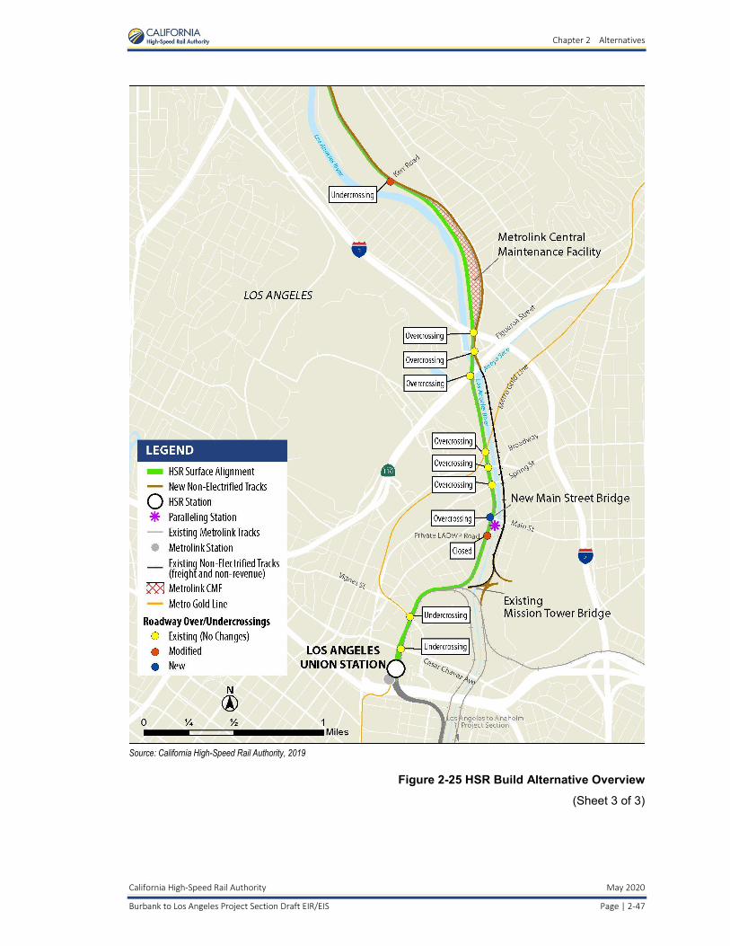
Chapter 2 Alternatives
California High-Speed Rail Authority May 2020
Burbank to Los Angeles Project Section Draft EIR/EIS Page | 2-47
Source: California High-Speed Rail Authority, 2019
Figure 2-25 HSR Build Alternative Overview
(Sheet 3 of 3)

Chapter 2 Alternatives
May 2020 California High-Speed Rail Authority
Page | 2-48 Burbank to Los Angeles Project Section Draft EIR/EIS
Continuing south, the alignment would cross Verdugo Wash, where an existing railroad bridge would be rebuilt as a new clear-span structure to accommodate the additional set of electrified tracks. The alignment would continue south within the existing railroad right-of-way, which follows the Glendale and Los Angeles city borders. Between SR 134 and Chevy Chase Drive, a UPRR siding track would be realigned to the east of the non-electrified tracks, for a total of five tracks within the right-of-way in this area. This siding track is currently at the Metrolink CMF, but it would need to be relocated to accommodate HSR operations at the CMF. The typical cross-section for this area is shown on Figure 2-26.
Source: California High-Speed Rail Authority, 2019
Figure 2-26 Typical Cross-Section between State Route 134 and Chevy Chase Drive
The alignment would pass by the Glendale Metrolink Station (originally known as the Southern Pacific Railroad Depot), a known historical resource listed on the National Register of Historic Places and located north of Glendale Boulevard. No modifications would be necessary for the Glendale Metrolink Station. At Tyburn Street, the alignment would enter the city of Los Angeles. Continuing south, the two sets of tracks would diverge at the north end of the Metrolink CMF. The electrified tracks would travel along the west side of the CMF, and the non-electrified, mainline tracks would travel along the east side of the facility.
The CMF is Metrolink’s major daily servicing location and maintenance facility in the region. It is used for Metrolink maintenance only and would not service HSR trains. The Burbank to Los Angeles Project Section proposes reconfiguring the various yard and maintenance facilities within the CMF to accommodate HSR while maintaining as many of the existing yard operations as possible. Figure 2-27 displays a schematic diagram of the existing CMF and the proposed changes, which include new mainline-to-yard track connections, partial demolition of the existing maintenance shop, a revised roadway network with reconfigured parking areas, track relocation shifts, and construction to provide additional storage capacity. Additionally, several facilities would need to be relocated or rebuilt within the CMF, including a train washing/reclamation building, a yard pump house, and two service and inspection tracks. Utilities would also need to be relocated with the CMF, including domestic and fire water, underdrains and rebuilt catch basins, power facilities, fueling facilities and storage tanks, and sanitary sewer systems. The proposed design would not be able to accommodate wheel truing operations or progressive maintenance bays; these would relocate to another Metrolink facility. All other facilities and infrastructure would remain in place. The construction work at the CMF would be phased to minimize the disruption to the existing operations and to maintain the key operational facilities.

Chapter 2 Alternatives
California High-Speed Rail Authority May 2020
Burbank to Los Angeles Project Section Draft EIR/EIS Page | 2-49
Source: California High-Speed Rail Authority, 2017
Figure 2-27 Diagram of Existing and Proposed Metrolink Central Maintenance Facility
At the south end of the CMF, the two electrified and two non-electrified tracks would converge briefly within the right-of-way and then diverge again south of Figueroa Street. The electrified tracks would cross over the west bank of the Los Angeles River on the existing Metrolink Downey Bridge. The existing tracks on the Downey Bridge would be electrified, which would allow for both HSR and passenger rail operations. The non-electrified tracks would remain on the east bank of the Los Angeles River and cross the Arroyo Seco on an existing railroad bridge, which would not require modifications. The non-electrified tracks would connect with the existing tracks on the east bank, which currently serve UPRR and nonrevenue trains. Figure 2-28 provides an illustrative cross-section for this area, showing the placement of the electrified and non-electrified tracks relative to the Los Angeles River.

Chapter 2 Alternatives
May 2020 California High-Speed Rail Authority
Page | 2-50 Burbank to Los Angeles Project Section Draft EIR/EIS
Source: California High-Speed Rail Authority , 2019 The electrified tracks would cross the Los Angeles River just north of State Route 110 and run along the west bank of the Los Angeles River. The non-electrified tracks would run along the east bank of the Los Angeles River. (Figure is not to scale.)
Figure 2-28 Typical Cross-Section from State Route 110 to Mission Junction
South of Main Street, on the east bank of the Los Angeles River, the existing tracks would be modified at Mission Junction to be usable by freight and passenger rail. They would cross the river on the existing Mission Tower bridge to join the electrified tracks within the railroad right-of-way. The existing Mission Tower bridge has two tracks, but currently only one track is functional and utilized by Metrolink. The HSR Build Alternative would replace the trackwork to conform to the most current design standards and specifications, which may require a retrofit to the bridge.
The two sets of tracks would continue south to terminate at LAUS. The electrified tracks and HSR station platforms would be on the west side of the station, while the non-electrified tracks would merge with the Metrolink and Amtrak tracks. The configuration at LAUS is described in further detail in Section 2.5.2.3.
Roadway Crossings The HSR Build Alternative would have 34 roadway crossings, 15 of which would require roadway modifications. Figure 2-25 shows the crossings throughout the project section, and Table 2-10 lists their configurations before and after the introduction of the HSR Build Alternative. Additional detail is provided in Appendix 2-A, Road Crossings.

Chapter 2 Alternatives
California High-Speed Rail Authority May 2020
Burbank to Los Angeles Project Section Draft EIR/EIS Page | 2-51
Table 2-10 Roadway Crossings within the Burbank to Los Angeles Project Section
Roadway Current Crossing Configuration Proposed HSR Crossing Configuration1
Buena Vista Street At-Grade* At-Grade* (modified)
Undercrossing** (new)
Victory Place Undercrossing” Undercrossing*
Undercrossing (new)
Burbank Boulevard Overcrossing Overcrossing (modified)
Magnolia Boulevard Overcrossing Overcrossing
Olive Avenue Overcrossing Overcrossing
Interstate 5 Overcrossing Overcrossing
Alameda Avenue Undercrossing Undercrossing (modified)
Western Avenue Overcrossing Overcrossing
Sonora Avenue At-Grade Undercrossing (new)
Grandview Avenue At-Grade Undercrossing (new)
Flower Street At-Grade Undercrossing (new)
Fairmont Avenue Overcrossing Overcrossing
SR 134 Overcrossing Overcrossing
Salem/Sperry Street2 No Crossing Overcrossing (Metro project)
Colorado Street Undercrossing Undercrossing (modified)
Goodwin Avenue No Crossing Undercrossing (new)
Chevy Chase Drive At-Grade Closed
Los Feliz Boulevard Undercrossing Undercrossing (modified)
Glendale Boulevard Undercrossing Undercrossing (modified)
Fletcher Drive Undercrossing Undercrossing
SR 2 Overcrossing Overcrossing
Kerr Road Undercrossing Undercrossing (modified)
I-5 Overcrossing Overcrossing
Figueroa Street Overcrossing Overcrossing
SR 110 Overcrossing Overcrossing
Metro Gold Line Overcrossing Overcrossing
Broadway Overcrossing Overcrossing
Spring Street Overcrossing Overcrossing
Main Street At-Grade Overcrossing
Private Los Angeles Department of Water and Power Road
At-Grade Closed
Vignes Street Undercrossing Undercrossing
Cesar Chavez Avenue Undercrossing Undercrossing
Source: California High-Speed Rail Authority, 2019 Crossings noted as “new” or “modified” would experience a change from existing conditions under the HSR Build Alternative. 1 All proposed grade crossing configurations are pending California Public Utilities Commission approval. 2 Salem Street/Sperry Street would be grade-separated as a part of the Metro Doran Street and Broadway/Brazil Grade Separation Project. The project also proposes closing the existing at-grade railroad crossings at Doran Street and Broadway/Brazil Street. As this project would be completed before the introduction of HSR service, the crossing configurations are considered part of the existing conditions for the HSR project. *Crossings apply to Metrolink and UPRR tracks only **Crossing applies to HSR tracks under Metrolink or UPRR tracks only HSR = high-speed rail I = Interstate
Metro = Los Angeles County Metropolitan Transportation Authority UPRR = Union Pacific Railroad SR = State Route

Chapter 2 Alternatives
May 2020 California High-Speed Rail Authority
Page | 2-52 Burbank to Los Angeles Project Section Draft EIR/EIS
Modifications to Existing Crossings • Victory Place—A new bridge for the HSR tracks would be built directly south of the existing
railroad bridge over Victory Place, and the roadway would be lowered to cross under the new bridge.
• Burbank Boulevard—The roadway bridge would be rebuilt to cross over the tracks, and Burbank Boulevard would be raised in elevation on the west side.
• Alameda Avenue—The railroad bridge would be rebuilt to be wider. • Colorado Street—The railroad bridge would be rebuilt to be wider. • Los Feliz Boulevard—The railroad bridge would be rebuilt to be wider, and the roadway
would be lowered slightly. • Glendale Boulevard—The railroad bridge would be rebuilt to be wider, and the roadway
would be lowered slightly. • Kerr Road—The railroad bridge would be rebuilt to be wider, and the roadway would be
lowered slightly.
New Grade Separations • Buena Vista Street—The crossing would be modified and remain at-grade for Metrolink and
UPRR tracks, but a new undercrossing would be built to grade-separate the HSR tracks only from the roadway.
• Sonora Avenue—A new roadway undercrossing would be built, with the tracks slightly raised on retained fill and the roadway slightly lowered (Section 2.5.2.9).
• Grandview Avenue—A new roadway undercrossing would be constructed, with the tracks slightly raised on retained fill and the roadway slightly lowered (Section 2.5.2.9).
• Flower Street—A new roadway undercrossing would be constructed, with the tracks slightly raised on retained fill and the roadway slightly lowered (Section 2.5.2.9).
• Goodwin Avenue—The road currently does not cross the railroad right-of-way, but the project would grade-separate it as a new roadway undercrossing (Section 2.5.2.9).
• Main Street—A new roadway bridge would be built north of the existing Main Street bridge, which would cross the railroad right-of-way and the Los Angeles River (Section 2.5.2.9).
Closures • Chevy Chase Drive—The roadway would be closed, and a new pedestrian undercrossing
would be provided (see Section 2.5.2.9). • Private Driveway—A driveway that currently provides access to a Los Angeles Department of
Water and Power facility parking lot would be closed, and the Los Angeles Department of Water and Power parking would be relocated to a new facility on Main Street.
2.5.2.3 Station Sites The HSR stations for the Burbank to Los Angeles Project Section would be in the vicinity of Hollywood Burbank Airport and at LAUS. Stations would be designed to optimize access to the California HSR System, particularly to allow for intercity travel and connections to local transit, airports, highways, and the bicycle and pedestrian networks. Both stations would include the following elements:
• Passenger boarding and alighting platforms • Station head house with ticketing, waiting areas, passenger amenities, vertical circulation,
administration and employee areas, and baggage and freight-handling service • Vehicle parking (short-term and long-term) • Pick-up and drop-off areas

Chapter 2 Alternatives
California High-Speed Rail Authority May 2020
Burbank to Los Angeles Project Section Draft EIR/EIS Page | 2-53
• Motorcycle/scooter parking • Bicycle parking • Waiting areas and queuing space for taxis and shuttle buses • Pedestrian walkway connections
Burbank Airport Station The Burbank Airport Station site would be west of Hollywood Way and east of Hollywood Burbank Airport. The airport and ancillary properties occupy much of the land south of the Burbank Airport Station site, while industrial and light industrial land uses are located to the east and residential land uses are found to the north of the Burbank Airport Station site. I-5 runs parallel to the station site, approximately 0.25 mile north of the proposed Metrolink platform.
The Burbank Airport Station would have both underground and above-ground facilities. Above-ground facilities would span approximately 70 acres and would include a station building (which would house ticketing areas, passenger waiting areas, restrooms, and related facilities), pick-up/drop-off facilities for private automobiles, a transit center for buses and shuttles, surface parking areas, and stormwater capture/drainage facilities. Underground portions of the station, which include the train boarding platforms, would be beneath Cohasset Street, along which runs the boundary between the city of Los Angeles to the north and the city of Burbank to the south. There would be two HSR tracks at the Burbank Airport Station.
The Burbank Airport Station would have up to 3,210 surface parking spaces in multiple lots by 2040. Approximately 1,640 of these spaces would be available by the start of HSR operations (2029). Proposed surface parking would be in addition to any parking spaces that might be included in the replacement terminal project if the Preferred Alternative site is ultimately selected (see Chapter 8, Preferred Alternative). The preliminary station layout concept plan is shown on Figure 2-29 and a cross-section of the underground and above-ground facilities are shown in Figure 2-30. This EIR/EIS analyzes the Burbank Airport Station project footprint displayed on Figure 2-29 as permanently affected because no additional temporary construction easements are identified beyond the permanent area required to construct, operate, and maintain the station. This is the assumption based on the current level of design.
Los Angeles Union Station The existing LAUS campus and surrounding tracks are being reconfigured as a part of the Metro Link US Project.9 The Link US Project would reconfigure the station entry tracks from north of Mission Junction and would include expansion of the existing pedestrian passageway. Up to 10 new run-through tracks would be constructed on “common” infrastructure to support regional/intercity rail and HSR trains. Depending on funding arrangements, reconfiguration may occur in one continuous phase or could continue over two construction phases. If phased, the first phase (Phase A) would include implementation of early action/interim improvements primarily associated with the regional/intercity rail run-through track infrastructure south of LAUS and necessary signal modifications, roadway modifications, and property acquisitions to facilitate new run-through service that would occur in the interim condition. The second phase (Phase B) would include new lead tracks, the elevated rail yard, and the new modified expanded passageway. The Authority, under NEPA Assignment, is the federal lead agency for the Metro Link US EIS (), that evaluates these changes. Metro previously certified a Final EIR in June 201910, on which the Authority is a responsible agency under CEQA. These changes would be completed prior to the introduction of HSR service.
9 Link US will transform LAUS from a “stub-end” station to a “run-through tracks” station by extending tracks south over U.S. Route 101. The project will add a new passenger concourse that will provide improved operational flexibility for rail service. More information is available at metro.net/projects/link-us. 10 Metro Link US Notice of Determination (June 2019) available at https://ceqanet.opr.ca.gov/2016051071/3/Attachment/J9R7Bx.

Chapter 2 Alternatives
May 2020 California High-Speed Rail Authority
Page | 2-54 Burbank to Los Angeles Project Section Draft EIR/EIS
Source: California High-Speed Rail Authority , 2019
Figure 2-29 Preliminary Station Concept Layout Plan—Burbank Airport Station

Chapter 2 Alternatives
California High-Speed Rail Authority May 2020
Burbank to Los Angeles Project Section Draft EIR/EIS Page | 2-55
Figure 2-30 Preliminary Station Concept Layout Plan—Burbank Airport Station

Chapter 2 Alternatives
May 2020 California High-Speed Rail Authority
Page | 2-56 Burbank to Los Angeles Project Section Draft EIR/EIS
While Metro would environmentally clear and construct the trackwork and new passenger concourse, the HSR project would require additional modifications within the Link US area. HSR improvements include raising the platform heights and installing an OCS. The Burbank to Los Angeles Project Section EIR/EIS evaluates these modifications as well as potential increases in traffic associated with the introduction of HSR service.
The proposed HSR station at LAUS would include up to four HSR tracks and two 870-foot platforms (with the possibility of extending to 1,000 feet). The HSR system would share passenger facilities, such as parking and pick-up/drop-off facilities, with other operators. HSR would require 1,180 parking spaces in 2029 and 2,010 spaces in 2040. This new demand may be met by existing underutilized parking supply within 0.5 mile of LAUS. This parking would be shared with other LAUS service providers and businesses.
Figure 2-31 illustrates the proposed location of HSR tracks and station platforms at LAUS along with Metro’s Link US project boundaries.
Sources: California High-Speed Rail Authority , 2019; Los Angeles County Metropolitan Transportation Authority, 2017
Figure 2-31 Preliminary Station Elements Plan—Los Angeles Union Station

Chapter 2 Alternatives
California High-Speed Rail Authority May 2020
Burbank to Los Angeles Project Section Draft EIR/EIS Page | 2-57
2.5.2.4 Maintenance of Infrastructure As described in Section 2.3.9, the design and spacing of maintenance facilities along the HSR system do not require the Burbank to Los Angeles Project Section to include any maintenance facilities within its limits. However, for purposes of environmental analysis, the Authority has defined each project section to have the capability to operate as a standalone project in the event that other project sections of the HSR system are not constructed. Because this project section does not provide an HMF, LMF, or MOIF, an independent contractor would need to be retained to handle all maintenance functions for vehicles and infrastructure if this project section were built as a standalone project for purposes of independent utility. Independent utility is discussed further in Section 2.1.1.
2.5.2.5 Ancillary and Support Facilities Trains would draw power for the California HSR System from the state’s existing electricity grid. Electricity would be distributed via an OCS. The Burbank to Los Angeles Project Section would not include the construction of a separate power source, although it would include the extension of power lines to a series of power substations positioned along the HSR corridor. The transformation and distribution of electricity would occur in three types of stations:
• TPSSs transform high-voltage electricity supplied by public utilities to the train operating voltage. TPSSs would be adjacent to existing utility transmission lines and the right-of-way, and would be approximately every 30 miles along the HSR system route.
• Switching stations connect and balance the electrical load between tracks and switch OCS power on or off to tracks in the event of a power outage or emergency. Switching stations would be midway between, and approximately 15 miles from, the nearest TPSS. Each switching station would be 120 feet by 80 feet and located adjacent to the HSR right-of-way.
• Paralleling stations, or autotransformer stations, provide voltage stabilization and equalize current flow. Paralleling stations would be located approximately every 5 miles between the TPSSs and the switching stations. Each paralleling station would be approximately 100 feet by 80 feet and located adjacent to the right-of-way.
Table 2-11 lists the proposed switching stations and paralleling station sites within the Burbank to Los Angeles Project Section. As described in Section 2.3.6.1, a TPSS is not required for the Burbank to Los Angeles Project Section because of the HSR system’s facility spacing requirements. The Burbank to Los Angeles Project Section would be able to use the TPSSs within the Palmdale to Burbank Project Section or the Los Angeles to Anaheim Project Section. In the event the other project sections of the HSR system are not constructed, a standalone TPSS would be required within the Burbank to Los Angeles Project Section for purposes of independent utility.
Table 2-11 Proposed Traction Power Locations Traction Power Station Type Location
Paralleling Station Los Angeles, south of Main Street, between railroad right-of-way and Los Angeles River
Switching Station Los Angeles, south of Verdant Street and west of railroad right-of-way
Source: California High-Speed Rail Authority and Federal Railroad Administration, 2017
2.5.2.6 Safety and Security The HSR system would provide safety and security by applying risk-based System Safety and System Security programs that identify, assess, and reduce or avoid hazards and vulnerabilities for the HSR system. Using domestic regulations, international experience, and industry best practices, the objective of the HSR System Safety and System Security programs would be to adequately and consistently apply risk-based hazard avoidance measures. HSR operations would follow safety and security plans developed by the Authority in cooperation with FRA, including a System Safety Program Plan and Safety; a Security Certification Program; a Threat

Chapter 2 Alternatives
May 2020 California High-Speed Rail Authority
Page | 2-58 Burbank to Los Angeles Project Section Draft EIR/EIS
and Vulnerability Assessment; a Preliminary Hazard Analysis; a Vehicle Hazard Analysis; a Fire Life Safety Program; and a System Security Plan. Detailed information about these safety and security plans is included in Section 2.3.1, System Design Performance, Safety, and Security.
2.5.2.7 State Highway and Local Roadway Modifications The state highway and local roadway modifications that would result from the HSR Build Alternative in the Burbank to Los Angeles Project Section are analyzed as part of this EIR/EIS.
State Highway Modifications The Burbank to Los Angeles Project Section is within Caltrans District 7. The HSR Build Alternative is within an existing railroad corridor with five existing at-grade crossings. The HSR Build Alternative would grade-separate the existing at-grade crossings and would not sever access to state highway or route facilities. The Caltrans state facilities that would be affected by the HSR Build Alternative are listed in Table 2-12 and shown on Figure 2-32.
Table 2-12 Impact of High-Speed Rail Build Alternative on California Department of Transportation State Highway Facilities
No. District-County Location Proposed Configuration
1 07-LA Burbank Boulevard Overpass (3147+17)
New—New overpass (replacing existing) over the HSR alignment, the existing Metrolink railroad, and one existing roadway.
2 07-LA Main Street Aerial Structure (3683+24)
New—New overpass over the electrified tracks, the Los Angeles River, and the existing Metrolink Railroad.
3 07-LA SR 134—Fairmont Avenue On-Ramp
No Modification—Protection of the existing structures (HSR crosses at-grade underneath the Fairmont Avenue on-ramp).
4 07-LA SR 134 No Modification—Protection of the existing structures (HSR crosses at-grade underneath SR 134).
5 07-LA SR 134 Doran Street Off-Ramp
No Modification— Protection of the existing structures (HSR crosses at-grade underneath the Doran Street off-ramp).
6 07-LA SR 2 No Modification—Protection of the existing structures (HSR crosses at-grade underneath SR 2).
7 07-LA I-5 No Modification—Protection of the existing structures (HSR crosses at-grade underneath I-5).
8 07-LA US-110 No Modification—Protection of the existing structures (HSR crosses at-grade underneath US-110).
HSR = high-speed rail I = Interstate
SR = State Route US = U.S. Route
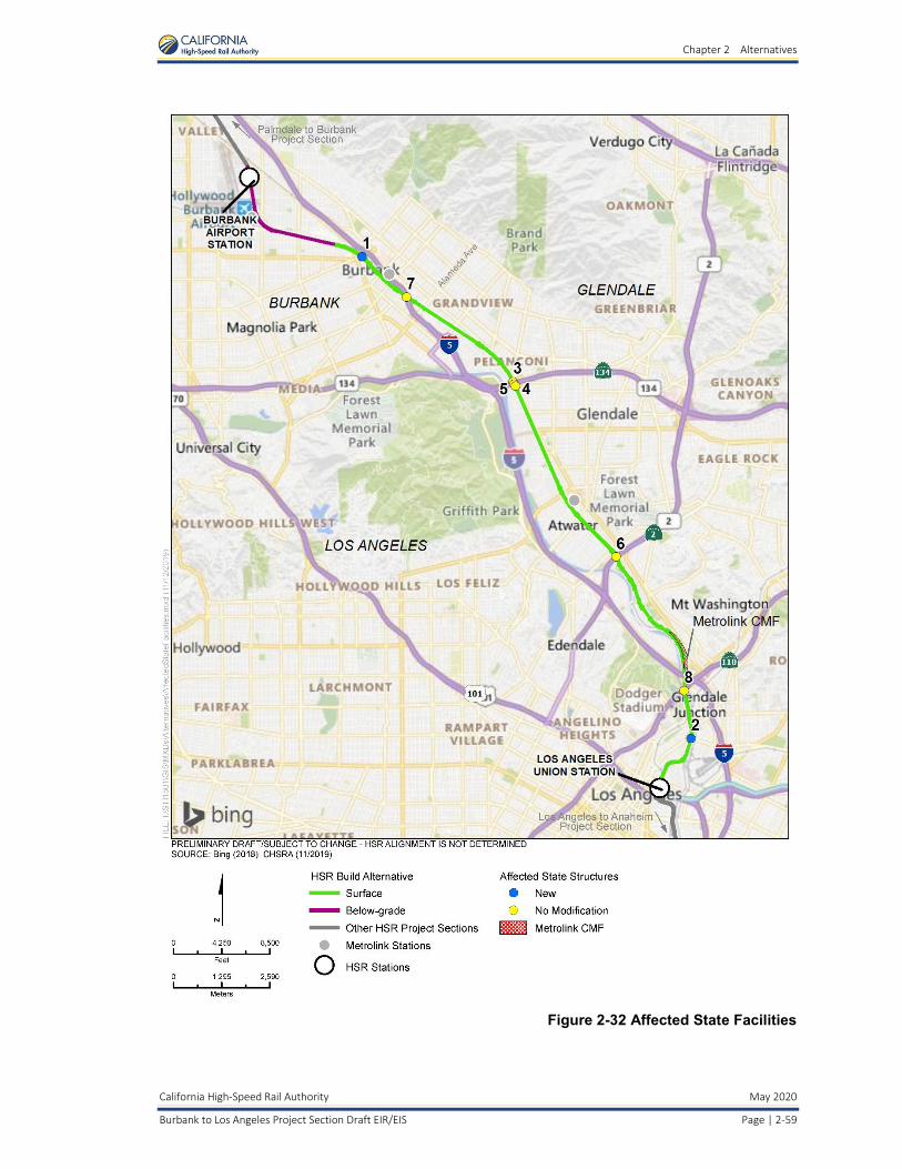
Chapter 2 Alternatives
California High-Speed Rail Authority May 2020
Burbank to Los Angeles Project Section Draft EIR/EIS Page | 2-59
Figure 2-32 Affected State Facilities

Chapter 2 Alternatives
May 2020 California High-Speed Rail Authority
Page | 2-60 Burbank to Los Angeles Project Section Draft EIR/EIS
Local Roadway Modifications Details on local roadway modifications for the HSR Build Alternative are described in Section 2.5.2.2.
2.5.2.8 Freight and Passenger Railroad Modifications The freight and passenger railroad modifications that would result from the HSR Build Alternative in the Burbank to Los Angeles Project Section are analyzed as part of this EIR/EIS.
Track Modifications As described in Section 2.5.2.1, throughout most of the project section (between Alameda Avenue and SR 110), two new electrified tracks would be placed along the west side of the existing railroad right-of-way, and the existing non-electrified tracks would be shifted east within the railroad right-of-way to run parallel to the new, electrified tracks. In several locations, existing freight siding tracks and one industry spur would be relocated and one spur closed. As described in Section 2.5.2.2, several modifications to non-HSR tracks would be needed to accommodate HSR, particularly throughout the area where the HSR alignment transitions from tunnel to at-grade (i.e., the existing Metrolink Ventura Subdivision tracks would be realigned north within the existing right-of-way, and an existing UPRR siding track east of Buena Vista Street would be relocated to between Hollywood Way and Buena Vista Street). Modifications to freight and passenger rail lines were designed to limit right-of-way acquisition and to keep relocated tracks within the existing rail corridor. These modifications were developed in consultation with Metrolink and UPRR.
Relocated freight siding tracks and spur closures are described in Table 2-13.
Table 2-13 Freight Siding Tracks and Industry Spur Relocations and Closures
Track Existing Length
(linear feet) Relocated/Reconstructed
Length (linear feet)
Relocated Metrolink Track 116,865 112,165
Relocated UPRR Glendale Siding Track 8,910 9,100
Relocated UPRR Ventura Sub-Siding Track 3,386 3,305
Relocated Terry Lumber Spur 1,780 1,870
Glendale Spur Track Closures 5,600 0
Source: Jacobs, 2018 UPRR = Union Pacific Railroad
Table 2-14 Industry Spur Relocations
Spur Track per HSR Stationing1 Actively Serving
Industry? Spur Length (linear feet)
Proposed Modifications to Track
3155+00 to 3164+00 No 1,560 Remove
3164+00 Yes 200 Remove
3350+00 No N/A; tracks have been partially removed
Remove
3464+50 to 3482+50 Yes 1,570 Realign
3491+00 No 1,550 Remove
Source: STV, 2020 1Refer to Volume 1 of the PEPD, for stationing locations. UPRR = Union Pacific Railroad

Chapter 2 Alternatives
California High-Speed Rail Authority May 2020
Burbank to Los Angeles Project Section Draft EIR/EIS Page | 2-61
Modifications to Railroad Structures Where new roadway undercrossings of existing railroads are required, a temporary shoofly track would be built to maintain railroad operations during undercrossing construction. The modifications to existing railroad structures and the new railroad structures are listed in Table 2-15 and illustrated on Figure 2-33.
Table 2-15 New and Modified Railroad Structures
Number Crossing Name City Existing Structure Proposed Structure
H-02 Victory Pl Burbank Metrolink bridge New HSR bridge south of existing bridge
H-03 Alameda Ave Burbank Metrolink/freight bridge Wider bridge for HSR and other operators
H-04 Sonora Ave Glendale None; at-grade crossing New bridge for HSR and other operators
H-05 Grandview Ave Glendale None; at-grade crossing New bridge for HSR and other operators
H-06 Flower St Glendale None; at-grade crossing New bridge for HSR and other operators
H-07 Colorado St Glendale Metrolink/freight bridge Wider bridge for HSR and other operators
H-08 Goodwin Ave Glendale None; no crossing New bridge for HSR and other operators
H-09 Chevy Chase Dr Glendale None; at-grade crossing New bridge for HSR and other operators (over pedestrian tunnel)
H-10 Los Feliz Blvd Glendale Metrolink/freight bridge Wider bridge for HSR and other operators
H-11 Glendale Blvd Glendale Metrolink/freight bridge Wider bridge for HSR and other operators
H-12 Kerr Rd Los Angeles Metrolink/freight bridge Wider bridge for HSR and other operators
Source: California High-Speed Rail Authority , 2019 HSR = high-speed rail

Chapter 2 Alternatives
May 2020 California High-Speed Rail Authority
Page | 2-62 Burbank to Los Angeles Project Section Draft EIR/EIS
Figure 2-33 New and Modified Railroad Structures

Chapter 2 Alternatives
California High-Speed Rail Authority May 2020
Burbank to Los Angeles Project Section Draft EIR/EIS Page | 2-63
Modifications to Metrolink Central Maintenance Facility Metrolink’s CMF is the major daily servicing location and maintenance facility in the region. The HSR Build Alternative proposes reconfiguration of the various yard and maintenance facilities within the CMF to accommodate HSR, while maintaining as many of the existing yard operations as possible. Figure 2-27 in Section 2.5.2.2 is a schematic diagram of the existing CMF and the proposed changes, which include new mainline-to-yard track connections; partial demolition of the existing maintenance shop; a revised roadway network with reconfigured parking areas; and track relocation shifts and construction to provide additional storage capacity. Additionally, several facilities would need to be relocated or rebuilt within the CMF, including a train-washing/reclamation building, a yard pump house, and two service and inspection tracks. Utilities would also need to be relocated with the CMF, including domestic and fire water; underdrains and reconstructed catch basins; power facilities; fueling facilities and storage tanks; and sanitary sewer systems. The proposed design would not be able to accommodate wheel truing operations or progressive maintenance bays; these would be relocated to another Metrolink facility. All other facilities and infrastructure would remain in place. The construction work at the CMF would be phased to minimize the disruption to existing operations and to maintain the key operational facilities.
2.5.2.9 Early Action Projects As described in the 2016 Business Plan, the Authority has made a commitment to invest in regionally significant connectivity projects in order to provide early benefits to transit riders and local communities while laying a solid foundation for the HSR system (Authority 2016d). These early actions would be made in collaboration with local and regional agencies. These types of projects include grade separations and improvements at regional passenger rail stations, which increase capacity, improve safety, and provide immediate benefits to freight and passenger rail operations. Local and regional agencies may take the lead on coordinating the construction of these early action projects. Therefore, they are described in further detail below and are analyzed within the Burbank to Los Angeles Project Section EIR/EIS to allow the agencies, as Responsible Agencies under CEQA, to adopt the findings and mitigation measures as needed to construct these projects.
Downtown Burbank Metrolink Station Modifications Although the HSR system would not serve the Downtown Burbank Metrolink Station, modifications at the station would be required to ensure continued operations of existing operators. The HSR tracks would be within the existing parking lot west of the southbound platforms; the platforms and existing Metrolink tracks would not change. The parking would be relocated to between Magnolia Boulevard and Olive Avenue, and Flower Street would be extended from where it currently ends at the south side of the Metrolink Station. Pedestrian bridges would be provided for passengers to cross over the HSR tracks to access the Metrolink platforms. Other accessibility improvements would include additional vehicle parking, bus parking, and bicycle pathways. Figure 2-34 shows the proposed site plan for the Downtown Burbank Metrolink Station.
Sonora Avenue Grade Separation Sonora Avenue is an existing at-grade crossing. The existing roadway configuration consists of two traffic lanes in both the eastbound and westbound directions. The HSR Build Alternative proposes a “hybrid” grade separation, with Sonora Avenue slightly depressed and the HSR alignment and non-electrified tracks raised on a retained-fill structure. A 10-foot-wide median would be added and the lanes would be narrowed, so the overall width of Sonora Avenue would not change. Sonora Avenue would be lowered in elevation for a length of approximately 650 feet between Air Way and San Fernando Road; the lowest point of the undercrossing would be approximately 10 feet below the original grade. The height of the new retained-fill structure would be approximately 28 feet. Figure 2-35 shows the temporary and permanent project footprint areas.

Chapter 2 Alternatives
May 2020 California High-Speed Rail Authority
Page | 2-64 Burbank to Los Angeles Project Section Draft EIR/EIS
Source: California High-Speed Rail Authority, 2019
Figure 2-34 Downtown Burbank Metrolink Station Site Plan

Chapter 2 Alternatives
California High-Speed Rail Authority May 2020
Burbank to Los Angeles Project Section Draft EIR/EIS Page | 2-65
Source: California High-Speed Rail Authority, 2019
Figure 2-35 Sonora Avenue Grade Separation Footprint
Grandview Avenue Grade Separation Grandview Avenue is an existing at-grade crossing located approximately 0.5 mile south of Sonora Avenue. The existing roadway configuration consists of three traffic lanes in both the eastbound and westbound directions. The HSR Build Alternative proposes a “hybrid” grade separation, with Grandview Avenue slightly depressed and the HSR alignment and non-electrified tracks raised on retained fill. Grandview Avenue would be lowered in elevation between Air Way and San Fernando Road, and the lowest point of the undercrossing would be approximately 3 feet below original grade. The lanes and overall width of Grandview Avenue would not change. The height of the new retained-fill structure would be approximately 30 feet. Figure 2-36 shows the temporary and permanent project footprint areas.
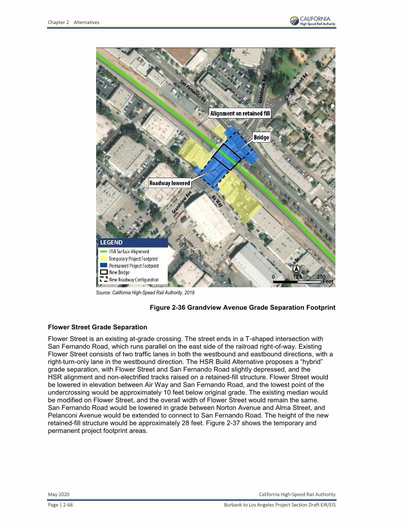
Chapter 2 Alternatives
May 2020 California High-Speed Rail Authority
Page | 2-66 Burbank to Los Angeles Project Section Draft EIR/EIS
Source: California High-Speed Rail Authority, 2019
Figure 2-36 Grandview Avenue Grade Separation Footprint
Flower Street Grade Separation Flower Street is an existing at-grade crossing. The street ends in a T-shaped intersection with San Fernando Road, which runs parallel on the east side of the railroad right-of-way. Existing Flower Street consists of two traffic lanes in both the westbound and eastbound directions, with a right-turn-only lane in the westbound direction. The HSR Build Alternative proposes a “hybrid” grade separation, with Flower Street and San Fernando Road slightly depressed, and the HSR alignment and non-electrified tracks raised on a retained-fill structure. Flower Street would be lowered in elevation between Air Way and San Fernando Road, and the lowest point of the undercrossing would be approximately 10 feet below original grade. The existing median would be modified on Flower Street, and the overall width of Flower Street would remain the same. San Fernando Road would be lowered in grade between Norton Avenue and Alma Street, and Pelanconi Avenue would be extended to connect to San Fernando Road. The height of the new retained-fill structure would be approximately 28 feet. Figure 2-37 shows the temporary and permanent project footprint areas.

Chapter 2 Alternatives
California High-Speed Rail Authority May 2020
Burbank to Los Angeles Project Section Draft EIR/EIS Page | 2-67
Source: California High-Speed Rail Authority, 2019
Figure 2-37 Flower Street Grade Separation Footprint
Goodwin Avenue/Chevy Chase Drive Grade Separation There is currently no crossing at Goodwin Avenue, which ends in a cul-de-sac on the west side of the railroad right-of-way. The HSR Build Alternative proposes a grade separation, with Goodwin Avenue realigned and depressed to cross under a new railroad bridge supporting the HSR and non-electrified tracks. A new roadway bridge would also be required to carry Alger Street over the depressed Goodwin Avenue, connecting to W San Fernando Road. The new depressed roadway would curve north from Brunswick Avenue, cross under the new roadway and railroad bridges, and connect with Pacific Avenue on the east side of the railroad right-of-way. The lowest point of the undercrossing would be approximately 28 feet below original grade.
Chevy Chase Drive is an existing at-grade crossing. With the construction of a new grade separation at Goodwin Avenue, Chevy Chase Drive would be closed on either side of the rail crossing and a pedestrian undercrossing would be provided. Figure 2-38 shows the temporary and permanent project footprint areas for Goodwin Avenue and Chevy Chase Drive.

Chapter 2 Alternatives
May 2020 California High-Speed Rail Authority
Page | 2-68 Burbank to Los Angeles Project Section Draft EIR/EIS
Source: California High-Speed Rail Authority, 2019
Figure 2-38 Goodwin Avenue/Chevy Chase Drive Grade Separation
Main Street Grade Separation Main Street is an existing at-grade crossing. It crosses the existing tracks at grade on the west bank of the Los Angeles River, crosses over the river on a bridge, and then crosses the existing tracks at grade on the east bank of the river. The existing bridge carries two traffic lanes in both directions. The HSR Build Alternative proposes a grade separation, with a new Main Street bridge spanning the tracks on the west bank, the Los Angeles River, and the tracks on the east bank. The new Main Street bridge would be 86 feet wide and 75 feet high at its highest point over the Los Angeles River and would place three columns within the river channel. Main Street would be raised in elevation starting from just east of Sotello Street on the west side of the Los Angeles River. The new bridge would come down to grade at Clover Street on the east side of the Los Angeles River. Several roadways on the east side of the Los Angeles River would be reconfigured, including Albion Street, Lamar Street, Avenue 17, and Clover Street. The existing Main Street bridge would not be modified, but it would be closed to public access. Figure 2-39 shows the temporary and permanent project footprint areas.

Chapter 2 Alternatives
California High-Speed Rail Authority May 2020
Burbank to Los Angeles Project Section Draft EIR/EIS Page | 2-69
Source: California High-Speed Rail Authority , 2019
Figure 2-39 Main Street Grade Separation Footprint
2.5.2.10 High-Speed Rail Project Impact Avoidance and Minimization Features As part of the Tier 1 decision, the Authority and FRA committed to integrate programmatic impact avoidance and minimization features (IAMF) into the HSR project. The Authority has developed IAMFs that are applicable to this project section. IAMFs include standard engineering or industry practices, actions, and design features that the Authority has employed during the design of the project section or would employ as part of standard agency requirements during design and construction.
Appendix 2-B, Impact Avoidance and Minimization Features, presents descriptions of the IAMFs appropriate to this project section. This EIR/EIS describes IAMFs applicable to each resource section in Chapter 3, Affected Environment, Environmental Consequences, and Mitigation Measures. The Mitigation Monitoring and Enforcement Program would track each IAMF.
The Authority would implement these measures during project design, construction, and operation, as relevant to the project section, to avoid or reduce impacts. These measures are considered to be part of the HSR Build Alternative and would include measures related to each resource. The full text of the IAMFs that are applicable to the project is provided in Appendix 2-B. Chapter 3 provides a description of each IAMF as well as its purpose in the context of each resource topic.
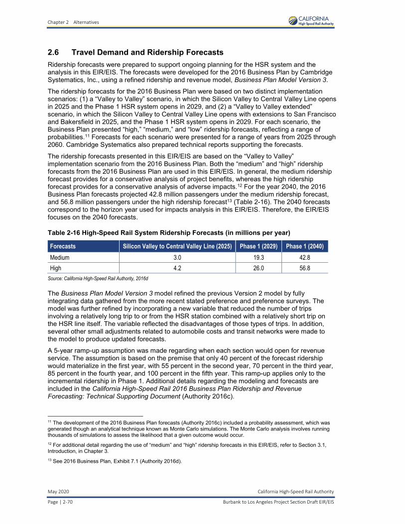
Chapter 2 Alternatives
May 2020 California High-Speed Rail Authority
Page | 2-70 Burbank to Los Angeles Project Section Draft EIR/EIS
2.6 Travel Demand and Ridership Forecasts Ridership forecasts were prepared to support ongoing planning for the HSR system and the analysis in this EIR/EIS. The forecasts were developed for the 2016 Business Plan by Cambridge Systematics, Inc., using a refined ridership and revenue model, Business Plan Model Version 3.
The ridership forecasts for the 2016 Business Plan were based on two distinct implementation scenarios: (1) a “Valley to Valley” scenario, in which the Silicon Valley to Central Valley Line opens in 2025 and the Phase 1 HSR system opens in 2029, and (2) a “Valley to Valley extended” scenario, in which the Silicon Valley to Central Valley Line opens with extensions to San Francisco and Bakersfield in 2025, and the Phase 1 HSR system opens in 2029. For each scenario, the Business Plan presented “high,” “medium,” and “low” ridership forecasts, reflecting a range of probabilities.11 Forecasts for each scenario were presented for a range of years from 2025 through 2060. Cambridge Systematics also prepared technical reports supporting the forecasts.
The ridership forecasts presented in this EIR/EIS are based on the “Valley to Valley” implementation scenario from the 2016 Business Plan. Both the “medium” and “high” ridership forecasts from the 2016 Business Plan are used in this EIR/EIS. In general, the medium ridership forecast provides for a conservative analysis of project benefits, whereas the high ridership forecast provides for a conservative analysis of adverse impacts.12 For the year 2040, the 2016 Business Plan forecasts projected 42.8 million passengers under the medium ridership forecast, and 56.8 million passengers under the high ridership forecast13 (Table 2-16). The 2040 forecasts correspond to the horizon year used for impacts analysis in this EIR/EIS. Therefore, the EIR/EIS focuses on the 2040 forecasts.
Table 2-16 High-Speed Rail System Ridership Forecasts (in millions per year)
Forecasts Silicon Valley to Central Valley Line (2025) Phase 1 (2029) Phase 1 (2040)
Medium 3.0 19.3 42.8
High 4.2 26.0 56.8
Source: California High-Speed Rail Authority, 2016d
The Business Plan Model Version 3 model refined the previous Version 2 model by fully integrating data gathered from the more recent stated preference and preference surveys. The model was further refined by incorporating a new variable that reduced the number of trips involving a relatively long trip to or from the HSR station combined with a relatively short trip on the HSR line itself. The variable reflected the disadvantages of those types of trips. In addition, several other small adjustments related to automobile costs and transit networks were made to the model to produce updated forecasts.
A 5-year ramp-up assumption was made regarding when each section would open for revenue service. The assumption is based on the premise that only 40 percent of the forecast ridership would materialize in the first year, with 55 percent in the second year, 70 percent in the third year, 85 percent in the fourth year, and 100 percent in the fifth year. This ramp-up applies only to the incremental ridership in Phase 1. Additional details regarding the modeling and forecasts are included in the California High-Speed Rail 2016 Business Plan Ridership and Revenue Forecasting: Technical Supporting Document (Authority 2016c).
11 The development of the 2016 Business Plan forecasts (Authority 2016c) included a probability assessment, which was generated though an analytical technique known as Monte Carlo simulations. The Monte Carlo analysis involves running thousands of simulations to assess the likelihood that a given outcome would occur. 12 For additional detail regarding the use of “medium” and “high” ridership forecasts in this EIR/EIS, refer to Section 3.1, Introduction, in Chapter 3. 13 See 2016 Business Plan, Exhibit 7.1 (Authority 2016d).

Chapter 2 Alternatives
California High-Speed Rail Authority May 2020
Burbank to Los Angeles Project Section Draft EIR/EIS Page | 2-71
This range of ridership forecasts reflects the development of certain aspects of the HSR system’s design and certain portions of the environmental analysis, which are described in more detail below. Because the ultimate ridership of the HSR system will depend on many uncertain factors, such as the price of gasoline and population growth, the HSR system described in this document has been designed to accommodate the broad range of ridership expected over the coming decades.
Since the 2016 Business Plan forecasts were developed, the Authority has adopted its 2018 Business Plan, which was accompanied by updated forecasts (2016 Business Plan Ridership and Revenue Forecasting: Technical Supporting Document [Authority 2016c]; 2018 Business Plan: Technical Supporting Document: Ridership & Revenue Forecasting [Authority 2018b]). The 2016 and 2018 Business Plan ridership forecasts were developed using the same travel forecasting model; the forecasts differ due to changes in the model’s inputs, including the HSR service plan, demographic forecasts, estimates of automobile operating costs and travel times, and airfares. The “medium” ridership forecast for 2040 decreased by 6.5 percent, from 42.8 to 40 million, and the “high” ridership forecast decreased by 10.1 percent, from 56.8 to 51.6 million. In addition, the 2018 Business Plan assumes an opening year of 2033 rather than 2029 for the full Phase 1 system (2016 Business Plan, Table 7.1 [Authority 2016d]; 2018 Business Plan, Table 7.1. [Authority 2018b]).
The Authority released a Draft 2020 Business Plan in February 2020 for public review and comment. The plan’s final adoption is expected at the April 2020 Board meeting for submittal to the Legislature by May 1, 2020. The 2020 Business Plan forecasts were developed using the same travel forecasting model as the 2016 and 2018 Business Plans, updated for population and employment forecasts. The Phase 1 medium ridership forecast for 2040 is 38.6 million, and the high is 50.0 million.
To the extent that the lower ridership levels projected in the 2018 Business Plan or the 2020 Business Plan would result in fewer trains operating in 2040, the impacts associated with the train operations in 2040 would be somewhat less than the impacts presented in this EIR/EIS, and the benefits accruing to the project (e.g., reduced VMT, reduced greenhouse gas emissions, reduced energy consumption) also would be less than the benefits presented in this EIR/EIS. As with the impacts, the benefits would continue to build and accrue over time and would eventually reach the levels discussed in this EIR/EIS for the Phase 1 system.
2.6.1 Ridership and High-Speed Rail System Design The HSR system analyzed in this EIR/EIS reflects the fact that the system is a long-term transportation investment for the State of California. It is being designed with state-of-the-art infrastructure and facilities that will serve passengers over many decades (Authority 2016c). While most of the infrastructure components are being designed and built for full utility, certain components are more flexible and can change and adapt to meet ridership as it grows over time.
While the Authority and FRA weighed ridership and revenue potential in evaluating alignment and station alternatives in the Tier 1 Program EIR/EIS documents and Tier 2 alternatives screening, the primary driver affecting the design of the HSR system is not the total forecasted annual ridership, but rather the performance objectives and safety requirements stipulated by the Authority, FRA, the U.S. Department of Transportation, and the regional transportation partners—including Caltrain, Amtrak, and other operators—whose systems will either use the shared segments of the HSR alignment (blended corridor) or provide connections to the high-speed service.
In keeping with these objectives and requirements, the portion of the alignment that is fully dedicated to HSR service comprises a two-track system for most of the right-of-way with four tracks at intermediate stations regardless of total annual ridership. Track geometry and profile, power distribution systems, train control/signal systems, type of rolling stock, and certain station elements will be the same in both the dedicated and blended corridors regardless of how many riders use the HSR system. The location of the heavy and light maintenance facilities also follow the mandates stipulated by technical operating requirements rather than ridership.

Chapter 2 Alternatives
May 2020 California High-Speed Rail Authority
Page | 2-72 Burbank to Los Angeles Project Section Draft EIR/EIS
While the performance objectives and safety requirements are the main factors affecting HSR system design, ridership does influence some aspects of the system’s design, including the size of the heavy and light maintenance facilities, which are based on the 2040 high-ridership forecast to ensure that these facilities are large enough to accommodate maximum future needs. This approach is consistent with general planning and design practices for large infrastructure projects in which resilience and adaptability are incorporated by acquiring enough land for future needs up front instead of trying to purchase property at a later date when it may no longer be available or be impractical to acquire. The use of ridership forecasts facilitates the early phases of maintenance facility construction as well as subsequent expansion of the facility as fleet size and maintenance requirements grow.
Forecasted annual ridership and peak-period ridership also play a role in determining the size of some station components, such as the size of the public accessway/egressway to the HSR system. The 2040 high ridership forecast formed the basis for the conceptual service plan, which in turn influenced station site planning by ensuring that station facilities would be sufficient to accommodate the anticipated increase over time of HSR use.
The 2040 high ridership forecast was also used, along with local conditions, to determine the maximum amount of parking needed at each station. Parking demand and supply were analyzed by considering many factors, including ridership demand, station area development opportunities, and availability of alternative multimodal access improvements, to inform the size of the parking facilities at each station and the anticipated schedule for the phased implementation of these facilities. The use of the 2040 high ridership forecast provides flexibility to change or even reduce the amount of station parking as these factors become more defined and resolved over time. (See Section 2.6.3, Ridership and Station-Area Parking, for additional information). Because ridership forecasts were not designed to produce detailed access and egress mode shares at specific stations, forecasting model outputs for the allocation of HSR access and egress trips among modes were refined to provide detailed information for station facility sizing. The refinements were based on the following factors: location-specific data for existing rail stations and airports near each station; comparisons with other rail stations and airports in California and the nation; local, regional, and state plans for transportation and land use; and consultation with local jurisdictions, including review of preliminary estimates. Additional information on mode-share adjustments is provided in the California High-Speed Rail Station Access and Egress Southern California Mode Share Adjustment Methodology and Review Process Memorandum (Appendix 2-E).
2.6.2 Ridership and Environmental Impact Analysis The forecasts of annual HSR ridership play a role in the analysis of environmental impacts and benefits related to traffic, air quality, noise, and energy. This EIR/EIS uses medium and high ridership forecasts to analyze potential environmental impacts from operation of the HSR system. This is discussed in more detail in Section 3.1.
2.6.3 Ridership and Station-Area Parking HSR system ridership, parking demand, parking supply, and development around HSR stations are intertwined and will evolve as ridership increases from the 3 million to 4.2 million anticipated at the start of revenue service in 2025 to as many as 56.8 million passengers in 2040 when the HSR system is in full operation. To attract, support, and retain high ridership levels, the Authority is working with transportation service providers and local agencies to promote transit-oriented development around HSR stations and expand multimodal access to the HSR system.
The implementation of these activities will vary at each station because some cities and regions will be able to develop their station areas and local transit systems at a faster rate than others by the 2029 start of HSR revenue service and before 2040 when the HSR system will be fully operational. In addition, technological advances, such as multimodal trip planning/payment software and autonomous vehicles, will affect parking demand and supply at each station, as will changes in the bundle of services available to consumers, such as ride-hailing services and bike- and car-sharing programs.
Chapter 2 Alternatives
California High-Speed Rail Authority May 2020
Burbank to Los Angeles Project Section Draft EIR/EIS Page | 2-73
Research suggests that the percentage of transit passengers arriving/departing transit stations by car and needing parking accommodations decreases as land-use development and population around the stations increases. The Authority has adopted station-area development policies that recognize the inverse relationship between parking demand and HSR station-area development. In keeping with these policies, the Authority is working with regional planners and planners in the station cities to maximize the success of the HSR system by locating stations in areas where there is, or will be, a high density of population, jobs, commercial development, entertainment venues, and other activities that generate trips. Encouraging development in high-density areas around HSR stations will allow the Authority to attain its dual goal of supporting system ridership while reducing parking demand.
However, land use development around HSR stations will not occur immediately. Although the HSR system will be a catalyst for development, local land-use decisions and market conditions will dictate actual construction. The Authority will work in partnership with local governments to encourage station-area development, exemplified by the station-area planning funding agreements it has provided to the Cities of Fresno and Bakersfield, but the Authority’s power in this regard is limited. As a result, the factors that will determine actual parking demand and supply are dependent primarily on local decisions and local conditions. In the case of LAUS, the Authority has provided and committed to provide funding to Metro to develop LAUS to accommodate HSR services.
In light of the uncertainty regarding the need for station-area parking, this EIR/EIS conservatively identifies parking facilities based on the maximum forecast for parking demand at each station and the local conditions affecting access planning. This approach results in providing the upper range of actual needs and the maximum potential environmental impacts of that range.
The Authority , in consultation with local communities, will have the flexibility to make decisions regarding which parking facilities will be built initially and how additional parking can be phased in or adjusted depending on how HSR system ridership increases over time. For example, some parking facilities could be built at the 2025 project opening and subsequently augmented or replaced in whole or in part based on future system ridership, station-area development, and parking management strategies. A multimodal access plan will be developed prior to the design and construction of parking facilities at each HSR station. These plans will be prepared in coordination with local agencies and will include a strategy that addresses and informs the final location, amount, and phasing of parking at each station.
2.7 Operations and Service Plan 2.7.1 High-Speed Rail Service Per the California High Speed Rail Authority Statewide Operations and Service Plan (Authority 2017d), the conceptual HSR service plan for Phase 1 describes service starting in Anaheim/Los Angeles, running north through the Central Valley from Bakersfield to Merced, and traveling northwest into the San Francisco Bay Area. Subsequent phases of the HSR system include a southern extension from Los Angeles to San Diego via the Inland Empire and an extension from Merced north to Sacramento.
HSR train service would run in diverse patterns between various terminals. Three basic service types are envisioned:
• Express trains, which would serve major stations only, providing fast travel times between downtown San Francisco and LAUS
• Limited-stop trains, which would skip selected stops along a route to provide faster service between stations
• All-stop trains, which would focus on regional service
Most trains would provide limited-stop services and offer a fast run time along with connectivity among various intermediate stations. Numerous limited-stop pattern runs would be provided to achieve a balanced level of service at the intermediate stations. The California High Speed Rail

Chapter 2 Alternatives
May 2020 California High-Speed Rail Authority
Page | 2-74 Burbank to Los Angeles Project Section Draft EIR/EIS
Authority Statewide Operations and Service Plan (Authority 2017d) envisions at least four limited-stop trains per hour in each direction, all day long, on the main route between San Francisco and Los Angeles. Select intermediate stations would be served by at least two limited-stop trains every hour—offering at least two reasonably fast trains per hour to both San Francisco and Los Angeles. Selected limited-stop trains would be extended south of Los Angeles as appropriate to serve projected demand.
Including the limited-stop trains on the routes between Sacramento and Los Angeles, and Los Angeles and San Diego, and the frequent-stop local trains between San Francisco and Los Angeles/Anaheim, and Sacramento and San Diego, every station on the HSR network would be served by at least two trains per hour per direction throughout the day and at least three trains per hour during the morning and afternoon peak periods. Stations with higher ridership demand would generally be served by more trains than those with lower estimated ridership demand.
The California High Speed Rail Authority Statewide Operations and Service Plan (Authority 2017d) provides for direct-train service between most station pairs at least once per hour. Certain routes may not always be served directly, and some passengers would need to transfer from one train to another at an intermediate station, such as LAUS, to reach their final destination. Generally, the Phase 1 conceptual operations and service plan offers a wide spectrum of direct-service options and minimizes the need for passengers to transfer.
Phase 1 is scheduled to start operations in 2029 and would complete the HSR system from a north terminal in San Francisco to the south terminal at Anaheim, including the Burbank to Los Angeles Project Section. For the Burbank to Los Angeles Project Section, estimated trip time would be approximately 9 minutes between Burbank and Los Angeles (Authority 2016d). Train service in the corridor is anticipated to run from approximately 6:00 a.m. to midnight. Nonservice activities required to maintain the system are anticipated to occur during nonrevenue service hours. The dwell time of trains at the intermediate stations for passenger unloading and loading is expected to be approximately 20 minutes.
The Burbank Airport Station and LAUS would see a mix of stopping trains and through trains. In 2029, the service plan concept for Phase 1 estimates that the main HSR line through the Central Valley would have eight trains per hour in each direction during the peak periods and five trains per hour during the off-peak periods. In the peak periods, the base level of service would include:
• Two trains per hour between San Francisco and Los Angeles • Two trains per hour between San Francisco and Anaheim • Two trains per hour between San Jose and Los Angeles • One train per hour between Merced and Los Angeles • One train per hour between Merced and Anaheim
For more detail, refer to Appendix 2-C, Operations and Service Plan Summary.
2.7.2 Maintenance Activities The Authority would regularly perform maintenance along the track and railroad right-of-way, as well as the power, train control, signalizing, communications, and other vital systems required for the safe operation of the HSR system. Maintenance methods are expected to be similar to those of existing European and Asian HSR systems, adapted to the specifics of the California HSR System. However, FRA will specify standards of maintenance, inspection, and other items in a set of regulations (i.e., Rule of Particular Applicability) to be issued in the next several years, and the overseas practices may be amended in ways not currently foreseen. The brief descriptions of maintenance activities provided below are thus based on best professional judgment about future practices in California.
• Track and Right-of-Way—The track at any point would be inspected several times per week using measurement and recording equipment aboard special measuring trains. These trains are similar in design to the regular trains but would operate at a lower speed. They would run between midnight and 5:00 a.m. and would usually pass over any given section of track once in the night.
Chapter 2 Alternatives
California High-Speed Rail Authority May 2020
Burbank to Los Angeles Project Section Draft EIR/EIS Page | 2-75
Most adjustments to the track and routine maintenance would be accomplished in a single night at any specific location, with crews and material brought by work trains along the line. When rail resurfacing (i.e., rail grinding) is needed, perhaps several times per year, specialized equipment would pass over the track sections at 5 to 10 miles per hour.
Ballasted track would require tamping approximately every 4 to 5 years. This more intensive maintenance of the track uses a train with a succession of specialized cars to raise, straighten, and tamp the track, and vibrating “arms” to move and position the ballast under the ties. The train would typically cover a 1-mile-long section of track in the course of one night’s maintenance. Slab track, which is expected to comprise track at elevated sections, would not require this activity. No major track components are expected to require replacement through 2040.
Other maintenance of the right-of-way, aerial structures, and bridge sections of the alignment would include drain cleaning, vegetation control, litter removal, and other inspection that would typically occur monthly to several times per year.
• Power—The OCS along the right-of-way would be inspected nightly, with repairs being made when needed. These repairs would typically be accomplished during a single-night maintenance period. Other inspections would occur monthly. Many of the functions and status of substations and smaller facilities outside of the trackway would be remotely monitored. However, visits would be made to repair or replace minor items and would also be scheduled several times per month to check the general site. No major component replacement for the OCS or the substations is expected through 2040.
• Structures—Visual inspections of the structures along the right-of-way and testing of fire and life-safety systems and equipment in or on structures would occur monthly, while inspections of all structures for structural integrity would occur at least annually. Steel structures would also require painting every several years. For tunnels and buildings, repair and replacement of lighting and communication components would be performed on a routine basis. No major component replacement or reconstruction of any structures are expected through 2040.
• Signaling, Train Control, and Communications—Inspection and maintenance of signaling and train control components would be guided by FRA regulations and standards to be adopted by the Authority. Typically, physical in-field inspection and testing of the system would occur four times per year using hand-operated tools and equipment. Communication components would be routinely inspected and maintained, usually at night, although daytime work may occur if the work area is clear of the trackway. No major component replacement of these systems is expected through 2040.
• Stations—Each station would be inspected and cleaned daily. Inspections of the structures, including the platforms, would occur annually. Inspections of other major systems, such as escalators, the heating and ventilation system, ticket-vending machines, and closed-circuit television, would be according to manufacturer recommendations. Major station components are not expected to require replacement through 2040.
• Perimeter Fencing and Intrusion Protection—Fencing and intrusion protection systems would be remotely monitored, as well as periodically inspected. Maintenance would occur as needed; however, fencing or systems are not expected to require replacement before 2040.
2.8 Additional High-Speed Rail Development Considerations 2.8.1 High-Speed Rail, Land Use Patterns, and Development around High-
Speed Rail Stations Proposition 1A, approved by voters in 2008, called for HSR stations to “be located in areas with good access to local mass transit or other modes of transportation and further required that the HSR system be planned and built in a manner that minimizes urban sprawl and impacts on the natural environment.” The Authority embraced these policies in Proposition 1A by adopting High-Speed Train Station Area Development: General Principles and Guidelines on February 3, 2011

Chapter 2 Alternatives
May 2020 California High-Speed Rail Authority
Page | 2-76 Burbank to Los Angeles Project Section Draft EIR/EIS
(Authority 2011a). The purpose of the guidance was to provide “international examples where cities and transit agencies have incorporated sound urban design principles as integral elements of large-scale transportation systems.”
To meet these guidelines, the Authority has established a station-area planning program to provide cities that will have an HSR station with funding to study ways to promote economic development, encourage station-area development, and enhance multimodal connections between the station and the city. The guidelines go on to state that “the attention paid to the ‘edges’ and interface between improvements will greatly determine the character and function of the station as a ‘place.’” Typical issues that lie at this “edge” or interface that are addressed in station planning include:
• Coordination of architectural design of station-area infrastructure components with the surrounding context
• High-quality pedestrian connections to and from the station and into the surrounding community
• Traffic calming and high-quality aesthetic design of station-district streets
• Preservation of important view corridors
• Design and preservation of station-district signage and wayfinding
• Design and provision of station-district open space
Figure 2-40 shows how the HSR system would connect with existing transit service areas throughout Southern California.
2.8.2 Right-of-Way Acquisition for Construction, Operation, and Maintenance of High-Speed Rail
Implementation of the HSR Build Alternative would require the acquisition of property along the proposed alignment for right-of-way purposes related to construction and operation of the project. Temporary acquisitions would be required along the proposed alignment to accommodate materials and equipment storage and stockpile areas, a pre-cast concrete segment casting yard, placement of construction best management practices for water quality, and general construction activities. Permanent acquisitions would be required to operate and maintain the HSR system facilities and for the provision of adequate right-of-way spacing. Table 2-17 summarizes the anticipated temporary and permanent right-of-way acquisitions.
The Authority has developed a right-of-way process that is in accordance with the Uniform Relocation Assistance and Real Property Acquisition Policies Act. The Uniform Relocation Assistance and Real Property Program ensures that persons displaced as a result of a federal action or by an undertaking involving federal funds are treated fairly, consistently, and equitably. This helps to ensure persons will not suffer disproportionate injuries as a result of projects designed for the benefit of the public as a whole.
In accordance with the Uniform Relocation Assistance and Real Property Acquisition Policies Act, the Authority will provide relocation advisory assistance to any person, business, farm, or nonprofit organization displaced as a result of the acquisition of real property for public use. The Authority will assist displacees in obtaining comparable replacement housing by providing current and continuing information on the availability and prices of both houses for sale and rental units that are “decent, safe, and sanitary.” Commercial displacees will receive information on comparable properties for lease or purchase.

Chapter 2 Alternatives
California High-Speed Rail Authority May 2020
Burbank to Los Angeles Project Section Draft EIR/EIS Page | 2-77
Figure 2-40 Burbank to Los Angeles Transit Service Area

Chapter 2 Alternatives
May 2020 California High-Speed Rail Authority
Page | 2-78 Burbank to Los Angeles Project Section Draft EIR/EIS
Table 2-17 Right-of-Way Acquisitions
Acquisition Type HSR Build Alternative (acres)1,2
Temporary Construction Easements
Commercial 19.6
Community Facilities3 6.7
Industrial4 57.7
Mixed Commercial and Industrial 2.2
Mixed Residential and Commercial 1.5
Transportation, Communications, and Utilities 21.3
Railroads 1.2
Residential 2.8
Permanent Right-of-Way Acquisition
Commercial 3.0
Community Facilities3 5.1
Industrial4 94.5
Mixed Commercial and Industrial 8.9
Mixed Residential and Commercial 2.2
Railroad 1.0
Residential 3.5
Transportation, Communications, and Utilities 7.6
Vacant 26.8
Source: California High Speed Rail Authority, 2018 1 Values are rounded to the nearest decimal place; therefore, the grand totals are rounded as well. 2 Does not include the station areas. 3 The Community Facilities land use designation includes: public facilities, government offices, police and sheriff stations, fire stations, major medical health care facilities, religious facilities, public parking facilities, special use facilities, correctional facilities, special care facilities, other special use facilities, and other public facilities.
4 Includes temporary conversion at Los Angeles Union Station. HSR = high-speed rail
Residential replacement dwellings will be in equal or better neighborhoods, at rents or prices within the financial ability of the individuals and families displaced, and reasonably accessible to their places of employment. Comparable replacement dwellings will be offered to displacees before any displacement occurs. All benefits and services will be provided equitably without regard to race, color, religion, sex, age, disability or national origin, consistent with the requirements of Title VIII of the Civil Rights Act of 1968. This assistance will also include the supplying of information concerning federal and state assisted housing programs and any other known services offered by public and private agencies in the area.
Persons who are eligible for relocation payments and who are legally occupying a property required for the proposed project will not be asked to move without first being given at least 90 days’ written notice. Occupants eligible for relocation payment(s) will not be required to move unless the Authority offers at least one comparable “decent, safe, and sanitary” replacement residence available on the market.
Figure 2-41 shows the Authority’s right-of-way process, which has four major milestones: Design/Survey, Appraisal, Acquisition, and Relocation.

Chapter 2 Alternatives
California High-Speed Rail Authority May 2020
Burbank to Los Angeles Project Section Draft EIR/EIS Page | 2-79
Source: California High-Speed Rail Authority, 2017c ROW = right-of-way
Figure 2-41 Right-of-Way Process

Chapter 2 Alternatives
May 2020 California High-Speed Rail Authority
2-80 | Page Burbank to Los Angeles Project Section Draft EIR/EIS
The Authority has developed a permit-to-enter process for private property owners to be utilized for (1) environmental phase fieldwork and (2) ongoing (post-EIR/EIS), pre-construction fieldwork. The permit-to-enter process for the environmental phase fieldwork covers environmental studies and geotechnical survey work, and the ongoing (post-EIR/EIS), pre-construction fieldwork covers ongoing environmental studies and geotechnical survey work.
For large organizations with their own permit-to-enter processes (utilities, railroads, water districts, school districts, etc.), general permit-to-enter letters are not sent, but are handled on a case-by-case basis.
The HSR system is a large transportation project program that will result in the displacement of a small percentage of the population. However, Authority policy requires that displaced persons shall not suffer unnecessarily as a result of a program such as the HSR project program that is designed to benefit the public as a whole. Displaced individuals, families, businesses, farms, and nonprofit organizations displaced by the project may be eligible for relocation advisory services and payments. More details on relocation assistance for residences,14 mobile homes,15 businesses, farms, and nonprofit organizations16 are provided in the Authority’s Your Rights and Benefits as a Displacee Under the Uniform Relocation Assistance Program brochures.
2.9 Construction Plan and Phased Implementation Plan This section describes the Authority’s general approach to building the HSR system, including activities associated with pre-construction and construction of major system components. It also describes the Authority’s phased implementation strategy.
2.9.1 Design-Build Project Delivery While specific project delivery methods are not yet determined, certain parts of the Burbank to Los Angeles Project Section could be built using a “design-build” (DB) approach. This method of project delivery involves a single contract between the Authority and the contractor to provide both design and construction services. This differs from the “design-bid-build” approach, where design and construction services are managed under separate contracts and the design is completed before the project is put out for construction bids. The DB approach offers opportunity for innovation and for cost-saving alternative construction methods to be considered through the final design process. The Authority’s contract with the DB contractor would require compliance with standard engineering design and environmental practices and regulations, as well as implementation of the design features and mitigation measures included in this EIR/EIS.
2.9.2 Phased Implementation Strategy As described in Chapter 1, the Authority has developed a phased implementation strategy to deliver the HSR system, with a priority on completing Phase 1 of the HSR system between San Francisco and Anaheim while also continuing planning for Phase 2 sections. As reinforced in the Authority’s 2018 Business Plan, the Authority is focusing on delivering short-term improvements to local corridors, mid-term regional corridor benefits, and full-term integration of HSR into key high-capacity urban corridors to complete the integrated statewide passenger rail network. An integrated, phased approach would bring more benefits sooner.
14 California High-Speed Rail Authority, “Your Rights and Benefits as a Displacee Under the Uniform Relocation Assistance Program (Residential),” www.hsr.ca.gov/docs/programs/private_property/RAP_Information_for_Residential.pdf (accessed March 13, 2020). 15 California High-Speed Rail Authority, “Your Rights and Benefits as a Displacee Under the Uniform Relocation Assistance Program (Mobile Home),” www.hsr.ca.gov/docs/programs/private_property/RAP_Information_for_Mobile_Homes.pdf (accessed March 13, 2020). 16 California High-Speed Rail Authority, “Your Rights and Benefits as a Displacee Under the Uniform Relocation Assistance Program (Business, Farm or Nonprofit Organization),” https://www.hsr.ca.gov/docs/programs/private_property/RAP_Information_for_Business.pdf (accessed March 13, 2020).

Chapter 2 Alternatives
California High-Speed Rail Authority May 2020
Burbank to Los Angeles Project Section Draft EIR/EIS Page | 2-81
This project section is a key link to an integrated network. LAUS is a link to major area transportation systems. Phase 2 of the HSR system would connect Los Angeles to San Bernardino, Riverside, and San Diego in Southern California and San Francisco to Sacramento in Northern California.
2.9.3 General Approach The Authority would begin implementing its construction plan for the Burbank to Los Angeles Project Section after receiving the required environmental approvals and permits, and securing funding. Given the size and complexity of the HSR project, the design and construction work could be divided into several procurement packages. In general, the procurement would address the following:
• Civil/structural infrastructure, including design and construction of passenger stations, maintenance facilities, wayside facilities, utility relocations, and roadway modifications
• Trackwork, including design and construction of direct fixation track and sub-ballast, ballast, ties and rail installation, switches, and special trackwork
• Core systems, such as traction power, train controls, communications, the operations center, and the procurement of trainsets
One or more DB packages would be developed. The Authority would issue construction requests for proposals, begin right-of-way acquisition, and procure construction management services to oversee physical construction of the project. During peak construction periods, work would occur concurrently with different subsections, with overlapping construction of various project elements. Working hours and workers present at any time would vary depending on the activities being performed. Construction fencing would be restricted to areas designated for construction staging and areas where public safety or environmentally sensitive resources are a concern. Although the DB contractor will set the actual schedule, an illustrative schedule for construction is provided in Table 2-18 for reference purposes.
Consistent with the California High-Speed Rail Authority Sustainability Policy (Authority 2016e), the Authority will continue to implement sustainability practices that inform and affect the planning, siting, designing, construction, mitigation, operation, and maintenance of the HSR system. The Authority is committed to the following objectives to the maximum extent possible: • Achieving net-zero greenhouse gas and criteria pollutant emissions in construction
• Operating the system entirely on renewable energy
• Using net-zero energy through Leadership in Energy and Environmental Design (LEED) Platinum Facilities
• Planning for climate adaption and resilience
• Making life-cycle performance of components, systems, and materials a priority
Applicable design standards, including compliance with laws, regulations, and industry-standard practices, are included in Appendix 2-D and are considered part of the project.

Chapter 2 Alternatives
May 2020 California High-Speed Rail Authority
2-82 | Page Burbank to Los Angeles Project Section Draft EIR/EIS
Table 2-18 Construction Schedule1
Activity Tasks Duration
Right-of-Way Acquisition ▪ Proceed with right-of-way acquisitions once the State Legislature appropriates funds in the annual budget
TBD
Survey and Pre-Construction
▪ Locate utilities
▪ Establish right-of-way and project control points and centerlines
▪ Establish or relocate survey monuments
▪ Conduct geotechnical investigations
January 2020–January 2027
Mobilization ▪ Safety devices
▪ Special construction equipment January 2020–January 2028
Site Preparation/Land Clearing
▪ Utility relocation
▪ Clearing/grubbing right-of-way
▪ Establishment of detours and haul routes
▪ Preparation of construction equipment yards, stockpile materials, and pre-cast concrete segment casting yard
January 2020–January 2025
Structure Demolition ▪ Demolishing bridges December 2020–January 2025
Building Demolition ▪ Demolish/reconfigure any buildings or structures that are acquired for HSR construction
December 2020–October 2025
Earthmoving ▪ Excavation and earth support structures July 2020–July 2024
Material Handling ▪ Sub-ballast
▪ Ballast
▪ Railway ties
▪ Concrete/cement
▪ Structures support materials
January 2020–January 2026
Construction of Road Crossings
▪ Surface street modifications
▪ Grade separations January 2021–July 2026
Construction of Aerial/Elevated Structures
▪ Aerial structure and bridge foundations, substructure, and superstructure
July 2021–July 2026
Track at Grade ▪ Includes backfilling operations and drainage facilities July 2020–July 2026
Track below Grade ▪ Includes cut and cover and subterranean January 2025–July 2026
Batch Plants ▪ Concrete production facilities January 2021–January 2026
Systems ▪ Train control systems
▪ Overhead contact system
▪ Communication system
▪ Signaling equipment
January 2027–January 2029
Demobilization ▪ Includes site cleanup January 2028–July 2029
Source: California High-Speed Rail Authority, 2019 1 The proposed dates are based on the Authority’s 2016 Business Plan. Although these activities would not begin until after the Authority approves the Final EIR/EIS and the Record of Decision, the duration of each activity is accurate and what was assumed in the analysis of construction impacts in this EIR/EIS. Authority = California High-Speed Rail Authority EIR/EIS = environmental impact report/environmental impact statement TBD = to be determined

Chapter 2 Alternatives
California High-Speed Rail Authority May 2020
Burbank to Los Angeles Project Section Draft EIR/EIS Page | 2-83
2.9.4 Pre-Construction Activities 2.9.4.1 Operational Right-of-Way During final design of the Burbank to Los Angeles Project Section, the Authority and its contractor would conduct a number of pre-construction activities to determine how actual construction should be staged and managed. These activities include the following:
• Conducting geotechnical investigations to define precise geological, groundwater, and seismic conditions along the alignment. The results of this work would guide final design and construction methods for foundations, underground structures, tunnels, stations, grade crossings, aerial structures, systems, and substations.
• Identifying construction laydown and staging areas used for mobilizing personnel, stockpiling materials, and storing equipment for building HSR or related improvements. In some cases, these areas would also be used to assemble or pre-fabricate components of guideway or wayside facilities before transport to installation locations. Pre-casting yards would be identified for the casting, storage, and preparation of pre-cast concrete segments. Temporary spoil storage, workshops, and temporary storage of delivered construction materials would also be identified.
Field offices and temporary jobsite trailers would also be located at the staging areas. Construction laydown areas are part of the project footprint that is evaluated for potential environmental impacts; however, actual use of the area would be at the discretion of the D/B contractor. After completing construction, the staging, laydown, and pre-casting areas would be restored to pre-construction conditions.
• Initiating site preparation and demolition, such as clearing, grubbing, and grading, followed by the mobilization of equipment and materials. Demolition would require strict controls to ensure that no adjacent buildings, infrastructure, or natural or community resources are damaged or otherwise affected by the demolition efforts.
• Relocating utilities prior to construction. The contractor would work with the utility companies to relocate or protect in place such high-risk utilities such as overhead tension wires, pressurized transmission mains, oil lines, fiber-optic conduits or cables, and communications lines or facilities prior to construction.
• Implementing temporary, long-term, and permanent road closures to reroute or detour traffic away from construction activities. Handrails, fences, and walkways would be provided for the safety of pedestrians and bicyclists.
• Locating temporary batch plants as needed to produce Portland cement or asphaltic concrete needed for roads, bridges, aerial structures, retaining walls, and other large structures. The facilities generally consist of silos containing fly ash, lime, and cement; heated tanks of liquid asphalt; sand and gravel material storage areas; mixing equipment; aboveground storage tanks; and designated areas for sand and gravel truck unloading, concrete truck loading, and concrete truck washout. The contractor would be responsible for implementing procedures for reducing air pollutant emissions, mitigating noise impacts, and controlling the discharge of potential pollutants into storm drains or watercourses from the use of equipment, materials, and waste products.
• Conducting other studies and investigations as needed, such as surveys of local businesses to identify usage, delivery, shipping patterns, and critical times of the day or year for business activities. This information will help develop construction requirements and worksite traffic control plans, and will identify potential alternative routes as well as necessary cultural resource investigations and historic property surveys.
For each grade separation and water crossing, the proposed staging and laydown areas would be in the general vicinity of the work site. These areas have been incorporated into the environmental footprint to be environmentally cleared for this project section. These areas are defined by quadrant at each work site and located by HSR stationing as illustrated in Volume 3 of

Chapter 2 Alternatives
May 2020 California High-Speed Rail Authority
2-84 | Page Burbank to Los Angeles Project Section Draft EIR/EIS
this EIR/EIS. The proposed area for these functions is defined in acres, and access to these sites is provided from nonresidential roadways.
Table 2-19 and Table 2-20 list these sites, the proposed areas needed for construction, HSR stationing, and the available access roads to each site.
2.9.4.2 Non-Operational Right-of-Way In certain negotiated right-of-way purchase situations, the Authority may enter into agreements to acquire properties or portions of properties that are not directly needed for construction of the HSR Build Alternative and are not intended to be part of the operational right-of-way. These are known as excess properties and are distinct from severed remnant parcels (which are evaluated as part of the project footprint). Although eventually these properties would likely be sold as excess state property, they are not part of the project footprint, and in the interim the Authority would need to conduct various management and maintenance activities on them (Authority 2018b).
The process for acquisition and disposal of excess property is detailed in Chapter 16 of the California High-Speed Rail Authority Right of Way Manual (Authority 2019). Chapter 11 of the California High-Speed Rail Authority Right of Way Manual identifies the following management and maintenance activities that may take place on any given excess property. The activities required on a given parcel will depend on site conditions, including the presence of buildings or other structures, existing land uses, and habitat conditions.
• Structure Demolition—Various structures may be present on excess property, including single and multifamily residences, mobile homes, mobile offices, warehouses and other light industrial structures, sheds, fences, concrete driveways, signs, other nondescript buildings, and related appurtenances and utilities (e.g., in-ground pools, septic systems, water wells, gas lines) as well as orchards and ornamental shrubs and trees. If the Authority determines that any existing uses of a particular structure are not going to continue, it may, following additional environmental review if/as necessary (e.g., to confirm the structure is not considered historic), decide to demolish and remove the structure. Demolition of a structure may also be appropriate if the structure is in a state of disrepair or a potential safety and security concern exists from trespassers.
The properties may include utilities such as water wells, septic systems, and gas and electric lines that would require removal in accordance with local and state regulations. Local construction permits for demolition and removal would be secured from the local agency with jurisdiction (e.g., well demolition permit, septic removal).
• Vegetation Management—Excess properties may have a variety of vegetation present, including ornamental landscaping, various crops (including orchards or vineyards), and natural habitats such as annual grassland. Vegetation management may occur as part of initial site clearing efforts or as part of ongoing management.
Initial site clearing is likely to occur in conjunction with structure demolition. Ornamental landscaping may be removed to reduce ongoing maintenance needs. Vegetation removal or disturbance may be necessary for equipment access during structure demolition. If certain agricultural crops are present on-site, particularly orchards or vineyards, they may be removed if the Authority determines that it is appropriate, based on the condition of the plants.
Ongoing vegetation management activities may include mowing, discing, or similar mechanical control; the clearing of firebreaks on larger properties; and, if noxious weeds are present, treatment with the use of approved herbicides. Mowing or other mechanical control may be used to maintain vegetation at a certain height or density based on site-specific concerns of security, visual appearance, or fire prevention. The mechanical control of weed species may also be appropriate depending on the relevant species and site conditions. Firebreaks may be mowed or disced in an approximately 12-foot band around the exterior of a site. Internal fire breaks may be appropriate for larger sites. All herbicide application will be conducted in a manner consistent with product labeling and applicable laws, including application by a licensed Pest Control Advisor if appropriate.

Chapter 2 Alternatives
California High-Speed Rail Authority May 2020
Burbank to Los Angeles Project Section Draft EIR/EIS Page | 2-85
Table 2-19 Contractor Staging and Laydown Areas for Grade Separations
Crossing Status Street Crossing
Grade Separation Centerline
Staging Area (Quadrant)
Staging/Laydown Area (Acres) Street Access Remarks
Burbank
At-Grade Empire Ave 3058+41 NW 1.41 N Avon St Storage within adjacent parcel (2466-011-029).
At-Grade Buena Vista Ave 3088+54 N/A Linear Construction Vanowen St Street to remain at grade. Storage within rail right-of-way.
Existing UP Victory Pl 3137+29 E, W 0.94600551 N Lake St Storage within existing RR right-of-way and acquired parcels (2462-019-028, 2462-021-011, and 2462-021-019).
Existing OP Burbank Blvd 3147+19 SW 0.584458219 N Lake St, N Victory Blvd Storage within existing RR right-of-way and acquired parcels (2449-030-029, 2449-030-022, and 2449-030-002).
Existing OP Magnolia St 3170+19 SE 2.295684114 N Varney St Storage within existing RR right-of-way and acquired parcel (2451-010-906).
Existing OP Olive Ave 3182+34 SW, SE 3.185881543 S Flower St Storage within existing RR right-of-way and acquired parcels (2451-010-903 and 2451-006-803).
Existing OP I-5 Burbank (Golden State Freeway)
3201+07 SW 2.402456382 S Flower St, W Verdugo St
Storage within existing RR right-of-way and acquired parcel (2451-005-901).
Glendale
Existing UP Alameda St 3218+57 N/A Linear Construction S Flower St Storage within existing RR right-of-way.
Existing OP Western Ave 3249+44 N/A Linear Construction S Flower St, San Fernando Rd
Storage within existing RR right-of-way.
At-Grade Sonora Ave 3265+36 N/A Linear Construction Air Way, San Fernando Rd
Proposed UP. Storage within existing RR right-of-way.
At-Grade Grandview Ave 3288+77 N/A Linear Construction Air Way, San Fernando Rd
Proposed UP. Storage within existing RR right-of-way.

Chapter 2 Alternatives
May 2020 California High-Speed Rail Authority
2-86 | Page Burbank to Los Angeles Project Section Draft EIR/EIS
Crossing Status Street Crossing
Grade Separation Centerline
Staging Area (Quadrant)
Staging/Laydown Area (Acres) Street Access Remarks
At-Grade Flower St 3301+41 NW, NE 0.894674013 Air Way, San Fernando Rd
Proposed UP. Storage within existing RR right-of-way and acquired parcels (5628-032-012, 5628-032-013, 5628-032-014, 5628-038-027, 5628-038-005, 5628-038-006, and 5628-038-007).
Existing OP Fairmont Ave 3321+38 N/A Linear Construction San Fernando Rd Storage within existing RR right-of-way.
Existing OP Fairmont Ave (off- ramp)
3321+93 N/A Linear Construction San Fernando Rd Storage within existing RR right-of-way.
Existing OP SR 134 (Ventura Freeway) westbound off-ramp
3323+10 N/A Linear Construction San Fernando Rd Storage within existing RR right-of-way.
Existing OP SR 134 (Ventura Freeway)
3324+15 N/A Linear Construction San Fernando Rd Storage within existing RR right-of-way.
Existing OP SR 134 (Ventura Freeway) eastbound off-ramp
3325+03 N/A Linear Construction San Fernando Rd Storage within existing RR right-of-way.
At-Grade Doran St 3326+38 N/A Linear Construction San Fernando Rd Proposed OP by others. Storage within existing RR right-of-way.
Existing OP Salem-Sperry OP (Doran St)
3350+21 N/A Linear Construction San Fernando Rd Storage within existing RR right-of-way.
At-Grade Broadway St, Brazil St
3351+72 N/A Linear Construction San Fernando Rd Proposed closure by others. Storage within existing RR right-of-way.
Existing UP Colorado St 3370+88 N/A Linear Construction San Fernando Rd Storage within existing RR right-of-way.
At-Grade Chevy Chase Dr 3404+57 SW 0.513888889 Alger St Proposed closure. Storage within existing RR right-of-way and acquired parcel (5593-021-023).
Existing UP Los Feliz Rd 3430+34 SW Linear Construction San Fernando Rd, Seneca Ave
Storage within existing RR right-of-way and partially acquired parcel (5594-006-020).
Existing UP Glendale Blvd 3455+18 SW 3.37056933 San Fernando Rd, Seneca Ave
Storage within existing RR right-of-way and acquired parcel (5435-001-022).

Chapter 2 Alternatives
California High-Speed Rail Authority May 2020
Burbank to Los Angeles Project Section Draft EIR/EIS Page | 2-87
Crossing Status Street Crossing
Grade Separation Centerline
Staging Area (Quadrant)
Staging/Laydown Area (Acres) Street Access Remarks
Los Angeles
Existing UP Fletcher Dr 3495+94 N/A Linear Construction San Fernando Rd, La Clede Ave
Storage within existing RR right-of-way.
Existing OP CA 2 (Glendale Freeway)
3502+80 N/A Linear Construction San Fernando Rd, Casitas Ave
Storage within existing RR right-of-way.
Existing UP Kerr Rd/Taylor Yard Access Rd
3571+24 N/A Linear Construction San Fernando Rd Storage within existing RR right-of-way.
Existing OP I-5 Los Angeles (Golden State Freeway)
3628+63 N/A Linear Construction San Fernando Rd Storage within existing RR right-of-way.
Existing OP Riverside Dr/ Figueroa St
3633+96 N/A Linear Construction San Fernando Rd Storage within existing RR right-of-way.
Existing OP SR 110 southbound (Arroyo Seco Pkwy)
3640+22 N/A Linear Construction Arroyo Seco Pkwy Storage within existing RR right-of-way.
Existing OP SR 110 northbound (Arroyo Seco Pkwy)
3641+15 N/A Linear Construction Arroyo Seco Pkwy Storage within existing RR right-of-way.
Existing OP Metro Gold Line Bridge
3663+87 N/A Linear Construction Meadow Rd Storage within existing RR right-of-way.
Existing OP Broadway St 3668+63 N/A Linear Construction Baker St Storage within existing RR right-of-way.
Existing OP Spring St 3674+14 N/A Linear Construction S Ave 18 Storage within existing RR right-of-way.
At-Grade Main St 3683+96 NE 1.547658402 Wilhardt St, Albion St Proposed grade separation. Storage within existing RR right-of-way and acquired parcels (5409-013-905, 5409-013-908, and 5409-013-906)
Existing OP Los Angeles River/Mission Tower Bridge
N/A N/A Linear Construction Leroy St Storage within existing RR right-of-way.
Existing UP Vignes St N/A N/A Linear Construction N Alameda St Storage within existing RR right-of-way.
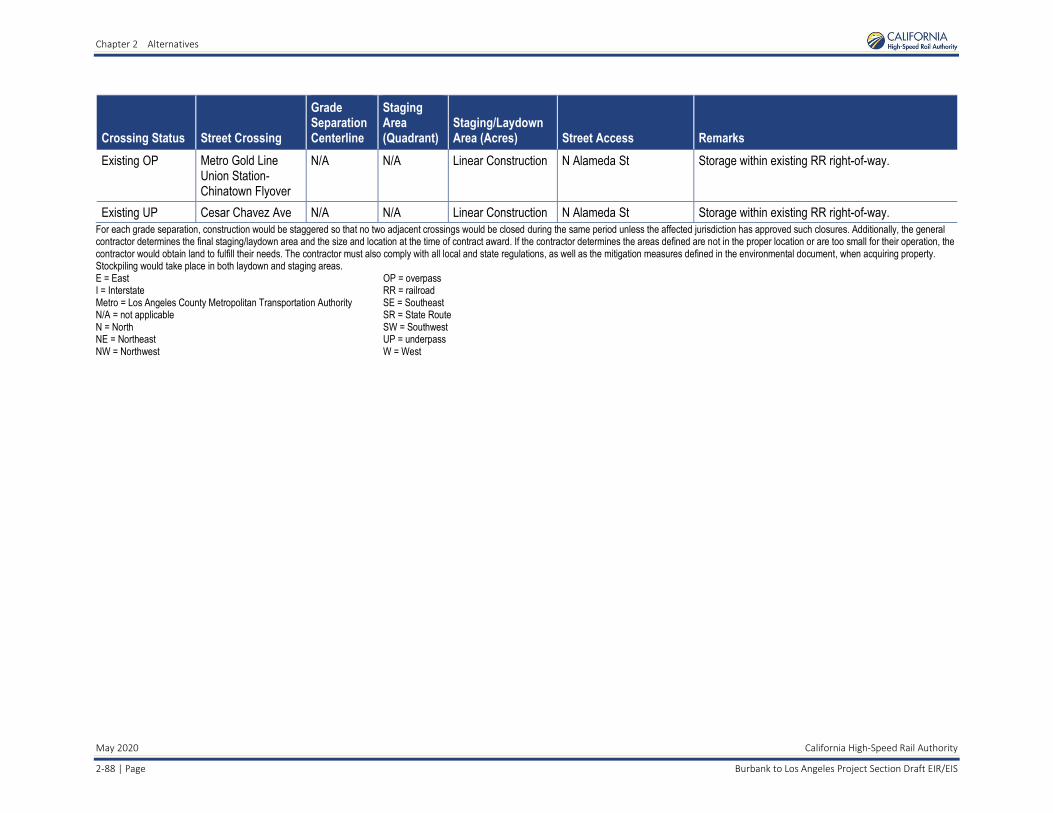
Chapter 2 Alternatives
May 2020 California High-Speed Rail Authority
2-88 | Page Burbank to Los Angeles Project Section Draft EIR/EIS
Crossing Status Street Crossing
Grade Separation Centerline
Staging Area (Quadrant)
Staging/Laydown Area (Acres) Street Access Remarks
Existing OP Metro Gold Line Union Station- Chinatown Flyover
N/A N/A Linear Construction N Alameda St Storage within existing RR right-of-way.
Existing UP Cesar Chavez Ave N/A N/A Linear Construction N Alameda St Storage within existing RR right-of-way.
For each grade separation, construction would be staggered so that no two adjacent crossings would be closed during the same period unless the affected jurisdiction has approved such closures. Additionally, the general contractor determines the final staging/laydown area and the size and location at the time of contract award. If the contractor determines the areas defined are not in the proper location or are too small for their operation, the contractor would obtain land to fulfill their needs. The contractor must also comply with all local and state regulations, as well as the mitigation measures defined in the environmental document, when acquiring property. Stockpiling would take place in both laydown and staging areas. E = East I = Interstate Metro = Los Angeles County Metropolitan Transportation Authority N/A = not applicable N = North NE = Northeast NW = Northwest
OP = overpass RR = railroad SE = Southeast SR = State Route SW = Southwest UP = underpass W = West

Chapter 2 Alternatives
California High-Speed Rail Authority May 2020
Burbank to Los Angeles Project Section Draft EIR/EIS Page | 2-89
Table 2-20 Contractor Staging and Laydown Areas for Water Crossings by City
Crossing Status Water Crossing HSR Stationing
Staging Area Crossing (Quadrant)
Staging/Laydown Area (Acres) Work Area Access Remarks
Burbank
Existing Concrete Channel
Lockheed Channel 3097+44 NW 3.245867769 Buena Vista Ave, N Victory Way
Storage within existing RR right-of-way. Remove portion of channel within RR right-of-way and extend along northern edge into Costco facility.
Existing Concrete Channel
Burbank Western Channel
3153+37 SW, SE 0.333103765 W Chestnut St Storage within existing RR right-of-way. Proposed bridge across channel.
Glendale
Existing Bridge Verdugo Wash 3320+07 N/A Linear Construction San Fernando Rd Storage within existing RR right-of-way.
Los Angeles
Existing Bridge Los Angeles River/Downey Bridge
3637+02 N/A Linear Construction Arroyo Seco Pkwy, San Fernando Rd
Storage within existing RR right-of-way.
Existing Bridge Los Angeles River/Main Street
3683+36 NE 1.547658402 Wilhardt St, Albion St Proposed grade separation. Storage within existing RR right-of-way and acquired parcels (5409-013-905, 5409-013-908, and 5409-013-906).
Existing Bridge Los Angeles River/Mission Tower
N/A NW 5.627708907 Lamar St, Leroy St Storage within existing RR right-of-way and acquired parcel (5410-015-826).
Existing Concrete Channel
Los Angeles River/San Bernardino Wye
N/A NE, NW 2.923829201 E Cesar Chavez Ave Storage within existing RR right-of-way.
The general contractor determines the final staging/laydown area and the size and location at the time of contract award. If the contractor determines the areas defined are not in the proper location or are too small for their operation, the contractor would obtain land to fulfill their needs. The contractor must also comply with all local and state regulations, as well as the mitigation measures defined in the environmental document, when acquiring property. E = East HSR = high-speed rail N/A = not applicable NE = Northeast
NW = Northwest RR = railroad SE = Southeast SW = Southwest
Chapter 2 Alternatives
May 2020 California High-Speed Rail Authority
2-90 | Page Burbank to Los Angeles Project Section Draft EIR/EIS
• Pest Management—Pest management may include the mechanical control of insects, rodents, and other animals. Mechanical removal (trapping) of rodents and other animals may be appropriate in or around structures that exist on excess properties. Mechanical removal of animals will be conducted by a licensed Pest Control Advisor and after obtaining any appropriate local approvals. Rodenticide will not be used for the control of animals.
Chemical control of insects may occur in or around buildings on excess property or in agricultural areas to control pest species. Any pesticide application will be conducted in a manner consistent with product labeling and applicable laws, including application by a licensed Pest Control Advisor if appropriate and after obtaining any appropriate local approvals.
• Site Security—Site security will primarily consist of the installation of fencing around properties. The installation of fencing may be appropriate on properties where structures will remain or where there is a safety and security concern or a particular risk of trespass. Fencing will consist of 6- to 12-foot-high chain-link fencing and may include barbed wire or similar features at the top. Fence posts may be either metal or wood and require an excavation up to 4 inches in diameter and 3 feet deep. Other security devices, such as security lighting, an alarm system, or cameras, may be implemented if specific conditions require it. If buildings or other structures are present on the site, windows and doors may be boarded up to prevent trespass. “No Trespassing” or similar signs may be posted as appropriate.
Site security will also involve the periodic inspection of excess properties for signs of trespass and removal of any accumulated trash or dumping.
• Structure Maintenance—If buildings or other structures remain on-site, they will be maintained in a clean and orderly condition so as not to detract from the general appearance of the neighborhood. If the property is rented or leased, maintenance activities will be undertaken as needed to ensure the health and safety of occupants. Maintenance and repair activities may include exterior and interior painting; yard maintenance; repair or replacement of plumbing, electrical facilities, roofs, windows, heaters, and built-in appliances; and other similar activities.
2.9.5 Major Construction Activities Major types of construction activities for the project include earthwork; bridge, aerial structure, and roadway crossings; tunnel; railroad systems; and station construction, as briefly described in the following subsections.
2.9.5.1 Earthwork Earth support is an important factor in constructing deep excavations that would be encountered on the below-grade alignment. The following excavation support systems may be used. There are three general excavation support categories that would be used during construction of the HSR Build Alternative, which are described below.
• Open-Cut Slope—Open-cut slopes are used in areas where sufficient room is available to open-cut the area and slope the sides back to meet the adjacent existing ground. The slopes are designed similar to any cut slope, taking into account the natural slope of adjacent ground material and ground stability in the area. Construction areas with insufficient easements would employ other means of soil stabilization and earth retaining strategies.
• Temporary—Temporary excavation support structures are designed and installed to support vertical or near-vertical faces of the excavation in areas where room to open-cut does not exist. This structure does not contribute to the final load-carrying capacity of the tunnel or trench structure, and is either abandoned in place or dismantled as the excavation is being backfilled. Generally, it consists of soldier piles and lagging, sheet pile walls, slurry walls, secant piles, or tangent piles.

Chapter 2 Alternatives
California High-Speed Rail Authority May 2020
Burbank to Los Angeles Project Section Draft EIR/EIS Page | 2-91
• Permanent—Permanent structures are designed and installed to support vertical or near-vertical faces of the excavation in areas where room to open-cut does not exist. This structure forms part of the permanent final structure. Generally, it consists of slurry walls, secant piles, or tangent pile walls.
2.9.5.2 Bridge, Aerial Structure, and Roadway Crossing Construction There are no aerial structures within the Burbank to Los Angeles Project Section. Road crossings where existing and proposed railroads intersect with an existing roadway would be modified and built inline within the existing right-of-way or offline/realigned at some locations to avoid overall impacts and reduce the project footprint. When built inline, the existing road would be closed, with traffic temporarily diverted. When built offline, use of the existing road would be maintained until the new crossing is completed. Where new roadway undercrossings of existing railroads are required, a temporary shoofly track would be built to maintain railroad operations during undercrossing construction. In areas where sufficient rail right-of-way is available, new tracks would be built while existing tracks are in operation. Once complete, rail operations would be transferred to the new track for a seamless transition.
Construction of foundations and substructures for proposed bridges, retaining walls, and other structures would be similar to that for aerial structures but reduced in size. Bridge superstructures would likely be constructed using pre-cast, pre-stressed, concrete girders and cast-in-place deck. Approaches to the bridges would be earthwork embankments, mechanically stabilized earth walls, or other retaining structures.
2.9.5.3 Tunnel Construction/Hollywood Burbank Airport Construction As described previously in Section 2.5.2.2, the Burbank to Los Angeles Project Section would begin at the underground Burbank Airport Station and would consist of two new electrified tracks. After exiting the underground station, the alignment would travel southeast in a tunnel beneath the Hollywood Burbank Airport Runway 8-26, Taxiway D, and proposed extended Taxiway C. South of the current airport terminal roadway, the alignment would continue in a cut-and-cover tunnel before entering a trench into the Metrolink Ventura Subdivision near N Fairview Street in the city of Burbank.
For the portion of the tunnel alignment under the Hollywood Burbank Airport runway and taxiways, the proposed method of construction would be the SEM to avoid disruption to runway and taxiway operations during construction. The length of the tunnel would be approximately 0.3 mile, and the depth of the tunnel would be approximately 20 to 30 feet under the runway and taxiways, which would avoid any impacts to the surface. Areas needed for SEM tunnel construction, including the tunnel launch box17 and staging areas, would be located in current surface parking lots on airport property but outside of the airfield and critical airport safety zones. To ensure that construction and operations of the Burbank to Los Angeles Project Section would not create any safety conflicts, the Authority would implement S&S-IAMF#5, Aviation Safety; additional information on safety at the airport is included in Section 3.11, Safety and Security.
For the portion of the alignment in tunnel but not under the runway and taxiways, the proposed method of construction would be cut-and-cover tunnel. This includes portions of the alignment that run through airport property (but not under the runways/taxiways) and would entail surface disruption during the construction process on airport property.
17 A launch box is an excavated area that provides access for the machines required for tunneling.

Chapter 2 Alternatives
May 2020 California High-Speed Rail Authority
2-92 | Page Burbank to Los Angeles Project Section Draft EIR/EIS
Figure 2-42 depicts the tunnel alignment in the airport area and notes the limits of the SEM tunnel construction and the cut-and-cover tunnel construction, as well as the airport and airfield boundaries. Figure 2-43 shows an elevation of the northern portal; while the support box that would be required for construction of the tunnel extends underneath the runway and taxiways, it would be constructed entirely underground and would connect to the cut-and-cover tunnel area in a current surface parking lot on airport property. The section below describes the SEM in more detail and how it avoids surface disturbance. See Volume 3 of the Draft EIR/EIS for detailed plans and profiles of the tunnel.
Figure 2-42 Tunnel Alignment beneath Hollywood Burbank Airport Runway

Chapter 2 Alternatives
California High-Speed Rail Authority May 2020
Burbank to Los Angeles Project Section Draft EIR/EIS Page | 2-93
Figure 2-43 Northern Tunnel Portal Elevation
Based on available geologic information along the tunnel alignment, alluvial soils will be present above and in the face of excavation. To prevent subsidence or changes to the runway, several measures will be taken during excavation, such as using stiff pre-support and face support (such as face dowels and shotcrete, multiple drifts and short round lengths, and early installation of the center wall.) These measures are to control ground loss ahead of the face and face stability.
A general construction sequence for the SEM is as follows:
1. Construct two working portals. These portals will be constructed within the airport property but outside of the runways and taxiways using a cut-and-cover approach. Soil nails18 can be used for the temporary support of excavation for the launch portals to minimize the need for tall construction equipment adjacent to the active Hollywood Burbank Airport runway. See Figure 2-44 for portal temporary support configuration.
2. Install and grout pipe canopy and face support at both portals.
3. Proceed with sequential excavation as shown in Figure 2-45 and install the temporary tunnel support liner as the excavation proceeds.
4. Install waterproofing membrane and cast-in-place final structure once the final excavated cross section is complete.
18 Soil nailing is a shoring technique that drills and inserts reinforcement bars horizontally into the side of the excavation. Other shoring techniques require long sticks to be placed vertically into the ground from the surface with cranes.

Chapter 2 Alternatives
May 2020 California High-Speed Rail Authority
2-94 | Page Burbank to Los Angeles Project Section Draft EIR/EIS
Source: California High-Speed Rail Authority, 2017b
Figure 2-44 Portal Excavation Support
Source: California High-Speed Rail Authority, 2017b
Figure 2-45 Sequential Excavation Method Construction Sequencing

Chapter 2 Alternatives
California High-Speed Rail Authority May 2020
Burbank to Los Angeles Project Section Draft EIR/EIS Page | 2-95
2.9.5.4 Railroad Systems Construction The HSR system will include trackwork, traction power electrification, signaling, and communications. After completion of earthwork and structures, trackwork is the first rail system to be built, and it must be in place at least locally to start traction power electrification and railroad signalizing installation. Trackwork construction generally requires the welding of transportable lengths of steel running onto longer lengths (approximately 0.25 mile), which are placed in position on crossties or track slabs and field-welded into continuous lengths.
Both tie and ballast, and slab-track construction would be used. Tie and ballast construction, which would be used for at-grade and minor structures, typically uses crossties and ballast that are distributed along the trackbed by truck or tractor. In sensitive areas, such as where the HSR alignment would be parallel to or near streams, rivers, or wetlands, and in areas of limited accessibility, this operation may be accomplished by using the constructed rail line for material delivery. For major civil structures, slab-track construction would be used. Slab-track construction is a nonballasted track form employing pre-cast track supports to which the track is directly fixed.
Traction electrification equipment to be installed in this project section includes the OCS. The OCS is assembled in place over each track and includes poles, brackets, insulators, conductors, and other hardware.
Signaling equipment to be installed includes wayside cabinets and bungalows, communications towers, wayside signals (at track interlockings), switch machines, insulated joints, impedance bonds, and connecting cables. The equipment will support automatic train protection, enhanced automatic train control, and positive train control to control train separation, routing at interlocking, and speed.
2.9.5.5 Station Construction The HSR station at Hollywood Burbank Airport would be newly constructed, whereas the HSR station at LAUS would require improvements to the existing station to accommodate HSR service. Existing train operations (including station capacity and passenger levels-of-service) would be maintained during construction. HSR stations would require extensive coordination and planning to accommodate safe and convenient access to existing businesses and residences and to accommodate traffic control during construction periods. Section 2.5.2.3 provides additional information about the station areas. The typical construction sequence would be as follows:
• Demolition and Site Preparation—The contractor would be required to construct detour roadways, new station entrances, construction fences and barriers, and other elements required as a result of taking existing facilities on the worksite out of service. The contractor would be required to perform street improvement work, site clearing and earthwork, drainage work, and utility relocations. For platform improvements or additional platform construction, the contractor may be required to realign existing track.
• Structural Shell and Mechanical/Electrical Rough-Ins—For these activities, the contractor would construct foundations and erect the structural frame for the new station, enclose the new building, or construct new platforms and connect the structure to site utilities. Additionally, the contractor would rough-in electrical and mechanical systems and install specialty items such as elevators, escalators, and ticketing equipment.
• Finishes and Tenant Improvements—The contractor would install electrical and mechanical equipment, communications and security equipment, finishes, and signage. Additionally, the contractor may install other tenant improvements if requested.
2.10 Permits The Authority has entered into agreements with environmental resource agencies to facilitate the environmental permitting required during final design and construction. These agreements are intended to identify the Authority’s responsibilities in meeting the permitting requirements of the federal, state, and regional environmental resource agencies.

Chapter 2 Alternatives
May 2020 California High-Speed Rail Authority
2-96 | Page Burbank to Los Angeles Project Section Draft EIR/EIS
A memorandum of agreement was established in 2010 among the Authority, FRA, USACE, and USEPA (Authority et al. 2010) regarding the integration of NEPA, Clean Water Act Section 404, and Rivers and Harbors Act Section 14 processes. The Authority has determined it will not use this agreement for Clean Water Act Section 404 compliance since it is anticipated that the project section would qualify for coverage under the Nationwide Permit Program. In addition, the Authority and FRA entered into a Section 106 Programmatic Agreement with the California State Historic Preservation Office in 2011 (Authority and FRA 2011) to establish the process for considering the effects on historic properties during project-level environmental reviews. A Memorandum of Understanding (FRA et al. 2010) was established between the Authority and the State Water Resources Control Board regarding activities that would require a Complete Application for Clean Water Act Section 401 Certification and/or Waste Discharge Requirements, the delineation of nonfederal wetlands and other surface waters of the state that are not waters of the U.S., and substantive review of those applications. Coordination with the U.S. Coast Guard was conducted, and the U.S. Coast Guard indicated that this project is not within its jurisdiction (FRA et. al. 2010). Additionally, coordination with the FAA has been ongoing.
Table 2-21 shows the major environmental reviews, permits, and approvals required for the HSR project (as of November 2019). The table identifies each agency’s status as a NEPA cooperating agency or CEQA responsible agency. As a state agency, the Authority is exempt from local permit requirements; however, in order to coordinate construction activities with local permit requirements, the Authority plans to pursue local permits as part of construction process activities, consistent with local ordinances. The agencies identified in the table are anticipated to rely on the EIR/EIS documents to support their permitting and approval processes. Other approvals may require new specific documentation.
19 NWP 12 has been included in case it needs to be acknowledged that several new structures are associated with utility realignments, although it is likely that all of the structures that would result in fill are associated with the linear transportation project. Further, multiple NWPs could be used for any given structure for this project since the impacted acreage thresholds would not be exceeded. NWP General Condition 28 states, “Use of Multiple Nationwide Permits. The use of more than one NWP for a single and complete project is prohibited, except when the acreage loss of waters of the United States authorized by the NWPs does not exceed the acreage limit of the NWP with the highest specified acreage limit.” For example, if a road crossing over tidal waters is constructed under NWP 14, with associated bank stabilization authorized by NWP 13, the maximum acreage loss of waters of the U.S. for the total project cannot exceed 1/3 acre.
Table 2-21 Anticipated Environmental Reviews, Permits, and Approvals
Agency Permit
Federal
U.S. Army Corps of Engineers (NEPA cooperating agency)
▪ Clean Water Act Section 404 Nationwide Permit Verifications—NWP 12, Utility Line Activities, and NWP 14, Linear Transportation Projects19
▪ Section 408 Approval to alter or modify a facility or feature of any federal project levee or federally regulated flood control system
U.S. Advisory Council on Historic Preservation via the California State Historic Preservation Office
▪ Section 106 consultation (National Historic Preservation Act of 1966) and memorandum of agreement
U.S. Environmental Protection Agency ▪ Review of Environmental Impact Statement under Clean Air Act Section 309
▪ General Conformity Determination for Air Quality
U.S. Fish and Wildlife Service ▪ Section 7 Consultation and Biological Opinion1
Surface Transportation Board (NEPA cooperating agency)
▪ Authorization to construct and operate a new rail line pursuant to 49 U.S.C. § 10901 or 49 U.S.C. §.§ 10502, as applicable
Chapter 2 Alternatives
California High-Speed Rail Authority May 2020
Burbank to Los Angeles Project Section Draft EIR/EIS Page | 2-97
Agency Permit
Federal Aviation Administration (FAA) ▪ Approval of use of tall construction equipment (e.g., cranes and drill rigs) affecting National Airspace System (NAS) will require flagging and lighting in accordance with FAA regulations
▪ Notice of proposed construction or alteration (FAA form 7460-1) will need to be filed with the FAA prior to tunnel construction under the Burbank Airport runway. A No Hazard Determination will need to be made by the FAA. Coordination with the FAA is ongoing.
State
California Department of Fish and Wildlife (CEQA responsible agency)
▪ California Endangered Species Act permits
▪ California Department of Fish and Wildlife Section 1602 Lake and Streambed Alteration Agreement
Caltrans (CEQA responsible agency) ▪ Caltrans Encroachment Permits
▪ Caltrans Statewide Stormwater Permit (Order No. 2012-0011-DWQ, as amended by 2014-0006-EXEC, 2014-0077-DWQ, and 2015-0036-EXEC; NPDES No. CAS000003)
California Public Utilities Commission (CEQA responsible agency)
▪ Approval for construction and operation of a railroad crossing of a public road and for construction of new transmission lines, electrical upgrades, and substations
California State Lands Commission (CEQA responsible agency)
▪ Lease for crossing state sovereign lands
State Water Resources Control Board (CEQA responsible agency)
▪ Section 401 Water Quality Certification under the Clean Water Act of 1972
▪ Construction General Permit (Order No. 2009-0009-DWQ, as amended by 2014-0006-EXEC, 2014-0077-DWQ, and 2015-0036-EXEC; NPDES No. CAS000002)
▪ Phase II MS4 Permit (Order No. 2013-0001-DWQ, NPDES No. CAS000004)
▪ Spill Prevention, Control and Countermeasure Plan (part of Section 402 process)
Regional: Burbank to Los Angeles Project Section
South Coast Air Quality Management District
▪ Rule 201 General Permit Requirements, Rule 403 Fugitive Dust, Rule 442 Architectural Coatings, and Rule 902 Asbestos
Los Angeles Regional Water Quality Control Board
▪ Dewatering Permit (Order No. R4-2013-0095, NPDES No. CAG994004)
Los Angeles County Flood Control Board (CEQA responsible agency)
▪ California Code of Regulations Title 23, Section 2, and Code of Federal Regulations Title 33, Section 208.10 (Flood Protection Facilities)
▪ Municipal Separate Storm Sewer System Permit (Order No. R4-2012-0175 and Order No. R8-2009-0030)
Burbank-Glendale-Pasadena Airport Authority
▪ Approval for construction and operation of a tunnel under Hollywood Burbank Airport.
1 A Section 7 Consultation and Biological Opinion are only required if it is determined that the HSR Build Alternative may adversely affect species federally listed as threatened or endangered. Caltrans = California Department of Transportation CEQA = California Environmental Quality Act DWQ = Division of Water Quality MS4 = municipal separate storm sewer system FAA = Federal Aviation Administration
NEPA = National Environmental Policy Act NPDES = National Pollutant Discharge Elimination System NWP = Nationwide Permit U.S. = United States U.S.C. = U.S. Code

Chapter 2 Alternatives
This page intentionally left blank
May 2020 California High-Speed Rail Authority
Burbank to Los Angeles Project Section Draft EIR/EIS 2-98 | Page