2012 denver regional aerial photography project … · two (2) zeiss rmk top film camera systems...
TRANSCRIPT
Presentation for
2012 DENVER REGIONAL AERIAL PHOTOGRAPHY PROJECT (DRAPP)
DENVER REGIONAL COUNCIL OF GOVERNMENTS (DRCOG)
Presentation February 22, 2012 by:
John Antalovich, Jr., PE, PS, President
Dan Debiase, Digital Imaging Manager
Kucera International Inc. 38133 Western Parkway, Willoughby, Ohio 44094 Tel (440) 975-4230, Fax (440) 975-4238 [email protected], www.kucerainternational.com

58 years of continuous operation as an independent, private corporation specializing in aerial mapping services
Over 250 county/citywide and multi-county digital base mapping projects completed since 2011
In-House Services(Year provided since):
Vertical aerial photography (film 1953, digital 2005)Georeferenced digital oblique aerial photography (2009)Aerial lidar surveying (2003)Multispectral and thermal remote sensing (1975)Control surveying (conventional ground 1953, GPS ground 1991, airborne GPS/IMU (1999)Aerotriangulation (analytical 1975, digital 1996)Orthophotography (analytical 1984, digital 1994)Digital terrain/elevation/surface modeling (1980)
Planimetric/topographic feature stereocompilation/mapping (conventional 1953, digital 1985)Cadastral/land use mapping (1975)CAD/GIS Conversion (1986)Metadata generation (1996)
Kucera Profile

KUCERA OFFICES Headquarters (Staff 62)38133 Western ParkwayWilloughby, Ohio, 44094 Phone – 440-975-4230 Fax – 440-975-4238 www.kucerainternational.com Henderson Aerial Surveys (Staff 9)3889 Grove City RoadGrove City, Ohio, 43123Phone – 614-539-3925, Fax – 614-539-3928
Keddal Aerial Mapping (Staff 9)1121 Boyce Road, Suite 3100Pittsburgh, Pennsylvania, 15241Phone – 724-942-2881 Fax – 724-942-2885 www.keddalaerial.com
Kucera South (Staff 4)110 W. Reynolds St.Suite 202, Plant City, Florida 33563Phone – 813-754-9247, Fax – 813-754-9830
Southeast Region Sales (Staff 1)41 Andover Place, South Carolina 29909Phone – 843-540-2157
Kucera's Headquarters
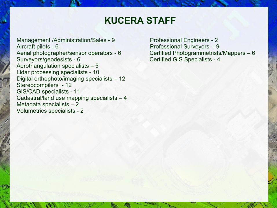
KUCERA STAFF
Management /Administration/Sales - 9 Professional Engineers - 2Aircraft pilots - 6 Professional Surveyors - 9Aerial photographer/sensor operators - 6 Certified Photogrammetrists/Mappers – 6Surveyors/geodesists - 6 Certified GIS Specialists - 4Aerotriangulation specialists – 5Lidar processing specialists - 10Digital orthophoto/imaging specialists – 12Stereocompilers - 12GIS/CAD specialists - 11Cadastral/land use mapping specialists – 4Metadata specialists – 2Volumetrics specialists - 2

Kucera Equipment
Data Acquisition, Scanning, Plotting
Four (4) - twin-engine Piper Navajo Chieftain aircraft w/ dual sensor ports Two (2) single-engine Cessna TU206 aircraft Two (2) Leica ADS40/SH51 4-band large format pushbroom digital camerasTwo (2) Vexcel UCX 4-band large format frame digital cameras Two (2) Zeiss RMK TOP film camera systems w/FMC + gyromount Two (2) Leica ALS60/70 250/500 KHz aerial lidar systems w/MPiA (1 with waveform) One (1) GeoVista 21 megapixel 4-way color digital oblique camera system Two (2) Z/I PhotoScan 3600 dpi photogrammetric film scanners Five (5) Trimble 5700/5800 dual-frequency GPS receivers One (1) Topcon GRS-1 dual frequency GNSS/VRS receiver Two (2) Topcon ET2 total stations Two (2) Terratech TerraPOS AGPS processing stations One (1) Ideal 8300 800 dpi 36" scanner One (1) Cannon IPF 9100 2400 dpi 60" color plotter One (1) Agfa Grand Sherpa 64" 1440 dpi color plotter One (1) HP 5500 1200 dpi color inkjet plotter

Kucera Equipment
Photogrammetric Processing/Map Preparation
Two (2) Inpho Match-AT digital aerotriangulation stationsTwo (2) Leica ORIMA digital aerotriangulation stationsTwo (2) GeoVista oblique image application stationsTen (10) Leica GPro/XPro ortho rectification stationsFour (4) Z/I OrthoPro ortho rectification stationsEight (8) Inpho OrthoMaster/OrthoVista ortho processing stationsFive (5) TerraSolid and GeCue LP360 lidar processing stations Four (4) Cardinal Systems VR2 softcopy stereoplotters (2 w/3D lidargrammetry)Three (3) BAE Socet Set softcopy stereoplottersTwo (2) Z/I SSK softcopy stereoplottersTen (10) Cardinal Systems VR1/2 map edit stations (4 w/TIN/contour generation)Six (6) ArcGIS, ERDAS Imagine, Global Mapper GIS stationsEight (8) AutoCad, Microstation, PLS-CAD, Terramodel CAD stationsTwo (2) Leica XPro autocorrelation/surface modeling stationsTwo (2) Inpho SCOP, Microstation InRoads TIN/contour generation stations

Scope of Work/Phases > Initiation > Ground control survey
> Digital aerial photography and airborne control survey > Aerotriangulation > Interim 3-band orthophotography > DEM Review/Update – new DSM/DEM generation as needed > Final 4-band digital orthophotography and metadata > Covering 11-county, ~7000 sq. mi. Denver, CO region
All work performed in-house from/at Kucera headquarters office (Willoughby, OH)
Regular, scheduled communication/status reporting
Use of proven, latest generation technologies and procedures
Thorough batch and manual QC review/edit process
Strive for improvement upon previous years' orthos
Kucera Approach - General
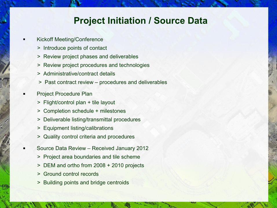
Kickoff Meeting/Conference
> Introduce points of contact
> Review project phases and deliverables
> Review project procedures and technologies
> Administrative/contract details
> Past contract review – procedures and deliverables
Project Procedure Plan
> Flight/control plan + tile layout
> Completion schedule + milestones
> Deliverable listing/transmittal procedures
> Equipment listing/calibrations
> Quality control criteria and procedures
Source Data Review – Received January 2012
> Project area boundaries and tile scheme
> DEM and ortho from 2008 + 2010 projects
> Ground control records
> Building points and bridge centroids
Project Initiation / Source Data

Point marking and field identification/referencing> Semi-permanent, e.g., - Pk nail, rebar, chiseled mark> Photos + description sheets
Control report - hardcopy + digital
> Procedure summary> Control listing > Network diagram
Control Survey / Georeferencing (Con't)

Aerial Photography Acquisition Time Frame
> Areas 1, 2, 4 - March 15 - April 15, 2012 (~ 60 flight hrs.)> Area 3 - June 2012 - after DRCOG authorization (~ 12 flight hrs.)
Capture Technologies> Piper Navajo Chieftain twin-engine aircraft, one w/ 2 sensor port> Leica ADS40/SH51 4-band, large format, pushbroom/strip image capture digital aerial cameras> Leica IPAS AGPS/IMU
Conditions> No significant clouds/cloud shadows, snow, flooding, leaves (Areas 1,2,4) > Minimum 30 degree sun height, 40 degrees over downtown Denver
Base of Flight Operations> Centennial Airport - Arapahoe County> Aircraft available for viewing during non-acquisition hours
Flight Plan> Areas 1 and 4 - 4700' above ground - 0.5' image capture> Areas 2 and 3 - 9400' above ground - 1' image capture> N-S Flight lines - full tile coverage> 30% side image overlap, 60-80% for reduced lean/”near-true” ortho areas


Leica ADS40 Digital Camera Technology
Kucera experience – 6 years, >200 counties/cities + 1 state (OR) - ~210,000 sq miles
Two committed systems + 1 backup available
Upgraded 51 series sensor heads (SH51)> Full alignment of color and infrared imagery> Improved image quality – shadow + highlight detail> Proper use of integration time for optimal image quality
Advantages of strip image capture> Reduced overall feature lean> Reduced image “stitching” / mosaicing required> Supports expedited preliminary ortho image delivery
> Varied stereo views/exaggerations support efficient DSM autocorrelation > Not susceptible to multiple camera-system anomalies (e.g., image “fringing”)
■ Inherent characteristic – elongation of moving vehicles in line of flight> Generally occurs only for vehicle speeds >35 mph> Can reduce effect using different image views (forward, nadir, aft)

Building No Lean Reduction

Building Lean Reduction

Reduced Mosaicing

Interim Orthophotography Time Frame
> Areas 1, 2, 4 - April 2012 delivery> Area 3 - June 2012 delivery
Production Technologies/Procedures> Leica XPro/ORIMA> Georeferencing to AGPS, ground control, existing DEM> Accuracy - ASP Class 2, as supported by existing DEM
Ortho Image Delivery> 3-band color> uncompressed GeoTIFF format> include digital flight index

DEM Preparation
Time Frame – May - August 2012 delivery
Production technologies/procedures> DSM Generation - Leica DSM
> Change Detection - Global Mapper > DEM Classification - TerraSolid Terramodeler
> Breaklines as needed- BAE Socet Set stereoplotters> Test rectification w/ source DEM> Determine areas of change> Update and/or replace as needed
Deliverable> New/updated DEM in specified format/datum (e.g., shapefile)> Optional DSM w/ or w/o image draping

Change Detection

Final Orthophotography Time Frame
> Pilot Areas 1, 2, 3 – June 2012> Pilot Area 3 - July 2012> Full Areas 1-4 - July - October 2012
Production technologies> Image rectification - Leica XPro> Image mosaicing/tiling - Inpho OrthoVista> Image edit - Adobe Photoshop> Datum conversion - Global Mapper
General process> Initial rectification + QC/geometric accuracy check
> Image mosaicing/seam line placement> Radiometric/color/tone adjustment/balancing> PLS tile extraction> Manual tile QC review/edit> Datum conversion/reprojection> Final uncompressed QC review + delivery> Compressed QC review + delivery
QC review process matching DRCOG DAT criteria> Positional accuracy> Feature representation geometric integrity> Image radiometry/resolution/detail visibility> Image coverage, organization, formats, metadata

Orthophoto Deliverables
Datums/Projections> NAD83/HARN CO Central Zone State Plane> NAD83 Pre-HARN CO Central Zone State Plane> NAD83/HARN CO North Zone State Plane> NAD83 Pre-HARN CO North Zone State Plane> UTM Zone 13 North, NAD83, meters
Uncompressed imagery> 4-band> PLS tiles> GeoTIF or TIF/TFW format
Compressed imagery> 4-band > PLS tiles>10:1 JPEG2000 w/ world file>10:1 JPEG2000 GeoTIFF>10:1 SID Gen 3 w/SDW
Associated data> FGDC-compliant XML metadata by tile> Mosaic seam line files -shapefile
Special Requirements - “Reduced Lean/Near True Orthophotography> Downtown Denver> Denver Tech Center> Denver Medical Campus

Customer Service/Support and Rapport
Continuing Services/Support
> Aerial lidar surveys
> Aerial oblique and street level imaging
> Aerial thermal + multispectral surveys
> Emergency/rapid response imaging/mapping
> Terrain Model and Topographic Feature Mapping
> Planimetric feature mapping – buildings, impervious surfaces, etc.
> Cadastral and land use mapping
> E911 road center mapping and addressing
> 3D visualization/modeling
> GIS conversion and support
> Promotional, education, public relations
> Data archiving and historical image conversion
Emphasis on long-term, cooperative working relationship – excellent track record