2.2 bio- physical environment 2.2.0 biological oceanography … · the biological oceanography...
TRANSCRIPT

2 - 42
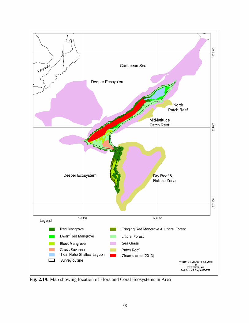
2.2 Bio- physical Environment 2.2.0 Biological Oceanography The Biological Oceanography component of the current EIA focuses on the habitat types, as well as the plants and animals associated with the project site [See Figs. 1.3a & 2.19]. The Biological Oceanography component of the EIA also focuses on the conservation concerns related to the site. This is in relation to both the geographical location and management implications of the project site relative to MPAs and other conservation areas, as well as in relation to species of special significance 2.2.1 Flora and Fauna The fauna and flora found in the area and by extension their associated habitats are greatly influenced by salinity and temperature. The oceanic quality nature of the saline influences of the area and the tropical temperatures generally combine to accommodate three (3) of the most productive and diverse ecosystems on the planet, viz: sea-grass beds, mangrove forests and coral reefs. As may be seen from Fig. 2.19, the sub-tidal portion of the project has a fairly well developed reef system off the southeastern portion of the caye. As may be seen from Fig 2.19 the reef systems occur in three (3) cluster zones: These are located in the near-shore waters off the southeastern end of the larger island, as well as the upper two-thirds latitude of said caye. The third reef system is a semi-dry rubble zone off the southeast portion of the smaller island [See Fig. 2.19]. Although much of the sea-grass is also distributed in the area of the reef zones, prominent meadows were also seen to the northeast of the larger island, as well as the shallower areas to the northwest of the caye. The emergent and caye-based vegetation were in large measure mangroves [See Fig. 1.3a & b]. Virtually 100% of the smaller island was covered by mangrove forests while 46.1% of the larger island was covered by mangroves [See Fig. 1.3a & b]. 2.2.1.1 Flora The flora associated with the project site can be segregated into two (2) main subsets, viz the land-based or supra-tidal and emergent vegetation, as well as the sub-tidal or below the surface of the water sub-set [See Figs. 1.3 a&b & 2.19]. The land-based portion consists of the supra-tidal component, which in large measure takes the form of ‘littoral forest’ and grass savannah, as well as the inter-tidal component which is represented mainly by mangroves. The supra-tidal component is in large measure the sea-grass beds and to a much lesser extent macro-algal stands. Technically the vegetation classes could be described as:

2 - 43
• Tropical Littoral Forest and Beach Communities • Mixed Mangrove Scrub • Coastal Fringing Mangrove and Overwash Mangrove Forest • Short Grass Savannah
Some of the more prominent tree species encountered in the littoral forest are: the Button Wood (Conocarpus erectus), the Gumbo Limbo (Bursera simaruba), the Black Poisonwood (Metopium brownei), the Sea Grape (Coccolaba uvifera), the Coconut (Cocos nucifera), the Thatch Palm or Bay Leaf (Acoelorrhaphe wrightii) and the Palmetto (Thrinax radiata). Some of the herbaceous vegetation associated with the beach and savannah were: Burr-burr (Cenchrus echinatus), Sporobolus (Sporobolus virginicus), Chichibe (Sida rhombifolia), Yama Bush or Rat Bean (Senna occidentalis) and Cladium (Cladium jamaicense). The most dominant mangrove species was the Red Mangrove (Rhizophora mangle): This was followed by the Black Mangrove (Avicennia germinans), which was followed by the White Mangrove (Laguncularia racemosa) [See Fig. 1.3 a&b]. The most abundant and ubiquitous subtidal vegetation was the Turtle Grass (Thallassia testudinum). There were also noticeable tufts or zones of the Manatee Grass (Syringodium filiforme) immediately adjacent the beach/land fringe on both the windward southeastern side of the caye, as well as the leeward northwestern side of the island. A number of macro-algal species were also seen in the seagrass beds around the caye, these include: the Clump Halimeda (Halimeda opuntia), the Shaving Bush Algae (Penicillus spp.), the Green Club Bubble Algae (Valonia macrophysa) the Brown Branched Algae (Dictyota divaricata), and the Feather Algae (Caulerpa prolifera).
PL 2.2.1 PL 2.2.2
44
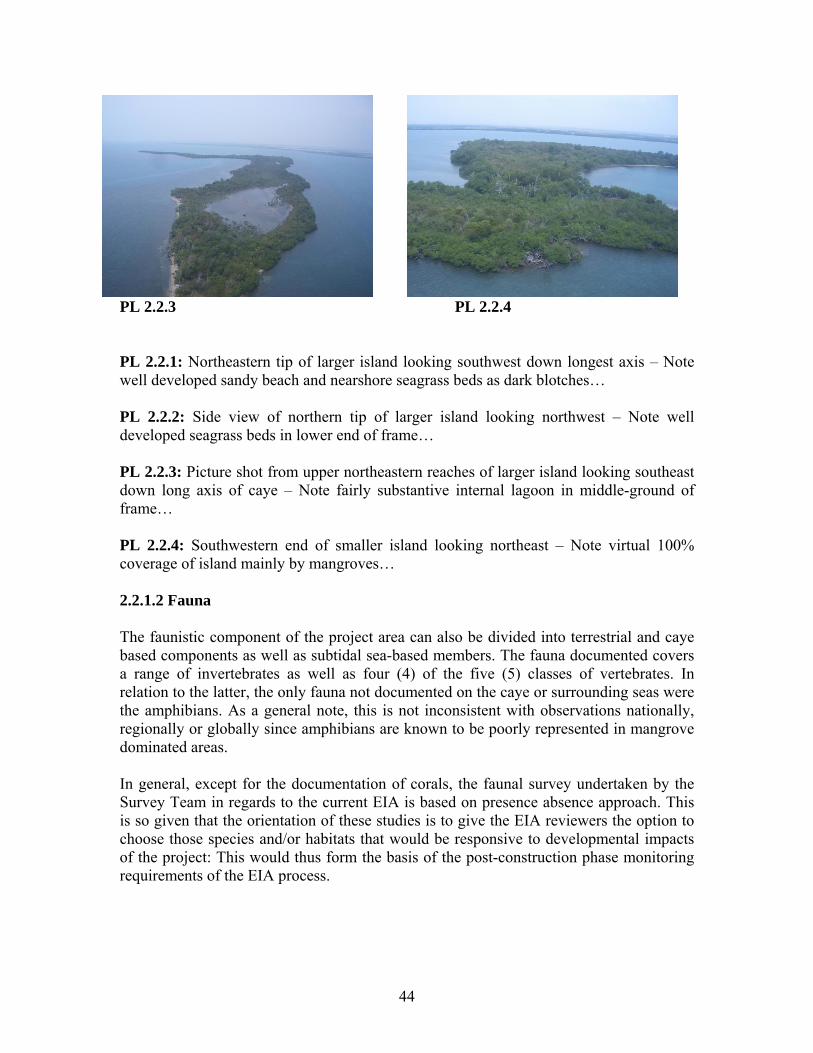
PL 2.2.3 PL 2.2.4 PL 2.2.1: Northeastern tip of larger island looking southwest down longest axis – Note well developed sandy beach and nearshore seagrass beds as dark blotches… PL 2.2.2: Side view of northern tip of larger island looking northwest – Note well developed seagrass beds in lower end of frame… PL 2.2.3: Picture shot from upper northeastern reaches of larger island looking southeast down long axis of caye – Note fairly substantive internal lagoon in middle-ground of frame… PL 2.2.4: Southwestern end of smaller island looking northeast – Note virtual 100% coverage of island mainly by mangroves… 2.2.1.2 Fauna The faunistic component of the project area can also be divided into terrestrial and caye based components as well as subtidal sea-based members. The fauna documented covers a range of invertebrates as well as four (4) of the five (5) classes of vertebrates. In relation to the latter, the only fauna not documented on the caye or surrounding seas were the amphibians. As a general note, this is not inconsistent with observations nationally, regionally or globally since amphibians are known to be poorly represented in mangrove dominated areas. In general, except for the documentation of corals, the faunal survey undertaken by the Survey Team in regards to the current EIA is based on presence absence approach. This is so given that the orientation of these studies is to give the EIA reviewers the option to choose those species and/or habitats that would be responsive to developmental impacts of the project: This would thus form the basis of the post-construction phase monitoring requirements of the EIA process.
45
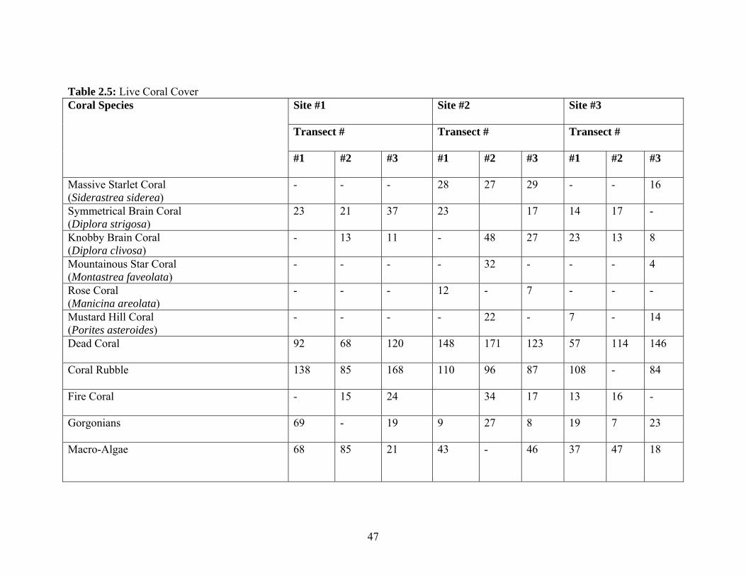
2.2.1.2.1 Coral Reef Ecological Status Survey The main purpose of the field surveys is to characterize the receiving environment in relation to the proposed excavation of an access channel and berthing facilities to accommodate NCL Ships. This entailed an assessment of the benthic communities, complimented by a cataloguing of the fin-fish and other aquatic vertebrates associated with the area. The benthic characterization of the area entailed an evaluation of the ecological condition and health status of the coral reef and its associated flora and fauna. The latter largely entails a range of sessile and slow-moving invertebrates, as well as macro-algae and sea-grass species. The aquatic vertebrate survey related mainly to fin-fishes and any other vertebrate that would be a part of the nekton inhabiting the water column. The latter includes crocodiles, dolphins and manatees. 2.2.1.2.1.2 Coral Reef Assessment The main aim of the coral reef assessment is to inventory and document the ecological vitality and diversity of the reef and its associated organisms. This entails the determination of the extent of Hard or Reef Building Corals on a given stretch of reef and the subsequent determination of the proportion of ‘live’ CORAL COVER on the reef. As a corollary exercise the ‘cover’ or quantum of macro-algae, gorgonians, sea-grass and other biota is also assessed and documented (See Annex 7). This included sceleratinian or hard corals, soft corals or gorgonians, the hydrozoan Fire Coral (Millepora spp.), coral rubble, macro-algae, sea grass and bare substratum which was mainly ‘pavement’ or compacted sand (See Table 2.5). For the hard coral survey, specifically the length or distance of ‘live coral’, was cumulatively measured, as well as the length of ‘dead coral’ and the denuded or un-colonized substrate: The species of corals encountered along the transect was also recorded, including the individual and cumulative cover of the particular species. The quantum of every other biota and bare substrate is also recorded for further analysis. The in situ field survey was complimented by in-house sample examination and laboratory analysis. The in-house observations related mainly to the seafloor samples collected at Sites CD #1 and CD #2 (See PLs 1 – 4). The coordinates of each transect was recorded: This was taken at the beginning of the transect line. The survey was carried out October 22 – 24, 2013. 2.2.1.2.2 Fish Survey The aim of the Fish Survey was to determine the range of species present and to get an estimate of their abundance. The two (2) basic methods explored to realize this goal were the Belt Transect Count and the Rover Diver Census. These methods were the protocol adapted by the Atlantic and Gulf Rapid Reef Assessment (AGRRA) Scientists. The rover diver was deployed to swim slowly in a radius of about 90 meter around the site of the Coral Transect at each of the three (3) sites sampled. The diver swam for about 30 – 45 minutes around the Coral Transect Site recording every species of fish and
46
documenting their numbers or abundance. The numbers of fish were documented on an under slate using the logarithmic category: 1 = Single, 2 – 10 = Few, 11 – 100 = Many, ≥ 101 = abundant. Species verification was made in situ using water proof identification slates and booklets. 2.2.1.2.2.1 Observations In addition to the three (3) reef assessment sites, two (2) other sites were sampled along the path of the proposed access channel (See Sites 4 & 5 Fig. 2.18): These sites however yielded very little information. This was a function of the extreme turbidity of the area. Visibility at CD #1 was about 6 feet while the visibility at CD#2 was about 8 feet;
The high turbidity of the area was a function of the location being heavily influenced by outfalls from the Sennis River, Big Creek and the Placencia Lagoon: This was compounded by the rains and generally inclement weather conditions at the site during the field survey, as well as the exposure of the area to relatively strong winds and heavy sea states. The latter is a function of the relatively long fetch between the project site and the eastern limits of the Bay of Honduras.
The underwater visibility conditions were at its worse on the third day of the survey with an increase in the rains and overcast conditions (Oct. 24, 2013).
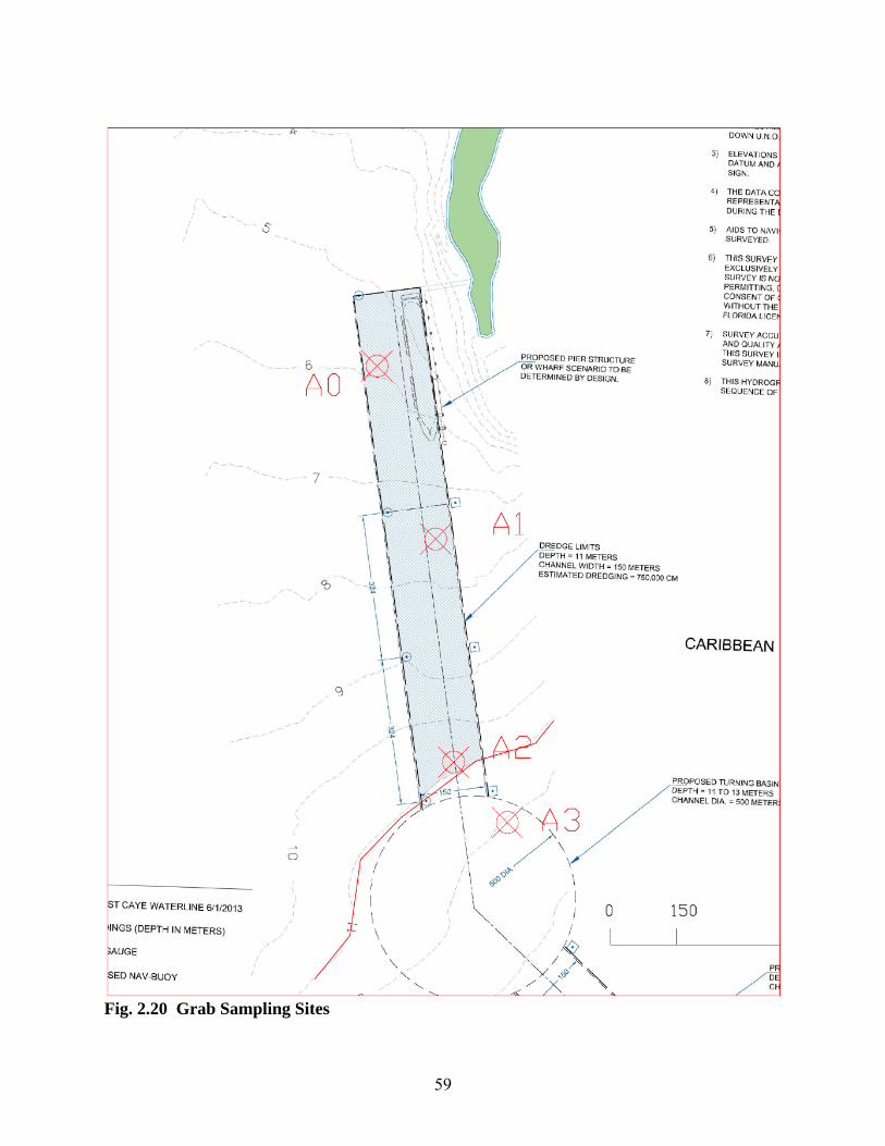
It was not possible to do any faunal survey at the deep water sites (See Site 4 & 5 Fig. 2.18) due to the aforementioned turbidity problem: The only samples taken were sediment samples taken by a simple construction trowel – Although the Survey Team was equipped with a ‘Grab Sampler’ for benthic surveys [See Fig. 2.20], this was impractical since when it was deployed all the sediments washed out of it by the time it was retrieved at the surface.
47
Table 2.5: Live Coral Cover Coral Species Site #1
Site #2 Site #3
Transect #
Transect # Transect #
#1
#2 #3 #1 #2 #3 #1 #2 #3
Massive Starlet Coral (Siderastrea siderea)
- - -
28 27 29 - - 16
Symmetrical Brain Coral (Diplora strigosa)
23 21 37 23 17 14 17 -
Knobby Brain Coral (Diplora clivosa)
- 13 11 - 48 27 23 13 8
Mountainous Star Coral (Montastrea faveolata)
- - - - 32 - - - 4
Rose Coral (Manicina areolata)
- - - 12 - 7 - - -
Mustard Hill Coral (Porites asteroides)
- - - - 22 - 7 - 14
Dead Coral
92 68 120 148 171 123 57 114 146
Coral Rubble
138 85 168 110 96 87 108 - 84
Fire Coral
- 15 24 34 17 13 16 -
Gorgonians 69 -
19 9 27 8 19 7 23
Macro-Algae 68
85
21 43 - 46 37 47 18
48
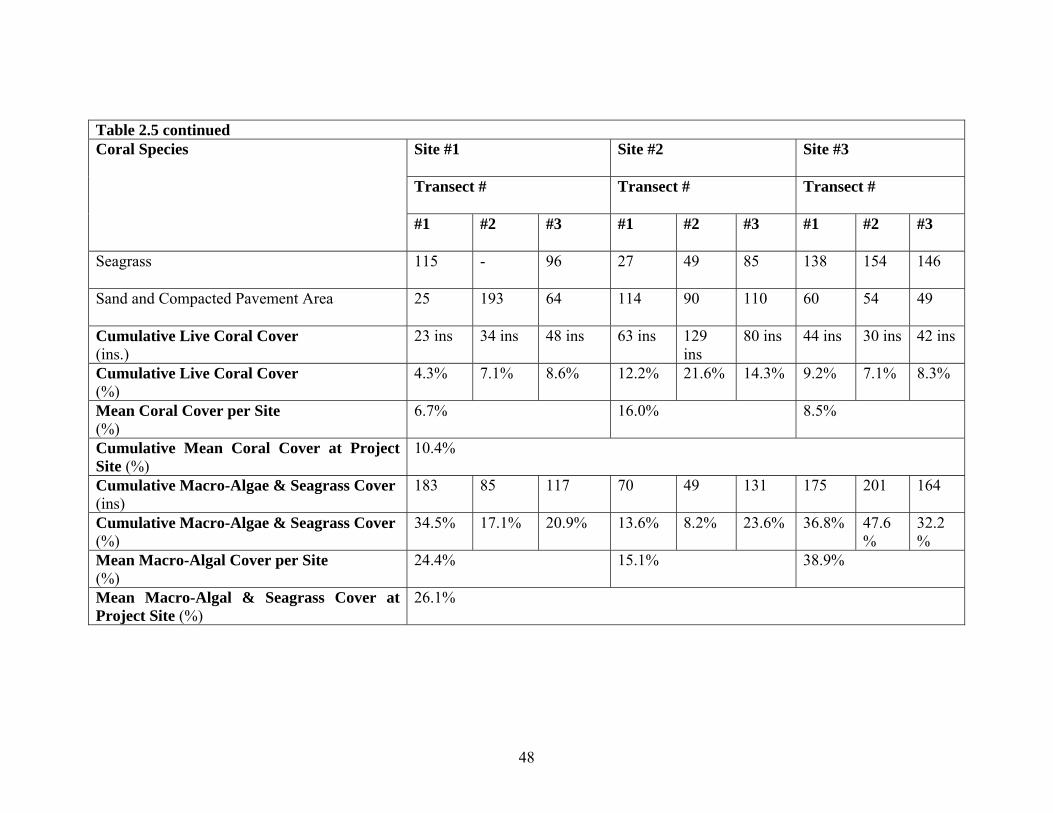
Table 2.5 continued Coral Species
Site #1
Site #2 Site #3
Transect #
Transect # Transect #
#1
#2 #3 #1 #2 #3 #1 #2 #3
Seagrass 115 -
96 27 49 85 138 154 146
Sand and Compacted Pavement Area 25 193
64 114 90 110 60 54 49
Cumulative Live Coral Cover (ins.)
23 ins 34 ins 48 ins 63 ins 129 ins
80 ins 44 ins 30 ins 42 ins
Cumulative Live Coral Cover (%)
4.3% 7.1% 8.6% 12.2% 21.6% 14.3% 9.2% 7.1% 8.3%
Mean Coral Cover per Site (%)
6.7% 16.0% 8.5%
Cumulative Mean Coral Cover at Project Site (%)
10.4%
Cumulative Macro-Algae & Seagrass Cover (ins)
183 85 117 70 49 131 175 201 164
Cumulative Macro-Algae & Seagrass Cover (%)
34.5% 17.1% 20.9% 13.6% 8.2% 23.6% 36.8% 47.6%
32.2%
Mean Macro-Algal Cover per Site (%)
24.4% 15.1% 38.9%
Mean Macro-Algal & Seagrass Cover at Project Site (%)
26.1%
49
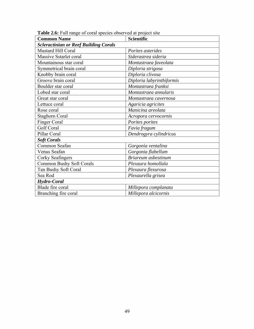
Table 2.6: Full range of coral species observed at project site Common Name Scientific Scleractinian or Reef Building Corals Mustard Hill Coral Porites asterides Massive Sstarlet coral Siderastrea sideria Mountainous star coral Montastraea faveolata Symmetrical brain coral Diploria strigosa Knobby brain coral Diploria clivosa Groove brain coral Diploria labyrinthiformis Boulder star coral Montastraea franksi Lobed star coral Montastraea annularis Great star coral Montastraea cavernosa Lettuce coral Agaricia agricites Rose coral Manicina areolata Staghorn Coral Acropora cervocornis Finger Coral Porites porites Golf Coral Favia fragum Pillar Coral Dendrogyra cylindricus Soft Corals Common Seafan Gorgonia ventalina Venus Seafan Gorgonia flabellum Corky Seafingers Briareum asbestinum Common Bushy Soft Corals Plexaura homollala Tan Bushy Soft Coral Plexaura flexurosa Sea Rod Plexaurella grisea Hydro-Coral Blade fire coral Millepora complanata Branching fire coral Millepora alcicornis
50
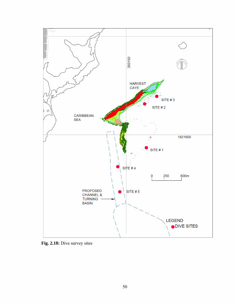
Fig. 2.18: Dive survey sites

51
Table 2.7: Invertebrates, sea-grasses and macro-algae encountered during dive survey Common Name
Scientific Name Abundance
Sea Grasse Turtle Grass
Thalassia testudinum Widespread and abundant
Manatee Grass
Syringodium filiforme Moderate abundance and distribution
Macro-Algae Y Branched Algae
Dictyota sp. Few limited distribution
Large Leaf Watercress
Halimeda discoidea Moderate and limited distribution
Water Cress
Halimeda opuntia Moderate abundance and widespread
Flat-Top Bristle Brush
Penicillus pyriformis Few limited distribution
Sea Pearl
Ventricaria ventricosa
Few limited distribution
Mermaid Fans
Udotea sp. Few limited distribution
Reef Cement
Porolithon pachydermum Moderate and limited distribution
Invertebrates Cushion Sea Star
Oreaster reticulatus Few limited distribution
Portugese Man-of-War
Physalia physalia Few limited distribution

52
Table2.8: Fin-fish Survey Results Species Transect Abundance
#1 #2 #3 Cocoa Damselfish (Stegastes variabilis)
X X Few
Striped Parrotfish (Scarus iserti)
X X X Many
Bucktooth Parrotfish (Sparisoma radians)
X X X Few
Stoplight Parrotfish (Sparisoma viride)
X X X Few
Midnight Parrotfish (Scarus coelestinus)
X X X Few
Spotfin Butterflyfish (Chaetodon ocellatus)
X Few
Beaugregory (Stegastes leucostictus)
X X Many
Nurse Shark (Ginglymostoma cirratum)
X Single
Red Snapper (Lutjanus campechanus)
X X Few
Dog Snapper (Lutjanus jocu)
X X Many
White Grunt (Haemulon plumieri)
X X X Many
Saucereye Porgy (Calamus calamus)
X X Few
Gray Snapper (Lutjanus griseus)
X Few
Doctorfish (Acanthurus chirurgus)
X Few
Gray Angelfish (Pomacanthus arcuatus)
X Few
Queen Angelfish (Holacanthus ciliaris)
X Few
Key: 1 = Single 2 – 10 = Few 11 – 100 Many ≥ 101 = Abundant

53
Table 2.9: Comparative Coral Cover Harvest Caye vs Other Locations in Belize Location Coral Cover (%) Source
Mean Minimum Maximum Current Harvest Caye Survey Harvest Caye 3 Deeper Water Sites
10.4% 6.7% 16.0%
Tunich Nah Consultants & Engineers October 2013
Harvest Caye 2008 Survey Harvest Caye 2 Shallow Water Sites
17.0% 5.0% 37% Tunich Nah site-specific survey June. ‘08
False Caye Historical False Caye (10 Transects) 9.7% 3.5% 14.1% Tunich Nah Derived Calculations of
Values Mar. ‘08 Historical Marine Reserves Bacalar Chico Marine Reserve and National Park 5 Sites
18.67% 13.65% 25.75% MBRS Synoptic Monitoring 2004 and 2005
Hol Chan Marine Reserve 4 Sites 11.97% 7.85% 14.18% MBRS Synoptic Monitoring 2004 and 2005
Caye Caulker Marine Reserve 4 Sites
44.58% 41.50% 48.83% MBRS Synoptic Monitoring 2004 and 2005
South Water Caye (Marine Reserve): No specified location(s)
44.25% 34.67% 49.95% MBRS Tech Doc. No. 18, Dec. 2006: Results of Synoptic Monitoring from 2004 and 2005
Sapodilla Caye (Marine Reserve): 3 Sites…2 back-reef and 1 deep fore-reef
28.95% 24.44% 37.74% MBRS Tech Doc. No. 18, Dec. 2006: Results of Synoptic Monitoring from 2004 and 2005
Belize National Average Belize National Average Live Coral Cover
25.75% - - MBRS Tech Doc. No. 18, Dec. 2006: synoptic Monitoring 2004 to 2005

54
PL#2.2.5: Sea Grass sample from Site PD#1: Turtle PL#2.2.6: Seafloor sample from Site CD#1: Note fine
Grass (Thalassia testudinium) silty muck constituency
PL#2.2.7: Seafloor sample from Site CD#2: Note PL#2.2.8: Seafloor sample from Site CD#2: Note
Silty muck consistency Note finer more watery consistency
55
The three (3) reef sample sites chosen were an on-site decision (See Fig 2.18). The reef systems were strategically chosen to be either in closed proximity to the dredging operations and pier development or to coincide with previous work done by Tunich Nah Consultants and Engineers (See Sites 2 & 3 Fig. 2.18 and Table 2.9). The more distal Sites 2 & 3 (See Fig. 2.18) have been scheduled to act as ‘control sites’ for the dredging operations.
The attached and slow-moving flora and fauna documented in the various Tables were not the full extent of the plants and animal encountered in the area. Those that were documented were the ones that occurred along the various transects. Some of the plants and animals that fell outside of the sampled area included three (3) West Indian Manatees (Manatus manatus), the Cushion Star (Oreaster reticulatus), and the Portuguese Man-of-War (Physalia physalia). Much of the soft corals included the Common Seafan (Gorgonia ventilina), the Corky Seafingers (Briareum asbestinum) and the Tan Bushy Coral (Plexaura flexurosa) [See Table 2]. Some of the flora encountered included the Sea Pearl (Ventricaria ventricosa), the Large Leaf Water Cress (Halimedia opuntia) and the Mermaid Fan (Udotea sp.) [See Table 2.7].
The area nearer to the Caye is dominated seagrass beds: The most important species in terms of abundance and distribution is the Turtle Grass (Thalassia testudinium). The Manatee Grass (Syringodium filiforme) is more abundant near to shore.
The turbidity greatly curtailed the taking of pictured to document the coral formations, invertebrates and fishes in the area.
2.2.1.2.3 Results and Discussion
The mean percent coral cover for the three (3) sites sampled (See Fig. 2.18) ranged from 6.7% to 16.0% with a mean of 10.4% (See Table 2.9). This was significantly lower than the coral cover documented for the site in 2008. The latter had an average coral cover of 23.1% (See Table 2.9).
The low reading was attributable mainly to the sampling of Site #1 (See Fig. 2.18) which was in large measure a shallow swash and rubble zone with much coral rubble and low coral cover. The lowest coral cover for the project site was recorded in this zone and read 4.3% (See Table 2.9).
The cumulative coral cover for the Harvest Caye sites was lower than the National Average: The Harvest Caye coral cover was 10.4% was less than the national average of 25.75% (See Table 2.9). The latter was documented in a Sub-Regional Survey of the Meso-American Reef System in 2005.
The current Harvest Caye Coral Cover was also significantly less than those obtained for a number of Marine Reserves. The average coral cover for the Bacalar Chico Marine Reserve and National Park was 18.67%, while those for the South Water Caye Marine Reserve was 44.25% (See Table 2.9).
The nearest approximation of Coral Cover to the current Harvest Caye initiative was False Caye with an average value of 9.7% (See Table 2.9).
56
The low mean cumulative Coral Cover of 10.4% for Harvest Caye for the current survey effort (See Table 2.5) places it in the ‘poor’ category for reef health and functionality. This is an indication that the area is exposed to significant stresses, which may be from within or from outside of the area. There is no discernible developmental or extractive use related activities that would be precipitating this stress from within the system. The only traditional usage of the area is fishing. This is for the most part subsistence fishing since the area is not noted for lobster or conch production which are prime commercial fishing activities in the area. The area is also not known as an aggregation site for the spawning of commercial stocks such as the Mutton Snapper (Lutjanus analysis) or the Red Snapper (Lutjanus campechanus), which are prime commercial finfish species.
The likely stressors to the system are from external sources: These are from a combination of heavy sedimentation and freshwater fluxes to the system. In the case of the latter is from the relatively lower salinities encountered [See Fig. 2.5 b]. The diluting influences are derived from the riverine outfall from lotic systems such as the Sennis River and Big Creek, as well as general land runoff from the areas such as the Placencia Lagoon. The freshwater inputs into the system are obviously of greater magnitude during the rainy season, which coincides with the Tunich Nah Field Survey in later October and early November 2013.
As a general rule Oceanic quality water has a salinity of 35 PPT and any values less than this would be indicative of the diluting influences of freshwater inputs into the system. It should be noted that the salinities recorded for the area on November 6, 2013 were generally higher (See Fig. 2.5 a & c) than those documented for October 28, 2013 (See Fig 2.5 b). This is because it was not raining on November 6, 2013 and the river systems were less flooded, as opposed to October 28, 2013 when it was raining and the river systems were in a greater state of flooding.
The turbidity and poor visibility conditions encountered during the late October/early November 2013 field survey by Tunich Nah are due largely to the flood stage and consequently larger outflows of the riverine systems and general land runoffs. The Turbidity values documented in Fig. 5 bear out the high turbidity of the area and the consequent low visibility status of the area.
In general the relatively low coral cover documented for the area, in particular Site #1 (See Fig. 2.18) is an indicator the Harvest Caye locale is not primary coral reef habitat. This may be confirmed from the large accumulation of coral rubble and the high proportion of dead corals along transects, especially at Site #3.
It can be argued that the corals and reef systems that have established and maintained in this environment have adapted to heavy sedimentation and indeed freshwater run-off and they may be resilient reef systems to some of the effects of Climate Change. In general it has been asserted that the rising sea temperatures brought about by global warming will result in more frequent and severe coral bleaching events. This may well result in exacerbating an already tenuous situation with the consequence of even lower coral cover and health status of the reef systems in the area.
Also in relation to Climate Change, it has also been postulated that as greater quantities of atmospheric Carbon Dioxide becomes dissolved in seawater the seas will become more acidic, altering the chemistry of the oceans. This will mean that corals and other organisms with carbonate based skeletons will need to expend more energy to ‘fix’ calcium carbonate: It has
57
been asserted that could lead to a reduction of 17 – 35% reduction in reef calcification and growth. This has significant negative implications in terms of health status and productivity for the reef systems in the area that are already stressed.
The increased frequency and intensity of hurricanes that have been associated with climate change also has negative implications for the reef systems at Harvest Caye. This is especially so for the shallow rubble strewn reef system at Site #1 (See Fig. 2.18). The devastation of high wave energy associated with hurricanes and in general storms will result in increased mechanical damage to the reef systems.
Apart from coral cover, the relatively high macro-algal and seagrass cover at the three (3) sites (See Table 2.5) are an indicator that nutrient pollution are a challenge for reef systems in the area. This is a consequence of land run-off, which is confirmed by the levels of nitrate and phosphate in the water column, as evidenced in Figs. 2.6 a.
The noticeable presence of fin-fishes in the area as evidenced in Table 2.8, is an indicator that the area can support fish life and on a local scale is a contributor to livelihood for commercial fishers and sport fishing guides who use the area.
The mucky and unconsolidated nature of the seafloor (See PL #’s 2, 3 & 4) in the deeper areas along the proposed path of the access channel (See Site #’s 4 & 5 Fig. 2.18) is an indicator that the area is not a prime habitat for coral reef or sea-grass bed: These are two (2) of the most productive and diverse ecosystems in tropical seas.
2.2.1.2.3.1 Conclusions/Recommendations
The total absence of any reef structures along the path of the proposed access channel makes the excavation of the channel a viable one from an environmental perspective. This is further augmented by the lack of any epi-fauna, algal stand or sea-grass beds on the seafloor of the deeper areas of the proposed channel.
The poor state of the reef systems off the immediate environs of the access channel (See Site 1, Fig. 2.18) would make the sedimentation impacts on the receiving environment much less of a critical concern, which bodes well for the mitigation of said impacts.
The proposed excavation of the access channel is thus a viable suggestion from an environmental feasibility standpoint: This would be predicated on building in the necessary engineering containment and procedural measures to mitigate and ameliorate the negative environmental impacts.
The environmental feasibility of the proposed project would also extent to the building of the berthing facilities, given these would not have any discernible impacts on sedimentation and/or the demise and destruction of the reef systems in the area.
58
Fig. 2.19: Map showing location of Flora and Coral Ecosystems in Area
59
Fig. 2.20 Grab Sampling Sites

60
PL 2.5 PL 2.6
PL 2.7 PL 2.8 PL 2.5: Cushion Star (Oreaster reticularis) in seagrass bed at Project site… PL 2.6: Cushion Star (Oreaster reticularis) in patch reef environment… PL 2.7: Loggerhead Sponge (Spheciospongia vesparium) in centre of frame… PL 2.8: Unidentified encrusting sponge in seagrass bed…
61
PL 2.9 PL 2.10
PL 2.11 PL 2.12
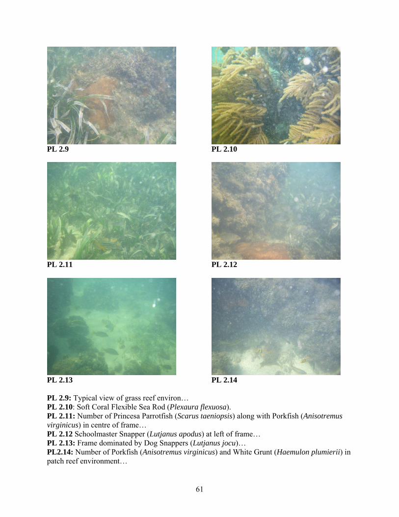
PL 2.13 PL 2.14 PL 2.9: Typical view of grass reef environ… PL 2.10: Soft Coral Flexible Sea Rod (Plexaura flexuosa). PL 2.11: Number of Princesa Parrotfish (Scarus taeniopsis) along with Porkfish (Anisotremus virginicus) in centre of frame… PL 2.12 Schoolmaster Snapper (Lutjanus apodus) at left of frame… PL 2.13: Frame dominated by Dog Snappers (Lutjanus jocu)… PL2.14: Number of Porkfish (Anisotremus virginicus) and White Grunt (Haemulon plumierii) in patch reef environment…

62
PL2.15 PL 2.16 PL 2.15: Scrawled Cowfish (Acanthostracion quadricornis) in lower end of frame… PL 2.16: Porkfish (Anisotremus virginicus) and number of White Grunt (Haemulon plumierii) in frame of patch reef at project site.
PL 2.17 PL 2.18 PL 2.17: Picture shot from lower southeastern quadrat of larger island looking southwest PL 2.18: Southwestern end of larger island looking east – Note well developed sandy beach running obliquely across 50% of frame and nearshore Red Mangrove islets. ..

63
PL 2.19 PL 2.20
PL 2.21 PL 2.22 PL 2.19: Close-up underwater shot of nearshore seagrass beds off northeastern end of caye – Note off white color of substrate indicative of carbonate sediments… PL 2.20: Close-up of seagrass bed off northeastern end of larger island – Note lush, prolific nature of seagrass growth… PL 2.21: Northeastern sea grass bed…Note sequence of sea grass, followed by stony coral and subsequently macro-algae… PL 2.22: Reef off mid-latitudinal area of larger caye – Note virtual 100% overgrowth of reef by macro-algae, which was typical of reef in the area.
64
2.2.1.2.2.2 Aquatic and Semi-Aquatic Reptiles and Mammals Apart from small Anoles (Anolis spp.), the caye-based reptile of note observed by the Tunich Nah Survey Team was the Green Iguana (Iguana iguana). The other reptile of note reportedly occurring in the area was the American Crocodile (Crocodylus acutus) [See Table 2.10]. This animal was reported to be seen on both the caye, as well as the surrounding seas. Table 2.10: Aquatic and Semi-aquatic Reptiles and Mammals occurring in the project area Common Name
Scientific Name Observed During Survey
Reported Anecdotally
Environment
Reptiles Anole Anolis (sp.)
CB
Green Iguana Iguana iguana
CB
American Crocodile
Crocodylus acutus
CB, NSA
Aquatic Mammals
West Indian Manatee
Trichechus manatus
NSA, OSA
Bottle-nose Dolphin
Tursiops truncatus
OSA
Key: NSA = Nearshore Areas
OSA = Offshore Areas CB = Caye Based The mammalian forms of note occurring in the area of the proposed project site were both aquatic in orientation. These were the West Indian Manatee (Trichechus manatus) and the Bottle-nose Dolphin (Tursiops truncatus) [See Table 2.10]. The manatees are known to occur in significant numbers to the west-north-west of Harvest Caye. 2.2.1.2.2.3 Birds Twenty-six (26) species of birds were observed on Harvest Caye. These include woodland species as well as wetland fowls and seabirds. A number of the wetland species such as the herons, egrets, stilts, yellowlegs and wood storks were seen in the lagoon on the northern end of the larger island [See Table 2.11 and Fig 2.20 b]. The most ubiquitous and frequently occurring forms were the seabirds. These included: the Brown Pelican (Pelecanus occidentalis), the Neotropic Cormorant (Phalacrorax brasilianus), the Laughing Gull (Larus atricilla) and the Magnificent Frigatebird (Fregata magnificens) [See Table 2.11].
65
Familiar woodland species encountered included: the Golden Fronted Woodpecker (Melanerpes aurifrons), the Flycatcher (Empidomax species), and the Melodious Blackbird (Dives dives). The species associated with the project site either residents or visitors. Resident species included the Brown Pelican (Pelecanus occidentalis), the Green Heron (Butorides virescens) and the Osprey (Pandion haliaetus) [See Table 2.11]. Winter residents included the Black Bellied Plover (Pluvialis squatarola) and the Little Blue Heron (Egretta caerulea) [See Table 2.11]. Winter migrants to the caye included the Yellow Warbler (Dendroica petechia) [See Table 2.11]. At the time of the field survey there were no signs that the caye was being used as a breeding site for sensitive and gregarious marine species such as the Red Footed Booby or the Bridled Terns which have a declining breeding population. Further details of issues related to the Tunich Nah bird survey may be found in Annex 9. Table 2.11: Birds Species identified on Harvest Caye Common name
Scientific name Habitat Seasonality Abundance
Brown Pelican Pelecanus occidentalis
Sea Resident very common
Neotropic Cormorant
Phalacrorax brasilianus
Sea Resident common
Anhinga Anhinga anhinga Lagoon visitor very common
Magnificent Frigatebird
Fregata magnificens
Sea Resident very common
Great Egret Ardea alba
lagoon & mangrove Visitor uncommon
Snowy Egret Egretta thula
Lagoon,mangrove Visitor uncommon
Little Blue Heron Egretta caerulea Lagoon winter resident common Green Heron Butorides
virescens Mangroves
Resident common
White Ibis Eudocimus albus
Mangrove & lagoons Visitor uncommon
Osprey
Pandion haliaetus Mangrove & lagoons Resident uncommon
Black Bellied Plover
Pluvialis squatarola
Beach winter resident uncommon
Spotted Sandpiper Actitis macularia lagoon & beach winter resident Common
Laughing Gull Larus atricilla Sea Resident very common
White Crowned Pigeon
Columba leucocephala
Mangrove & littoral forest
seasonal resident only
common
66
Common name
Scientific name Habitat Seasonality Abundance
Cinnamon Hummingbird
Amazilia rutila Beach Resident common
Green Breasted Mango
Anthracothrax prevostii
Coastline Resident uncommon
Golden Fronted Woodpecker
Melanerpes aurifrons
Coastline Resident common
Flycatcher Empidomax sp.
Mangrove vireo Vireo pallens Mangrove Resident Uncommon
Yucatan vireo Vireo magister Mangrove Resident Very common
Black Catbird (Mockingbird)
Melannoptila glabriostris
Littoral forest Resident uncommon
Wood Warblers Yellow Warbler Dendroica
petechia Mangrove, low scrub minter migrant common
Magnolia Warbler Dentroica magnolia
Mangrove winter migrant common
Northern Waterthrush
Sieurus noveboracensis
Mangrove and littoral forest
winter migrant common
Blackbirds Melodious Blackbird
Dives dives
Coastal Resident common
Great-Tailed Grackle
Quiscalus mexicanus
Coastal and cayes Resident common

67
Fig 2.20 b: Map showing Bird count locations in relation to habitat
68
2.2.2 Conservation Issues Conservation issues in relation to the current EIA relates to both species of special significance, as well as those sea-based geographic locations with some measure of statutory protection. In the case of the latter the nearest MPA is the Port Honduras Marine Reserve [PHMR]. This Marine Reserve at its nearest approaches lies 12 NM southwest of the proposed project site. Species of special significance are generally either endangered or threatened in some way. These species include both the American Crocodile (Crocodylus acutus) and the West Indian Manatee (Trichechus manatus). The American Crocodile (Crocodilus acutus) is protected by the Wildlife Protection Act, which prohibits any hunting or collection otherwise of these animals. The crocodile also falls under the CITES Regime on international trade: In this regard it is listed in Appendix II of the CITES Regulations. The West Indian Manatee (Trichechus manatus) has also been listed as endangered by the U.S. Fish and Wildlife Service and has been listed as vulnerable to extinction by IUCN. The species is also protected under the CITES Regulations where it has been placed on Appendix I of the ‘Species List’. There are two (2) manatee hotspots in the vicinity of the proposed project site. These are the Indian Hill Lagoon/Sennis River Complex and the Placencia Lagoon. These sites represent activity centers that are used year-round by groups of manatees for feeding, resting and accessing freshwater. Manatee use of the site is not seasonal and has been reliable from year to year. This is confirmed by aerial survey maps of the area [Fig. 2.21]. Each point on the map represents a sighting which could be one or a few animals (Pers. comm., Nicole Gomez).
69
Fig 2.21: Manatee Aerial Survey 2006/2007(Courtesy Nicole Gomez) The Harvest Caye area and surrounding environs have sea grass beds that are important for the manatee. Harvest Caye Eco-Resort development has taken this into account, and have determined that the development should have little or no effect on the foraging area for Manatees. Dredging activities are to be confined to areas that are east of-, and appreciably removed from locally frequented Manatees.
70
As per Attached Argos Map [See Fig. 2.22], Harvest Caye is within a travel corridor for manatees that use the Indian Hill/Sennis River area and the Placencia Lagoon. The map shows a tagged manatee that has consistently showed this pattern. The map specifically shows movement of an adult male manatee between July 6 and 14, 2008 (Per com Nicole Gomez). Watercraft collisions continue to be the primary cause of deaths for manatees in Belize (per com Nicole Gomez). This site is becoming more and more of a tourist attraction and mitigation measures need to be put in place. Additionally, various additional threats to manatees compromising important use areas (e.g. reduction of submerged aquatic vegetation and increased pollution in coastal lagoons), such as this one need to be managed properly to safeguard their productivity and suitability for species of concern, such as the manatee. Taking this into consideration, the developer has ensured that the development on the leeward side is minimal: This entailed a relocation of the proposed marina from the leeward section of the island to the inner lagoon within the island, as well as the purchasing and deployment of signage focused on Manatee conservation measures. Figs. 2.23, 2.24a and 2.24b show the different measures being taken by the project proponents to address the situation in the event of stranding and boating guidelines. The developer is willing to cooperate with the proper authorities and assist in addressing the problem by complying with the relevant regulations.
Fig. 2.22: Tracking Data of Tagged Manatee (Courtesy Nicole Gomez)

71
Fig. 2.23: Brochures that provide manatee info to resource users
72
Fig. 2.24a: Stranding Network Information

73
Fig. 2.24b: Stranding Network Information
74
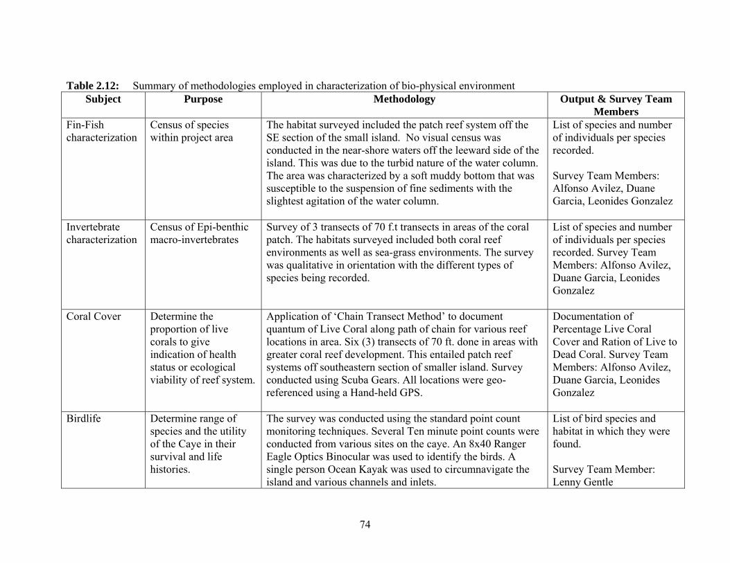
Table 2.12: Summary of methodologies employed in characterization of bio-physical environment
Subject
Purpose Methodology Output & Survey Team Members
Fin-Fish characterization
Census of species within project area
The habitat surveyed included the patch reef system off the SE section of the small island. No visual census was conducted in the near-shore waters off the leeward side of the island. This was due to the turbid nature of the water column. The area was characterized by a soft muddy bottom that was susceptible to the suspension of fine sediments with the slightest agitation of the water column.
List of species and number of individuals per species recorded. Survey Team Members: Alfonso Avilez, Duane Garcia, Leonides Gonzalez
Invertebrate characterization
Census of Epi-benthic macro-invertebrates
Survey of 3 transects of 70 f.t transects in areas of the coral patch. The habitats surveyed included both coral reef environments as well as sea-grass environments. The survey was qualitative in orientation with the different types of species being recorded.
List of species and number of individuals per species recorded. Survey Team Members: Alfonso Avilez, Duane Garcia, Leonides Gonzalez
Coral Cover Determine the proportion of live corals to give indication of health status or ecological viability of reef system.
Application of ‘Chain Transect Method’ to document quantum of Live Coral along path of chain for various reef locations in area. Six (3) transects of 70 ft. done in areas with greater coral reef development. This entailed patch reef systems off southeastern section of smaller island. Survey conducted using Scuba Gears. All locations were geo-referenced using a Hand-held GPS.
Documentation of Percentage Live Coral Cover and Ration of Live to Dead Coral. Survey Team Members: Alfonso Avilez, Duane Garcia, Leonides Gonzalez
Birdlife
Determine range of species and the utility of the Caye in their survival and life histories.
The survey was conducted using the standard point count monitoring techniques. Several Ten minute point counts were conducted from various sites on the caye. An 8x40 Ranger Eagle Optics Binocular was used to identify the birds. A single person Ocean Kayak was used to circumnavigate the island and various channels and inlets.
List of bird species and habitat in which they were found. Survey Team Member: Lenny Gentle

75
Subject
Purpose Methodology Output
Aquatic and Semi-Aquatic Mammal and Reptile characterization
To record presence of species within project area
Engaging in 2 boat surveys of the entire area comprising of a captain and spotter.
List of species and nature of environment in which found. Survey Team Members: Alfonso Avilez and Jose Garcia, Leonides Gonzalez
Mangrove Characterization
To record presence of mangrove species and their distribution
Entailed trek throughout entire island system to identify species – complimented by digitized imagery sourced from ‘Google Earth’.
Vegetation Map Survey Team Members: Alfonso Avilez and David McCollough
76
2.3 Socio-cultural Environment 2.3.1 Introduction Master Planned and Large Resort Development projects planned for development in eco sensitive marine coastal environments will always produce some level of impact to the environmental conditions over no development. These impacts may be temporary due to the direct impact of construction and other long term effects due to improvements made to land mass, water way development and added flora and fauna. Other influences and changes to the environment may include impacts to traditional/cultural resources and recreational uses including fisheries and migrations of species. Development may also include introduction or changes in ethnic and demographic migration and or dispersion based on intended use. Properly planned development projects while impacting social and cultural environments generally improve the social and cultural environments depending on the size and type of the development, which must also create or enhance economic circumstances, for the health, education and other social benefits that are valued by society at large and by the specific communities impacted. These large development projects can also produce positive impacts on the entrepreneurial small business community particularly those related to hospitality and related service industries. These impacts most directly affect immediate supply and demand of construction materials and construction related jobs and services; while increasing the long term demand for cultural entertainment and historical education, as well as increase employment opportunities in many sectors of the community. The social infrastructure of the area will be impacted even though for the most part the proposed development will be self-contained on the off shore island. The most impact on social infrastructure will be indirect and affect the larger communities on the mainland which will provide employees for the development and contribute to the new supply and demand services added to accommodate the development. Social impacts form a newly developed project should be positive as the project will generate new jobs in almost every business segment of the local population and meet the needs of the residents, visitors and existing businesses. The traditional users of these unimproved lands and waters includes (fishing and tourism ventures) which will impact the biological and physical resources if mitigation measures are not put in place. In terms of positive impacts, the proposed development will create an increase in the demand for goods and services, such as transportation, agricultural commodities and skilled labor. It is expected that the project will create long-term employment and investment opportunities for the area, the region, and the country on a whole during both the construction phase as well as the follow-on implementation phase of the project. The environmental assessment contained herein identifies, analyses, and evaluates those social impacts the proposed development may have on individuals, social groups, traditional users, and other social users of the area during the construction as well as post-construction phases of the project. In terms of positive impacts, the proposed development will create an increase in the demand for goods and services, such as transportation, agricultural commodities and skilled labor. It is expected that the project will create long-term employment and investment opportunities for the

77
area, the region, and the country on a whole during both the construction phase as well as the follow-on implementation phase of the project,. The current assessment identifies, analyses, and evaluates those social impacts the proposed development may have on individuals, social groups, traditional users, and other social users of the area during the construction as well as post-construction phases of the project. 2.3.2 Regional Demographics and Population Related Issues The Stann Creek District is the second smallest district in size with an area of 840 sq. miles. The 2000 Population Census showed the district had a population of 24,548 representing 10.2% of the total population of Belize (240,204) and a population density of 29.2 per square mile. The mid-year estimate for 2006 for the district population is 32,200 (10.3% of country total estimate of 311,500) and a density of 38.3 per sq. mile. There was an average of 4.2 persons per household in the district [CSO Mid-year estimate 2006]. The national population density in 2000 and 2006 were 28.2 and 35 persons per square mile, respectively. The communities to be most likely impacted by the development are Independence, Mango Creek and Big Creek. These communities had a combined population of approximately 5,000 in 2007 [See Table 2.13 below]. Table 2.13: Current and Projected Population of 2 Communities to be Directly Impacted by
the Proposed Development (CSO Census 2000/AOS 2007) Village Total in
2000 Number of Households
Males in 2000 Females in 2000
Mid-year Estimates in 2006 (Total)
Mango Creek & Independence
2,881 636 1,447 1,434 5,000
Please note the CSO reports that annual population growth rate for Belize is 2.7%. 2.3.2. 1 Description of Big Creek and Mango Creek A brief description of the Big Creek and Mango Creek Communities follow: Independence/Mango Creek Village and the Big Creek Port The Big Creek, Mango Creek, and Independence areas can be characterized as citrus, banana and shrimp farming country. Big Creek is a deep water port for Belize where boats from all over the world enter to pick up bananas, shrimp, lobster, oranges, grapefruit, mangoes and plantains. Mango Creek to the north is a support area for much of the processing of the shrimp that is exported. In Independence there are relatively large numbers of expatriates who have built homes. Independence has a regional emergency care hospital or poly-clinic, two denominational primary
78
schools, a number of churches, a large ball park where regional football tournaments are sponsored, and a high school that serves much of southern Stann Creek District, including Placencia and Siene Bight Villages. This expanded village has other amenities including:
- a regional police headquarters - a regional airstrip with international connections - a potable water system that has a very abundant aquifer - a garbage collection system with two specialized trucks - a small boat taxi “marina” or pier in Mango Creek that facilitates movement of villagers
and tourists in the area - two hotels and a few guest houses - a number of grocery shops - a pharmacy and - a number of restaurants and bars.
With the increasing importance of tourism to the Belizean economy, the waters around the mangrove islets in the Placencia Lagoon are being used for sports fishing and manatee watching by tourists from Placencia, Monkey River, and Mango Creek. There is also a total of approximately 100 fishers of lobsters, conch and scale-fish from Independence, Placencia and Monkey River who have traditionally utilized the waters around Harvest Caye, however there are no fishing camps on the island. During the current Social Assessment Interviews those interviewed were informed that the proposed development will take place in one continuous phase and will involve minimum impacts to the mangroves. The project should be inaugurated on 2015. 2.3.2.2 Summary of Stakeholders Concerns (2010) In earlier Harvest Caye development discussions in 2010 with direct stakeholders in Independence and village leaders in Placencia, the primary negative concerns registered were (in no order of priority):
• impact of dredging to this somewhat productive fishing grounds for lobster, conch and scale fish;
• dredging will kill the lobster juveniles and increase the depth of the water; • dredging will “scare and chase” the lobster, conch and fish on the east and west sides of
the island and reduce the catch of the fishers thus impacting on the sustainability of the fishing industry that is already on a downward trend. They mentioned that the three shrimp farms in the area have already “chased” these animals because of the waste emptied into the sea;
• sedimentation will destroy the sea grass beds (feeding habitat) and coral and will also cover the fishing traps and kill lobster in traps and shade if dredging is done during the eight-months lobster season thus resulting in financial loss to the fishers;
• loss of sea grass beds will also affect the manatee which are a tourist attraction and will affect the livelihood of the Placencia and Monkey River tour guides;
• settlement of fine silt on the barrier reef and mangroves will also affect spawning aggregation sites, especially for lobster;
• cutting the mangroves will result in the lost of breeding grounds (habitat), as well as the
79
lack of protection from storms for Big Creek; • displacement of fishers from their current fishing grounds and of tour guides due to the
dredging and marina docks establishment; • the development may cause restriction of traffic to fishers; the area may be “buoyed off”
to prevent fishers and tour guides from using the areas close to the island; • disposal of solid waste and sewerage will be a problem; • fishing rights may be lost and thus result in loss of traditional livelihood; • the marina will create bilge pollution; • employment of people from the villages will be limited to lower positions while the
senior management position will go to non-villagers; • increased boat traffic will create disturbance resulting in lobster, conch and fish not
settling in the area; • the traffic by high speed boats will affect not only the commercial species but will also
kill or threaten the lives of the manatees resident in the area; • the development should not displace fishing and a balance should be found between the
two activities; • cultural impacts that may result from workers coming from other districts that are not
sensitive to the local customs, especially as it relate to water usage, human waste and garbage disposal.
In meetings held by NCL with direct stakeholders in Independence and Placencia, the main negative concerns registered were (in no order of priority): While the stakeholders made it clear that they are not against development, they want this type of development to follow the Coastal Zone Development Guidelines that were developed by the Coastal Zone Management Authority and Institute during its First Phase. If dredging is not done properly, the development can have serious impacts on the fishers, the cooperatives and the overall economy of the area. Under the proposed redevelopment of Harvest Caye as a Cruise destination the dredge component of the project has less direct impact to the fisheries and is limited to a single approach channel leading to existing deep water. Direct stakeholders interviewed in the Mango Creek, Independence and Placencia Area were: Mr. Gustavo Carrillo, Manager, Port of Big Creek Ms. Candy Logan, Manager, CARDI’s Hotel and Restaurant Mr. J. William Barillas, Representative and Boarding Officer, Belize Port Authority Mr. Elvis Leslie, Fisher, Independence Mr. Lincoln Garbutt, Fisher, Independence Mr. Mario Gonzales, Fisher, Independence Mr. Ralph Ramclam, Fisher, Independence Mr. Michael Young, Fisher, Independence Mr. Lindsey Garbutt, Manager, Friends of Nature Mr. Erlindo Jacobs, Worker, Friends of Nature
80
Mr. George Murray, Chairman, Independence Village Council Mr. Dwight Neal, Chairman, Independence Water/Solid Waste Board Mr. Francisco Linares, Justice of the Peace, Mango Creek Mr. Francisco Cruz, Banana, Citrus and Cattle Farmer Mr. Bryan Yearwood, Chairman, Placencia Village Council Mr. David Vernon, Chairman, BTIA, Placencia Branch Mrs. Elizabeth Zabaneh, Business Owner, Mango Creek Mr. Allan Dunker, Business Owner, Independence Mr. Sidney Lopez, Chairman, Placencia Cooperative Society Summary of responses (2013) The survey was conducted over two (2) days period (November 19-20, 2013). Interviewees were randomly selected from the villages of Maya Center, Seine Bight, Placencia, Independence and the Big Creek Port. A total of 25 persons were interviewed during the survey period [See Table 2.13 b]. Twenty two (88%) of the respondents indicated that they knew about the proposed project as compared to only three (12%) who indicated not having any knowledge of the project. Twenty one (21) respondents (84%) voiced positive concerns. The positive concerns/comments were mainly about employment creation and opportunities for businesses/entrepreneurs and overall development in the Southern Region. Only four (4) respondents (16%) expressed negative concerns about the project. The negative concerns focused mainly on the following:
• Dredging will negatively affect manatees and coral • Pollution/run off, garbage/waste disposal • Project does not reconcile with Tourism Master Plan for the region
Suggestions that were made by the persons interviewed varied, but most stated that they should ensure that they mitigate environmental impact, create opportunities for all tourism stakeholders, and deliver on promises made to stakeholders, and create a fund to assist villages in the area with developmental projects. Additionally, the four area representatives of the southern region were interviewed, and the following are their comments about the project:
1. Yes we had several meetings with the principals and the project looks great. We were explained what will happen phase by phase. 2. Our main positive concerns is the creation of jobs and we were promised that the people of the south will have first priority in every aspect of the project this also include tours. 3. Our main negative concern is the impact of the environment and the 25 years exclusivity for the entire southern Belize.
81
Contact Name Email Phone Comments / Concerns
Samuel Ack [email protected] 650-0598
We the Mayan People need jobs. 1. Are there going to be community projects for the village who seek funding from NCL? 2. Are there specific requirements for employment? 3. Can NCL adopt a village for any project that they want in the village?
David Cruz [email protected] 622-0853 The Steadfast Village Council fully supports NCL 1 . Want to know more about the JOBS.
Gonzago Cal (Red Bank Village)
N/A 633-3582
Red Bank supports the project. "It is a vision for us. We will greatly benefit from it." 1. Red Bank has so much to offer. 2. PROBLEM they lack tour guide & support for training. 3. They are ready to start moving. Also make every effort to visit Red Bank
Zabdiel Martinez [email protected] 633-8792
We would appreciate that the provision of employment be done without POLITICAL interference. 1. What about the Latin Culture in Southern Belize? 2. Fliers and presentation missing Latin / Spanish culture.
Juan Choc N/A 628-6698
1. How can we benefit in our Community of Indian Creek. 2.. How soon are we going to get through to this business? 3. Who can get into the cruise jobs and how soon?
82
Ernesto Saqui (MAYA CENTER)
N/A 665-1313 I support the NCL Development
Hon. Anthony Ramos Sr. J.P [email protected] 663-9876
Thinks this project will be a blessing for the community. 1. Wants to know if marriages will be officiated on the ship. Harvest Caye is happy to proposed different wedding packages at a package cost.
Hilberto Choc (Toledo District)
N/A 636-2018
1. How can we get these jobs? 2. Where / Who do we need to contact for us to get the jobs? 3. When will the first trip that is going to happen? Wants to be notified so they are aware. 4. Has a product and wants to know how he can find the guest so he can show his product.
Jonathan Cor [email protected] 661-0897
They want to be included in the map. PLEASE EMAIL. 1. How soon will you be hiring people? 2. How can Red Bank Village be involved in setting up a business service. Such as a Tour guide.
Reynerio Yuvianis Lobo (Chair person with Santa Cruz Village)
N/A 667-1482
Equality and fair share among the people of Southern Belize.
Blanen Chan (Valley Community Village Council)
N/A 625-3745
Thank you for choosing the South but at the same time whenever the project comes out I would like you to train our own people in our community without any political interference or any related parties.
83
Antonia Shal (Chairman)
634-5281
Santa Rosa Village has a beautiful waterfall which I would like to develop as a tourist destination. However, I like my village. Training as tour guide will benefit directly on this project.
Federica Choc [email protected] 662-9365
1. How will the village of Maya Center and stakeholders (Women’s Group, Tour guides, cocoa farmers, Maya museum, and taxi owners) benefit from NCL? 2. Is there a time limit when the villagers should expect feedback and training for preparation because our village has a lot to offer. STATEMENT: Cruise Tourist that visit our village have very limited time to be in the village and having no or little cash in the village.
Polinaria Bolon (Secretary of Maya Center Women's Group)
N/A 650-8475
Concerned of Nature Park vendor space. 1. Will there be enough room for them to sell their arts and crafts. Concerned it will be overcrowded and they will be left out again.
84
Alverta Sagin (Chair Lady) Maya Culture Women's Group
N/A phone: 533-7034 cell: 668-2434
1. How can an existing craft center become a visiting point for the cruise? 2. How can the items in the craft center be evaluated with reference to quality? 3. In the past the cruise used to buy gift items from the craft center, today they are not benefiting. The sales helped parents with educating children at the primary secondary level. 4. Would like for the Maya Center Women's Group to be a tourist point.
Richard Sameul Jagana N/A 605-3451 or 605-
3951 (not sure)
1. Will the whole southern district get a fair chance in employing workers? 2. What type of qualification will be needed in able to work with NCL? 3. Will the NCL be able to assist local business in terms of local staying in the south? Example: How to make sure local restaurants and other business would stay open or pop up. 4. Please be fair with the southern people and be there for them. We all need fair success.
85
N/A N/A N/A
1. Why do passengers do not like to buy local crafts? 2. is it true that the cruise owners discourage them to buy off land because the ship has everything? If so how then can we the villagers benefit from these cruise lines? 3. What job opportunities can we expect from these ships? 4. Is it true that the government will get $7.00 head tax and will give back $4.00 to the company, what kind of benefit is that? 5. I have read an article in the newspaper where an American Congress man described the cruise company as blood suckers because they do not observe the tax law and the labor laws. IS THAT TRUE?
Pablo Choc (Chairman of Idian Creek Village)
N/A 660-7857
Concern: Indian Creek Village is just a 3/4 mile from Nim Li Pinnit archeological site. I would like to request that we want our community to benefit from these cruise business in the south. We want consultation with each community so that everybody will understand what cruise line is and how the community benefits from it. We need to meet with B T.B. Personnel. We need our people to be trained. We need to prepare our villages especially the site. It needs to be upgraded - the ROADS are bad. Parking area not goo. What type of guide needed? Arts and craft need to work with group etc.
86
Candelaria Chub (Laguna Village
N/A 635-1855
I am not involved in tourism opportunity in my village but I am very much interested in taking tour guide training. Given the opportunity I would make a difference in my community. I support this project.
Justina Sackul N/A 637-4561
1. Will people from the village be able to give tour guide to the visitors? 2. Will all villagers have an opportunity to take tour guide training that will be offer? 3. Will women be given opportunity to take these training? 4. To show how e wave bags and Arts & Crafts.
Rosa N/A N/A Concern: Look at their finance
Andres Che N/A 631-1639
I hope this cruise tourism will be for community of Laguna people. Not for only few people for everyone. Because our children need the jobs.
Jyuacio Coy (Maya Village Slana creek district)
N/A N/A
Looking for Help with road conditions. No street lights. Ask for support for the village of Maya Mopan about one mile or two from the highest way.
Primitivo Teul [email protected] 661-2043
COMMENT: Please keep to your promise to our villages. Creating jobs to our people. Also a opportunity for the poor people give them the first opportunity.
Loiuis Chub N/A 632-7994 Please commence meeting with the people in the villages as soon as possible
87
Elesario Shorl N/A 663-3767
Interested of learn to be a tour guide and just want to find out when it would be available to start or when to get help or information. I am energetic and willing to learn. I am a fast learner.
Daniel Bolon [email protected] N/A The project sounds very interesting and would want to gather more information online.
N/A [email protected] 610-3074 NCL is having and opportunity to partner with these communities please consult.
Juan Caal [email protected] / [email protected] 501-626-0078 PLEASE EMAIL POWERPOINT TO
ME I would like to have a more in depth observation of your project.
Arturo Chal (Santa Rosa Village)
N/A 667-7140
Would like to have a good clarification of my question because I am a tour guide in Santa Rosa Village and I want to know how to get in contact with these tourism industry that is going on now who or whom to ask for because is a waterfall in my village. Is there any assistance that assist for this project in order to contact because this site is very beautiful and is not registered or known yet.

88
Table 2.13b: List of people interviewed (2013) # Name Address Phone # Comments 1 Alberta Saqui Maya Center
Village Maya Women’s
Craft Center/BAS 2 Gregorio Chun Maya Center 533-7045/670-0709 V.C. Chairman 3 Ernesto Saqui Maya Center 665-1313 Tour Operator/Craft
Shop 4 Justo Augustine Siene Bight V.C. Chairman 5 Nautical Inn Siene Bight 523-3594 Resort 6 Leslie Faux Placencia Fisherman 7 Ilsa Villanueva Placencia V.C. Chairlady 8 Jolie Pollard Placencia BTIA 9 Frik De Meyere Placencia 610-0294 Real Estate 10 John Howarth Placencia Purple Space
Monkey Restaurant 11 Wendy Lemus Placencia 523-3335 Wendy’s Restaurant 12 Justino Mendez Placencia 523-3102 Placencia Producers
Coop 13 Lowell Godfrey Placencia Fisherman/Tour
Guide 14 Magda Morales Placencia Owner/Manager
The Shak 15 Dana Eiley Placencia Nightwind Tours 16 Loydia caballero Placencia 634-8479 Placencia Tourism
Business Org. 17 Jenny Westby Placencia Manager, M&M
Hardware 18 Arthur Westby Placencia 634-8479 Boat Captain/Tour
Guide 19 Nicole Gomez Placencia 523-3377/6368609 Executive Director,
SEA 20 Manuel Zabaneh Independence Businessman 21 Shermaine Bonnell Independence Manager, Rosa’s
Restaurant 22 Emelio Zabaneh Independence Businessman 23 Belford Logan Independence Fisherman 24 Gustavo Carillo Big Creek Port 523-2003/610-1793 Manager 25 Jean Mark Seine Bight Owner/Mgr Roberts
Grove 26 Rodwell Ferguson Area Rep. 610-5296 Stann Creek West 27 Ivan Ramos Area Rep. 621-7781 Dangriga 28 Oscar Requena Area Rep. 631-1996 Toledo West 29 Mike Espat Area Rep. 671-4494 Toledo West

89
2.3.2.2.1 Village Meetings in Independence
• Southern Caucus Meeting Norwegian representative presented to the group and answered project specific questions of jobs and general impacts. Informational handouts were given with contact information to Norwegian Cruise Line.
• Mayan Community Meeting IDEA presented to approx. 100 Mayan attendees, including village council members. The meeting overall was extremely positive and no major push back or concerns were expressed by attendees. The main general question expressed was how their villages can be involved from such a far distance away from the project. It was explained by IDEA that a cooperative will be established to procure services and goods from a wide variety of local groups to demonstrate the diversity that Belize holds. Informational handouts were given with contact information to Norwegian Cruise Line. Also, comment and question cards were given to every attendee for them to supply their contact information and written feedback. About 50 response cards were filled out by attendees. IDEA and Norwegian have documented the feedback and responded to these individuals.
2.3.2.2.2 Job Fairs
• Six days of job fairs were help from October 28, 2013 – November 6, 2013. The fairs were held in Independence and Punta Gorda and approx 600 individuals attended. Only about 15-20% of initial 600 attendees were cut in the selection process, the majority selected were asked to come back for a final interview the following day. Of the initially selected group, approx 350 people, only 135 returned for the second day. All of which returned were hired.
2.3.2.2.3 Placencia Meetings
• Two meetings were held in Placencia for the tour guide group and local cooperatives. Norwegian representative presented to the group and answered project specific questions and general impacts. Informational handouts were given with contact information to Norwegian Cruise Line.
2.3.2.2.4 Island Beach Party
• Local opposition groups organized a day for people to travel to Harvest Caye in support of the opposition. Harvest Caye Project representatives attended the day trip and supplied handouts with contact information for Norwegian Cruise Lines as well as beverages. Most opposition came from false and fabricated information and assumptions. Approx 25 individuals attended and were able to discuss with project

90
representative actual impacts and design intent, which appeared to alleviate some concerns.
2.3.2.2.5 Project Office Independence
• A site for a project office has been rented and renovated in Independence. The office will supply job applications, project information and a project office representative to collect community feedback. This office will be utilized during the construction of the project and may be relocated to the Malacate site once it is established.
2.3.2.2.6 Norwegian Efforts
• The corporate Public Relations arm of Norwegian Cruise Line has developed a newsletter that has been released twice thus far to the local community through different media formats, print and radio. There is a long term commitment from Norwegian to supply the local community with pertinent and timely information.
• Group cruise ship tours for government and local groups/individuals have been facilitated on multiple occasions to demonstrate the operations of the ships and their systems. Most opposition from the community has come from false and fabricated information and assumptions, in particular towards environmental related activity.
91
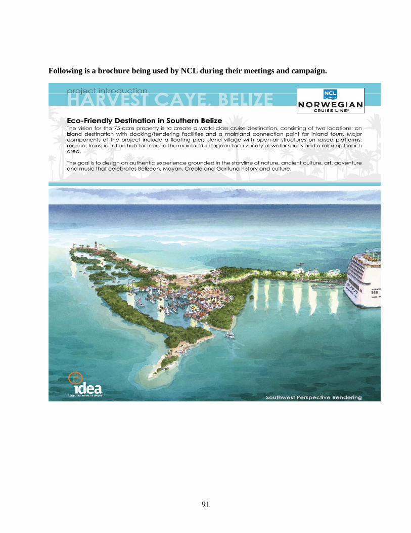
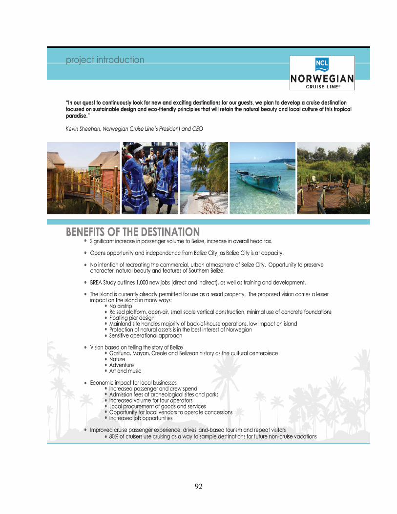
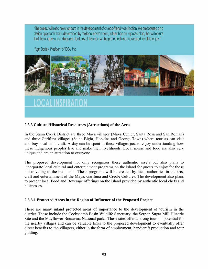
Following is a brochure being used by NCL during their meetings and campaign.
92
93
2.3.3 Cultural/Historical Resources (Attractions) of the Area In the Stann Creek District are three Maya villages (Maya Center, Santa Rosa and San Roman) and three Garifuna villages (Seine Bight, Hopkins and George Town) where tourists can visit and buy local handicraft. A day can be spent in these villages just to enjoy understanding how these indigenous peoples live and make their livelihoods. Local music and food are also very unique and are an attraction to everyone. The proposed development not only recognizes these authentic assets but also plans to incorporate local cultural and entertainment programs on the island for guests to enjoy for those not traveling to the mainland. These programs will be created by local authorities in the arts, craft and entertainment of the Maya, Garifuna and Creole Cultures. The development also plans to present local Food and Beverage offerings on the island provided by authentic local chefs and businesses. 2.3.3.1 Protected Areas in the Region of Influence of the Proposed Project There are many inland protected areas of importance to the development of tourism in the district. These include the Cockscomb Basin Wildlife Sanctuary, the Serpon Sugar Mill Historic Site and the Mayflower Bocawina National park. These sites offer a strong tourism potential for the nearby villages and can be valuable links to the proposed development to eventually offer direct benefits to the villagers, either in the form of employment, handicraft production and tour guiding.
94
Being a predominantly ethnically mixed community, these villages have access to the culture of its people as the main cultural resource; from Garinagu to Creole and Hispanic, North American and Chinese cuisine and art. The residents of this area have a great potential to benefit from the tourism service opportunities that may arise from this proposed development. Even though there are no Maya monuments in the close vicinity of three villages, the Cockscomb Basin Wildlife Sanctuary (CBWS) or Jaguar Reserve and Mayflower Bocawina National Park offer another opportunity for the youth to become specialized tour guides in ancient Maya Archaeology. Other opportunities for tour guiding are in Sittee River Serpon Mill. In 1984, the Cockscomb Basin Forest Reserve was declared as “No Hunting” area to protect the natural prey of its resident jaguars. The Cockscomb Basin Wildlife Sanctuary, with an area of 3,640 acres, was established in 1986 and in 1990 the area was expanded to 102,400 acres by the Forest Department. Today this protected area is a world famous attraction to the eco-tourist visiting Belize. The main trails pass through various ecosystems that range from sea level to over 3,000 ft at Victoria Peak. The Belize Audubon Society has a co-management agreement with the Forest Department and ensures that most employees of the Sanctuary are the indigenous Maya from Maya Center Village. The Cockscomb Basin Wildlife Sanctuary and Jaguar Preserve is located in the north-central Stann Creek District just west of the Southern Highway. A small road entrance turnoff from the Southern route provides an access deep into the rain forest. The basin is a part of the Maya Mountain Range and is a gorge with several large rivers that meander through the area creating numerous waterfalls and fast flowing river runs. Directly west but still within the sanctuary is Victoria Peak, the tallest point in Belize at 1,120 meters (3, 675 ft). Large mountain ranges also enclose the park to the south with Richardson Peak listed at 1,000 meters (3,280 ft). Also located within the enclosure of the sanctuary is the Jaguar Preserve, the first Jaguar preserve in world. The Cockscomb Basin Wildlife Sanctuary and Jaguar Preserve was founded by director Dr. Alan Rabinowitz who looked at various locations in Belize ranking them by prey potential and area. After he studied the information he selected the Cockscomb Basin area. The New York Zoological Society supported the then young researcher, beginning in October 1982. He experimented with several techniques to study and increase the population of the Jaguar. The largest concentration of Jaguar in Belize is now located in the preserve proving his techniques work. Though accused of preying on ranchers cattle, Rabinowitz found that the jaguar would not eat cattle, or so he reported, but anecdotal information says different. Some of the cats were trapped for study and found to have gunshot wounds. It seemed people were hunting the animal though it was illegal. Those who blamed the cats for preying on cattle were covering their tracks as poachers. It is illegal to hunt jaguar in Belize. After Rabinowitz study, the jaguar and the preserve became protected under Belizean law, foiling the attempt by ranchers to hunt the cats for a price tag. The Cockscomb Basin covers 415 sq km (160 sq miles). The area receives a high amount of rainfall each year with most years averaging 3.5 cm or (135 inches). The dense jungle and the
95
large amount of rainfall supports a large population of animal species including the Jaguar (Panthera onca), the Puma (Felis concolor), the Ocelot (Felis pardalis), the Green Iguana (Iguana iguana), the Green Tree Frog (Hyla cinerea), and various snakes such as the Fer-de-lance or Tommy Goff (Bothrops asper) and the Boa Constrictor (Boa constrictor). The park is also famous for spotting the Scarlet Macaw (Ara macao) and the Keel-billed Toucan (Ramphastos sulfuratus). The King Vulture (Sacoramphus papa) and the Black-and-white Hawk-eagle (Spizastur melanoleucus) is listed as often spotted by bird watchers. The Howler Monkey (Alouatta pigra) is also an inhabitant of the park. A program to move small family populations of the howler monkey from the baboon sanctuary at Bermudian Landing has been successful. These monkeys have a low octave and loud roar that can be heard for great distances throughout the Cockscomb Basin. Some of the greatest trail adventures offered by Belize are located in the Cockscomb Basin Wildlife Sanctuary and Jaguar Preserve. Adventurers can enjoy tubing of the rapids, canoeing, and cave exploration. Several adventure tours are run from the Dangriga area, as well as Placencia, San Ignacio and Punta Gorda. In Sittee River there is the Serpon Sugar Mill, one of the first sugar mills that were introduced into Belize by the American Confederates after the American Civil War. The two sugar mills were operational between 1863 and 1890. These mills were operated by locomotive steam engines imported from England and Scotland. In 1989 a group of concerned Sittee River residents and the Department of Archaeology saved the mills from destruction by bulldozers and the site was declared a National Historic Site. Today the site is managed by committee of local residents aptly called “The Pride of Sittee”. With assistance from foreign and local donors, the site has a visitor’s center, a picnic shelter, the Tapir Trail and rest rooms. The Tapir Trail is approximately one mile long and leads through tropical lowland forest, cohune ridge and a massive bamboo stand. Birding is excellent and jaguar and tapir tracks can be seen on many occasions. Another national park is the Mayflower Bocawina National Park which was established in 2001. This park has over 7000 acres of pristine lowland broadleaf forest, located in Belize’s “saw-toothed” Maya Mountains. The park includes areas of Belize’s first protected area, the Silk Grass Forest Reserve. The Park has two unexcavated Maya Temple Mounds (one of the few in the Stann Creek District) and vast amounts of flora and fauna can be seen along several miles of hiking trails. It has become a popular tourist attraction to the extent that over 16 tour operators and lodges offer trips to Mayflower. It is said that the Park has an above average tourism attraction. On the marine/coastal environment, there are many cayes with many attractions. Apart from the coastal plains and inland montane areas, the zone of interest for the proposed development also includes the South Water Cayes. In relation to the latter more than 100 cayes are strewn along the coast out to about 40 km (25 miles) from the mainland of Belize. Numerous other cayes are available for visiting. Other sites along the Belize Barrier Reef that are popular destinations include Columbus Reef, Lark Caye, Quamina Caye, Ranguana Caye, the

96
Silk Cayes, Little Water Caye, and a complex of cayes to the south referred to as the Sapodilla Cayes. The Tobacco Reef includes a number of small cayes that are well known among the research and scientific community but which receive an appreciable number of visits from tourists. These small islands are reached by boat from Dangriga and Placencia, as well as small communities such as Hopkins and Sittee River Village. Snorkeling among these cayes is among the best to be experienced in Belize. The Smithsonian Institute has a marine laboratory on Carrie Bow Caye. A number of reef studies are on going at the location. They are open for tours Monday through Friday by appointment only. At South Water Caye, the International Zoological Expeditions maintains a research center offering international students to enter into living study programs which require the student to live on the island and observe, report, and study marine biology. A PADI dive center is located at the observatory and the dorms on the island can house up to 25 students. On the south end of Tobacco Reef is also Twin Cayes where manatee sightings are a common occurrence. The Laughing Bird Caye National Park in the region is rated by skin diver magazine as the third best dive location in the world: This areas is located immediately east of the Placencia Peninsula. For this reason Placencia has become a premier dive destination for the avid professional and the scientific community. Friends of Nature, is one of the important NGOs located in Placencia that has a co-management agreement with the GOB to manage this protected area. The best dive operations in southern Belize are located in Placencia. It was Rum Point Inn divers from the area who requested the Belize Government to declare the area as an MPA. The southern cayes in the region of interest of the proposed project are noted for whale shark sightings. Other species commonly encountered in the area include the loggerhead turtle (Caretta caretta), the hawksbill turtle (Eretmochelys imbricata) and the tarpon (Megalop atlanticus). Apart from the caye based Laughing Bird Caye MPA, the Five Blues Lake National Park is located on mainland Belize in the northeastern Stann Creek District. The lakes open up into a beautiful limestone formation. The lakes are a cenotes or collapsed limestone cavern. There are many caves in the area some with evidence of prior Maya habitation. The Five Blues Lakes are so named because they seem to glisten in the sunlight reflecting a iridescent blue. This is due to the limestone that makes a rounded shallow lake bed allowing sunlight to be reflected from the bottom back toward the top of the water column. Numerous hiking trails allow one to explore the area including a number of cave systems. Visitors to the park have the option of packing their own tent or open air sleeping bag: In-door accommodations are also available at a hotel located in Saint Margaret's Village which is 35 minutes by road south of the park. Another hotel facility located in the area that has been recently established is the Over-The-Top Camp.
97
2.3.3 2 Independence Village Water Supply and Solid Waste Management The Village Water Board is responsible for provision of water supply and solid waste collection. The village potable water supply system comes from ground water sources: A well is dedicated to the needs of the Mango Creek Community, while two other wells assigned to Big Creek and Placencia. The solid waste is collected twice a week by two (2) specialized trucks that transport the waste to an area used as a dump site. This area is a part of the pine ridge near to the junction with the Southern Highway. This system of solid waste disposal is currently working adequately. Each household pays $5/month. In discussion with both the Water Board Chair and the Manager of Port of Big Creek, it was made clear that they are open for negotiations to establish a mechanism on how to supply water to the proposed development and to arrive at a cost for the water supply. It is expected that the developer will purchase the piping material and make engineering provisions that this pipeline does not interfere with the navigation into and out of the port of Big Creek. All negotiations will be with the Board of Directors of the Port of Big Creek as this is totally owned by the private sector In the case of solid waste disposal, the Chairman of the Water Board suggests that in lieu of the possibility that the developer assists them with another garbage truck, they would prefer assistance in the expansion and upgrade of the entire system of which details were not mentioned. The mechanism to be put in place need to get the clearance from the Ministry of Health, Port Authority and the Belize Agricultural Health Authority (BAHA). 2.3.4 Social Infrastructure and Services 2.3.4.1 Education/Health Services Primary schools are available in Independence, Placencia and Monkey River Villages. There is one high school in Independence that caters to the overall area. Advanced studies at the Sixth Form and University Levels are available in Dangriga Town and Belmopan City, respectively. The children of workers at the proposed Harvest Caye Development residing in the Independence area that are of primary school age are likely to attend school there. The children requiring higher education are also expected to attend school in Independence, as well as elsewhere, as indicated above. The residents of Harvest Caye, permanent or visiting, are not expected to use the education facilities in the country since they will be mostly retirees. There is a Hospital Facility (a poly-clinic) in Independence: The larger and more advanced medical facility that would be available to the people associated with the proposed Harvest Caye Development is the Southern Regional Hospital. This facility is located in Dangriga, which approximately 48 miles from Independence. The roadway is a primary paved road.
98
Other health service providers and diagnostic centers are also available in Belize City. In case of medical emergencies, the developer would need to make arrangements to transport patients via boat and overland transportation to the Savannah Airstrip. Table 2.14: Social Infrastructure/Amenities of Communities Impacted by Project. Commu-nity
Prim. Schl.
Fire Stn.
Police Stn.
Health Cnter.
Church
Com. Center
Cable TV
Internet Cafe
Independ./ Mango Creek/Big Creek
2 0* 1 1 2 1 1 Many
Placencia 1 0** 1 1 2 1 1 Many *= Belize Natural Energy has one at the Port and can be used in the Independence village. **= rudimentary fire control system 2.3.4.2 Labor and Employment The Stann Creek District is highly dependent on two main activities: tourism and agriculture, including shrimp farming. Tourism visitors to the Stann Creek District are attracted for its scenic views, the cayes, the rainforest, archaeological sites and its world re-knowned Jaguar Reserve. In 2007, the agriculture industry continues to play an important role in the economy of the Stann Creek District, particularly in the rural communities. Most of the agricultural production in this district is characterized by the export crops (citrus, bananas, papaya, cacao, and newly developed organically produced fruits) and subsistence farming. In recent times shrimp farming has taken a lead role in export production together with those commodities mentioned before. The employment situation in the Stann Creek District during 2005 - 2007 is shown in Table 2.15. The National employment rate in 2005 was 89% while in 2007 it was 91.2%. In the Stann Creek District, the comparative figures were 80-85 %. Male employment accounts for almost twice that of females during the same period. During the period 2005-2007, citrus prices have been constant while the tourism sector has been expanding at an impressive rate: Tourism has thus been responsible for a major upswing in employment. Table 2.15: Employment Data in the Stann Creek District during 2005-2007
Employment Situation Total Male % Female
%
a. Employed- 2005 b. Employed- 2006 c. Employed- 2007
10,41910,90911,312
7,1676,8907,162
68.863.263.3
3,252 4,019 4,150
31.236.836.7
a. Unemployed-2005 b. Unemployed- 2006 c. Unemployed- 2007
1,1951,4081,469
481 444
447
40.331.530.4
713 963
992
59.768.469.6
Source: Labour Force Survey by CSO in 2007
99
The proposed development will further contribute to the development of tourism in the district. Job seekers represented 5-7% of the available labor force and are represented equally between the sexes. There may be the need for on-the-job training at Harvest Caye relative to the unskilled job seekers. It is expected that some skilled workers would come from other parts of the country to fill the jobs that will be generated by the proposed development: These opportunities are expected to be in both the service tourism aspects, as well as in construction related activities. 2.3.4.3 Communication and Services Communication and services are well established in the area with public and private telephones, fixed and mobile cellular phones, fax and email, and internet facilities. The Harvest Caye development will have 24-hour electricity and cable television and all other communication services. 2.3.4.4 Transportation Routes and Options The project site can only be reached by boat or helicopter. The traditional sea routes used to transport people to and from Placencia to Independence and Monkey River are north of the proposed development. Monkey River is to the southwest of Harvest Caye, while the sea/land access points to Independence and Mango Creek are northwest of the proposed project site: The seaward tip/terminus of the Placencia Peninsula where much of the tourism and commercial activities is concentrated, are to the northeast of the project site. The main concerns of the stakeholders interviewed are the increased boat traffic; particularly in the form of high speed boats and barges to transport construction supplies to the caye. This is especially in relation to the potential for collision accidents at sea; especially with pre-existing tourist and fishing boats, large banana boats and petroleum barges. The nearest landing strip is located at Savannah, which is approximately 2.0 miles northwest of the nearest mainland access from the proposed project site. 2.3.5 Labor Issues Big Creek is an international entry point to Belize by marine travelers. Illegal migrants from Guatemala and Honduras seeking employment in the banana industry and shrimp farming, use the area to land in Belize. In-country migration to the area will be mostly from laborers coming from the Toledo, Stann Creek and Cayo Districts, whom are expected to be job searching during and after the construction phase of the development. Their permanence and settlement in the area (Mango Creek/Independence) may pose a strain on the current social services of the area. It may also be possible that highly skilled workers would have to be imported into Belize from time to time.

100
2.3.6 Economic Activities in the Area 2.3.6.1 Tourism Activities In 2007, of the top ten (10) destinations identified by the BTB for tourism development in Belize the Stann Creek District placed second in number of hotels and hotel rooms as well as the number of beds and tour operators. The Stann Creek District ranked third in terms of the number of tour guides. Comparing 2002 and 2007 tourism statistics between the Stann Creek District and the rest of the Country, the Stann Creek District has grown at a very high and impressive rate [See Table 2.3.4]. The number of beds in the District has more than quintupled the national growth rate [See Table 2.3.4]. The numbers of hotels and hotel rooms have also had a slightly higher growth rate than the national average [See Table 2.3.4]. During the 2002 and 2007 timeframe, there was a decrease in the number of tour guides and a slight increase in the number of tour operators. The number of employees in the hotel sub-sector has tripled between 2002 and 2007: Dangriga has had an increase of six (6) times the national average [See Table 2.3.4]. This increase can be attributed to the rapid expansion in the sector on the Placencia Peninsula after Hurricane Iris. While these figures are good indicators for the level of investment, the BTB does not have segregated visitation figures for each of the ten destinations being monitored as a function of market share. Table 2.16: Comparative Tourism Industry Statistics in the Stann Creek District
Tourism Statistics – Stann Creek District (Town/Rural)
2002 2007 % Increase
Stann Creek District/Country
# of Hotels 104/ 437 144/ 591 38/ 35 # of Rooms 781/ 4,706 1,184/ 6,200 51/ 31 # of Beds 1,317/ 7,902 3,327/ 10,502 252/ 33
#Tour-guides 199/ 1,098 190/ 1,173 (-5)/ 6 #Tour operators 43/ 171 50/ 205 16/19
Employees in Hotel Sub-sector 539/ 3,134 1,697/ 4,868 315/ 55
Countrywide Occupancy 41.8 44.3 3.5 % Labor 9.4% 13.70% 4.3
Over-night visitors 199,521 251,656 26.1 Cruise Visitors 319,690 624,128 95.2
Tourism Contribution to GDP 14.30% 24.10% 68.5
Source: BTB Annual Statistics for 2007, Feb, 2008
101
2.3.6.2 Fishing Activities The fishing activity in the southern region that includes the Harvest Caye area entails approximately 100 fishers. These fishers are from Placencia, Mango Creek and Independence. They engage in commercial fishing for lobster, conch and scale fish. The fishers immediately associated with the Harvest Caye area are five (5) or six (6) from Placencia, as well as about the same amount from Monkey River. These fishers generally sell their catch to the Placencia Cooperative. The majority of fishers utilizing the area sell their products to the Mango Creek branch of the Northern Fishing Cooperative. A portion of the catch is also sold to the population at large for their daily consumption. It was not possible to get the volume of production or an estimate of the income of these fishers who deliver at either the Placencia or Mango Creek receiving stations. The lobster harvested in the area is caught with traps and through free diving. Lobster shades, which are a type of FAD, are also deployed in the area. Conch is harvested by free divers who simply retrieve them with their hands. The lobsters taken by free divers are taken using hook sticks to snag the animals. The fishery is not a major one however some of the parties interviewed are of the opinion that the fishery may be affected by the proposed dredging activity. Anecdotally, fishers remember that when the Big Creek Port was dredged some 20 years ago, it took almost 10 years before they could have returned to harvest the lobster and conch. As mentioned earlier, the area west of the caye forms an important foraging area for population of manatees and dolphins. Tour guides utilize the area for manatee watching when coming back from their tours to Monkey River. Again the guides mention that the dredging will affect the sea grass beds and will “chase these animals”. 2.3.7 NGO and Public Interest Prominent resident non-government or community-based organizations in the region include: Friends of Nature, BTIA-Placencia branch, Placencia Fishermen Cooperative, the Peninsula Citizens for Sustainable Development and the Placencia Humane Society. There is also a collecting sub-station of Northern Fishermen Cooperative Society at Mango Creek that services its members fishing in the southern waters. This includes the delivery of produce by the fishers from the Cooperative Sub-Station and the picking of up of ice by the fishers to preserve their produce while at sea. The concerns of these NGOs and CBOs have been both positive and negative. These views can be easily read on the Belize newspapers, TV, and webpages.

102
2.3.7.1 Friends of Nature (FoN) FoN is a conservation Non-Governmental Organization with its administrative offices located in the community of Placencia. Members of the board of the Friends of Laughing Bird Caye and Friends of Placencia Lagoon officially registered the organization in March 2002. FoN was formed through the amalgamation of those two existing community groups. The mission of the organization is: "Preserving and promoting the sustainability of marine resources, islands, and cayes for our children and the country of Belize". FoN co-manages Gladden Spit and Silk Cayes Marine Reserve with the Fisheries Department and Laughing Bird Caye National Park with the Forestry Department.
Photos by: Rachel Graham
FoN maintains deep roots in the community. Their constituency includes the six coastal villages in the central southern region of Belize. The six communities are: Hopkins, Sittee River, Seine Bight, Placencia, Independence and Monkey River. The Chairperson of each Village Council sits on FoN's Board of Directors, which also includes representatives from other key stakeholder groups. FoN’s motto is "Protecting our natural resources by developing our human resources".
2.3.7. 2 The Peninsula Citizens for Sustainable Development (PCSD)
The PCSD is a Belizean non-profit corporation and grass roots community organization of Placencia Peninsula residents concerned with the rapid, and often poorly planned and executed development of the Peninsula. PCSD seeks to bring information about proposed developments to Peninsula residents to ensure that all developments are environmentally sustainable with respect to water quality and mangrove protection of the fragile eco-systems of the Peninsula and its communities and cultures.
2.3.7.3 The Placencia Humane Society Prior to 1999, pet owners on the Placencia Peninsula could only obtain care for their pets by transporting them to Belize City, or waiting for sporadic visits by veterinarians from other parts of the country. The Placencia Humane Society was formed in 1999 primarily to respond to the need for regular veterinary care on the Peninsula. Today, the Placencia Humane Society has expanded well beyond its original purpose and now offers temporary emergency shelter for stray and injured pets, no-interest loans to area residents who need help caring for their pets, spaying
103
and neutering clinics for feral cats, and is now in the process of raising funds to build a permanent clinic facility on land leased from the Placencia Village Council.
2.3.7.4 The Belize Tourism Industry Association (BTIA)
In the early 1980's tourism was of relatively little importance in Belize. Nonetheless, it was an evolving industry that was impacting various sectors. A group of individuals foresaw the importance of the industry and anticipated the need for a medium through which tourism concerns could be voiced. This group, lead by the late Mrs. Jean Shaw, conceived the Belize Tourism Industry Association (BTIA). Four years later, in 1989, BTIA was incorporated under the laws of Belize.
The mission is: “BTIA is a private sector organization promoting sustainable tourism, while maintaining the natural and cultural integrity of Belize.
The Placencia Branch of BTIA is arguably the most active chapter of BTIA in the country.
Today the BTIA has evolved into an intermediary between government and the private sector as well as private sector and national and international organizations. The four hundred member strong association boasts of representation on every government, legislative, advisory, consultative and licensing committee, which in itself is proof of its continued commitment to national development. As a direct consequence of BTIA's initiatives, tourism has become the fastest growing industry and has been pushed to the forefront of government's priorities.
In the international arena, BTIA continues to serve as Belize's ambassador, marketing the country's attractions and services at all major trade shows and voicing its views at symposiums, conferences and forums.
BTIA’s purpose is to serve and promote the interests of its members, to develop and promote the Belize tourism product and to influence and secure the improvement of the industry. In order to accomplish these goals, BTIA:
• Continues to serve as the voice of the tourism industry in Belize. • Promotes the sound development of local infrastructure and tourism. • Provides a network and forum for addressing tourism related concerns. • Endorses the growth of the tourism industry without damage to the environment. • Represents and advocates the best interest of members and the industry. • Lobbies for critical issues of interest to its members and tourism in general. • Markets and promotes Belize as a destination. • Assists members in improving their skills and services in order to improve
professionalism and quality of the industry.
BTIA has gone publicly requesting the GOB to slow down the decision making pace on this project.

104
2.3.7.5 Benefits of the NCL project A - Labor and Employment
• Project Employment Office located in Mango Creek/Independence • Construction Phase (2 yrs.+) • Full time employment (150) • Part Time employment (50) • Seasonal employment (Varies, depends on # of port calls)
B - Economic Activities
• Local Vendor Arts and Craft sales on Island • Local Vendor Arts and Craft sales in Communities • Retail sales in Malacate to support Tourism and Services Industry • Retail Sales in Placencia • Retail Crew Sales in Malacate • Tour Sales to local Tour Operators • Tour sales to local Transportation Companies • Sales at Local Attractions • Supplier sales in Food and Beverage Provisioning • Supplier sales in dry Good Sales • Supplier sales in Fruits and Vegetables • Supplier sales for parts and services for marine and transportation services • Fuel oil and gasoline sales • Landscape products and services
C- Fishing Activities benefits.
• Non-motorized activity on western side of island to preserve manatee and fishing grounds between coastline and island
• Limited access to coast line with access to north of island to Malacate Placencia and Monkey River
• Offering deep sea fishing excursions from Harvest Caye Marina • Offering Bone fishing excursions from Harvest Caye Marina • Commercial purchasing and provisioning of local seafood for Island use in Food and
Beverage program
2.3.7.6 NCL Project Investment NCL has committed to invest $50 M for the development and operations of Harvest Caye, in addition to securing training for local Belizean jobs. The annual revenue projections have not been establish and are subject to the M.O.U. discussions and future agreements with the Government of Belize.
105
2.4 Archaeology
2.4.1 Findings
Research conducted at the Institute of Archaeology (IOA) indicated that Prehistoric/Historic presence on the island is sketchy and as such the area is designated as a possible settlement site. While there are no reference literature on Harvest Caye as a possible settlement site, apart from it being generally mentioned by archaeologist Jeff McKinnon as part of his area of study (1983, 1992, 1994, and 1996), the general registry map at the IOA indicates a possible prehistoric use.
Results of the visual survey, traverse and reconnaissance of the Caye shows no signs nor indication of prehistoric occupation [See Annex 10]. Apart from sand dunes occurring on the eastern and southern part of the larger island, there is no evidence of any prehistoric or man-made mounds.
There were a few pieces of historic porcelain vessel fragments and a relatively large but eroded piece of pottery found on the northern beach tip of the larger or main island. These were found in approximately two to three feet of water off the north east beach of the island.
Two colonial bottles of the early 1900s were also found washed up on the eastern coast of the main Harvest Caye Island [See Annex 10].
Research done by Dr. Jeff McKinnon in the 1980 revealed that most of the island and Cayes around the Placencia Peninsula area were used as salt procurement areas as well as for the harvesting and extraction of maritime resources especially during the Terminal Classic (AD 700 – 900) (MacKinnon 1996). While this may be so, no signs or mention has been made of either activity on the island even though Harvest Caye was among the cayes in the general area researched and surveyed by Dr. McKinnon. The occurrence of a few pieces of colonial artifact fragments and a crude pottery piece may have been as a result of tidal surges and possible hurricanes as nowhere else on the entire island were there any visible evidence of at least the most common cultural feature – pottery shards. It is evident from the debris found on the island that it has been affected by storms in the past. 2.4.2 Mitigation Measures
Given that the areas around Harvest Caye were being used by prehistoric and historic people, the project proponents are committed to proceed with every caution in relation to any excavation work, dredging or earth work otherwise being carried out at the project site. Should there be any signs of archaeology remains be discovered during civil works, especially when dredging the internal lagoon for the creation of the marina, or when conducting excavations for building foundations, and the dredging of the near-shore seas, all operations will be immediately halted and the Institute of Archaeology will be informed of these findings. The project proponents will seek some directive from the Institute of Archaeology in regards to future developmental activities at the site.
106
2.5 Policy Review 2.5.1 INTRODUCTION Current national environmental policies are based on the need to take an integrated approach to environmental management and the need to work towards the goal of sustainable development. The Government of Belize through the Department of Environment, Coastal Zone Management Authority and Institute (now defunct), the Department of Fisheries, and the other government institutions are the regulatory bodies of the various instruments. Of importance to the proposed development is the need to identify those regulations and legislations which will need compliance for development activities in respect to the area and region of the proposed development. In light of the fact that the area and region of the proposed development is within an area of significant importance in terms of its ecological and biological importance and proposed planning regime, it is also of important that development activities strike a balance development and the environment. This section is aimed at reviewing relevant environmental resource and planning legislations and regulations to ensure that “development projects” meets policy and legislative criteria, and that relevant requirements are built into project design and implementation. The policy review also outlines specific procedures and measures to be carried out before, during and after project development. It is noted that the proposed development site is located within two protected areas. Specific conservation zones been established for all user activities within marine reserve.
.1.12.5 The Environmental Protection Act SI 22/1992 and 328/2003 THE ENVIRONMENTAL PROTECTION ACT established the Department of the Environment. Under section 3 (3) the Department has the responsibility to monitor the implementation of the Act and Regulations, and to take necessary actions to enforce the provisions of the Act and Regulations. This enabling legislation provides the Government and the Department with comprehensive environmental protection authority it needs in order to address modern environmental pollution problems. The ACT also grants the Department of Environment broad regulatory and enforcement authority for the prevention and control of environmental pollution, conservation and management of natural resources, and environmental impact assessment (EIA). The Environmental Protection Act entrusted the Department of the Environment and Ministry of Tourism with broad range of functions relating but not limited to the assessment of water pollution, the coordination of activities relating to the discharge of wastes, the licensing of activities that may cause water pollution, the registration of sources of pollution and the carrying out of research and investigations as to the causes, nature and extent of water pollution, and the necessary prevention and control measures (section 4). The Department is also empowered to approve EIAs. Under the revised edition 2000 Part III 7 (1) (d) specifying the standards in excess of which pollutants discharged into the environment shall not be discharged or emitted; (e) formulating environmental codes of practices specifying procedures, practices or releases limits for

107
environmental control relating to works, undertakings and activities during any phase of the development and operation, including the location, design, construction, start-up, closure, dismantling and clean-up phases and any subsequent monitoring activities and (f) environmental quality guidelines specifying recommendations in quantitative or qualitative terms to support and maintain particular uses of the environment and (j) the control of noise. Under the Act, no person, installation, factory or plant shall, unless specifically permitted by the Department, emit, deposit or discharge or cause emission of any pollutant or contaminant into the atmosphere or environment in contravention of the permitted levels: Every person, installation, factory or plant emitting air pollutants is required to maintain and submit to the Department, records of the type, composition and quantity of pollutants emitted. No person shall cause or permit the extracting, crushing, screening, handling or conveyance of materials or other operations likely to give rise to airborne dust without taking reasonable precautions, by means of spray bars or wetting agents, to prevent particulate matter form becoming airborne. Furthermore any person or undertaking exploiting the land, water resources, seas or other natural resources shall ensure the protection of the environment against unnecessary damage or from pollution by harmful substances; and no person shall emit, import, discharge, deposit, dispose of or dump any waste that might directly or indirectly pollute water resources or damage or destroy marine life. 2.5.1.2 Environmental Impact Assessment Regulations SI 107/1995 The Environmental Impact Assessment (1995) regulations describe in detail the processes involved in the preparation and evaluation of environmental impact assessments. The regulations divide projects or activities into three categories. The first category consists of those projects that automatically require an environmental assessment based on the sensitivity of the surroundings or the nature of the undertaking. The second category comprises those projects that may require an assessment to be carried out, but with some modifications based on the location and size of a project. The third category encompasses activities or programs that do not require an assessment to be conducted which may not have significant impacts on the environment. The Environmental Impact Assessment Part V - 20 (4) states that every project, programme or activity shall be assessed with a view to the need to protect and improve human health and living conditions and the need to preserve the reproductive capacity of ecosystems as well as the diversity of species; under 20 (5) when making an environmental impact assessment, a proposed developer shall consult with public and other interested bodies or organizations and under 20 (7) a decision by the DOE to approve an environmental impact assessment may be subjected to conditions which are reasonably required for environmental purposes 2.5.1.3 Coastal Zone Management Strategy Chap. 329 2000 Revised Edition The Coastal Zone Management was legally established in 1998 with the passage of the Coastal Zone Management Authority Act (Act # 5 of 1998). Under section 5 (1), the main functions of
108
the Authority include (i) to advise Government on matters related to development and use of resources in the coastal zone in an orderly and sustainable manner; (ii) formulation of policies on coastal zone management; (iii) development of a coastal zone management plan and revise it as needed; (iv) commission monitoring and research of coastal areas and; (v) promote public awareness; (vi) prepare guidelines for developers. The Coastal Zone Management Strategy seeks to facilitate improved management of coastal resources, to ensure economic growth is balanced with sound environmental management practices. The Strategy seeks to review and ‘enhance existing laws, regulations, ‘policies’ and guidelines relating to conservation, resource management and development controls in the coastal zone are.’ These support a coastal area management framework that addresses the need for management approaches in location between, as well as within, Coastal and marine Protected Areas, and special requirements for management development and conservation in the barrier reef region, particularly the cayes. 2.5.1.4 Effluent Limitation Regulations SI 94/1995 THE ENVIRONMENTAL PROTECTION EFFLUENT LIMITATION REGULATIONS came into force in 1996, at which time the Department of the Environment commenced enforcing the Regulations. The Regulations are intended to control and monitor discharges of effluent into any inland waters or the marine environment of Belize. 2.5.1.5 Pollution Regulations SI 56/1996 The Pollution Regulations of 1996 addresses issues of air, water and soil pollution, including noise pollution. Part III – 6 (1) deals generally with the emission of contaminants into the air where no person shall cause, allow or permit contaminants to be emitted or discharged either directly or indirectly into the air from any source. Part X 31 (c & d) deals with pollution of land generally that could be harmful, or potentially harmful to animals, birds, wildlife, plants or vegetation. The Department of Environment is responsible for the enforcement of the Regulations made Act. 2.5.1.6 Solid Waste Management Authority Act SI 224 of 2000 Under the Act, the Authority shall devise ways and means for the efficient collection and disposal of solid waste employing modern methods and techniques and exploring the possibility of recycling waste materials. Under the Act “construction waste material” includes building materials from construction, alteration and remodeling building or structure of any kind, such as lumber, concrete, steel roofing, etc. SI 13/1991 established the Solid Waste Management Authority and gave it broad powers for the collection and disposal of solid waste. 2.5.1.7 Ancient Monuments and Antiquities Act SI 330/2000 Under section (4) of the Ancient Monuments and Antiquities Act, all ancient monuments and antiquities however situate, whether upon any land or in any river, stream or watercourse, or
109
under territorial waters of the country, and whether or not before the date of the commencement of this Act in private ownership, possession, custody or control, shall absolutely vest in the Government Under section (12), if any person finds any ancient monument or antiquity he shall within fourteen days of such findings report the details of the findings to the Minister. 2.5.1.8 Belize Water Industry Act No. 1 of 2001 The Water Industry Act repeals the Water and Sewerage Act, Chapter 185 of 1971 Laws of Belize. Chapter one of the Act deals with controlling disposal of wastes generated from sewer treatment. The Act makes new provisions with respect to the supply and control of water and sewerage services in Belize. The Water Industry Act also establishes the responsibility of private entities to provide facilities for the final disposal of sewerage taking into consideration 36 of the Environmental Protection Act 1 of 2001. 2.5.1.9 Belize Port Authority Act SI 233 of 2000/2003 Under Part III Sec. 23 (1) the Minister may, after consultation with the Authority, grant in writing a license to any person, corporation or other body to construct and operate a private port subject to such terms, conditions and restrictions and on the payment of such fees as the Minister may consider appropriate (Private ports 15 of 1989). Under part III 19 –(3) and in particular and without prejudice to the generality of the provisions of subsections (1) and (2), it is the duty of the Authority- (a) to operate the ports as appears to it best calculated to serve the public interest; (b) to regulate and control navigation within the limits of ports and their approaches; (c) to maintain, improve and regulate the use of such ports and services and facilities therein as it considers necessary or desirable; (d) to provide for such ports and the approaches thereto such pilotage services, beacons, buoys and other navigational services and aids as it considers necessary or desirable; (e) to exercise the duties and functions relating to shipping and navigation exercisable under the provisions of any other law. 2.5.1.10 Belize Public Health Act Revised Edition SI 40/2000 Under Part VIII of Offensive Trades 128 (1) b the Minister can make regulations relating to nuisances for the prevention, control or reduction of pollution or contamination of air, soil or water caused by any activity or condition resulting in the emission of a pollutant or contaminant into the environment. The Act also specifies restrictions and regulations for nuisances from factories or other industrial developments, and incidental provisions relating to offensive businesses.
110
2.5.1.11 National Lands Act (No. 6 of 1992) and SI 191 of 2000 The Act is designed to establish a framework for the management of national lands. The Act applies to all lands (other than Reserved Forest) not already "located" or granted, including any lands acquired by or ceded to the Crown. They are classified as town, suburban, rural, mineral lands and beach lands. In section 28 where the sea, or any sound bay or creek is described as forming part of the boundary of any national land to be granted or disposed of, then the high water mark shall be considered to be the property boundary. Under the Act, the seabed defined as the land extending seawards from the high water mark of ordinary tides is National Land owned by the Government of Belize under the authority of the National Lands Act. 2.5.1.12 Crown Land Rules SI 60 of 1939 Under Crown Land Rules (Statutory Rules and Orders 66 of 1939), a 66 ft wide strip of land along all water frontages, measured from high water mark, is designated as public easement, but lands titles prior to 1930 included the land to the high water mark and in some cases, below the high water mark. 2.5.1.13 Mines and Minerals Act Chap. 226 of 2000 The Mines and Minerals (General) Regulations provide a general framework for the implementation of the Mines and Minerals Act. These Regulations cover a range of topics such as application, duties, terms and conditions and failure to comply with the conditions of a mining license. Under the Act “land” includes land beneath water. The Act also addresses dredging and sand mining, which is essential in avoiding destruction to coastal habitats such as seagrass beds and the coral reef. 2.5.1.14 Forests (Mangrove Protection) Regulations, SI No. 52 of 1989 The Forests (Protection of Mangrove) Regulations, 1989, prohibit any "alteration” (which includes cutting and defoliating, but does not include "selective trimming") of mangroves on any land except with a permit (reg. 4). Alterations which involve dredging or filling can be authorized only in "exceptional circumstances." Factors considered for issuing or denying permits include the proximity of the proposed project to coastal and reef areas known to be of outstandingly high ecological value (reg. 5(2) (i)), and the existing or proposed plans such as the barrier reef regional management and development plan. The Mangrove Regulations were amended in 1992 to increase the level of fines and sanctions. 2.5.1.15 The Forest Act SI 213/2000 The protection of all mangroves fall under this Act via the Forest (Protection of Mangrove) Regulations. Mangrove clearance may be permitted under this Act. In most cases a permit to
111
clear mangroves is issued after a multi-agency assessment is conducted. This Act includes the establishment of Forest Reserves which may include mangroves, littoral forests and water bodies. However, no specific regulations exist under this Act that address littoral forests. The Forest Act is currently being revised. The legislative basis for conservation of national lands within PHMR is defined by the Forest and Wildlife Conservation Acts. The Forest Act provides for the protection and conservation of all mangrove forests on both private and national lands, any alterations to which require evaluation and permit by the Forestry Department. 2.5.1.16 Fisheries Act SI 210/2000 Under 6(1) of the Act, no person shall use or employ any boat in commercial fishing unless there is in force in respect of such boat a “license to fish” issued under the provisions of any regulations made under this Act. (7) No person shall engage in commercial fishing or be engaged or employed in or on any boat while in use for commercial fishing unless he is the holder of a valid “fisherman’s license” issued under the regulations made under this Act (2 of 1972). (8) No person shall conduct or be engaged or employed in any scientific or research operations in any water or waters to which this Act applies which involve the taking, killing or capturing of any fish, or any interference or disturbances of fish, or with the seabed, unless there is in force in respect of such operations a license granted under the regulations made under this Act (2 of 1972). 9.-(1) No person shall export, attempt to export or purchase with a view to export any fish unless he is the holder of a valid fish exporter’s license issued under the regulations made under this Act (2 of 1972,1 of 1983 &19 of 1989). Penalties for breach of the regulations are also included in the Act. The Fisheries Amendment Regulation also provides complete protection for the marine turtles of Belize. This is aimed at bringing Belize in line with the Inter-American Convention for the Protection and Conservation of Marine Turtles (IAC), which Belize ratified in February 2003, these Regulations prohibit:
• fishing in the waters of Belize or the purchase, sale or possession any marine turtle; • the take of any turtle found on land; the disturbance, take, purchase, sale or possession of
any turtle or turtle eggs; and the interference with any turtle nest, except under written
• permission by the Fisheries Administrator; and • The import into, transit through or export from Belize of any turtle or turtle products.
112
2.5.1.17 The Wildlife Protection Act SI 220/2000 The Wildlife Protection Act - This Act seeks to control hunting, research and trade of wildlife. It protects many species from hunting, killing and harassment Part II (a). Many coastal and marine species are protected under this Act and includes two species of crocodiles, the manatee, all birds with the exception of six species, whales, dolphins, and the Caribbean monk seal. The Act prohibits the hunting of endangered species such as cetaceans, freshwater turtles and crocodiles. A formal conservation zoning scheme for the BCNP has yet to be developed and recommended to Cabinet for legislative enactment. Several key localities of particular conservation interest, and therefore potential suitability for legislative zoning and protection, 2.5.1.18 Housing and Town Planning Act SI 182/2000 Part II of the Act, gives general powers of the Central Authority. Under the Completion of Schemes and Consequential Powers and Duties of the Central Authority 31 (2) the Central Authority may, in connection with any scheme, authorize the laying out and construction of roads and services upon the land acquired by it, and all roads and services as laid out and constructed, if situated within the jurisdiction of a local authority, shall thenceforth be public roads and services maintained by the local authority.
113
2.5.1.19 Port Honduras Marine Reserve The closest reserve to the project area, on which it might have an impact is the Port Honduras Marine Reserve.
114

115
2.5.1.20 Hotels and Tourist Accommodation Act 285/2000 Under Part II (2) an application for registration in respect of any premises used for the business of a hotel or tourist accommodation should be carried out. Part III (14) defines the minimum standards to be observed by hotel and tourist accommodation. Part III of the Act defines registration and Regulations of Hotels and Tourist Accommodations. Under the Act the Belize Tourism Board has the responsibility of registering all hotel and tourist accommodation in Belize. Subject to the provisions of the Act, Part IV (22 91)) states that “there shall be levied and paid a tax at the rate of seven per centum of all the accommodation charges in regards to lodging.” Part
116
V General, sets out Offences and penalties and regulations prescribing standards for hotels and tourist accommodation. The Hotels Act and the Housing and Town Planning Act complement each other, since they both address tourism and residential developments in coastal areas. 2.5.1.21 Protected Areas Conservation Trust Act (PACT) Chap. 218/2000 The Protected Areas Conservation Trust Act (PACT) establishes a fund for the financing of all protected areas, including marine reserves and all other protected areas on the coast. Indirectly related is the Fiscal Incentives Act, which provides numerous facilities for coastal developments. A portion of the fees collected at the border points is used to finance local community based initiatives.
2.5.1.22 Belize Tourist Board Act
The Belize Tourist Board Act indirectly encompasses most of the other Acts, since it contains provisions for the development of tourism policies, which would need to consider the effects and roles of all sectors in the development of tourism.
2.5.1.23 International Conventions and Agreements
Belize is signatory or party to many international conventions and agreements, and is a member of many regional organizations involved in the management and protection of biological resources. Those that impact on biodiversity are listed below. (a) United Nations Law of the Sea Convention (LOSC) (ratified 13 August, 1983).
(b) World Heritage Convention (ratified in 1990).
(c) Convention on the International Trade in Endangered Species of Wild Fauna and Flora (CITES) (ratified 1976). (d) Convention on Biological Diversity (CBD) (ratified in December, 1993).
(e) Central American Biodiversity Convention.
(f) Convention for the Conservation of Biodiveristy and the Protection of Priority Areas in Central America. (g) Agreement on Cooperation between Belize and Mexico for the Protection and the Improvement of the Environment and the Conservation of Natural Resources in the Border Zone (signed 20 September, 1991). (h) Protocol on Specially Protected Wildlife (SPAW Protocol)
(I) Land-Based Sources of Pollution Protocol (LBSP).
(j) United Nations Framework Convention on Climate Change (ratified September, 1994).
(k) Convention for the Prevention of Pollution from Ships (MARPOL 73/78) (ratified 12 May, 1995).
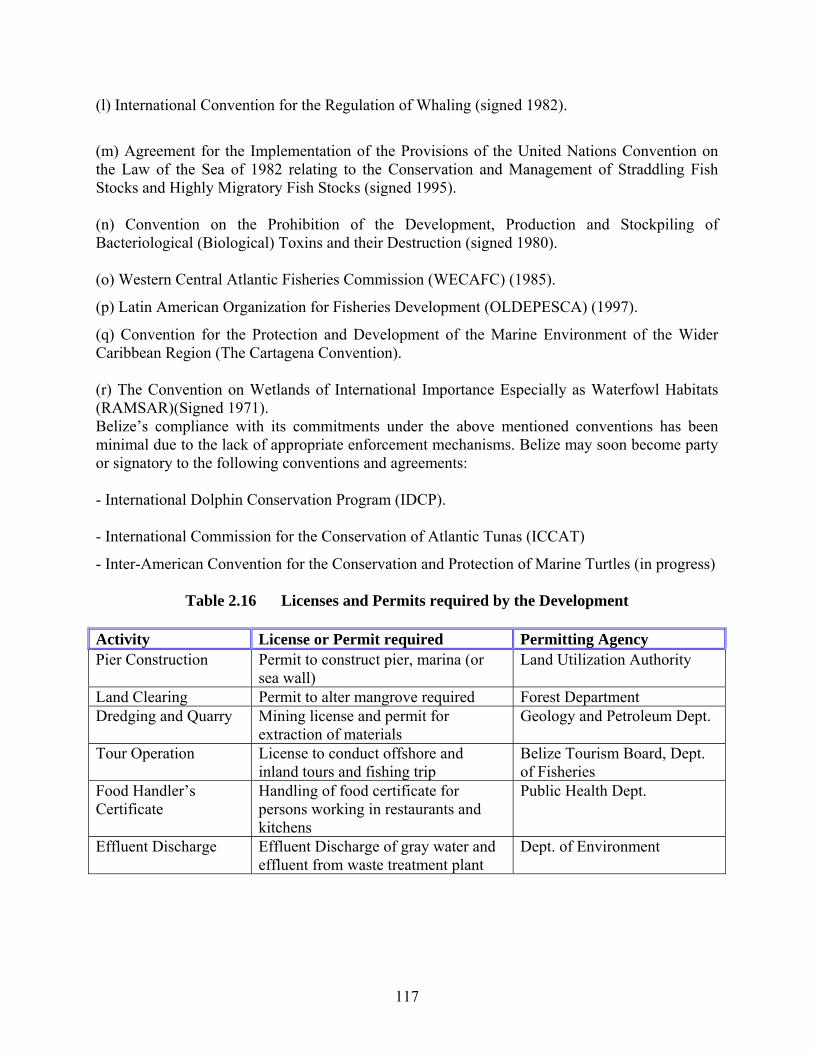
117
(l) International Convention for the Regulation of Whaling (signed 1982).
(m) Agreement for the Implementation of the Provisions of the United Nations Convention on the Law of the Sea of 1982 relating to the Conservation and Management of Straddling Fish Stocks and Highly Migratory Fish Stocks (signed 1995). (n) Convention on the Prohibition of the Development, Production and Stockpiling of Bacteriological (Biological) Toxins and their Destruction (signed 1980). (o) Western Central Atlantic Fisheries Commission (WECAFC) (1985).
(p) Latin American Organization for Fisheries Development (OLDEPESCA) (1997).
(q) Convention for the Protection and Development of the Marine Environment of the Wider Caribbean Region (The Cartagena Convention). (r) The Convention on Wetlands of International Importance Especially as Waterfowl Habitats (RAMSAR)(Signed 1971). Belize’s compliance with its commitments under the above mentioned conventions has been minimal due to the lack of appropriate enforcement mechanisms. Belize may soon become party or signatory to the following conventions and agreements: - International Dolphin Conservation Program (IDCP). - International Commission for the Conservation of Atlantic Tunas (ICCAT)
- Inter-American Convention for the Conservation and Protection of Marine Turtles (in progress)
Table 2.16 Licenses and Permits required by the Development Activity License or Permit required Permitting Agency Pier Construction Permit to construct pier, marina (or
sea wall) Land Utilization Authority
Land Clearing Permit to alter mangrove required Forest Department Dredging and Quarry Mining license and permit for
extraction of materials Geology and Petroleum Dept.
Tour Operation License to conduct offshore and inland tours and fishing trip
Belize Tourism Board, Dept. of Fisheries
Food Handler’s Certificate
Handling of food certificate for persons working in restaurants and kitchens
Public Health Dept.
Effluent Discharge Effluent Discharge of gray water and effluent from waste treatment plant
Dept. of Environment
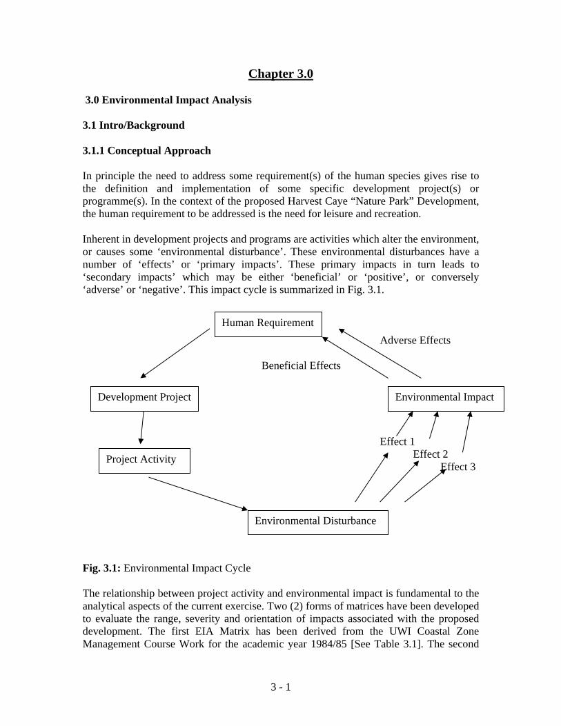
3 - 1
Chapter 3.0 3.0 Environmental Impact Analysis 3.1 Intro/Background 3.1.1 Conceptual Approach In principle the need to address some requirement(s) of the human species gives rise to the definition and implementation of some specific development project(s) or programme(s). In the context of the proposed Harvest Caye “Nature Park” Development, the human requirement to be addressed is the need for leisure and recreation. Inherent in development projects and programs are activities which alter the environment, or causes some ‘environmental disturbance’. These environmental disturbances have a number of ‘effects’ or ‘primary impacts’. These primary impacts in turn leads to ‘secondary impacts’ which may be either ‘beneficial’ or ‘positive’, or conversely ‘adverse’ or ‘negative’. This impact cycle is summarized in Fig. 3.1. Adverse Effects Beneficial Effects Effect 1 Effect 2 Effect 3 Fig. 3.1: Environmental Impact Cycle The relationship between project activity and environmental impact is fundamental to the analytical aspects of the current exercise. Two (2) forms of matrices have been developed to evaluate the range, severity and orientation of impacts associated with the proposed development. The first EIA Matrix has been derived from the UWI Coastal Zone Management Course Work for the academic year 1984/85 [See Table 3.1]. The second
Human Requirement
Development Project Environmental Impact
Project Activity
Environmental Disturbance

3 - 2
matrix is a modified Leopold Matrix first used by Tunich Nah Consultants and Engineers in the US Capital Energy EIA submitted to the DOE in 2007 [See Table 3.2]. The UWI Coastal Zone Matrix has been used firstly to demonstrate that the proposed project, like most other development initiative, has both negative and positive impacts, and secondly that the primary, secondary and tertiary impacts are hierarchical [See Table 3.1]. The primary impacts vary in magnitude only, however the secondary and tertiary impacts vary in both magnitude and direction [See Table 3.1]. This matrix shown in Table 3.1 is to be used in tandem with the Ecosystem Map shown in Fig. 3.2. The main purpose of the UWI associated matrix is to highlight or underscore those areas of impacts that would need further analysis, especially as it relates to mitigatory interventions. In the case of the latter, the modified Leopold Matrix mentioned above, has been employed: Thus as would be noted from Tables 3.2 and 3.3, the orientation of all the impacts identified is ‘negative’ or deleterious. It is apparent from the UWI associated matrix that there is a geographic relationship between a particular developmental activity and the severity of the impact associated with that activity. Thus for example it may been seen from Table 3.1 that the magnitude of the impacts associated with increases in nutrient enrichment and sedimentation [See blue and red color scheme respectively], is highest near the developmental activity or nearshore ecosystems, and dissipates with distance for the offshore ecosystems. The EIA Matrix shown as Table 3.1 is based on the implementation of the project with all its in-built mitigation measures. It may be seen from Table 3.2 that the major deleterious ecological impacts derive from dredging, sewage, solid waste and land clearing. It may also be seen that the most severe deleterious socio-economic impacts are associated with the threat to economic livelihood, the threat to human health and safety, and the potential conflicts and discomfiture associated with the meeting and interaction of different cultures. Table 3.2 represents an analysis of the impacts of the project without mitigation, while Table 3.3 represents an analysis of the project with mitigation measures. It may be seen that the magnitude of the deleterious impacts shown in Table 3.2 are significant reduced relative to Table 3.3. This is the most salient indicator that the project as conceptualized can and should proceed with the proper mitigation measures. Tables 3.1, 3.2 and 3.3 are a comprehensive treatment of the analysis of the ecological and primary socio-economic impacts of the proposed project.
3 - 3
Table 3.1: EIA Matrix of the Proposed Harvest Caye Development. LEVEL 1 IMPACTS
(PARAMETRICALCHANGES) ACTIVITIES
Marine Water Quality Landform Main Dev. Area Ecology
Inc
reas
e in
Nut
rient
s In
crea
se in
S
edim
enta
tion
Incr
ease
in F
ecal
C
olifo
rm
Inc
reas
e in
BO
D
Inc
reas
e in
H
ygro
gen
Sul
phid
e I
ncre
ase
in
Pet
role
um P
ollu
tion
Incr
ease
in
Stra
tific
atio
n D
ecre
asei
n D
isso
lved
O
xyge
n
Inc
reas
e in
Sal
inity
In
crea
sed
Sal
iniz
atio
n of
Soi
ls
Inc
reas
e in
Ero
sion
I
ncre
ased
O
nsho
re/O
ffsho
re
Sed
imen
t Tra
nspo
rt In
crea
se in
Sol
id
Was
te
Incr
ease
in A
noxi
c se
edim
ent
Inc
reas
ed L
and
Run
-of
f In
crea
se F
orei
gn
Tour
ists
In
crea
se in
pel
agic
ha
bita
t
Loss
of b
enth
ic h
abita
t D
ecre
ase
Nur
sery
H
abita
t In
crea
se in
fera
l an
imal
s In
crea
se in
aqu
atic
fa
una
near
Dev
. Site
ec
ease
prod
uctiv
ity o
f m
angr
oves
D
ecre
ase
man
grov
e pr
op ro
ot h
abita
t In
crea
se in
bird
po
pula
tions
D
ecre
ase
in S
eagr
ass
Bio
mas
s D
ecre
ase
in c
oral
reef
co
ver a
nd d
iver
sity
Con
stru
ctio
n Ph
ase
Dredging To deepen arrival area for cruise ships and reclaim Parts of Caye
3 1 1 1 1 3 2 1 1 2 1
Deposition and Dewatering of Spoil 1 1 1 2 1 1 2 1 2 1 2 Excavation for Marina Basin 1 1 1 2 1 1 1 Reclamation of areas on island and beach 1 1 3 3 3 2 2 2 2 2 Construction Elevated Walkway and Light Vehicle Path
1 1
Barging of Construction Supplies 1 3 Construction of Freight and Main Access Piers
2
Construction of Restaurants, shops and other service buildings
1
Installation & Operation of Sewer Infrastructure
3 2 2
Inst. & Operation of Desalinization Facilities 1 1 1 Inst. & Operation Diesel Generators Inst. Main Submarine Power Cable from Mainland
1 1 1 1
Inst. Caye-based Potable Water Infrastructure
Pre-development Land Clearing 1 2 1 2 2 2 2 1 Fuel Storage Piers/Marinas 1 1 Inst. Floating Trail Platform for Snorkeling
Ope
ratio
nal P
hase
Dockside Boating/Berthing Operations 1 1 1 1 Cay-based Nature Watch 1 Caye-based motorized traffic Fueling of Boats in Marina 1 Main buildings Occupancy & Operation 3 1 3 2 1 Recreational Beach Activities 1 1 1 Kayaking Operation 1 Nearshore Snorkeling & Scuba Diving Operation
1
Nature Trail Operation 1 LEVEL 2 IMPACTS
Nea
rsho
re
Ecos
yste
m
Leew
ard
Side
of Fringing Mangrove Prop Root Productivity 0 -2 -2 0 0 -2 -2 -2 -2 -2
Fringing Mangrove Canopy Biomass & Productivity
+1 -2 -2 0 -2 -2
Phytoplankton Productivity +1 -1 -1 0 0 0 Zooplankton Productivity +1 -1 -1 0 0 0 0 Sea-grass Productivity +1 -1 -2 0 0 -2 -2 -2 Macro-Invertebrate Population +1 -1 -2 0 0 0 0 0 -1 -1 -1 -1 -2 Fin-Fish Population +1 -1 -1 0 0 0 0 0 0 -1 -1 -1 -1 Seabird Population 0 0 0 0 0 0 +1 0 +1 0
Nea
rsho
re R
eefs
&
Seag
rass
Win
dwar
d Si
deof
Cay
e
Coral Reef Cover and Diversity -1 -1 -1 0 0 -1 -1 -1 General Pelagic Fish Populations +1 -1 0 0 0 0 -1 0 0 0 0 Reef Fish Abundance and Diversity +1 -1 -1 0 0 0 -1 -1 0 0 0 -1 Seagrass Productivity +1 -1 -1 0 0 -1 0 Macro-invertebrate Populations +1 -1 -1 0 0 -1 -1 0 0 -1 General Lobster Populations +1 -1 -1 0 0 -1 -1 0 0 -1 Phytoplankton Productivity +1 -1 -1 0 Zooplankton Productivity +1 -1 -1 0 Seabird Population 0 0 0 0 +1 0 0 0 Manatee Population 0 0 0
Cay
e-ba
se E
cosy
stem
Mangrove Canopy Biomass & Geographic Extent
+1 -2 -2 0 -2 0
Swamp Floor Productivity & Geographic Extent
+1 -2 -2 0 -2 -2 -2
Littoral Forest Productivity and Geographic Extent
-1 -1 -1
Woodland Bird Population 0 -1 -1 0 +1 +1 Sea Bird Populations 0 0 0 +1 0 +1 Invasive Feral Fauna Abundance & Diversity
-2 +1 +1
Resident Iguana Populations 0 -1 -1 0 -1 General Faunal Diversity -1 -1 -1 +1 -1 +1 +1 -1 -1
Offs
hore
Ec
osys
tem
0.
5 N
M o
f
Phytoplankton Productivity 0 0 0 0 Zooplankton Productivity 0 0 0 0 Seagrass Productivity 0 0 0 0 -2 Manatee Populations 0 0 0 Fin-Fish Population 0 0 0 0 0 -1 Sea Bird Populations 0 0 0 0 General Faunal Diversity & Abundance 0 0 0 -1
LEVEL 3 IMPACTS
Econ
omic
A
ctiv
ities
Boat Traffic In Channel off North End of Caye
Boat Access for Subsistence Fishers +1 0 Recreational Manatee Observation Commercial Lobster Fishing -1 0 -1 -1 -1 -1 -1 Bait Fish Harvest -1 0 -1 -1 -1 -1
Hum
an
Settl
emen
t Pathogenic Diseases -1 -1 -1 Mosquitos, Sandflies &Associated Pests -1 Culture conflicts -1 -1 -1 -1 Injury and physical trauma -1 Noise Pollution Odour pollution -1 0 -1 0 -1 -1 Muds & Sight Pollutiom -1 0 -1 0 -1 -1 0 -2 -2 0
KEY
Minor Change 1 Minor Beneficial Impact +1 Minor Adverse Impact -1
Moderate Change 2 Moderate Beneficial Impact +2 Moderate Adverse Impact -2
Major Change 3 Major Beneficial Impact +3 Major Adverse Impact -3
No Change Relationship exist but no 0 impact is expected
3 - 4
Table 3.2: Impact Matrix – Without Mitigation Topic Area Dev. Activity
Specific Area Primary or
Direct Impact
Secondary or Indirect Impact
Mag. & Dir. Impact
TS &
Rev
Geo. Scope Mit. Avail.
L R N
Physical Environment
Dredging Soils Land-based deposition of dredged spoils leading to salinization of soils.
Suffocation of root systems and high salinities results in wilting and death of mangroves and littoral forest vegetation…Negative implications for iguanas and other herbivores, as well as woodland birds.
-3 ST, R
√ √
(Sea-floor sediments)
Physical extraction of seafloor with attendant sedimentation and turbidity influences.
Mechanical destruction of sea-grass beds, algal tufts, denuded seafloor and other benthic habitat…Also effects from sedimentation and turbidity influences in form of blanketing of sedentary and slow-moving benthic invertebrates as well as impairment of photosynthesis and secondary production in sea-grass dominated areas.
-2 MT, R
√ √

3 - 5
Topic Area Dev. Activity
Specific Area Primary or Direct Impact
Secondary or Indirect Impact
Mag. & Dir. Impact
TS &
Rev
Geo. Scope Mit. Avail.L R N
Land Clearing Soils Exposure of soils to aerial and sea-based shoreline erosion
Loss and change of vegetation, with negative implications for native fauna, such as iguanas, land crabs, lizards and woodland birds.
-2 ST, R
√ √
Physical Env. cont’d
Inst. & op. of Sewage System
Water Quality Production and liberation of eutrophic or nutrient enrichment substances.
Liberation of nitrates and phosphates from sewage into water column of surrounding seas may lead to increase in photosynthesis and primary production at lower end of pollution spectrum…At extreme end of spectrum leads to mass mortalities or ‘crash’ of microalgal blooms…Stimulus for overgrowth of reef systems by macro-algae and seagrasses leading to their demise.
-3 LT, R
√ √
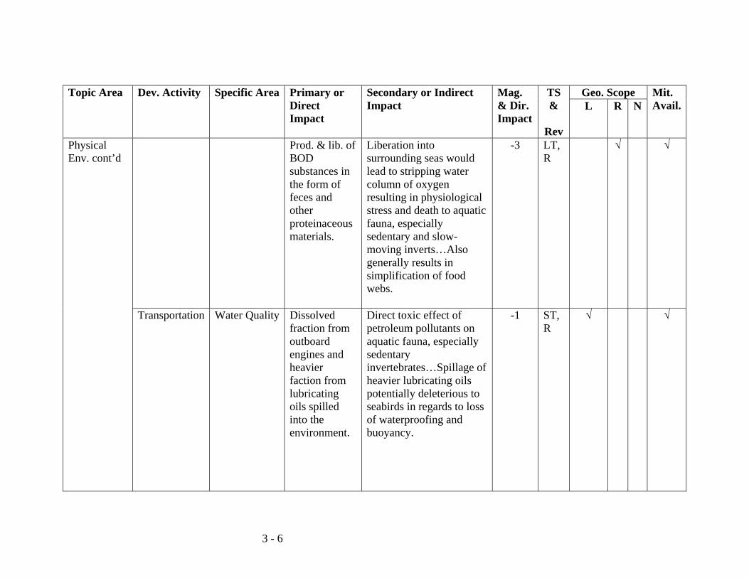
3 - 6
Topic Area Dev. Activity
Specific Area Primary or Direct Impact
Secondary or Indirect Impact
Mag. & Dir. Impact
TS &
Rev
Geo. Scope Mit. Avail.L R N
Physical Env. cont’d
Prod. & lib. of BOD substances in the form of feces and other proteinaceous materials.
Liberation into surrounding seas would lead to stripping water column of oxygen resulting in physiological stress and death to aquatic fauna, especially sedentary and slow-moving inverts…Also generally results in simplification of food webs.
-3 LT, R
√ √
Transportation Water Quality Dissolved fraction from outboard engines and heavier faction from lubricating oils spilled into the environment.
Direct toxic effect of petroleum pollutants on aquatic fauna, especially sedentary invertebrates…Spillage of heavier lubricating oils potentially deleterious to seabirds in regards to loss of waterproofing and buoyancy.
-1 ST, R
√ √
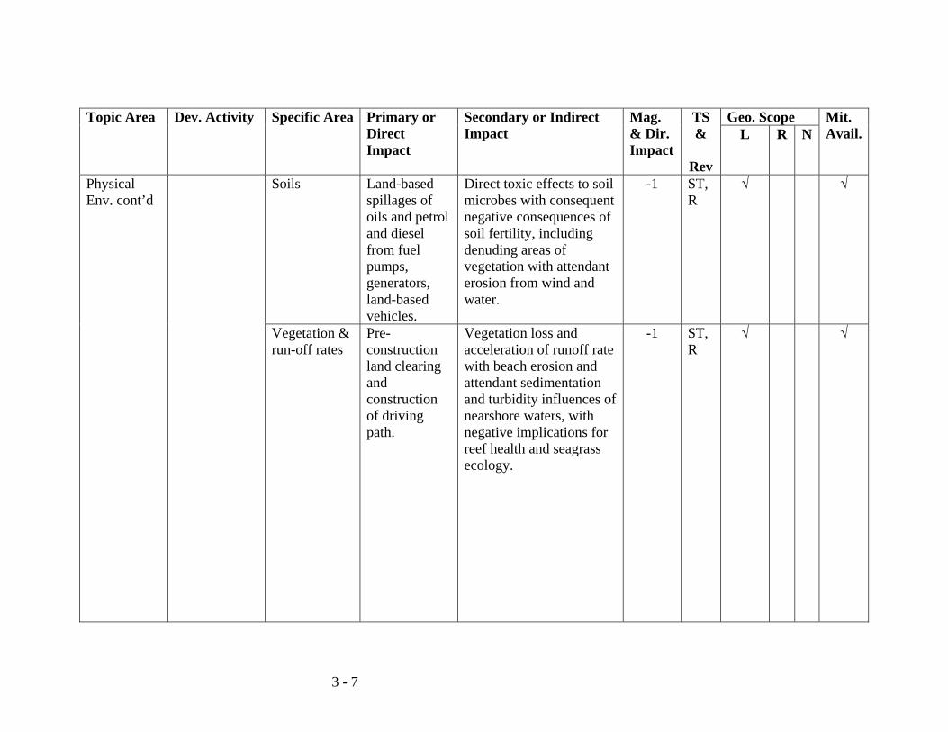
3 - 7
Topic Area Dev. Activity
Specific Area Primary or Direct Impact
Secondary or Indirect Impact
Mag. & Dir. Impact
TS &
Rev
Geo. Scope Mit. Avail.L R N
Physical Env. cont’d
Soils Land-based spillages of oils and petrol and diesel from fuel pumps, generators, land-based vehicles.
Direct toxic effects to soil microbes with consequent negative consequences of soil fertility, including denuding areas of vegetation with attendant erosion from wind and water.
-1 ST, R
√ √
Vegetation & run-off rates
Pre-construction land clearing and construction of driving path.
Vegetation loss and acceleration of runoff rate with beach erosion and attendant sedimentation and turbidity influences of nearshore waters, with negative implications for reef health and seagrass ecology.
-1 ST, R
√ √

3 - 8
Topic Area Dev. Activity
Specific Area Primary or Direct Impact
Secondary or Indirect Impact
Mag. & Dir. Impact
TS &
Rev
Geo. Scope Mit. Avail.L R N
Ecology and nature conservation
Solid Wastes Accumulation
Food discards Attraction of feral animals and household pests in the form of crocodiles, raccoons, rats and vagrant birds.
Interaction of invasive species with native caye-based fauna in form of prey/predator relationships, as well as parasite/host relationships and disease introduction situations, and competition/displacement scenarios.
-3 LT, R
√ √
Alteration of species diversity indices driven by induced and incidental introduction of non-native flora and fauna.
Disruption of ecological balance and gene frequency on Caye with threat of altering course of evolution of native fauna.
-3 LT, R
√ √
Leaching of toxic, pH altering and oxidative substances from discards.
Direct mortality and morbidity to land-based fauna such as iguanas, geckos, blue land crabs crows and vultures.
-3 LT, IR
√ √
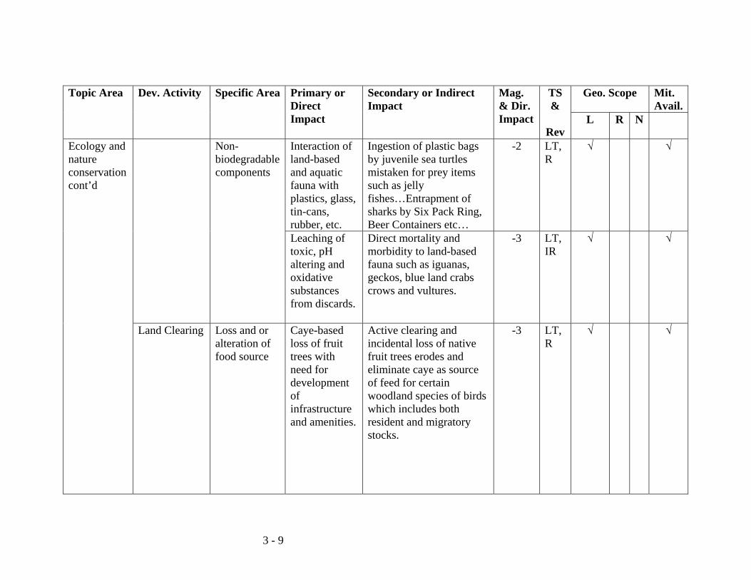
3 - 9
Topic Area Dev. Activity
Specific Area Primary or Direct Impact
Secondary or Indirect Impact
Mag. & Dir. Impact
TS &
Rev
Geo. Scope Mit. Avail.
L R N
Ecology and nature conservation cont’d
Non-biodegradable components
Interaction of land-based and aquatic fauna with plastics, glass, tin-cans, rubber, etc.
Ingestion of plastic bags by juvenile sea turtles mistaken for prey items such as jelly fishes…Entrapment of sharks by Six Pack Ring, Beer Containers etc…
-2 LT, R
√ √
Leaching of toxic, pH altering and oxidative substances from discards.
Direct mortality and morbidity to land-based fauna such as iguanas, geckos, blue land crabs crows and vultures.
-3 LT, IR
√ √
Land Clearing Loss and or alteration of food source
Caye-based loss of fruit trees with need for development of infrastructure and amenities.
Active clearing and incidental loss of native fruit trees erodes and eliminate caye as source of feed for certain woodland species of birds which includes both resident and migratory stocks.
-3 LT, R
√ √
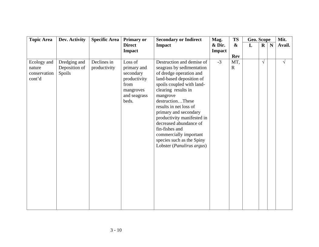
3 - 10
Topic Area Dev. Activity
Specific Area Primary or Direct Impact
Secondary or Indirect Impact
Mag. & Dir. Impact
TS &
Rev
Geo. Scope Mit. Avail.L R N
Ecology and nature conservation cont’d
Dredging and Deposition of Spoils
Declines in productivity
Loss of primary and secondary productivity from mangroves and seagrass beds.
Destruction and demise of seagrass by sedimentation of dredge operation and land-based deposition of spoils coupled with land-clearing results in mangrove destruction…These results in net loss of primary and secondary productivity manifested in decreased abundance of fin-fishes and commercially important species such as the Spiny Lobster (Panulirus argus)
-3 MT, R
√ √
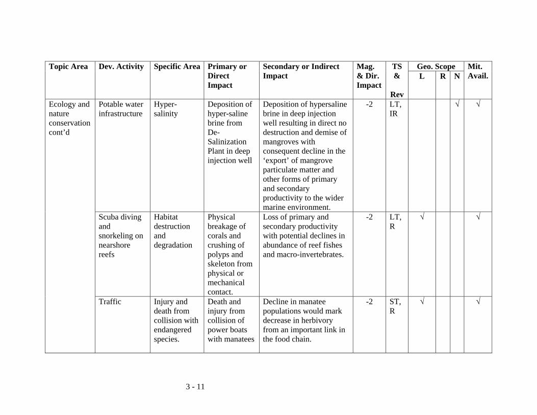
3 - 11
Topic Area Dev. Activity
Specific Area Primary or Direct Impact
Secondary or Indirect Impact
Mag. & Dir. Impact
TS &
Rev
Geo. Scope Mit. Avail.L R N
Ecology and nature conservation cont’d
Potable water infrastructure
Hyper-salinity
Deposition of hyper-saline brine from De-Salinization Plant in deep injection well
Deposition of hypersaline brine in deep injection well resulting in direct no destruction and demise of mangroves with consequent decline in the ‘export’ of mangrove particulate matter and other forms of primary and secondary productivity to the wider marine environment.
-2 LT, IR
√ √
Scuba diving and snorkeling on nearshore reefs
Habitat destruction and degradation
Physical breakage of corals and crushing of polyps and skeleton from physical or mechanical contact.
Loss of primary and secondary productivity with potential declines in abundance of reef fishes and macro-invertebrates.
-2 LT, R
√ √
Traffic Injury and death from collision with endangered species.
Death and injury from collision of power boats with manatees
Decline in manatee populations would mark decrease in herbivory from an important link in the food chain.
-2 ST, R
√ √
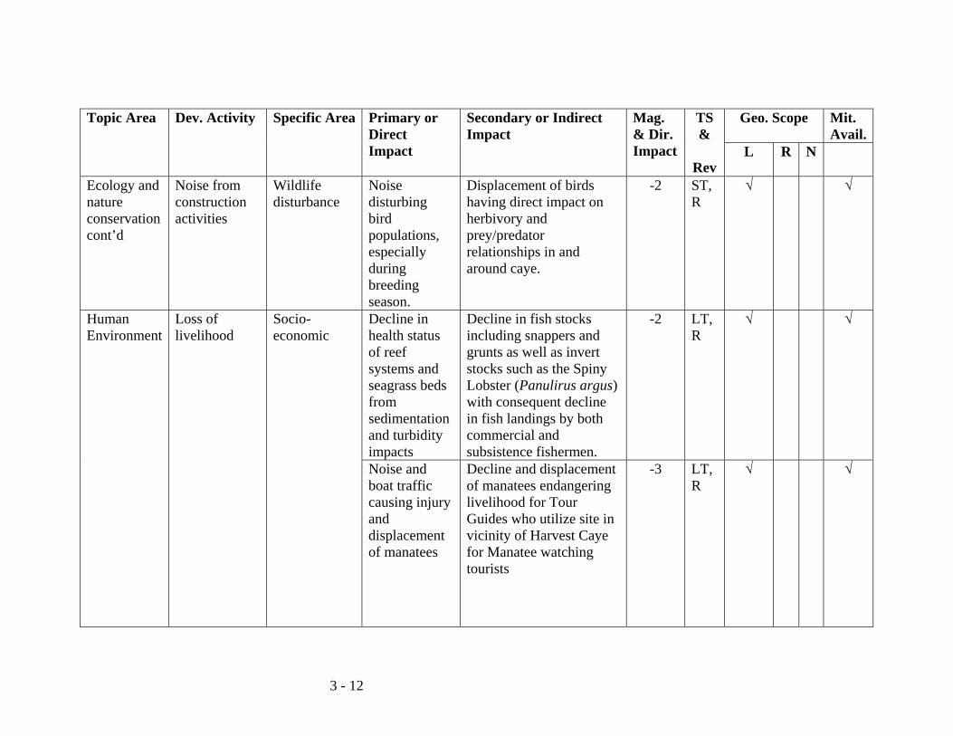
3 - 12
Topic Area Dev. Activity
Specific Area Primary or Direct Impact
Secondary or Indirect Impact
Mag. & Dir. Impact
TS &
Rev
Geo. Scope Mit. Avail.
L R N
Ecology and nature conservation cont’d
Noise from construction activities
Wildlife disturbance
Noise disturbing bird populations, especially during breeding season.
Displacement of birds having direct impact on herbivory and prey/predator relationships in and around caye.
-2 ST, R
√ √
Human Environment
Loss of livelihood
Socio-economic
Decline in health status of reef systems and seagrass beds from sedimentation and turbidity impacts
Decline in fish stocks including snappers and grunts as well as invert stocks such as the Spiny Lobster (Panulirus argus) with consequent decline in fish landings by both commercial and subsistence fishermen.
-2 LT, R
√ √
Noise and boat traffic causing injury and displacement of manatees
Decline and displacement of manatees endangering livelihood for Tour Guides who utilize site in vicinity of Harvest Caye for Manatee watching tourists
-3 LT, R
√ √
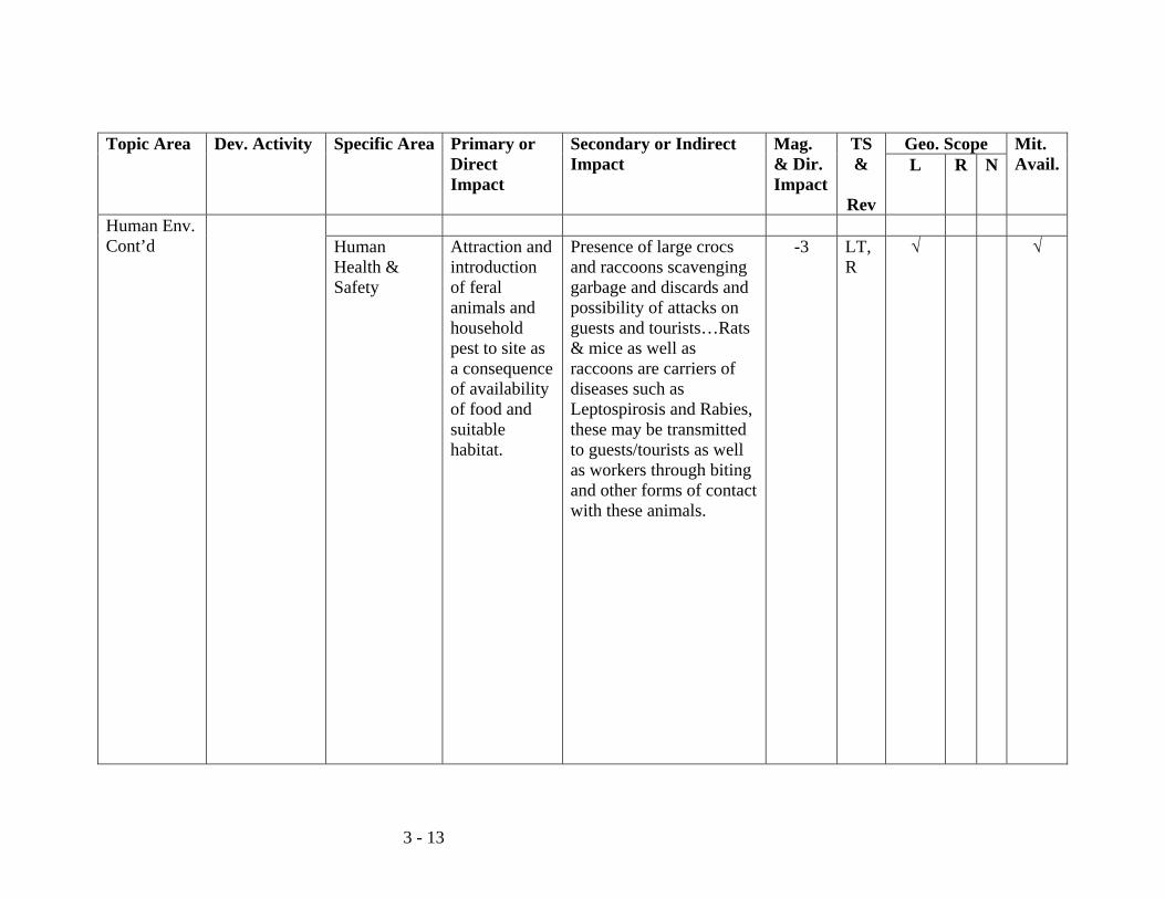
3 - 13
Topic Area Dev. Activity
Specific Area Primary or Direct Impact
Secondary or Indirect Impact
Mag. & Dir. Impact
TS &
Rev
Geo. Scope Mit. Avail.L R N
Human Env. Cont’d
Human Health & Safety
Attraction and introduction of feral animals and household pest to site as a consequence of availability of food and suitable habitat.
Presence of large crocs and raccoons scavenging garbage and discards and possibility of attacks on guests and tourists…Rats & mice as well as raccoons are carriers of diseases such as Leptospirosis and Rabies, these may be transmitted to guests/tourists as well as workers through biting and other forms of contact with these animals.
-3 LT, R
√ √
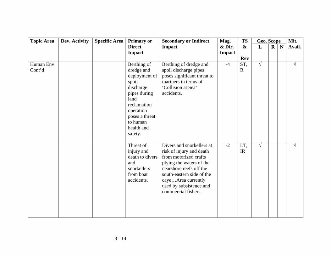
3 - 14
Topic Area Dev. Activity
Specific Area Primary or Direct Impact
Secondary or Indirect Impact
Mag. & Dir. Impact
TS &
Rev
Geo. Scope Mit. Avail.L R N
Human Env Cont’d
Berthing of dredge and deployment of spoil discharge pipes during land reclamation operation poses a threat to human health and safety.
Berthing of dredge and spoil discharge pipes poses significant threat to mariners in terms of ‘Collision at Sea’ accidents.
-4 ST, R
√ √
Threat of injury and death to divers and snorkellers from boat accidents.
Divers and snorkellers at risk of injury and death from motorized crafts plying the waters of the nearshore reefs off the south-eastern side of the caye…Area currently used by subsistence and commercial fishers.
-2 LT, IR
√ √
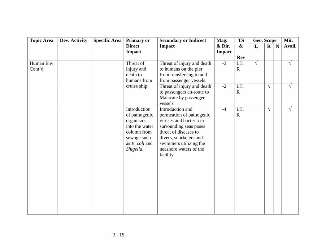
3 - 15
Topic Area Dev. Activity
Specific Area Primary or Direct Impact
Secondary or Indirect Impact
Mag. & Dir. Impact
TS &
Rev
Geo. Scope Mit. Avail.L R N
Human Env Cont’d
Threat of injury and death to humans from cruise ship.
Threat of injury and death to humans on the pier from transferring to and from passenger vessels.
-3 LT, R
√ √
Threat of injury and death to passengers en-route to Malacate by passenger vessels
-2 LT, R
√ √
Introduction of pathogenic organisms into the water column from sewage such as E. coli and Shigella.
Introduction and permeation of pathogenic viruses and bacteria in surrounding seas poses threat of diseases to divers, snorkelers and swimmers utilizing the neashore waters of the facility
-4 LT, R
√ √
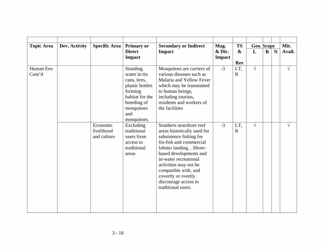
3 - 16
Topic Area Dev. Activity
Specific Area Primary or
Direct Impact
Secondary or Indirect Impact
Mag. & Dir. Impact
TS &
Rev
Geo. Scope Mit. Avail.L R N
Human Env Cont’d
Standing water in tin cans, tires, plastic bottles forming habitat for the breeding of mosquitoes and mosquitoes.
Mosquitoes are carriers of various diseases such as Malaria and Yellow Fever which may be transmitted to human beings, including tourists, residents and workers of the facilities
-3 LT, R
√ √
Economic livelihood and culture
Excluding traditional users from access to traditional areas
Southern nearshore reef areas historically used for subsistence fishing for fin-fish and commercial lobster landing…Shore-based developments and in-water recreational activities may not be compatible with, and covertly or overtly discourage access to traditional users.
-3 LT, R
√ √
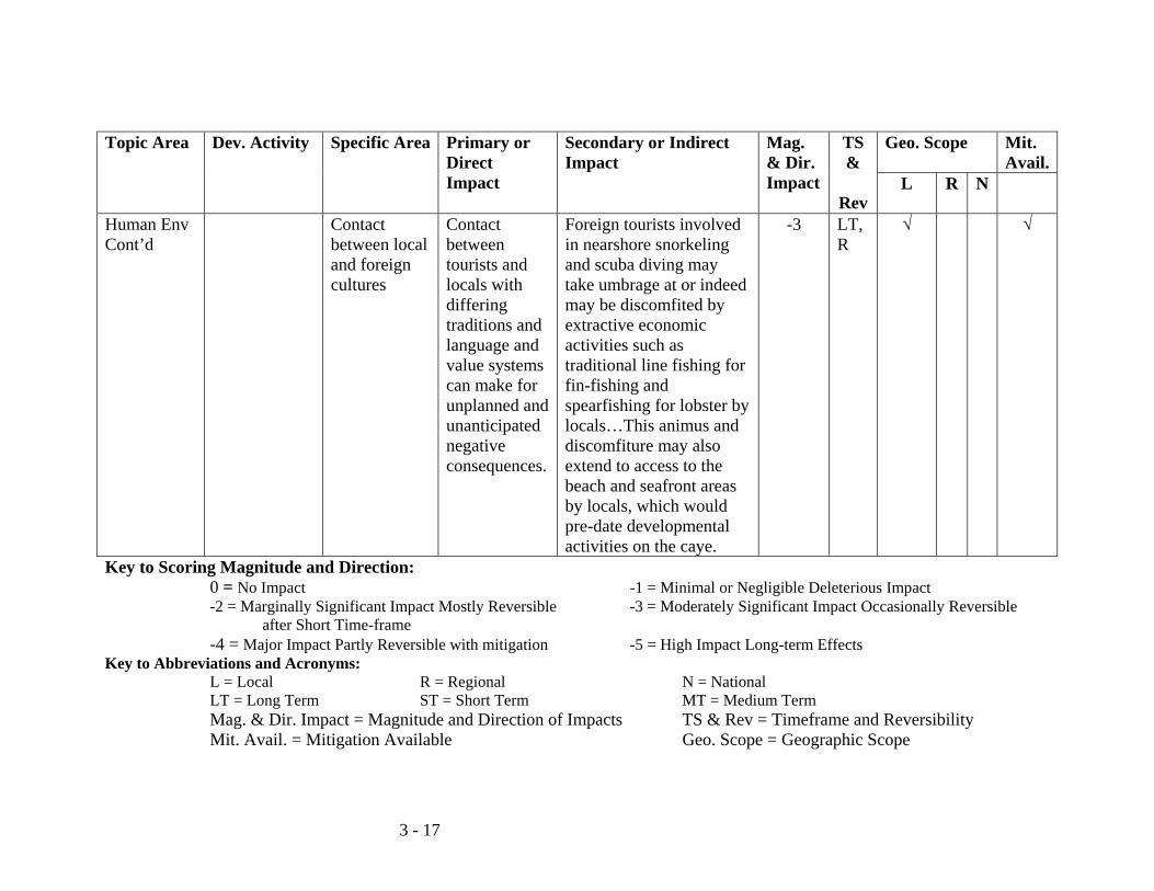
3 - 17
Topic Area Dev. Activity
Specific Area Primary or Direct Impact
Secondary or Indirect Impact
Mag. & Dir. Impact
TS &
Rev
Geo. Scope Mit. Avail.
L R N
Human Env Cont’d
Contact between local and foreign cultures
Contact between tourists and locals with differing traditions and language and value systems can make for unplanned and unanticipated negative consequences.
Foreign tourists involved in nearshore snorkeling and scuba diving may take umbrage at or indeed may be discomfited by extractive economic activities such as traditional line fishing for fin-fishing and spearfishing for lobster by locals…This animus and discomfiture may also extend to access to the beach and seafront areas by locals, which would pre-date developmental activities on the caye.
-3 LT, R
√ √
Key to Scoring Magnitude and Direction: 0 = No Impact -1 = Minimal or Negligible Deleterious Impact -2 = Marginally Significant Impact Mostly Reversible -3 = Moderately Significant Impact Occasionally Reversible after Short Time-frame -4 = Major Impact Partly Reversible with mitigation -5 = High Impact Long-term Effects Key to Abbreviations and Acronyms: L = Local R = Regional N = National LT = Long Term ST = Short Term MT = Medium Term Mag. & Dir. Impact = Magnitude and Direction of Impacts TS & Rev = Timeframe and Reversibility Mit. Avail. = Mitigation Available Geo. Scope = Geographic Scope
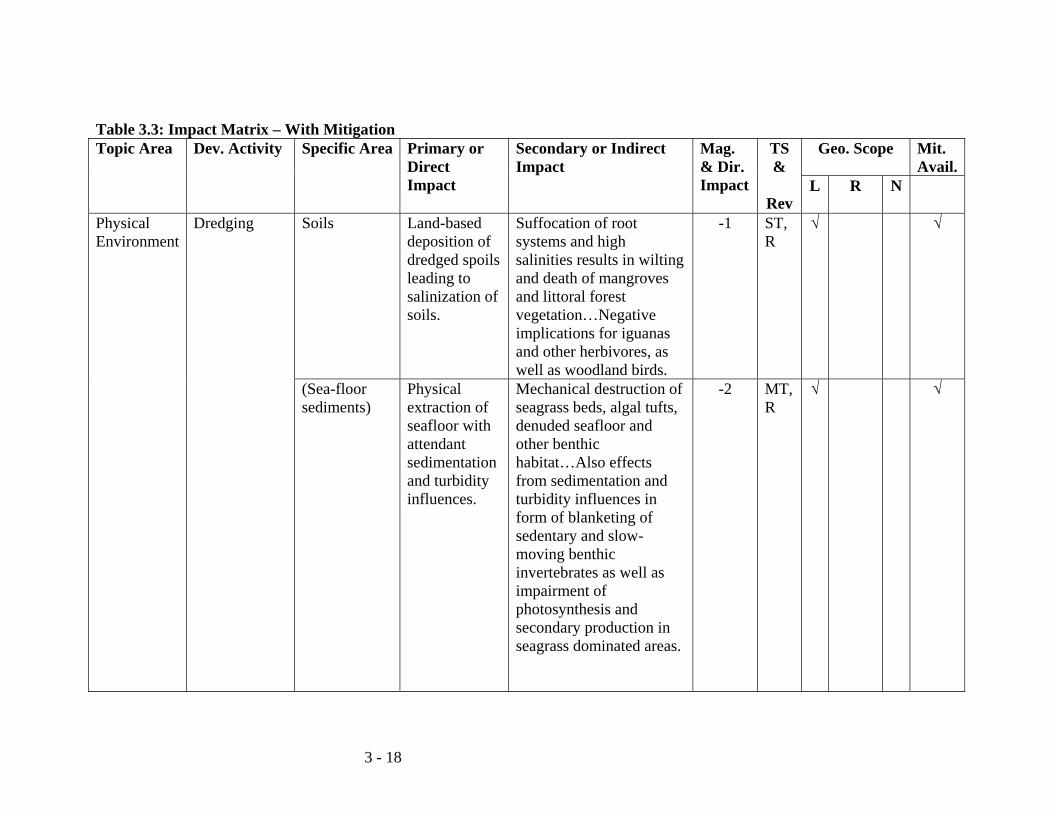
3 - 18
Table 3.3: Impact Matrix – With Mitigation Topic Area Dev. Activity
Specific Area Primary or
Direct Impact
Secondary or Indirect Impact
Mag. & Dir. Impact
TS &
Rev
Geo. Scope Mit. Avail.
L R N
Physical Environment
Dredging Soils Land-based deposition of dredged spoils leading to salinization of soils.
Suffocation of root systems and high salinities results in wilting and death of mangroves and littoral forest vegetation…Negative implications for iguanas and other herbivores, as well as woodland birds.
-1 ST, R
√ √
(Sea-floor sediments)
Physical extraction of seafloor with attendant sedimentation and turbidity influences.
Mechanical destruction of seagrass beds, algal tufts, denuded seafloor and other benthic habitat…Also effects from sedimentation and turbidity influences in form of blanketing of sedentary and slow-moving benthic invertebrates as well as impairment of photosynthesis and secondary production in seagrass dominated areas.
-2 MT, R
√ √
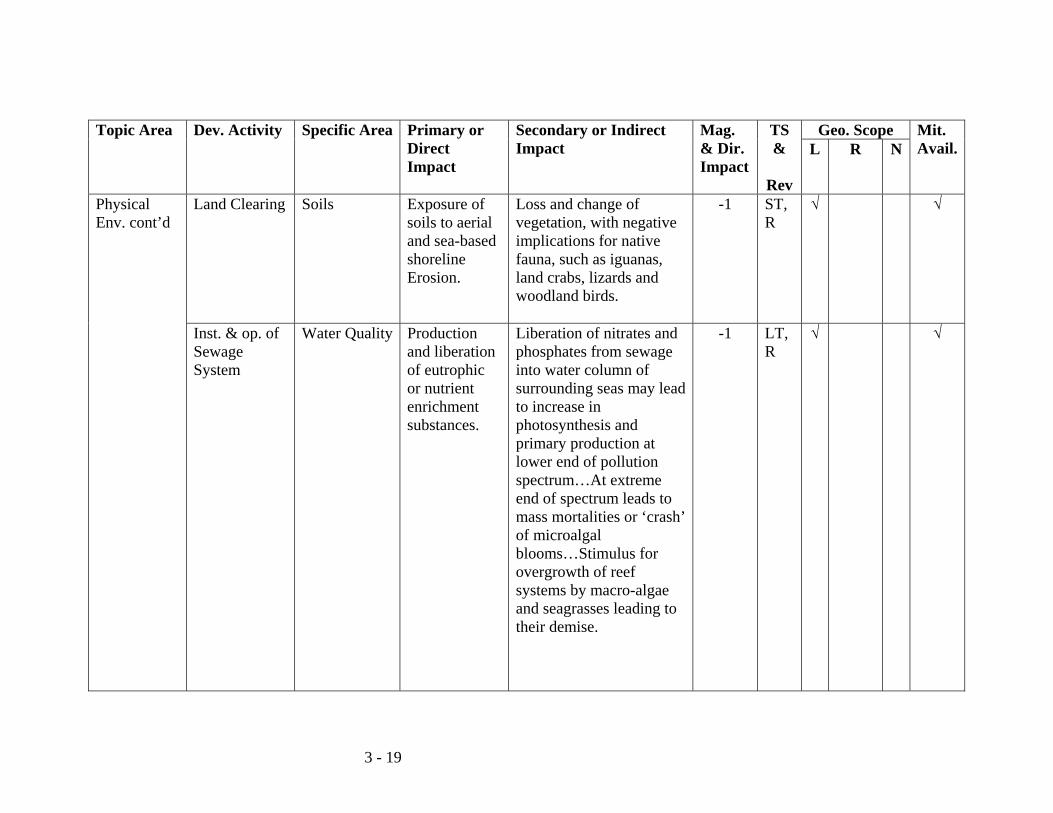
3 - 19
Topic Area Dev. Activity
Specific Area Primary or Direct Impact
Secondary or Indirect Impact
Mag. & Dir. Impact
TS &
Rev
Geo. Scope Mit. Avail.L R N
Physical Env. cont’d
Land Clearing Soils Exposure of soils to aerial and sea-based shoreline Erosion.
Loss and change of vegetation, with negative implications for native fauna, such as iguanas, land crabs, lizards and woodland birds.
-1 ST, R
√ √
Inst. & op. of Sewage System
Water Quality Production and liberation of eutrophic or nutrient enrichment substances.
Liberation of nitrates and phosphates from sewage into water column of surrounding seas may lead to increase in photosynthesis and primary production at lower end of pollution spectrum…At extreme end of spectrum leads to mass mortalities or ‘crash’ of microalgal blooms…Stimulus for overgrowth of reef systems by macro-algae and seagrasses leading to their demise.
-1 LT, R
√ √

3 - 20
Topic Area Dev. Activity
Specific Area Primary or Direct Impact
Secondary or Indirect Impact
Mag. & Dir. Impact
TS &
Rev
Geo. Scope Mit. Avail.L R N
Physical Env. cont’d
Prod. & lib. of BOD substances in the form of feces and other proteinaceous materials.
Liberation into surrounding seas would lead to stripping water column of oxygen resulting in physiological stress and death to aquatic fauna, especially sedentary and slow-moving inverts…Also generally results in simplification of food webs.
-1 LT, R
√ √
Transportation Water Quality Dissolved fraction from outboard engines and heavier faction from lubricating oils spilled into the environment.
Direct toxic effect of petroleum pollutants on aquatic fauna, especially sedentary invertebrates…Spillage of heavier lubricating oils potentially deleterious to seabirds in regards to loss of waterproofing and buoyancy.
-1 ST, R
√ √

3 - 21
Topic Area Dev. Activity
Specific Area Primary or Direct Impact
Secondary or Indirect Impact
Mag. & Dir. Impact
TS &
Rev
Geo. Scope Mit. Avail.L R N
Physical Env. cont’d
Soils Land-based spillages of oils and petrol and diesel from fuel pumps, generators, land-based vehicles.
Direct toxic effects to soil microbes with consequent negative consequences of soil fertility, including denuding areas of vegetation with attendant erosion from wind and water.
-1 ST, R
√ √
Vegetation & run-off rates
Pre-construction land clearing and construction of driving path.
Vegetation loss and acceleration of runoff rate with beach erosion and attendant sedimentation and turbidity influences of nearshore waters, with negative implications for reef health and seagrass ecology.
-1 ST, R
√ √
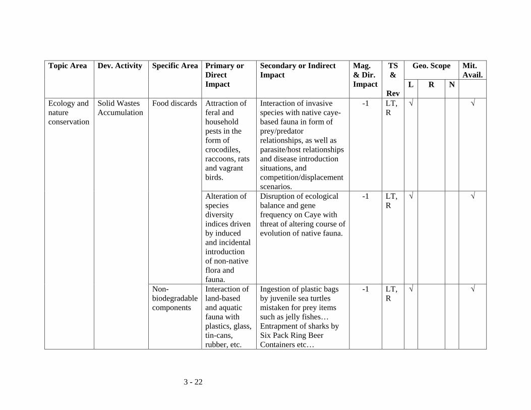
3 - 22
Topic Area Dev. Activity
Specific Area Primary or Direct Impact
Secondary or Indirect Impact
Mag. & Dir. Impact
TS &
Rev
Geo. Scope Mit. Avail.
L R N
Ecology and nature conservation
Solid Wastes Accumulation
Food discards Attraction of feral and household pests in the form of crocodiles, raccoons, rats and vagrant birds.
Interaction of invasive species with native caye-based fauna in form of prey/predator relationships, as well as parasite/host relationships and disease introduction situations, and competition/displacement scenarios.
-1 LT, R
√ √
Alteration of species diversity indices driven by induced and incidental introduction of non-native flora and fauna.
Disruption of ecological balance and gene frequency on Caye with threat of altering course of evolution of native fauna.
-1 LT, R
√ √
Non-biodegradable components
Interaction of land-based and aquatic fauna with plastics, glass, tin-cans, rubber, etc.
Ingestion of plastic bags by juvenile sea turtles mistaken for prey items such as jelly fishes… Entrapment of sharks by Six Pack Ring Beer Containers etc…
-1 LT, R
√ √
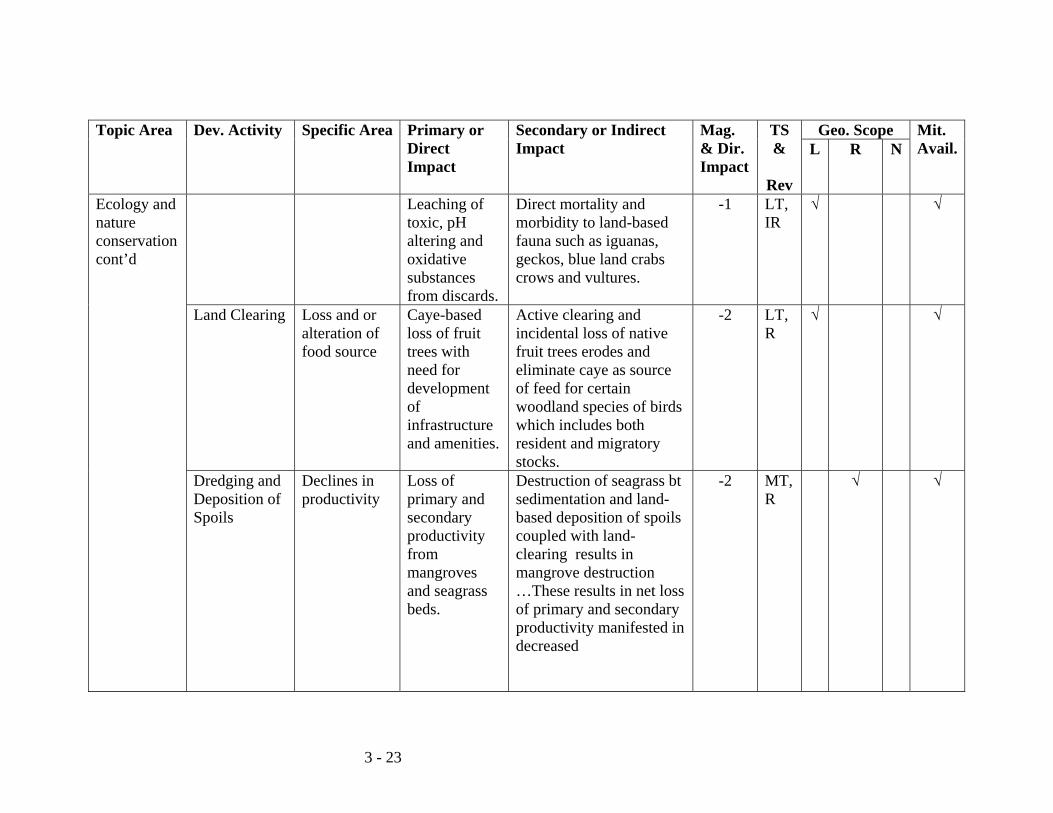
3 - 23
Topic Area Dev. Activity
Specific Area Primary or Direct Impact
Secondary or Indirect Impact
Mag. & Dir. Impact
TS &
Rev
Geo. Scope Mit. Avail.L R N
Ecology and nature conservation cont’d
Leaching of toxic, pH altering and oxidative substances from discards.
Direct mortality and morbidity to land-based fauna such as iguanas, geckos, blue land crabs crows and vultures.
-1 LT, IR
√ √
Land Clearing Loss and or alteration of food source
Caye-based loss of fruit trees with need for development of infrastructure and amenities.
Active clearing and incidental loss of native fruit trees erodes and eliminate caye as source of feed for certain woodland species of birds which includes both resident and migratory stocks.
-2 LT, R
√ √
Dredging and Deposition of Spoils
Declines in productivity
Loss of primary and secondary productivity from mangroves and seagrass beds.
Destruction of seagrass bt sedimentation and land-based deposition of spoils coupled with land-clearing results in mangrove destruction …These results in net loss of primary and secondary productivity manifested in decreased
-2 MT, R
√ √
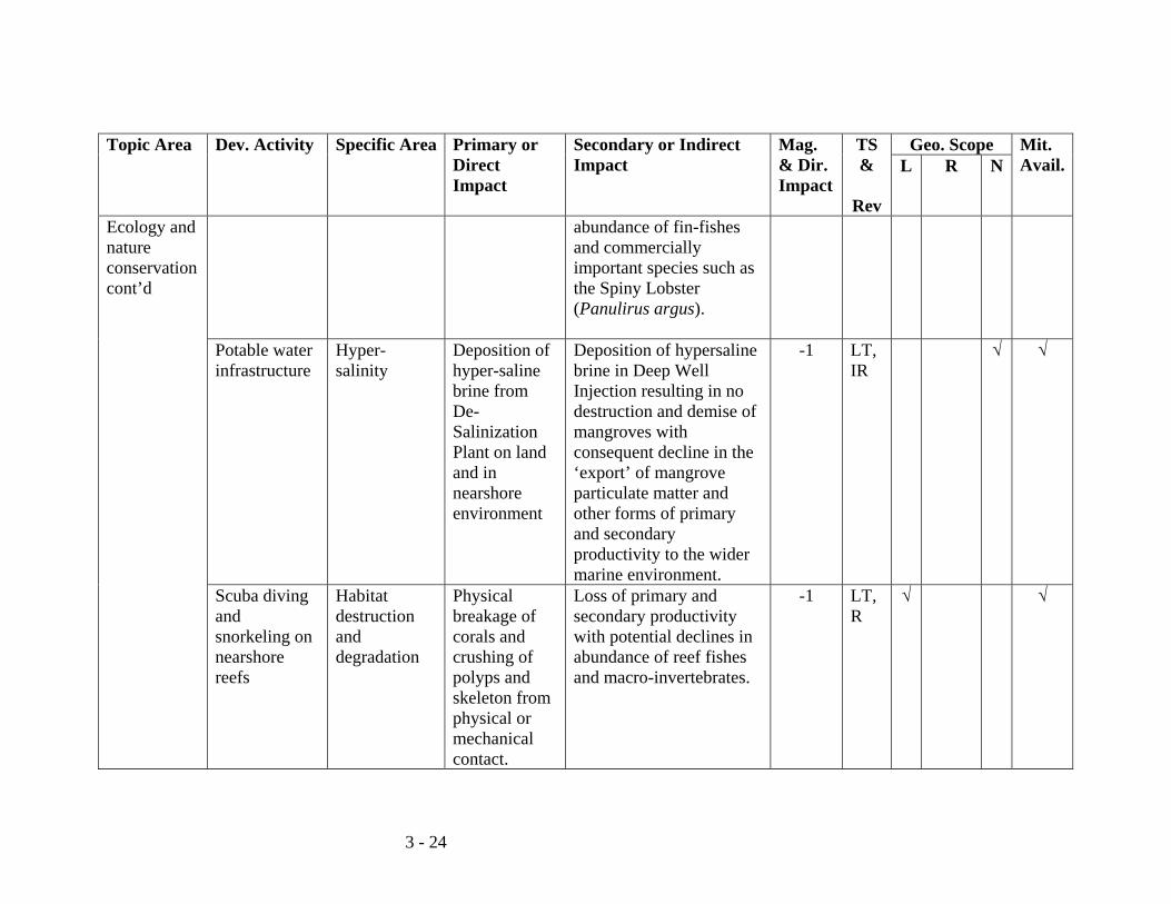
3 - 24
Topic Area Dev. Activity
Specific Area Primary or Direct Impact
Secondary or Indirect Impact
Mag. & Dir. Impact
TS &
Rev
Geo. Scope Mit. Avail.L R N
Ecology and nature conservation cont’d
abundance of fin-fishes and commercially important species such as the Spiny Lobster (Panulirus argus).
Potable water infrastructure
Hyper-salinity
Deposition of hyper-saline brine from De-Salinization Plant on land and in nearshore environment
Deposition of hypersaline brine in Deep Well Injection resulting in no destruction and demise of mangroves with consequent decline in the ‘export’ of mangrove particulate matter and other forms of primary and secondary productivity to the wider marine environment.
-1 LT, IR
√ √
Scuba diving and snorkeling on nearshore reefs
Habitat destruction and degradation
Physical breakage of corals and crushing of polyps and skeleton from physical or mechanical contact.
Loss of primary and secondary productivity with potential declines in abundance of reef fishes and macro-invertebrates.
-1 LT, R
√ √
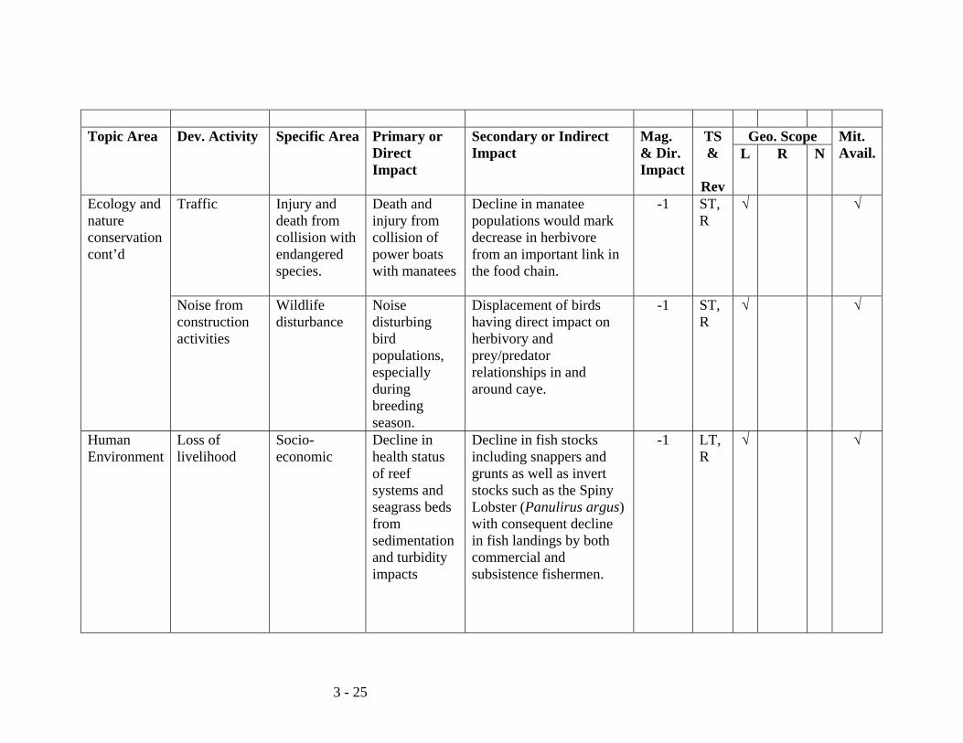
3 - 25
Topic Area Dev. Activity
Specific Area Primary or
Direct Impact
Secondary or Indirect Impact
Mag. & Dir. Impact
TS &
Rev
Geo. Scope Mit. Avail.L R N
Ecology and nature conservation cont’d
Traffic Injury and death from collision with endangered species.
Death and injury from collision of power boats with manatees
Decline in manatee populations would mark decrease in herbivore from an important link in the food chain.
-1 ST, R
√ √
Noise from construction activities
Wildlife disturbance
Noise disturbing bird populations, especially during breeding season.
Displacement of birds having direct impact on herbivory and prey/predator relationships in and around caye.
-1 ST, R
√ √
Human Environment
Loss of livelihood
Socio-economic
Decline in health status of reef systems and seagrass beds from sedimentation and turbidity impacts
Decline in fish stocks including snappers and grunts as well as invert stocks such as the Spiny Lobster (Panulirus argus) with consequent decline in fish landings by both commercial and subsistence fishermen.
-1 LT, R
√ √

3 - 26
Topic Area Dev. Activity
Specific Area Primary or Direct Impact
Secondary or Indirect Impact
Mag. & Dir. Impact
TS &
Rev
Geo. Scope Mit. Avail.L R N
Human Environment cont’d
Noise and boat traffic causing injury and displacement of manatees
Decline and displacement of manatees endangering livelihood for Tour Guides who utilizes site in vicinity of Harvest Caye for manatee watching tourists.
-1 LT, R
√ √
Human Health & Safety
Attraction and introduction of feral animals and household pest to site as a consequence of availability of food and suitable habitat.
Presence of large crocs and raccoons scavenging garbage and discards and possibility of attacks on guests and tourists…Rats & mice as well as raccoons are carriers of diseases such as Leptospirosis and Rabies, these may be transmitted to guests/tourists as well as workers through biting and other forms of contact with these animals.
-1 LT, R
√ √
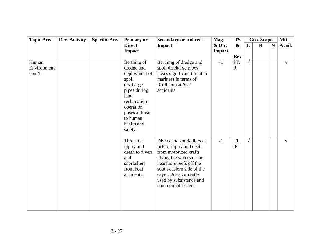
3 - 27
Topic Area Dev. Activity
Specific Area Primary or Direct Impact
Secondary or Indirect Impact
Mag. & Dir. Impact
TS &
Rev
Geo. Scope Mit. Avail.L R N
Human Environment cont’d
Berthing of dredge and deployment of spoil discharge pipes during land reclamation operation poses a threat to human health and safety.
Berthing of dredge and spoil discharge pipes poses significant threat to mariners in terms of ‘Collision at Sea’ accidents.
-1 ST, R
√ √
Threat of injury and death to divers and snorkellers from boat accidents.
Divers and snorkellers at risk of injury and death from motorized crafts plying the waters of the nearshore reefs off the south-eastern side of the caye…Area currently used by subsistence and commercial fishers.
-1 LT, IR
√ √
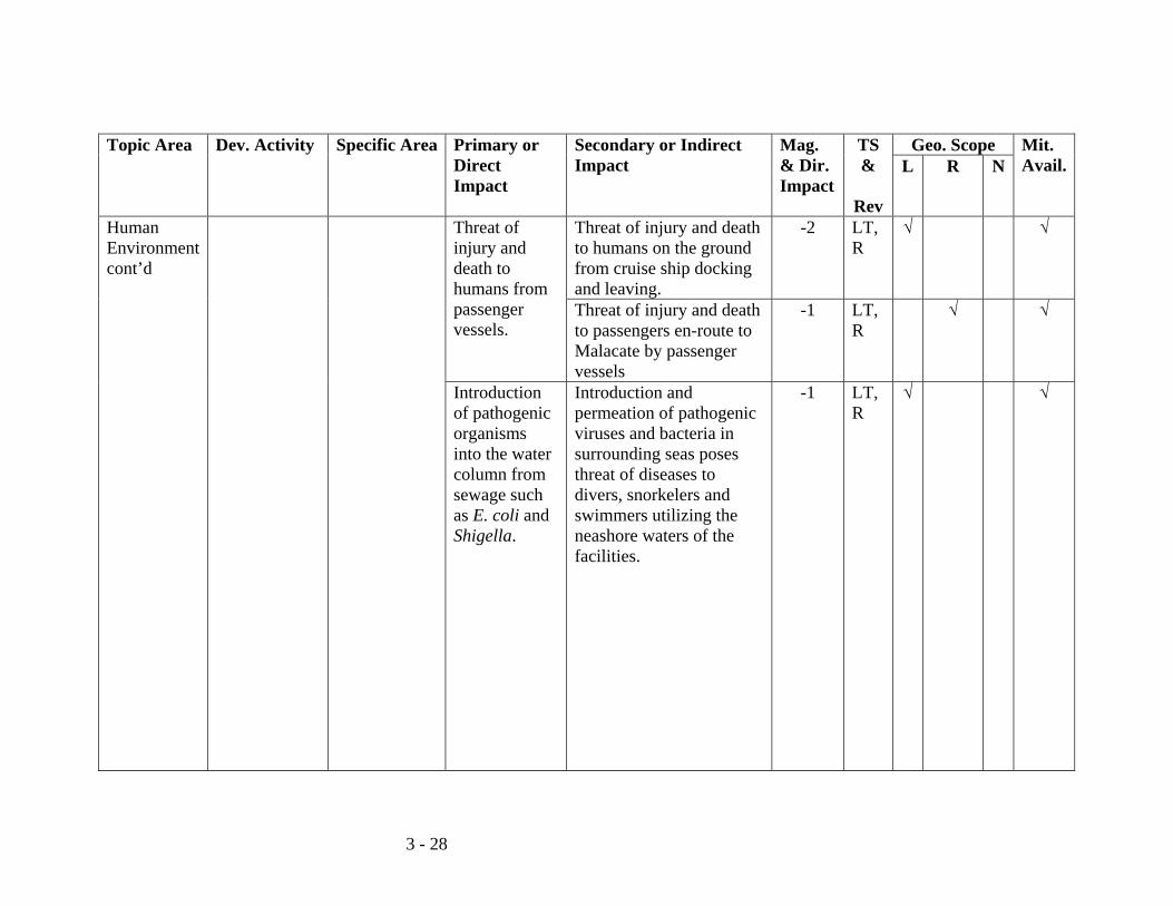
3 - 28
Topic Area Dev. Activity
Specific Area Primary or Direct Impact
Secondary or Indirect Impact
Mag. & Dir. Impact
TS &
Rev
Geo. Scope Mit. Avail.L R N
Human Environment cont’d
Threat of injury and death to humans from passenger vessels.
Threat of injury and death to humans on the ground from cruise ship docking and leaving.
-2 LT, R
√ √
Threat of injury and death to passengers en-route to Malacate by passenger vessels
-1 LT, R
√ √
Introduction of pathogenic organisms into the water column from sewage such as E. coli and Shigella.
Introduction and permeation of pathogenic viruses and bacteria in surrounding seas poses threat of diseases to divers, snorkelers and swimmers utilizing the neashore waters of the facilities.
-1 LT, R
√ √
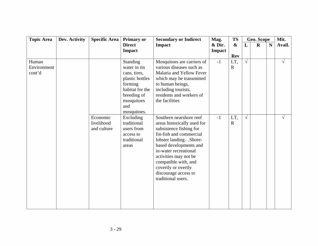
3 - 29
Topic Area Dev. Activity
Specific Area Primary or Direct Impact
Secondary or Indirect Impact
Mag. & Dir. Impact
TS &
Rev
Geo. Scope Mit. Avail.L R N
Human Environment cont’d
Standing water in tin cans, tires, plastic bottles forming habitat for the breeding of mosquitoes and mosquitoes.
Mosquitoes are carriers of various diseases such as Malaria and Yellow Fever which may be transmitted to human beings, including tourists, residents and workers of the facilities
-1 LT, R
√ √
Economic livelihood and culture
Excluding traditional users from access to traditional areas
Southern nearshore reef areas historically used for subsistence fishing for fin-fish and commercial lobster landing…Shore-based developments and in-water recreational activities may not be compatible with, and covertly or overtly discourage access to traditional users.
-1 LT, R
√ √
3 - 30
Topic Area Dev. Activity
Specific Area Primary or Direct Impact
Secondary or Indirect Impact
Mag. & Dir. Impact
TS &
Rev
Geo. Scope Mit. Avail.
L R N
Human Environment cont’d
Contact between local and foreign cultures
Contact between tourists and locals with differing traditions and language and value systems can make for unplanned and unanticipated negative consequences.
Foreign tourists involved in nearshore snorkeling and scuba diving may take umbrage at or indeed may be discomfited by extractive economic activities such as traditional line fishing for fin-fishing and spearfishing for lobster by locals…This animus and discomfiture may also extent to access to the beach and seafront areas by locals, which would pre-date developmental activities on the caye.
-1 LT, R
√ √
Key to Scoring Magnitude and Direction: 0 = No Impact -1 = Minimal or Negligible Deleterious Impact -2 = Marginally Significant Impact Mostly Reversible -3 = Moderately Significant Impact Occasionally Reversible after Short Time-frame -4 = Major Impact Partly Reversible with mitigation -5 = High Impact Long-term Effects Key to Abbreviations and Acronyms: L = Local R = Regional N = National LT = Long Term ST = Short Term MT = Medium Term Mag. & Dir. Impact = Magnitude and Direction of Impacts TS & Rev = Timeframe and Reversibility Mit. Avail. = Mitigation Available Geo. Scope = Geographic Scope
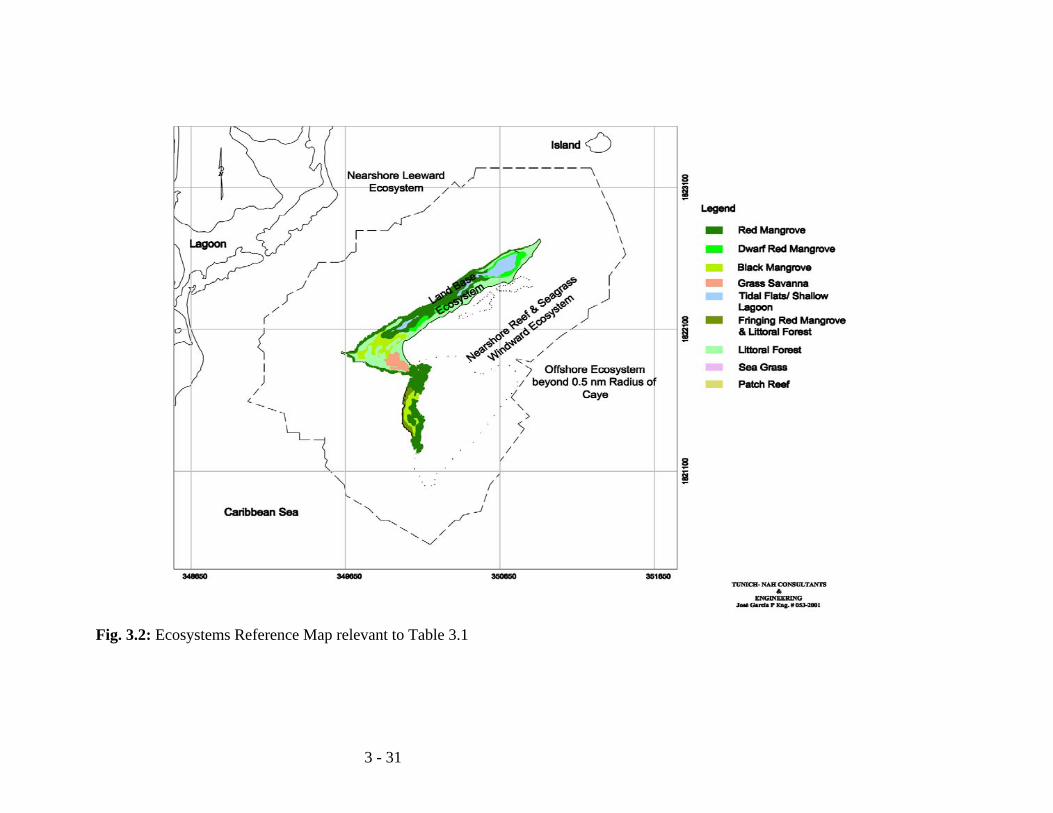
3 - 31
Fig. 3.2: Ecosystems Reference Map relevant to Table 3.1
3 - 32
3.2.1.2 Social Impacts of Note The social impacts associated with the proposed development, like the ecological impacts, have been classified as being both positive and negative in orientation. The perceived positive impacts from the perspective of those interviewed were as follows:
• increased employment and job creation and the possibility for local residents to enter or expand their business, such as restaurants, hardware supplies, handicraft markets, souvenir shops and fashion centers, and curio shops within the development itself;
• establishing the appropriate balance between tourism, the natural environment and fishing;
• the availability of new markets in the area for farm products and fishery commodities;
• a general increase in business activity and revenue generation during the construction and post-construction phase of the development; and
• increases in the customer base of the local Water Board. Those interviewed also saw indirect benefits resulting from existing tourism operations that would cater to retirees in the areas of sports fishing, manatee watching and sea-based freight haulage services. The perceived negative social impacts articulated by those interviewed are as follows:
• long-term access of traditional fishers to fishing grounds; • damage to the various habitats (mangrove, coral reef, sea-grass beds) that would
result in decline in productivity and biodiversity which would negatively impact the livelihoods of fishers and tour guides;
• increased boat traffic, especially by fast boats, that could threaten the survival of the manatee and other marine life;
• in-migration of workers for the development who will necessarily need to reside in the Mango Creek/ Independence and Placencia areas leading to a strain on existing public infrastructure and social services;
• increase in crime in the Mango Creek/Independence and Placencia areas; • competition for labor with banana and tourism industry of Placencia; and • by-passing locals in relation to skilled labour and senior management jobs.
The other potential negative impact on local and regional tourism sector perceived by residents in the area is competition with Belizeans should the retirees become investors. One of the direct effects of such competition is the possible increase in the price of land. A summary of the social impacts have been chronicled in Table 3.4 below.
3 - 33
Table3.4: Summary of social impacts associated with Harvest Caye Development (Without Mitigation) Issue Activity Social Impacts Residual Impacts,
Magnitude/Direction/ Duration/Scope
Land Use Location and size of development.
Macro-scale of development may exacerbate or over-burden social infrastructure and services during both construction and operational phase…Also potential for over-development of caye in terms of high or excessive site coverage of buildings and other standing infrastructure.
Major/Negative/Long-term/Local
Activities during Construction Phase
Transportation of construction supplies and equipment during all phases of development.
Potential for collisions at sea resulting in loss of life and property…Also potential for road-based accidents with consequent injury and death, apart from spillage of equipment and supplies.
Moderate/Negative/Short-term/Regional
Operation of construction machinery.
Potential threat to human health and safety from operating machinery on-site….This is magnified with inappropriate usage as well as when equipment and machinery is handled by untrained and inexperienced operators.
Minor/Negative/Short-term/Regional
Caye-based increase in population during construction phase of the Development.
Sanitation issues becomes relevant, including access to clean drinking water and toilet facilities…Also potential for transmitting communicable diseases…Interruption of access to caye and surrounding seas for traditional users.
Moderate/Negative/Short-term/Local
Caye-based shelter During construction phase workers need to be sheltered from the elements…Exposure would be reflective of poor working conditions…Exposure to rain, hot sun and other aspects of the weathers could lead to or contribute to heat stroke, the common cold and the flu.
Moderate/Negative/Short-term/Local
Marine and Terrestrial Traffic
Increase in boat traffic between Mango Creek and Harvest Caye that are engaged in recreational activities, and the transportation of operational supplies and equipment, as well as guests and workers.
Potential of adding to volume of pre-existing traffic, as well as contributing to congestion and collision at sea accidents…Has negative implications in terms of injury and loss of life for humans.
Moderate/Negative/Short-term/Regional
Increased in volume of unregulated traffic likely to lead to increase in risk of collision and consequent injury and death to manatees, sea turtles and other marine life…This has direct negative implications in terms of livelihood issues for tour guides and charter boat operators..
Moderate/Negative/Short-term/Local
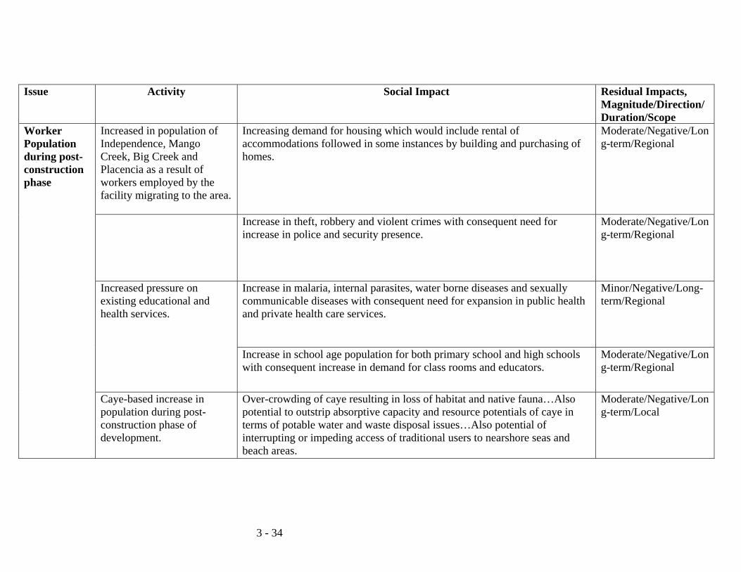
3 - 34
Issue Activity Social Impact Residual Impacts, Magnitude/Direction/ Duration/Scope
Worker Population during post-construction phase
Increased in population of Independence, Mango Creek, Big Creek and Placencia as a result of workers employed by the facility migrating to the area.
Increasing demand for housing which would include rental of accommodations followed in some instances by building and purchasing of homes.
Moderate/Negative/Long-term/Regional
Increase in theft, robbery and violent crimes with consequent need for increase in police and security presence.
Moderate/Negative/Long-term/Regional
Increased pressure on existing educational and health services.
Increase in malaria, internal parasites, water borne diseases and sexually communicable diseases with consequent need for expansion in public health and private health care services.
Minor/Negative/Long-term/Regional
Increase in school age population for both primary school and high schools with consequent increase in demand for class rooms and educators.
Moderate/Negative/Long-term/Regional
Caye-based increase in population during post-construction phase of development.
Over-crowding of caye resulting in loss of habitat and native fauna…Also potential to outstrip absorptive capacity and resource potentials of caye in terms of potable water and waste disposal issues…Also potential of interrupting or impeding access of traditional users to nearshore seas and beach areas.
Moderate/Negative/Long-term/Local
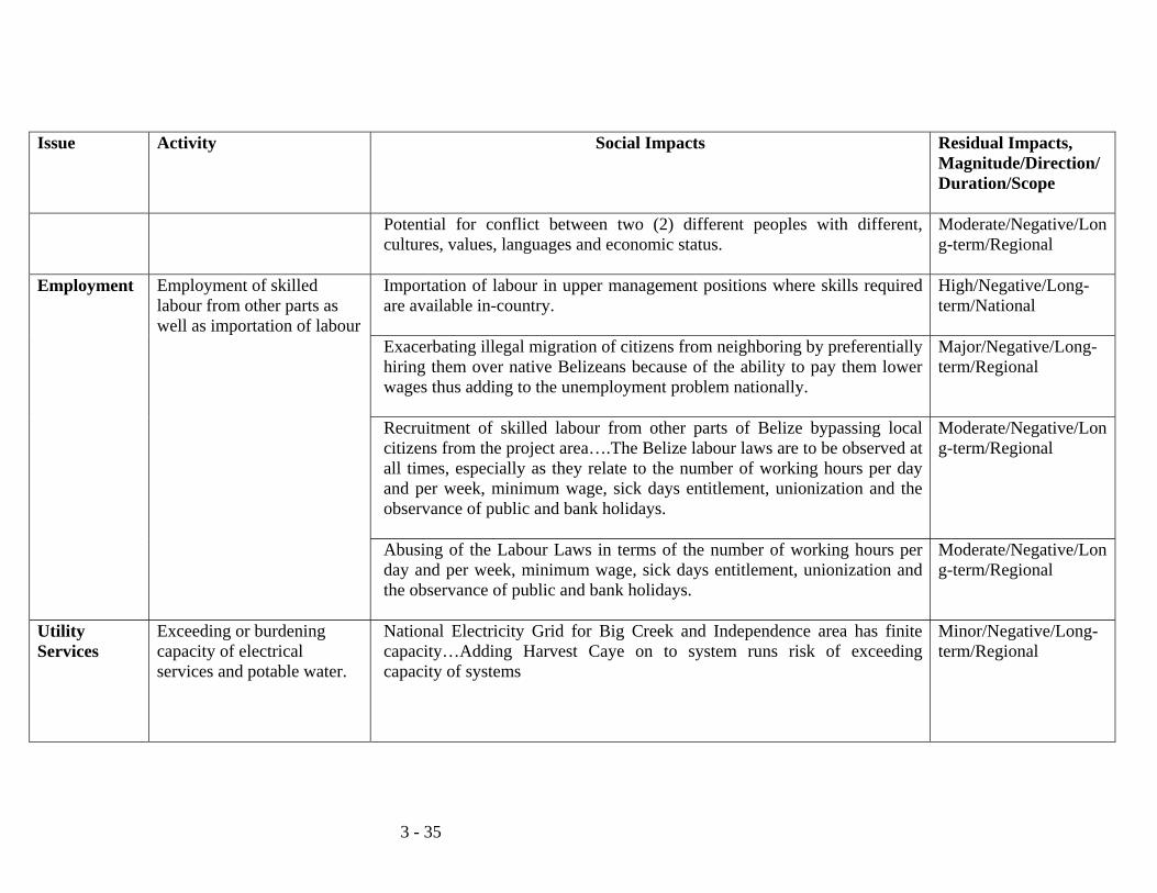
3 - 35
Issue
Activity Social Impacts Residual Impacts, Magnitude/Direction/ Duration/Scope
Potential for conflict between two (2) different peoples with different, cultures, values, languages and economic status.
Moderate/Negative/Long-term/Regional
Employment Employment of skilled labour from other parts as well as importation of labour
Importation of labour in upper management positions where skills required are available in-country.
High/Negative/Long-term/National
Exacerbating illegal migration of citizens from neighboring by preferentially hiring them over native Belizeans because of the ability to pay them lower wages thus adding to the unemployment problem nationally.
Major/Negative/Long-term/Regional
Recruitment of skilled labour from other parts of Belize bypassing local citizens from the project area….The Belize labour laws are to be observed at all times, especially as they relate to the number of working hours per day and per week, minimum wage, sick days entitlement, unionization and the observance of public and bank holidays.
Moderate/Negative/Long-term/Regional
Abusing of the Labour Laws in terms of the number of working hours per day and per week, minimum wage, sick days entitlement, unionization and the observance of public and bank holidays.
Moderate/Negative/Long-term/Regional
Utility Services
Exceeding or burdening capacity of electrical services and potable water.
National Electricity Grid for Big Creek and Independence area has finite capacity…Adding Harvest Caye on to system runs risk of exceeding capacity of systems
Minor/Negative/Long-term/Regional
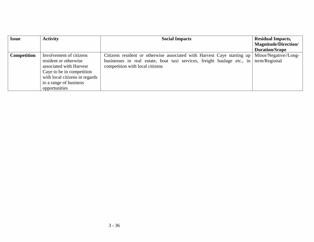
3 - 36
Issue Activity Social Impacts Residual Impacts, Magnitude/Direction/ Duration/Scope
Competition Involvement of citizens resident or otherwise associated with Harvest Caye to be in competition with local citizens in regards to a range of business opportunities
Citizens resident or otherwise associated with Harvest Caye starting up businesses in real estate, boat taxi services, freight haulage etc., in competition with local citizens
Minor/Negative//Long-term/Regional
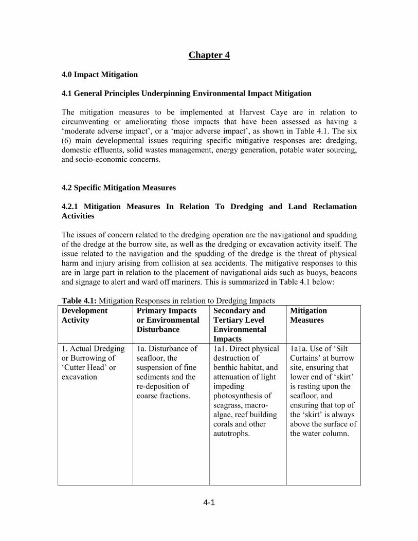
4-1
Chapter 4 4.0 Impact Mitigation 4.1 General Principles Underpinning Environmental Impact Mitigation The mitigation measures to be implemented at Harvest Caye are in relation to circumventing or ameliorating those impacts that have been assessed as having a ‘moderate adverse impact’, or a ‘major adverse impact’, as shown in Table 4.1. The six (6) main developmental issues requiring specific mitigative responses are: dredging, domestic effluents, solid wastes management, energy generation, potable water sourcing, and socio-economic concerns. 4.2 Specific Mitigation Measures 4.2.1 Mitigation Measures In Relation To Dredging and Land Reclamation Activities The issues of concern related to the dredging operation are the navigational and spudding of the dredge at the burrow site, as well as the dredging or excavation activity itself. The issue related to the navigation and the spudding of the dredge is the threat of physical harm and injury arising from collision at sea accidents. The mitigative responses to this are in large part in relation to the placement of navigational aids such as buoys, beacons and signage to alert and ward off mariners. This is summarized in Table 4.1 below: Table 4.1: Mitigation Responses in relation to Dredging Impacts Development Activity
Primary Impacts or Environmental Disturbance
Secondary and Tertiary Level Environmental Impacts
Mitigation Measures
1. Actual Dredging or Burrowing of ‘Cutter Head’ or excavation
1a. Disturbance of seafloor, the suspension of fine sediments and the re-deposition of coarse fractions.
1a1. Direct physical destruction of benthic habitat, and attenuation of light impeding photosynthesis of seagrass, macro-algae, reef building corals and other autotrophs.
1a1a. Use of ‘Silt Curtains’ at burrow site, ensuring that lower end of ‘skirt’ is resting upon the seafloor, and ensuring that top of the ‘skirt’ is always above the surface of the water column.
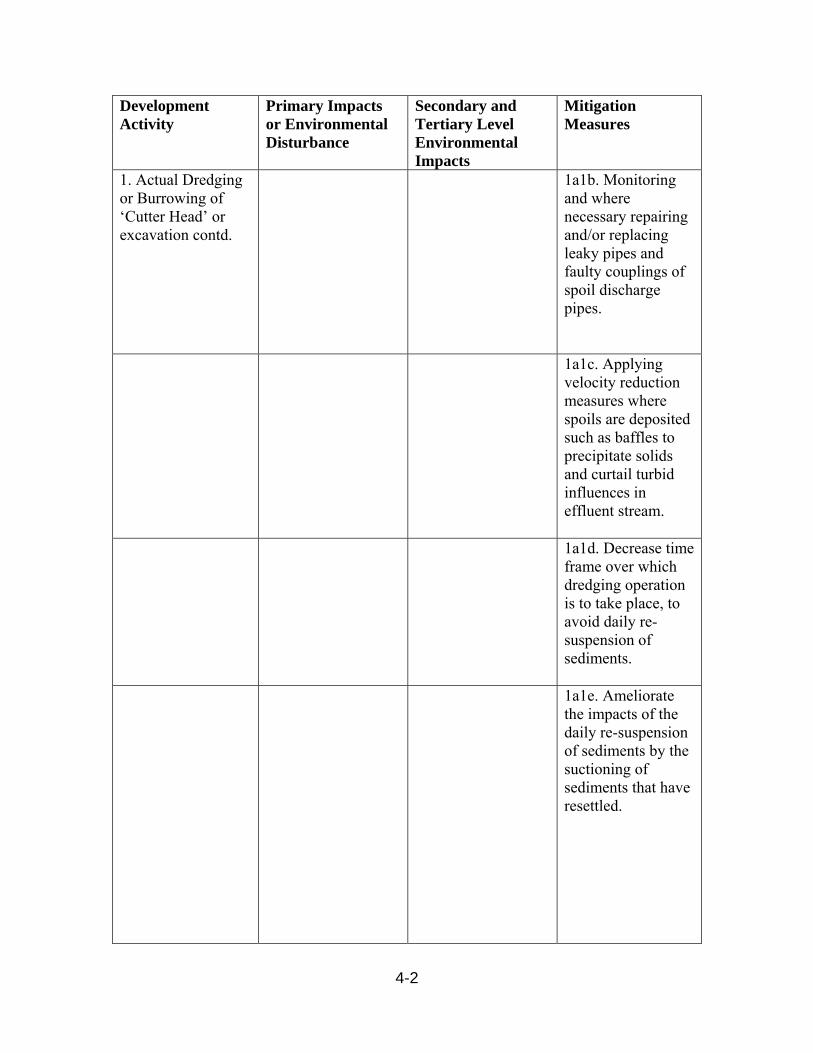
4-2
Development Activity
Primary Impacts or Environmental Disturbance
Secondary and Tertiary Level Environmental Impacts
Mitigation Measures
1. Actual Dredging or Burrowing of ‘Cutter Head’ or excavation contd.
1a1b. Monitoring and where necessary repairing and/or replacing leaky pipes and faulty couplings of spoil discharge pipes.
1a1c. Applying velocity reduction measures where spoils are deposited such as baffles to precipitate solids and curtail turbid influences in effluent stream.
1a1d. Decrease time frame over which dredging operation is to take place, to avoid daily re-suspension of sediments.
1a1e. Ameliorate the impacts of the daily re-suspension of sediments by the suctioning of sediments that have resettled.
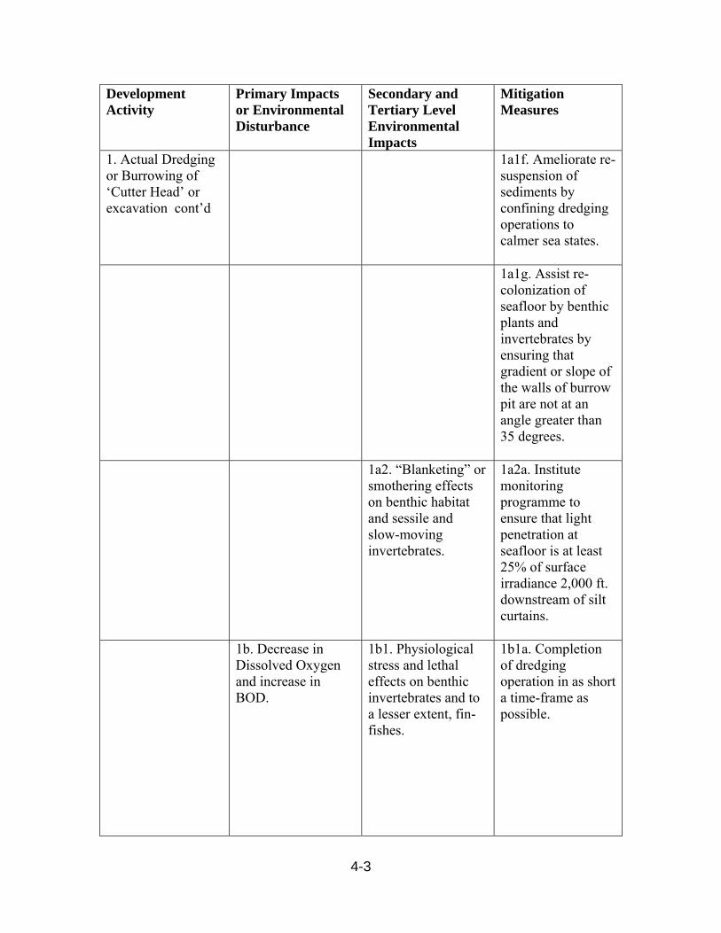
4-3
Development Activity
Primary Impacts or Environmental Disturbance
Secondary and Tertiary Level Environmental Impacts
Mitigation Measures
1. Actual Dredging or Burrowing of ‘Cutter Head’ or excavation cont’d
1a1f. Ameliorate re-suspension of sediments by confining dredging operations to calmer sea states.
1a1g. Assist re-colonization of seafloor by benthic plants and invertebrates by ensuring that gradient or slope of the walls of burrow pit are not at an angle greater than 35 degrees.
1a2. “Blanketing” or smothering effects on benthic habitat and sessile and slow-moving invertebrates.
1a2a. Institute monitoring programme to ensure that light penetration at seafloor is at least 25% of surface irradiance 2,000 ft. downstream of silt curtains.
1b. Decrease in Dissolved Oxygen and increase in BOD.
1b1. Physiological stress and lethal effects on benthic invertebrates and to a lesser extent, fin-fishes.
1b1a. Completion of dredging operation in as short a time-frame as possible.
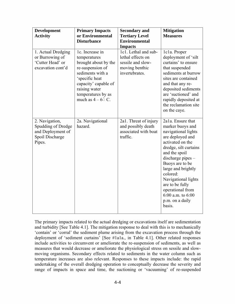
4-4
Development Activity
Primary Impacts or Environmental Disturbance
Secondary and Tertiary Level Environmental Impacts
Mitigation Measures
1. Actual Dredging or Burrowing of ‘Cutter Head’ or excavation cont’d
1c. Increase in temperatures brought about by the re-suspension of sediments with a ‘specific heat capacity’ capable of raising water temperatures by as much as 4 – 6 ْ◌ C.
1c1. Lethal and sub-lethal effects on sessile and slow-moving benthic invertebrates.
1c1a. Proper deployment of ‘silt curtains’ to ensure that suspended sediments at burrow sites are contained and that any re-deposited sediments are ‘suctioned’ and rapidly deposited at the reclamation site on the caye.
2. Navigation, Spudding of Dredge and Deployment of Spoil Discharge Pipes.
2a. Navigational hazard.
2a1. Threat of injury and possibly death associated with boat traffic.
2a1a. Ensure that marker buoys and navigational lights are deployed and activated on the dredge, silt curtains and the spoil discharge pipes – Buoys are to be large and brightly colored: Navigational lights are to be fully operational from 6:00 a.m. to 6:00 p.m. on a daily basis.
The primary impacts related to the actual dredging or excavations itself are sedimentation and turbidity [See Table 4.1]. The mitigation response to deal with this is to mechanically ‘contain’ or ‘corral’ the sediment plume arising from the excavation process through the deployment of ‘sediment curtains’ [See #1a1a., in Table 4.1]. Other related responses include activities to circumvent or ameliorate the re-suspension of sediments, as well as measures that would decrease or ameliorate the physiological stress on sessile and slow-moving organisms. Secondary effects related to sediments in the water column such as temperature increases are also relevant. Responses to these impacts include: the rapid undertaking of the overall dredging operation to conceptually decrease the severity and range of impacts in space and time, the suctioning or ‘vacuuming’ of re-suspended

4-5
sediments ashore to decrease the potential of the expansive dispersal of sediments, and adjusting the overall mechanics of the dredging operation to allow for the re-colonization of the area by benthic plants and sessile and slow-moving invertebrates [See Table 4.1]. 4.2.2 Mitigation Measures In Relation To Human Wastes and Domestic Effluents The primary impacts associated with human wastes and domestic effluents are: eutrophic or nutrient-enrichment effects, increases in the risks of pathogenic diseases, increases in BOD and suspended solids. The mitigative responses to these impacts include the application of BESST Sewage Treatment Technology and the recycling and reuse of effluents [See Table 4.2]. These responses reduce the levels of macro-nutrients, BOD substances, pathogenic microbes and suspended solids to levels where they do not constitute a threat to human health or a risk to the integrity of the environment [See Table 4.2]. The various impacts and the consequent responses to these have been detailed Table 4.2. Table 4. 2: Summary of impacts associated with human wastes and domestic effluents Development Activity
Primary Impacts or Environmental Disturbance
Secondary and Tertiary Level Environmental Impacts
Mitigation Measures
1.0 Human Waste and Domestic Effluents
1a. Nutrient enrichment from the liberation of macro-nutrients into the environment.
1a1. Stimulus to plant growth on land and in the water column, in the case of the latter this includes phytoplanktons, seagrass and macroalgae, including the possibility of the overgrowth of nearshore patch reefs by macroalgae and seagrass.
1a1a. Installation of Treatment technology to treat waste to ‘Secondary’ Levels, where Total Nitrogen Loads are reduced to less than 10 mg/l and Phosphorus are reduced to 2-3mg/l..
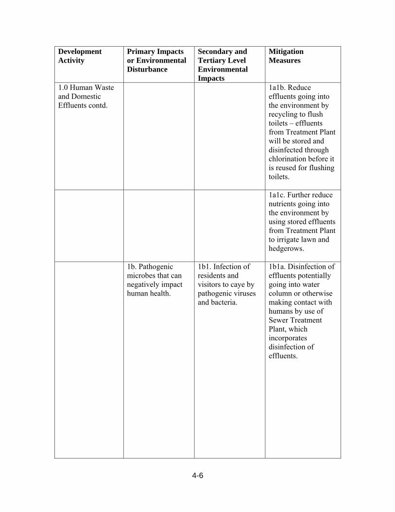
4-6
Development Activity
Primary Impacts or Environmental Disturbance
Secondary and Tertiary Level Environmental Impacts
Mitigation Measures
1.0 Human Waste and Domestic Effluents contd.
1a1b. Reduce effluents going into the environment by recycling to flush toilets – effluents from Treatment Plant will be stored and disinfected through chlorination before it is reused for flushing toilets.
1a1c. Further reduce nutrients going into the environment by using stored effluents from Treatment Plant to irrigate lawn and hedgerows.
1b. Pathogenic microbes that can negatively impact human health.
1b1. Infection of residents and visitors to caye by pathogenic viruses and bacteria.
1b1a. Disinfection of effluents potentially going into water column or otherwise making contact with humans by use of Sewer Treatment Plant, which incorporates disinfection of effluents.

4-7
Development Activity
Primary Impacts or Environmental Disturbance
Secondary and Tertiary Level Environmental Impacts
Mitigation Measures
1.0 Human Waste and Domestic Effluents contd
1b1b. Reduction of effluents going into the environment by use of a Treatment Plant. And incorporation of recycling and reuse of effluents for flushing of toilets and watering of lawn.
1c. Suspended Solids from un-dissolved components of human waste and domestic effluents.
1c1. Suspended solids would impedes light penetration in the water column and erode or arrest photosynthesis.
1c1a. Application of Treatment technology reduces TSS to less than 10 mg/l, this in combination with effluent recycling and reuse regime reduces suspended solids to insignificant levels in the water column.
1d. Sedimentation associated with settlement of flocculent faction of human waste and domestic effluents.
1d1. Blanketing of seafloor and suffocation of slow-moving and sedentary invertebrates.
1d1a. Application of Treatment technology reduces TSS to less than 10 mg/l, this in combination with effluent recycling and reuse regime reduces to insignificant levels suspended solids in the water column.
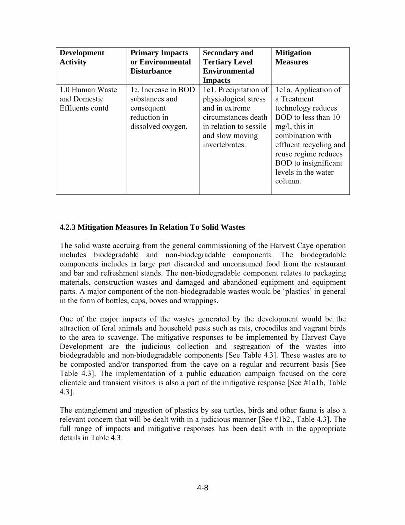
4-8
Development Activity
Primary Impacts or Environmental Disturbance
Secondary and Tertiary Level Environmental Impacts
Mitigation Measures
1.0 Human Waste and Domestic Effluents contd
1e. Increase in BOD substances and consequent reduction in dissolved oxygen.
1e1. Precipitation of physiological stress and in extreme circumstances death in relation to sessile and slow moving invertebrates.
1e1a. Application of a Treatment technology reduces BOD to less than 10 mg/l, this in combination with effluent recycling and reuse regime reduces BOD to insignificant levels in the water column.
4.2.3 Mitigation Measures In Relation To Solid Wastes The solid waste accruing from the general commissioning of the Harvest Caye operation includes biodegradable and non-biodegradable components. The biodegradable components includes in large part discarded and unconsumed food from the restaurant and bar and refreshment stands. The non-biodegradable component relates to packaging materials, construction wastes and damaged and abandoned equipment and equipment parts. A major component of the non-biodegradable wastes would be ‘plastics’ in general in the form of bottles, cups, boxes and wrappings. One of the major impacts of the wastes generated by the development would be the attraction of feral animals and household pests such as rats, crocodiles and vagrant birds to the area to scavenge. The mitigative responses to be implemented by Harvest Caye Development are the judicious collection and segregation of the wastes into biodegradable and non-biodegradable components [See Table 4.3]. These wastes are to be composted and/or transported from the caye on a regular and recurrent basis [See Table 4.3]. The implementation of a public education campaign focused on the core clientele and transient visitors is also a part of the mitigative response [See #1a1b, Table 4.3]. The entanglement and ingestion of plastics by sea turtles, birds and other fauna is also a relevant concern that will be dealt with in a judicious manner [See #1b2., Table 4.3]. The full range of impacts and mitigative responses has been dealt with in the appropriate details in Table 4.3:

4-9
Table 4.3: Mitigation Matrix in Relation to Solid Wastes Development Activity
Primary Impacts or Environmental Disturbance
Secondary and Tertiary Level Environmental Impacts
Mitigation Measures
1.0 Commissioning of all aspects of the development
1a. Discarding of waste food and food containers.
1a1. Attraction of feral animals such as rats, crocodiles, and birds to the area to scavenge and in effect shift the ecological balance in a way not induced by nature.
1a1a. Judicious collection of discards by staff with composting biodegradable component and storage of non-biodegradable component in impervious plastic bins for transportation to the Big Creek Municipal Dump Site.
1a1b. Definition and implementation of public education campaign focused on tourists and visitors in general, in the form of interactive posters and brochures posted in strategic locations such as restaurants, gift shops, rest rooms and beach.
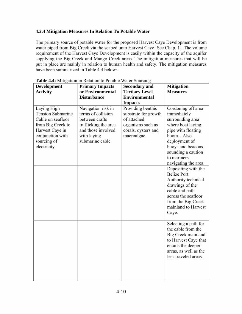
4-10
4.2.4 Mitigation Measures In Relation To Potable Water The primary source of potable water for the proposed Harvest Caye Development is from water piped from Big Creek via the seabed unto Harvest Caye [See Chap. 1]. The volume requirement of the Harvest Caye Development is easily within the capacity of the aquifer supplying the Big Creek and Mango Creek areas. The mitigation measures that will be put in place are mainly in relation to human health and safety. The mitigation measures have been summarized in Table 4.4 below: Table 4.4: Mitigation in Relation to Potable Water Sourcing Development Activity
Primary Impacts or Environmental Disturbance
Secondary and Tertiary Level Environmental Impacts
Mitigation Measures
Laying High Tension Submarine Cable on seafloor from Big Creek to Harvest Caye in conjunction with sourcing of electricity.
Navigation risk in terms of collision between crafts trafficking the area and those involved with laying submarine cable
Providing benthic substrate for growth of attached organisms such as corals, oysters and macroalgae.
Cordoning off area immediately surrounding area where boat laying pipe with floating boom…Also deployment of buoys and beacons sounding a caution to mariners navigating the area.
Depositing with the Belize Port Authority technical drawings of the cable and path across the seafloor from the Big Creek mainland to Harvest Caye.
Selecting a path for the cable from the Big Creek mainland to Harvest Caye that entails the deeper areas, as well as the less traveled areas.
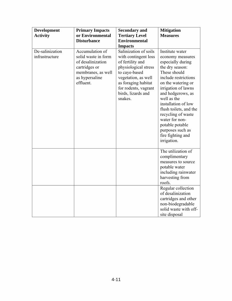
4-11
Development Activity
Primary Impacts or Environmental Disturbance
Secondary and Tertiary Level Environmental Impacts
Mitigation Measures
De-salinization infrastructure
Accumulation of solid waste in form of desalinization cartridges or membranes, as well as hypersaline effluent.
Salinization of soils with contingent loss of fertility and physiological stress to caye-based vegetation, as well as foraging habitat for rodents, vagrant birds, lizards and snakes.
Institute water economy measures especially during the dry season: These should include restrictions on the watering or irrigation of lawns and hedgerows, as well as the installation of low flush toilets, and the recycling of waste water for non-potable potable purposes such as fire fighting and irrigation.
The utilization of complimentary measures to source potable water including rainwater harvesting from roofs.
Regular collection of desalinization cartridges and other non-biodegradable solid waste with off-site disposal
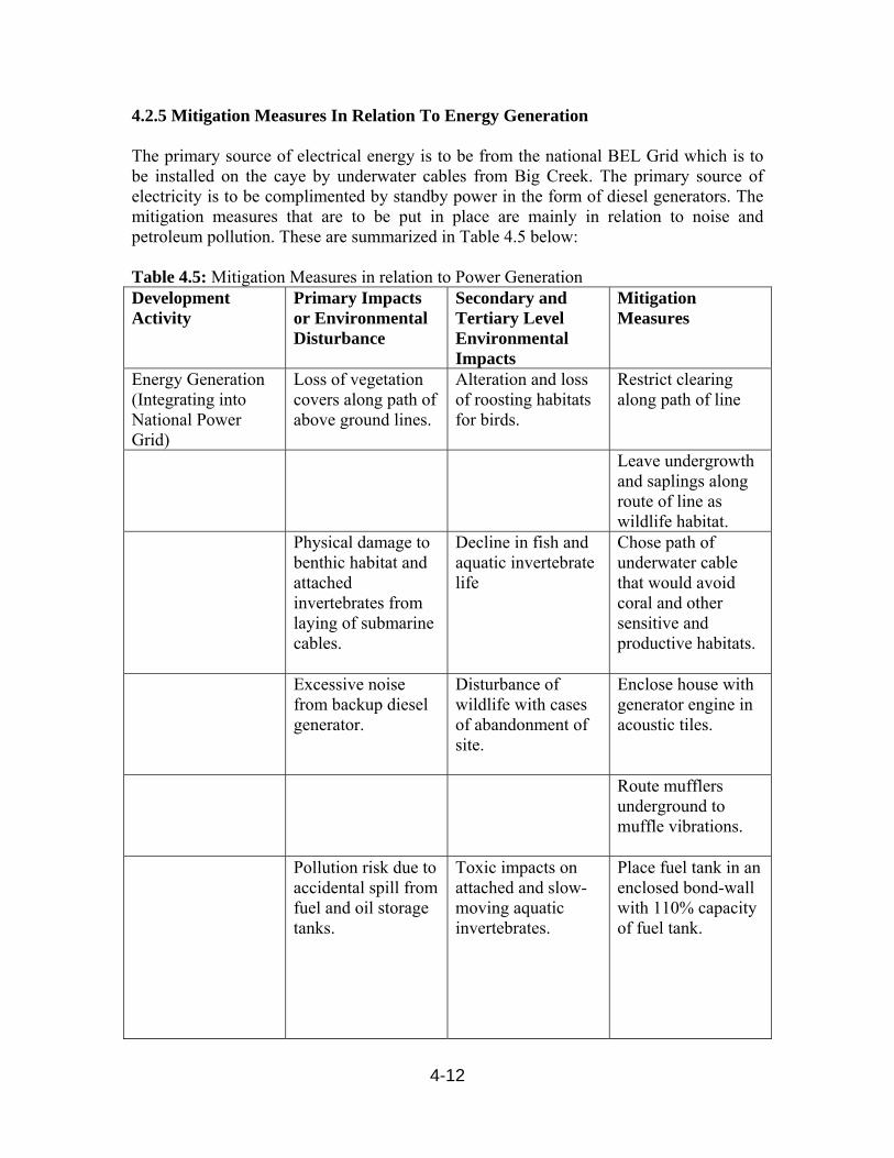
4-12
4.2.5 Mitigation Measures In Relation To Energy Generation The primary source of electrical energy is to be from the national BEL Grid which is to be installed on the caye by underwater cables from Big Creek. The primary source of electricity is to be complimented by standby power in the form of diesel generators. The mitigation measures that are to be put in place are mainly in relation to noise and petroleum pollution. These are summarized in Table 4.5 below: Table 4.5: Mitigation Measures in relation to Power Generation Development Activity
Primary Impacts or Environmental Disturbance
Secondary and Tertiary Level Environmental Impacts
Mitigation Measures
Energy Generation (Integrating into National Power Grid)
Loss of vegetation covers along path of above ground lines.
Alteration and loss of roosting habitats for birds.
Restrict clearing along path of line
Leave undergrowth and saplings along route of line as wildlife habitat.
Physical damage to benthic habitat and attached invertebrates from laying of submarine cables.
Decline in fish and aquatic invertebrate life
Chose path of underwater cable that would avoid coral and other sensitive and productive habitats.
Excessive noise from backup diesel generator.
Disturbance of wildlife with cases of abandonment of site.
Enclose house with generator engine in acoustic tiles.
Route mufflers underground to muffle vibrations.
Pollution risk due to accidental spill from fuel and oil storage tanks.
Toxic impacts on attached and slow-moving aquatic invertebrates.
Place fuel tank in an enclosed bond-wall with 110% capacity of fuel tank.
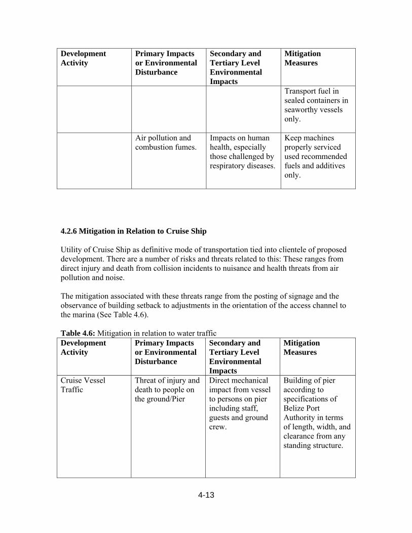
4-13
Development Activity
Primary Impacts or Environmental Disturbance
Secondary and Tertiary Level Environmental Impacts
Mitigation Measures
Transport fuel in sealed containers in seaworthy vessels only.
Air pollution and combustion fumes.
Impacts on human health, especially those challenged by respiratory diseases.
Keep machines properly serviced used recommended fuels and additives only.
4.2.6 Mitigation in Relation to Cruise Ship Utility of Cruise Ship as definitive mode of transportation tied into clientele of proposed development. There are a number of risks and threats related to this: These ranges from direct injury and death from collision incidents to nuisance and health threats from air pollution and noise. The mitigation associated with these threats range from the posting of signage and the observance of building setback to adjustments in the orientation of the access channel to the marina (See Table 4.6). Table 4.6: Mitigation in relation to water traffic Development Activity
Primary Impacts or Environmental Disturbance
Secondary and Tertiary Level Environmental Impacts
Mitigation Measures
Cruise Vessel Traffic
Threat of injury and death to people on the ground/Pier
Direct mechanical impact from vessel to persons on pier including staff, guests and ground crew.
Building of pier according to specifications of Belize Port Authority in terms of length, width, and clearance from any standing structure.

4-14
Development Activity
Primary Impacts or Environmental Disturbance
Secondary and Tertiary Level Environmental Impacts
Mitigation Measures
Posting of signage notifying of existence of deep water area and providing caution to visitors, staff and residents of risk of injury and death…Interventions to take form of ‘Secured Area’, as well as danger signs and fence securing area from access to general public.
Offsetting Channel and pier from general landmass of island…Thus channel is positioned running parallel to long axis of island.
Threat of collision of cruise ship with smaller boats with consequent death and injury to mariners and passengers while in docking and departing mode .
Ensuring adequate signage and setbacks in the form of placement of buoys and beacons in sea along radius 150 M from centre-line of channel warning mariners of restricted area for marine traffic.

4-15
Development Activity
Primary Impacts or Environmental Disturbance
Secondary and Tertiary Level Environmental Impacts
Mitigation Measures
Angling marina entrance from path of Cruise vessel such that path of access channel to marina basin describes a north-eastern course.
Noise and air pollution
Offset of pier from main island as well as setback of buildings…In particular most buildings sited on windward side of main island or an appreciable distance for structures associated with smaller southern island.
Movement of vessels to be confined to daylight hours to avoid noise during quieter night-time hours.
Threat of death and injury from passenger vessel while in motion.
Death and injury to passengers and crews of domestic passenger vessel ferrying guests to and from the island.
Full observance of standards set by Belize Port Authority…Includes observance of maintenance schedules for vessels.
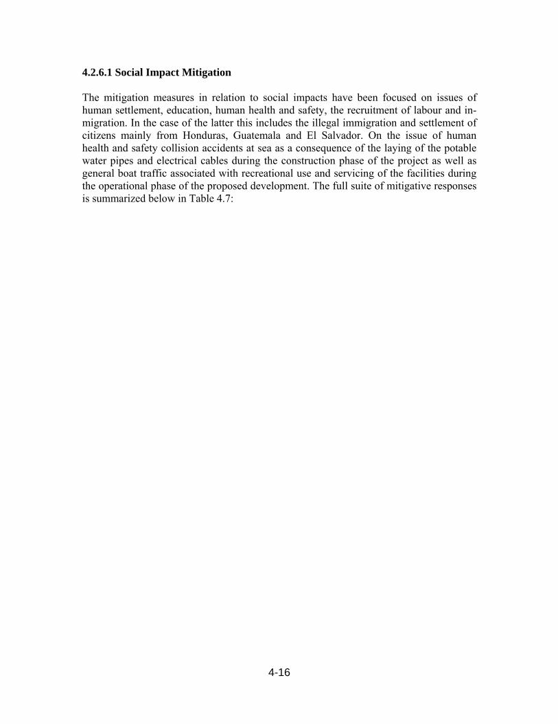
4-16
4.2.6.1 Social Impact Mitigation The mitigation measures in relation to social impacts have been focused on issues of human settlement, education, human health and safety, the recruitment of labour and in-migration. In the case of the latter this includes the illegal immigration and settlement of citizens mainly from Honduras, Guatemala and El Salvador. On the issue of human health and safety collision accidents at sea as a consequence of the laying of the potable water pipes and electrical cables during the construction phase of the project as well as general boat traffic associated with recreational use and servicing of the facilities during the operational phase of the proposed development. The full suite of mitigative responses is summarized below in Table 4.7:
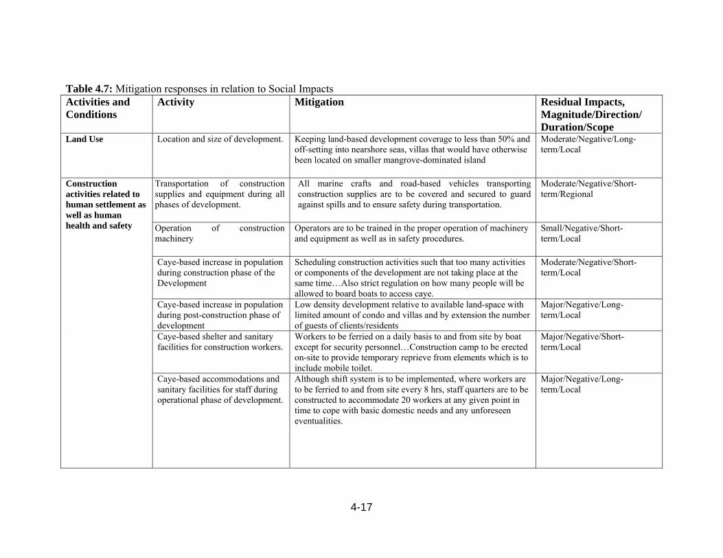
4-17
Table 4.7: Mitigation responses in relation to Social Impacts Activities and Conditions
Activity Mitigation Residual Impacts, Magnitude/Direction/ Duration/Scope
Land Use Location and size of development.
Keeping land-based development coverage to less than 50% and off-setting into nearshore seas, villas that would have otherwise been located on smaller mangrove-dominated island
Moderate/Negative/Long-term/Local
Construction activities related to human settlement as well as human health and safety
Transportation of construction supplies and equipment during all phases of development.
All marine crafts and road-based vehicles transporting construction supplies are to be covered and secured to guard against spills and to ensure safety during transportation.
Moderate/Negative/Short-term/Regional
Operation of construction machinery
Operators are to be trained in the proper operation of machinery and equipment as well as in safety procedures.
Small/Negative/Short-term/Local
Caye-based increase in population during construction phase of the Development
Scheduling construction activities such that too many activities or components of the development are not taking place at the same time…Also strict regulation on how many people will be allowed to board boats to access caye.
Moderate/Negative/Short-term/Local
Caye-based increase in population during post-construction phase of development
Low density development relative to available land-space with limited amount of condo and villas and by extension the number of guests of clients/residents
Major/Negative/Long-term/Local
Caye-based shelter and sanitary facilities for construction workers.
Workers to be ferried on a daily basis to and from site by boat except for security personnel…Construction camp to be erected on-site to provide temporary reprieve from elements which is to include mobile toilet.
Major/Negative/Short-term/Local
Caye-based accommodations and sanitary facilities for staff during operational phase of development.
Although shift system is to be implemented, where workers are to be ferried to and from site every 8 hrs, staff quarters are to be constructed to accommodate 20 workers at any given point in time to cope with basic domestic needs and any unforeseen eventualities.
Major/Negative/Long-term/Local

4-18
Activities and Conditions
Activity Mitigation Residual Impacts, Magnitude/Direction/ Duration/Scope
Marine and Terrestrial Traffic
Increase in number of boats and barges between Big Creek and Harvest Caye transporting construction supplies.
During construction phase, movement of workers, machinery/equipment and cargo, is to be planned and operated on a scheduled that does not conflict with or exacerbate pre-existing marine traffic.
Major/Negative/Short-term/Regional
Self-regulation of marine traffic by Management of Harvest Caye Development including confining boats and other marine crafts to designated “shipping lanes”. Demarcation of berthage, ‘no wake zones’, speed limit, etc., through installation of marker buoys, beacons, flags and signage.
Post-construction Worker Population & Potential Strain Social Services
Increase in workers engaged with proposed development will of necessity reside in Mango Creek/ Independence areas as well as Placencia and create a strain on existing housing infrastructure.
Meeting of project proponent with Village Councils and other community groups to sensitize them about the existence of project and demand on infrastructure and social services…Village Council and developers need to engage real estate and housing development sector.
Major/Negative/Long-term/Regional
Increased pressure on existing educational and health services.
Working with Village Councils and Central Government to make adjustments in schools and health care facilities as a function of the increase in population associated with the proposed Harvest Caye Development…Central Government will need to be engaged in this discussion to make necessary accommodations in additional classrooms and teachers, as well as expansion of medical facilities and number of health care workers in area.
Moderate/Negative/Long-term/Regional
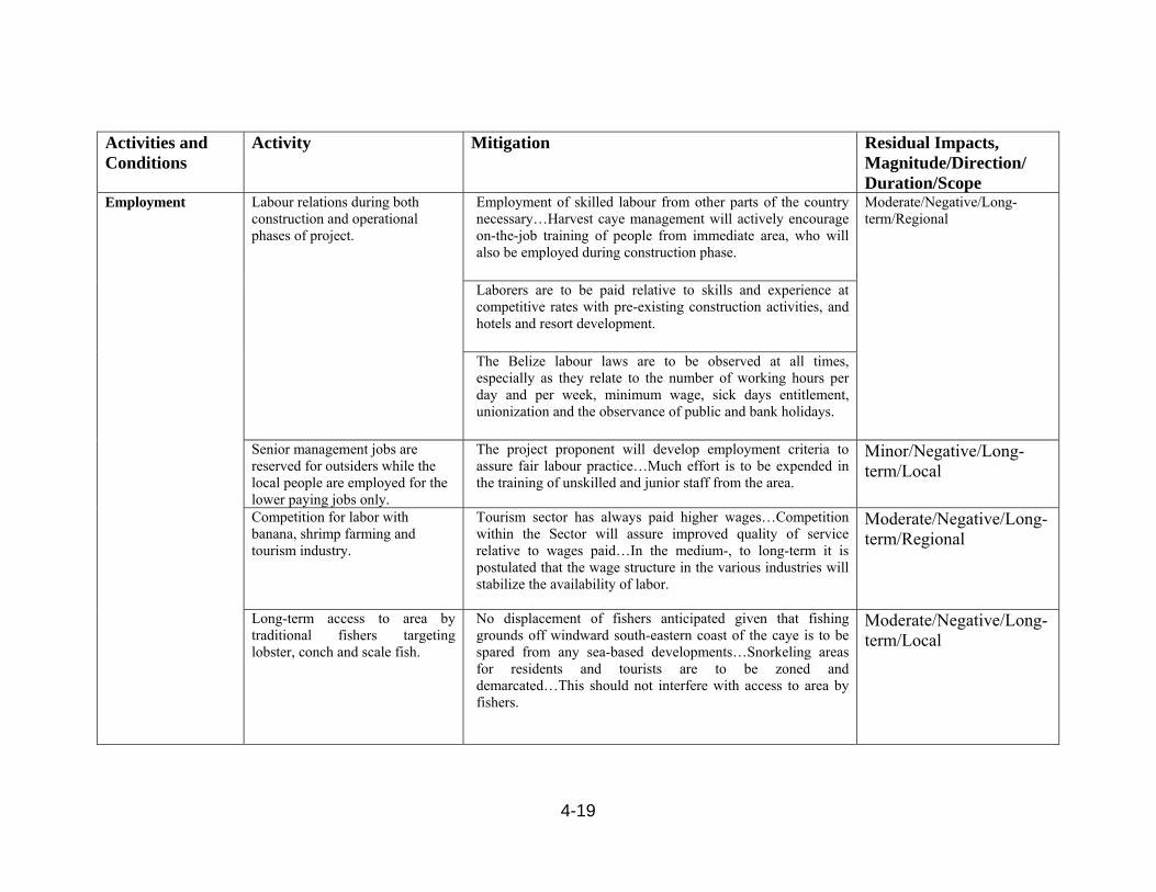
4-19
Activities and Conditions
Activity Mitigation Residual Impacts, Magnitude/Direction/ Duration/Scope
Employment Labour relations during both construction and operational phases of project.
Employment of skilled labour from other parts of the country necessary…Harvest caye management will actively encourage on-the-job training of people from immediate area, who will also be employed during construction phase.
Moderate/Negative/Long-term/Regional
Laborers are to be paid relative to skills and experience at competitive rates with pre-existing construction activities, and hotels and resort development.
The Belize labour laws are to be observed at all times, especially as they relate to the number of working hours per day and per week, minimum wage, sick days entitlement, unionization and the observance of public and bank holidays.
Senior management jobs are reserved for outsiders while the local people are employed for the lower paying jobs only.
The project proponent will develop employment criteria to assure fair labour practice…Much effort is to be expended in the training of unskilled and junior staff from the area.
Minor/Negative/Long-term/Local
Competition for labor with banana, shrimp farming and tourism industry.
Tourism sector has always paid higher wages…Competition within the Sector will assure improved quality of service relative to wages paid…In the medium-, to long-term it is postulated that the wage structure in the various industries will stabilize the availability of labor.
Moderate/Negative/Long-term/Regional
Long-term access to area by traditional fishers targeting lobster, conch and scale fish.
No displacement of fishers anticipated given that fishing grounds off windward south-eastern coast of the caye is to be spared from any sea-based developments…Snorkeling areas for residents and tourists are to be zoned and demarcated…This should not interfere with access to area by fishers.
Moderate/Negative/Long-term/Local
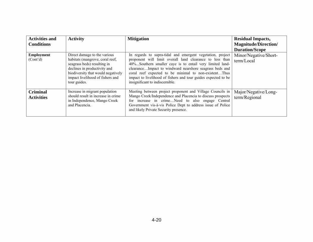
4-20
Activities and Conditions
Activity Mitigation Residual Impacts, Magnitude/Direction/ Duration/Scope
Employment (Cont’d)
Direct damage to the various habitats (mangrove, coral reef, seagrass beds) resulting in declines in productivity and biodiversity that would negatively impact livelihood of fishers and tour guides.
In regards to supra-tidal and emergent vegetation, project proponent will limit overall land clearance to less than 40%...Southern smaller caye is to entail very limited land-clearance…Impact to windward nearshore seagrass beds and coral reef expected to be minimal to non-existent…Thus impact to livelihood of fishers and tour guides expected to be insignificant to indiscernible.
Minor/Negative/Short-term/Local
Criminal Activities
Increase in migrant population should result in increase in crime in Independence, Mango Creek and Placencia.
Meeting between project proponent and Village Councils in Mango Creek/Independence and Placencia to discuss prospects for increase in crime…Need to also engage Central Government vis-à-vis Police Dept to address issue of Police and likely Private Security presence.
Major/Negative/Long-term/Regional
4-21
4.3 Monitoring Plans 4.3.1 Principles Underpinning Environmental Monitoring The principles underlying environmental monitoring as it relates to any given development is to observe for any changes over time that may be associated with the development. These changes would in principle vary over time in both magnitude and direction. In the case of the latter it is important to understand that changes in environmental parameters and functions may be positive or negative. Thus in principle a monitoring plan does not necessarily focus only on the perceived or anticipated negative changes precipitated by a given project activity, but also on the positive or beneficial changes. The parameters chosen are those that have been identified in the analytical process as being affected in the most significant way by the development. 4.3.2 Specific Monitoring Issues The proposed monitoring plan for the Harvest Caye Recreational Development has been derived from the EIA Matrix shown in Chap. 3, Table 3.1. The parameters of relevance have been grouped into five (5) main areas, viz: water quality parameters, biodiversity, beach dynamics, engineering considerations and socio-economic issues. The proposed monitoring plan has been developed not only in relation to satisfying the statutory requirements of the EIA process, but also as a consequence of the proper implementation of the proposed development. The details of the proposed monitoring plan are outlined in Table 4.8 below. As may be seen from the Table, differing priorities have been applied to the various parameters that are being proposed for monitoring. The frequency to be applied to the various parameters being monitored, as well as the institutions charged with the particular mandate has been included in said Table 4.8.

4-22
Table 4.8: Proposed Monitoring Plan Harvest Caye Parameter Frequency Critical
Level Geographic
Area Priority Agency
ResponsibleWater Quality Impact
Phosphate and Nitrates
Monthly 10 mg/l Sample Locations 1 – 7 (See Chap. 2, Fig. 2.4b)
High Priority
DOE
TSS Monthly 100 mg/l Sample Locations 1 – 7 (See Chap. 2, Fig. 2.4b)
Moderate Priority
DOE
Turbidity Weekly Determining ‘secchi depth’ or observing disappearance of secchi disc in water column and comparing this over time at different locations.
Sample Locations 1 – 7 (See Chap. 2, Fig. 2.4b)
High Priority
DOE
BOD Monthly 200 mg/l (EPA/WHO)
Sample Locations 1 – 7 (See Chap. 2, Fig. 2.4b)
High Priority
DOE
- Total Coliform - E. coli - Fecal Coliform
Monthly Sample Locations 1 – 1 (See Chap. 2, Fig. 2.4b)
High Priority
Public Health

4-23
Parameter Frequency Critical Level
Geographic Area
Priority Agency Responsible
Beach DynamicsBeach erosion Quarterly Observable
loss of beach material.
Two recreational beaches (See Fig. 1.2a)
High Priority
Fish. Dept.
Engineering AspectsSafety in relation to navigational lights, marker buoy on dredge.
Construction phase activities to be done on a weekly basis.
All lights aboard the dredge as well as beacons marking the path of the spoil delivery pipes and sediment curtains must be functional, and all marker buoys must be deployed appropriately.
- Associated with the dredge, spoil delivery pipes and sediment curtains.
High Priority
Port Authority, Fisheries Dept., Geology
Technical integrity of dredging operation.
Construction phase activity to be done on weekly basis.
Inspection of sediment curtains and spoil delivery pipe for overflows and leakages respectively.
- Done along the entire path of the sediment curtains and spoil delivery pipes.
High Priority
Fish. Dept., Geology
Inspection of Caye Based de-watering ‘bund’ for leakages and collapse of walls
- Done along perimeter of the retaining wall around the caye
High Priority
DOE, Fish. Dept., Geology
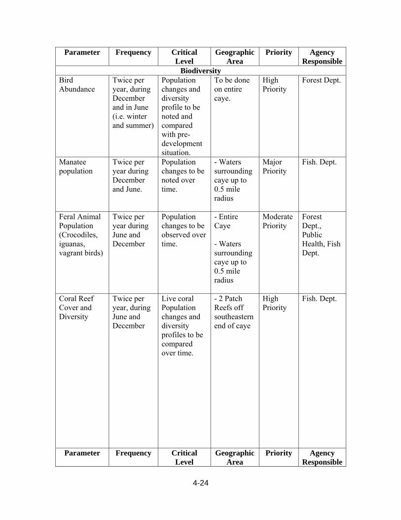
4-24
Parameter Frequency Critical Level
Geographic Area
Priority Agency Responsible
BiodiversityBird Abundance
Twice per year, during December and in June (i.e. winter and summer)
Population changes and diversity profile to be noted and compared with pre-development situation.
To be done on entire caye.
High Priority
Forest Dept.
Manatee population
Twice per year during December and June.
Population changes to be noted over time.
- Waters surrounding caye up to 0.5 mile radius
Major Priority
Fish. Dept.
Feral Animal Population (Crocodiles, iguanas, vagrant birds)
Twice per year during June and December
Population changes to be observed over time.
- Entire Caye - Waters surrounding caye up to 0.5 mile radius
Moderate Priority
Forest Dept., Public Health, Fish Dept.
Coral Reef Cover and Diversity
Twice per year, during June and December
Live coral Population changes and diversity profiles to be compared over time.
- 2 Patch Reefs off southeastern end of caye
High Priority
Fish. Dept.
Parameter Frequency Critical Level
Geographic Area
Priority Agency Responsible
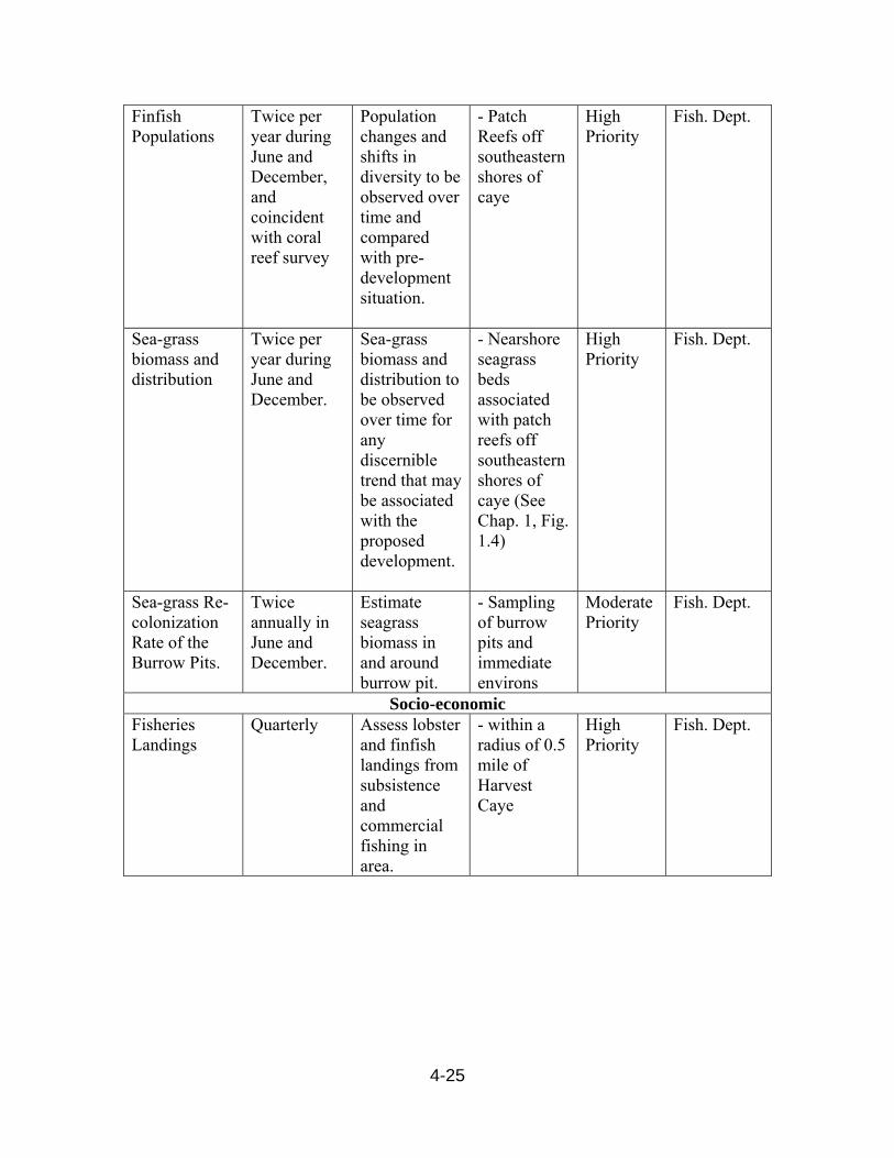
4-25
Finfish Populations
Twice per year during June and December, and coincident with coral reef survey
Population changes and shifts in diversity to be observed over time and compared with pre-development situation.
- Patch Reefs off southeastern shores of caye
High Priority
Fish. Dept.
Sea-grass biomass and distribution
Twice per year during June and December.
Sea-grass biomass and distribution to be observed over time for any discernible trend that may be associated with the proposed development.
- Nearshore seagrass beds associated with patch reefs off southeastern shores of caye (See Chap. 1, Fig. 1.4)
High Priority
Fish. Dept.
Sea-grass Re-colonization Rate of the Burrow Pits.
Twice annually in June and December.
Estimate seagrass biomass in and around burrow pit.
- Sampling of burrow pits and immediate environs
Moderate Priority
Fish. Dept.
Socio-economicFisheries Landings
Quarterly Assess lobster and finfish landings from subsistence and commercial fishing in area.
- within a radius of 0.5 mile of Harvest Caye
High Priority
Fish. Dept.
5-1
Chapter 5
5.0 Disaster Management 5.1 Disaster Classifications Disaster Management (or Emergency Management) follows protocol aimed to prevent emergencies from occurring and reduce risk through planning. Considering the possibilities of such an occurrence, a Disaster Management Plan is aimed at identifying the different potential disasters that could impact life safety. This plan will focus on potential types of disasters that can arise from various sources and affect the safe operations on the project site. Table 5.1 outlines some of the more likely disasters that could occur on site. Table 5.1 Summary of the Disaster Preparedness Plans for Harvest Caye Nature Park
Event Description Response Plan Stages Hurricanes and tropical storms
Hurricanes and storms can vary in strength damaging the project’s infrastructure thus affecting the operation of the project.
Hurricane Preparedness Plan
Alert, Response, Recovery
Fire Fire outbreaks can vary in size and location and can cause irreparable damage to the project’s infrastructure.
Fire Prevention and Response Plan
Response
Fuel/oil Spills and leaks
This incident could pose a serious impact to the sensitive environment in which the caye is found.
Spill Contingency Plan (Tier levels)
Response, Recovery
Medical Medical emergencies can occur at any moment without giving notice and therefore requires a quick and coordinated effort to respond to this need.
Medical Emergency Plan (Transportation and Evacuation)
Response, Recovery
5.2 Disaster Management Structure An Emergency Coordinator and a subordinate shall be assigned the responsibility to direct and execute all the activities outlined by the response plans. The emergency committee must conduct periodic meetings to address important issues concerning the disaster management plans. Such important issues should be the objectives of the committee, their roles and responsibilities, updates, training, drills.
5-2
5.3 Hurricane Preparedness Plan (HPP) The HPP is aimed at making reasonable preparations should the project be threatened by an imminent Tropical Depression of Hurricane strike. This is to enable the developers to protect their employees and assets, and also to ensure that the project is able to continue to function after the hurricane has passed. The hurricane preparedness plan will involve an alert, response and recovery stage to deal with any natural disaster involving hurricanes, storms or tropical depressions. This is the most common natural phenomenon occurring in Belize and the only one that would require a full scale evacuation. Belize lies within the hurricane belt, and is vulnerable to high wind and storm surge. During the past 100 years, Belize has been hit several times by major hurricanes. Belize has been hit 40 times by storms ranging from tropical depressions to hurricanes (Usher, 2000). The return period for storms since 1870 is three (3) years, and the vulnerability increases from North to South (Usher 2000). The hurricane season in Belize commences officially on June 1st and ends on November 30th. For this plan to be effective the staff is required to review the plan every year prior to the beginning of the Hurricane Season: There will also be simulation exercises in relation to various elements of the plan. 5.3.1 Purpose of Plan The purpose of this hurricane preparedness plan is to:
(i) Secure property and evacuate during the threat of a storm or hurricane.
(ii) Increase awareness to management and others (boaters, employees, guests etc.) of the need for hurricane preparedness,
5.3.2 Information System The “official alert” system for a storm or hurricane entails the coordination between management, the National Emergency Management Organization (NEMO) and the Belize National Meteorological Service (NMS). The emergency coordinator will therefore activate the required hurricane plan. The proposed project will follow the official alert and hurricane categories profile put in place by NEMO. Such categories along with the wind speeds are illustrated in the following:
Tropical Depression 29 mph – 38 mph Tropical Storm 39 mph – 73 mph Hurricane Category 1 74 mph – 95 mph Hurricane Category 2 96 mph – 110 mph

5-3
Hurricane Category 3 111 mph – 130 mph Hurricane Category 4 131 mph – 155 mph Hurricane Category 5 Above 155 mph
Harvest Caye Nature Park will adopt the official Warning Flag System as follows:
Flags Phases One Red Flag Preliminary Alert Phase (Storm/Hurricane Watch) One Red flag with Black Center RED I Phase (storm or hurricane watch) Two Red Flags with Black Centers RED II (Warning Phase) One Green Flag Green Phase ( ALL CLEAR) 5.3.3 Pre-Season Preparation At the beginning of May each year the Emergency Committee and the Emergency Coordinator will ensure that all of these equipments are checked and available at all times during the hurricane season. The Emergency Coordinator will also ensure that all buildings and assets such as equipment, boats and vehicles are photographed (digital with date) at the beginning of each hurricane season, for possible insurance claims. 5.3.4 Implementation Plan for Harvest Caye Nature Park during threats Preliminary Alert - Hurricane Watch This is the First Phase, and means that a storm or hurricane may threaten within 72 hours. A storm or hurricane is within 21° N 80° W of Belize. Actions to be taken: (i) The Emergency Committee should be prepared to convene and take action if the
Belize Weather Bureau issues a warning. (ii) Stay informed by radio and television of the storm progress. (iii) Obtain hurricane tracking chart for Committee members and project management, (iv) Obtain the contact number etc. from the Management, including employees and
owners of marine vessels, and inform vessel owners of the alert phase, (v) Ensure that contact is made with all employees, guests and captains of vessels,
whether by direct or indirect means, to alert them of the phase and to make initial contact.
(vi) Prepare a checklist (electronically) of items required in the event of a strike. (vii) The Emergency Coordinator will identify and categorize items or equipment to be
removed as follows: list of equipment to stay, and list of those to be removed to designated site.
(viii) Prepare a tentative list of all the employees management staff on the island. Hurricane Warning – Red 1 Phase (Watch)

5-4
During this phase, a hurricane may threaten within (36) thirty-six hours. A hurricane or storm is located within 20° N 85° W. Actions to be taken:
(i) Advise all vessel Captains to leave the marina area immediately and take their vessel to safe harbor or properly moor their boats to the marina.
(ii) The Emergency Coordinator will advise all employees and available human resources to install the hurricane shutters on the buildings or necessary protection measures.
(iii) Advise all occupants of the island to be prepared to evacuate the island upon the recommendations of NEMO.
(iv) Identify official shelter for guests and any other employee in need of such
shelters, (iv) Management will identify employees to report to work after the hurricane
or after the Green Phase all clear is given. (iv) Update NEMO on all actions taken. Hurricane Warning – RED 2 Phase Whenever Phase 2 (Red) is given, this means that a hurricane is likely to strike Harvest Cay within (24) twenty-four hours. Actions to be taken:
(i) The checklist of items required will then be printed and each head of sections will be provided with a checklist,
(ii) The precautionary list will be printed and provided to each head of sections,
(iii) Final hurricane preparations should be concluded
(iv) Evacuation of employees, guests and management should be completed
Third Phase – Green (All Clear) This is the ALL CLEAR, which will be declared by NEMO after the hurricane has passed and it is safe to return to review the effects of the hurricane. Actions to be taken: (i) The Emergency Committee will attempt to return and survey the project site as
soon as possible, (ii) The Emergency Committee will immediately make a brief report on all damages
(supported with photographs), and prepare an estimate of damages, and submit the same to NEMO and Management for their perusal.
5-5
(ii) Employees will report as previously advised. (iii) Clean-up phase will commence with the assistance of employees, and all available human resources, where possible. 5.4 Fire Prevention and Response Plan for Harvest Caye Nature Park
The fire prevention and response plan will focus on the possibility of a fire. Due to the project location and distance from either the Placencia Peninsula or the mainland, the proposed development shall provide its own service. 5.4.1 Purpose of Plan The purpose of the Fire Prevention and Response plan for the proposed project is to:
(i) increase awareness to management, employees and others of the need for a fire prevention and response plan,
(ii) Indicate all possible evacuation routes for each building, cabaña and other buildings on the property including the Cruise Ship.
5.4.2 Fire Protection Equipment/Systems All the buildings shall install protection systems which are summarized below:
1) Fire alarm detection and notification systems.
• Smoke detectors: Ionization detectors shall be installed to identify the products of combustion in accordance with national code requirements.
• Manually activated pull station: The buildings will have a manually activated pull station in the event of a fire. It is essential that all guests and staff are aware of these warning devices and their potential use in detecting fires.
2) Fire Suppression Systems.
• Hydrants: a mobile fire suppression system consisting of a water pump and hose with sea water being the extinguishing media.
• Fire Extinguishers: Harvest Caye will install multi-purpose dry chemical (Class ABC) fire extinguishers. Dry chemical extinguishers will range in sizes of 5 lbs to 10 lbs and will be installed in the all the building units. These will also be installed at key areas such as, containment walls, generators, electrical panels, maintenance areas, Utility Zone etc.
5.4.3 Fire Prevention Measures designed to prevent and control fires include:
I. Use of fire retardant material - The use of nonflammable building material will be encouraged within the project. For example the use of sheet roofing
5-6
instead of shingles will be encouraged and the use of fire rated doors, fire resistant windows and barriers. II. Qualified personnel to install electrical system - Only certified Electricians will be allowed to carry out any electrical work on the premises. Each building, after completion should be approved by the Belize Electricity Limited.
III Building Codes - The project will call for the construction of restaurants, cabañas and other buildings, with heights above (1) one and possibly (2) two stories high. A set of building codes will be developed by the engineers of the project, in order to ensure adequate construction of buildings. The engineering standards will also include provisions for adequate and safe wiring; plumbing, heating, and cooling systems are also in conformity with acceptable building codes.
5.4.4 Fire Response This plan must address congested areas such as the restaurants, bars and other buildings. Actions to be taken:
(i) Sound the alarm
(ii) Use an extinguishing media preferably a fire extinguisher to fight the fire.
(iii) Do not fight a large fire with a fire extinguisher.
(iv) Check to see that the fire is completely extinguished.
(v) Inspect the fire area and assess for damages.
(vi) Close off the area for safety purposes.
At some point, the Emergency Coordinator needs to be notified of the situation. A report of the incident should be submitted to the Emergency Committee for assessment, and notify any member of the National Fire Service for further investigation and recommendation. 5.5 Spill Contingency Plan A Spill Contingency plan be developed for fuel storage on site and for standby generators 5.5.1 Purpose of Plan The purpose of the plan is to outline the procedures necessary to:
• Increase staff awareness on Spill Response procedures
• Training of staff to utilize their resources in Response Procedures.
• Establish and define clearly the roles and responsibility of Management in Spill Contingency and Response procedures.
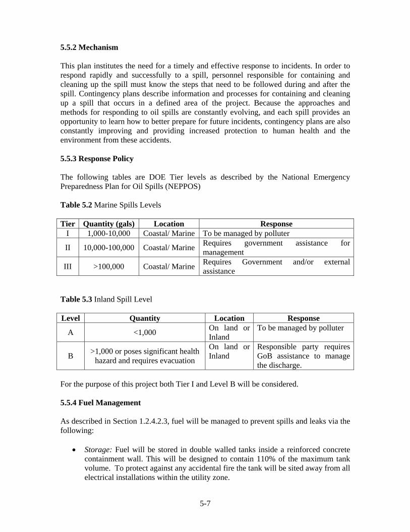
5-7
5.5.2 Mechanism This plan institutes the need for a timely and effective response to incidents. In order to respond rapidly and successfully to a spill, personnel responsible for containing and cleaning up the spill must know the steps that need to be followed during and after the spill. Contingency plans describe information and processes for containing and cleaning up a spill that occurs in a defined area of the project. Because the approaches and methods for responding to oil spills are constantly evolving, and each spill provides an opportunity to learn how to better prepare for future incidents, contingency plans are also constantly improving and providing increased protection to human health and the environment from these accidents. 5.5.3 Response Policy The following tables are DOE Tier levels as described by the National Emergency Preparedness Plan for Oil Spills (NEPPOS) Table 5.2 Marine Spills Levels Tier Quantity (gals) Location Response
I 1,000-10,000 Coastal/ Marine To be managed by polluter
II 10,000-100,000 Coastal/ Marine Requires government assistance for management
III >100,000 Coastal/ Marine Requires Government and/or external assistance
Table 5.3 Inland Spill Level Level Quantity Location Response
A <1,000 On land or Inland
To be managed by polluter
B >1,000 or poses significant health hazard and requires evacuation
On land or Inland
Responsible party requires GoB assistance to manage the discharge.
For the purpose of this project both Tier I and Level B will be considered. 5.5.4 Fuel Management As described in Section 1.2.4.2.3, fuel will be managed to prevent spills and leaks via the following:
• Storage: Fuel will be stored in double walled tanks inside a reinforced concrete containment wall. This will be designed to contain 110% of the maximum tank volume. To protect against any accidental fire the tank will be sited away from all electrical installations within the utility zone.
5-8
• Documentation: All the fuel consumed and received must be recorded.
• Maintenance: Routine inspection of the containment walls, fuel tanks, dispensing pumps, hoses, supply fuel lines and generators for spills and/or leaks.
5.5.5 Waste Oil Management Waste oil will be managed according to the following:
• Storage: All waste oil will be stored in properly sealed drums and inside a containment wall. This would most probably be inside a fuel tank containment wall.
• Handling: Used oils shall be handled adequately and with care.
• Disposal: Once stored, the waste oil should be disposed by an approved or certified DOE contractor.
5.5.6 Contingency Equipment and Safety Priorities Spill response equipment is the most important component in the Spill Contingency Plan. This equipment can vary depending on the size and type of the activity. For the interest of the development the following equipment will be required:
• Spill response Kits – these will be installed at key locations such as dispensing pumps, generators, maintenance areas, etc.
• Containment Booms –mostly for marine spills which will be deployed if need be the case.
The Emergency Committee will ensure that the following priorities are taken into consideration:
• Safety to human life is the highest priority in any response, and should be ensured that all personnel are protected.
• Containment of incident to stabilize the situation.
• Minimize and prevent any adverse environmental impact.
5-9
5.6 Medical Emergency Plan A medical emergency is an injury or illness that poses an immediate threat to a person's life or long term health. These emergencies may require assistance from another person, who should ideally be suitably qualified to do so, although some of these emergencies can be dealt with by the victim themselves. Dependent on the severity of the emergency, and the quality of any treatment given, it may require the involvement of multiple levels of care, from a first-aider to an emergency physician through to specialist surgeons. A more comprehensive plan will be developed by the Emergency Committee. In any event, the plan will be required to be approved by a certified doctor, health institution or NEMO. 5.6.1 Purpose of the Plan The primary objectives of the medical response plan are to:
•
• To respond to a health situation and to implement basic first aid treatment where applicable.
• Transport to a recognized health institution.
• Increase awareness to guests, transient visitors and employees of the availability of such primary health care.
5.6.2 Basic First Aid First Aid is the provision of limited care for an illness or injury, which is provided, usually by a certified person, to a sick or injured patient until definitive medical treatment can be accessed, or until the illness or injury is dealt with (as not all illnesses or injuries will require a higher level of treatment). It generally consists of series of simple, sometimes life saving, medical techniques, that an individual, either with or without formal medical training, can be trained to perform with minimal equipment. First aid kits will be provided on-site and will be immediately available for emergency situations. In any event, the Emergency Coordinator will be required to make transportation arrangements for the health institution in the event of a medical emergency. Aims
The 3 main aims of first aid, commonly referred to as the “3 Ps” are:
• Preserve life • Prevent further injury • Promote recovery
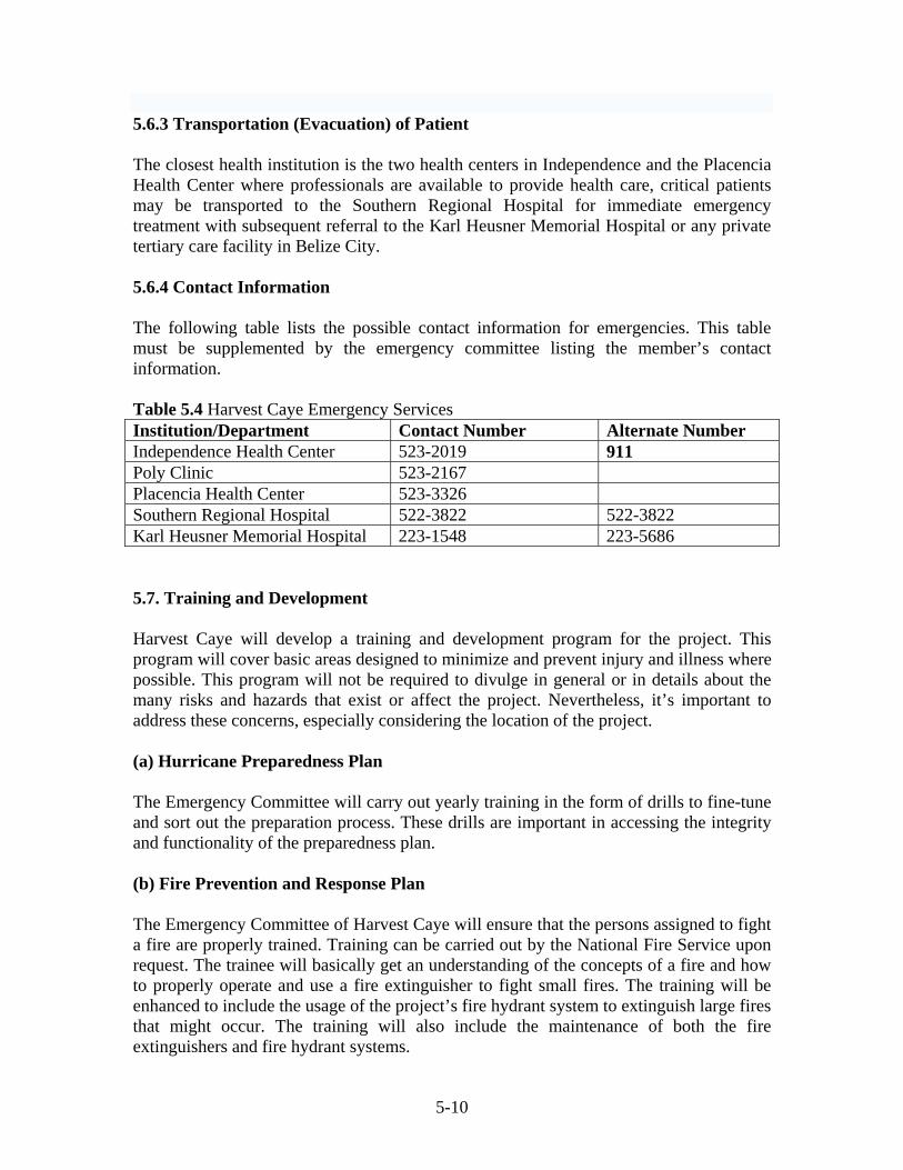
5-10
5.6.3 Transportation (Evacuation) of Patient The closest health institution is the two health centers in Independence and the Placencia Health Center where professionals are available to provide health care, critical patients may be transported to the Southern Regional Hospital for immediate emergency treatment with subsequent referral to the Karl Heusner Memorial Hospital or any private tertiary care facility in Belize City. 5.6.4 Contact Information The following table lists the possible contact information for emergencies. This table must be supplemented by the emergency committee listing the member’s contact information. Table 5.4 Harvest Caye Emergency Services Institution/Department Contact Number Alternate Number Independence Health Center 523-2019 911 Poly Clinic 523-2167 Placencia Health Center 523-3326 Southern Regional Hospital 522-3822 522-3822 Karl Heusner Memorial Hospital 223-1548 223-5686 5.7. Training and Development Harvest Caye will develop a training and development program for the project. This program will cover basic areas designed to minimize and prevent injury and illness where possible. This program will not be required to divulge in general or in details about the many risks and hazards that exist or affect the project. Nevertheless, it’s important to address these concerns, especially considering the location of the project. (a) Hurricane Preparedness Plan The Emergency Committee will carry out yearly training in the form of drills to fine-tune and sort out the preparation process. These drills are important in accessing the integrity and functionality of the preparedness plan. (b) Fire Prevention and Response Plan The Emergency Committee of Harvest Caye will ensure that the persons assigned to fight a fire are properly trained. Training can be carried out by the National Fire Service upon request. The trainee will basically get an understanding of the concepts of a fire and how to properly operate and use a fire extinguisher to fight small fires. The training will be enhanced to include the usage of the project’s fire hydrant system to extinguish large fires that might occur. The training will also include the maintenance of both the fire extinguishers and fire hydrant systems.

5-11
(c) Spill Contingency Plan Training in this field will be limited to small localized spills that could occur on the caye and any marine spills. Precedence will be given to the small spills since the probability is much higher. Trainees in this area will be required to learn the basics in spill containment and remediation process. This will involve the deployment of spill kits to the required areas and also undertaking remediation services. Training in this field can be undertaken by the Department of the Environment, or private consultancies. (d) Medical Emergency Staff and guests will be provided with the information to seek assistance during a medical emergency.
i
Executive Summary Project Location The currently proposed Harvest Caye Nature Park Project is located on Harvest Caye which is an island lying 2.94 miles south of the Placencia Village by navigable boat route or 2.15 miles from the Big Creek Port. The Caye is in the Stann Creek District and lies approximately 34.8 miles south of Dangriga Town, as the crow flies, and 71.5 miles south of Belize City. The only access to Harvest Caye is by boat. The caye is unoccupied with no pre-existing development. Harvest Caye comprises two (2) islands: A larger north-east sandy caye, and a smaller south-western caye dominated by mangroves. Harvest Caye is 71 acres in size, with the larger island measuring 58 acres and the smaller measuring 13 acres. Project Profile The proposed project is of a Nature Park, complimented by a Deep water access pier and channel. The development also entails facilities that will support the island at Malacate Beach, Independence. Complimentary amenities and infrastructure include: beaches, swimming pools, nature trails, lawns and hedgerows, as well as piers and a marina. A Utility Zone has been integrated into the design of the project. The Utility Zone is to house energy generation facilities, potable water storage and harvesting infrastructure, sewage treatment technologies and solid waste sorting, storage and disposal facilities as well as fuel storage and dispensing. Dredging and reclamation are an important component of the proposed project. A major part of the dredging activity is connected to the development of a 11 m deep channel to be located in the SW area of the small cay. Other dredging activity is land-based and is to be dedicated to the creation of a marina and a lagoon. The majority of the reclamation activity is connected to the reclamation of the larger caye, and reclaiming some of the beach, and creating a small island to SW of the large island using the excess dredged material. The total volume of dredged material is over 1 million M3. This fill material for the island amounts to approximately 750,000 m3, with the balance being deposited to create an island offshore the larger island. The Harvest Caye project is designed to accommodate 4,000 guests at full development, which is to be comprised of guests and employees.

ii
The facilities are to be staffed by 150 full-time persons whom are to include: managers, administrative staff, bar tenders, chefs, waitresses, grounds keepers, security personnel, boat handlers and janitors. The primary source of energy is to be from the BEL Grid via an underwater cable line, supplemented by diesel generators in a stand-by capacity. The primary source of potable water is from Reverse Osmosis. Additional potable water is to be supplemented by some rainwater catchment and well water abstraction. Water conservation strategy in the form of the recycling of wastewater is also to be employed to lessen water demand. In this regard post-treated wastewater associated with the wastewater treatment facilities is to be used for the irrigation of lawns and hedgerows and other non-potable uses. Sewage derived from human waste and domestic effluents is to be treated through the deployment of secondary treatment technology. A ‘package plant’ known by its trade name “MBRP” is to be employed in the treatment of all wastewater generated by the facilities. This technology reduces major pollutants such as the macro-nutrients nitrates and phosphates, and ammonia, as well as Total Suspended Solids (TSS), BOD substances and microbes to levels where they do not pose a threat to the integrity of the environment, or human health. Solid waste management entails the separation of the garbage generated by the facilities into organic and inorganic components. The organic or biodegradable component is to be composted on-site through the application of ‘earth tub’ technology. The waste, in the form of a semi-dry mulch is to be used as an organic fertilizer for the hedge rows and lawns. The inorganic components are to be further separated into combustible and non-combustible components: These are to be bagged in color coded impervious plastic bags and transported to the Big Creek Dump Site for disposal. State of the Environment Harvest Caye is comprised of two (2) islands, a smaller mangrove dominated caye and a larger sandy caye characterized by littoral forest, alternated by open savannah and stands of mangroves. The latter is particularly relevant for the lower southwestern portion of the caye. The most dominant mangrove species on the southern island is the Red Mangrove (Rhizohpora mangle): This is followed by the Black Mangrove (Avicennia germinans) and subsequently the White Mangrove (Laguncularia racemosa). Red Mangroves (Rhizohpora mangle) were also the dominant mangrove species on the larger island: These found in the greatest abundance in the mid-latitude of the northwestern portion of the caye. Significant stands of Black Mangroves (Avicennia germinans) were found in the internal areas on the southern extreme of the larger island.
iii
The greatest Littoral Forest development was found on the northern and eastern portion of the larger caye. Tree species commonly encountered included the Button Wood (Conocarpus erectus), the Gumbo Limbo (Bursera simaruba), the Black Poisonwood (Metopium brownei) and the Sea Grape (Coccolaba uvifera). The mangroves and other tree species found on Harvest Caye were generally in a good state of health. The nearshore areas off the eastern windward a northern portion of the larger island was dominated by seagrass beds. The preponderant seagrass species was the Turtle Grass (Thalassia testudinium). In certain locales however such as sheltered areas immediately adjacent the beach, there were noticeable clumps of the Manatee Grass (Syringodium filiforme). Macro-algal species frequently encountered in seagrass beds include the Clump Halimeda (Halimeda opuntia), the Shaving Bush Algae (Penicillus spp.), the Feather Algae (Caulerpa prolifera), and the Green Club Bubble Algae (Valonia macrophysa). The most significant attached benthic faunal component was corals. These occurred mainly off the eastern or windward portion of the caye and included both reef-building or ‘stony’ coral forms, as well as soft coral forms. The reef-building forms occurred in significant profusion as ‘Patch Reef”, although there were also isolated forms or ‘coral heads’. Some of the more frequently occurring species included the Mountainous Star Coral (Montastrea faveolata), the Boulder Star Coral (Montastrea annularis), the Finger Coral (Porites porites), and the Golf Ball Coral (Favia fragum). Soft coral species included the Corky Sea Finger (Briareum asbestinum), the Rough Sea Plume (Muriceopsis flavida) and the Common Sea Fan (Gorgonia ventalina). Macro-invertebrates found in the seagrass beds and coral reef areas include the Spiny Lobster (Panulirus argus), the Queen Conch (Strombus gigas), the Sun Anemone (Stoichactus helianthus) and the Sea Star (Oreaster reticularis). Fish species found in the area include the Red Hind (Epinephelus guttatus), the Fairy Basslet (Gramma loreto), the White Grunt (Haemulon plumieri) and the Princess Parotfish (Scarus taeniopterus) and the Barracuda (Sphyraena baracuda). The other aquatic vertebrates occurring in the area were two (2) mammalian species, viz the West Indian Manatee (Trichechus manatus) and the Bottlenose Dolphin (Tursiops truncatus). Although these animals were not seen in the area by the Tunich Nah Survey Team, they were reported anecdotally. There are two (2) manatee hotspots in the vicinity of Harvest Caye. These are the Indian Hill Lagoon/Sennis River Complex which lies to the southwest of the project site, and the Placencia Lagoon which lies to the north of the caye. These sites represent activity centers that are used year-round by groups of manatees for feeding, resting and accessing freshwater.
iv
The only quantitative measure of aquatic habitat taken was Live Coral Cover: This is a measure of the health and vigor of the reef systems in the area. Live Coral Cover varied from low to a high. The lower mean value was below the national average of 11.5% which is an indicator that the particular reef system is in a poor state of health. The higher mean Live Coral Cover value obtained means are an indicator that the mid-latitude reefs are in a good state of health. Apart from sub-tidal marine fauna, the area was also inhabited by terrestrial fauna. These were mainly in the form of caye-based reptiles such as the Green Iguana (Iguana iguana) and the Anole (Anolis sp), as well as birds. The latter are by far the most abundant terrestrial vertebrates. These included a range of seabirds such as the Brown Pelican (Pelicanus occidentalis), the Laughing gull (Larus atricilla), the Neotropic Cormorant (Phalacrocorax brasilianus) and the Frigate Bird (Fregata magnificens), as well as wetland species such as the Green Heron (Butorides virescens), the Great Egret (Ardea alba), and the White Ibis (Eudocimus albus). Littoral forest and woodland species include the White Crowned Pigeon (Columba leucocephala), the Melodious Blackbird (Quiscalus mexicanus), the Golden Fronted Woodpecker (Melanerpes aurifrons), the Flycatcher (Empidomax sp.) and the Black Catbird (Melannoptila glabriostris). Environmental Impacts The environmental impacts arising from the project were both ecological and social in orientation. The project activities that are likely to give rise to some environmental impacts of note are the dredging and reclamation operations, the generation of domestic effluents, solid wastes, and energy generation. The primary turbidity and sedimentation impacts arising as a consequence of the dredging activities scheduled to be undertaken in conjunction with the currently proposed project are moderate in scope. The secondary impacts have been assessed as ‘moderate’ at their most severe: This is related to the source of the ‘fill’ material or dredged spoils, the nature of the ‘fill’ material, and the dredging methods and associated protocols to be applied. In relation to the latter, a cutter-head dredgeand excuvation will be applied: This is to be accompanied by sediment curtains. Additional mitigation measures will also be applied such as dredging in calm sea-states, and suctioning the barrow pits of mobile sediments on a daily basis to curtail the re-suspension and re-broadcasting of sediments. The primary impacts in relation to human and domestic wastes were evaluated as major given the scope of the development. These relate to nutrient enrichment or eutrophication, increase in BOD compounds and the elevation of fecal pathogens in the water column. Much of the secondary nutrient effluent impacts were positive, given the very limited liberation of nutrients into the environment and its positive influence on primary production and fisheries productivity. The secondary impacts in regard to BOD and fecal coliform were evaluated in the ‘minor deleterious’ category at their most severe.

v
Apart from the limited dispersal of effluents into the environment, the sewage treatment methodology applied was also responsible for the minor deleterious categorization of the secondary impacts. The adoption of the Sewage Treatment System in the design of the proposed project will reduce macro-nutrients, BOD substances and fecal pathogens to levels that are well within national standards. The storage and chlorination of effluents that are to be reused for flushing toilets and the watering of lawns and hedgerows should denature any pathogens that would remain after treatment by the Plant. The most severe primary impacts in regard to solid waste, has been evaluated as major. The secondary ecosystems level impacts have been evaluated as ‘minor’ deleterious. This is attributable to the solid waste management strategies to be applied. The composting of organic wastes, and the collection and off-site disposal of the inorganic components should greatly reduce its impacts on opportunistic and scavenging birds such as the Great Tailed Grackle (Quiscalus mexicanus) and the Frigate Bird (Fregata magnificens). Crocodiles may also become a nuisance if the solid wastes are not appropriately managed. The consequence of unattended or inappropriately discarded solid waste items in providing breeding grounds for nuisance insects such as mosquitoes, which may be vectors for malaria and other diseases were recognized. The risks or level of impact however was viewed as minimal given the efficacious disposal strategy to be employed, thus the ‘tertiary level’ or human health was assessed as ‘minor deleterious’ at their most severe. Other social impacts related to exposure to fecal pathogens, threat of injury and physical trauma, and aesthetic pollution. The threat of injury and physical trauma relates to potential encounter with guests of the facilities with wildlife attracted to the area such as crocodiles, as well as collision-at-sea events associated with the dredging event and the piers and other standing infrastructure in the near-shore seas. Aesthetic pollution relates mainly to the mud, turbidity and odor associated with the dredging and land reclamation event. These have all been described as ‘level 3’ or ‘tertiary level’ impacts. These impacts have been all assessed as ‘minor deleterious’ at their most extreme.
References Auil, N. 1997. Manatee Research Progress Report, March – July 1997, Coastal Zone Management Project. Auil, N.E. (1998). Belize Manatee Recovery Plan, Coastal Zone Management Project. (GEF UNDP) Azueta, J. 2002. Draft Revised Management Plan For Bacalar Chico Marine Reserve, Unpublished Report. Bak, R.P.M. and Meesters, E.H. 1998. Coral population structure: the hidden information of colony size-frequency distributions. Marine Ecology Progress Series 162: 301-306. Blackstone Corporation. 1998. Tourism Strategy for Belize. Ministry of Tourism and Environment, & IADB. Belize, Natural History and Archaeology. 1996. International Expeditions, Inc., Helena Alabama. Blackstone Corporation. 1998. Tourism Strategy for Belize. Ministry of Tourism and Environment, & IADB. BTB. 2003. Belize Cruise Ship Policy. Belize Tourism Board. BTB. 2007. Tourism & Travel Statistics. Belize Tourism Board Biswas, A.K. and Q. Geping, 1987. Environmental Impact Assessment for Developing Countries. The United Nations Development Library. Budd, A.F, Stemann, T.A and Johnson, K.G. 1994. Stratigraphic distributions of genera and species of Neogene to Recent Caribbean reef corals. Journal of Paleontology 68: 951-977. Caribbean Tourism Organization, 1999. Integrating Environment and Tourism Policies and Strategies: A Protected Areas Framework. Canter, L.W. 1996. Environmental Impact Assessment 2nd Edition McGraw Hill Cayes Development Policy. 1995. Coastal Zone Management Committee. CZMAI./FD. Government of Belize Central Statistical Office (Statistical Institute of Belize). 2004. Environmental Statistics for Belize. Central Statistical Office, Ministry of National Development, Belize. Corbitt, D. S. 1998: Standard Handbook of Environmental Enginner, Second Edition, McGraw Hill
Council on Environmental Quality (CEQ), 1987: Regulations for Implementing the National Environmental Policy Act, 40 Codes of Federal Regulations, Chapter V, July 1, 1987. CZMAI. 1996. Belize City Cayes Development Guidelines. CZMAI. The National Integrated Coastal Zone Management Strategy for Belize. Davis M.L. and Cornwell, D.A. 1998. Introduction to Environmental Engineering, Third Edition, McGraw Hill ISBN 0-07-015918-1 Dean, R.G. and Dalrymple R.A. 2004: Coastal Processes with Engineering Applications, First Edition, Press Syndicate of the University of Cambridge – ISBN 0-521-49535 Development Solutions. 2004. Belize City Cayes Region Development Guidelines Volume 5. Edwards, Ernest P. 1998. The Birds of Mexico and Adjacent areas. Environmental Water Quality Program, Water Quality Monitoring Protocol, Department of the Environment, June 1995 Environmental Protection (Effluent Limitations) Regulations, 1995. Statutory Instrument NO. 94 of 1995. Garcia-Selgado M., et al. 2006. Conservation and Sustainable Use of the Meso-American Barrier Reef System (MBRS). Baseline of the Status of the Meso-American Barrier Reef Systems: Results of Synoptic Monitoring from 2004 and 2005, Vol. 1. Garcia, Jose, 1992. Water Source Study (Northeast Belize Region) Gibson, J. 1991. Trip Report. Reef Pt - Bacalar Chico, Ambergris Cay. Ginsberg, R. and Kramer, P. 1999. Atlantic and Gulf Rapid Reef Assessment (AGRRA) Regional Update 1999. Reef Encounter, Newsletter of the International Society for Reef Studies, 26 (Dec): 41-43. Gischler E. and A.J. Lomando. 1999. Recent sedimentary facies of isolated carbonate platforms, Belize-Yucatan System, Central America. Jour. Sedimentary Res., Vol. 69, No. 3. Ginsburg, R.N., Steneck, R., Lang, J. and Kramer, P. 1998. Atlantic-Gulf Reef Assessment, an international collaboration. International Society for Reef Studies European Meeting – Perpignan: 80 (Abstract). Gobin, Judith. 2001. Coastal Infrastructure Design, Construction and Maintenance A Course in Coastal Zone/Island Systems Management. Organized by Department of Civil Engineering, The University of the West Indies, in conjunction with Old Dominion University, Norfolk, VA,

USA and Coastal Engineering Research Centre, US Army, Corps of Engineers, Vicksburg, MS, USA. Goldsmith F.B. 1991. Monitoring for Conservation and Ecology. Chapman and Hall. Green Reef Environmental Institute (2004). The Revised Bacalar Chico National Park and Marine Reserve Manage Plan.San Pedro Town, Belize Grimshaw, T. & G.M. Paz. 2004. The Revised Bacalar Chico National Park and Marine Reserve Management Plan. Green Reef Environmental Institute, San Pedro Town, Belize, Central America. Guderjan, T.H. 1993. Ancient Maya Traders of Ambergris Caye. Cubola Publications, Benque Viejo del Carmen, Belize. 39 pp. Halcrow Group. 2000. The Coastal Zone Management Strategy for Belize. Draft. CZMA&I, Belize. Halcrow A CH2M Hill Company. 2012 : Feasibility Study for the Placencia Peninsula Pilot Wastewater Management System, Placencia, Stann Creek District, Belize Hartshorn, G.. Nicolait, J., et al. 1984. Belize Country Environmental Profile. A field study. United States Agency for International Development. Healthy Reefs. 2012. Report Card for the Meso-American Reef: An Evaluation of Ecosystem Health. Herbich, J. B. 2000. Handbook of Dredging Engineering. Mc Graw Hill, Second Edition _______________, Handbook of Coastal Engineering, Mc Graw Hill First Edition. ISBN 0-07-134402-0 High, L.R. 1969. Geomorphology and Sedimentology of Holocene Coastal Deposits. Taken form PhD thesis, Rice Univ. Hoese, H. D., and R. H. Moore. 1977. Fishes of the Gulf of Mexico, Texas, Louisiana, and Adjacent Waters. Texas A&M University Press. Hill, J., and C. Wilkinson. 2004. Methods for Ecological Monitoring of Coral Reefs: A resource for Managers. Vol. 1. Humann, P. 1992. Reef Creature Identification. Florida, Caribbean, Bahamas. New World Publications. Humann, P. 1994. Reef Fish Identification. Florida, Caribbean, Bahamas. New World Publications.
Ishmael, L. 1994. Development of North Ambergris Caye, Belize: An Investment in the Future. Report to the Inter-American Development Bank, Washington D.C. James, N.P. and R.N. Ginsburg. 1979. The seaward margin of the Belize barrier reef and atoll reefs. Int. Ass. of Sedimentologists, Special Publication; No. 3. Jolly, K. and E. McRae. 1998. The Environment of Belize: our life support system, Cubola Productions. Jones H. L. 2003. Birds of Belize. University of Texas Press, Austin. Jones H. L., & A.C. Vallely. 2000. Annotated Checklist of the Birds of Belize. Lynx Edition. Kaplan, H.K. 1988. Petersen Field Guide: A Field Guide to the Southeastern United States and Caribbean Seashores. King, R. B., Baillie, I.C., Abel, T.M.B., Dunsmore, J.R., Gray, D.A., Pratt, J.H., Versey, H.R., Wright, A.C.S., and Zisman, S.A. 1992. Land Resource Assessment of Northern Belize. Natural Resources Institute Bulletin No 43. 513pp. (2 volumes) Kricher, J.C, (1989). A Neotropical Companion, Princeton University Press. Launchpad Consulting. 2005. Belize Tourism Policy 2005. Belize Tourism Board.
Littler, D.S., M.M. Littler and B.L. Brooks. 1995. Marine Algae and Seagrasses from the Tobacco Range Fracture Zone, Belize, C.A. Atoll Research Bulletin, Nos. 426-431. Majil, I. 2000. Sea Turtle Monitoring And Conservation Programme, Unpublished Report. 8 Pp. Marriot, B.B. 1997: Environmental Impact Assessment -A Practical Guide. Second Edition McGraw Hill Mazzullo, S.J., Anderson-Underwood, K.E., Burke, C.D. and Bischoff, W.D. 1992. Holocene coral patch reef.
Mazzullo, S.J. Teal, C.S. Bischoff, W.D., Dimmick-Wells, K., And Wilhite, B.W. 2003.Sedimentary Architecture And Genesis Of Holocene Shallow-Water Mud-Mounds, Northern Belize Sedimentology 50, 743-770. MBRS Project. 2005. Reef Fish Spawning Aggregation Monitoring Protocol for the Meso-American Reef and the Wider Caribbean. Vol. 2. McCalla. W. 1995. Guide for Developers. Ministry of Tourism and the Environment.

McField, M. et al. 1996. State of the Coastal Zone Report, Belize 1995. Coastal Zone Management Programme. Government of Belize McField, M.D. 2000. Evaluation of management effectiveness - Belize marine protected areas system. Prepared for the CZM Authority & Institute, Belize City, Belize. August 2000. 20 p. McGee, M. Understanding and interpreting water quality. Florida Cooperative Extension Service, Institute of Food and Agricultural Sciences, University of Florida. McGlade, J. 1995. SIMCOAST. Interdisciplinary scientific methodologies for the sustainable use and management of coastal resource systems. Contributed paper at ASEAN-EU workshop, 13-15th September 1995, Penang, Malaysia. McKillop, Heather. 1996. Ancient Maya Trading Posts and the Integration of Long- Distance and Regional Economics: Wild Cane Caye in South – Central Belize. Ancient Mesoamerica 7: 49 - 62 McKillop, Heather. 2002. Salt, White Gold of Ancient Maya. University Press of Florida, Gainesville Meadows, M. 1995. Bacalar Chico Bird Report. Report to ITCF. Meerman, J. C. & W. Sabido. 2001. Belize Ecosystems Map and classification. Programme for Belize. Miller, B.W., and Carolyn M. Miller. 2000. Birds of Belize: a check list. Belize Audubon Society: Belize, Central America. 2nd revised edition. Miller B.W, & C. M. Miller. 1994. National Protected Areas Systems Plan For Belize, Full Report Vol. 3 Zoological Report. Mumby, P.J., A.R.Harborne and P.S.Raines. 1998. Classification scheme for marine habitats of Belize. Unpublished report for the UNDP/GEF Belize Coastal Zone Management Project. Mumby, P.J. and Harborne, A.R. 1999. Development of a systematic classification scheme of marine habitats to facilitate regional management and mapping of Caribbean coral reefs. Biological Conservation 8: 155-163. Nathanson, J.A. 1996. Basic Environmental Technology: Water Supply, Waste Management and Pollution Control. 2nd Edition. National Emergency Management Organization (NEMO). Hurricane Preparedness
2003. Nicolait, R. 1984. Belize Country Environmental Profile, A Field Study.
Odum, E., C.C. McIvor and T.J. Smith. 1982. The Ecology of the Mangroves of South Florida: A Community Profile. Dept. Env. Sc., Univ. Virginia, Charlottesville, Virginia. PAHO. 2002. Health Systems and Services Profile. Organization and Management of Health Systems and Services Division of Health Systems and Services Development. Paz, G.M. and T. Grimshaw. 2001. Status report for Nassau groupers in Belize. Workshop Report “Towards a sustainable management of Nassau groupers in Belize”, Belize City, 30 July 2001. Perkins, J.S. 1983. The Belize Barrier Reef Ecosystem: an assessment of its resources, conservation status and management. New York Zoological Soc. Report pp. 189. Platt, S. G., Thorbjarnarson, J. B. 1997. Status and Life History of the American Crocodile in Belize. ix + 164 Pgs. Purdy, E.G. 1974. Karst-determined facies patterns in British Honduras: Holocene carbonate sedimentation model. Am. Ass. Petrol. Geol. Bull. 58: pp. 825-855. Purdy, E.G. and E. Gischler. 2003. The Belize margin revisited: Holocene marine facies. Int J Earth Sci. (Geol Rundsch) 92: 532-551 Purdy, E.G. and E. Gischler. 2003. The Belize margin revisited: Holocene marine facies. Int J Earth Sci. (Geol Rundsch) 92: 532-551. Raines, P.S., McCorry, D., Mumby, P.J. and Ridley, J.M. 1993. Coral Cay Conservation – survey techniques and their application in Belize. Proceedings of the 7th
International Coral Reef Symposium 1: 122-126. Rauscher, F. and J.M. Wilensky. 2007. Cruising Guide to Belize and Mexico’s Caribbean Coast, including Guatemala’s Rio Dulce, 3rd Ed. Raines, P., Wells, S. and Harborne, A. 1995. Coral Cay Conservation Interim Report. April-December 1994. Belize Coastal Zone Management Programme, B7-5040/93. Report to European Union. Rauscher, F. and J.M. Wilensky. 1996. Cruising Guide to Belize and Mexico’s Caribbean Coast, including Guatemala’s Rio Dulce, 2nd Ed. Reeve, D et al 2004: Coastal Engineering -Processes, Theory and Design Practice, First Edition, Spon Press Sale, P.F. 1997. Visual census of fishes: How well do we see what is there? Proceedings of 8th International Coral Reef Symposium 2: 1435-1440.

Sale, P.F. and Douglas, W.A. 1981. Precision and accuracy of visual census technique for fish assemblages on coral patch reefs. Environmental Biology of Fishes 6: 333-339. Sedberry, G.R. and Carter, J. 1993. The fish community of a shallow tropical lagoon in Belize, Central America. Estuaries 16 (2): 198-215. Smith, G. W. 1995. Survey of Reptiles and Mammals in the Proposed Bacalar Chico Marine Reserve and Wildlife Sanctuary. Smith, G. W. 1990. Ground Surveying for Sea Turtle Nesting Sites in Belize, 1990. Belize Audubon Society, Belize City. 24 p. Stake Bank Cruise Ship Facility Development: Dec. 21st , 2005. State of the Coast Report of Belize, 1999. Coastal Zone Management Authority and Institute. Stoddart, D.R. 1974. Post-hurricane changes on the British Honduras reefs: resurvey of 1972. Proc. 2nd Int. Coral Reef Symp. Pp. 473-483. Stoddart, D.R., F.R. Fosberg and D.L. Spellman. 1982. Cays of the Belize Reef and Lagoon. Atoll Res. Bull. 256: pp. 1-76. Sullivan, K.M., G.A. Delgado, G.A. Meester, and W.K. Miller. 1994. Rapid Ecological Assessment Methods for Tropical Estuarine Ecosystems: Port Honduras, Belize. The Nature Conservancy, Florida and Caribbean Conservation Science Center, University of Miami. Thurman, H.V. 1988. Introductory Oceanography, Fifth Ed. Published by Merrill Publishing Company. Tunich Nah Consultants & Engineering, 2006. Environmental Impact Assessment of Ambergris Caye Belize Resort – A tourist resort to be located on Northern Ambergris Caye. Tunich Nah Consultants. 2008. Environmental Impact Assessment South Beach Belize – A proposed residential and tourism development project, south end of Ambergris Caye Tunich Nah Consultants & Engeering. Ltd. 2001. Environmental Impact Assessment of Hugh Parkey Belize Adventure Island – A proposed tourism resort and subdivision project, Spanish Lookout Caye Tunich Nah Consultants. 2008. Environmental Impacts for Eco-Resort Project at Harvest Caye Tunich Nah Consultants. 2009. Environmental Impact Assessment Chrysalis Resort Limited – A proposed tourism development project AT Big Channel and Little Channel Caye, offshore Stann Creek, Belize

Watson, R.A., Carlos, G.M. and Samoilys, M.A. 1995. Bias introduced by the non- random movement of fish in visual transect surveys. Ecological Modelling 77: 205- 214.
Wantland. K.D. 1967. Recent Benthic Foraminifera of the British Honduras Shelf. Ph.D. thesis, Rice Univ., Houston, Texas. pp. 299. Woods, T.L. 1998. An Overview of Belizean History (html document). Woods, R.L., ST. Reid, & A.M. Reid. 1988. The field guide to Ambergris Caye Belize. C.A. including other areas. 176 p. Woodside, G and Kocurek D. 1997: Environmental, Safety, and Health Engineering, Second Edition, John Wiley & Sons Inc. Zisman, S. 1996. The Directory of Belizean Protected Areas and Sites of Nature Conservation Interest, (Second Edition).