23-archaeological investigations in the lower galien river
TRANSCRIPT
Western Michigan University Western Michigan University
ScholarWorks at WMU ScholarWorks at WMU
Archaeological Technical Reports Intercultural and Anthropological Studies
1990
23-Archaeological Investigations in the Lower Galien River Valley 23-Archaeological Investigations in the Lower Galien River Valley
of Southwest Michigan of Southwest Michigan
William M. Cremin Western Michigan University
Follow this and additional works at: https://scholarworks.wmich.edu/anthropology_tech_reports
Part of the Archaeological Anthropology Commons
WMU ScholarWorks Citation WMU ScholarWorks Citation Cremin, William M., "23-Archaeological Investigations in the Lower Galien River Valley of Southwest Michigan" (1990). Archaeological Technical Reports. 21. https://scholarworks.wmich.edu/anthropology_tech_reports/21
This Report is brought to you for free and open access by the Intercultural and Anthropological Studies at ScholarWorks at WMU. It has been accepted for inclusion in Archaeological Technical Reports by an authorized administrator of ScholarWorks at WMU. For more information, please contact [email protected].
DEPARTMENT OF ANTHROPOLOGY
WESTERN MICHIGAN UNIVERSITY
TECHNICAL REPORT NO. 23
1990
ARCHAEOLOGICAL INVESTIGATIONS IN THE
LOWER GALIEN RIVER VALLEY OF SOUTHWEST MICHIGAN
EOITEO BY:
WILLIAM M. CREMIN
CONTRIBUTORS:
WILLIAM M. CREMIN
6REGORY R. WALZ
DANIEL B. GOATLEY
ACKNOWLEDGEMENTS
The editor end contributors to this volume gratefully acknowl-
edge the support of Galien River Associates, sponsors of the work
reported herein, Resource Management Group of Grand Haven, and
especially Mr. David Zuckerman of this firm, who participated
fully in the actual fieldwork, the field crew from Western Michigan
University responsible for the collection oF date from the sites,
and the 18 participants of WMU's Spring 1990 archaaological field
school, who volunteered many hours in the laboratory processing
Flotation samples and sorting the contents prior to analysis for
inclusion in this report.
W.M.C. G.R.W. O.B.G
TABLE OF CONTENTS PAGE
INTRODUCTION TO THE PROJECT (Cremin) 1
Project personnel . . . . . . . . . . . . . . . . . . . . . . . . . . . . . . . . . . . . . . 1
Description of the Study Area and Review of the Survey Fieldwork Conducted in November 198 9 • • • • • • • • • • • • • • • • • • • • • • • • • • • • • • • • • • • • • • • • • • • • • • • • • • • 3
Designing and Implementing the Follow-up Investigation . . . . . . . . . . . . . . . . . . . . . . . . . • . . . . . . . . . . . . . . . . 8
Conclusion of the Stripping Operation and Commencement of Feature Excavation
FEATURES RECORDED FOR SITES 20BE405, 410, AND 411 (Cremin) ........................ .
Features other than Deep Roasting Pits
Deep Roasting Facilities
Radiocarbon Dating the Features
CERAMICS FROM SITES IN THE PROJECT AREA (Walz)
PRELIMINARY ANALYSIS OF THE PROJECT LITHIC
11
16
17
20
28
29
ASSEMBLAGE (Goatley) . . . . . . . . . . . . . . . . . . . . . . . . . . . . . . . . . . . . . . 30
Raw Materials ........................ .
Heat Treatment of Lithic Raw Materials
Observations on Lithic Reduction ..... .
Formal Tools Identified in the Assemblage
Distribution of Lithic Materials in the Project Area
ARCHAEOBOTANY (Walz)
Field and Laboratory Procedures ...... .
Wood Charcoal ........................................... Charcoal Other than Wood ............. .
Tubers
Seeds, Fruits, Nuts, and Other Remains ............. .
Discussion ........................... .
THE PHASE II FAUNAL ASSEMBLAGE (Goatley)
31
35
35
37
40
41
41
42
47
48
49
52
53
Discussion . . . . . . . . . . . . . . . . . . . . . . . . . . . . . . . . . . . . . . . . . . . . . 56
TABLE OF CONTENTS, CONTINUED
PAGE
CONCLUSIONS A~:D RECOMMENDATIONS (Cremin) . . • . . . . . . • • . . . . . . . 57
Limitations on Our Original Program oF Research . • • . • • • • • • • • . . . . . . • . • • • . . . . . . . • . . . . . . . • . . . . . . . . 58
Potential SigniFicance oF this Archaeological Resource . . . . . . . . . . . . . . . . . . . . . . . . . . . . . . . . . . . . . . . . . . . . . . . 59
Recommendations • . . . . • • • • • • • • • • • • • • • • . . • • . . . . . . • • • . . . . . . 61
REFERENCES CITED • . • • . . . • • • • . • • • • • • • • • • • . • . • . . . . . . . . • • . . . • . 62
FIGURE 1 :
FIGURE 2:
FIGURE 3:
FIGURE 4:
FIGURE 5:
FIGURE 6:
FIGURE 7:
FIGURE 8:
FIGURE 9:
FIGURES
PAGE
SIMA TRACT, NEW BUFFALO, MICHIGAN . . . . . . . . . . . . . . 4
SIMA PROJECT (Phase I Fieldwork)
SIMA TRACT EXCAVATIONS
REPRESENTATIVE FEATURE PROFILES
REPRESENTATIVE FEATURE PROFILES
REPRESENTATIVE FEATURE PROFILES ................
5
12
22
23
24
CHERT SOURCE AREAS (in the Upper Midwest) ...... 34
ARTIFACTS FROM PROJECT SITES
ARTIFACTS FROM PROJECT SITES
36
38
TABLES PAGE
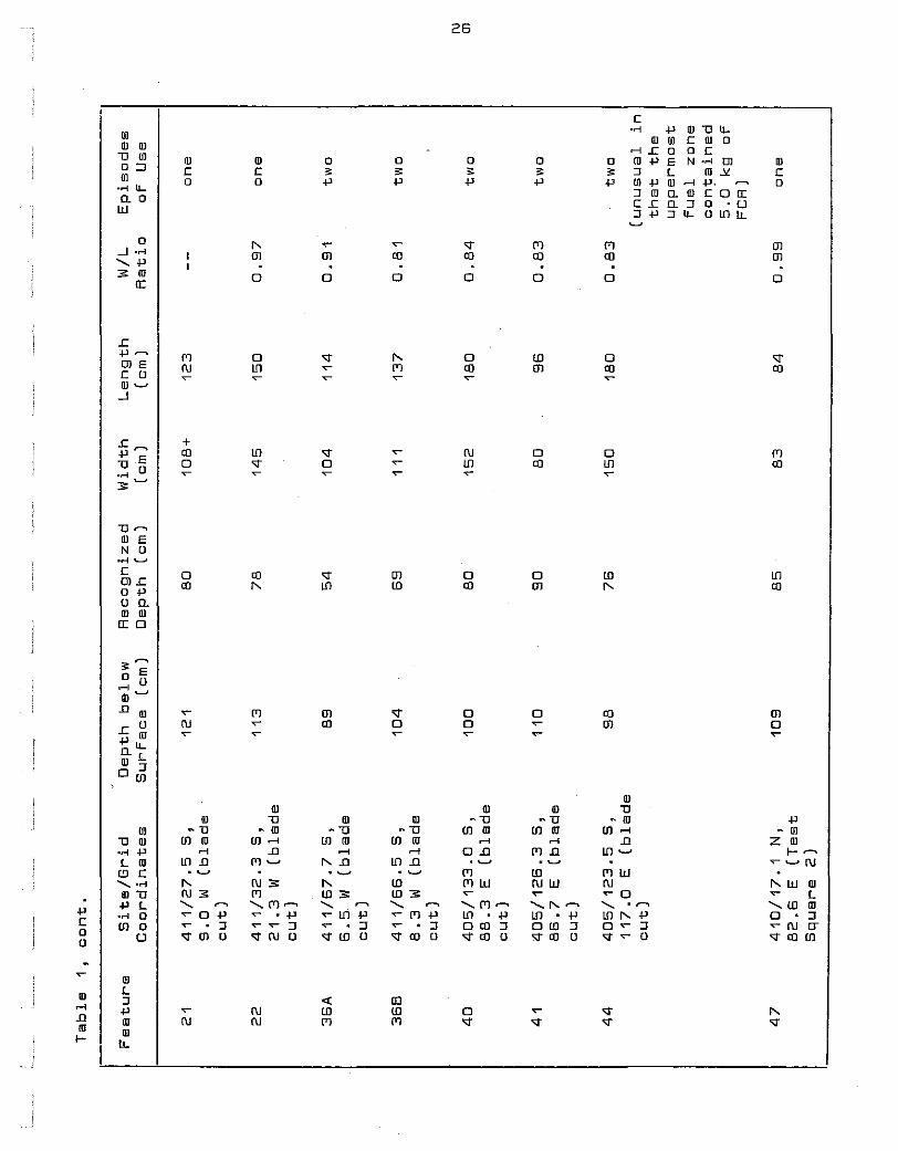
TABLE 1: LOCATIONAL AND METRICAL DATA FOR 17 DEEP ROASTING PITS ON 20BE405, 410 AND 411 25
TABLE 2: LITHIC MATERIAL FROM THE PROJECT AREA BY SOURCE AND REDUCTION STAGE ....................... 32
TABLE 3: PERCENTAGE FREQUENCIES FOR WOOD CHARCOAL TAXA FROM SIX FEATURES ON THREE SITES IN THE PROJECT AREA . . . . . . . . . . . . . . . . . . . . . . . . . . . . . . . . . 43
TABLE 4: PLANT REMAINS OTHER THAN WOOD CHARCOAL IN FLOTATION SAMPLES FROM FEATURES ............... 51
TABLE 5: FAUNAL REMAINS FROM 20BE410 AND 2DBE411 .......... 55
l]TRODUCTION TO THE PROJECT
William M. Cremin
Upon receipt of a grant to Western Michigan University and
the author on 9 Feb 90 from Galien River Associates to support
follow-up investigations an a series of prehistoric sites recorded
during archaeological survey of an upland ares overlooking the
Lower Galien River near New Buffalo, Michigan last fall (Cremin
and Walz 1989), a team of archaeologists returned to the original
study area in April and May for eight days of intensive study of
eight sites previously recorded. The report which follows provides
a description of the data recovery methods employed and the sorts of
information retrieyed, an albeit brief evaluation of the data from
the perspective of current knowledge about the southern Lake
Michigan basin during the time these sites appear to have been
occupied, and recommendations directed at the potential importance
of the resource in question in light of both conservation of said
resource and future research needs which additional access to the
sites mi~ht very well satisfy.
PROJECT PERSONNEL:
From the onset of this investigation, the time and resources
which could be committed to our program of research were in short
supply; hence, the participation of a group of people such as we
assembled on short notice was essential to the successful comple-
tion of the field.phase of our program of study. The individuals
comprising our team were no strangers to compliance archaeology,
2
nor were they unfamiliar·with the long-term research objectives
oF the program at WMU. With the singular exception oF David
Zuckerman, who receiyed his archaeological field training in the
Northeast and joined Resource Management Group aFter successFully
completing his M.A. in Geography at WMU and spending several yesrs
in the employ oF the Michigan Department oF Natural Resources, all
members oF the team had also taken the WMU archaeological Field
school. And no Fewer than three graduate students on the dig had
served as Graduate Supervisors in this context, acquiring some
valuable experience in teaching field methods to the uninitiated
undergraduate and/or graduate student.
The Following comprises a list oF the research team:
Principal Investigator- William M. Cremin, Ph.D., ProFessor oF
Anthropology, WMU
Project Supervisor
Field Assistants
Gregory R. Walz, M.A. Candidate in
Anthropology, WMU
Gregory Brubaker, Senior majoring in
Anthropology, WMU
Lawrence Svendsen, Senior majoring in
Anthropology, WMU
JeFFrey Bonevich, Graduate Student in
Anthropology, WMU
Daniel Goatley, Graduate Student in
Anthropology, WMU
Timothy Knapp, Graduate Student in
Anthropology, WMU
Lewis Wisser, M.A. Candidate in
Anthropology, WMU
3
-David Zuckerman, M.A., Resource Management
Group of Grand Haven, Michigan
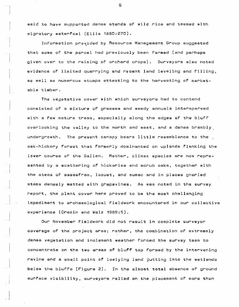
DESCRIPTION OF THE STUDY AREA AND REVIEW OF THE SURVEY FIELDWORK CONDUCTED IN NOVEMBER 1989:
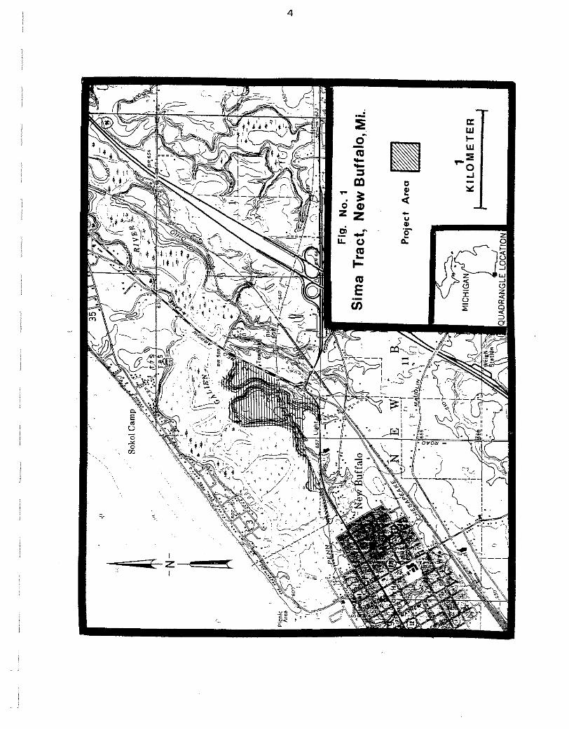
The research area consists of morainal uplands overlooking
the wetland-choked lower valley of the Galien River (formerly known
as "Lake Pottawattamie") in the SW 1/4 of Section 2 and extreme
SE 1/4, SE 1/4 of Section 3, New Buffalo Township, T8S R21W, Berrien
County, Michigan (Figure 1; here reproduced from the Phase 1 survey
report by Cremin and Walz 1989). Encompassing as estimated 70+
acres (28.3 ha), at the time of our visit in November (and this past
spring) this parcel supported dense second growth forest and fallow
field cover accessible to us by a recently constructed road lying_
between the marshlands flanking the river and the Penn Central Rail-
road right-of-way that almost bisects the morainal uplands from
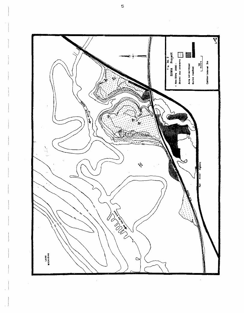
east to west (Figure 2; also reproduced from Cremin and Walz 1989).
The study area is further bisected north-south by a steep-sided
ravine that here carries water off the uplands to the river. The
maximum elevation above sea level exceeds 190 m at bluff's edge and
drops rapidly to an elevation of about 178 m ASL in the marsh west
of bluffbase. The elevation of the Lake Michigan shoreline, which
is here separated from the Lower Galien River Valley by a narrow
spit of sandy beach and dunelands rising almost 10 m above the river,
is 177m ASL (Figure 2).
Today the channel occupied by the Galien River meanders quite
strongly through a pristine marsh, whereas at the time of settlement
the lower course of the river for a distance of some 3.2 km above
its mouth was occupied by ''Lake Pottawattamier'. Filling the flood-
plain from valley margin to valley margin, this body of water is
~;)
··~ .I
"
-N- ~
Fig
. N
o.1
Sim
a T
ract
, N
ew
Bu
ffal
o, M
i ..
Pro
ject
A
rea
1 K
ILO
ME
TE
R
.1:>
" ~ ~
I .. • • ~
~ a !
• ! ~ ~
i l • ~
~-• w . ~
3
,~~
~ z , ; 0
.. ~ ; • • • ii
~ 0
II: ~ ' ;
D .
Cl)
3:: .. :l1
..!! ~ g
• ;;, •• •• .. •
6
said to have supported dense stands of wild rice and teemed with
migratory waterfowl (Ellis 1880:270).
Information pro~ided by Resource Management Group suggested
that soma of the parcel had previously bean farmed (and perhaps
given over to the raising of orchard crops). Surveyors also noted
evidence of limited quarrying and recent land leveling and filling,
as well as numerous stumps attesting to the harvesting of market
able timber.
The vegetative cover with which surveyors had to ·contend
consisted of a mixture of grasses and weedy annuals interspersed
with a few mature trees, especially along the edges of the bluff
overlooking the valley to the north and west, and a dense brambly
undergrowth. The present canopy bears little resemblance to the
oak-hickory forest that formerly dominanted on uplands flanking the
lower course of the Galien. Rather, clim~x species are now repre-
sented by a scattering of hickories and scrub oaks, together with
the stems of sassafras, locust, and sumac and in places gnarled
stems densely matted with grapevines. As was noted in the survey
report, the plant cover here proved to be the most challenging
impediment to archaeological fieldwork encountered in our collective
experience (Cremin and Walz 1989:5).
Our November fieldwork did not result in complete surveyor
coverage of the project area; rather, the combination of extremely
dense vegetation and inclement weather forced the survey team to
concentrate on the two areas of bluff top formed by the intervening
ravine and a small point of lowlying land jutting into the wetlands
below the bluffs (Figure 2). In the almost total absence of ground
surface visibility, surveyors relied on the placement of more than
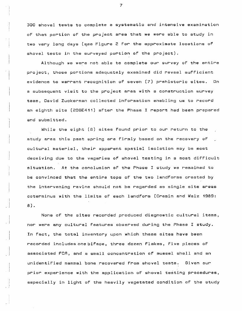
7
300 shovel tests to complete a systematic and intensive examination
oF that portion oF the project area that we ware able to study in
two very long days (~ee Figure 2 For the approximate locations oF
shovel tests in the surveyed portion oF the project).
Although we were not able to complete our survey of the entire
project, those portions adequately examined did reveal sufficient
evidence to warrant recognition of seven (7) prehistoric sites. On
a subsequent visit to the project area with a construction survey
team, David Zuckerman collected information enabling us to record
an eighth site (2DBE411) after the Phase I report had been prepared
and submitted.
While the eight (8) sites found prior to our return to the
study area this past spring are firmly based on the recovery oF
cultural material, their apparent spatial isolation may be most
deceiving due to the vagaries oF shovel testing in a most difficult
situation. At the conclusion of the Phase I study we remained to
be convinced that the entire tops of the two landforms created by
the intervening ravine should not be regarded as single site areas
coterminus with the limits of each landForm (Cremin and Walz 1989:
8).
None of the sites recorded produced diagnostic cultural items,
nor were any cultural features observed during the Phase I study.
In Fact, the total inventory upon which these sites have been
recorded includesonebiFace, three dozen Flakes, Five pieces oF
associated FCR, and a small concentration oF mussel shell and an
unidentiFied mammal bone recovered From shovel tests. Given our
prior experience with the application oF shovel testing procedures,
especially in light of the heavily vegetated condition of the study
8
area, we could not but regard our success in recovering this evidence
of prehistoric occupation as quite remarkable. And, furthermore, we
unhesitatingly conclyded that the data unearthed probably represented
the "tip of the iceberg" .. Therefore, while fully recognizing that
the project area and its population of archaeological sites, in the
words of the State Archaeologist, represented an unregulated resource,
we strongly encouraged the clients through their representatives at
Resource Management Group to permit additional study of these sites
in order that we might ascertain their spatial extent and determine
whether any cultural context (i.e. site integrity} remained preserved
below the surface.
DESIGNING AND IMPLEMENTING THE FOLLOW-UP INVESTIGATION:
In January of this year I was approached by David Zuckerman to
prepare a proposal for follow-up investigation of the resource
identified in November for submission to the clients of RMG and also
the State Archaeologist for his reaction and, hopefully, approval.
Typically, archaeological research undertaken to accomplish the
previously mentioned objectives involves the application of a
combination of intensive survey and limited testing procedures.
However, in this case, given the great difficulty the survey team
had encountered in dealing with the vegetative cover in the project
area, I and my associates regarded the use of ''standard'' Phase II
investiga~ive procedures as being inadequate to the task. We felt
that the sites previously recorded were not necessarily isolated
from one another and that our identification of eight individual
sites on the two landforms might reflect inadequacies in the Phase I
sampling strategy as we struggled to attain good survey coverage in
a most difficult situation. It was just possible that the spatial
9
distribution of archaeolOgical material was coterminus with each of
the two landforms. And we had only to contend with ''zero'' surface
visibility and plant_cover that in places wes simply too dense to
permit passage of a person to demonstrate that this was or was not
the case!
To test this assumption in the context of a Phase II program
of research, I proposed that we employ minimal machine stripping
of vegetation and topsoil along transects across the landforms in
conjunction with testing by traditional hand excavation methods
within areas delimited by positive shovel tests. The reaction of
all parties to this proposal was positive, and Zuckerman and I set
about the task of placing transects that were to range in length
from 195-425 m and traverse the two landforms from the Penn Central
ROW on the south to bluff's edge on the north and from the edges of
the ravine to bluff's edge on the west and to Red Arrow Highway on
the eastern limits of the study area (Figure 2). Furthermore, the
transects were also placed so as to pass through the areas where
positive shovel tests had resulted in the definition of seven sites
during our survey, as well as the site subsequently recorded by
Zuckerman on a later visit to the project.
A budget was prepared that provided for two days of machine
stripping under the supervision of Zuckerman and myself, together
with two senior crew members, followed by seven days of feature
recovery in the blade cuts and hand excavation of test squares
where deemed appropriate by a field party consisting of the pre-
viously named individuals. This budget was approved by the clients
of RMG, and on 9 Feb 90 a grant in the amount requested was awarded
to the university. Finally, in a letter to Zuckerman dated 14 Mar 90,
10
Or. Halsey and his StaFF at the Bureau or History indicated accep
tance or our Phase I survey report and the methodology proposed For
the Follow-up invest~gation.
Late in March, Zuckerman returned to the project area with Mr.
Ourwood D'Agostino, the individual who would be operating the heavy
equipment during the Phase II study. O'Agostino looked the area
over and informed Zuckerman that the dense vegetative cover would
make it virtually impossible to strip the transects as had been
proposed (i.e. without undertaking the massive task or systemat
ically clearing the entire area oF all but selected trees through
the use of much larger machines than we desired to have on the site).
Given the realistic limits placed on our activity by the pro 7
posed scope of work, we then turned to an alternative planw It Wi§!S
agreed that Zuckerman and D'Agostino would return with a brush-hog
that would allow them to selectively clean paths through the plant
cover for later stripping with a bulldozer. The clearing would be
conFined to the westernmost landform and would necessarily follow
the ''path of least resistance'' through the vegetation; yet it would
enable us to clear plants and strip the topsoil in the general areas
designated as sites as well as in the intervening space between site
loci.
The clearing of small trees and undergrowth with the brush-hog
provided irregular, discontinuous, and oFten curving rather than
straight paths which nonetheless gave 7 us access to the areas we wished
to examine. And on 18-19 Apr 90 four of us, together with the
operator and a 0-38 bulldozer equipped with an eight foot (2.4 m)
wide blade, returned to the study aree to commence stripping these
"transects".
11
The stripping operation generally proceeded quite smoothly,
with O'Agostino exhibiting considerable skill in removing topsoil
from the transects. rHowever, because extremely heavy rains had
fallen on the study area between the time of clearing and stripping,
he did experience some problems in controlling the depth to which
the blade penetrated as soil composition and moisture content
varied across the landform. In several areas of higher elevation
where sandy well-drained soils supported a grassy ground cover
beneath an open canopy (e.g. the areas of 20BE405 and 410), it was
possible to strip the topsoil in fine enough increments to permit
those supervising the operation to catch a glimpse of subsurface
soil staining usually within 20+ em of ground level. Elsewhere on
the landform (e.g. 20BE411), clayey soils proved more difficult to
strip by virtue of their wetter condition and the dense root systems
put down by the scrubby tree, bramble, and thicket cover more common
to such soils. Mare passes of the blade were required to provide
us with a cut through the topsoil clean enough to define soil stains.
But not before we had reached a depth of 30 em or, more typically,
35-36 em below the surface. Finally, in the case of 20BE404, the
paths cleared here for passage oF the bulldozer were found to be
in standing water. The soil was so thoroughly saturated that it
would not support the weight of the bulldozer; hence, this site
could not even be investigated. Figure 3 shows those areas on this
landform which were successfully cleared of topsoil during the
stripping operation.
CONCLUSION OF THE STRIPPING OPERATION AND COMMENCEMENT OF FEATURE EXCAVATION:
Stripping of the transects revealed a total of 46 patches of
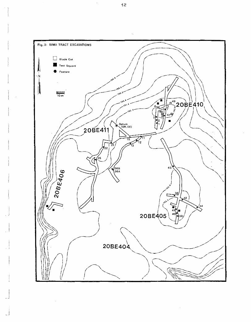
~ -N-
~ WIS :c·S!.::I SNOJlVAV::>X3 l.::>VIH V
13
dark organically stained soil in a matrix oF lighter colored sandy
or clayey subsoil. Upon careful examination, 22 were assigned
feature numbers. OF the remaining 24, a Few gentle scraps with
the shovel and/or trowel resulted in their disappearance. However,
given the depths below surFace at which the vast majority oF these
stain were observed, it is very likely that most also represent
cultural Features. That most oF them were exposed in blade cuts
in the area oF 2DBE411, where stripping typically terminated at
depths greater than was the case For either 20BE405 or 410, might
be interpreted to confirm our contention that many of these stains
represent Features too shallow to survive the stripping operation.
Following two days oF machine stripping and Feature deFiniti~n,
those members oF the crew who had participated in this phase oF tbe
investigation were joined by Four additional people For two days oF
intensive feature work. However, when the weekend oF 20-21 Apr
came to and end and the crew returned to WMU For Final exams, the
project map that is herein reproduced as Figure 3 had been largely
completed, .but only a handFul oF the large pits represented by
soil stains in blade cuts had been Fully recorded and more or less
completely excavated.
With the end oF Winter Semester, the crew, now having reached
its maximum size, returned once again to accomplish everything that
could be done in one week (Parenthetically, the annual WMU archaeo
logical Field school, involving some oF the project participants,
was scheduled to begin in the Following week, and other members oF
the crew were committed to leaving the area For Fieldwork elsewhere
in the Midwest.). We had originally planned to devote much oF this
week to traditional test excavation in areas oF the sites not
14
disturbed by stripping, but with 17 Features still exposed and
unexcavated in the blade cuts, most of the crew's attention was
directed toward retr!eving data from these recorded contexts
rather than seeking aut more features.
During the course oF the week, all features exposed by the
blade, with the singular exception of Feature 45, were excavated.
And we did manage to open 10 excavation units, one meter on a side,
as well. Two units on 208E406, near bluFF's edge overlooking an
extensive marsh to the west, produced no more in the way of goad
inFormation than had been observed in two short blade cuts nearby.
While some cultural items were collected From the cuts and the two
test squares, no tools or features were observed on this site.
Similarly, two test squares located on either side oF a blade cut_
in which three Features were exposed on the sandy knoll deFined as
208E405 produced little in the way oF useFul data. But on the
smaller knoll to the north, designated 208E41D, three oF six excava-
tion units revealed three additional pit Features. It is perhaps
noteworthy that while two Features on the crest oF this sandy knoll
were encountered just below the humus level at depths oF 22 em and
24 em, the third pit, located in a test square slightly downslope
oF the crest, appeared just below the topsoi 1, but at a depth oF 40 em
below the modern surFace.
In aggregate, our Phase II investigation oF the westernmost
landForm where prior survey work had resulted in the identiFication
oF Five sites, when sampled by means oF machine stripping and some
limited test excavation, has conFirmed the presence oF preserved
archaeological context in the Form oF subsurFace pit Features on
three oF these sites. Additionally, many cultural items, including
15
flintknapping debris, stone tools, some of which are typologically
distinctive, and an occasional potsherd, frequently associated
with pieces of fire-gracked rock, have been collected from blade
cuts both in close proximity to and at some distance from the 25
features recorded to date.
While the archaeological data presented in the following
section of this report constitutes a small assemblage, it is a
potentially informative one. By and large it is a data set col-
lected under extraordinary conditions; yet difficult field condi
tions did not adversely affect the controls over the recovery (and
analysis) of these data. In the treatment of features, the only
evidence far the preservation of context which these sites have so
far offered, standard recording and recovery procedures were care~
fully followed. It was mapped with respect to our project datum
(labeled ON, DE in Figure 3) and assigned grid coordinates that
represent the approximate center point of the feature as determined
from the plan view drawing. Following completion of plan view
drawings and photographs, each excavated feature was cross-sectioned
for removal of one/half of its contents and the fill passed through
6.3 mm hardware mesh. The exposed profile was then drawn and photo-
graphed and the remainder removed by soil zone in order that we
might make some meaningful statements about the depositional history
of fills and feature function. Standard 10 liter samples of each
soil zone were at this time collected for later processing by the
flotation procedure to ensure recovery of small-scale remains that
might shed light on the subsistence ecology of the users of these
prehistoric facilities.
But the bottom line with respect to our program of research
16
can perhaps best be summarized in this manner. While Zuckerman has
estimated that the landform on which our work was conducted occupies
an area of 24.7 acre~ (11.1 ha), the data collected by us have been
derived from a total area of only 2200 m2
(0.5 acre; 0.2 ha) that
has bean either machine stripped or hand excavated. Thus, our
sample of the entire area of this landform represents under 2.0%.
Perhaps more to the point, I would suspect that had we succeeded in
precisely delineating the spatial extent of any or all sites here
recorded, that portion of each examined in the manner described
previously would probably amount to even less!
FEATURES RECORDED FOR SITES 20BE405, 410, AND 411
William M. Cremin
As noted in the preceding section, a total of 25 subsurface
features representing facilities created and used by the prehistoric
residents of three sites constitute the only evidence for preserved
archaeological context (i.e. site integrity) derived from our Phase II
investigations. They are fairly evenly distributed between the sites,
with six recorded for 20BE405, nine for 20BE410, and nina for 20BE411.
Feature 45 is somewhat removed from the six pits recorded for the
knoll we have designated 20BE405, and has not been excavated, but
rather only recorded; yet for lack of a better alternative we are
including this as a seventh feature assigned to this site (sea
Figure 3 for the distribution of pit features).
These facilities vary little from site to site, as if to sug-
gast that the nature of activity (and presumably season of occupa-
tion) conducted on each was remarkably similar: This is not to say
17
that all features should be assigned to the same functional class
of facilities. For most assuredly, this is nat the case! Feature
morphology and the cgntents of feature fills point to these pits
having been used in different ways, notably as hearths and food
processing or storage facilities, prior to their having become
recepticles for camp trash. In the discussion which follows, I
will first present a brief description of those features that can-
not be so easily typed. Terms such as hearth or firepit convey
as much information about them as we can presently muster. But
for 17 of the features, which bear much in common, both in terms
of their morphology and contents, with facilities on a number of
late prehistoric sites investigated by us elsewhere in southwest
Michigan, we will propose a function that has important implicatipns
for our long-term research into the adaptive strategies of people
who were, at least in part, dependent upon agriculture for their
livelihood. These part-time nfarmersn also selectively exploited
natural food resources, deriving much of their sustenance from
plants and animelscommonto both aquatic and riparian habitats.
And a facility frequently used to process one or more of these
foods for consumption we have termed the ''deep roaster'' (Cremin
1980) .
FEATURES OTHER THAN DEEP ROASTING PITS:
Feature 1, located in a blade cut 3.0 m Nand 60.0 mE of the
project datum in the area designated as 20BE410, is a shallow pit
with an irregular floor that was encountered at a depth of 20 em
below surface. It extends to a depth of 13 em below the plane of
origin and in its longest dimension is 105 em. Only 90 em of this
pit's other dimension is exposed in the cut, but based on the plan
18
view only a very small area remained unexposed outside the scraped
surface. In the absence of FCR or a fuel zone and oxidized pit
wells and floor indigative of in situ burning, a Food processing
function cannot be proposed for this facility.
represent a shallow storage pit.
Rather, it may
Feature 25, located in the area of 20BE411 some 53.5 m 5 and
34.5 m W of datum, was encountered in a blade cut at a depth of
36 em below ground surface. This basin-shaped pit is 112 em X
122 em in plan and 48 em deep. It lacks the highly organic soil
staining noted for most of the features recorded, produced little
FCR, and evidenced no in situ burning. Redeposited fill did have
some of the usual sorts of camp trash observed in pit fills else-
where on these sites. Tentatively, we interpret this facility to
represent a thoroughly emptied processing or storage pit.
Feature 38, situated 107.2 m 5 and 85.0 m E of datum in the
area defined as 20BE405, in another shallow basin-shaped pit that
was exposed in a blade. cut. It was recognized at a depth of 23 em
below the surface and reached a maximum depth of 36 em below the
plane of origin. Oblong in plan, this pit measures 71 em X 115 em
and is notable for the almost total absence of organic material in
the fill. In fact., were it not for the greater moisture retaining
quality of its unconsolidated fill, this feature may well have been
overlooked during the stripping operation.
proposed for this facility.
No function is herein
Feature 39, occurring in this same area at a point 135.0 m S
and 89.5 m E of the project datum, is a conoidal pit consisting
entirely of a brownish-black fill mottled with sand and occasional
charcoal and pieces of FCR. Encountered in a blade cut at a depth
I
19
oF 30 "em below surFace, this Feature extends For an additional 50
em into the ground. In plan view Feature 39 is also oblong and
measures 86 em X 130 em. Its use prior to becoming a recepticle
For camp trash is uncertain, but a food processing and/or storage
Function seems likely.
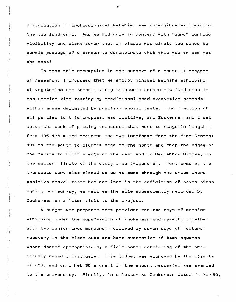
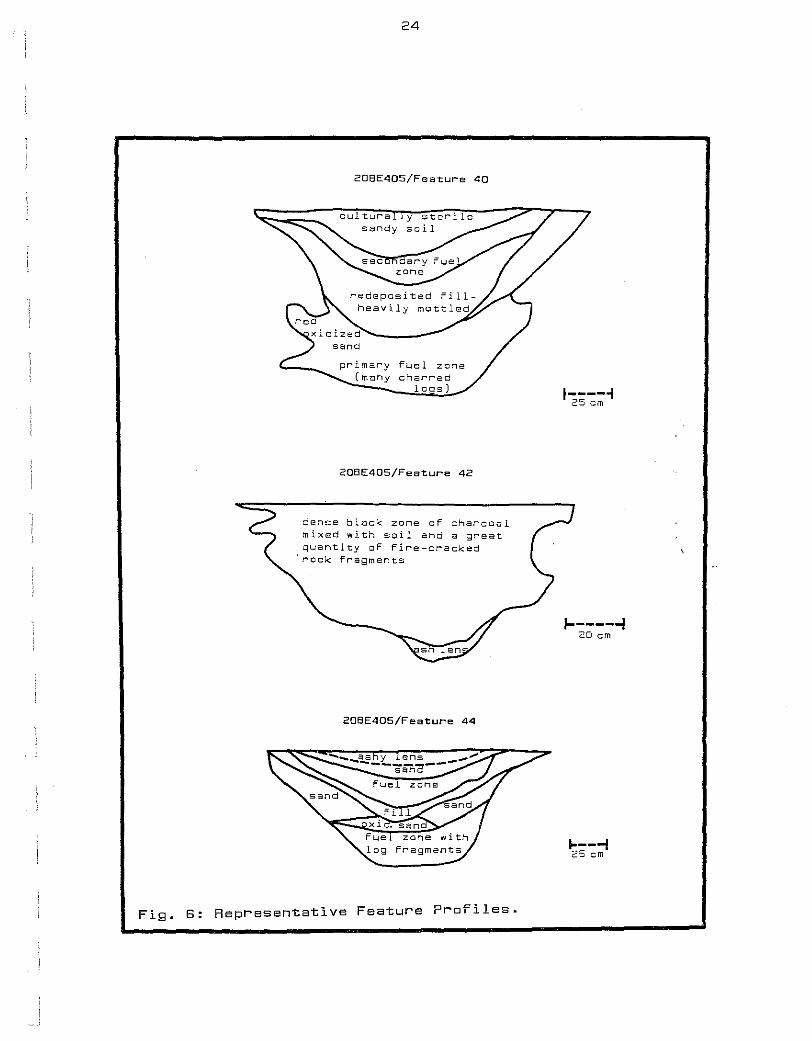
Feature 42 (Figure 6), again in the area oF 20BE405 at a dis
tance oF 112.4 m S and 97.2 m E oF datum, is a deep basin consisting
oF a homogeneous fill that is black in color and includes quantities
oF charcoal mixed with many large chunks oF Fire-cracked rock. At
the base oF this pit nearly 47 em below the plane oF origin in a
blade cut 30 em beneath the modern surFace, is an ash lens that
conForms to the rounded bottom oF the pit. Measuring 100 em X 108
em at the oriFice and Featuring irregular sloping walls, this
Facility is suggestive oF an earth oven in which indirect cooking
by means oF heated rocks took place. Certainly, in the absence oF
a distinct Fuel zone(s) and heavily oxidized soil, in situ Firing
such as characterizes the roasting pits can probably be ruled out.
The mixing oF fuel residues and FCR in the Fill suggests an episode
oF disposal oF debris From a surFace Fire where rocks were heated
near this facility; however, we did notobserveevidence for such
a Fire proximal to this Feature within the conFines oF the blade
cut.
Feature 45, observed in a blade cut approaching 20BE405 From
the north, cannot be included within the limits oF this site with
any degree oF conFidence. Rather, it is simply closer to the knoll
where this site occurs than to the other sites presently deFined on
this landForm. Located 68.8 m S and 87.0 m E oF datum, this pit
measures 126 em by 156 em in plan at a depth oF 29 em below surFace.
This stain shows dense concentrations oF charcoal with Flecks oF
20
burnt sandstone scattered throughout the stain as delineated by
shovel scraping. Feature 45 was not proFiled due to constraints
or time, but probing with the soil tester revealed that the very
homogeneous rill terminated a mere 9 em below the plane or origin.
It can be suggested that this very shallow basin most probably
Function as a hearth.
Feature 48 was encountered in Test Square 1 on 20BE410 at a
depth below surFace or 40 em and is located 17.1 m Nand 69.3 mE
or the project datum. When initially deFined, this soil stain
Featured moderately heavy concentrations or charcoal and FCR in
a dark soil matrix measuring 118 em X 148 em. Cross-sectioning
revealed a basin extending below the plane or origin For 39 em
~nd consisting or a single rill unit varying little in color and
texture from top to bottom. While this is clearly a rirepit, its
precise function has not been ascertained.
Feature 49 was round in Test Square 7 at a depth or 22 em
below the sandy knoll herein designated 20BE410 and is located
32.8 m N and 80.2 m E or datum. This pit measures only 75 em by
78 em in plan and extends to a depth below its point or origin or
only 16 em. Charcoal and ash were noted in the redeposited rill,
and the gravelly soil underlying it appears to have been oxidized
by exposure to heat. Given its small size and evidence for in
situ Firing, a hearth Function is proposed For this shallow pit.
DEEP ROASTING FACILITIES:
Seventeen (68.0%) or the Features identiFied on three sites
are herein assigned to a single functional class; they are "deep
roasters'' not unlike those reported in recent years by us for a
series of late prehistoric sites in this region. Rether than
21
discuss each Feature, in the paragraphs which Follow I will present
the salient characteristics of this class oF features, supplemented
by tabular and graph1c data (see Figures 4-6), and note those
observations pertaining to feature contents that suggest to us how
these pits were used.
These pits are circular to oblong or oval in plan, and while
some proFiles have been obscured by slumping walls (or Feature re-
use), all are basin-shaped to conoidal in cross-section and quite
deep relative to oriFice diameter. Pit widths For those For which
plan dimensions are Fully recorded range From 53 em to 180 em
+ (with a mean oF 111.5-29.9 em), and lengths vary between 78-200 em
ex ex
+ 135.8-32.6 em).
+
Width/length ratios range From 0.68-0.99
= 0.86-0.10). Depths below the plane of origin vary between
54-140 em (X + 88.4-19.7 em), and From the present ground surFace
- + they range From 89-180 em (X = 120.0-24.4 em) in depth. Complete
locational and metrical observations are provided in Table 1.
The observed variability in pit size ahd, to a much lesser
extent, cross-sectional Form contrasts markedly with the great
similarity oF contents. The typical proFile shows an uppermost
soil zone composed oF redeposited Fill containing varying amounts
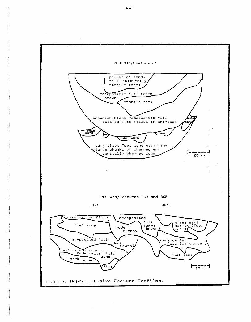
of camp reFuse (Figure 5, Feature 21) . Beneath this zone oF re-
deposited Fill there commonly occur concentrations oF oxidized
sand, either orange, red, or reddish-black in color. Occasionally,
this zone takes the Form of a continuous lens, but in most pits
oxidized or burnt sand is conFined to areas along pit walls
(Figure 4, Feature 4; Figure 5, Feature 21). Little or no cultural
debris occurs in the oxidized zone(s). The basal soil unit is also
culturally sterile and consists oF a jet-black, oFten greasy,
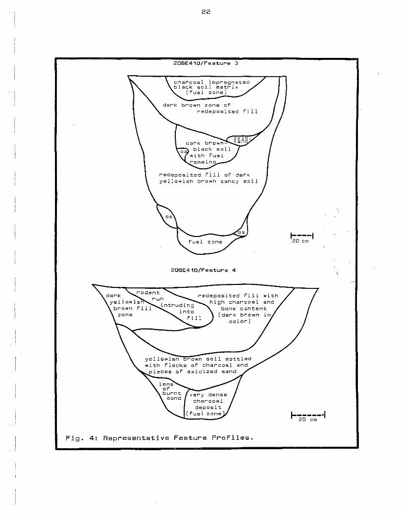
22
20BE410/Feature 3
charcoal impregnated black soil matrix
(fuel zane]
redeposited fill
redeposited fill of dark yellowish brawn sandy soil
2DBE410/Feature 4
redeposited fill with high charcoal and
bone content (dark brown
color)
Fig. 4: Representative Feature Profiles.
1----t 20 em
1------·1 20 em
23
208E411/Feature 21
packet of sandy soil (culturally sterile zone) ....
Fill (dark
fuel zone with many large chunks of charred and
partially charred logs
20BE411/Features 36A and 368
368 36A
Fig. 5: Representative Feature Profiles.
1----~--i 20 em
1----~; 25 em
24
208E405/Feature 40
20BE405/Feature 42
dense black zone of charcoal mixed with soil and a great quantity of fire-cracked
'rock fragments
2DBE405/Feature 44
Fig. 6: Representative Feature Profiles.
1-----1 25 em
1------1 20 em
~---i 25 em
Tab
le
1 :
Lo
ca
tio
na
l an
d
Metr
ical
Data
fo
r
17
D
eep
R
oesti
ng
P
its
on
2
0B
E4
05
, 4
10
an
d
41
1.
Featu
re
Sit
e/G
rid
D
ep
th
belo
w
Reco
gn
ized
W
idth
L
en
gth
W
/L
Ep
iso
des
Co
ord
inate
s
Su
rface
(em
) D
ep
th
(em
) (e
m)
(em
) R
ati
o
of
Use
2 4
10
/8.D
N
, 1
13
8
5
14
1
20
0
0.7
1
two
5
9.5
E
(b
lad
e
cu
t)
3 4
10
/12
.8
N,
18
0
14
0
12
4
12
8
D.9
7
three
59
.5
E
(bla
de
cu
t)
4 4
10
/26
.D
N,
? 8
6
14
5
15
0
0.9
7
Cin
e 6
2.5
E
(b
lad
e
cu
t)
6 4
10
/15
.3
N,
11
8
83
9
8
12
9
0.7
6
two
7
1.6
E
(b
lad
e
cu
t)
I ru
7
41
D/2
3.7
N
, 9
8
78
1D
2 1
30
0
.78
tw
o
Ul
74
.D
E
(bla
de
cu
t)
11
41
1/1
7.5
s,
1
23
9
3
14
2
14
5
0.9
8
two
3
5.D
E
(b
lad
e
cu
t)
12
4
11
/21
.5 s,
1
46
11
D
53
7
8
0.6
8
on
e
31
.0
E
(bla
de
cu
t)
13
4
11
/27
.0 s,
1
52
1
00
1
17
1
47
D
.8D
tw
o
20
.0
E
(bla
de
cu
t)
15
4
11
/17
.5 s,
1
46
1
16
7
6+
1
38
--
on
e
19
.0
E
(bla
de
cu
t)
Tab
le
1 '
co
nt.
Featu
re
Sit
e/G
rid
D
ep
th
belo
w
Reco
gn
ized
W
idth
L
en
gth
W
/L
Ep
iso
des
Co
ord
inate
s
Su
rface
(em
) D
ep
th
(em
) (e
m)
(em
) R
ati
o
of
Use
21
4
11
/27
.5 s,
12
1
8D
10
8+
1
23
--
on
e
9.0
w
(b
lad
e
cu
t)
22
4
11
/32
.3 s,
11
3
78
1
45
1
50
D
.97
o
ne
21
.3 w
(b
lad
e
cu
t)
36
A
41
1/6
7.7
s,
89
5
4
10
4
11
4
0.9
1
two
I 6
.5 w
(b
lad
e
cu
t)
36
8
41
1/6
6.5
s'
10
4
69
1
11
1
37
0
.81
tw
o
8.3
w
(b
lad
e
cu
t)
I N
4
0
40
5/1
33
.0 s,
1
00
8
0
15
2
18
0
0.8
4
two
m
8
8.3
E
(b
lad
e
cu
t)
41
4
05
/12
6.3
s,
11
D
9D
80
9
6
D.8
3
two
8
6.7
E
(b
led
e
cu
t)
44
4
05
/12
3.5
s,
9
8
76
1
50
1
80
0
.83
tw
o
11
7.D
E
(b
lad
e
(un
usu
al
in
cu
t)
that
the
up
perm
ost
fu
el
zo
ne
co
n:t
sin
ed
5
.0
kg
o
f F
CR
)
47
4
10
/17
.1
N,
10
9
85
8
3
84
0
.99
o
ne
82
.6
E
(Test
Sq
uare
2
)
27
carbonaceous sand thoroughly mixed with flecks of charcoal and
incompletely combusted logs (Figure 5, Feature 21; Figura 6,
Features 40 and 44)_
This zone of fuel residues usually lines the bottom of the
facility, but on occasion it may be underlain by a thin deposit
of oxidized sand or, as is the case with Feature 42 (Figure 6), a
concentration of ashy soil conforming to the rounded bottom of the
pit. Concentrations of ash have also bean observed taking the
form of a discontinuous lens capping the basal fuel zone in
Feature 21 (Figura 5).
It is further noteworthy that fire-cracked rock is exceeding
rare or absent From these features. The only exception to this
observation is Feature 44 (Figure 6), where a considerable number
of pieces of FCR were collected from the fuel zone near the top
of this pit and presumably represent a reuse of the facility. The
presence of FCR may signify that this feature during its second
episode of use did not Function in the manner For which the pit
was originally intended. Perhaps in its later use it had served
as a rock hearth placed in the shallow depression Formed when the
unconsolidated fill had become compressed and settled deeper within
the original excavation.
Feature 44 is not the only recorded instance oF reuse oF such
Facilities when, Following initial use and reFilling of the pit,
a shallow depression Formed aFter the soil had compressed and
settled. Eleven oF 17 roasting pits on the three sites display
multiple Fuel zones, with Feature 3 (Figure 4) evidencing three
episodes oF use of this Facility (see Table 1). Some site revisits-
tion and reuse of these Food processing loci over time is Further
28
is slso indicated by the psrtial intersection oF Features 36A and
36B (Figure 5); this is an observation that can only be accounted
for had one pit been excavated at some time prior to the other!
RADIOCARBON DATING THE FEATURES:
Because diagnostic lithic and ceramic artifacts were not
abundant on these sites and were rarely observed in feature context,
dating the Features by radiocarbon became imperative. This was
especially important for those Features classified as ''deep roasters''
on the basis oF their morphology and contents; For such pits were
well known to us from a series of Upper Mississ~ppian sites in
northwest Indiana and southwest Michigan assigned to the Huber and
Berrien phases, respectively, and, in the case of the latter, dating
to A.D. 1400-1600 (Cremin 1980, 1983, and 1989; Faulkner 1972).
And, Furthermore, while some Huber Phase sites in Greater Chicago-
land had produced Eerly Historic material in association with
objects oF Netive American manuFacture, no site assigned to the
Berien Phase has yet been shown to cross the threshold into history.
Thus, a major question emerging from our research was "Do the
sites in question, even in the absence of convincing artifactual
evidence, possibly date to the Berrien Phase? And to answer this
question we selected wood charcoal samples From one roasting pit
on each oF three sites For submission to Beta Analytic.
Wood charcoal samples oF approximately 50 g in weight were
collected From the basal Fuel zones oF Feature 4 on 2DBE410 and
Feature 21 on 20BE411 and From the secondary Fuel zone that we
interpreted to represent an episode oF reuse oF Feature 40 on
20BE405. The radiocarbon dates provided by the laboratory were
+ 350-60 years: A.D. 1600 (Beta-37615), + 210-50 years: A.D. 1740
29
(Beta-37616), and 310~70 years: A.D. 1640 (Beta-37617), respectively.
When these dates were subsequently corrected through use of the
program developed by-the University of Washington (Stuiver and Reimer
1986), the following calibrated ages were obtained:
Feature 4- multiple intercept calibrated ages of A.D. 1494, 1502,
15D6, and 16D5;
Feature 21-calibrated age of A.D. 1662; and
Feature 40-multiple intercept calibrated ages of A.D. 1529, 1556,
and 1634.
In other words, the three Berrien Phase-like roasting facilities
from our three sites ranged in age from the late 15th through the
mid 17th centuries. It now remained for us to firm up the assign~
ment of these features (and the sites on which they occur) to th~
Berrien Phase on other grounds before we could confidently extend
this late prehistoric cultural manifestation into Early Historic
times and perhaps even posit an ethnic identity for the Berrien
Phase people.
CERAKICS FROK SITES IN THE PROJECT AREA
Gregory R. Walz
Unfortunately, the small ceramic assemblage collected during
our Phase II research _program sheds little light on the question
posed above. During the course of machine stripping and feature
excavation, a total of: only 24 potsherds were recovered; seven
were retrieved from features and the remainder were collected from
blade cuts in various areas on the landform. For the most part
these are small body sherds, with little in the way of surface
treatment being visible. All are grit-tempered, and th~ majority
30
exhibit an orange colored paste. Only two specimens do not resemble
the majority in paste color. One of these, recovered from Feature
21, has a corkmarked exterior surface and is unique in that it bears
the impression oF a thumb or finger over the cardmarking. The paste
is also much darker in color than the other shards, being almost
black. In addition, there is a small sherd from Feature 22 that
appears to be of the same type, and it is here associated with the
only rimsherd that we recovered. This small rim is orange in color
and appears to bear two small notches Qr partial punctates as the
only decoration. The profile shows this specimen to be very slightly
bevelled, with the aforementioned decoration confined to the bevelled
surface.
While these ceramic specimens do not, in and of themselves,_
lend much in the way of interpretative potential to our analysis
of the data from these sites, they in no way contradict the late
Berrien Phase and/or Early Historic temporal placement of the
features from which the radiocarbon dates were obtained.
PRELIMINARY ANALYSIS OF THE PROJECT LITHIC ASSEMBLAGE
Daniel B. Goatley
The lithic assemblage from the project numbers 841 chipped
stone pieces and four ground stone tools (hammerstones) weighing
2.25 kg and was retrieved from all 25 features, eight of 10 test
squares, and blade outs and Phase I shovel tests located in the
areas of four of fives sites defined on this landform. While a
number of recovery methods were employed, mast specimens were col
lected from 6.3 mm hardware mesh during sifting of feature fill.
Most of the very small debitage was found in feature floats.
31
The analysis of lithia material from sites in the study area
involved a three-phase approach. First, all lithic items in the
assemblage were compared with type specimens of raw material From
known sources throughout the Midwest in order that we might better
understand patterns of long distance communication and transporta
tion resulting in the movement of this material from source areas
to the Lower Galien River Valley. The second involves placement
of the lithic debitage in appropriate stages of the reduction
process in order to gain some insight into the manner by which the
raw material reached the sites, the size and quantity in which it
arrived, and the kinds of tools which ware fabricated from this
material (Garland and Clark 1981:22-23). The final aspect of this
study focused on the artifacts, assuming that certain styles or _
forms, especially of the projectile points, might be assigned to
specific time frames; thus, diagnostic implements from the sites
in question have the potential to strengthen the temporal place
ment suggested by the series of three radiocarbon dates obtained
from selected features on 2DBE405, 20BE41D, and 2DBE411.
RAW MATERIALS:
Examination of the chipped stone from the sites investigated
during the Phase II study resulted in the identification of 22
specific types of chert and quartz in this assemblage. Of 841
pieces of lithic material, 487 (56.8%) have been identified to
raw material type (Table 2). These, in turn, can be broken down
by source into locally derived material found in till, outwash,
and streambed deposits throughout this region and nonlocal or
exotic cherts transported here from sources located elsewhere in
the Midwest. Sources for chert located outside of southwest
Tab
le
2:
Lit
hic
M
ate
r"ia
l fr
"om
th
e
Pr"
oje
ct
Ar"
ea
by
S
ou
rce
an
d
Red
ucti
on
S
tag
e.
Red
uct
ion
Sta
ge
Was
te
Dec
Pl
""i
Sec
Te
l""
Fr"g
B
lk
Oth
er"
To
tal
Wei
gh
t %
of
Co
un
t %
of
Wei
gh
t
-Att
ica
1 1
0.1
0
0.1
D
. 1
-Bay
po
r"t
2 2
17
24
3
1 4
9
27
.50
5
.8
2.5
-B
ur"
lin
gto
n
1 1
20
14
1
37
1
7.3
5
4.4
1
.6
-Heat
Tr"
eate
d
Bu
r"li
ng
ton
1
2 3
5.0
0
0.4
0
.5
-Co
bd
en
4 4
0.6
5
0.5
0
.1
-Cot
""de
ll
2 2
1 5
9.2
0
0.6
0
.8
-Fli
nt
Rid
ge
2 7
3 1
13
11
.65
1
.5
1 . 1
-K
ett
le P
oin
t 1
1 1
.10
D
. 1
0,1
-L
embr
"ix
5 7
13
10
4 1
2 4
2
40
.50
5
.0
3.7
-L
aur"
el
6 11
2
9
12
10
1 6
9
77
.95
8
.2
7.1
-M
elt"
"ose
3
3 12
7
4 2
9
23
.00
3
.4
2.
1 -M
oli
ne
1 1
1.1
0
D.
1 0
.1
-Nor
"woo
d 1
3 4
0.6
5
0.5
D
. 1
-On
on
dag
a 1
3 1
2 7
4.4
5
0.8
0
.4
-Pip
e C
t""e
ek
1 1
2 1
.55
0
.2
0.
1 -U
pper
" M
et""c
et""
1 2
3 2
8 16
8
.00
1
.9
0.7
I
w
-Wy
and
ott
e 1
1 7
10
1 2
22
2
3.9
0
2.9
2
.9
1\J
-Zale
ske
1 1
1 3
0.8
0
0.4
0
.1
To
tal
of
all
ex
oti
c c
her
t 2
3
27
9
8
101
49
2
8 3
08
2
54
.35
3
6.6
2
3.2
-Deerl
ick
C
t""e
ek
7 3
10
11
3 1
35
5
9.9
1
4.2
5
.5
-Oli
ve
3 1
4 7
.75
0
.5
0.7
-P
ur"
ple
1
1 2
2 1
1 8
32
.95
0
.9
3.0
-Q
uat"
"tz
1 1
0.5
0
D. 1
D
. 1
-Yel
low
..:W
hit
e 12
18
3
4
29
2
4
4 1
122
22
8.5
0
14
.5
20
.8
To
tal
of
all
lo
ca
l ch
e!""
t 2
0
22
5
0
45
2
6
5 2
170
32
9.6
1
20
.2
30
.1
-Un
iden
tifi
ed
5
9
26
7
9
140
44
6
9 3
63
5
12
.32
4
3.2
4
6.7
-I
den
tifi
ed
4
3
49
14
8 14
6 7
5
7 10
4
78
5
83
.96
5
6.8
5
3.3
TOTA
L 10
2 7
5
22
7
28
6
119
13
19
841
10
96
.28
1
00
.0
10
0.0
% C
F TO
TAL
12
.1
8.9
2
7.0
3
4.0
1
4.5
1
.5
2.3
1
00
.0
10
0.0
33
Michigan and identified in this assemblage are shown in Figure 7.
Locally derived raw material is represented by 170 pieces,
or 20.2% of the total assemblage. A small stream flowing south
of South Haven, Michigan and called Deerlick Creek is the only
precisely identified source for a good quality chert that is
named after this stream. The three other cherts and quartz
obtained locally by knappers could have been collected from till
and outwash deposits and found in streambeds throughout the
region.
Yellow-white chert represents both the most common local
material and the most abundant of all lithic debris comprising
the assemblage. Numbering 122 specimens, this chert accounts for.
71.8% and 14.5% of the lithic pieces, respectively. It has been-
observed to occur in the general area of the site and seems to
have a distribution coextensive with the coastal zone along the
western side of the state. In looking at Yellow-white chert
debitage, one was be especially careful in distinguishing natural
fractures from those produced by the knapper.
Exotic cherts in the assemblage from these sites number 17,
and they account for 36.6% of all lithic specimens. Sources
occur as Far away as New York on the east, southeastern Ohio,
southern Indiana, and southern Illinois to the south, west-central
Illinois on the west, and the Upper Peninsula of Michigan to the
north.
Laurel chert from east-central Indiana is the single most
common nonlocal raw material, numbering 69 specimens (8.2%),
followed by Bayport chert from the Saginaw Bay area (49 pieces;
5.8%), Lambrix chert from Oceania County (42 items; 5.0%), and
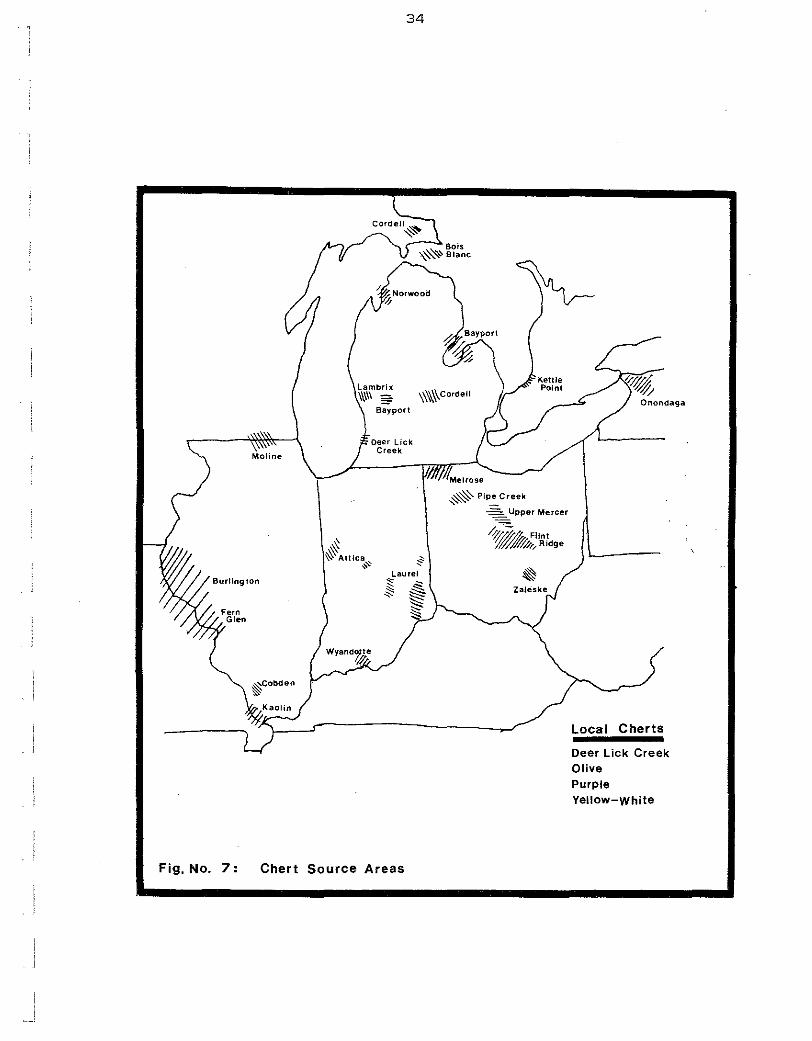
Fig, No. 7:
34
Lambrix \
.\\II\ = \\\\\\Co,dell [/ ---"' / Onondaga Bayport
~ ~Attica~ • ~
Laurel « -~ & ~ ~ ~ §
Chert Source Areas
~Pipe Creek ~ -
Upper Mercer
0--;»..4 FUnt ~~,,Ridge
~
Local Cherts
Deer Lick Creek Olive Purple Yellow-White