4.0 a ssociated property types
TRANSCRIPT

4.0 ASSOCIATED PROPERTY TYPES
4.0 ASSOCIATED PROPERTY TYPES The Associated Property Types for the DuPont Highway include commercial properties; institutional, recreational and governmental buildings and sites; agricultural properties; the roadway and associated buildings and structures; and residential properties. As mentioned earlier, the historic architectural investigation evaluated all properties located within the two study areas for the U.S. Route 113 North/South study that were visually dated or documented to date to before 1963. The National Register Criteria considerations permit nominations of properties less than 50 years of age if they are of exceptional importance to a community, a state, a region of the nation (Sherfy and Luce 1998). Because of the number of properties of the post-World War II period in the study area and their general lack of architectural distinction and historic importance, it is doubtful whether any properties from the 1956-1962 time period will be found to possess the exceptional importance necessary for National Register eligibility under Criterion Consideration G. Commercial Roadside Architecture A context for commercial roadside architecture was included in the Cultural Resource Survey of U.S. Route 113, Milford-Georgetown, Sussex County, Delaware (LBA 1992). This context included the following property types: auto support facilities, eating establishments, lodging, and “other” (roadside stands, miniature golf courses, and drive-in movie theaters). Relevant property types included in this document are referenced in this study. Because this context has been accepted by both the Department and the Delaware SHPO, its property types and registration requirements are employed in this investigation. Most or all of the property types identified in this context are found at some point along the DuPont Highway between Wilmington and the Maryland state line. Not all of the following property types are found adjacent to the highway, but nonetheless exist in the study area. Several additional property types were added to those identified in the LBA study based on preliminary field reconnaissance of the study corridor. 4.1 AUTOMOBILE FACILITIES The LBA study included three types of auto support facilities: service stations and auto parts stores, auto showrooms, and bus stations. Of these, only service stations are located in the current study areas. An additional property type, the independent garage, is also found in the study areas. 4.1.1 INDEPENDENT GARAGES During the early decades of the automotive era, motorists relied upon the filling station to provide gas and oil. When their auto required repairs, car owners generally turned either to the repair facilities being built by major automotive companies such as Packard for service on the cars they produced or to a host of blacksmith shops and independent garages. By the 1920s, the combined filling station and garage began to be widespread although independent repair garages remained and continued to be built (Liebs 1985:102). Most independent garages were simple buildings, rectangular in plan, built on a concrete slab with recesses for hydraulic lifts (Figure 16). For fire safety, most garages were constructed of
HISTORIC CONTEXT FOR THE DUPONT HIGHWAY, U.S. ROUTE 113, KENT AND SUSSEX COUNTIES, DELAWARE
30

���������������� ��
���������������
����������
�� � ���
�� � ���
��������
���������
���������
�������
�����
������
��� !"#
��������� ��� �������� ������������������� � ������ ���������������������������� !"
4.0 ASSOCIATED PROPERTY TYPES
concrete block. An office and parts room generally occupied one side of the building, while the remainder contained service bays. Vehicular access to the service bays was provided by roll-down doors in the front wall. As-built plans of the highway corridor from 1931 depicted five garages in the corridor between Georgetown and Milford, while 1947 as-builts showed two garages between Milford and Little Heaven. 4.1.2 AUTO SALVAGE With the growth in the number of automobiles, a particular type of commercial enterprise emerged in response to the automobile as a perishable commodity. Salvage yards offered a means by which unwanted vehicles could be discarded and portions be dismantled for reuse. Such salvage yards generally consist of sturdy, functional buildings surrounded by ample yards on which automobiles and automobile parts can be stored awaiting a purchaser. Automobile salvage firms obtain unwanted vehicles from automobile dealers, insurance companies, consumers or municipal pounds; sell usable parts from these automobiles; keep an adequate inventory of parts through substantial hulk accumulation; and remove outdated hulks to processing facilities. In 1968, an estimated 15,600 companies in the United States were engaged in auto salvage. Seventeen percent of these were one person operations, and 53 percent employed from two to five people (EPA 1972:31-32). The single automobile salvage yard in the study portion of the corridor, Fitzgerald’s Auto Salvage was founded in 1935 by John T. Fitzgerald on family property south of Milford (S-03941). The southern section of the main building was erected at this time (LBA 1992:50-51). 4.1.3 SERVICE STATIONS In the commercial roadside architecture context, the LBA study defines the prototypical service stations as a small brick building with a paved yard and four gas pumps on a city lot. Prefabricated and standardized gas station designs soon became more common. While oil companies often promoted the use of distinguished signage and color schemes, the form of the property type was essentially a “decorated shed” notable for the lack of ornamentation. Early service stations were often small, hipped roof, brick or wood-framed buildings with a front porte-cochere that sheltered the pump island. A detailed typology and history of the service station in the United States is contained in Jakle and Sculle’s The Gas Station in America (1994). The two earliest service stations in the corridor are both examples of Jakle and Sculle’s “house with canopy” type (Figure 17). In their discussion of this type, the authors wrote:
The addition of a canopy integrated into the roof of the small house or cottage produced another distinctive type of gasoline station….Standard Oil of Ohio pioneered a prefabricated prototype in 1916. The station was fifteen feet square with the canopy supported in front by a single post covering a similar area (Jakle and Sculle 1994:141).
HISTORIC CONTEXT FOR THE DUPONT HIGHWAY, U.S. ROUTE 113, KENT AND SUSSEX COUNTIES, DELAWARE
32
As-built plans of the highway between Selbyville and North Georgetown, drafted in 1930, show 11 service stations along the corridor, most located at intersections. As-builts of the portion of the

������
������������ ��������� ����� ��������� ������������������������������������ !"#
��������
�� � ���
�� � ���
�������
����������
�������
������
����
������
���� !"

4.0 ASSOCIATED PROPERTY TYPES
corridor between Georgetown and Ellendale, prepared in 1946, show seven filling stations, while six filling stations are shown in the portion of the corridor between Ellendale and Milford on 1948 as-built plans. 4.2 RESTAURANTS The LBA study included the following types of eating establishments: tearooms, diners, fast food chains, and drive-in restaurants. Only diners are represented by pre-1961 buildings within the current study areas. In addition, a bar or tavern is found on Route 113 between the Milford and Germantown-south study areas. 4.2.1 DINERS Although diners eventually became a roadside staple, the roots of the diner were in an urban context. The earliest diners, established at the turn of the century, were located near factory gates to serve quick, hot, home-cooked meals to factory workers. Diners, set up along roadsides, provided the same service to motorists that were offered to urban workers. By the 1940s, the original diner market was in trouble. Restaurants located in inner city industrial districts of cities such as Wilmington, Baltimore, and Philadelphia suffered the loss of customers as manufacturers relocated to suburban areas where land was cheap and abundant. Worse for the restaurant owners, many of these new plants included their own cafeterias (Hurley 2001:41). The diner industry changed in response to changing demographics and land use patterns. The new site was often on a major highway in the outskirts of a town or city where the diner could “play host to everyone.” In addition to serving hungry laborers, these new diners often served executives on their way to work, office workers on lunch breaks, and couples on their way to or from evening entertainment (Hurley 2001:42-43). The name and form of the diner was derived from the railroad dining car. Like its predecessor, the original diner was portable and could be erected on any suitable lot (LBA 1992:294-295). The classic diner, with its stainless steel exterior and interior, prefabricated by a series of manufacturers, was often the first building on a lot. As a diner grew in popularity, this building was sometimes replaced by a larger, more permanent restaurant, an addition was attached to the original block, or the original diner was encapsulated in later construction. Through the 1940s, many diners placed their units flush against the sidewalk, anticipating that most customers would arrive by foot. By the 1950s, the diners made accommodations to better serve automobile-bound patrons, often resembling islands set within seas of concrete. Early hand-painted signs were replaced by huge signs raised on pylons that could be read from afar and at high speeds. Diner designs in the 1950s reflected the spirit of the times. Exterior floodlights illuminated stainless-steel siding, angled metallic canopies, and large plate glass windows. The small counter area was subordinated to the spacious dining area as diners grew larger to accommodate more tables and booths (Hurley 2001:56, 66-67).
HISTORIC CONTEXT FOR THE DUPONT HIGHWAY, U.S. ROUTE 113, KENT AND SUSSEX COUNTIES, DELAWARE
34
4.0 ASSOCIATED PROPERTY TYPES
4.2.2 FAST FOOD RESTAURANTS In his book Main Street to Miracle Mile, Chester Liebs traces the beginnings of the fast food restaurant to about 1939 when two ex-New Englanders, Maurice and Richard McDonald, opened a drive-in restaurant in San Bernardino, California. To increase profits, the brothers pared down service and menu to an absolute minimum. By 1952, the brothers were producing an estimated one million of their fifteen-cent hamburgers and 160 tons of ten-cent portions of French fries per year in their 192-square foot food factory. Improvements in assembly-line techniques and rigid standardization permitted this high output. By the early 1950s, the brothers began to open a small number of other McDonald’s in Arizona and California. Soon after, Ray Kroc, a former Lily Cup salesman convinced the brothers to allow him to franchise their concept nationwide. Kroc commissioned a standard building design from architect Stanley Meston. Assisted by staff architect Charles W. Fish and in close collaboration with the McDonald brothers, Meston developed one of the mid-twentieth century’s most recognizable architectural icons: a building with an overhanging slanted roof, visual front, wall panels decorated with red-and-white striped tile and the flanking golden arches. By 1960, 200 McDonald’s restaurants had been erected around the country (Liebs 1985:212-213). While McDonald’s was the earliest major national fast food chain, others soon followed suit. Kentucky Fried Chicken, begun by Harland Sanders at Corbin, Kentucky, grew to 200 licensed restaurants by 1960 and 600 by 1963 (Jakle and Sculle 1999:219-220). Burger King, established in the 1950s by Matthew Burns of Long Beach, California, and his stepson, Keith G. Cramer of Daytona, Florida, had grown to 274 units by 1967 (Jakle and Sculle 1999:117). Hardee’s, begun in 1960 by Greenville, North Carolina restaurant owner and fry cook Wilber Hardee, grew to 300 restaurants by 1972. Wendy’s, established by New Jersey native R. David Thomas, grew to 407 units by 1976 (Jakle and Sculle 1999:123, 127-128). These chains typically located their restaurants on heavily traveled regional thoroughfares on the outskirts of downtowns. The building and sign were the trademarks of each fast food chain, making the particular restaurant instantly recognizable to the highway traveler. 4.2.3 BARS OR TAVERNS The field reconnaissance revealed that there are no pre-1963 resources of this type within the two study areas. However, there is a bar/tavern on Route 113 in the corridor preservation area between the assigned Milford and Georgetown-South study areas. This historic building, Teddy’s Tavern, is listed in the National Register. Generally single story buildings of functional construction, twentieth century bars and taverns often feature a neon sign advertising a featured brand of beer. The buildings are often located close to the roadside and feature adjacent parking. In more densely settled areas, some of the buildings are the product of residential conversions. Teddy’s Tavern is a well-preserved example of a World War II-era roadhouse, a tavern located on a heavily traveled automotive route.
HISTORIC CONTEXT FOR THE DUPONT HIGHWAY, U.S. ROUTE 113, KENT AND SUSSEX COUNTIES, DELAWARE
35

4.0 ASSOCIATED PROPERTY TYPES
4.3 LODGING The LBA study included the following lodging property types: tourist camps, tourist cabins and cabin courts, and motels. Tourist cabins and cabin courts and motels are found in the study areas. 4.3.1 TOURIST CABINS AND CABIN COURTS Initially, automobile travelers often had to rely upon campgrounds for overnight accommodations in rural areas. Around 1920, some campground owners began to build cabins for travelers who desired more comfortable and private accommodations. As the idea caught on, cabin operators provided beds and linens for travelers. Facilities were expanded and upgraded further during the Depression as former hotel patrons turned to lower-cost cabin camps for their lodging. A one-stop facility grew in popularity containing cabins, gas station and restaurant. The office, manager’s quarters, and restaurant were typically located in a single building at the center of the parcel. By 1934, an estimated 32,000 camps serving 30 million travelers had been erected around the country (LBA 1992:297-298). 4.3.2 MOTELS The motel evolved when lodging providers began to erect a single U-shaped building instead of individual cabins. This method allowed construction of more units at reduced cost and construction time. Motels generally offered the same accommodations and amenities as cabin courts and often included an on-premises restaurant and/or filling station. The largest boom in motel construction occurred following World War II. In 1939, there were about 13,000 motels nationwide. By 1948, that number had doubled, and the number of motels reached 41,000 by 1952 (LBA 1992:299). Heather Lynn Yost includes an evolutionary typology of motels or motor courts in her study of motels on U.S. 40 in New Castle County, Delaware and Cecil County, Maryland. The immediate forerunners of the motel were downtown hotels of cities and small towns which flourished during the late nineteenth and early twentieth centuries; auto camps and tourist homes, which became popular during the 1910s and 1920s; cabin camps which flourished during the 1920s to 1940s; and cottage courts, popular during the period from the 1930s to the late 1940s. By the 1950s, the motor inn emerged, primarily in metropolitan areas. This new lodging form was substantially larger and more luxurious than the motor court or motel. It has been largely superseded by the highway hotel, a multistory boxes with interior corridors and public spaces concentrated on the first floor (Yost 2003:34-48). In his study of motels, Michael Karl Witzel describes the characteristics of a “motor court” or first generation motel:
These were long, low, one-story buildings that shared a common air-conditioning plant, plumbing system, and foundation (slashing the total construction costs). The individual garages of the old cottage days were dropped in this design, since the square footage they added resulted in extra costs in material and construction. In the long run, it was much cheaper to pave a large parking lot and direct visitors to park in front of their rooms.
HISTORIC CONTEXT FOR THE DUPONT HIGHWAY, U.S. ROUTE 113, KENT AND SUSSEX COUNTIES, DELAWARE
36

4.0 ASSOCIATED PROPERTY TYPES
To give overnighters the illusion they were still renting out an individual room and not just a tiny chamber in a rabbit warren, architects added new styling details. One of the most widely used visual tricks was the addition of an overhead portico at each entry door. A miniature recreation of a pitched roof, it highlighted each room as being separate, conjuring up a homey feel. Later, this feature was simplified even further when the pitched roof aspect was dropped. Designers created the same effect by attaching a small, flat overhang above the door (Witzel 2000:85, 87).
A typical motor court was arranged in a U-shaped plan with the office and owner’s apartment at one end, a courtyard in the interior of the U and parking spaces at the rear of each unit (Jakle, Sculle and Rogers 1996:46). The courtyards functioned as informal outdoor lobbies and were often the location of an in-ground swimming pool (Yost 2003:44). Other motor courts were arranged with linear or L-shaped room arrangements. Rooms became increasingly standardized with furnishings purchased from supply houses specializing in hotel and motel outfitters (Jakle, Sculle and Rogers 1996:47). Jakle, Sculle and Rogers developed a graphic typology of motel construction in their book on the subject (Figure 18). 4.4 OTHER The LBA study included the following other property types: roadside stands, miniature golf courses, and drive-in movie theaters. Of these, roadside stands are found in the current study areas. 4.4.1 ROADSIDE STANDS As noted by LBA (1992) in their commercial roadside architecture context, roadside stands were among the earliest and most prevalent features of the automobile era, as local farmers set up small stands along the side of the road to sell goods to passing motorists. Roadside stands were generally simple, wood-framed sheds erected along the side of the road, perhaps including a few off-street parking spaces. Some stands were more elaborate and rested on concrete foundations and had window and door openings. Merchandise available at the stands varied. Many were limited to excess produce that a farmer or gardener could not consume and did not wish to sell at market. Other stands sold cold drinks, as well as ice cream or sandwiches, while some stands sold post cards and souvenirs. Some stands evolved. A farm stand originally selling only produce might begin to carry cold drinks and later add sandwiches. Soon seating was added and in some cases: gas pumps were erected as well (LBA 1992:301). 4.4.2 INSTITUTIONAL, GOVERNMENTAL AND CORPORATE PROPERTIES In the pre-automobile era, institutional, governmental, and industrial property location was governed by several factors: accessibility to roads, accessibility to power, and accessibility to points of shipment. For example, grist mills were generally located adjacent to rivers and streams that could be dammed to provide power for operation. Proximity to a roadway was also important to facilitate transportation of the flour and meal to consumption or sales points. Governmental facilities were placed in a central location in the jurisdiction, often at a major crossroads to HISTORIC CONTEXT FOR THE DUPONT HIGHWAY, U.S. ROUTE 113, KENT AND SUSSEX COUNTIES, DELAWARE
37

������������ ���� �� ������������� �������������� ��������� �� ��� ������������������������������������������� �������� !

4.0 ASSOCIATED PROPERTY TYPES
facilitate travel to them. The desire for a centrally located county seat led to the establishment of Georgetown and the relocation of the Sussex county seat from Lewes. Church and schools were placed along roads in a position centrally located to the community they served. With the development of water transportation, factories were often located along navigable waterways, both to provide steam for machinery and an adjacent corridor for shipment. In more recent years institutional and governmental buildings have been constructed along major highways to permit ease of access and alternatively to promote growth and development. Institutional and governmental property types represented along portions of the length of the highway include governmental buildings, churches, some with associated cemeteries, and independent cemeteries. Governmental facilities located within the current study areas include a DelDOT district office (Georgetown), a State Police barracks (Georgetown) and a prison (Georgetown). The prison contains components that pre-date 1963. Two major institutional properties are found in the study areas: the Stockley Center and the Sussex Correctional Institution. The Stockley Center, original known as the Delaware Colony, was established in 1921 on a 1,000-acre tract as the state institution for the developmentally disabled. In 1938, it had about 400 residents, mostly children, and its plant included administrative offices, training shops, a laundry, an infirmary, and a truck and dairy farm. The Stockley Center is now the state’s only facility licensed as an intermediate care facility for people with mental retardation. In 2002, its resident population was 179. Most of the buildings visible from Route 113 are residences built of rusticated concrete block in the bungalow style (Delaware Health and Social Services 2002:4; Eckman et al. 1938:385). The Sussex Correction Institution (S-00210), a maximum, medium, and minimum security prison for men with associated boot camp was established in Georgetown in 1931. For much of its history, it was one of two farms in the Delaware correctional system with a total of 250 acres in agricultural use. Among the products of the farm were truck crops, grain, milk and pork products. Some original or historic exterior fabric is visible from Route 113. Its present appearance largely reflects a major expansion undertaken between April 1997 and April 2000 that raised prison capacity to 1,206 (Department of Correction 2004; State Board of Corrections 1963:43-44). Several churches are located in the current study areas. None of these churches appears to have been constructed prior to 1963. Several cemeteries are also present in the study areas. These cemeteries are of two types, religiously or fraternally-affiliated cemeteries and independent cemeteries. An example of the former is the Odd Fellows Cemetery located in Milford. This cemetery, located on a flat parcel of land on the east side of Route 113 consists primarily of linearly arranged, recently erected markers. An example of a small independent cemetery is located on the east side of Route 113 south of Milford. This cemetery, established in the nineteenth century, consists of irregularly arranged markers of various erection dates. 4.4.3 RECREATION Several recreational facilities are located within the study areas. Two, the Milford Lanes bowling alley and Seacoast Speedway in Stockley, were probably erected to take advantage of Route 113
HISTORIC CONTEXT FOR THE DUPONT HIGHWAY, U.S. ROUTE 113, KENT AND SUSSEX COUNTIES, DELAWARE
39

4.0 ASSOCIATED PROPERTY TYPES
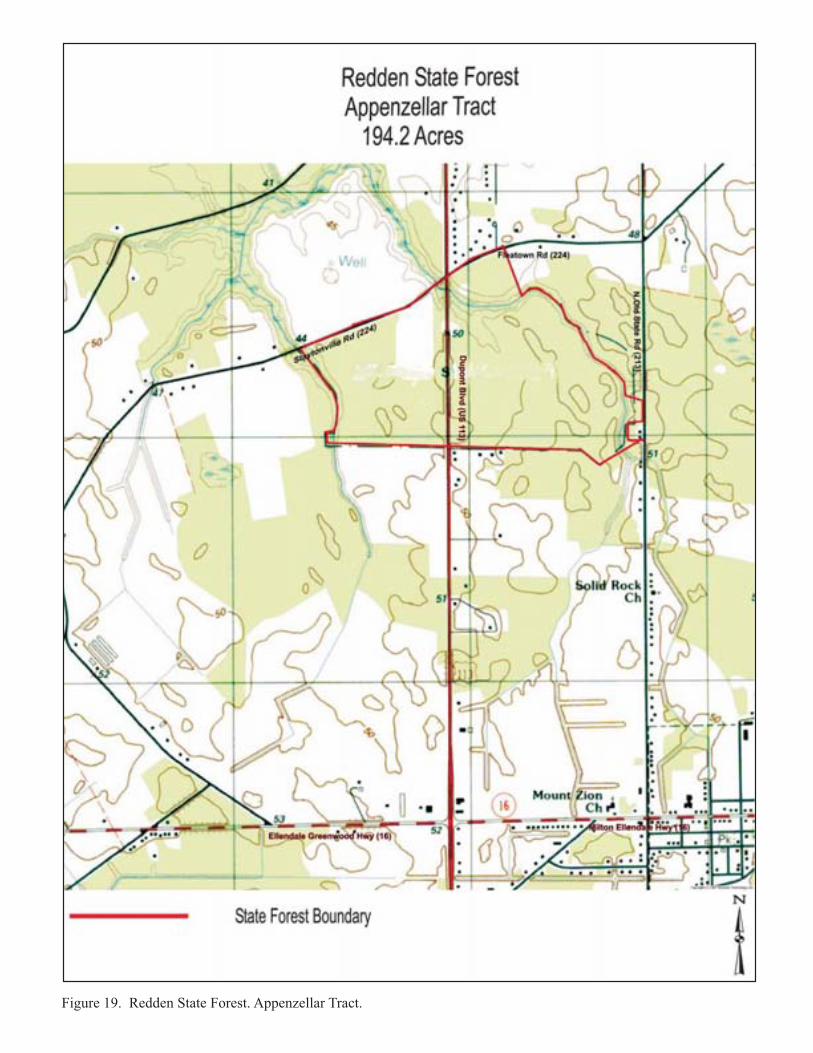
frontage. The third, two units of Redden State Forest, extend to either side of Route 113 between the Milford and Georgetown South study areas. In the years following World War II, increasing numbers of Americans began to bowl as a leisure activity. One reason for the increased popularity of the sport was the introduction of the automatic pinsetting machine during the 1950s. No longer were patrons at the mercy of often rude pin boys, and games could progress more quickly. By 1961, the number of bowling alleys in the United States had grown to over 10,000. Bowling establishments of the 1950s were promoted as centers of family fun where the entire family could gather outside the home (Berk and Simple n.d.; Hurley 2001:139, 159). The Milford Lanes (K-07544) was typical of such post-World War II lanes erected to provide family entertainment for residents of the local area. Seacoast Speedway (S-11019) is located behind a board fence on the east side of Route 113 south of Woods Branch Road (231). It presently consists of ½- and ¼-mile semi-banked clay ovals. Originally known as Georgetown Speedway, it has been the site of both stockcar races and drag races. Part of the National Dirt Racing Association circuit, races were last held at the track in 2000. It was most recently used for a short-lived outdoor concert series. The original ½-mile dirt oval was opened in March 1950 and was used periodically until 2000. Built by Melvin Joseph Construction, it was originally designed to become part of the NASCAR circuit. When that idea fell through, it was used as a track for local racers. The ¼-mile dirt oval was added in 1971 and was also used periodically until 2000. A ¼-mile paved dragstrip was used in 1956 and 1957 when the facility was known as Delaware Speedway, and a 1/8-mile paved dragstrip was used in 1962 and 1963 when the facility was known as Stockley Speedway (New Jersey Dirt Racing 2004). The Delaware Forest Service manages its state forest holdings for a variety of objectives including timber production, wildlife habitat enhancement, forest management demonstration, and outdoor recreation (Delaware Forest Service 2005). The State Forestry Commission began the acquisition of property along the DuPont Highway south of Milford in the 1920s. In the spring of 1928, the Commission purchased a three-acre plot and leased an additional acre five miles south of Milford and adjacent to Hudson Pond as a nursery site. The land was cleared and seeds were sown for a variety of forest trees, chiefly loblolly pine, red pine and white pine (State Forestry Commission 1930:9-10). This land remained the State Forest Tree Nursery supplying tree seedlings to both public entities and private landowners until the late 1960s when widening of Route 113 resulted in the taking of a portion of the nursery. It was then relocated to the nearby Appenzellar Tract (State Forestry Commission 1968:9). The corridor protection zone between Milford and Georgetown adjoins two units of the Redden State Forest, the 194.2 acre Appenzellar Tract and the 1494.25 acre Ellendale Tract (Figures 19 and 20) of Redden State Forest. The initial portion of the former tract, measuring 45 acres and lying on both sides of the DuPont Highway about a mile south of the State Forest Tree Nursery, was purchased by the State Forestry Commission for $100 on December 29, 1927. A portion of the area was thinned and pruned the following August and September (State Forestry Commission 1930:12). The second tract, once known as Ellendale State Forest, had its genesis in a 40-acre tract in the heart of Ellendale Swamp transferred by the State Highway Department to the State Forestry Department in 1932. The Forestry Department’s original plans for the land included planting HISTORIC CONTEXT FOR THE DUPONT HIGHWAY, U.S. ROUTE 113, KENT AND SUSSEX COUNTIES, DELAWARE
40
��������������� ������������������ ������������

��������������� ������������������ ����������

4.0 ASSOCIATED PROPERTY TYPES
vacant areas of abandoned farmland the following year, brushing out existing roads and trails, and erection of campsite facilities on that portion fronting the DuPont Highway (State Forestry Commission 1932:15). By the following year, the Department had completed a Class B public campsite by grading and cleaning up the land, erection of two latrines and roofed picnic tables, installation of drinking water facilities, and construction of a stone and concrete fireplace (State Forestry Commission 1933:19). During subsequent years, both tracts were managed as forests, trails were added to facilitate public access, and additional parcels were added to each tract. In 1938, the Forestry Department purchased three tracts, of 302, 94 ¾, and 6 ¾ acres of the Ellendale Swamp on the west side of the DuPont Highway for incorporation into Ellendale State Forest (State Forestry Department 1938:10). In the following year, the Ellendale Forest again grew with the acquisition of the 79.83 acre Burton Tract to its south. With these acquisitions, the forest totaled 450 acres. Also in 1939, the roadside picnic area (listed in the National Register) was improved by addition of a rustic picnic shelter and stone incinerator (State Forestry Department 1939:13). By 1947, Ellendale had grown further to encompass a total of 752 acres, 620 acres owned by the Forestry Department and the remainder owned by the State Highway Department. Work in the forest during the year included about 1 ½ miles of trail construction and roughing out of an additional half mile lateral trail (State Forestry Department 1947:13). Additional changes to the forest occurred in the 1950s. In 1950, the latrines in the picnic area were declared unsatisfactory and were removed. In 1952, two tracts of 240 acres were added to the forest. In the same year, wood stock pumps were replaced by cast iron pumps in an attempt to eliminate contamination (State Forestry Department 1950:9, 1952:8.). In 1953, a trail was extended and a creosoted timber bridge was built to provide access to the newly acquired parcels. A new well was drilled at the picnic area to reduce contamination (State Forestry Department 1953:12-13). In 1956, a second picnic site had been established in the forst, and three new picnic tables were added at the original site (State Forestry Department 1956:9). In 1963, two tracts were added to the forest, the first of 20 acres adjoining other lands, and the other of 134 acres northwest of the forest. With these acquisitions, the forest totaled 1223 acres. A new trail was built to provide access to the larger of the two newly acquired tracts (State Forestry Department 1963:6, 8). The Appenzellar Tract grew more slowly. In 1965, 83 acres of cutover woodland and abandoned farmland was added to the north and east sides of the tract by land purchased from Carey D. Sapp of Georgetown. Plans were for this land to be converted from low value hardwoods to pines. During 1968, two additional tracts were added. The first, the 58-acre Harry Frankel property, was located west of the tract boundary. Twenty additional acres were added in December 1968 (State Forestry Department 1968:7). 4.4.4 RESIDENTIAL-COMMERCIAL CONVERSIONS A typical evolutionary pattern on major transportation routes involves the initial construction of residences on lots in proximity to existing towns and cities. As traffic increases and roads are widened and improved, the house site becomes viewed as less suitable for residential use. The zoning of the property is changed. The former residence is converted to commercial use. Some residences, converted to office use, undergo a relatively modest level of alterations, often only the replacement of doors and windows. The former front yard may be partially or totally paved and converted to parking. Other residences, converted to retail or light industrial use, HISTORIC CONTEXT FOR THE DUPONT HIGHWAY, U.S. ROUTE 113, KENT AND SUSSEX COUNTIES, DELAWARE
43
4.0 ASSOCIATED PROPERTY TYPES
undergo more substantial alterations including the erection of a new block equal to or exceeding the size of the residence. In many areas, residential-commercial conversion represents an intermediate land use stage. A subsequent stage consists of the assembly of a number of smaller parcels, several of which may have been the site of residential-commercial conversions. The existing buildings are then demolished and replaced with a more intensive use such as a strip shopping center, big box store, office building, or apartment complex. 4.4.5 INDUSTRY Because of dependence on motor freight transportation, many industrial facilities choose to locate on or in proximity to major highways. Several types of industrial facilities were historically or are currently located within the study areas. 4.4.6 LUMBERING The extensive forests of inland southern Delaware represented an important resource first harvested by settlers to the region in the eighteenth century. Early on vast stands of cypress in the Great Cypress Swamp near Millsboro were harvested for hand-hewn shingles. During the century from 1750 to 1850, large volumes of white oak were logged in Delaware for local shipbuilding, much of it in Milford, or for export to Holland, Sweden, and England (NFES 1959:1). From 1869 until the 1950s, Delaware’s lumber production averaged 25 million board-feet per year (Edmonson 1978). In the 1890s, two large lumber mills began operation in Millsboro. Members of the locally prominent farming family, the Houstons, were principals in each mill. The company that eventually prevailed was the Houston-White Company whose managing partner was William J.P. White. The company continued as Millsboro’s largest industry until the 1950s (Carter n.d.; NFES 1959:3). By the early twentieth century, the leading forest species of southern Delaware were the loblolly (Pinus taeda) and scrub (Pinus virginiana) pines. A large proportion of these trees were grown in woodlots on farms rather than in designated tree plantations. Loblolly pines, a fast growing member of the yellow pine family, obtains a height of 60 to 70 feet and a diameter of three feet. Its wood was principally used for lumber, piling, mine props and fuel. Scrub pines typically reach a height of 40 to 50 feet and a diameter of 18 inches. Its wood was principally used for mine props, piling lumber, paper pulp and fuel. (CCFD 1927:8-9, 18-19, 27-30). In the late 1950s, a total of approximately 400,000 forested acres were found within the state. A majority of this land, 252,000 acres, was located in Sussex County. In 1956, sixty percent of the forest products taken from Delaware forests was used for lumber. Seventy percent of this total was softwood—almost all of it pine. While most of the sawmills in northern Delaware were stationary, most of those in the southern portion of the state were portable, moved frequently from location to location as stands were harvested (NFES 1959:4). The remaining major forest products included pulpwood (13% of the total), wood pilings (9 percent of the total), and basket veneer (5 percent of the total). The final 13 percent was divided among fuel wood, fence posts, mine props, and other small scale uses. Because Delaware had no pulpwood mills, the southern yellow pine harvested for this purpose was shipped out of state,
HISTORIC CONTEXT FOR THE DUPONT HIGHWAY, U.S. ROUTE 113, KENT AND SUSSEX COUNTIES, DELAWARE
44
4.0 ASSOCIATED PROPERTY TYPES
most to tidewater Virginia and western Maryland. Three basket-veneer mills operated in Delaware (Edmonson 1978; NFES 1959:4-7). No remnants of the formerly important Sussex County lumbering industry remain in the study areas. 4.4.7 CANNING Prior to the invention of modern refrigerators and freezers, preserving food for substantial periods of time proved difficult. The process of canning fruits and vegetables was first developed in France in the early nineteenth century. By the mid-1800s, canning had become a popular method of preserving food in much of the United States. Delaware’s first cannery opened in 1846 when Read Gordon of Port Penn, New Castle County, began canning peaches. In the 1870s, Delaware canneries began processing vegetables, as well as fruits. By the 1870s and 1880s, the development of new technology such as large pressure cookers, as well as the mechanized harvest of crops, led to a boom in the industry. In 1890, almost 6,000 acres of land in Sussex County was devoted to the cultivating of tomatoes. Much of this crop was canned (Doerrfeld, et al. 1993:11). In the early twentieth century, vegetable canning was an important component of the economy of southern Delaware. By 1910, the canning industry in Delaware included 300 processing plants employing one-quarter of the state’s labor force. Delaware’s canneries flourished until the 1940s when new methods of food preservation, such as freezing, and competition from California and other warm weather states, caused a decline in the state’s canning industry. Among the leading crops canned in Sussex County was the tomato. By 1910, even small villages in the Delmarva had canneries. Because these canneries operated for only about four weeks during the year, temporary gangs of laborers were often brought in from beyond the Delmarva peninsula to operate the plants (Williams 1998:4). Though some canneries were little more than a shed, the typical cannery was a two-story building. Within the building, specific areas were designated for making cans and processing food. Canneries were often located near railroads so that goods could be placed in wooden crates and shipped quickly to market (Delaware Agricultural Museum n.d.) Early in the history of the canning industry in Delaware, much of the product shipment was done by water. By the mid-twentieth century, shipment of canned goods in the state was by trucks and by rail. In his study of the industry in Delaware, McCauley cited Draper Food Products, Inc., of Milford, a canned goods sales office that used its own trucks for transportation of half its canned products. In the 1950s, railroads carried less than 10 percent of the total yearly output of canned goods in the state. The remainder was by truck, and much of that shipped from southern Delaware was carried along the DuPont Highway (McCauley 1961:68-69). As one Delaware researcher has concluded “canneries dominated Delaware’s economy before World War II” (Heite 1990:115). Through time, many canneries underwent alterations and renovations in order to remain current and competitive. The significance of canneries within the study areas is clear from the number of canneries that were present from the last quarter of the nineteenth century to the middle of the twentieth century. At least 32 canneries were located in Sussex County, with the largest number at Georgetown (7), followed by Milford (5), Selbyville HISTORIC CONTEXT FOR THE DUPONT HIGHWAY, U.S. ROUTE 113, KENT AND SUSSEX COUNTIES, DELAWARE
45
4.0 ASSOCIATED PROPERTY TYPES
(4), Lincoln (4), Staytonville (3), Dagsboro (2), Ellendale (2), Frankford (2), Millsboro (2), and Stockley (1) (Heite 1990:134-137). Fires were a common occurrence at canneries (Heite 1990:48). While the majority of canneries are no longer standing cultural resources, data recovery investigations at the Collins, Geddes Cannery site near Lebanon, Delaware has demonstrated the archeological potential of cannery sites (Heite 1990). No buildings historically associated with the canning industry remain in the study areas, although Vlasic pickles are still canned in Millsboro. 4.4.8 HOLLY PRODUCTION The holly wreath industry flourished in Sussex from the 1880s until the 1960s, and many farmers supplemented their incomes during the months of November and December in the holly business. It was an especially significant industry during the Depression, and in 1936 over 2 million wreaths were shipped from the towns of Bridgeville, Milton, Millsboro, and Selbyville. At its peak, nearly 10,000 Delawareans were employed making wreaths, and the wreaths contributed a million dollars annually to the state’s economy. In recognition of the industry’s importance in 1939 the American holly was formally designated as Delaware’s state tree. The industry declined quickly after World War II with the development of plastic Christmas wreaths (Eckman et al. 1938: 385; Hancock 1976:102). The holly used for wreaths was American holly (Ilex opaca) indigenous to the United States. Holly branches were generally cut from trees with a height of 15 to 30 feet and a diameter of 3 to 8 inches. Only the female trees bear berries. Holly trees are found throughout the state but were most abundant in the deep woods, swamps and moist depressions in southern Kent and Sussex counties. In the 1920s, holly products were valued at about $400,000 and included about 1.5 million wreaths and 600 cases of loose sprays and branches (Commission 1927:15-16). Overcutting and poor forest management decimated the wild holly in the eastern United States (Gradishar 1975:1). Because of the decentralized nature of the industry, few buildings were built exclusively for wreath production. Instead, wreathmaking generally took place in household settings, in outbuildings such as garages, or small open, wood-framed warehouse buildings equipped with tables.2 No buildings historically associated with the holly industry remain in the study areas. 4.5 ROADWAYS A heavily traveled highway is an almost continual work in progress (Marriott 1998). This has been a proven fact seen and felt with almost all of the United States’ highways. Widening and repaving occur, new intersections are created and existing intersections removed, and bypasses are built. The property types representative of the DuPont Highway itself include road surfaces, signs, culverts and bridges, and waysides, rest areas and landscaping.
HISTORIC CONTEXT FOR THE DUPONT HIGHWAY, U.S. ROUTE 113, KENT AND SUSSEX COUNTIES, DELAWARE
46 2 The latter are pictured in photographs of wreathmaking in the collection of the Delaware Public Archives.
4.0 ASSOCIATED PROPERTY TYPES
4.5.1 ROAD SURFACES As an evolving transportation route whose earliest sections were laid nearly 90 years ago, the DuPont Highway (present Routes 13 and 113) is expected to have few, if any, portions of original road surfaces. Those sections that may exist are presumably bypassed portions of the road. As-built drawings and other primary source documents including highway contracts provide information concerning original specifications for assistance in identifying any remaining early road sections. As indicated in the historic overview, the highway underwent a series of large-scale widening and dualization prior to 1963. Remaining highway fabric from these improvements may possess significance as representative of the historic evolution of the road. Again, these sections may be able to be identified by reference to as-builts and construction contracts. 4.5.2 SIGNS Due to changing highway sign standards, no early road signs are expected to remain along the former DuPont Highway. Signs from the highway may exist in public and private collections. Because of their removal from their historic locations, it is doubtful whether such signs would contribute to the National Register eligibility of any portion of the road. Older signs that may exist are most likely associated with older commercial establishments in the corridors. These signs are more appropriately considered under the roadside commercial context. 4.5.3 BRIDGES AND CULVERTS Because of the many rivers, streams, ponds, and swampy areas crossed by the highway and the poor drainage of portions of the road, the original road included many bridges and culverts. Most of the bridges in the study area are concrete girder or slab spans used to pass over streams and brooks. A culvert, a structure smaller than a bridge and generally in the form of a concrete or steel tube or pipe, allows water, often water drained from the road, to safely pass beneath the road surface. Few, if any, original structures are expected to remain. Remaining pre-1963 bridges and culverts are expected to exist primarily on bypassed portions of the highway where traffic volumes are lighter. The initial source for identification of bridges should be the Delaware historic bridge survey conducted by A.G. Lichtenstein and Company for DelDOT and the Delaware SHPO (LCE 2000). This study did not include culverts.3 Pre-1963 culverts should be identified using as-builts and in consultation with the engineering staff of the Department. 4.5.4 WAYSIDES AND REST AREAS Many early to mid-twentieth century highways, especially those catering to long-distance and tourist traffic, incorporated waysides and rest areas. In their simplest form these resting points were simply widenings of the road shoulder providing parking spaces for one or more automobiles. These waysides were often equipped with picnic tables located in the shade of a tree. More elaborate waysides may have permanent picnic shelters, sometimes equipped with an
HISTORIC CONTEXT FOR THE DUPONT HIGHWAY, U.S. ROUTE 113, KENT AND SUSSEX COUNTIES, DELAWARE
47
3 According to the 2004 National Bridge Inventory for Delaware, of the 896 structures indicated as bridges, 202 are culverts (NBI 2004).
4.0 ASSOCIATED PROPERTY TYPES
outdoor grill. Most elaborate are rest areas, a complex with its own internal road system and containing restroom buildings and larger parking areas. One wayside has been previously listed in the National Register: the Ellendale State Forest CCC Picnic Facility (listed July 22, 1991). This resource is located on Route 113 between the Milford and Georgetown-South study areas. 4.5.5 STREET TREES Within the study areas are few if any examples of trees planted intentionally to form allées defined by the highway. The State Highway Department undertook an intentional highway “beautification” program in the years between 1920 and 1930. In 1929 alone, it was reported that the Department planted 5,000 trees and that “practically all” the highways where planting was practicable were completed (AR 1929:35). A year later it was noted that tree planting, along with roses and shrubbery, had been ongoing for a decade, but was not seriously considered until “the principal highways were hard-surfaced” (AR 1930:39). The landscaping efforts of the State Highway Department at this time were part of a larger national trend at highway beautification, a movement endorsed by the American Association of State Highway Officials in 1930 (AR 1930:39). As-built plans of the highway prepared in the 1930s and 1940s depict several tree allées lining Route 113 within both study areas. Portion of lines of sycamores planted to create such allées remain along portions of Route 13 in New Castle County and also along Route 9 in Sussex County, east of Georgetown. 4.6 RESIDENCES Soon after the completion of the highway, portions of largely agricultural properties adjoining the highway in southern Kent and Sussex counties began to be subdivided into residential lots. Houses were erected on these lots and faced the highway. Generally, this development first occurred in the vicinity of existing towns, especially Milford and Georgetown. Later, string residential development extended west from existing downtowns along major thoroughfares leading from downtown to the DuPont Highway. These residences reflect common architectural styles and plans of the twentieth century United States. Styles and plans of houses reflect the lifestyles and economic levels of the residents, as well as the influence of the media including architectural and general interest periodicals and plan books. Other influences include the predilections of local builders and the availability of prefabricated houses manufactured by companies such as Sears Roebuck and Aladdin. Post-World War II residential construction in the study areas, as elsewhere, reflected the influence of widespread economic and cultural trends. Economic trends that resulted in housing construction included public and private financial assistance; increased mobility due to improved roads and increased ownership of automobiles; general post-war economic prosperity; relocation of jobs away from city and town cores; and economic transition away from agriculture and toward manufacturing and service jobs. Cultural trends that resulted in residential development included an increased desire to own land; increased dissemination of a suburban ideal of independent ownership of a single-family home;
HISTORIC CONTEXT FOR THE DUPONT HIGHWAY, U.S. ROUTE 113, KENT AND SUSSEX COUNTIES, DELAWARE
48

4.0 ASSOCIATED PROPERTY TYPES
changing living patterns; availability of new materials for home construction; and economic and racial segregation. Several trends characterize the adaptations of post-World War II housing in Delaware. High style residences are not as common as simpler, small versions. Among the reasons for this trend are economic conditions resulting in the need for rapidly built affordable housing. Within the study areas, traditional suburban developments appear later than in the more urbanized areas of Dover and north. This may be due to the prevailing rural character of southern Kent and Sussex County and due to the erection of houses along linear corridors and narrow, subdivided portions of farm tracts. Residences built along the DuPont Highway and intersecting thoroughfares represent many of the common house types chronicled in architectural guidebooks and in specialized guides such as Jakle, Bastian and Meyer’s Common Houses in America’s Small Towns: The Atlantic Seaboard to the Mississippi Valley (1989). Among the house types and forms present in the study area are bungalows, Colonial Revival residences, four-square plan houses, Cape Cod Cottages, English Cottages (Tudor), World War II Era-Cottages, Standard Ranch Houses, Minimal Ranch Houses, and Split-Levels. These designed houses were generally erected using existing plans disseminated through periodicals, plan books, as well as plans obtained by builders and, in some cases, distributed through lumber yards or financial institutions. These designs received regional or national distribution. Thus, some of these house designs were as frequently seen in Alabama and Oregon, for example, as in Delaware. 4.6.1 BUNGALOWS (1910S-1930S) According to architectural historian Anthony King, the bungalow is America’s first “distinctively national type” of house. It was one of the first common house ideas in the United States to break regional boundaries and gain acceptance almost everywhere. Based upon Arts and Craft ideas, it enabled an inexpensive house to be built with open flowing spaces that appealed to Americans of modest means. The bungalow grew in popularity as a result of prefabricated houses and the national media. The prefabricated houses, offered by Sears, Roebuck and Company, departed substantially from Arts and Crafts idea. While William Morris and Gustav Stickley and others encouraged hand craftsmanship, the bungalow became the epitome of machine-made housing. The national media, including such magazines as The American Architect, Good Housekeeping, Architectural Record, Country Life, and Ladies Home Journal provided both photographs and floor plans of bungalow designs (Jakle et al. 1989: 172-173). While bungalows are not as common along the corridor as they are in some suburban neighborhoods, the scattered examples indicate that rural homeowners were also comfortable with this style. Bungalows began to be built in the United States at about the turn of the twentieth century, became popular during the 1910s and remained popular through the 1930s (Noble 1984:146-147). Characterized by low silhouettes and low pitched overhanging roofs with inset front porches, bungalows were constructed both in the suburbs of the northern portion of the state and in more rural areas of Kent and Sussex counties. Single bungalows are common throughout the state. Bungalows were viewed as economic dwellings with easily built designs that appealed to both
HISTORIC CONTEXT FOR THE DUPONT HIGHWAY, U.S. ROUTE 113, KENT AND SUSSEX COUNTIES, DELAWARE
49
4.0 ASSOCIATED PROPERTY TYPES
urban and rural residents. It was not uncommon for some if not all the building materials to come from local mills (Mulchahey, et al. 1990). Bungalows in Delaware are typically three-bay, one- or one-and-one-half story houses of wood-framed, brick, stone or concrete block construction or a combination of these materials (figures 21 and 22). Wood-framed bungalows are often shingled, although clapboards are also frequently used as exterior cladding. A common feature of the bungalow is its low-pitched shallow roof with deep overhanging eaves supported by substantial brackets. The roof may be oriented with its ridge line either parallel or perpendicular to the street. Exposed structural members, such as rafter ends are also typical. A deep porch with flared base nearly always extends across the façade and is supported by corner pillars. Pillars are often battered and may be constructed either of the same material as the dwelling or of a contrasting material, such as stucco or concrete. The porch roof may be cross gabled or pyramidal but is most typically shed (Lanier and Herman 1997:179-180). Bungalow plans often included fireplaces with rustic hearths. Plans also frequently included such built-in furniture as cupboards, buffets, bookcases, and window seats. Mulchahey, et al., in their study of Delaware bungalows reported that a sampling of house plans published between 1910 and 1924 indicated that the average bungalow had five or six rooms including living rooms, dining room, kitchen, two or three bedrooms plus bath. Half had built-in buffets while about a third had built-in window seats of bookcases (Mulchahey 1990:8-8). Most bungalows constructed in rural settings were designed to appear part of a suburb. They were constructed on small lots along the roadway, often with sidewalks leading to the front doors and hedges marking property boundaries. Builders often treated rural roads as if they were streets and constructed an architectural form that followed a suburban, rather than a rural, pattern in size, orientation, and use of space. There was a clear contrast with neighboring farm houses which were generally set back further from the road and surrounded by domestic and agricultural outbuildings (Mulchahey et al. 1990). 4.6.2 FOUR-SQUARES (1900-1920S) The four-square, also known as the American Foursquare, emerged as comfortable, space-efficient housing for middle class families. During the Victorian era, it was fashionable to built complex, highly ornamented dwellings with complicated floor plans with many small rooms, hallways, and stairways. By the turn of the century, many homebuilders were seeking easier to erect, more economical forms for America’s middle class. The four-square dominated suburban neighborhoods through the first decades of the twentieth century. The square form made the houses especially practical for narrow city and suburban lots. Its plan, generally consisting of four square rooms above three square rooms and an entrance hall eliminated the need for long hallways and made efficient use of interior space. In addition, the simple symmetrical four-square was less costly to build than complicated Victorians, Mail order companies also favored four-squares for pre-cut “kit” homes (Pollock n.d., Craven 2004).
HISTORIC CONTEXT FOR THE DUPONT HIGHWAY, U.S. ROUTE 113, KENT AND SUSSEX COUNTIES, DELAWARE
50
Along with the bungalow, the four-square is the most common early twentieth-century house type in Delaware and much of the remainder of the eastern United States. Four-square dwellings are generally two stories in height, constructed in a cubic shape and crowned by a hipped or pyramidal hipped roof (Figure 23). Some four-squares have four dormer windows, one projecting from each roof slope, while others feature a single dormer projecting from the front roof slope.
������������
����� ����������
�������������
������������������
����� ���������������
������������ �������������� ��������� ������������������������������� !"#
������� �
�� � ���
�� � ���
���������
����������
���������
��������
���
�����
�!�"�#$
������������
����� ����������
����� �����������
������ ��
���������
�� � ���
�� � ���
���������
����������
��������
��������
�����
������
��� !�"
������������� ������������������������������������������������������������ ��!

������������
���� ���������
�������������������
��������������
�������� �
���������
����������
����
������
���� �!
������������ ���������������� ��������������������������������������� ��!
�� � ���
�� � ���
"�������
#���$���
4.0 ASSOCIATED PROPERTY TYPES
Dormers are typically hipped in shape. Other common exterior features include a single-story porch with substantial columns or posts extending the width of the front elevation, a window designed to provide light for the stairway located midway between the first and second floors on an exterior side wall, and side bay windows (Lanier and Herman 1997:182). Some four-squares lack exterior ornamentation, while others may be stylistically associated with the Colonial Revival, Craftsman, or Prairie styles (Wyatt n.d.:30). Four-squares are most commonly built using wood-framed construction, but are also built of brick and sheathed in stucco. Sears Roebuck & Company sold a cement block making machine that could manufacture blocks on site for its four-square designs. 4.6.3 COLONIAL REVIVAL (1890S-1940) The genesis of the Colonial Revival style in the United States has been traced back to Philadelphia’s Centennial Exposition. Shortly after the exposition awakened interest in Colonial architecture, prominent architects traveled around New England to study buildings of the Colonial era. The result was grand mansions for the wealthy, not historically correct copies, but free interpretations with details inspired by colonial precedents. During the first decades of the twentieth century, the Colonial Revival became a more common style for middle class houses as publications such as the White Pine Series of Architectural Monographs and local studies such as George Fletcher Bennett’s Early Architecture of Delaware. Later examples of Colonial Revival houses, such as those in the study area, are generally simpler than earlier examples, incorporating design influences rather than copying architectural elements of Colonial prototypes (McAlester and McAlester 1992:326). In some areas, Colonial Revival dwellings became the predominant middle class house design following the eclipse of the bungalow. Two types of Colonial Revival residences are present in the study areas. The more common is the Dutch Colonial (Figure 24). This house style, introduced in the United States between 1895 and 1915 as front-gabled dwellings, was built during the 1920s and 1930s with the gables to the sides. In the side-gable form, the one-and-one-half story dwelling is generally defined by a long gambrel roof with a continuous shed dormer across the entire width of the dwelling. Fenestration is usually symmetrical with the centrally-placed entry door sheltered by a hood roof over the stoop. In its most typical version, the building is wood-framed with clapboards painted white (Chase et al. 1992:46, 48). Often enclosed porches project from one or both gable ends. The second, less common form is a side-gabled, typically three or five bay dwelling often with a one-story porch or wing on one or both gable ends (Figure 25). This form often has dormers projecting from the front roof slope. Two or two-and-one-half stories in height, the house is constructed of wood-framed, brick, stucco or stone or of a combination of materials. Fenestration is nearly always symmetrical with the front door often emphasized by a decorative pediment and pilasters or by an entry-door porch whose flat or gabled roof is supported by classical pillars. The door may be further ornamented with a fanlight and/or sidelights (Chase et al. 1992:46). 4.6.4 CAPE COD (1930-1950S) In basic form, the Cape Cod is a simple, side-gabled cottage with diagnostic attic dormers. It represented a more affordable version of Colonial Revival architecture than did the Dutch
HISTORIC CONTEXT FOR THE DUPONT HIGHWAY, U.S. ROUTE 113, KENT AND SUSSEX COUNTIES, DELAWARE
54

���������������� �
�����������
�� �������
�������
������������������
�������
���
�
��
����
�������
�� � �����
�� � �����
������������ �������������������� ��������������������������������������� �!"�#

��������
�������� ������
������� ���������� ���� �����
����������
����������������
��������
�� � ���
�� � ���
� �����
������ ���
� ���
������
���� ��
������������ ������������������ �������� ������� ������������������������������������� !"#$�$%
!�����
"���#���
4.0 ASSOCIATED PROPERTY TYPES
Colonial or side gable Colonial Revival house. In this way, it represented a successor of the bungalow and appealed to the same demographic group, providing a small, economical, yet old-fashioned house. The Cape Cod received national publicity through books such as Houses for Homemakers by Boston architect Royal Barry Wills. The Cape Cod house came to its greatest popularity in the 1940s and 1950s as GIs returning home sought to buy houses for their families. Plans for Cape Cod homes by Wills and other architects were circulated nationally through the “House of the Month” scheme, which distributed plans and models to banks and savings and loans all over the country. In addition, planned developments such as Levittown, New York featured Cape Cod houses (National Association of Realtors n.d.) This one-and-one-half story dwelling is typically three bays wide with a steep side-gabled roof (Figure 26). A distinctive feature is the presence of two or sometimes three, gabled dormers that pierce the front roof slope. The Cape Cod is most frequently of wood-framed construction with a clapboard exterior, although brick and stucco is also used. The dwelling is usually symmetrical with a central entry flanked by a pair of windows on either side. The entry is frequently ornamented with a pediment and pilasters and occasionally transom and sidelights (Chase et al. 1992:50). In less elaborate examples, the main entry is sheltered by a gabled hood. Another Colonial Revival detail present on some examples is a dentilled cornice. 4.6.4 ENGLISH COTTAGE (TUDOR) (C. 1925-1940) The English Cottage traces its lineage back to architect-designed Tudor landmarks of the late nineteenth century. These earlier houses are often termed “Jacobethan” by architectural historians as they incorporate detailing from English Elizabethan and Jacobean precedents. In the early twentieth century, these landmarks were joined by less pretentious examples featuring superimposed steep and half-timbering on otherwise symmetrical facades. Still relatively uncommon before World War I, the style greatly increased in popularity in the 1920s and 1930s as masonry veneering techniques allowed even the most modest examples to mimic the brick and stone exterior of English prototypes (McAlester and McAlester 1992:358). More commonly a suburban than a rural house type, examples in the Route 113 corridor may have been built using published house plans for middle or upper middle class homeowners. The English Cottage, a small twentieth century house type, features a steeply pitched roof and is usually side gabled (and less frequently front gabled) with a facade dominated by one or more prominent cross gables (Figure 27). Windows are often tall and narrow, usually in multiple groups with multi-pane glazing. Overlapping gables with eave lines of varying heights are common. Doorways are frequently placed in round-arch surrounds (McAlester and McAlester 1992:360, 368). 4.6.6 WORLD WAR II-ERA COTTAGES (1940-1950) This house type, defined by Cory Jensen of the Utah State Historic Preservation Office (SHPO), represents a small circa 1940-1950 house found throughout much of the United States. Jensen notes that, primarily due to war-time economics and housing demand, the narrow deep house form of the bungalow and period cottage were transformed in these cottages to a square, boxy
HISTORIC CONTEXT FOR THE DUPONT HIGHWAY, U.S. ROUTE 113, KENT AND SUSSEX COUNTIES, DELAWARE
57

������������� � �������
����������������� ����������
��������������
��������������
��������
�� � ���
�� � ���
���� ����
��������
����
������
��� !!�
������������ ��������� ���������������������������������������������� ���!
"�� ����
#���$����

�������������� �������� ����� �����
�������� ����
��������������������� �����
� ���� ��
� ����� �����������
����������
�� � ���
�� � ���
���������
����������
����
�����
�������
������������ �������������������� ��������������������������������������������� !�"�#�$
������
!� �"����

4.0 ASSOCIATED PROPERTY TYPES
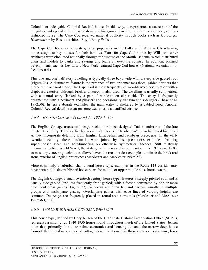
plan with small rooms situated around a core (Figure 28). These houses, small in scale, and inexpensive in cost, were affordable to many first-time homebuyers. Returning GIs often purchased these houses as the first step in climbing the ladder of the middle class. Characteristics of this type include typically square or slightly rectangular footprint, although porch or front window area may project slightly; hipped or side-gabled roofs; gabled projections over the front entrance and larger windows; often side (driveway) entrances; often attached garages; windows that are either wood or metal double hung, wood or metal casements, or large front picture windows with multiple panes sometimes in horizontal bands; exterior stairwell access to basements; exterior sheathing including brick, asbestos or Masonite shingles, and wood or aluminum siding (Jensen 2004:18). 4.6.7 STANDARD RANCH HOUSE (1950-PRESENT) The ranch house supplanted popular pre-World War II house designs such as the Cape Cod, Colonial Revival or Tudor Revival. With its often integral garage and single floor plan, it was designed for efficiency, lacking the stairs of earlier popular styles. As noted by MacAlester and MacAlester, ranch houses were made possible by the country’s increasing dependence on the automobile. As the automobile replaced streetcars and buses as the principal means of personal transportation, relatively compact houses forms on small lots were replaced by sprawling house designs on much larger lots. The rambling form of the ranch house emphasizes these larger lots by maximizing façade width (McAlester and McAlester 1992:479). The standard ranch house became a popular design for members of the middle class able to afford land costs and construction costs greater than those of the minimal ranch or World War II cottage. The standard ranch house is a box-like, one story building with a very shallow pitched gabled, cross-gabled, or hipped roof (Edwards et al. 2004:3-6) (Figure 29). Its perimeter outline is a strict rectangle. A garage is usually attached or integrated as part of the overall plan. Set off the street by a wide lawn and broad driveway, the standard ranch clearly presents a “suburban” image (Jakle et al. 1989:186). In his recently published typology of post-World War II houses, Cory Jensen divides ranch houses into two types, the early ranch, viewed as an enlarged version of the World War II-era cottage, and the ranch. Details that Jensen indicates define the early ranch include a slightly more elongated form than the World War II-era cottage; the frequent inclusion of attached garages; windows, siding, and architectural details similar to those of World War II-era cottages; projecting cross gables often allow for additional interior space; and siding materials including striated brick, asbestos shingles, and aluminum siding (Jensen 2004:19). Details characteristic of the ranch include long and low single level basic mass with gabled, hipped or, less commonly, flat roofs; attached carports or garages; frequent rear patios; and smaller windows in the front and larger ones at the rear as emphasis is placed on the backyard, although large picture windows are common in the living room (Jensen 2004:20). 4.6.8 MINIMAL RANCH HOUSE (1950-PRESENT) The minimal ranch was brought to popularity by post-war developers such as William Levitt, who sought to build good, low-cost housing for the millions of people who sought their own first
HISTORIC CONTEXT FOR THE DUPONT HIGHWAY, U.S. ROUTE 113, KENT AND SUSSEX COUNTIES, DELAWARE
60

����������
�� ����������
�������������
������
���
��
�
����
�������
�� � �����
�� � �����
������������ ��������������� ������� ����� �������������������������������� !"��#

����������������
�������������
��������
�� � ���
�� � ���
��������
�������
�����
������
�������
������������ ���������� �� ���� ����������������������������������������� �!
�������
���! ���
4.0 ASSOCIATED PROPERTY TYPES
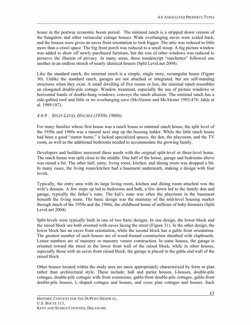
house in the postwar economic boom period. The minimal ranch is a stripped down version of the bungalow and other vernacular cottage houses. Wide overhanging eaves were scaled back, and the houses were given an eaves front orientation to look bigger. The attic was reduced to little more than a crawl space. The big front porch was reduced to a small stoop. A big picture window was added to show off newly purchased furniture, but the size of other windows was reduced to preserve the illusion of privacy. In many areas, these nondescript “ranchettes” followed one another in an endless stretch of nearly identical houses (Split Level.net 2004). Like the standard ranch, the minimal ranch is a simple, single story, rectangular house (Figure 30). Unlike the standard ranch, garages are not attached or integrated, but are self-standing structures when they exist. A small dwelling of five rooms or less, the minimal ranch resembles an elongated double-pile cottage. Window treatment, especially the use of picture windows or horizontal bands of double-hung windows, conveys the ranch allusion. The minimal ranch has a side-gabled roof and little or no overhanging eave (McAlester and McAlester 1992:478; Jakle et al. 1989:187). 4.6.9 SPLIT-LEVEL HOUSES (1950S-1960S) For many families whose first house was a ranch house or minimal ranch house, the split level of the 1950s and 1960s was a natural next step up the housing ladder. While the little ranch house had been a good “starter home,” it lacked specialized spaces, the den, the playroom, and the TV room, as well as the additional bedrooms needed to accommodate the growing family. Developers and builders answered these needs with the original split-level or three-level home. The ranch house was split close to the middle. One half of the house, garage and bedrooms above was raised a bit. The other half, entry, living room, kitchen, and dining room was dropped a bit. In many cases, the living room/kitchen had a basement underneath, making a design with four levels. Typically, the entry area with its large living room, kitchen and dining room attached was the wife’s domain. A few steps up led to bedrooms and bath, a few down led to the family den and garage, typically the father’s zone. The kid’s zone was often the playroom in the basement beneath the living room. The basic design was the mainstay of the mid-level housing market through much of the 1950s and the 1960s, the childhood home of millions of baby boomers (Split Level.net 2004). Split-levels were typically built in one of two basic designs. In one design, the lower block and the raised block are both oriented with eaves facing the street (Figure 31). In the other design, the lower block has an eaves front orientation, while the second block has a gable front orientation. The greatest number of such houses are of wood-framed construction sheathed with clapboards. Lesser numbers are of masonry or masonry veneer construction. In some houses, the garage is oriented toward the street in the lower front wall of the raised block, while in other houses, especially those with an eaves front raised block, the garage is placed in the gable end wall of the raised block.
HISTORIC CONTEXT FOR THE DUPONT HIGHWAY, U.S. ROUTE 113, KENT AND SUSSEX COUNTIES, DELAWARE
63
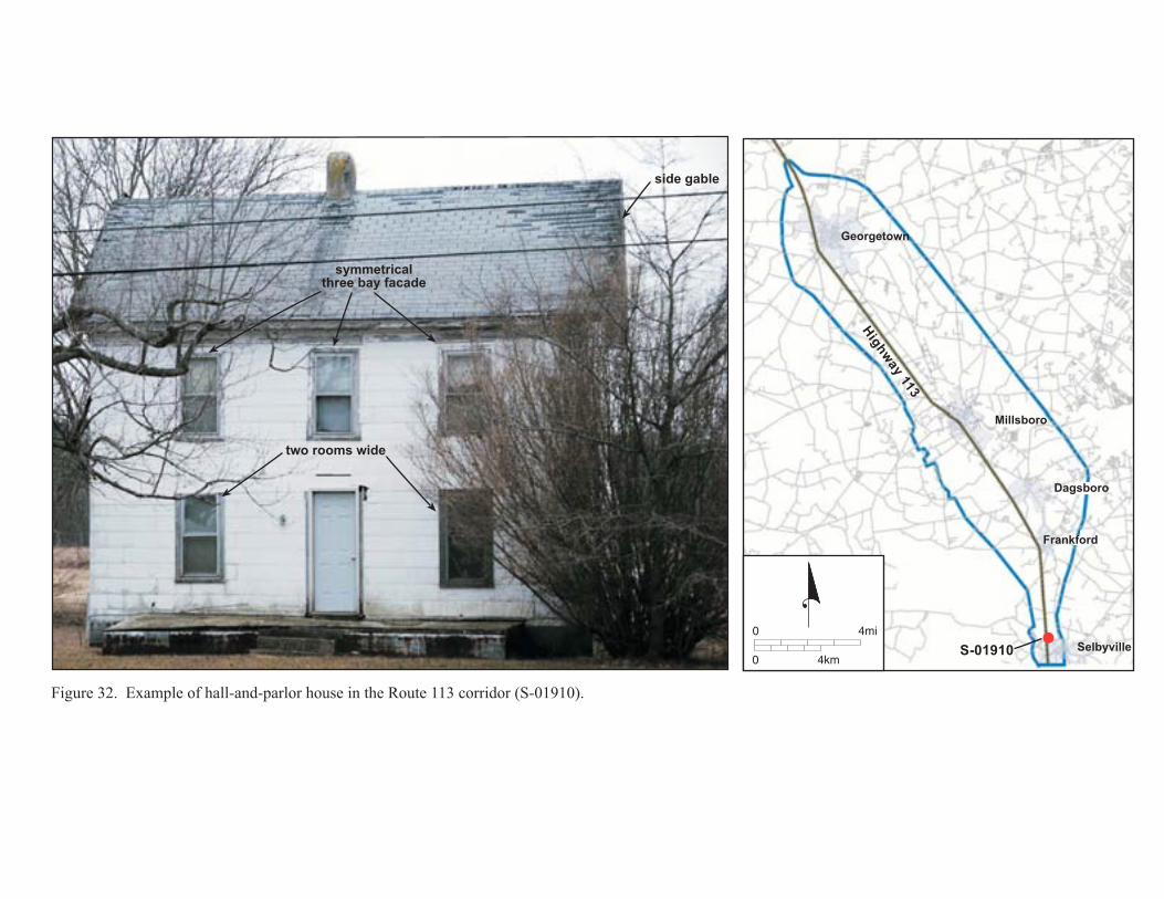
Other houses located within the study area are more appropriately characterized by form or plan rather than architectural style. These include: hall and parlor houses, I-houses, double-pile cottages, double-pile cottages with front extensions, gable-front double-pile cottages, gable-front double-pile houses, L-shaped cottages and houses, and cross plan cottages and houses. Such
�����������������
� ����� ����
����������� �
�������� �������������
������������
����������
� �����
� �������
�
������
�� � �����
�� � �����
������������ ������������� ��� ����������������������������������������� !"
�������������
������� �����
���������� �����
��������
�� � ���
�� � ���
�����
���� ��
�����
������
�������
������������ �������������������������������������������������������
������
��������

4.0 ASSOCIATED PROPERTY TYPES
house plans are of two types. The first type is the “vernacular” house, such as the hall and parlor and I-house, a form whose ultimate origin may have been European and was adapted to local conditions, economics and household needs. The second type, including the L-plan and cross plan cottage or house, may have originally been developed as a “folk” or “vernacular” house type, but by the time they reached the peak of popularity were generally built by builders using existing standard plans or plan books. 4.6.10 HALL AND PARLOR HOUSES (MID-19TH-EARLY 20TH CENTURIES) The hall and parlor house is a rural vernacular house type related to the I-house and the single story hall and parlor cottage. In early examples, unequal room sizes, indicated by the asymmetrical facades, reflect Old World origins. With the advent of balloon framing and standardized materials and building components, the house plan remained popular in rural areas until the end of the nineteenth century. By the end of this period, symmetry was introduced with equal sized rooms and balanced window treatment. The typical occupants of a hall and parlor house was a middle class farm family, sufficiently prosperous to be able to afford a two-story dwelling but lacking the means to afford the larger I-house. The hall and parlor house, a side-gabled dwelling, two full stories in height features two rooms side by side without a separating central hallway (Figure 32). L and T rear appendages are common as with other single-pile dwelling types. Early hall and parlor houses feature asymmetrical facades reflecting unequal room sizes, while later examples feature symmetrical facades often two or three bays wide (Jakle et al. 1989:114). 4.6.11 I-HOUSE (EARLY 19TH-EARLY 20TH CENTURIES) As Jakle, et al. indicate (1989), during the nineteenth century, the I-house symbolized affluence born of the land. The strength of the form as a status symbol was maximized when the façade faced the public road projecting an impressive front elevation. This association of the house with prosperity and respectability was common among farmers and businessmen and professionals in villages and towns. Much of the rural affluence could be attributed to the rise of commercial agriculture associated with the development of regional railroad networks and regional markets (Jakle, et al. 1989:121). The central hall I-house is one of the more noticeable traditional house forms in the rural eastern United States (McAlester and McAlester 1992:96; Noble 1984:52-55). In form, it is essentially a hall and parlor house with an added central hallway serving a centrally positioned front door (Figure 33). The form is one room deep with single rooms on either side of the hall. It is two full stories high with a gable roof. Fenestration is characteristically symmetrical with three, four and five bay patterns common. Many I-houses have additional space in a perpendicular, two-story rear ell (Jakle et al. 1989:120-121; Wyatt n.d.:33). In some cases, including in the larger study areas, the façade is elaborated with a central cross gable. 4.6.12 DOUBLE-PILE COTTAGE (EARLY TO MID-20TH CENTURY) The double-pile cottage is among the simplest and least expensive housing forms. It was marketed in builders’ catalogs between 1915 and 1925 (Edwards et al. 2004:3-4). Due to small
HISTORIC CONTEXT FOR THE DUPONT HIGHWAY, U.S. ROUTE 113, KENT AND SUSSEX COUNTIES, DELAWARE
66
��������������� ������
������ �
��������������
����������
�� � ���
�� � ���
��� ���
�� ����
�����
�����
�������
������������ ��������� ��� ���� ���������������������������������������������
��� ���
��� ����

����������
�� � ���
�� � ���
��� ���
��� �����
����
������
�������
������������� �������������������������������������������������
�����������
���� ��������� ������ �������
������ ������������ ������
��������
�����������
!��� ���
"��������

4.0 ASSOCIATED PROPERTY TYPES
size and simplicity of construction, these dwellings were affordable to people of modest means. Often such houses are found in the vicinity of farms and factories providing housing for farm and factory workers rather than owners and managers. The double-pile cottage is a one or one-and-one-half story dwelling with either gable or hipped roof, the ridge line running parallel to the façade (Figure 34). The roof is of average pitch, and the façade is generally three bays wide. While most gabled roof examples have traditional gabled roofs several examples in the study areas have clipped or jerkinhead gables. In twentieth century examples, there is often no hall and the front door opens directly into the front room. Cottages with steeply pitched roofs resemble a Cape Cod without its characteristic gabled dormers. 4.6.13
4.6.14
DOUBLE-PILE COTTAGE WITH FRONT EXTENSION (EARLY TO MID-20TH CENTURY) The double-pile cottage with front extension represents a small step up from the double-pile cottage. Jakle, et al. attribute the popularity of this form to builder proclivities to “excite and serve a modest-priced market for middle class housing.” Although only slightly larger than the double-pile cottage, this house probably appealed to buyers who wanted a dwelling that conveyed a slightly more impressive appearance than the humble double pile cottage (Jakle et al. 1989:136). This double pile cottage has a gabled roof with ridge parallel to the façade. A perpendicular extension extends off the front wall either to the left or to the right and is covered by a small gable that intersects the main roof at or below the ridge line (Figure 35). The extension contains, in most instances, an enlarged living room and sometimes contains the front door (Jakle et al. 1989:136). 4.6.14 GABLE-FRONT DOUBLE-PILE COTTAGES (EARLY 20TH CENTURY) The gable-front, double-pile cottage is closely associated with the bungalow. In some suburban communities, such houses are interspersed with the side-gabled bungalow and represent a smaller and less expensive variation. Many such houses incorporate bungalow-craftsman decorative elements such as eaves brackets; three over one, double hung, sash windows; and full width front porches with battered posts. It is probable that many of these houses originated as scaled-down imitations of bungalows affordable to those of relatively modest means. In this house type, the gable faces forward and contains the front entrance, the axis of the dwelling being perpendicular to the street (Figure 36). These one and one-and-one-half story dwellings are two rooms wide and two or more rooms deep. Most are three bays wide, often with a central entry bay. Most also have full-width porches, generally hipped or shed-roofed in form (Jakle et al. 1989:141). While most have traditional gables, some, including several in the study areas have jerkinhead or clipped gables.
GABLE-FRONT DOUBLE-PILE HOUSES (LATE 19TH AND EARLY 20TH CENTURIES) Late nineteenth and early twentieth century gable-front houses are commonly seen in cities where they were particularly well-suited for the narrow lots of the urban northeast. This house form is less commonly found in small towns and rural areas. By the early twentieth century, the gable-front house was widely available as both a stock builder form and a prefabricated catalog house.
HISTORIC CONTEXT FOR THE DUPONT HIGHWAY, U.S. ROUTE 113, KENT AND SUSSEX COUNTIES, DELAWARE
69

��������������� �
������������
� �� �
�� ���� ��
�� � ���
�� � ���
������ �
����������
����
������
�������
������������ ������������������������ �������������������������������������
����� �
���� � ��

��������������� �������
������������
���������
�� � ���
�� � ���
���������
����������
����
�����
�������
������������ ������������������������ ����������������������������������������������������� !"�#$
�������
���!����

������������������� �
����������
����������������������
���������
�� � ���
�� � ���
���������
����������
�����
������
�������
������������ ��������� ��������������������������� ��������������������������������� !"#
�������
!��"���

4.0 ASSOCIATED PROPERTY TYPES
While typical urban houses have a narrow, tall, façade the few examples in the study area are wider than these urban examples, allowing more interior space (McAlester and McAlester 1992:90). Because of the larger size than most other house types of the period, these houses were probably erected for relatively prosperous early twentieth century Delawareans. In this house type, the gable faces the street and the building rises to a height of two- or two-and-one-half stories (Figure 37). It is two rooms wide and two or more rooms deep. Nineteenth-century versions of this form usually feature a side hall serving a front door set to one side of the gable. Gable front twentieth-century houses have irregular bungalow-like room arrangements (Jakle et al. 1989:143). 4.6.16 L-SHAPED COTTAGES AND HOUSES (EARLY TO MID 20TH CENTURIES) L-shaped cottages and houses were promoted in house catalogs of the early twentieth century. Often built as housing for working and lower middle class individuals and families, their popularity reflected the predilections of individual builders who widely replicated selected plan types in their communities. In the L-shaped cottage and house, a single, multiple-gable roof covers the entire dwelling (Figure 38). Unlike the similar folk house, the gable front or upright and wing, the L-shaped cottage or house lacks multiple roof levels. Ranging from one to two stories in height, the L-shaped dwelling often has a hipped or shed-roof porch extending from the side wall of the gabled front block across the entirety of the eaves front portion of the facade. In floor plan, the L-shaped dwelling comprises a single, integrated whole (Jakle et al. 1989:161-3). 4.6.17 CROSS PLAN COTTAGES AND HOUSES (EARLY TO MID 20TH CENTURIES) Cross plan houses are well-represented in the plan books and house catalogs of the late nineteenth and early twentieth centuries. As with the gable front house, this plan is more common in cities and towns as builders attempted to fit irregular massing on the narrow urban lots typical of most towns and cities. The few found in the study area may possible represent versions of published house plans built for middle class residents. In a cross plan dwelling, the principal axis of the building is perpendicular to the street with one or two cross gables midway back from the street (Figure 39). Frequently a hipped or shed-roofed front porch extends the width of the front gable wall. The positioning of the front door varies. In many cross plan dwellings, it is located in one of the cross gables and is approached along a side porch. In other dwellings, it is located in the façade wall (Jakle et al. 1989:163-4). 4.6.18 PREFABRICATED AND STANDARD DESIGN HOUSES (INITIAL EXAMPLES: EARLY 20TH CENTURIES; LATER EXAMPLES: MID-20TH CENTURY-PRESENT) The earliest use of standard design homes dates back to nineteenth century architectural pattern books.4 By the early twentieth century, prefabricated houses, made by companies such as Sears Roebuck and Aladdin, and shipped in pieces to the site became popular in some areas of the country. No examples of early standard design homes or prefabricated homes have been identified within the study areas.
HISTORIC CONTEXT FOR THE DUPONT HIGHWAY, U.S. ROUTE 113, KENT AND SUSSEX COUNTIES, DELAWARE
73 4 See Building an American Identity: Pattern Book Homes & Communities (Smeins 1999).

������������
���� �����
��������
�� � ���
�� � ���
���������
��������
�����
�����
�������
������������ ��������� ����������������������������������������������������������� �!�"
� ������
�� �� ��
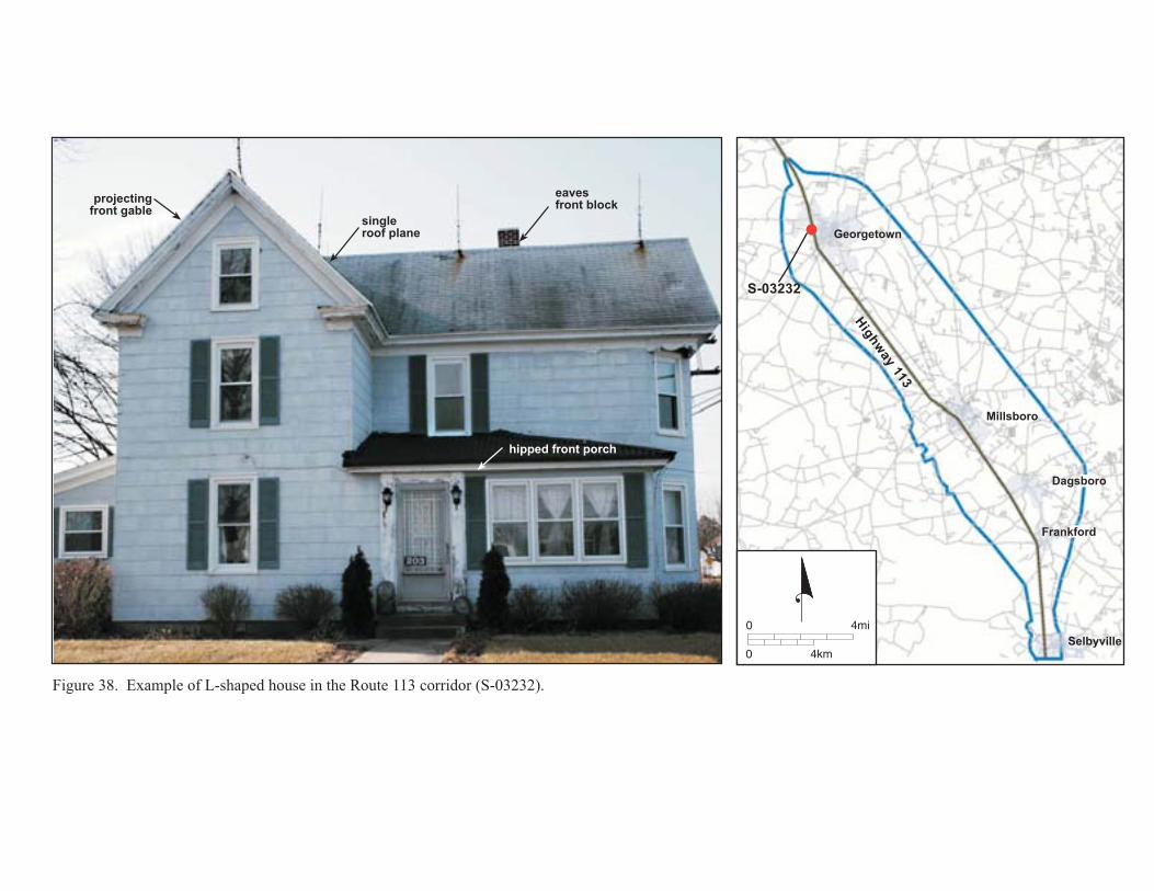
��������������
�������������
�������������������
��������������
����������
�� � ���
�� � ���
���������
����������
��������
��������
��� �
�����
�� �!�!
������������ ������������ ����������������������������������������� � !

����������
�� � ���
�� � ���
��� ���
��� �����
���������
���� ���
����
������
�������
�!�����"� �� ���#$�������������
������������ ���������������� �����������������������������������������
#������� ��
� ��������� ��#�
#������������

4.0 ASSOCIATED PROPERTY TYPES
Prefabricated and standard design homes regained popularity due to the increased demand for housing in the mid-20th century. Research undertaken in issues of local papers from the 1950s and 1960s including the Delmarva News and the Milford Chronicle revealed that several suppliers of prefabricated homes offered their products to Sussex and Kent County residents. From the mid-1950s to at least the early 1960s, the Delmarva News of Selbyville included regular ads from the Houston-White Company of Millsboro. The Houston-White Company was originally founded in the late nineteenth-century as a lumber milling operation and was, for many years, the largest business in the town. The company pictured a series of houses with designs from the Small House Planning Bureau (Figures 40 and 41) and advertised “Order a Home by Telephone? It is Almost That Easy!” Houston-White offered house plans including rectangular cottages, rectangular and L-shaped ranches and split-levels and could construct these houses, as well. Other suppliers that advertised in local papers included Nelson T. Swain of Georgetown, a Main Line Homes dealer, who offered, in 1962, a three bedroom ranch style house with full basement for $8420 or $62.24 per month (Swain 1962). Dover’s Institute for Essential Housing offered its “Low-Cost Homes for the Working Man:” “Cranapple Crest,” “Blueberry Hill,” and “Plum Hill” (IEH 1962). Each was a ranch design. It is presently unknown whether any house within the study area was provided by any of these sources. This information may be able to be obtained by interviewing owners of houses of the period. 4.7 AGRICULTURAL DWELLINGS AND SUPPORTING OPERATIONS Agricultural properties located within the study areas include farmsteads, termed “agricultural complexes” by DeCunzo and Garcia (1993), and housing and processing facilities associated with the poultry industry. 4.7.1 AGRICULTURAL COMPLEXES The term “agricultural complex” is derived from the historic context developed to aid in the examination of the archeology of agricultural properties in Sussex County (DeCunzo and Garcia 1993). Although the report specifically contains a typology of archeological sites, some identified types are applicable to standing structures, as well. The agricultural complex is one such applicable type. De Cunzo and Garcia define the type as consisting of
standing buildings—dwelling(s) and domestic and agricultural outbuildings—and/or archaeological evidence associated with them….The dwelling(s) may have housed the farm’s owners, tenant farmers, farm managers, other relatives, and/or farm hands. Quarters, kitchens, smokehouses, milk houses, spring houses, wood sheds, ice houses, and other food and supply storage buildings number among the expected domestic outbuildings; agricultural outbuildings would include barns of different types, stables, cart sheds, granaries, hay barracks, hog houses, sheep houses, chicken/broiler houses, and potato/root houses. In addition, the Complex encompasses the utilitarian and nonutilitarian spaces and features directly associated with these buildings—landscaped lawns, yards, and gardens;
HISTORIC CONTEXT FOR THE DUPONT HIGHWAY, U.S. ROUTE 113, KENT AND SUSSEX COUNTIES, DELAWARE
77
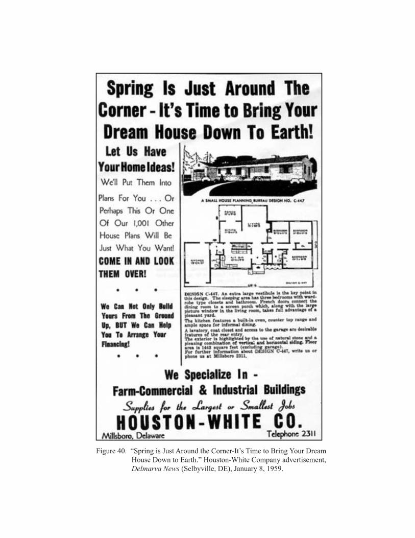
������������ ������������������������������������������������������������������������������� �������!�����"����#� �������$�������� ��%���&����������'�������������������������������(��)*%&�))�'��"+'�������%�,'�-./.

������������ ����������������������������������������������������������������������� � �!��� ���"�� ��#�����$���%�� ������ &�������������������������������'��()$%�((�&���*&�+�($�,&�-./
4.0 ASSOCIATED PROPERTY TYPES
kitchen gardens; work yards; animal pens; wells and other water sources; drives, lanes and paths; and trash and other waste disposal areas and features (De Cunzo and Garcia 1993:250).
Agricultural fields, woodlots, marshes, ditches, streams and orchards are important natural features of agricultural complexes that contribute to the setting and feeling of the property (De Cunzo and Garcia 1993:235). 4.7.2 POULTRY INDUSTRY FACILITIES The poultry industry, a major income and employment source in Sussex and southern Kent counties, is represented by numerous building and structure types including hen houses, broiler houses, grain elevators, hatcheries, and processing plants. Of these property types, hen houses, broiler houses, and a feed mill are present within the study areas. Hen Houses and Broiler Houses As noted, chicken houses are diagnostic of Sussex County poultry-related agricultural complexes. The earliest such houses were used for egg production, while the more recent ones were used to house chickens for the region’s dominant broiler industry. In his book on poultry production, Ralston Hanna cited primary needs in houses for laying chickens (Hanna 1923). The birds must have sufficient room, at least four square feet of floor space per bird. The house must have ample ventilation and must be dry at all times. Ventilation is generally provided by having sufficient openings in the front wall of the house, some containing windows, and others kept open nearly all the time and closed, when necessary, with muslin curtains. Hanna included plans for a laying house of the type recommended by the New Jersey Agricultural Experiment Station and suitable for use in other states with similar conditions. The wood-framed house had a shed roof and measured 20 feet square. It was designed to form an expandable unit, each unit to accommodate 100 birds. The height of the house was eight feet in front and five feet in the rear with a concrete floor and concrete foundation. Fresh air was provided by two large openings, each four feet by five feet and two glass windows, each 21/2 by 51/2 feet. Additional ventilation could be provided by having a hinged top board on the rear elevation (Hanna 1923:27-29; Figures 42 and 43). Other roof types for laying houses indicated by Hanna included the two-thirds span (gable with catslide), the even span (gable), the gable roof with center monitor, the half monitor, and the gambrel roof (Hanna 1923:33; Figure 44). Later laying houses were generally larger than those described by Hanna. In a 1951 publication on poultry husbandry, Morley Jull recommended a house depth of 24 to 36 feet and indicated that lengths of up to 200 feet were common. He pictured an open-front, 30 by 180 foot laying house in southern Delaware with a 20-foot feed section at one end (Jull 1951:229, 234).
HISTORIC CONTEXT FOR THE DUPONT HIGHWAY, U.S. ROUTE 113, KENT AND SUSSEX COUNTIES, DELAWARE
80

�������������� ���� ����������������� �����������������������������������������������������������������
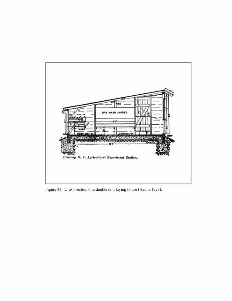
������������� � ���������������������������������� �������������
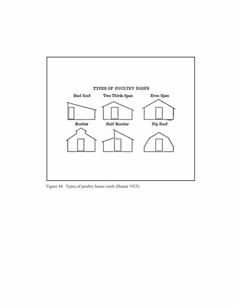
�������������� ��������������� ������ �������������

4.0 ASSOCIATED PROPERTY TYPES
Broiler chicken houses underwent rapid evolution as the Sussex County broiler industry boomed. The earliest such houses, typified by Mrs. Wilmer Steele’s houses5, were small, square, wood-framed buildings, measuring 14 to 16 feet on a side, with single pitch, shed roofs. A coal stove provided heat. Because many early broiler growers had previously operated commercial egg farms, their new broiler houses resembled those built to accommodate young layers. To increase capacity, a grower simply erected new houses. When young broilers reached six weeks or so in age, they might be removed to a larger but now abandoned egg-laying house, formerly used for mature layers. The first long houses were erected in 1928. These early long broiler houses were generally 16 to 18 feet wide and varied according to the size of the operation. By 1940, most Delmarva broilers were raised in shed-roofed, wood-framed buildings as much as 1,000 feet long but more commonly half that length. These buildings typically had dirt floors covered by a litter of sawdust, wood shavings or ground corncobs. These later broiler houses were generally 20 or 24 feet wide and averaged 320 feet long. These houses were often divided into ten rooms, each 30 feet by 20 feet with a 20 foot square feed room in the center. Each room had two stoves. Figuring 500 chickens per stove, the average house had a capacity of 10,000 broilers. Due to in large part to increase in house size, the average grower increased his annual production from about 2,000 broilers in 1927 to about 8,000 in 1935, and approximately 17,000 in 1943 (Williams 1998:21; Hoffman and Johnson 1946:42; Tomhave 1951:133). A shed-roofed house was deemed easiest and most economical to build and easiest to ventilate. A combination roof or “two-thirds span” had also been a popular broiler house type. In this configuration, the rear span is usually twice as long as the front span (Hoffman and Johnson 1946:46) (see Figure 44). Growers lived in close proximity to their chicken houses in order to keep constant watch over their flock. In some cases, the hired hands and their families lived above the central feed storage room in second-story living quarters called chicken-house apartments (Williams 1998:21). Typically gabled roof and weatherboarded on the exterior, the first floor of the center portion of these buildings was used to store feed, while the second floor housed a resident caretaker. The first floor feed room was ventilated with windows and had doors permitting access to either side of the chicken house. An exterior stairway provided access to the second story apartment, usually consisting of three rooms: a living room, kitchen and bedroom. Often a bathroom was included, as well. These chicken houses, which generally ranged between 400 to 500 feet long and 16 to 20 feet wide, could hold between 5,000 and 15,000 birds. Many such houses were located in Sussex County towns such as Dagsboro and Selbyville and were often owned by companies such as Townsend Poultry, Inc., and Allen Family Foods. Both these companies remain in operation in Sussex County, although their holdings have changed in recent years. These once common buildings are now rare and even fewer remain in use (Lanier and Herman 1997:239-241). Early long houses were heated by hot water, piped from a central heater. This system was soon dropped in favor of separate brooder stoves designed to provide uniform heat the length of the house. During the late 1940s, improved central heating units were introduced with excellent results (Tomhave 1951:133). In his book on poultry husbandry, Morley Jull described the typical broiler house built in 1950:
HISTORIC CONTEXT FOR THE DUPONT HIGHWAY, U.S. ROUTE 113, KENT AND SUSSEX COUNTIES, DELAWARE
84
5 One of Mrs. Steele’s broiler houses is currently used as an exhibit at the Delaware Agricultural Museum in Dover.

4.0 ASSOCIATED PROPERTY TYPES
Most of the commercial-broiler houses are of simple design. The shed-roof and gable-roof types of house predominate. Most of them are about 20 feet deep and their length depends on the number of chickens to be brooded under one roof. Where continuous brooding is practiced, the homes are up to 50 ft. deep. Many houses are about 80 to 400 feet long and are divided into pens, each 20 by 20 ft., or 20 by 30 ft., a brooder being used in each pen. In other houses, there are no partitions, although a few partitions are advisable to break drafts and avoid chicks piling up in corners. Dirt floors predominate, although concrete floors are much more sanitary and are used to some extent. The fronts of the houses are relatively open, windows or burlap being used to cover the opening sin cold weather or in the case of driving rain. Most of the houses have windows in the rear to provide for adequate ventilation in warm weather (Jull 1951:214-216).
In an article in the 1950 Delaware Poultry Handbook, W.A. Calvert descried a new look in poultry houses. These newly constructed houses were 44 to 48 feet wide and 200 to 400 feet long with a lower silhouette than earlier houses. Studs were covered with asbestos-cement board or exterior fiberboard. The foundation consisted of footings extended a minimum of 24 inches below ground level. The houses were roofed in sheet metal. Because of the increased width of these new houses, windows were not adequate for ventilation and had to be supplemented or supplanted by manual or automatic commercial ventilators. The earlier heating stoves were replaced by hot water or hot air heat, and efficiency was increased through use of automatic feeders (Calvert 1950:26-28).
By the end of World War II, mechanical improvements had been made to broiler houses to improve feed-handling efficiency. Most growers had installed feed carriers mounted with rollers on tracks attached to the ceilings. A grower or hired hand would load feed onto the carrier in the storeroom and then push the carrier along the track down the length of the chicken house. Feed was taken from the carrier in scoops or buckets and poured into the troughs. By the late 1950s, automatic feeding systems began to be introduced. At the same time, improvements were made in water delivery systems. Much of the equipment used in these improved delivery systems was fabricated by Mumford Sheet Metal works of Selbyville (Williams 1998:85-89). The primary type of broiler house construction in the 1950s was the pole-type house. According to author Byron Bondurant, pole-type houses cost from $.75 to $1.50 per square foot, less than the cost of other construction. In pole-type houses, the poles are of sufficient strength to support the roof and sidewalls and are inbedded four to five feet in the ground. Framing is attached to the poles and braces to support loads due to snow, wind, and weight of materials without aid of roofing or siding (Bondurant 1954:26) Chicken house design in the Delmarva Peninsula underwent dramatic change as a result of the effects of Hurricane Hazel in 1954. Since many of the early chicken houses were not designed as permanent structures and were built of lesser quality materials, the wind and rain of the storm destroyed many of these houses. Author William E. Larson attributed much of the damage to the lack of proper anchoring. He advocated construction with a foundation concrete footing 8 inches thick and 16 inches wide constructed of poured concrete or concrete blocks. Sills should be HISTORIC CONTEXT FOR THE DUPONT HIGHWAY, U.S. ROUTE 113, KENT AND SUSSEX COUNTIES, DELAWARE
85

4.0 ASSOCIATED PROPERTY TYPES
constructed of two 2 by 6s. If platform type construction is used, metal straps should be used to tie rafters to studs (Larson 1955:8). Many farmers decided to modernize poultry operations and to use new chicken house plans sent by local extension agents and the University of Delaware’s Agricultural Experiment Station. One such plan was the clear span broiler house, a gabled roof design with the roof supported by trusses without intervening columns. Other articles published during the 1950s discussed the issue of poultry house ventilation. Ventilation of the houses had two major functions, to remove moisture and to remove heat. Two general techniques were used: gravity or fans. In gravity ventilation, openings were placed near the roof to expel warm arm. Fans, generally deemed more satisfactory, were used to move air through the building (Larson 1956:36-38). By the late 1950s, longer poultry houses were being built than the 44 by 400 foot houses common earlier in the decade. Ray Lloyd indicated that Elwood Workman and Son of built a shed-roofed house near Georgetown that measured 24 feet wide by 1,230 feet long. Partitions were placed every 60 feet and a feed track extended down the center of the house. Four doors were placed in back and three doors in front of each 60-foot section. Ventilation was provided by sliding front windows of glass substitute and drop boards on the rear wall (Lloyd 1958:82). Articles in the Delaware Poultry Handbook in the 1960s defined contemporary thinking concerning appropriate characteristics of broiler houses. In an article concerning the best length, width, and depth of poultry houses, author T.R.C. Rokeby advocated a 40-foot width, a length of 400 feet long, and a sidewall height of six to seven feet. He indicated that a 40-foot width is better adapted to the use of continuous chain-type automatic feeders than narrower houses. Small houses resulted in an unnecessary duplication of equipment, while longer than 400 feet requires a second service area (Rokeby 1963:44-49). In another article in the same edition, A.D. Longhouse examined the need for windows in a broiler house and concluded that windows cost more to build per square foot than wall, windows cost more to maintain than walls, and windows are poor insulators, and concluded that the windowless house was preferable (Longhouse 1963:78-80). By 1980, poultry houses generally were built with one of the following structural frames: 1) open web rigid steel frames; 2) wood trusses on wood poles with no interior supports; 3) pole framed structures with interior posts; 4) steel trusses on steel posts; and 5) open web steel rafters on wood posts. The most common house type was probably the pole-framed house with two interior rows of posts (Driggers 1980:544-545). According to a 1981 article in Poultry Digest, the basic broiler house was stronger and tighter than previously, largely due to improvements in trusses and the recognition of the desirability of insulation. Evidence indicated that the most popular truss in modern broiler houses was the arched unit that provided clear span and allowed a laminated material to be attached over which insulation was installed. Most houses are curtain type. Summer cooling was done with different configurations of fans and air inlets. Heating, formerly supplied by wood-burning or coal-fired brooders had generally been replaced by gas-fired brooders (Anonymous 1981:467-468). In 1991, 161 new chicken houses were completed in Delmarva, 62 others were started, and financial approval was granted for the building of 13 additional houses. The average capacity of these houses was 26,5000 birds and the average cost was $100,000 (Williams 1998:91). Among the improvements in these modern houses was large fans placed at one end of the house to pull air through its entire length (Williams 1998:93). Replacement of earlier, less efficient broiler houses
HISTORIC CONTEXT FOR THE DUPONT HIGHWAY, U.S. ROUTE 113, KENT AND SUSSEX COUNTIES, DELAWARE
86

4.0 ASSOCIATED PROPERTY TYPES
has been encouraged by the offering of “new-house” contracts by poultry grow-out companies to growers who construct new broiler houses according to company specifications (Palmer 1994:1). Most of the houses built in the 1990s were 40 to 42 feet wide and 400 to 500 feet long. Construction generally incorporates truss rafters, eliminating the need for support posts inside the house. The typical sidewall is 6 feet high with an insulated knee wall and a plastic curtain above. The curtain may be adjusted up or down with a winch (Palmer 1994:3). Ventilation is provided by fans controlled by time clocks and overriding thermostats to control minimum air movement and additional fans to cool birds under summer conditions. Fans are usually located only on one side of the house. In recent years, gas space heaters have been increasingly used for house heating (Palmer 1994:4, 6). Feed Mills The availability of food was critical to the growth and survival of Delaware’s poultry industry. The large-scale poultry feed industry began in the years following World War II. Though corn and soybeans, the key ingredients in chicken feed, could be stored for long periods, storage facilities were expensive to build. No feed dealer could afford a large inventory that was not moving. Feed companies began buying chicks from hatcheries and selling them to farmers in attempts to increase their markets (Williams 1998:50-51). From 1941 to 1961, locally owned companies captured an increasing share of the Delmarva chicken feed market. Their prosperity was aided by low shipping costs. Local mills turned to local farmers for corn and soybeans. A 1955 study of lower Delaware noted that “most of the broiler feed in the area is manufactured locally” (Williams 1998:48). During the late 1940s and early 1950s, regional and national giants such as Pillsbury, Ralston Purina, and Southern States, and additional smaller, locally owned feed companies, attached themselves to a large number of chicken farmers through a contract system. Credit was provided to the grower for the purchase of feed with the understanding that upon sale, the grower would reimburse the feed company for the cost of feed (Williams 1998:49-50). By the late 1950s, Delmarva companies were moving toward vertical integration with the independent feed mill becoming a fixture of the past (Williams 1998:54). To manufacture poultry feed for distribution to contract poultry growers, the leading Delmarva poultry producers established their own feed mills. One feed mill is located in the Georgetown-South study area in Frankford. Established by Townsends, Inc., it was acquired by Mountaire Farms of Delaware in 2000. In addition to the feed mill, the property contains a granary with 6.2 million bushels of grain storage. This grain mill serves local farmers (Mountaire Farms n.d.). Feed mills are located throughout the Delmarva region. In 1998, Allen Family Foods operated a feed mill in Delmar, Delaware; Mountaire operated one in Frankford, Delaware; Perdue operated one in Bridgeville, Delaware, and four in Maryland; and Tyson Foods, Inc., operated two in Maryland (Williams 1998:113-114). Feed mills typically consist of a series of attached buildings and structures with a detached office. This detached office may have originally been built as a residence and was enlarged to accommodate its present use. Feed mills contain several primary components: a grain elevator or storage silos are used to house the corn or soybeans to be converted to poultry feed; grinding machinery processes the grain, preparing it to be mixed with other feed components; the mixers HISTORIC CONTEXT FOR THE DUPONT HIGHWAY, U.S. ROUTE 113, KENT AND SUSSEX COUNTIES, DELAWARE
87
4.0 ASSOCIATED PROPERTY TYPES
combine the components used in the feed; pellet machines use heat and metal dies to form the feed into pellets; and the pellets are then cooled in a cooler and are then ready for shipment by truck (Dozier 2002). 4.7.3 SEASONAL LABOR OR TENANT HOUSING In an article in the May 1957 issue of American Child, Mrs. Thomas Herlihy, Jr. described the migrant labor situation in the state:
Migrant labor is an integral part of Delaware’s farm economy. Harvesting and canning the state’s crops depend on a supply of temporary nonresident farm workers to supplement the number of local farm workers. Starting in May and ending in late fall, migrant workers are in demand with as many as four or five thousand being employed during some weeks in August (Herlihy 1957:3).
In the 1920s, the seasonal agricultural work force in Delaware was principally composed of white women. Over the next twenty years however, they were replaced by thousands of migrant farm laborers, both black and white, traveling north from Florida following the potato, vegetable, and berry harvests into Delaware (Miller et al. 1997; Taylor 1937). In addition to these migratory crews, local teenagers and African Americans who had “fallen out” of the migratory “stream,” worked seasonally in Kent and Sussex counties (Miller et al. 1997). Beginning in the post-World War II period, migrant workers became an important component of the southern Delaware farm labor force. In the mid-1950s, most seasonal workers were African Americans from Florida, the Carolinas, and Georgia. About five percent of the seasonal workers were Hispanics from Puerto Rico. Delaware had about 150 labor camps housing seasonal workers. Most such camps were located on farms where the laborers worked. The laborers were typically employed to pick truck crops or to work in canneries (Frank 1955). A statistical study of the seasonal worker population in Delaware was published in 1967 by the State Department of Public Instruction. The report noted that from early summer to late fall, the migrant population was a significant part of the state’s labor force. In 1967, approximately 4,301 temporary agricultural workers came to Delaware. Of these, 2,600 male workers came from Puerto Rico under a contract from the Puerto Rican government. Most non-Puerto Rican workers arrived in crews, generally ranging from 16 to 25 workers, accompanied by nonworking children, wives, and older people. Most members of the crews were African American men, and most came from Florida or Texas (Thomasson 1967:1-11). Seasonal worker housing ranged from clean brick buildings to ramshackle wooden buildings. Typically accommodations included two rooms and were often part of an attached row of one-story, wood-framed quarters. Earlier seasonal labor housing often consisted of individual cabins, a single room measuring about eight by 10 feet shared by as many as seven people (Frank 1956). Typical seasonal labor cabins from the World War II-era are depicted in photographs from the general collection of the Delaware Public Archives. These single pen, wood-framed dwellings were front-gabled in orientation. A single door was placed in the center of the gable. Small windows were placed in at least one side wall and were shaded by angled hoods supported by angled wood braces. The cabins were sheathed in board siding, and a metal stovepipe usually projected from the roof ridge. The roof itself was sheathed in asphalt roofing paper. The interior was of basic construction with wood floors, and walls formed by studs and the inner side of the HISTORIC CONTEXT FOR THE DUPONT HIGHWAY, U.S. ROUTE 113, KENT AND SUSSEX COUNTIES, DELAWARE
88
4.0 ASSOCIATED PROPERTY TYPES
sheathing boards. Bedding was generally provided by a metal cot with thin mattress. Bathroom facilities were external to the cottage (see Figures 45 and 46). 4.8 PROPERTY LAYOUT CONFIGURATIONS 4.8.1 MOBILE OR MANUFACTURED HOME PARKS The house trailer first became widely popular in the 1930s. Two main lines in the future development of the house trailer had emerged. The first, then dominant, line of development viewed the trailer as an automobile accessory, an alternative to motels, hotels, or tents when a family embarked on a motoring vacation. The second line of development viewed the trailer as an alternative form of year-round dwelling. During the Depression and World War II, it was primarily single men, construction workers, defense laborers, military personnel, who converted tiny travel trailers to permanent homes. The popular image of the time was that of a rough, male-dominated space, and was often close to the mark (Hurley 2001:226). By 1936, an article suggested that trailers could be made more acceptable to local officials if they were made “more homelike and less streamlined” and placed in “attractive settings in permanent villages” (Wallis 1989:29). In his study of the mobile home, Wallis cited the type of people initially attracted to trailer living:
For itinerant construction workers who would normally leave their families at home, the trailer provided a way to keep the household together. Other itinerants, including unskilled laborers, salesmen, and traveling evangelists, also found the trailer a convenient and economical alternative to boardinghouses, hotels, and motels (Wallis 1989:31).
In his study of house trailers in the United States, David Thornburg characterized early mobile home parks:
The pioneer models that survived the war, the little 1930s leatherette and plywood boxes, were gathered onto small, decrepit parks during the late forties and turned low-dollar rentals….These were the sad little parks of everyone’s memory, poorly lighted, poorly drained, never paved and seldom grassy, full of solitary elderly folk…brave, lonely souls without family or friends….Here too were the abandoned families….(Thornburg 1991:166).
The primary function of the house trailer shifted because of housing shortages in the World War II years. Before the war 75 to 90 percent of all commercially manufactured trailers had been used for vacations. Ninety percent of the trailers manufactured during the war and throughout the early 1950s were used for year-round housing. A majority of residents were military or construction families (Wallis 1989:34-35). By the mid-1950s, the housing crisis had passed and a demographic shift had begun to appear among trailer buyers. At the time of the 1960 census, the average trailer household was younger,
HISTORIC CONTEXT FOR THE DUPONT HIGHWAY, U.S. ROUTE 113, KENT AND SUSSEX COUNTIES, DELAWARE
89

������������� ����������������� ���� ������������������������������������ �!� ��"�������� ������# �����������$�������������%������&��'����(
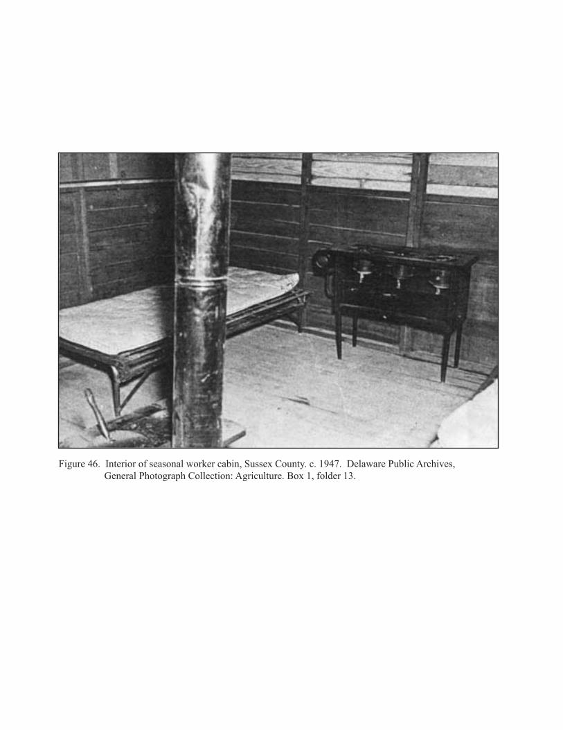
������������ ������������������������������������������� ������������������� ������!��"�#���������������������$������� "� ����%"������� ���&�!������ ����'���������(����)
4.0 ASSOCIATED PROPERTY TYPES
less educated, and less affluent than the general population. These households did not view the trailer as a dwelling to accommodate a transient lifestyle but as a means to enter the conventional housing market (Wallis 1989:37). At the same time a less “mobile” market emerged, wider mobile homes, 10-foot wide models, were introduced. The added width allowed for a floor plan in which a corridor was able to reach the rear bedroom without passing through the middle bedroom and bathroom. By 1960, 90 percent of all trailers manufactured were ten feet wide (Wallis 1989:37). Thornburg described the evolution of the mobile home parks:
Parks remodeled, widening and deepening their lots to accommodate the new models, and raising their rents accordingly. Ten-wides, twelve-wides, then double-wides (two eights joined together to make a sixteen) each became, successively, the norm (Thornburg 1991:174).
In addition, most trailers had concrete patios on the side that could be enclosed with walls and covered with an aluminum awning, thus converting it to an extra room (Hurley 2001:234). The majority of these mobile homes were placed in unincorporated areas. Beginning in the 1940s, the Mobile Home Manufacturers Association tried to promote the development of high quality parks. A typical park was oriented with units at right-angle to the street. Later parks introduced curvilinear streets, setback variations, and playgrounds. Municipalities typically tried to confine parks to nonresidential areas frequently zoning them into commercial or industrial strips along highways and railroad tracks (Wallis 1989:38). Many of these newer park enticed prospective tenants with idyllic names such as Tall Pines, Pine Oak, Oak Grove, Shady Grove, Shady Acres, Green Acres, Green Meadow, and Meadow Lark (Hurley 2001:243). In his study of trailer parks, Andrew Hurley noted the social hierarchies that typically developed among their largely blue-collar residents. Not only were parks divided into family and pet sections, but sections for large and small trailers, as well. Hurley notes, “Social credit accrued to families who traded in their dilapidated coaches for larger models and relocated to the ‘neighborhoods’ reserved for supersize trailers.” In 1971, a magazine article characterized the average trailer dweller as “a notch below the widely publicized ‘Middle American.’’ (Hurley 2001:170-171). In 1970, Kent County contained over 4,100 mobile homes, 18 percent of all dwelling units in the county. Of these, 1,721 were in mobile home parks, while 2,398 were on individual sites. A total of 167 mobile homes were located in the Milford planning district. Of these, 16 were in parks, and the remainder on individual sites (KCRPC 1971:54-55). Similar data is not readily available for Sussex County. 4.8.2 MINOR SUBDIVISIONS OR STRIP DEVELOPMENT Beginning within a few years of completion of the DuPont Highway, land along the highway corridor became attractive for both residential and commercial use. A majority of this land in Sussex and southern Kent County was used as either agricultural or timber land prior to construction of the road. Some of this land was a portion of the initial 200 foot right-of-way acquired by the Coleman DuPont Road, Inc.
HISTORIC CONTEXT FOR THE DUPONT HIGHWAY, U.S. ROUTE 113, KENT AND SUSSEX COUNTIES, DELAWARE
92
4.0 ASSOCIATED PROPERTY TYPES
As noted, the highway bypassed all of the towns along its route. Because the highway showed promise of rapidly becoming inland southern Delaware’s main north-south highway, land on streets between the downtowns and the highway was rapidly subdivided into small, generally residential lots, and a “string” type development occurred along these roads. Generally the older buildings are located closer to downtown, while the newer buildings are located closer to the highway. By the 1920s, land along the highway began to be subdivided and the first generation of houses erected along highway portions in proximity to existing communities. An early example of such development is seen near Milford where bungalows were erected on the east side of present Route 113. The chronology of both residential and commercial strip development can be roughly determined by the component styles and forms of buildings. A less frequent, though observable, development pattern in the Route 113 corridor is the minor subdivision. In form, these minor subdivisions typically consist of a road perpendicular to Route 113 and often terminate in a cul-de-sac. Land on either side of this road is divided into a series of lots, and often all of these lots are developed in quick succession. Several such post-World War II developments are found in the Milford study area. 4.8.3 FARMLAND SUBDIVISION A typical land development pattern in predominantly agricultural landscapes involves the subdivision of small parcels of land of a substantially larger farm along public perimeter roads. Some of this subdivision may be attributable to the desire of the farmer to provide land upon which family members can erect houses. This familial subdivision is often discernable by the presence of newer residences close to the road in proximity to a dwelling that appears to be the original farmhouse. A second pattern of development involves the sale of lots fronting the road to individuals unrelated to the farmer. This type of development could be attributable to a downturn in the agricultural economy in which the land sale was used to provide funds to balance a losing agricultural year. Clues as to the reason for subdivision may be discernible by researching the chain of titles for the properties, but identification of a definitive reason may require interview of property owners. Typically, the dwellings erected use designs popular during the period of land sale. Older farm subdivisions may include bungalows or four-squares, while more recent subdivisions may include Colonial revival, Cape Cod, minimal traditional, and ranch style dwellings, among others. 4.9 TRADITIONAL CULTURAL PROPERTIES Traditional cultural properties may be defined as historic properties whose significance is derived from the role the property plays in a community’s historically rooted beliefs, customs and practices. Examples of properties possessing such significance include:
• A location associated with the traditional beliefs of a Native American group about its origins, its cultural history, or the nature of its world;
• A rural community whose organization, buildings and structures, or patterns of land use reflect the cultural traditions valued by its long-term residents; or
• A location where a community has traditionally carried out economic, artistic, or other cultural practices important in maintaining its historic identity.
HISTORIC CONTEXT FOR THE DUPONT HIGHWAY, U.S. ROUTE 113, KENT AND SUSSEX COUNTIES, DELAWARE
93

4.0 ASSOCIATED PROPERTY TYPES
A traditional cultural property (TCP) may be eligible for the National Register because of its association with cultural practices or beliefs of a living community that are rooted in that community’s history and are important in maintaining the continuing cultural identity of the community (Parker and King 1998:1). The concept of TCPs is continually evolving as more communities and landscapes are surveyed and evaluated as TCPs. An important contribution to the study and evaluation of TCPs in Delaware is being made by University of Delaware graduate student Darrell Cook in his thesis. This thesis uses Coverdale Crossing, Sussex County, an African American community established by a white businessman by relocating houses from Seaford removed as part of urban renewal. Cook’s study will provide additional guidance in identifying and evaluating the National Register eligibility of TCPs (Cook 2005). To identify possible TCPs in the study area, it would be useful to enlist community members who may know the stories of intentionally established ethnic or racial communities. Among potential TCPs in Sussex County are properties associated with the Nanticoke, the Assateague, and the African American Antioch Camp Meeting near Frankford6. Examination of the original Coleman DuPont Road maps of the right-of-way between Selbyville and Milford give no evidence that the road was constructed through any established community. Instead, most of the land acquired was either part of larger farm properties or was forested. Therefore, no TCP is thought to exist along the existing Route 113.
6 The Antioch African American Methodist Episcopal Camp was the subject of a 2001 reconnaissance survey by Rodney M. Huff, an intern in the office of the Sussex County Preservation Planner. Mr. Huff indicated that the camp meets the definition of a TCP and recommended intensive evaluation to assess its NR eligibility.
HISTORIC CONTEXT FOR THE DUPONT HIGHWAY, U.S. ROUTE 113, KENT AND SUSSEX COUNTIES, DELAWARE
94