6 discussion...rio tinto greater west angelas vegetation and flora assessment april 2013 103 6...
TRANSCRIPT
Rio Tinto
Greater West Angelas Vegetation and Flora Assessment
April 2013
103
6 DISCUSSION
The significance of the vegetation and flora of the Study Area has been assessed at four scales: national, state, regional and local.
National significance refers to those features of the environment which are recognised under legislation as being of importance to the Australian community. Flora species and Threatened Ecological Communities (TECs) listed under the EPBC Act are regarded as nationally significant.
State significance refers to those features of the environment that are recognised under state legislation as being of importance to the Western Australian community. It includes species that are listed as Threatened under the WC Act and TECs and PECs listed by the DEC, or vegetation which supports fauna of scheduled status.
Regional significance addresses the representation of species and habitats at a biogeographical level. That is, species or habitat types that are endemic to the Hamersley sub‐region or whose distributions are limited or unknown are considered regionally significant.
Vegetation and flora species are of local significance when their presence is confined to a very locallised area or a specialised habitat type that is not common in the local or regional contaxt and whose disturbance or removal may lead to local extinction.
6.1 FLORISTIC RICHNESS
Species richness is a fundamental measurement of community and regional diversity (Gotelli and Colwell 2001). It is the simplest representation of species diversity (Magurran 1988, Fowler and Cohen 1990) and is the basic indicator of diversity used for this survey.
Rio Tinto
Greater West Angelas Vegetation and Flora Assessment
April 2013
104
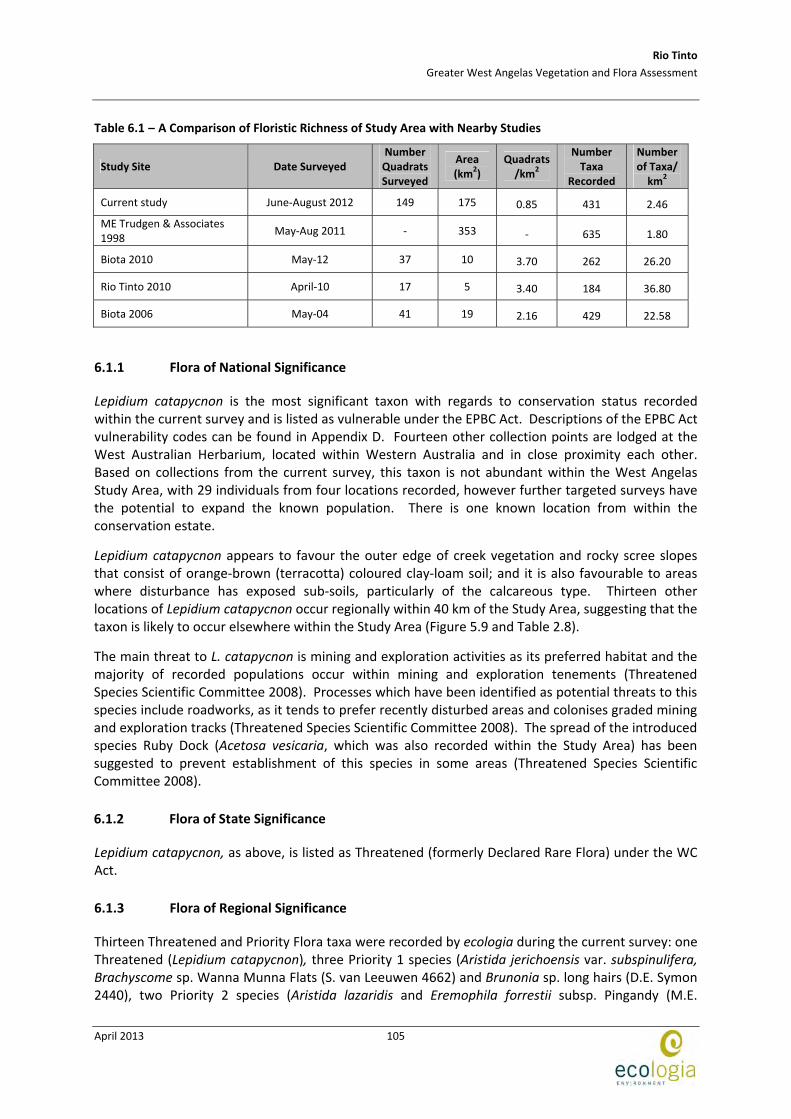
Table 6.1 compares the floristic inventory recorded during the current survey to that recorded in other quadrat‐based surveys conducted in the Pilbara. The most directly comparable survey was in 1998 of the Turee Study Area by ME Trudgen & Associates (1998) which was also a large scale survey. In ME Trudgen & Associates a larger area was survyed, encapusulating a greater range of habitats/landsystems which also resulted in a greater number of taxa recorded.
A comparison of survey intensity with that of the remaining previous projects is difficult due to the differing scales of survey sizes.
The survey intensity of the current study (0.85 quadrats/km2) is considered adequate to the area surveyed; which is reflected in the high number of taxa recorded for its scale.
Rio Tinto
Greater West Angelas Vegetation and Flora Assessment
April 2013
105
Table 6.1 – A Comparison of Floristic Richness of Study Area with Nearby Studies
Study Site Date Surveyed Number Quadrats Surveyed
Area (km2)
Quadrats /km2
Number Taxa
Recorded
Number of Taxa/ km2
Current study June‐August 2012 149 175 0.85 431 2.46
ME Trudgen & Associates 1998
May‐Aug 2011 ‐ 353 ‐ 635 1.80
Biota 2010 May‐12 37 10 3.70 262 26.20
Rio Tinto 2010 April‐10 17 5 3.40 184 36.80
Biota 2006 May‐04 41 19 2.16 429 22.58
6.1.1 Flora of National Significance
Lepidium catapycnon is the most significant taxon with regards to conservation status recorded within the current survey and is listed as vulnerable under the EPBC Act. Descriptions of the EPBC Act vulnerability codes can be found in Appendix D. Fourteen other collection points are lodged at the West Australian Herbarium, located within Western Australia and in close proximity each other. Based on collections from the current survey, this taxon is not abundant within the West Angelas Study Area, with 29 individuals from four locations recorded, however further targeted surveys have the potential to expand the known population. There is one known location from within the conservation estate.
Lepidium catapycnon appears to favour the outer edge of creek vegetation and rocky scree slopes that consist of orange‐brown (terracotta) coloured clay‐loam soil; and it is also favourable to areas where disturbance has exposed sub‐soils, particularly of the calcareous type. Thirteen other locations of Lepidium catapycnon occur regionally within 40 km of the Study Area, suggesting that the taxon is likely to occur elsewhere within the Study Area (Figure 5.9 and Table 2.8).
The main threat to L. catapycnon is mining and exploration activities as its preferred habitat and the majority of recorded populations occur within mining and exploration tenements (Threatened Species Scientific Committee 2008). Processes which have been identified as potential threats to this species include roadworks, as it tends to prefer recently disturbed areas and colonises graded mining and exploration tracks (Threatened Species Scientific Committee 2008). The spread of the introduced species Ruby Dock (Acetosa vesicaria, which was also recorded within the Study Area) has been suggested to prevent establishment of this species in some areas (Threatened Species Scientific Committee 2008).
6.1.2 Flora of State Significance
Lepidium catapycnon, as above, is listed as Threatened (formerly Declared Rare Flora) under the WC Act.
6.1.3 Flora of Regional Significance
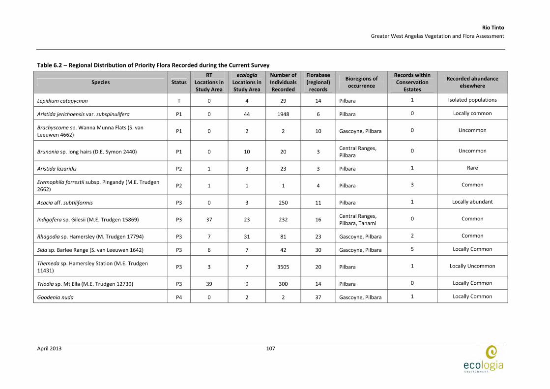
Thirteen Threatened and Priority Flora taxa were recorded by ecologia during the current survey: one Threatened (Lepidium catapycnon), three Priority 1 species (Aristida jerichoensis var. subspinulifera, Brachyscome sp. Wanna Munna Flats (S. van Leeuwen 4662) and Brunonia sp. long hairs (D.E. Symon 2440), two Priority 2 species (Aristida lazaridis and Eremophila forrestii subsp. Pingandy (M.E.
Rio Tinto
Greater West Angelas Vegetation and Flora Assessment
April 2013
106
Trudgen 2662), six Priority 3 species (Acacia aff. subtiliformis, Indigofera sp. Gilesii (M.E. Trudgen 15869), Rhagodia sp. Hamersley (M. Trudgen 17794), Sida sp. Barlee Range (S. van Leeuwen 1642), Themeda sp. Hamersley Station (M.E. Trudgen 11431) and Triodia sp. Mt Ella (M.E. Trudgen 12739) and one Priority 4 species (Goodenia nuda). Seven of these have been previously recorded by RT (but not by the DEC) within the Study Area. Table 6.2 summarises the known distribution and abundance of these taxa from all sources, including DEC records. Based on current records of the Western Australian Herbarium (Florabase), of the 13 species recorded within Greater West Angelas, five are not represented within the conservation estate (Aristida jerichoensis var. subspinulifera, Brachyscome sp. Wanna Munna Flats (S. van Leeuwen 4662), Brunonia sp. long hairs (D.E. Symon 2440), Indigofera sp. Gilesii (M.E. Trudgen 15869) and Triodia sp. Mt Ella (M.E. Trudgen 12739). It is possible that future studies in conservation reserves may result in the discovery of these taxa within their boundaries, but as this is not a certainty, these taxa are considered more vulnerable to mining activities, as there is no locality in which a representative population of the species can be preserved.
Aristida jerichoensis var. subspinulifera is a Priority One taxon with six known locations within the Pilbara bioregion. It was collected within the West Angelas Study Area, with an estimated 1948 individuals from 44 locations. Previous records for this taxon indicate that it can become locally common in preferred habitat, which is present within hardpan sandplains within the Study Area.
Brunonia sp. long hairs (D.E. Symon 2440), Priority One, was collected from 10 locations in the current survey, with 20 individuals recorded. It tends to occur as scattered individuals growing on floodplains and rangelands in red sandy‐clay soils. Brunonia sp. long hairs is taxonomically similar to Brunonia australis sensu lato, which is a phenotypically plastic species occurring in a wide variety of environments across Australia, and is highly variable with respect to the degree of hairiness (Carolin 1992). Current advice form the Western Australian Herbarium is that the two are likely to be amalgamated in the future (Hislop 2012, pers. comm.), but as this change has not yet been adopted by the Western Australian Herbarium, Brunonia sp. long hairs is considered distinct and regarded as Priorty Flora species for in this study.
Records of two taxa represent significant range extensions; Corymbia zygophylla and Euphorbia schultzii. These range extensions may reflect the boundary of the species habitat, but are also likely to result from a lack of collection and/or lodgement. One other taxon has been recorded for the first time in the Pilbara Bioregion: Maireana lanosa. It is not considered a significant range extension as it does not exceed 100 km in distance from a known record; but it expands the population occurrence in terms of regional distribution.
Rio Tinto
Greater West Angelas Vegetation and Flora Assessment
April 2013
107
Table 6.2 – Regional Distribution of Priority Flora Recorded during the Current Survey
Species Status RT
Locations in Study Area
ecologia Locations in Study Area
Number of Individuals Recorded
Florabase (regional) records
Bioregions of occurrence
Records within Conservation
Estates
Recorded abundance elsewhere
Lepidium catapycnon T 0 4 29 14 Pilbara 1 Isolated populations
Aristida jerichoensis var. subspinulifera P1 0 44 1948 6 Pilbara 0 Locally common
Brachyscome sp. Wanna Munna Flats (S. van Leeuwen 4662)
P1 0 2 2 10 Gascoyne, Pilbara 0 Uncommon
Brunonia sp. long hairs (D.E. Symon 2440) P1 0 10 20 3 Central Ranges, Pilbara
0 Uncommon
Aristida lazaridis P2 1 3 23 3 Pilbara 1 Rare
Eremophila forrestii subsp. Pingandy (M.E. Trudgen 2662)
P2 1 1 1 4 Pilbara 3 Common
Acacia aff. subtiliformis P3 0 3 250 11 Pilbara 1 Locally abundant
Indigofera sp. Gilesii (M.E. Trudgen 15869) P3 37 23 232 16 Central Ranges, Pilbara, Tanami
0 Common
Rhagodia sp. Hamersley (M. Trudgen 17794) P3 7 31 81 23 Gascoyne, Pilbara 2 Common
Sida sp. Barlee Range (S. van Leeuwen 1642) P3 6 7 42 30 Gascoyne, Pilbara 5 Locally Common
Themeda sp. Hamersley Station (M.E. Trudgen 11431)
P3 3 7 3505 20 Pilbara 1 Locally Uncommon
Triodia sp. Mt Ella (M.E. Trudgen 12739) P3 39 9 300 14 Pilbara 0 Locally Common
Goodenia nuda P4 0 2 2 37 Gascoyne, Pilbara 1 Locally Common
Rio Tinto
Greater West Angelas Vegetation and Flora Assessment
April 2013
108
6.2 VEGETATION OF CONSERVATION SIGNIFICANCE
6.2.1 Vegetation of National Significance
National significance refers to those features of the environment which are recognised under legislation as being of importance to the Australian community. TECs listed under the EPBC Act are regarded as nationally significant. Currently, there are no nationally‐listed TECs that occur within 40 km of the Study Area.
6.2.2 Vegetation of State Significance
State significance refers to those features of the environment that are recognised under State legislation as being of importance to the Western Australian community, in particular, communities listed as TECs or PECs. Ecological communities with insufficient information available to be considered a TEC, or which are rare but not currently threatened, are placed on the Priority list and referred to as PECs.
One Priority 1 PEC; West Angelas Cracking‐Clays, occurs extensively within the Study Area (Figure 2.7). This portion of the Study Area was relatively accessible and no new areas of this community were observed outside of previously defined locations. The biggest threat to this PEC is from mining activities and associated infrastructure (Kendrick 2001). In this survey it was identified as vegetation unit AlAp (Aristida latifolia, Astrebla pectinata and Brachyachne convergens tussock grassland with isolated Salsola australis, Boerhavia paludosa and Ptilotus nobilis subsp. nobilis forbs) and covers an area of 302.23 ha (Figure 6.1). The PEC is officially described by the DEC as "open tussock grasslands of Astrebla pectinata, A. elymoides, Aristida latifolia, in combination with Astrebla squarrosa and low scattered shrubs of Sida fibulifera, on basalt derived cracking‐clay loam depressions and flowlines”. The vegetation unit AlAp shares the dominant grasses of Aristida latifolia and Astrebla pectinata, but the remaining species typical of the PEC were not present as dominants. However, Sida fibulifera was recorded in five of the seven quadrats of this vegetation type, although not in high abundances. Astrebla elymoides was not recorded at all within the study area. This species is known to occur in the West Angelas PEC but is difficult to identify later in the season when tussock grass heads have dicintergrated. Specifically for tussock grassland communties the survey timing may not have been optimal.

670000 6800007
44
00
00
LegendStudy Area
PnnAp - West Angelas Cracking Clays
Coordinate SystemName: GDA 1994 MGA Zone 50Projection: Transverse MercatorDatum: GDA 1994 A4
Figure: 6.1Project ID: 1457
Drawn: CPDate: 23/11/2012
K0 1 2
Kilometres1:70,000Absolute Scale -
Unique Map ID: CP173Distribution of PEC Unit PnnAp within the
Greater West Angelas Study Area
Rio Tinto
Greater West Angelas Vegetation and Flora Assessment
April 2013
110
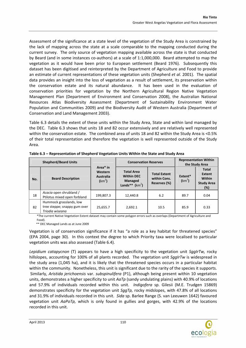
Assessment of the significance at a state level of the vegetation of the Study Area is constrained by the lack of mapping across the state at a scale comparable to the mapping conducted during the current survey. The only source of vegetation mapping available across the state is that conducted by Beard (and in some instances co‐authors) at a scale of 1:1,000,000. Beard attempted to map the vegetation as it would have been prior to European settlement (Beard 1976). Subsequently this dataset has been digitised and reinterpreted by the Department of Agriculture and Food to provide an estimate of current representations of these vegetation units (Shepherd et al. 2001). The spatial data provides an insight into the loss of vegetation as a result of settlement, its preservation within the conservation estate and its natural abundance. It has been used in the evaluation of conservation priorities for vegetation by the Northern Agricultural Region Native Vegetation Management Plan (Department of Environment and Conservation 2008), the Australian National Resources Atlas Biodiversity Assessment (Department of Sustainability Environment Water Population and Communities 2009) and the Biodiversity Audit of Western Australia (Department of Conservation and Land Management 2003).
Table 6.3 details the extent of these units within the Study Area, State and within land managed by the DEC. Table 6.3 shows that units 18 and 82 occur extensively and are relatively well represented within the conservation estate. The combined area of units 18 and 82 within the Study Area is <0.5% of their total representation and therefore the vegetation is well represented outside of the Study Area.
Table 6.3 – Representation of Shepherd Vegetation Units Within the State and Study Area
Shepherd/Beard Units Conservation Reserves Representation Within
the Study Area
No. Beard Description
Area* in Western Australia (km2)
Total Area Within DEC Managed
Lands** (km2)
Total Extent within Cons. Reserves (%)
Extent* (km2)
Total Extent Within
Study Area (%)
18 Acacia open shrubland / Ptilotus mixed open forbland 199,807.3 12,440.8 6.2 89.7 0.04
82
Hummock grasslands, low tree steppe; snappy gum over Triodia wiseana
25,655.7 2,692.1 10.5 85.9 0.33
*The current Native Vegetation Extent dataset may contain some polygon errors such as overlaps (Department of Agriculture and Food).
** DEC Managed Lands as at June 2009
Vegetation is of conservation significance if it has “a role as a key habitat for threatened species” (EPA 2004, page 30). In this context the degree to which Priority taxa were localised to particular vegetation units was also assessed (Table 6.4).
Lepidium catapycnon (T) appears to have a high specificity to the vegetation unit SggIrTw, rocky hillslopes, accounting for 100% of all plants recorded. The vegetation unit SggIrTw is widespread in the study area (1,045 ha), and it is likely that the threatened species occurs in a particular habitat within the community. Nonetheless, this unit is significant due to the rarity of the species it supports. Similarly, Aristida jerichoensis var. subspinulifera (P1), although being present within 10 vegetation units, demonstrates a higher specificity to unit AaTp (sandy undulating plains) with 40.9% of locations and 57.9% of individuals recorded within this unit. Indigofera sp. Gilesii (M.E. Trudgen 15869) demonstrates specificity for the vegetation unit SggTp, rocky midslopes, with 47.8% of all locations and 31.9% of individuals recorded in this unit. Sida sp. Barlee Range (S. van Leeuwen 1642) favoured vegetation unit AaPoTp, which is only found in gullies and gorges, with 42.9% of the locations recorded in this unit.
Rio Tinto
Greater West Angelas Vegetation and Flora Assessment
April 2013
111
Vegetation units SggIrTw (rocky hilltops) and AaEcTp (sandy plains) support five individual threatened and/or priority taxa. Collectively, these units account for eight out of the 13 Threatened and Priority Flora recorded in the survey: Aristida jerichoensis var. subspinulifera, Brachyscome sp. Wanna Munna Flats, Brunonia sp. long hairs, Goodenia nuda, Indigofera sp. Gilesii (M.E. Trudgen 15869), Lepidium catapycnon, Rhagodia sp. Hamersley and Sida sp. Barlee Range.
Table 6.4 – Assessment of Specificity of Priority Taxa to West Angelas Vegetation
Records Individuals Taxon Status Vegetation Unit
Count % Count %
Lepidium catapycnon T SggIrTw 4 1.0 29 1.0
AaAc 5 11.4 201 10.1
AaSaoTp 2 4.5 15 0.8
AaTssp 1 2.3 5 0.3
AaTp 18 40.9 1155 57.9
AaEcTp 1 2.3 5 0.3
AaTb 1 2.3 50 2.5
EgSggTb 4 9.1 66 3.3
AaTt 1 2.3 10 0.5
PsTp 10 22.7 486 24.4
Aristida jerichoensis var. subspinulifera P1
SggIrTw 1 2.3 1 0.1
AaEcTp 1 0.5 1 0.3 Brachyscome sp. Wanna Munna Flats (S. van Leeuwen 4662) PN
P1 PsTp 1 0.5 2 0.7
AaAc 1 10.0 5 13.9
AaTp 1 10.0 2 5.6
EllSggTw 1 10.0 2 5.6
AaEcTp 4 40.0 9 25.0
ApTssp 1 10.0 15 41.7
EllSggTp 1 10.0 2 5.6
Brunonia sp. long hairs (D.E. Symon 2440)
P1
SggAbTp 1 10.0 1 2.8
AaTp 1 33.3 20 74.1
AaTt 1 33.3 5 18.5 Aristida lazaridis P2
PsTp 1 33.3 2 7.4
Eremophila forrestii subsp. Pingandy (M.E. Trudgen 2662)
P2 AaTssp 1 100.0 1 100.0
Acacia aff. subtiliformis P3 EllSggTw 3 100.0 250 100.0
AaPoTp 3 13.0 15 5.4
ElAmTssp 2 8.7 27 9.7
SggTp 11 47.8 89 31.9
EgSggTp 4 17.4 45 16.1
SggAbTp 1 4.3 2 0.7
Indigofera sp. Gilesii (M.E. Trudgen 15869)
P3
SggIrTw 2 8.7 101 36.2
AaAc 3 9.7 9 9.4
AaEffTp 1 3.2 5 5.2
AaSaoTp 2 6.5 6 6.3
AaTp 6 19.4 13 13.5
EllSggTw 2 6.5 4 4.2
AaEcTp 2 6.5 8 8.3
PsTp 8 25.8 29 30.2
SggAbTp 1 3.2 2 2.1
Rhagodia sp. Hamersley (M. Trudgen 17794)
P3
SggIrTw 6 19.4 20 20.8
AaPoTp 3 42.9 18 33.3
EllSggTp 2 28.6 2 3.7 Sida sp. Barlee Range (S. van Leeuwen 1642)
P3
SggIrTw 2 28.6 34 63.0
AaTssp 1 14.3 1000 28.3
EllSggTw 1 14.3 500 14.1 Themeda sp. Hamersley Station (M.E. Trudgen 11431) PN
P3
AlAp 5 71.4 2035 57.6
Triodia sp. Mt Ella (M.E. Trudgen P3 AaPoTp 2 25.0 105 31.2
Rio Tinto
Greater West Angelas Vegetation and Flora Assessment
April 2013
112
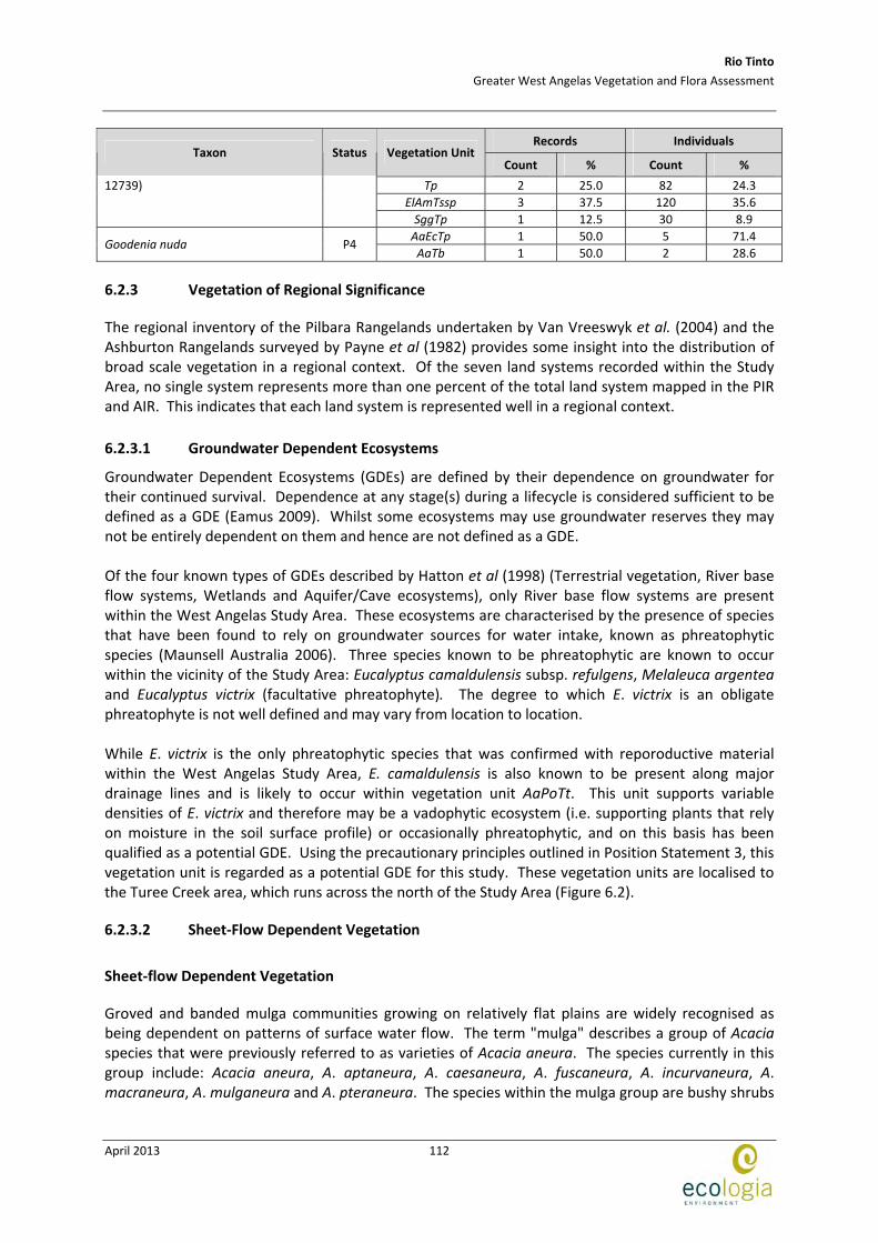
Records Individuals Taxon Status Vegetation Unit
Count % Count %
Tp 2 25.0 82 24.3
ElAmTssp 3 37.5 120 35.6
12739)
SggTp 1 12.5 30 8.9
AaEcTp 1 50.0 5 71.4 Goodenia nuda P4
AaTb 1 50.0 2 28.6
6.2.3 Vegetation of Regional Significance
The regional inventory of the Pilbara Rangelands undertaken by Van Vreeswyk et al. (2004) and the Ashburton Rangelands surveyed by Payne et al (1982) provides some insight into the distribution of broad scale vegetation in a regional context. Of the seven land systems recorded within the Study Area, no single system represents more than one percent of the total land system mapped in the PIR and AIR. This indicates that each land system is represented well in a regional context.
6.2.3.1 Groundwater Dependent Ecosystems
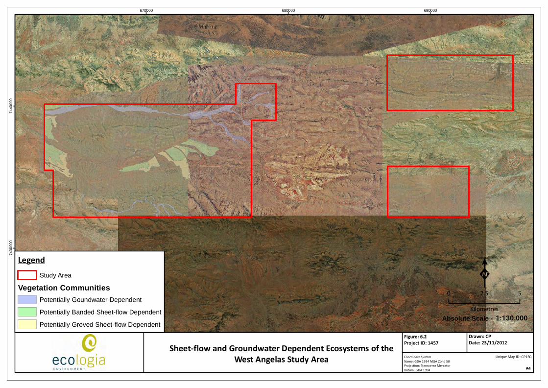
Groundwater Dependent Ecosystems (GDEs) are defined by their dependence on groundwater for their continued survival. Dependence at any stage(s) during a lifecycle is considered sufficient to be defined as a GDE (Eamus 2009). Whilst some ecosystems may use groundwater reserves they may not be entirely dependent on them and hence are not defined as a GDE. Of the four known types of GDEs described by Hatton et al (1998) (Terrestrial vegetation, River base flow systems, Wetlands and Aquifer/Cave ecosystems), only River base flow systems are present within the West Angelas Study Area. These ecosystems are characterised by the presence of species that have been found to rely on groundwater sources for water intake, known as phreatophytic species (Maunsell Australia 2006). Three species known to be phreatophytic are known to occur within the vicinity of the Study Area: Eucalyptus camaldulensis subsp. refulgens, Melaleuca argentea and Eucalyptus victrix (facultative phreatophyte). The degree to which E. victrix is an obligate phreatophyte is not well defined and may vary from location to location. While E. victrix is the only phreatophytic species that was confirmed with reporoductive material within the West Angelas Study Area, E. camaldulensis is also known to be present along major drainage lines and is likely to occur within vegetation unit AaPoTt. This unit supports variable densities of E. victrix and therefore may be a vadophytic ecosystem (i.e. supporting plants that rely on moisture in the soil surface profile) or occasionally phreatophytic, and on this basis has been qualified as a potential GDE. Using the precautionary principles outlined in Position Statement 3, this vegetation unit is regarded as a potential GDE for this study. These vegetation units are localised to the Turee Creek area, which runs across the north of the Study Area (Figure 6.2).
6.2.3.2 Sheet‐Flow Dependent Vegetation
Sheet‐flow Dependent Vegetation
Groved and banded mulga communities growing on relatively flat plains are widely recognised as being dependent on patterns of surface water flow. The term "mulga" describes a group of Acacia species that were previously referred to as varieties of Acacia aneura. The species currently in this group include: Acacia aneura, A. aptaneura, A. caesaneura, A. fuscaneura, A. incurvaneura, A. macraneura, A. mulganeura and A. pteraneura. The species within the mulga group are bushy shrubs
Rio Tinto
Greater West Angelas Vegetation and Flora Assessment
April 2013
113
or trees ranging in height from 2‐10 m, with considerable variation in growth form and phyllode morphology.
Sheet flows carry material (including seeds and other organic and inorganic debris) which is trapped by existing vegetation. his leads to the formation of a mosaic pattern of groves and banded vegetation with relatively bare areas in between. Thus the development and retention of mulga groves is directly dependent upon sheet flow. The different forms of Mulga (banded or groved) result from the position within the landscape and the availability of sheet flows of surface water. It is therefore thought that the susceptibility to alterations in sheet flow may also differ between banded and groved Mulga. However, both forms are potentially affected when sheet flow is disrupted within a landscape (University of Western Australia 2010).
Mulga has a root system that is adapted for taking up water from thin surface soils and has adaptations that concentrate soil water near the plant and conserve water within the plant. Consequently, the distribution and abundance of mulga is particularly influenced by soil moisture and the pattern of surface drainage (Paczkowska and Chapman, 2000). Construction can have an impact on sheet flow by creating a barrier on flow that increases the quantity of water on one side and decreases it on the other, or diverts the flow to a different area. Alterations to sheet‐flow are likely to be greater in close proximity to the construction, but estimating impact is speculative and requires hydrogeological modelling. Until the shadow effect of a proposed development can be determined and the impact adequately assessed, a precautionary approach should be taken.
The diversion of sheet flow or concentration of sheet flow to particular areas is likely to deprive or waterlog soils, with deleterious impacts on mulga. Hence areas with very shallow topography, which commonly support mulga, are likely to be more susceptible. The current analysis has identified banded or groved mulga communities on shallow topography as potentially Sheet Flow Dependent Vegetation (SDV).
The vegetation unit AaEcTp (Acacia open woodland over Eremophila isolated shrubs over Triodia open grassland) supports groved and banded mulga communities and is considered likely to be sheet‐flow dependent. The distribution of this unit is detailed in Figure 6.2. Other vegetation communities described in this survey are characterised by mulga species, but due to the fact that the trees do not occur in groved or banded patterns, they have not been included in the mapping.
670000 680000 6900007
43
00
00
74
40
00
0
LegendStudy Area
Vegetation CommunitiesPotentially Goundwater Dependent
Potentially Banded Sheet-flow Dependent
Potentially Groved Sheet-flow Dependent
Coordinate SystemName: GDA 1994 MGA Zone 50Projection: Transverse MercatorDatum: GDA 1994 A4
Figure: 6.2Project ID: 1457
Drawn: CPDate: 23/11/2012
K0 2.5 5
Kilometres1:130,000Absolute Scale -
Unique Map ID: CP150Sheet-flow and Groundwater Dependent Ecosystems of the
West Angelas Study Area
Rio Tinto
Greater West Angelas Vegetation and Flora Assessment
April 2013
115
6.2.4 Vegetation of Local Significance
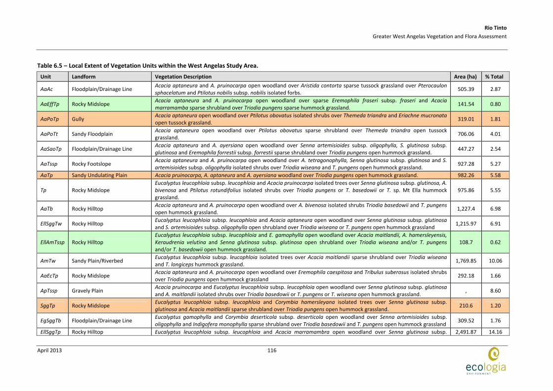
In a local context, vegetation can be considered significant if it is locally uncommon or is associated with habitats of local significance. Vegetation of local significance is not legislatively protected but is of conservation value if areas are restricted and have not been identified to occur outside the Study Area. The least extensive vegetation units locally are AaEffTp (141.54 ha) and AmTw (108.7 ha), which represent 0.80 % and 0.62% of the Study Area, respectively (Table 6.5).
Vegetation which supports rare flora is also considered locally significant. Vegetation units AaPoTp, AaTp, SggTp and SggIrTw all support Priority or Threatened flora. In particular, vegetation units SggIrTw (rocky hilltops) and AaEcTp (sandy plains) support five individual threatened and/or priority taxa. Collectively these units account for eight out of the 13 threatened and priority flora recorded in the survey: Aristida jerichoensis var. subspinulifera, Brachyscome sp. Wanna Munna Flats, Brunonia sp. long hairs, Goodenia nuda, Indigofera sp. Gilesii (M.E. Trudgen 15869), Lepidium catapycnon, Rhagodia sp. Hamersley and Sida sp. Barlee Range.
Rio Tinto
Greater West Angelas Vegetation and Flora Assessment
April 2013
116
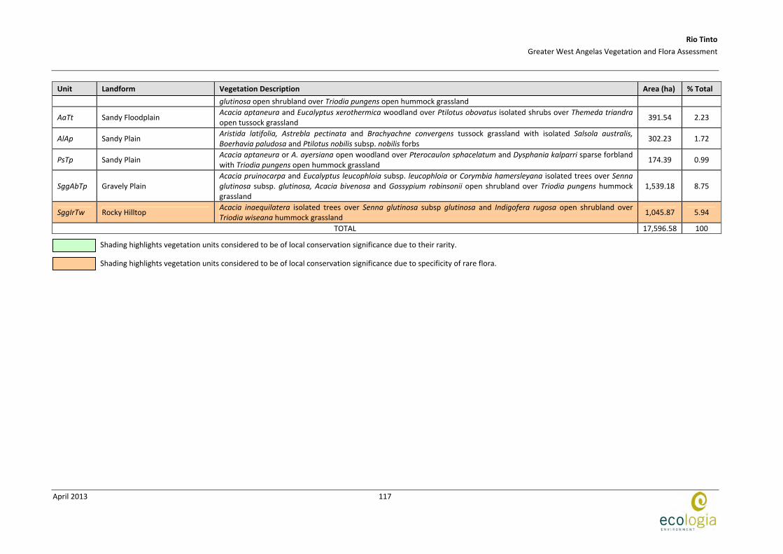
Table 6.5 – Local Extent of Vegetation Units within the West Angelas Study Area.
Unit Landform Vegetation Description Area (ha) % Total
AaAc Floodplain/Drainage Line Acacia aptaneura and A. pruinocarpa open woodland over Aristida contorta sparse tussock grassland over Pterocaulon sphacelatum and Ptilotus nobilis subsp. nobilis isolated forbs.
505.39 2.87
AaEffTp Rocky Midslope Acacia aptaneura and A. pruinocarpa open woodland over sparse Eremophila fraseri subsp. fraseri and Acacia marramamba sparse shrubland over Triodia pungens sparse hummock grassland.
141.54 0.80
AaPoTp Gully Acacia aptaneura open woodland over Ptilotus obovatus isolated shrubs over Themeda triandra and Eriachne mucronata open tussock grassland.
319.01 1.81
AaPoTt Sandy Floodplain Acacia aptaneura open woodland over Ptilotus obovatus sparse shrubland over Themeda triandra open tussock grassland.
706.06 4.01
AaSaoTp Floodplain/Drainage Line Acacia aptaneura and A. ayersiana open woodland over Senna artemisioides subsp. oligophylla, S. glutinosa subsp. glutinosa and Eremophila forrestii subsp. forrestii sparse shrubland over Triodia pungens open hummock grassland.
447.27 2.54
AaTssp Rocky Footslope Acacia aptaneura and A. pruinocarpa open woodland over A. tetragonophylla, Senna glutinosa subsp. glutinosa and S. artemisioides subsp. oligophylla isolated shrubs over Triodia wiseana and T. pungens open hummock grassland.
927.28 5.27
AaTp Sandy Undulating Plain Acacia pruinocarpa, A. aptaneura and A. ayersiana woodland over Triodia pungens open hummock grassland. 982.26 5.58
Tp Rocky Midslope Eucalyptus leucophloia subsp. leucophloia and Acacia pruinocarpa isolated trees over Senna glutinosa subsp. glutinosa, A. bivenosa and Ptilotus rotundifolius isolated shrubs over Triodia pungens or T. basedowii or T. sp. Mt Ella hummock grassland.
975.86 5.55
AaTb Rocky Hilltop Acacia aptaneura and A. pruinocarpa open woodland over A. bivenosa isolated shrubs Triodia basedowii and T. pungens open hummock grassland.
1,227.4 6.98
EllSggTw Rocky Hilltop Eucalyptus leucophloia subsp. leucophloia and Acacia aptaneura open woodland over Senna glutinosa subsp. glutinosa and S. artemisioides subsp. oligophylla open shrubland over Triodia wiseana or T. pungens open hummock grassland
1,215.97 6.91
EllAmTssp Rocky Hilltop Eucalyptus leucophloia subsp. leucophloia and E. gamophylla open woodland over Acacia maitlandii, A. hamersleyensis, Keraudrenia velutina and Senna glutinosa subsp. glutinosa open shrubland over Triodia wiseana and/or T. pungens and/or T. basedowii open hummock grassland.
108.7 0.62
AmTw Sandy Plain/Riverbed Eucalyptus leucophloia subsp. leucophloia isolated trees over Acacia maitlandii sparse shrubland over Triodia wiseana and T. longiceps hummock grassland.
1,769.85 10.06
AaEcTp Rocky Midslope Acacia aptaneura and A. pruinocarpa open woodland over Eremophila caespitosa and Tribulus suberosus isolated shrubs over Triodia pungens open hummock grassland
292.18 1.66
ApTssp Gravely Plain Acacia pruinocarpa and Eucalyptus leucophloia subsp. leucophloia open woodland over Senna glutinosa subsp. glutinosa and A. maitlandii isolated shrubs over Triodia basedowii or T. pungens or T. wiseana open hummock grassland.
, 8.60
SggTp Rocky Midslope Eucalyptus leucophloia subsp. leucophloia and Corymbia hamersleyana isolated trees over Senna glutinosa subsp. glutinosa and Acacia maitlandii sparse shrubland over Triodia pungens open hummock grassland.
210.6 1.20
EgSggTb Floodplain/Drainage Line Eucalyptus gamophylla and Corymbia deserticola subsp. deserticola open woodland over Senna artemisioides subsp. oligophylla and Indigofera monophylla sparse shrubland over Triodia basedowii and T. pungens open hummock grassland
309.52 1.76
EllSggTp Rocky Hilltop Eucalyptus leucophloia subsp. leucophloia and Acacia marramambra open woodland over Senna glutinosa subsp. 2,491.87 14.16
Rio Tinto
Greater West Angelas Vegetation and Flora Assessment
April 2013
117
Unit Landform Vegetation Description Area (ha) % Total
glutinosa open shrubland over Triodia pungens open hummock grassland
AaTt Sandy Floodplain Acacia aptaneura and Eucalyptus xerothermica woodland over Ptilotus obovatus isolated shrubs over Themeda triandra open tussock grassland
391.54 2.23
AlAp Sandy Plain Aristida latifolia, Astrebla pectinata and Brachyachne convergens tussock grassland with isolated Salsola australis, Boerhavia paludosa and Ptilotus nobilis subsp. nobilis forbs
302.23 1.72
PsTp Sandy Plain Acacia aptaneura or A. ayersiana open woodland over Pterocaulon sphacelatum and Dysphania kalparri sparse forbland with Triodia pungens open hummock grassland
174.39 0.99
SggAbTp Gravely Plain Acacia pruinocarpa and Eucalyptus leucophloia subsp. leucophloia or Corymbia hamersleyana isolated trees over Senna glutinosa subsp. glutinosa, Acacia bivenosa and Gossypium robinsonii open shrubland over Triodia pungens hummock grassland
1,539.18 8.75
SggIrTw Rocky Hilltop Acacia inaequilatera isolated trees over Senna glutinosa subsp glutinosa and Indigofera rugosa open shrubland over Triodia wiseana hummock grassland
1,045.87 5.94
TOTAL 17,596.58 100
Shading highlights vegetation units considered to be of local conservation significance due to their rarity.
Shading highlights vegetation units considered to be of local conservation significance due to specificity of rare flora.

Rio Tinto
Greater West Angelas Vegetation and Flora Assessment
April 2013
118
6.3 COMPARISON OF LOCAL VEGETATION COMMUNITIES
One hundred and fifty quadrats were used to define 22 vegetation units within the Study Area. All vegetation units from the ME Trudgen & Associates (1998), Biota (2006) and Biota (2010) surveys were compared with the current survey’s data. The use of multivariate software SYSTATTM was not possible in this instance as the species by site matrices were not available.
Vegetation communities were instead analysed by comparing the spatial data, vegetation descriptions and associated species to align the most similar units between each project. The species used to describe the vegetation units are paramount to the comparison, and it is possible, therefore, that the results drawn from this comparison would be different to results derived from species by site matrices data.
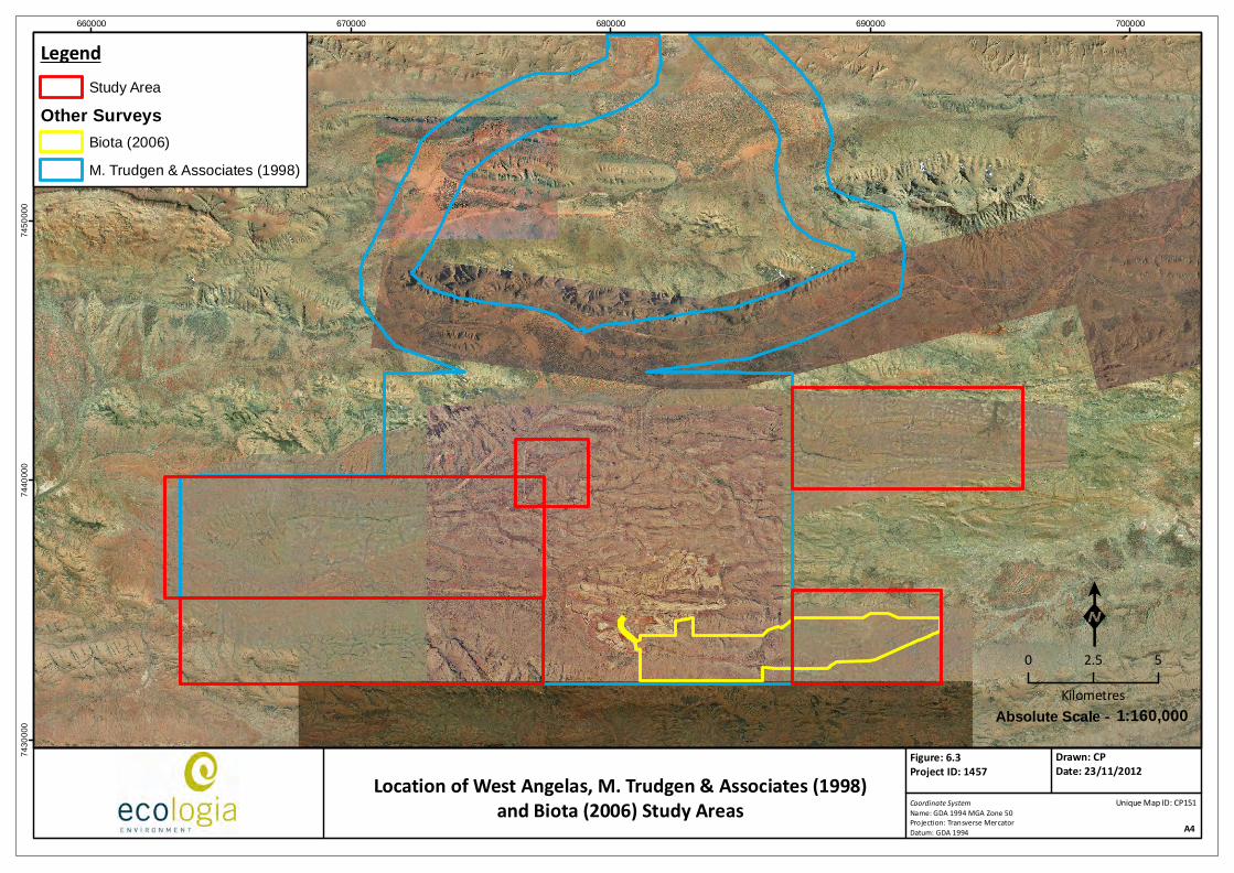
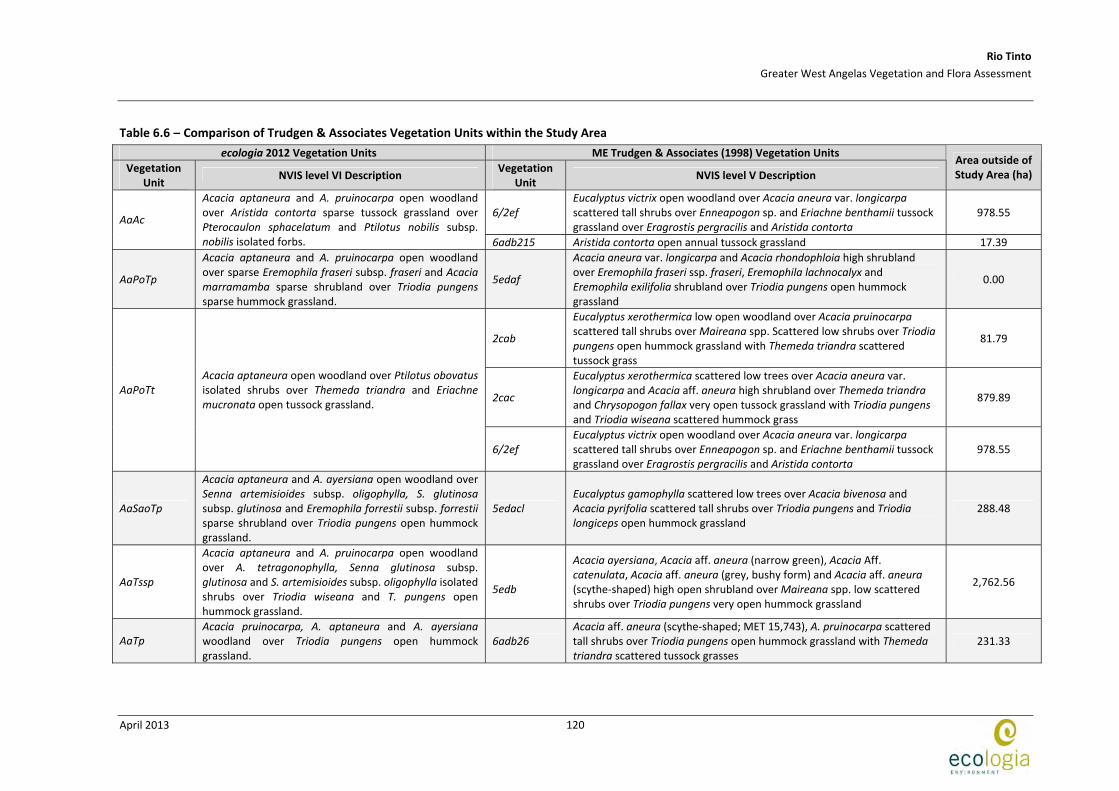
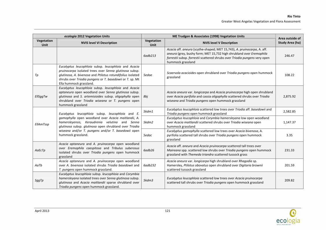
When vegetation units from the current survey (22 units from 150 quadrats) were compared to the ME Trudgen & Associates (1998) survey it was apparent that the quadrat density of the current survey allowed the majority of the vegetation to be mapped at a finer scale. Multiple vegetation units from the current survey were classified as the same under the broader units defined by ME Trudgen & Associates. The exception to this is the riverine/floodplain communities which were mapped at a finer scale by M. Trudgen & Associates when compared to the current survey. This is depicted in Table 6.6 where it can be seen that vegetation unit AaPoTt from the current survey is comparable to units 2cab, 2cac and 6/2ef from the ME Trudgen & Associates survey in the same area. The mapping boundaries of the ME Trudgen & Associates survey extended beyond that of the current survey resulting in just 29 of the 54 communities defined by ME Trudgen & Associates represented within the current Study Area. Table 6.6 depicts a comparison of units from each survey that are the most directly comparable, whilst also indicating regional distribution outside of the current Study Area.
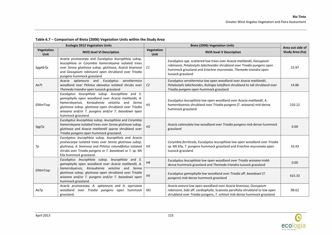
Vegetation communities of the current survey were also co‐analysed with units described in the 2006 Biota survey of Deposits E and F. The mapping of these two surveys was completed at a comparable scale and vegetation units corresponded well based on location, description and associated species as depicted in Table 6.7. Approximately 50% of the area surveyed by Biota falls outside of the current Study Area, although, of the 12 units described by Biota, 10 of the vegetation units identified in the current survey match well and are interpreted to be equivalent.
660000 670000 680000 690000 7000007
43
00
00
74
40
00
07
45
00
00
LegendStudy Area
Other SurveysBiota (2006)
M. Trudgen & Associates (1998)
Coordinate SystemName: GDA 1994 MGA Zone 50Projection: Transverse MercatorDatum: GDA 1994 A4
Figure: 6.3Project ID: 1457
Drawn: CPDate: 23/11/2012
K0 2.5 5
Kilometres1:160,000Absolute Scale -
Unique Map ID: CP151Location of West Angelas, M. Trudgen & Associates (1998)
and Biota (2006) Study Areas
Rio Tinto
Greater West Angelas Vegetation and Flora Assessment
April 2013
120
Table 6.6 – Comparison of Trudgen & Associates Vegetation Units within the Study Area
ecologia 2012 Vegetation Units ME Trudgen & Associates (1998) Vegetation Units
Vegetation Unit
NVIS level VI Description Vegetation
Unit NVIS level V Description
Area outside of Study Area (ha)
6/2ef Eucalyptus victrix open woodland over Acacia aneura var. longicarpa scattered tall shrubs over Enneapogon sp. and Eriachne benthamii tussock grassland over Eragrostis pergracilis and Aristida contorta
978.55 AaAc
Acacia aptaneura and A. pruinocarpa open woodland over Aristida contorta sparse tussock grassland over Pterocaulon sphacelatum and Ptilotus nobilis subsp. nobilis isolated forbs. 6adb215 Aristida contorta open annual tussock grassland 17.39
AaPoTp
Acacia aptaneura and A. pruinocarpa open woodland over sparse Eremophila fraseri subsp. fraseri and Acacia marramamba sparse shrubland over Triodia pungens sparse hummock grassland.
5edaf
Acacia aneura var. longicarpa and Acacia rhondophloia high shrubland over Eremophila fraseri ssp. fraseri, Eremophila lachnocalyx and Eremophila exilifolia shrubland over Triodia pungens open hummock grassland
0.00
2cab
Eucalyptus xerothermica low open woodland over Acacia pruinocarpa scattered tall shrubs over Maireana spp. Scattered low shrubs over Triodia pungens open hummock grassland with Themeda triandra scattered tussock grass
81.79
2cac
Eucalyptus xerothermica scattered low trees over Acacia aneura var. longicarpa and Acacia aff. aneura high shrubland over Themeda triandra and Chrysopogon fallax very open tussock grassland with Triodia pungens and Triodia wiseana scattered hummock grass
879.89 AaPoTt
Acacia aptaneura open woodland over Ptilotus obovatus isolated shrubs over Themeda triandra and Eriachne mucronata open tussock grassland.
6/2ef Eucalyptus victrix open woodland over Acacia aneura var. longicarpa scattered tall shrubs over Enneapogon sp. and Eriachne benthamii tussock grassland over Eragrostis pergracilis and Aristida contorta
978.55
AaSaoTp
Acacia aptaneura and A. ayersiana open woodland over Senna artemisioides subsp. oligophylla, S. glutinosa subsp. glutinosa and Eremophila forrestii subsp. forrestii sparse shrubland over Triodia pungens open hummock grassland.
5edacl Eucalyptus gamophylla scattered low trees over Acacia bivenosa and Acacia pyrifolia scattered tall shrubs over Triodia pungens and Triodia longiceps open hummock grassland
288.48
AaTssp
Acacia aptaneura and A. pruinocarpa open woodland over A. tetragonophylla, Senna glutinosa subsp. glutinosa and S. artemisioides subsp. oligophylla isolated shrubs over Triodia wiseana and T. pungens open hummock grassland.
5edb
Acacia ayersiana, Acacia aff. aneura (narrow green), Acacia Aff. catenulata, Acacia aff. aneura (grey, bushy form) and Acacia aff. aneura (scythe‐shaped) high open shrubland over Maireana spp. low scattered shrubs over Triodia pungens very open hummock grassland
2,762.56
AaTp Acacia pruinocarpa, A. aptaneura and A. ayersiana woodland over Triodia pungens open hummock grassland.
6adb26 Acacia aff. aneura (scythe‐shaped; MET 15,743), A. pruinocarpa scattered tall shrubs over Triodia pungens open hummock grassland with Themeda triandra scattered tussock grasses
231.33
Rio Tinto
Greater West Angelas Vegetation and Flora Assessment
April 2013
121
ecologia 2012 Vegetation Units ME Trudgen & Associates (1998) Vegetation Units
Vegetation Unit
NVIS level VI Description Vegetation
Unit NVIS level V Description
Area outside of Study Area (ha)
6adb213
Acacia aff. aneura (scythe‐shaped; MET 15,743), A. pruinocarpa, A. aff. aneura (grey, bushy form; MET 15,732 high shrubland over Eremophila forrestii subsp. forrestii scattered shrubs over Triodia pungens very open hummock grassland
246.47
Tp
Eucalyptus leucophloia subsp. leucophloia and Acacia pruinocarpa isolated trees over Senna glutinosa subsp. glutinosa, A. bivenosa and Ptilotus rotundifolius isolated shrubs over Triodia pungens or T. basedowii or T. sp. Mt Ella hummock grassland.
5edae Scaervola acacioides open shrubland over Triodia pungens open hummock grassland
108.22
EllSggTw
Eucalyptus leucophloia subsp. leucophloia and Acacia aptaneura open woodland over Senna glutinosa subsp. glutinosa and S. artemisioides subsp. oligophylla open shrubland over Triodia wiseana or T. pungens open hummock grassland
8bj Acacia aneura var. longicarpa and Acacia pruinocarpa high open shrubland over Acacia pyrifolia and cassia oligophylla scattered shrubs over Triodia wiseana and Triodia pungens open hummock grassland
2,875.92
5kdm1 Eucalyptus leucophloia scattered low trees over Triodia aff. basedowii and Triodia pungens open hummock grassland
2,582.85
5kdm2 Eucalyptus leucophloia and Corymbia hamersleyana low open woodland over Acacia maitlandii scattered shrubs over Triodia wiseana open hummock grassland
1,147.37 EllAmTssp
Eucalyptus leucophloia subsp. leucophloia and E. gamophylla open woodland over Acacia maitlandii, A. hamersleyensis, Keraudrenia velutina and Senna glutinosa subsp. glutinosa open shrubland over Triodia wiseana and/or T. pungens and/or T. basedowii open hummock grassland. 5edac
Eucalyptus gamophylla scattered low trees over Acacia bivenosa, A. pyrifolia scattered tall shrubs over Triodia pungens open hummock grassland
3.35
AaEcTp
Acacia aptaneura and A. pruinocarpa open woodland over Eremophila caespitosa and Tribulus suberosus isolated shrubs over Triodia pungens open hummock grassland
6adb26 Acacia aff. aneura and Acacia pruinocarpa scattered tall trees over Maireana spp. scattered low shrubs over Triodia pungens open hummock grassland with Themeda triandra scattered tussock grass
231.33
AaTb Acacia aptaneura and A. pruinocarpa open woodland over A. bivenosa isolated shrubs Triodia basedowii and T. pungens open hummock grassland.
6adb232 Acacia aneura var. longicarpa high shrubland over Rhagodia sp. Hamersley, Ptilotus obovatus open shrubland over Digitaria brownii scattered tussock grassland
201.59
SggTp
Eucalyptus leucophloia subsp. leucophloia and Corymbia hamersleyana isolated trees over Senna glutinosa subsp. glutinosa and Acacia maitlandii sparse shrubland over Triodia pungens open hummock grassland.
5kdm3 Eucalyptus leucophloia scattered low trees over Acacia pruinocarpa scattered tall shrubs over Triodia pungens open hummock grassland
209.82

Rio Tinto
Greater West Angelas Vegetation and Flora Assessment
April 2013
122
ecologia 2012 Vegetation Units ME Trudgen & Associates (1998) Vegetation Units
Vegetation Unit
NVIS level VI Description Vegetation
Unit NVIS level V Description
Area outside of Study Area (ha)
EgSggTb
Eucalyptus gamophylla and Corymbia deserticola subsp. deserticola open woodland over Senna artemisioides subsp. oligophylla and Indigofera monophylla sparse shrubland over Triodia basedowii and T. pungens open hummock grassland
SggAbTp
Acacia pruinocarpa and Eucalyptus leucophloia subsp. leucophloia or Corymbia hamersleyana isolated trees over Senna glutinosa subsp. glutinosa, Acacia bivenosa and Gossypium robinsonii open shrubland over Triodia pungens hummock grassland
5eda
Corymbia deserticola scattered low trees over Acacia bivenosa, Acacia pruinocarpa and Hakea chordophylla scattered tall shrubs over Cassia prunosa scattered shrubs over Triodia aff. basedowii and Triodia pungens open hummock grassland
1,898.14
5edad
Eucalyptus leucophloia low open woodland over Acacia aff. aneura, Acacia pruinocarpa and Acacia aneura var. ?aneura open scrub over Eremophila lachnocalyx scattered shrubs over Triodia pungens open hummock grassland
199.33 EllSggTp
Eucalyptus leucophloia subsp. leucophloia and Acacia marramambra open woodland over Senna glutinosa subsp. glutinosa open shrubland over Triodia pungens open hummock grassland
5kd3r Eucalyptus leucophloia low open woodland over Acacia pruinocarpa scattered tall shrubs over Triodia pungens open hummock grassland.
0.00
8db/8dc Astrebla pectinata, Astrebla elymoides and Aristida latifolia open tussock grassland
166.06 AlAp
Aristida latifolia, Astrebla pectinata and Brachyachne convergens tussock grassland with isolated Salsola australis, Boerhavia paludosa and Ptilotus nobilis subsp. nobilis forbs
8dd Sida fibulifera low scattered shrubs over Astrebla squarrosa tussock grassland
0.00
Note: Comparisons are based on aerial imagery and vegetation descriptions. Species by site matrices were not available for data comparison.
Rio Tinto
Greater West Angelas Vegetation and Flora Assessment
April 2013
123
Table 6.7 – Comparison of Biota (2006) Vegetation Units within the Study Area
Ecologia 2012 Vegetation Units Biota (2006) Vegetation Units
Vegetation Unit
NVIS level VI Description Vegetation
Unit NVIS level V Description
Area out side of Study Area (ha)
SggAbTp
Acacia pruinocarpa and Eucalyptus leucophloia subsp. leucophloia or Corymbia hamersleyana isolated trees over Senna glutinosa subsp. glutinosa, Acacia bivenosa and Gossypium robinsonii open shrubland over Triodia pungens hummock grassland
C1
Eucalyptus spp. scattered low trees over Acacia maitlandii, Gossypium robinsonii, Petalostylis labicheoides shrubland over Triodia pungens open hummock grassland and Eriachne mucronata, Themeda triandra open tussock grassland
15.97
AaTt Acacia aptaneura and Eucalyptus xerothermica woodland over Ptilotus obovatus isolated shrubs over Themeda triandra open tussock grassland
C2 Eucalyptus xerothermica low open woodland over Acacia maitlandii, Petalostylis labicheoides, Rulingia luteiflora shrubland to tall shrubland over Triodia pungens open hummock grassland
14.86
EllAmTssp
Eucalyptus leucophloia subsp. leucophloia and E. gamophylla open woodland over Acacia maitlandii, A. hamersleyensis, Keraudrenia velutina and Senna glutinosa subsp. glutinosa open shrubland over Triodia wiseana and/or T. pungens and/or T. basedowii open hummock grassland.
H1 Eucalyptus leucophloia low open woodland over Acacia maitlandii, A. hamersleyensis shrubland over Triodia pungens (T. wiseana) mid‐dense hummock grassland
210.12
SggTp
Eucalyptus leucophloia subsp. leucophloia and Corymbia hamersleyana isolated trees over Senna glutinosa subsp. glutinosa and Acacia maitlandii sparse shrubland over Triodia pungens open hummock grassland.
H2 Acacia catenulata low woodland over Triodia pungens mid‐dense hummock grassland
0.00
Tp
Eucalyptus leucophloia subsp. leucophloia and Acacia pruinocarpa isolated trees over Senna glutinosa subsp. glutinosa, A. bivenosa and Ptilotus rotundifolius isolated shrubs over Triodia pungens or T. basedowii or T. sp. Mt Ella hummock grassland.
H3 Corymbia ferriticola, Eucalyptus leucophloia low open woodland over Triodia sp. Mt Ella, T. pungens hummock grassland and Eriachne mucronata open tussock grassland
33.43
H4 Eucalyptus leucophloia low open woodland over Triodia wiseana midd‐dense hummock grassland and Themeda triandra tussock grassland
0.00
EllAmTssp
Eucalyptus leucophloia subsp. leucophloia and E. gamophylla open woodland over Acacia maitlandii, A. hamersleyensis, Keraudrenia velutina and Senna glutinosa subsp. glutinosa open shrubland over Triodia wiseana and/or T. pungens and/or T. basedowii open hummock grassland.
H5 Eucalyptus gamophylla low woodland over Triodia aff. basedowii (T. pungens) mid‐dense hummock grassland
415.33
AaTp Acacia pruinocarpa, A. aptaneura and A. ayersiana woodland over Triodia pungens open hummock grassland.
M1 Acacia aneura low open woodland over Acacia bivenosa, Gossypium robinsonii, Sida aff. cardiophylla, Scaevola parvifolia shrubland to low open shrubland over Triodia pungens, T. schinzii mid‐dense hummock grassland
98.62

Rio Tinto
Greater West Angelas Vegetation and Flora Assessment
April 2013
124
Ecologia 2012 Vegetation Units Biota (2006) Vegetation Units
Vegetation Unit
NVIS level VI Description Vegetation
Unit NVIS level V Description
Area out side of Study Area (ha)
M2 Acacia aneura low open woodland over Triodia pungens, T. aff. basedowii mid‐dense hummock grassland
23.63 AaTb
Acacia aptaneura and A. pruinocarpa open woodland over A. bivenosa isolated shrubs Triodia basedowii and T. pungens open hummock grassland.
M5 Acacia aneura low closed forest over Triodia pungens mid‐dense hummock grassland
0.00
PsTp Acacia aptaneura or A. ayersiana open woodland over Pterocaulon sphacelatum and Dysphania kalparri sparse forbland with Triodia pungens open hummock grassland
M3 Acacia aneura woodland over Maireana villosa, Ptilotus obovatus, Rhagodia sp. Hamersley open to low open shrubland over Triodia sp. Mt Ella open hummock grassland
32.00
AaAc
Acacia aptaneura and A. pruinocarpa open woodland over Aristida contorta sparse tussock grassland over Pterocaulon sphacelatum and Ptilotus nobilis subsp. nobilis isolated forbs.
M4
Acacia aneura, A. pruinocarpa low closed forest to low woodland over Eremophila forrestii, E. longifolia, Ptilotus obovatus, Rhagodia sp. Hamersley low open shrubland to open shrubland over Triodia pungens open hummock grassland
223.85
Note: Comparisons are based on aerial imagery and vegetation descriptions. Species by site matrices were not available for data comparison
Rio Tinto
Greater West Angelas Vegetation and Flora Assessment
April 2013
125
6.4 LAND DEGREDATION ANANYSIS
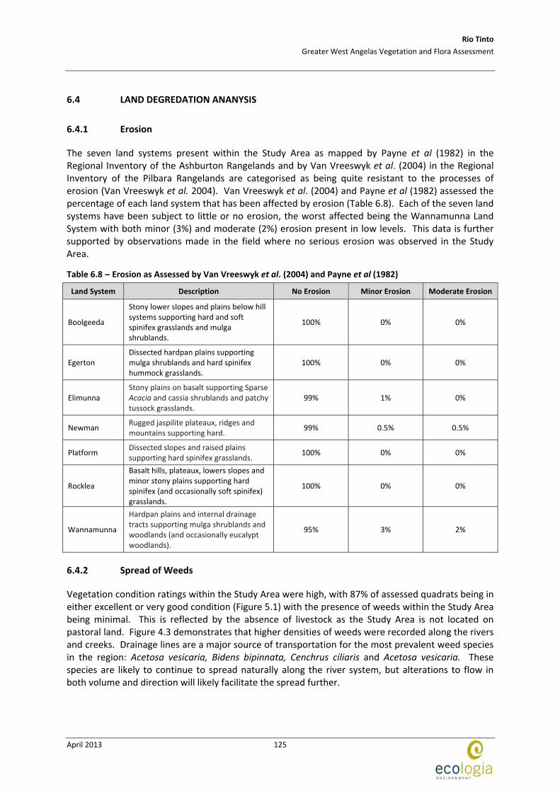
6.4.1 Erosion
The seven land systems present within the Study Area as mapped by Payne et al (1982) in the Regional Inventory of the Ashburton Rangelands and by Van Vreeswyk et al. (2004) in the Regional Inventory of the Pilbara Rangelands are categorised as being quite resistant to the processes of erosion (Van Vreeswyk et al. 2004). Van Vreeswyk et al. (2004) and Payne et al (1982) assessed the percentage of each land system that has been affected by erosion (Table 6.8). Each of the seven land systems have been subject to little or no erosion, the worst affected being the Wannamunna Land System with both minor (3%) and moderate (2%) erosion present in low levels. This data is further supported by observations made in the field where no serious erosion was observed in the Study Area.
Table 6.8 – Erosion as Assessed by Van Vreeswyk et al. (2004) and Payne et al (1982)
Land System Description No Erosion Minor Erosion Moderate Erosion
Boolgeeda
Stony lower slopes and plains below hill systems supporting hard and soft spinifex grasslands and mulga shrublands.
100% 0% 0%
Egerton Dissected hardpan plains supporting mulga shrublands and hard spinifex hummock grasslands.
100% 0% 0%
Elimunna Stony plains on basalt supporting Sparse Acacia and cassia shrublands and patchy tussock grasslands.
99% 1% 0%
Newman Rugged jaspilite plateaux, ridges and mountains supporting hard.
99% 0.5% 0.5%
Platform Dissected slopes and raised plains supporting hard spinifex grasslands.
100% 0% 0%
Rocklea
Basalt hills, plateaux, lowers slopes and minor stony plains supporting hard spinifex (and occasionally soft spinifex) grasslands.
100% 0% 0%
Wannamunna
Hardpan plains and internal drainage tracts supporting mulga shrublands and woodlands (and occasionally eucalypt woodlands).
95% 3% 2%
6.4.2 Spread of Weeds
Vegetation condition ratings within the Study Area were high, with 87% of assessed quadrats being in either excellent or very good condition (Figure 5.1) with the presence of weeds within the Study Area being minimal. This is reflected by the absence of livestock as the Study Area is not located on pastoral land. Figure 4.3 demonstrates that higher densities of weeds were recorded along the rivers and creeks. Drainage lines are a major source of transportation for the most prevalent weed species in the region: Acetosa vesicaria, Bidens bipinnata, Cenchrus ciliaris and Acetosa vesicaria. These species are likely to continue to spread naturally along the river system, but alterations to flow in both volume and direction will likely facilitate the spread further.
Rio Tinto
Greater West Angelas Vegetation and Flora Assessment
April 2013
126
There was also evidence to suggest that Bidens bipinnata is also being spread to a small degree by native fauna. Acetosa vesicaria was sighted growing within the 3 m buffer of the rail corridor in Deposit G. Track work and other maintenance in these areas could facilitate the spread of this species via vehicles or personnel, as well as soil disturbance. Control methods such as brush‐down procedures should be used when working in these areas of the rail.
6.4.3 Previous Disturbance
Previous disturbance within the Study Area was observed to be predominantly from clearing pertaining to previous exploration lines, drill pads, access tracks and associated infrastructure. Deposit G is the most disturbed as part of the rail and the main access road into the West Angelas Mine are within this site. Apart from the primary disturbance from the initial clearing footprint of this infrastructure, dust is also another source of disturbance in the area. West Angeles Mine currently has management plans in place to help control the impact and spread of dust.
Rio Tinto
Greater West Angelas Vegetation and Flora Assessment
April 2013
127
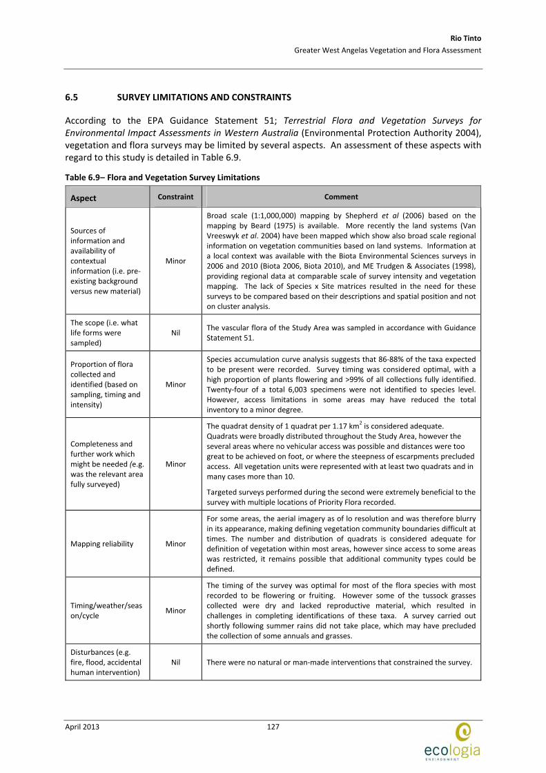
6.5 SURVEY LIMITATIONS AND CONSTRAINTS
According to the EPA Guidance Statement 51; Terrestrial Flora and Vegetation Surveys for Environmental Impact Assessments in Western Australia (Environmental Protection Authority 2004), vegetation and flora surveys may be limited by several aspects. An assessment of these aspects with regard to this study is detailed in Table 6.9.
Table 6.9– Flora and Vegetation Survey Limitations
Aspect Constraint Comment
Sources of information and availability of contextual information (i.e. pre‐existing background versus new material)
Minor
Broad scale (1:1,000,000) mapping by Shepherd et al (2006) based on the mapping by Beard (1975) is available. More recently the land systems (Van Vreeswyk et al. 2004) have been mapped which show also broad scale regional information on vegetation communities based on land systems. Information at a local context was available with the Biota Environmental Sciences surveys in 2006 and 2010 (Biota 2006, Biota 2010), and ME Trudgen & Associates (1998), providing regional data at comparable scale of survey intensity and vegetation mapping. The lack of Species x Site matrices resulted in the need for these surveys to be compared based on their descriptions and spatial position and not on cluster analysis.
The scope (i.e. what life forms were sampled)
Nil The vascular flora of the Study Area was sampled in accordance with Guidance Statement 51.
Proportion of flora collected and identified (based on sampling, timing and intensity)
Minor
Species accumulation curve analysis suggests that 86‐88% of the taxa expected to be present were recorded. Survey timing was considered optimal, with a high proportion of plants flowering and >99% of all collections fully identified. Twenty‐four of a total 6,003 specimens were not identified to species level. However, access limitations in some areas may have reduced the total inventory to a minor degree.
Completeness and further work which might be needed (e.g. was the relevant area fully surveyed)
Minor
The quadrat density of 1 quadrat per 1.17 km2 is considered adequate.
Quadrats were broadly distributed throughout the Study Area, however the several areas where no vehicular access was possible and distances were too great to be achieved on foot, or where the steepness of escarpments precluded access. All vegetation units were represented with at least two quadrats and in many cases more than 10.
Targeted surveys performed during the second were extremely beneficial to the survey with multiple locations of Priority Flora recorded.
Mapping reliability Minor
For some areas, the aerial imagery as of lo resolution and was therefore blurry in its appearance, making defining vegetation community boundaries difficult at times. The number and distribution of quadrats is considered adequate for definition of vegetation within most areas, however since access to some areas was restricted, it remains possible that additional community types could be defined.
Timing/weather/season/cycle
Minor
The timing of the survey was optimal for most of the flora species with most recorded to be flowering or fruiting. However some of the tussock grasses collected were dry and lacked reproductive material, which resulted in challenges in completing identifications of these taxa. A survey carried out shortly following summer rains did not take place, which may have precluded the collection of some annuals and grasses.
Disturbances (e.g. fire, flood, accidental human intervention)
Nil There were no natural or man‐made interventions that constrained the survey.

Rio Tinto
Greater West Angelas Vegetation and Flora Assessment
April 2013
128
Aspect Constraint Comment
Intensity (in retrospect, was the intensity adequate?)
Minor
The species accumulation curve suggests that 86‐88 % of species present were collected. All vegetation units were mapped were represented by at least two quadrats. Quadrats were distributed across the Study Area at a density of 1 quadrat per 1.17 km2; however the distribution was limited in some areas due to access constraints.
Resources Nil A total of 60 person‐days were expended across the survey period. There was sufficient time to access all areas that could be accessed using a vehicle and foot traverses.
Access problems Moderate
The majority of the survey area was easily accessed. However, the absence and poor condition of some tracks, as well as some vital tracks being recently rehabilitated required an investment of time and effort for accessing some areas on foot. The southeast and northwest areas of the larger study polygon and the centre‐southeast area of the smaller study polygon were the least sampled areas due to access difficulties.
Aerial imagery and landform mapping for this area indicate that the vegetation communities in the areas where access was restricted have been sampled elsewhere.
Experience levels (e.g. degree of expertise in plant identification to taxon level)
Nil
The Project was overseen by the Biological Sciences Manager who has over 14 years experience in biological assessments within Western Australia, the project manager and field leader have six and two years experience, respectively. Other botanists engaged in survey work have between 1 and 5 years experience in biological surveys. The two taxonomists responsible for identifications both have Doctorates in botanical taxonomy and have completed identifications for multiple, large scale projects within the Pilbara.
Rio Tinto
Greater West Angelas Vegetation and Flora Assessment
April 2013
129
7 CONCLUSION
7.1 FLORA
Flora sampling adequacy was estimated using species accumulation curve analysis and extrapolation. Using this analysis it is estimated that between 86% and 88 % of the taxa present were recorded.
Four specimens of the EPBC Act and the WC Act (Declared Rare Flora) listed Lepidium catapycnon were collected opportunistically from four locations within Greater West Angelas. A total of 29 individuals were recorded. The presence of preferred habitats beyond the location where the four specimens were collected suggest that it is possible that more individuals could be present given that access to some areas was limited during the survey. Further targeted surveys would be advantageous in defining the population.
Of the thirteen Threatened and Priority Flora taxa, five are not represented within conservation estates (Aristida jerichoensis var. subspinulifera, Brachyscome sp. Wanna Munna Flats (S. van Leeuwen 4662), Brunonia sp. long hairs (D.E. Symon 2440), Indigofera sp. Gilesii (M.E. Trudgen 15869) and Triodia sp. Mt Ella (M.E. Trudgen 12739). These taxa are considered to be of higher conservation significance, irrespective of the fact that Aristida jerichoensis var. subspinulifera (P1), Indigofera sp. Gilesii (M.E. Trudgen 15869) (P3) and Triodia sp. Mt Ella (M.E. Trudgen 12739) (P3) are relatively widespread within the Study Area.
Records from the survey include one bioregional extension, Maireana lanosa, although only 44 km north of the known population. Records of two taxa represent range extensions; Corymbia zygophylla and Euphorbia schultzii. These taxa represent the extent of the distribution of their species and are also of conservation significance.
7.2 VEGETATION
One Priority 1 PEC, West Angelas Cracking‐Clays, occurs within the Study Area. In this survey it was identified as vegetation unit AlAp (Aristida and Astrebla grassland). The boundaries of the larger area depicted in Figure 6.1 have been ground‐truthed in the field.
Vegetation units SggIrTw (rocky hilltops) and AaEcTp (sandy plains) support five individual threatened and/or priority taxa including Lepidium catapycnon (T). Collectively these units account for eight out of the 13 threatened and priority flora recorded. This identifies the significance of unit SggIrTw (where L. catapycnon occurs), whist also indicating that unit AaEcTp is of particular conservation significance.
Vegetation unit AaPoTt supports variable densities of E. victrix and therefore may be a vadophytic ecosystem (i.e. supporting plants that rely on moisture in the soil surface profile) or occasionally phreatophytic (i.e. supporting plants that rely on groundwater reservoirs), and on this basis has been qualified as a potential GDE. The vegetation unit AaEcTp (Acacia open woodland over Eremophila isolated shrubs over Triodia open grassland) supports groved and banded mulga communities and is considered likely to be sheet‐flow dependent. Both of these units are sensitive to changes in hydrology.
The least extensive vegetation units locally are AaEffTp (141.54 ha) and AmTw (108.7 ha), which represent 0.80 % and 0.62% of the Study Area respectively. These units are considered to be of local significance due to their limited representation in the local context.

Rio Tinto
Greater West Angelas Vegetation and Flora Assessment
April 2013
130
This page has been left blank intentionally
Rio Tinto
Greater West Angelas Vegetation and Flora Assessment
April 2013
131
8 STUDY TEAM
The flora and vegetation assessment in this report was planned, coordinated and executed by:
Project Staff and Qualifications
Kellie Honczar BSc Principal Ecologist
Renee Young PhD (Botany) Senior Botanist
Andrew Craigie PhD (Botany) Taxonomist and Botanist
Udani Sirisena PhD (Botany) Taxonomist
Matthew Macdonald PhD (Botany) Senior Botanist
Christopher Parker BSc Botanist
Heather Broad BSc Botanist
Licences ‐ “Licence to Take Flora for Scientific Purposes”
The vegetation and flora assessment described in this report was conducted under the authorisation of the following licences issued by the DEC:
Permit Number Valid Until
Matthew Macdonald SL 009996 30/04/2013
Andrew Craigie SL 009990 30/04/2013
Christopher Parker SL 009992 30/04/2013
Michelle Holmes SL009998 30/04/2013
Matthew Macdonald SL009996 30/04/2013
Heather Broad SL009976 30/04/2013

Rio Tinto
Greater West Angelas Vegetation and Flora Assessment
April 2013
132
This page has been left blank intentionally
Rio Tinto
Greater West Angelas Vegetation and Flora Assessment
April 2013
133
9 REFERENCES
2012. Weeds of National Significance Strategies, Resources and Comments. Accessed November 2011. http://www.weeds.org.au/WoNS/.
Australian Government Department of Sustainability, E., Water, Population and Communities,. 2012. Interim Biogeographic Regionalisation for Australia (IBRA), Version 7. Australian Government Department of Sustainability, Environment, Water, Population and Communities, Canberra, ACT.
Beard, J. S. 1975. The vegetation of the Pilbara region. Explanatory notes to map sheet 5 of vegetation survey of Western Australia: Pilbara. University of Western Australia Press, Nedlands.
Beard, J. S. 1976. Vegetation survey of Western Australia ‐ Murchison 1:1 000 000 vegetation series. University of Western Australia Press, Perth.
Biota. 2006. Vegetation and Flora Survey of West Angelas Deposits E and F.
Biota. 2010. A Flora and Vegetation Survey of the Proposed West Angelas Gas‐Fired Power Station and Pipeline Corridor.
BOM. 2011. Bureau of Meteorology. Accessed December 2011. http://www.bom.gov.au.
Carolin, R. C. 1992. Goodeniaceae. pp. 149‐166 in George, A. S., ed. Flora of Australia. Australian Government Publisinh Service, Canberra.
Colwell, R. K. 2009. EstimateS: Statistical estimation of species richness and shared species from samples. Version 8. University of Connecticut, USA, Connecticut.
Department of Agriculture and Food. 1976. Agriculture and Related Resources Protection Act 1976, as at Jan 2011 ‐ Declared Plants. The Agriculture Protection Board, Department of Agriculture and Food, Western Australia.
Department of Conservation and Land Management. 1999. Environmental Weed Strategy for Western Australia. Department of Conservation and Land Management, Government of Western Australia, Western Australia.
Department of Conservation and Land Management, ed. 2003. A Biodiversity Audit of Western Australia’s 53 Biogeographic Subregions in 2002. Department of Conservation and Land Management, Perth, Western Australia.
Department of Environment and Conservation. 2008. Native vegetation management plan: Northern Agricultural Region. Department of Environment and Conservation, Perth, Western Australia.
Department of Environment and Conservation. 2012. Priority Ecological communities fr Western Australia. Version 17. Species and Communities Branch, Department of Environment and Conservation, Western Australia.
Department of Environment and Water Resources. 2012. NVIS ‐ National Vegetation Information System. Department of Environment and Water Resources, Canberra.
Department of Sustainability Environment Water Population and Communities. 2009. Biodiversity Assessment ‐ Western Australia. Accessed November 2011. http://www.anra.gov.au/topics/vegetation/assessment/wa/index.html.
Eamus, D. 2009. Identifying groundwater dependent ecosystems: A guide for land and water managers. Land and Water Australia, Canberra, Australia.
Rio Tinto
Greater West Angelas Vegetation and Flora Assessment
April 2013
134
Environmental Protection Authority. 2002. Terrestrial Biological Surveys as an element of Biodiversity Protection. Position Statement No. 3. Environmental Protection Authority, Perth, Western Australia.
Environmental Protection Authority. 2004. Terrestrial flora and vegetation surveys for environmental impact assessment in Western Australia. Guidance for the Assessment of Environmental Factors No. 51. Environmental Protection Authority, Western Australia.
Environmental Protection Authority, Government of Western Australia. 2004. Guidance for the Assessment of Environmental Factors No. 51: Terrestrial flora and vegetation surveys for environmental impact assessment in Western Australia.
Hatton, T., Reece, P., Taylor, P., and McEwan, K. 1998. Does leaf water efficiency vary among eucalyptus in water‐limited environemnts? Tree Physiology. 18:529‐536.
Hickman, A. H. and Kranendonk, M. 2008. Compilers, Geology, in Geological Survey of Western Australia, Pilbara 1:100 000 Geological Information Series, 2008 update: Geological Survey of Western Australia.
Hislop, M. 2012, pers. comm.
Hussey, B. M. J., Keighery, G. J., Dodd, J., Lloyd, S. G., and Cousens, R. D. 2007. Western Weeds. Second Edition. The Plant Protection Society of Western Australia and Agriculture Western Australia, Victoria Park.
Johnson, S. L. and Wright, A. H. 2001. Central Pilbara Groundwater Study. pp. 102. Hydrogeological Record Series. Report HG 8. Water and Rivers Commission, Western Australia.
Kendrick, P. 2001. Pilbara 3 (PIL3 ‐ Hamersley subregion). A Biodiversity Audit of Western Australia's 53 Biogeographic Subregions in 2002. Department of Conservation and Land Management, Perth, Western Australia.
Kendrick, P. and McKenzie, N. 2001. Pilbara 1 (PIL1 ‐ Chichester subregion). A Biodiversity Audit of Western Australia's 53 Biogeographic Subregions. Department of Conservation and Land Management, Perth, Western Australia.
Maunsell Australia. 2006. Pit dewatering and vegetation monitoring plan. Iron ore mine and downstream processing, Cape Preston, Western Australia. Unpublished report prepared for Mineralogy Pty Ltd.
ME Trudgen & Associates. 1998. Flora and Vegetation Surveys of Orebody A & B in the West Angelas Hill Area.
Payne, A. L., Mitchell, A. A., and Holman, W. F. 1982. An inventory and condition survey of rangelands in the Ashburton River Catchment, Western Australia. Technical Bulletin No 62. Western Australian Department of Agriculture.
Pilbara Development Commision. 2009. Available at: www.pdc.wa.gov.au.
PlantNET. 2013. New South Wales Flora Online. Accessed January 2013. http://plantnet.rbgsyd.nsw.gov.au/search/simple.htm.
Shepherd, D. P., Beeston, G. R., and Hopkins, A. J. M. 2001. Native vegetation in Western Australia: Extent, type and status. Technical Report 249. Department of Agriculture, South Perth, Western Australia.
Threatened Species Scientific Committee. 2008. Commonwealth Conservation Advice on Lepidium catapycnon. Threatened Species Scientific Committee.
Rio Tinto
Greater West Angelas Vegetation and Flora Assessment
April 2013
135
Van Vreeswyk, A. M. E., Payne, A. L., Leighton, K. A., and Hennig, P. 2004. An inventory and condition survey of the Pilbara region, Western Australia. Technical Bulletin No. 92. Department of Agriculture, Western Australia.
Western Australian Herbarium. 1998‐2012. FloraBase ‐ The Western Australian Flora. Department of Environment and Conservation. Available at: http://florabase.dec.wa.gov.au/.
Western Australian Herbarium. 1998‐2013. FloraBase ‐ The Western Australian Flora. Department of Environment and Conservation. Available at: http://florabase.dec.wa.gov.au/.

Rio Tinto
Greater West Angelas Vegetation and Flora Assessment
April 2013
136
This page has been left blank intentionally
Rio Tinto
Greater West Angelas Vegetation and Flora Assessment
April 2013
137
APPENDIX A EPBC AND DEC CONSERVATION CATEGORIES
Rio Tinto
Greater West Angelas Vegetation and Flora Assessment
April 2013
138
This page has been left blank intentionally
Rio Tinto
Greater West Angelas Vegetation and Flora Assessment
April 2013
139
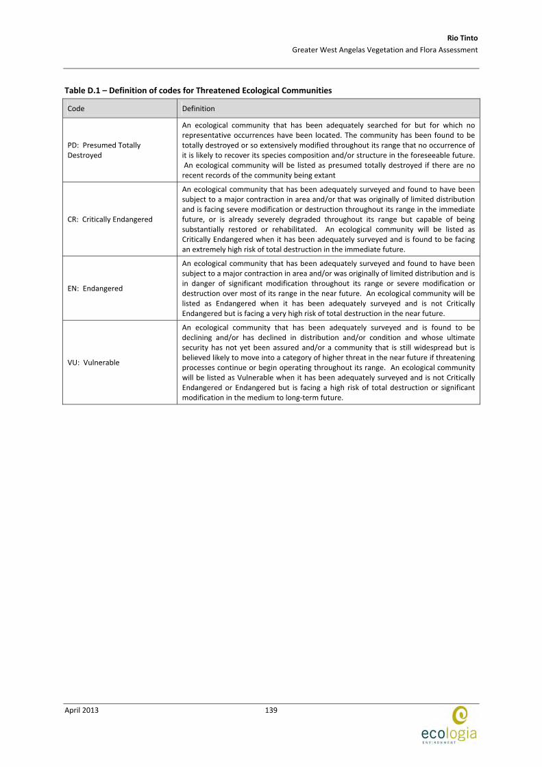
Table D.1 – Definition of codes for Threatened Ecological Communities
Code Definition
PD: Presumed Totally Destroyed
An ecological community that has been adequately searched for but for which no representative occurrences have been located. The community has been found to be totally destroyed or so extensively modified throughout its range that no occurrence of it is likely to recover its species composition and/or structure in the foreseeable future. An ecological community will be listed as presumed totally destroyed if there are no recent records of the community being extant
CR: Critically Endangered
An ecological community that has been adequately surveyed and found to have been subject to a major contraction in area and/or that was originally of limited distribution and is facing severe modification or destruction throughout its range in the immediate future, or is already severely degraded throughout its range but capable of being substantially restored or rehabilitated. An ecological community will be listed as Critically Endangered when it has been adequately surveyed and is found to be facing an extremely high risk of total destruction in the immediate future.
EN: Endangered
An ecological community that has been adequately surveyed and found to have been subject to a major contraction in area and/or was originally of limited distribution and is in danger of significant modification throughout its range or severe modification or destruction over most of its range in the near future. An ecological community will be listed as Endangered when it has been adequately surveyed and is not Critically Endangered but is facing a very high risk of total destruction in the near future.
VU: Vulnerable
An ecological community that has been adequately surveyed and is found to be declining and/or has declined in distribution and/or condition and whose ultimate security has not yet been assured and/or a community that is still widespread but is believed likely to move into a category of higher threat in the near future if threatening processes continue or begin operating throughout its range. An ecological community will be listed as Vulnerable when it has been adequately surveyed and is not Critically Endangered or Endangered but is facing a high risk of total destruction or significant modification in the medium to long‐term future.
Rio Tinto
Greater West Angelas Vegetation and Flora Assessment
April 2013
140
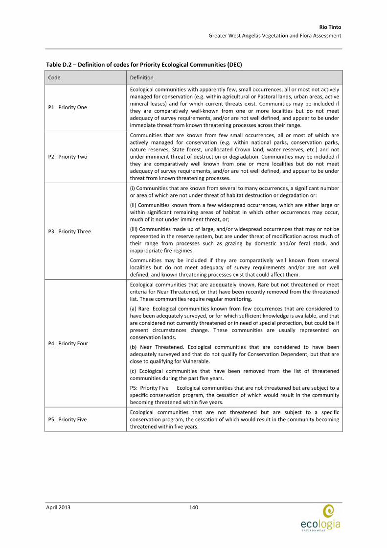
Table D.2 – Definition of codes for Priority Ecological Communities (DEC)
Code Definition
P1: Priority One
Ecological communities with apparently few, small occurrences, all or most not actively managed for conservation (e.g. within agricultural or Pastoral lands, urban areas, active mineral leases) and for which current threats exist. Communities may be included if they are comparatively well‐known from one or more localities but do not meet adequacy of survey requirements, and/or are not well defined, and appear to be under immediate threat from known threatening processes across their range.
P2: Priority Two
Communities that are known from few small occurrences, all or most of which are actively managed for conservation (e.g. within national parks, conservation parks, nature reserves, State forest, unallocated Crown land, water reserves, etc.) and not under imminent threat of destruction or degradation. Communities may be included if they are comparatively well known from one or more localities but do not meet adequacy of survey requirements, and/or are not well defined, and appear to be under threat from known threatening processes.
P3: Priority Three
(i) Communities that are known from several to many occurrences, a significant number or area of which are not under threat of habitat destruction or degradation or:
(ii) Communities known from a few widespread occurrences, which are either large or within significant remaining areas of habitat in which other occurrences may occur, much of it not under imminent threat, or;
(iii) Communities made up of large, and/or widespread occurrences that may or not be represented in the reserve system, but are under threat of modification across much of their range from processes such as grazing by domestic and/or feral stock, and inappropriate fire regimes.
Communities may be included if they are comparatively well known from several localities but do not meet adequacy of survey requirements and/or are not well defined, and known threatening processes exist that could affect them.
P4: Priority Four
Ecological communities that are adequately known, Rare but not threatened or meet criteria for Near Threatened, or that have been recently removed from the threatened list. These communities require regular monitoring.
(a) Rare. Ecological communities known from few occurrences that are considered to have been adequately surveyed, or for which sufficient knowledge is available, and that are considered not currently threatened or in need of special protection, but could be if present circumstances change. These communities are usually represented on conservation lands.
(b) Near Threatened. Ecological communities that are considered to have been adequately surveyed and that do not qualify for Conservation Dependent, but that are close to qualifying for Vulnerable.
(c) Ecological communities that have been removed from the list of threatened communities during the past five years.
P5: Priority Five Ecological communities that are not threatened but are subject to a specific conservation program, the cessation of which would result in the community becoming threatened within five years.
P5: Priority Five Ecological communities that are not threatened but are subject to a specific conservation program, the cessation of which would result in the community becoming threatened within five years.
Rio Tinto
Greater West Angelas Vegetation and Flora Assessment
April 2013
141
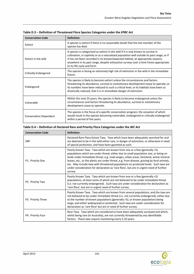
Table D.3 – Definition of Threatened Flora Species Categories under the EPBC Act
Conservation Code Definition
Extinct A species is extinct if there is no reasonable doubt that the last member of the species has died.
Extinct in the wild
A species is categorised as extinct in the wild if it is only known to survive in cultivation, in captivity or as a naturalised population well outside its past range; or if it has not been recorded in its known/expected habitat, at appropriate seasons, anywhere in its past range, despite exhaustive surveys over a time frame appropriate to its life cycle and form.
Critically Endangered The species is facing an extremely high risk of extinction in the wild in the immediate future.
Endangered
The species is likely to become extinct unless the circumstances and factors threatening its abundance, survival or evolutionary development cease to operate; or its numbers have been reduced to such a critical level, or its habitats have been so drastically reduced, that it is in immediate danger of extinction.
Vulnerable
Within the next 25 years, the species is likely to become endangered unless the circumstances and factors threatening its abundance, survival or evolutionary development cease to operate.
Conservation Dependent
The species is the focus of a specific conservation program, the cessation of which would result in the species becoming vulnerable, endangered or critically endangered within a period of five years.
Table D.4 – Definition of Declared Rare and Priority Flora Categories under the WC Act
Conservation Code Definition
DRF Declared Rare Flora‐Extant Taxa. Taxa which have been adequately searched for and are deemed to be in the wild either rare, in danger of extinction, or otherwise in need of special protection, and have been gazetted as such.
P1: Priority One
Poorly Known Taxa. Taxa which are known from one or a few (generally <5) populations which are under threat, either due to small population size, or being on lands under immediate threat, e.g. road verges, urban areas, farmland, active mineral leases, etc., or the plants are under threat, e.g. from disease, grazing by feral animals, etc. May include taxa with threatened populations on protected lands. Such taxa are under consideration for declaration as 'rare flora', but are in urgent need of further survey.
P2: Priority Two
Poorly Known Taxa. Taxa which are known from one or a few (generally <5) populations, at least some of which are not believed to be under immediate threat (i.e. not currently endangered). Such taxa are under consideration for declaration as 'rare flora', but are in urgent need of further survey.
P3: Priority Three
Poorly Known Taxa. Taxa which are known from several populations, and the taxa are not believed to be under immediate threat (i.e. not currently endangered), either due to the number of known populations (generally >5), or known populations being large, and either widespread or protected. Such taxa are under consideration for declaration as 'rare flora' but are in need of further survey.
P4: Priority Four Rare Taxa. Taxa which are considered to have been adequately surveyed and which, whilst being rare (in Australia), are not currently threatened by any identifiable factors. These taxa require monitoring every 5‐10 years.

Rio Tinto
Greater West Angelas Vegetation and Flora Assessment
April 2013
142
This page has been left blank intentionally
Rio Tinto
Greater West Angelas Vegetation and Flora Assessment
April 2013
143
APPENDIX B COORDINATES OF FLORA QUADRATS

Rio Tinto
Greater West Angelas Vegetation and Flora Assessment
April 2013
144
This page has been left blank intentionally
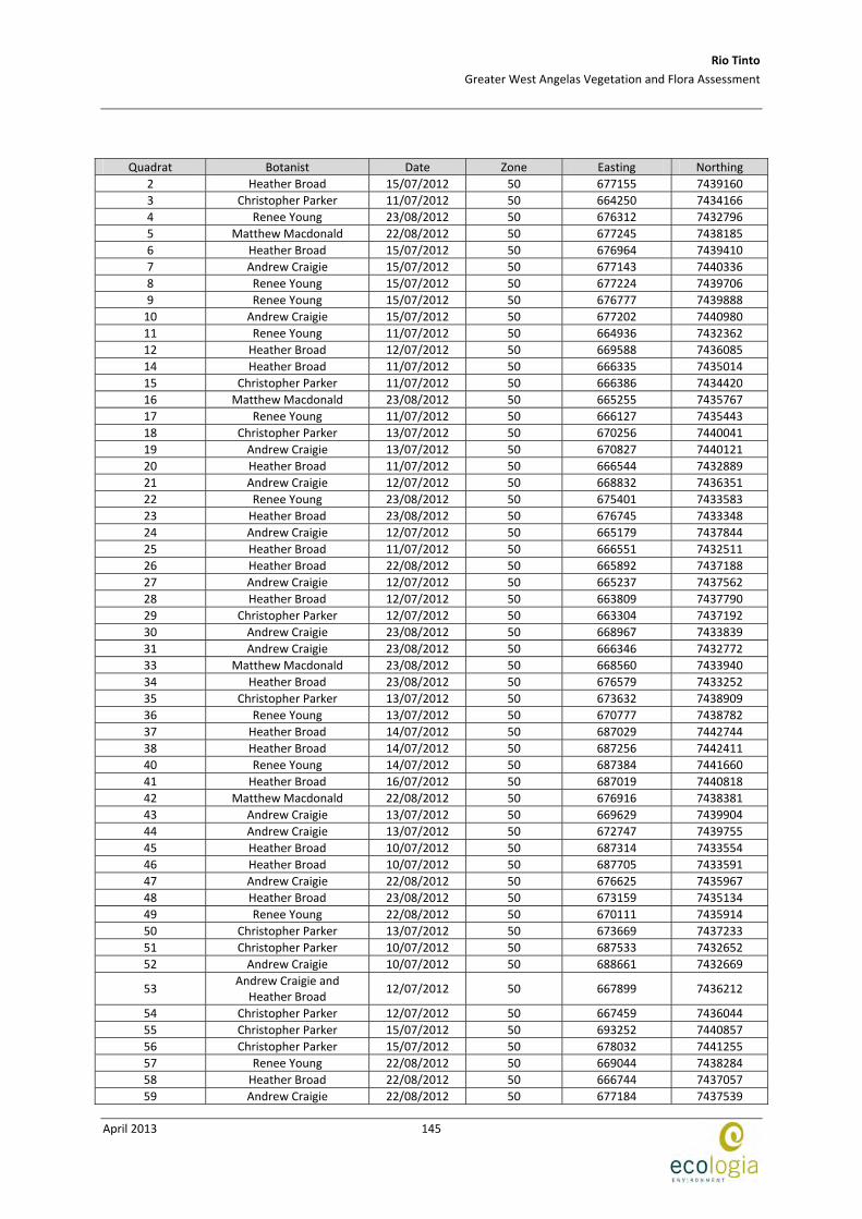
Rio Tinto
Greater West Angelas Vegetation and Flora Assessment
April 2013
145
Quadrat Botanist Date Zone Easting Northing
2 Heather Broad 15/07/2012 50 677155 7439160
3 Christopher Parker 11/07/2012 50 664250 7434166
4 Renee Young 23/08/2012 50 676312 7432796
5 Matthew Macdonald 22/08/2012 50 677245 7438185
6 Heather Broad 15/07/2012 50 676964 7439410
7 Andrew Craigie 15/07/2012 50 677143 7440336
8 Renee Young 15/07/2012 50 677224 7439706
9 Renee Young 15/07/2012 50 676777 7439888
10 Andrew Craigie 15/07/2012 50 677202 7440980
11 Renee Young 11/07/2012 50 664936 7432362
12 Heather Broad 12/07/2012 50 669588 7436085
14 Heather Broad 11/07/2012 50 666335 7435014
15 Christopher Parker 11/07/2012 50 666386 7434420
16 Matthew Macdonald 23/08/2012 50 665255 7435767
17 Renee Young 11/07/2012 50 666127 7435443
18 Christopher Parker 13/07/2012 50 670256 7440041
19 Andrew Craigie 13/07/2012 50 670827 7440121
20 Heather Broad 11/07/2012 50 666544 7432889
21 Andrew Craigie 12/07/2012 50 668832 7436351
22 Renee Young 23/08/2012 50 675401 7433583
23 Heather Broad 23/08/2012 50 676745 7433348
24 Andrew Craigie 12/07/2012 50 665179 7437844
25 Heather Broad 11/07/2012 50 666551 7432511
26 Heather Broad 22/08/2012 50 665892 7437188
27 Andrew Craigie 12/07/2012 50 665237 7437562
28 Heather Broad 12/07/2012 50 663809 7437790
29 Christopher Parker 12/07/2012 50 663304 7437192
30 Andrew Craigie 23/08/2012 50 668967 7433839
31 Andrew Craigie 23/08/2012 50 666346 7432772
33 Matthew Macdonald 23/08/2012 50 668560 7433940
34 Heather Broad 23/08/2012 50 676579 7433252
35 Christopher Parker 13/07/2012 50 673632 7438909
36 Renee Young 13/07/2012 50 670777 7438782
37 Heather Broad 14/07/2012 50 687029 7442744
38 Heather Broad 14/07/2012 50 687256 7442411
40 Renee Young 14/07/2012 50 687384 7441660
41 Heather Broad 16/07/2012 50 687019 7440818
42 Matthew Macdonald 22/08/2012 50 676916 7438381
43 Andrew Craigie 13/07/2012 50 669629 7439904
44 Andrew Craigie 13/07/2012 50 672747 7439755
45 Heather Broad 10/07/2012 50 687314 7433554
46 Heather Broad 10/07/2012 50 687705 7433591
47 Andrew Craigie 22/08/2012 50 676625 7435967
48 Heather Broad 23/08/2012 50 673159 7435134
49 Renee Young 22/08/2012 50 670111 7435914
50 Christopher Parker 13/07/2012 50 673669 7437233
51 Christopher Parker 10/07/2012 50 687533 7432652
52 Andrew Craigie 10/07/2012 50 688661 7432669
53 Andrew Craigie and
Heather Broad 12/07/2012 50 667899 7436212
54 Christopher Parker 12/07/2012 50 667459 7436044
55 Christopher Parker 15/07/2012 50 693252 7440857
56 Christopher Parker 15/07/2012 50 678032 7441255
57 Renee Young 22/08/2012 50 669044 7438284
58 Heather Broad 22/08/2012 50 666744 7437057
59 Andrew Craigie 22/08/2012 50 677184 7437539
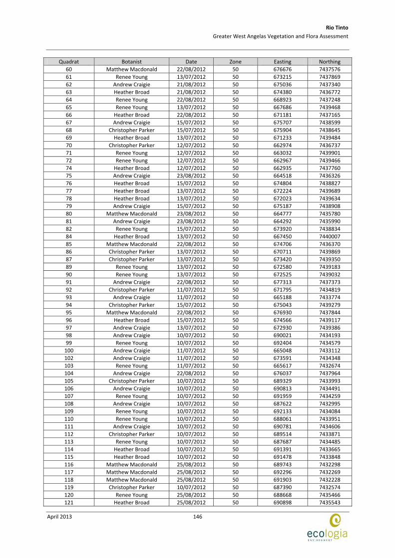
Rio Tinto
Greater West Angelas Vegetation and Flora Assessment
April 2013
146
Quadrat Botanist Date Zone Easting Northing
60 Matthew Macdonald 22/08/2012 50 676676 7437576
61 Renee Young 13/07/2012 50 673215 7437869
62 Andrew Craigie 21/08/2012 50 675036 7437340
63 Heather Broad 21/08/2012 50 674380 7436772
64 Renee Young 22/08/2012 50 668923 7437248
65 Renee Young 13/07/2012 50 667686 7439468
66 Heather Broad 22/08/2012 50 671181 7437165
67 Andrew Craigie 15/07/2012 50 675707 7438599
68 Christopher Parker 15/07/2012 50 675904 7438645
69 Heather Broad 13/07/2012 50 671233 7439484
70 Christopher Parker 12/07/2012 50 662974 7436737
71 Renee Young 12/07/2012 50 663032 7439901
72 Renee Young 12/07/2012 50 662967 7439466
74 Heather Broad 12/07/2012 50 662935 7437760
75 Andrew Craigie 23/08/2012 50 664518 7436326
76 Heather Broad 15/07/2012 50 674804 7438827
77 Heather Broad 13/07/2012 50 672224 7439689
78 Heather Broad 13/07/2012 50 672023 7439634
79 Andrew Craigie 15/07/2012 50 675187 7438908
80 Matthew Macdonald 23/08/2012 50 664777 7435780
81 Andrew Craigie 23/08/2012 50 664292 7435990
82 Renee Young 15/07/2012 50 673920 7438834
84 Heather Broad 13/07/2012 50 667450 7440007
85 Matthew Macdonald 22/08/2012 50 674706 7436370
86 Christopher Parker 13/07/2012 50 670711 7439869
87 Christopher Parker 13/07/2012 50 673420 7439350
89 Renee Young 13/07/2012 50 672580 7439183
90 Renee Young 13/07/2012 50 672525 7439032
91 Andrew Craigie 22/08/2012 50 677313 7437373
92 Christopher Parker 11/07/2012 50 671795 7434819
93 Andrew Craigie 11/07/2012 50 665188 7433774
94 Christopher Parker 15/07/2012 50 675043 7439279
95 Matthew Macdonald 22/08/2012 50 676930 7437844
96 Heather Broad 15/07/2012 50 674566 7439117
97 Andrew Craigie 13/07/2012 50 672930 7439386
98 Andrew Craigie 10/07/2012 50 690021 7434193
99 Renee Young 10/07/2012 50 692404 7434579
100 Andrew Craigie 11/07/2012 50 665048 7433112
102 Andrew Craigie 11/07/2012 50 673591 7434348
103 Renee Young 11/07/2012 50 665617 7432674
104 Andrew Craigie 22/08/2012 50 676037 7437964
105 Christopher Parker 10/07/2012 50 689329 7433993
106 Andrew Craigie 10/07/2012 50 690813 7434491
107 Renee Young 10/07/2012 50 691959 7434259
108 Andrew Craigie 10/07/2012 50 687622 7432995
109 Renee Young 10/07/2012 50 692133 7434084
110 Renee Young 10/07/2012 50 688061 7433951
111 Andrew Craigie 10/07/2012 50 690781 7434606
112 Christopher Parker 10/07/2012 50 689514 7433871
113 Renee Young 10/07/2012 50 687687 7434485
114 Heather Broad 10/07/2012 50 691391 7433665
115 Heather Broad 10/07/2012 50 691478 7433848
116 Matthew Macdonald 25/08/2012 50 689743 7432298
117 Matthew Macdonald 25/08/2012 50 692296 7432269
118 Matthew Macdonald 25/08/2012 50 691903 7432228
119 Christopher Parker 10/07/2012 50 687390 7432574
120 Renee Young 25/08/2012 50 688668 7435466
121 Heather Broad 25/08/2012 50 690898 7435543
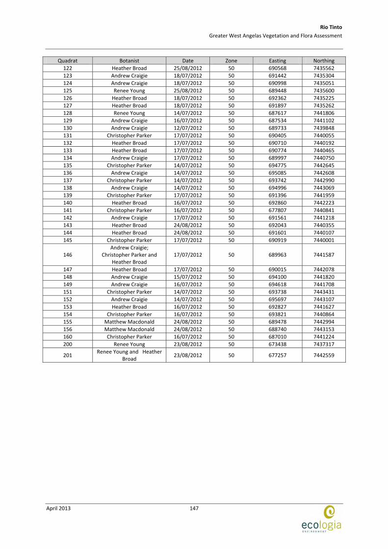
Rio Tinto
Greater West Angelas Vegetation and Flora Assessment
April 2013
147
Quadrat Botanist Date Zone Easting Northing
122 Heather Broad 25/08/2012 50 690568 7435562
123 Andrew Craigie 18/07/2012 50 691442 7435304
124 Andrew Craigie 18/07/2012 50 690998 7435051
125 Renee Young 25/08/2012 50 689448 7435600
126 Heather Broad 18/07/2012 50 692362 7435225
127 Heather Broad 18/07/2012 50 691897 7435262
128 Renee Young 14/07/2012 50 687617 7441806
129 Andrew Craigie 16/07/2012 50 687534 7441102
130 Andrew Craigie 12/07/2012 50 689733 7439848
131 Christopher Parker 17/07/2012 50 690405 7440055
132 Heather Broad 17/07/2012 50 690710 7440192
133 Heather Broad 17/07/2012 50 690774 7440465
134 Andrew Craigie 17/07/2012 50 689997 7440750
135 Christopher Parker 14/07/2012 50 694775 7442645
136 Andrew Craigie 14/07/2012 50 695085 7442608
137 Christopher Parker 14/07/2012 50 693742 7442990
138 Andrew Craigie 14/07/2012 50 694996 7443069
139 Christopher Parker 17/07/2012 50 691396 7441959
140 Heather Broad 16/07/2012 50 692860 7442223
141 Christopher Parker 16/07/2012 50 677807 7440841
142 Andrew Craigie 17/07/2012 50 691561 7441218
143 Heather Broad 24/08/2012 50 692043 7440355
144 Heather Broad 24/08/2012 50 691601 7440107
145 Christopher Parker 17/07/2012 50 690919 7440001
146 Andrew Craigie;
Christopher Parker and Heather Broad
17/07/2012 50 689963 7441587
147 Heather Broad 17/07/2012 50 690015 7442078
148 Andrew Craigie 15/07/2012 50 694100 7441820
149 Andrew Craigie 16/07/2012 50 694618 7441708
151 Christopher Parker 14/07/2012 50 693738 7443431
152 Andrew Craigie 14/07/2012 50 695697 7443107
153 Heather Broad 16/07/2012 50 692827 7441627
154 Christopher Parker 16/07/2012 50 693821 7440864
155 Matthew Macdonald 24/08/2012 50 689478 7442994
156 Matthew Macdonald 24/08/2012 50 688740 7443153
160 Christopher Parker 16/07/2012 50 687010 7441224
200 Renee Young 23/08/2012 50 673438 7437317
201 Renee Young and Heather
Broad 23/08/2012 50 677257 7442559

Rio Tinto
Greater West Angelas Vegetation and Flora Assessment
April 2013
148
This page has been left blank intentionally
Rio Tinto
Greater West Angelas Vegetation and Flora Assessment
April 2013
149
APPENDIX C FLORA SPECIES RECORDED AT WEST ANGELAS

Rio Tinto
Greater West Angelas Vegetation and Flora Assessment
April 2013
150
This page has been left blank intentionally
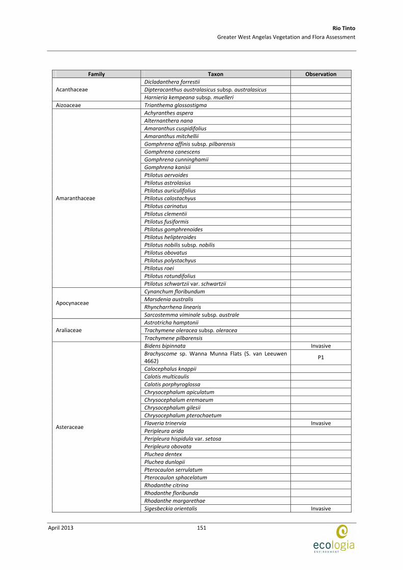
Rio Tinto
Greater West Angelas Vegetation and Flora Assessment
April 2013
151
Family Taxon Observation
Dicladanthera forrestii
Dipteracanthus australasicus subsp. australasicus Acanthaceae
Harnieria kempeana subsp. muelleri
Aizoaceae Trianthema glossostigma
Achyranthes aspera
Alternanthera nana
Amaranthus cuspidifolius
Amaranthus mitchellii
Gomphrena affinis subsp. pilbarensis
Gomphrena canescens
Gomphrena cunninghamii
Gomphrena kanisii
Ptilotus aervoides
Ptilotus astrolasius
Ptilotus auriculifolius
Ptilotus calostachyus
Ptilotus carinatus
Ptilotus clementii
Ptilotus fusiformis
Ptilotus gomphrenoides
Ptilotus helipteroides
Ptilotus nobilis subsp. nobilis
Ptilotus obovatus
Ptilotus polystachyus
Ptilotus roei
Ptilotus rotundifolius
Amaranthaceae
Ptilotus schwartzii var. schwartzii
Cynanchum floribundum
Marsdenia australis
Rhyncharrhena linearis Apocynaceae
Sarcostemma viminale subsp. australe
Astrotricha hamptonii
Trachymene oleracea subsp. oleracea Araliaceae
Trachymene pilbarensis
Bidens bipinnata Invasive
Brachyscome sp. Wanna Munna Flats (S. van Leeuwen 4662)
P1
Calocephalus knappii
Calotis multicaulis
Calotis porphyroglossa
Chrysocephalum apiculatum
Chrysocephalum eremaeum
Chrysocephalum gilesii
Chrysocephalum pterochaetum
Flaveria trinervia Invasive
Peripleura arida
Peripleura hispidula var. setosa
Peripleura obovata
Pluchea dentex
Pluchea dunlopii
Pterocaulon serrulatum
Pterocaulon sphacelatum
Rhodanthe citrina
Rhodanthe floribunda
Rhodanthe margarethae
Asteraceae
Sigesbeckia orientalis Invasive
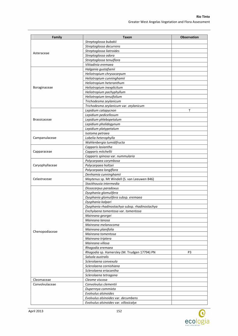
Rio Tinto
Greater West Angelas Vegetation and Flora Assessment
April 2013
152
Family Taxon Observation
Streptoglossa bubakii
Streptoglossa decurrens
Streptoglossa liatroides
Streptoglossa odora
Streptoglossa tenuiflora
Asteraceae
Vittadinia eremaea
Halgania gustafsenii
Heliotropium chrysocarpum
Heliotropium cunninghamii
Heliotropium heteranthum
Heliotropium inexplicitum
Heliotropium pachyphyllum
Heliotropium tenuifolium
Trichodesma zeylanicum
Boraginaceae
Trichodesma zeylanicum var. zeylanicum
Lepidium catapycnon T
Lepidium pedicellosum
Lepidium phlebopetalum
Lepidium pholidogynum
Brassicaceae
Lepidium platypetalum
Isotoma petraea
Lobelia heterophylla Campanulaceae
Wahlenbergia tumidifructa
Capparis lasiantha
Capparis mitchellii Capparaceae
Capparis spinosa var. nummularia
Polycarpaea corymbosa
Polycarpaea holtzei Caryophyllaceae
Polycarpaea longiflora
Denhamia cunninghamii
Maytenus sp. Mt Windell (S. van Leeuwen 846) Celastraceae
Stackhousia intermedia
Dissocarpus paradoxus
Dysphania glomulifera
Dysphania glomulifera subsp. eremaea
Dysphania kalpari
Dysphania rhadinostachya subsp. rhadinostachya
Enchylaena tomentosa var. tomentosa
Maireana georgei
Maireana lanosa
Maireana melanocoma
Maireana planifolia
Maireana tomentosa
Maireana triptera
Maireana villosa
Rhagodia eremaea
Rhagodia sp. Hamersley (M. Trudgen 17794) PN P3
Salsola australis
Sclerolaena convexula
Sclerolaena cornishiana
Sclerolaena eriacantha
Chenopodiaceae
Sclerolaena tetragona
Cleomaceae Cleome viscosa
Convolvulus clementii
Duperreya commixta
Evolvulus alsinoides
Evolvulus alsinoides var. decumbens
Convolvulaceae
Evolvulus alsinoides var. villosicalyx

Rio Tinto
Greater West Angelas Vegetation and Flora Assessment
April 2013
153
Family Taxon Observation
Ipomoea muelleri
Ipomoea polymorpha
Operculina aequisepala
Polymeria ambigua
Cucurbitaceae Cucumis variabilis
Bulbostylis barbata
Cyperus cunninghamii subsp. cunninghamii
Fimbristylis dichotoma Cyperaceae
Fimbristylis simulans
Adriana tomentosa var. tomentosa
Euphorbia alsiniflora
Euphorbia australis
Euphorbia biconvexa
Euphorbia boophthona
Euphorbia drummondii
Euphorbiaceae
Euphorbia schultzii
Acacia adoxa var. adoxa
Acacia adsurgens
Acacia ancistrocarpa
Acacia aptaneura
Acacia atkinsiana
Acacia ayersiana
Acacia bivenosa
Acacia catenulata subsp. occidentalis
Acacia citrinoviridis
Acacia colei var. colei
Acacia cowleana
Acacia dictyophleba
Acacia eriopoda
Acacia hamersleyensis
Acacia inaequilatera
Acacia incurvaneura
Acacia macraneura
Acacia maitlandii
Acacia marramamba
Acacia minyura
Acacia monticola
Acacia pachyacra
Acacia pruinocarpa
Acacia pteraneura
Acacia pyrifolia
Acacia pyrifolia var. pyrifolia
Acacia rhodophloia
Acacia sibirica
Acacia aff. subtiliformis P3
Acacia synchronicia
Acacia tenuissima
Acacia tetragonophylla
Acacia validinervia
Crotalaria medicaginea var. neglecta
Crotalaria novae‐hollandiae subsp. novae‐hollandiae
Cullen leucochaites
Gastrolobium grandiflorum
Glycine canescens
Gompholobium oreophilum
Indigofera fractiflexa
Indigofera georgei
Fabaceae
Indigofera sp. Gilesii (M.E. Trudgen 15869) P3
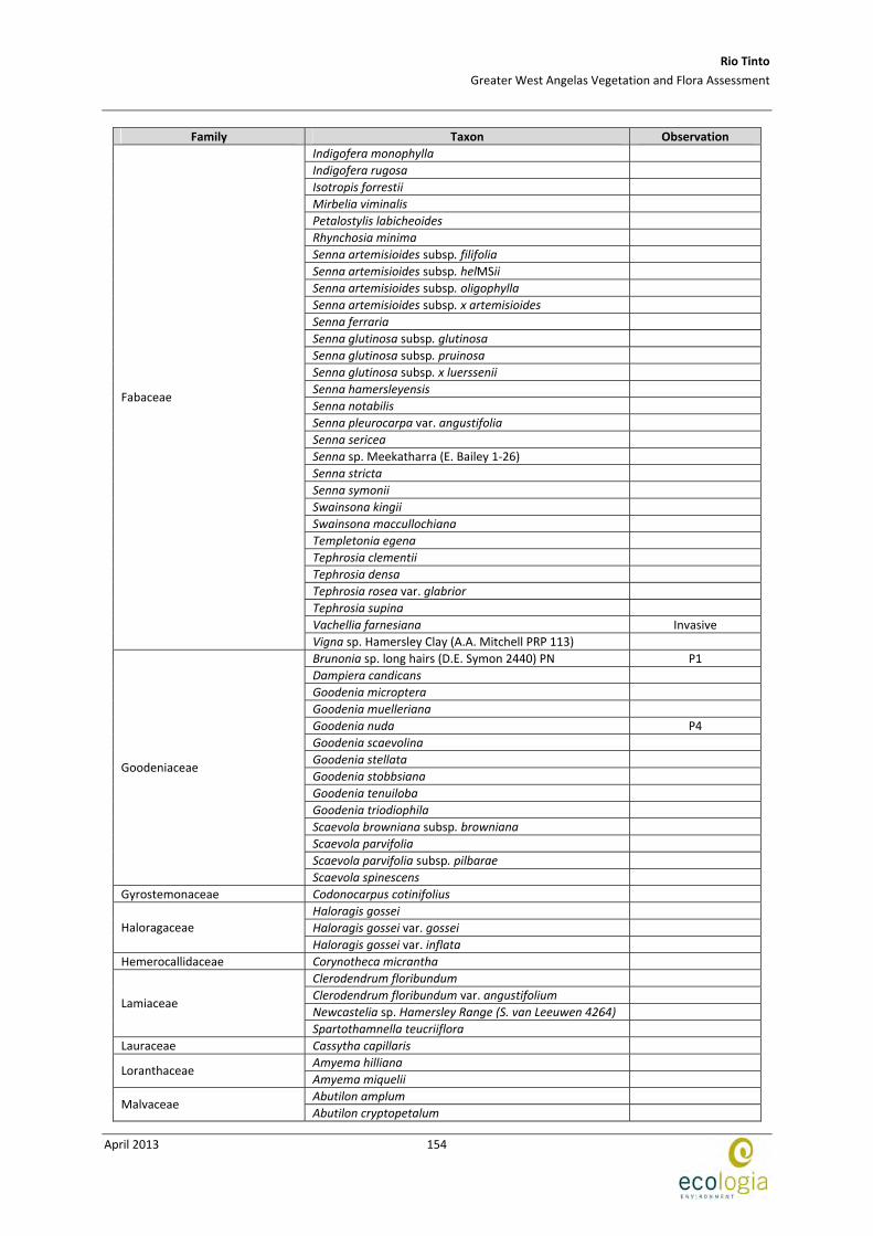
Rio Tinto
Greater West Angelas Vegetation and Flora Assessment
April 2013
154
Family Taxon Observation
Indigofera monophylla
Indigofera rugosa
Isotropis forrestii
Mirbelia viminalis
Petalostylis labicheoides
Rhynchosia minima
Senna artemisioides subsp. filifolia
Senna artemisioides subsp. helMSii
Senna artemisioides subsp. oligophylla
Senna artemisioides subsp. x artemisioides
Senna ferraria
Senna glutinosa subsp. glutinosa
Senna glutinosa subsp. pruinosa
Senna glutinosa subsp. x luerssenii
Senna hamersleyensis
Senna notabilis
Senna pleurocarpa var. angustifolia
Senna sericea
Senna sp. Meekatharra (E. Bailey 1‐26)
Senna stricta
Senna symonii
Swainsona kingii
Swainsona maccullochiana
Templetonia egena
Tephrosia clementii
Tephrosia densa
Tephrosia rosea var. glabrior
Tephrosia supina
Vachellia farnesiana Invasive
Fabaceae
Vigna sp. Hamersley Clay (A.A. Mitchell PRP 113)
Brunonia sp. long hairs (D.E. Symon 2440) PN P1
Dampiera candicans
Goodenia microptera
Goodenia muelleriana
Goodenia nuda P4
Goodenia scaevolina
Goodenia stellata
Goodenia stobbsiana
Goodenia tenuiloba
Goodenia triodiophila
Scaevola browniana subsp. browniana
Scaevola parvifolia
Scaevola parvifolia subsp. pilbarae
Goodeniaceae
Scaevola spinescens
Gyrostemonaceae Codonocarpus cotinifolius
Haloragis gossei
Haloragis gossei var. gossei Haloragaceae
Haloragis gossei var. inflata
Hemerocallidaceae Corynotheca micrantha
Clerodendrum floribundum
Clerodendrum floribundum var. angustifolium
Newcastelia sp. Hamersley Range (S. van Leeuwen 4264) Lamiaceae
Spartothamnella teucriiflora
Lauraceae Cassytha capillaris
Amyema hilliana Loranthaceae
Amyema miquelii
Abutilon amplum Malvaceae
Abutilon cryptopetalum
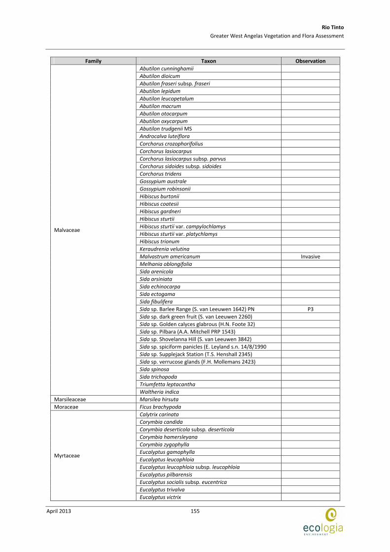
Rio Tinto
Greater West Angelas Vegetation and Flora Assessment
April 2013
155
Family Taxon Observation
Abutilon cunninghamii
Abutilon dioicum
Abutilon fraseri subsp. fraseri
Abutilon lepidum
Abutilon leucopetalum
Abutilon macrum
Abutilon otocarpum
Abutilon oxycarpum
Abutilon trudgenii MS
Androcalva luteiflora
Corchorus crozophorifolius
Corchorus lasiocarpus
Corchorus lasiocarpus subsp. parvus
Corchorus sidoides subsp. sidoides
Corchorus tridens
Gossypium australe
Gossypium robinsonii
Hibiscus burtonii
Hibiscus coatesii
Hibiscus gardneri
Hibiscus sturtii
Hibiscus sturtii var. campylochlamys
Hibiscus sturtii var. platychlamys
Hibiscus trionum
Keraudrenia velutina
Malvastrum americanum Invasive
Melhania oblongifolia
Sida arenicola
Sida arsiniata
Sida echinocarpa
Sida ectogama
Sida fibulifera
Sida sp. Barlee Range (S. van Leeuwen 1642) PN P3
Sida sp. dark green fruit (S. van Leeuwen 2260)
Sida sp. Golden calyces glabrous (H.N. Foote 32)
Sida sp. Pilbara (A.A. Mitchell PRP 1543)
Sida sp. Shovelanna Hill (S. van Leeuwen 3842)
Sida sp. spiciform panicles (E. Leyland s.n. 14/8/1990
Sida sp. Supplejack Station (T.S. Henshall 2345)
Sida sp. verrucose glands (F.H. Mollemans 2423)
Sida spinosa
Sida trichopoda
Triumfetta leptacantha
Malvaceae
Waltheria indica
Marsileaceae Marsilea hirsuta
Moraceae Ficus brachypoda
Calytrix carinata
Corymbia candida
Corymbia deserticola subsp. deserticola
Corymbia hamersleyana
Corymbia zygophylla
Eucalyptus gamophylla
Eucalyptus leucophloia
Eucalyptus leucophloia subsp. leucophloia
Eucalyptus pilbarensis
Eucalyptus socialis subsp. eucentrica
Eucalyptus trivalva
Myrtaceae
Eucalyptus victrix
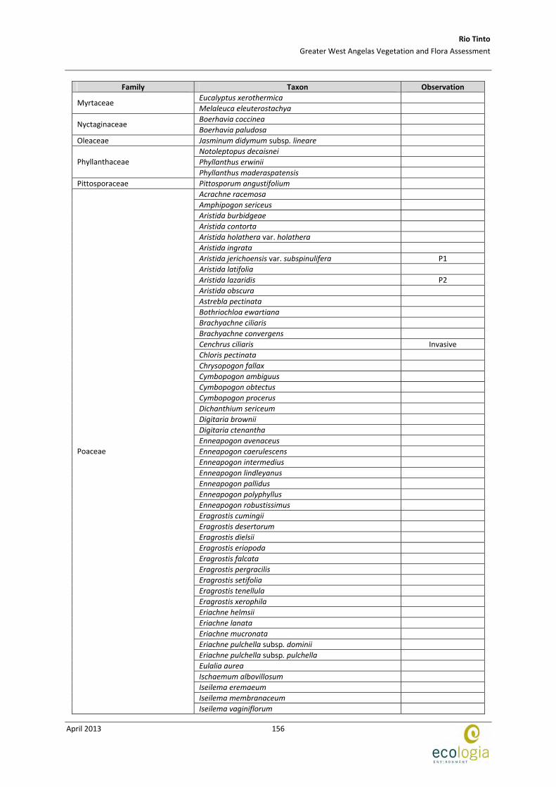
Rio Tinto
Greater West Angelas Vegetation and Flora Assessment
April 2013
156
Family Taxon Observation
Eucalyptus xerothermica Myrtaceae
Melaleuca eleuterostachya
Boerhavia coccinea Nyctaginaceae
Boerhavia paludosa
Oleaceae Jasminum didymum subsp. lineare
Notoleptopus decaisnei
Phyllanthus erwinii Phyllanthaceae
Phyllanthus maderaspatensis
Pittosporaceae Pittosporum angustifolium
Acrachne racemosa
Amphipogon sericeus
Aristida burbidgeae
Aristida contorta
Aristida holathera var. holathera
Aristida ingrata
Aristida jerichoensis var. subspinulifera P1
Aristida latifolia
Aristida lazaridis P2
Aristida obscura
Astrebla pectinata
Bothriochloa ewartiana
Brachyachne ciliaris
Brachyachne convergens
Cenchrus ciliaris Invasive
Chloris pectinata
Chrysopogon fallax
Cymbopogon ambiguus
Cymbopogon obtectus
Cymbopogon procerus
Dichanthium sericeum
Digitaria brownii
Digitaria ctenantha
Enneapogon avenaceus
Enneapogon caerulescens
Enneapogon intermedius
Enneapogon lindleyanus
Enneapogon pallidus
Enneapogon polyphyllus
Enneapogon robustissimus
Eragrostis cumingii
Eragrostis desertorum
Eragrostis dielsii
Eragrostis eriopoda
Eragrostis falcata
Eragrostis pergracilis
Eragrostis setifolia
Eragrostis tenellula
Eragrostis xerophila
Eriachne helmsii
Eriachne lanata
Eriachne mucronata
Eriachne pulchella subsp. dominii
Eriachne pulchella subsp. pulchella
Eulalia aurea
Ischaemum albovillosum
Iseilema eremaeum
Iseilema membranaceum
Poaceae
Iseilema vaginiflorum
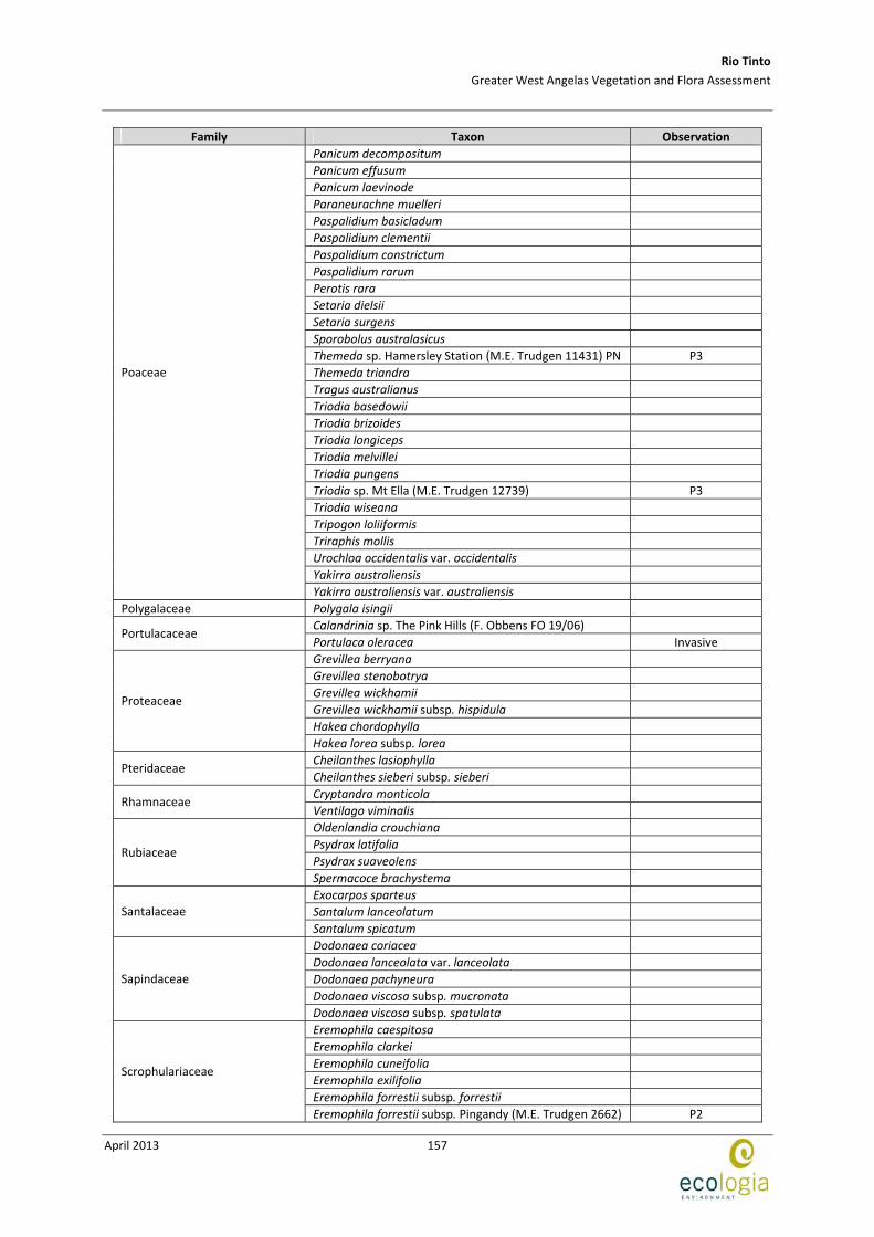
Rio Tinto
Greater West Angelas Vegetation and Flora Assessment
April 2013
157
Family Taxon Observation
Panicum decompositum
Panicum effusum
Panicum laevinode
Paraneurachne muelleri
Paspalidium basicladum
Paspalidium clementii
Paspalidium constrictum
Paspalidium rarum
Perotis rara
Setaria dielsii
Setaria surgens
Sporobolus australasicus
Themeda sp. Hamersley Station (M.E. Trudgen 11431) PN P3
Themeda triandra
Tragus australianus
Triodia basedowii
Triodia brizoides
Triodia longiceps
Triodia melvillei
Triodia pungens
Triodia sp. Mt Ella (M.E. Trudgen 12739) P3
Triodia wiseana
Tripogon loliiformis
Triraphis mollis
Urochloa occidentalis var. occidentalis
Yakirra australiensis
Poaceae
Yakirra australiensis var. australiensis
Polygalaceae Polygala isingii
Calandrinia sp. The Pink Hills (F. Obbens FO 19/06) Portulacaceae
Portulaca oleracea Invasive
Grevillea berryana
Grevillea stenobotrya
Grevillea wickhamii
Grevillea wickhamii subsp. hispidula
Hakea chordophylla
Proteaceae
Hakea lorea subsp. lorea
Cheilanthes lasiophylla Pteridaceae
Cheilanthes sieberi subsp. sieberi
Cryptandra monticola Rhamnaceae
Ventilago viminalis
Oldenlandia crouchiana
Psydrax latifolia
Psydrax suaveolens Rubiaceae
Spermacoce brachystema
Exocarpos sparteus
Santalum lanceolatum Santalaceae
Santalum spicatum
Dodonaea coriacea
Dodonaea lanceolata var. lanceolata
Dodonaea pachyneura
Dodonaea viscosa subsp. mucronata
Sapindaceae
Dodonaea viscosa subsp. spatulata
Eremophila caespitosa
Eremophila clarkei
Eremophila cuneifolia
Eremophila exilifolia
Eremophila forrestii subsp. forrestii
Scrophulariaceae
Eremophila forrestii subsp. Pingandy (M.E. Trudgen 2662) P2
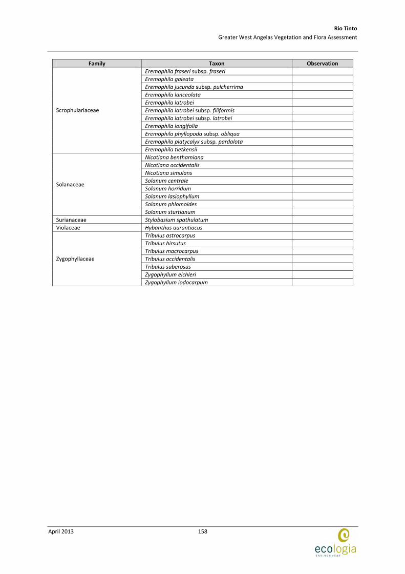
Rio Tinto
Greater West Angelas Vegetation and Flora Assessment
April 2013
158
Family Taxon Observation
Eremophila fraseri subsp. fraseri
Eremophila galeata
Eremophila jucunda subsp. pulcherrima
Eremophila lanceolata
Eremophila latrobei
Eremophila latrobei subsp. filiformis
Eremophila latrobei subsp. latrobei
Eremophila longifolia
Eremophila phyllopoda subsp. obliqua
Eremophila platycalyx subsp. pardalota
Scrophulariaceae
Eremophila tietkensii
Nicotiana benthamiana
Nicotiana occidentalis
Nicotiana simulans
Solanum centrale
Solanum horridum
Solanum lasiophyllum
Solanum phlomoides
Solanaceae
Solanum sturtianum
Surianaceae Stylobasium spathulatum
Violaceae Hybanthus aurantiacus
Tribulus astrocarpus
Tribulus hirsutus
Tribulus macrocarpus
Tribulus occidentalis
Tribulus suberosus
Zygophyllum eichleri
Zygophyllaceae
Zygophyllum iodocarpum
Rio Tinto
Greater West Angelas Vegetation and Flora Assessment
April 2013
159
APPENDIX D COORDINATES OF PRIORITY FLORA AT WEST ANGELAS

Rio Tinto
Greater West Angelas Vegetation and Flora Assessment
April 2013
160
This page has been left blank intentionally
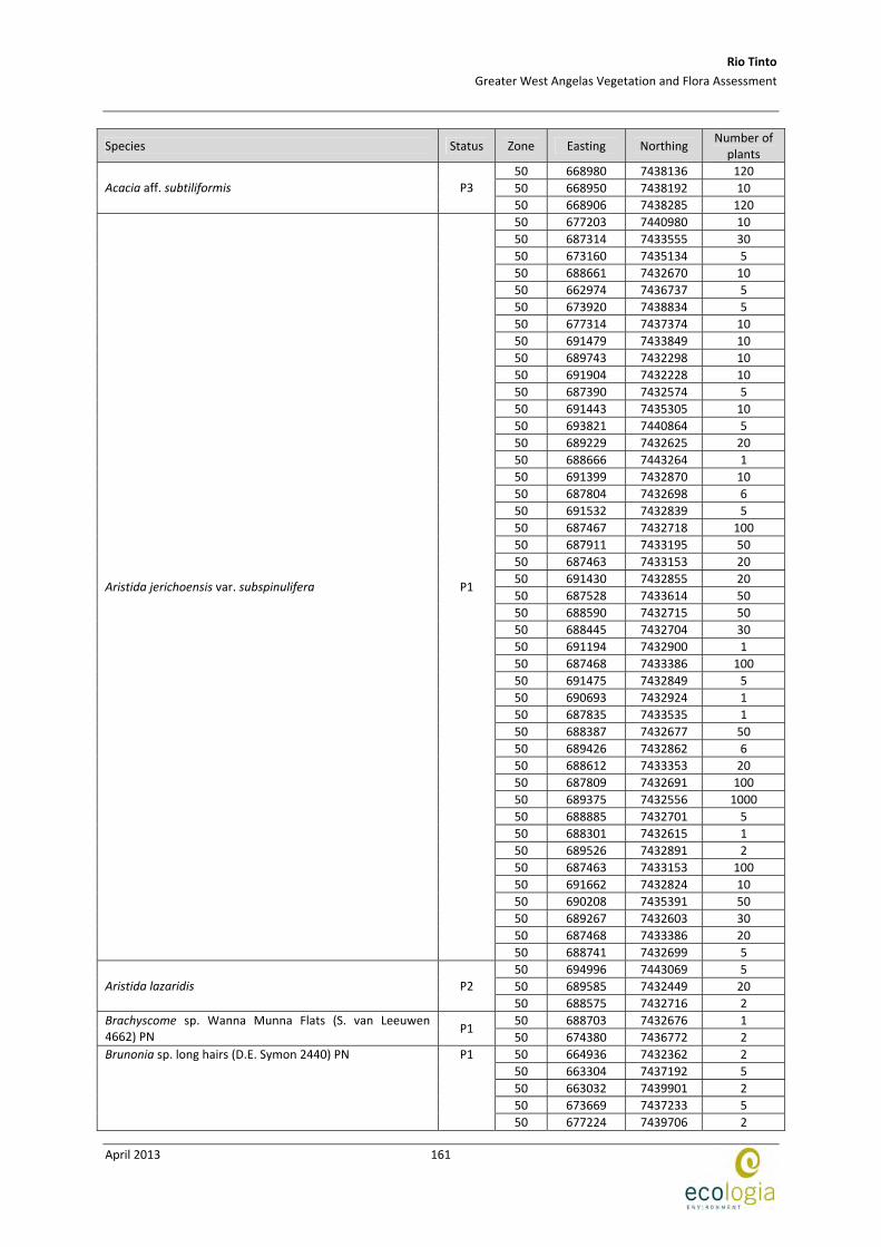
Rio Tinto
Greater West Angelas Vegetation and Flora Assessment
April 2013
161
Species Status Zone Easting Northing Number of
plants
50 668980 7438136 120
50 668950 7438192 10 Acacia aff. subtiliformis P3
50 668906 7438285 120
50 677203 7440980 10
50 687314 7433555 30
50 673160 7435134 5
50 688661 7432670 10
50 662974 7436737 5
50 673920 7438834 5
50 677314 7437374 10
50 691479 7433849 10
50 689743 7432298 10
50 691904 7432228 10
50 687390 7432574 5
50 691443 7435305 10
50 693821 7440864 5
50 689229 7432625 20
50 688666 7443264 1
50 691399 7432870 10
50 687804 7432698 6
50 691532 7432839 5
50 687467 7432718 100
50 687911 7433195 50
50 687463 7433153 20
50 691430 7432855 20
50 687528 7433614 50
50 688590 7432715 50
50 688445 7432704 30
50 691194 7432900 1
50 687468 7433386 100
50 691475 7432849 5
50 690693 7432924 1
50 687835 7433535 1
50 688387 7432677 50
50 689426 7432862 6
50 688612 7433353 20
50 687809 7432691 100
50 689375 7432556 1000
50 688885 7432701 5
50 688301 7432615 1
50 689526 7432891 2
50 687463 7433153 100
50 691662 7432824 10
50 690208 7435391 50
50 689267 7432603 30
50 687468 7433386 20
Aristida jerichoensis var. subspinulifera P1
50 688741 7432699 5
50 694996 7443069 5
50 689585 7432449 20 Aristida lazaridis P2
50 688575 7432716 2
50 688703 7432676 1 Brachyscome sp. Wanna Munna Flats (S. van Leeuwen 4662) PN
P1 50 674380 7436772 2
50 664936 7432362 2
50 663304 7437192 5
50 663032 7439901 2
50 673669 7437233 5
Brunonia sp. long hairs (D.E. Symon 2440) PN P1
50 677224 7439706 2
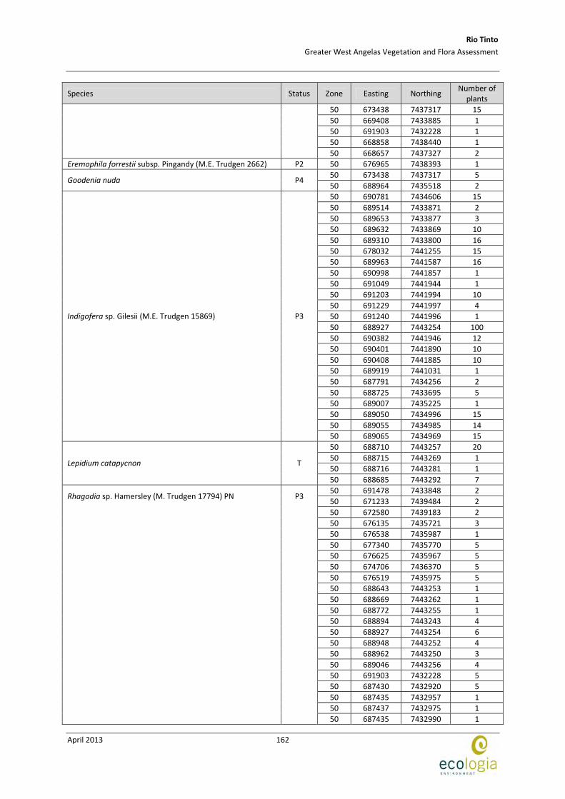
Rio Tinto
Greater West Angelas Vegetation and Flora Assessment
April 2013
162
Species Status Zone Easting Northing Number of
plants
50 673438 7437317 15
50 669408 7433885 1
50 691903 7432228 1
50 668858 7438440 1
50 668657 7437327 2
Eremophila forrestii subsp. Pingandy (M.E. Trudgen 2662) P2 50 676965 7438393 1
50 673438 7437317 5 Goodenia nuda P4
50 688964 7435518 2
50 690781 7434606 15
50 689514 7433871 2
50 689653 7433877 3
50 689632 7433869 10
50 689310 7433800 16
50 678032 7441255 15
50 689963 7441587 16
50 690998 7441857 1
50 691049 7441944 1
50 691203 7441994 10
50 691229 7441997 4
50 691240 7441996 1
50 688927 7443254 100
50 690382 7441946 12
50 690401 7441890 10
50 690408 7441885 10
50 689919 7441031 1
50 687791 7434256 2
50 688725 7433695 5
50 689007 7435225 1
50 689050 7434996 15
50 689055 7434985 14
Indigofera sp. Gilesii (M.E. Trudgen 15869) P3
50 689065 7434969 15
50 688710 7443257 20
50 688715 7443269 1
50 688716 7443281 1 Lepidium catapycnon T
50 688685 7443292 7
50 691478 7433848 2
50 671233 7439484 2
50 672580 7439183 2
50 676135 7435721 3
50 676538 7435987 1
50 677340 7435770 5
50 676625 7435967 5
50 674706 7436370 5
50 676519 7435975 5
50 688643 7443253 1
50 688669 7443262 1
50 688772 7443255 1
50 688894 7443243 4
50 688927 7443254 6
50 688948 7443252 4
50 688962 7443250 3
50 689046 7443256 4
50 691903 7432228 5
50 687430 7432920 5
50 687435 7432957 1
50 687437 7432975 1
Rhagodia sp. Hamersley (M. Trudgen 17794) PN P3
50 687435 7432990 1
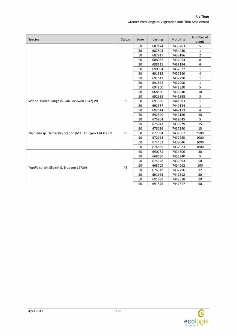
Rio Tinto
Greater West Angelas Vegetation and Flora Assessment
April 2013
163
Species Status Zone Easting Northing Number of
plants
50 687474 7433203 5
50 687803 7434230 1
50 687917 7433186 2
50 688055 7432954 8
50 688511 7433194 6
50 690364 7432322 1
50 691515 7432320 4
50 691647 7432290 1
50 691872 7432200 1
50 694100 7441820 5
50 668560 7433940 10
50 691335 7441998 3
50 691350 7441983 1
50 692537 7442144 1
50 692644 7442173 4
Sida sp. Barlee Range (S. van Leeuwen 1642) PN P3
50 692649 7442186 30
50 675904 7438645 5
50 675043 7439279 15
50 675036 7437340 15
50 677034 7437867 ~500
50 672958 7437985 1000
50 674453 7438046 1000
Themeda sp. Hamersley Station (M.E. Trudgen 11431) PN P3
50 674839 7437923 1000
50 690781 7434606 30
50 668560 7433940 5
50 675528 7433693 50
50 668709 7434062 100
50 676312 7432796 32
50 691966 7442312 50
50 691899 7442318 20
Triodia sp. Mt Ella (M.E. Trudgen 12739) P3
50 691875 7442317 50

Rio Tinto
Greater West Angelas Vegetation and Flora Assessment
April 2013
164
This page has been left blank intentionally

Rio Tinto
Greater West Angelas Vegetation and Flora Assessment
April 2013
165
APPENDIX E RARE AND PRIORITY FLORA REPORT FORMS
(Refer to attached disk)

Rio Tinto
Greater West Angelas Vegetation and Flora Assessment
April 2013
166
This page has been left blank intentionally
Rio Tinto
Greater West Angelas Vegetation and Flora Assessment
April 2013
167
APPENDIX F WEED CATEGORIES

Rio Tinto
Greater West Angelas Vegetation and Flora Assessment
April 2013
168
This page has been left blank intentionally
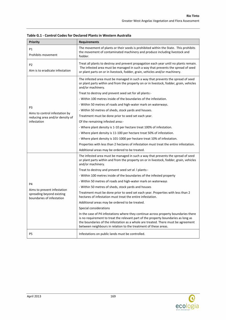
Rio Tinto
Greater West Angelas Vegetation and Flora Assessment
April 2013
169
Table G.1 ‐ Control Codes for Declared Plants in Western Australia
Priority Requirements
P1
Prohibits movement
The movement of plants or their seeds is prohibited within the State. This prohibits the movement of contaminated machinery and produce including livestock and fodder.
P2
Aim is to eradicate infestation
Treat all plants to destroy and prevent propagation each year until no plants remain. The infested area must be managed in such a way that prevents the spread of seed or plant parts on or in livestock, fodder, grain, vehicles and/or machinery.
P3
Aims to control infestation by reducing area and/or density of infestation
The infested area must be managed in such a way that prevents the spread of seed or plant parts within and from the property on or in livestock, fodder, grain, vehicles and/or machinery.
Treat to destroy and prevent seed set for all plants:‐
‐ Within 100 metres inside of the boundaries of the infestation.
‐ Within 50 metres of roads and high‐water mark on waterways.
‐ Within 50 metres of sheds, stock yards and houses.
Treatment must be done prior to seed set each year.
Of the remaining infested area:‐
‐ Where plant density is 1‐10 per hectare treat 100% of infestation.
‐ Where plant density is 11‐100 per hectare treat 50% of infestation.
‐ Where plant density is 101‐1000 per hectare treat 10% of infestation.
Properties with less than 2 hectares of infestation must treat the entire infestation.
Additional areas may be ordered to be treated.
P4
Aims to prevent infestation spreading beyond existing boundaries of infestation
The infested area must be managed in such a way that prevents the spread of seed or plant parts within and from the property on or in livestock, fodder, grain, vehicles and/or machinery.
Treat to destroy and prevent seed set al. l plants:‐
‐ Within 100 metres inside of the boundaries of the infested property
‐ Within 50 metres of roads and high‐water mark on waterways
‐ Within 50 metres of sheds, stock yards and houses
Treatment must be done prior to seed set each year. Properties with less than 2 hectares of infestation must treat the entire infestation.
Additional areas may be ordered to be treated.
Special considerations
In the case of P4 infestations where they continue across property boundaries there is no requirement to treat the relevant part of the property boundaries as long as the boundaries of the infestation as a whole are treated. There must be agreement between neighbours in relation to the treatment of these areas.
P5 Infestations on public lands must be controlled.

Rio Tinto
Greater West Angelas Vegetation and Flora Assessment
April 2013
170
This page has been left blank intentionally
Rio Tinto
Greater West Angelas Vegetation and Flora Assessment
April 2013
171
APPENDIX G LOCATION OF WEEDS RECORDED AT WEST ANGELAS

Rio Tinto
Greater West Angelas Vegetation and Flora Assessment
April 2013
172
This page has been left blank intentionally

Rio Tinto
Greater West Angelas Vegetation and Flora Assessment
April 2013
173
Taxon Zone Easting Northing
Acetosa vesicaria 50 670282 7439512
50 688661 7432669
50 692404 7434579
50 687622 7432995
50 691478 7433848
50 666551 7432511
50 671795 7434819
50 669588 7436085
50 662967 7439466
50 663340 7437261
50 670256 7440041
50 670827 7440121
50 669629 7439904
50 672747 7439755
50 673669 7437233
50 671233 7439484
50 667450 7440007
50 673420 7439350
50 672580 7439183
50 672525 7439032
50 672930 7439386
50 677143 7440336
50 676777 7439888
50 693252 7440857
50 674804 7438827
50 675187 7438908
50 675043 7439279
50 674566 7439117
50 687534 7441102
50 677807 7440841
50 689733 7439848
50 690405 7440055
50 690919 7440001
50 691442 7435304
50 674380 7436772
50 665892 7437188
50 676625 7435967
50 670111 7435914
50 677184 7437539
50 668923 7437248
50 671181 7437165
50 676037 7437964
50 666346 7432772
50 670282 7439512
50 676538 7435978
50 670245 7439842
50 670290 7439432
50 694470 7443294
50 676131 7435725
50 675457 7438797
50 677339 7435770
50 690693 7439991
50 693338 7440912
50 663126 7437338
Bidens bipinnata
50 674534 7439138
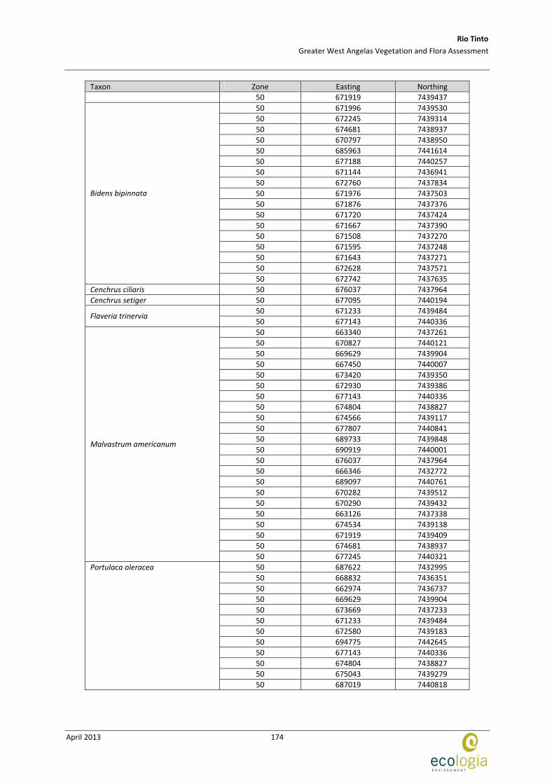
Rio Tinto
Greater West Angelas Vegetation and Flora Assessment
April 2013
174
Taxon Zone Easting Northing
50 671919 7439437
50 671996 7439530
50 672245 7439314
50 674681 7438937
50 670797 7438950
50 685963 7441614
50 677188 7440257
50 671144 7436941
50 672760 7437834
50 671976 7437503
50 671876 7437376
50 671720 7437424
50 671667 7437390
50 671508 7437270
50 671595 7437248
50 671643 7437271
50 672628 7437571
Bidens bipinnata
50 672742 7437635
Cenchrus ciliaris 50 676037 7437964
Cenchrus setiger 50 677095 7440194
50 671233 7439484 Flaveria trinervia
50 677143 7440336
50 663340 7437261
50 670827 7440121
50 669629 7439904
50 667450 7440007
50 673420 7439350
50 672930 7439386
50 677143 7440336
50 674804 7438827
50 674566 7439117
50 677807 7440841
50 689733 7439848
50 690919 7440001
50 676037 7437964
50 666346 7432772
50 689097 7440761
50 670282 7439512
50 670290 7439432
50 663126 7437338
50 674534 7439138
50 671919 7439409
50 674681 7438937
Malvastrum americanum
50 677245 7440321
50 687622 7432995
50 668832 7436351
50 662974 7436737
50 669629 7439904
50 673669 7437233
50 671233 7439484
50 672580 7439183
50 694775 7442645
50 677143 7440336
50 674804 7438827
50 675043 7439279
Portulaca oleracea
50 687019 7440818
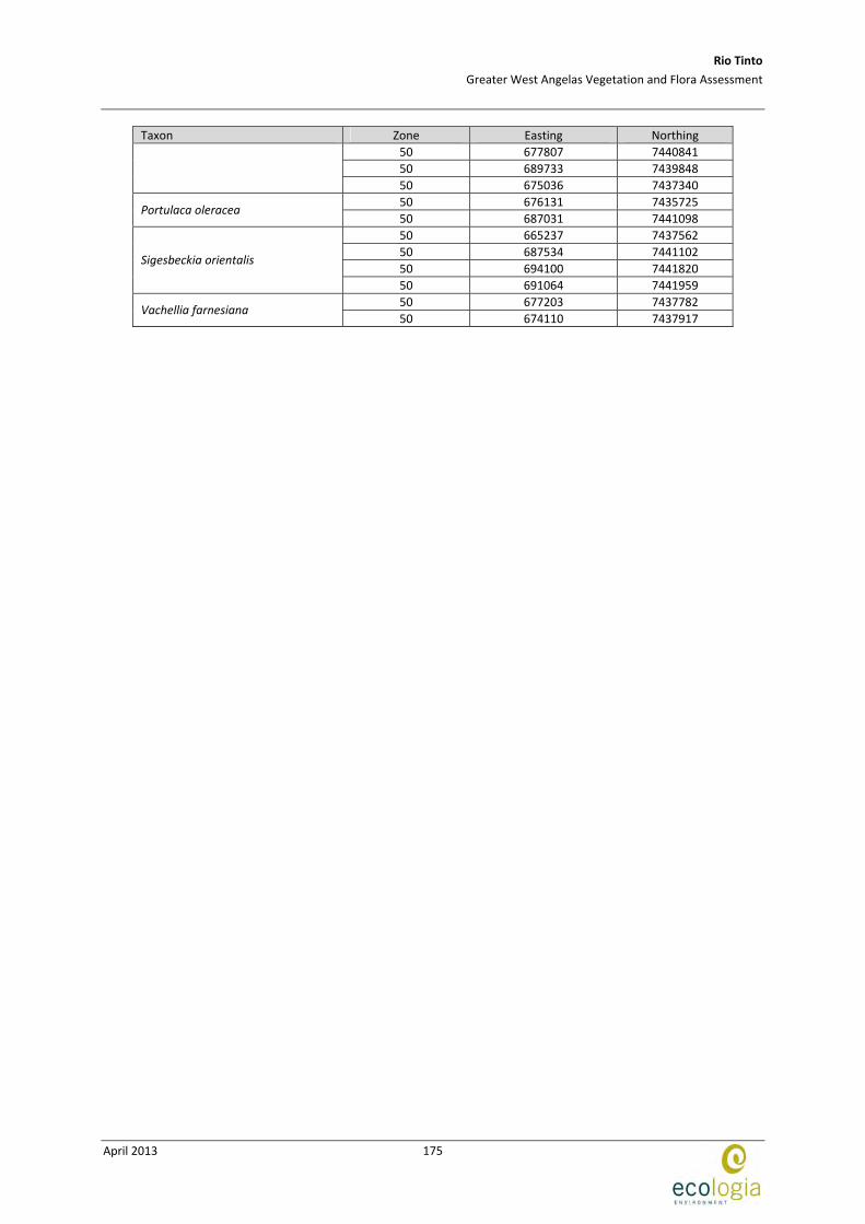
Rio Tinto
Greater West Angelas Vegetation and Flora Assessment
April 2013
175
Taxon Zone Easting Northing
50 677807 7440841
50 689733 7439848
50 675036 7437340
50 676131 7435725 Portulaca oleracea
50 687031 7441098
50 665237 7437562
50 687534 7441102
50 694100 7441820 Sigesbeckia orientalis
50 691064 7441959
50 677203 7437782 Vachellia farnesiana
50 674110 7437917
Rio Tinto
Greater West Angelas Vegetation and Flora Assessment
April 2013
176
This page has been left blank intentionally
Rio Tinto
Greater West Angelas Vegetation and Flora Assessment
April 2013
177
APPENDIX H SITE DESCRIPTIONS
(Refer to attached disc)

Rio Tinto
Greater West Angelas Vegetation and Flora Assessment
April 2013
178
This page has been left blank intentionally
Rio Tinto
Greater West Angelas Vegetation and Flora Assessment
April 2013
179
APPENDIX I SPECIES X SITE MATRIX
(Refer to attached disc)
Rio Tinto
Greater West Angelas Vegetation and Flora Assessment
April 2013
180
This page has been left blank intentionally