74 - in.gov
TRANSCRIPT


74
Indiana Trails PlanC H A P T E R 6
This chapter of the SCORP serves as an update to the 2016 Indiana Trails Plan. Dedicated state-wide trail planning began in the late 1990s with
Indiana Trails 2000, followed by the 2006—2016 Hoosiers on the Move: The Indiana State Trails, Gre-enways, and Bikeways Plan.
The 2006 plan was extremely comprehensive and featured data from the Trails Inventory, a data-base of all trails in Indiana maintained by the DNR that had been recently updated to include many more data points, including GPS-based trail data. This ad-vancement allowed for the DNR to identify and show progress on key long-term, statewide trail goals out-lined in Hoosiers on the Move, including the original goal of having every Hoosier within 7.5 miles of trail. Hoosiers on the Move also established the Visionary Trail System, an interconnected arterial of existing trails and planned potential trail corridors based on input from trail stakeholders.
After a brief progress report to Hoosiers on the Move in the 2011-2015 SCORP, the DNR engaged the public and stakeholders in 2014 for a refreshed 2016 Indiana Trails Plan. This plan better captured these more recent perceptions of trails and illustrated how Indiana’s trail system continued to grow and make progress on many of the original 2006 goals.
The 2016 Indiana Trails Plan then officially up-
dated the main goal to be having a trail within 5 miles of every Hoosier, which was set by then-Gov. Mike Pence after the original 7.5-mile goal was virtually met in 2014. Additionally, the 2016 Indiana Trails Plan also re-visited the Visionary Trail System. Large-ly based on feedback from trail stakeholders at the 2014 Trails Charrette, the Visionary Trail System was updated to include 1,070 miles of Visionary Trails and 1,144 miles of Potential Visionary Trails, an increase from 986 miles and 677 miles, respectively.
A new Indiana Trails Plan is expected to be com-pleted in 2026 (in conjunction with that edition of the SCORP). Like the 2016 plan, that Trails Plan will more fully engage the public as well as vital trail stakehold-ers in its development. Even so, due to increasing in-terest in and development of trails around Indiana, an update to the 2016 Indiana Trails Plan, even with limited public engagement, is warranted.
The main reason, in particular, is the Next Level Trails program (NLT), which was announced by Gov. Eric Holcomb in late 2018, infused $90 million into the state trail system by providing funding to local and regional projects around the state. By awarding the largest investment of state funding in Indiana history in 2019 and 2020, NLT will have an immediate and momentous impact on Indiana’s trail network.
In addition to NLT, this chapter will also cover

75 Indiana Statewide Comprehensive Outdoor Recreation Plan 2021-2025
and begin to explore the impact of new trends, is-sues, and successes relating to trails in Indiana that have occurred since 2016. It will also provide a progress report on the 2016 Indiana Trails Plan goal and strategies, as there has been dramatic advance-ment in many in just a few short years. Finally, this chapter will take a critical look at these objectives by analyzing the current trail context to begin to tailor appropriate trail priorities for the future.
NEW TRAIL-RELATED LEGISLATIONSeveral new laws were passed in Indiana over the past few years that impact the landscape for recre-ational trail use. They include:
Indiana Bicycle Trails Task ForceIndiana Code 8-4.5-7 took effect on July 1, 2017 and established the Gov. Holcomb-appointed Indiana Bi-cycle Trails Task Force with the primary goal of devel-oping actionable concepts to connect existing bicycle trails throughout Indiana. In order to create a larger, more comprehensive and connected state trail net-work, the task force was asked to study the feasibility of these concepts by estimating costs, presenting at least six innovative funding sources, and preparing a timeline for completion of these connections.
Additionally, the task force was charged with recommending changes to Indiana law to increase bicycle safety on trails and roadways. The task force had its final meeting on June 19, 2019, and present-ed its findings in a final report by the July 1, 2019 deadline.
Youth ORV HelmetOn July 1, 2017 a new law changed the language in IC 9-18.1-14-11 and IC 14-16-1-33 to require all children younger than age 18, as an operator or pas-senger, to wear a helmet on or in any Off-Road Vehi-cle (ORV). This applies to all ORVs, including but not limited to ATVs, UTVs (side-by-side vehicles), and dirt bikes. The law, which applies to both public and pri-vate property, aims to reduce the number of serious and fatal youth ORV accidents.
Trail Access LiabilityEffective as of July 1, 2018, Indiana Code 14-22-10-2 limits landowner liability for an injury to a per-son or property caused by an act or failure to act of
another person using the landowner’s property for recreational purposes. This does not apply only to owners with trail access points near their property, but for all landowners adjacent to trails, parks, and greenways. This new law is similar to existing legisla-tion that prevents landowners from being liable for injuries sustained by persons on their property while hunting and fishing.
E-BikesStarting July 1, 2019 E-Bikes are being regulated the same as bicycles. This new law — referred to in IC 9-13-2-25.8, IC 9-13-2-26.6, 26.7, 26.8, IC 9-13-2-49.2, and IC 9-21-11-13.1 — establishes that E-bikes are designated into three classes based on their maximum speed and components. All classes of e-bikes must follow the same rules and be given the same responsibilities as any other bicycle on a road. However, only class 1 and class 2 e-bikes are allowed on multi-use, hard surface trails or paths unless a broader or stricter policy is specified by the local authority. Conversely, all classes of e-mtb (e-mountain bikes) are prohibited on any natural sur-face trails unless that trail is open to motorized trail use or specifically allowed by the local trail manager.
Safe Passing LawAs of July 1, 2019, new rules for vehicles overtak-ing a bicycle took effect in IC 9-21-8-5. A motorist must provide 3 feet of clearance at minimum when overtaking a bicycle until the vehicle is safely clear of the bicycle. Crossing the non-passing double marked lines in the center of the street is allowed to safe-ly overtake a bicycle. Failure to comply can result in a traffic citation and fine. Several communities throughout Indiana have had this law in place locally for years, but this law extends this requirement state-wide.
NEW TRAILS DOCUMENTS AND RESOURCES Since the 2016 Indiana Trails Plan, several new documents relating to trails in Indiana have been re-leased. Although the purposes of these documents vary, all touch on trails in some capacity and can be a resource for those involved in trail development, management, and promotion.

76Chapter 6 • Indiana Trails Plan
Moving Toward an Active Indiana: Walking and Bicycling in the Hoosier State
The Indiana Department of Transportation (INDOT) continues to support the development of active trans-portation opportunities throughout the state, with a particular focus on infrastructure and programs supporting bicycle and pedestrian transportation. In 2018, INDOT stepped up its commitment by starting Moving Toward an Active Indiana: Walking and Bi-cycling in the Hoosier State, the state’s first active transportation plan.
INDOT, with the assistance of its steering com-mittee, engaged with several stakeholders by con-ducting its Active Transportation Survey and stake-holder interviews to form the basis of its plan. These efforts help assess the overall public understanding of existing active transportation infrastructure in In-diana as well as the demand for additional and im-proved infrastructure, such as multi-use trails. By creating a statewide inventory of pedestrian, bicycle, and trail infrastructure and analyzing the collected data, Moving Toward an Active Indiana develops sev-eral key recommendations and strategies that will help bridge the gaps for those walking and biking as transportation.
One of the greatest deliverables of the plan, as it relates to trails, is the trails cost calculator that could help trail developers and stakeholder better envision the cost of a potential project.
Information about Moving Towards an Active In-diana can be found at: www.IN.gov/indot/3963.htm.
Bicycle Trails Task Force Final Report Instead of prioritizing specific trail connections, the task force decided that local communities should lead the charge. The task force felt that the State Vi-sionary Trail System, last updated in the 2016 State Trail Plan, provided an excellent starting spot. Opting to build on this, the task force proposed adding an additional category, Proposed Visionary Trails, in the next iteration of the State Visionary Trail System. The three categories would be:
• Priority Visionary Trails: Completed or well-planned and near completion.
• Potential Visionary Trails: Have a lesser degree of planning and support, and are likely to be-come Priority trails in time.
• Proposed Visionary Trails: Corridors that close
gaps and connect major destinations, but have little to no planning.
The task force concluded that in order to assist and encourage these communities, state funding should prioritize trails that connect visionary trails, multiple communities or counties, recreational or cultural des-tinations, and direct, well-established routes, such as railroad or riparian corridors. The Final Report includ-ed seven recommended funding sources for these new trail connections. Those included:
1. Increase tipping (waste management) fees.2. Encourage use of public-private partnerships.3. Waste tire fee reallocation.4. Dedicate a percentage of sales tax on sporting
goods.5. Reallocate some of the state gas tax.6. Appropriate general funds.7. Create a real estate transfer tax.
The final report estimated that the average trail cre-ation cost was $600,000 per mile. With only 45.6% of the Visionary System and 15.2% of the Potential Visionary System complete, the task force recom-mends finding an additional $15 million in new ded-icated trail funding sources annually to make signifi-

77 Indiana Statewide Comprehensive Outdoor Recreation Plan 2021-2025
cantly more progress in the next 10 years. This would be in addition to the one-time $90 million NLT pro-gram, which is already boosting trail development.
Finally, the task force recommended the adop-tion of three statewide laws/policies to help protect cyclists and make Indiana a more bike-friendly state:
• Statewide Safe Passing Law (3 feet)• Statewide Complete Streets Policy• Clarify e-bike laws in State Statute
It should be noted that both the safe passing and e-bike laws were passed and signed as part of House Bill 1236 in May of 2019, just before the Final Report. Although the task force will no longer exist going for-ward, it leaves behind a number of recommendations in terms of tasks that still need to be completed:
• Create an Indiana bicycle trail brand for marketing.
• Promote and monitor the brand.• Seek funding for the system.• Monitor and promote progress toward the sys-
tem.• Have the State serve as a central service point
for communities seeking trail assistance.• Assist in the passage of laws and creation of
programs that make Indiana safer and more bicycle friendly.
The Bicycle Trails Task Force Final Report is available at: www.visitindianatourism.com/sites/default/files/documents/BikeTrailsFinalReport-compressed.pdf.
2017 Indiana Trails Study In 2017, at the behest of the Greenways Foundation, Indiana University’s Eppley Institute for Parks and Public Lands completed and published a study mea-suring health, economic, and community impacts of trails in Indiana.
Information and data were gathered by conduct-ing surveys of trail users, non-trails users (control group), and adjacent property owners to trails, as well as trail counts. Eight trails throughout the state were studied. By gathering these data, the Eppley Institute was able to both reinforce and update its findings from a similar survey in 2001. Once again, research showed benefits to trail users, as well as property owners adjacent to trails. Additionally, the new trail counts showed that the number of trail users contin-ues to grow.
The study can be found at: www.eppley.org/
wp-content/uploads/2018/06/TrailsStudy_Summa-ryReport.pdf.
Trail Guidelines Complying with Public Law 67, which was enacted in 2016, the Department of Natural Resources devel-oped Trail Guidelines to address the 10 issues out-lined in the law. They include:
1. Clear statement of ownership and manage-ment of each trail.
2. Right-of-way inconsistencies.3. Who is responsible for maintenance of fences,
drainage, and maintenance of drainage or drain tiles.
4. Tree, weed and brush removal between re-sponsible parties and landowners adjacent to recreational trails.
5. Mowing responsibility. 6. Law enforcement jurisdiction. 7. Signage. 8. Conflict resolution procedures.9. Appeal procedures. 10. Use by public utility facilities.
The DNR developed these guidelines based on two public surveys in 2016. The first set went out to trail owners or managers, while the second sought con-sensus of the draft guidelines from a larger trail stake-holder group. The guidelines not only comply with Public Law 67, but also can be seen as a recommen-dations for both trail managers and adjacent property owners to approach Action 1, Strategy 1 of Hoosiers on the Move, which is to “Encourage interested and affected representatives, including urban and rural landowners, not-for-profits, the agriculture communi-ty, businesses, public transit and governmental enti-ties to get involved in all phases of developing new trails.”
The Trail Guidelines can be found at: www.in.gov/dnr/outdoor/4126.htm.
TRAIL FUNDINGAs trails become an amenity in higher demand by res-idents, many communities are prioritizing these proj-ects and pursuing them with their own funds. More and more trail projects, many part of complete streets projects, larger parks plans, or quality of life initiatives, have been fully funded at the local level between pub-lic and private sources. However, many communities

78Chapter 6 • Indiana Trails Plan
as well as non-profit and other agencies struggle with limited budgets, making trail projects hard to fund. Trail developers and managers across Indiana contin-ue to search for ways to supplement their limited bud-gets and staffing to build, operate, and maintain trails.
Indiana continues to use its traditional federal sources, such as the Recreational Trail Program (RTP) and Transportation Alternatives (TA), as the primary ways to fund trail projects outside of local budgets. Additionally, several other federal sources, such as Congestion Mitigation and Air Quality (CMAQ), Land and Water Conservation Fund (LWCF), and Better Uti-lizing Investments to Leverage Development (BUILD, formerly TIGER) have been used or pursued for trail projects as well.
Several trail projects received a temporary bump in funds for land acquisition through the Bicentenni-al Nature Trust, while others have been able to use the President Benjamin Harrison Conservation Trust (formerly Indiana Heritage Trust) to purchase land for public trail use. Additionally, a handful of trail projects have been able to take advantage of the state-funded and DNR-administered Wabash River Heritage Corri-dor Fund.
Those seeking to develop trails in Indiana have also gotten creative in looking for funding sources and have taken advantage of several new state-funded grants that are not necessarily focused on trails, but can be used for them and other outdoor recreation projects. These include Indiana Office of Tourism De-velopment’s Destination Development grant, Indiana Housing and Community Development’s Authority’s CreatINg Places grant, and the Office of Community and Rural Affairs’ Quick Impact Place-Based grant. Additionally, many communities have used Indiana State Department of Health’s Bicycling and Pedes-trian Planning Grants to assist them in creating local bike/ped plans, which often lay the groundwork for future trail projects.
Furthermore, Indiana Economic Development Corporation’s Regional Cities Initiative awarded north-central, northeast, and southwest Indiana $42 million each to assist with regional development plans in late 2015. All nine applicants to the program includ-ed a trail component in their regional plans, and the three awardees have been using some of their funds to develop trails in their respective region.
Next Level Trails
Finally, the most impactful new source of trail devel-opment funding since the 2016 State Trail Plan was published is NLT. The program will invest $90 million—the largest infusion of state trail funding in Indiana history—toward the development of regionally and lo-cally significant trails throughout Indiana.
Part of Gov. Holcomb’s broader $1 billion Next Level Connections infrastructure program, NLT was designed to incentivize collaborative efforts to ac-celerate trail connections. A total of $70 million of the available NLT monies will fund regional projects, which tend to focus on more trail connections be-tween communities and major long-distance trails, while $20 million will go toward local projects that typically connect key amenities and attractions with-in their communities. The program is administered by the DNR in conjunction with INDOT.
NLT funds will be awarded in three rounds, with one in 2019 and two in 2020. With a $5 million cap for regional projects and $2 million for local projects, awardees can finally develop their entire project or larger sections of it all at once, as compared to using other programs with smaller limits that realize shorter sections of trail at a time.
Additionally, with up-front funding and an incen-tive for projects on an accelerated timeline, or faster than four years, NLT will help drastically increase Indi-ana’s trail network in a short amount of time. NLT gives preference to regional projects that will help complete the Visionary Trail System, so major progress is antici-pated by 2026 and the next Indiana Trails Plan.
The NLT program requires a 20% minimum grant match, but was designed to be as flexible as possi-ble by allowing monetary contributions, land value, and in-kind donations of labor and materials. The program also encourages applicants to exceed the minimum match requirement (if possible) and reach out to public and private partners in their community for contributions. This allows for the $90 million state investment to stretch to more Indiana communities and leverage additional public and private funds for larger total investment in trails. In reality, the NLT pro-gram will most likely greatly exceed $112.5 million, which is the amount of state funds available plus the minimum 20% match, total value in trail development by 2024. These figures make NLT an unprecedented investment for trails in Indiana.

79 Indiana Statewide Comprehensive Outdoor Recreation Plan 2021-2025
THE VISIONARY TRAIL SYSTEM
The Visionary Trail System is a collection of existing and proposed trail corridors that provide a back-bone for connected trails throughout Indiana. All trail corridors within the system must cross coun-ty lines and/or connect two Visionary Trails. For Visionary Trails yet to be planned, the corridor is intended to be broad rather than a specific route.
There are two types of trails in the Visionary Trail System: Visionary and Potential Visionary. Both are made up of existing trails, trails under de-velopment, and proposed trails that are planned and actively supported. The level of planning and active support may vary widely from formal to ex-ploratory planning, and can vary from small, grass roots non-profits, to regionally led trail initiatives. The difference is that Visionary Trails tend to have a higher degree of certainty of actually being com-pleted than Potential Visionary. Potential Visionary Trails tend to have less of a degree of public plan-ning and/or support, but show some promise of completion. It is possible for Potential Visionary Trails to make significant progress in trail develop-ment, planning, and support, to rise to Visionary Trail status. In addition to trails changing status, it is also possible for new trails to be added and removed from the Visionary Trail System as oppor-
tunities and priorities change. The Visionary Trail System is based on input
from trail stakeholders on where they have and want trails, as well as what trail projects they are currently supporting. The DNR does not create the Visionary Trail System Map, but curates it. The DNR does so by collecting this information from the stakeholders, selecting the trails that meet the above-mentioned criteria, and presenting the in-formation as a statewide map. Currently, the State Visionary System is re-visited every 10 years with a large public engagement from across the state. However, as Indiana’s trail system continues to rapidly develop and new opportunities arise, it may be worth revising sooner than every 10 years.
The Indiana Visionary Trails System is not a construction plan or a system that the State is unilaterally building. Instead it is a tool to help en-courage Indiana’s trail providers and developers, which most often are units of local governments and non-profits, to work together to complete and connect these corridors. The Visionary Trail Sys-tem is the State’s attempt to provide guidance, encourage interjurisdictional coordination, and in some cases, funding, to see those local efforts to fruition.

80Chapter 6 • Indiana Trails Plan
Figure 6.1 2016 INDIANA VISIONARY TRAILS SYSTEM
Visionary Trails Potential Visionary Trails American Discovery Trail

81 Indiana Statewide Comprehensive Outdoor Recreation Plan 2021-2025
NEW TRAIL & POTENTIAL TRAIL CORRIDORSSeveral new potential long-distance trail corridors have been identified in Indiana over the past few years. Although these corridors differ in stages of planning and development, all are cross-county and have the potential to be included in the Visionary Trail System in 2026. They include:
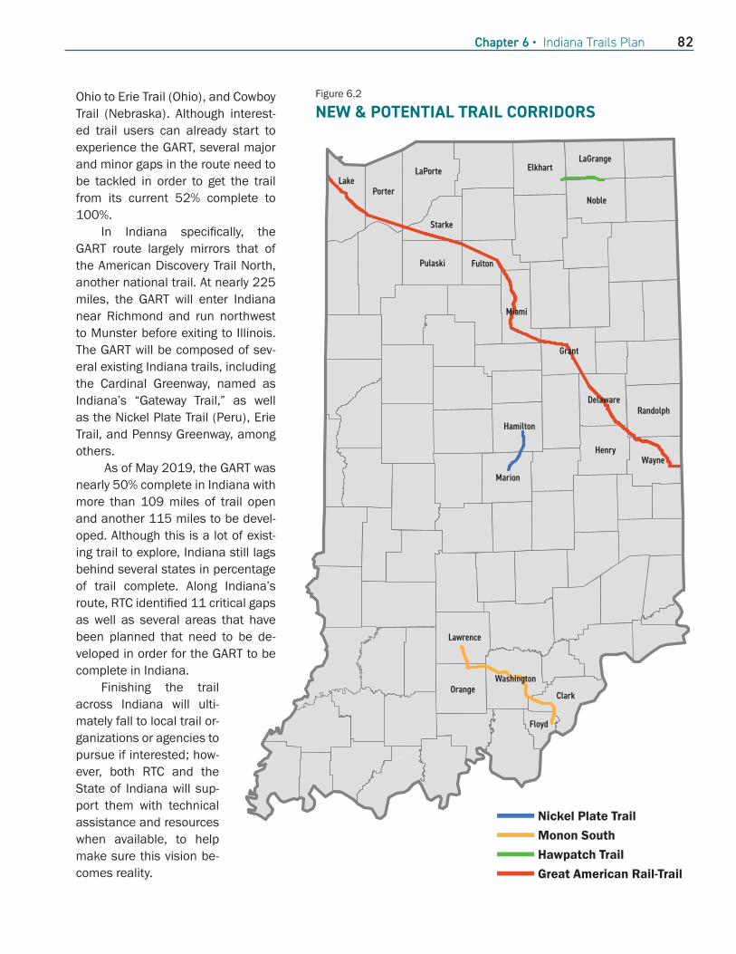
Hawpatch In 2019, LaGrange County Trails, a non-profit trail group, outlined its intent to develop a 17-mile multi-use trail. The Hawpatch, as the non-profit refers to it, would follow the discontinued Wabash Railroad from Millersburg through Topeka to Wolcottville. The proposed trail would connect Elkhart, LaGrange, and Noble counties. Although the project is still in the early planning stages, stakeholders hope that it will eventually provide the communities, many with large Amish populations, with much-needed safe bicycle infrastructure for commuters as well as a recreation-al and tourist amenity.
Monon SouthCSX filed to abandon a 62-mile stretch of railroad from New Albany to just north of Mitchell in December 2017. Two entities have filed to railbank the corridor for trail use and have been approved by the Surface Transportation Board to negotiate with CSX. The cor-ridor does not have an official name yet, but is some-times referred to as Monon South because it is part of the historic Monon rail line that ran across Indiana from Louisville, through Indianapolis, to Chicago.
Although it has not been railbanked at the time of publication, the length and location of this poten-tial trail provides a unique opportunity. At 62 miles through five southern Indiana counties, this corridor would be Indiana’s longest contiguous rail-banked corridor if successfully secured. Additionally, if de-veloped, it would finally provide access to a long-dis-tance bicycle and pedestrian trail to residents in this area of the state as well as provide an opportunity for significant tourism and economic development in the communities connected by a potential trail.
Nickel Plate (Marion and Hamilton Counties)In February 2017, Fishers, Noblesville, and Hamilton counties announced plans to turn their section of
the former Nickel Plate railroad into a trail. Although named for the same historic railroad, this new poten-tial trail would not connect to the existing Nickel Plate Trails located from Kokomo to Rochester or in Con-nersville. Fishers began the process of initial design and planning in 2018, releasing its final master plan in May 2019. Indianapolis has also joined the Ham-ilton County communities in exploring the concept of developing the corridor into a multi-use trail. As of July 2019, the communities are in the initial phase of removing the tracks, and Fishers plans to break ground on its first phase of the trail shortly thereafter.
If and when fully constructed, the Nickel Plate Trail would span more than 16 miles and connect Indianapolis, Fishers, and Noblesville. The corridor would navigate through major commercial centers, as well as residential neighborhoods, parks, and re-gional attractions. It would also expand the region’s trail network by connecting to other trails such as the Midland Trace and the Fall Creek Trail. In addition to opportunities for recreation, wellness, and alterna-tive transportation, the communities hope the trail can provide a significant increase to quality of life for residents and attract future development.
Great American Rail-Trail In 2016, Rail-to-Trails Conservancy (RTC) embarked on an 18-month route assessment to study the feasi-bility of the Great American Rail-Trail (GART), the idea for a national multi-use trail. The goal of the trail was to connect the country and provide an All-American, personal way for residents and tourists to experience the U.S. The trail would also deliver a multiplier effect by which it would benefit all trails users visiting the trail, whether single day or a through trip, as well as the communities that it connects.
In order to develop the trail route, RTC coordinat-ed with state trail officials, including the transporta-tion and resource agencies, in every state to identify the optimal route. In May 2019, the RTC formally an-nounced the GART and unveiled the preferred route.
The GART route spans more than 3,700 miles from Washington, D.C. to Washington State. It will traverse 12 states, including Indiana. Currently, the route takes advantage of 125 existing trails for more than 1,900 miles that are open to explore immediate-ly. This includes several marquee long-distance trails such as the Great Alleghany Passage (Pennsylvania),
82Chapter 6 • Indiana Trails Plan
Ohio to Erie Trail (Ohio), and Cowboy Trail (Nebraska). Although interest-ed trail users can already start to experience the GART, several major and minor gaps in the route need to be tackled in order to get the trail from its current 52% complete to 100%.
In Indiana specifically, the GART route largely mirrors that of the American Discovery Trail North, another national trail. At nearly 225 miles, the GART will enter Indiana near Richmond and run northwest to Munster before exiting to Illinois. The GART will be composed of sev-eral existing Indiana trails, including the Cardinal Greenway, named as Indiana’s “Gateway Trail,” as well as the Nickel Plate Trail (Peru), Erie Trail, and Pennsy Greenway, among others.
As of May 2019, the GART was nearly 50% complete in Indiana with more than 109 miles of trail open and another 115 miles to be devel-oped. Although this is a lot of exist-ing trail to explore, Indiana still lags behind several states in percentage of trail complete. Along Indiana’s route, RTC identified 11 critical gaps as well as several areas that have been planned that need to be de-veloped in order for the GART to be complete in Indiana.
Finishing the trail across Indiana will ulti-mately fall to local trail or-ganizations or agencies to pursue if interested; how-ever, both RTC and the State of Indiana will sup-port them with technical assistance and resources when available, to help make sure this vision be-comes reality.
Grant
Fulton
Delaware
LakePorter
LaPorte
WashingtonOrange
Clark
Floyd
HenryWayne
Noble
Pulaski
Miami
Randolph
Hamilton
Marion
Elkhart
Lawrence
Starke
LaGrange
Figure 6.2 NEW & POTENTIAL TRAIL CORRIDORS
Nickel Plate Trail Monon South Hawpatch Trail Great American Rail-Trail

83 Indiana Statewide Comprehensive Outdoor Recreation Plan 2021-2025
TRAIL TRENDSThe way in which trails are used and how trail users access information about trails has changed signifi-cantly in the last couple of years due to technology and other trends. Similarly, the way trails are devel-oped, managed, maintained, and promoted also continues to evolve. Below are some of the newest trends we are seeing in Indiana related to trails:
• Trail running, or running on natural surface trails, continues to grow in popularity while oth-er pedestrian based activities hold steady. This can be gleaned from an uptick in specific trail running events with a growing number of com-petitive participant classes, held in Indiana over the last few years.
• More backpackers and bikepackers are opting to use hammocks for camping rather than tradi-tional tents, as this is lighter and takes up less space. As a result, those using hammocks priori-tize camping spots along the trail that have trees close enough together to set up rather than tree-less, open areas. Done improperly, hammock camping can damage trees, and this accordingly affects management of the resource.
• Mountain biking continues to grow in populari-ty and appears to be increasingly diverse. This can be gathered by Indiana now having a Na-tional Interscholastic Cycling Association (NICA) league, an organization for youth mountain bike development and competition that has partic-ipation from around the state, as well as from an increase in mountain bike skills clinics and sessions, including many targeted specifically to Indiana’s women and urban youth.
• New mountain bike trails being developed tend to be purpose-built trails, meaning designed specifically with mountain bikers and their ex-perience in mind. In particular, “flow trails” that often have berms, rollers, tabletops, jumps, and other features are growing in popularity. These new types of trails have been developed in near-ly every corner of the state in the past few years, including the regionally renowned Hobbs Hollow Flow Trail in Brown County State Park.
• Bike parks and progressive trails provide oppor-tunities for off-road bicyclists to improve their technical skills. A safe spot to develop these skills and progress is critical to developing new
trail users, such as those in the new National In-terscholastic Cycling Association (NICA) league. Several of these have been developed in Indiana over the past few years, including Griffin Bike Park in 2016, Indiana’s first mountain bike park.
• Many more off-road trail users are opting for side-by-sides; sometimes called UTVs. The ability to fit two or even four people along with their comfort, versatility, capable handling, and speed, as compared to ATVs and traditional four-wheel-drive vehicles, has skyrocketed their share of the ORV market. Although Indiana does not track specific types of ORVs, their increase in popularity can easily be witnessed on ORV trails throughout the state. Wells Fargo Securities Re-search estimates over 483,474 UTVs were sold worldwide in 2017.
• Bikeshares (or bikeshare programs), which pro-vides residents and visitors an easy and afford-able opportunity to rent a bike, is now a staple on many Indiana trails. Indiana’s first dock-style bikeshare appeared in 2014 on the Indianapo-lis Cultural Trail: A Legacy of Eugene and Marilyn Glick, and quickly spread to communities vary-ing in sizes and settings, including college cam-puses. Bikeshare has evolved to quickly offer a dockless system, as introduced in South Bend in 2017, and be more inclusive with options such as children’s and tagalong bikes, as seen in Ko-komo’s 2019 launch of its bikeshare. Although not every bikeshare program launched in Indi-ana has been successful, many have, and gen-erally their key to success is a location near safe bike infrastructure, such as trails.
• The styles of bicycling have evolved in the past few years beyond more traditional road, recre-ation, and mountain biking. Newer cycling trends include gravel road riding, cyclo-cross racing, and bikepacking on all types of surfaces, as well as fat tire biking, especially in the winter. These new bicycle-use styles change not only the way bikes look, as many feature unique components that provide advantages for each style of riding, but also when and where cyclists use trails, roads, and public lands.
• E-bikes continue to grow in popularity in Indiana, and can be seen on both roads and trails. Mar-keted as an alternative to a traditional bicycle,

84Chapter 6 • Indiana Trails Plan
especially for individuals with limited physical fitness, advanced age, or disability challenges, e-bikes are sold by several Indiana bike shops, and a handful even specialize in them. E-bikes have become mainstream enough to regulate them, especially their use on trails, through laws and policies on federal, state, and local levels.
• E-scooters were first introduced in Indiana in In-dianapolis in 2018 and quickly spread to several other cities. The e-scooters’ dockless design and affordable price provide an efficient alternative to biking and walking, and direct competition to many existing bikeshare systems. With bat-tery-powered, motorized speeds up to 15 mph, a dockless design, and the ability to go nearly anywhere, e-scooters quickly became popular with many. However, this combination also led to some safety concerns and controversy for many others, leaving some community officials scram-bling on how to regulate them, including whether they should be allowed on trails that currently bar motorized vehicles. As e-scooter companies continue to push into new markets and local of-ficials figure out how to regulate them, the long-term impact of e-scooters on micromobility and trails is yet to be seen.
• More people are wanting to paddle and more are also opting to own personal watercraft to do so. As seen from our Water Trail User Survey, most opting to buy or rent seem to prefer kayaks over traditional canoes, and many are also opting for stand-up paddleboards, a relatively new trend in the last five years. This may be because both are more maneuverable, efficient, lighter, and gener-ally easier to transport than other options, and because of the ability to purchase them at big box stores at an affordable price point.
• The concept of user-accessible, formally cre-ated and marketed water trails continues to gain traction as paddling becomes increasingly popular. Water trails provide a more quality ex-perience to paddlers with a marked route on navigable waterways, well-developed access sites, and often ample amenities, such as boat parking, restrooms, food, or camping, along the way. Although Indiana does not have an official state water trail program, there have been local efforts across the state to make many of Indi-
ana’s rivers more like water trails, with signage, better information online, and new access sites, including several more accessible launches, and programming.
• Most trail users are now getting information about trails through websites, social media, and trail-specific apps as opposed to brochures, pa-per maps, and word of mouth, which were more prominent in the past. In particular, a large percentage of this traffic is via mobile phones. Trail managers should pay specific attention to making sure crucial trail information such as lo-cation, mileage, difficulty, status, trailhead and amenity locations, special events, descriptions, and other necessary information about their trail can be easily found online, and is mobile-friend-ly. Interactive maps, photos, and video are also preferred, as these allow users to have a better grasp of what to expect.
• Trail users are not only using apps to get infor-mation about the trails, but also using apps, smart watches, and GPS tracking devices while on the trail. Although these can have added ben-efits, like helping to navigate, they are primarily focused on tracking progress, especially regard-ing personal fitness. These devices may help de-velop repeat trail users because they allow users to better see personal trail-use benefits or find new trails as a result of other trail users being able to easily share their experiences. Addition-ally, some of these data are publically available and may be good trail usage tools for some trail managers.
• A few new forms of technology have been assist-ing trail managers looking to manage, develop, or promote their trails. These include trail count-ers, which have seen significant technology ad-vancements and become more affordable in re-cent years, as well as trail cameras, drones, and bikeshare data.
• Trails are being promoted by communities, busi-nesses, and trail advocates as a key piece of quality of life and important tools for place-mak-ing. There have been more efforts to integrate things like public art, parks and other recreation-al opportunities, as well as historic and cultural resources, among others, into trail systems to create a stronger sense of quality of place for

85 Indiana Statewide Comprehensive Outdoor Recreation Plan 2021-2025
residents and visitors. This trend can be seen in projects both small and large across the state, as well as in numerous recently completed local trail plans.
• Within the past few years, neighboring Michigan and Kentucky have launched a Trail Town pro-gram. The point of Trail Town programs and simi-lar others throughout the U.S. is to create a more trail-friendly town. This is accomplished through wayfinding, business offerings, infrastructure, and other things, in order for communities to better take advantage of the opportunity for pos-itive economic impact that having a trail running through a community provides. Hoosier commu-nities are increasingly interested in this, and as a result the Greenways Foundation offered work-shops on this topic as a resource in the fall of 2019.
• As more individual Indiana trails are developed, more emphasis has been put on connecting these trails in recent years. Connecting trails, both within and outside of local jurisdictions, into a more integrated system not only allows us-ers more miles of recreational opportunities, but also creates a stronger active transportation net-work. It also can improve the tourism and eco-nomic impact capacity of the newly connected trail. The focus on connecting trails can be seen in both the main assignment to the Bicycle Trails Task Force in 2017 and throughout the Next Lev-el Trails program criteria.
INDIANA’S TRAIL SUPPLY
Indiana Trails Inventory
Indiana DNR staff maintain a database and map of all known trails in the state, including those that are open, under development, proposed, or have poten-tial to be developed or proposed. This includes trails managed by federal, State, and local governments as well as those run by non-profit organizations. This information is kept up-to-date through the close mon-itoring of new trail construction and related news sto-ries, review of aerial imagery throughout the state, information gained from the administration of grants programs, and frequent communication between the DNR, trail organizations, stakeholders, and local governments. Maps and data are made available to
DNR staff and the public through resources like the Indiana Trail Finder, a mobile and user-friendly inter-active map launched in 2016.
As of September 2019, Indiana has more than 4,000 miles of trails open to the public. The break-down of trails in the state in terms of usage and sta-tus type is as follows:
Open Trail Types by Usage
• Hike/Pedestrian – 3,613 miles ◦ Natural Surface (Native Soil or Rock) Hike: 1,745 miles
◦ Hard Surface (Asphalt, Concrete or Crushed Stone) Pedestrian: 1,721 miles
◦ Other Surface (All other Trail Materials) Hike: 147 miles
• Bicycle Trails: 2,165 miles ◦ Hard Surface Road Bike –1,535 miles ◦ Mountain Bike – 630 miles
• Equestrian – 690 miles• Snowmobile – 237 miles• Motorized* – 95 miles
* Includes trails open to dirt bikes, ATVs, side x sides, 4x4
vehicles, and/or other types of ORVs. Does not include snow-
mobile or privately owned, for-profit trails or sites.
Trails By Status • Open – 4,093 miles• Planned – 1,203 miles• Potential – 2,698 miles• Under Development – 118 miles
Motorized Trails
Indiana offers a few options for off-roading recre-ationists. The state manages two multi-use proper-ties, both of which are repurposed former coal mines that allow off-roading. Interlake State Recreation Area (SRA) provides more than 75 miles of trail sprawled across over 3,500 acres, while Redbird SRA has more than 20 miles of trail on 700 acres. Both properties offer trails of varying difficulties for all manner of off-road vehicles, from dirt bikes to full-size vehicles. In addition to these public trails, Prairie Creek Reservoir also offers a few miles of publicly owned and operat-ed ORV trails. These trails are included in the amount of motorized trails in the Trails Inventory.
Indiana also has private off-roading opportuni-ties around the state. These include The Badlands,

86Chapter 6 • Indiana Trails Plan
Figure 6.3 2019 INDIANA TRAIL INVENTORY
Open Planned
Potenial
Under Development Cities and Towns

87 Indiana Statewide Comprehensive Outdoor Recreation Plan 2021-2025
Figure 6.4 2019 INDIANA TRAIL TYPES
Multi-Use (Bicycle & Pedestrian) Trails: 1,538 Miles Hiking Trails: 3,470 Miles
Mountain Bike Trails: 630 Miles
Horse Trails: 690 Miles Motorized Trails: 260 Miles Cities and Towns

88Chapter 6 • Indiana Trails Plan
Haspin Acres, and Lawrence County Recreation Park. Although these facilities have trails and are open to the public to ride, because they are private, they are not tracked in the Indiana Trails Inventory.
Indiana has four State Snowmobile Trails—Buffa-lo Run, Miami, Salamonie, and Heritage. These trails, which are a result of a partnership between the local snowmobile clubs and the DNR, are open when weath-er conditions allow from Dec. 1 to March 31. There is also one privately maintained trail, the Potawatomi Snowmobile Trail. All five trails combine for 237 miles available for sledding and are included in the Trails Inventory total amount of mileage despite being sea-sonal.
Water TrailsIndiana is home to a sole National Water Trail, the Kankakee River. It traverses from northeast Indiana, south through Illinois before flowing into the Illinois River. Recent efforts to designate a few other water trails in the state through the National Park Service’s program are being explored. The program has detailed criteria for designation and an application process.
Indiana offers more than 35,000 miles of streams, many of which have been deemed naviga-ble. In the DNR’s recent Water Trails Survey, 32 differ-ent rivers were offered as options for respondents to choose from to indicate interest in paddling.
Additionally, the Division of Fish & Wildlife (DFW) promotes 821 access sites in their inventory and inter-active map, “Where to Fish.” The access sites include both lake and stream access sites, and are open to paddlers to use. Many of these access sites have been installed and are maintained by the DFW, but some are developed and managed by user groups, local park and recreation departments, and others. Like the Trails Inventory, maintaining this inventory, especially for new, local, access sites, is an ongoing venture.
With the bounty of rivers and access sites, there are plenty of options for paddling throughout in Indi-ana. However, at this time there is no active state wa-ter trails program, with official designations, in Indiana as there is in some other states, including Ohio and Michigan. It is important to note that no water trail miles are included in the Trail Inventory mileage at this time.
COMPARISON TO NEIGHBORING STATES’ TRAIL SYSTEMS
In order to better understand the degree to which activities and policies both past and present have promoted trail development, it is worthwhile to look into the recreational trail infrastructure of other states, particu-larly Indiana’s neighbors. Below are the key trail metrics reported by the Ohio and Mich-igan DNRs. Comparable figures from Illinois and Kentucky are not readily available.
Ohio
• 5,000 total trail miles (all types, includ-ing water trails).
• 1,600 miles of recreational trails for hik-ing, backpacking, and mountain biking.
• 650 miles of water trails (across 11 state-designated water trails).
• Since 2000, Ohio has invested more than $86 million in state funding for trail development through its Clean Ohio program, which includes a trail grant program. More than $6 million in annual funding is available for trail cor-ridor acquisition, trail development, and trailhead facilities through the Clean Ohio Trails Fund.
Michigan• 12,000 miles of total trail miles (all
types, including water trails). • 6,407 miles of snowmobile trail. • 2,627 miles of ORV trails. • 2,623 miles of rail-trail. • 590 miles of equestrian trail. • $164 million invested from the Michi-
gan Natural Resources Trust Fund for land acquisition and recreational facility development, including trails. Roughly $15-20 million in grants from the trust fund is awarded each year.

89 Indiana Statewide Comprehensive Outdoor Recreation Plan 2021-2025
DEMAND FOR TRAILS IN INDIANA
Trail User Survey
The trails user survey shows very little change from 2013 to 2017. Trails used for walking (+1%), hiking (+2.7%), and for transportation (+1.1%) all showed a slight increase. The only big increase was in those who canoe and kayak in a given year, which increased more than 6%.
Some 5% fewer people spent less than $100 (the lowest category of spending) on recreational ac-tivities, from 49% down to 43.9%, in 2017. This sug-gests that some outdoor recreation users in Indiana are investing more in their activities than previous surveys indicated.
More users said a general tax (+3.1%) or local tax (+1%) is the most appropriate way for funding recreational trail development and maintenance af-ter pursuing all available grants and donations. This appears to indicate that more Hoosiers are willing to invest their tax dollars in their outdoor recreation ac-tivities.
There was a modest increase in the number of respondents who said that the current supply of trails (in all categories of trail use, except “roller/in-line skating”) was “Just Right.” At the same time, many respondents also stated that the trail supply was not enough, which indicates that there is still plenty of work left to be done.
Also identified in the Trail User Survey was the amount of trail users who want to see trail connectiv-ity, which most strongly agreed or somewhat agreed was important to their community’s infrastructure. The last trend showcased from the Trail Users Survey regards how the respondents indicated they find out about trail opportunities. Unsurprisingly, people said they are using websites and digital formats more, and relying less on booklets, brochures, and paper maps.
Trail Stakeholder SurveyThe DNR’s 2018 Trails Stakeholder Survey shows that stakeholders believe Indiana should push for trails of all sizes, should use railbanking, and that a combination of groups should own, operate, and maintain trails. Funding-source responses from stakeholders showed 66.7% used existing budgets/local money, 60.6% relied on private funding, 51.5%
used federal grants, 48.5% did fundraising, and only 27.2% used state grants.
An often-recurring answer to the open-ended question “What new challenges … is your trail system struggling with?” was funding. Some answers even noted that while not a new problem, funding is an on-going problem they face. Furthermore, from the pre-vious stakeholder survey, asked if current funding of trail maintenance and operations is adequate, more than 80% answered “Strongly Disagree” or “Dis-agree.” Only 5 % of respondents answered ‘Agree’ or ‘Strongly Agree.’ This suggests that funding, specif-ically for trail maintenance, is a recurring issue for many trail stakeholders.
Water Trail SurveyThe DNR’s online Water Trails Survey had 341 re-spondents. Asked why they visited the water trails guide and ultimately ended up taking the survey, re-spondents gave “seeking information about public access sites” as the most common response. Among Indiana Water Trails, Sugar Creek was the most popu-lar water trail people searched for information about.
Following behind in popularity were both forks of the White River, the Wabash River, and the Blue River. Respondents overwhelmingly (more than 90%) use kayaks on water trails, 53% use canoes; and 10% paddle on standup paddle boards. Note that the question asked respondents to check all watercraft they use on water trails. Another demand shown in the survey was that the majority of respondents pre-fer to get their information by website (89%) or from an app (55%).
Next Level TrailsIn addition to its catalytic role in the development of dozens of miles of new trails throughout the State of Indiana, a positive result of the $25 million allocated for round one of NLT was its clear illustration of the high levels of demand for trail development from lo-cal governments, non-profits, and the general public. Consider some of the statistics gathered from appli-cations for the project’s first round alone:
• 82 applications from 42 of Indiana’s counties were received.
• $143,780,509 in grant funds was requested.• The projects would represent more than 236.75
miles of new trail, if it were possible to award

90Chapter 6 • Indiana Trails Plan
funds to every applicant.• The program encourages partnerships as a
way to help applicants with match, stretch NLT funds, and show community support for the project. Partners are defined as contributing something of financial value to the NLT project. Partners pledging support in round one included local governments, nonprofits, foundations, hos-pitals, schools, religious organizations, private companies, and individuals.
This strong response to a new program clearly indi-cates that communities, organizations, and individ-uals in all parts of the state understand the benefits of trails and would like to play a larger role in their development and usage. Additionally, it made obvi-ous the fact that these same stakeholders are more than willing to put money into trail development, and that they are more likely to do so when these funds can leverage a robust funding source.
Moving Toward an Active IndianaINDOT’s Active Transportation plan, Moving Toward an Active Indiana – Walking and Bicycling in the Hoosier State, is being developed with the help of extensive research and outreach to active transpor-tation users and stakeholders. One product of this process has been a survey of 2,500 Hoosiers about active transportation infrastructure, including trails and policies regarding them. Respondents indicat-ed high amounts of interest in trail usage and devel-opment, as demonstrated by the following findings:
• 87% of respondents said they would use a paved recreational trail.
• Asked what keeps them from walking and cy-cling more often in all areas, respondents indi-cated that concerns about bicyclist/pedestri-an safety in traffic and around vehicles (41%) was most likely to keep them from doing so.
• Asked what they thought would encourage more people to bike more often, 82% agreed that more bicycle paths and trails would do so; 63% also answered that way about “more sep-aration between bikes and cars.”
• Additionally, respondents said more trails and paths, along with improved sidewalks, would get Hoosiers walking more often.
IU Eppley Trails Study
The IU Eppley Institute for Parks and Public Lands conducted a study by surveying trail users, manag-ers, and neighbors in 2017. This study produced a number of findings that provide evidence of demand for new trails and the improvement of existing ones. These include:
• The percentage of trail users who use trails for transportation (as opposed to exercise and rec-reation) has more than doubled since 2001—from 2% to 5%.
• A higher percentage of people bicycle than in 2001.
• The largest concerns of trail users are trail maintenance and access to facilities such as restrooms, with 18% of respondents identifying these as their primary concerns. This reflects a change from 2001, when access to restrooms/water fountains and the adequacy of safety pa-trols were the biggest concerns.
• Longer usage of trails—respondents indicated that they stay on trails longer, averaging 9 miles

91 Indiana Statewide Comprehensive Outdoor Recreation Plan 2021-2025
travelled during their “primary activity.” In 2001, this figure was 7 miles.
ORV and Snowmobile Registration NumbersIndiana requires all ORV and snowmobiles, with a few minor exceptions, to be registered. Registration for both types of vehicles is $30 for three years and is handled through the Indiana Bureau of Motor Ve-hicles (BMV). These registration numbers provide important data about the demand for trails to accom-modate ORVs and snowmobiles.
Registration numbers for ORVs continue to climb in Indiana. In the past three years, over 60,000 ORVs have been registered through the BMV. The running three-year total in December 2016 was 52,000. De-spite this recent growth of 15% in registration, num-bers from the Trail User Survey show a small drop in off-roading.
Conversely, snowmobile registration numbers show a slight decline. As of July 1, 2019, a total of 9,362 snowmobiles had been registered in the pre-ceding three years. The running three-year total in December of 2016 was 10,125, a decrease of 8%.
INDIANA TRAILS NEEDS ASSESSMENT After carefully evaluating Indiana’s supply and de-mand for trails as well as placing it into the larger
current trails context, the DNR found several key themes. Those themes are listed below, as is some supporting evidence that will shape the state’s future goals.
Indiana Trails Are Not Meeting Hoosiers’ Needs
• Surveyed about the supply of trails, respondents to the Trail User Survey indicated strongly that the supply of all types of trails either needs to be increased in the future or does not meet their needs.
• More than 24% of respondents from the Trail User Survey did not use trails as often as they desired due to distance to a trail, the quality of the trail, or dangerous intersections.
• The 2014 Online Trails Stakeholder Survey, found that building more trails was the most im-portant trail issue. It also was the most import-ant trail issue to respondents in the most recent 2018 survey, with 69% rating it as “very import-ant.”
• According to the INDOT Active Transportation Survey the No. 1 reason for not using active transportation infrastructure is bicyclists and pedestrians feeling unsafe in traffic and around vehicles, and No. 2 was inconvenience.

92Chapter 6 • Indiana Trails Plan
• Respondents to the INDOT Active Transportation Survey did NOT want bike lanes on busy streets, but instead desired more trails and paths, as well as bike lanes on smaller side streets and better signage.
• The 2017 IU Eppley Study reported that across Indiana, 18% of users have concerns about trail maintenance and access to facilities.
Demand For Trails Is Growing• 82 NLT applications for a total of 236.75 miles
of desired trail development in just the initial round proved that statewide demand for trails is massive.
• 185 individuals attended the NLT Round 1 Work-shop in person, and another 100 people attend-ed via webinar to learn more about the new trail grant program as a funding opportunity for their project.
• 80% of respondents to the Trail User Survey use a trail for walking sometime each year.
• Every regional cities plan submitted contained plans with trail components, and some regions even made this a high priority.
• The 2018 Trail Stakeholder Survey put the high-est focus for trail development on connecting lo-cal community destinations for residents.
• Trail connectivity, or linking together existing trails, was the second most important topic to re-spondents in the 2014 Online Trail Stakeholder Survey, with 56.3% saying it was very important.
• The Bicycle Trails Task Force was created by the legislature in 2017 in response to the demand for more trails and to connect existing trails.
Current Funding Levels Cannot Match Local Development And Maintenance Needs
• The Bicycle Trails Task Force’s final report states that with current funding and no NLT investment, only 20 miles of trail will be developed per year. NLT is estimated to add around 150 miles of trails statewide over the life of the program. The report estimates a $15 million increase in State trails funding annually would yield more than 25 additional miles of trails per year.
• Tasked by the legislature to identify funding sources for trails, the Bicycle Trails Task Force recommended seven sources to help meet the
need to develop and connect trails statewide.• Round 1 of NLT funded $25 million for trails,
an unprecedented amount of state trail funding by itself, on 17 trail projects, which equated to roughly 20% of projects that applied. However, even with the full $90 million available, only 65% of Round 1 projects could have been funded.
• The Trail User Survey showed that the most de-manded form of trail funding, after federal funds, is state general taxes, followed by land develop-ment set-asides,.
• A 2018 Trail Stakeholder Survey showed that more than 50% of trail projects use federal funds, while the rest of the project cost is usu-ally covered by local money and private funding. State grants were the lowest form of project funding.
• A total of 56.3% of respondents in the 2014 Online Trails Stakeholder Survey rated “desig-nating a state funding source for trails” as very important, while 34.3% stated it was important. Additionally, 43.9% of respondents said that “designating a state funding source for trails maintenance” was very important, while another 37.1% said it was important.
• The same survey showed that 62% of stakehold-ers applied for a grant to fund their trail projects, making it the most popular of any funding source used.
• The survey also indicated that most stakehold-ers either strongly disagreed (34.4%) or dis-agreed (45.9%) with the statement that “current funding of trail maintenance and operations is adequate.”
• The Greenways Foundation, for many years, has been advocating for a sustainable source of state funding for the existing, but empty, Trails Maintenance Fund. The Greenways Foundation estimates that it takes $3,500 - $6,500 per year to maintain 1 mile of trail.
• The lack of trail maintenance funding was brought up at many Bicycle Trails Task Force meetings as well as at the NLT stakeholder meeting. The Bi-cycle Trails Task Force final report recommends that any future State trail funding source should allow both trail development and maintenance as eligible costs.

93 Indiana Statewide Comprehensive Outdoor Recreation Plan 2021-2025
Leadership And Coordination For Trail Development Is Inefficient
• A total of 97% of trail stakeholders said they want the state of Indiana to have a stronger role in railbanking. Their top ways for Indiana to be more involved include supporting local efforts, taking charge, and providing legal assistance or funding.
• The majority of stakeholders said they want all trail types elevated equally, while the next high-est majority wants the State Visionary Trail Sys-tem prioritized. This message was also echoed at the NLT stakeholder meeting, which led to key aspects of the grant program’s design.
• With the current network of trails divided be-tween different organizations promoting trails individually, the Bicycle Trails Task Force sug-gested a statewide brand to unify these differ-ent trails under one brand to promote the trail experience in Indiana.
• Completing trail connections between different municipalities, agencies, and organizations is essential to further developing a statewide trail network. This idea was heard in Bicycle Trails Task Force meetings and later incorporated into the NLT program.
• The Bicycle Trails Task Force recommends that the State act as a central point of contact for communities seeking trail assistance.
Better Information Is Needed For Trail Users• Some 41.2% of respondents in the 2014 On-
line Trails Stakeholder Survey said publishing trail maps and guides was very important, and 47.6% said it was important.
• A total of 16% of respondents to a National Rec-reation and Park Association survey said they do not use outdoor recreation facilities due to not knowing the location or offerings.
• Some 89% of water trail users surveyed said they prefer information available on a website, and 55% wanted an interactive app/map for in-formation.
• Indiana should follow other states, such as Michigan and Ohio, as examples for expanding available information online to include status of trails, location of trailheads, difficulty levels, and other useful information.
• A universal rating system for each recreation activity, similar to mountain biking or ORV trails, would give participants better expectations when planning trips using each trail type.
PROGRESS REPORT FOR THE 2016 STATE TRAILS PLAN GOALS AND STRATEGIES
2016 Trails Plan Goal Nearly Achieved: A trail within 5 miles of all Indiana residents by 2020.Total trail mileage in Indiana has skyrocketed in the past 10 years and continues to increase. The pre-vious goal of having a trail within 5 miles of every Hoosier is nearly obtained, with 96.2% of Hoosiers having a trail within this distance, an increase from 93.9% in 2015. Because of population density, to-pography, and other factors, it is unfeasible to target the remaining 3.8% specifically. However, this metric will continue to be tracked as more trails develop.
2016 Strategy 1: Improve coordination of trail development, planning and design at local, state and federal levels. Improving the trail development, planning, and de-sign process at all levels is a continuing effort as the demand for trails increases across the United States, as well as in Indiana. The Visionary Trail Sys-tem, which was established in 2006 by planners, trail providers, and trail users, and updated in 2016, continues to be a resource for trail stakeholders across the state.
The Visionary Trail System is continually empha-sized by stakeholders as something that should be considered for grant funding, as it is in NLT, and for any future plans or recommendations, as seen in the Bicycle Trails Task Force final report. Knowing the im-portance of this issue to stakeholders, the Visionary Trail System should be re-visited and updated for the 2026 Trails Plan and a charrette should be held to address improved coordination.
Although the Visionary Trail System has certain-ly helped, Indiana continues to struggle with coor-dination between jurisdictions at all levels, which is why collaboration and partnerships were particular-ly incentivized in the NLT program. Coordination be-tween trail users and land or trail managers about

94Chapter 6 • Indiana Trails Plan
Population Within a 5-mile Radius of a Trail 2 0 1 9
Figure 6.5 2019 POPULATION WITHIN A 5 MILE RADIUS OF A TRAIL
Open Trail 2019 Area within a 5 mile radius of a trail
96.2% of Indiana’s population lives within 5 miles of a trail.

95 Indiana Statewide Comprehensive Outdoor Recreation Plan 2021-2025
development, planning, and design also continues to be an area that could be improved, especial-ly for natural surfaces and water trails. Although some meetings and networking events have been held over past few years to address this issue, more communication would likely help improve co-ordination.
2016 Strategy 2: Increase trail funding to provide trails to meet present and future demand. Although federal programs like the Recreational Trails Program and Transportation Alternatives continue to be helpful in developing trails, their funding has remained steady. However, other State agencies such as the DNR, Office of Commu-nity and Rural Affairs, Indiana Housing and Com-munity Development Authority, Indiana Office of Tourism Development, Indiana State Department of Health, and the Indiana Economic Development Corporation are helping fund Indiana trails proj-ects through their grant programs, many of which were developed in the last five years or so.
Despite none of these grant programs being specifically designed for trails, they have helped in a variety of ways, including buying land, provid-ing planning, improving trail amenities, or directly building new miles of trail. Unfortunately a few, like the Bicentennial Nature Trust and Regional Cities Initiative, no longer have funds available.
In September 2018, Gov. Holcomb announced the Next Level Connections initiative, which includ-ed $90 million in State funding for trail develop-ment to be awarded by the end of 2020. As the largest State trails funding in Indiana history, this funding will drastically impact Indiana’s trail sys-tem by adding miles of trails to the network in a span of four years or less.
NLT, with its focus on connectivity and collab-oration, will add new trail miles in a more mean-ingful and efficient manner on both a local and regional scale around the state. In particular, the concept of encouraging both partnerships and over-match, when possible, has allowed the funds to be leveraged further.
While the importance of these NLT funds to Indiana’s network cannot be overstated, it should be noted that NLT is a one-time funding opportu-
nity. It is not a sustainable source, which is what is needed to complete the demanded state trail net-work.
Indiana has also made great progress in recog-nizing the demand for trails in the future and explor-ing options for funding trail building initiatives. The legislature created the Bicycle Trails Task Force and tasked it with exploring funding options for trails. The July 2019 report highlighted seven different recom-mendations for sustainable State funding sources for trails. Because most existing grants funds, includ-ing NLT, seem to focus on land acquisition and trail development, locating funds for trail maintenance projects has continued to be extremely difficult.
Recognizing this, as well as the fact Indiana has a growing number of maturing trails in need of main-tenance, the task force made clear that any new funding source for trails should support both the de-velopment and the maintenance of trails in order to serve the network over time. Now that the first step of identifying potential sources and clearly stating what costs should be eligible has been completed, the heavy lift of pursuing these recommendations is the next step, in securing additional funds for trails.
2016 Strategy 3: Acquire more land for trails. Since the last Indiana Trails Plan, Indiana has worked to provide funding opportunities to assist with acquiring land for trails through the Bicenten-nial Nature Trust, President Benjamin Harrison Con-servation Trust (PBHCT), and now NLT. All have add-ed significant acreage for trails in Indiana, but there is still a need for more acquisition, as judged by NLT program interest.
While these programs are great tools to acquire land, the only specific trail program is NLT, and only the PBHCT is longstanding. Working to create a per-manent fund for trails will be a key to acquiring more acreage. Additionally, better railbank laws and poli-cy, including first right of refusal by the State on any corridor filed for abandonment, could help make ac-quisition easier and much cheaper because it keeps the corridor intact.
Last, better collaboration between govern-ments, non-profits organizations, landowners and other stakeholders, such as local companies or school districts, will also help with acquiring more land for trails.

96Chapter 6 • Indiana Trails Plan
2016 Strategy 4: Provide increased education about trails and trail benefits.
More than 118 organizations in Indiana are work-ing on trail development, management, advocacy, outreach, and/or education. While many work to support their local trail, some organizations, such as the Greenways Foundation, have legislative agendas, and advocate statewide.
Additionally, some groups, such as the Trails Advisory Board and Bicycle Trails Task Force use an interdisciplinary approach to discuss difficul-ties and collaborate toward success for trail devel-opment and education in Indiana. Ten to twenty years ago the benefits of trails in Indiana were of-ten unknown or not particularly trusted. But thanks to the work of these many groups, regardless of type, that work on our trail network, the many so-cio-economic, quality of life, transportation, and health benefits of trails are well established.
Another accomplishment since the last Indi-ana Trails Plan was the completion of the 2017 Indiana Trails Study by Indiana University’s Eppley Institute.
While the number of trails studies has drasti-cally increased in the past 10-15 years, most were national or specific to other locales, which often leaves some stakeholders in Indiana skeptical. With its updated trail data being specific to Indi-ana, this study provides a more relevant example of Indiana communities’ and the public’s weighing in on trails.
The next step forward is to continue to make this study and the many other good resources available to decision makers and the public in order to better educate them. An online directory connecting Indiana stakeholders to these resourc-es, which can be updated as new material be-comes available, should be considered as a good way to assist with this.
The support for trails has drastically improved over the past few decades. Trails are now seen as an amenity that many people desire. However, progress can still be made to better prioritize this specific amenity, especially when it comes to the funding available.
GOALS AND STRATEGIES FOR THE 2021-2025 INDIANA TRAILS PLANThis plan is intended to provide a framework for a trail system throughout the state of Indiana, as well as build and expand on the 2016 Indiana Trails Plan strategies.
The goal of serving Hoosiers throughout the state regardless of geographic location is well estab-lished and nearly complete, as reflected by the previ-ous goal of having all Hoosiers within a 5-mile radius of a trail. It is therefore logical for any new goals to apply to the entire state and similarly aim to be appli-cable to a variety of trail types.
One of the overarching visions of this State Trails Plan is for a diverse range of trail types and trail users to be recognized, as well as for progress in trail devel-opment and trail-related policies to be implemented in a way that reflects all trail activities. Therefore, the goals listed below should apply to all trail types, in-cluding the Visionary Trail System, bicycle/pedestri-an trails, natural- surface trails, recreational trails for motorized vehicles, water trails, and any other trail type.
Goal 1: Develop more miles of trail to meet need.Objective 1: Make overall progress in new trail miles added, including trying to add miles in all trail types, including the Visionary Trail System, that do not meet current demands.Strategy 1: Increase Funding for Trail Development.
Actions:• Explore all potential options for increased
funding, from any and all sources.• Explore creation of a permanent, revolving
fund for trail development.• Explore funding of trail operations, not just
development.• Encourage current and future non-trail-spe-
cific grant programs to make trails develop-ment an “eligible cost.”
Strategy 2: Measure trail development progress over time.
Actions:• Work with local trail stakeholders to gauge
trail development.• Explore public demand/use for individual
trail types.

97 Indiana Statewide Comprehensive Outdoor Recreation Plan 2021-2025
Figure 6.6 2019 VISIONARY TRAILS SYSTEM PROGRESS
Open Visionary Trails Unopened Visionary Trails
Open Potential Visionary Trails
Unopened Potential Visionary Trails Cities and Towns
Total System Mileage
Open Mileage
Percent Complete
Visionary 1,070 488 45.61%
Potential Visionary 1,144 174 15.21%
Visionary Status

98Chapter 6 • Indiana Trails Plan
• Explore sustainability of all existing trail, and all types (long-term action).
• Create metrics and collect data from trail counters, studies, etc. to support all these efforts and show progress.
Strategy 3: Support local efforts to create and connect new Visionary and non-Visionary trail statewide.
Actions:• Regularly update the Visionary Trail Sys-
tem.• Provide education and technical assis-
tance for both Visionary and non-Visionary Trails.
• Start a toolkit or directory for those look-ing to develop trails so they can quickly find and utilize available resources.
Strategy 4: Improve the legal structure for trail development at the state and local levels.
Actions:• Make Railbanking (right of first refusal by
the State) the automatic initial response to railroad corridor filed for abandonment under Indiana law.
• Better use of existing trail law, until laws improve or are changed.
• Study best possible improvements to all pertinent laws and regulations.
Strategy 5: Improve communication, collabora-tion, and coordination between all levels of gov-ernment, land managers, stakeholders, non-prof-its, neighbors, etc.
Actions:• Make the DNR Division of Outdoor Recre-
ation a touchstone for all trail stakehold-ers statewide.
• Explore online methodologies to dissem-inate information, and collaborate state-wide.
• Encourage formation and support of collaborative organizations and groups working on all trails, trail advocates, user advocates, etc.
Strategy 6: Focus development efforts connect-ing existing trails to improve network.
Actions:• Explore creating a top 10 trail gap list to
be tackled.
• Encourage all levels (and across levels) of government and non-profits to coordinate trail connection efforts.
Strategy 7: Better articulate public demand for trail. Actions:• Gather new data about public demand for
trails as evidence.• Communicate all evidence to stakeholders,
lawmakers, and levels of government, as well as the public.
Goal 2: Better maintain Indiana’s existing trails.Strategy 1: Increase trail maintenance funding.
Actions:• Gauge maintenance needs statewide (long-
term action).• Begin exploration of methods of using
existing trails maintenance fund to disburse future maintenance dollars.
• Pursue a state funding source for trail main-tenance.
Strategy 2: Improve trail maintenance information.Actions:• Start toolkit/directory of best maintenance
practices and methods.• Begin examination of methods of maximizing
limited resources.• Determine best practices for transition to
sustainable design.a. Sustainable future planning b. Sustainable future designc. Future remediation of unsustainable
trail
Goal 3: Increase trail stakeholder capacity for trail management/use of best practices.Strategy 1: Share information.
Actions:• Share education on best trail management
practices with all stakeholders.• Explore a “train the trainers” methodology
with trail management experts.Strategy 2: Know, assess, and respond to changing trail conditions over time.
Actions:• Regular monitoring of the trail by trained
staff and volunteers.

99 Indiana Statewide Comprehensive Outdoor Recreation Plan 2021-2025
• Assess, record, report, and track changes in trail conditions.
• Analyze trail condition reports to deter-mine appropriate responses.
Strategy 3: Manage the trail for user safety and security.
Actions:• Ensure trail and facilities are in good
working order and do not present any inherent safety hazards.
• Identify and create trail safety improve-ments such as clear signage, street crossings/crosswalks, lighting, cameras, etc. as needed.
• Familiarize local emergency response agencies with trail and coordinate with them to develop protocols in case of emergencies.
• Encourage regular trail patrols by local law enforcement or trail volunteers.
• Incorporate user safety and security ele-ments in facility design.
Strategy 3: Create, disseminate, and enforce trail-use policy.
Actions:• Create statewide trail user right-of-way
policy.• Create policy for trail neighbor rights and
courtesies.• Create policy to illuminate and resolve
trail user conflicts.• Articulate a clear local trail-use policy and
ensure that it is effectively communicated to all users and stakeholders: encourage feedback.
• Educate trail users and neighbors on these policies.
Strategy 4: Make timely and current trail infor-mation accessible to public.
Actions:• Use best practices for traditional meth-
ods, such as trailhead signage, maps, and brochures.
• Integrate electronic methods, such as social media, websites, phone apps, etc. alongside traditional methods.
• Update trail users on latest trail conditions, special events, etc. in a timely manner.
Goal 4: Improve trail user experience.
Strategy 1: Provide better public outreach and public input.
Actions:• Create convenient and effective marketing
materials to disseminate trail information, which should be readily accessible to first time or occasional trails users, by utilizing a combination of traditional and electronic methods.
• Provide more detailed and informative trail information for regular trail users, using a combination of traditional and electronic methods.
• Create simple public feedback and com-ment methods, and ensure public input is heard, acknowledged, and acted on.
Strategy 2: Proactively adapt to evolving trail uses, trends, and equipment.
Actions:• Stay abreast of local and national trail
trends, and respond proactively. • Encourage and accept trail user, public, and
stakeholder feedback, specifically on evolu-tion of trail uses and equipment.
Strategy 3: Add more trail amenities. Actions:• Encourage trail managers to provide trail
facilities appropriate to the length, type, and uses of their trails. Facilities can include trailheads, public art, restrooms, water fountains, signage, etc.
• As trails grow and interconnect, encourage trail managers to add new or improved trail support facilities as needed.
• Coordinate with local business owners, tourism agencies, economic development groups, elected officials, and others to implement a “Trail Town” program or best practices.
Strategy 4: Increase programming and special events.
Actions:• Use trail-based programming and special
events to support trail marketing, user education, tourism, volunteer recruiting, and fundraising.

100Chapter 6 • Indiana Trails Plan
• Use trail-based programming and special events to reach a new audience or pro-vide a unique experience for regular trail users.
Strategy 5: Collect and integrate public feed-back.
Actions:• Create methodology and a collection plat-
form for trail user and neighboring land-owner public input for all trail managers.
• Analyze and process trail user and neigh-bor public input data.
• Share all trail user and neighboring landowner public input datasets with all trail managers, all levels of governments, non-profits, and the general public.
CONCLUSIONThe goals listed above are purposely general and are based directly on the key themes found in the Needs Assessment, which integrates this plan’s scoping, data collection, and public input. The in-tent behind this iteration of the Indiana Trails Plan
is to introduce a more detailed and better organized framework of goals, strategies and actions than shown in previous “update” plans.
More specific and measurable objectives and actions within each of these four new, larger goals should be developed in the future to see more prog-ress. However, it is important for these objectives and actions to reflect the vision and desire of Indi-ana’s trail stakeholders. Because this Indiana Trails Plan only had a moderate component of public out-reach, it seems best to develop these more detailed goals and strategies in the next trails plan, which will include full statewide public-input methodologies. Additionally, this future public input will also help to develop more detailed, specific actions and tactics that will support these goals.
Although there is still more work to be done in the years to come for the future 2026 Indiana Trails Plan, these goals still reflect Indiana’s trail needs and provide several ways to improve the state’s trail network. The progress toward meeting many of these goals can be tracked over the next five years.