8 environmental monitoring plan - erm€¦ · environmental resources management kangra coal (pty)...
TRANSCRIPT
ENVIRONMENTAL RESOURCES MANAGEMENT KANGRA COAL (PTY) LTD.
8-1
8 ENVIRONMENTAL MONITORING PLAN
This chapter relates to the following sections of the MPRDA and Regulation
527 (GNR 527) of 23 April 2004 promulgated in terms of the MPRDA:
“Sections 50(h) and 51(b) of the MPRDA Regulations, 2004 under the MPRDA,
2002 requires that an environmental monitoring programme must be developed for a
mining operation.”
Monitoring programmes are also a requirement of Section 24Q of the National
Environmental Management Amendment Act (NEMAA) 2008, (Act No. 26 of
2008) and have to comply with the requirements of the NEMA and associated
Regulations promulgated thereunder. In order for Kangra Coal to comply
with the requirements of the MPRDA and NEMA, monitoring programmes
have to be developed for the different components of the environment that
will be impacted on by the proposed mining and related activities.
The key to the success of environmental management lies in the effective
implementation of the proposed mitigation and management measures.
Monitoring provides qualitative and quantitative information pertaining to
the possible impacts of the development on the environment, and enables the
measurement of the effectiveness of environmental management measures.
Monitoring plans have been developed for the various components of the
EMPr Consolidation and are described in this Chapter. This includes the
monitoring of:
Surface water;
Groundwater;
Biodiversity;
Ambient Air Quality;
Noise; and
Soils
The monitoring plan for each of these potentially impacted areas is described
in the following sections and is an extension of the monitoring programme
currently being undertaken at Kangra’s operations.
8.1 SURFACE WATER MONITORING
Monitoring of surface water is required for the following purposes:
1. To detect the actual impact on surface water quality/quantity timeously.
2. To assess the cumulative impacts on surface water quality/quantity from
current operational and abandoned mines in the catchment areas.
ENVIRONMENTAL RESOURCES MANAGEMENT KANGRA COAL (PTY) LTD.
8-2
3. To assess whether the mitigation/management measures provided in
Chapter 7 are effective, supporting the update of mitigation measures
where necessary.
8.1.1 Central Discard Dump
Surface water monitoring at Maquasa East and West is conducted on a
quarterly basis. There is currently one monitoring point upstream of the
proposed Central Discard Dump and no downstream point.
It is recommended that the programme be expanded to include an additional
upstream monitoring point (Egude River tributary, downstream of the
Rooikop mining area) and a monitoring site downstream of the proposed
facility, as described in Table 8.1 and shown in Figure 8.1.
Table 8.1 Current and Proposed Surface Water Monitoring Sites
Site Description Coordinates Status
Latitude Longitude
977 Tributary of the Egude River, upstream of the
proposed Discard Dump -27.01752 30.37000 Current
DD1
Egude River tributary, downstream of
Rooikop and upstream of the proposed
Discard Dump
-27.007686 30.380717 Recommended
DD1 Egude River, downstream of the Discard
Dump -26.999244 30. 385 721 Recommended
Source: GCS, 2016
Samples should be collected by an independent competent person, using best
practice guidelines and should be analysed by a South African National
Standard (SANS) accredited laboratory.
It is recommended that the samples collected at the points listed in Table 8.1
are analysed for the parameters currently included in the monitoring
programme (Table 8.2), as well as any additional parameters identified by the
DWS (no additional parameters are considered necessary at this stage).
Table 8.2 Water Quality Parameters for Sample Analysis
Parameter Parameter Parameter
pH Magnesium (Mg), Iron (Fe),
Conductivity (EC), Sodium (Na), Aluminium (K),
Total Dissolved Solids (TDS), Potassium (K), Sulphate (SO4),
Calcium (Ca), Manganese (Mn), Chloride (Cl),
Fluoride (F), Total Alkalinity (TALK as CaCO3) Suspended solids (SS).
Source: GCS, 2016
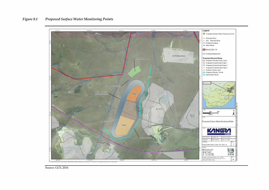
Figure 8.1 Proposed Surface Water Monitoring Points
Source: GCS, 2016

ENVIRONMENTAL RESOURCES MANAGEMENT KANGRA COAL (PTY) LTD.
8-4
8.1.2 Adit 5 and Overland Conveyor
The surface water monitoring plan is presented in Table 8.3.
Table 8.3 Surface Water Monitoring Plan
ID Latitude Longitude Location Primary Purpose
Water Quality Monitoring
Frequency Water Flow Monitoring Frequency
C5 260 58’ 11.01” S 300 20’ 38.38” E Hlelo stream, bridge
crossing Road D273
To assess water quality and
streamflow rates within the Hlelo
stream downstream of the oHlelo
stream inflow and immediately
downstream of old mining activities
Monthly field parameters,
Quarterly full analysis
Monthly
C8 260 59’ 45.597” S 300 20’ 19.405” E Tributary to the Hlelo
River upstream of the
abandoned mine,
adjacent to the planned
temporary construction
camp and Nooitgezien
operations, and
downstream of the
conveyor
To assess water quality in the
tributary and any impacts as a result
of the temporary construction camp,
Nooitgezien operations and
operation of the conveyor
Monthly field parameters,
Quarterly full analysis
-
C9 270 3’ 30.919” S 300 18’ 29.957” E Tributary to the south
east of the Mining Right
area
To assess water quality the south east
of the Mining Right area
Monthly field parameters,
Quarterly full analysis
-
C13 26°59'27.41"S 30°19'12.47"E Hlelo stream upstream of
inflow point of water
from Kransbank wetland
Monitor the change in water
chemistry in the Hlelo stream related
to the Kransbank wetland inflow.
Monthly field parameters,
Quarterly full analysis
Monthly
C10 260 59’ 55.591” S 300 19’ 12.080” E Downstream point on the
Kransbank wetland.
Tributary to the Hlelo
stream downstream of
Adit 5 and the conveyor
route. Adjacent to
Nooitgezien operations.
To assess water quality in the
tributary and any impacts as a result
of the temporary construction camp,
operation of the conveyor and Adit 5.
Monthly field parameters,
Quarterly full analysis
Monthly
C14 27° 1'42.15"S 30°19'2.78"E Tributary of the
Kransbank wetland that
drains the northern side
of Adit 5 location. Also
point at which conveyor
crosses the Kransbank
wetland.
Monitor water quality and flow
impacts related to operations at Adit
5.
Monthly field parameters,
Quarterly full analysis
Monthly
Point 2 27° 2' 2.744" S 30° 18' 26.647" E Surface water abstraction
point immediately
adjacent to the Adit 5
location, from where
surface water will drain
into the Kransbank
wetland.
Monitor water quality and flow
impacts related to operations at Adit
5.
Monthly field parameters,
Monthly full analysis
Monthly
ENVIRONMENTAL RESOURCES MANAGEMENT KANGRA COAL (PTY) LTD.
8-6
The monitoring plan is a living document that needs to be updated as
monitoring data results are generated. Details in support of Table 8.3 are as
follows:
Each surface water sampling location was selected in order to gain an
overall understanding on the impacts on surface water.
Surface water flow monitoring will be carried out concurrently with field
parameter measurement and surface water sampling where required.
Field parameters, including pH, electrical conductivity (EC), temperature
and dissolved oxygen (DO) should be monitored on a monthly basis.
Samples should be collected for submission to the laboratory on a
quarterly basis at most monitoring locations, but on a monthly basis at
Point 2.
The list of chemical constituents to be analysed will be routinely updated
based on previous results. Parameters to be tested include, but are not
limited to:
pH, EC (to verify field data) and TDS (for quality control purposes)
Cl, SO4, NO3, total N, F, Ca, Mg, Na, K, total alkalinity.
Major metals by inductively coupled plasma – mass spectrometry
(ICP-MS): Al, Cd, Co, Cu, Fe, Mn, Ni, Pb, Sb, Zn, U.
Parameters identified as potential contaminants of concern include SO4, Fe, Co, Ni.
In addition to the parameters detailed above, Point 2, adjacent to Adit 5
should be monitored on a quarterly basis for:
BTEX (benzene, toluene, ethylbenzene and xylenes);
EPH (extractable petroleum hydrocarbons);
GRO (gasoline range organics);
DOC (dissolved organic carbon);
COD (chemical oxygen demand); and
E. coli.
Samples will be submitted to a SANAS accredited laboratory within
recommended holding times.
Water quality results will be compared to the water quality objectives
(WQO) developed as part of this EIA process rather than to existing
national screening levels. These screening levels are intended to be used to
assess the quality of water in natural surface water systems.
All monitoring records will be stored in a database which is routinely
updated, maintained, and includes all metadata associated with the
monitoring activities.
ENVIRONMENTAL RESOURCES MANAGEMENT KANGRA COAL (PTY) LTD.
8-7
The monitoring programme and data will be reviewed annually and
amended if necessary.
The contribution of surrounding land uses will be considered when
conducting the sampling and analysis described above. In particular this
will include the impact of farming and animal husbandry on water
quality.

Figure 8.2 Surface Water Monitoring Points
Source: ERM, 2015
ENVIRONMENTAL RESOURCES MANAGEMENT KANGRA COAL (PTY) LTD.
8-9
8.2 GROUNDWATER MONITORING
Monitoring of groundwater is required for the following purposes:
1. To detect impacts on groundwater quantity and quality timeously.
2. To assess whether the mitigation/management measures provided in
Chapter 7 are effective, supporting the update of mitigation measures
where necessary.
3. To support adaptive management in which the numerical groundwater
model can be updated based on new information increasing its confidence
level and then used to predict groundwater impacts and assist with social
and biodiversity impacts and closure planning. With updated high
confidence predictions the mine can act in a pre-emptive manner, thus
reducing risks, rather than acting in hindsight when monitoring data
reveals a problem.
4. To interrogate unknowns identified in this report, in which various field
investigations can be carried out to test and improve the conceptual
hydrogeological understanding of the aquifer system.
8.2.1 Central Discard Dump
It is recommended that groundwater monitoring, particularly in areas down-
gradient of the Central Discard Dump, begin before the construction phase in
order to establish the baseline conditions, i.e. to obtain data regarding the
natural response of the aquifer/s, as well as to detect any changes in
groundwater quality. Monitoring is important because early detection of
potential impacts on surface and groundwater could potentially be managed
through intervention measures before large scale remediation is required.
Kangra Coal currently has a groundwater monitoring programme where
groundwater quality and quantity monitoring is undertaken on a quarterly
basis. It is recommended that this monitoring programme be expanded to
include the Central Discard Dump area (Table 8.4 and Figure 8.3).
Table 8.4 Proposed Groundwater Monitoring Points
Borehole ID Description Coordinates
Latitude Longitude
MONBH03*
Objective: Groundwater
monitoring of deeper fractured
rock aquifer.
Decision: Possible water quality
contribution from existing
Maquasa East mining
operation/s, located to the east of
the proposed Project site.
-27.01316278 30.38823781
ENVIRONMENTAL RESOURCES MANAGEMENT KANGRA COAL (PTY) LTD.
8-10
Borehole ID Description Coordinates
MONBH03-s
Objective: Groundwater
monitoring of shallow weathered
aquifer.
Decision: Possible water quality
contribution from existing
Maquasa East mining operations,
located to the east of the
proposed Project site.
-27.01286489 30.38821928
MONBH04*
Objective: Groundwater
monitoring of deeper fractured
rock aquifer. Early warning
system with regards to the
ephemeral down-gradient Egude
flow system.
Decision: Possible water quality
contribution from proposed
pollution control system and
from existing Maquasa East
mining operation/s, located to
the east of the proposed Project
site.
-27.00548839 30.40287769
MONBH04-s
Objective: Groundwater
monitoring of shallow weathered
aquifer. Early warning system
with regards to the ephemeral
down-gradient Egude flow
system.
Decision: Possible water quality
contribution from proposed
pollution control system and
from existing Maquasa East
mining operation/s, located to
the east of the proposed Project
site.
-27.00554303 30.40298822
MONBH05*
Objective: Groundwater
monitoring of deeper fractured
rock aquifer. Early warning
system with regards to the
ephemeral down-gradient Egude
flow system.
Decision: Possible water quality
contribution from proposed
discard storage facility and from
existing Maquasa East mining
operations, located to the east and
west of the proposed Project site.
-27.01305328 30.38175961
ENVIRONMENTAL RESOURCES MANAGEMENT KANGRA COAL (PTY) LTD.
8-11
Borehole ID Description Coordinates
MONBH05-s
Objective: Groundwater
monitoring of shallow weathered
aquifer. Early warning system
with regards to the ephemeral
down-gradient Egude flow
system.
Decision: Possible water quality
contribution from proposed
discard storage facility and from
existing Maquasa East mining
operations, located to the east and
west of the proposed Project site.
-27.0131345 30.38175917
MONBH06-s
Objective: Groundwater
monitoring of shallow weathered
aquifer.
Decision: Possible water quality
contribution from existing
Maquasa West mining
operations, located to the south /
southwest of the proposed Project
site.
-27.020133 30.39105172
MONBH06-d
Objective: Groundwater
monitoring of deeper fractured
rock aquifer.
Decision: Possible water quality
contribution from existing
Maquasa West mining
operations, located to the south /
southwest of the proposed Project
site.
-27.02017214 30.38139819
MONBH07-s
Objective: Groundwater
monitoring of shallow weathered
aquifer.
Decision: Possible water quality
contribution from existing
Maquasa West mining
operations, located to the south /
southwest of the proposed Project
site.
-27.00294139 30.39114436
MONBH07-d
Objective: Groundwater
monitoring of deeper fractured
rock aquifer.
Decision: Possible water quality
contribution from existing
Maquasa West mining
operations, located to the south /
southwest of the proposed Project
site.
-27.00297833 30.39133558
ENVIRONMENTAL RESOURCES MANAGEMENT KANGRA COAL (PTY) LTD.
8-12
Borehole ID Description Coordinates
Notes:
Coordinates Projection: Universal Transverse Mercator
Datum: WGS84
-s Shallow monitoring borehole, with depths less than ~20 mbgl
-d Deep monitoring boreholes, with depths greater than ~20 mbgl.
* existing monitoring boreholes (constructed)
Source: GCS, 2016
Groundwater quantity (i.e. levels) and quality monitoring should continue to
be undertaken on a quarterly basis, unless indicated otherwise in the
environmental authorisations (ROD, or IWUL).
Groundwater samples should be collected by an independent groundwater
consultant, using best practice guidelines and should be analysed by a SANS
accredited laboratory. The recommended parameters for groundwater quality
analysis are listed in Table 8.2.
It is recommended that the groundwater monitoring network database is
updated quarterly as information becomes available, analysed and evaluated;
and, reported to the authorities (during construction, operational and closure
phases).
In addition to the above, it is recommended that a monitoring response
protocol is developed in the event of groundwater quality deterioration.

Figure 8.3 Proposed Groundwater Monitoring Locations
Source: GCS, 2016
ENVIRONMENTAL RESOURCES MANAGEMENT KANGRA COAL (PTY) LTD.
8-14
8.2.2 MWE Underground Works
Each of the individual fountains and streams proposed for monitoring must
be incorporated into the monitoring system as soon as mining commences in
the respective sub-catchment area of that fountain or stream. If a mining
impact is suspected, the monitoring system must be expanded to include all
the fountains listed and streams included in Figure 8.4, as well as all fountains
and streams where specific complaints arise.
Table 8.5 Fountains to be monitored
Nr on Map Y X Farm Nr
MWG-FII 62493.28 2990975.43 19HT
MWG-F37 63091.17 2990906.51 19HT
MWG-F39 63131.43 2991109.39 19HT
MWG-F40 63135.30 2991330.73 19HT
MWG-F60 66299.75 2988409.76 381 1T
MWG-F63 64671.59 2988308.61 18HT
MWG-F64 64099.55 2988285.96 18 HT
MWG-F65 64085.76 2988107.88 18HT
MWG-F80 64629.87 2993185.79 20HT
MWG-F81 64825.25 2993210.83 20HT
EF-1 67231.29 2991474.52 15HT
EF-2 67279.66 2991521,32 15HT
EF-4 67437.65 2992219.14 15 HT
BF-1 68816.15 2993985.14 34HT
BF-2 67958.69 2994210.92 34HT
Source: Oryx Environmental, 2006
Table 8.6 Streams to be monitored
Nr on Map Y X Farm Nr
MWS-S3 65588.25 2987165.94 381 IT
MWS-S5 61045.94 2991644.42 19HT
MWS-S8 61099.06 2988232.32 18 HT
MWS-S9 62717.21 2994405.25 20HT
ES-15 67449.935 2987361.505 15HT
Source: Oryx Environmental, 2006
Figure 8.4 Localities of proposed fountains and streams to be monitored
Source: Oryx Environmental, 2006

8.2.3 Adit 5 and Overland Conveyor
The Groundwater Monitoring Plan has been developed taking into account
the best practice guidelines for water monitoring in the South African mining
industry (DWAF, 2008). The measurement of water levels and collection of
groundwater samples discussed in this section will proceed according to the
best practice for monitoring methods, as outlined by Weaver (2007).
The groundwater monitoring plan is presented in Table 8.7.

Table 8.7 Groundwater Monitoring Plan
BHID Latitude Longitude Type Primary Purpose
Water Level
Monitoring
Frequency
Flow Rate
(Yield)
Monitoring
Frequency Water Quality Monitoring Frequency
RMBH3
27° 2'10.96"S 30°18'50.65"E
Recommended shallow (10 – 20 m) monitoring BH Water quality impact related to adit
facilities
Monthly Quarterly
RMBH4
27° 2'2.73"S 30°18'42.09"E
Recommended shallow (10 – 20 m) monitoring BH Water quality impact related to adit
facilities
Monthly Quarterly
Notes: BH Borehole
ENVIRONMENTAL RESOURCES MANAGEMENT KANGRA COAL (PTY) LTD.
8-18
The monitoring plan is a living document that needs to be updated as
monitoring data and modelling results are generated. Details in support of
Table 8.7 are listed as follows:
Each borehole was selected in order to monitor mining related risks to
particular aquifers, including dewatering risks and impacts to
groundwater quality.
Monitoring boreholes installed by ERM have been selected for monitoring.
ERM recommends installation of additional monitoring boreholes to
provide increased coverage in certain areas, referred to in Table 8.7 as
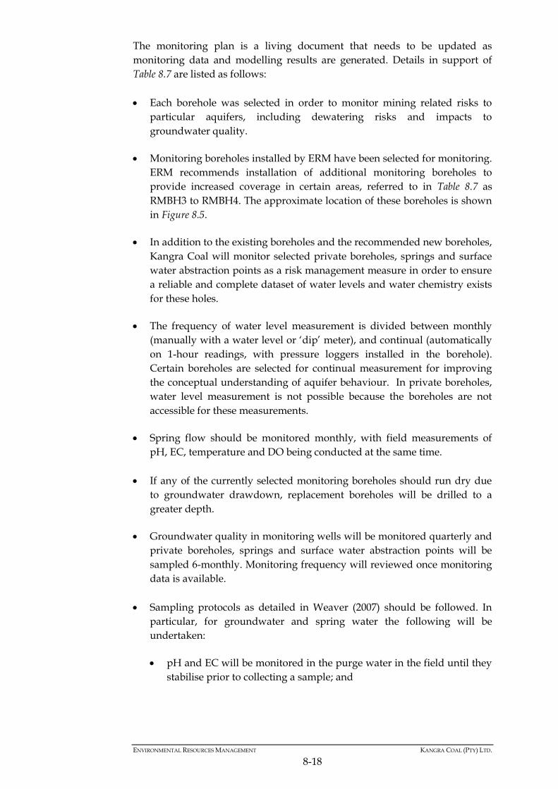
RMBH3 to RMBH4. The approximate location of these boreholes is shown
in Figure 8.5.
In addition to the existing boreholes and the recommended new boreholes,
Kangra Coal will monitor selected private boreholes, springs and surface
water abstraction points as a risk management measure in order to ensure
a reliable and complete dataset of water levels and water chemistry exists
for these holes.
The frequency of water level measurement is divided between monthly
(manually with a water level or ‘dip’ meter), and continual (automatically
on 1-hour readings, with pressure loggers installed in the borehole).
Certain boreholes are selected for continual measurement for improving
the conceptual understanding of aquifer behaviour. In private boreholes,
water level measurement is not possible because the boreholes are not
accessible for these measurements.
Spring flow should be monitored monthly, with field measurements of
pH, EC, temperature and DO being conducted at the same time.
If any of the currently selected monitoring boreholes should run dry due
to groundwater drawdown, replacement boreholes will be drilled to a
greater depth.
Groundwater quality in monitoring wells will be monitored quarterly and
private boreholes, springs and surface water abstraction points will be
sampled 6-monthly. Monitoring frequency will reviewed once monitoring
data is available.
Sampling protocols as detailed in Weaver (2007) should be followed. In
particular, for groundwater and spring water the following will be
undertaken:
pH and EC will be monitored in the purge water in the field until they
stabilise prior to collecting a sample; and
ENVIRONMENTAL RESOURCES MANAGEMENT KANGRA COAL (PTY) LTD.
8-19
Samples for trace element analysis will be appropriately filtered and
acidified in the field to ensure results are representative of dissolved
species in the aquifer.
Samples will be submitted to a SANAS accredited laboratory within
recommended holding times.
The list of chemical constituents to be analysed will be routinely updated
based on previous results. Parameters to be tested include, but are not
limited to:
pH, EC and TDS.
Major constituents - Cl, SO4, NO3, total N, F, Ca, Mg, Na, K, total
alkalinity.
Major metals by inductively coupled plasma – mass spectrometry
(ICP-MS): Al, Cd, Co, Cu, Fe, Mn, Ni, Pb, Sb, Zn, U.
Parameters identified as potential contaminants of concern include
Sulphate, Iron, Cobalt Nickel.
In addition to the parameters detailed above, recommended boreholes
RMBH3 and RMBH4 downgradient of Adit 5 should be monitored for:
EPH (extractable petroleum hydrocarbons);
GRO (gasoline range organics);
DOC (dissolved organic carbon);
COD (chemical oxygen demand); and
E. coli.
Water quality results will be compared to the water quality screening
levels developed as part of this EIA process rather than to existing national
screening levels.
All monitoring records will be stored in a database which is routinely
updated, maintained, and includes all metadata associated with the
monitoring activities.
The monitoring programme and data will be reviewed by an independent
hydrogeologist annually and amended if necessary.
Figure 8.5 Groundwater monitoring points
Source: ERM, 2015
ENVIRONMENTAL RESOURCES MANAGEMENT KANGRA COAL (PTY) LTD.
8-21
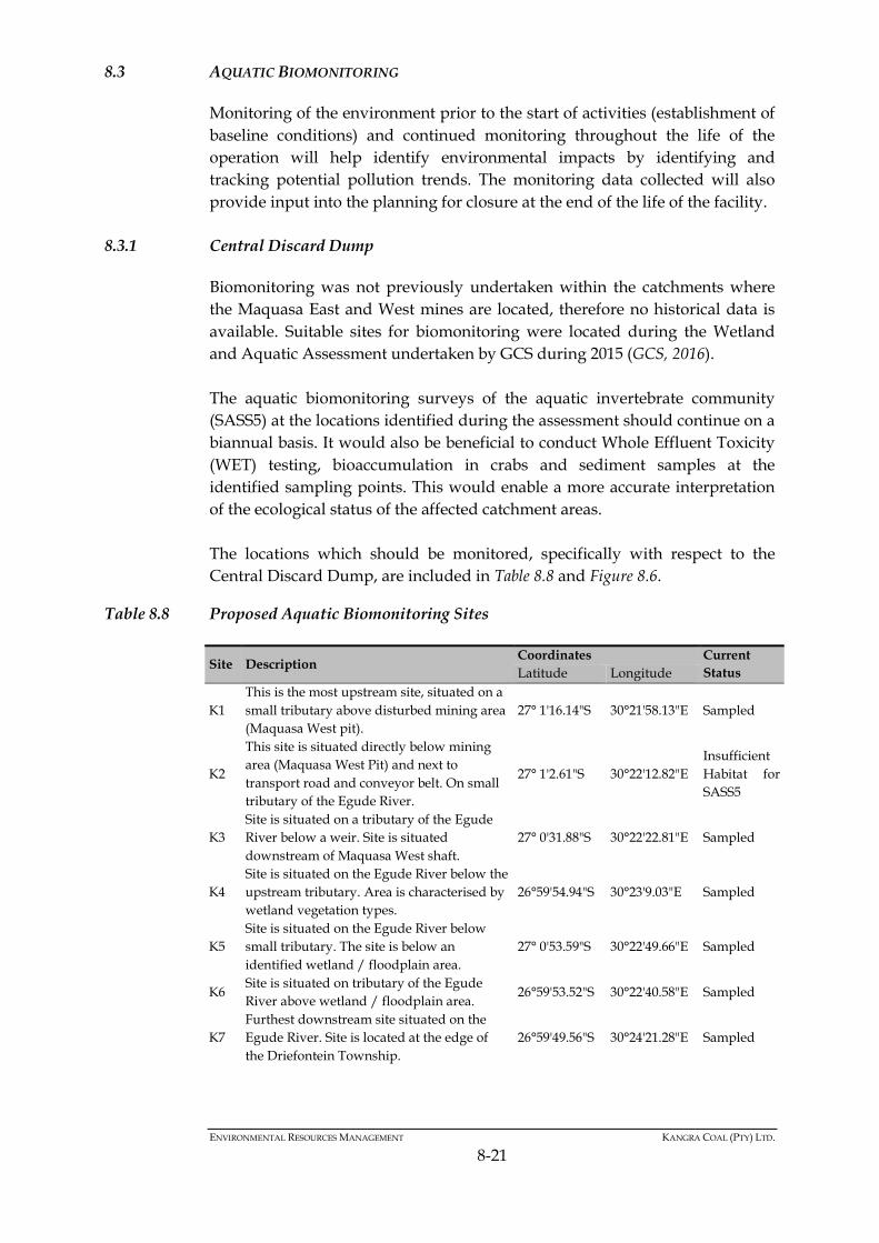
8.3 AQUATIC BIOMONITORING
Monitoring of the environment prior to the start of activities (establishment of
baseline conditions) and continued monitoring throughout the life of the
operation will help identify environmental impacts by identifying and
tracking potential pollution trends. The monitoring data collected will also
provide input into the planning for closure at the end of the life of the facility.
8.3.1 Central Discard Dump
Biomonitoring was not previously undertaken within the catchments where
the Maquasa East and West mines are located, therefore no historical data is
available. Suitable sites for biomonitoring were located during the Wetland
and Aquatic Assessment undertaken by GCS during 2015 (GCS, 2016).
The aquatic biomonitoring surveys of the aquatic invertebrate community
(SASS5) at the locations identified during the assessment should continue on a
biannual basis. It would also be beneficial to conduct Whole Effluent Toxicity
(WET) testing, bioaccumulation in crabs and sediment samples at the
identified sampling points. This would enable a more accurate interpretation
of the ecological status of the affected catchment areas.
The locations which should be monitored, specifically with respect to the
Central Discard Dump, are included in Table 8.8 and Figure 8.6.
Table 8.8 Proposed Aquatic Biomonitoring Sites
Site Description Coordinates Current
Status Latitude Longitude
K1
This is the most upstream site, situated on a
small tributary above disturbed mining area
(Maquasa West pit).
27° 1'16.14"S 30°21'58.13"E Sampled
K2
This site is situated directly below mining
area (Maquasa West Pit) and next to
transport road and conveyor belt. On small
tributary of the Egude River.
27° 1'2.61"S 30°22'12.82"E
Insufficient
Habitat for
SASS5
K3
Site is situated on a tributary of the Egude
River below a weir. Site is situated
downstream of Maquasa West shaft.
27° 0'31.88"S 30°22'22.81"E Sampled
K4
Site is situated on the Egude River below the
upstream tributary. Area is characterised by
wetland vegetation types.
26°59'54.94"S 30°23'9.03"E Sampled
K5
Site is situated on the Egude River below
small tributary. The site is below an
identified wetland / floodplain area.
27° 0'53.59"S 30°22'49.66"E Sampled
K6 Site is situated on tributary of the Egude
River above wetland / floodplain area. 26°59'53.52"S 30°22'40.58"E Sampled
K7
Furthest downstream site situated on the
Egude River. Site is located at the edge of
the Driefontein Township.
26°59'49.56"S 30°24'21.28"E Sampled
ENVIRONMENTAL RESOURCES MANAGEMENT KANGRA COAL (PTY) LTD.
8-22
Site Description Coordinates Current
Status
K8
Site is located to the south of the mining
area on a small tributary to the Mpundu
River.
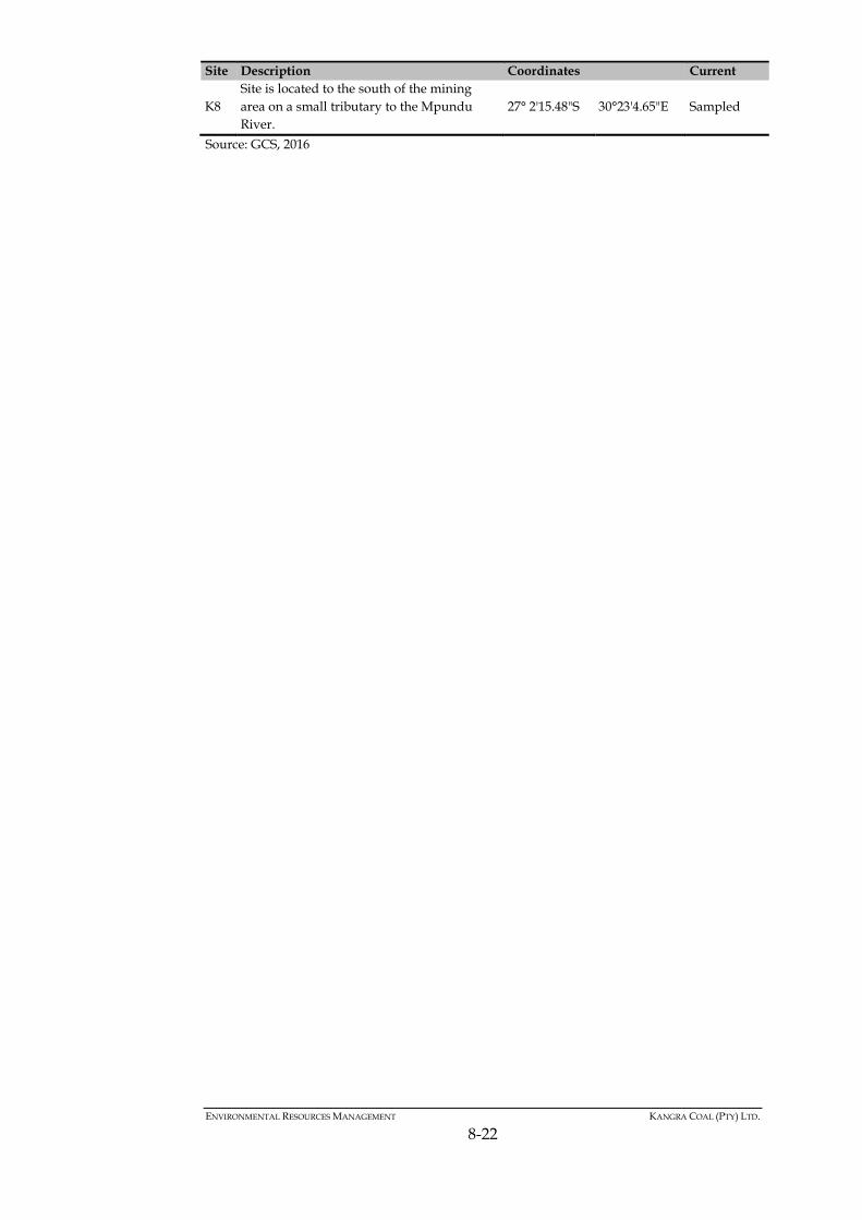
27° 2'15.48"S 30°23'4.65"E Sampled
Source: GCS, 2016
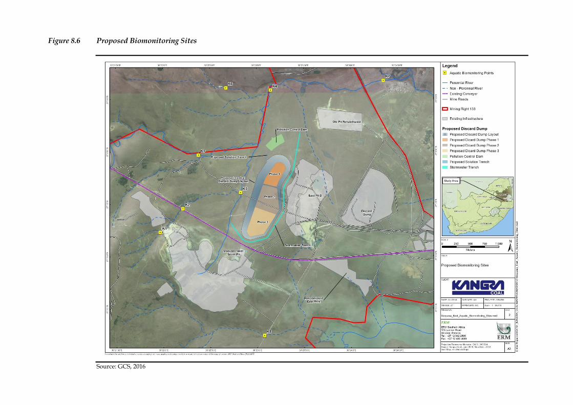
Figure 8.6 Proposed Biomonitoring Sites
Source: GCS, 2016
ENVIRONMENTAL RESOURCES MANAGEMENT KANGRA COAL (PTY) LTD.
8-24
8.3.2 Adit 5 and Overland Conveyor
Water quality should be regularly monitored and appropriate and timeous remedial interventions made in the case of non-compliance.
Quarterly monitoring of aquatic ecosystems should be conducted in order to ensure that they stay in their current unimpacted state. Appropriate and timeous remedial interventions should be made in cases where aquatic ecosystems are seen to be deteriorating.
Careful monitoring is needed to ensure erosion nick points (e.g. around gabions) are detected and managed. Sediments eroded from remaining stockpiles should be minimized and prevented from reaching watercourses.
8.4 AIR QUALITY MONITORING
8.4.1 Central Discard Dump
Dust monitoring is required at the mine site, as well as in the vicinity of the
Central Discard Dump. The following dust buckets are located within the
vicinity of the Central Discard Dump:
Dust Yende family: -27.01660°-30.33352°E; and Community 1: --27.016283°S; -30.370031°E
It is recommended that two additional monitoring points are established at
the southern and northern boundaries of the Central Discard Dump.
The dust buckets should be monitored on a monthly basis and reports
compiled on a quarterly basis.
8.4.2 Adit 5 and Overland Conveyor
Air quality impacts as result of the operation of Adit 5, the overland conveyor
and servitude road are predicted to be moderate; this is mainly influenced by
sensitive receptors around the project site. Fine particulates (specifically PM10)
and ambient dustfall monitoring is recommended to ascertain the modelling
results. Monitoring should commence during the construction phase and
continue throughout the life of the project. The monitoring programme is
designed to assist in the decision making process around the implementation
of mitigation, verify the efficiency of mitigation measures and ensure that
unacceptable impacts are not arising at nearby sensitive receptors.
Monitoring effort should be focused on the areas defined in Figure 8.7, where
simulated concentrations exceed the PM10 daily standard of 75 µg/m³, such as
at receptors C88, C90 and C72. PM10 monitoring should be undertaken using
devices that are recognised by the DEA for compliance purposes. In this
regard, gravimetric sampling (filter-based methods) is required. The use of
“mini-vol”, filter based sampling requires the daily changing of filters.
Appendix A of the Air Quality Specialist Report (Annex 5B) provides a
ENVIRONMENTAL RESOURCES MANAGEMENT KANGRA COAL (PTY) LTD.
8-25
detailed discussion regarding the various types of PM10 monitors on the
market.
During the construction phase the monitoring data should be reviewed on a
daily basis; and during the operational phase, should be considered on a
monthly basis. Where PM10 emissions associated with the site are above the
National Ambient Air Quality Standards (NAAQS), investigations should be
made into the sources of emissions and measures implemented to manage
emissions.
Dustfall monitoring should be carried out using the American Society of
Testing and Materials (ASTM) methodology. The apparatus for monitoring
consists of a bucket approximately 150 mm in diameter and 300 mm deep in
which dust is collected for a period between 28 and 33 days. Solid matter
larger than 2 mm in size (insects etc.) is removed by screening. The remaining
solid matter is washed from the bucket, filtered and weighed. Use of this
method will ensure that sampled dustfall rates are comparable to the National
Dust Control Regulations (NDCR). A dustfall monitoring network should be
expanded to include areas around sensitive receptors, conveyor route and
material handling points. Indicatives sites are illustrated in Figure 8.7. The
proposed monitoring locations may be revised annually or as project phases
and operational areas change, this will assist in obtaining a good baseline and
also identify areas where mitigation measures should be focused.
During the construction and operational phases the monitoring data should be
reviewed on a monthly basis by the environmental manager. Where dust
emissions associated with the site are above NDCR’s residential and non-
residential limits, investigations should be made into the sources of emissions
and measures implemented to manage emissions.
Monitoring will serve to meet objectives such as:
Compliance monitoring;
Validate dispersion modelling results;
Use as input for health risk assessment;
Assist in source apportionment;
Temporal trend analysis;
Spatial trend analysis;
Source quantification; and
Tracking progress made by control or mitigation measures.
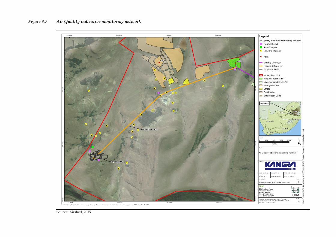
Figure 8.7 Air Quality indicative monitoring network
Source: Airshed, 2015
ENVIRONMENTAL RESOURCES MANAGEMENT KANGRA COAL (PTY) LTD.
8-27
8.5 NOISE MONITORING
Quarterly noise measurements are recommended to be conducted by an
acoustical specialist for the duration of the operation. This acoustical
specialist, along with Kangra Coal, must determine where noise monitoring is
required and develop a site specific monitoring plan considering the selected
and implemented mitigation measures.
Quarterly noise measurements should also be collected in 10-minute bins over
a period of at least 24 hours during the construction, decommissioning and
closure phases.
Measurements should be collected as defined by SANS 10103:2008 (or any
future updates) using instruments as defined in the National Noise Control
Regulations (or any future promulgated laws).
8.6 SOILS
The project area has a distinct rainy and dry season. It is recommended that
the erosion monitoring programme will include two rounds of evaluation per
year during construction and operations (January and June) to determine if
any seasonal variations do occur. Thereafter, annual monitoring will take
place once per year, preferably at the end of the dry season before the start of
the rainy season (August).
Each monitoring round should include a physical observation and reporting
of the following:
Evidence of erosion or land degradation;
Condition of access roads;
Condition of cleared areas;
Condition of perimeter drains (if installed) and associated settlement
ponds (if installed); and
Compliance with applicable regulatory and corporate requirements.
8.7 GENERAL SITE MONITORING AND REQUIREMENTS
8.7.1 Rehabilitation Progress
The post-construction and post-decommissioning rehabilitation requires
monitoring of the progress/success of the rehabilitation efforts. This
monitoring will involve the inspection of areas which have been disturbed,
ENVIRONMENTAL RESOURCES MANAGEMENT KANGRA COAL (PTY) LTD.
8-28
eroded or rehabilitated which should be documented to provide a photolog of
the area.
Vegetation monitoring will assist in determining whether further
rehabilitative measures need to be implemented and if alien plant control
interventions have been successful or if they need to implemented more
intensively.
Alien and invasive species monitoring and control should be done on a
quarterly basis during the entire life of the facility.
8.7.2 Reporting
Monitoring reports must be compiled and submitted to the relevant authority.
These include:
Surface water and groundwater monitoring reports must be compiled on a
quarterly basis, with one annual report being compiled at the end the year.
All reports must be submitted to the relevant officials at the DWS and
DMR.
Aquatic Biomonitoring Reports must be compiled on a bi-annual basis and
submitted to the relevant official at the DWS.
Air Quality Monitoring Reports must be compiled on a quarterly basis and
submitted to the relevant official at the DEA (if requested).
8.7.3 Environmental Performance Audits
Performance assessment audits are required in terms of Regulation 55 (1) of
the MPRDA Regulations, GR527. In order to comply with this regulation, the
following will be undertaken:
Monitoring will be conducted on ongoing basis.
Performance assessments of the approved EMPr will be undertaken by
Kangra Coal on an annual basis, with an external performance assessment
audit every two years. The annual performance assessment will be
undertaken by a suitably qualified person, while the audit will be
undertaken by a qualified, independent third party.
Submission of an annual performance assessment report to the Director:
Minerals at the DMR.