a cross-sectional study of asbestos- related morbidity and
TRANSCRIPT

A Cross-Sectional Study of Asbestos-Related Morbidity and Mortality in Vermonters Residing Near an Asbestos Mine
November 3, 2008
108 Cherry Street, PO Box 70 Burlington, VT 05402 802.863.7200 healthvermont.gov

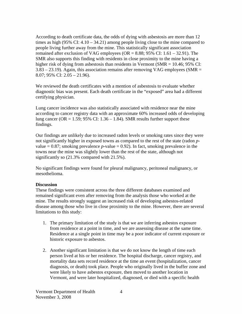
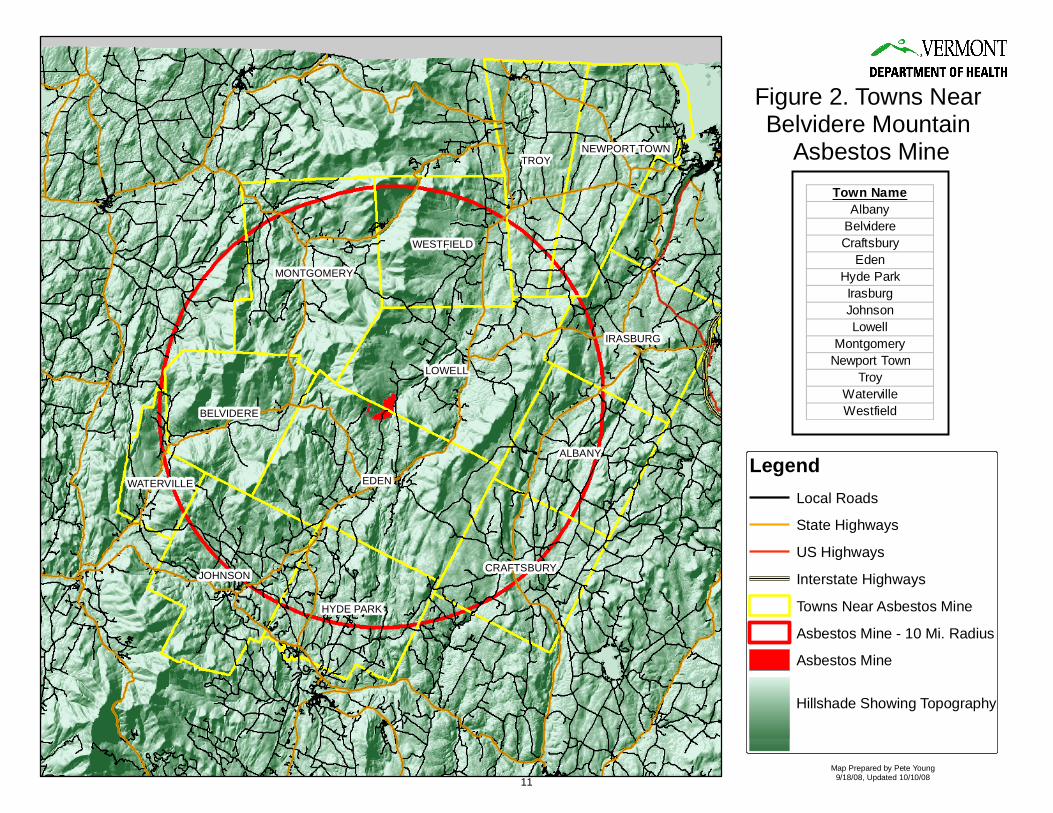
A Cross-Sectional Study of Asbestos-Related Morbidity and Mortality in Vermonters Residing Near an Asbestos Mine Introduction Chrysotile asbestos was mined from three locations on Belvidere Mountain in the northern part of Vermont from the early 1900’s to 1993. Mining operations left mill tailings estimated to contain over 29 million tons of asbestos-contaminated waste. Asbestos is still found at the site in various forms, including undisturbed veins of the raw mineral in the quarry walls and several million cubic yards of partially processed rock. Erosion of the tailing piles by both wind and rain has caused significant ecological damage. However, lack of environmental sampling data has created challenges in estimating the risk to human health from exposure to living near and recreating on the partially processed waste rock that is scattered over approximately 1,540 acres. Inhalation of chrysotile asbestos has been associated with lung cancer, mesothelioma, and asbestosis in workers in numerous epidemiological studies.1 Studies of workers have shown a dose response association between the concentration and duration of chrysotile asbestos exposure and the severity of disease. However, few studies have evaluated the risk of developing lung cancer or asbestosis when exposed to chrysotile asbestos by non-occupational means. In 2006, the Vermont Department of Health (VDH) was approached by the Department of Environmental Conservation (DEC) to assist in developing strategies to understand the risk to Vermonters who lived in close proximity to the asbestos mine located on Belvidere Mountain. Due to limited environmental sampling data and lack of good asbestos risk assessment models, VDH used univariate statistical analyses to assess human health risk. VDH used existing health surveillance data from death certificates, hospital discharge billing records, and cancer registry data for the 10-year period 1996 to 2005 to compare risk of developing lung cancer, asbestosis, and/or mesothelioma in those individuals who lived in the 13 towns closest to the Belvidere Mountain asbestos mine and those living in the rest of the state. Methods We defined the geographical area where residents were more likely to be exposed to asbestos based on proximity to the Belvidere Mountain asbestos mine. Exposure was defined as residing in a town that is within a 10 mile radius around the mine. Residents in the following towns were considered exposed to asbestos: Albany, Belvidere, Craftsbury, Eden, Hyde Park, Irasburg, Johnson, Lowell, Montgomery, Newport Town, Troy, Waterville, and Westfield. Some towns that only partially overlap that circle, and are separated from the mine by mountains, were excluded from the area defined as “exposed.” Residents of Enosburg, Bakersfield, and Wolcott, along with those of all other Vermont towns, were considered “unexposed.” Figure 1 shows the proximity of the mine to the rest of the state, and Figure 2 shows more detail of the study area. 1 WHO, 1998. Chrysotile asbestos: Environmental health criteria. Geneva, Switzerland. World Health Organization.
Vermont Department of Health November 3, 2008
1

Onsite meteorological data is not available. For the past two years, the Vermont Department of Health, in collaboration with the Department of Environmental Conservation, have requested these data from the Vermont Asbestos Group but have been unsuccessful in obtaining them. In absence of onsite data, we therefore estimated a southwesterly sustained wind direction for the area around the asbestos mine. We applied the August 2008 wind rose pattern for the Burlington International Airport (source: Natural Resources Conservation Service), taking into consideration the differences in topography between the Champlain Valley (where Burlington is located), and the valley near the Belvidere Mountain asbestos mine. Data Sources The following data sources were identified by the Environmental Health Section and the Vermont Cancer Registry (VCR) for use in the study:
1. Individual death certificates with any mention of asbestosis, pleural malignancy, peritoneal malignancy or mesothelioma were extracted for Vermont residents from the mortality records. Mortality data for Vermont residents who died outside of Vermont were obtained through the Interjurisdictional Exchange Agreement.
2. Hospital discharges with a primary or contributing diagnosis of asbestosis, pleural
malignancy or peritoneal malignancy were also obtained. Data were obtained for Vermont residents discharged from Vermont hospitals and hospitals in neighboring states (Massachusetts, New York and New Hampshire).
3. New diagnoses of lung cancer, pleural malignancy, peritoneal malignancy and
mesothelioma were obtained from the Vermont Cancer Registry. Cancer incidence represents Vermont residents, including residents diagnosed out of state.
4. Vermont Asbestos Group (VAG) is the current owner of the Belvidere Mountain
asbestos mine. A list of VAG employees, with dates of hire from 1928 through 1992, was obtained from the Vermont Attorney General’s Office based on prior court proceedings.
5. Population data were obtained from the VDH Center for Health Statistics, the
U.S. Bureau of the Census, and the National Center for Health Statistics.
6. The average smoking prevalence among Vermont adults was obtained from the Vermont Behavioral Risk Factor Surveillance System (BRFSS).
7. Radon in air levels were obtained from the Vermont Radon Program’s database of
long term air monitoring. All deaths, discharges and diagnoses were classified according to the International Classification of Diseases (see Table 1). All data were extracted for the most recent 10 year period available for analyses, 1996 through 2005.
Vermont Department of Health November 3, 2008
2

Statistical Analysis We compared cases who were residents of the exposed towns with cases from the rest of the state (“exposed” having been defined above) by using crude odds ratios (ORs) and standardized mortality (or morbidity) ratios (SMR). Standardized mortality ratios were calculated for death certificate data; standardized morbidity ratios were calculated for hospital discharge and cancer registry data. SMRs were calculated using 10-year age groupings and with the entire population of Vermont as the standard population. The denominator data (10-year population) for the calculation of the ORs are as follows: 167,007 for the exposed towns and 5,932,612 for the unexposed towns. The age groupings for the SMRs are as follows: 0-4 years, 5-14 years, 15-24 years, 25-34 years, 35-44 years, 45-54 years, 55-64 years, 65-74 years, 75-84 years, 85+ years. For hospital discharges and death certificate data, due to small numbers, confidence intervals and p-values for the ORs were calculated using the mid-P version of Fisher’s exact method. Confidence intervals and p-values for the SMRs were calculated using a mid-P method based on the Poisson distribution. For cancer registry data, confidence intervals for the ORs are based on the Taylor series; p-values are two-sided (Mantel-Haenszel chi-squared method). Confidence intervals for the SMRs were calculated using the Rothman/Greenland approximation, and p-values are two-sided using the chi-squared method. To assess potential lung cancer biases, average radon air measurements and smoking prevalence for exposed and unexposed towns were compared using t-tests. For cancer registry and death certificate data, measures of effect were calculated with and without Vermont Asbestos Group employees. We excluded VAG employees to evaluate whether an increased risk of developing asbestos-related conditions existed among residents near the mine who were not likely to have an occupational exposure to asbestos from the mine. All of the above described methods were reviewed and approved by the Health Surveillance Division Director, the State Epidemiologist for Environmental Health, the Vermont Cancer Registry Chief, and the Public Health Statistics Chief. The methods are considered “best practice” for conducting these types of epidemiological studies with small populations. Results All statistically significant results are presented in Table 2. A statistically significant association (OR = 3.03; 95% CI: 1.69- 5.10) was observed between asbestosis as reported by hospital discharge data and residence in a town in close proximity to the mine. Age adjusted results using the standard mortality ratio (SMR) also revealed a statistically significant association with the observed number of discharges greater in the towns close to the mine as compared to the Vermont population (SMR = 3.14 95% CI: 1.79 – 5.15).
Vermont Department of Health November 3, 2008
3
According to death certificate data, the odds of dying with asbestosis are more than 12 times as high (95% CI: 4.10 – 34.21) among people living close to the mine compared to people living further away from the mine. This statistically significant association remained after exclusion of VAG employees (OR = 8.88; 95% CI: 1.61 – 32.91). The SMR also supports this finding with residents in close proximity to the mine having a higher risk of dying from asbestosis than residents in Vermont (SMR = 10.46; 95% CI: 3.83 – 23.19). Again, this association remains after removing VAG employees (SMR = 8.07; 95% CI: 2.05 – 21.96). We reviewed the death certificates with a mention of asbestosis to evaluate whether diagnostic bias was present. Each death certificate in the “exposed” area had a different certifying physician. Lung cancer incidence was also statistically associated with residence near the mine according to cancer registry data with an approximate 60% increased odds of developing lung cancer (OR = 1.59; 95% CI: 1.36 – 1.84). SMR results further support these findings. Our findings are unlikely due to increased radon levels or smoking rates since they were not significantly higher in exposed towns as compared to the rest of the state (radon p-value = 0.87; smoking prevalence p-value = 0.92). In fact, smoking prevalence in the towns near the mine was slightly lower than the rest of the state, although not significantly so (21.3% compared with 21.5%). No significant findings were found for pleural malignancy, peritoneal malignancy, or mesothelioma. Discussion These findings were consistent across the three different databases examined and remained significant even after removing from the analysis those who worked at the mine. The results strongly suggest an increased risk of developing asbestos-related disease among those who live in close proximity to the mine. However, there are several limitations to this study:
1. The primary limitation of the study is that we are inferring asbestos exposure from residence at a point in time, and we are assessing disease at the same time. Residence at a single point in time may be a poor indicator of current exposure or historic exposure to asbestos.
2. Another significant limitation is that we do not know the length of time each
person lived at his or her residence. The hospital discharge, cancer registry, and mortality data sets record residence at the time an event (hospitalization, cancer diagnosis, or death) took place. People who originally lived in the buffer zone and were likely to have asbestos exposure, then moved to another location in Vermont, and were later hospitalized, diagnosed, or died with a specific health
Vermont Department of Health November 3, 2008
4

condition, would be classified as residing outside the buffer zone and unlikely to have asbestos exposure. The converse is also true.
3. Although the years 1996-2005 are consistently analyzed across each of the data
sets, the time of exposure to asbestos was likely earlier than the time of the hospitalization, diagnosis, or death of each study participant.
4. Given the time period studied, our analysis may not include persons who would
have been identified as ill before 1996 or persons who have yet to be reported to VDH after 2005. It is a possibility that further cases will be identified as a result of the length of time from asbestos exposure to disease diagnosis and data collection within public health data sources.
5. Some of the findings of this study are based on very small numbers. For example,
the number of events studied could be as low as three. Additionally, the geographic area where people were likely to have asbestos exposure is rural. On average, 16,701 people lived in the buffer zone at any given time during the study (compared to an average of 609,962 for Vermont overall). To compensate for this, we used multiple approaches to assess whether we observed a higher number of health events among people living in the buffer zone than expected. Both odds ratios and standardized mortality (or morbidity) ratios were calculated. We used the mid-P version of Fisher's exact method (for ORs) and used the mid-P method based on the Poisson distribution (for SMRs) when testing statistical significance for small numbers.
6. The VAG employment records may be incomplete because they were based on
information that was indirectly obtained from the employer. Several typed lists were data entered, de-duplicated and checked for errors. In the 65 years of employment, it is likely that some employees, particularly temporary or part-time employees, were excluded from the master list that we used to classify people as VAG employees.
7. We could not assess whether people who did not work at VAG were exposed to
asbestos by other sources. It is possible that persons residing anywhere in Vermont could have been exposed to asbestos in the workplace. Although occupation and industry are included in the mortality and cancer registry data sets, the data fields are not 100 percent accurate or complete.
8. We combined mesothelioma, all malignancies of the pleura, and all malignancies
of the peritoneum due to limitations in coding deaths that occurred before 1999 and hospital discharges of all years. (ICD-9 and ICD-9-CM lacks the specificity needed to separate mesothelioma from different malignancies.) This could have underestimated the difference in pleural and peritoneal mesothelioma that might exist between the buffer zone and the rest of the state.
Vermont Department of Health November 3, 2008
5

9. The mortality data are very likely to be an undercount of deaths for the specified causes. There is no national requirement for states to share with each other a copy of the death certificate if a resident dies out of state. It can be assumed with some confidence that there may be long-time Vermont residents that worked and lived in the study area, moved to other states, and died during the study period. We only receive death certificates or notifications reliably from NH, NY, ME, and Canada.
10. In those cases where a Vermont resident died in another state and that state sent
us a notification of the death as a courtesy, the Vital Records / Statistics Office is restricted from sharing all of the information with the study group. The Interjurisdictional Exchange Agreement, signed by all states, stipulates the allowed and disallowed use of birth and death certificate information by other states. The agreement goes into significant detail as to which fields of the certificates may be used by which states for what type of purpose. Some states allow other states to use all of the information. Other states prohibit any type of use.
11. We cannot adjust for individual smoking status in the cancer incidence analysis
because it is not collected by the cancer registry. However, we did compare the smoking prevalence in the buffer towns to the rest of the state and found no statistical difference.
12. Vermont cancer incidence data are estimated to be 100 percent complete based on
evaluation by the Centers for Disease Control and Prevention (CDC) and the North American Association of Central Cancer Registries (NAACCR). However, it is possible that people diagnosed with cancer were unreported by healthcare providers or healthcare facilities. It is also possible that Vermont residents received their diagnosis and first course of treatment in a state that does not have an interstate data exchange agreement and therefore would not be reported to the VCR.
13. The Hospital Discharge Data represent discharges, not individuals. By law, we do
not have access to the personal identifiers in the hospital discharge data set. A limitation of the study is that we assumed the amount of duplication (multiple discharges per person) is similar in the buffer zone and the rest of the state. However, access to care could be different in different areas of the state.
14. We were unable to establish household contacts of VAG employees because cases
were not interviewed.
Vermont Department of Health November 3, 2008
6

Conclusion This study found several statistically significant associations between asbestos-related disease/death and residence in one of the 13 towns closest to Belvedere Mountain asbestos mine. Vermonters discharged from the hospital with a diagnosis of asbestosis were statistically more likely to live close to the mine; Vermonters who died of asbestosis or asbestosis contributed to their death were statistically more likely to live close to the mine; and Vermonters who were diagnosed with lung cancer were statistically more likely to live close to the mine. Although statistically significant increases in asbestos-related disease and death were found in those who lived in close proximity to the mine, the study does not identify the cause of the increase. A major limitation of the study is the lack of exposure information. Exposure since the mine closed in 1993 is less likely than during the years when the mine was operational. This is important to note because the diseases we have studied generally take years to develop, pointing to exposure going back further in time. Residency close to the mine is used as an exposure surrogate, but residency may be a poor indicator of actual non-occupation asbestos exposure. The study indicates further asbestos exposure risk assessment is necessary to determine the existence or likelihood of current health risks associated with residence near the mine. VDH recommends the following: A. Complete asbestos exposure health risk assessment including, but not limited to,
activity-based sampling, perimeter air sampling, residential home air and wipe sampling, and meteorological data to better understand current off site migration of asbestos;
B. Compare the prevalence of pleural plaques in the 13 towns compared to the rest of
the state using mortality data from 1999 to 2005. (The latency period for developing asbestos-related pleural plaques is approximately five years. Pleural plaques may be a better indicator of residential non-occupational asbestos exposure);
C. Evaluate the extent of the off site use of asbestos mine tailings; D. Restrict public access to the asbestos mine.
Vermont Department of Health November 3, 2008
7

Table 1. Site group definitions.
Site Group Hospital Discharge Data (ICD-9-CM)
Deaths occurring before 1999 (ICD-9)
Deaths occurring on or after 1999 (ICD-10)
Cancer Incidence Data (ICD-O-3)
Topography | Morphology
Asbestosis 501 501 J61 C34.0 C34.1 C34.2 C34.3 C34.8
Malignant neoplasm of bronchus and lung
C34.9
invasive neoplasms
except 9590-9989
158 158 C48 158.0 158.0 C48.0 C48.0 158.8 158.8 C48.1 C48.1 158.9 158.9 C48.2 C48.2
Malignant neoplasm of peritoneum
C48.8 C48.8
invasive neoplasms
except 9590-9989
163 163 C38.4 C38.4 163.0 163.0 C38.4 C38.4 163.1 163.1 C38.4 C38.4 163.8 163.8 C38.4 C38.4
Malignant neoplasm of pleura
163.9 163.9 C38.4 C38.4
invasive neoplasms
except 9590-9989
C45 C45.0 C38.4 C45.1 C48.2 C45.2 C38.0 C45.7 any
Mesothelioma
C45.9 any
morphology code M905
with behavior code /3
Vermont Department of Health November 3, 2008
8

Table 2. Association between asbestos-related disease and living in close proximity1 to the Belvidere Mountain asbestos mine, 1996-2005.
Health Event Exposed / Unexposed
OR
95% CI
p-Value Observed / Expected SMR 95% CI p-Value
Hospital Discharge Asbestosis2 14 / 164 3.03 1.69 – 5.10 0.0006 14 / 4.46 3.14 1.79 – 5.15 <0.0001 Death Certificate Asbestosis2 5 / 14 12.69 4.10 – 34.21 0.0001 5 / 0.48 10.46 3.83 – 23.19 <0.0001 Death Certificate Asbestosis2
VAG employees excluded 3 / 12 8.88 1.61 – 32.91 0.008 3 / 0.37 8.07 2.05 – 21.96 0.007 Cancer Registry Lung Cancer3 184 / 4116 1.59 1.37 – 1.84 <0.0001 184 / 110.82 1.66 1.43 – 1.92 <0.0001 Cancer Registry Lung Cancer3
VAG employees excluded 179 / 4113 1.55 1.33 – 1.80 <0.0001 179 / 110.61 1.62 1.39 – 1.87 <0.0001 OR, Odds Ratio; CI, Confidence Interval; SMR, Standardized Mortality (Morbidity) Ratio 1 Towns in close proximity include Albany, Belvidere, Craftsbury, Eden, Hyde Park, Irasburg, Johnson, Lowell, Montgomery, Newport Town, Troy, Waterville, and Westfield, Vermont. 2 For hospital discharges and death certificate data, confidence intervals and p-values for ORs were calculated using the mid-P version of Fisher's exact method. Confidence intervals and p-values for the SMRs were calculated using the mid-P method based on the Poisson distribution. 3 For cancer registry data, confidence intervals for ORs were based on the Taylor series; p-values are two-sided (Mantel-Haenszel chi-squared method). Confidence intervals for the SMRs were calculated using the Rothman/Greenland approximation, and p-values are two-sided using the chi-squared method.
Vermont Department of Health November 3, 2008
9

Figure 1. Asbestos - Related Morbidity and Mortality
Study Area
LegendAsbestos Mine - 10 Mi. Radius
Asbestos Mine
Towns Near Asbestos Mine
Town Boundaries
Map Prepared by Pete Young9/18/08, Updated 10/10/08
10
EDEN
LOWELL
TROY
ALBANY
JOHNSON
MONTGOMERY
IRASBURG
WESTFIELD
HYDE PARK
BELVIDERE
CRAFTSBURY
NEWPORT TOWN
WATERVILLE
Figure 2. Towns Near Belvidere Mountain
Asbestos Mine
LegendLocal Roads
State Highways
US Highways
Interstate Highways
Towns Near Asbestos Mine
Asbestos Mine - 10 Mi. Radius
Asbestos Mine
Map Prepared by Pete Young9/18/08, Updated 10/10/08
Town NameAlbany
BelvidereCraftsbury
EdenHyde ParkIrasburgJohnsonLowell
MontgomeryNewport Town
TroyWatervilleWestfield
Hillshade Showing Topography
11