a model sea level rise overlay zone - dnr.maryland.govdnr.maryland.gov › ccs › publication ›...
TRANSCRIPT

A Model Sea‐Level Rise Overlay Zone For Maryland Local Governments
Expert Review Report v.3 – November 2011
Jessica Grannis* Eric Swanson
Christine Wyman Jena Shoaf
Meagan Singer
This project was prepared by Georgetown Climate Center under award number NA09NOS4190170 from the Office of Ocean and Coastal Resource Management (OCRM), National Oceanic and Atmospheric Administration (NOAA), through the Maryland Department of Natural Resources Chesapeake and Coastal Program. The statements, findings, conclusions and recommendations are those of the author(s) and do not necessarily reflect the views of NOAA or the U.S. Department of Commerce.
ABSTRACT
This project was designed to create a model overlay zone with land‐use tools designed to adapt to sea‐level rise impacts (SLR). The final deliverables include a model ordinance (Appendix A), a background report analyzing legal and policy considerations for implementing the ordinance, and roadmap for how the ordinance could be implemented in two Maryland jurisdictions, Anne Arundel County and the City of Annapolis (Appendix B). The model ordinance proposes revisions to existing floodplain ordinances: (1) to extend the floodplain boundaries to regulate in areas that will become at increasing risk of flooding as sea levels rise, and (2) to create different subdistricts within the floodplain district to allow local governments to tailor regulations based upon two adaption goals: accommodation (allow for continued development but require that it be more resilient to impacts), and retreat (gradually move development away from vulnerable areas to preserve valuable coastal resources). Each subdistrict employs different land‐use tools to effectuate the goals of that district. In the accommodation district, the model requires increased setbacks, resilient design of structures and septic systems, and increased building elevations. In the conservation district (or retreat zone), the model uses downzoning, increased setbacks, and rebuilding restrictions.
In the first phase of this project, we surveyed jurisdictions with cutting‐edge floodplain and coastal regulations to use as templates for our model. Second, we adapted the exemplar provisions of the surveyed jurisdictions and used them to draft the model ordinance (Appendix A). In the third phase, we tested the ordinance in the two Maryland jurisdictions and analyzed potential legal and policy barriers in the background report. In this phase we also analyze how the ordinance could be integrated into existing zoning frameworks in our two test jurisdictions (Appendix B). Legal considerations included: delegations to local governments to zone and plan, and consistency with existing state and federal laws (e.g., National Flood Insurance Program, Americans with Disabilities Act, the Critical Areas Act, and the recently enacted Living Shorelines Protection Act), and constitutional questions (e.g., takings and substantive due process). We also analyzed potential policy barriers to implementation, such as the upfront costs of implementation, lack of administrative or technical capacity, and potential political opposition.
Through this project we identified what adaptive measures Maryland local governments can likely implement now with existing data and legal authorities; and what tools will require additional technical capacity, additional delegations, or amendments to existing laws. We discovered that state law is likely the biggest barrier to local adaptation. For example, Critical Area Act grandfathering provisions may severely hamstring local authority to limit development and redevelopment in vulnerable areas.
AUTHORS’ NOTE
About the Georgetown Climate Center: States have long been leaders in U.S. efforts to address climate change, both in terms of reducing greenhouse gas emissions and adapting to the physical and human impacts of climate change. The Georgetown Climate Center (GCC) works to distill, analyze, and communicate adaptation policies in a way that is responsive to the needs of state and local officials. For information about GCC work and events, go to http://www.georgetownclimate.org/adaptation/index.php Georgetown Climate Center gratefully acknowledges the support of our funders who make this work possible: Rockefeller Foundation and Kresge Foundation. The authors are grateful for helpful comments on prior drafts from Professor J. Peter Byrne, Georgetown University Law Center; Ren Serey, Critical Area Commission for the Chesapeake and Atlantic Coastal Bays, Jay Prager, Deputy Program Manager, Wastewater Permits Program, Water Management Administration, and Joshua Flatley, Project Manager, Bay Restoration Fund, Maryland Department of Environment. We are releasing this report as an expert review draft in order to solicit substantive feedback from academics, practitioners, and state, local and federal experts. We will revise and publish this report after receiving comments. This study presents analysis by the authors; it does not represent
Georgetown University or any federal, state or local agency. Please do not cite to, post or further circulate this draft without permission. We are still revising the draft based on reviewer comments. Send comments to: Jessica Grannis, climate policy fellow, email [email protected], phone: 202‐661‐6594. * Authors: Jessica Grannis (L.L.M., Georgetown University Law Center, 2011; J.D., cum laude,
University of California Hastings College of the Law, 2005; B.A., University of Chicago, 1998) is a staff attorney at Georgetown University Law Center’s Harrison Institute for Public Law and was a staff attorney for the California State Coastal Conservancy and Ocean Protection Council. Eric Swanson (J.D., Georgetown University Law Center, 2011; B.A., Berry College, magna cum laude, 2007); Christine Wyman (J.D., cum laude, Georgetown University Law Center, 2011; M.E.M., Nicholas School of the Environment, Duke University, 2008; B.S., University of North Carolina at Asheville, 2002); Jena Shoaf (J.D. candidate, Georgetown University Law Center, 2013; M.P.P. candidate, Georgetown Public Policy Institute, 2013; B.A., University of California, Berkeley, cum laude, 2007); and Meagan Singer (J.D. Candidate, Georgetown University Law Center, 2012, Double B.A., University of North Carolina, Chapel Hill, 2006). We would also like to thank our research assistant Jonathan Wright for his invaluable help with this project.

Table of Contents EXECUTIVE SUMMARY............................................................................................................................................................. 1
1. Introduction: Statement of Problem ............................................................................................................................ 1 2. Solution: Adaptation through Zoning ............................................................................................................................ 1 3. Analysis: Testing the Ordinance ................................................................................................................................... 2 4. Conclusions: Next Steps and Lessons Learned ............................................................................................................. 5
I. INTRODUCTION .............................................................................................................................................................. 6 1. Statement of the Problem ............................................................................................................................................ 6 2. Adaptation Through Zoning .......................................................................................................................................... 7 3. Benefits of Adapting Through Zoning ......................................................................................................................... 10 4. Purpose, Methodology and Organization ................................................................................................................... 11
II. LEGAL BACKGROUND ....................................................................................................................................................13 1. Local Authority to Zone for SLR ................................................................................................................................... 13 2. Zoning Generally ......................................................................................................................................................... 14 3. Floodplain Regulation (NFIP) ....................................................................................................................................... 15 4. Critical Areas Regulation (Coastal Zone Management Act) ......................................................................................... 16 5. Living Shorelines Protection Act.................................................................................................................................. 19 6. Americans with Disabilities Act (ADA) ......................................................................................................................... 20 7. Historic Preservation Requirements ........................................................................................................................... 21 8. Constitutional Issues ................................................................................................................................................... 22
III. TEST JURSDICTIONS .......................................................................................................................................................25
IV. DESIGN OF SLR SUBDISTRICTS .......................................................................................................................................26 1. Purposes and Findings ................................................................................................................................................ 26 2. Applicability and Boundaries ....................................................................................................................................... 26 3. Uses and Downzoning: ................................................................................................................................................ 29
V. TOOLS TO EMPLOY IN SLR SUBDISTRICTS ......................................................................................................................32 1. Setbacks ...................................................................................................................................................................... 32 2. Resilient Structure Design ........................................................................................................................................... 34 3. Limits on Septic ........................................................................................................................................................... 37 4. Rebuilding Restrictions ............................................................................................................................................... 41
VI. ADMINISTRATIVE CONSIDERATIONS .............................................................................................................................45 1. Site Plan Review .......................................................................................................................................................... 45 2. Variances ..................................................................................................................................................................... 48 3. Nonconformities ......................................................................................................................................................... 50
VII. CONCLUSIONS ...............................................................................................................................................................52 1. Next Steps ................................................................................................................................................................... 53 2. Areas for Further Research ......................................................................................................................................... 53 3. Lessons Learned .......................................................................................................................................................... 53
APPENDIX A—MODEL SEA‐LEVEL RISE OVERLAY ZONE ......................................................................................................... A‐1 APPENDIX B—ROAD MAP INCORPORATION SLR INTO TEST JURISDICTION’ LAND‐USE FRAMEWORKS ................................. B‐1
1. INTRODUCTION .......................................................................................................................................................... B‐1 2. ANNE ARUNDEL COUNTY ........................................................................................................................................... B‐1 3. CITY OF ANNAPOLIS ................................................................................................................................................... B‐9
Maryland SLR Overlay Zone Expert Review Report v.3—November 2011
1
EXECUTIVE SUMMARY
1. Introduction: Statement of Problem
With over 3,000 miles of coastline, Maryland is extremely vulnerable to the impacts of sea‐level rise (SLR). Even a modest rise in sea levels will cause dramatic impacts to development and natural resources along the state’s shoreline. Physical impacts include the inundation of low‐lying shorelines, the exacerbation of erosion, and damage from increasing extreme weather events.
Local governments face tough legal and policy questions when developing and carrying out plans to adapt to these impacts. In order to implement coastal adaptation measures, local governments must navigate overlapping and sometimes conflicting state and federal laws, which were often designed without consideration of a changing climate. As we discovered in Maryland, state laws may frustrate or prohibit localities from implementing certain adaptive measures. Existing laws often leave little room for local governments to flexibly balance the competing demands on coastal resources – economic development and environmental preservation.
In addition to legal barriers, local governments face tough policy questions when deciding on the best adaptation options for their community. Communities must consider the economic and political feasibility of implementing new regulations, and the administrative and technical capacity of their staff to enforce new regulations. Different communities have different risks, different states of development, and different adaptation goals. For example in Maryland, densely developed, historic cities like Annapolis will have limited options to retreat from the coasts and are more likely to use coastal armoring to protect development. Meanwhile, Ann Arundel County, with over 530 miles of less developed, more rural coastline, will face fewer physical barriers to retreat, but economic constraints and environmental concerns may limit the viability of hard protection. Maryland serves as an example to all coastal states—in order to develop an effective adaptation strategy policymakers will have to consider the specific socio‐economic, geographic and political characteristics of their communities and tailor their regulatory responses to meet unique local needs.
2. Solution: Adaptation through Zoning Despite the challenges, local governments have broad powers to prepare their communities for SLR using zoning. The purpose of this project was to develop a model sea‐level rise ordinance to help local governments use land‐use regulations to adapt. The model was designed to provide local governments with flexible mechanisms by which they can tailor regulations to meet the needs of their community and its particular vulnerabilities.
The model ordinance (Appendix A) employs two strategies for helping local governments adapt floodplain regulations to the increased threats posed by SLR. First, the ordinance extends the boundaries of the regulated floodplain to protect development that will become increasingly vulnerable to impacts as SLR drives flooding further inland. Second, the ordinance designates two floodplain sub‐districts where special regulations are imposed; each designed to effectuate the community’s adaption goals for different areas.
The Floodplain Conservation District (FCD) is designed to protect natural resources and provide for the gradual relocation of development in highly vulnerable areas. The FCD could include highly vulnerable areas that have sensitive natural resources and that are unsuitable for hard‐shoreline protection. The following tools are employed in the FCD to effectuate these purposes:

Maryland SLR Overlay Zone Expert Review Report v.3—November 2011
2
o Downzone: limit development and redevelopment to low‐density/low‐intensity uses (such as agricultural, recreational, or open space).
o Increase setbacks: require that structures be setback on the lot as far landward or upland on a site as feasible (“maximum practicable setbacks”).
o Limit the size and height of structures: permit only smaller structures that will be more easily relocated, will put fewer people at risk, and will minimize the economic consequences of floods.
o Restrict rebuilding: prohibit redevelopment of storm‐damaged structures in highly vulnerable areas or prohibit redevelopment of repetitive loss structures.
The Floodplain Accommodation District (FAD) is designed to allow for continued development while requiring that structures be sited and built to be more resilient to impacts. The FAD may include areas with intense to moderate existing development, some ecologically sensitive resources, and limited viability for hard‐shoreline armoring. Tools employed in the FAD include: o Downzone: limit new development of critical facilities or require that more intense uses obtain a
special use permits. o Increase setbacks: apply erosion‐based or tiered setbacks for waterfront properties. o Increased freeboard: require additional freeboard consistent with estimates for projected SLR
(2.7 to 3.4 feet in Maryland). o Limit building size and densities allowances: consider requiring smaller, less dense development
than would be allowed by the base zoning.
Originally, this model also proposed the creation of a “protection subdistrict” where local governments could designate, in advance, areas where they will allow hard armoring of the shoreline. However, Maryland’s Living Shorelines Protection Act preempts local regulation of shoreline armoring. Because jurisdictions in other states may not face similar constraints, the model includes provisions that other jurisdictions could use to regulate shoreline armoring (provisions which were ruled out as infeasible for Maryland local governments).
In drafting the model, we focused on drafting the special development standards for new construction and redevelopment in areas vulnerable to SLR (described above). However, when implementing these tools, local governments will also need to weigh different community‐specific tradeoffs to decide on:
Issues of design: where to apply the tools, how to draw the boundaries for each subdistrict, and what uses to permit in each subdistrict; and
Administrative provisions: how to integrate new SLR regulations into the general administrative provisions of the zoning ordinance, such as whether to require developers to consider SLR in site plans; how to phase out existing uses and structures that do not comply with new SLR regulations (i.e., nonconformities); and how to administer variances within each subdistrict.
3. Analysis: Testing the Ordinance Models, however, are only as useful as the real‐life changes they help to promote. Therefore, after completing a draft of the model ordinance, we tested the model in Maryland in order to identify any legal or policy barriers to implementation.
Legal: Each tool was tested against federal and state laws to determine whether localities can legally implement a tool:
Authority: Local governments are creations of the state and, as a result, can only exercise those powers delegated to them by their state legislatures. In Maryland, local governments likely have sufficient authority to use zoning powers to address SLR. Maryland is a home rule jurisdiction, meaning the state has delegated broad powers to its local governments to regulate for public
Maryland SLR Overlay Zone Expert Review Report v.3—November 2011
3
health, safety and welfare. Because SLR clearly poses clear public threats, local governments have the authority to use land‐use regulations to mitigate potential impacts. However, as discussed below, other state laws may preempt or limit local authority to implement specific tools, such as prohibiting hard‐shoreline armoring and rebuilding after storm events.
Consistency with federal laws: Although land‐use regulation is typically a local concern, local governments must ensure that regulations comply with overlapping federal regulations. We analyzed each tool for consistency with the following federal statutes.
To participate in the National Flood Insurance Program (NFIP), Maryland local governments must impose minimum regulations on development in floodplains. Although NFIP minimum requirements will be insufficient in addressing SLR, local governments must nonetheless comply with the Program in order to maintain their community’s eligibility for federal flood insurance. To do so, the model ordinance proposes that local governments use existing flood zones delineated on NFIP floodplain maps (FIRMs) to determine where to impose new regulatory requirements. Under the NFIP, local governments must regulate development in A‐zones (the “100‐year floodplain,” areas that have a 1 percent chance of flooding based upon historic data), and V‐zones (areas of the 100‐year floodplain that are also subject to wave action). Floodplain maps also designate X‐zones (the so called “500‐year floodplain” that has between a 0.2 percent to 1 percent annual risk of flooding), but the NFIP does not require that these areas be regulated. While NFIP flood zones are only designated based upon historic flooding, they document scientifically‐verifiable risk and can be used, in combination with SLR studies, to justify enhanced regulations. The model proposes that local governments augment regulations in the floodplain in two ways. First, it proposes that localities extend minimum floodplain regulations to the 500‐year floodplain (X‐zones (shaded)). Second, in the regulated floodplain (A‐zones and V‐zones), the model proposes that local governments impose special enhanced regulations based upon the community’s adaptation goals for certain areas (accommodation or retreat, discussed above). By following existing floodplain boundaries, local governments can maintain compliance with the NFIP while enhancing regulations to increase their community’s resilience to SLR, in a legally justifiable manner.
The Americans with Disabilities Act’s (ADA) accessibility requirements could conflict with building elevation requirements proposed in the model. Although residential structures and many small businesses are exempted from ADA accessibility requirements, numerous businesses and government facilities that are open to the public are not exempt. NFIP minimum regulations only require that residential structures be elevated, however, any new regulations that require non‐residential buildings to be elevated (such as critical facilities) may pose substantial burdens on these businesses that must comply with the ADA. ADA rules apply to both new construction and alterations to existing facilities covered by the Act; generally, alterations to existing facilities cannot make the building less accessible. To maintain accessibility, the ADA could require that elevators or ramps be installed, unless the structures qualify for an exemption. Therefore, policymakers may want to consider regulatory alternatives to elevation requirements for some structures, such as floodproofing options or possibly even relocating critical facilities out of the floodplain.
Consistency with state law: Local governments must also ensure that new regulations comply with myriad state laws. In the case of SLR regulations, state law may pose the biggest obstacle to local implementation. In Maryland, the following state laws may prohibit or limit the ability of local governments to implement specific tools, such as limitations on hard‐shoreline armoring, rebuilding restrictions, and downzoning.
Maryland SLR Overlay Zone Expert Review Report v.3—November 2011
4
The Maryland Living Shoreline Protection Act, enacted in 2008, removes local control over shoreline armoring and delegates permitting authority to the Maryland Department of Environment (MDE). The Act will affect armoring decisions in two important ways: It establishes a preference for soft – or living – shoreline protection; landowners who wish to construct hard armoring will have to show that living shorelines are not viable for their property on a case‐to‐case basis. It also establishes a streamline process for permitting hard‐shoreline armoring; the MDE is directed to map areas that are infeasible for living shorelines. As a result, local governments may want to coordinate with MDE on implementation of the Act because armoring decisions will be a critical component of their adaptation strategy.
The Critical Areas Act (CAA) provides both opportunities and barriers to adaptation. Local governments could use Critical Area development designations (Intensely Developed Areas, Limited Development Areas, and Resource Conservation Areas) to inform where they draw the boundary lines for each SLR subdistrict. Through these designations, the Critical Areas Commission and local governments have already determined the state of existing development and the natural resources present in the area. The Critical Areas buffer also presents an opportunity for adaptation; the buffer establishes a rolling setback that will protect development from flood impacts and provide space for ecosystems to migrate upland as sea levels rise. However, the Act could present a barrier. The Act includes grandfathering provisions that require local governments to allow for the continuation of uses that pre‐date the Act, unless the use is “abandoned”. This may limit the ability of localities to restrict redevelopment of storm‐damaged structures or downzone grandfathered structures in vulnerable areas.
Historic preservation requirements may also limit adaptation options in communities with many historic structures. Historic preservation is primarily administered at a local level in Maryland. Although there are state and federal laws that encourage historic preservation, these laws do not limit the alteration or demolition of private property. Instead, pursuant to state delegation, local governments can regulate historic properties through the creation of Historic Area Overlay Zones where a Historic Preservation Commission (HCP) is appointed to review and approve changes to historic properties. HCPs review changes based upon considerations of the structure’s architectural significance and other aesthetic factors. It is unclear whether HCPs consider a structure’s risk of flooding when approving exterior changes. Historic preservation requirements may conflict with or make it more expensive to elevate or retrofit historic structures to protect against flood damage. Additionally, rebuilding restrictions may not be feasible in historic districts because such policies will conflict with state and local goals to preserve these cultural resources.
Consistency with constitutional laws: The primary concern that most local governments have when enacting new regulations is that they will be sued for violating constitutional protections of property rights. Both the United States and Maryland Constitutions prohibit regulatory actions that (i) “take” private property without just compensation (5th Amendments “takings") and (ii) are arbitrary or unreasonable (substantive due process).
Takings law prohibits government regulations that “go too far”—regulations that effectively expropriate private property without the payment of just compensation. SLR regulations would likely be analyzed under one of two takings test: First, a regulation that deprives a property owner of all economically beneficial use is a taking per se, and requires compensation unless the government can show that the use would have otherwise been prohibited at common law (e.g., as a public nuisance). Second, if a regulation does not constitute a per se taking, the court weighs three factors to determine whether the regulation nonetheless works a compensable taking: (i) the economic impact of the regulation, (ii) the character of the government action, and (iii) the

Maryland SLR Overlay Zone Expert Review Report v.3—November 2011
5
reasonable investment‐backed expectations of the landowner. Even though many of the issues raised by SLR regulations are novel and have not yet been specifically addressed by any court, local governments should not be overly circumspect in regulating to mitigate SLR impacts. While affected property owners often raise takings challenges to new regulations, these challenges are rarely successful. Maryland courts have upheld carefully tailored regulations that serve important public purposes, such as preventing public health impacts from septic, and where the regulation allows for some residual economic use of regulated lands. Additionally, laws that provide sufficient notice of regulatory changes and give property owners time to adjust their investment decisions based upon new regulatory restrictions have a much higher chance of overcoming a constitutional challenge.
Substantive due process requirements of the Constitution also prohibit irrational and unreasonable regulations. Thus, new SLR regulations must be rationally related to a legitimate public purpose. By using existing flood zone designations, new SLR regulations are likely to survive a substantive due process challenge. NFIP floodplain maps establish that these areas are at historic risk of flooding. Additionally, vulnerability assessments demonstrate that these areas will be subject to increasing impacts as sea levels rise over the next century, thus justifying enhanced regulation in these areas.
Integration: Local governments must also ensure that each tool integrates with existing zoning frameworks. Land‐use and floodplain regulations tend to differ significantly by jurisdiction. Therefore, policymakers will need to ensure that definitions are used consistently, that development standards in the SLR subdistricts are consistent with (or more restrictive than) the standards required by the other applicable zones, and that new regulations integrate with the general administrative provisions within the zoning ordinance. For a discussion of integration issues presented in each test jurisdiction see Appendix B.
Policy: In the testing phase, we also analyzed the policy considerations that local governments will need to weigh when determining whether they should implement a particular tool. There is no one‐size‐fits‐all approach to adaptation because communities have widely different terrain, including different states of development, resources at risk (e.g., critical facilities, natural resources), potential for armoring, perception and sensitivities to risk, among other things. As a result, policies that may be politically untenable in one community may be well received in another. To help local governments assess which tools best fit their community, we provide a framework to help policymakers analyze each tool for potential policy barriers to implementation:
Costs/Benefits: How much will it cost to implement a measure and what economic benefits will be achieved?
Political: Will a measure face political opposition?
Administrative/Technical: Does the local government have sufficient technical and administrative capacity and training to implement a measure?
4. Conclusions: Next Steps and Lessons Learned Our next steps are to work with state, local and federal experts to determine the viability of implementing this model or certain provisions of this model on the ground in Maryland. Through this process we hope to explore the policy and technical questions that were beyond the expertise of the authors, but that will be necessary to address before new regulations can be enacted. We also hope that the methodology we used to create this model ordinance will serve as a case study that other jurisdictions can replicate when planning adaptive measures in their own communities.
From this project we learned that although local governments face many challenges, they also have a lot of options to address SLR.
Maryland SLR Overlay Zone Expert Review Report v.3—November 2011
6
Local governments in many flood‐prone communities have experimented and developed cutting‐edge land‐use tools to mitigate flood hazards. These policies can be borrowed and adapted in other jurisdictions to cope with SLR.
Federal law will not prevent local adaptation efforts, but federal programs could be redesigned to better support local efforts and specifically address climate threats.
Although courts have yet to weigh in on the issue, it is likely that local governments can carefully craft land‐use regulations to address the substantial public harms threatened by SLR in order to avoid takings liability.
State laws will likely pose the most significant barrier to adaptation. State laws tend to vary significantly between states, they apply different mechanisms to regulate different vulnerable areas (beaches, coastal wetlands, floodplains), and they may include some antiquated policies that could hinder or prohibit local adaptation efforts (such as grandfathering provisions that allow for the continuation of nonconforming uses). Therefore, a comprehensive review of state coastal laws may be required to ensure that adaptive policies conform to state legal requirements.
I. INTRODUCTION
1. Statement of the Problem
With over 3,000 miles of coastline, Maryland is one of the states that is most vulnerable to the impacts of sea‐level rise (SLR). Under conservative estimates, Maryland is anticipated to experience between 2.7 and 3.4 feet of SLR (under IPCC low and high emissions scenarios).1 Even a modest rise in sea levels will cause dramatic impacts to development and natural resources along Maryland’s coast. In addition to inundating low‐lying shorelines, SLR will exacerbate impacts from extreme events (such as hurricanes and nor’easters), exacerbate erosion of subsiding lands, increase flood heights, and increase the geographical extent of flooding.2 Maryland has significant public and private investment in harm’s way, including the U.S. Naval Academy and historic downtown Annapolis. Maryland also has bountiful natural resources at risk, with miles of low‐lying coastal wetlands and beaches that will be inundated or eroded under even the lowest projections of sea‐level rise. 3
1 See Md. Comm’n on Climate Change Adaptation and Response Working Group, Comprehensive Strategy for Reducing
Maryland’s Vulnerability to Climate Change Phase I: Sea‐level Rise and Coastal Storms, ch. 5 at 4 (Aug. 2008) available at ttp://www.mde.state.md.us/programs/Air/ClimateChange/Documents/www.mde.state.md.us/assets/document/Air/ClimateChange/Chapter5.pdf (last visited Sept. 27, 2011) [hereinafter MD Comprehensive Strategy]
2 Some Maryland shorelines are already losing up to 8 feet of upland annually due to erosion. MD Comprehensive Strategy ch. 5; see also John Boon et al., Virginia Institute of Marine Sciences, College of William and Mary College, Planning For Sea Level Rise and Coastal Flooding at 1 (Oct. 2008), available at http://www.vims.edu/research/units/programs/icccr/_docs/coastal_sea_level.pdf (last visited Mar. 21, 2011). Coastal subsidence refers sinking of the Mid‐Atlantic coast due to tectonic shifts, glacial adjustments, and subsidence caused by the removal of groundwater. U.S. Climate Change Science Program (USCCSP), Coastal Sensitivity to Sea‐Level Rise: A Focus on the Mid‐Atlantic Region – Synthesis and Assessment Product 4.1 at 18 (Jan. 2009) [hereinafter SAP 4.1], available at http://www.climatescience.gov/Library/sap/sap4‐1/final‐report/sap4‐1‐final‐report‐all.pdf. (last visited Sept. 27, 2011).
3 See generally Office of Planning and Zoning, Anne Arundel County, Sea Level Rise, Strategic Plan, Phase 1 Report: Vulnerability Assessment 18 (Sept. 2010) [hereinafter AAC Strategic Plan]; see also MD Climate Action Plan ch. 5 at 4‐7; Emmett Duffy, Virginia Institute of Marine Sciences, William and Mary College, Wetlands and Estuaries: How will things change where the land meets the sea (2010), available at http://www.compassonline.org/sites/all/files/eventfiles/Duffy_AAAS2011_0.pdf (last visited Mar. 21, 2011).
Maryland SLR Overlay Zone Expert Review Report v.3—November 2011
7
This case study focused on two particularly vulnerable communities in Maryland: Anne Arundel County (AAC) and the City of Annapolis. Anne Arundel County is located on the western shore of the Chesapeake Bay directly south of Baltimore. The City of Annapolis is the capital of Maryland and within AAC and lies along the Chesapeake Bay at the mouth of the Severn River. Anne Arundel County has 530 miles of coastline and is therefore exposed to wide‐ranging fiscal impacts from SLR: property damage, economic disruption, and emergency response costs.4 With two feet of SLR, Anne Arundel County estimates that it would suffer almost $3 billion in property damages and $4.1 billion with 5 feet.5
Local governments, like AAC and Annapolis, are put in the unenviable position of having to balance multiple and competing public and private interests in coastal areas. They have to simultaneously protect people and property, while also preserving vulnerable coastal ecosystems. Private property owners will want to continue to develop in coastal areas and protect their investments from rising seas. However, the public has an interest in conserving scarce public funds, and protecting public coastal lands for their recreational and natural resource values.
As a result, governments will need to develop flexible frameworks to regulate coastal development in the face of increasing risks. Current practices will be insufficient: they do not account for changing future conditions and they apply similar regulations to all properties based upon historic flood risk. This one‐size‐fits‐all approach is impractical because communities often must regulate across widely divergent terrain—with different risks, states of development, and natural resource values. These characteristics of at‐risk lands will lead policymakers to develop different adaptation goals for different parts of their community. Therefore, we designed the attached ordinance to provide local governments with a flexible framework by which they can tailor regulations to the needs of their community and its particularized vulnerabilities.
2. Adaptation Through Zoning To effectively balance all the competing interests in coastal resources in the face of mounting threats, local governments will need flexible and robust land‐use policies. Zoning is the most powerful tool that local governments have to preemptively mitigate hazards. Through planning and zoning, local governments can determine what is at risk, what is safe to build, and where it is safe to build. By analyzing vulnerabilities and planning for impacts, local governments can shape landowner expectations and build political support for adaptive measures. Through regulations, local governments can ensure that fewer people and structures are in harm’s way when impacts occur, and that developers site and construct new structures to be more resilient to flooding and other impacts. The question that most local governments have is—how?
Appendix A to this report is a model ordinance that was designed to help Maryland local governments answer this question—the model demonstrates how local governments can integrate adaptive land‐use policies into their zoning ordinances.6 The model ordinance was designed with two principles in mind.
4 AAC Strategic Plan at 1.
5 These totals include only inundation (i.e., the land that will come to be covered completely by the ocean as it rises) and it does not account for the increased storm damages likely to result. AAC Strategic Plan at 6‐7.
6 This model ordinance uses the technique of overlay zoning to insert SLR adaptations into existing zoning frameworks. See generally Ctr. for Land Use Ed., Coll. of Nat. Res. at the Univ. of Wis. Stevens Point, Planning Implementation Tools – Overlay Zones (Nov. 2005), available at ftp://ftp.wi.gov/DOA/public/comprehensiveplans/ImplementationToolkit/Documents/OverlayZoning.pdf (discussing the use and benefits of overlay zoning). Overlay zones are regulatory tools that allow local governments to superimpose additional regulations on areas with unique characteristics (such as historic areas or floodplains) without changing existing

Maryland SLR Overlay Zone Expert Review Report v.3—November 2011
8
First, local governments need to enhance their methods for regulating floodplains because SLR will pose increasing threats to development. Second, localities need more flexibility to regulate areas differently based upon consideration of their unique circumstances:
What is at risk in the area: critical facilities,7 existing urban, suburban or rural non‐critical development, or natural resources such as beaches, wetlands, or habitat;
What are the area’s vulnerabilities: extreme events (such as hurricanes and nor’easters), increased flood elevations, increased surge, increased geographical reach of flooding, or increased erosion; and
What are the community’s adaptation goals for the area: ○ Retreat—conserve natural resources and provide for the gradual relocation of structures
away from the coast as impacts intensify. ○ Accommodate—allow for continued development and redevelopment but require that
structures be built and sited to be more resilient to impacts. ○ Protect—protect development from floodwaters and erosion and allow for the use of hard‐
coastal armoring (such as sea walls, levees and breakwaters).8
To this end the model employs two strategies. First, the model extends the boundaries of the regulated floodplain to ensure that inland areas are protected as SLR drives flooding further inland. Second, special regulations are applied in two floodplain subdistricts to effectuate the community’s adaptation goal for that district—a Floodplain Conservation District (retreat zone), and a Floodplain Accommodation District (accommodation zone).
The Floodplain Conservation District (FCD) is designed to protect sensitive natural resources and to preserve corridors to allow for the upland migration of ecosystems. The FDC is also designed to provide
zoning classifications (i.e., the “base zoning”). Overlays provide greater flexibility because they do not require local governments to change existing zoning classifications (i.e., the “base zoning”). The restrictions of an overlay zone apply in addition to base zoning requirements. In case of a conflict between the base zoning and an overlay zone, the more restrictive provisions will control. This is because an overlay zone is meant to impose greater restrictions for certain purposes: to allow landowners to conform to the lesser restrictions of the base zoning would defeat the purpose of the overlay. See generally John R. Nolan & Patricia E. Salkin, LAND USE 218‐19 (2006); see, e.g., Anne Arundel County, Md., Code art. 18, § 14‐101 (2005) (“If any provision in this title conflicts with other County law, the provisions of this title prevail) While overlay zones are permitted in Maryland, as implied from the broad delegation of zoning powers in Sections 25A and 66B of the Code of Maryland, Swarthmore Co v. Kaestner, 266 A.2d 341 (Md. 1970). It should be noted that overlay zones are not permitted in all states. Edward H. Ziegler, RATHKOPF'S THE LAW OF ZONING AND PLANNING, § 11.16 (4th ed. 2011), available at WESTLAW, RLZPN § 11:16.
7 Critical facilities are facilities that local governments define as “critical” to the health, safety and convenience of its community. Critical facilities could include highways, bridges, public transport, airports, ports, water treatment facilities, and other structures that provide important public services. Jessica Grannis, Georgetown Climate Center, Adaptation Tool Kit: Sea‐Level Rise and Coastal Land Use at 14 (August 2011), http://www.georgetownclimate.org/resources/adaptation‐tool‐kit‐sea‐level‐rise‐and‐coastal‐land‐use [hereinafter GCC Adaptation Tool Kit] (citing The National Oceanic & Atmospheric Administration (NOAA), Office of Ocean & Coastal Resource Management, Adapting to Climate Change: A Planning Guide for State Coastal Managers at 88 (2010), http://coastalmanagement.noaa.gov/climate/docs/adaptationguide.pdf (last visited Sep. 9, 2010) [hereinafter NOAA Planning Guide].
8 This concept of incorporating adaptation goals into the design of zoning districts was initially proposed by Tom Ankersen, Director of the Conservation Clinic the University of Florida Levin College of Law. See Thomas T. Ankersen, et al., presentation to the Charlotte Harbor National Estuary Program, Comprehensive Plan Policies, Land Development Regulations, and a Parcel‐Specific Implementation Strategy to Address Sea‐Level Rise Impacts in Florida (May 27, 2010), available at http://www.law.ufl.edu/conservation/projects/coastal.shtml (last visited Aug. 9, 2010).
Maryland SLR Overlay Zone Expert Review Report v.3—November 2011
9
for the gradual relocation of development in highly vulnerable areas where armoring is not feasible due to hydrological, geological, economic, or ecological constraints. The following tools are employed in the FCD to effectuate these purposes (each specific tool is discussed in more detail in Section V, below):
Downzone—Limit development and redevelopment to low‐density/low‐intensity uses (such as water‐dependent, agricultural, recreational, or open space uses).
Increase setbacks—Require that structures be set back on the lot as far landward or upland on a site as feasible, or apply erosion‐based or tiered setbacks.
Limit size and height of structures—Permit only smaller structures that will be more easily relocated, will put fewer people at risk, and will minimize economic disruption in the event of flooding.
Restrict rebuilding—Prohibit redevelopment of storm‐damaged structures in highly vulnerable areas that are damaged in storm events or prohibit rebuilding of repetitive loss structures.9 This tool may be difficult to implement by Maryland local governments due to grandfathering provisions of the Critical Areas Act (discussed below at Section II(4)).
The Floodplain Accommodation District (FAD) is designed to allow continued development while requiring that structures be sited and designed to be more resilient to impacts (a floodplain district plus). The FAD may cover areas with intense to moderate existing development, some ecologically sensitive resources, and limited viability for hard‐shoreline armoring. Tools employed in the FAD include:
Downzone—Prohibit new development of critical facilities or require that more intense uses obtain special use permits.10
Increase setbacks—Apply erosion‐based or tiered setbacks for waterfront properties.
Increase freeboard—Require buildings to be elevated consistent with estimates for projected SLR (2.7 to 3.4 feet in Maryland).
Limit building size and densities—similar to limits in the FCD, but consider allowing for larger building size and densities.
Originally, this model also proposed creation of a “protection subdistrict,” where local governments could designate in advance areas where they would allow hard‐shoreline armoring. Armoring decisions will be a critical concern for communities figuring out how to adapt to SLR. Although hard armoring causes adverse environmental impacts on coastal resources, it may be necessary in certain areas to protect extensive public and private development and critical facilities. However, armoring decisions will no longer be made at a local level. Pursuant to Maryland’s Living Shorelines Protection Act (discussed below at Section II(5)), the state Department of the Environment (MDE) will issue permits for shoreline armoring.
9 The term “repetitive loss structure” is defined by the National Flood Insurance Program as having been repeatedly
damaged by flooding and have made multiple insurance claims for property damage. 42 U.S.C.§ 4102a (2006).
10 Special‐use permits allow regulators to allow more intense development (“special uses”) if the landowner agrees to certain measures to mitigate the impacts of those special uses. Regulators must have a statutory basis for imposing the condition. The zoning ordinance will specify the special uses that may be permitted and the mitigation measures to be required as a condition of the permit. See Virginia Chapter of the American Planning Association (VA‐APA), Managing Growth and Development in Virginia: A Review of the Tools Available to Localities at 30 (Oct. 2009), available at http://apavirginia.org/documents/legislation/Growth%20Tools%20Revised%2010‐09_final.pdf [hereinafter VA Managing Growth].

Maryland SLR Overlay Zone Expert Review Report v.3—November 2011
10
POLICIES BY IMPACT AVERTED OR MINIMIZED
PRIMARY PHYSICAL IMPACTS SECONDARY IMPACTS
Extreme Events
Increased Flood Heights
Increased Surge
Greater Geographical Reach of Flooding
Increased Erosion
Impacts to Natural
Resources
Property Damage
Downzoning X X X X X X X
Regulation of 500‐year floodplain
X X X X
Maximum setbacks X X X X X
Erosion‐based setbacks
X X X X X
Tiered Setbacks X X X X
Elevation X X X X X X
Height and size limits
X X X
Rebuilding Restrictions
X X X X X
3. Benefits of Adapting Through Zoning Although climate change may seem far off, policymakers must realize that land‐use planning is a slow moving ship. Just like the scouts on the Titanic, planners must gaze far off into the horizon to see the potential risks and start steering a course to avoid impacts far in advance.
Even though it may be decades before we see the full brunt of impacts along our shorelines, land‐use policies take many years to implement and take effect. It can take many years to engage in a comprehensive rezoning process, and it takes many more years for the changes to actually set in. Newly enacted regulations will only affect new construction, but many communities have a lot of existing development that is already vulnerable. It may take decades to bring these structures into compliance, as nonconformities are phased out as structures are replaced or damaged.
By enacting regulations now, policymakers can begin to steer the course for their communities—to avoid the iceberg on the horizon. A rezoning process can set a clear vision for how a community will develop given their vulnerabilities. New regulations give notice to property owners in vulnerable areas that their development may eventually have to cede to rising seas, allowing those owners to adjust their investment decisions accordingly. By preemptively regulating, communities can also ensure that they redevelop after storms in a way that increases their resilience to future extreme weather events.
Preemptive strategies can help local governments avoid the unnecessary economic and social disruption that occurs when communities wait until after the storm. They can allow local governments to develop in a manner that increases protections for development while also ensuring conservation of valuable natural resources. By planning ahead, governments can lessen or avoid long‐term costs to rebuild flooded infrastructure and provide emergency response. Governments can also avoid liabilities that arise when they make reactive decisions affecting property rights. In this manner, governments can
Maryland SLR Overlay Zone Expert Review Report v.3—November 2011
11
target and conserve scarce public funds. As an added bonus, by undertaking these measures local governments can qualify landowners in their communities for insurance premium discounts under the National Flood Insurance Program’s (NFIP) Community Rating System (CRS).11
4. Purpose, Methodology and Organization
The purpose of this project was to develop a model ordinance to help local governments implement flexible methods to address threats from SLR. The model is designed to help local governments both protect people and development from increasing impacts, while also helping them to preserve the valuable coastal resources that make their communities so attractive.
The ordinance applies land‐use tools that were analyzed in Georgetown Climate Center’s Sea‐Level Rise Toolkit. 12 This project was designed to test the principles and policies identified in the Toolkit in order to determine the feasibility of implementing these tools on the ground.
Survey Stage
We first surveyed jurisdictions with progressive floodplain and coastal regulations to find good models. We looked at communities with high ratings from the Community Rating System, and states and localities that were identified in various reports as having cutting‐edge coastal development regulations. We then modified selected provisions to fit the existing zoning frameworks in two Maryland jurisdictions, Anne Arundel County and the City of Annapolis. A general model ordinance is attached as Appendix A with annotated notes providing instructions on how to use the model.
Drafting Stage
In drafting the model, we addressed three considerations:
Issues of design—In implementing the model, local governments will need to decide where to draw the boundaries for each subdistrict, and what uses to permit in each district. Resolution of these issues will require local officials to carefully weigh the policy tradeoffs and the unique needs of their community. Therefore, rather than provide model language, we provide criteria that policymakers can use to help them resolve these questions.
Implementing selected tools—Our focus during this project was to draft language that would help local governments figure out how to implement the selected tools. The model ordinance is designed to be as “plug and play” as possible so that local planners can directly insert provisions into their own code. However, land‐use regulations tend to vary significantly based upon the unique characteristics of the community. Therefore, when using the model, policymakers will need to ensure that the provisions integrate into their existing frameworks. They will need to ensure that
11 The FEMA Community Rating System, a sub‐program of the NFIP, provides incentives to encourage localities to increase
regulations in floodplains above the minimum requirements of the NFIP. Homeowners in participating communities receive discounts on their flood insurance premiums. To qualify for the program, communities must undertake activities to mitigate flood losses. Activities include enacting higher regulatory standards for development in floodplains than the minimums required by the NFIP (e.g., requiring that buildings be elevated above the base‐flood elevation, so called “freeboard” requirements). In the most highly ranked communities, insured homeowners can receive up to a 40% discount. 42 U.S.C. § 4022(b)(2) (2006); see also Federal Emergency Management Agency (“FEMA”), National Flood Insurance Program (“NFIP”) Program Description 31‐33 (Aug. 2002), available at http://www.fema.gov/library/viewRecord.do?id=1480 [hereinafter Program Description]; FEMA, Community Rating System: A Local Official’s Guide to Saving Lives, Preventing Property Damage and Reducing the Cost of Flood Insurance (Apr. 2006), available at http://www.fema.gov/library/viewRecord.do?id=3655.
12 Georgetown Climate Center, SLR Adaptation Tool Kit at 14.
Maryland SLR Overlay Zone Expert Review Report v.3—November 2011
12
terms are appropriately defined and that the tools do not conflict with other provisions within their ordinance.
Administrative provisions—Local governments should also consider how new regulatory tools will integrate with general administrative provisions within their zoning ordinance. General provisions will govern all aspects of the permitting process, such as site plan review, nonconformities, and variances. Policymakers will need to consider whether these processes need to be modified to specifically address SLR.
Testing Stage
After completing a draft of the ordinance, we then tested each of the tools applied in the model to answer two threshold questions: (1) Can the tool be implemented—is it legal? (2) Should the tool be implemented—does it make sense for the community?
Legal—Each tool was tested against Maryland law to determine whether localities can legally implement a tool:
o Authority—Whether Maryland local governments have existing legal authority to zone for sea‐level rise and implement the identified land‐use tools.
o Consistency—Whether Maryland local governments can implement each tool consistently with other state and federal laws and constitutions.
Federal laws reviewed include the National Flood Insurance Program (NFIP), and the Americans with Disabilities Act (ADA).
State laws reviewed include the Critical Areas Act, the Floodplain Management Act, the Living Shorelines Protection Act and historic preservation requirements.
Constitutional provisions reviewed include Fifth Amendment takings and substantive due process.
o Integration—How each tool can be integrated within existing zoning frameworks in each test jurisdiction.
Policy—In the testing phase, we also analyzed the policy considerations that local governments will need to weigh when determining whether they should implement a particular tool. For each tool, we provide a narrative description of some of the challenges local governments may face in implementing each tool. This report does not, however, analyze threshold policy questions that local governments will need to consider in setting their adaptation goals for each subdistrict.13 This is because local governments will have already confronted these tradeoffs when drawing the boundaries for each subdistrict. This report instead focuses on the policy barriers that local governments need to consider when selecting which land‐use tools they want to employ in each subdistrict in order to effectuate their pre‐defined goals.
o Costs/Benefits—how much will it cost to implement a measure in consideration of what economic benefits will be achieved?
o Political—will a measure face political opposition?
13 For a more complete discussion of these policy tradeoffs, see the GCC Adaptation Tool Kit at 19‐44.
Maryland SLR Overlay Zone Expert Review Report v.3—November 2011
13
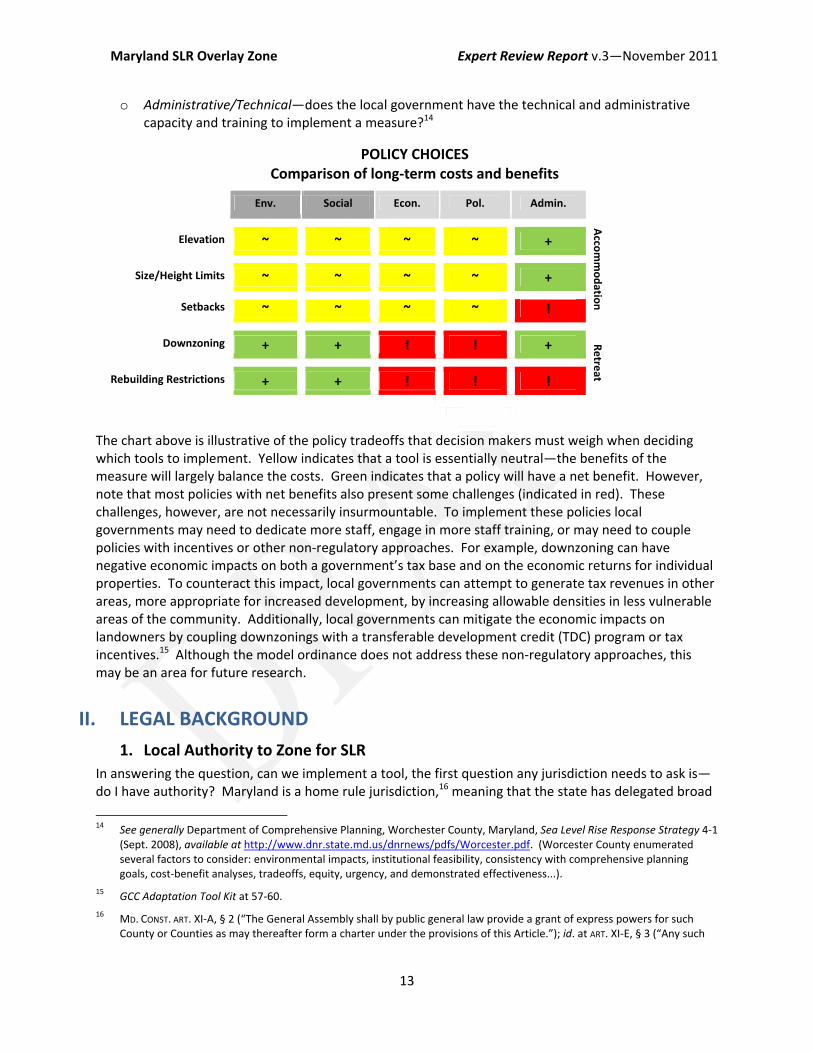
o Administrative/Technical—does the local government have the technical and administrative capacity and training to implement a measure?14
POLICY CHOICES Comparison of long‐term costs and benefits
Env. Social Econ. Pol. Admin.
Acco
mmodatio
n
Elevation ~ ~ ~ ~ +
Size/Height Limits ~ ~ ~ ~ +
Setbacks ~ ~ ~ ~ !
Downzoning + + ! ! + Retre
at Rebuilding Restrictions + + ! ! !
The chart above is illustrative of the policy tradeoffs that decision makers must weigh when deciding which tools to implement. Yellow indicates that a tool is essentially neutral—the benefits of the measure will largely balance the costs. Green indicates that a policy will have a net benefit. However, note that most policies with net benefits also present some challenges (indicated in red). These challenges, however, are not necessarily insurmountable. To implement these policies local governments may need to dedicate more staff, engage in more staff training, or may need to couple policies with incentives or other non‐regulatory approaches. For example, downzoning can have negative economic impacts on both a government’s tax base and on the economic returns for individual properties. To counteract this impact, local governments can attempt to generate tax revenues in other areas, more appropriate for increased development, by increasing allowable densities in less vulnerable areas of the community. Additionally, local governments can mitigate the economic impacts on landowners by coupling downzonings with a transferable development credit (TDC) program or tax incentives.15 Although the model ordinance does not address these non‐regulatory approaches, this may be an area for future research.
II. LEGAL BACKGROUND
1. Local Authority to Zone for SLR In answering the question, can we implement a tool, the first question any jurisdiction needs to ask is—do I have authority? Maryland is a home rule jurisdiction,16 meaning that the state has delegated broad
14 See generally Department of Comprehensive Planning, Worchester County, Maryland, Sea Level Rise Response Strategy 4‐1
(Sept. 2008), available at http://www.dnr.state.md.us/dnrnews/pdfs/Worcester.pdf. (Worcester County enumerated several factors to consider: environmental impacts, institutional feasibility, consistency with comprehensive planning goals, cost‐benefit analyses, tradeoffs, equity, urgency, and demonstrated effectiveness...).
15 GCC Adaptation Tool Kit at 57‐60.
16 MD. CONST. ART. XI‐A, § 2 (“The General Assembly shall by public general law provide a grant of express powers for such County or Counties as may thereafter form a charter under the provisions of this Article.”); id. at ART. XI‐E, § 3 (“Any such

Maryland SLR Overlay Zone Expert Review Report v.3—November 2011
14
powers to its local governments to regulate for the public health, safety and welfare.17 Maryland has created four types of local bodies (commissioner, code and charter counties, and municipal corporations).18 Although each has differing manners of formation and different governance rules, each type of locality is granted broad powers to regulate land use to protect the health, safety and welfare of the community.19
These broad delegations should be sufficient to allow all Maryland local governments to regulate land use to mitigate SLR impacts. SLR poses clear public health, safety, and welfare threats. Increased flooding will threaten lives, property, and natural resources. Flooding can also cause social and economic disruption. Regulating for these potential impacts is clearly related to protecting the public health, safety, and welfare of the community, and is thus within the authority of all Maryland local governments. Local authorities to implement specific tools are addressed in the legal considerations section for each tool (Section V, below).
2. Zoning Generally Zoning laws are the regulations that govern development in a community. Zoning laws can be broken into several integral components:
The zoning map designates areas in the community based upon use (e.g. residential, commercial, industrial, etc.). In floodplain districts, flood insurance rate maps also affect how lands may be developed.
The zoning ordinance specifies what uses will be permitted in each district and the specific development regulations that apply in each use district. This is called the community’s “base zoning”.
o Uses—the zoning map will designate the zoning for each area (e.g. R1 is single family residential). The zoning ordinance will specify what types of uses are permitted by right, what uses may require a special permit, and what uses will be prohibited in each zone (discussed below at Section IV(3)).
municipal corporation, now existing or hereafter created, shall have the power and authority, (a) to amend or repeal an existing charter or local laws relating to the incorporation, organization, government, or affairs of said municipal corporation heretofore enacted by the General Assembly of Maryland, and (b) to adopt a new charter, and to amend or repeal any charter adopted under the provisions of this Article.”); id. at ART. XI‐F, § 3 (“Except as otherwise provided in this Article, a code county may enact, amend, or repeal a public local law of that county, following the procedure in this Article.”). MARK M. VIANI, MARYLAND LOCAL GOVERNMENT LAW AND STRUCTURE ch. 1, at 1 (1999) (citing Neuenschwander v. Washington Suburban Sanitary Comm’n, 48 A.2d 593, 597 (Md. 1946) (In 1915, the state enacted a Home Rule Amendment granting broad powers to its local governments).
17 M.D. CONST., arts. XI‐A, XI‐E, XI‐F; see also NOLON, LAND USE 6‐7 (2006).
18 M.D. CONST., art. XI‐A, XI‐F; VIANI, MARYLAND LOCAL GOVERNMENT LAW AND STRUCTURE at ch. 1‐3 to 3‐9.
19 Charter counties are granted the broadest power—Article 25A allows charter counties to enact any zoning regulations so long as they are “for the protection and promotion of public safety, health, morals, and welfare.” MD. CODE ANN., ART. 25A, § 5(X) (West 2001). Similarly, pursuant to Article 66B, code and commissioner counties and municipal corporations may enact zoning ordinances designed to “[s]ecure the public safety;” “[p]romote health and general welfare;” [p]romote the conservation of natural resources;” and “[f]acilitate the adequate provision of transportation, water, sewerage, schools, recreation, parks and other public requirements.” MD. CODE ANN., ART. 66B, § 4.01(b)(1) (2009). Although Article 66B provides specific requirements for how code and commissioner counties may enact zoning ordinances, the Article is also written broadly, resulting in a delegation of authority that is almost coextensive to the delegation to charter counties.
Maryland SLR Overlay Zone Expert Review Report v.3—November 2011
15
o General development standards—the zoning ordinance will specify the development standards for each use district (e.g., required setbacks, size and height requirements).
o General administrative provisions—the zoning ordinance also includes general administrative provisions that govern the granting of development permits, address nonconforming structures and uses, articulate special permitting processes, including any site plan review requirements, and articulate procedures for granting a variance (discussed below at Section VI).
Overlay zones sit on top of the base‐zoning and provide supplementary regulations for areas within the community that have special characteristics (e.g., floodplains and historic areas). Special development standards apply in these districts (e.g., increased setbacks or elevation requirements). Maryland communities typically implement floodplain regulations and critical area regulations through separate, but overlapping, overlay zones. This means that developers in these areas must comply with three separate sets of regulations—the base zoning, the floodplain ordinance, and the critical areas ordinance.
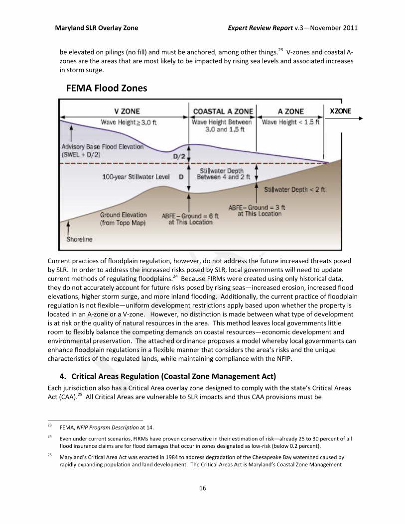
3. Floodplain Regulation (NFIP) Maryland requires local governments to impose special regulations on development in tidal and non‐tidal floodplains in order to comply with the National Flood Insurance Program (NFIP).20 Under the NFIP, the Federal Emergency Management Agency (FEMA) is charged with developing floodplain maps (called flood insurance rate maps or FIRMs). FIRMs govern where local governments must impose additional regulations, but are developed using only historical data. The FIRMs separate lands into zones based upon their historic risk of flooding: the 100‐year floodplain comprises areas with a 1 percent annual chance of flooding, and the 500‐year floodplain comprises areas with a 1 to 0.2 percent annual chance of flooding. The flood maps divide these portions of the floodplain into three zones (relevant to this study):
● X‐zones (shaded) are areas of low to moderate risk. X‐zones are either protected by levees or within the 500‐year floodplain. No additional regulations are required for development in these zones.
● A‐zones include both coastal and riverine areas subject to the 100‐year flood. A‐zones are sometimes divided into inland A‐zones and coastal A‐zones that may experience some wave action. In order to qualify for the NFIP, local governments must impose minimum floodplain regulations on development in A‐zones, such as floodproofing or building elevation requirements.21
● V‐zones include coastal floodplains that are subject to additional danger from wave action.22 Local governments must impose more restrictive regulations on development in V‐zones; structures must
20 The NFIP was established by the National Flood Insurance Act of 1968, 42 U.S.C. § 4001 et seq. (2006). Maryland
empowered its local governments to participate in the NFIP Maryland by enacting the Flood Hazard Management Act of 1976, MD. CODE ANN., ENVIR. §§ 5‐801 et seq. (1995). The Act requires local governments to develop flood management plans and implementing regulations for the 100‐year floodplain. Id. at § 5‐803(d)(1)‐(g)(1). The Maryland Department of Environment (MDE) has regulatory authority over non‐tidal wetlands, defined to include the 100‐year floodplain for non‐tidal waters. MD. CODE REGS. 26.17.04.01. Within the non‐tidal floodplain, MDE requires 1‐foot of freeboard. Id. at. 26.17.04.07. However, because authority to regulated tidal floodplains has been delegated to local governments, state agencies cannot impose a freeboard requirement in tidal floodplains without additional authority from the state legislature. Md. Comprehensive Strategy, ch. 5 at 13.
21 Federal Emergency Mgmt. Agency (FEMA), National Flood Insurance Program, Program Description 13‐14 (Aug. 2002) [hereinafter NFIP Program Description].
22 FEMA, NFIP Program Description at 7.
Maryland SLR Overlay Zone Expert Review Report v.3—November 2011
16
be elevated on pilings (no fill) and must be anchored, among other things.23 V‐zones and coastal A‐zones are the areas that are most likely to be impacted by rising sea levels and associated increases in storm surge.
Current practices of floodplain regulation, however, do not address the future increased threats posed by SLR. In order to address the increased risks posed by SLR, local governments will need to update current methods of regulating floodplains.24 Because FIRMs were created using only historical data, they do not accurately account for future risks posed by rising seas—increased erosion, increased flood elevations, higher storm surge, and more inland flooding. Additionally, the current practice of floodplain regulation is not flexible—uniform development restrictions apply based upon whether the property is located in an A‐zone or a V‐zone. However, no distinction is made between what type of development is at risk or the quality of natural resources in the area. This method leaves local governments little room to flexibly balance the competing demands on coastal resources—economic development and environmental preservation. The attached ordinance proposes a model whereby local governments can enhance floodplain regulations in a flexible manner that considers the area’s risks and the unique characteristics of the regulated lands, while maintaining compliance with the NFIP.
4. Critical Areas Regulation (Coastal Zone Management Act)
Each jurisdiction also has a Critical Area overlay zone designed to comply with the state’s Critical Areas Act (CAA).25 All Critical Areas are vulnerable to SLR impacts and thus CAA provisions must be
23 FEMA, NFIP Program Description at 14.
24 Even under current scenarios, FIRMs have proven conservative in their estimation of risk—already 25 to 30 percent of all flood insurance claims are for flood damages that occur in zones designated as low‐risk (below 0.2 percent).
25 Maryland’s Critical Area Act was enacted in 1984 to address degradation of the Chesapeake Bay watershed caused by rapidly expanding population and land development. The Critical Areas Act is Maryland’s Coastal Zone Management
FEMA Flood Zones
X ZONE
Maryland SLR Overlay Zone Expert Review Report v.3—November 2011
17
harmonized with SLR regulations. The Act’s goals are to minimize the negative impacts of new development on water quality and to conserve fish, wildlife and plant habitats. The CAA presents both opportunities and obstacles to local regulation. While the program is not specifically designed to address rising seas or flooding, it uses familiar tools and land‐use designations, which could guide local adaptation decisions. However, some measures of the Act (such as the grandfathering provisions) may hamstring local action.
The Act requires local governments to enact a local regulatory program within the Critical Area (areas within 1,000 feet of the mean high‐tide watermark) pursuant to state‐developed criteria.26 The Act uses two tools to limit the impacts of development on the Bay: a buffer requirement and development area designations. The Act requires that all new development retain a 100‐foot minimum buffer from the mean high water line.27 No structures or septic fields can be placed within the buffer.28 New permits will also require landowners to actively manage their buffers and submit a Buffer Management Plan. To limit and direct growth out of sensitive natural resource areas, local governments must also delineate three development areas within its Critical Area:
Intensely Developed Areas (IDA) include areas where there is extensive public and private development (four units per acre) and little natural habitat.29 In the IDA, development is allowed pursuant to the base‐zoning requirements, including allowance for residential, commercial, or industrial uses.30
Limited Development Areas (LDA) include areas with limited to moderate development intensities (between one unit per five acres and four units per acre), containing areas of plant and animal habitat, but not dominated by agriculture, wetland, forest or open space.31 In the LDA, additional low to moderate intensity uses that conform with existing uses may be allowed.
Resource Conservation Areas (RCA) include areas “characterized by nature‐dominated environments... and resource‐utilization activities (one unit per five acres or less).”32 The RCA has the strictest development regulations.33 Land in the RCA can only be used for limited residential development at one dwelling unit per 20 acres.34 New commercial, industrial and institutional facilities are prohibited.35
Program enacted to comply with the federal Coastal Zone Management Act. See MD. DEP’T OF NATURAL RES., CRITICAL AREA COMMISSION HOMEPAGE, http://www.dnr.state.md.us/criticalarea/index.asp (last visited Sept. 28 2011). .
26 MD. CODE ANN., NAT. RES. § 8‐1807.1801.
27 MD. CODE REGS. 27.01.09.01 §E(3) (2011).
28 MD. CODE ANN., NAT. RES. § 8‐1808(c)(1)(iii)(7).
29 Maryland Critical Areas Commission, Bay Smart A Citizen's Guide to Maryland's Critical Area Program at 29, available at http://www.dnr.state.md.us/criticalarea/BaySmartGuide.asp (last visited Sep. 29, 2011) [hereinafter Bay Smart Guide].
30 MD. CODE REGS. 27.01.02.03 (2011).
31 Bay Smart Guide at 32.
32 MD. CODE REGS. 27.01.02.05 §A (2011).
33 New development and redevelopment must conserve “the overall ecological values of the Critical Area, its biological productivity, and its diversity[.]” MD. CODE REGS. 27.01.02.05 §B(1) (2011).
34 MD. CODE REGS. 27.01.02.05 §C(4) (2011).
35 MD. CODE REGS. 27.01.02.05 §C(5) (2011).

Maryland SLR Overlay Zone Expert Review Report v.3—November 2011
18
These designations present an opportunity for adaptation—local governments can use these designations to inform how they draw the boundaries for each SLR subdistrict (see discussion below, at Section IV(2)(a)). By making these designations, local governments and the Critical Areas Commission have already determined the state of existing development and natural resource values in certain areas. Local governments can use these determinations to help them establish adaption goals for areas within their community.
Second, the Critical Areas buffer creates a setback that is not only useful to protect water quality and habitat (a specified purpose for creation of the buffer under the statute), but also to increase natural flood protections for upland development (not a specified purpose). In designing and approving Buffer Management Plans, the Commission and local governments should consider the resilience of the buffer design and buffer vegetation to inundation and flooding. Additionally, where lot sizes permit, local governments should consider requiring increased setbacks beyond the 100‐foot buffer. The buffer employs a “rolling” boundary (the mean high tide line). Therefore, the boundary of the buffer will move inland with corresponding sea‐level rise. For low‐lying areas without gradation, the buffer may become inundated overtime, which will limit its utility for habitat, water filtration, and flood protection. By employing increased setbacks, local governments can reserve room for the buffer to migrate inland as seas rise, and preserve its useful functions for a longer period of time. Additionally, local governments can avoid enforcement problems that may arise as the buffer erodes and structures come to encroach on the buffer area.
However, local governments must also be aware of some potential conflicts that may arise between SLR regulations and the Critical Area Act. First, grandfathering provisions of the CAA may preempt local attempts to downzone in Critical Areas or prohibit rebuilding.36 Although the provision seems intended to protect pre‐CAA uses37 from density limits imposed in the RCA, the grandfathering provisions are written broadly enough that they could be read to prohibit any downzoning or rebuilding restrictions (see discussion below at section V(4)). Additionally, the CAA allows for growth representing up to five percent of its Resource Conservation Area lands at the time of local program approval.38 Jurisdictions can use a portion of their growth allocation to switch an RCA to an LDA/IDA, or LDA to IDA.39 Although local governments are directed to consider flood risks as a factor in determining growth allocations, local communities may want to assess whether they are allocating growth to areas that may be vulnerable to future SLR impacts.
The state may also want to consider amending the Critical Areas Act to explicitly require consideration of SLR and flooding. One of the purposes of the statute is to harmonize growth with environmental preservation. Both development and natural resources are equally threatened by SLR and increased flooding and erosion. To ensure a coordinated approach and to give local regulators the flexibility needed to balance development with preservation, the state should allow local governments to
36 Section 27.01.02.07 of the regulations state: “After program approval, local jurisdictions shall permit the continuation, but
not necessarily the intensification or expansion, of any use in existing on the date of program approval, unless the use has been abandoned for more than 1 year or is otherwise restricted by existing local ordinances.” This exception applies not only to individual nonconforming uses recorded by Dec. 1, 1985, but also to subdivisions that received local approval prior to June 1, 1984. MD. CODE REGS. 27.01.02.07 (2011)(emphasis added).
37 Uses existing at the time the program was adopted in 1985.
38 MD. CODE ANN., NAT. RES. § 8‐1808.1(b).
39 MD. CODE ANN., NAT. RES. § 8‐1808.1(c).
Maryland SLR Overlay Zone Expert Review Report v.3—November 2011
19
consider, as part of its Critical Area Program, how SLR will exacerbate the impacts of coastal development on Bay ecosystems and water quality.
5. Living Shorelines Protection Act The newly enacted Maryland Living Shorelines Protection Act removes local control over shoreline armoring.40 The Act delegates authority to the Maryland Department of the Environment (MDE) to issue permits for coastal protection. Although armoring decisions will no longer be made at a local‐level, the Act will affect armoring in two important ways: (1) The Act establishes a preference for soft – or living – shoreline protection41 over hard armoring; property owners will have to show that living shorelines are infeasible on their property on a case‐ by‐case basis; 42 and (2) Properties within areas mapped by MDE as “infeasible for living shorelines,” will be able to pursue a streamline permitting process to erect hard armoring.43
Because the MDE mapping process will greatly affect armoring decisions along the shore, MDE may want to consider coordinating with local governments in this process. While the Act does not require MDE to consult with local governments regarding its mapping decisions, local knowledge of flooding and development patterns could be valuable input in determining the feasibility of armoring. The MDE streamlined process will also largely determine what portions of the Maryland shoreline may be armored. Both public and private landowners in those areas will have an added degree of certainty that they will be able to use hard armoring to protect their development and their investments. Landowners in other areas will have to demonstrate the infeasibility of using living shorelines on a site‐specific level. These decisions will have important local consequences—they may affect the development values of coastal lands and the local government’s ability to protect its own infrastructure.
Additionally, local governments may also want to weigh in on how MDE permits coastal armoring projects. State decisions regarding armoring will affect upland development permitted by local entities.
40 MD. CODE ANN. ENVIR. § 16‐201.
41 Soft armoring uses non‐structural approaches to erosion control such as marsh creation. MD. CODE ANN. ENVIR. § 16‐201(c)(1)MD LEGIS 304 (2008), Article 16‐201(c)(1). The draft regulations define living shorelines as “a suite of stabilization and erosion control measures that preserve the natural shoreline and are designed to minimize shoreline erosion, maintain coastal processes, and provide aquatic habitat. Measures must include marsh plantings and may include the use of sills, sand containment structures, breakwaters or other natural components.” Maryland Department of the Environment, Proposed Living Shoreline Regulations (2010) at § B(33). Hard armoring typically uses bulkheads or rip‐rap. See MD. CODE ANN. ENVIR. § 16‐201, preamble.
42 MD. CODE ANN. ENVIR. § 16‐201(c)(2)(ii). The MDE uses the following criteria in evaluating an applicant’s request for a waiver: “(a) Presence of a waterway width inadequate to support a nonstructural shoreline stabilization measure; (b) Lack of suitable bottom elevation and slope at mean low water for sustaining a nonstructural shoreline stabilization measure; (c) Lack of suitable bottom substrate to support a nonstructural shoreline stabilization measure; (d) Expansive fetch; (e) Bank elevation and orientation that would prevent grading and successful establishment of vegetation; (f) Areas of excessive erosion; (g) Areas subject to heavy tides; (h) Other physical constraints that would impede or prevent successful establishment of a nonstructural shoreline stabilization measure; or (i) Other environmental factors including plant, fish and wildlife habitat or riparian Buffers that would be adversely affected by the proposed nonstructural shoreline stabilization practice and would be protected by a structural practice.” Md. Dep’t of the Env’t, Proposed Living Shoreline Regulations at §§ F(4)‐F(4)(i) (2010).
43 HOUSE BILL 973‐1978, codified in MD. CODE ANN. ENVIR. § 16‐201(c)(1)(i). See also Md. Dep’t of the Env’t, Proposed Living
Shoreline Regulations at § E(1). Areas that are subject to excessive erosion (greater than two feet per year), are subjected to heavy tides or are too narrow for such techniques to be implemented without impacting navigation are generally deemed not feasible for living shorelines. Living Shorelines Summit, Conference Proceedings, Preface, available at www.vims.edu/cbnerr/_docs/ctp_docs/ls.../06_LS_sponsor_steer.pdf.
Maryland SLR Overlay Zone Expert Review Report v.3—November 2011
20
In their jurisdictions, local governments may want to see armoring designed to a higher standard (currently most armoring need only be designed to a 100‐year standard), or be designed to withstand a specific degree of SLR. Local governments may also want to weigh in on mitigation requirements for armoring projects. Therefore, MDE may want to develop mechanisms to coordinate with local governments on implementation of the Act’s requirements.
6. Americans with Disabilities Act (ADA)
The Americans with Disabilities Act’s (ADA)44 accessibility requirements could conflict with some of resiliency measures proposed in the model ordinance, specifically building elevation requirements. Various provisions within the ADA require that structures reduce “architectural barriers” to disabled persons. Facilities that are open to the public must be physically accessible to disabled persons to “the maximum extent feasible.” ADA rules apply to be both new construction and alterations to existing facilities; generally alterations to existing facilities cannot make the building less accessible.45
While the regulations do not apply to private residential development, three types of structures in the floodplain district will have to consider ADA accessibility rules when complying with new SLR regulation: commercial facilities open to the public (so called “public accommodations”), government facilities, and health care providers.46 If new SLR regulations require these types of facilities to be elevated, the ADA could require that elevators or ramps be installed to ensure access for disabled persons, unless the structures qualify for an exemption.47
Several ADA exemptions may limit the conflict between building elevation requirements and the ADA’s provisions on accessibility. First, new construction need not meet accessibility standards where it would be “structurally impracticable.”48 This exemption applies only where unique characteristics of the property’s terrain make accessibility unusually difficult; as an example the regulations refer to a building that must be built on stilts because of its location in marshlands or over water.49 A property’s unique susceptibility to flooding may qualify structures for this exemption. Second, altered structures need not meet accessibility standards where the cost of altering the “path of travel” to the structure “is
44 42 U.S.C. §§12101‐12213. et seq. (2009)..
45 42 U.S.C. § 12183(a)(1)‐(2). The regulations provide that newly constructed buildings must be equipped with at least one accessible route to the facility.
46 Title II of the ADA prohibits all public entities (departments, agencies, special purpose districts or other instrumentalities of any state of local government) from discriminating against persons with disabilities. 42 U.S.C. § 12131. Title III of the ADA extends the prohibition expressed in Title II to private entities that operate places of public accommodation. 42 U.S.C. § 12182(a). The ADA defines a “public accommodation” as an entity whose operations affect commerce, and that falls within at least one of the listed categories. 42 U.S.C. § 12181(7). The regulation’s definition of “place of public accommodation” includes the same list. 28 C.F.R. § 36.104. Although the regulations within each title are not identical, they are very similar.
47 Costs to install an elevator range from $15,000 to $35,000. MSA Elevator, http://www.marshallsamuels.com/faqs.asp (last visited Sept. 23, 2011). Installation for wheelchair lifts cost anywhere from $4,000.00 to $13,000. Electric Wheelchairs 101, http://www.electric‐wheelchairs‐101.com/Home‐and‐Commercial‐Lifts.htm (last visited Sept. 23, 2011). Installation of ramps are much more economical, however, the ADA has very specific guidelines governing allowable incline. See 28 C.F.R. § 36, App. A; see also FEMA, Elevator Installation for Buildings located in Special Flood Hazard Areas in accordance with the National Flood Insurance program, Technical Bulletin 4 (Nov. 2010)
48 See 28 C.F.R. § 36.401(c).
49 28 C.F.R. § 36.401(c).
Maryland SLR Overlay Zone Expert Review Report v.3—November 2011
21
disproportionate to the cost of the overall alteration.”50 However, even when the costs are disproportionate, the landowner must still make reasonable efforts to provide accessibility to the extent that can be accomplished without incurring disproportionate costs. Third, small public accommodations (less than 3 stories or less than 3,000 square feet per story) are exempt from the requirement to install elevators; government facilities, shopping centers and professional health care facilities, however, do not qualify for this exemption. 51
It will be important for local governments and planning agencies to consider how new SLR regulations will affect accessibility. Entities that fail to meet ADA accessibility requirements can be liable under the Act.52 Local governments should consider the financial burdens that certain businesses (specifically small businesses, government agencies, and healthcare providers) may experience when trying to comply with both elevation and accessibility requirements. Although some small businesses may qualify for an exemption, many government agencies, healthcare providers and shopping centers will not. Therefore, policymakers may want to consider other alternatives, such as floodproofing options or possibly even relocation.
7. Historic Preservation Requirements
Historic preservation requirements may also limit the adaptation options for communities with many historic structures. Historic preservation is primarily administered at a local level in Maryland. Although there are state and federal laws that encourage historic preservation, no state or federal laws limit the alteration or demolition of private property.53 In Maryland, local governments may appoint a Historic Preservation Commission,54 and they may establish regulations to designate, review, and approve changes to historic properties through creation of a Historic Area Overlay Zone.55
SLR regulations that would require landowners to make “publicly visible exterior changes” to historic structures (such as elevation requirements) would require approval from the Historic Preservation
50 Alterations will be deemed disproportionate when the cost to provide an accessible route to the altered area is greater
than 20% of the cost of the alteration to the primary function area . 28 C.F.R. § 36.403(a).
51 Under Title III, private entities are not required to install elevators when constructing or altering buildings that have fewer than three stories or less than 3,000 square feet per floor. This exemption does not apply to public entities under Title II, however, if the facility is a professional office of a health care provider, a shopping center or a shopping mall. In addition, the Attorney General may determine that a particular category of facilities requires the installation of elevators based on the usage of the facilities. 42 U.S.C. § 12183(b). The elevator exemption also does not apply to a terminal, depot, or other station used for specified public transportation or to an airport passenger terminal. 28 C.F.R. §36.404(a).
52 See 42 U.S.C.A. § 12188.
53 The National Historic Preservation Act (NHPA) was enacted to preserve the “historical and cultural foundations of the Nation... as a living part of our community life and development in order to give a sense of orientation to the American people.” 16 U.S.C. § 470(b)(2). The Act delegates authority to the Department of the Interior to oversee the National Register of Historic Places, National Historic Landmarks programs. 16 U.S.C. § 470a(a). Under the statute, state programs must maintain an appointed State Historic Preservation Officer and review board and State Historic Preservation programs. MD. CODE ANN., STATE FIN. & PROC. § 5a‐309‐21. Property owners may only face legal challenges if they use State or Federal funds, permits, or other assistance as part of their project, or have received state or federal rehabilitation tax credits in the past five years. See 16 U.S.C. § 470f; MD. DEP’T OF PLANNING, MARYLAND HISTORIC TRUST, http://mht.maryland.gov/preserveMaryland.html (last visited Sept. 21, 2011).
54 Historic zoning ordinances for Maryland's non‐charter jurisdictions follow Article 66B, §§8.01 – 8.17. Charter Counties (e.g. Baltimore County, Harford County) follow Article 25A §5(BB), and Montgomery and Prince George’s Counties fall under Article 28 §8‐101.
55 MD.CODE ANN. art. 66B, § 8.01(b)(2).
Maryland SLR Overlay Zone Expert Review Report v.3—November 2011
22
Commission.56 The Commission may deny an application based on a list of subjective factors regarding the structures relationship to the surrounding area, its architectural significance, the alteration’s compatibility with the surrounding area, and other aesthetic factors.57
Historic preservation requirements could limit both elevation requirements and rebuilding restrictions. First, while retrofitting historic structures is not explicitly prohibited by the historic overlay, specific retrofitting measures would be subject to Commission review based on the criteria above. It is unclear how the Commission applies these criteria when considering retrofits to structures vulnerable to flooding, or if it has ever considered this issue.58 It is unclear what additional expense would be incurred by landowners to retrofit structures in a manner compliant with historic preservation requirements. Second, rebuilding restrictions in historic districts are likely infeasible because such a policy would conflict with historic preservation goals to preserve cultural resources.
Local governments need to consider how SLR regulations will integrate with historic preservation regulations. Maryland local governments can consider the model of communities devastated by Hurricane Katrina. After Katrina, Gulf states were forced to deal with tremendous destruction to their historic properties and districts. Mississippi created elevation design guidelines and a permitting program for their historic districts, in conjunction with a homeowner grant program. The program provides incentives for elevation and relocation of historic properties; and instructions for homeowners regarding local appropriateness and elevation plan reviews, as well as variance and permitting procedures.59
8. Constitutional Issues Local governments must also ensure that new SLR regulations are compliant with state and federal constitutional requirements: 5th Amendment takings and substantive due process requirements.
a. The Takings Clause The primary concern of most local governments is that new regulations will be challenged as a regulatory taking. This section provides background on Maryland’s takings law generally. However, many of the issues raised by SLR regulations are novel and have not yet been specifically addressed by any court.
56 MD.Ann. CODE ANN. art. 66B, § 8.05, See generally Faulkner v. Town of Chestertown, 290 Md. 214, 221 (1981) (holding that
building located within a town’s historic district were subject to historic commission jurisdiction notwithstanding lack of architectural or historic significance of the individual property). In Annapolis, historic structures cannot be altered, reconstructed, rehabilitated, moved or demolished a without a Certificate of Approval from the Commission.
57 City of Annapolis, Md. Code of Ordinances, ch. 21.56, § 060(A) (2010).
58 Retrofit measures may be even more difficult to implement for structures of “unusual importance.” Where the Commission finds that a structure is of “unusual importance to the City, State or Nation” it must reject an application, unless it finds that the project will not “materially impair the historic, cultural, archaeological or architectural significance of the landmark.” And, in order to approve the project despite impacts, the Commission must make a finding that: (1) is a deterrent to a major improvement program, (2) would cause “undue financial hardship” to the owner, or (3) its continued existence went against the best interest of the community. MD. Ann. CODE ANN. art. 66B, § 8.10.
59 MISSISSIPPI HERITAGE TRUST, HURRICANE KATRINA: IMPACT ON MISSISSIPPI'S HISTORIC STRUCTURES, available at http://www.mississippiheritage.com/HurricaneKatrina.html (last visited Sept. 23,2011); MISSISSIPPI DEVELOPMENT AUTHORITY, Grant Application Guide, http://www.msdisasterrecovery.com/documents/historic_prop_grant_app.pdf (last visited Sept. 23, 2011).
Maryland SLR Overlay Zone Expert Review Report v.3—November 2011
23
Both the United States and Maryland Constitutions prohibit government regulatory actions that “take” private property without just compensation;60 a regulation can constitute an unconstitutional taking when the regulation “goes too far.”61 The Supreme Court has not developed a clear test for determining when a regulation “goes too far,” and instead applies two relevant62 tests:
Total takings—where a regulation deprives a property owner of “all economically beneficial use” it is a takings per se and the government must pay the landowner just compensation—the regulation must essentially render the property valueless.63
o Nuisance exception—there is one important exception to the total taking rule: a regulation that deprives all economic use will not be a taking where the limitation on use “inheres in the title itself in the background principles of property and common law.”64 This has been interpreted to include land‐use regulations that prohibit nuisances or serious public harms.65
60 U.S. CONST. AMEND. V (The 5th Amendment prohibits that “private property be taken for public use, without just
compensation.”). The 5th Amendment’s “takings clause” has been incorporated into the 14th Amendment’s “due process clause” and applied to the States. Chicago, B. & Q.R. Co. v. City of Chicago, 166 U.S. 226, 236 (1897). Maryland law tracks almost directly with U.S. Supreme Court decisions. Neifert v. Dep’t of the Env’t, 910 A.2d 1100, 1119 n.33 (Md. 2007) (Maryland courts view the decisions of the U.S. Supreme Court as “practically direct authorities" for both the state and federal provisions.) (quoting Bureau of Mines v. George's Creek, 321 A.2d 748, 755 (1974)).
61 E.g., Lucas v. South Carolina Coastal Council, 505 U.S. 1003, 1045 (1992).
62 To complicate matters more, the Supreme Court recognizes two other takings tests. The Supreme also applies a per se test for permanent physical invasions. Where a regulation imposes an obligation that invades the landowner’s “exclusive right of possession” it is a taking per se and the government must pay for the right regardless of how minimal the economic impact on the landowner. In the seminal case, Loretto v. Teleprompter Manhattan CATV Corp. (1982), the Supreme Court held that a New York law requiring landowners to allow a television company to install cable equipment on their property was a per se taking even though the physical invasion of the landowner’s property was minimal. Loretto v. Teleprompter Manhattan CATV Corp., 458 U.S. 419, 421 (1982).
The Supreme Court applies a third distinct test in the case of regulatory exactions. Where a government requires a landowner to dedicate an interest in real property as a condition for a development permit (what is called an “exaction”), the court applies a third test requiring: (i) an “essential nexus” between the purpose for the exaction and the impact that the exaction seeks to mitigate, (Nollan v. California Coastal Commission, 483 U.S. 825, 837 (1992)), and (ii) a “rough proportionality” between the exaction and the impact of the proposed development, (Dolan v. City of Tigard, 512 U.S. 374, 391 (1992)). The Court has subsequently limited the application of this test to the exaction context. Lingle v. Chevron U.S.A., Inc. 544 U.S.528, 538‐539 (2005).
63 In the seminal case Lucas v. South Carolina Coastal Council, the Supreme Court found that application of the setback provisions of the state’s Beachfront Management Act was a taking per se because the provisions prohibited the landowner from building any permanent, habitable structures on his two oceanfront lots, essentially rendering the land valueless. Lucas v. South Carolina Coastal Council, 505 U.S. 1003, 1007, 1019 (1992). Maryland courts apply a similar analysis; in Steel v. Cape Corp., a developer sued Anne Arundel County when his property was downzoned to only allow open space use. The County denied the developer’s request for a rezoning on the grounds that the area lacked adequate school facilities. The court found that the law constituted a regulatory taking because the Open Space classification left the company with “no reasonable use” of the undeveloped land. Steel, 677 A.2d at 651.
64 Lucas, 505 U.S. at 1027.
65 See Lucas, 505 U.S. at 1028‐1029; see also Erb v. Maryland, 676 A.2d 1016, 1027 (Md. Ct. Spec. App. 1996). In Erb, for example, the court found that Maryland Department of the Environment’s denial of a septic system permit, making the land virtually undevelopable, did not amount to a per se taking. The Maryland Court of Appeals found that the operation of an on‐site septic system on the property owner’s land would most likely have contributed to the contamination of drinking wells and posed a threat to public health, constituting a nuisance. Erb, 676 A.2d at 1027 (Md. Ct. Spec. App. 1996).

Maryland SLR Overlay Zone Expert Review Report v.3—November 2011
24
Many have argued that the nuisance exceptions would also apply to regulations designed protect public trust lands.66
Penn Central balancing—more commonly, where there is no per se taking, the court applies a three‐factor ad‐hoc balancing test weighing (i) the economic impact of the regulation, (ii) the character of the government action, and (iii) the “reasonable investment‐backed expectations” of the landowner.67 Maryland courts have uniformly upheld regulations restricting future development of undeveloped land under a balancing analysis. Even regulations that severely limit a landowner’s economic return have survived constitutional challenge. Maryland courts have upheld regulations where landowners were left with some economically viable use, and the government demonstrated a clear threat to the public health, safety and welfare.68
The important thing to note about takings law is that courts do not like regulations that cause abrupt changes to property rights and property values. Laws that provide sufficient notice of changes and that allow property owners to adjust their investment decisions based upon new regulatory restrictions have a much higher chance of overcoming a constitutional challenge. Reactive ad‐hoc responses to impacts are more likely to violate constitutional protections, thus driving the need for local governments to enact new regulations well in advance of impacts.
b. Substantive Due Process In enacting new SLR regulations, local governments will also have to ensure compliance with substantive due process requirements, which requires that regulations be “rationally related to a legitimate public interest.”69 Courts are typically deferential to local governments’ policy decisions and only prohibit irrational decision making. In order to justify regulations and insulate them from legal challenges, local governments will need to ensure that zoning amendments explicitly state the rationales for regulating (i.e., the public safety, health and welfare purposes served by enacting regulations to address future impacts from SLR).
Local regulation for SLR impacts in established flood zones would likely survive a substantive due process challenge. The model ordinance uses existing flood zone boundaries depicted on FEMA flood maps to determine where to impose additional regulations. These areas have historic risk of flooding as documented in FEMA Flood Insurance Studies used to develop flood maps. Additionally, Maryland courts have said that local governments may consider the needs of the” reasonably foreseeable
66 See generally, James Titus, Rising Seas, Coastal Erosion, and the Takings Clause: How to Save Wetlands and Beaches
Without Hurting Property Owners, 57 MD. L. REV. 1279, 1361‐1382 (1998).
67 Penn Central Transportation Co. v. New York City, 438 U.S. 104, 124 (1978).
68 See e.g., Security Mgmt. Corp. v. Baltimore County, 655 A.2d 1326, 1329 (Md. Ct. Spec. App. 1995) (Applying a Penn Central inquiry, the Maryland Court of Special Appeals rejected a takings claim based upon a county’s refusal to rezone a developer’s 200‐acre parcel from RC‐4 (permitting 0.2 dwelling units per acre) to RC‐16 (permitting 16 dwelling units per acre) because the restrictive regulation permitted some productive use of the land.)
69 This standard derives from judicial interpretations of state and federal constitutional clauses that prohibit governments from “depriv[ing] anyone of life, liberty, or property without due process of law.” U.S. CONST. amend XIV, § 1; see also Beverly Bank v. Illinois Dep’t of Transp., 579 N.E.2d 815, 821 (Ill. 1991). The test, as originally articulated by the Supreme Court of the United States, requires that ordinances must have “substantial relation to public health, safety, morals or general welfare.” Village of Euclid v. Ambler Realty, Co., 272 U.S. at 395 (1926). Although the precise test may vary in name, the basic substance of a court’s analysis is essentially the same across jurisdictions. See generally Ziegler, RATHKOPF'S THE LAW OF ZONING AND PLANNING § 3:17 (4th ed. 2010).
Maryland SLR Overlay Zone Expert Review Report v.3—November 2011
25
future.”70 The test articulated by the court seems to permit consideration of future conditions so long as they are sufficiently documented. SLR will clearly increase risks in flood‐prone areas, thus justifying increased regulations in FEMA mapped flood zones.
However, local governments may have more difficulty in enacting regulations based solely upon projected SLR. Although courts review local regulatory decisions with deference, local land‐use regulations are often subject to legal challenge by affected landowners. And while the state and some local governments have documented the threat of SLR through mapping and vulnerability assessments, these maps may not be sufficiently rigorous to justify regulatory restrictions on lands that have no historically documented risk of flooding. Were local governments to use SLR maps to impose regulations in areas not currently mapped in FIRMs, they may be sued and could be required to prove the scientific veracity of the projections of SLR and the mapping techniques used to create the maps.
III. TEST JURSDICTIONS The two test jurisdictions each face unique adaptation challenges. Although Anne Arundel County has large areas of low‐lying highly vulnerable coast, it is not very densely populated—most of its coastal communities comprise low‐ to medium‐ density residential and maritime uses. Most of its higher intensity use districts are concentrated in upland areas of the County. However, the County has large regions with sensitive natural resources and habitat. Therefore, the County may want to focus on two strategies: (1) ensuring that new development and redevelopment is more resilient to impacts and (2) preserving natural resources through implementation of retreat policies (where feasible).
By contrast, the City of Annapolis is a relatively densely developed, with little room for expansion. The City’s waterfront houses a host of historic structures, and dense commercial and residential development. Vulnerable parts of the City include the U.S. Naval Academy, and the historic downtown, which is designated as a National Historic Landmark. The City also has extensive maritime development, including yacht clubs and private and commercial moorings.71 Because of physical constraints, Annapolis will require a different adaptation approach. Retreat options may be difficult if not impossible to implement. Additionally, retrofit options, such as building elevation requirements and setbacks, may be infeasible for existing structures on smaller lots and historic structures. Therefore, the City may want to focus on other adaptation strategies, such as (1) protection measures (to do so, City Planning staff may want to coordinate with MDE on implementation of the Living Shorelines Act), and (2) increasing regulations for new development and redevelopment in vulnerable areas. Additionally, the City may want to consider budgeting for and potentially requiring mitigation fees for development in vulnerable areas to pay for the costs of future armoring and to mitigate the impacts of armoring.
For a detailed discussion of each test jurisdiction and an analysis of how each jurisdiction can integrate adaptive measures into their zoning ordinance see Appendix B.
70 In Jacobs v. County Board of Appeals for Baltimore County, the court stated “it is universally recognized, in those
jurisdictions where zoning has been established, that zoning is not static, and the zoning authorities, either in adopting a comprehensive zoning plan or in granting a reclassification, may take into consideration needs of the reasonably foreseeable future.” 198 A.2d 900, 902 (Md.1964). Jacobs, 198 A.2d 900, 902 (Md. 1964).
71 City of Annapolis, Md., Annapolis Comprehensive Plan 15 (Oct. 2009), available at http://www.annapolis.gov/Government/Departments/PlZon/CompPlan/FrontPages_ExecSummary.pdf
Maryland SLR Overlay Zone Expert Review Report v.3—November 2011
26
IV. DESIGN OF SLR SUBDISTRICTS This section describes the general design considerations that Maryland local governments will need to assess when amending their ordinance, including: how to justify new regulations, where to apply regulations and how to draw the boundaries for each SLR subdistrict, and what uses to allow in each subdistrict.
1. Purposes and Findings For each subdistrict, local governments will need to make specific findings justifying enactment of the policies employed in that district. As discussed above, substantive due process requirements prohibit regulations that are arbitrary and unreasonable. Findings explain the public purposes served by the statute and anticipate legal challenges. In the event a law is challenged, the court will look to the statute’s findings to evaluate the reasonableness of the law and to determine whether the law is consistent with constitutional protections
In Section 1.2 of the model ordinance (Appendix A) we provide example findings that could be used to justify new regulations based upon threats from SLR. The model findings describe the risks posed by SLR, the inadequacies of the existing floodplain maps, and the risks posed by erosion justifying erosion‐based setbacks.
2. Applicability and Boundaries This model does not provide language to establish the boundaries for the different SLR subdistricts. Drawing boundaries will require local governments to weigh different policy considerations: the community’s adaption goals for particular areas, their perception and sensitivity to risk, and how precautionary they want to be in regulating. Instead of delineating each subdistrict, we provide criteria by which policymakers can use to determine where they want to set the regulatory boundaries.
Overlay zoning is useful for this purpose because it provides policymakers with flexibility to determine where to apply new regulations. Overlay zones can adhere to existing zoning boundaries or cut across zones.72 Thus, the subdistricts could either follow the contours of existing floodplain districts or could delineate new boundaries to account for future SLR and other impacts of global climate change.
This model proposes that local governments use the existing FIRM zones (V‐zones, A‐zones, and X‐zones (shaded)) to determine the boundaries for each subdistrict. Although the current boundaries may not completely reflect future risk, in the short‐term, it is unlikely that the state or individual local governments will be able to develop and adopt sufficiently rigorous SLR maps to use for regulatory purposes.
a. Use Existing FIRM Boundaries
Using existing boundaries will allow local governments to ensure that they maintain compliance with NFIP requirements. First, the model ordinance leaves in place each jurisdiction’s existing floodplain district and leaves the minimum floodplain regulations as general development standards for all development in the floodplain district. The model provides additional protection by extending the
72 Ctr. for Land Use Ed., Coll. of Nat. Res. at the Univ. of Wis. Stevens Point, Planning Implementation Tools – Overlay Zones
at 1 (Nov. 2005), available at ftp://ftp.wi.gov/DOA/public/comprehensiveplans/ImplementationToolkit/Documents/OverlayZoning.pdf (last visited Feb. 25, 2011).
Maryland SLR Overlay Zone Expert Review Report v.3—November 2011
27
boundaries of the “floodplain district” to include the 500‐year floodplain (X‐zones (shaded)). This will require that new development and redevelopment of “substantially improved”73 structures in the 500‐year floodplain be built (or retrofit) to comply with the general floodplain district requirements, such as requirements that structures be elevated or floodproofed (requirements that are only currently required in the 100‐year floodplain). This will ensure some additional measure of protection for structures that are at current risk of impacts and that will be subject to increased risks in the near‐term as SLR drives flooding further inland.
Second, the model ordinance extends general floodplain regulations for development in V‐zones to coastal A‐zones. Observations from previous storms have shown that structures located in the coastal A‐zone, inland of the V‐zone, experience significant damage from storm surge from moderate wave
heights of 1.5 to 3 feet.74 Therefore, FEMA recommends that communities extend V‐zone regulations to these areas.75
Third, the model ordinance creates two subdistricts where special development standards apply, based upon the area’s special characteristics. In drawing the boundaries for each subdistrict, we recommend that local governments consider the following factors to determine the appropriateness of the different regulatory techniques that will be applied in each area: existing floodplain designations (V‐zones, coastal A‐zones, and inland A‐zones); existing critical areas designations (IDAs, LDAs, and RCAs); the extent and type of existing development (critical facilities, residential, commercial); the quality of natural resources in the area and the value of the ecological services provided; the area’s vulnerability to impacts (based upon SLR maps, SLOSH maps,76 erosion maps, flood insurance data of repetitive loss structures); and both the extent of existing armoring and the feasibility and likelihood of future armoring.
When drawing boundaries for the FCD consider coastal A‐zones and V‐zones that are most at risk to storm surges and permanent inundation; low‐lying areas that are likely to be inundated and thus inappropriate for accommodation approaches; areas designated as RCAs under the Critical Areas Act;77 areas with limited armoring and that are unlikely to be armored in the future due to regulatory, geological or economic constraints; areas at historic risk of impacts given insurance claims data on repetitive loss structures; and areas that may be highly vulnerable to impacts and therefore inappropriate for continued development. Local governments should also consider excluding areas with historic structures, or exempting historic structures from rebuilding restrictions.
73 “Substantially improved” includes both improvement and repair of damage where the cost to improve exceeds 50 percent
of the structure’s market value. See e.g. Anne Arundel County, Md., Code, art. 16, § 1‐101 (90) (2005).
74 FEMA defines coastal A‐zones as areas of the SFHAs seaward of the limit of moderate wave action (“LiMWA”). FEMA, Homeowner’s Guide to Retrofitting: Six Ways to Protect Your Home from Flooding at 3‐1; 3.2.4 (2d ed. Dec. 2009), available at http://www.fema.gov/library/viewRecord.do?id=1420 [hereinafter Homeowner’s Guide to Retrofitting].
75 FEMA, Homeowner’s Guide to Retrofitting, at 3.2.4.
76 SLOSH refers to NOAA’s Sea Lake and Overland Surges from Hurricane model. “SLOSH is a numerical storm surge model that uses a series of hypothetical hurricanes of varying intensity, direction, and forward speed, based upon historical record to run thousands of simulations.” Teresa L. Martin, report prepared for Anne Arundel County, Office of Emergency Management, Tropical Cyclone Isabel, Anne Arundel County, MD at 23 (2008), available at http://www.aacounty.org/OEM/resources/TropicalCycloneIsabel_PublicVersionFinal.pdf.
77 The Critical Areas Commission and local governments have already determined that these areas contain sensitive natural resources and have limited existing development and are therefore appropriate for conservation.

Maryland SLR Overlay Zone Expert Review Report v.3—November 2011
28
When drawing boundaries for the FAD consider coastal A‐zones with low to moderate existing development and inland A‐zones with moderate to intense existing development; areas with few critical facilities; areas that will be vulnerable to increased flooding but that could be sufficiently protected with resilient design techniques or soft‐armoring; areas designated as LDAs under the CAA;78 areas that may be less vulnerable to impacts and appropriate for continued or expanded development; and areas that may be inappropriate for hard‐coastal armoring.
We recommend that local governments use this approach in the near to short‐term because it will be easier to administer and will not require expensive mapping or expose governments to additional risk of being sued. Local governments are already familiar with these designations and have maps on hand that they can apply now. 79 As the state develops SLR maps adequate for regulatory purposes, local governments can consider redrawing the boundaries of each SLR subdistrict.
b. SLR maps
It is unlikely that Maryland local governments will be able to designate boundaries based upon projected SLR impacts at this time. Although, Maryland has developed SLR inundation maps, the state has not formally adopted the maps and has specifically disclaimed their use for regulatory purposes.80 Because of this, it may be difficult for a local government to rely on these maps to make zoning amendments. In the event that new zoning regulations were challenged, the local government may be forced to defend the scientific accuracy of the state maps in court. Therefore, if the state were to require local governments to zone and plan for SLR, it should consider adopting maps designed to be used for regulatory purposes.
FEMA maps are also unlikely to be updated to account for SLR in the near term. FEMA has concluded that they do not have authority to consider future conditions when developing floodplain maps for actuarial purposes. Although they have funded two pilot projects to study the feasibility of developing
78 The Commission and local governments have already determined that the area has low to moderate development and
some natural resources.
79 In order to provide an extra measure of safety from SLR, the Woods Hole Sea Grant program, in their Model Coastal Floodplain Bylaw, recommends that local governments use existing floodplain designations (A‐zones/V‐zones), but include a 200‐foot buffer landward of the boundary of V‐zones and coastal A‐zones or “landward of where buildings have been documented to have been structurally damaged,” and a 100‐foot buffer landward of the tidal A‐zones. This precautionary buffer is justified on the grounds that sea‐level rise will increase the lateral floodplain area and FIRMs “are often outdated or contain mapping uncertainties.” Were local governments to adopt this approach, they may want to consider documenting the scientific basis for establishing the extent of the buffer. For example, local governments could refer to state‐developed erosion maps, SLR maps and SLOSH maps to predict the extent of shoreline change they are likely to see given different SLR scenarios. Using these estimates, they can determine what size buffers would be appropriate given the increased risks. Legislative policy changes to add a buffer to existing FIRM zones should be substantiated in the ordinance findings. See James F. O’Connell & Stacey Justus, Woods Hole Sea Grant, Barnstable County, Massachusetts: Cape Cod Commission and Cape Cod Cooperative Extension, Model Bylaw for Effectively Managing Coastal Floodplain Development Sea Grant Model Bylaw at 24 (Dec. 14 2009), available at http://www.capecodcommission.org/resources/bylaws/Coastal_Floodplain_Bylaw_Dec2009.pdf [hereinafter Sea Grant Model Bylaw].
80 COASTAL ATLAS: SHORELINES, MARYLAND DEPARTMENT OF NATURAL RESOURCES, http://www.dnr.state.md.us/ccp/coastalatlas/shorelines.asp (last visited Sept 26, 2011) (“[The atlas] should be used strictly as a planning reference tool and not for navigation, permitting, or other legal purposes.”).

Maryland SLR Overlay Zone Expert Review Report v.3—November 2011
29
SLR advisory maps, one in Puerto Rico and one in North Carolina,81 the results of these studies have not been released and it is unlikely that advisory maps will be developed for Maryland in the near term.
c. Examples from other jurisdictions
Seabrook, NH, is one example of a jurisdiction that has developed a map of an “extended coastal flood hazard overlay” to account for increased storm surge and sea levels. To do this, the town used the existing Flood Insurance Rate Maps (FIRMs) published by FEMA, which established a base flood elevation of nine feet above mean sea level. The town then expanded this zone to include all land within fifteen feet of mean sea level to account for increased storm surge and rising sea levels. The planning board is considering amending its existing floodplain ordinance to incorporate the extended coastal flood hazard overlay.82
3. Uses and Downzoning: For each SLR subdistrict, the local government will need to consider what uses they want to permit by right, what uses they want to permit by special exception permit, and what uses they want to prohibit, if any.
Permit by right means the permitting authority must issue a permit where an applicant can show that their project conforms to the applicable regulations for the specific zone where their property is located (e.g., R1 or C1), and any specific regulations that may be imposed through an overlay zone (e.g., floodplain overlay). For these permits, the role of the permitting authority is ministerial (a rubber stamp), the authority must issue the permit so long as the development complies with the applicable regulations. Some uses are permitted by right with special requirements (so‐called “conditional uses” in Anne Arundel County). These uses are contemplated under the zoning ordinance, but development must meet additional criteria specified by the ordinance.
Special exception permits are not permitted by right but are contemplated uses under the zoning ordinance. These are uses that the zoning authorities have determined can be developed in a manner harmonious with the base zoning; but they are special types of development that require additional review because they could pose unique adverse impacts to neighboring properties. The special permitting process gives regulator discretion to deny, condition or approve a permit based up consideration of site‐specific factors. Regulators can impose conditions to require that the development mitigate impacts to neighboring properties or be designed to be more resilient to impacts (such as requiring additional setbacks or parking).83
Local governments can “downzone” through an overlay zone, meaning they can prohibit or require special exception permits for uses that would be permitted by right in the base zoning. Using special
81 Brian Batten Ph.D, Dewberry, Consideration of Sea Level Rise Advisory Mapping Layer for the National Flood Insurance
Program, available at http://stormsmart.org/wp‐content/blogs.dir/1/files/group‐documents/22/1307719242‐Batten_GOM_Workshop.pdf.
82 Rockingham Planning Commission, Adaptation Strategies to Protect Areas of Increased Risk From Coastal Flooding Due to Climate Change, Seabrook, NH at 1 (Jul. 25, 2009), available at http://des.nh.gov/organization/divisions/water/wmb/coastal/documents/seabrook_adaptation.pdf (last visited Sept. 27, 2011) [hereinafter Seabrook Adaptation Strategies];
83 Pace University Law School, Land Use Law Center, Land Use Primer at 7, available at http://www.pace.edu/lawschool/files/landuse/LandUsePrimer.pdf (last visited Sept. 28, 2011).

Maryland SLR Overlay Zone Expert Review Report v.3—November 2011
30
exception permitting, local governments could require a site‐specific analysis of the project’s vulnerability to SLR through the site plan review process discussed below.
In the FCD, local governments could limit uses to only those which are consistent with the fragile nature of the area and its high flood risk (such as water‐dependent, recreational, conservation, or agricultural uses). The local government could allow more intense uses by special exception permit, such as low‐density residential or R‐1 and C‐1 uses, and require a site‐specific analysis of impacts to the project from SLR. Local governments could also consider prohibiting development that would require new septic in these areas because of the likelihood that the septic systems will flood and cause environmental and public health impacts.84
In the FAD, local governments can permit by right low density uses permitted by the base zoning, such as R1 and C1 uses. They could require special use permits and site‐specific analysis for more intense uses. The local government could also discourage development in these areas by prohibiting development of critical facilities or new public improvements.
a. Application in Test Jurisdictions Downzoning may not be necessary in many areas of AAC because most of the areas vulnerable to SLR are already designated low‐ to medium‐ density residential or maritime. However, the County may want to downzone particularly vulnerable areas to open space uses where it wants to eventually phase out existing uses through rebuilding restrictions and protect sensitive natural resources, if permissible under CAA grandfathering provisions.
Downzoning may not be feasible in Annapolis given the City’s dense existing development, historic districts and institutional facilities. Where protection measures are employed, downzoning may not be necessary.
84 However, see the discussion of potential conflicts with the CAA’s grandfathering provisions at Section V (3)(b). Septic
legislation was proposed and rejected in Maryland in 2011. The findings of the proposed legislation, however, articulated the adverse environmental impacts of installing on‐site septic systems on properties prone to flooding: “On‐site sewage disposal systems release pollutants such as nitrogen into ground waters that feed surface waters, creating a pathway for pollutants to the Chesapeake Bay and Coastal Bays; and… an estimated 8 percent(4 million pounds per year) of the State’s total nitrogen load to the Chesapeake Bay comes from on‐site sewage disposal systems. Based on current growth trends, the Maryland Department of Planning estimates that 145,000 new on‐site sewage disposal systems will be added over the next 25 years, resulting in a 34 percent increase in the State’s total nitrogen load from on‐site sewage disposal systems...”
“On‐site sewage disposal” is defined as “the disposal of sewage effluent beneath the soil surface.” “OSSD system” means a sewage treatment unit, collection system, disposal area, and related appurtenances. Includes a shared facility or community sewerage system that disposes of sewage effluent beneath the soil surface.” H.B. 1107, 428th Sess. Gen. Assemb. (Md. 2011) available at http://www.macroltd.com/wp‐content/uploads/Septic‐Ban‐Bill_021011.pdf
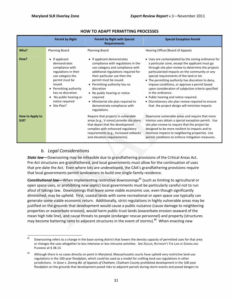
Maryland SLR Overlay Zone Expert Review Report v.3—November 2011
31
HOW TO ADAPT PERMITTING PROCESSES
Permit by Right Permit by Right with Special Requirements
Special Exception Permit
Who? Planning Board Planning Board Hearing Officer/Board of Appeals
How? If applicant demonstrates compliance with regulations in their use category the permit must be issued.
Permitting authority has no discretion.
No public hearing or notice required
Site Plan?
If applicant demonstrates compliance with regulations in the use category and compliance with additional regulations required for their particular use then the permit must be issued.
Permitting authority has no discretion
No public hearing or notice required
Ministerial site plan required to demonstrate compliance with regulations.
Uses are contemplated by the zoning ordinance for a particular zone, except the applicant must go through site plan review to determine the projects particularized impacts on the community or any special requirements of the land or lot.
The permitting authority has discretion to deny, impose conditions, or approve a permit based upon consideration of subjective criteria specified in the ordinance.
Public hearing and notice required. Discretionary site plan review required to ensure that the project design will minimize impacts
How to Apply to SLR?
Require that projects in vulnerable areas (e.g., V‐zones) provide site plans that depict that the development complies with enhanced regulatory requirements (e.g., increased setbacks and elevation requirements).
Downzone vulnerable areas and require that more intense uses obtain a special exception permit. Use site plan review to require that the project be designed to be more resilient to impacts and to minimize impacts to neighboring properties. Use permit conditions to enforce mitigation measures.
b. Legal Considerations State law—Downzoning may be infeasible due to grandfathering provisions of the Critical Areas Act. Pre‐Act structures are grandfathered, and local governments must allow for the continuation of uses that pre‐date the Act. Even where lots are undeveloped, the CAA’s grandfathering provisions require that local governments permit landowners to build one single‐family residence.
Constitutional law—When implementing restrictive downzonings85 (such as limiting to agricultural or open space uses, or prohibiting new septic) local governments must be particularly careful not to run afoul of takings law. Downzonings that leave some viable economic use, even though significantly diminished, may be upheld. First, coastal lands with some recreational or open space use typically can generate some viable economic return. Additionally, strict regulations in highly vulnerable areas may be justified on the grounds that development would cause a public nuisance (cause damage to neighboring properties or exacerbate erosion), would harm public trust lands (exacerbate erosion seaward of the mean high tide line), and cause threats to people (endanger rescue personnel) and property (structures may become battering rams to adjacent structures in the event of storms).86 When enacting new
85 Downzoning refers to a change in the base‐zoning district that lowers the density capacity of permitted uses for that area
or changes the uses altogether to less intensive or less intrusive activities. See ZIEGLER, RATHKOPF'S THE LAW OF ZONING AND PLANNING at § 38.13.
86 Although there is no cases directly on point in Maryland, Massachusetts courts have upheld very restrictive land‐use regulations in the 100‐year floodplain, which could be used as a model for crafting land‐use regulations in other jurisdictions. In Gove v. Zoning Bd. of Appeals of Chatham, Chatham County prohibited development in the 100‐year floodplain on the grounds that development posed risks to adjacent parcels during storm events and posed dangers to

Maryland SLR Overlay Zone Expert Review Report v.3—November 2011
32
regulations, local governments should clearly articulate the public purposes served by the law and specifically make findings showing that the regulations are designed to prevent public nuisances, impacts to public trust land, and harm to people and property. Maryland courts have upheld very restrictive regulations where the government could show that more intense uses could threaten public health and safety, and where some economic use was permitted. 87
c. Policy Considerations
Cost—Downzoning may limit the economic development value of coastal lands and can reduce the government tax base as nonconforming uses are phased out over time. Local governments can mitigate some of the tax repercussions by upzoning areas that are not at risk of SLR (i.e., allowing increase densities or intensity of uses in upland areas and thereby increasing the taxable property value). This may generate additional revenues in other areas of the community. The economic impacts to individual landowners could be mitigated through creation of a transfer development credits (TDC) program.88
Political—Downzonings often face intense political opposition from affected property owners.
V. TOOLS TO EMPLOY IN SLR SUBDISTRICTS
1. Setbacks Setbacks provide horizontal flood protection. They are a useful tool to provide short‐ to medium‐term protection from flooding by requiring that structures be sited landward on the property.89 On waterfront properties, setbacks often require preservation of coastal features that provide natural flood protections, such as dunes and wetlands. Setbacks can also be used to ensure that landowners do not need to construct armoring in the near‐term to protect their development.
In the FCD, the local government could require a “maximum practicable setback,” requiring that structures be set back as far landward or upland on the lot as possible, whichever provides the most protection to structures from flooding and erosion.
Alternatively, local governments could employ erosion‐based setbacks, tiered setbacks, or a hybrid of both. Erosion‐based setbacks calculate the setback based upon the erosion rate for the area
rescue personnel during evacuations. The court found that the regulation was not a taking because it did not prevent all economic use of regulated properties; residual uses included recreational, agricultural, and commercial fishing. 831 N.E.2d 865, 871‐75 (Mass. 2005).
87 In Roberts v. Grant, the court upheld the downzoning of land from light industrial to residential, despite expert testimony that manufacturing was “highest and best possible use”. The court found that rezoning the property back to its original zoning classifications could have a deleterious effect on the surrounding residential neighborhood, and was, therefore, not in the general public interest and welfare. 20 Md. App. 247, 250‐253 (Md. Ct. Spec. App. 1974).
88 Where authorized, local governments can allow for the transfer of development rights, in the form of credits, from one part of a community to another. Credits are generated in the district the local government wishes to protect. The credits can then be used in the receiving district to allow for development above and beyond what is allowed by the base‐zoning. The receiving district is generally an area that can absorb the additional development. See NOLON, LAND USE at 230. The authority to establish a program for the transfer of development rights has been delegated to local governments in Maryland. MD. CODE ANN., art. 25A, § 5(X)(1)(i)(2) (2001); id at art. 66B, §11.01 (2009).
89 A FEMA study in North Carolina after Hurricane Floyd determined that structures setback less than 30 feet from the shoreline experienced twice as much damage than those setback 30‐100 feet, and three times more than those setback more than 100 feet. NOAA Planning Guide at 72.

Maryland SLR Overlay Zone Expert Review Report v.3—November 2011
33
multiplied by the projected life of the structure. The model uses the setback recommended by the National Academies and requires a setback of 60 times the annual erosion rate for smaller, readily movable structures.90 A second alternative is to allow for tiered setbacks. Tiered setbacks require greater setbacks for larger structures and lesser setbacks for smaller structures.91
In the FAD, similar setback provisions could be applied for waterfront properties.
a. Application in Test Jurisdictions Increased setbacks could be a useful tool for AAC. AAC may experience new development in vulnerable areas and lot sizes tend to be larger in the County, providing additional buildable space to allow for sufficient setbacks. Requiring increased setbacks for redevelopment may be more difficult because it could potentially require landowners to undertake expensive relocation.
Increased setbacks may not be feasible for many areas of Annapolis because much of the shoreline is already developed and waterfront lots tend to be small with no upland buildable space for relocation. Annapolis may want to consider applying increased setback regulations where they permit new development or redevelopment on large lots.
b. Legal Considerations State law—Local governments will need to ensure that any special floodplain setback requirements comply with Critical Areas buffers. At a minimum, new regulations should ensure that development abide by the CCA 100‐foot buffer requirement. Local governments may also want to consider adding an additional setback from the buffer boundary to provide room for inland migration. Because the buffer boundary is measured in relation to the mean tide level, it will roll inland as seas rise. As the shoreline erodes away, structures may come to encroach in the buffer areas and local governments will need to figure out how to treat these structures that become nonconforming as a result of natural shoreline changes.
Constitutional law—Setbacks on smaller lots may result in takings challenges where application of the setback would prohibit any development. However, regulators can typically avoid completely prohibiting any development through the variance process.
c. Policy Considerations
Cost—More restrictive setback provisions will reduce the buildable space of land and could impact property values. However, setbacks can reduce the drive to build hard protection and may provide sufficient protection from flooding over the near‐term.
Administrative/Technical—Maximum practicable setbacks will require regulators to exercise some degree of discretion to ensure that structures are sited on the most protective portion of a lot. This may
90 NOAA Planning Guide at 72.
91 North Carolina provides an example of a tiered setback; structures less than 5,000 square feet require a setback of 30 times the annual erosion rate and structures greater than 5,000 square feet require a setback of 60 times the annual erosion rate. 15A N.C. ADMIN. CODE 07H.0306 (2009); NOAA Planning Guide at 72. These multipliers reflect a choice to use a 30‐year mortgage as the life of the structure. Some policymakers recommend use of actual estimates for a life of a structure 60‐70 years. See Sea Grant Model Bylaw at 10‐12. The multiplier used will be a policy choice that the local government will need to determine in consideration of average lot sizes and the number of lots that may be rendered unbuildable given different multipliers.

Maryland SLR Overlay Zone Expert Review Report v.3—November 2011
34
require permits to be issued at a public hearing, with notice, and by a permitting authority with discretionary authority, which could add significant administrative burden.
By using erosion‐based setbacks regulators can ensure that development is sufficiently protected in highly erosive areas, while also ensuring that setbacks are not overly restrictive in low‐risk areas.92
Erosion‐based setbacks do not require discretionary authority because the setback can be established using existing data—where an applicant can demonstrate compliance with the requisite setback the permitting authority will have to issue the permit. To implement erosion based setbacks local governments could use the historic erosion rates for the state’s shorelines compiled by the Maryland Geological Survey available on the state’s web‐based mapping tool –Coastal Atlas.93
Tiered setbacks are useful to build in flexibility based upon the size and intensity of the project. Larger structures require greater setbacks because they pose a greater risk of collateral damage in the event they are flooded; whereas smaller structures require lesser setbacks because smaller structures put fewer people at risk and are more easily moved.
Onerous setback provisions may result in numerous applications for variances, which could also be administratively taxing.94
d. Practice Tips In order to determine whether the setbacks comply with the ordinance, applicants will have to submit a site plan that depicts the topography of the site, flood elevations, erosion‐rates and the location of the erosion‐based setback, and the structure’s dimension in relation to the setback. Maximum practicable setback provisions may also require that permit applicants draw up site plans demonstrating the siting of the structure on the lot and providing a narrative description of why the setback is the “maximum practicable.” Applicants will have to hire an engineer or geologist to prepare the site plan and to evaluate the site‐specific conditions. This will add to the expense of applying for a building permit.
When calculating setbacks, policymakers should consider average lot sizes in their community. Requiring a setback of 60 times the average erosion rate may render some smaller lots unbuildable in highly erosive areas, potentially triggering takings challenges. To avoid this problem, Kauai used a combination of erosion‐based setback and ‘fixed setback’ based upon consideration of average lot sizes.95
2. Resilient Structure Design Resilient design techniques require that structures be constructed and designed to be more resilient to flooding impacts, and include freeboard, floodproofing, and building height and size limits.
Building elevations, or “freeboard requirements,” provide vertical flood protection. Currently, NFIP minimums require that residential structures be elevated to at or above the base flood elevation
92 NOAA Planning Guide at 71.
93 COASTAL ATLAS: SHORELINES, MARYLAND DEPARTMENT OF NATURAL RESOURCES, http://www.dnr.state.md.us/ccp/coastalatlas/shorelines.asp (last visited Sept 26, 2011); see also SHORELINE CHANGE MAP
DATA, COASTAL AND ESTUARINE GEOLOGY PROGRAM, http://www.mgs.md.gov/coastal/maps/schangevect.html
94 Sea Grant Model Bylaw at 11.
95 Sea Grant Model Bylaw at 11‐12.
Maryland SLR Overlay Zone Expert Review Report v.3—November 2011
35
(BFE).96 Maryland has a one‐foot freeboard requirement for its non‐tidal floodplains, meaning that structures in these areas must be elevated one foot above the BFE under state law. However, the state does not require freeboard in tidal floodplains—regulation of tidal floodplains is delegated to local governments who have sole discretion to require freeboard.97
(Dry) Floodproofing requires that portions of a structure below the BFE or the design flood‐elevation height (i.e., height specified in the ordinance usually BFE plus freeboard) be constructed of flood resistant materials or protected with sealant.98
Height and size regulations limit the types of structures that can be placed in harm’s way. By limiting the structure size, local governments can reduce the amount of people in danger, reduce collateral damage from destroyed structures, and require that structures be easier to relocate as impacts intensify.99
This model recommends that local governments increase the resiliency of structures permitted in flood‐prone areas. First, the model recommends raising freeboard standards. Given that the state is estimating a 2.4 to 3.7 foot increase in sea levels by the end of the century, current elevation requirements will be insufficient to protect many structures over their lifetimes.100 Second, where freeboard is infeasible, local governments could require that structures be floodproofed. Finally, the model recommends that local governments limit the size of structures allowed to be built in flood zones.
In the General Floodplain District, the model extends regulatory requirements to the 500‐year floodplain. This will require that new construction and any substantially improved structures in these areas comply with floodplain regulations (i.e., buildings will need to be elevated and basements will need to be removed, etc.).
In the FCD, the model requires that structures be elevated on pilings. This is currently a NFIP requirement for properties located in the V‐zone—the model ordinance extends these regulations to structures in the coastal A‐zone as well. Elevation on pilings (open foundations) is required in coastal floodplains to preserve the shoreline’s natural ability to adapt to flood impacts. The model recommends that structures be limited to a maximum of 5,000 square feet and a height of 35 feet.
In the FAD, the model ordinance simply requires that structures be elevated; this could allow elevation on fill and closed foundations. The model proposes that local governments require critical facilities be elevated to the 500‐year flood height. No size and height limits are included in this model in the FAD; however, local governments could consider employing size and height limits in these areas as well (perhaps allowing a little extra bulk and density than permitted in the FCD).
96 The base flood elevation (BFE) is the “computed elevation which floodwater is anticipated to rise during the base flood.”
For regulatory purposes the base flood is the 100‐year storm event. Structures must typically be elevated one‐foot above the BFE; this elevation is called “freeboard”. FEMA, Base Flood Elevation, available at http://www.fema.gov/plan/prevent/floodplain/nfipkeywords/base_flood_elevation.shtm (last visited Sept. 27, 2011)..
97 See note 20, supra.
98 FEMA, Homeowner’s Guide to Retrofitting at 3‐4
99 See NOAA Planning Guide at 65.
100 Freeboard standards are based solely upon uncertainties in historic calculations of flood elevations and inundation, and do not account for risks posed by future conditions. See FEMA, Homeowner’s Guide to Retrofitting at 3‐6. Maryland estimates 2.7 to 3.4 feet of SLR are based on conservative IPCC estimates that did not account for ice sheet melt. See Maryland Comprehensive Strategy, ch. 5 at 4.

Maryland SLR Overlay Zone Expert Review Report v.3—November 2011
36
a. Application in Test Jurisdictions Resilient design requirements could be a useful tool for AAC. The County could require that new development be designed to be more resilient to impacts and could limit the size and bulk of new structures in vulnerable areas. Existing development could also be easily retrofit in vulnerable areas because existing land uses tend to be smaller residential structures and maritime uses.
Resilient design may be more difficult to implement in Annapolis. Annapolis is unlikely to see much new construction along its shorelines; therefore, these policies would be primarily applied to require retrofit of existing structures, which is more expensive. The City will have to give special consideration to how to elevate structures in historic districts and for structures subject to ADA accessibility requirements. The City may want to consider allowing some of these structures to use floodproofing techniques rather than elevation through the variance process or an exemption.
b. Legal Considerations Integration—Height limitations required by the base zoning may conflict with freeboard requirements. Local governments should consider allowing retrofit structures to exceed the height limitations of the base zoning where the structures are being elevated to comply with freeboard requirements.
It may be difficult to require retrofitting of historic structures. Local governments typically allow historic structures to avoid floodplain regulations through the variance process. Where homeowner’s seek to retrofit structures they will require approval from a Historic Preservation Commission that considers aesthetics and the historical character of the structure when approving alterations; these local Commissions may view flood protections as incompatible with historic preservation criteria.
Federal law—Local governments will also need to carefully consider how businesses, government facilities, and health care facilities will comply with elevation requirements while maintaining accessibility for disable persons as required by the ADA. As an alternative, local governments could allow structures to be floodproofed where they cannot feasibly be elevated in compliance with the ADA.
c. Policy Considerations
Cost—Freeboard is useful to protect new construction, but is more expensive when retrofitting existing structures. 101 Height and size limits can reduce the economic value of new development. However, by instituting freeboard requirements local governments can qualify for points under the CRS, and homeowner’s can receive insurance premium discounts.
Political—Policymakers should also consider the effect that elevation requirements may have on viewsheds. Homeowner’s in coastal areas tend to be particularly protective of their water views. Elevation requirements for older structures may disrupt landward viewsheds, which can be politically unpopular.
101 According to the Federal Emergency Management Agency (FEMA), elevating a home two feet costs between $29 per
square foot of the building’s footprint and $88 per square foot of the building’s footprint. Elevating a home four feet costs between $32 per square foot of the building’s footprint and $91 per square foot of the building’s footprint. Elevating a home eight feet costs between $37 per square foot of the building’s footprint and $96 per square foot of the building’s footprint. These amounts vary depending on the house’s construction type and foundation. FEMA, Homeowner’s Guide to Retrofitting at 3‐20 (2009).

Maryland SLR Overlay Zone Expert Review Report v.3—November 2011
37
d. Practice Tips Governments can encourage property owners to elevate structures through permitting incentives or tax rebates, as an alternative to a purely regulatory approach. Tax incentives can also be used to help landowners recoup some of the costs of elevating existing structures, especially in newly regulated areas (such as the 500‐year floodplain) where landowners are not required to carry flood insurance and will be ineligible for premium discounts offered for elevated structures. Hull, Massachusetts offers rebates on permitting fees to developers and homeowners who elevate new construction or redevelopment.102
By requiring that substantially damaged structures comply with new SLR regulations, communities can continue to allow nonconforming uses (as required by grandfathering provisions of the CAA) while ensuring that redeveloped structures are built to be more resilient to future impacts. Because only uses are grandfathered, local governments can require that redeveloped structures comply with new elevation and setback requirements and size and height limits.
3. Limits on Septic
Septic systems can have adverse effects on the environment. In Maryland, each year approximately 430,000 septic systems release four million pounds of nitrogen into the Chesapeake Bay.103 This figure accounts for seven percent of nitrogen pollution in the Bay, which causes oxygen‐depletion and dead zones that are detrimental to marine life. Sea level rise will exacerbate these impacts for the 52,000 septic tanks located in flood‐prone areas of Maryland.104 When septic tanks and their fields become submerged, they can contaminate groundwater.105 As flood events become more common, contamination from septic tanks will increase.106 SLR will also cause water tables to rise, resulting in failed septic systems when drain fields are no longer the necessary distance above the water table to function properly.107
Maryland has attempted to reduce the water quality impacts of septic by passing state septic regulations. Local governments are delegated authority to administer septic requirements consistent with state standards.108 In general, septic systems are prohibited within 100 feet of surface waters, and
102 For a general description of Hull’s freeboard incentive program see MASSACHUSETTS OFFICE OF COATAL ZONE MANAGEMENT,
STORMSMART COASTS 2009‐2011 PILOT PROJECT – HULL FREEBOARD INCENTIVE AND STORM SURGE VISUALIZATION, available at http://www.mass.gov/czm/stormsmart/pilots/hull.htm (last visited Oct. 18, 2011).
103 H.B. 1107, 428th Sess. Gen. Assemb. (Md. 2011). 2011 Maryland House Bill No. 1107, Maryland 428th Session of the General Assembly
104 MARYLAND’S NITROGEN‐REDUCING SEPTIC UPDATE PROGRAM, MARYLAND DEPARTMENT OF THE ENVIRONMENT, available at http://www.mde.state.md.us/programs/Water/BayRestorationFund/OnsiteDisposalSystems/Pages/Water/cbwrf/index.aspx (last visited Sept. 27, 2011).
105 U.S. Climate Change Science Program (USCCSP), Coastal Sensitivity to Sea Level Rise: A Focus on the Mid‐Atlantic Region, Synthesis and Assessment Product 4.1 at 224 (Jan. 2009), available at http://epa.gov/climatechange/effects/coastal/sap4‐1.html (last visited Sept. 27, 2011) [hereinafter Coastal Sensitivity to Sea Level Rise].
106 USCCSP, Coastal Sensitivity to Sea Level Rise at 98
107 USCCSP, Coastal Sensitivity to Sea Level Rise at 174,Figure 10.2
108 See WATER MANAGEMENT PERMITS, MARYLAND DEPARTMENT OF THE ENVIRONMENT, available at http://www.mde.state.md.us/programs/Permits/WaterManagementPermits/Pages/Permits/WaterManagementPermits/index.aspx (last visited Sept. 27, 2011; MARYLAND’S NITROGEN‐REDUCING SEPTIC UPDATE PROGRAM, MARYLAND DEPARTMENT OF THE
ENVIRONMENT, http://www.mde.state.md.us/programs/Water/BayRestorationFund/OnsiteDisposalSystems/Pages/Water/cbwrf/index.aspx (last visited Sept. 27, 2011).
Maryland SLR Overlay Zone Expert Review Report v.3—November 2011
38
a lot must have a minimum area suitable for placement of a septic tank.109 In addition, the Chesapeake Bay Nitrogen Reduction Act of 2009 prohibits the installation or replacement of septic systems within Critical Areas, 110 unless the septic system uses “Best Available Technology” (“BAT”) for nitrogen removal.111 In early 2011, a proposal was introduced in the General Assembly to expand septic regulations through legislation entitled the “Sustainable Growth and Agricultural Preservation Act.” 112 The bill would have prohibited septic systems in subdivisions with 5 lots or more and required smaller subdivisions to use BAT for nitrogen removal.113 The bill failed, but a Task Force was convened to study the economic impact of septic limitations among other things.114
While it is clear that SLR will adversely affect the use of septic systems and private wells, the adaptation solution is not as clear. The model proposes that, at a minimum, local governments consider increasing minimum setbacks for septic from 100 feet from surface waters to 200 feet. However, there are several other adaptation strategies that policymakers could consider, but each will require additional technical and economic consideration.
Extend BAT requirements—Local governments could consider extending the BAT requirements to all areas within the SLR subdistricts to ensure that new technologies to improve water quality are deployed as septic systems are replaced. However, it is unclear whether these systems will withstand SLR impacts better than conventional septic.
Site Plan Review—Local governments could consider the impacts of SLR to septic when reviewing site plans (see general discussion of site plan review, below at Section VI(1)). As part of their building permit application, developers must submit to local health departments a septic design site plan. Regulators review the design in consideration of the general topography, soil, and hydrology of the site, drainage conditions, and the “[h]istory of septic systems and wells in the area.”115 To take SLR impacts into account, future hydrologic, surface, and subsurface conditions could also be considered when determining where a septic system can be appropriately designed on the site. It is unclear whether this type of analysis can be completed with existing data.
109 MD. CODE REGS. 26.04.02.02 (B)(1), 26.04.02.04 (J) (2011).
110 “The Critical Area includes all lands within 1,000 feet of the mean high water line of tidal waters or wetlands of the Chesapeake and Coastal Bays and their tidal tributaries.” MARYLAND’S NITROGEN‐REDUCING SEPTIC UPDATE PROGRAM, MARYLAND
DEPARTMENT OF THE ENVIRONMENT, http://www.mde.state.md.us/programs/Water/BayRestorationFund/OnsiteDisposalSystems/Pages/Water/cbwrf/index.aspx (last visited Sept. 27, 2011).
111 S.B. 554, 426th Sess. Gen. Assemb. (Md. 2009) (“An upgraded, nitrogen‐removing septic system cuts a system’s nitrogen load in half. The Maryland Department of the Environment has upgraded over 2,000 septic systems to nitrogen removing Best Available Technology (BAT) through the Bay Restoration Fund (BRF) Onsite Sewer Disposal System (OSDS) grant program...”); see also MARYLAND’S NITROGEN‐REDUCING SEPTIC UPDATE PROGRAM, MARYLAND DEPARTMENT OF THE ENVIRONMENT, http://www.mde.state.md.us/programs/Water/BayRestorationFund/OnsiteDisposalSystems/Pages/Water/cbwrf/index.aspx (last visited Sept. 27, 2011).
112 H.B. 1107, 428th Sess. Gen. Assemb. (Md. 2011).
113 2011 Maryland House Bill No. 1107, Maryland 428th Session of the General Assembly
114 TASK FORCE ON SUSTAINABLE GROWTH AND WASTEWATER DISPOSAL, MARYLAND DEPARTMENT OF PLANNING (Sept. 26 2011), available at http://www.mdp.state.md.us/YourPart/septicsTF/septicsTaskForce.shtml (last visited Sept. 27, 2011).
115 MD. CODE REGS. 26.04.02.04 (2011).
Maryland SLR Overlay Zone Expert Review Report v.3—November 2011
39
Extend sewer lines—Where feasible, local governments could extend sewer lines to developed areas, and areas where future development is desired.116 Extending sewer lines to these areas would eliminate the need for septic tanks and avoid harmful environmental effects. However, local governments should carefully consider whether they can support additional wastewater capacity. Transitioning to sewer shifts the burden of waste disposal from the private landowner to the local government. Furthermore, overflows from insufficient wastewater treatment facilities can pose even greater environmental harms than flooded septic. The County could raise funds to support additional wastewater treatment by assessing impact fees for new development that will be serviced by extended sewer lines.
Septic resiliency—Maryland’s septic regulations could be amended to require that systems be designed to be more resilient to SLR. Regulations could require that septic systems be designed to be water‐tight through the use of sealed covers and non‐return valves.117
Septic siting—Regulators could also require that septic systems be placed on the most upland and inland portion of the lot. This will ensure that septic systems are protected from floodwaters by the natural topography of the land. Similarly, in areas where the water table is high, or likely to rise due to SLR, mounds‐based septic systems could be required. These systems use a constructed sand mound to ensure proper filtration and drainage, and may be less affected by a rise in the water table.118
a. Application in Test Jurisdictions Septic is likely to be of greater concern in AAC, where many properties are not connected to public sewers. Septic may not be as much a concern in Annapolis where most of the city is serviced by public sewers; ensuring that public wastewater treatment facilities are resilient to impacts may be of more concern to the City.
b. Legal Considerations Authority—Although the state has the authority to regulate the “character and location” of septic systems,119 local governments also appear to regulate septic systems.120 The extent to which local governments can regulate septic systems and the extent of state oversight is not immediately clear to the authors. A further review of legal authorities may be required to evaluate appropriate septic adaptation options.
State law—It is unlikely that septic systems can be prohibited in Critical Areas due to the grandfathering provisions in the regulations, which allow for the continuation of nonconforming uses. Septic prohibitions would in effect discontinue grandfathered uses because they are an integral component of the use.121
116 USCCSP, Coastal Sensitivity to Sea Level Rise at 174.
117 Guy Howard, et al., Securing 2020 Vision for 2030: Climate Change and Ensuring Resilience in Water and Sanitation Services, 1 JOURNAL OF WATER AND CLIMATE CHANGE 2, 7 (2010).
118 USCCSP, Coastal Sensitivity to Sea Level Rise at 175.
119 MD. CODE ANN., ENVIR. § 10‐103 (1982).
120 Anne Arundel County, Maryland, Code, art. 15, § 2 (2005).
121 See MD. CODE REGS. 27.01.02.07. (2011); Telephone Interview with Ren Serey, Critical Area Commission for the Chesapeake and Atlantic Coastal Bays (Sept. 22, 2011).
Maryland SLR Overlay Zone Expert Review Report v.3—November 2011
40
Constitutional law—Maryland courts, however, have upheld limitations on septic against constitutional takings challenges. In Maryland, operating a septic system that may be detrimental to public health is a nuisance.122 As a result, prohibiting septic systems in flood‐prone areas may not cause a regulatory taking, even if the prohibition results in no economically beneficial use of the land. In Erb v. Department of the Environment, the Maryland Court of Special Appeals denied a takings claim where expert testimony was provided to show that if a septic system were installed, it would likely fail, based upon existing characteristics of the site. The court found that denial of the permit did not constitute a taking, even though the land could not be developed without the permit, because the state appropriately denied the permit to prevent a public harm.123 Courts have not, however, addressed the question of whether regulators can deny septic permits based upon threatened future impacts (i.e., not based upon the existing characteristics of a site). To do so, regulators will need to develop methodologies to evaluate how SLR will affect septic systems and assess the likelihood that SLR could cause septic system to fail, thus posing threats to public health and the environment.
c. Policy Considerations
It is clear that SLR will have an impact on existing septic systems, and should influence how septic systems are permitted in the future—the specifics of how regulations should be crafted, however, requires technical expertise beyond the scope of this report. The following general issues should be thoroughly considered before regulatory action is taken:
Cost—BAT septic systems substantially reduce nitrogen loads to surface waters under normal conditions. However, it is unclear whether these systems will perform better than conventional systems as water tables rise and systems increasingly flood.124 Therefore, regulators should examine whether the extra costs of requiring BAT systems will provide enough environmental benefit to warrant the expense to landowners.125 Limiting the use of septic systems could also affect growth. Septic restrictions may have enormous impact on property values where hook‐up to public sewers is infeasible or unavailable.126
Additionally, in some communities, a potentially disastrous consequence of failed septic is that many houses may become uninhabitable. This could cause people to abandon their property if it cannot be sold for other uses.127 In these circumstances, regulators may either have to approve “holding tanks”128 122 110 Md. App. 246, 265 (1996).
123 Id.
124 Telephone Interview with Jay Prager, Deputy Program Manager, Wastewater Permits Program, Water Management Administration & Joshua Flatley, Project Manager, Bay Restoration Fund, Maryland Department of Environment (Sept. 23, 2011).
125 See Joe Tassone, Maryland Department of Planning, Septics Task Force, Development on Sewer and Septic at 2 (Aug. 25, 2011), available at http://www.mdp.state.md.us/PDF/YourPart/septicsTF/20110825/CompCosts_082511.pdf (last visited on Sept. 27, 2011) (comparing the costs between conventional septic systems and BAT for nitrogen removal septic systems).
126 State legislators claimed restrictions on septic would lead to decreased rural land values. Len Lazarick, MarylandReporter.com (Feb. 15, 2011), available at http://marylandreporter.com/2011/02/15/eastern‐shore‐legislators‐mount‐opposition‐to‐septic‐tank‐restrictions/ (last visited on Sept. 27, 2011). But see Septic System Task Force & Sustainable Growth Commission, Effects of Development Restrictions on Land Values (Sept. 12, 2011), available at http://www.mdp.state.md.us/PDF/YourPart/septicsTF/20110912/OtherSourcesJft091211.pdf (finding that restrictions may not decrease property value).
127 See James G. Titus & Charlie Richman, Maps of Land Vulnerable to Sea Level Rise: Modeled Elevations Along the US Atlantic and Gulf Coasts, 18 CLIM RES 205, 225, (2001) (citing interviews with Interview with Sandy Manter, Planner of Accomack

Maryland SLR Overlay Zone Expert Review Report v.3—November 2011
41
for sewage, or effectively condemn these properties.129 The pros and cons of each option should be considered. Holding tanks may not be an appropriate long‐term solution for waste disposal and they may have unique vulnerabilities to SLR. Condemnation could require that local government pay for lands and remove structures. If septic systems are not removed on abandoned lands, contaminants could pollute groundwater and the Bay requiring expensive remediation.
Administrative/Technical/Legal—A policy requiring engineers to factor in SLR when calculating water tables in septic design plans may be technically difficult to administer. Policymakers will need to develop clear criteria by which regulators can evaluate how SLR will affect septic systems and determine the likelihood that SLR will cause a system to fail. Further legal research may be required to evaluate how imminent the threat needs to be to justify denying permits on nuisance grounds to avoid takings liability. Although it is clear that sea levels are rising, the extent of timing of impacts is uncertain—making it difficult for regulators to develop clear permitting criteria. For example, it is unclear whether it would be legally tenable to deny a septic permit on the grounds that it could fail if sea levels rise 5‐inches or could fail in 5‐years given an estimated rate of SLR. In the short‐term, regulators could use data of historic rates of SLR to project the future hydrology of the site and evaluate the risks of septic failure.
Political—Because septic affects property values, regulations may be contentious and difficult to pass. The Sustainable Growth Act failed because many landowners opposed the measure arguing that the septic prohibitions would have effectively prohibited subdivision of land into more than five lots.
4. Rebuilding Restrictions Rebuilding restrictions are a useful tool to phase out development in highly vulnerable areas as impacts occur. In the context of a coastal retreat policy, rebuilding restrictions would ensure that nonconforming uses are eliminated after the structures has been damaged or destroyed.130 While rebuilding restrictions do not provide preemptive protections, they are useful to put landowners on notice that their development is at risk and may have to be relocated as sea levels rise.
Rebuilding restrictions can be imposed in highly vulnerable areas, such as prohibiting new construction and redevelopment in V‐zones, or they can be imposed based upon insurance claims data, such as prohibiting redevelopment in areas where there are many severe repetitive loss structures.131 The
County, Virginia, July 1998; interview with Joan Kean, Somerset County Planner, Maryland, August 1998); Wanda Cole, Maryland Eastern Shore, Resource Conservation & Development Council, Sea Level Rise: Guidance for Dorchester County 26 (Mar. 2008) available at http://dnr.maryland.gov/CoastSmart/pdfs/SeaLevel_Dorchester.pdf (last visited Sept. 27, 2011).
128 See MD. CODE REGS. 26.04.02.03 (2011).
129 Telephone Interview with Jay Prager, Deputy Program Manager, Wastewater Permits Program, Water Management Administration & Joshua Flatley, Project Manager, Bay Restoration Fund, Maryland Department of Environment (Sept. 23, 2011).
130 See generally BARLOW BURKE, UNDERSTANDING THE LAW OF ZONING AND LAND USE CONTROLS 93 (2d ed. 2009).
131 The National Flood Insurance Program defines “severe repetitive loss” (SRL) structures as residential structures: (1) that have had at least 4 claims of over $5,000 each, and the cumulative amount of such claims payments exceeds $20,000; or (2) for which at least two separate claims payments have been made with the cumulative amount paid exceeding the value of the building.
Pilot Program for Mitigation of Severe Repetitive Loss Properties, 42 U.S.C. § 4102a (2004). (At least two of the referenced claims must have occurred within any ten‐year period, and must be greater than 10 days apart). SEVERE REPETITIVE LOSS PROGRAM, FEMA (Jun. 1, 2011) available at http://www.fema.gov/government/grant/srl/ (last visited Sept. 27, 2011).
Maryland SLR Overlay Zone Expert Review Report v.3—November 2011
42
model ordinance uses the methodology employed in Maine, under the Sand Dune Rules. Structures located in V‐zones that are substantially damaged in a storm event can only be reconstructed one time. If the structure is damaged a second time, rebuilding is prohibited, unless the landowner can relocate the structure out of the V‐zone.
a. Application in Test Jurisdictions In AAC, vulnerable areas are less likely to be protected by hard armoring because of the extent of the shoreline that is at risk and the cost. Therefore, the County may need to seriously consider retreat measures. Rebuilding restrictions may also be more feasible because large lot sizes and sparse development provide more room to relocated vulnerable structures inland. Additionally, AAC experienced rapid growth after enactment of its Critical Areas program; therefore less development may be subject to grandfathering provisions.
Rebuilding restrictions are likely infeasible in many areas of Annapolis. Development in Annapolis likely pre‐dates the Critical Areas program; as such, rebuilding restrictions may conflict with grandfathering requirements. There is limited room for expanded development within the City’s borders, providing limited potential to relocate structures. Additionally, Annapolis has extensive historic properties and retreat will likely conflict with the City’s goals to preserve and maintain these properties.
b. Legal Considerations State law—Critical Areas Act regulations could limit local governments’ ability to restrict the rebuilding of grandfathered structures. The regulations require local governments to allow for the continuation of uses that existed at the time the program was enacted.132 While regulations allow for termination of a use that has been “abandoned”—homeowners have one year to seek to rebuild. The CAA regulations do not define the term abandoned. Because the regulations are silent on whether or not the grandfathering requirements apply “destroyed” structures, local ordinances should govern whether a nonconforming use destroyed by a storm event can be rebuilt.
Currently, local ordinances often distinguish between intentional abandonment and unintentional discontinuance of uses (such as destruction by natural causes).133 Landowners of discontinued or destroyed uses are typically given a longer period of time to seek to rebuild, because the owner is seen to be not at fault for the discontinuation. Local governments could, however, be justified in immediately terminating uses that are repeated damaged by storms, despite the grandfathering provisions. Courts typically give local governments more leeway to terminate uses that have become a
132 Section 27.01.02.07 of the regulations state: “After program approval, local jurisdictions shall permit the continuation, but
not necessarily the intensification or expansion, of any use in existing on the date of program approval, unless the use has been abandoned for more than 1 year or is otherwise restricted by existing local ordinances.” MD. CODE REGS. § 27.01.02.07 (2011) (emphasis added).
133 See e.g., City of Annapolis Code, Title 21, Div. V. Ch. 21.68.060(C) (excluding from the calculation of the period of the length of abandonment “any period of abandonment caused by government actions, fire, or natural calamities, and without any contributing fault by the nonconforming user”); see also City of Baltimore, Md., Zoning Code, § 13‐207 (The zoning ordinance distinguishes between and intentional “abandonment” and an unintentional “discontinuance” of uses. Whether the use has been abandoned and discontinued determines the length of time the landowner has to seek to reestablish the use—a nonconforming use terminates immediately when abandoned, but a landowner has 6 months to seek to rebuild an unintentionally discontinued use. Also, where a nonconforming structure is destroyed by natural causes the landowner may rebuild within one‐year. However, the Critical Area Overlay includes “discontinued” in the definition of abandoned. Section 8‐313 defines “abandoned uses” as “[a]ny use that is discontinued for 12 consecutive months: (1) is considered abandoned; and (2) may not be reestablished in the Critical Area unless…”).

Maryland SLR Overlay Zone Expert Review Report v.3—November 2011
43
nuisance due to changes in their location or surroundings; and many courts allow local governments to terminate uses that have been destroyed by natural causes.134
Local governments, however, may be hesitant to adopt this approach because of ambiguity in the regulations. Without more clarity, any local provisions terminating grandfathered uses could be challenged as violating the Act. To give local governments more flexibility, the Commission could amend the regulations to define “abandonment” to specifically exclude “destroyed by natural causes”.135
Constitutional law—Rebuilding restrictions may also cause a 100‐percent diminution in economic value triggering a requirement to pay just compensation under the takings clause. Maryland courts have yet to address the question of whether restricting rebuilding constitutes a regulatory taking. In dictum, however, the Maryland Court of Appeals said that where a “nonconforming building has been destroyed by act of God, the owner should not be allowed to rebuild as a matter of right without authority from statute or ordinance.”136 Additionally, laws restricting the rebuilding of storm‐damaged structures have been upheld in other states. A facial challenge to rebuilding prohibitions of the South Carolina Beachfront Management Act was rejected in Esposito v. South Carolina Coastal Council. 137 The law prohibited any habitable structure “destroyed beyond repair” by natural causes or fire from being rebuilt seaward of a statutorily‐defined setback line.138 While the landowner argued that the law severely diminished the value of the property, the court upheld the provisions because the home had not yet been damaged nor the restrictions enforced.139 Thus, because the restriction allowed the present use to continue unabridged, applying a Penn Central analysis, the court found no taking.140
However, because Esposito was a facial challenge, it does not resolve the question of whether rebuilding restrictions would constitute a taking at the time of enforcement. Arguably, because landowners are allowed to continue economically viable uses of the property until their structures are destroyed, there should be no taking. Because rebuilding restrictions proposed by this ordinance are not triggered until
134 See generally Jay Campbell, Amortization in the Twenty‐Second Century, 26 No. 11 ZONING AND PLANNING LAW REPORT 1 (Jan.
2004); Maryland courts have upheld ordinances that terminate nonconforming uses after a reasonable amortization period. In one case the courts upheld an ordinance that terminated a check cashing station in a residential district after only a 12‐month amortization period on the grounds that the city council made a reasonable determination that the use was inconsistent and incompatible with the district. Eutaw Enterprises, Inc. v. City of Baltimore, 241 Md. 686, 694 (1966); see also Edward H. Ziegler et al., 4 RATHKOPF'S THE LAW OF ZONING AND PLANNING § 74:11 (4th ed. 2011).
135 Before enacting such a measure, the Commission should carefully review the legislative history to the grandfathering provisions to determine whether the legislature expressed any intent to grandfather uses destroyed by natural causes.
136 Colati v. Jirout, 47 A.2d 613, 615 (Md. 1946) (holding that the Baltimore Board of Zoning Appeals had no authority to grant a permit to expand a structure deemed a nonconforming use); see also Lone v. Montgomery County 85 Md. App. 477, 498‐499 (Md.App.,1991) (In dicta, the court found that “there is no difference in kind, either, between limitations that prevent the adding to or extension of a nonconforming use, or provisions that the right to the use is lost if abandoned or if the structure devoted to the use is destroyed, or the denial of a right to substitute a new use for the old, all of which are common if not universal in zoning laws and all of which are established as constitutional and valid, on the one hand, and a requirement, on the other, that an existing nonconformance must cease after a reasonable time.”).
137 Esposito v. South Carolina Coastal Council, 939 F.2d 165, 167 (4th 1st Cir. 1991).
138 “Destroyed beyond repair” for purposes of the statute meant more than 66 and 2/3 percent of the cost to replace the entire structure. The designated setback line, or “baseline,” was a line at the “crest of an ideal primary oceanfront sand dune” or where the crest one would be located in places where the shoreline had been altered by erosion control devices. Esposito, 939 F.2d at 167 (quoting S.C. Code Ann., § 48‐39‐280 (Supp.1989)).
139 Esposito, 939 F.2d at 170.
140 Esposito, 939 F.2d at 170.

Maryland SLR Overlay Zone Expert Review Report v.3—November 2011
44
the structure has been twice damaged by storms, property owners should have sufficient time to amortize their investment in the property. Additionally, repeated storm damage is evidence that a site is unstable and that development on the site poses a hazard to public health, safety and welfare. Regulators may also be able to demonstrate that a twice damaged structure poses a public nuisance thereby qualifying the enforcement of the regulation for the nuisance exception to the per se Lucas test. However, this issue has yet to be addressed by any court.
c. Policy Considerations
Cost—By prohibiting rebuilding, governments can reduce the push to armor the coastline to protect structures and provide room for coastal resources to migrate upland to keep pace with SLR. Governments can also save public funds over the long‐term by reducing emergency response costs and phasing out maintenance of infrastructure servicing those vulnerable developments. Areas where rebuilding is restricted can be restored to their natural floodplain function and thereby provide protection for upland properties. However, rebuilding restrictions will significantly reduce the tax‐base as valuable coastal development is gradually phased out. Local governments may also have to defend against costly takings challenges.
Administrative— Rebuilding restrictions can be difficult to enforce due to technical difficulties and potential liability. Regulators must appraise the value of the structures and the costs of repair to trigger the restrictions.
Political— Even aside from the legal hurdles, rebuilding restrictions may be politically challenging, if not impossible, to implement without significant financial incentives for affected landowners. City officials are often especially reticent to enforce regulations that could be perceived as indifferent to victims of storm events. Property owners often balk at relocation, and in some coastal communities landowners may lack the financial resources to relocate. This could raise legal and equity issues for local governments.141
d. Practice Tips Local governments can temper some of the financial burden on landowners by coupling rebuilding regulations with other incentives, such as relocation tax credits or transferrable development rights.142 Although this model does not provide language to implement these types of incentives, this may be an area for future research.
Local governments can insulate themselves from takings challenges by allowing some residual economic use of the land even after rebuilding restrictions are enforced and by ensuring that the rebuilding restrictions are solidly grounded in legitimate public purposes, such as protecting against public nuisances and protecting public trust lands.
141 San Francisco Planning and Urban Research Association, Strategies for Managing Sea Level Rise (Dec. 2009), available at
http://www.spur.org/publications/library/report/strategiesformanagingsealevelrise_110109.
142 For example, Texas reimburses landowners for expenses incurred to relocate or demolish structures where redevelopment is prohibited by the state’s Open Beaches Act. NOAA Planning Guide, at 71.
Maryland SLR Overlay Zone Expert Review Report v.3—November 2011
45
VI. ADMINISTRATIVE CONSIDERATIONS Every zoning ordinance has general administrative processes that govern all aspects of permitting, such as site plan review, variances, and nonconforming use requirements. Local governments will also need to figure out how to consider adaptation in these administrative processes.
1. Site Plan Review
Site plan review may be a useful tool to help regulators assess the impacts of SLR to individual projects. The site plan review process requires permit applicants to provide a detailed site‐specific analysis of the physical characteristics of a proposed development.143 The zoning ordinance will typically specify what needs to be included in the site plan, such as the specifications for proposed structures and improvements to land, and their relationship to existing features (such as neighboring structures, topographical elevations, and floodplain boundaries).144 Site plan review is often used in coordination with approving special exception uses and variances. 145
To mitigate SLR impacts, local governments could require that applicants demonstrate that a project will not be impacted by a specific rate of sea‐level rise over the life of the structure. Whether the review subjectively assesses the project’s impacts, or objectively ensures the project meets specific regulatory requirements will depend on how the zoning ordinance is drafted and structured to fit within the jurisdiction’s existing zoning ordinance and regulatory scheme.
A critical component of site plan review is the criteria that will be used by regulators to assess and approve a project.146 These criteria may be objective or subjective in nature. Objective criteria usually take the form of structural and design requirements specified in the ordinance that leave no ambiguity on whether the applicant has or has not met the requirement. Examples of criteria that could be useful in assessing the resilience of a project to SLR include explicit setback147 and freeboard148 requirements, design standards such as septic tank placement149 and floodproofing,150 rebuilding restrictions based on
143 See ZIEGLER, 5 RATHKOPF'S THE LAW OF ZONING AND PLANNING, at § 87:4. (4th ed.)
144 See ZIEGLER, 5 RATHKOPF'S THE LAW OF ZONING AND PLANNING, at § 87.1. (4th ed.)
145 Site plan review must not focus on whether the particular use is appropriate at that location. See Norman Williams, Jr. & John Taylor, 7 AMERICAN LAND PLANNING LAW § 161:1 (Rev. Ed. 2011) available at WESTLAW ALPLAW § 161:1. That the use is appropriate in that zone has already been decided by the legislative body. See S.E.W. Friel v. Triangle Oil Co., 543 A.2d 863, 869 (Md. Ct. Spec. App. 1988) (quoting RATHKOPF'S THE LAW OF ZONING AND PLANNING, at § 62‐17 ) (Finding that "[a]n expressly permitted use by zoning designation is ‘tantamount to a legislative finding that the use [is] in harmony with the general zoning plan.’”). See generally Ziegler, 5 RATHKOPF'S THE LAW OF ZONING AND PLANNING, at § 87:3. (4th ed.)
146 Maryland courts require that the ordinance specify the criteria that the reviewing authority is authorized to consider when issuing the permit. S.E.W. Friel, v. Triangle Oil Co., 543 A.2d at 863, 869 (Md. Ct. Spec. App. 1988).
147 See e.g., Brevard County, Fla., Code of Ordinances ch. 62, art. XII, § 62‐4210 (2002), available at http://library.municode.com/index.aspx?clientId=10473&stateId=9&stateName=Florida (last visited Sept. 27, 2011).
148 See e.g., City of Myrtle Beach, S.C., Code of Ordinances, app. A, art. XI11, § 1110 (2011) available at http://www.cityofmyrtlebeach.com/PDF%20Forms/Zoning%20ReWrite%20Text%20Draft.pdf (last visited Sept. 27, 2011).
149 See e.g., Town Oak Bluffs, Mass., Rules and Regulations of the Floodplain Overlay Zoning District, § 6(D)(2),available at http://www.mass.gov/czm/stormsmart/resources/oak_bluffs_regs.pdf (last visited Sept. 28, 2011).
150 See e.g., Sarasota County, Fla., Code of Ordinances ch. 54, art. XVI, § 54‐516 (2010) available at http://library.municode.com/index.aspx?clientID=11511&stateID=9&statename=Florida (last visited on Sept. 28, 2011).

Maryland SLR Overlay Zone Expert Review Report v.3—November 2011
46
cost and square footage,151 limitations on the total footprint of a structure,152 minimum open space requirements,153 and maximum density limitations.154 Site plan review based on objective criteria can typically be administered by a ministerial body such as a planning department that simply reviews the site plan to ensure compliance with the specifications listed in the ordinance.
At the opposite spectrum, ordinances sometimes delegate discretionary authority to a hearing officer or Board of Appeals to approve or deny a project based upon consideration of subjective factors. The subjective criteria that the permitting authority uses to assess the project must be specifically defined in the ordinance. In the case of SLR, criteria could require that projects be designed to be more resilient to impacts and to minimize impacts to adjacent properties. In these cases, applicants could be required to provide a site‐specific analysis of erosion rates, subsidence rates, and topography, and evaluate the likelihood that erosion or flooding could affect the development given a certain rate of sea‐level rise over the life of the structure. Based upon the site plan, the permitting authority could evaluate the project using specified criteria, such as whether the project:
Maximizes “protection against flood damage on site and protection against flood impacts to adjoining properties, taking into consideration current conditions and the potential for sea level rise.”155
Preserves “the natural capacity of the land to prevent or reduce flooding. Structures, including fill, shall be designed with special attention to minimizing the potential for property damage from flooding and the re‐direction of flood waters to other locations.”156
“Proper[ly] sites surface drainage so that removal of surface waters shall not adversely affect neighboring properties or the public storm drainage system.”157
Minimizes “potential adverse impacts of the proposed activity on both coastal resources and future water‐dependent activities.” When assessing the potential adverse impacts, the reviewing board shall “(1) [c]onsider the characteristics of the site, including the location and condition of any [coastal resources] (2) consider the potential effects, both beneficial and adverse, of the proposed activity on coastal resources and future water‐dependent development opportunities; and (3) follow all applicable goals and policies [of the statute].”158
Ensures the adequacy of storm water drainage facilities.
151 See e.g., Town of Nags Head, N.C., Code of Ordinances ch.48, art. XX (1990) available at
http://library.municode.com/index.aspx?clientID=13763&stateID=33&statename=North%20Carolina (last visited on Sept. 28, 2011).
152 See e.g., 06‐096 ME. CODE REGS. § 355 (2004) available at http://www.maine.gov/sos/cec/rules/06/096/096c355.doc (last visited Sept. 28, 2011).
153 See e.g., Chatham County, Mass, Protective Bylaw, § II, (B)(76) (2011) available at http://chathamma.virtualtownhall.net/Public_documents/chathamma_CommDev/Zbylaw.pdf (last visited Sept. 28, 2011).
154 See, e.g., MD. CODE REGS. 27.01.02.05(C)(4) (2011).
155 Town of Hull, Mass., Proposal to amend Article IV. Section 40‐4, available at http://stormsmart.org/wp‐content/uploads/hull‐bylaw‐language/Hull‐bylaw‐language‐2011.pdf (last visited Sept. 28, 2011).
156 Id.
157 Id.
158 CONN. GEN . STAT. § 22a‐106(a)‐(b) (1980).

Maryland SLR Overlay Zone Expert Review Report v.3—November 2011
47
Ensures the adequacy of structures, roadways and landscaping in areas with susceptibility to ponding, flooding, and/or erosion, taking into consideration current conditions and the potential for future sea‐level rise.159
Whether the site plan meets these criteria requires a subjective analysis of the project design and the potential impacts to the project on a case‐by‐case basis. This discretionary review allows the board to consider the unique features of the natural landscape and surrounding land uses when approving a project in an area susceptible to SLR.
a. Legal Considerations Authority—Maryland courts have upheld the use of site plan review despite lack of express state authorization. Instead, authority is implied through Article 25A’s express grant of zoning authority to charter counties, and Article 66B’s delegation of zoning authority to other counties and municipalities.160 However, Maryland courts require that the ordinance specify the criteria the permitting authority is allowed to consider and they may “consider only those factors specifically enumerated in the [zoning ordinance].”161 Overbroad delegations can be challenged in court, and the zoning provisions can be voided.
b. Policy Considerations Cost—Site plan review processes often require the applicant to bear the expense of studying and documenting potential impacts to a project. Applicants must typically hire a professional engineer or geologist to prepare the site plan (in Maine compliance with the site plan requirements can cost between $1,000 to $5,000).162 Local governments must assess the costs they are willing to incur themselves, and the costs they are willing to impose on applicants. The more detailed the review requirements, the more costly the site plan will be to prepare and the more difficult it will be to review. Discretionary approvals also increase administrative costs because of public notice and hearing requirements. However, local governments may be able to craft a more ministerial site plan review that ensures that the technical aspects of the development conform to the regulatory requirements without requiring detailed analysis of potential future impacts.
Administrative/Technical—The benefit of a discretionary review process is that it provides regulators with more flexibility. Regulators can work with applicants to design projects to be more resilient and to minimize impacts to adjacent properties and natural resources.
The problem with this approach is that there are administrative costs and technical barriers. To determine future conditions, regulators and engineers will need to access and analyze different to types of data (LiDAR, erosion rates, flood maps, GIS). Then, local staff will need the technical capacity to review and evaluate the veracity of the applicant’s site plan.
159 Town of Hull, Mass., Zoning Bylaws, Section 40‐4 (A)(5).
161 S.E.W. Friel v. Triangle Oil Co., 543 A.2d 863, 869 (Md. Ct. Spec. App. 1988). See also Southland Corporation‐7 Eleven Stores v. Mayor & City Council of Laurel, 541 A.2d 653, 656 (Md. Ct. Spec. App. 1988) (finding that the City of Laurel may delegate "to its Planning Commission the authority to determine whether a proposed building or use, due to its proposed location, would create a public safety hazard").
162 Interview with Stephen Dickson, Marine Geologist, Maine Geologic Survey, Department of Conversation (Sept. 8, 2011).
Maryland SLR Overlay Zone Expert Review Report v.3—November 2011
48
c. Practice Tips
To lessen administrative burdens, discretionary site plan review can be reserved for development that is especially vulnerable to impacts, such as projects in V‐zones.
Site plan review also provides regulators with the opportunity to impose site‐specific conditions.163 Conditions must be reasonable, designed to mitigate specific impacts, and specifically prescribed in the zoning ordinance.164 If a project is located in an especially sensitive environmental area or an area this is more susceptible to flood risks, regulators could condition the project’s approval on additional mitigation or protection measures.
d. Examples from Other Jurisdictions
This approach is currently being employed at the state level by the Maine Department of the Environment for all development adjacent to coastal sand dunes under the state’s Sand Dune Rules. Landowners must submit a detailed site plan demonstrating compliance with the Rule’s setback and density restrictions. The site plan must assess the project’s vulnerability to two feet of SLR over the life of the structure. The Department can condition or deny a permit where the project site will not be stable given two feet of SLR over the next 100 years. The Department reviews the application in coordination with the Maine Geological Survey.165
The Town of Hull, Massachusetts recently amended its zoning ordinance to require that applicants consider the potential impacts from SLR in site plans. Applicants are required to narratively describe how the project will mitigate impacts from future sea‐level rise.166 While the ordinance does not provide very detailed criteria by which SLR impacts are to be evaluated (no specific range of estimated SLR rates for the region is provided), the hope is that the site plan review process will at least encourage private landowners and the Planning Board to assess potential impacts to new development. The Town, however, has limited new development and expects that the process will not considerably add to their administrative burden. They expect to review approximately ten applications per year.167
2. Variances To enforce SLR regulations, it will be crucial for policymakers to assess their variance procedures, because affected property owners often seek to circumvent more restrictive regulations by requesting a variance. A variance is permission to use (use variance) or develop (area variance) land in a manner that is inconsistent with the zoning ordinance.168 Variances are not contemplated under the zoning ordinance, but the permitting authority can waive certain regulations where the applicant can show unreasonable hardship.169 A two‐step analysis is typically applied when granting a variance. First, the
163 See ZIEGLER, 3 RATHKOPF'S THE LAW OF ZONING AND PLANNINGat § 60.2. (2011), available at Westlaw RLZPN § 60:2.
164 See Montgomery County v. Mossburg, 180 A.2d 851, 852 (Md. 1962).
165 See, e.g., 06‐096 Me. Code R. § 355 Coastal Sand Dune Rules (2004) available at http://www.maine.gov/sos/cec/rules/06/096/096c355.doc (last visited Sept. 28, 2011)
166 Town of Hull, Mass., Proposal to amend Article IV. Section 40.
167 Interview with Anne Herbst Administrator, Conservation Department, Hull Mass. (Sept. 13, 2011).
168 See generally ZIEGLER, RATHKOPF'S THE LAW OF ZONING AND PLANNING, § 58.1.
169 BARLOW BURKE, UNDERSTANDING THE LAW OF ZONING AND LAND USE CONTROLS 137 (2d ed. 2009). Article 25A granting zoning authority to charter counties is silent on the matter of variances; however, such authority is implied. See Md. Code Ann.,

Maryland SLR Overlay Zone Expert Review Report v.3—November 2011
49
applicant must show that the variance is needed because of the property’s unique characteristics (not shared by other properties in the area).170 Second, the applicant must demonstrate that application of the zoning ordinance would result in “unreasonable hardship”171 or “practical difficulty.”172 Because the issuance of a variance requires consideration of subjective criteria, it must typically be acted upon by a discretionary review body (hearing officer or Board of Appeals) and requires notice and a public hearing.
Regulators often use more restrictive criteria for issuing variances in areas with special hazards. Variances from floodplain regulations typically require the permitting authority to make specific findings that the project will not increase flood risks. Local jurisdictions are also required to make specific findings when issuing variances for development within the Critical Area boundary. Findings must show that peculiar characteristics of the land would result in an “unwarranted hardship” were the CAA restrictions enforced, the need for the variance does not arise from any actions by the landowner, and the “granting of the variance will not adversely affect water quality or impact fish, wildlife or plant habitat,” among other things.173 Although these restrictions on issuance of variances appear strong,
art. 25A, § 5(X) (2001). Article 66B defines a variance as a “modification only of density, bulk, or area requirements” that is “[n]ot contrary to the public interest; and” because of “conditions peculiar to the property and not any action taken by the applicant, would result in unnecessary hardship or practical difficulty.” MD. CODE ANN., art. 66B, § 1.00(m) (2009). As a result of the limitation in the delegation, Article 66B counties may only grant area variances (variances waiving lot size requirements).
170 A property is unique if it has an “inherent characteristic not shared by other properties in the area.” North v. St. Mary’s County, 638 A.2d 1175, 1181 (Md. Ct. Spec. App. 1994).
171 To prove undue hardship for a use variance, the applicant must demonstrate the inability “to secure a reasonable return from or to make any reasonable use of his property; . . . the difficulties or hardships were peculiar to the property in question and contrast with those of other property owners in the same district; . . . [and] the hardship was not the result of the applicant’s own actions.” Anderson v. Board. of Appeals, Town of Chesapeake Beach, 322 A.2d 220, 226 (Md. Ct. Spec. App. 1974)
172 To prove practical difficulty for an area variance, the applicant must show that strict compliance with the requirement “would unreasonably prevent the owner from using the property for a permitted purpose or would render conformity with such restrictions unnecessarily burdensome; . . . that a grant of the variance applied for would do substantial justice to the applicant as well as other property owners in the district, or whether a lesser relaxation than that applied for would give substantial relief to the owner of the property involved and be more consistent with justice to other property owners; . . . [and] relief can be granted in such fashion that the spirit of the ordinance will be observed and public safety and welfare secured.” Anderson v. Board. of Appeals, Town of Chesapeake Beach, 322 A.2d 220, 226 (Md. Ct. Spec. App. 1974); Cromwell v. Ward, 651 A.2d 424, 426 (Md. Ct. Spec. App. 1995).
173 In order to grant a variance from the Critical Area Program, section 27.01.11.01 of the regulations requires the local variance provisions require the following:
(1) That findings are made by the local jurisdiction which demonstrate that special conditions or circumstances exist that are peculiar to the land or structure within the jurisdiction's Critical Area program, would result in unwarranted hardship;
(2) That a literal interpretation of this subtitle or the local Critical Area program and related ordinances will deprive the applicant of rights commonly enjoyed by other properties in similar areas within the Critical Area of the local jurisdiction;
(3) That the granting of a variance will not confer upon an applicant any special privilege that would be denied by this subtitle or the local Critical Area program to other lands or structures within the jurisdiction's Critical Area;
(4) That the variance request is not based upon conditions or circumstances which are the result of actions by the applicant, nor does the request arise from any condition conforming, on any neighboring property;
(5) That the granting of a variance will not adversely affect water quality or adversely impact fish, wildlife, or plant habitat within the jurisdiction's Critical Area, and that the granting of the variance will be in harmony with the general spirit and intent of the Critical Area law and the regulations adopted in this subtitle; and
Maryland SLR Overlay Zone Expert Review Report v.3—November 2011
50
they are not always strictly enforced at a local level and there is little remedy for the Critical Areas Commission to require local governments to more strictly construe the variance criteria.174
It will be particularly important for local governments to evaluate how their variance process will integrate with new SLR regulations. The criteria for issuing a variance in SLR subdistricts should be specified so that landowners do not seek to circumvent the more rigorous requirements of the new regulations. In issuing variances, the review body should be directed to consider potential SLR impacts, such as whether the variance will result in increased danger that materials from the applicant site will be swept onto other lands, or increase danger to life and property due to erosion and flooding.175 This will ensure that non‐compliant development will not adversely affect neighboring properties or impose unreasonable costs on the local government.
3. Nonconformities
Where local governments engage in a comprehensive rezoning to address SLR impacts, they will also need to address nonconformities generated by the rezoning. Rezonings generally only apply to future development of land; nonconformities are allowed to continue and are “grandfathered” out of the new regulations.176 There are two types of nonconformities: uses and structures. Nonconforming uses occur when a zoning ordinance changes the uses associated with land, such as when the district surrounding a commercial property is downzoned from commercial to residential. Nonconforming structures occur when a zoning ordinance amends structural or aesthetic requirements as applied to a once compliant structure.
This model ordinance proposes both downzoning and increased regulations that will result in both nonconforming uses and nonconforming structures in each subdistrict. To decrease the vulnerability of the community, the ordinance should make provisions to ensure that nonconformities are phased out over time. Nonconformities can be phased out using many different tools. Floodplain ordinances require that nonconforming structures be brought into compliance with current regulations when an existing structure is “substantially improved” (including rebuilt after damage) where the cost of the improvement will exceed 50 percent of the structures pre‐damage market value. Nonconforming uses are typically addressed in zoning ordinance through abandonment, expansion, and change in use
(6) That applications for a variance will be made in writing to the local approving authority with a copy provided to the Commission.
MD. CODE REGS. 27.01.11.01.
174 The Commission can only appeal a local body’s decision to the court based upon a claim that the body’s decision was arbitrary and capricious and review is limited to the administrative record. MD. CODE REGS. 27.01.11.01.
175 See e.g., City of Travelers Rest, S.C., Municipal Code, tit. 4, ch. 08, § 260, available at http://travelersrestsc.com/municipal_codes/_DATA/TITLE04/Chapter_4_08_FLOOD_DAMAGE_PREV.html#31 (last visited Sept. 28, 2011).
176 Related to the topic of nonconformities is the doctrine of vested rights. Vested rights are more limited than nonconformities, but provide certainty to land owners in the process of developing their land that rezonings will not prevent the completion of the development. See generally BURKE, UNDERSTANDING THE LAW OF ZONING AND LAND USE CONTROLS 333 (2d ed. 2009). Once a property owner obtains a lawful building permit, commences to build in good faith, and completes substantial construction on the property, his right to complete and use that structure cannot be affected by any subsequent change of the applicable building or zoning regulations. His right has been “vested.” Sycamore Realty Co. v. People’s Counsel, 684 A.2d 1331, 1336. (Md. 1996). Therefore, new SLR regulations may not apply to projects where a building permit has already been issued and a landowner has already begun development of the project. However, once constructed, the project will be considered a nonconformity under the regulations and such regulations will apply to it.

Maryland SLR Overlay Zone Expert Review Report v.3—November 2011
51
regulations. Typically, nonconforming uses cannot be expanded or changed. Nonconforming uses are terminated if “abandoned,” when the use ceases for a specific period of time.177
In the FCD, the model proposes that local governments downzone highly vulnerable areas to only permit low‐intensity uses; this will result in nonconforming uses in these areas. It may be difficult to extinguish these nonconforming uses given CAA grandfathering provisions.
In the FCD and the FAD, the model proposes increased setbacks, limits on building size and height, and increased freeboard requirements, which will create nonconforming structures (and potentially nonconforming lots). Non‐conforming structures will be gradually phased out by floodplain regulations requiring that “substantially improved” structures comply with current regulations.178
a. Legal considerations State law—The Critical Areas’ grandfathering provisions may make it difficult to phase out nonconforming uses in the floodplain district. These provisions require local governments to allow for the continuation of uses that preexist the local Critical Area program unless they are “abandoned” for more than one year.179 It is unclear whether these regulations would apply to structures that are destroyed by natural causes, but most existing local ordinances grant landowners a one‐year grace period during which they can seek to rebuild.180
Constitutional law—The elimination of nonconformities is also subject to constitutional protections.181 Maryland courts balance the private landowner’s rights to continue existing uses with local needs to phase out nonconformities over time.182 Typically, the local need is not great—local governments merely seek to phase out nonconforming uses in order to harmonize uses within the zone. Under a balancing approach, Maryland courts have upheld regulations that eliminate nonconforming uses that have been “abandoned,” destroyed, or where the local government has provided sufficient time for the landowner to amortize their use (so called “amortization periods”). Reestablishment of a nonconforming use or structure can be prohibited where development has been destroyed by an “act of God.”183 Ordinances may also prohibit the extension, expansion, or intensification of a non‐conforming use.184 Local governments may choose how restrictively they phase out nonconformities, so long as they
177 Trip Associates, Inc. v. Mayor and City Council of Baltimore, 898 A.2d 449, 456 (Md. 2006).
178 “Substantially improved” includes both improvement and repair of damage where the cost to improve exceeds 50 percent of the structure’s market value. Anne Arundel County, Md., Code, art. 16, § 1‐101 (90) (2005).
179 See discussion of the CAA grandfathering provisions and definition of the term “abandoned” at Section II(4), supra.
180 See note 133, supra.
181 City of Annapolis v. Waterman 357 Md. 484, 511 (Md.,2000) (In the absence of sufficient and proper amortization and nonconforming use provisions, constitutional “takings” issues could arise, even if remaining viable economic use would exist after the termination of the use and even if no exactions would result.).
182 Lone v. Montgomery County, 85 Md. App. 477, 498 (1991), ([The] constitutionality [of phasing out nonconforming uses] depends on overall reasonableness, on the importance of the public gain in relation to the private loss.”) (quoting Grant v. City of Baltimore, 212 Md. 301 (1957)).
183 In dicta Colati, 47 A.2d at 615 (Md. 1946).
184 Phillips v. Zoning Com’r of Howard County, 169 A.2d 410, 414 (Md. 1961) (“The courts generally disapprove—as a substantial departure from a vested nonconforming use—a change from one use to another.” In Maryland, “a change from one nonconforming use to a new and different one constitutes an extension of the use.”).

Maryland SLR Overlay Zone Expert Review Report v.3—November 2011
52
eliminate nonconformities in a manner consistent with the requirements of the zoning ordinance and constitutional protections. 185
An open question is whether local governments could terminate nonconforming uses that come to constitute a public nuisance, regardless of the CAA grandfathering provision. Existing uses can become nuisances by reason of their location or surroundings.186 A local government can provide for the termination of such uses through an ordinance that defines how regulators should determine when the use comes to constitute a nuisance. To build a stronger case for upholding rebuilding restrictions, local governments should clearly declare that twice damaged structures constitute a nuisance because of the demonstrated risks to people, property and rescue personnel.
VII. CONCLUSIONS This case study demonstrates that local governments face two large challenges in adapting to SLR: legal constraints and policy constraints. Local governments are charged with regulating land use along our coasts and are looked to as the primary actors in implementing adaptive measures. However, regulating for SLR requires local governments to navigate layers of ill‐fitting and sometimes conflicting laws. A complex maze of state and federal statutes govern coastal development and the preservation of coastal resources and watersheds. None of these laws were designed in consideration of climate change or SLR. These laws implicitly, and explicitly in the case of the NFIP, assume static climate conditions and therefore apply mechanisms that are no longer appropriate or effective given changing conditions. And, as we discovered in Maryland, some state laws may directly prohibit or significantly hamstring local governments from implementing certain adaptive measures.
On top of the legal barriers, local governments face tough policy questions when deciding on which options to employ in their communities. First, they need to decide which measures are best for their community—given their vulnerabilities, the type of development and natural resources that are at risk, the community’s sensitivities to risk, and their adaptation goals. Additionally, they need to assess local capacity to implement and enforce new laws. Some tools may be technically infeasible without additional data, maps and models. Some tools may be too administratively burdensome to implement given staffing and budgetary constraints. Some tools may impose too much expense on landowners or the public.
This model attempts to chart a path forward. Although local governments face significant barriers, they have a lot of options. In the short‐term, local governments can enhance resiliency through existing floodplain regulations. Over the long‐term, state and local governments can work to amend laws to remove barriers and to equip local governments with more malleable tools to address climate change in their communities. However, there is no one‐size‐fits‐all approach. Local governments need to assess their delegations, existing zoning frameworks, and state and constitutional laws to ensure that the measures they choose are legally feasible. States also have a role—they can conduct a review of state laws to identify potential barriers to adaptation and propose legislative or regulatory amendments to empower their local governments to address the huge problems that are already impacting their shores.
185 Colati v. Jirout, 47 A.2d 613, 615 (Md. 1946).
186 Nonconforming uses can be terminated “in those situations in which an overriding necessity for immediate discontinuance in terms of public health, safety, or welfare [are] tangibly and clearly demonstrated.” Edward H. Ziegler, Rathkopf's The Law of Zoning and Planning, § 74:16 (4th ed. 2011), available at WESTLAW, RLZPN § 74:16.
Maryland SLR Overlay Zone Expert Review Report v.3—November 2011
53
1. Next Steps Legal and policy opinions are only as useful as the real‐life changes they help to implement. Therefore, our next steps are to work with state, local and federal experts to determine the viability of implementing this model or certain provisions of this model on the ground in Maryland. Through this process we hope to explore the policy and technical questions that were beyond the expertise of the authors—questions that will be necessary to address before new regulations can be enacted.
2. Areas for Further Research This report and model ordinance identify potential technical, administrative and research gaps that we hope to investigate with federal, state and local partners, including: What rates of SLR to plan and regulate for based upon current research, and whether to use
different rates based upon considerations of risk, type of use, location, topography, or natural resources?
Where to draw the boundaries of each subdistrict? What uses to allow by right or by special use permit and what uses to prohibit (based upon the
administrative capacity of staff and other factors)? How to integrate historic preservation and flood mitigation practices? How to tailor density bonuses or “Priority Funding Areas” or “Managed Growth Areas” adopted
pursuant to the Smart Growth Areas Act so that development is not being directed to areas vulnerable to SLR?
How SLR should be incorporated into subdivision regulations? This model does not consider regulation of subdivisions, which present a huge opportunity for regulators to ensure that developers consider SLR impacts when developing large tracts of land.
How policymakers can use incentives to counteract some of the negative economic effects of regulatory measures, such as Transferrable Development Credits?
How communities can align adaptation with insurance incentives? Communities can earn points through the Community Rating System for implementing each provision in this model ordinance. This may help build political support in the community for more stringent regulatory measures.
3. Lessons Learned It is also hoped that the methodology we used to create this model ordinance will serve as a case study that other jurisdictions can replicate when trying to implement adaptive measures in their own communities. Although the coastal legal landscape is complex, there are some commonalities and some clear differences that governments can derive from this case study to guide research into their own legal frameworks.
Likely Commonalities
Local delegations. In home rule jurisdictions, broad delegations will likely allow local governments to consider SLR because of the potential impacts to the health, welfare and safety of the community. However, authority to use specific tools may differ.
Local floodplain regulations derive from the NFIP minimum requirements. Localities have implemented floodplain regulations differently, and some more restrictively, but at‐root all jurisdictions follow the same principles adopted by the NFIP. Additionally, local governments can borrow policies from jurisdictions that regulate floodplains more restrictively, such as CRS‐rated communities.
Federal statutory laws will not preempt local regulation of coastal land use. Most federal laws addressing land use recognize the supremacy of the local role. Therefore, federal laws such as the
Maryland SLR Overlay Zone Expert Review Report v.3—November 2011
54
Coastal Management Act and National Flood Insurance Program employ a cooperative model whereby locals are encouraged to regulate up to federal standards but they are not required to, and local governments are not preempted from regulating more restrictively.
Federal takings law. Regulations designed to mitigate flood hazards will likely survive takings challenge in most states. Although each state has its own takings law (some state constitutions define takings more broadly and some state courts review regulations more strictly), policymakers can carefully craft ordinances to ensure that measures preserve some economic use of affected properties. Because SLR regulations are designed to prevent clear threats to public health, safety and welfare, local governments will likely be able to justify very restrictive regulations of land use.
Potential Differences
State coastal regulations. State coastal regulations can vary substantially between states. Some states take a top‐down approach where a state‐level agency regulates development in a defined “coastal zone,” such as Maine. Other states delegate authority to local governments to regulate subject to state oversight and based upon state standards that are designed to comply with the federal Coastal Zone Management Act, such as California. Other states, delegate almost exclusive authority to regulate to their local governments, subject to state‐adopted standards, such as Maryland. States also vary regulatory tactics based upon geological conditions—states will often apply different regulations for coastal versus estuarine shorelines (e.g., Rhode Island). As a result, local governments looking to implement SLR regulations must ensure that new regulations comply with state laws governing development in coastal zones and adjacent wetlands, and ensure that their authority to regulate has not been preempted by state statute or usurped by state agencies.
State takings jurisprudence tends to be driven by state courts because of procedural difficulties elevating cases to federal court. Therefore, governments should carefully consider differences between state takings cases and the overarching Supreme Court rulings.
Provisions in floodplain and zoning ordinances are not very “plug and play.” Although many floodplain and zoning ordinances originate from common model ordinances, jurisdictions have transformed the model provisions to address the particularized needs of their communities—using different definitions and applying different organizations. This makes it difficult to cut provisions from one jurisdiction’s ordinance and paste them into another jurisdiction’s code without understanding the organic whole of how the provision functions in the originating ordinance.

APPENDIX A MODEL SEA‐LEVEL RISE OVERLAY ZONE
Expert Review Draft—November 2011
User’s Guide
The following model ordinance was designed for Maryland local governments and tested against zoning frameworks in Anne Arundel County and the City of Annapolis. The
ordinance is designed to be as “plug and play” as possible, meaning we hope that other jurisdictions looking to employ similar land‐use policies can take these provisions and
insert them into their own ordinances. However, land‐use ordinances tend to differ substantially based upon local context. Therefore, policymakers will need to ensure that
these model provisions integrate with their existing zoning frameworks. Terms of art that may differ by jurisdiction are italicized and bracket. We also provide footnotes citing
to the ordinance from which we modified the provisions in the model. This will allow policymakers to reference these originating ordinances to see how the provisions function
within the jurisdiction’s entire framework for regulating land use.
These tools were also only tested against Maryland law. Land use and coastal law tends to differ significantly between states. Therefore, tools that may be legally feasible in
Maryland may not be legally feasible in other states. Policymakers will need to assess state statutory and constitutional law to determine the legal feasibility of particular tools.
Through our research, we determined that some of the tools may be prohibited or limited by Maryland state law—these tools are described in rows shaded pink. While these
tools may not be legally feasible in Maryland, other jurisdiction may not have the same restrictions.
Additionally, regulating land use requires a complex weighing of policy tradeoffs. Application of some of the tools below will require policymakers to weigh costs and benefits
and balance interests in their community. Rather than make these choices, we indicate in highlighted, italicized bracketed annotated comments where policymakers will need
to make choices about what measures to adopt given local considerations and provide optional language that policymakers may want to consider. Legal and policy
considerations are discussed in the notes section. The model ordinance includes the following section:
Section 1, General Provisions (pp. A2‐A11) provides model findings that local governments can use to justify increased regulations; defines the scope of the floodplain
overlay zone and the different subdistricts; and includes amendments to administrative provisions governing site plan review, variances and nonconformities.
Section 2, General Development Standards (pp. A12‐A14) tracks with the NFIP minimum requirements—all development within the floodplain zone, now defined to
include the 500‐year floodplain, must now conform to minimum floodplain regulations in A‐zones, and coastal A‐zones must conform to V‐zone requirements. Section 2
also creates and defines the two floodplain subdistricts: the Floodplain Conservation District (FCD) and the Floodplain Accommodation District (FAD).
Section 3, Floodplain Conservation District (pp. A14‐A21) establishes the boundaries, permitted uses, and special development standards for development in the FCD.
Section 4, Floodplain Accommodation District (pp. A21‐A22) establishes the boundaries, permitted uses, and special development standards for development in the FAD.

Appendix A—Model SLR Overlay Zone Expert Review Draft v.3—Nov. 2011
A‐2
§1 GENERAL PROVISIONS NOTES
1.1 DEFINITIONS—terms that a local government may need to add to the definition sections of its floodplain ordinance are included in footnotes when first referenced.
1.2 PURPOSE/FINDINGS—local governments should consider adding purposes and findings to justify increased regulations
NFIP Boilerplate The flood hazard areas are subject to periodic inundation which results in loss of life and property, health, and safety hazards, disruption of commerce and governmental services, extraordinary public expenditures for flood protection and relief, and impairment of the tax base, all of which adversely affect the public health, safety and general welfare.
These flood losses are caused by placing capital development and infrastructure in areas prone to inundation, the cumulative effect of obstructions in areas of special flood hazards, which increase flood heights and velocities, and when inadequately anchored structures damage uses in other areas. Uses that are inadequately floodproofed, elevated, or otherwise protected from flood damage also contribute to flood loss.
The purpose of these provisions is to prevent the loss of property and life, the creation of health and safety hazards, the disruption of commerce and governmental services and extraordinary and unnecessary expenditure of public funds for flood protection and relief, and the impairment of the tax base by: (a) Regulating uses, activities and land development which, acting alone or in combination with other
existing or future uses, activities and land development will cause unacceptable increases in flood heights, velocities and frequencies;
(b) Restricting or prohibiting certain uses, activities and land development from locating within areas subject to flooding;
(c) Requiring all uses, activities and land development that do occur in flood‐prone areas to be protected and/or floodproofed against flooding and flood damage;
(d) Minimizing the financial burden imposed on the community, its governmental bodies and individuals by floods;
(e) Maintaining, to the maximum extent possible, the floodplain in its natural state and minimizing the removal of vegetation and compaction of soil to maximize its flood carrying capacity and water filtering capabilities;
(f) Complying with the provisions of the National Flood Insurance Program and the Maryland Flood Plain Management Act of ___.1
Findings to Justify Erosion‐Based Setbacks
(a) [Jurisdiction’s] coastline is subject to a wide variety of natural hazards such as relative sea‐level rise, coastal erosion, subsidence, hurricanes and nor’easters that pose dangers to people and property located near the shoreline.
(b) Proper siting of structures based on hazard recognition and long‐term planning principles is critical
Might have to modify for estuarine shorelines.
1 From Lehigh Valley Planning Commission, Floodplain Guide/Model Regulations at 3, Sec. 100 Purposes (Oct. 2007), available at
http://www.lvpc.org/pdf/modelFloodplainOrdinance.pdf (last visited Sept. 28, 2011).

Appendix A—Model SLR Overlay Zone Expert Review Draft v.3—Nov. 2011
A‐3
§1 GENERAL PROVISIONS NOTES
to the protection of life and property, the mitigation of coastal hazards and the preservation of coastal resources.
(c) Development and other improvements on coastal lands have occurred without regard to coastal and erosion hazards.
(d) Because chronically retreating shorelines eventually threaten these improvements there has been widespread construction of shore protection structures such as seawalls and revetments.
(e) Seawalls and revetments distort the natural shoreline environment often leading to accelerated erosion on adjoining properties, beach loss and reduced public access.
(f) This pattern of coastal zone development seriously degrades natural attributes of the coast line (as documented by…)
(g) [Economic / natural resource values of beaches and wetlands] Beaches and wetlands also help to minimize risks from coastal hazards by dissipating wave energy which could otherwise cause significant damage to coastal property. Beaches and wetlands provide important habitat for threatened and endangered species. Beaches and wetlands are part of the public trust and it is the government’s fiduciary responsibility to protect beaches and coastal areas.2
SLR specific findings3
(a) The topography, soil characteristics (e.g., composition, size, density, and shape of soil material), vegetation, erodibility and permeability of the land surface within the coastal floodplain are critical characteristics which determine how effective an area is in dissipating wave energy and floodwater flow and in protecting areas within and landward of flood zones from storm and flood damage. The more gentle and permeable a seaward‐sloping land surface is, the more effective that land surface is at reducing the height and velocity of incoming storm waves and flood waters. Wave energy and flood water flow may be expended in eroding and transporting materials comprising the land surface of the coastal floodplain, as well as percolation or the downward movement of storm water through more permeable land surfaces, thereby lessening the effects of backwash, scour and erosion.
(b) Fill or the placement of structures within coastal high hazard zones may cause the refraction, diffraction and/or reflection of waves and moving flood water thereby forcing floodwater onto
For finding (e) below, the local government may want to cite to state specific studies regarding local rates of SLR and potential local impacts, such as state and local vulnerabilities assessments. The local government may also consider citing more recent studies estimating a greater rate of SLR due to updated calculations of ice flow dynamics and the effect of ice sheet melt on global average sea levels.4
2 Adapted from Kaua'i County, Hawaii, County Code, Ordinance 863 Establishing A New Article 27, ch. 8, § 1 (1987), available at
http://collaborate.csc.noaa.gov/climateadaptation/Lists/Resources/Attachments/12/Kauai_Shoreline_Setback_Bill_Final.pdf (last visited Sept. 28, 2011).
3 Adapted from James F. O’Connell & Stacey Justus, Woods Hole Sea Grant, Barnstable County: Cape Code Commission & Cape Cod Cooperative Extension, University of Hawaii Sea Grant, Model Bylaw for Effectively Managing Coastal Floodplain Development, 21‐22, art. 1 (2009) available at http://www.floods.org/ace‐files/documentlibrary/State_Local%20Resources%20and%20Tools/Best%20Practices/Sea_Grant_Coastal_Floodplain_Bylaw_Model_12_14_09.pdf (last visited Sept. 29, 2011) [hereinafter Model Bylaw].
4 Martin Vermeer & Stefan Rahmstorf, Global Sea Level Linked to Global Temperature, PROC. NATL. ACAD. SCI. U.S.A. 106, 21527 (2009). See also Stefan Rahmstorf, A Semi‐Empirical Approach to Projecting Future Sea‐Level Rise, 315 SCIENCE 368, 369 (Jan. 19, 2007) (melting of continental glaciers and ice sheets could cause sea levels to rise several feet more than IPCC estimates).

Appendix A—Model SLR Overlay Zone Expert Review Draft v.3—Nov. 2011
A‐4
§1 GENERAL PROVISIONS NOTES
adjacent property, natural resources and public or private ways potentially resulting in otherwise avoidable storm damages. When struck with storm wave, solid structures within coastal high hazard zones may also increase localized rates of erosion and scour. An engineered beach nourishment project or dune enhancement may be exceptions to this rule, and if properly designed may reduce wave energy.
(c) In some cases, the placement of fill in hydraulically constricted portions of the coastal floodplain may increase flood levels in conjunction with heavy rain fall events.
(d) Velocity zones, AO‐zones, and Coastal A‐zones of Land Subject to Coastal Storm Flowage (a term of art denoting the 100‐year coastal floodplain) are areas that are subject to hazardous flooding, wave impact, velocity flows, erosion, scour, and high winds, which can result in loss of life and property, increasing public expenditures for storm recovery activities, taxpayer subsidies for flood insurance and disaster relief, and increased risks for personnel involved in emergency relief programs. Alteration of land surfaces in A‐zones could change drainage characteristics that could cause increased flood damage on adjacent properties. The FEMA Coastal Construction Manual recommends that construction in Coastal A‐zones be subject to the same NFIP regulatory requirements as for V‐zone construction.
(e) Those portions of coastal floodplains which are immediately landward of salt marshes, coastal beaches, coastal dunes, barrier beaches and coastal banks require special protection. These areas are likely to be in a state of transition as the entire complex of coastal wetland resource areas gradually migrates landward in response to relative sea level rise, resulting in inundation of more landward area. As sea level rises, the shoreline may retreat and areas are successively inundated more frequently by storm and tidal activity. Activities carried out in these ‘special transitional areas’ of coastal floodplains may interfere with or prohibit the natural landward migration of the adjacent coastal resource areas. Therefore, maintaining these special transitional areas in their natural state is necessary to allow these coastal resources to migrate and, thus, continue to exist and continue to provide the storm damage prevention and flood control beneficial functions of the coastal resources. The International Panel on Climate Change, among others, has predicted that the worldwide sea level rise rate will more than likely accelerate in the near future, making protection of these transition areas even more critical to prevent concomitant future flood damage acceleration.
SLR specific purposes
(a) To prevent loss or diminution of coastal resources and their natural beneficial functions that contribute to storm and flood damage prevention or pollution prevention, including by allowing them to migrate landward in response to relative sea level rise.
(b) To restrict or prohibit development in known hazard areas where the provision of public safety may be jeopardized or where public safety personnel may be endangered, thereby minimizing the need for rescue relief efforts associated with flooding and generally undertaken at the expense of the general public and to enable safe access to and from coastal homes and buildings for homeowners and emergency response personnel in order to effectively provide public safety services.
(c) To be fiscally responsible by minimizing expenditures of public funds for costly flood control and damage recovery projects.

Appendix A—Model SLR Overlay Zone Expert Review Draft v.3—Nov. 2011
A‐5
§1 GENERAL PROVISIONS NOTES
(d) To help maintain a stable tax base by providing for the sound use and development of flood prone areas, which could minimize prolonged business or economic losses and interruptions caused by structural damage and/or flooding.
(e) To reduce or prevent public health emergencies resulting from surface and ground water contamination from inundation of or damage to sewage disposal systems and storage areas for typical household hazardous substances.
(f) To maintain vegetative buffers to coastal wetlands and water bodies so as to reduce and/or eliminate runoff, and other non‐point source discharges of pollutants in order to protect coastal water quality and public health for reasons including the propagation of fish and shellfish, and for recreational purposes.
(g) To preserve and enhance the community character and amenities of [jurisdiction] and to conserve natural conditions, wildlife and open space for the general welfare of the public and the natural environment.5
Findings to justify rebuilding restrictions
(a) Coastal systems are inherently dynamic; coastal landforms shift with changing conditions of water levels, waves, and winds. Changes to coastal landforms will increase risks to coastal development as sea levels rise and natural flood protections are eroded away or drown. Development in coastal high hazard6 areas is especially vulnerable to increased impacts because it is subject to wind and wave damage from storm events, higher base flood elevations, and inundation.
(b) Under any scenario of increasing sea levels, development in coastal high hazard areas will increase the harm of development to coastal ecosystems as coastal resources are squeezed by rising seas on one side and coastal development on the other. Rising sea levels will also expose development in coastal high hazard areas to increased risk of damage, increased risk that damaged structures will cause collateral impacts to adjacent structures, and risks to rescue personnel servicing the development.7 [Therefore, the legislative body determines that structures twice severely damaged in ocean storms shall constitute a public nuisance.]
5 Adapted from Sea Grant Model Bylaw, at 22‐23, art. 2, available at http://www.floods.org/ace‐
files/documentlibrary/State_Local%20Resources%20and%20Tools/Best%20Practices/Sea_Grant_Coastal_Floodplain_Bylaw_Model_12_14_09.pdf.
6 See definition in Anne Arundel County Ordinance § 16‐2‐103 for “coastal high hazard areas [include] coastal floodplains, zones V9, V10, V11, and V12 with an elevation number (EL‐) on the flood insurance rate maps and subject to inundation by high‐velocity waters and wave action based on a detailed wave height study.” Anne Arundel County, Md., Code art. 16, § 2‐103 (2005) available at http://www.amlegal.com/nxt/gateway.dll/Maryland/annearundelco_md/annearundelcountycode2005?f=templates$fn=default.htm$3.0$vid=amlegal:annearundelco_md (last visited Sept. 29, 2011).
7 Adapted from 06‐096 Me. Code R. § 355(1) Coastal Sand Dune Rules (2004) available at http://www.maine.gov/sos/cec/rules/06/096/096c355.doc (last visited Sept. 28, 2011).
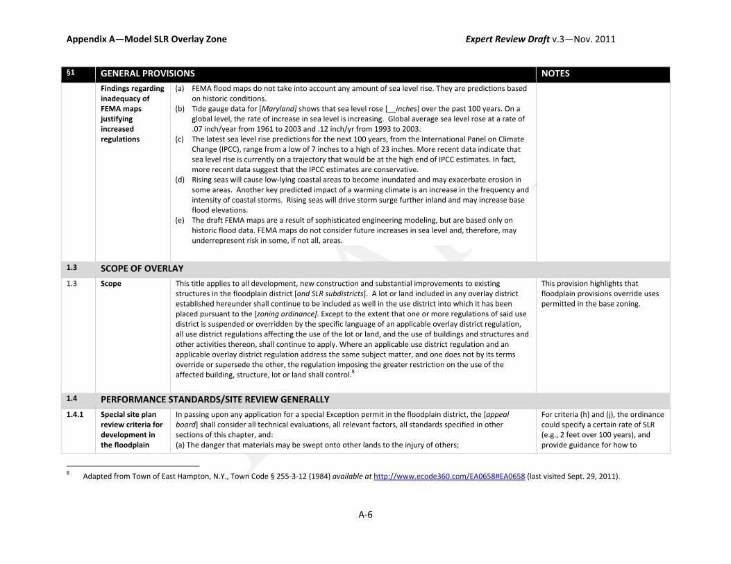
Appendix A—Model SLR Overlay Zone Expert Review Draft v.3—Nov. 2011
A‐6
§1 GENERAL PROVISIONS NOTES
Findings regarding inadequacy of FEMA maps justifying increased regulations
(a) FEMA flood maps do not take into account any amount of sea level rise. They are predictions based on historic conditions.
(b) Tide gauge data for [Maryland] shows that sea level rose [__inches] over the past 100 years. On a global level, the rate of increase in sea level is increasing. Global average sea level rose at a rate of .07 inch/year from 1961 to 2003 and .12 inch/yr from 1993 to 2003.
(c) The latest sea level rise predictions for the next 100 years, from the International Panel on Climate Change (IPCC), range from a low of 7 inches to a high of 23 inches. More recent data indicate that sea level rise is currently on a trajectory that would be at the high end of IPCC estimates. In fact, more recent data suggest that the IPCC estimates are conservative.
(d) Rising seas will cause low‐lying coastal areas to become inundated and may exacerbate erosion in some areas. Another key predicted impact of a warming climate is an increase in the frequency and intensity of coastal storms. Rising seas will drive storm surge further inland and may increase base flood elevations.
(e) The draft FEMA maps are a result of sophisticated engineering modeling, but are based only on historic flood data. FEMA maps do not consider future increases in sea level and, therefore, may underrepresent risk in some, if not all, areas.
1.3 SCOPE OF OVERLAY
1.3 Scope This title applies to all development, new construction and substantial improvements to existing structures in the floodplain district [and SLR subdistricts]. A lot or land included in any overlay district established hereunder shall continue to be included as well in the use district into which it has been placed pursuant to the [zoning ordinance]. Except to the extent that one or more regulations of said use district is suspended or overridden by the specific language of an applicable overlay district regulation, all use district regulations affecting the use of the lot or land, and the use of buildings and structures and other activities thereon, shall continue to apply. Where an applicable use district regulation and an applicable overlay district regulation address the same subject matter, and one does not by its terms override or supersede the other, the regulation imposing the greater restriction on the use of the affected building, structure, lot or land shall control.8
This provision highlights that floodplain provisions override uses permitted in the base zoning.
1.4 PERFORMANCE STANDARDS/SITE REVIEW GENERALLY
1.4.1 Special site plan review criteria for development in the floodplain
In passing upon any application for a special Exception permit in the floodplain district, the [appeal board] shall consider all technical evaluations, all relevant factors, all standards specified in other sections of this chapter, and: (a) The danger that materials may be swept onto other lands to the injury of others;
For criteria (h) and (j), the ordinance could specify a certain rate of SLR (e.g., 2 feet over 100 years), and provide guidance for how to
8 Adapted from Town of East Hampton, N.Y., Town Code § 255‐3‐12 (1984) available at http://www.ecode360.com/EA0658#EA0658 (last visited Sept. 29, 2011).

Appendix A—Model SLR Overlay Zone Expert Review Draft v.3—Nov. 2011
A‐7
§1 GENERAL PROVISIONS NOTES
district
(b) The danger to life and property due to flooding or erosion damage, and the safety of access to the property in times of flood for ordinary and emergency vehicles; (c) The susceptibility of the proposed facility and its contents to flood damage and the effect of such damage on the individual owner; (d) The importance of the services provided by the proposed facility to the community; (e) The necessity to the facility of a waterfront location, where applicable; (f) The availability of alternative locations, not subject to flooding or erosion damage, for the proposed use; (g) The compatibility of the proposed use with existing and anticipated development, and the relationship of the proposed use to the comprehensive plan and floodplain management program for that area; (h) The expected heights, velocity, duration, rate of rise, and sediment transport of the floodwaters and the effects of wave action, if applicable, expected at the site in consideration of [__ feet] of sea level rise over the life of the structure; (i) The costs of providing governmental services during and after flood events including maintenance and repair of public utilities and facilities such as sewer, gas, electrical and water systems, and streets and bridges; 9 and (j) The use of mitigation measures to protect against flood damage on site and protection against flood impacts to adjoining properties, taking into consideration current conditions and the potential for future sea level rise.
determine the life of the structure.
1.4.2 Site plan content The site plan shall include the information listed below. The [permitting authority] may require additional information, if necessary to complete its review. (1) A narrative description of the proposed use or uses of the property. (2) An estimate of the cost of site improvements. (3) A map showing the following information [include information about required scale ( e.g., “prepared at a scale of 1 inch equals 20 feet or such other scale as may be approved by the Planning Board”)]:
(a) Lot size and zoning classification, including any overlay zoning classifications (b) Boundaries of property plotted to scale (c) Proposed uses of the property (d) The nature, location, dimensions, and elevations of all existing and proposed structures
including applicable setback distances and square footage calculations for each use (e) The nature, location, design and elevations of all existing and proposed site improvements
including: refuse storage and disposal; drains and culverts; retaining walls and fences, outdoor storage areas, if any; existing trees of more than 4 inches in diameter
(f) Landscaping plan [including…]
9 Adapted from City of Travelers Rest, S.C., Municipal Code ch. 4.08, § 260 Considerations (2006) available at
http://travelersrestsc.com/municipal_codes/_DATA/TITLE04/Chapter_4_08_FLOOD_DAMAGE_PREV.html#31 (last visited Sept. 30, 2011).
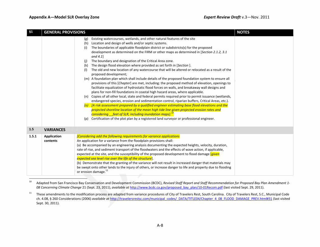
Appendix A—Model SLR Overlay Zone Expert Review Draft v.3—Nov. 2011
A‐8
§1 GENERAL PROVISIONS NOTES
(g) Existing watercourses, wetlands, and other natural features of the site (h) Location and design of wells and/or septic systems. (i) The boundaries of applicable floodplain district or subdistricts(s) for the proposed
development as determined on the FIRM or other maps as determined in [Section 2.1.2, 3.1 and 4.1]
(j) The boundary and designation of the Critical Area zone. (k) The design flood elevation where provided as set forth in [Section ]. (l) The old and new location of any watercourse that will be altered or relocated as a result of the
proposed development; (m) A foundation plan which shall include details of the proposed foundation system to ensure all
provisions of this [Chapter] are met, including: the proposed method of elevation, openings to facilitate equalization of hydrostatic flood forces on walls, and breakaway wall designs and plans for non‐fill foundations in coastal high hazard areas, where applicable.
(n) Copies of all other local, state and federal permits required prior to permit issuance (wetlands, endangered species, erosion and sedimentation control, riparian buffers, Critical Areas, etc.).
(o) [A risk assessment prepared by a qualified engineer estimating base flood elevations and the projected shoreline location of the mean high tide line given projected erosion rates and considering __feet of SLR, including inundation maps].10
(p) Certification of the plot plan by a registered land surveyor or professional engineer.
1.5 VARIANCES
1.5.1 Application contents
[Considering add the following requirements for variance applications An application for a variance from the floodplain provisions shall: (a) Be accompanied by an engineering analysis documenting the expected heights, velocity, duration, rate of rise, and sediment transport of the floodwaters and the effects of wave action, if applicable, expected at the site, and the susceptibility of the proposed development to flood damage [given expected sea level rise over the life of the structure]. (b) Demonstrate that the granting of the variance will not result in increased danger that materials may be swept onto other lands to the injury of others, or increase danger to life and property due to flooding or erosion damage.11
10 Adapted from San Francisco Bay Conservation and Development Commission (BCDC), Revised Staff Report and Staff Recommendation for Proposed Bay Plan Amendment 1‐
08 Concerning Climate Change 21 (Sept. 23, 2011), available at http://www.bcdc.ca.gov/proposed_bay_plan/10‐01Recom.pdf (last visited Sept. 29, 2011).
11 These amendments to the modification process are adapted from variance procedures of City of Travelers Rest, South Carolina. City of Travelers Rest, S.C., Municipal Code ch. 4.08, § 260 Considerations (2006) available at http://travelersrestsc.com/municipal_codes/_DATA/TITLE04/Chapter_4_08_FLOOD_DAMAGE_PREV.html#31 (last visited Sept. 30, 2011).
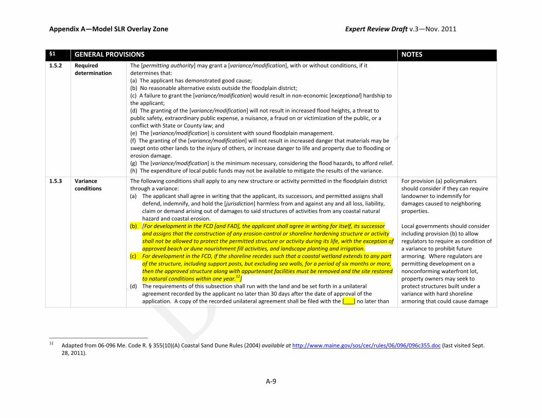
Appendix A—Model SLR Overlay Zone Expert Review Draft v.3—Nov. 2011
A‐9
§1 GENERAL PROVISIONS NOTES
1.5.2 Required determination
The [permitting authority] may grant a [variance/modification], with or without conditions, if it determines that: (a) The applicant has demonstrated good cause; (b) No reasonable alternative exists outside the floodplain district; (c) A failure to grant the [variance/modification] would result in non‐economic [exceptional] hardship to the applicant; (d) The granting of the [variance/modification] will not result in increased flood heights, a threat to public safety, extraordinary public expense, a nuisance, a fraud on or victimization of the public, or a conflict with State or County law; and (e) The [variance/modification] is consistent with sound floodplain management. (f) The granting of the [variance/modification] will not result in increased danger that materials may be swept onto other lands to the injury of others, or increase danger to life and property due to flooding or erosion damage. (g) The [variance/modification] is the minimum necessary, considering the flood hazards, to afford relief. (h) The expenditure of local public funds may not be available to mitigate the results of the variance.
1.5.3 Variance conditions
The following conditions shall apply to any new structure or activity permitted in the floodplain district through a variance: (a) The applicant shall agree in writing that the applicant, its successors, and permitted assigns shall
defend, indemnify, and hold the [jurisdiction] harmless from and against any and all loss, liability, claim or demand arising out of damages to said structures of activities from any coastal natural hazard and coastal erosion.
(b) [For development in the FCD [and FAD], the applicant shall agree in writing for itself, its successor and assigns that the construction of any erosion‐control or shoreline hardening structure or activity shall not be allowed to protect the permitted structure or activity during its life, with the exception of approved beach or dune nourishment fill activities, and landscape planting and irrigation.
(c) For development in the FCD, if the shoreline recedes such that a coastal wetland extends to any part of the structure, including support posts, but excluding sea walls, for a period of six months or more, then the approved structure along with appurtenant facilities must be removed and the site restored to natural conditions within one year.12]
(d) The requirements of this subsection shall run with the land and be set forth in a unilateral agreement recorded by the applicant no later than 30 days after the date of approval of the application. A copy of the recorded unilateral agreement shall be filed with the [___] no later than
For provision (a) policymakers should consider if they can require landowner to indemnify for damages caused to neighboring properties. Local governments should consider including provision (b) to allow regulators to require as condition of a variance to prohibit future armoring. Where regulators are permitting development on a nonconforming waterfront lot, property owners may seek to protect structures built under a variance with hard shoreline armoring that could cause damage
12 Adapted from 06‐096 Me. Code R. § 355(10)(A) Coastal Sand Dune Rules (2004) available at http://www.maine.gov/sos/cec/rules/06/096/096c355.doc (last visited Sept.
28, 2011).
Appendix A—Model SLR Overlay Zone Expert Review Draft v.3—Nov. 2011
A‐10
§1 GENERAL PROVISIONS NOTES
45 days after the date of [___] and the filing of the agreement shall be a prerequisite to the issuance of any building permit.13
to neighboring structures and natural resources. Policymakers should consider whether the state’s Living Shorelines Protection preempts the local government from imposing a condition prohibiting armoring. Local governments should consider including provision (c) to allow regulators to require the removal of structures permitted under a variance. This will provide regulators with a flexible mechanism to allow continued development while ensuring that development will not continue in the future if shoreline changes cause the structure to encroach on public lands. This also will remove the burden from the local government to remove and restore sites that may need to be abandoned as sea levels rise. Policymakers should consider whether a removal condition would be consistent with the CAA grandfathering provisions.
1.5.4 Historic places Variances may be issued for the reconstruction, rehabilitation or restoration of structures listed in the National Register of Historic Places or State Inventory of Historic Places without regard to the procedures set forth in this title; provided, that the activity does not cause an increase in the elevation of the 100‐year flood as established and adopted by this title.14
Local governments need to consider how to integrate new SLR regulations with historic preservation goals. This provision
13 Requirements were adapted from Kaua'i County, Hawaii, County Code, Ordinance 863 Establishing A New Article 27, ch. 8, § 27.7(b) (1987), available at
http://collaborate.csc.noaa.gov/climateadaptation/Lists/Resources/Attachments/12/Kauai_Shoreline_Setback_Bill_Final.pdf (last visited Sept. 28, 2011).
14 From City of Annapolis, Md., Code of Ordinances ch. 17.11 Floodplain Management, § 440 Historic Places (1988) available at http://library.municode.com/index.aspx?clientId=16754&stateId=20&stateName=Maryland (last visited Sept. 29, 2011).

Appendix A—Model SLR Overlay Zone Expert Review Draft v.3—Nov. 2011
A‐11
§1 GENERAL PROVISIONS NOTES
would allow regulators to grant a variance from new SLR regulation for historic structures.
1.6 NONCONFORMITIES
1.6.1 Nonconforming uses and structures
(a) Any nonconforming structure located outside the [coastal high hazard zone] may be reconstructed or structurally altered without conforming to the standards of this [Chapter], provided that such reconstruction or structural alteration does not constitute a substantial improvement. Expansion of nonconforming uses or structures is prohibited. [Alternative: No nonconforming use or structure shall be enlarged, expanded, reconstructed or structurally altered, with the limited exception of a one‐time, ten percent (10%) square footage improvement that may be allowed on the landward side or within the sideyard setback areas of an existing structure. (b) Any substantial improvement to a nonconforming structure or nonconforming use shall be subject to all the regulations of this [Chapter]. The [permitting authority] may, after public notice and hearing, approve the substantial improvement, relocation, or replacement, of a nonconforming structure or use within the floodplain district provided that: (i) The proposed development is in compliance with all the general development standards in the floodplain district and all the specific development standards in any applicable SLR subdistrict; (ii) A nonconforming structure within the coastal high hazard areas that is substantially damaged or destroyed may only be reconstructed in compliance with Section 3.3.5 of this [Chapter]. (c) Any legal nonconforming use of property which existed at the time of the adoption [of the jurisdiction’s Critical Areas Program] may be continued although such use does not conform with the provisions of this [Chapter] (“grandfathered use”). However, such grandfathered use may not be expanded or increased. [Consider adding language requiring that structures supporting a grandfathered use that are destroyed by natural causes be rebuilt to conform to new requirements of the subdistrict.] (d) Uses which are nuisances under common law shall not be permitted to continue as nonconforming uses. [If instituting rebuilding restrictions, consider providing criteria for determining when a nonconforming use becomes a public nuisance.] [May need to include definitions distinguishing nonconforming uses from nonconforming structures. “Nonconforming use means a use of land or structure which does not comply with all regulations for the district(s) in which it is located.” “Non‐conforming structure means a building or structure which does not conform to the requirements for location or dimension of such building or structure in the district in which it is situated as regards to minimum setbacks, maximum building height or maximum building coverage.”]
These provisions attempt to phase out nonconforming uses/structures over time as they become damaged. Standard provisions addressing nonconformities through the zoning ordinance may not be strict enough. Provision (c) allows for continuation of grandfathered uses under the CAA. Provision (d) allows for termination of uses constituting a nuisance. Local governments may be able to terminate uses, even on grandfathered lots, if the use constitutes a public nuisance.

Appendix A—Model SLR Overlay Zone Expert Review Draft v.3—Nov. 2011
A‐12
§2 GENERAL FLOODPLAIN DISTRICT DEVELOPMENT STANDARDS NOTES
2.1 APPLICABILITY
2.1.1 Establishment of floodplain district
A floodplain district is established. It includes the areas in the County subject to inundation by flood waters as determined and delineated by: (a) the Flood Insurance Study and Wave Height Study for [jurisdiction] (b) [other state and local studies]
See notes regarding citation to other studies at Section 2.1.3, below.
2.1.2 Areas included The floodplain district consists of the following areas: (a) “moderate flood hazard areas,” areas designated as zones B or X (shaded) on the flood insurance rate map, which are the areas between the limits of the base flood and the 0.2‐percent‐annual‐chance (or the so called “500‐year flood”). (b) “nontidal 100‐year floodplain,” designated as zones [A_] on the flood insurance rate maps; (c) “approximated floodplain,” designated as zone A on the flood insurance rate maps, and with an approximated boundary because a detailed study has not been performed and water surface elevations have not been provided; (d) “coastal floodplain,” designated as zones [A_] with an elevation number (EL‐) on the flood insurance rate maps and based on detailed study information and profiles; (e) “coastal high hazard areas,” designated within coastal floodplains as zones [V_] with an elevation number (EL‐) on the flood insurance rate maps and subject to inundation by high‐velocity waters and wave action based on a detailed wave height study; and (f) “floodway,” designated as floodway within the 100‐year nontidal floodplain on maps titled “flood boundary and floodway maps”.15
Provision (a) extends all NFIP minimum requirements (so called “floodplain general development standards”) to all new development and redevelopment in the 500‐year floodplain—including freeboard and floodproofing requirements. Local governments should consider how they will establish base flood elevations for newly regulated structures in the 500‐year floodplain.
2.1.3 Establishment of SLR subdistricts
Two SLR subdistricts are established within the floodplain district. It includes the areas in the County subject to impacts from sea‐level rise as determined and delineated by the: (a) Flood Insurance Study and Wave Height Study [for Anne Arundel County, Maryland (Unincorporated Areas), dated November 2, 1982, and the Flood Insurance Study and Wave Height Study for the Town of Highland Beach, Maryland (Incorporated Area), dated April 15, 1982, with accompanying flood insurance rate and floodway maps by FEMA and all subsequent revisions]; or [add studies that would allow regulators to use additional sources of data, such as: (b) Maryland SLR Study (c) SLOSH maps showing surge (d) Critical Areas maps] Subdistricts. The floodplain district shall comprise the following two subdistricts:
Regulators will need to determine how to draw the boundaries for each subdistrict. See list of criteria local governments should consider when drawing boundaries (within the “Applicability” section for each subdistrict, below). Although the state of Maryland has disclaimed their SLR maps as being for “informational purposes,” these maps are the best data available to
15 Adapted from National Flood Insurance Program (NFIP) flood zones definitions. Flood Zones, National Flood Insurance Program (NFIP) Policy Index, Federal Emergency
Management Agency (FEMA) (Aug. 11, 2010), available at http://www.fema.gov/plan/prevent/floodplain/nfipkeywords/flood_zones.shtm (last visited Sept. 29, 2011).
Appendix A—Model SLR Overlay Zone Expert Review Draft v.3—Nov. 2011
A‐13
§2 GENERAL FLOODPLAIN DISTRICT DEVELOPMENT STANDARDS NOTES
(1) “Floodplain Conservation District” [define boundaries] (2) “Floodplain Accommodation District” [define boundaries]
local governments to help them determine their risks. By overlaying various different types of maps, local governments can build a sound evidentiary basis for increasing regulations in some areas. FIRMs demonstrate historical risk of flooding. SLOSH maps show storm surge risks. SLR maps demonstrate future risk of inundation. Critical areas maps show existing uses and areas with sensitive natural resources.
2.2 USES Policymakers will need to determine whether to allow all uses permitted by the base zoning, whether to allow some uses by special exception permit, or whether to downzone the floodplain district to less intense uses and prohibit some uses that would be allowed by the base zoning.
The Critical Areas Act may prohibit downzoning.
2.3 DEVELOPMENT STANDARDS
2.3.1 General standards for development in the floodplain district
All other development in the floodplain district shall be subject to the following general development requirements and any applicable specific develop requirements required by each subdistrict.
This provision retains existing floodplain requirements in all areas and extends the general floodplain requirements to the 500‐year floodplain. Regulators should consider requiring freeboard in these areas, if not already required; and should also consider extending minimum regulations for development in V‐zones to coastal A‐zones (recommended by FEMA).16
16 “Local governments looking to designate a Coastal A Zone should make sure two conditions are met: 1) there should be a water depth sufficient to support waves between
1.5 and 3.0 feet high, and 2) there should be an expectation that wave heights between 1.5 and 3.0 feet will occur during the 1 percent chance storm.” FEMA, CRS Credit for Coastal A Zone Regulations 3, available at http://training.fema.gov/EMIWeb/CRS/430%20CAZ%20CRS%20Credit%20for%20Coastal%20A%20Zones.pdf (last visited Sept. 29, 2011).
Under the CRS, up to 650 credit points are available for local governments that map Coastal A‐zones and regulate these areas based on V‐zone building standards. FEMA, CRS Credit for Coastal A Zone Regulations, at 4.

Appendix A—Model SLR Overlay Zone Expert Review Draft v.3—Nov. 2011
A‐14
§2 GENERAL FLOODPLAIN DISTRICT DEVELOPMENT STANDARDS NOTES
2.3.2 Critical facilities Construction of new or substantially improved critical facilities17 shall be prohibited in coastal high hazard areas. Construction of new or substantially improved critical facilities shall be, to the extent possible, located outside the limits of the special flood hazard area (SFHA) (one hundred‐year floodplain). Construction of new critical facilities shall be permissible within the SFHA if no feasible alternative site is available. Critical facilities constructed within the SFHA shall have the lowest floor elevated [three] feet at or above the level of the base flood elevation [or at or above the approximate five hundred‐year flood elevation] at the site, [whichever is greater]. Floodproofing and sealing measures must be taken to ensure that toxic substances will not be displaced by or released into floodwaters. Access routes elevated to or above the level of the base flood elevation shall be provided to all critical facilities to the extent possible. [Alternative: All new construction of critical facilities shall be elevated to the 500‐year flood elevation or be elevated to the highest known historical flood elevation (where records are available), whichever is greater.]
This provision will prohibit construction of critical facilities in coastal high hazard areas. The ordinance could also extend this provision to prohibit in coastal A‐zones as well. In order to use this provision the ordinance should define “special flood hazard area” and “500‐year flood elevation”. Policymakers may need to provide instruction on how 500‐year flood elevations are to be calculated. Policymakers should consider how these provisions may affect compliance with ADA and historic preservation requirements.
§3 FLOODPLAIN CONSERVATION SUBDISTRICT (FCD) NOTES
3.1 APPLICABILITY
Boundaries [Consider FIRM V‐zones and coastal A‐zones; CAA Resource Conservation Areas; areas with sensitive natural resources and potential for upland migration; areas of high vulnerability to flooding, surge and erosion; consider existing development, potential uses, and likelihood potential for future development; likelihood and potential for hard coastal armoring.]
3.2 USES
Uses [Consider limiting to agricultural, open space or recreational uses and low‐density residential. For more Restricted in Maryland.
17 Critical facility means “Public utility building or facility means a structure, use or land designed and maintained as a public or private utility or service facility which qualifies
as a public service corporation under [state code definition] for the provision of services like gas, electric, telephone, radio, television, water, and sewer or a municipal utility or service facility.” Town of Chatham, Mass., Protective Bylaw, § II(B)(82) (1998) available at http://chathamma.virtualtownhall.net/Public_documents/chathamma_CommDev/Zbylaw.pdf (last visited Sept. 29, 2011).
Appendix A—Model SLR Overlay Zone Expert Review Draft v.3—Nov. 2011
A‐15
§3 FLOODPLAIN CONSERVATION SUBDISTRICT (FCD) NOTES
flexibility, the ordinance could use special permits and site plan review to permit uses allowed under the base zoning]. Only those uses permitted in the respective zoning district and applicable overlays which are consistent with the fragile nature of the area and its high flood risk potential are permitted in the FCD, such as water‐dependent, recreational, conservation, agricultural uses, [and low‐density residential?]. New construction of structures shall require a special use permit. The following uses shall be prohibited: [new construction or substantial improvement of structures with onsite waste disposal; critical facilities; reconstruction of severely damaged structures in coastal high hazard areas; and repair or substantial improvement to severe repetitive loss structures in coastal high hazard areas].18
Local governments may have to allow continuation of uses and allow for development of single family residential structures on lots that pre‐date the CAA, per grandfathering provisions. Where local governments use special permitting processes to permit development, they may not be able to deny permits for grandfathered uses. Additionally, local governments may not be able to prohibit onsite septic on grandfathered lots unless they can show risk of the septic system flooding and causing a public nuisance. Restrictive downzonings, including prohibitions on septic, could result in takings challenges. However, courts in other jurisdiction have upheld restrictive downzonings that prohibited the development of any structures on the grounds of public health and safety threats.19 Additionally, Maryland courts have upheld prohibitions on septic
18 Adapted from Town of Oak Bluffs, Mass., Floodplain Zoning Bylaw, § 8.1.6.2 Prohibited Uses in V and AO Zones (2010), available at http://www.ci.oak‐
bluffs.ma.us/index.cfm/pk/download/id/12645/pid/10463 (last visited Sept. 29, 2011).
19 See Gove v. Zoning Bd. of Appeals of Chatham, 831 N.E.2d 865, 871‐75 (Mass. 2005) (The County downzoned to prohibit development in the 100‐year floodplain on the grounds that development posed risks to adjacent parcels during storm events and posed dangers to rescue personnel during evacuations. The Court found that the regulation was not a taking because it did not prevent all economic use of regulated properties; residual uses included recreational, agricultural, and commercial fishing.).

Appendix A—Model SLR Overlay Zone Expert Review Draft v.3—Nov. 2011
A‐16
§3 FLOODPLAIN CONSERVATION SUBDISTRICT (FCD) NOTES
where installation of septic posed a potential public nuisance.20 Local governments may not need to downzone given strict density limits required in RCA of 1 dwelling unit per 20 acres.
3.3 SPECIAL DEVELOPMENT REGULATIONS FOR THE FCD
3.3.1 Prohibit armoring The construction placement or installation of new shoreline protection structures is prohibited. The repair, reconstruction, or alteration of all lawfully existing shoreline protection structures shall be permitted only upon a showing that such actions would result in the reduction of the size or length of the structure, would provide a public environmental benefit, would not interfere with the littoral transport of sand or other sediment, so as to cause substantial damage to or measureable increase in erosion of the project site or downdrift shoreline, and would not cause the loss of identified habitat for important wildlife, native vegetation, including marine line and marine habitat. Any permit authorizing the repair, reconstruction or alteration of a lawfully existing erosion control structure may be conditioned upon a requirement that the owner remove the structure if it comes to lie seaward of the mean high tide line. The provision of this section shall not apply to erosion control structures which are part of a water‐dependent facility,21 or which are part of a lawfully existing marina or recreation marina in any district.
Local regulation preempted by the Living Shorelines Act. Maryland local governments do not have authority to prohibit armoring, this will be a decision made by MDE under the Living Shorelines Protection Act.
20 See Erb v. Maryland Department of the Environment, 676 A.2d 1017, 1027 (Md. Ct. Spec. App. 1996) (The court found that the denial of a septic permit was not a taking
when expert testimony was provided that if a septic system were installed, it would likely fail. The court found that the land had not been taken for public use; instead, the state restricted land use to prevent a public harm.).
21 "Water‐dependent facilities means: Those structures or accessory buildings associated with maritime, recreational, educational or fisheries activities that require location at or near the shoreline; an activity that cannot exist outside the buffer and is dependent on the water by reason of the intrinsic nature of its operation.”
"Water‐dependent structures (maritime) means those structures or accessory buildings associated with maritime activities involving seafood industrial, in‐water boat storage or marine fabrication use that, in the determination of the Director of Planning and Zoning, require location within one hundred feet of the bulkhead or mean high water line for efficiency of operation.” City of Annapolis, Maryland, Code of Ordinances, ch. 21.54 Critical Area Overlay, § 050(A) (2005), available at http://library.municode.com/index.aspx?clientId=16754&stateId=20&stateName=Maryland (last visited Sept. 28, 2011).

Appendix A—Model SLR Overlay Zone Expert Review Draft v.3—Nov. 2011
A‐17
§3 FLOODPLAIN CONSERVATION SUBDISTRICT (FCD) NOTES
3.3.2 Setbacks/ Buffers
Maximum Practicable Setbacks:
All new construction and substantial improvement of any structure shall be setback as far landward or upland on the lot as practicable,22 whichever maximizes protection from flooding and erosion, as determined by the [permitting authority] given shoreline setback requirements and site limitations; no lot shall have a shoreline setback of less than [120] feet [to establish a setback to allow for the landward migration of the Critical Areas buffer.]
This will likely require a body vested with discretionary authority (such as OAH or BZA) to review and determine what is “practicable”. This provision extends the 100‐foot buffer required by the CAA to 120 feet to allow room for upland migration of coastal resources where sea levels rise. However, policymakers should consider the average lot sizes of waterfront lots to determine whether a 120 foot minimum setback will allow sufficient buildable space.
Fixed Setback: [Require 120 feet minimum setback to provide room for inland migration of Critical Area buffer as seas rises and to minimize potential for nonconformities to arise as structures come to encroach on the buffer as it erodes.]
Erosion Based Setback:
All new construction and substantial improvement of structures shall be setback in accordance with the shoreline setback requirements; no lot shall have a shoreline setback of less than 120 feet, [with the exception of water‐dependent uses, such as elevated boardwalks] “Shoreline setback” means a distance measured landward from mean high tide line to the recession line that would be established by multiplying the long‐term annual erosion rate times [60], provided that, where there has been no long‐term erosion or the rate is less than two feet per year, this distance shall be set at a minimum of 120 feet landward from the mean high tide line. For the purposes of this chapter, the erosion rates shall be those set forth in tables entitled [use historic erosion rates compiled by the Maryland Geological Survey and available through the state’s Coastal Atlas website]”23
This may be easier to administer than a maximum practicable setback so long as erosion rates are clearly defined for the area. Applicants can merely apply the formula to determine the necessary setback and the DPZ can confirm through a ministerial site plan review. Policymakers should consider whether there is sufficient data to implement an erosion based setback and whether staff has sufficient administrative and technical capacity.
22 “Practicable” means “available and feasible considering cost, existing technology and logistics based on the overall purpose of the project.” Adapted from 06‐096 Me. Code
R. § 355(3)(CC) Coastal Sand Dune Rules (2004) available at http://www.maine.gov/sos/cec/rules/06/096/096c355.doc (last visited Sept. 28, 2011).
23 COASTAL ATLAS: SHORELINES, MARYLAND DEPARTMENT OF NATURAL RESOURCES, http://www.dnr.state.md.us/ccp/coastalatlas/shorelines.asp (last visited Sept 26, 2011).
Appendix A—Model SLR Overlay Zone Expert Review Draft v.3—Nov. 2011
A‐18
§3 FLOODPLAIN CONSERVATION SUBDISTRICT (FCD) NOTES
Regulators may want to exempt and define water‐dependent uses.
3.3.3 Size and height limits No structure greater than [35 feet] in height or covering a ground area greater than [2,500 square feet] may be constructed in the FCD. An existing structure may be elevated on a post or pile foundation to exceed [35 feet] for the sole purpose of meeting the elevation requirements of this section. When determining the height of the building, the measurement is taken from the existing, lowest natural elevation within the structure’s footprint if the lot is undeveloped, the lowest natural elevation measured 5 feet from the corners of an existing structure’s foundation, or the elevation used by the municipality when determining compliance with local ordinances.24
Size and height limits are designed to make it easier to relocate structures and to reduce potential harms to people, collateral damage to adjacent structures, and economic disruption. Even where regulators have to permit redevelopment of storm‐damaged structures that could require that structures be rebuilt to a smaller footprint by requiring that they comply new size and height limits.
3.3.4 Freeboard To allow for the movement of sand and water and future shoreline changes, all new construction and substantial improvements to existing structures (except accessory structures) shall have the lowest portion of the structural members of the lowest floor constructed on a post25 or piling foundation, and be elevated [three feet] above the base‐flood elevation. The post or piling foundation may be enclosed with latticework or other similar material through which water, wind and sand can easily move.26
Maryland currently requires 1 foot of freeboard in non‐tidal floodplains. The State’s Adaptation Plan recommends a two or more foot freeboard requirement in tidally influenced floodplains.27
24 Adapted from 06‐096 Me. Code R. § 355(5)(D) Coastal Sand Dune Rules (2004) available at http://www.maine.gov/sos/cec/rules/06/096/096c355.doc (last visited Sept. 28,
2011).
25 “Posts” means “any pilings or column support that allows water and sand to move freely underneath the structure, and that is adequate to provide a foundation for the structure it supports. The term "posts" does not include frost walls or breakaway foundation construction.” Adapted from 06‐096 Me. Code R. § 355(3)(BB) Coastal Sand Dune Rules (2004) available at http://www.maine.gov/sos/cec/rules/06/096/096c355.doc (last visited Sept. 28, 2011).
26 Adapted from 06‐096 Me. Code R. § 355(6)(G) Coastal Sand Dune Rules (2004) available at http://www.maine.gov/sos/cec/rules/06/096/096c355.doc (last visited Sept. 28, 2011).
27 Md. Comm’n on Climate Change Adaptation and Response Working Group, Comprehensive Strategy for Reducing Maryland’s Vulnerability to Climate Change Phase I: Sea‐level Rise and Coastal Storms, ch. 5 at 13 (2008) [hereinafter MD Comprehensive Strategy].
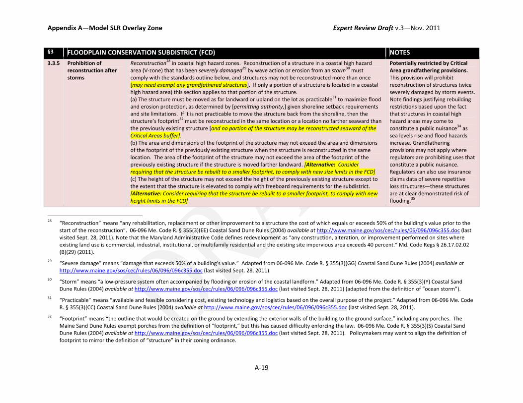
Appendix A—Model SLR Overlay Zone Expert Review Draft v.3—Nov. 2011
A‐19
§3 FLOODPLAIN CONSERVATION SUBDISTRICT (FCD) NOTES
3.3.5 Prohibition of reconstruction after storms
Reconstruction28 in coastal high hazard zones. Reconstruction of a structure in a coastal high hazard area (V‐zone) that has been severely damaged29 by wave action or erosion from an storm30 must comply with the standards outline below, and structures may not be reconstructed more than once [may need exempt any grandfathered structures]. If only a portion of a structure is located in a coastal high hazard area) this section applies to that portion of the structure. (a) The structure must be moved as far landward or upland on the lot as practicable31 to maximize flood and erosion protection, as determined by [permitting authority,] given shoreline setback requirements and site limitations. If it is not practicable to move the structure back from the shoreline, then the structure’s footprint32 must be reconstructed in the same location or a location no farther seaward than the previously existing structure [and no portion of the structure may be reconstructed seaward of the Critical Areas buffer]. (b) The area and dimensions of the footprint of the structure may not exceed the area and dimensions of the footprint of the previously existing structure when the structure is reconstructed in the same location. The area of the footprint of the structure may not exceed the area of the footprint of the previously existing structure if the structure is moved farther landward. [Alternative: Consider requiring that the structure be rebuilt to a smaller footprint, to comply with new size limits in the FCD] (c) The height of the structure may not exceed the height of the previously existing structure except to the extent that the structure is elevated to comply with freeboard requirements for the subdistrict. [Alternative: Consider requiring that the structure be rebuilt to a smaller footprint, to comply with new height limits in the FCD]
Potentially restricted by Critical Area grandfathering provisions. This provision will prohibit reconstruction of structures twice severely damaged by storm events. Note findings justifying rebuilding restrictions based upon the fact that structures in coastal high hazard areas may come to constitute a public nuisance34 as sea levels rise and flood hazards increase. Grandfathering provisions may not apply where regulators are prohibiting uses that constitute a public nuisance. Regulators can also use insurance claims data of severe repetitive loss structures—these structures are at clear demonstrated risk of flooding.35
28 “Reconstruction” means “any rehabilitation, replacement or other improvement to a structure the cost of which equals or exceeds 50% of the building’s value prior to the
start of the reconstruction”. 06‐096 Me. Code R. § 355(3)(EE) Coastal Sand Dune Rules (2004) available at http://www.maine.gov/sos/cec/rules/06/096/096c355.doc (last visited Sept. 28, 2011). Note that the Maryland Administrative Code defines redevelopment as “any construction, alteration, or improvement performed on sites where existing land use is commercial, industrial, institutional, or multifamily residential and the existing site impervious area exceeds 40 percent.“ Md. Code Regs § 26.17.02.02 (B)(29) (2011).
29 “Severe damage” means “damage that exceeds 50% of a building's value.” Adapted from 06‐096 Me. Code R. § 355(3)(GG) Coastal Sand Dune Rules (2004) available at http://www.maine.gov/sos/cec/rules/06/096/096c355.doc (last visited Sept. 28, 2011).
30 “Storm” means “a low‐pressure system often accompanied by flooding or erosion of the coastal landform.” Adapted from 06‐096 Me. Code R. § 355(3)(Y) Coastal Sand Dune Rules (2004) available at http://www.maine.gov/sos/cec/rules/06/096/096c355.doc (last visited Sept. 28, 2011) (adapted from the definition of “ocean storm”).
31 “Practicable” means “available and feasible considering cost, existing technology and logistics based on the overall purpose of the project.” Adapted from 06‐096 Me. Code R. § 355(3)(CC) Coastal Sand Dune Rules (2004) available at http://www.maine.gov/sos/cec/rules/06/096/096c355.doc (last visited Sept. 28, 2011).
32 “Footprint” means “the outline that would be created on the ground by extending the exterior walls of the building to the ground surface,” including any porches. The Maine Sand Dune Rules exempt porches from the definition of “footprint,” but this has caused difficulty enforcing the law. 06‐096 Me. Code R. § 355(3)(S) Coastal Sand Dune Rules (2004) available at http://www.maine.gov/sos/cec/rules/06/096/096c355.doc (last visited Sept. 28, 2011). Policymakers may want to align the definition of footprint to mirror the definition of “structure” in their zoning ordinance.

Appendix A—Model SLR Overlay Zone Expert Review Draft v.3—Nov. 2011
A‐20
§3 FLOODPLAIN CONSERVATION SUBDISTRICT (FCD) NOTES
(d) If any part of the previously existing structure was located in a coastal high hazard area, then the structure must be designed and configured to minimize or eliminate the footprint’s intrusion into the coastal high hazard to the extent practicable, as determined by the [OAH] given setbacks and site limitations. (e) A severely damaged structure located within the coastal high hazard area that is reconstructed completely outside the coastal high hazard area pursuant to this section is eligible for further reconstruction after subsequent severe damage by wave action from an ocean storm, should it occur.33 [Consider also including a removal condition. Permitting authority could require as a condition of a rebuilding permit that structures be removed if they come to be located seaward of the MHTL. See conditions to variance at section 1.5.3, above]
The Maine Dune Rules use “severe damage” which is effectively the same as “substantial damage.” The ordinance could define “severe damage” to require a higher threshold than 50 percent, thus limiting the application of the prohibition to structures that are essentially destroyed. Non‐storm damaged structures would be governed by general provisions addressing redevelopment of nonconformities. These provisions may be politically difficult to implement. The ordinance could mitigate economic impacts on property owners by pairing regulations with tax incentives and acquisition programs. Policymakers also need to consider the short‐term loss of
34 May consider including general provision authorizing zoning administrator to declare a previously permitted use as a nuisance and require abatement. See e.g., From City
of Annapolis, Md., Code of Ordinances ch. 17.11 Floodplain Management, § 490 Nuisance (1988) available at http://library.municode.com/index.aspx?clientId=16754&stateId=20&stateName=Maryland (last visited Sept. 29, 2011) (“Nuisance. A structure constructed, reconstructed, enlarged, altered or relocated in noncompliance with this chapter may be declared by the director to be a public nuisance and subsequently abated as a public nuisance.”)
35 “Severe Repetitive Loss Structure” means a residential property that is covered under an NFIP flood insurance policy and: (a) That has at least four NFIP claim payments (including building and contents) over $5,000 each, and the cumulative amount of such claims payments exceeds $20,000; or (b) For which at least two separate claims payments (building payments only) have been made with the cumulative amount of the building portion of such claims exceeding the market value of the building. For both (a) and (b) above, at least two of the referenced claims must have occurred within any ten‐year period, and must be greater than 10 days apart. 42 U.S.C. § 4102a (2004); Severe Repetitive Loss Program, FEMA, (Jun. 1, 2011) available at http://www.fema.gov/government/grant/srl/ (last visited Sept. 29, 2011).
33 Adapted from 06‐096 Me. Code R. § 355(6)(E) Coastal Sand Dune Rules (2004) available at http://www.maine.gov/sos/cec/rules/06/096/096c355.doc (last visited Sept. 28, 2011).

Appendix A—Model SLR Overlay Zone Expert Review Draft v.3—Nov. 2011
A‐21
§3 FLOODPLAIN CONSERVATION SUBDISTRICT (FCD) NOTES
tax base when prohibiting redevelopment, but this loss could be offset by allowing for increased densities in upland areas of the community.
§4 FLOODPLAIN ACCOMMODATION SUBDISTRICT (FAD) NOTES
4.1 APPLICABILITY
Boundaries [Consider enhancing regulations in SFHA (100 year floodplain); CAA Limited Development Areas; consider feasibility/likelihood of armoring; extent of existing development and potential for future development (what is current zoning?); proximity of critical infrastructure; natural resource values; vulnerability to flooding, surge and erosion.]
4.2 USES
Uses All uses permitted in the respective zoning district and applicable overlays shall be permitted in the FAD, [consider prohibiting critical facilities. with the exception of critical facilities which shall be prohibited].
This would allow uses permitted under the base zoning with the exception of critical facilities. Policymakers should consider the effect on the community of prohibiting critical facilities in the FAD. Policymakers could consider using site plans to review and mitigate SLR impacts for higher intensity or density uses. An express prohibition of critical facilities may not be necessary where a policymakers choose to regulate critical facilities under the general development standards described in Section 2.3.2, above.
4.3 SPECIAL DEVELOPMENT REGS
4.3.1 Setbacks/Buffers Could apply similar setbacks as those specified in FCD for waterfront property (erosion based) or maintain fixed 120 foot setback to provide room for inland migration of CAA buffer.
4.3.2 Elevation The floor level of any structure used for human occupancy shall be not less than [three feet] above the base flood elevation.
The ordinance may need to specify how to calculate BFE where they are

Appendix A—Model SLR Overlay Zone Expert Review Draft v.3—Nov. 2011
A‐22
§4 FLOODPLAIN ACCOMMODATION SUBDISTRICT (FAD) NOTES
[Potentially exempt structures that must maintain accessibility for disabled persons pursuant to the ADA and properties subject to historic preservation requirements, but require these structures to employ floodproofing techniques, where feasible].
not provided on the FIRM. See definition of floodproofing at Section 4.4.4, below.
4.3.3 Septic Onsite waste disposal shall not be installed in areas that would subject to inundation in the event of coastal flooding to [2 feet] elevation above mean sea level. Leach field drain tiles shall be not less than [200 horizontal feet] inland from elevation above mean sea level, irrespective of groundwater elevation. [Alternative: Any sanitary disposal facility shall require permit from the Board of Health before installation, and shall be located at least two hundred feet from any water body.]
The ordinance may need to define onsite waste disposal. The Oak Bluffs code also includes provisions requiring siting of facility away from water supply and allowing for variance by Board of Health.
4.4.4 Floodproofing Nonresidential structures exempt from elevation requirements shall be dry‐floodproofed to not less than [three feet] above the base flood elevation for the applicable subdistrict as specified by the U.S. Army Corps of Engineers in its publication EP1165 2 314 entitled "Flood‐proofing Regulations."
4.4.5 Limitations on structure size and footprint
No structure greater than [__ feet] in height or covering a ground area greater than [___ square feet] may be constructed in the FCD. An existing structure may be elevated on a post or pile foundation to exceed [__ feet] for the sole purpose of meeting the elevation requirements of this section. When determining the height of the building, the measurement is taken from the existing, lowest natural elevation within the structure’s footprint if the lot is undeveloped, the lowest natural elevation measured 5 feet from the corners of an existing structure’s foundation, or the elevation used by the municipality when determining compliance with local ordinances.36
May adjust heights and square footage consistent with local policies.
4.4.6 Erosion control structures (preference for living shoreline protection)
When such measures can effectively and practically reduce or prevent shoreline erosion, the use of nonstructural shore protection measures shall be encouraged to conserve and protect plant, fish and wildlife habitat. The following criteria shall be followed when selecting shore erosion protection practices: nonstructural practices shall be used whenever possible; structural measures shall be used only in areas where nonstructural practices are impractical or ineffective; where structural measures are require, the measure that best provides for the conservation of fish and plant habitat and which is practical and effective shall be used; if significant alteration of the characteristics of the shoreline occurs, the measure that best fits the change may be used for sites in that area; [consider adding requirement that structural measures be designed to protect development in consideration of certain degree of SLR: the design of structural measures shall consider maximum wave height given 2 feet of sea level rise].37
Local regulation preempted by the Living Shorelines Act. This measure cannot be implemented at a local‐level in Maryland because decisions about armoring will be made at a state‐level by MDE under the Living Shorelines Protection Act.
36 Adapted from 06‐096 Me. Code R. § 355(5)(D) Coastal Sand Dune Rules (2004) available at http://www.maine.gov/sos/cec/rules/06/096/096c355.doc (last visited Sept. 28,
2011).From ME Sand Dune Rules p. 8.
37 Adapted from Town of East Hampton, N.Y., Town Code § 255‐5‐51 (2007) available at http://www.ecode360.com/EA0658#EA0658 (last visited Sept. 29, 2011).

APPENDIX B
ROAD MAP INCORPORATION SLR INTO TEST JURISDICTION’S LAND‐USE FRAMEWORKS
Expert Review Draft—November 2011
1. INTRODUCTION
We tested the model SLR ordinance in two Maryland jurisdictions, Anne Arundel County and the City of Annapolis, to analyze how the model provisions could be integrated into existing zoning frameworks. Below we provide a brief background on zoning provisions in the test jurisdictions and describe how each jurisdiction’s ordinance may have to change to accommodate new SLR regulations.
Rather than create a whole new overlay, this model ordinance proposes that the jurisdictions amend their existing Floodplain zones. To ensure the jurisdictions maintain compliance with the NFIP, the model leaves in place the general development standards for the floodplain district. To ensure increased protection from SLR impacts, the model calls for two key amendments to existing flood zones. First, it extends the boundaries of the “floodplain district” by redefining the boundaries to include the 500‐year floodplain. This will require that all new development and redevelopment in the 500‐year floodplain meet minimum NFIP development standards. Second, the amendments create two special SLR subdistricts designed to enhance regulations based upon two adaptation goals: a Floodplain Accommodation District (accommodate development) and a Floodplain Conservation District (preserve natural resources). This will give regulators flexibility to impose different regulations based upon what is at risk in each area and the community’s goals for how to address the threats. The Floodplain Conservation district is designed to protect natural resources and gradually phase out higher density development in these areas. The Floodplain Accommodation District is an enhanced floodplain district; special development standards apply to require that structures be built to be more resilient to impacts (including higher freeboard, increased setbacks, etc.).
Because a SLR overlay zone will superimpose regulations on top of the existing zoning, lawmakers will need to (1) ensure that development standards in the SLR overlays are consistent with or more restrictive than the standards required by the other applicable zones, and (2) determine whether they want to restrict uses in the SLR subdistricts that would be permitted by right in other zones.
2. ANNE ARUNDEL COUNTY
Anne Arundel County (AAC) has a much easier road to implementing adaptation measures than Annapolis, because the County is relatively sparsely developed and most of its coastal areas are limited to residential and martime uses. Seventy percent of AAC’s land area is designated as low‐ to medium‐density residential, rural, open space, or environmental preservation areas.1
1 Anne Arundel County, General Development Plan 27 (Oct. 19, 2009), available at
http://www.aacounty.org/PlanZone/Resources/GDP2009.pdf (last visited Sept. 29, 2011) [hereinafter Development Plan].

Appendix B—Roadmap for Test Jurisdictions Expert Review v.3—Nov. 2011
B‐2
a. Local Roles and Responsibilities
AAC is a charter county governed by Article 25A of the Maryland Code. The AAC charter vests legislative authority to enact zoning ordinances with the County Council,2 and authority to administer the zoning ordinances with the County Executive.3 The County Council must adopt the comprehensive plan, enact the zoning ordinance and any comprehensive rezonings. 4 The County Council will therefore have to enact any rezonings to address SLR. Under the authority of the County Executive, the Office of Planning and Zoning (“OPZ”)5 and the Office of Administrative Hearings (“OAH”) are the primary actors in executing and enforcing the zoning ordinance.6 The OPZ is the administrative body—it makes recommendations to the Council to help them decide on zoning amendments and comprehensive plans,
and ministerially issues permits that require no exercise of discretion (permitted by right uses). 7 The charter delegates to OAH the authority to make discretionary decisions to grant or deny requests for special exceptions, variances, and rezonings through a public hearing.8 The Board of Appeals hears appeals of decisions made by OPZ and OAH, as required by Article 25A.9
b. AAC’s Zoning Generally
Anne Arundel County has a zoning ordinance that establishes the rules for its base zones, including residential, commercial, industrial, maritime, and mixed‐use zones.10 The zoning ordinance establishes the development standards for each zone (e.g., bulk, size, height limitations) and lists the type of uses and special uses that will be permitted in each zone. Much of lands vulnerable to impacts in AAC are currently zoned for residential, maritime, or natural feature uses. As a result AAC is less densely developed than Annapolis and it may be more feasible to implement retreat measures.
The County also employs special development regulations through overlay zones. Five of AAC’s overlay zones may overlap with new SLR subdistricts, including the Critical Areas overlay (Title 13), Bog Protection overlay (Title 14—Subtitle 1), Erosion and Sediment Control overlay (Article 16—Title 3), and Stormwater Management overlay (Article 16—Title 4).
For each proposed new SLR policies, we discuss how each policy will be integrated with these existing regulations, and any potential amendments that could be required to harmonize the different approaches.
2 Anne Arundel County, Md., charter art. III, § 306 (2005).
3 Anne Arundel County, Md., charter art. IV, § 405(a) (2005).
4 Anne Arundel County, Md., charter art. V, § 531 (2005).
5 Anne Arundel County, Md., charter art. V, §§ 530‐31 (2005).
6 Anne Arundel County, Md., charter art. V, § 535 (2005).
7 Anne Arundel County, Md., charter art.. V, § 531 (2005). The zoning code consists of the zoning map and zoning rules and
regulations. Anne Arundel County, Md., charter art.. V, § 531 (2005).
8 Anne Arundel County, Md., charter art.. V, § 535(a)‐(b) (2005).
9 Md. Code Ann., art. 25A(U) (2001); Anne Arundel County, Md., charter art. VI, § 602(b) (2005).
10 Anne Arundel County, Md., Code of Ordinances, art. 18 Zoning (2005).

Appendix B—Roadmap for Test Jurisdictions Expert Review v.3—Nov. 2011
B‐3
c. AAC’s Floodplain Ordinance
This model proposes amendments to AAC’s Floodplain Management overlay at Article 16—Title 2 of the Anne Arundel County Code.
i. Purpose/Findings
The model proposes that the County add a section to the floodplain ordinance describing the purposes and findings that justify new regulations, including, threats to the County from SLR, erosion‐rates and the need for erosion‐based or maximum practicable setbacks, and the insufficiency of FEMA floodmaps.
ii. Redefine Floodplain Boundaries
The model proposes that the County create a general “Floodplain District” encompassing all lands susceptible to flooding including the 100‐year floodplain and extending the boundaries to include the 500‐year floodplain. The model proposes that the County leave in place existing development standards within the entire Floodplain District. This will ensure that all development, now including development in the 500‐year floodplain, meet NFIP minimum standards, and will ensure that the County maintains compliance with the NFIP. Then the model proposes that the County create two special subdistricts (a Floodplain Accommodation District, and a Floodplain Conservation District) within the floodplain district to create flexible mechanisms increase regulations in two areas especially vulnerable to impacts.
Amend Section 16‐2‐103. To extend boundaries to include the 500 year floodplain, ACC will need to amend provisions “establishing the floodplain district” to strike reference to the “100‐year flood”, and to add to the 500‐year floodplain to the definition “areas included” in the floodplain district (Section 16‐2‐103(b)). The 500‐year flood plain is defined as “moderate flood hazard areas,” areas designated as zones B or X (shaded) on the flood insurance rate map, which are the areas between the limits of the base flood and the 0.2‐percent‐annual‐chance (or so called “500‐year flood”) on the flood insurance rate map.
In order to regulate in these areas, policymakers should consider how to calculate base‐flood elevations in these areas to determine building elevation requirements. Additionally, they should consider how extending floodplain regulations to these previously unregulated areas will affect critical facilities, historic properties, and properties subject to ADA requirements, such as government facilities, health care facilities, and shopping centers. Policymakers may need to provide exemptions for these properties allowing for floodproofing measures rather than elevation.
Additionally, to extend and redefine the floodplain district in this manner will require action by the County Council. Section 16‐2‐103(c) of the floodplain ordinance limits OPZ’s authority to “revise delineation of the floodplain district only in compliance with NFIP and the requirements of the State and only when there are changes through natural or other causes as indicated by detailed hydrologic and hydraulic studies.”11 This provision would prohibit OPZ from redefining the floodplain boundaries, but the County Council, as a legislative body with broad power to regulate for the health, safety, and welfare of the community, could redefine the floodplain district boundaries as a legislative act.
Add Section 16‐2‐103(g) to establish SLR subdistricts. To enhance regulations while creating a flexible framework, the model proposes that the County establish two SLR subdistricts. To determine the boundaries for the subdistrict, the County could cite to the Flood Insurance Rate Maps, Maryland Sea‐Level Rise Maps, SLOSH maps showing storm surge impacts, Critical Areas maps showing locations of existing low‐ and high‐intensity development and sensitive natural resources. Planners will need to
11 Anne Arundel County, Md., Code of Ordinances, art. 16, § 2‐103(c) (2005).
Appendix B—Roadmap for Test Jurisdictions Expert Review v.3—Nov. 2011
B‐4
determine how to define the boundaries for each subdistrict based upon the considerations listed in this report and the community’s adaptation goals. Within each of these subdistricts, the model proposes that the County apply special development standards including the policies below.
iii. General Development Standards
Redefine Section 16‐2‐202 as “General Development Requirements in the Floodplain District.” The model proposes that the County maintain its current development standards for all properties within the floodplain district. Section 16‐2‐202 standards will apply to all development in the entire floodplain district, including the 500‐year floodplain. By maintaining these general development standards, the County can ensure that it maintains compliance with the NFIP, while enhancing regulations in limited, highly vulnerable areas of the floodplain.
Add provisions regarding Critical Facilities. The model proposes that the County prohibit critical facilities in coastal high hazard areas (V‐zones and potentially coastal A‐zones), and require that critical facilities in the SFHA be elevated 3 feet or at or to the 500‐year flood elevation.
iv. Uses
In each subdistrict the County will need to determine whether it wants to continue to allow uses that are permitted by the base‐zoning and the Critical Areas Overlay, or whether it wants to downzone (prohibit uses or require a special exception use permit for uses that would otherwise by permitted by right in the base zone). In Anne Arundel County, some uses are permitted by right but require compliance with additional regulations based upon the particular use (called conditional use permits).12 AAC also has a “special exception permitting process” by which special uses can be permitted in a zone, but they require special documentation and must go through a discretionary site plan review process. Special exception permits are reviewed by the OAH, who has the authority to grant, deny, or condition special exception permits through a public hearing.13
The model proposes that in the FCD, the County consider allowing only low‐intensity uses such as open space, agricultural and recreational uses. The County could allow for low‐density residential (which would be consistent with the CAA’s RCA density limits). The County could also require that all uses requiring development of structures obtain a special exception permit. Through the special exception permitting process, the County could require a detailed site plan demonstrating how the development would be affected by a given level of SLR over the life of the structure. The site plan could be used by the OAH to require conditions that the development be sited and built to be more resilient to impacts. The County should consider impacts to lots grandfathered under the Critical Areas Act. The County must permit lots that were legally recorded prior to enactment of AAC’s Critical Areas Program to build one
12 The terms conditional use permit and special exception permits are sometimes used interchangeably, however they
appear to be slightly distinct in their application in Maryland. Conditional use permits are ministerial—where the applicant demonstrates compliance with the base‐zoning and the special conditional requirements spelled out in the zoning ordinance, the permitting authority must grant the permit. Special exception permits are more discretionary—the permitting authority can evaluate the project and has broader discretion to deny, condition or approve a permit based upon consideration of the project’s compliance with subjective criteria listed in the ordinance. Because the process is more discretionary, the permitting authority is required to hold a public hearing and provide notice, and the permitting authority must make specific findings on the record of the projects compliance with specific criteria required under the ordinance. In charter counties in Maryland the OPZ can issue conditional use permits; whereas special exception permits must be issued by OAH and require a public hearing. See Annapolis Road, Ltd. v. Anne Arundel County, 686 A.2d 727, 741 (Md. Ct. Special Appeals 1996).
13 Anne Arundel County, Md., charter art. V, § 535(a)‐(b) (2005) (The OAH also has authority to grant or deny requests for rezonings and variances through a public hearing process.).
Appendix B—Roadmap for Test Jurisdictions Expert Review v.3—Nov. 2011
B‐5
single family residence, even if the lot does not meet the density requirements of the RCA. Therefore, the County may not be able to downzone these lots.
The County should also consider its Managed Growth Areas, designated under the Smart Growth Areas Act. Several of the communities slated for growth or maintenance of existing development include communities that are highly vulnerable to impacts including Deale, Churchton, Shady Side, Beverly Beach, Mayo, and Highland Beach.14
v. Special Development Standards
Add Section 16‐2‐206 Establishing Special Development Standards for Development in the SLR Subdistricts. The model proposes that the County create two SLR subdistricts where special development standards will apply.
Setbacks: This model proposes that the County employ either maximum practicable setbacks or erosion‐based setbacks for waterfront properties. In no instance should the setback be less than the 100‐foot buffer required by the Critical Areas Act. However, local governments may want to consider requiring increased setbacks to allow for the buffer to migrate inland as the sea levels rise. As the shoreline is eroded away, structures will come to encroach on the Critical Areas buffer, which will create nonconformities that the County will need to address when these structures are substantially improved.
In the FCD, the model proposes that the County establish maximum practicable setbacks that require structures to be setback as far landward or upland on the lot to maximize flood protections. Maximum practicable setbacks will provide regulators with flexibility to address siting on a case‐by‐case basis. However, this may require discretionary review by the OAH and may require a public hearing. The County should consider whether they have the administrative capacity to undertake a site‐specific analysis of all development permits in the FCD.
In the FAD, the model proposes that the County use an erosion‐based “flood protection setback.” The setback is measured from the mean high tideline and must extend back 60 times the average annual erosion rate. The minimum setback distance is established at 120 feet where there is no documented erosion rate or where application of the erosion‐based shoreline setback would prevent development. The model uses the factor 60 as recommended by the National Academy of Science, however, policymakers may want to consider average lot sizes of waterfront lots in the County to ensure that application of the shoreline setback will not render lots unbuildable.
Additionally, the County may want to consider amending the waterfront provisions within Subtitle 4 of the Zoning Ordinance. These provisions establish a waterfront setback that “approximates the average front yard setbacks” of abutting lots.15 While this may maintain consistency of lot setbacks, it may not provide sufficient flood protection for waterfront lots. Therefore, the County may want to consider adding a provision that requires application of the most restrictive setback requirements: “Where the requirements of this section are in conflict with any other provisions of this ordinance (including the floodplain ordinance and critical area overlay), the more restrictive requirements shall apply.”
Size Height Limits: Most of the areas that would be affected by new SLR regulations are currently zoned residential or maritime. Structures in residential zones can typically build to 35 or 45 feet and can cover between 25 to 45 percent of the lot depending on the zones designation (Residential Low Density to R‐22). This model proposes that the County apply the lowest development standards to properties in the
14 Development Plan, at 17, 123‐29.
15 Anne Arundel County, Md., Code of Ordinances, art. 18, § 2‐401 to 404 (2005).
Appendix B—Roadmap for Test Jurisdictions Expert Review v.3—Nov. 2011
B‐6
SLR subdistricts, including a maximum footprint of 2,500 square feet, maximum lot coverage of 20 percent, and a maximum height of 35 feet.
Septic: The model does not propose any specific regulations for septic because septic design requires technical consideration of topography, hydrology, groundwater elevations, geological conditions, location of surface waters, and flooding. The background report considers different options that local governments can consider for “adapting” septic in vulnerable areas, but these options require additional consideration technical, administrative and legal constraints. Local governments may want to consider extending or requiring maximum practicable setbacks from water bodies. The County may also want to include a definition of “onsite waste disposal”—the term is used through the ordinance but is not defined.
Freeboard: Amend Section 16‐1‐101(44) definition of “flood protection elevation”. Currently, the County applies a one‐foot freeboard requirement in SFHAs, through its definition of flood protection elevation. The model proposes that the County raise freeboard requirements in the FAD and FCD. Under a conservative estimate the state is anticipating 2.7 to 3.4 feet of SLR over the next century. This will increase base flood elevations and drive flooding further inland. The model would require that all new construction and redevelopment within the 500‐year floodplain incorporate one foot freeboard. Local governments may need to consider how they will calculate base flood elevations in these newly regulated areas; base flood elevations for these areas are likely not calculated on the County’s FIRM. Additionally, the model proposes that the County require increased freeboard in the FAD and FCD to 3 feet. Higher elevations may be justified in the FCD because these areas will comprise V‐zones that are more highly vulnerable due to wave action and storm surge. Therefore, a more precautionary elevation requirement would be justified in these areas. To create different freeboard requirements the County will need to amend the definition of “flood protection elevation” at Section 16‐1‐101(44). The model proposes that the ordinance define “flood protection elevation” as the elevation of the 100‐year flood plus applicable freeboard requirements. This will allow the County to set different freeboard requirements for different zones.
Rebuilding Restrictions: The model proposes that the County prohibit reconstruction of structures that are damaged two times by storm events. If the county employs this measure it should determine whether it needs to exempt grandfathered structures built before enactment of the local Critical Areas program. The County will need to revisit how it terminates nonconforming uses destroyed by natural causes, discussed below. It may also need to include definitions for reconstruction, storm event, severe damage, practicable, and footprint. Policymakers should also consider any potential ambiguities or conflict between the terms structure, building, and footprint.
d. AAC’s General Administrative Provisions
i. Site plan
Amend Section 16‐2‐201, Required Information for Application for Building Permit. Currently, AAC requires that site plans be submitted with the proponent’s application for a building permit. In order to enforce new special development standards in the subdistricts, the County may need to amend the required contents of the site plan. Applicant’s should be required to delineate on the site plan the necessary shoreline setback or maximum practicable setback, whichever applies. The County may want to consider requiring applicant’s to demonstrate the design and siting of septic systems on the lot. The County could also follow the lead of Hull, Massachusetts and require that some types of development depict the site given different rates of SLR over the life of this structure. If the County wants to delegate discretionary authority to condition or deny a permit based upon the results of the site plan, the ordinance will need to delegate authority to the OAH or Board of Appeals. Additionally, the ordinance

Appendix B—Roadmap for Test Jurisdictions Expert Review v.3—Nov. 2011
B‐7
should clearly articulate the criteria the permitting authority is allowed to consider when issuing the permit.
The County may also want to delegate authority to the permitting authority to impose conditions on building permits authorized through site plan review or variance process (called “modifications” in AAC). Section 18‐16‐306(b) of the zoning ordinance authorizes the OAH to impose conditions that are “considered appropriate to preserve, improve, or protect the general character and design of the land or improvements or of the surrounding or adjacent land and improvements.”16 In allowing for conditions in the floodplain district, the County may want to specifically articulate the types of conditions that can imposed. The County could require as a condition of new development in the SLR subdistricts that landowners agree not to construct hard coastal armoring. And, for waterfront properties the County could require the landowners agree to remove any structures that come to encroach on public lands (lie seaward of the MHTL) and restore the site to its natural state.
ii. Variances
Amend Section 16‐2‐301 Modifications. Anne Arundel County’s floodplain ordinance allows for “modifications” from the ordinance requirements. The effect of a modification process is the same as a variance: the landowner is excused from strict compliance with the floodplain ordinance. However, the process of obtaining a modification in Anne Arundel County differs from a variance. The modification application is reviewed by OPZ or the Department of Inspections and Permits17 and must demonstrate that the modification is not adverse to public safety, there is no reasonable alternative outside the floodplain, and application of the ordinance will result in non‐economic hardship.18 The county should consider adding requirements to ensure that the modification will not result in impacts to the development or to adjacent development, including requirements that a modification application: (1) Be accompanied by an engineering analysis documenting the expected heights, velocity, duration, rate of rise, and sediment transport of the floodwaters and the effects of wave action, if applicable, expected at the site, and the susceptibility of the proposed development to flood damage. (2) Demonstrate that the grant of a modification will not result in increased danger that materials may be swept onto other lands to the injury of others, or increase danger to life and property due to flooding or erosion damage. The County may also want to reconsider its use of the term “non‐economic hardship.” The County’s website states that modification applicants must demonstrate “exceptional hardship”—these terms are not synonymous and the use of differing standards could cause confusion.
iii. Non‐conformities
The County will need to figure out how to phase out nonconforming uses in the FCD, and nonconforming structures in both the FCD and FAD. Three provisions in AAC’s ordinance govern non‐conformities: “substantial improvement” provisions of the floodplain ordinance (Section 16‐1‐101), nonconforming uses provisions of the zoning ordinance (Article 18‐‐Title 15), and the grandfathering provisions with the Critical Areas Overlay at Section 18‐13‐201.
16 Anne Arundel County, Md., Code of Ordinances art. 18, § 16‐306(b) (2005). Id.
17 Applications relating to infrastructure proposed during the subdivision process are reviewed by OPZ. All other applications are filed with the Department of Inspections and Permits. Anne Arundel County, Md., Code of Ordinances, art. 16, § 2‐301(a) (2005).
18 Anne Arundel County, Md., Code of Ordinances, art. 16, § 2‐301(b)‐(c) (2005). But, note that AAC's website states that applicant must show exceptional hardship. Floodplain Modification Request and/or Boundary Line Revisions, Anne Arundel County, available at http://www.aacounty.org/PlanZone/Development/ModifyFlood.cfm (last visited Sept. 29, 2011).
Appendix B—Roadmap for Test Jurisdictions Expert Review v.3—Nov. 2011
B‐8
First, nonconforming structures will be phased‐out as structures are “substantially improved.” Compliance with floodplain development standards (including special development standards in the SLR subdistricts) is required for all new construction and “substantial improvement” to existing structures. At Section 16‐1‐101(90), substantial improvement is defined to include “substantial damage,” and applies to any development where the cost to improve or repair the structure will equal or exceed 50 percent of the (pre‐damage) market value of the structure. The County could increase compliance by redefining “substantial improvement” to include incremental improvements over a five‐year period that cumulatively equal or exceed 50 percent. The County should also consider exempting from the definition of substantial improvement, improvements designed to mitigate impacts from flooding and storm damage, so as not to discourage landowners from voluntarily installing flood mitigations.19 Therefore, nonconforming structures in all areas of the floodplain district will gradually come into compliance as structures are redeveloped. 20 The floodplain ordinance does not specifically address nonconforming uses, which are governed by general provisions in the zoning ordinance.
Amend Section 18‐2‐303. In order to enforce the size and height limitations employed in the model ordinance, AAC will need to amend Section 18‐2‐303 of its zoning ordinance, which allows from the reconstruction of structures damaged by natural causes in a manner that does not comply with applicable bulk regulations. The overlay should explicitly preempt this aspect of the zoning ordinance. Section 1.3 of the model states that restrictive provisions of the overlay apply, however the County may want to amend this section to explicitly exclude more restrictive bulk regulations provided in overlay zones.
Title 15 of AAC’s zoning ordinances governs nonconforming uses. Anne Arundel County eliminates nonconformities through abandonment, and limits the expansion or intensification of noncomforming use.21 Nonconforming uses are defined as “a use that was allowed when it came into existence but that is no longer allowed under the law in effect in the zoning district in which the use is located.”22 Nonconforming uses are permitted to change to new less intensive uses,23 and may be intensified “so
19 The County could add the following to the definition of substantial improvement: “Incremental improvements shall be
considered substantial improvements if within a five year period, they cumulatively meet the definition of substantial improvement.” The term “substantial improvement” includes structures that have incurred “substantial damage” or “repetitive loss,” regardless of the actual repair work performed. The term “substantial improvement” does not, however, include either: costs of alterations or improvements whose express purpose is the mitigation of future storm damage, provided they do not exceed 50 percent of the market value of the structure over any one‐year period; examples of such mitigation include the installation of storm shutters or shatterproof glass, strengthening of roof attachments, floors, or walls, and minor floodproofing. a. Storm mitigation improvements may be made during the same year as other improvements, but the total cost of improvements of both types that are made over any one‐year period may not exceed 50% of the market value of the structure. b. The annual allowance for storm mitigation improvements is not applicable to any costs associated with a lateral or vertical addition to an existing structure or to the complete replacement of an existing structure.” Fort Myers Beach, Fla., Land Development Code, ch. 6, § 405 (2008).
20 Anne Arundel County, Md., Code of Ordinances, art. 16, § 2‐101(a) (2005).
21 Anne Arundel County, Md., Code of Ordinances, art. 18, § 15‐102 to 104 (2005)..
22 Anne Arundel County, Md., Code of Ordinances, art. 18, § 1‐101(63) (2005). The AAC website, however, includes in the definition of nonconforming use a “use or structure that is not allowed in a Zoning District, but existed at a time that such use or structure was permitted. Examples of such uses include apartment in single family dwellings, two dwellings on one lot, or a commercial business operating in a district zoned residential.” Zoniing FAQs, Anne Arundel County, available at http://www.aacounty.org/PlanZone/FAQs/ZoningFAQs.cfm?CATID=39594&DISPLAYMODE=SubPage (last visited Sept. 29, 2011).
23 Anne Arundel County, Md., Code of Ordinances, art. 18, § 15‐102(a). Whether the new use is less intensive is determined by OPZ “only if the following are the same or less than the existing use: the number and kind of vehicular trips; the nature

Appendix B—Roadmap for Test Jurisdictions Expert Review v.3—Nov. 2011
B‐9
long as the nature and character of the use are unchanged and substantially the same facilities used.”24 Reconstruction and relocation of nonconforming uses and structures is permitted so long as the extent of nonconformance does not increase. 25 Nonconforming uses terminate after 1 year of non‐use (or “abandonment”),26 but a nonconforming use does not terminate when the nonuse is the result of a natural catastrophe.27 Additionally, the ordinance allows for the expansion of nonconforming through the special exception permitting process.28
The County may want to consider adopting special provisions for governing nonconforming uses in the floodplain district. If the County employs rebuilding restrictions, this will result in termination of uses in V‐zones. However, inland areas would be governed by liberal provisions in the zoning ordinance and higher intensity uses, that may not be appropriate in flood‐prone areas, will not be phased‐out over time. The County should consider prohibiting the expansion or intensification of nonconforming uses in the floodplain district. The County should also provide for the termination nonconforming uses in the floodplain that are destroyed by natural causes or abandoned. Additionally, the definitions in the ordinance do not distinguish between nonconforming uses and structures. The floodplain ordinance may want to treat nonconforming differently from nonconforming uses, especially given Critical Areas Act grandfathering provision requiring local governments to allow for the continuation of uses existing before enactment of the local Critical Area Program.
3. CITY OF ANNAPOLIS
Annapolis is the capital of Maryland and is located on the Western shore of the Chesapeake Bay. The City has a population of approximately 36,000 and has grown an average 8 percent over the last two decades.29 The City is relatively densely populated and located at the convergence of the Annapolis Neck Peninsula between two rivers—leaving little room for physical expansion.30 The City’s waterfront houses a historic downtown district with commercial and residential development, the U.S. Naval Academy, and St. John’s College. The downtown pre‐industrial colonial city is designated as a National Historic Landmark. The City also has extensive maritime development, including yacht clubs and private and commercial moorings.
The City is vulnerable to flooding and SLR impacts. About 40 percent of the City lies in the Critical Area.31 The City has identified the City Dock Area, Eastport, and the Naval Academy as the areas of the community most vulnerable to impacts.32
of any outside storage, loading, and parking; hours of operation; and impact on natural features.” Anne Arundel County, Md., Code of Ordinances, art. 18, § 15‐102(a) (2005).
24 Anne Arundel County, Md., Code of Ordinances, art. 18, § 15‐102(b) (2005).
25 Anne Arundel County, Md., Code of Ordinances, art. 18, § 15‐102(c) (2005).
26 Anne Arundel County, Md., Code of Ordinances, art. 18, § 15‐104(a) (2005).
27 Anne Arundel County, Md., Code of Ordinances, art. 18, § 15‐104(a) (2005).
28 Anne Arundel County, Md., Code of Ordinances, art. 18, § 15‐103(a) (2005).
29 City of Annapolis, Md., Annapolis Comprehensive Plan 9 (Oct. 2009), available at http://www.annapolis.gov/Government/Departments/PlZon/compplan/2009%20Comp%20Plan%20Web.pdf (last visited Sept. 29, 2011).
30 City of Annapolis, Md., Annapolis Comprehensive Plan at 15.
31 City of Annapolis, Md., Annapolis Comprehensive Plan at 88.

Appendix B—Roadmap for Test Jurisdictions Expert Review v.3—Nov. 2011
B‐10
The City has limited adaption options. Much of the City is already developed and large areas of the City are subject to historic preservation requirements. Many of the tools proposed for AAC will have limited utility and may not be feasible to implement, such as setbacks, elevation requirements, height and size limits, and rebuilding restrictions. The City will have to focus more on retrofitting existing structures, and potentially designating some areas for Open Space. The City, however, is more likely to be protected by hard‐shoreline armoring, and thus may not have to rely on retreat measures to the same extent as AAC.
a. Local Roles and Responsibilities
The City of Annapolis is a municipal corporation governed by Article 66B of the Maryland Code. Annapolis’ zoning ordinance is structured similarly to a 66B county. The City Council, Annapolis’ legislative body,33 enacts the zoning code and zoning maps, and would be responsible for enacting a SLR zoning ordinance.34 The Planning Commission is a group of citizens who advise the City County on land‐use decisions.35 The Department of Planning and Zoning (“DPZ”) is the ministerial body and executes and enforces the zoning ordinance by approving permits and site plans.36 The Board of Appeals hears appeals from decisions by the DPZ, as well as makes decisions on special exceptions, variances, and rezonings,37 informed by recommendations by the Planning Commission.38 The Historic Preservation Commission decides on applications for Certificates of Approval (Ch. 21‐56).39
b. Annapolis’ Zoning Generally
Annapolis has a zoning ordinance that establishes the rules for its base zones, including residential (including conservation residence C1 and special conservation residence C1A), commercial, industrial, maritime, and office and mixed‐use zones.40 The zoning ordinance establishes the development standards for each zone (e.g., bulk, size, height limitations) and lists the type of uses and special uses that will be permitted in each zone. Similar to AAC, the City employs special development regulations through overlay zones. The City must integrate SLR regulations not only with Critical Areas requirements, similar to AAC, but also with Historic District requirements.
c. Annapolis Historic Preservation
Annapolis has unique adaptation challenges given the number of historic structures and districts that are vulnerable to sea level rise. Historic preservation requirements govern not only alterations to historic structures, but also new construction in historic districts. Under Annapolis’ current system, historic structures do not generally have to comply with floodplain requirements—reconstruction,
32 City of Annapolis, Md., Annapolis Comprehensive Plan at 91.
33 City of Annapolis, Md., charter, art. IV, § 2 (2010).
34 City of Annapolis, Md. Code of Ordinances, ch. 21.08, § 020 (2005).
35 City of Annapolis, Md. Code of Ordinances, ch. 21.08, §§ 020 to 030 (2005).
36 City of Annapolis, Md. Code of Ordinances, ch. 21.08, § 050 (2005).
37 City of Annapolis, Md. Code of Ordinances, ch. 21.08, § 040 (2005).
38 City of Annapolis, Md. Code of Ordinances, ch. 21.08, § 030 (2005).
39 City of Annapolis, Md. Code of Ordinances, ch. 21.08, § 060 (2005).
40 City of Annapolis, Md. Code of Ordinances, ch. 21 (2005).

Appendix B—Roadmap for Test Jurisdictions Expert Review v.3—Nov. 2011
B‐11
rehabilitation and restoration of historic structures listed in the National Register can receive a variance from the floodplain provisions so long as they do not increase base flood elevations under Section 17.11.440. It is unclear whether permitting authorities require property owners to floodproof structures when they receive a variance from elevation requirements. The City will need to determine whether it wants to require (through amendment floodplain ordinance) or encourage property owners to retrofit historic structures to be more resilient to flood impacts (by fine‐tuning provisions of its historic preservation rules).
Annapolis may need to review its current practices for regulating development in historic districts (Chapter 21.56) 41 and neighborhood districts. The focus of both districts it to preserve the historic character of the community. No measures within the rules address flood protections for historic properties. Some of the rules may even restrict property owners from voluntarily elevating structures, depending on how they are applied by the Commission. And, rebuilding restrictions do not integrate with current requirements that require landowners present plans to rebuild structures when existing structures are demolished.42
The Annapolis Historic Preservation Commission is charged with administering the historic preservation requirements. Landowners with properties in historic districts cannot alter, reconstruct, rehabilitate, move or demolish a historic structure without a Certificate of Approval from the Commission. The Commission may deny an application based on a list of subjective factors regarding the structures relationship to the surrounding area, its architectural significance, the alteration’s compatibility with the surrounding area and other aesthetic factors (Section 21.56.060(A)).43 It is unclear how the Commission applies these factors when considering retrofits to structures vulnerable to flooding, or if it has ever considered this issue.
Additionally, retrofit measures may be even more difficult to implement for structures of “unusual importance.” Where the Commission finds that a structure is of “unusual importance to the City, State or Nation” it must reject applications unless it finds that the project will not “materially impair the historic, cultural, archaeological or architectural significance of the landmark” (Section 21.56.060(E)(2)).44 And, in order to approve the project despite impacts, the Commission must make a finding that: “(a) the landmark, site or structure is a deterrent to a major improvement program which will be of substantial benefit to the City; (b) retention of the landmark, site or structure would cause undue financial hardship to the owner; or (c) retention of the landmark, site or structure would not be in the interests of a majority of persons in the City.” Therefore, if the Commission views retrofit measures as “materially impairing” the historic character of the structure, they can deny approval for the measures. And, demolition of a structure of unusual importance would require that the structure deter a major improvement program or benefit a majority of the City.
The Commission also has detailed guidelines for the construction of new buildings in historic districts and alterations to existing historic structures. New construction must be designed to mimic the historic character of the neighborhood, and therefore size, bulk, height and setback requirements are
41 Annapolis’ Historic District overlay was enacted under powers delegated under Article 66B to regulate lands to preserve
historical and cultural heritage. Md. Code Ann., art. 66B, §§ 8.01‐8.17.
42 The Annapolis Historic Preservation Society, Building in the Fourth Century, 43 (2007) available at http://www.annapolis.gov/government/BoardsCommissions/HPC/documents/DesignMnl.pdf (last visited Sept. 29, 2011) [hereinafter Annapolis Historic Design Manual].
43 City of Annapolis, Md. Code of Ordinances, ch. 21.56, § 060(A) (2010).
44 City of Annapolis, Md. Code of Ordinances, ch. 21.56, § 060(E)(2) (2005).
Appendix B—Roadmap for Test Jurisdictions Expert Review v.3—Nov. 2011
B‐12
established to be consistent with the existing historic structures in the district. Historic structures are subject to detailed guidelines for preservation and rehabilitation. Demolition of historic structures is reviewed strictly; and may typically only be approved where the Department of Public Works orders demolition because of an existing dangerous condition that constitutes and emergency hazard to public safety and the applicant has approved plans for a suitable replacement structure.45 Exterior changes to buildings must preserve the historic character of the community and must be appropriate to the general character of the district. The Commission even provides guidelines for preserving historic wall systems and installing new masonry.46 The City’s design guidelines do not provide any standards for elevating or floodproofing historic structures.
While retrofitting historic structures is not explicitly prohibited by the historic overlay, specific retrofitting measures would be subject to Commission review to ensure their compatibility with the overall historic character of the district, the impact to the structure and general aesthetics. Because the review is so subjective it is unclear whether the Commission would approve the retrofitting measures recommended by the model ordinance. Additionally, it is unclear what additional expense would be incurred by landowners to retrofit structures compliant with historic preservation requirements. Rebuilding restrictions in historic districts are likely infeasible and would conflict with City goals to preserve the cultural resources.
d. Annapolis’ Floodplain Ordinance
This model proposes amendments to Annapolis’ Floodplain Management Ordinance at Chapter 17.11 of Title 17 of Annapolis’ Building and Construction Ordinance. Similar to the amendments proposed for Anne Arundel County, the City should (1) add purposes and finding to its floodplain ordinance to justify increased regulations; (2) consider extending the boundaries of its “Floodplain District” to include areas subject to the 500‐year flood while leaving in place general development standards in these areas, and (3) create two subdistricts where increased regulations will apply. To extend the boundaries of the floodplain district to the 500‐year floodplain, the City will need to amend Section 17‐11‐050 to strike reference to the “base flood elevation” and “one‐hundred‐year flood elevation” and replace with reference to “500‐year flood elevation.” In this section, the City could also establish the two SLR subdistricts, as described above.
Redefining the boundaries of the floodplain district will extend all general development standards to areas within the 500‐year floodplain (Sections 17.11.090—17.11.260). This will require that all new and substantially improved structures be elevated 8 feet above mean sea levels or be dry‐floodproofed (Section 17.11.120); remove basements (Section 17.11.130); be anchored and constructed with flood resistant materials (Section 17.11.160); and have elevated electric systems, plumbing, and furnaces (Sections 17.11.180—17.11.190). Policymakers should consider whether the extra flood protections justify the significant retrofitting expense that may be imposed on landowners. Additionally, by extending these requirements the City may be subject to a barrage of variance applications seeking to avoid the burden of retrofitting existing structures, especially historic structures. Alternatively, the City could consider extending general development requirements to only new construction in the 500‐year floodplain.
45 Annapolis Historic Design Manual, at 43.
46 Annapolis Historic Design Manual, at 46‐47.

Appendix B—Roadmap for Test Jurisdictions Expert Review v.3—Nov. 2011
B‐13
i. Uses
It may be difficult to downzone uses in Annapolis. Much of the City may be grandfathered under the CAA, and the City is required to allow for the continuation of these pre‐CAA uses. Because the City is already mostly developed, downzoning will only be effective at reducing long‐term flood damages to the extent that the City can restrict rebuilding and phase out nonconforming uses as structures are abandoned or destroyed. The lowest density designation is R‐1, which permits two dwelling units per acre (Section 21.40.030).
However, the City could require that new development in the floodplain obtain a special exception permit. Through this process the City could require a detailed site plan demonstrating how the development would be affected by a given level of SLR and erosion over the life of the structure. The site plan could be used by the Board of Appeals to require conditions that the development is sited and built to be more resilient to impacts. This should not add too much administrative burden because the City is likely to receive few applications for new development.
ii. Special Development Standards
The model proposes that the City create two SLR subdistricts where special development standards will apply. The following discusses potential obstacles and approaches to implementing recommended tools in Annapolis.
Setbacks: Setback provisions may not be a feasible adaptation option in Annapolis. Much of the waterfront is already developed and many of the lots may not have sufficient buildable space to provide room to relocate existing structures inland. However, the City may want to consider extending fixed setbacks or requiring maximum practicable setbacks for new construction and substantial improvement of waterfront structures. In order to increased setbacks the City may need to revise provisions relating to “waterway yards” at Section 21.40.010(H), which (similarly AAC) establish setbacks by reference to the average setbacks on adjacent lots. They may also need to review historic preservation rules that require that new structures be sited in a manner that integrates with specific siting requirements for historic properties.47
Size and Height Limits: Most of the areas that would be affected by new SLR regulations are currently zoned residential or maritime. Structures in residential zones can typically build to 35 or 45 feet. This model proposes that the City apply the lowest development standards to properties in the SLR subdistricts, including a maximum footprint of 2,500 square feet and a maximum height of 35 feet. However, these provisions are unlikely to greatly increase the City’s resiliency to flood impacts as size and height limits will typically only affect new development.
Septic: Section 17.11.250 already prohibits installation of septic tanks for new construction. These provisions would be extended to the 500‐year floodplain if the City decides to extend the floodplain district boundaries. Policymakers should determine whether this will impact any undeveloped properties that cannot be connected to public sewers.
Freeboard: The base flood elevation in Annapolis is defined as “7.2 feet above mean sea level.”48 Section 17.11.120 requires structures to be elevated to 8 feet above mean sea level when constructed, reconstructed or substantially improved. Elevation requirements are referenced to mean sea levels, rather than the BFE; this provision may require increased freeboard as sea levels naturally rise.
47 Annapolis Historic Design Manual, at 37.
48 City of Annapolis, Md. Code of Ordinances, ch. 17.11, § 120 (2005).
Appendix B—Roadmap for Test Jurisdictions Expert Review v.3—Nov. 2011
B‐14
Requiring the retrofit of existing structures may also be difficult in Neighborhood Conservation Districts (Section 21.40.060) and Historic Districts (Section 21.56.030) because “enlargements to building size and bulk, and structure alterations” are subject to site plan review and require additional approvals. Structural alterations must be consistent with the “historic character and design of the area.” For a more detailed discussion of Annapolis’ historic preservation requirements see Section 2(c), above.
Rebuilding Restrictions: The City may have difficulty implementing rebuilding restrictions because many waterfront uses may be grandfathered under the CAA. Section 21.54.150 describes Annapolis’ “Grandfathering provisions,” which allow the continuation of existing land uses as of February 13, 1989. Rebuilding restrictions may also conflict with City goals to preserve historic structures. If the City does consider implementing rebuilding restrictions they should review provisions relating to demolition permits (Sections 21.14.010—21.14.050) and historic preservation requirements, discussed above.
e. Annapolis’ General Administrative Provisions
i. Site plan
Amend Section 17.11.280 regarding plans and specifications. Annapolis could develop a site plan review similar to that employed in Hull, Massachusetts where site plans for new construction projects must consider the impacts of SLR over the life of the structure. This will likely not considerably increase the burden on staff to administer site plan reviews because Annapolis likely receives few applications for new development in the floodplain district, which is already extensively developed. Arguably the DPZ can already require information about SLR impacts to the project pursuant to Section 21.10.030 allowing the DPZ to “request additional studies, [or] acquire additional data.”49
ii. Variances
Section 17.11.370 allows for the DPZ to grant variances for the “reconstruction, rehabilitation or restoration of” historic structures. This will allow the DPZ to exempt historic structures from any of the more onerous requirements imposed through SLR subdistricts. Generally, however, applicants seeking a variance from floodplain regulations must show “exceptional hardship,” and that the variance will not result in increased flood heights or threats to public safety or expense.50
Section 17.11.390. Similar to AAC, the City may want to consider requiring that variance applicants submit engineering analysis documenting the expected heights, velocity, duration, rate of rise, and sediment transport of the floodwaters and the effects of wave action, if applicable, expected at the site. They could also require applicants to assess the susceptibility of the proposed development to flood damage [and potentially including a consideration of a specific rate of SLR over the life of the structure].
iii. Non‐conformities
The City will have more difficulty phasing out nonconforming uses and structures than AAC. Many structures in Annapolis are historic, subject to historic preservation requirements, and eligible for variances for floodplain provisions. It also may be technically or economically infeasible to retrofit these structures.
Non‐historic nonconforming structures will still be governed by rules governing “substantial improvements.” Structures that are damaged or improved by more than 50 percent are required to conform to new floodplain requirements. The City could similarly expand the definition of substantial
49 City of Annapolis, Md. Code of Ordinances, ch. 21.10, § 030 (2005).
50 City of Annapolis, Md. Code of Ordinances, ch. 17.11, § 370(B) (2005).
Appendix B—Roadmap for Test Jurisdictions Expert Review v.3—Nov. 2011
B‐15
improvement to include cumulative improvements and exempt improvements designed to mitigate impacts from flooding and storm damage. The ordinance will require nonconforming structures in all areas of the floodplain district to gradually come into compliance as structures are redeveloped. 51
Nonconforming uses may be more difficult to phase out. Many uses will predate the CAA and will thus be grandfathered (see discussion above); it may be legally infeasible to phase out these uses. However, Section 17.11.090 prohibits expansion of nonconforming uses or structures in the floodplain district. And, Section 21.54.150 prohibits the expansion of alteration of grandfathered uses.
Section 21.26.070 also allows for the reestablishment of a special exception use, “which is destroyed or damaged by fire or other casualty or act of God,” where reestablishment “is actively and diligently
pursued to completion in a timely fashion.” The City may want to amend this provision to allow for the discontinuation of special exception uses in vulnerable areas, where structures are severely damage by flooding or erosion caused by a storm events.
51 City of Annapolis, Md. Code of Ordinances, ch. 17.11, § 090 (1988).