a study of medieval colonization in the e i forest of ... · pdf filea study of medieval...
TRANSCRIPT

A Study of Medieval Forest of Arden,
Colonization in the Warwickshire
By B. K. R O B E R T S
C OLONIZATION has long been recognized as one of the more potent forces moulding the landscape of the Middle Ages, but, nevertheless, while a number of recent studies have stressed the
sharp differences between colonizing and non-colonizing manors, relatively few studies have been produced in the British Isles which focus upon this topic and examine ill any detail the causes, processes, and effects of coloniza- t ion3 T h e author was st imulated to a t tempt such a study as a result of dis- covering the existence of a large collection of private land charters relating to one parish situated wi th in the heart of the Forest of Arden, Warwickshire. F requent references to woodland, waste, and heathland in the charters re- vealed that active colonization was taking place. 2
Arden, first documented in the eleventh century, was an extensive tract of woodland whose individuali ty emerged when once broad belts of cleared land had developed wi th in the surrounding lowlands. Never Royal Forest, Arden developed its distinctive landscape of villages, hamlets, single farms, and small hedged fields as a result of being colonized relatively late. Domes- day Book reveals that Arden in lO86 was l ightly settled, poor in terms of the agricultural wealth represented by p lough teams, and yet, paradoxically, r ich in terms of the woodland resources which awaited exploitation, s
1 A notable exception is a recent study of fenland colonization by H. E. Hallam, Settlement and Society, A Study of the Early Agrarian History of South Lincolnshire, 1965. The following two studies also lay emphasis upon colonization: J. Z. Titow, 'Some Differences between Manors and their Effects on the Condition of the Peasant in the Thirteenth Century', Agric. Hist. Rev., x, 1962, pt 1, pp. 1-13 ; E. C. ¥ollans, 'The Evolution of Farm-lands in the Central Chilterns in the Twelfth and Thirteenth Centuries', Trans. Institute of British Geographers, no. 26, 1959, pp. 197-241. In 1959 Professor R. H. Hilton discussed the characteristics of the Arden area in his paper 'Old Enclosures in the West Midlands: a Hypothesis about their late medieval Development', Gdographie et Histoire Agraires, Universit6 de Nancy, M6moire no. 2I, 1959, pp. 272-83.
o The collection is lodged in the Birthplace Library, Stratford upon Avon, and comprises the muniments of the Archer family of Tanworth (henceforth referred to as Archer Coll.), together with satellite material. The author would like to acknowledge the help he received from the staff there, in particular, Mrs E. Berry.
R. H. Kinvig, 'Warwickshire', in The Domesday Geography of Midland England, ed. H. C. Darby and J. B. Terrett, 1954, pp. 27o-3o8.
I I _
! L
i J E
i 4 ! I
i
q
t
' 101 ]

102 THE A G R I C U L T U R A L H I S T O R Y REVIEW
From the eleventh to the early fourteenth centuries the area experienced a vigorous colonizing movement which saw the creation of new farms and fields, reclaimed piecemeal from the waste and woodland by peasant colon- ists. This movement appears to have been stimulated partly by peasant land hunger in the old settled lands to the south of Arden, and partly by seignorial encouragement, the result of a desire to increase income from rents and dues, and possibly to consolidate political power. The landscape which re- sulted was largely one of single farms associated with hedged fields held in severalty, but there is evidence to show that these forms existed in close association with a very different type of organization, a form of open-field, possibly common field, subdivided into strip holdings, and closely attached to old-established village nuclei. The relationship between these two forms and their relative chronology constitutes a major problem. 1
In the Midlands of England a sharp contrast exists between the great river valleys, with their tracts of warm, fertile, river-terrace soils, and the water- shed regions, of which Arden is part, comprising upland surfaces, frequently at a general altitude of 400 to 50o feet, overlain by glacial drift of very variable character. The soils of Arden are such that, once clearance was initiated, considerable degeneration occurred, and the original oak-birch woodland was replaced by thorn, scrub, bracken, and rank grass, locally termed 'heath'. This process may well have been under way by Iron Age times, and the earliest specific references to vegetation, in mid-twelfth-century monastic foundation charters, refer to both woodland and heath. 2 The process of woodland destruction continued steadily throughout the period I I5o to 135 ° as the result of felling, fuel extraction, and grazing animals. There is evidence from the thirteenth century of deliberate preservation in the form of enclosed woods."
Some difficulty exists in finding a term m describe this feature accurately, for if Dr J. Thirsk's definition of a 'common' field be accepted (vide 'The Common Fields', Past and Present, no. 29, Dec. 1964, p. 3) it is difficult to prove that all four necessary conditions were present in the Middle Ages. The author is of the view that they were, but the evidence is by no means conclusive and cannot be discussed here.
2 See I. Ryland, The Records of Wroxall Abbey and Manor, 19o 3, MS. 79, and W. Dugdale, Monasticon Anglicanum, 1846 edn by Caley, Ellis, and Bulkerley Bandinel, Iv, pp. 113-18.
3 In lO86 one 'hay' is recorded in Arden, and from 12oo onwards references to both hays and enclosed woods become frequent. The need to enclose and protect woodland is made clear by several specific references, thus in c. 12oo a grantee received the right to "free entry and exit to the enclosure called Haywode Ein Baddesley Clinton] with all his farm animals for feeding, except goats, and also sufficient wood from the said enclosure for repairing houses, making hedges and firing."--Stratford upon Avon, Ferrars Coil., Baddesley Clinton, Charter no. i. A charter of 1281 (Stratford upon Avon, Archer Coil., Tanworth, Charter no. io, Nov. 1281) is even more specific: the grantees received the right to cut timber provided that they then "enclose the land so that more trees may grow."

L i
MEDIEVAL C O L O N I Z A T I O N IN THE FOREST OF ARDEN 103
This study focuses upon one parish, Tanworth, some 9,40o acres in extent, which lies at the heart of the late settled zone of Arden. Tanworth, unfortunately, was not mentioned specifically in Io86, although there are good reasons for believing that at that date it was still largely woodland, attached to, but physically separate from, an estate in the southern part of the county, Brailes. I This dependency persisted until the early twelfth century, but by 12o2 the chapel at Tanworth had become an independent parish church, and it is significant that the earliest documentary evidence for the development of the estate derives from the period c. I15o-8o. Tanworth, however, is clearly a name of Anglo-Saxon origin, and at least a small area of clearing in IO86 may reasonably be inferred. The character and location of this provide a further problem for investigation.
The technique adopted in this work was to locate the charters within the parish, and then use the information contained in them to compile a series of distribution maps which could be used as the basis for reconstructing the human landscape of Tanworth parish between the twelfth century and 13 5 °. The picture so created was amplified by using court rolls, rentals, and later surveys, together with more general sources, such as taxation lists, extents, and place-names. The disappearance of the formal records of the manor, the products of the lord's administration, is to be regretted, as they would have provided a valuable framework. Broadly speaking it is possible to recognize within the parish three distinct phases of colonization, which will be considered in turn.
Phase one comprises the period between the earliest settlement and the late twelfth century, and although no direct evidence survives, a certain amount of speculation is feasible. The earliest settlement appears to have consisted of two elements: first, an area of strip-fields, and second, the demesne lands. The former are mapped in Fig. IV which shows their extent in the period 13oo-5o; no evidence has been found for rotational practice, and the material so far analysed throws little light on the actual disposition of tenements, but the constant use of such terms as 'selion', 'parcel', and 'furlong' clearly suggests intermixed strip holdings, while a number of charters, together with a survey of c. 15oo , specifically use the term 'common field', the earliest such reference appearing in i27I. 2 This area of strip-fields can be traced back to c. 12oo with some certainty, and although in detail
i In the twelfth century Tanworth church was a chapelry of Brailes, and in an Inquisition post mortem of 1315 Tanworth was specifically described as a hamlet of Brailes (P.R.O. C 134/49, no. 72). As early as 1656 the antiquarian Dugdale pointed out that as Brailes lay in largely oper~ country, and few of the surrounding manors possessed woodland, the large quantity of wood attributed to this es~.ate in Io86 probably lay at Tanworth.
2 Archer Coll., Tanworth, Charter no. 29, Sept. 1271.
f

104 THE AGRICULTURAL HISTORY REVIEW
changes, contraction, and perhaps expansion do occur, there is no evidence for any laNe-scale expansion of this small piece of open-field by the sub- division of assarts. Indeed, the earliest assarts for which proof exists lie on the edge of this field-land, and yet preserve their identity as closes in several- ty. 1
When the distribution of open-field land within Arden as a whole is ex- amined, it occurs always in close association with the earliest settlements, as indicated by place-names, and, indeed, a comparison of the distribution of such land and the extent of development indicated in Domesday Book sug- gests a close degree of correlation. While absolute proof can never be avail- able, there are reasonable grounds for postulating that within Arden pre- twelfth-century colonization took a form which was to develop into open- fields, with intermixed strip holdings, open one to the other. This represents the first definable stage in the colonization of the woodland. It is also prob- able that in Tanworth the demesne represents land cleared before 118o; it was demonstrably present by the early thirteenth century, and certain field names suggest that this may have been the site of early clearing. ~ At this point mention must be made of the village of Tanworth, sited on a gravel- capped spur adjacent to open fields and demesne. The charters do not sug- gest any site changes, and yet curiously the settlement is not only eccentric to the parish, but the southern side of the village street actually lies within another manor and parish. None of the records examined illuminates this point, and no known facts of estate history can be invoked to account for this strange circumstance.
In about 118o, the Earl of Warwick, lord of Tanworth, subinfeudated one-third of the parish (Fig. I), creating the separate manor of Monkspath in the north, and this grant initiated a second phase of vigorous colonization, during which patterns of landownership and landscape were established which survive to the present. Falling between about 118o and the mid- thirteenth century this phase was characterized by a determined attack on the waste and woodland by free colonists, armed with charters issued by the
1 This situation contrasts markedly with that described by T. A. M. Bishop in 'Assarting and the Growth of the Open-Fields', Econ. Hist. Rev., vI, no. z3, z935, p. z 3 ft. The author has discovered that several assarts were broken up to merge ultimately with the main area of open-field land in some parts of Arden, significantly in parishes on the periphery of the late settled zone, at Coleshill, for instance.
2 In particular the name 'Oldburi' (early thirteenth century) is evocative, and a seventeenth- century letter describes the discovery of the "bodies of a multitude of men" together with a "spearhead of iron, much eaten with rust" and "divers potsherds," probably near Oldburi, possibly suggesting an Anglo-Saxon cemetery.--J. Burman, The Story of Tanworth in Arden, z93o, p. 50.
!i i
, i
I I

I ,
,!
MEDIEVAL C O L O N I Z A T I O N I N THE FOREST OF A R D E N 105
Earl. It saw the establishment of new farm unks away from the initial nucleus, the dispersal of farmsteads, and the appearance of a vigorous market in land which was to have a profound effect upon subsequent developments within the parish. Three categories of seignorial land grants may be distinguished; first, there is direct evidence for the granting of relatively small pieces of land, some 2-I 5 acres in extent, at a regular rate of 2d. per acre. Initially these grants occurred adjacent to the strip-field area and the demesne, and in some cases the grants may comprise demesne land; thus in the late twelfth
TANWORTH: THE PROGRESS OF COLONIZATION B CHRONOLOGY OF OCCUPANCE A SEIGNORIAL LAND GRANTS
~-~ Moakll~ath Fulw~ct o 2.5 ~e! O 11-15 ~:tos Eorr of W4twlck 1208-9
• b*)ow 2 * ~ . Earl W*L~zcn ~ 11G,.t,-1204 Gad 'Faom=s 1228~1 W 2-5 acr~
e2mS=Cr" Ot1-15o:@e, Em[ 6.,lOJcres Do.-.lOucr~ eUnknowa U 11-ISacr.
M 1 ~.20 *cr** m2o acr~ ~ ov~
C WYSTANSCROFT HOLDING
I ~ 1200-30 r., 11S0-1250 ~ Add;d~s c. 120~0 c. 1230-50 ~ Houso
Four p~¢4 |
¢.1250-80c. 1280.1300 1 [ ] ¢.1250-1300 • Mudow
FIG. I
century Waleran, Earl of Warwick, confirmed to Herbert, son of Dolfm, "all the land in Werdesworth which Dolphin held of the grantor," while nearby one hears of "the land called little Bancroft which John son of Alard claimed. ''1 By the second and third decades of the thirteenth century these grants were occurring farther afield, and one reads of "8 acres of land at Sponna in Tanworth, lying on each side of the little river between Calvesleia and the road lying between. Sponna aforesaid and the land which belonged to Thomas de Hawkeshawe and the great heath and the way lying between Frid and Sponna. ''~ In spite of the small amount of evidence it is reasonable
1 P.R.O. E 4o/A45o7 and Archer Coll., Tanworth, Charter no. 7, c. 1184-12o 4. 2 Archer Coll., Tanworth, Chatter no. 43, c. I22O-- 9.

106 T H E A G R I C U L T U R A L H I S T O R Y R E V I E W
to view the late twelfth century as a period when tentative thrusts were being made outwards from the earliest nucleus of clearing, and charters of the early thirteenth century show that this largely took the form of the creation of enclosures in severalty. By the middle of the century, grants were being made out on the plateau surface, well away from this nucleus, and while some of these small pieces seem to represent additions to existing holdings, others were clearly creations de novo. Fig. IA maps these grants, and shows their scatter throughout the parish to the north of the initial focus of settlement in the south, while Fig. IB is based on all the charters, and, using quarter- kilometer squares to provide an objective basis, maps the earliest reference within each unit. The two maps make the northward thrust quite clear, and demonstrate the piecemeal, irregular character of development.
A second category of seignorial grants is to be found in a series of some- what larger block grants made by the Earls, ranging from 15 to 60 acres in extent. Some of these were quite irregular, comprising blocks of territory delimited by natural features, but others were clearly relatively regular blocks running from a stream to a heath or a road. One, for example, com- prised "all the land in Tanworth which lies from the highway between Tan- worth and Aspley, down the hedge of Roger Theke to the river Blythe, and up the Blythe to the hedge of John, son of Alard, and by the hedge of John, son of Alard back to the said highway, and so by the highway back to the hedge of Roger Theke," a long rectangular strip holding, probably about 15 acres in extent, and parallel to others of a similar nature.: In a p arishadjacent to Tanworth, Solihull, one colonist was granted by his lord some 60 acres of land "between Tellewelle brook and the highway, in length two furlongs according to the great measure of Arden. ''2 Many of the grants involved in this category include or are composed entirely of heathland, and it is evident that by this period the Earl was carefully preserving the main blocks of high woodland still surviving, granting only those areas which had already been devastated.
The evidence for the final category of grants is more nebulous, but the Earl was probably making block grants, of some size, to men who served him in an official capacity, and who appear as witnesses to his charters. Thus, Sir Henry de Ladbroke, described as the Earl's steward ill one charter, held a large estate in Tanworth called Ladbrokes; William de Bereford and Hugh de Benetford, respectively chamberlain and butler, are clearly to be linked with landholding families in Tanworth with these names, and it is not with- out significance that the Archer family, whose muniments form the basis of
1 Archer Coll., Tanwor th , Charter no. 9, c. 1184-12o 4. 2 Archer Coll., Solihull, Charter no. I, c. 123o.

'i MEDIEVAL C O L O N I Z A T I O N IN T H E FOREST OF ARDEN 107
this study, appear to have been granted about 2 5 acres of land in the late twelfth century and clearly served the Earl in some milkary capacity? Grants of land were being used as a means of rewarding officials, and in some cases there is evidence that the land was retained in the hand of the grantee or passed to a member of his family, while in others further sub-grants took place. 2
A close examination of such peasant holdings as can be reconstructed in this period reveals that discrete holdings were usual, and that it is normal to find that part of the property lay either within the strip-field area, or com- prised a piece of demesne held on lease. However, as the new holdings gradually became viable, there is evidence for the development of a pattern of dispersed farmsteads, and this was accompanied by the disposal of the land lying within the original nucleus of clearing. Indeed, in one instance a strong case can be made for the alienation of a messuage within the village, which had become redundant as a result of the establishment of another on the new holding. 8 The new farms were made up of squarish enclosed fields, frequently delimked by a bank and ditch of some size, the former topped by a fence or live hedge to afford some protection against the depredations of deer. ~
The de Wystanscroft holding provides a good illustration of this phase of colonization: the original grant was made in about I2oo, and comprised the land later known as Wystanscroft, some 15 acres in extent, for which a rent of 2d. per acre was demanded. 5 This land is indicated in black in Fig. Ic. During the first half of the thirteenth century various pieces of land, amount- ing to at least 30 acres, were added, some being purchased from the Earl, some from other peasants, with the result that by about i25o a compact unit of some 45-5 ° acres had been created, on which wheat and oats were cuki- vated, and which possessed a cattleshed and sheepfold. ° By c. I28o it can be proved that the family were living on their new compact farm, and it is at
1 Archer Coll., Tanworth, Charter no. 55, c. 1229-39. 2 P.R.O. E 4o/A4659, where Sir Henry de Ladbroke grants to John, son of Richard des
Aspes, for his life, arable lands and meadows in Tanworth, together with pasture rights and stock.
3 Archer Coll., Tanworth, Charters nos 37 and 38, c. 121o-2o. 4 Land is frequently described as "ditched and enclosed," and field evidence indicates that a
substantial bank and ditch were used. At first the bank would carry a fence, which in time would develop into a live hedge, although the term viva haia does occur in the documents. The banks were normally about four feet high by five at the base, and the ditches five feet wide and about four feet deep.
5 Archer Coll., Tanworth, Charter no. 13, c. 12oo; no. I4, c. 121o. e Archer Coll., Tanworth, 13 Oct..~284, and a charter of c. 132o , a grant from Richard de
Wystanscroft to Richard his son.

II
lo8 THE AGRICULTURAL HISTORY REVIEW
this period that parcels of land in the furlong called Shirewoldeshull were alienated, a sale which may be interpreted as the disposal of part of the holding which had become redundant.
A third phase of colonization, lasting from the mid-thirteenth century until the early decades of the fourteenth, saw a number of further develop- ments: first, during the period i268-98 the Earl of Warwick granted more small pieces of wasteland, which were added to existing farm units (Fig. IB). For instance, Roger Gerin of Betlesworth received "three acres and three roods of waste land in Tanworth, lying in Betlesworth, and extending in length from the road leading from Betlesworth towards Alresshawe as far as the land of the said Roger, and in breadth between the highway leading from Benetford towards Birmingham as far as the land of Philp Duruvassal," in rettirn for which he rendered to the Earl ISd. annual rent (i.e. 4 d. per acre), suit of court twice yearly, and zd. per acre scutage when this was
"levied. 1 These grants by charter may have been accompanied by a number of others, generally below 2 acres in extent, to persons of more humble status, who were given no charter, but held by recognition in the manorial court and whose lands were listed on the back of a court roll. All these grants resulted in the creation of further small enclosed fields in severahy.
Secondly, the period saw the rapid rise of a class of small landowners, wealthy freemen, who were able to create large compact holdings by buying out small freeholders, exchanging properties, and purchasing wasteland from the Earl. 2 The most successful members of this group were the Archer family, and Fig. II demonstrates how the initial holding of about 25 acres was gradually added to throughout the thirteenth century by the steady piecemeal accumulation of new land and viable holdings, tenanted and vacant. This process, linked with a policy of judicious marriages, resulted in the establishment of a large compact holding, to which was finally added the manor of Monkspath, comprising the northern third of Tanworth parish. Members of this class were never villein owners on any scale, and their hold- ings comprised a substantial home farm, surrounded by tenant farms, formed of small freeholdings absorbed during expansion. The Archers were the most successful of a group of such small landowners, and the result of this process was the development of a series of well-marked sub-manors within Tanworth which eventually, by prescription rather than right, acquired
z Archer Coll., Tanworth, c. z268-98, a grant from William de Beauchamp, Earl of Warwick, to Roger Gerin.
2 See E. A. Kosminsky, Studies in the Agrarian History of Englandin the Thirteenth Century, trans. R. Kisch, z953, oh. v, for a discussion of this social group based upon evidence derived from the Hundred Rolls of zz79.

MEDIEVAL C O L O N I Z A T I O N IN THE FOREST OF ARDEN 109
courts of their own. Their owners clearly had substantial amounts of capital available to invest in land, but as the charters throw but little light on the economy of the area, the source of this is still largely an unsolved problem.
Thirdly, this period saw an intensification of the pattern of dispersed settlement; cottages and single farms were spread throughout the whole parish, together with the occasional hamlet, where a few smallholders, free and servile, often the tenants of the small landowners, were concentrated at a favoured point, a cross-road for example, where a small patch of wasteland
TANWORTH: THE ARCHER ESTATES
A. C.1350
±
i:!:l=,::;:,::=o - John Archer III c 1290--99
E ~ ' Boundllrlo~ cottoM ~ , ~ l':T-7i i: ._ :_:,I $omo uncortat~ty
: : ; : UncertaM
BKR
FIG. II
was available for grazing a few beasts. It was during the half-century between 125o and 13oo that the small landowners established themselves in the large moated farmsteads which are such a notable feature of the Arden landscape today. While it is not possible to produce an actual map of settlement in 135o, all known dwellings have been recorded in Fig. IV, and in addition the information derived from a more complete survey of c. 15oo has been plotted for comparison. The evidence suggests extreme dispersal, with each, in the words of William Harrison, "dwelling in the midst of his owne occupieng. ''1
1 W. Harrison, Description of England, ed. F. J. Furnivall, New Shakespeare Soc., I, p. 259.
110
f i
I
T H E A G R I C U L T U R A L H I S T O R Y R E V I E W
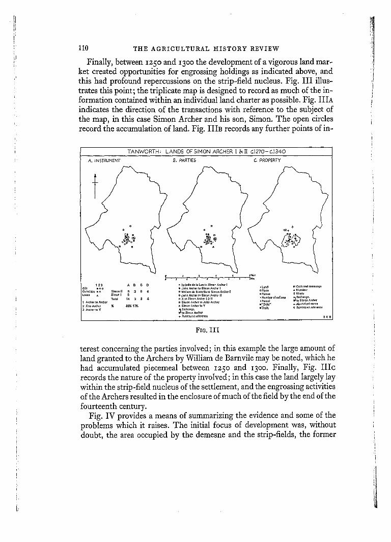
Finally, between 125o and 13oo the development of a vigorous land mar- ket created opportunities for engrossing holdings as indicated above, and this had profound repercussions on the strip-field nucleus. Fig. III illus- trates this point; the triplicate map is designed to record as much of the in- formation contained within an individual land charter as possible. Fig. IIIA indicates the direction of the transactions with reference to the subject of the map, in this case Simon Archer and his son, Simon. The open circles record the accumulation of land. Fig. IIIB records any further points of in-
TANWORTN: LANDS OFSIMON ARCHER [ & f i C,.i270-C.I340
A. INSTRUHENT B. PARTIES C. PROPERTY
t :
sM,~l
1 2 3 A B C D - IsnbelladolaLootoSimonAIcherl =Cloftondmossuaoo Gift • o o • John Amhot to S;men Archer I • Lend Quitckllm • t3 Simon II 9 3 8 4 u William do Oztrnville to Simon Archer t o Piece & Meadow Lease • Simon I 5 o John Archer to Simon A;cher II • Piece= 0 Waste
Sxch~noo, Totol 14 3 8 4 o X to Simon Archer t 8" II • N umbttt of $ol]on$ ~ t o Simon Archer
Archer to Archer u Simon Archer to Johtl Archer - Parcel X to Archer % 83% 17% • Simon Archer to Y O"DoM '° + Abultal leferoneo Archer to Y Exehnng0, ~t'Cto(t o Rclro=0oct rQI0renco
~{tO Simon Alchor + Retrospect leferone0 B K R
FIo. I I I
terest concerning the parties involved; in this example the large amount of land granted to the Archers by William de Barnvile may be noted, which he had accumulated piecemeal between 125o and 13oo. Finally, Fig. l l Ic records the nature of the property involved; in this case the land largely lay within the strip-field nucleus of the settlement, and the engrossing activities of the Archers resulted in the enclosure of much of the field by the end of the fourteenth century.
Fig. IV provides a means of summarizing the evidence and some of the problems which it raises. The initial focus of development was, without doubt, the area occupied by the demesne and the strip-fields, the former L
I

M E D I E V A L C O L O N I Z A T I O N I N T H E F O R E S T OF A R D E N
T A N W O R T H
C1,350 l
E A R L 3 WOO,
LADBROKE PARK
. /~ ' .2 , '~ : ' j ' H c a t : h T a n w o r t h ~ ;;' ~,,o,.~ ~:.~"."..I., ~"" ~ ' ~ C ~ ' """ "L'~,,"
Woodland c.1350 . . . . . . Parish boundary ".. ~°othlo.do,~oo ' .":,o ...... ,°.d~ ~ ~ ' . , LXX~J S,,Tp.,e~dnooto., t ~ Po,~,ond . . . . .
~] Moated sites ~ Fishponds ~{ ,~ Roads (enclosed & unenclosed) • Largo farmhouses
0 Messuages '~ Appmxlmoto location on, Houses o CotlagQsJ ~ -
m;~
Messuages B houscs mentioned ]n C. 1500 I (Alcher pstatos only),
THE L ~ i
\" t " I
~o~ t /~ t Lce
FIG. IV
111
B,KR.

112 THE A G R I C U L T U R A L H I S T O R Y R E V I E W
being cultivated in severalty, the latter comprising intermixed holdings, each open to the other, and probably being worked in common. These lay on an area of better than average soils in a valley opening southwards towards the main early-settled region of Warwickshire, the middle Avon valley, and this must have formed an axis of penetration. Documentary evidence can prove the presence of both of these elements in the early decades of the thirteenth century, and it is reasonable to conclude that they are to be linked with the phase of Anglo-Saxon colonization indicated by the place-name Tanworth, but the problem of their origin remains. Do they represent old-established forms fossilized by social and legal changes, or are they the product of de- velopments immediately before the appearance of documentary evidence in the late twelfth century? It is hoped that further work will throw more light on the character of these vital nuclei.
By I35o most of Tanworth parish was occupied by enclosed severalties, fields, or 'closes', on average about 5 acres in area, associated with single farms. These were mainly established in the early thirteenth century, and at this date were in the hands of the initial grantees or their heirs or assigns. The late thirteenth century saw a growth of population, and the addition of more land to existing farm units, but the development of a market in land paved the way for the emergence of sharper social differentiation, and the period saw the rise to prominence of a group of wealthy freeholders who accumulated land to create sub-manors, and who demonstrated this wealth in the construction of large moated farmsteads. The emergence of these holdings resulted in a reduction of the number of small independent free- holds, and the concentration of land in the hands of a few powerful families, under whom the smaller men became tenants. With regard to the sources of their wealth, the charter evidence raises more questions than it solves, but the size of their rent rolls is insufficient to account for their substantial in- vestments in land. So far actual reconstructions of farm and field boundaries have not been systematically undertaken, but there are encouraging signs that it will be possible in many cases to relate the documents to the field evi- dence, and so understand more fully the actual landscapes which resulted from this colonizing movement.
Tanworth is almost unique in Arden because of the exceptional degree of freedom prevailing among its inhabitants; for instance, over 60 per cent of the Earl of Warwick's income from this manor was derived from free rents, a figure of 30-4 ° per cent being more normal within Arden. This situation was quite clearly the result of a policy pursued by the Earl as territorial overlord. Other manors in his hands, having a similar physical environment and early settlement history to Tanworth, exhibit different trends, while the patterns

i
MEDIEVAL COLONIZATION IN THE FOREST OF ARDEN 113
of development and landscape found on the Earl's manors contrast sharply with those found on the estates of other Arden landowners. This analysis of an extreme case poses many problems, but land charters, "minute fragments of agricultural reality," provide a means of examining an otherwise largely undocumented process. 1
• O ~ 1 R. H. Hilton, 'The Content and Sources of English Agrarian History before ~5 o , Agric. Hist. Rev., III, I955, p. so.
N O T E S ON C O N T R I B U T O R S
I. R. Coull is lecturer in Geography at the University of Aberdeen. He completed a Ph.D. thesis on the geography of crofting in Scotland in I962, and has participated in several surveys, sponsored by government departments, on problems of economic de- velopment in Scotland.
J. P. D. Dunbabin is Fellow and Tutor in Politics and Modern History at St Edmund Hall, Oxford. Hie is engaged in research into rural discontent in nineteenth-century Bri- tain.
at the Agricultural Research Council's Animal Breeding Research Organization in Edinburgh. His current research interests in- clude moulting and fleece structure. He has a book in the press on Wool Growth.
Miss Lucia Pearson is a lecturer in dairying at Reading University in one of the home- based posts of the Ministry of Overseas De- velopment. She recently held a I-Iarkness FeUowship in America and has become par- ticularly interested in the agricultural de- velopment of South America.
B. K. Roberts is lecturer in Geography at Durham University. He is working on the development of settlement forms and field systems in the Midlands and north-east England.
M. L. Ryder is a Principal Scientific Officer
Ernest A. Pocock farms 460 acres at Clanfield in south-west Oxfordshire. He is collecting material for a history of his village, and has already published two booklets on the White Horse at Uffngton, Berkshire, and on Radcot bridge, the oldest surviving bridge over the Thames.