abandoned mineral exploration sites in nunavik rehabilitation
TRANSCRIPT

Kativik Regional Government
Renewable Resources, Environment,Lands and Parks Department
January 2012
ABANDONED MINERAL EXPLORATION SITES IN NUNAVIK REHABILITATION PROJECT
2005-2012 Summary Reportand
Update of the General Response Plan

Cover photos:
Partial view of site PJ-1 before (back cover; in 2001) and after (front cover; in 2011) clean-up work.
Reference:
Kativik Regional Government. 2012. Abandoned Mineral Exploration Sites in Nunavik Rehabilitation Project. 2005-2012 Summary Report and Update of the General Response Plan. Renewable Resources, Environment, Lands and Parks Department of the Kativik Regional Government, Kuujjuaq.
NOTE : Ce rapport est aussi disponible en français

Kativik Regional Government
Renewable Resources, Environment,Lands and Parks Department
January 2012
ABANDONED MINERAL EXPLORATION SITES IN NUNAVIK REHABILITATION PROJECT
2005-2012 Summary Reportand
Update of the General Response Plan

iii
PROJECT LEADERS AND MEMBERS
2001-‐2002 Assessment and Prioritization of Abandoned Mineral Exploration Sites in Nunavik Kativik Regional Government Renewable Resources, Environmental and Land Use Planning Department Michael Barrett, Project Co-‐Director, Assistant Director Sammy Tukkiapik, Site Assessor Josée Brunelle, Project Coordinator, Paul F. Wilkinson & Associates Inc., for the Kativik Regional Government and the Makivik Corporation; Advisor for the Naskapi Nation of Kawawachikamach
Makivik Corporation Robert Lanari, Project Co-‐Director, Makivik Corporation
Environment Canada, Environmental Protection Branch Lucie Olivier, Contaminant Expert
Partners Environment Canada, Northern Ecosystem Initiative Environment Canada, Environmental Protection Branch Ministère des Ressources naturelles du Québec Indian Affairs and Northern Development Canada Kativik Regional Government Makivik Corporation Groupe d’études inuit et circumpolaires, Université Laval Inuit communities Naskapi Nation of Kawawachikamach
Community Participation Johnny Appahatak, Inuit Informant, Aupaluk Amaamak Jaaka, Inuit Informant, Kangiqsujuaq Paulusie Padlayat, Inuit Informant, Salluit Sandy Berthe, Inuit Informant, Tasiujaq Sandy Gordon, Director, Renewable Resources, Environmental and Land Use Planning Department, Kativik Regional Government; Inuit informant, Kuujjuaq and Tasiujaq
Pete Guanish, Naskapi Informant, Kawawachikamach Louis Einish, Naskapi Technical Assistant, Kawawachikamach Suppa Fleming, Inuit Informant, Kuujjuarapik Matthew Petagumskum, Cree Informant, Whapmagoostui Jack Anowak, Inuit Informant, Umiujaq Peter Duncan and Christophe Vani, Pilots, Nunavik Rotors Inc., Kuujjuaq
iv
2004 Rehabilitation and Assessment Work Kativik Regional Government Renewable Resources, Environmental and Land Use Planning Department Michael Barrett, Assistant Director Jean-‐Marc Séguin, Consultant
2005 Rehabilitation Work Kativik Regional Government Renewable Resources, Environmental and Land Use Planning Department Michael Barrett, Assistant Director Jean-‐Marc Séguin, Consultant, Project Coordinator
Partners NORPAQ Air Charters Cruise North Expeditions Inc. Anglo American Exploration Canada Canadian Royalties Inc. Environment Canada
Community Participation Naskapi Nation of Kawawachikamach Abraham Chemaganish Louis John Einish Peshu Gauthier Job Nattawapio Lazarus Nattawapio (Cook) Hannah Tooma Einish
Innu Nation of Matimekush-‐Lac John George Jourdain Ismael McKenzie
2006 Rehabilitation Work Kativik Regional Government Renewable Resources, Environmental and Land Use Planning Department Michael Barrett, Associate Director Caroline Larrivée, Land Use Planner Jean-‐François Henri, Project Coordinator
Partners Environment Canada NORPAQ Air Charters Cruise North Expeditions Inc. Anglo American Exploration Canada Canadian Royalties Inc. Natural Resources Canada

v
Community Participation Naskapi Nation of Kawawachikamach Peter Paul Mameanskum Louis John Einish Wabush Vollant Patrick Nattawappio Hannah Tooma Einish
Innu Nation of Matimekush-‐Lac John George Jourdain Benedic Mckenzie
Northern Village of Tasiujaq Charlie Nayome Joseph Kauki Sandy Kritik
Northern Village of Aupaluk Charlie Akapahatak Etua Iggyok
2007 Rehabilitation Work Kativik Regional Government Renewable Resources, Environmental and Land Use Planning Department Michael Barrett, Associate Director Anne-‐Marie LeBlanc, Project Coordinator David Barrett, Environmental Technician
Partners Fonds Restor-‐Action Nunavik Abitibi Géophysique inc. Association de l’exploration minière du Québec Association minière du Québec Agnico Eagle Alexandria Minerals Corporation Alexis Minerals Corporation Areva Québec Canadian Royalties Inc. Dios Exploration Ditem Exploration Inc. Donner Metals Ltd. Eastmain Resources Exploration Azimut Inc. Everton Resources Exploration Osisko Genivar Hélicoptères Canadiens (les) Knight Resources Ltd. Kativik Regional Government
Makivik Corporation Mines Aurizon Mines Opinaca (les) -‐ (Goldcorp) Virginia Mines Inc. PricewaterhouseCoopers Prospectors & Developers Association (PDAC) Ressources Appalaches Ressources Breakwater Ressources Cartier Ressources Majescor inc. Ressources Metco Ressources Sirios inc. Ressources Strateco Roche Ltd, Consulting Group Raglan – Xstrata Stonoway Diamond Corporation Uranium Star Société d’exploration minère Viro Inc.
Ministère des Ressources naturelles et de la Faune Makivik Corporation, Georges Gagnon NORPAQ Adventures Xstrata Nickel Cruise North Expeditions Inc. Ministère du Développement durable, de l’Environnement et des Parcs Nunavik Rotors Inc.
vi
Community Participation Naskapi Nation of Kawawachikamach Barnaby Gabriel Bill Einish Christina Mokoush Gregory Tooma Louis Einish
Innu Nation of Matimekush-‐Lac John Daniel Bastien Éric Jourdain
Northern Village of Tasiujaq Charlie Nayome Maggie Kriti Sandy Kritik Tamisa Mosesiapik
2008 Rehabilitation Work Kativik Regional Government Renewable Resources, Environmental and Land Use Planning Department Martin Tremblay, Project Coordinator Alexandre Gaudreau, Field Technician Michael Barrett, Associate Director Mark T. Gordon, Winter Transportation Logistics
Partners Fonds Restor-‐Action Nunavik Ministère des Ressources naturelles et de la Faune Makivik Corporation NORPAQ Adventures Atmacinta Inc. Xstrata Nickel Goldbrook Ventures Ministère du Développement durable, de l’Environnement et des Parcs Nunavik Rotors Inc. Nunavut Eastern Arctic Shipping Inc.
Community Participation Northern Village of Kangirsuk Jimmy Annahatak Peter Annahatak Sammy Airo Michael Kuddluk Jack Kuddluk David Suppa
Northern Village of Kangiqsujuaq Willie Qamugaaluk William Qumaaluk Juupi Koneak Juupi Qamugaaluk Siasie Tuniq Ningiuruvik Tuniq Koneak Tuniq Jobie Qamugaaluk
Northern Village of Kangiqsujuaq Joanasie Annahatak
Northern Village of Salluit Normand Lavoie Jr.
Innu Nation of Matimekush-‐Lac John Lazar André Ben Junior Einish Claude Gabriel Jean-‐Mathieu Grégoire Éric Jourdain
Naskapi Nation of Kawawachikamach Mavrick Volant George Katsimoko Louis Einish

vii
2009 Rehabilitation Work Kativik Regional Government Renewable Resources, Environmental and Land Use Planning Department Michael Barrett, Associate Director Nancy Dea, Project Coordinator Charlie Akpahatak, Field Technician
Partners Fonds Restor-‐Action Nunavik Ministère des Ressources naturelles et de la Faune
Makivik Corporation Cruise North Expeditions Inc.
Nunavik Rotors Inc. Xstrata Nickel Goldbrook Ventures Nunavut Eastern Arctic Shipping Inc. Canadian Royalties Inc.
Community Participation Naskapi Nation of Kawawachikamach and Innu Nation of Matimekush-‐Lac John Micheal Tooma Marcellin Gregoire Roger Pinette Alex Nabinacaboo Guy Nabinacaboo Ned Tooma Judas Shecanapish Raphael Andre Francois Scott Joseph Sandy/Peastitute Natalino Andre Rodney Einish Junior Shecanapish
Northern Village of Tasiujaq Saipilie Berthe George Watt Kritik Etua Emataluk Eva Kritik
Northern Village of Aupaluk Dominic Iggyook Sammy Akpahatak Lisa Angutinguak Arthur Agma Zebidee Angutinguak Etua Iggyook Juanassie Annahatak Johnny Oovout
Northern Village of Kangiqsujuaq Peter Ilimasaut Jusi Kadjulik Johnny Sakiagak Bobby Qanugaaluk Thmoassie Qissiq
Northern Village of Salluit Matt Papigatuk Audlaluk Koperqualuk
Northern Village of Kangirsuk Etua Putulik Peter Annahatak Elijah Tukkiapik David Pootoogee Markusie Eetook

viii
2010 Rehabilitation Work Kativik Regional Government Renewable Resources, Environmental and Land Use Planning Department Michael Barrett, Associate Director Nancy Dea, Consultant, Project Coordinator, Environmental Consultant Nathalie Girard, Interim Project Coordinator, Environmental Consultant Charlie Akpahatak, Field Technician
Partners Fonds Restor-‐Action Nunavik Ministère des Ressources naturelles et de la Faune
Makivik Corporation Nunavik Rotors Inc. Xstrata Nickel
Goldbrook Ventures Canadian Royalties Inc. Nunavut Eastern Arctic Shipping Inc. NORPAQ Adventures Safari Nordiq Transport Desgagnés
Community Participation Naskapi Nation of Kawawachickamach and Innu Nation of Matimekush-‐Lac John Ned Tooma Joseph Peastitute Jacob Einish Travis Swappie Allan Nabinacaboo
Northern Village of Tasiujaq Charlie Nayomik Willie Cain Jr. Etua Emataluk Matta Cain
Northern Village of Kangiqsujuaq Tommy Qamugaaluk Tuniq Ningiurik
Northern Village of Salluit Christopher Ikey Adamie Ilisituk Timangiak Cameron
Northern Village of Aupaluk Dominic Iggyook Sammy Akpahatak Lisa Angutinguak Elijah Gordon Zebedee Angutinguak Etua Iggyook Juanassie Akpahatak Lazaussie Akpahatak Quaki Akpahatak Larussie Grey Eva Grey Elijah Grey Willie Angutinguak Johnny Etok Maggie Grey Charlie Angutinguak Etuk Akpahatak Bobby Angutinguak David Angutinguak Tamisa Grey
Northern Village of Kuujjuaq Steven Gordon Jonah Jones Alex Gordon
Northern Village of Umiujaq Johnny Kasuadluak Willie Kumarluk Timothy Tookto

ix
2011 Rehabilitation Work Kativik Regional Government Renewable Resources, Environment, Lands and Parks Department Michael Barrett, Associate Director Nancy Dea, Consultant, Project Coordinator, Environmental Consultant Nathalie Girard, Interim Project Coordinator, Environmental Consultant Charlie Munick, Field Technician
Partners Fonds Restor-‐Action Nunavik Ministère des Ressources naturelles et de la Faune
Makivik Corporation Nunavik Rotors Inc.
Xstrata Nickel Canadian Royalties Inc. Nunavut Eastern Arctic Shipping Inc. Oceanic Iron Ore Corporation Northern Village of Kuujjuaq Air Inuit
Community Participation Northern Village of Salluit Christopher Ikey Adamie Ilisituk Timangiak Cameron Adamie Snowball Elijah Kumakuluk Piadli Angutigirk Jr. Moses Saviadjuk
Northern Village of Aupaluk Charlie Akpahatak
Northern Village of Kangiqsujuaq Tommy Qamuraluk
Northern Village of Kangiqsualujjuaq Ned Baron Tommy Annanack Jake Annanack David Unatweenu
2011 Inspection Work Kativik Regional Government Renewable Resources, Environment, Lands and Parks Department Michael Barrett, Associate Director Nancy Dea, Project Coordinator, Summary Report Co-‐Author, Environmental Consultant Charlie Munick, Field Technician Josée Brunelle, Summary Report Co-‐Author, Environmental Consultant
Ministère du Développement durable, de l’Environnement et des Parcs Patrick Therrien, Water and Sanitation Technician
x
ACKNOWLEDGEMENTS
The idea for the abandoned mineral exploration site rehabilitation project began with the persistent request from Amaamak Jaaka that sites near his community of Kangiqsujuaq be cleaned. Following the 2008 documentary featuring Johnny Peters of the Makivik Corporation that was produced by Francis Labbé and broadcast on Radio Canada, public and corporate interest in the project increased and the idea continued to develop. Finally, André Gaumond of Virginia Mines put forward the idea of a collaborative project between northern organizations and mining companies that grew into the successful project we know today. Since the very beginning, many people, organizations and municipalities have been involved in this project. The Kativik Regional Government (KRG) would like to take this opportunity to thank everyone for their part in making it such a success. In particular, the KRG would like to formally acknowledge the community of Aupaluk for its enormous participation in clean-‐up work at the site PJ-‐1. Special thanks go to Maggie Grey (the municipal secretary-‐treasurer) and Charlie Akpahatak (a former field technician) for their continued dedication to the project. The community of Tasiujaq should also be thanked for its involvement in clean-‐up work at this site and others. The KRG would like to acknowledge the communities of Kangiqsujuaq and Salluit for their multi-‐year participation in clean-‐up work at the site SW-‐34. The environmental division of Xstrata Nickel should also be thanked for its many contributions during the site’s continued rehabilitation. The Naskapi Nation of Kawawachickamach and the Innu Nation of Matimekush-‐Lac John should be acknowledged for their continuing contribution to clean-‐up work at the site KAW-‐35. NORPAQ Adventures, a local outfitter, has also been an important contributor to this work. In 2011, the Northern Village of Kangiqsualujjuaq participated in clean-‐up work at the sites PJ-‐1 and SW-‐34, providing several workers to assist the field technician, Charlie Munick. The Northern Village of Kangirsuk should be thanked for its involvement in the rehabilitation of the site TW. Similarly, the Northern Village of Kuujjuaq should be thanked for the assistance that it provided for clean-‐up work at nearby sites. The KRG moreover acknowledges the outstanding contribution of Cruise North Expeditions to the clean-‐up work at the sites PJ-‐17, PJ-‐17A and PJ-‐18 and for the many volunteers who were given an opportunity to make a difference. Mining companies currently active in Nunavik, such as Canadian Royalties, Goldbrook Ventures, Xstrata Nickel and, most recently, Oceanic Iron Ore Corporation, should furthermore be recognized for their clean-‐up initiatives on numerous abandoned mineral exploration sites located on or near their claims. The KRG would also like to thank Nunavut Eastern Arctic Shipping for its patience and understanding regarding the transportation of several hundred tonnes of metal debris and heavy equipment removed from the site PJ-‐1 and stored at Aupaluk over the years, as well as for its long-‐standing support for the project. Finally, the KRG would like to thank Nunavik Rotors for its continued professionalism and expertise regarding the transportation of residual materials and employees throughout the entire project.

xi
EXECUTIVE SUMMARY
Beginning in the 1950s, mining companies had a growing interest in the Nunavik region. At this time, very few regulations existed to monitor and guide the social and environmental impacts of the activities of these companies. With the signing of the James Bay and Northern Québec Agreement in 1975, mining companies became subject to more strict rules that oblige the companies to declare their activities to the ministère des Ressources naturelles et de la Faune (natural resources and wildlife, MRNF) and to rehabilitate closed mineral exploration sites. Unfortunately, past mining-‐company activities have had an impact on vegetation, wildlife habitat and water quality, as well as a visual impact on the landscape of the region. The present clean-‐up project stemmed from community initiatives in the 1990s, followed by a joint project undertaken in 1999 by the Kativik Regional Government (KRG), the Makivik Corporation and the Groupe d’études inuit et circumpolaires (Université Laval) to identify and locate abandoned mineral exploration sites in Nunavik. In 2000, the Naskapi Nation of Kawawachikamach joined the project. A review of existing oral and written information on all mining-‐related sites identified some 595 potential abandoned mineral exploration sites in Nunavik. In 2001–2002, an inventory of a sample of 193 potential sites was conducted to validate the information previously gathered. As a result, 90 sites were confirmed as abandoned mineral exploration sites and, of these, 18 sites were classified as requiring major clean-‐up work, 27 as requiring intermediate clean-‐up work, and 45 as requiring minor clean-‐up work. Classification of the sites was based on a list of criteria adapted from the National Classification System for Contaminated Sites, including an assessment of the quantity of material and equipment present at the sites, as well as soil and surface water contamination. Considering Inuit concerns and the threat that these sites posed to the environment, the KRG and Makivik joined forces to identify the funding needed to undertake their clean-‐up. In December 2004, the KRG signed a four-‐year contribution agreement (2004–2008) with Environment Canada under the Northern Ecosystem Initiative. As a first phase, the KRG undertook pilot rehabilitation projects in 2005 and 2006 on two of the sites requiring major clean-‐up work (KAW-‐35 near Kawawachikamach and PJ-‐1 near Tasiujaq). In October 2007, a formal contribution agreement was signed by the KRG, Makivik, the MRNF and a consortium of mining exploration companies known as Fonds Restor-‐Action Nunavik. The agreement focused on providing the KRG with the funding and technical support needed to undertake clean-‐up work on all of the 18 sites requiring major clean-‐up. Since the signing of these agreements, the KRG has completed work at 13 sites and initiated work at two other sites in cooperation with Inuit communities, the Naskapi Nation of Kawawachikamach and a few mining companies. This work involves numerous partners and continuous collaboration between governments, regional and municipal entities, as well as mining companies and several northern organizations. In 2011, inspections were carried out at sites classified as requiring intermediate clean-‐up work. The waste at these 27 sites is similar to the waste found at the sites requiring major clean-‐up, but the extent of the work to be performed is smaller. From 2006 to 2011, nine sites requiring intermediate work were cleaned up by various mining companies. An amendment to the 2007 contribution agreement was moreover signed to provide funding for work at the sites requiring intermediate clean-‐up as well as to complete work at the five remaining sites requiring major clean-‐up.

xii
This report presents the work carried out between 2005 and 2011 at the sites requiring major clean-‐up and some sites requiring intermediate clean-‐up. To date, more than 50 pieces of heavy equipment (including large machinery), 4,300 barrels, 250 propane tanks, 14 large reservoirs, 23,100 L of residue hydrocarbons (diesel or other), 2,000 L of motor oil, 70 batteries and a large amount of debris have been removed from the sites. As well, hydrocarbons and hazardous material, such as paint, grease, batteries, fire extinguishers and transformers, have been shipped to specialized facilities in the south for proper recycling or proper disposal.

xiii
RÉSUMÉ
À partir des années 1950, les sociétés minières ont eu un intérêt grandissant pour la région du Nunavik. Il n’y avait à cette époque que très peu de réglementation visant à encadrer et orienter les activités des sociétés en lien avec les impacts causés sur l’environnement et le milieu social. Depuis la signature de la Convention de la Baie-‐James et du Nord québécois en 1975, les sociétés minières sont assujetties à des règles plus strictes qui les obligent à déclarer leurs activités au ministère des Ressources naturelles et de la Faune (MRNF) et à restaurer les sites d’exploration minière qu’ils abandonnent. Malheureusement, les activités réalisées par les sociétés minières dans le passé ont eu un impact sur la végétation, les habitats fauniques et la qualité de l’eau, ainsi qu’un impact visuel sur le paysage de la région. Le présent projet de nettoyage découle d’initiatives lancées par les communautés dans les années 1990, suivies d’un projet conjoint entrepris en 1999 par l’Administration régionale Kativik (ARK), la Société Makivik et le Groupe d’études inuit et circumpolaires (GÉTIC) de l’Université Laval visant à dénombrer et à localiser les sites d’exploration minière abandonnés au Nunavik. En 2000, la Nation Naskapi de Kawawachikamach s’est jointe au projet. Une revue globale de l’information orale et écrite existante sur le sujet a permis de dénombrer 595 sites potentiels d’exploration minière abandonnés au Nunavik. En 2001-‐2002, un inventaire d’un échantillon de 193 sites potentiels d’exploration minière abandonnés a été réalisé afin de valider l’information qui avait été précédemment recueillie. Selon les résultats de cet inventaire, 90 sites ont été confirmés comme étant des sites d’exploration minière abandonnés. Dix-‐huit de ces sites ont été classés comme nécessitant des travaux de nettoyage de grande envergure, 27 des travaux de moyenne envergure et 45 des travaux de faible envergure. La classification des sites a été faite en fonction d’une liste de critères adaptée provenant du Système national de classification des lieux contaminés et inclut l’évaluation de la quantité de matières résiduelles présentes sur les sites ainsi que la contamination des sols et de l’eau de surface. En raison des préoccupations soulevées par les Inuits et de la menace que représentent ces sites pour l’environnement, l’ARK et la Société Makivik ont conjugué leurs efforts afin de trouver le financement nécessaire pour entreprendre le nettoyage de ces sites. En décembre 2004, l’ARK a conclu une entente de contribution de quatre ans (2004-‐2008) avec Environnement Canada, par l’entremise de l’Initiative des écosystèmes du Nord (IEN). Lors d’une première phase, l’ARK a entrepris des projets pilotes de réhabilitation en 2005 et en 2006 à deux des sites nécessitant des travaux de nettoyage de grande envergure, à savoir le site KAW-‐35 dans les environs de Kawawachikamach et le site PJ-‐1 dans les environs de Tasiujaq. En octobre 2007, une entente de contribution officielle a été signée par l’ARK, la Société Makivik, le MRNF et un consortium de sociétés minières connu sous le nom de Fonds Restor-‐Action Nunavik (FRAN). L’entente avait pour but de fournir à l’ARK le financement et le soutien technique nécessaires pour réaliser les travaux de nettoyage aux 18 sites nécessitant des travaux de nettoyage de grande envergure. Depuis la signature de ces deux ententes, les travaux de nettoyage réalisés par l’ARK ont été achevés à 13 des 18 sites et entrepris à deux autres sites en collaboration avec les communautés inuites, la Nation Naskapi de Kawawachikamach et quelques sociétés minières. Ces travaux impliquent un grand nombre de partenaires et une collaboration continue de la part des gouvernements, des autorités régionales et municipales ainsi que des sociétés minières et de plusieurs organismes nordiques. En 2011, les sites nécessitant des travaux de nettoyage de moyenne envergure ont été inspectés. Ces 27 sites contiennent les mêmes matières résiduelles que les sites nécessitant des travaux de grande

xiv
envergure, mais en moins grandes quantités. De 2006 à 2011, neuf sites nécessitant des travaux de moyenne envergure ont été nettoyés par diverses sociétés minières. De plus, une modification a été apportée à l’entente de contribution signée en 2007, afin que les travaux de nettoyage puissent être entrepris aux sites nécessitant des travaux de moyenne envergure et achevés aux cinq derniers sites nécessitant des travaux de grande envergure. Le présent rapport décrit les travaux qui ont été réalisés de 2005 à 2011 aux sites nécessitant des travaux de grande envergure et à quelques-‐uns des sites nécessitant des travaux de moyenne envergure. À ce jour, plus de 50 équipements lourds (incluant de la grosse machinerie), 4 300 barils, 250 bonbonnes de propane, 14 grands réservoirs, 23 100 L de résidus d’hydrocarbures (diesel ou autre), 2 000 L d’huile à moteur, 70 batteries et de grandes quantités de matières résiduelles ont été retirés des sites. Les hydrocarbures et les matières dangereuses, telles que la peinture, la graisse, les batteries, les extincteurs et les transformateurs, ont été expédiés à des installations spécialisées du sud en vue de leur recyclage et de leur élimination adéquate.

xv
gr7mEq8i4 â9otEs†5
!(%)-s2 x3ÇAq8i WQx3hA, s/C8ix5 tudtq5b WJ5ns÷3iq5 kN[7u4 Wo3XoxyMs3ymJ5. Ö5hmi, wr5gxWsMs3ymJ5 moá5 w2WAhQxc3tyJ5 x7ml grjxQxc3tyJ5 Ì4fx tusJ5 wk8i4 x7ml x?tu4 WNhx3iuk5 h3êAtq8i4. è7+ Ñu x7ml fÑ4 b3Czi xqctŒ8i6 xtos3[sm5 !(&%-u, s/C8ix5 tuq5 moQxcyMs3ymJ5 §ai3ni4 moZ3i4 Ì4fiz tui4 scExc3tyJi4 hN8ixm¯3u4 ui+bj5 yMs2 W?9odtq8k5 x7ml ßmJk5 (MNRF) x7ml ng3tyQxc3tyJi4 s4fxymo3gi4 s/C8ixZ3i4 ei3†5 kNg3o[iq8i4. §rxaZlx6, c7usq8iÖ5 s/C8ixi[iq5 h3êi3lymK5 WD3gi4, ßmJw5 kNq8i4 x7ml wms2 Wsizi4, x7ml bs5gqtA5 h3êht4 kNi4 bµi kNdtu. Ì8N s9lu nl7àQx3iu4 WNhx5n6 WD3[cMsJJ6 kNø5 WQx3tbtq8i4 !(()-s2 x3ÇAq8i, mo5tc3hi vg5÷u4 WNh8iu4 !(((-u vJytbsMs3ymJu4 vt[4 kNooµ5 v?mzk5 GKRGH, mr{[j5 x7ml wo8ixctŒk5 wk8i4 x7ml yM3Jx2 srs3bgzi4 GM¿9 yM5gn3[uH Nlâ3yAbs5hi x7ml NiyAbs5hi wWê8Nbsoi3i4 s/C8ix†5 kNg3o[iq8i4 kN[s2 wlxi. @)))-u, N+Ï„5 wkqb kN3Jxz5 vAxAx5yvm4u bmgjz WNh8ij5 wMQostMsJ7uJ6. eu3Di6 Wbco‰3gi4 scsy4f5 x7ml x9MymJ3tA5 cspmAti4 W5Jto8i4 s/C8ix[symJoµi4 kNi4 Nlâ3yAbsymJ6 %(% u5ñî5gi4 wWê8NbsmJi4 s/C8ixC5nys3†5 kNg3o[iq8i4 kN[7u. @))!-@))@-u, cspnC5ñ„5 kxbsMsJJ5 ß5gC3bi4 !(#-i4 Öµ4 kNg3o[isAN3i4 cspmAt5ã5 yKizi kxbsymJ5 hoAtos3hQ5. xhw˜4, ()-i4 kNg3o[i3i4 h3dwMsJJ5 wWê8Nbsm5ht4 s/C8ixC5nys3tk5 kNg3o[isQxq5 x7ml, Ì4fNi, !*-i4 kNg3o[i3i4 Nlâ3gcMsJ5hi W7mE9lQ5 nl7mnExc3tlQ5, @& Nlâ3tlQ5 xf8ˆeu4 nl7mnExc3tlQ5 x7ml $% wf9MJu4 nl7mnExc3tlQ5. Ì4fx kNg3o[î5 W7mE8iq5 ᐋ€3eh3bsMsJJ5 g1z[c3hi iS3tQxo8i4 tAymJi4 kN3Jx2 S3go‰5tystq8i4 nlà9ot3ymJi4 kNi4, bm8N wMc3tlA v1aNesti4 W[î5 x7ml WN§t[î5 em5bsmJ5 ckw9lxiq8i4, x7ml kNs2 wms9l kNs2 çzî5©2 nlà9ot3ymiq8i4. whm5ht4 wkw5 whµlAtq8i4 x7ml slExn3gi4 b4fx kNg3o[î5 kwbtbq8i4 x?tj5, KRG-f5 mr{[f9l vg5pyMsJJ5 NiyZhx3ht4 ®Ns/3©t5ni4 bm4fx nl7mn3bsiq8k5 xgExc3ixgi4. ty7WE @))$-u, KRG-‐f5 xtos3[cMsJJ5 x3ÇAk5-ybmk5 ®Ns/c3tyA†5 xqctŒ8izi4 G@))$-@))*H x?toEp4f5 ÏNbu wMQ5hQ5 srs3bgi ßm[oEi3u4 WQxDtqb xbA5. yK9oÙu4 WNh8ist9lA, KRG-f5 vJyt5yMsJJ5 ß5gCsti4 ng3tyQxD†5 WNh8ibq8i4 @))%-u x7ml @))^-u vmAtQ5hQ5 m3Îi4 kNg3o[î5 wMq8i4 W7mE9lQ4 nl7mnExø8i4 GKAW-‐35 ÏAxAx5yvm4 nixi x7ml PJ-‐1 bys/s2 nixiH. ß4©WE @))&-u, ®Ns/c3tys†5 xqctŒ8iMEzi4 xtos3[sJcMsJJ6 KRG-fk5, mr{[j5, MRNF-‐f8kl x7ml s/C8ix†5 tuqb vg5pctŒzk5 sc3bsJj5 ®Nsè5 ng3tyQx3if5-WNh8ij5 kN[7u. Ì8N xqctŒ8i6 gÇzJ6 Wt5yi3j5 KRG-u4 ®Ns/tA5 W9lf5goEi4fl wvJ3bsAtQQxoq8i4 vJyt5yMzli nl7mãis2 WNh5bsizi4 w¬8âi !*-i kNg3o[i3i W7mE5gu4 nl7mnExo8i. Ö4fx xqctQA†5 xtos3bsMs3tlQ5, KRG-f5 W/‰3ymo3g5 !#-i kNg3o[i3i WNhQxo8i4 x7ml WQx3ymo3uhi m3DQx9˜i4 kˆ8i4 WNhctc3hi wkw5 kNoq8i4, N+Ï„5 kN3Jxzi4 ÏAxAx5yvm4u x7ml s/C8ix†5 tuq8i4 xu§1q©Zlxi4. bm8N WNh8i6 xg3S6 xuhwi4 WNhctŒi4 x7ml Öm1zoµ6 wvJ3tŒq8Ni3u4 xf8iu v?mk5, kNooµ5 x7ml kNø5 tuq8k5, x7ml ho s/C8ixtk5 x7ml xuhZ˜k5 srs3bgus5 tudtq8k5.

xvi
@)!!-u, eu3DA†5 xg3bsMsJJ5 kNi xf8ˆeu4 nl7mExc3iC3bsymJi. nî5 Ì4fNi @&-i kNi x5pZMsgw8Ng5 ni3k5 bf/sc5bgk5 kNi W7mE9lQ5 nl7mExc3ymJi, WNhQxc3iqb W/Exgiq5 wf9Mi3nsgw8Nht4. @))^-u4 @)!!-j5, dos1qZ3gi4 kNi4 xf8ˆeu4 nl7mExo8i4 nl7mn3bsJcMsJJ6 x5pŒ1qgk5 s/C8ix†5 tuq8k5. ᐋ€3eQxD†5 @))&-u ®Ns/3bD†5 xqctŒ8izk5 xtos3[sMsJ7uJ5 ®Ns/i4 kw5yAbs5ht4 WNhAt5ni4 kNi xf8ˆeu4 nl7mnExo8i x7ml W/‰Dt5ni4 WNh5bsJi4 b9oài kNi xux4fi W7mE9lQ5 nl7mnExc3ymJi. Ì4fx gn3tyA†5 kw5yK5 WNh5bsymJi4 @))% x7ml @)!! x3ÇAqb xf8izi Ö4fNi kNi W7mE9lQ5 nl7mExc3ymJi x7ml kâ5 wMq8i xf8ˆeu4 nl7mExc3ymJi. s9luj5 tr5hA, %) szÌk5 WN§t3M[î5 GxqJaxÇlw5 WN§†5 wMst9lQ5H, $,#)) c5bsè5, @%) S9ä5, !$ xqJxlw5 s3hcs†5, @#,!)) L s3hn/[î5 xiux4fq5 Gs3hxlgw8N6 s{?¬8î5 xyxH, @,))) L xsMs†5 s3hDtz, &) wfms†5 x7ml xuá5gmExlw5 nigw8â5 „3bsymo3g5 Ì4fN1z5 kNg3o[i3i4. hoQx9M4, s3hnè5, x7ml x5bN3gbø5 W[î5, ß5©tQlQ5 uaxD†5, Xbsè5, wfms†5, cutEs†5 x7ml wfms†5 natDtq5, xs9Mtbsymo3g5 vmA8Ngk5 whxdtk5 yei3usi W5yxlQ5 xgEx9Mgoxa˜3mb s{?¬8î5 W5yxlQ5 wQ5goxa˜3mb.

xvii
TABLE OF CONTENTS
PROJECT LEADERS AND MEMBERS .......................................................................................................................................... III
ACKNOWLEDGEMENTS .................................................................................................................................................................... X
EXECUTIVE SUMMARY ................................................................................................................................................................... XI
RÉSUMÉ .............................................................................................................................................................................................. XIII
gr7mEq8i4 â9otEs†5 ..................................................................................................................................................... XV
TABLE OF CONTENTS .................................................................................................................................................................. XVII
LIST OF TABLES .............................................................................................................................................................................. XIX
LIST OF APPENDICES ..................................................................................................................................................................... XX
1 INTRODUCTION ............................................................................................................................................................................. 1
2 OVERVIEW ....................................................................................................................................................................................... 1 2.1 Mining Exploration and Waste ............................................................................................................... 2 2.2 Environmental Regulations .................................................................................................................... 2 2.3 Environmental Concerns ........................................................................................................................ 2 2.4 Inventory and Assessment of the Sites ................................................................................................... 3
1999-‐2000 Inventory .............................................................................................................................. 3 2001-‐2002 inventory and Assessment ................................................................................................... 3
2.5 2004–2008 Contribution Agreement with Environment Canada ........................................................... 4 2.6 2005 and 2006 Pilot Projects .................................................................................................................. 4 2.7 2005, 2006, 2007 and 2009 Clean-‐Up Work by Cruise North Expeditions ............................................. 4 2.8 Funding for the Rehabilitation of Sites Requiring Major Clean-‐Up Work ............................................... 5
KRG and Makivik Proposal ...................................................................................................................... 5 Fonds Restor-‐Action Nunavik ................................................................................................................. 5
2.9 2008–2012 Contribution Agreement: the KRG, Makivik, the MRNF and the FRAN ............................... 5
3 CLEAN-‐UP WORK CARRIED OUT IN 2011–2012 ............................................................................................................ 5 3.1 Description of Work ............................................................................................................................... 6
Tasiujaq Sector ....................................................................................................................................... 6 PJ-‐1 .................................................................................................................................................... 6
Aupaluk Sector ........................................................................................................................................ 6 PJ-‐10 .................................................................................................................................................. 6
Salluit Sector ........................................................................................................................................... 6 SW-‐34 ................................................................................................................................................ 6 SW-‐42 ................................................................................................................................................ 7
Inspections .............................................................................................................................................. 7 3.2 Presentation to the KRG Council ............................................................................................................ 7 3.3 Clean-‐Up Work Carried Out by Mining Companies ................................................................................ 8 3.4 Expenditures ........................................................................................................................................... 8
xviii
4 SUMMARY OF THE 2005-‐2007 AND 2008-‐2012 WORK AT THE 18 SITES REQUIRING MAJOR CLEAN-‐UP .................................................................................................................................................................................. 9
4.1 Description of the 2004–2008 and 2008–2012 work .............................................................................. 9 Kawawachikamach Sector ..................................................................................................................... 10
KAW-‐35 ............................................................................................................................................. 10 KAW-‐45 ............................................................................................................................................. 12
Tasiujaq Sector ...................................................................................................................................... 13 PJ-‐1 ................................................................................................................................................... 13 TQ-‐1 .................................................................................................................................................. 16 TQ-‐4 .................................................................................................................................................. 17
Aupaluk Sector ...................................................................................................................................... 18 PJ-‐10 ................................................................................................................................................. 18 PJ-‐17 ................................................................................................................................................. 20
Kangirsuk Sector .................................................................................................................................... 21 TW .................................................................................................................................................... 21
Kangiqsujuaq Sector .............................................................................................................................. 23 K-‐28 .................................................................................................................................................. 23 K-‐61 .................................................................................................................................................. 24 WB-‐3 ................................................................................................................................................. 25
Salluit Sector .......................................................................................................................................... 26 KV-‐1 .................................................................................................................................................. 26 SAL-‐1 ................................................................................................................................................. 27 SW-‐27 ............................................................................................................................................... 28 SW-‐34 ............................................................................................................................................... 29 SW-‐42 ............................................................................................................................................... 31 WB-‐9 ................................................................................................................................................. 31
Umiujaq Sector ...................................................................................................................................... 32 WHA-‐1 .............................................................................................................................................. 32
4.2 Overview of clean-‐up work from 2005 to 2011 ..................................................................................... 33 4.3 Expenses from 2007 to 2011 ................................................................................................................. 35
5 SITES REQUIRING INTERMEDIATE CLEAN-‐UP ............................................................................................................ 35 5.1 Site descriptions .................................................................................................................................... 35
Kawawachikamach Sector ..................................................................................................................... 36 Kuujjuaq Sector ..................................................................................................................................... 36 Tasiujaq Sector ...................................................................................................................................... 37 Aupaluk Sector ...................................................................................................................................... 37 Kangirsuk Sector .................................................................................................................................... 39 Kangiqsujuaq Sector .............................................................................................................................. 39 Salluit Sector .......................................................................................................................................... 41 Umiujaq Sector ...................................................................................................................................... 41 Other sites ............................................................................................................................................. 41
5.2 Overview of work at sites requiring intermediate clean-‐up .................................................................. 42
6 2012-‐2017 GENERAL RESPONSE PLAN ........................................................................................................................ 42 6.1 Introduction ........................................................................................................................................... 42 6.2 Work to Be Carried Out ......................................................................................................................... 43
Fieldwork Logistics ................................................................................................................................ 43 Transportation and Disposal of Hazardous Material ............................................................................. 44

xix
Management of Combustible Non-‐Toxic Material ............................................................................... 45 Management of Non-‐Combustible Non-‐Toxic Material ....................................................................... 46
6.3 Work Schedule ...................................................................................................................................... 47 6.4 Budget .................................................................................................................................................. 47 6.5 Human Resources ................................................................................................................................. 51 6.6 Communications ................................................................................................................................... 51 6.7 Clean-‐Up Work to Complete ................................................................................................................ 52
KAW-‐35 ................................................................................................................................................. 52 SW-‐34 ................................................................................................................................................... 52 PJ-‐1 (Aupaluk) ....................................................................................................................................... 52
6.8 Collaborative Clean-‐up Work ................................................................................................................ 53 KV-‐1 ...................................................................................................................................................... 53 SW-‐27 ................................................................................................................................................... 53 WB-‐9 ..................................................................................................................................................... 53
6.9 Conclusion ............................................................................................................................................ 54
REFERENCES ...................................................................................................................................................................................... 55
APPENDICES ....................................................................................................................................................................................... 57
LIST OF TABLES
Table 1 Expenditures for Work Carried Out in 2011 .................................................................................... 8
Table 2 Clean-‐up work between 2005 and 2007 at Abandoned Mineral Exploration Sites Requiring Major Clean-‐Up (2004–2008 Contribution Agreement) .................................................................. 9
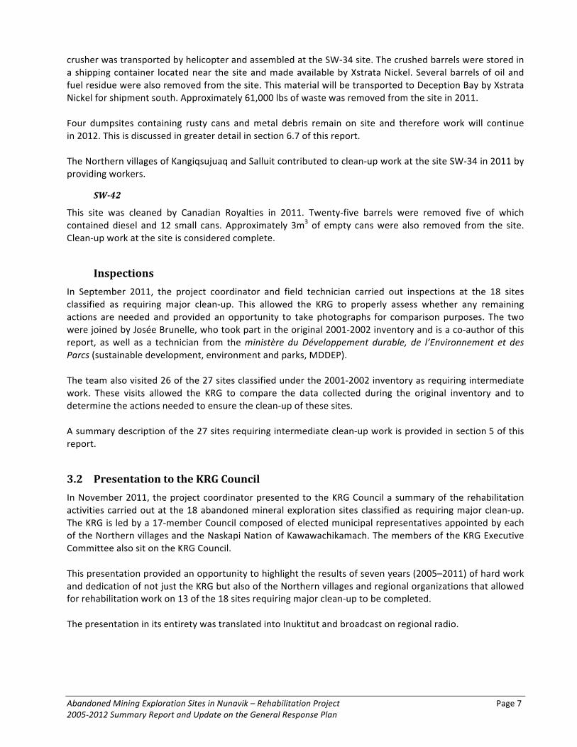
Table 3 Clean-‐up work between 2008 and 2011 and Work Still Planned in 2011 and 2012 at the 18 Abandoned Mineral Exploration Sites Requiring Major Clean-‐Up (Contribution Agreement 2008–2012) ................................................................................................................. 10
Table 4 Quantities of Waste Removed from the 18 Abandoned Mineral Exploration Sites Classified as Requiring Major Clean-‐Up Work between 2005 and 2011 ....................................................... 34
Table 5 Expenses for the Clean-‐Up of Abandoned Mineral Exploration Sites Classified as requiring Major Clean-‐Up Work between 2007 and 2011 ............................................................................ 35
Table 6 Quantities of Waste Removed by Canadian Royalties from the Abandoned Mineral Exploration Sites Classified as Requiring Intermediate Clean-‐Up Work ........................................ 42
Table 7 Fieldwork Logistics, 2012–2017 ..................................................................................................... 44
Table 8 Transportation and Disposal of Hazardous Material, 2012–2017 ................................................. 45
Table 9 Management of Combustible Non-‐Toxic Material, 2012–2017 .................................................... 46
Table 10 Work Schedule, 2012-‐2017 ........................................................................................................... 48
Table 11 Budget, 2012-‐2013 ........................................................................................................................ 49
Table 12 Overall Estimated Budget, 2012-‐2017 ........................................................................................... 50

xx
LIST OF APPENDICES
Appendix 1 Maps Showing the Locations of Abandoned Mineral Exploration Sites in Nunavik
Appendix 2 Sites On Which Ocean Iron Ore Corporation Carried Out Clean-‐up Work in 2011
Appendix 3 Inventory Sheets (2001–2002) of the 18 Sites Requiring Major Clean-‐up Work
Appendix 4 Photographs of Sites Requiring Major Clean-‐up, Before and After Clean-‐up Work
Appendix 5 Photographs of Sites Requiring Intermediate Clean-‐up Work
Appendix 6 Photographs of the Remaining Sites Requiring Major Clean-‐up Work
Page 1
1 INTRODUCTION
In 2001 and 2002, verification of 193 potential abandoned mineral exploration sites was performed in Nunavik, the territory of Québec north of the 55th parallel. The results of that verification are described in the Assessment and Prioritization of Abandoned Mining Exploration Sites in Nunavik: Final Report on a Two-‐Year Project (2001–2002) produced by the Kativik Regional Government (KRG) and the Makivik Corporation in March 2003. The final report indicates that, of the 193 possible sites, 90 were confirmed to be abandoned mineral exploration camps. Eighteen of these were classified as requiring major clean-‐up work, 27 intermediate clean-‐up work and 45 minor clean-‐up work. This classification takes into account the quantity of material and equipment present at each site, as well as the nature and scope of soil and surface water contamination. Further to the recommendations contained in the report on the 2001-‐2002 inventory work and with funding from Environment Canada under the Northern Ecosystem Initiative and from the ministère des Ressources naturelles et de la Faune (natural resources and wildlife, MRNF), in 2005 and 2006 the KRG implemented two rehabilitation pilot projects of at abandoned mineral exploration sites classified as requiring major work, KAW-‐35 (2005–2006) and PJ-‐1 (2006). At the same time, Cruise North Expeditions voluntarily undertook work at a third abandoned mineral exploration site (PJ-‐17) requiring major clean-‐up. These initiatives represent the initial stage of a proposed Nunavik-‐wide clean-‐up project. In August 2003, the KRG and Makivik proposed a funding mechanism and recommendations for the assessment and rehabilitation of abandoned mineral exploration sites (Barrett and Lanari, 2003). The proposal focused in particular on the 18 sites classified as requiring major clean-‐up work and promoted a partnership between Northern Québec communities, the mining industry and the different levels of government. In March 2007, the mining industry took up the challenge and created the Fonds Restor-‐Action Nunavik to rehabilitate abandoned mineral exploration sites in Nunavik dating as far back as several decades. Finally in October 2007, a contribution agreement was signed by the KRG, Makivik, the MRNF and the FRAN. The agreement made it possible to proceed with work at all 18 sites requiring major clean-‐up using the expertise developed during the above-‐mentioned pilot projects. This report is a summary of all the work carried out at the 18 sites requiring major clean-‐up, as well as the work carried out at other sites, to date. First, the report provides an historical overview of the project and the financial agreements and partnerships that provided for its success. Secondly, the report describes the clean-‐up work carried out during the 2011–2012 season, provides an overview on the progress of work since 2005, and updates the 2007–2012 General Response Plan. Finally, the report describes the sites classified as requiring intermediate clean-‐up and presents the 2012–2017 General Response Plan, which outlines future clean-‐up work based on previous completed activities and the necessary budget.
2 OVERVIEW
This section provides an overview of the clean-‐up of abandoned mineral exploration sites in Nunavik. It presents facts and observations related to mineral exploration activities since the 1940s, and describes the site inventory and characterization projects, rehabilitation pilot projects, as well as work at sites classified as requiring major clean-‐up that has been carried out.

Page 2
2.1 Mining Exploration and Waste Between the 1940s and 1980s, extensive mineral exploration programs were carried out in Northern Québec above the 55th parallel, especially in the Labrador and Ungava troughs. Exploration was initiated in the Labrador Trough, from Schefferville near Labrador to Kangirsuk, a village located on the western coast of Ungava Bay. In the 1950s, mineral exploration activities were extended to the Ungava Trough, oriented east–west from Kangiqsujuaq on the Hudson Strait to Hudson Bay. This prospecting led to the opening of the Asbestos Hill and Raglan mines. A third smaller region, located along the Hudson Bay coast between Umiujaq and Kuujjuarapik–Whapmagoostui was also explored for its mineral potential, but for a more limited period of time. Before 1976, some companies cleaned up the sites when they left, while others abandoned them as is, leaving buildings, motors, core trays, drilling and heavy equipment (generators, compressors, bulldozers, etc.), petroleum tanks and barrels (some of which still contained residue), batteries, transformers, chemical products, salts and acids. Today, it is clear that these sites are polluted and may have adverse impacts on wildlife, water and the diet of Nunavimmiut.
2.2 Environmental Regulations The signing of the James Bay and Northern Québec Agreement (JBNQA) on November 11, 1975, and the signing of the Northeastern Québec Agreement on January 31, 1978, created environmental regulations for development projects, including mining activities. Consequently, after 1976, mining companies were subject to more strict rules that obliged them to declare their activities to the MRNF and to rehabilitate closed mineral exploration sites. On March 9, 1995, the Mining Act was adopted by the Québec government to govern mineral exploration and mining activities. Provisions concerning activity-‐site remedial measures include sections 232.1 through 232.11. Section 232.11 moreover stipulates that the Minister may decide to go beyond the norms stipulated and “enjoin” mining companies to clean up sites retroactively, with no time limit. However, as companies did not report their activities to the MRNF prior to 1976, it is impossible to identify the companies responsible for most of the exploration activities carried out in Nunavik before that date (Duhaime and Comtois 2002).
2.3 Environmental Concerns In the early 1990s, Inuit communities began to notice possible environmental contamination. In 1997, more than 100 L of highly toxic concentrated acid, generally used for chemical exploration, were discovered improperly stored in an area accessible to the local population, 10 km south of the Katinniq mine. In 2000, abandoned dynamite was found close to Tasiujaq (Duhaime and Comtois, 2002). In 1997, some Inuit municipalities undertook to clean up some old mineral exploration sites. Priority was given to those sites that were considered dangerous and easily accessible. Consequently, only a very small fraction of the sites known to Inuit were cleaned (Duhaime and Comtois, 2002). The clean-‐up of these sites remains an important concern for Inuit communities. In 1998, the KRG attempted to obtain funding from the Québec government to pursue this work. But, both the number of sites and the threat they posed to the environment were unknown (Duhaime and Comtois, 2002). It therefore became necessary and urgent to carry out a more systematic evaluation.
Abandoned Mining Exploration Sites in Nunavik – Rehabilitation Project Page 3 2005-‐2012 Summary Report and Update on the General Response Plan
2.4 Inventory and Assessment of the Sites
1999-‐2000 Inventory In order to survey and assess the abandoned mineral exploration sites, a four-‐phase program was designed. The first phase consisted of a pilot project to test various methods to best inventory the sites. The second phase was an inventory of abandoned mineral exploration sites in the region north of the 55th parallel. The third phase was an evaluation of these sites to determine their size and the hazards that each posed to the ecosystems and to land users. The fourth and final stage, which is the purpose of this proposal, is to carry out the remedial measures at the identified sites and to complete the evaluation undertaken in the third phase. Subsequently, in 1999 a pilot project, primarily funded by the EJLB Foundation and conducted jointly by the KRG, Makivik and the Groupe d’études inuit et circumpolaires (GÉTIC, Université Laval), was undertaken in a 50 km X 50 km area located 70 km west of Kangiqsujuaq to test three methods to inventory abandoned mineral exploration sites. The three methods tested involved: 1) interviews with local key informants and archival data; 2) aerial surveys; and 3) satellite imagery. The project concluded that aerial surveys and interviews were the most reliable ways to map the sites and that archival data helped to complete the inventory. The project specified, however, that the characterization of sites would require field surveys by helicopter. In the area surveyed, 47 abandoned mineral exploration sites were identified using topographic maps (Duhaime and Comtois, 2000). In 2000, consultations in the 14 Inuit communities and the Naskapi community, and a review of documentation from the Québec Ministry of Natural Resources (MRNQ, now known as MRNF), revealed the possible existence of 595 abandoned mineral exploration sites in Nunavik, most of them located in the Labrador and Ungava troughs.
2001-‐2002 inventory and Assessment In 2001-‐2002, a two-‐year project was initiated to survey and assess the abandoned mineral exploration sites in Nunavik. The KRG and Makivik were the project promoters and contributed to the project in kind and financially. Environment Canada’s Environmental Protection Branch also contributed to the project in kind and financially. Additional funding was provided by Environment Canada under the Northern Ecosystem Initiative (NEI), the MRNQ (now known as the MRNF), Indian and Northern Affairs Canada and the Naskapi Nation of Kawawachikamach. The GÉTIC provided data and technical support at the beginning of the study. Some Inuit, Naskapi and Cree informants participated in the field surveys. The sites were classified according to their contents, contamination and the risk they posed to the environment. Classification was based on a list of criteria adapted from the National Classification System for Contaminated Sites, including an assessment of the quantity of material and equipment present at the sites, as well as soil and surface water contamination. The results of the verification carried out in 2001-‐2002 of 193 potential abandoned mineral exploration sites are described in the Assessment and Prioritization of Abandoned Mining Exploration Sites in Nunavik: Final Report on a Two-‐Year Project (2001–2002) produced by the KRG and Makivik in March 2003. The final report indicates that, of the 193 possible sites, 90 were confirmed to be abandoned mineral exploration camps. Eighteen of these were classified as requiring major clean-‐up work, 27 intermediate clean-‐up work and 45 minor clean-‐up work. Based on the fact that since 90 of the 193 inspected sites contained residual materials from mineral exploration activities, it was projected that there could be a total of 277 potential abandoned mining exploration sites in Nunavik: 25 requiring major clean-‐up work, 95 requiring intermediate clean-‐up work, and 157 requiring minor clean-‐up work.
Page 4
In 2001, another one-‐year project was initiated under the NEI. Its goal was to test the use of IKONOS satellite imagery to inventory abandoned mineral exploration sites in a portion of the 1999 pilot project area (Duhaime and Comtois, 2000). The project promoters were the KRG and Makivik. The project was funded by the NEI, the KRG, Makivik, and the geo-‐matic sciences department of Université Laval,. Hydro-‐Québec provided the IKONOS images (Pouliot et al., 2002). The GÉTIC provided some data to Université Laval geo-‐matic sciences department, which conducted the research. No further study using IKONOS imagery was carried out after this project.
2.5 2004–2008 Contribution Agreement with Environment Canada In December 2004, the KRG signed a four-‐year contribution agreement (2004–2008) for $152,000 with Environment Canada under the NEI. The two parties agreed to reach the following objectives by March 2008: • increase awareness on the impacts of contamination to northern ecosystems and promote the capacity
of northern communities to play an active role in related research and remediation activities;
• participate in field assessments and complete the inventory and characterization of the abandoned mining exploration sites located north of the 55th parallel to provide an overview of the current situation;
• evaluate the direct and cumulative impacts of the abandoned mining exploration sites, make recommendations and develop remedial measures to minimize those impacts to environment and public health.
• respond to the requests made by Inuit, Naskapi and Innu communities to assess the environmental impacts of abandoned mining exploration sites in Northern Québec.
An amount of $50,000 was paid in the 2006–2007 year to complete validation work at sites requiring major and intermediate clean-‐up and to continue work at certain pilot-‐project sites requiring major clean-‐up. The agreement was terminated in October 2007. In order to continue this important work, a new contribution agreement was signed in October 2007 by several parties (refer to section 4 of this report).
2.6 2005 and 2006 Pilot Projects Further to the recommendations contained in the report on the 2001-‐2002 inventory and site characterization work, in 2005 and 2006 the KRG implemented two pilot projects at abandoned mineral exploration sites requiring major clean-‐up, KAW-‐35 (2005-‐2006) and PJ-‐1 (2006). Contributions were provided by Environment Canada (under the above-‐mentioned agreement) and by the MRNF. The work carried out at these sites under the pilot projects are described in detail in the reports produced by the KRG (KRG, 2006, 2007a and 2007b). The work carried out at these sites, under the current report and covered by the contribution agreement referred to in the preceding section (2.5), are described in section 4.1 of this report.
2.7 2005, 2006, 2007 and 2009 Clean-‐Up Work by Cruise North Expeditions Parallel to the above-‐mentioned pilot projects and in cooperation with Makivik and the KRG, Cruise North Expeditions participated on a volunteer basis in the Aupaluk sector in the first year of work (phase 1) at the site PJ-‐17 which is classified as requiring major clean-‐up, as well as at the site PJ-‐17A which is classified as

Abandoned Mining Exploration Sites in Nunavik – Rehabilitation Project Page 5 2005-‐2012 Summary Report and Update on the General Response Plan
requiring intermediate clean-‐up and at the site PJ-‐18 which was not verified during the initial 2001-‐2002 inventory work. The work performed at these sites under the pilot projects are described in detail in the reports produced by the KRG (KRG, 2006, 2007a and 2007b). In 2006 (phase 2), in 2007 (phase 3) and in 2009 (phase 4), Cruise North Expeditions continued to participate in clean-‐up work at the site PJ-‐17 in cooperation with Makivik, the KRG and the community of Aupaluk. The work performed at the site PJ-‐17 is described in section 4.1 of this report.
2.8 Funding for the Rehabilitation of Sites Requiring Major Clean-‐Up Work The pilot projects represented the initial stage of a Nunavik-‐wide clean-‐up project that was implemented between 2007 and 2011 after the KRG and its partners were able to secure the necessary funding.
KRG and Makivik Proposal In order to implement this ambitious clean-‐up project, the KRG and Makivik proposed in August 2003 a funding mechanism and recommendations for the assessment and rehabilitation of abandoned mineral exploration sites (Barrett and Lanari, 2003). The proposal focused in particular on the 18 sites classified as requiring major clean-‐up work and promoted a partnership between Northern Québec communities, the mining industry and the different levels of government.
Fonds Restor-‐Action Nunavik In March 2007, the mining industry responded to the challenge and created the Fonds Restor-‐Action Nunavik (FRAN). FRAN is a consortium of Québec mining exploration companies which share a goal to clean up and rehabilitate abandoned mining sites. Through the FRAN, these mining companies aim to participate in the rehabilitation of priority mineral exploration and mining sites, in cooperation with the provincial government and Inuit communities. Cognizant that the rehabilitation practices of past generations of mining companies did not comply with modern, responsible practices, participating companies wish to demonstrate that, in addition to strict environmental management and social responsibility practices, they are capable of concrete actions to rehabilitate selected priority sites and ensure compliance with environmental standards for current and future activities.
2.9 2008–2012 Contribution Agreement: the KRG, Makivik, the MRNF and the FRAN In October 2007, a contribution agreement was signed by the KRG, Makivik, the MRNF and the FRAN. The agreement made it possible to proceed with work at all 18 sites requiring major clean-‐up using the expertise developed during the above-‐mentioned pilot projects. In this manner, between 2007 and 2011, work was undertaken at sites requiring major clean-‐up.
3 CLEAN-‐UP WORK CARRIED OUT IN 2011–2012
This section provides an updated description of the sites at which clean-‐up work was carried out in 2011–2012. Appendix 1 contains maps showing the locations of the abandoned mineral exploration sites in Nunavik. Section 4 contains a summary of clean-‐up work carried out under the 2008–2012 contribution agreement (refer to section 2.9 of this report). Appendices 3 and 4 contain photographs that illustrate the evolution of clean-‐up work at each site.

Page 6
It should be noted that in 2011 a field technician, Charlie Munick from Kangiqsualujjuaq, was hired to supervise the work at each of the sites and in some communities when necessary. The KRG would like to thank Charlie Akpahatak, the former field technician, for his hard work during his time with the project (2006–2011). Nancy Dea, the project coordinator since 2009, continued to exercise this role in 2011.
3.1 Description of Work
Tasiujaq Sector
PJ-‐1
During three work sessions in August, September and October 2011, the field technician and a work team from Kangiqsualujjuaq undertook the final stages of work at the site, the largest of all the sites requiring major clean-‐up. The smaller pieces of debris that were left at the site at the end of the 2010 winter work were collected in all sectors and transported to Aupaluk by helicopter. One trailer, which will remain on site at the request of the community of Aupaluk, was cleaned and restored and can now be used as a temporary shelter. Approximately 4,000 lbs of debris was removed from the site in 2011. Although the clean-‐up of this site is now considered complete, a large volume of material removed over the years is currently being stored at Aupaluk, the closest community to PJ-‐1. In August 2011, the project coordinator met with Nunavut Eastern Arctic Shipping (NEAS) to discuss the transportation of this equipment and debris. Further to this meeting, approximately 36 pieces of equipment and machinery, totalling 117 tonnes, were transported by ship in October 2011 to a metal recovery facility in the south. The ship will return next season to remove the remainder of the equipment, most of which is scrap metal. Meanwhile, preparation work will be required to guarantee that all remaining debris is removed (refer to section 6.7 of this report). Again this year, the Northern Village of Aupaluk contributed a great deal to clean-‐up work at the site PJ-‐1 by providing workers and coordinating supply and rental logistics in the community. Nunavik Rotors also assisted with the transportation of debris from the site PJ-‐1 to the temporary storage site at Aupaluk.
Aupaluk Sector
PJ-‐10
In 2011, Oceanic Iron Ore Corporation assisted in the final clean-‐up at the site, removing several piles of aluminium and tin. The mining company undertook rehabilitation activities at a total of seven sites near Aupaluk. Clean-‐up work at this site is now considered complete.
Salluit Sector
SW-‐34
With the assistance of Xstrata Nickel and Canadian Royalties, a team of workers from Salluit and Kangiqsujuaq undertook three work sessions at the site SW-‐34 in July, August and September 2011. As poor weather conditions hampered clean-‐up activities, multiple attempts were made to complete the work. Approximately 300 barrels were crushed and then removed from the site by helicopter. The crusher was purchased by the KRG in 2010 and transported by ship to Deception Bay by Xstrata Nickel. In 2011, the
Abandoned Mining Exploration Sites in Nunavik – Rehabilitation Project Page 7 2005-‐2012 Summary Report and Update on the General Response Plan
crusher was transported by helicopter and assembled at the SW-‐34 site. The crushed barrels were stored in a shipping container located near the site and made available by Xstrata Nickel. Several barrels of oil and fuel residue were also removed from the site. This material will be transported to Deception Bay by Xstrata Nickel for shipment south. Approximately 61,000 lbs of waste was removed from the site in 2011. Four dumpsites containing rusty cans and metal debris remain on site and therefore work will continue in 2012. This is discussed in greater detail in section 6.7 of this report. The Northern villages of Kangiqsujuaq and Salluit contributed to clean-‐up work at the site SW-‐34 in 2011 by providing workers.
SW-‐42
This site was cleaned by Canadian Royalties in 2011. Twenty-‐five barrels were removed five of which contained diesel and 12 small cans. Approximately 3m3 of empty cans were also removed from the site. Clean-‐up work at the site is considered complete.
Inspections In September 2011, the project coordinator and field technician carried out inspections at the 18 sites classified as requiring major clean-‐up. This allowed the KRG to properly assess whether any remaining actions are needed and provided an opportunity to take photographs for comparison purposes. The two were joined by Josée Brunelle, who took part in the original 2001-‐2002 inventory and is a co-‐author of this report, as well as a technician from the ministère du Développement durable, de l’Environnement et des Parcs (sustainable development, environment and parks, MDDEP). The team also visited 26 of the 27 sites classified under the 2001-‐2002 inventory as requiring intermediate work. These visits allowed the KRG to compare the data collected during the original inventory and to determine the actions needed to ensure the clean-‐up of these sites. A summary description of the 27 sites requiring intermediate clean-‐up work is provided in section 5 of this report.
3.2 Presentation to the KRG Council In November 2011, the project coordinator presented to the KRG Council a summary of the rehabilitation activities carried out at the 18 abandoned mineral exploration sites classified as requiring major clean-‐up. The KRG is led by a 17-‐member Council composed of elected municipal representatives appointed by each of the Northern villages and the Naskapi Nation of Kawawachikamach. The members of the KRG Executive Committee also sit on the KRG Council. This presentation provided an opportunity to highlight the results of seven years (2005–2011) of hard work and dedication of not just the KRG but also of the Northern villages and regional organizations that allowed for rehabilitation work on 13 of the 18 sites requiring major clean-‐up to be completed. The presentation in its entirety was translated into Inuktitut and broadcast on regional radio.

Page 8
3.3 Clean-‐Up Work Carried Out by Mining Companies In 2011–2012, several mining companies currently active in Nunavik carried out restoration work at various sites classified as requiring major, intermediate and minor clean-‐up, as well as at some sites not included in the 2001-‐2002 inventory. Over the last eight years, Canadian Royalties has voluntarily cleaned up more than 50 abandoned mineral exploration sites in parallel with its mineral exploration activities and the development of the Nunavik Nickel project. In 2011, Canadian Royalties undertook clean-‐up work at 11 sites in the Kuujjuaq sector, near Lac Prinzèles. These sites were not part of the 2001-‐2002 inventory. Generally, the work involved the collection of empty fuel barrels, scrap metal and various waste (acid, paint, grease, oil, etc.). In the Kangiqsujuaq sector, work at three sites by Canadian Royalties was completed: the site SW-‐42 which is classified as requiring major clean-‐up and the sites KAN-‐1 and I-‐32 which are classified as requiring intermediate clean-‐up. A total of 87 barrels were collected along with 3.5 m3 of other debris. This waste was transported to Canadian Royalties’ Expo Camp (K-‐61) where they were processed according to the company’s hazardous waste management procedure. Oceanic Iron Ore Corporation, which was quite active in the Aupaluk area in 2011, also carried out clean-‐up activities at numerous, mostly minor sites. A list of these sites can be found in Appendix 2 of this report.
3.4 Expenditures Table 1 indicates fieldwork and project administration expenditures from June to December 2011. Some expenditures were over-‐ or under-‐estimated in previous cost assessments due to weather constraints and extra sessions of fieldwork.
Table 1 Expenditures for Work Carried Out in 2011
Expenditures* 2011 Travel and Accommodations $231,773 Purchase of materials $9,935 General contracts $334,021 Administrative charges $100,000 Administrative costs $23,377 TOTAL: $699,106
*Source: KRG Financial Statement, 2011

Abandoned Mining Exploration Sites in Nunavik – Rehabilitation Project Page 9 2005-‐2012 Summary Report and Update on the General Response Plan
4 SUMMARY OF THE 2005-‐2007 AND 2008-‐2012 WORK AT THE 18 SITES REQUIRING MAJOR CLEAN-‐UP
Section 4 provides descriptions of the 18 abandoned mineral exploration sites classified as requiring major clean-‐up and of the work carried out at these sites.
4.1 Description of the 2004–2008 and 2008–2012 work The following paragraphs describe the contents of the 18 sites requiring major clean-‐up according to the 2001-‐2002 inventory (KRG, 2003), the 2007 follow-‐up inventory (KRG, 2007b) and clean-‐up activity reports (KRG, 2006, 2007a). For each site, the description of the contents is followed by a summary of the clean-‐up work carried out between 2005 and 2007 (four sites) under the 2004–2008 contribution agreement (refer to section 2.5 of this report) and between 2007 and 2011 (18 sites) under the 2008–2012 contribution agreement (refer to section 2.9 of this report). Appendix 1 contains maps showing the locations of inventoried sites as well as a map (Map 8) showing the locations of the sites that have been rehabilitated. Appendix 3 contains the site inventory sheets completed during the 2001-‐2002 inventory and Appendix 4 contains photographs of each site before and after clean-‐up work. It should be recalled that clean-‐up work was carried out at the sites KAW-‐35, PJ-‐1 and PJ-‐17 between 2005 and 2007 under the 2004–2008 contribution agreement (refer to sections 2.5 to 2.7 of this report). As well, clean-‐up work was carried out at the site SW-‐34 by mining companies in 2007 (KRG, 2007b). Tables 2 and 3 show the work carried out between 2004 and 2008 and between 2008 and 2012, respectively, at the 18 sites requiring major clean-‐up according to the 2001-‐2002 inventory. The work planned for the winter of 2011–2012 and the summer of 2012 at the sites still requiring more clean-‐up are described in sections 6.7 and 6.8 of this report. Table 2 Clean-‐up work between 2005 and 2007 at Abandoned Mineral Exploration Sites
Requiring Major Clean-‐Up (2004–2008 Contribution Agreement)
Sector/ Site
Summer or fall 2005
Winter 2005–2006
Summer or fall 2006
Winter 2006–2007
Summer or fall 2007
Kawawachikamach KAW-‐35 CW CW CW Tasiujaq PJ-‐1 CW CW Aupaluk PJ-‐17 CW (CNE) CW (CNE) CW (CNE) PJ-‐17A* CW (CNE) + C PJ-‐18** CW (CNE) PJ-‐19* CW *** Kangiqsujuaq K-‐28 CW (CR) K-‐61 CW (CR) + C Salluit SW-‐34 CW
Legend: CW: Clean-‐up work; (CR): Canadian Royalties; (CNE): Cruise North Expeditions; C: Clean-‐up considered complete (PJ-‐1: waste remains to be transported from Aupaluk); WT: Winter transportation; * Site requiring intermediate clean-‐up; ** Site not verified during the 2001-‐2002 inventory work / *** The site PJ-‐19 was cleaned up in April 2010
Page 10
Table 3 Clean-‐up work between 2008 and 2011 and Work Still Planned in 2011 and 2012 at the 18 Abandoned Mineral Exploration Sites Requiring Major Clean-‐Up (Contribution Agreement 2008–2012)
Sector/ Site
Summer or fall 2008
Winter 2008-‐2009
Summer or fall 2009
Winter 2009-‐2010
Summer or fall 2010
Winter 2010-‐2011
Summer or fall 2011
Winter 2011-‐2012
Summer or fall 2012
Kawawachikamach KAW-‐35 CW CW CW See 6.7 See 6.7 KAW-‐45 CW + C Tasiujaq PJ-‐1 WT + CW CW WT CW WT CW + C See 6.7 TQ-‐1 CW + C TQ-‐4 CW + C Aupaluk PJ-‐10 CW WT CW + C PJ-‐17 CW (CNE) + C Kangirsuk TW CW WT CW + C Kangiqsujuaq K-‐28 CW (CR) + C K-‐61 CW (CR) + C WB-‐3 CW CW + C Salluit KV-‐1 See 6.8 SAL-‐1 CW + C SW-‐27 See 6.8 SW-‐34 CW CW CW CW See 6.7 SW-‐42 CW (CR) + C WB-‐9 See 6.8 Umiujaq WHA-‐1 CW + C Legend: CW: Clean-‐up work; (CR): Canadian Royalties; (CNE): Cruise North Expeditions; C: Clean-‐up complete (PJ-‐1:
waste remains to be transported from Aupaluk); WT: Winter transportation
Kawawachikamach Sector
KAW-‐35
Description The abandoned mineral exploration site KAW-‐35 (55°13.94’ N, 66°07.27’ W) is located near Lake Retty, 60 km east-‐northeast of Kawawachikamach and Schefferville (Map 3). The site covers 0.15 km2 and comprises three sectors; locally, it is known as Blue Lake. The 2001-‐2002 inventory ranks this site eighth in importance. The 2007 follow-‐up inventory (KRG, 2007b) indicates that the site remained as described in the 2001-‐2002 inventory and that the site should have been ranked among the top three sites requiring the most work. The contents of the site KAW-‐35 are described as follows in the 2001-‐2002 inventory:

Abandoned Mining Exploration Sites in Nunavik – Rehabilitation Project Page 11 2005-‐2012 Summary Report and Update on the General Response Plan
Buildings (no.)
Heavy equipment
(no.)
Hydrocarbons and other products
(qty)
Batteries and
transfor-‐mers (no.)
Pipes/ core trays/
wood (m3)
Debris (m3)
Conta-‐mina-‐ted soil (m2)
19 1 muskeg
1 insulated tank (in a shed)
Furnaces, water heaters, motors (generators)
1 trailer
1 large sled
Diesel barrels >1000 total >6 full (>1200 L) >200 with residue 6 X 4400-‐L diesel reservoirs: empty Plastic bottles: hydrofluoric acid 4% -‐3 empty -‐10 full: 5 L -‐3 with residue: 10 mL Pails: 5 X 20-‐L: full or residue of biodegradable solvent Dry extinguishers
3 batteries 500+ (including buildings)
100+ 103
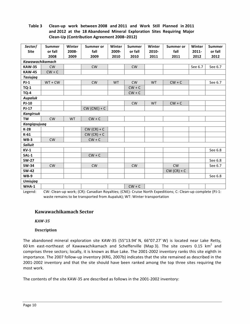
The inventory sheet for the site KAW-‐35 in the 2001-‐2002 inventory (KRG, 2003), which appears in Appendix 3 of this report, provides a detailed description of the site, including photographs and the results of contaminated soil analysis.
Work Performed The KRG began clean-‐up work at site KAW-‐35 under the 2005–2006 pilot project (KRG, 2006, 2007). It continued this work in 2007 under the 2004–2008 contribution agreement (KRG, 2007) and again in 2008, 2009 and 2010 under the 2008–2012 contribution agreement (refer to section 2.9 of this report). Detailed accounts of this work are provided in the reports prepared by the KRG (KRG, 2008, 2009, 2011). During the clean-‐up work carried out in 2005 and 2006 (pilot project) as well as in 2007, 814 barrels (roughly 87% of all the barrels), and all hazardous material were removed from the site, except for three barrels containing residue diesel and oil and two other 20-‐L containers of grease. No treatment of contaminated soil (103 m3) could be performed. In 2007, the buildings were still standing. The work was carried out by Naskapi workers from Kawawachikamach and Innu workers from Matimekush-‐Lac John (KRG, 2007b). The clean-‐up work carried out in July 2008 involved the burning of combustible waste (100m3) and the eight buildings (only the truck trailers were conserved) as well as the transportation of waste to recycling and treatment facilities. All non-‐combustible material was removed from the trailers before they were burned. Metal sheeting was folded and prepared for transportation. Residue hydrocarbons were transferred into undamaged barrels and the empty barrels were cut up using a grinder. All the barrels were transported

Page 12
from the site by floatplane to Schefferville. Subsequently, all the waste was transported by train to Sept-‐Îles and the hydrocarbons and other hazardous material were transported to Baie-‐Comeau (KRG, 2008). From October 5 to 14, 2009, the clean-‐up work involved reducing the number of piles of metal debris at the site, cutting up the metal frames of the eight trailers burned in 2008, cutting up the metal sheeting into sizes that could be handled and transported, and inspecting and emptying the two trailers located roughly one kilometre north of the main site. Part of the metal debris from the trailers (a total of roughly 9000 lbs) was transported by helicopter to Kawawachikamach (no floatplane was available), loaded onto a truck trailer, and transported to Schefferville. The metal debris was then transported to a recycling facility at Sept-‐Îles. A small pumping station north of the site was emptied and burned. From July 12 to 16, 2010, the clean-‐up work involved reconstructing the floating dock to make floatplane access easier and safer, and then removing a portion of the remaining metal debris from the site by floatplane. The metal framing and sheeting from the eight trailers were transported by floatplane to a sorting facility at Schefferville. This debris and two other small piles of metal debris were then transported by train to a recycling facility at Sept-‐Îles. Sector 2 of this site contains a large quantity of ore tailings. A water sample taken from the mine, which is now flooded, revealed an acid pH of 3.27 (21.7°C). This acid pH indicates acid mine drainage. The slope of the terrain drains towards the lake. Due to the presence of an outfitting camp near the site KAW-‐35, the sector is visited frequently. Action is recommended to minimize the impact of acid mine drainage (KRG, 2011). The inspection carried out by the KRG in September 2011 served to update the description of the site KAW-‐35 following the clean-‐up work carried out between 2005 and the summer of 2010 and to estimate the work that remains to be done. Refer to section 6.7 of this report. Photographs of the site before and after clean-‐up work appear in Appendix 4.
KAW-‐45
Description The abandoned mineral exploration site KAW-‐45 (55°33.68’ N, 67°21.20’ W) is located on the shore of Lake Musset, 30 km west-‐northwest of Kawawachikamach and Schefferville (Map 3). The site comprises two sectors located close to one another. The 2001-‐2002 inventory ranks this site 16th in importance. The 2007 follow-‐up inventory (KRG, 2007b) indicates that the site remained as described in the 2001-‐2002 inventory. The contents of the site KAW-‐45 are described as follows in the 2001-‐2002 inventory:
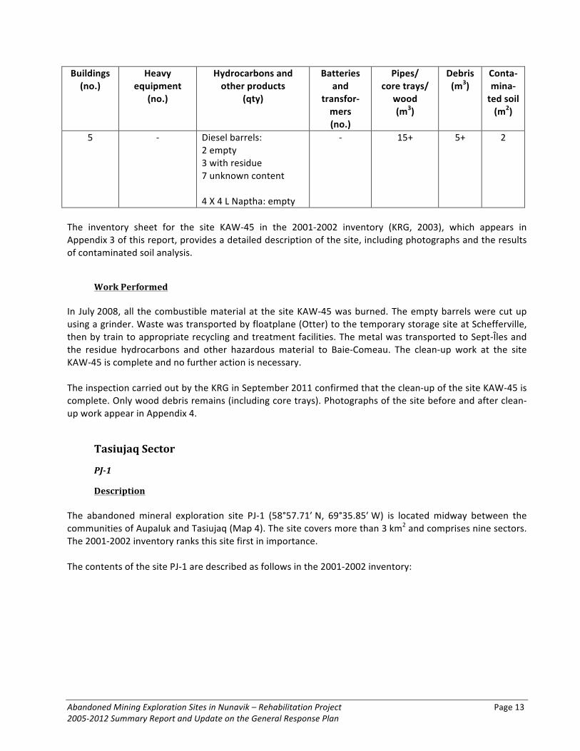
Abandoned Mining Exploration Sites in Nunavik – Rehabilitation Project Page 13 2005-‐2012 Summary Report and Update on the General Response Plan
Buildings (no.)
Heavy equipment
(no.)
Hydrocarbons and other products
(qty)
Batteries and
transfor-‐mers (no.)
Pipes/ core trays/
wood (m3)
Debris (m3)
Conta-‐mina-‐ted soil (m2)
5 -‐ Diesel barrels: 2 empty 3 with residue 7 unknown content 4 X 4 L Naptha: empty
-‐ 15+ 5+ 2
The inventory sheet for the site KAW-‐45 in the 2001-‐2002 inventory (KRG, 2003), which appears in Appendix 3 of this report, provides a detailed description of the site, including photographs and the results of contaminated soil analysis.
Work Performed In July 2008, all the combustible material at the site KAW-‐45 was burned. The empty barrels were cut up using a grinder. Waste was transported by floatplane (Otter) to the temporary storage site at Schefferville, then by train to appropriate recycling and treatment facilities. The metal was transported to Sept-‐Îles and the residue hydrocarbons and other hazardous material to Baie-‐Comeau. The clean-‐up work at the site KAW-‐45 is complete and no further action is necessary. The inspection carried out by the KRG in September 2011 confirmed that the clean-‐up of the site KAW-‐45 is complete. Only wood debris remains (including core trays). Photographs of the site before and after clean-‐up work appear in Appendix 4.
Tasiujaq Sector
PJ-‐1
Description The abandoned mineral exploration site PJ-‐1 (58°57.71’ N, 69°35.85’ W) is located midway between the communities of Aupaluk and Tasiujaq (Map 4). The site covers more than 3 km2 and comprises nine sectors. The 2001-‐2002 inventory ranks this site first in importance. The contents of the site PJ-‐1 are described as follows in the 2001-‐2002 inventory:

Page 14
Buildings (no.)
Heavy equipment
(no.)
Hydrocarbons and other products
(qty)
Batteries and
transfor-‐mers (no.)
Pipes/ core trays/
wood (m3)
Debris (m3)
Conta-‐mina-‐ted soil (m2)
7 2 bulldozers 2 muskegs 1 truck
2 crushers 2 conveyors 1 crane
8 machines 2 alternators 1 radiator 3 trailers
6 generators 10 X 40,000-‐L reservoirs 2+ motors
Diesel barrels: ~357 empty 3 full: 2500 L 43 with residue: 2595 L Propane tanks: 80 empty ~50 tubes of grease 1 X 2 kg grease 1 X 4 L motor oil 1 X 50 L motor oil 3 X 4L paint
20 batteries
2 transfor-‐mers
150+ 100+ 115
The inventory sheet for the site PJ-‐1 in the 2001-‐2002 inventory (KRG, 2003), which appears in Appendix 3 of this report, provides a detailed description of the site, including photographs and the results of contaminated soil analysis. The April 2011 report indicates that the ore tailings at the site PJ-‐1 contain higher than acceptable levels of heavy metals, according to analysis carried out by the MDDEP (KRG, 2011).
Work Performed In 2006 (pilot project) and in 2007, major clean-‐up work carried out at the site PJ-‐1, both in the summer and in the winter, permitted the removal of 15 batteries, 34 oil filters and five 4-‐L containers of paint. The barrels that had been cut up and stacked in different locations at the site were prepared for winter transportation by snowmobile to Aupaluk in the winter of 2008. Taking into account all the sectors of the site PJ-‐1, there were roughly 146 barrels each containing one or two more barrels, roughly 24 barrels containing residue hydrocarbons, and more than 90 barrels containing rocks, metal debris and other waste. All the barrels containing residue hydrocarbons were labelled with a ‘D’ for diesel or an ‘O’ for oil. Hazardous material and some other products were left at the site or were stored temporarily inside the wooden shed in sector 5 (KRG, 2007b). During the work carried out in 2006, biological soil treatment was performed in sectors 4 and 6. Analysis results showed a reduction in hydrocarbon soil contamination in the sectors 4 and 6 by 52% and 23%, respectively, compared with the initial values measured in 2002 (KRG, 2007). In April 2008, waste was transported from the site PJ-‐1 to Aupaluk with snowmobiles and sleds. In total, 117 barrels that were either empty or filled with metal debris and 33 propane tanks were removed from the site. The waste was stored in a shipping container at a temporary storage site near the Aupaluk disposal site (KRG, 2008).

Abandoned Mining Exploration Sites in Nunavik – Rehabilitation Project Page 15 2005-‐2012 Summary Report and Update on the General Response Plan
In July 2009, work in the sectors 1, 2, 3, 4, 5, 8 and 9 generally involved sorting and stacking the remaining waste by type (barrels, metal debris, tires and flexible hose; and from trailers: boards, insulation, electrical wiring and toilets) in preparation for its transportation by helicopter the following clean-‐up season. All combustible material remaining on site, including one of the two trailers located in Sector 5, was burned. In 2009, in sector 4 which contains a large quantity of ore tailings, a water sample taken near the tailings revealed a neutral pH of 6.79 (15.9°C), suggesting the absence acid mine drainage. Also, in 2009, waste was transported from sectors 6 and 7 by helicopter to Aupaluk and then transported by ship to specialized treatment facilities in the south. The work in these two sectors was completed. On October 15 and 16, 2009, roughly 20,000 lbs of waste and a small quantity of hazardous material (sectors 6, 5 and 4) were removed from the site PJ-‐1. This waste and hazardous material was transported by helicopter to Aupaluk and stored in shipping containers. In November 2009, these containers were transported by ship to the south; the hazardous material was specifically transported to specialized treatment facilities (KRG, 2009). In November and December 2009, over a three-‐week period, all the heavy equipment except for one piece (15 pieces total) was removed from the site PJ-‐1 (crane, tractor, truck, crusher, conveyer, generators, motor, tracks, etc.). This equipment was transported to Aupaluk using an excavator and tractor along a 45-‐km temporary winter road across the tundra. This work was carried out by specialists (mechanics, welders and equipment operators), assisted by local workers. The heavy equipment was stored temporarily in Aupaluk in preparation for its transportation to the south in the summer of 2010 (KRG, 2009, 2011). Several 10,000-‐L reservoirs from the site were cut in half and used to transport waste. Some of these were left at the site for removal in the winter of 2010 with other metal debris such as pole segments and rolls of metal grating (KRG 2009). From July 21 to 26, 2010, the clean-‐up work generally involved collecting and sorting the remaining waste from sectors 1, 2, 3, 8 and 9 and transporting it by helicopter to sector 5. All the combustible waste in these sectors was burned. At the end of the clean-‐up work in July 2009, sector 5 contained only a single trailer and all the waste had been prepared for transportation to Aupaluk during the winter (KRG, 2011). In October 2010, eight containers filled with propane tanks, metal debris and compacted barrels, i.e. 43.5 tonnes of metal and 972 lbs of aluminium, were transported by ship from Aupaluk to a recycling facility in the south. However, due to its considerable size and weight, the dock master decided that the heavy equipment could not be transported safely. An alternative strategy to remove the heavy equipment from Aupaluk therefore had to be found (KRG, 2011). In the fall of 2010, the workers repaired and prepared the heavy equipment for the work to be carried out in the winter of 2011. In January 2011, due to extremely cold temperatures and unusually thin snow cover, the work team adopted a new strategy to transport the huge pieces of metal and inoperable heavy equipment from the site to Aupaluk. Metal reservoirs were transformed into trailers and skies were welded onto metal frames to create sleds. The trailers were then towed one behind the other by a bulldozer (KRG, 2011). In this manner, ten loads of metal pieces and waste were transported from the site PJ-‐1 to Aupaluk. Three weeks of hard labour on the part of the work team in cooperation with the Northern Village of Aupaluk were necessary to transport everything. The community asked that the remaining trailer in sector 5 be left behind to serve as an emergency shelter (KRG, 2011).
Page 16
The Northern Village of Aupaluk made major contributions to the clean-‐up work at the site PJ-‐1 by supplying labourers and handling material logistics and equipment rental in the community. The work carried out at this site in 2011 is described in section 3.1 of this report. The inspection carried out by the KRG in September 2011 confirmed that the clean-‐up of the site PJ-‐1 is complete. Further to a request made by the community, a trailer has been left behind in sector 5. Photographs of the site before and after clean-‐up work appear in Appendix 4. Heavy equipment is still stored at Aupaluk; refer to section 6.7 of this report.
TQ-‐1
Description The abandoned mineral exploration site TQ-‐1 (57°57.68’ N, 69°40.16’ W) is located on the shore of Lake Gerido, 75 km west of Kuujjuaq (Map 4). The site comprises one sector. The 2001-‐2002 inventory ranks this site sixth in importance. The 2001-‐2002 inventory notes that the outfitter Safari Nordik appeared to be using the site under the name Gerido Camp. The contents of the site TQ-‐1 are described as follows in the 2001-‐2002 inventory: Buildings (no.)
Heavy equipment
(no.)
Hydrocarbons and other products
(qty)
Batteries and transformers
(no.)
Pipes/ core trays/
wood (m3)
Debris (m3)
Conta-‐mina-‐ted soil (m2)
8 1 snowmobile Diesel barrels: -‐30 empty
-‐1 with ~100 L at <2 m from the lake
Propane tanks:
6 empty
1 battery 20+ 10+ 2
In 2001-‐2002 it was noted that the barrels of diesel connected to the building stoves have leaked, causing soil contamination. One barrel containing roughly 100 L of diesel is situated less than 2 m from the lake. There is also some recent waste: batteries, fuel tanks, freezers, stove, small watercraft and trailer. The site seems to be used, but is not well maintained. The inventory sheet for the site TQ-‐1 in the 2001-‐2002 inventory (KRG, 2003), which appears in Appendix 3 of this report, provides a detailed description of the site, including photographs and the results of contaminated soil analysis. The 2007 follow-‐up inventory indicates that the site was still in use by the outfitter Safari Nordik and that the site remained as described in the 2001-‐2002 inventory. The camp was, however, better maintained and renovations had been carried out. The soil contamination identified under old barrels next to the buildings was still present (KRG, 2007b). The 2007 follow-‐up inventory indicates that roughly 50 barrels containing diesel were counted next to the landing strip located about one kilometre from the camp, inland from Lake Gerido. These barrels, which
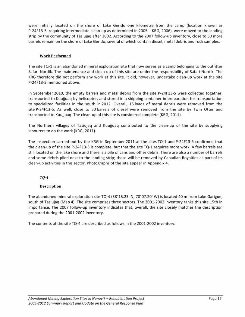
Abandoned Mining Exploration Sites in Nunavik – Rehabilitation Project Page 17 2005-‐2012 Summary Report and Update on the General Response Plan
were initially located on the shore of Lake Gerido one kilometre from the camp (location known as P-‐24F13-‐5, requiring intermediate clean-‐up as determined in 2005 – KRG, 2006), were moved to the landing strip by the community of Tasiujaq after 2002. According to the 2007 follow-‐up inventory, close to 50 more barrels remain on the shore of Lake Gerido, several of which contain diesel, metal debris and rock samples.
Work Performed The site TQ-‐1 is an abandoned mineral exploration site that now serves as a camp belonging to the outfitter Safari Nordik. The maintenance and clean-‐up of this site are under the responsibility of Safari Nordik. The KRG therefore did not perform any work at this site. It did, however, undertake clean-‐up work at the site P-‐24F13-‐5 mentioned above. In September 2010, the empty barrels and metal debris from the site P-‐24F13-‐5 were collected together, transported to Kuujjuaq by helicopter, and stored in a shipping container in preparation for transportation to specialized facilities in the south in 2012. Overall, 15 loads of metal debris were removed from the site P-‐24F13-‐5. As well, close to 50 barrels of diesel were removed from the site by Twin Otter and transported to Kuujjuaq. The clean-‐up of this site is considered complete (KRG, 2011). The Northern villages of Tasiujaq and Kuujjuaq contributed to the clean-‐up of the site by supplying labourers to do the work (KRG, 2011). The inspection carried out by the KRG in September 2011 at the sites TQ-‐1 and P-‐24F13-‐5 confirmed that the clean-‐up of the site P-‐24F13-‐5 is complete, but that the site TQ-‐1 requires more work. A few barrels are still located on the lake shore and there is a pile of cans and other debris. There are also a number of barrels and some debris piled next to the landing strip; these will be removed by Canadian Royalties as part of its clean-‐up activities in this sector. Photographs of the site appear in Appendix 4.
TQ-‐4
Description The abandoned mineral exploration site TQ-‐4 (58°15.23’ N, 70°07.20’ W) is located 40 m from Lake Garigue, south of Tasiujaq (Map 4). The site comprises three sectors. The 2001-‐2002 inventory ranks this site 15th in importance. The 2007 follow-‐up inventory indicates that, overall, the site closely matches the description prepared during the 2001-‐2002 inventory. The contents of the site TQ-‐4 are described as follows in the 2001-‐2002 inventory:

Page 18
Buildings (no.)
Heavy equipment
(no.)
Hydrocarbons and other products (qty)
Batteries and transformers
(no.)
Pipes/ core trays/
wood (m3)
Debris (m3)
Contami-‐nated soil
(m2)
2 + 1 cabin
1 ice drill Diesel barrels: 153 empty; some with
residue: 150 L
Propane tanks: 8 empty
3 X 20 L gasoline: full
0 10+ 10+ 0
The inventory sheet for the site TQ-‐4 in the 2001-‐2002 inventory (KRG, 2003), which appears in Appendix 3 of this report, provides a detailed description of the site, including photographs and the results of contaminated soil analysis. Inspections carried out in 2007 and 2010 revealed that the site closely matches the description prepared during the 2001-‐2002 inventory , with a still useable building, a collapsed building, a wooden platform, some waste (35 barrels, eight propane tanks, aluminium insulation, etc.) near the two buildings in sector 1, as well as 115 barrels located around two depressions in sector 2.
Work Performed In September 2010, 120 empty barrels, several propane tanks, 3,500 lbs of steel rod and six loads of metal debris were removed from the site and transported by helicopter to Tasiujaq to be stored in a shipping container to be transported to specialized facilities in the south. All the combustible material, including a collapsed building and wooden platform, were burned on site. A building was cleaned up and left to serve as a shelter (KRG, 2011). The Northern villages of Tasiujaq and Kuujjuaq contributed to the clean-‐up of the site by supplying labourers to do the work. The clean-‐up of this site is considered complete (KRG, 2011). The inspection carried out by the KRG in September 2011 confirmed that the clean-‐up of the site TQ-‐4 is complete. Photographs of the site before and after clean-‐up work appear in Appendix 4.
Aupaluk Sector
PJ-‐10
Description The abandoned mineral exploration site PJ-‐10 (59°15.07’ N, 70°06.52’ W) is located 50 m from Lake Ford, 30 km west-‐southwest of Aupaluk (Map 5). The site comprises two sectors. The 2001-‐2002 inventory ranks this site ninth in importance. Highly hydrocarbon-‐contaminated soil was noted under two piles of barrels. The 2007 follow-‐up inventory indicates that the site matched the description prepared during the 2001-‐2002 inventory.

Abandoned Mining Exploration Sites in Nunavik – Rehabilitation Project Page 19 2005-‐2012 Summary Report and Update on the General Response Plan
The contents of the site PJ-‐10 are described as follows in the 2001-‐2002 inventory: Buildings (no.)
Heavy equipment
(no.)
Hydrocarbons and other products (qty)
Batteries and transformers
(no.)
Pipes/ core trays/
wood (m3)
Debris (m3)
Contami-‐nated soil
(m2)
1 base 1 reservoir Diesel barrels: 39 empty 34 with residue: ~1400 L Propane tanks: 10 empty 5 with residue 2 X 20 L grease 7 X 40 L motor oil
1 battery 50+ 25+ 20
The inventory sheet for the site PJ-‐10 in the 2001-‐2002 inventory (KRG, 2003), which appears in Appendix 3 of this report, provides a detailed description of the site and the results of contaminated soil analysis.
Work Performed From August 16 to 22, 2010, close to twenty loads of metal debris were transported from the site by helicopter to Aupaluk and stored at the local disposal site. The debris consisted of empty barrels, 11 x 12’-‐long steel rods, empty aluminium core trays, metal sheeting, used oil barrels, extinguishers, grease pails and barrels filled with small metal debris. This waste was stored in a shipping container in preparation for transportation by ship to specialized facilities in the south (KRG, 2011). The soil contaminated by seven leaky barrels was placed in appropriate bags and transported by helicopter to Aupaluk. These bags were stored with other hazardous waste in a shipping container. The contents of the barrels were transferred into undamaged barrels and transported to Aupaluk. Several barrels containing small pieces of metal debris and sheeting (with sharp edges that made them unsafe to transport by helicopter) were left at the site at the end of the summer work for transportation in the winter by snowmobile (KRG, 2011). Because the remaining debris could not be transported in the winter as planned, Oceanic Iron Ore Corporation returned to the site in the summer of 2011 to collect it. Refer to section 3.1 of this report. The clean-‐up of this site is considered complete. The inspection carried out by the KRG in September 2011 confirmed that the clean-‐up of the site PJ-‐10 is complete. Only wood debris remains. Photographs of the site before and after clean-‐up work appear in Appendix 4.

Page 20
PJ-‐17
Description The abandoned mineral exploration site PJ-‐17 (59°20.29’ N, 69°45.93’ W) is located roughly 10 km northwest of Aupaluk at Merganser Point, Hopes Advance Bay (Map 5). The site comprises three sectors. The 2001-‐2002 inventory ranks this site third in importance. The contents of the site PJ-‐17 are described as follows in the 2001-‐2002 inventory: Buildings (no.)
Heavy equipment
(no.)
Hydrocarbons and other products
(qty)
Batteries and
transfor-‐mers (no.)
Pipes/ core trays/ wood
(m3)
Debris (m3)
Conta-‐mina-‐ted soil (m2)
2 1 truck 1 metal sled
1 runway roller 8 motors
Diesel barrels: 270 empty 15 with residue: 500 L Propane tanks: 27 empty 13 with residue 1 pail full of grease
5 batteries 1 transfor-‐
mer
15+ 30+ 125
The inventory sheet for the site PJ-‐17 in the 2001-‐2002 inventory (KRG, 2003), which appears in Appendix 3 of this report, provides a detailed description of the site and the results of contaminated soil analysis.
Work Performed Clean-‐up work was carried out at the site PJ-‐17 by Cruise North Expeditions in September 2005, 2006 and 2007 with KRG and Makivik support. The project was made possible through the volunteer contributions of Cruise North Expeditions staff, R/V Ushuaia (in 2005) and M/V Lyubov Orlova (in 2006 and 2007) crew, and the participation of corporate sponsors and passengers on these volunteer cruises. This work involved the dismantling of antennas and a pole with a transformer, the gathering of cables and a large quantity of metal debris, and the burning of combustible material. The work also involved the removal from the site of 94% of the barrels (290 of 308), 33% of the propane tanks (13 of 40), 76% of the metal and other debris (19 of 25 m2), 50% of the metal rods and pipes (50 of 100) and a significant quantity of small-‐ and medium-‐sized waste. The waste was transported by ship (Cruise North Expeditions) to St-‐John’s, Newfoundland and Labrador, for appropriate processing. The clean-‐up work is described in detail in the March 2006 and March 2007 reports prepared by the KRG (KRG, 2006, 2007). In September 2009, Cruise North Expeditions carried out a fourth clean-‐up campaign at the site PJ-‐17 with KRG and Makivik support. Hazardous material, metal debris and other waste collected at the site were transported by Zodiac or by helicopter to the ship or by helicopter to the temporary storage site at Aupaluk. Twenty-‐eight propane tanks were stored at Aupaluk in a shipping container and then transported by sealift in November 2009 to the south of Québec. Hazardous material and other waste transported aboard the M/V Lyubov Orlova (Cruise North Expeditions) were dropped off in the port at St-‐John’s, Newfoundland and

Abandoned Mining Exploration Sites in Nunavik – Rehabilitation Project Page 21 2005-‐2012 Summary Report and Update on the General Response Plan
Labrador. The firm FPCollins subsequently took responsibility for recycling the metal debris and the proper disposal of the other waste (KRG, 2009). During the clean-‐up work carried out in 2005, 2006, 2007 and 2009, roughly 325 barrels, 60 propane tanks, thousands of pounds of metal and other waste, including metal rods and pipes as well as a significant quantity of small-‐ and medium-‐sized waste, were removed from the site. During the four clean-‐up campaigns, no biological treatment was performed on the 125 m2 of soil contaminated with hydrocarbons (near the garage). In 2009, the clean-‐up of this site was considered complete (KRG, 2009). The December 2009 report (KRG, 2009) indicates that large items could not be transported by helicopter during the September fieldwork. It was recommended that the large items be transported to Aupaluk by heavy equipment, once the construction of an access road that will pass by the site PJ-‐17 has been completed. Subsequently, the items will be transported to the south. At the request of the community of Aupaluk, the garage at the site PJ-‐17 was left on site. The following items remain to be removed from the site: -‐ one piece of heavy equipment (in the garage); -‐ large motor parts (in the garage); -‐ four large pieces of metal sheeting (behind the garage); -‐ two steel rollers (6-‐ft. X 30 in.) (on the road between the main site and the bay and next to the landing strip). The inspection carried out by the KRG in September 2011 confirmed the presence of all the items listed above. They will be removed from the site once the construction of the road between the site PJ-‐17 and Aupaluk is complete. The clean-‐up of this site is considered complete. Photographs of the site before and after clean-‐up work appear in Appendix 4.
Kangirsuk Sector
TW
Description The abandoned mineral exploration site TW (60°05.45’ N, 69°55.48’ W) is located on the shore of Lake Twin near Kangirsuk (Map 5). The site comprises one sector. The 2007 follow-‐up inventory indicates that the site matched the description prepared during the 2001-‐2002 inventory (KRG, 2007b). The 2001-‐2002 inventory ranks this site fourth in importance. The contents of the site TW are described as follows in the 2001-‐2002 inventory:
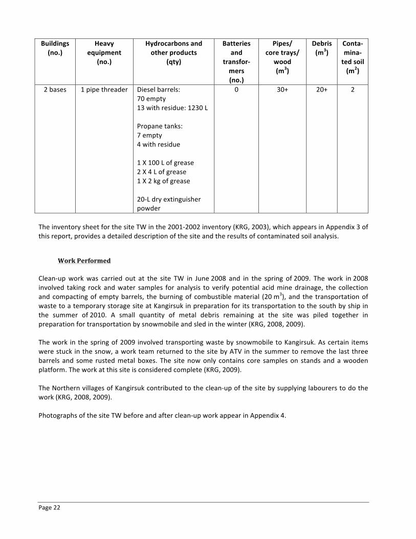
Page 22
Buildings (no.)
Heavy equipment
(no.)
Hydrocarbons and other products
(qty)
Batteries and
transfor-‐mers (no.)
Pipes/ core trays/
wood (m3)
Debris (m3)
Conta-‐mina-‐ted soil (m2)
2 bases 1 pipe threader Diesel barrels: 70 empty 13 with residue: 1230 L Propane tanks: 7 empty 4 with residue 1 X 100 L of grease 2 X 4 L of grease 1 X 2 kg of grease 20-‐L dry extinguisher powder
0 30+ 20+ 2
The inventory sheet for the site TW in the 2001-‐2002 inventory (KRG, 2003), which appears in Appendix 3 of this report, provides a detailed description of the site and the results of contaminated soil analysis.
Work Performed Clean-‐up work was carried out at the site TW in June 2008 and in the spring of 2009. The work in 2008 involved taking rock and water samples for analysis to verify potential acid mine drainage, the collection and compacting of empty barrels, the burning of combustible material (20 m3), and the transportation of waste to a temporary storage site at Kangirsuk in preparation for its transportation to the south by ship in the summer of 2010. A small quantity of metal debris remaining at the site was piled together in preparation for transportation by snowmobile and sled in the winter (KRG, 2008, 2009). The work in the spring of 2009 involved transporting waste by snowmobile to Kangirsuk. As certain items were stuck in the snow, a work team returned to the site by ATV in the summer to remove the last three barrels and some rusted metal boxes. The site now only contains core samples on stands and a wooden platform. The work at this site is considered complete (KRG, 2009). The Northern villages of Kangirsuk contributed to the clean-‐up of the site by supplying labourers to do the work (KRG, 2008, 2009). Photographs of the site TW before and after clean-‐up work appear in Appendix 4.

Abandoned Mining Exploration Sites in Nunavik – Rehabilitation Project Page 23 2005-‐2012 Summary Report and Update on the General Response Plan
Kangiqsujuaq Sector
K-‐28
Description The abandoned mineral exploration site K-‐28 (61°34.65’ N, 73°14.75’ W) is located 67 km west of Kangiqsujuaq, far from any body of water (Map 6). The site comprises three sectors. The 2001-‐2002 inventory ranks this site 11th in importance. The contents of the site K-‐28 are described as follows in the 2001-‐2002 inventory: Buildings (no.)
Heavy equipment
(no.)
Hydrocarbons and other products
(qty)
Batteries and
transfor-‐mers (no.)
Pipes/ core trays/
wood (m3)
Debris (m3)
Conta-‐mina-‐ted soil (m2)
1 tent 1 motor Diesel barrels: 60 empty 10 with residue: 2000 L Propane tanks: 9 empty 6 with residue Bags with CaCl2 (de-‐icing salt)
0 30+ 25+ 15
The inventory sheet for the site K-‐28 in the 2001-‐2002 inventory (KRG, 2003), which appears in Appendix 3 of this report, provides a detailed description of the site, including photographs and the results of contaminated soil analysis.
Work Performed This site was partially cleaned in 2006 by Canadian Royalties (KRG, 2007b). The 2007 follow-‐up inventory indicates that wood was burned, that scattered barrels were stacked together, and that barrels containing diesel and bags containing calcium chlorite were removed from the site. Canadian Royalties also gathered roughly 100 barrels from Sectors 1 and 2 along the road that leads to its Berbegamo Camp. Although the tripod was still in place, except for a pile of metal debris at the foot of the tripod, all the drilling material that was observed in 2001 had been removed from the site. The 2007 October report by the KRG states that Canadian Royalties would continue to implement its clean-‐up plan and was expected to remove all the barrels by 2009 (KRG, 2007b). The soil contamination in sector 1 was still present. Up until July 2007, no biological treatment had been performed on the 5 m2 of hydrocarbon contaminated soil (KRG, 2007b). In 2009, Canadian Royalties continued clean-‐up work and removed from the site the remaining barrels and other waste. Hydrocarbon contaminated soil (5 m2) was also removed from sector 1. The clean-‐up of this site is complete (KRG, 2009).

Page 24
The inspection carried out by the KRG in September 2011 confirmed that the clean-‐up of the site K-‐28 is complete. Photographs of the site before and after clean-‐up work appear in Appendix 4.
K-‐61
Description The abandoned mineral exploration site K-‐61 (61°33.25’ N, 73°27.25’ W) is located 80 km west of Kangiqsujuaq, more than 500 m from any body of water (Map 6). The site comprises three sectors. The 2001-‐2002 inventory ranks this site seventh in importance. The contents of the site K-‐61 are described as follows in the 2001-‐2002 inventory: Buildings (no.)
Heavy equipment
(no.)
Hydrocarbons and other products
(qty)
Batteries and
transfor-‐mers (no.)
Pipes/ core trays/
wood (m3)
Debris (m3)
Conta-‐mina-‐ted soil (m2)
12 2 muskegs 1 X 40,000-‐L reservoir 1 bath
3 water heaters 6 motors
Diesel barrels: 25 empty 10 full: 2000 L >5 with residue Propane tanks: 18 total; 16 full 44 X 20 L of grease 20 X 1 L of grease 2 L of motor oil 1 container with acid 1 X 4 L of paint
5 batteries 150+ 75+ 75
The inventory sheet for the site K-‐61 in the 2001-‐2002 inventory (KRG, 2003), which appears in Appendix 3 of this report, provides a detailed description of the site, including photographs and the results of contaminated soil analysis. The 2001-‐2002 inventory indicates that the site K-‐61 seemed to be in use by Canadian Royalties, under the name Expo Camp. As of the visit in July 2007, the original buildings had been demolished or renovated. Sector 1 remained unchanged. It included reservoirs, barrels and debris located near the original buildings as well as the same types of material removed from sites requiring intermediate and minor clean-‐up on the Canadian Royalties property. This material was to be removed from the site.
Work Performed The 2007 October report by the KRG states that Canadian Royalties was continuing to implement its clean-‐up plan and was expected to remove all the barrels by 2009 (KRG, 2007b). Up until July 2007, no biological treatment had been performed on 75 m2 of hydrocarbon contaminated soil (KRG, 2007b).

Abandoned Mining Exploration Sites in Nunavik – Rehabilitation Project Page 25 2005-‐2012 Summary Report and Update on the General Response Plan
According the 2009 KRG report, Canadian Royalties started clean-‐up at the site K-‐61 in 2006, removing from the site a certain number of barrels, metal debris and non-‐hazardous waste, as well as a muskeg. In 2009, Canadian Royalties continued its clean-‐up work, removing from the site the remaining barrels and waste, as well as 75 m2 of hydrocarbon contaminated soil (KRG, 2009). The inspection carried out by the KRG in September 2011 confirmed that the clean-‐up of the site K-‐61 is complete.
WB-‐3
Description The abandoned mineral exploration site WB-‐3 (61°29.41’ N, 72°18’09’ W) is located on the shore of Lake Qulusuttalik, roughly 22 km southwest of Kangiqsujuaq (Map 6). The site comprises one sector. The 2001-‐2002 inventory ranks this site tenth in importance. The 2007 follow-‐up inventory indicates that, overall, the site matched the description prepared during the 2001-‐2002 inventory. The contents of the site WB-‐3 are described as follows in the 2001-‐2002 inventory: Buildings (no.)
Heavy equipment
(no.)
Hydrocarbons and other products
(qty)
Batteries and
transfor-‐mers (no.)
Pipes/ core trays/
wood (m3)
Debris (m3)
Conta-‐mina-‐ted soil (m2)
0 1 round wooden base covered with aluminium
Diesel barrels: 76 empty 9 with residue: 675 L Propane tanks: 1 empty
0 20+ 5+ 2,5
The inventory sheet for the site WB-‐3 in the 2001-‐2002 inventory (KRG, 2003), which appears in Appendix 3 of this report, provides a detailed description of the site, including photographs and the results of contaminated soil analysis.
Work Performed The clean-‐up of this site was carried out during the 2008 and 2009 summer seasons. In July 2008, the work involved collecting and cutting up all the empty barrels (some had to be emptied), burning all the combustible material (20 m3) and transporting waste by helicopter to a temporary storage site at Kangiqsujuaq. At the site, only some metal sheeting and a few metal rods remained to be transported by snowmobile (KRG, 2008). The Northern village of Kangiqsujuaq was responsible for supplying labourers. Xstrata Nickel provided an in-‐kind contribution through the use of the helicopter (KRG, 2008).
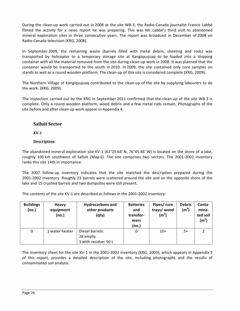
Page 26
During the clean-‐up work carried out in 2008 at the site WB-‐3, the Radio-‐Canada journalist Francis Labbé filmed the activity for a news report he was preparing. This was Mr. Labbé’s third visit to abandoned mineral exploration sites in three consecutive years. The report was broadcast in December of 2008 on Radio-‐Canada television (KRG, 2008). In September 2009, the remaining waste (barrels filled with metal debris, sheeting and rods) was transported by helicopter to a temporary storage site at Kangiqsujuaq to be loaded into a shipping container with all the material removed from the site during clean-‐up work in 2008. It was planned that the container would be transported to the south in 2010. In 2009, the site contained only core samples on stands as well as a round wooden platform. The clean-‐up of this site is considered complete (KRG, 2009). The Northern Village of Kangiqsujuaq contributed to the clean-‐up of the site by supplying labourers to do the work. (KRG, 2009). The inspection carried out by the KRG in September 2011 confirmed that the clean-‐up of the site WB-‐3 is complete. Only a round wooden platform, wood debris and a few metal rods remain. Photographs of the site before and after clean-‐up work appear in Appendix 4.
Salluit Sector
KV-‐1
Description The abandoned mineral exploration site KV-‐1 (61°25.64’ N, 76°45.46’ W) is located on the shore of a lake, roughly 100 km southwest of Salluit (Map 6). The site comprises two sectors. The 2001-‐2002 inventory ranks this site 14th in importance. The 2007 follow-‐up inventory indicates that the site matched the description prepared during the 2001-‐2002 inventory. Roughly 23 barrels were scattered around the site and on the opposite shore of the lake and 15 crushed barrels and two dumpsites were still present. The contents of the site KV-‐1 are described as follows in the 2001-‐2002 inventory: Buildings (no.)
Heavy equipment
(no.)
Hydrocarbons and other products
(qty)
Batteries and
transfor-‐mers (no.)
Pipes/ core trays/ wood
(m3)
Debris (m3)
Conta-‐mina-‐ted soil (m2)
0 1 water heater Diesel barrels: 28 empty 1 with residue: 50 L
0 10+ 5+ 2
The inventory sheet for the site KV-‐1 in the 2001-‐2002 inventory (KRG, 2003), which appears in Appendix 3 of this report, provides a detailed description of the site, including photographs and the results of contaminated soil analysis.
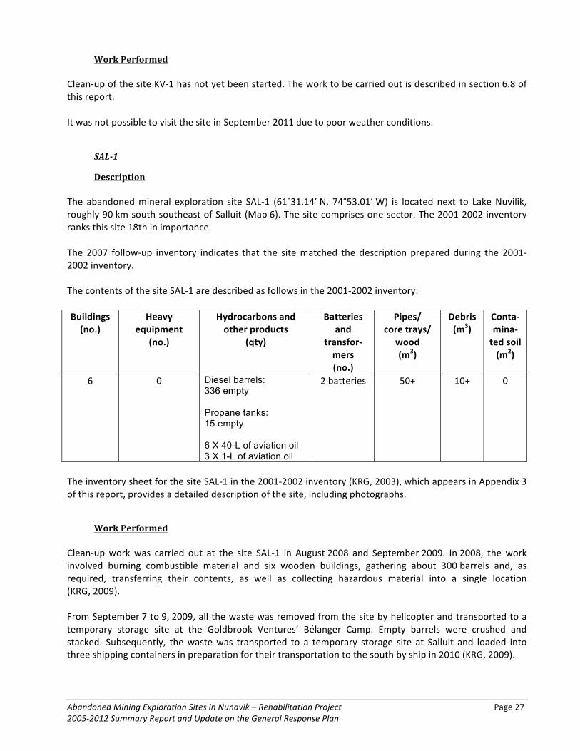
Abandoned Mining Exploration Sites in Nunavik – Rehabilitation Project Page 27 2005-‐2012 Summary Report and Update on the General Response Plan
Work Performed Clean-‐up of the site KV-‐1 has not yet been started. The work to be carried out is described in section 6.8 of this report. It was not possible to visit the site in September 2011 due to poor weather conditions.
SAL-‐1
Description The abandoned mineral exploration site SAL-‐1 (61°31.14’ N, 74°53.01’ W) is located next to Lake Nuvilik, roughly 90 km south-‐southeast of Salluit (Map 6). The site comprises one sector. The 2001-‐2002 inventory ranks this site 18th in importance. The 2007 follow-‐up inventory indicates that the site matched the description prepared during the 2001-‐2002 inventory. The contents of the site SAL-‐1 are described as follows in the 2001-‐2002 inventory: Buildings (no.)
Heavy equipment
(no.)
Hydrocarbons and other products
(qty)
Batteries and
transfor-‐mers (no.)
Pipes/ core trays/
wood (m3)
Debris (m3)
Conta-‐mina-‐ted soil (m2)
6 0 Diesel barrels: 336 empty Propane tanks: 15 empty 6 X 40-L of aviation oil 3 X 1-L of aviation oil
2 batteries 50+ 10+ 0
The inventory sheet for the site SAL-‐1 in the 2001-‐2002 inventory (KRG, 2003), which appears in Appendix 3 of this report, provides a detailed description of the site, including photographs.
Work Performed Clean-‐up work was carried out at the site SAL-‐1 in August 2008 and September 2009. In 2008, the work involved burning combustible material and six wooden buildings, gathering about 300 barrels and, as required, transferring their contents, as well as collecting hazardous material into a single location (KRG, 2009). From September 7 to 9, 2009, all the waste was removed from the site by helicopter and transported to a temporary storage site at the Goldbrook Ventures’ Bélanger Camp. Empty barrels were crushed and stacked. Subsequently, the waste was transported to a temporary storage site at Salluit and loaded into three shipping containers in preparation for their transportation to the south by ship in 2010 (KRG, 2009).

Page 28
The Northern villages of Kangiqsujuaq and Salluit contributed to the clean-‐up of the site by supplying labourers to do the work. Goldbrook Ventures, and in particular the team at the Bélanger Camp, contributed to the clean-‐up work by providing accommodations and meals for the workers and by permitting the use of two helicopters to transport the waste to the camp and a Twin Otter aircraft to transfer the waste to Salluit. Clean-‐up work at this site is now complete (KRG, 2009). The inspection carried out by the KRG in September 2011 confirmed that the clean-‐up of the site SAL-‐1 is complete. Only a few sheets of plywood and wood debris remain. Photographs of the site before and after clean-‐up work appear in Appendix 4.
SW-‐27
Description The abandoned mineral exploration site SW-‐27 (61°28.76’ N, 76°22.93’ W) is located roughly 90 km south-‐southwest of Salluit, far from any body of water (Map 6). The site covers 0.2 km2 and comprises four sectors. The 2001-‐2002 inventory ranks this site 12th in importance. The 2007 follow-‐up inventory indicates that the site matched the description prepared during the 2001-‐2002 inventory. Of all the abandoned mineral exploration sites still requiring clean-‐up, the site SW-‐27 contains the greatest quantity of hydrocarbon residue and residual material. The contents of the site SW-‐27 are described as follows in the 2001-‐2002 inventory: Buildings (no.)
Heavy equipment
(no.)
Hydrocarbons and other products
(qty)
Batteries and
transfor-‐mers (no.)
Pipes/ core trays/
wood (m3)
Debris (m3)
Conta-‐mina-‐ted soil (m2)
1 base 1 muskeg 1 tractor 1 trailer
Diesel barrels: 77 empty 6 full: 1200 L 8 with residue: 450 L Propane tanks: 1 with residue 9 pails of grease: 260 L ~40 L of motor oil 6 L of aviation oil
1 battery 20+ 15+ 2,5
The inventory sheet for the site SW-‐27 in the 2001-‐2002 inventory (KRG, 2003), which appears in Appendix 3 of this report, provides a detailed description of the site, including photographs and the results of contaminated soil analysis.
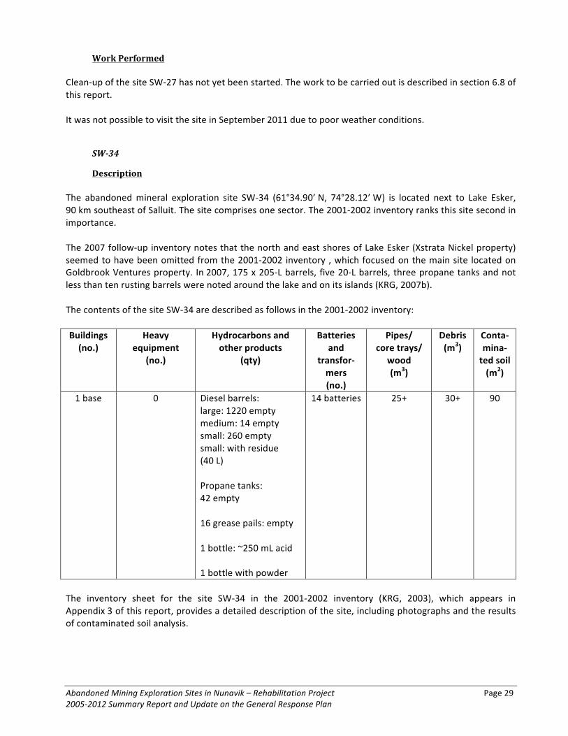
Abandoned Mining Exploration Sites in Nunavik – Rehabilitation Project Page 29 2005-‐2012 Summary Report and Update on the General Response Plan
Work Performed Clean-‐up of the site SW-‐27 has not yet been started. The work to be carried out is described in section 6.8 of this report. It was not possible to visit the site in September 2011 due to poor weather conditions.
SW-‐34
Description The abandoned mineral exploration site SW-‐34 (61°34.90’ N, 74°28.12’ W) is located next to Lake Esker, 90 km southeast of Salluit. The site comprises one sector. The 2001-‐2002 inventory ranks this site second in importance. The 2007 follow-‐up inventory notes that the north and east shores of Lake Esker (Xstrata Nickel property) seemed to have been omitted from the 2001-‐2002 inventory , which focused on the main site located on Goldbrook Ventures property. In 2007, 175 x 205-‐L barrels, five 20-‐L barrels, three propane tanks and not less than ten rusting barrels were noted around the lake and on its islands (KRG, 2007b). The contents of the site SW-‐34 are described as follows in the 2001-‐2002 inventory: Buildings (no.)
Heavy equipment
(no.)
Hydrocarbons and other products
(qty)
Batteries and
transfor-‐mers (no.)
Pipes/ core trays/
wood (m3)
Debris (m3)
Conta-‐mina-‐ted soil (m2)
1 base 0 Diesel barrels: large: 1220 empty medium: 14 empty small: 260 empty small: with residue (40 L) Propane tanks: 42 empty 16 grease pails: empty 1 bottle: ~250 mL acid 1 bottle with powder
14 batteries 25+ 30+ 90
The inventory sheet for the site SW-‐34 in the 2001-‐2002 inventory (KRG, 2003), which appears in Appendix 3 of this report, provides a detailed description of the site, including photographs and the results of contaminated soil analysis.

Page 30
Work Performed In August 2007, the KRG undertook the first phase of clean-‐up work at the site SW-‐34, which partially overlaps the Xstrata Nickel and Goldbrook Ventures properties. At this time, 180 barrels and three propane tanks from around the lake and its islands (Xstrata Nickel property) were gathered in a single location (61°35.046’ N, 74°27.494’ W) by helicopter and ATV in preparation for their eventual removal. Residue diesel, aviation gasoline and naptha were transferred into 19 undamaged barrels in preparation for their transportation to the Raglan mine for treatment. Xstrata Nickel Exploration based at the Raglan mine provided an in-‐kind contribution to this first phase of clean-‐up work. Clean-‐up work was mostly concentrated on the Xstrata Nickel property, although some work was carried out on the Goldbrook Ventures property (KRG, 2007b). On the Goldbrook Ventures property (i.e. the site SW-‐34 as indicated in the 2001-‐2002 inventory), roughly 200 barrels (the majority of which were empty) were gathered with another group of roughly 500 barrels. The hydrocarbon residue in the 800 barrels was estimated to be equivalent to between 60 and 100 barrels. Finally, 20 batteries and 20 oil filters were removed from the site by helicopter and delivered to the environmental services for the Raglan mine (KRG, 2007b). In August 2008, close to 3000 L of hydrocarbon residue was transferred into undamaged barrels. Of the 700 barrels at the site SW-‐34, 520 were crushed and stacked with propane tanks along the edge of the lake. Metal debris (70 m3) was gathered into 25 piles. Combustible material was gathered together and burned. The waste from the former dumpsite was placed in not less than 50 gunny sacks in preparation for transportation (KRG, 2008). On September 8, 2009, the site was inspected. It contained roughly 400 crushed barrels, 20 empty propane tanks, 300 uncrushed barrels and 20 full barrels gathered together near the lake, plus more than ten piles of metal debris at different locations. Other barrels, including close to 100 very rusted barrels and 19 full barrels in good condition were collected together along the edge of the lake, roughly one kilometre east of the main site. On September 9, 160 crushed barrels were transported by helicopter to the Xstrata Nickel road, near the mining site close to East Lake. They were subsequently loaded into shipping containers. The work carried out in September 2009 was interrupted due to helicopter technical problems (KRG, 2009). During the 2008–2009 winter, Xstrata Nickel delivered two empty shipping containers to its camp at East Lake, roughly 10 mi. from the site SW-‐34. In August 2010, the clean-‐up work involved transporting the remaining roughly 300 crushed barrels, as well as 70 propane, oxygen and acetylene tanks to the shipping containers. Roughly 20,000 lbs of metal was removed from the site. Xstrata Nickel planned to remove the shipping containers from the area during the winter of 2010–2011. Roughly 500 uncrushed and several piles of metal debris were still at the site (KRG, 2011). The Northern villages of Kangiqsujuaq and Salluit contributed to the clean-‐up of the site by supplying labourers to do the work. In August 2008, Xstrata Nickel provided transportation and accommodations for workers, as well as a barrel crusher and other on-‐site help. In September 2009, Goldbrook Ventures, and in particular the team at the Bélanger Camp, contributed to the clean-‐up work by providing accommodations and meals for the workers and the helicopter pilot. The work carried out at this site in the summer of 2011 is described in section 3.1 of this report. The work that remains to be carried out is described in section 6.7. It was not possible to inspect the site in September 2011 due to heavy fog.

Abandoned Mining Exploration Sites in Nunavik – Rehabilitation Project Page 31 2005-‐2012 Summary Report and Update on the General Response Plan
SW-‐42
Description The abandoned mineral exploration site SW-‐42 (61°23.92’ N, 74°34.40’ W) is located next to Lake Beauparlant, roughly 100 km south-‐southeast of Salluit (Map 6). The site comprises one sector. The 2001-‐2002 inventory ranks this site 13th in importance. The 2007 follow-‐up inventory indicates that the site matches the description prepared during the 2001-‐2002 inventory, except with regards to a pile of 1-‐ to 20-‐L metal containers located only a few metres from the lake. The contents of the site SW-‐42 are described as follows in the 2001-‐2002 inventory: Buildings (no.)
Heavy equipment
(no.)
Hydrocarbons and other products
(qty)
Batteries and
transfor-‐mers (no.)
Pipes/ core trays/
wood (m3)
Debris (m3)
Conta-‐mina-‐ted soil (m2)
1 0 Diesel barrels: 74 empty 7 with residue: 700 L 3 X 4-‐L of grease 200 mL insect repellent
0 10+ 10+ 12
The inventory sheet for the site SW-‐42 in the 2001-‐2002 inventory (KRG, 2003), which appears in Appendix 3 of this report, provides a detailed description of the site, including photographs and the results of contaminated soil analysis.
Work Performed In 2011, this site was cleaned up by Canadian Royalties. Refer to section 3.1 in this report. The inspection carried out by the KRG in September 2011 confirmed that the clean-‐up of the site SW-‐42 is complete. Only a few remnants of the old building on the ground and some barrels remain. Photographs of the site before and after clean-‐up work appear in Appendix 4.
WB-‐9
Description The abandoned mineral exploration site WB-‐9 (61°27.35’ N, 74°33.22” W) is located next to Lake Kenty, roughly 100 km south-‐southeast of Salluit (Map 6). The site comprises one sector. The 2001-‐2002 inventory ranks this site fifth in importance. The 2001-‐2002 inventory (KRG, 2003) does not present the complete inventory of the site since it seemed to be still used by Falconbridge Exploration at the time of the 2001 visit. According to the 2007 follow-‐up
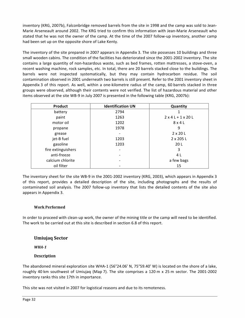
Page 32
inventory (KRG, 2007b), Falconbridge removed barrels from the site in 1998 and the camp was sold to Jean-‐Marie Arseneault around 2002. The KRG tried to confirm this information with Jean-‐Marie Arseneault who stated that he was not the owner of the camp. At the time of the 2007 follow-‐up inventory, another camp had been set up on the opposite shore of Lake Kenty. The inventory of the site prepared in 2007 appears in Appendix 3. The site possesses 10 buildings and three small wooden cabins. The condition of the facilities has deteriorated since the 2001-‐2002 inventory. The site contains a large quantity of non-‐hazardous waste, such as bed frames, rotten mattresses, a stove-‐oven, a recent washing machine, rock samples, etc. In total, there are 20 barrels stacked close to the buildings. The barrels were not inspected systematically, but they may contain hydrocarbon residue. The soil contamination observed in 2001 underneath two barrels is still present. Refer to the 2001 inventory sheet in Appendix 3 of this report. As well, within a one-‐kilometre radius of the camp, 60 barrels stacked in three groups were observed, although their contents were not verified. The list of hazardous material and other items observed at the site WB-‐9 in July 2007 is presented in the following table (KRG, 2007b):
Product Identification UN Quantity battery paint
motor oil propane grease
jet-‐B fuel gasoline
fire extinguishers anti-‐freeze
calcium chlorite oil filter
2794 1263 1202 1978 -‐
1203 1203 -‐ -‐ -‐ -‐
1 2 x 4 L + 1 x 20 L
8 x 4 L 9
2 x 20 L 2 x 205 L 20 L 3 4 L
a few bags 15
The inventory sheet for the site WB-‐9 in the 2001-‐2002 inventory (KRG, 2003), which appears in Appendix 3 of this report, provides a detailed description of the site, including photographs and the results of contaminated soil analysis. The 2007 follow-‐up inventory that lists the detailed contents of the site also appears in Appendix 3.
Work Performed In order to proceed with clean-‐up work, the owner of the mining title or the camp will need to be identified. The work to be carried out at this site is described in section 6.8 of this report.
Umiujaq Sector
WHA-‐1
Description The abandoned mineral exploration site WHA-‐1 (56°24.06’ N, 75°59.40’ W) is located on the shore of a lake, roughly 40 km southwest of Umiujaq (Map 7). The site comprises a 120 m x 25 m sector. The 2001-‐2002 inventory ranks this site 17th in importance. This site was not visited in 2007 for logistical reasons and due to its remoteness.
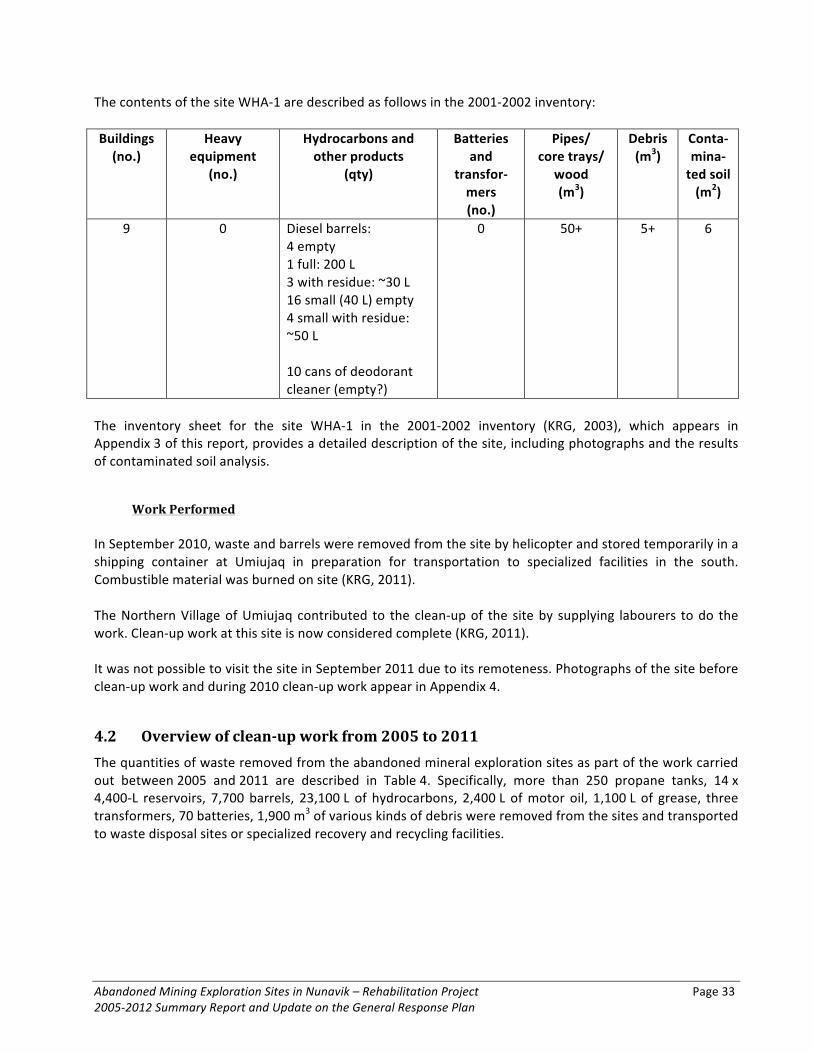
Abandoned Mining Exploration Sites in Nunavik – Rehabilitation Project Page 33 2005-‐2012 Summary Report and Update on the General Response Plan
The contents of the site WHA-‐1 are described as follows in the 2001-‐2002 inventory: Buildings (no.)
Heavy equipment
(no.)
Hydrocarbons and other products
(qty)
Batteries and
transfor-‐mers (no.)
Pipes/ core trays/
wood (m3)
Debris (m3)
Conta-‐mina-‐ted soil (m2)
9 0 Diesel barrels: 4 empty 1 full: 200 L 3 with residue: ~30 L 16 small (40 L) empty 4 small with residue: ~50 L 10 cans of deodorant cleaner (empty?)
0 50+ 5+ 6
The inventory sheet for the site WHA-‐1 in the 2001-‐2002 inventory (KRG, 2003), which appears in Appendix 3 of this report, provides a detailed description of the site, including photographs and the results of contaminated soil analysis.
Work Performed In September 2010, waste and barrels were removed from the site by helicopter and stored temporarily in a shipping container at Umiujaq in preparation for transportation to specialized facilities in the south. Combustible material was burned on site (KRG, 2011). The Northern Village of Umiujaq contributed to the clean-‐up of the site by supplying labourers to do the work. Clean-‐up work at this site is now considered complete (KRG, 2011). It was not possible to visit the site in September 2011 due to its remoteness. Photographs of the site before clean-‐up work and during 2010 clean-‐up work appear in Appendix 4.
4.2 Overview of clean-‐up work from 2005 to 2011 The quantities of waste removed from the abandoned mineral exploration sites as part of the work carried out between 2005 and 2011 are described in Table 4. Specifically, more than 250 propane tanks, 14 x 4,400-‐L reservoirs, 7,700 barrels, 23,100 L of hydrocarbons, 2,400 L of motor oil, 1,100 L of grease, three transformers, 70 batteries, 1,900 m3 of various kinds of debris were removed from the sites and transported to waste disposal sites or specialized recovery and recycling facilities.
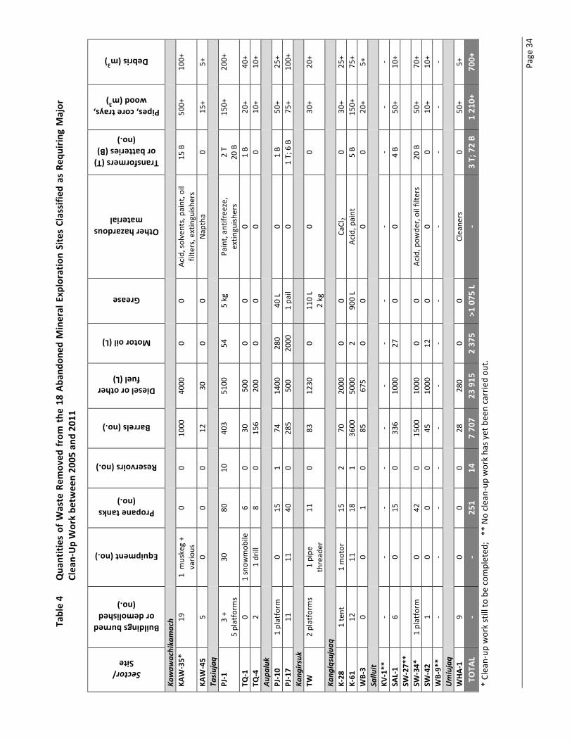
Page 34
Table 4
Qua
ntities of Waste Rem
oved
from the
18 Ab
ando
ned Mineral Exp
loratio
n Sites Classifie
d as Req
uirin
g Major
Clea
n-‐Up Work be
twee
n 20
05 and
201
1 Sector/ Site
Buildings burned or demolished
(no.)
Equipment (no.)
Propane tanks (no.)
Reservoirs (no.)
Barrels (no.)
Diesel or other fuel (L)
Motor oil (L)
Grease
Other hazardous material
Transformers (T) or batteries (B)
(no.)
Pipes, core trays, wood (m
3)
Debris (m3)
Kawaw
achika
mach
KA
W-‐35*
19
1 m
uskeg +
vario
us
0 0
1000
40
00
0 0
Acid, solvents, paint, o
il filters, extinguish
ers
15 B
500+
10
0+
KAW-‐45
5 0
0 0
12
30
0 0
Nap
tha
0 15
+ 5+
Ta
siujaq
PJ-‐1
3 +
5 platform
s 30
80
10
40
3 51
00
54
5 kg
Paint, an
tifreeze,
extin
guish
ers
2 T
20 B
150+
20
0+
TQ-‐1
0 1 snow
mob
ile
6 0
30
500
0 0
0 1 B
20+
40+
TQ-‐4
2 1 drill
8 0
156
200
0 0
0 0
10+
10+
Aupa
luk
PJ-‐10
1 platform
0
15
1 74
14
00
280
40 L
0 1 B
50+
25+
PJ-‐17
11
11
40
0 28
5 50
0 20
00
1 pa
il 0
1 T; 6 B
75+
100+
Ka
ngirsuk
TW
2 platform
s 1 pipe
thread
er
11
0 83
12
30
0 11
0 L
2 kg
0 0
30+
20+
Kang
iqsujuaq
K-‐28
1 tent
1 motor
15
2 70
20
00
0 0
CaCl
2 0
30+
25+
K-‐61
12
11
18
1
3600
50
00
2 90
0 L
Acid, p
aint
5 B
150+
75
+ WB-‐3
0 0
1 0
85
675
0 0
0 0
20+
5+
Sallu
it
KV
-‐1**
-‐ -‐
-‐ -‐
-‐ -‐
-‐ -‐
-‐ -‐
-‐ -‐
SAL-‐1
6 0
15
0 33
6 10
00
27
0 0
4 B
50+
10+
SW-‐27*
*
SW
-‐34*
1 platform
0
42
0 15
00
1000
0
0 Ac
id, p
owde
r, oil filters
20 B
50+
70+
SW-‐42
1 0
0 0
45
1000
12
0
0 0
10+
10+
WB-‐9*
* -‐
-‐ -‐
-‐ -‐
-‐ -‐
-‐ -‐
-‐ -‐
-‐ Umiujaq
WHA-‐1
9 0
0 0
28
280
0 0
Cleane
rs
0 50
+ 5+
TO
TAL
-‐ -‐
251
14
7 70
7 23
915
2 37
5 >1
075
L
-‐ 3 T; 72 B
1 21
0+
700+
* Clean-‐up
work still to
be completed
; ** No clean-‐up
work ha
s yet been carried ou
t.

Page 35
4.3 Expenses from 2007 to 2011 Table 5 shows the expenses incurred for site clean-‐up work from 2007 to 2011.
Table 5 Expenses for the Clean-‐Up of Abandoned Mineral Exploration Sites Classified as requiring Major Clean-‐Up Work between 2007 and 2011
KRG EXPENSES 2007 2008 2009 2010 2011 Total
Travel and accommodation
$100,307 $53,096 $205,229 $266,327 $231,733 $856,732
General contracts $77,721 $28,815 $306,752 $235,844 $334,021 $983,153
Salaries and fringe benefits
$38,153 $2,018 $3,698 $0 $0 $43,869
Purchase of materials $36,209 $28,555 $23,731 $35,495 $9,935 $133,925
Administrative costs $0 $0 $24,769 $1,040 $23,377 $49,186
Administrative charges $13,000 $120,000 $180,000 $89,000 $100,000 $502,000
TOTAL $265,390 $232,484 $744,179 $627,706 $699,106 $2,568,865
Source: KRG financial statements
5 SITES REQUIRING INTERMEDIATE CLEAN-‐UP
The 2001-‐2002 inventory (KRG, 2003) classified 27 sites as requiring intermediate clean-‐up according to the material and equipment present. These sites are divided equally between the Labrador Trough (14 sites) and the Ungava Trough (13 sites). In September 2011, visits to sites requiring intermediate clean-‐up were conducted in every sector (Kawawachikamach, Tasiujaq, Aupaluk, Kangirsuk, Kangiqsujuaq and Salluit), except for the Umiujaq sector (site GW-‐8). The goal was to update the results of the 2001-‐2002 inventory and assess the extent of work to be carried out in the coming years. This section provides descriptions of these sites. As priority has to date been given to work at abandoned mineral exploration sites requiring major clean-‐up (refer to section 4 of this report for details), work has not yet been organized systematically at the sites requiring intermediate clean-‐up. Nonetheless, some intermediate sites were cleaned by mining companies when these sites were located on or close to current activities (mining titles).
5.1 Site descriptions This section describes the state of each of the 27 sites requiring intermediate clean-‐up included in the 2001-‐2002 inventory (26 of which were visited between September 15 and 19, 2011), plus four new sites identified in September 2011 and another site not included in the 2001-‐2002 inventory that was cleaned up in the Aupaluk sector (site PJ-‐18). The site descriptions integrate the results of the 2001-‐2002 inventory and the September 2011 visits. The maps in Appendix 1 show the locations of the abandoned mineral exploration sites and Appendix 5 contains photographs.

Page 36
Kawawachikamach Sector There are three sites requiring intermediate clean-‐up in the Kawawachikamach sector: KAW-‐36, KAW-‐59 and KAW-‐199 (Map 3). The results of the observations made at these sites are summarized in the following table. Site no. Map no. North
latitude West
longitude Description
KAW-‐36 23/O8 55°15.02’ 66°09.46’ 32 barrels, 1 wooden platform, plastic core trays (10 m3), drilling pipes, wood and metal debris, dumpsite with cans (2 m3), old toilet.
KAW-‐59 24B/5 56°17.80’ 67°49.00’ 4 wooden platforms, 3 barrels, piping, metal debris, 1 stove, 1 tarpaulin, 1 recent canoe. REQUIRED ACTION: Cut down trees and bushes to allow a helicopter to land at the site.
KAW-‐119 23O/10 57°37.48’ 66°45.77’ 17 barrels, 2 wooden platforms, 1 stove, 1 isolated barrel on the other side.
Kuujjuaq Sector There is only one site requiring intermediate clean-‐up in the Kuujjuaq sector: P-‐24F (Map 3). The results of the observations made at this site are summarized in the following table. Site no. Map no. North
latitude West
longitude Description
P-‐24F (located on an island)
24F/2 57°01.54’ 68°53.20’ 3 wooden platforms (6 m3), 44 empty barrels, 1 barrel with ~10 L of diesel, 2 small barrels with ~20 L of diesel (the barrels are in 3 groups), 6 x 1 L aviation-‐oil containers (empty), 2 empty pails, empty Raid aerosol cans, 2 small propane tanks, 2 stoves, stove piping, cans, shingles (~1 m3), bottles, beer cans, 1 double toilet, plastic, wood debris (1–2 m3), aluminium core tray (1–2 m3). REQUIRED ACTION: Cut down trees and bushes to allow a helicopter to land at the site.

Abandoned Mining Exploration Sites in Nunavik – Rehabilitation Project Page 37 2005-‐2012 Summary Report and Update on the General Response Plan
Tasiujaq Sector There are six sites requiring intermediate clean-‐up in the Tasiujaq sector (Map 4). The results of the observations made at these sites are summarized in the following table. Site no. Map no. North
latitude West
longitude Description
TA-‐1 24K/5 58°16.80’ 69°50.19’ 8 barrels, wood debris, 1 propane tank, 1 wooden bench in the water, 1 blue tarpaulin, 1 small dumpsite.
TA-‐2 (see TQ-‐6)
24K/5 58°17.48’ 69°56.34’ Core trays, 9 barrels (1 in the water), piping, 2 wood beams, beds, 1 furnace, 2 open barrels, pails, wood debris. Near site TQ-‐6.
TQ-‐6 (TA-‐2 et TQ-‐6 are the same site)
24K/5 58°17.92’ 69°57.37’ Aluminium core trays, open barrels, metal and wood debris, cables, ~45 x 45 gal. barrels, 2 x 10 gal. barrels, metal drilling pipes, aluminium piping, wood beams, propane tanks, furnace, stove piping, tar paper, beds, cans. No contaminated soil observed.
TQ-‐10 24L/1 58°06.36’ 70°09.10’ 3 large pliable bladders <10 m from the shore, 1 wooden box containing a pliable bladder, hose, motor with pump, 1 motor, 1 wooden box with debris (piping), 1 barrel with residue (1 eighth full of diesel). NOTE: Shrubs hide debris.
TQ-‐14 24L/8 58°19.36’ 70°14.30’ 11 scattered barrels, 4 propane tanks, wood debris of an old cabin. Near the shore.
VP-‐11 24F/13E 57°48.59’ 69°31.75’ Debris of 3 collapsed wooden cabins, 3–4 groups of 5–6 barrels (all empty) a few of which are 5 m from the shore.
Aupaluk Sector There are three sites requiring intermediate clean-‐up in the Aupaluk sector (Map 5). The results of the observations made at these sites are summarized in the following table. Site no. Map no. North
latitude West
longitude Description
G-‐24N04-‐3 24N/4 59°11.57’ 69°49.86’ Sector 1: mineral exploration camp, including: 9 recent yellow barrels (eight x full, 1 x a third full); 1 burned building; 20 burned aluminium pipes (1.5 m long) aluminium piping (3 x 3 m3); metal debris; 4 beds, 8 barrels (three recent containing diesel; four empty, one very old); 9 empty barrels on the beach; 1 old building (clean). No contamination. Towards sector 2: 2 empty barrels. (This site is close to G-‐24/N04-‐3). Dumpsite.
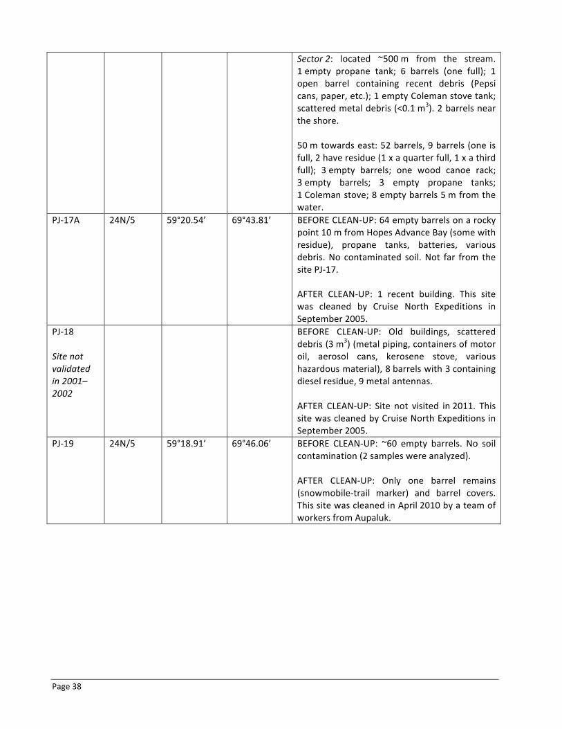
Page 38
Sector 2: located ~500 m from the stream. 1 empty propane tank; 6 barrels (one full); 1 open barrel containing recent debris (Pepsi cans, paper, etc.); 1 empty Coleman stove tank; scattered metal debris (<0.1 m3). 2 barrels near the shore. 50 m towards east: 52 barrels, 9 barrels (one is full, 2 have residue (1 x a quarter full, 1 x a third full); 3 empty barrels; one wood canoe rack; 3 empty barrels; 3 empty propane tanks; 1 Coleman stove; 8 empty barrels 5 m from the water.
PJ-‐17A
24N/5 59°20.54’ 69°43.81’ BEFORE CLEAN-‐UP: 64 empty barrels on a rocky point 10 m from Hopes Advance Bay (some with residue), propane tanks, batteries, various debris. No contaminated soil. Not far from the site PJ-‐17. AFTER CLEAN-‐UP: 1 recent building. This site was cleaned by Cruise North Expeditions in September 2005.
PJ-‐18 Site not validated in 2001–2002
BEFORE CLEAN-‐UP: Old buildings, scattered debris (3 m3) (metal piping, containers of motor oil, aerosol cans, kerosene stove, various hazardous material), 8 barrels with 3 containing diesel residue, 9 metal antennas. AFTER CLEAN-‐UP: Site not visited in 2011. This site was cleaned by Cruise North Expeditions in September 2005.
PJ-‐19
24N/5 59°18.91’ 69°46.06’ BEFORE CLEAN-‐UP: ~60 empty barrels. No soil contamination (2 samples were analyzed). AFTER CLEAN-‐UP: Only one barrel remains (snowmobile-‐trail marker) and barrel covers. This site was cleaned in April 2010 by a team of workers from Aupaluk.

Abandoned Mining Exploration Sites in Nunavik – Rehabilitation Project Page 39 2005-‐2012 Summary Report and Update on the General Response Plan
Kangirsuk Sector The site QC-‐3 requiring intermediate clean-‐up is in the Kangirsuk sector (Map 5). The results of the observations made at this site are summarized in the following table. Site no. Map no. North
latitude West
longitude Description
QC-‐3 Inuit camp
25D/8E 60°21.55’ 70°09.33’ 1 locked cabin, 19 empty barrels, metal piping, 2 empty camping-‐fuel cans, 2 containers of motor oil. No contaminated soil. 2 dumpsites, 1 blue tarpaulin, 2 gas containers. 7 barrels scattered nearby were observed from the air.
Kangiqsujuaq Sector There are ten sites requiring intermediate clean-‐up in the Kangiqsujuaq sector (Map 6). Among these sites, seven were cleaned by Canadian Royalties (I-‐32, K-‐27, K-‐37, K-‐49, KAN-‐1, KAN-‐2 and KAN-‐4). The results of the observations made at the sites are summarized in the following table. Site no. Map no. North
latitude West
longitude Description
I-‐32 35H/10W 61°43.12’ 72°54.94’ BEFORE CLEAN-‐UP: 7 scattered barrels along the shore; 36 standing up; 1 propane tank; 1 dumpsite. Close to Lake Qanartaliup Tasinga, next to the cliff edge. AFTER CLEAN-‐UP by Canadian Royalties: No debris observed.
K-‐27 35H/11W 61°36.24’ 73°19.89’ BEFORE CLEAN-‐UP: Near Lake Bombardier: 20 barrels. No contaminated soil observed. AFTER CLEAN-‐UP by Canadian Royalties: No barrels observed.
K-‐37 35H/12E 61°31.07’ 73°37.44’ BEFORE CLEAN-‐UP: Wood beams, water heater, 14 barrels, wood debris, wire, metal piping. AFTER CLEAN-‐UP by Canadian Royalties: No debris observed.
K-‐49 35H/5 61°28.70’ 73°49.70’ BEFORE CLEAN-‐UP: One plane, ~45 barrels, 14 propane tanks, 1 stove, metal piping, wood debris, cans, metal debris. Debris have been piled up by the community. AFTER CLEAN-‐UP by Canadian Royalties: No debris observed.

Page 40
KAN-‐1
35H/10W 61°32.19’ 72°57.90’ BEFORE CLEAN-‐UP: 1 old helicopter, 12 barrels, 1 old battery. Close to a lake (5 m). Close to the site I-‐26. AFTER CLEAN-‐UP by Canadian Royalties: No debris observed.
KAN-‐2 35H/12E 61°32.51’ 73°31.11’ BEFORE CLEAN-‐UP: 2 tripods, 1 non-‐hydraulic drill, debris (motor, hoses, winch), ~50 pipes, barrels, drilling sites, dump of calcium salts. AFTER CLEAN-‐UP by Canadian Royalties: 1 barrel and metal piping. Wood boards.
KAN-‐4 35H/12 61°30.92’ 73°40.18’ BEFORE CLEAN-‐UP: A pile of ~75 barrels; 2 are set apart and contain diesel. AFTER CLEAN-‐UP by Canadian Royalties: No barrels observed.
KAN-‐6 (Confirmed Inuit camp)
35H/5 61°28.94’ 73°49.50’ 2 buildings. About 1.5 m2 of contaminated soil near buildings. Near Lake Vaillant.
KAN-‐7 35H/12E 61°28.48’ 73°49.93’ BEFORE CLEAN-‐UP: A pile of ~75 barrels, 1 muskeg, 18 propane tanks, 2 oxygen tanks. Other debris (metal rods, piping, wood, etc.). Barrels and debris have been piled up by the community. AFTER CLEAN-‐UP by Canadian Royalties: Only one muskeg remains on the site.
KAN-‐10 35H/10 61°31.58’ 72°49.30’ BEFORE CLEAN-‐UP: Collapsed building, 25 barrels, 1 propane tank, metal and wood debris, core trays, barrels in a wetland. ~100m from the lake. 10 crushed barrels at 61°31.27’ N; 72°48.96’ W. OBSERVATIONS: Building collapsed, 25 stacked barrels, debris gathered in a pile near the barrels.
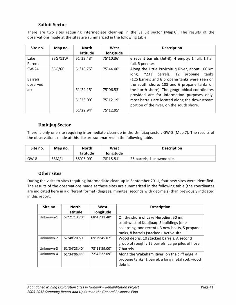
Abandoned Mining Exploration Sites in Nunavik – Rehabilitation Project Page 41 2005-‐2012 Summary Report and Update on the General Response Plan
Salluit Sector There are two sites requiring intermediate clean-‐up in the Salluit sector (Map 6). The results of the observations made at the sites are summarized in the following table. Site no. Map no. North
latitude West
longitude Description
Lake Parent
35G/11W 61°33.43’ 75°10.36’ 6 recent barrels (Jet-‐B): 4 empty; 1 full; 1 half full. 5 perches
SW-‐24 Barrels observed at:
35G/6E 61°18.75’ 61°24.15’ 61°23.09’ 61°22.94’
75°44.00’ 75°06.53’ 75°12.19’ 75°12.95’
Along the Little Puvirnituq River, about 100 km long. ~233 barrels, 12 propane tanks (125 barrels and 6 propane tanks were seen on the south shore; 108 and 6 propane tanks on the north shore). The geographical coordinates provided are for information purposes only; most barrels are located along the downstream portion of the river, on the south shore.
Umiujaq Sector There is only one site requiring intermediate clean-‐up in the Umiujaq sector: GW-‐8 (Map 7). The results of the observations made at this site are summarized in the following table. Site no. Map no. North
latitude West
longitude Description
GW-‐8 33M/1 55°05.09’ 78°15.51’ 25 barrels, 1 snowmobile.
Other sites During the visits to sites requiring intermediate clean-‐up in September 2011, four new sites were identified. The results of the observations made at these sites are summarized in the following table (the coordinates are indicated here in a different format (degrees, minutes, seconds with decimals) than previously indicated in this report.
Site no. North latitude
West longitude
Description
Unknown-‐1 57°21’13.70” 68°45’31.40" On the shore of Lake Hérodier, 50 mi. southwest of Kuujjuaq. 5 buildings (one collapsing, one recent). 3 new boats, 5 propane tanks, 8 barrels (stacked). Active site.
Unknown-‐2 57°48’20.50" 69°29’45.07” Wood debris, 10 stacked barrels. A second group of roughly 15 barrels. Large piles of hose.
Unknown-‐3 61°34’23.40” 73°11’59.00” 7 barrels. Unknown-‐4 61°34’06.44” 72°45’22.09” Along the Wakeham River, on the cliff edge. 4
propane tanks, 1 barrel, a long metal rod, wood debris.

Page 42
5.2 Overview of work at sites requiring intermediate clean-‐up The quantities of waste removed from abandoned mineral exploration sites requiring intermediate clean-‐up are indicated in Table 6.
Table 6 Quantities of Waste Removed by Canadian Royalties from the Abandoned Mineral Exploration Sites Classified as Requiring Intermediate Clean-‐Up Work
Sector/
Site
Equipm
ent (no
.)
Prop
ane tank
s (no.)
Barrels (no.)
Diesel o
r other
fuel (L)
Other hazardo
us
material
Batteries (no.)
Deb
ris
I-‐32 -‐ 1 30 820 -‐ -‐ 1 dumpsite K-‐27 -‐ -‐ 20 -‐ -‐ -‐ Wood, wiring, piping K-‐37 1 water
heater -‐ 14 -‐ -‐ -‐
K-‐49 1 plane 14 45 -‐ -‐ -‐ 1 stove, piping, wood, wood and metal debris
KAN-‐1 1 helicopter -‐ 12 820 -‐ 1 Helicopter debris (metal) KAN-‐2 2 tripods,
1 drill, 1 motor, 1 winch
-‐ -‐ -‐ CaCl2 -‐ 50 pipes
KAN-‐4 -‐ -‐ 75 -‐ -‐ -‐ -‐ KAN-‐7* -‐ 18 75 -‐ -‐ -‐ 2 oxygen tanks, metal, wood KAN-‐10 -‐ 1 25 -‐ -‐ -‐ Metal and wood, core trays TOTAL 34 296 1640 -‐ 1 -‐ * A muskeg remains. ** First phase of clean-‐up complete (waste collected together). The material will be removed during a second phase. Note: The quantities of material removed by Ocean Iron Ore Corporation (Appendix 2) have not be inventoried.
6 2012-‐2017 GENERAL RESPONSE PLAN
6.1 Introduction The Agreement Concerning the Clean-‐up in Nunavik of Abandoned Mineral Exploration Sites Classified as “Major” was amended to allow for the continuation of rehabilitation work in Nunavik. This funding will be used to complete work at the five remaining sites requiring major clean-‐up and to carry out work at the sites classified as requiring intermediate clean-‐up. The 2012–2017 General Response Plan, which is presented below, takes these developments into account. It contains a revised project budget, based on the expertise acquired during the past several years of clean-‐up work. The 2012–2017 General Response Plan contains: a description of the clean-‐up work to be carried out before March 2017; a proposed work schedule; a proposed budget; a description of the needed human resources; a description of work to be carried out by mining companies; and a few details concerning the communication of results.

Abandoned Mining Exploration Sites in Nunavik – Rehabilitation Project Page 43 2005-‐2012 Summary Report and Update on the General Response Plan
6.2 Work to Be Carried Out The work to be completed at the remaining sites (five sites requiring major clean-‐up and 18 sites requiring intermediate clean-‐up) can be broken down into the following categories: 1) fieldwork logistics; 2) transportation and disposal of hazardous material; 3) management of combustible non-‐toxic material; and 4) management of non-‐combustible non-‐toxic material. For each of these categories, the work is described below.
Fieldwork Logistics Summer is the busiest and most productive clean-‐up season. Workers have easier access to the waste on the sites and a greater number of daylight hours for working. Summer fieldwork involves cutting up and crushing barrels, transferring residue hydrocarbons to undamaged barrels, gathering of hazardous material and other waste, gathering and burning combustible material, and preparing if necessary hazardous material and waste for removal from the site in winter. Table 7 provides a general description of fieldwork logistics for each of the sites including the proposed number of workdays and workers, based on the site description and the scope of the work to be carried out. Sites may be accessible by land depending on the distance between each site and the nearest villages, as well as the topography. However, generally speaking, workers will access most sites by helicopter or floatplane. Winter work can involve the transportation of waste if the site is close enough to a village and accessible by snowmobile.
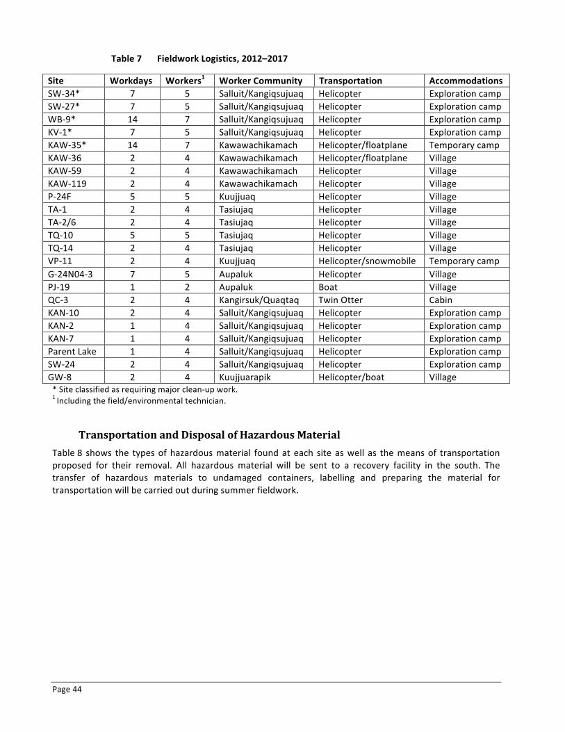
Page 44
Table 7 Fieldwork Logistics, 2012–2017
Site Workdays Workers1 Worker Community Transportation Accommodations SW-‐34* 7 5 Salluit/Kangiqsujuaq Helicopter Exploration camp SW-‐27* 7 5 Salluit/Kangiqsujuaq Helicopter Exploration camp WB-‐9* 14 7 Salluit/Kangiqsujuaq Helicopter Exploration camp KV-‐1* 7 5 Salluit/Kangiqsujuaq Helicopter Exploration camp KAW-‐35* 14 7 Kawawachikamach Helicopter/floatplane Temporary camp KAW-‐36 2 4 Kawawachikamach Helicopter/floatplane Village KAW-‐59 2 4 Kawawachikamach Helicopter Village KAW-‐119 2 4 Kawawachikamach Helicopter Village P-‐24F 5 5 Kuujjuaq Helicopter Village TA-‐1 2 4 Tasiujaq Helicopter Village TA-‐2/6 2 4 Tasiujaq Helicopter Village TQ-‐10 5 5 Tasiujaq Helicopter Village TQ-‐14 2 4 Tasiujaq Helicopter Village VP-‐11 2 4 Kuujjuaq Helicopter/snowmobile Temporary camp G-‐24N04-‐3 7 5 Aupaluk Helicopter Village PJ-‐19 1 2 Aupaluk Boat Village QC-‐3 2 4 Kangirsuk/Quaqtaq Twin Otter Cabin KAN-‐10 2 4 Salluit/Kangiqsujuaq Helicopter Exploration camp KAN-‐2 1 4 Salluit/Kangiqsujuaq Helicopter Exploration camp KAN-‐7 1 4 Salluit/Kangiqsujuaq Helicopter Exploration camp Parent Lake 1 4 Salluit/Kangiqsujuaq Helicopter Exploration camp SW-‐24 2 4 Salluit/Kangiqsujuaq Helicopter Exploration camp GW-‐8 2 4 Kuujjuarapik Helicopter/boat Village * Site classified as requiring major clean-‐up work. 1 Including the field/environmental technician.
Transportation and Disposal of Hazardous Material Table 8 shows the types of hazardous material found at each site as well as the means of transportation proposed for their removal. All hazardous material will be sent to a recovery facility in the south. The transfer of hazardous materials to undamaged containers, labelling and preparing the material for transportation will be carried out during summer fieldwork.

Abandoned Mining Exploration Sites in Nunavik – Rehabilitation Project Page 45 2005-‐2012 Summary Report and Update on the General Response Plan
Table 8 Transportation and Disposal of Hazardous Material, 2012–2017
Site
Means of Transportation Quantity of hazardous material
From site
to
nearest village
From
village to a
recovery fa
cility
Diesel (L)
Antifreeze (L)
Oil (L)
Nap
tha (L)
Grease (L)
Prop
ane (tan
ks)
Batteries (no.)
Paint (L)
SW-‐34* Helicopter/ container
Cargo (Xstrata Nickel
200
SW-‐27* Helicopter Cargo (Canadian Royalties)
1,650 20 6 260 1 1
WB-‐9* Helicopter Cargo To be determined. KV-‐1* Helicopter Cargo
(Canadian Royalties)
50
KAW-‐35* Floatplane Train Only metal debris remaining KAW-‐36 KAW-‐59 KAW-‐119 P-‐24F Helicopter Cargo 30 2 TA-‐1 Helicopter Cargo 1 TA-‐2/6 Helicopter Cargo 1 4 TQ-‐10 TQ-‐14 Helicopter Cargo 4 VP-‐11 Snowmobile Cargo G-‐24N04-‐3 Helicopter Cargo 3,000 4 PJ-‐19 QC-‐3 KAN-‐10 KAN-‐2 KAN-‐7 Parent Lake Helicopter Cargo 400 SW-‐24 Helicopter Cargo 30-‐
50
GW-‐8 * Site classified as requiring major clean-‐up work.
Management of Combustible Non-‐Toxic Material Combustible non-‐toxic material will be burned or left at each site. This material includes wood as well as buildings constructed from wood, aluminium and mineral wool. Pursuant to section 22 of the Regulation respecting the Quality of the Atmosphere, a certificate of authorization is required to burn wood, shacks and buildings. Prior to burning any building, all hazardous material must be removed including emergency lights (lead and Ni-‐Cd battery cells), smoke detectors, fluorescent ballast and fire system accumulators (Ni-‐Cd battery cells). Non-‐combustible material must also be removed including asphalt shingles, heating stoves, refrigerators, stove-‐ovens, bed frames, etc. Material unable to be burned (tin, glass wool, iron and wire) is managed with the other waste at the site. It is possible that hydrocarbons at the sites are used to ignite
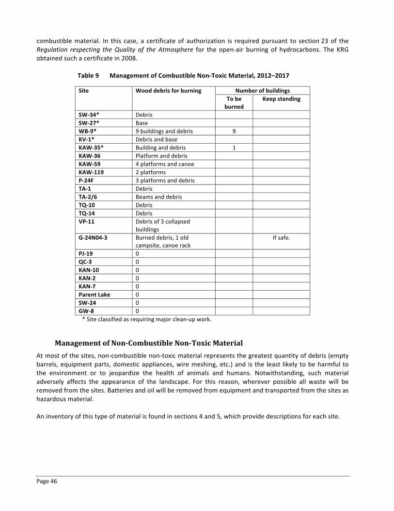
Page 46
combustible material. In this case, a certificate of authorization is required pursuant to section 23 of the Regulation respecting the Quality of the Atmosphere for the open-‐air burning of hydrocarbons. The KRG obtained such a certificate in 2008.
Table 9 Management of Combustible Non-‐Toxic Material, 2012–2017
Site Wood debris for burning Number of buildings To be burned
Keep standing
SW-‐34* Debris SW-‐27* Base WB-‐9* 9 buildings and debris 9 KV-‐1* Debris and base KAW-‐35* Building and debris 1 KAW-‐36 Platform and debris KAW-‐59 4 platforms and canoe KAW-‐119 2 platforms P-‐24F 3 platforms and debris TA-‐1 Debris TA-‐2/6 Beams and debris TQ-‐10 Debris TQ-‐14 Debris VP-‐11 Debris of 3 collapsed
buildings
G-‐24N04-‐3 Burned debris, 1 old campsite, canoe rack
If safe.
PJ-‐19 0 QC-‐3 0 KAN-‐10 0 KAN-‐2 0 KAN-‐7 0 Parent Lake 0 SW-‐24 0 GW-‐8 0 * Site classified as requiring major clean-‐up work.
Management of Non-‐Combustible Non-‐Toxic Material At most of the sites, non-‐combustible non-‐toxic material represents the greatest quantity of debris (empty barrels, equipment parts, domestic appliances, wire meshing, etc.) and is the least likely to be harmful to the environment or to jeopardize the health of animals and humans. Notwithstanding, such material adversely affects the appearance of the landscape. For this reason, wherever possible all waste will be removed from the sites. Batteries and oil will be removed from equipment and transported from the sites as hazardous material. An inventory of this type of material is found in sections 4 and 5, which provide descriptions for each site.
Abandoned Mining Exploration Sites in Nunavik – Rehabilitation Project Page 47 2005-‐2012 Summary Report and Update on the General Response Plan
6.3 Work Schedule Table 10 outlines the proposed work schedule for work at the remaining sites requiring major clean-‐up and at the sites requiring intermediate clean-‐up between April 1, 2012, and March 31, 2017. In order to facilitate the work, clean-‐up work will be carried out, when possible, on sites located in the same sector. The first priority is to complete the rehabilitation work on the five remaining sites requiring major clean-‐up.
6.4 Budget Table 11 presents the estimated budget for the clean-‐up work to be carried out in 2012–2013. Table 12 presents the overall estimated 2012–2017 budget for rehabilitation work at the remaining sites requiring major clean-‐up and the sites requiring intermediate clean-‐up as identified in the 2001-‐2002 inventory.
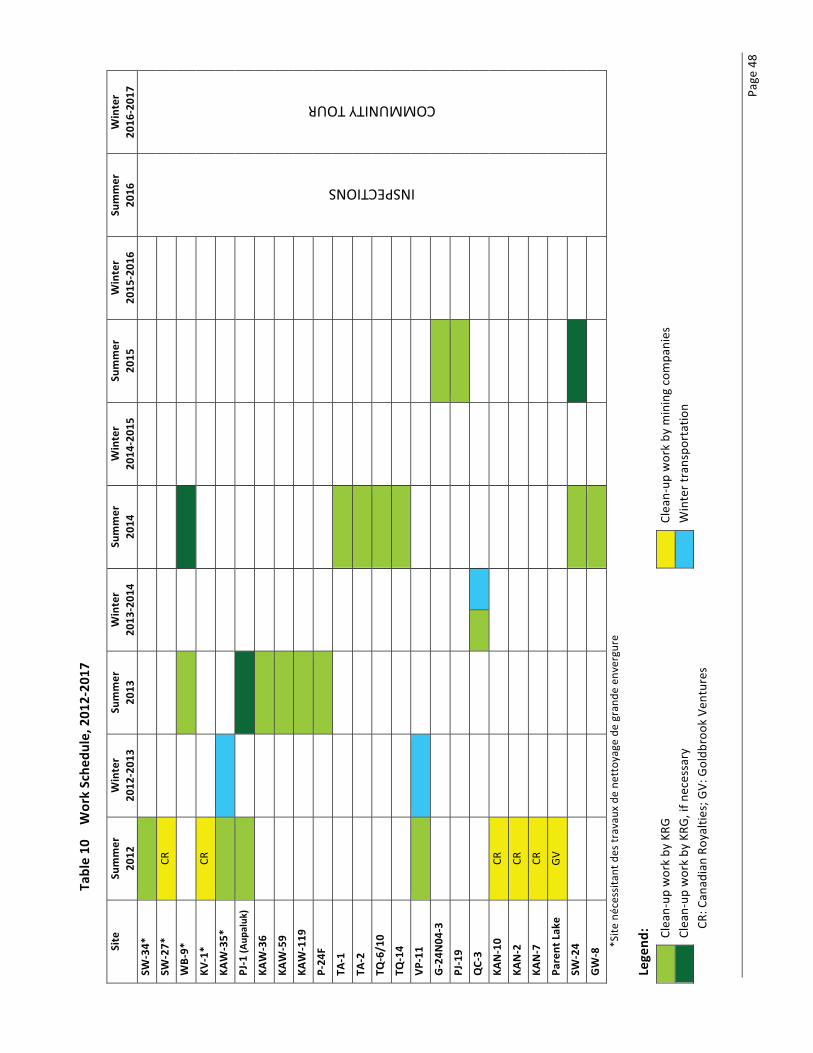
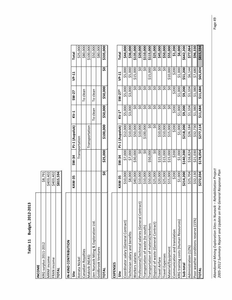
Aban
doned Mining Exploration Sites in Nun
avik – Rehab
ilitatio
n Project
Page 49
2005
-‐201
2 Summary Re
port and
Upd
ate on
the General Respo
nse Plan
Table 11
Bu
dget, 201
2-‐20
13
INCO
ME
KR
G su
rplus 2
011-‐20
12
$8,791
MRN
F income
$403
,402
FRAN
income
$403
,402
TOTA
L $8
15,594
IN-‐KIND CONTR
IBUTION
Site
KA
W-‐35
SW-‐34
PJ-‐1 (A
upaluk
) KV
-‐1
SW-‐27
VP-‐11
Total
Xstrata Nickel
Tran
sportatio
n
$25,00
0 Ca
nadian
Royaltie
s
To
clean
$80,00
0 Makivik (N
EAS)
Tran
sportatio
n
$100
,000
Jie
n Nun
avik M
iing & Exploratio
n Ltd.
To
clean
To
clean
$50,00
0 Goldb
rook Ven
tures
$80,00
0 TO
TAL
$0
$25,00
0 $1
00,000
$5
0,00
0 $5
0,00
0 $0
$3
35,000
EX
PENSES
Site
KA
W-‐35
SW-‐34
PJ-‐1 (A
upaluk
) KV
-‐1*
SW-‐27*
VP
-‐11
Total
Coordina
tor salary (Gen
eral Con
tract)
$10,00
0 $7
,000
$1
2,00
0 $5
,000
$5
,000
$5
,000
$4
4,00
0 Technician
salary and
ben
efits
$8,000
$7
,000
$1
0,00
0 $3
,000
$3
,000
$5
,000
$3
6,00
0 Workers sa
larie
s $4
0,00
0 $3
0,00
0 $5
0,00
0 $0
$0
$1
5,00
0 $1
35,000
Professio
nal/T
echn
ical sa
larie
s (Gen
eral Con
tract)
$10,00
0 $0
$1
0,00
0 $0
$0
$0
$2
0,00
0 Tran
sportatio
n of waste (to south)
$10,00
0 $0
$1
00,000
$0
$0
$0
$1
10,000
Tran
sportatio
n of m
aterial/w
orkers
$50,00
0 $5
0,00
0 $0
$0
$0
$1
5,00
0 $1
15,000
Disposal of w
aste (G
eneral Con
tract)
$25,00
0 $0
$0
$0
$0
$0
$2
5,00
0 Travel Airfare
$20,00
0 $1
5,00
0 $1
0,00
0 $0
$0
$0
$4
5,00
0 Travel Expen
ses
$25,00
0 $1
5,00
0 $1
0,00
0 $0
$0
$0
$5
0,00
0 Material/E
quipmen
t $1
5,00
0 $1
5,00
0 $1
5,00
0 $0
$0
$1
0,00
0 $5
5,00
0 Co
mmun
ication an
d tran
slatio
n $2
00
$200
$2
00
$200
$2
00
$200
$1
,200
KR
G training costs (H
uman
Resou
rces)
$1,000
$1
,000
$1
,000
$1
,000
$1
,000
$1
,000
$6
,000
Sub
-‐total
$214
,200
$1
40,200
$2
18,200
$9
,200
$9
,200
$5
1,20
0 $6
42,200
Ad
ministratio
n (12%
) $2
5,70
4 $1
6,82
4 $2
6,18
4 $1
,104
$1
,104
$6
,144
$7
7,06
4 Po
or weather con
ditio
ns re
serve (15%
) $3
2,13
0 $2
1,03
0 $3
2,73
0 $1
,380
$1
,380
$7
,680
$9
6,33
0 TO
TAL
$272
,034
$1
78,054
$2
77,114
$1
1,68
4 $1
1,68
4 $6
5,02
4 $8
15,594
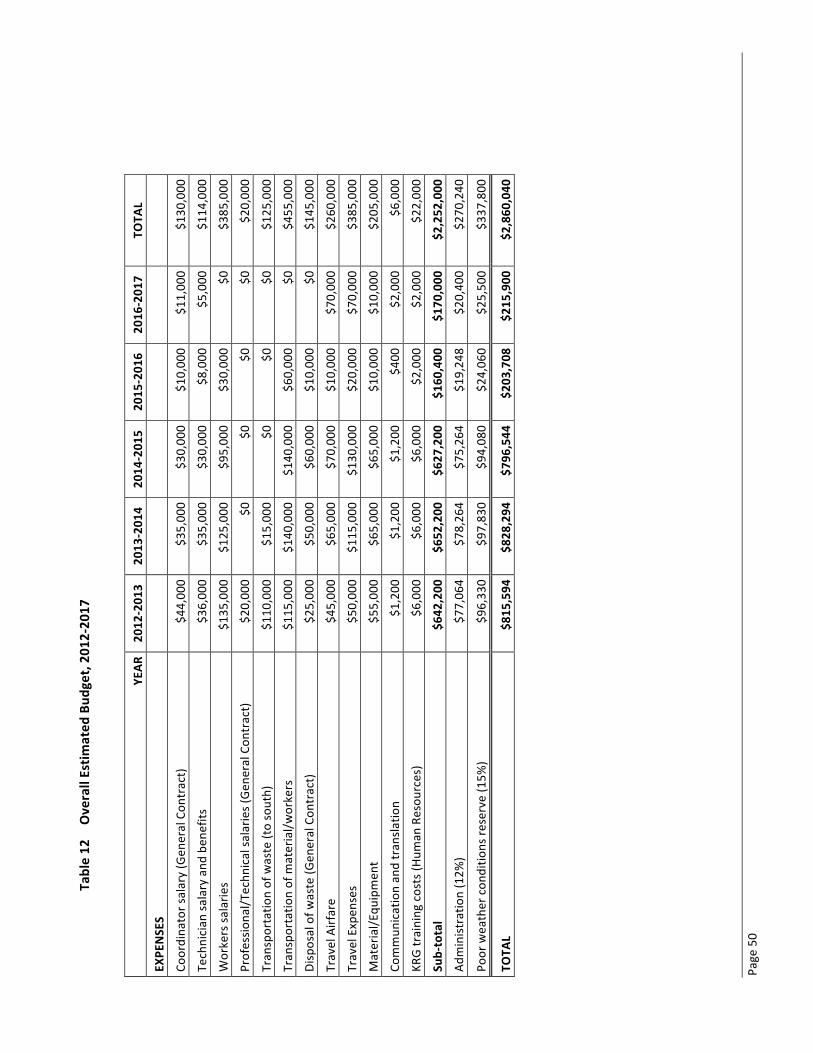
Page 50
Table 12
Overall Estim
ated
Bud
get, 20
12-‐201
7
YE
AR
2012
-‐201
3 20
13-‐201
4 20
14-‐201
5 20
15-‐201
6 20
16-‐201
7 TO
TAL
EXPE
NSES
Coordina
tor salary (Gen
eral Con
tract)
$44,00
0 $3
5,00
0 $3
0,00
0 $1
0,00
0 $1
1,00
0 $1
30,000
Technician
salary and
ben
efits
$36,00
0 $3
5,00
0 $3
0,00
0 $8
,000
$5
,000
$1
14,000
Workers sa
larie
s $1
35,000
$1
25,000
$9
5,00
0 $3
0,00
0 $0
$3
85,000
Professio
nal/T
echn
ical sa
larie
s (Gen
eral Con
tract)
$20,00
0 $0
$0
$0
$0
$2
0,00
0
Tran
sportatio
n of waste (to south)
$110
,000
$1
5,00
0 $0
$0
$0
$1
25,000
Tran
sportatio
n of m
aterial/w
orkers
$115
,000
$1
40,000
$1
40,000
$6
0,00
0 $0
$4
55,000
Disposal of w
aste (G
eneral Con
tract)
$25,00
0 $5
0,00
0 $6
0,00
0 $1
0,00
0 $0
$1
45,000
Travel Airfare
$45,00
0 $6
5,00
0 $7
0,00
0 $1
0,00
0 $7
0,00
0 $2
60,000
Travel Expen
ses
$50,00
0 $1
15,000
$1
30,000
$2
0,00
0 $7
0,00
0 $3
85,000
Material/E
quipmen
t $5
5,00
0 $6
5,00
0 $6
5,00
0 $1
0,00
0 $1
0,00
0 $2
05,000
Commun
ication an
d tran
slatio
n $1
,200
$1
,200
$1
,200
$4
00
$2,000
$6
,000
KRG training costs (H
uman
Resou
rces)
$6,000
$6
,000
$6
,000
$2
,000
$2
,000
$2
2,00
0
Sub-‐total
$642
,200
$6
52,200
$6
27,200
$1
60,400
$1
70,000
$2
,252
,000
Administratio
n (12%
) $7
7,06
4 $7
8,26
4 $7
5,26
4 $1
9,24
8 $2
0,40
0 $2
70,240
Poor weather con
ditio
ns re
serve (15%
) $9
6,33
0 $9
7,83
0 $9
4,08
0 $2
4,06
0 $2
5,50
0 $3
37,800
TOTA
L $8
15,594
$8
28,294
$7
96,544
$2
03,708
$2
15,900
$2
,860
,040
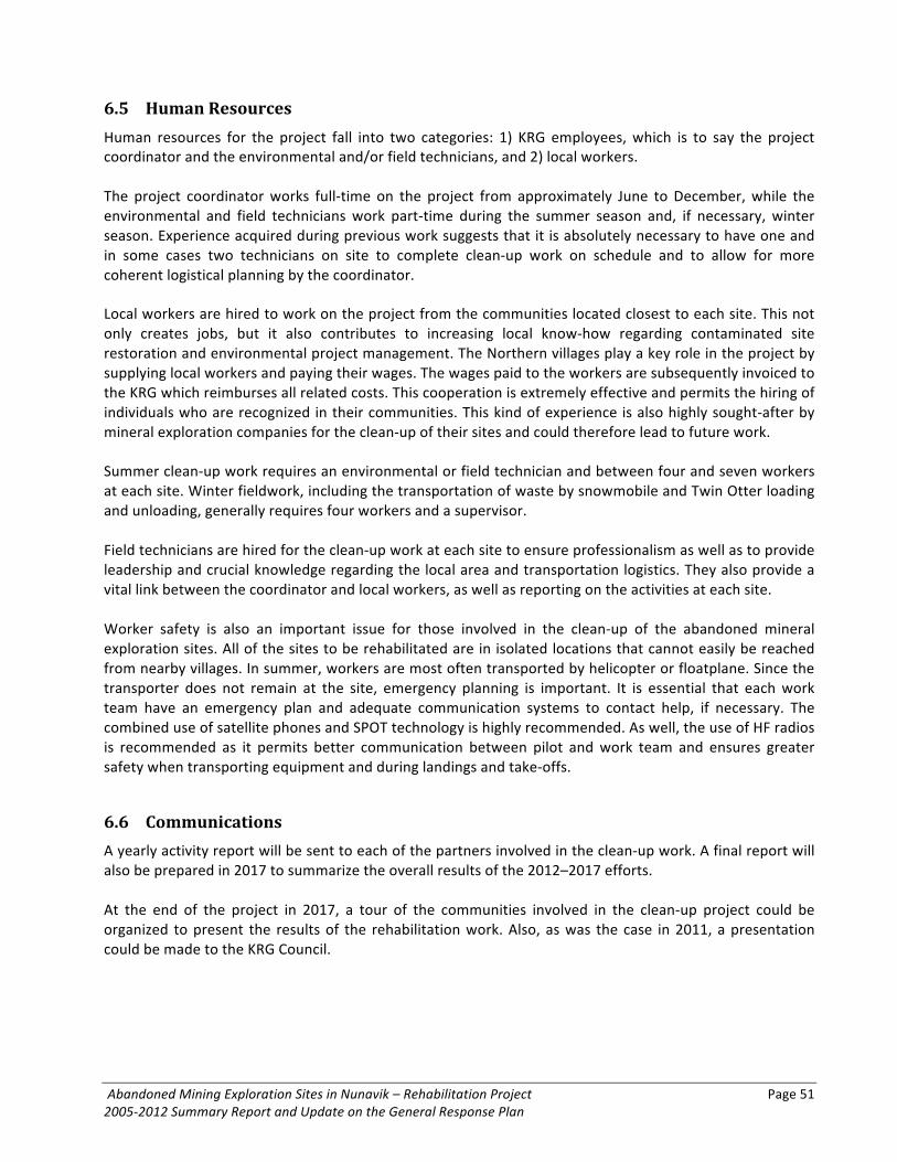
Abandoned Mining Exploration Sites in Nunavik – Rehabilitation Project Page 51 2005-‐2012 Summary Report and Update on the General Response Plan
6.5 Human Resources Human resources for the project fall into two categories: 1) KRG employees, which is to say the project coordinator and the environmental and/or field technicians, and 2) local workers. The project coordinator works full-‐time on the project from approximately June to December, while the environmental and field technicians work part-‐time during the summer season and, if necessary, winter season. Experience acquired during previous work suggests that it is absolutely necessary to have one and in some cases two technicians on site to complete clean-‐up work on schedule and to allow for more coherent logistical planning by the coordinator. Local workers are hired to work on the project from the communities located closest to each site. This not only creates jobs, but it also contributes to increasing local know-‐how regarding contaminated site restoration and environmental project management. The Northern villages play a key role in the project by supplying local workers and paying their wages. The wages paid to the workers are subsequently invoiced to the KRG which reimburses all related costs. This cooperation is extremely effective and permits the hiring of individuals who are recognized in their communities. This kind of experience is also highly sought-‐after by mineral exploration companies for the clean-‐up of their sites and could therefore lead to future work. Summer clean-‐up work requires an environmental or field technician and between four and seven workers at each site. Winter fieldwork, including the transportation of waste by snowmobile and Twin Otter loading and unloading, generally requires four workers and a supervisor. Field technicians are hired for the clean-‐up work at each site to ensure professionalism as well as to provide leadership and crucial knowledge regarding the local area and transportation logistics. They also provide a vital link between the coordinator and local workers, as well as reporting on the activities at each site. Worker safety is also an important issue for those involved in the clean-‐up of the abandoned mineral exploration sites. All of the sites to be rehabilitated are in isolated locations that cannot easily be reached from nearby villages. In summer, workers are most often transported by helicopter or floatplane. Since the transporter does not remain at the site, emergency planning is important. It is essential that each work team have an emergency plan and adequate communication systems to contact help, if necessary. The combined use of satellite phones and SPOT technology is highly recommended. As well, the use of HF radios is recommended as it permits better communication between pilot and work team and ensures greater safety when transporting equipment and during landings and take-‐offs.
6.6 Communications A yearly activity report will be sent to each of the partners involved in the clean-‐up work. A final report will also be prepared in 2017 to summarize the overall results of the 2012–2017 efforts. At the end of the project in 2017, a tour of the communities involved in the clean-‐up project could be organized to present the results of the rehabilitation work. Also, as was the case in 2011, a presentation could be made to the KRG Council.
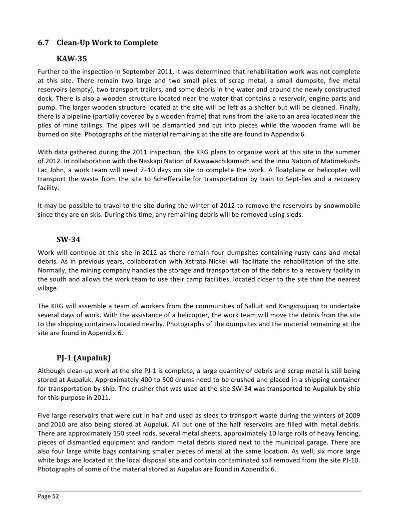
Page 52
6.7 Clean-‐Up Work to Complete
KAW-‐35 Further to the inspection in September 2011, it was determined that rehabilitation work was not complete at this site. There remain two large and two small piles of scrap metal, a small dumpsite, five metal reservoirs (empty), two transport trailers, and some debris in the water and around the newly constructed dock. There is also a wooden structure located near the water that contains a reservoir, engine parts and pump. The larger wooden structure located at the site will be left as a shelter but will be cleaned. Finally, there is a pipeline (partially covered by a wooden frame) that runs from the lake to an area located near the piles of mine tailings. The pipes will be dismantled and cut into pieces while the wooden frame will be burned on site. Photographs of the material remaining at the site are found in Appendix 6. With data gathered during the 2011 inspection, the KRG plans to organize work at this site in the summer of 2012. In collaboration with the Naskapi Nation of Kawawachikamach and the Innu Nation of Matimekush-‐Lac John, a work team will need 7–10 days on site to complete the work. A floatplane or helicopter will transport the waste from the site to Schefferville for transportation by train to Sept-‐Îles and a recovery facility. It may be possible to travel to the site during the winter of 2012 to remove the reservoirs by snowmobile since they are on skis. During this time, any remaining debris will be removed using sleds.
SW-‐34 Work will continue at this site in 2012 as there remain four dumpsites containing rusty cans and metal debris. As in previous years, collaboration with Xstrata Nickel will facilitate the rehabilitation of the site. Normally, the mining company handles the storage and transportation of the debris to a recovery facility in the south and allows the work team to use their camp facilities, located closer to the site than the nearest village. The KRG will assemble a team of workers from the communities of Salluit and Kangiqsujuaq to undertake several days of work. With the assistance of a helicopter, the work team will move the debris from the site to the shipping containers located nearby. Photographs of the dumpsites and the material remaining at the site are found in Appendix 6.
PJ-‐1 (Aupaluk) Although clean-‐up work at the site PJ-‐1 is complete, a large quantity of debris and scrap metal is still being stored at Aupaluk. Approximately 400 to 500 drums need to be crushed and placed in a shipping container for transportation by ship. The crusher that was used at the site SW-‐34 was transported to Aupaluk by ship for this purpose in 2011. Five large reservoirs that were cut in half and used as sleds to transport waste during the winters of 2009 and 2010 are also being stored at Aupaluk. All but one of the half reservoirs are filled with metal debris. There are approximately 150 steel rods, several metal sheets, approximately 10 large rolls of heavy fencing, pieces of dismantled equipment and random metal debris stored next to the municipal garage. There are also four large white bags containing smaller pieces of metal at the same location. As well, six more large white bags are located at the local disposal site and contain contaminated soil removed from the site PJ-‐10. Photographs of some of the material stored at Aupaluk are found in Appendix 6.

Abandoned Mining Exploration Sites in Nunavik – Rehabilitation Project Page 53 2005-‐2012 Summary Report and Update on the General Response Plan
This material will need to be prepared for transportation by binding similar items together using a metal strapper. Larger items, such as engines and equipment parts, will need to be grouped together and properly labelled for transportation. The hazardous material will need to be separated and stored in a designated container. The KRG will organize a team at Aupaluk to carry out this work in the summer of 2012 so that the waste can be transported by ship in the fall.
6.8 Collaborative Clean-‐up Work The following section describes work to be carried out in collaboration with mining companies that are active in the region.
KV-‐1 Roughly 23 barrels are scattered around the site and on the opposite shore of the lake. As well, 15 compacted barrels and two dumpsites are still present. As this site is located near the site SW-‐27, the two sites should be cleaned-‐up at the same time to make effective use of the work team and helicopter. Work will consist of gathering barrels and other debris for removal from the site, burning combustible materials on site, and inspecting the dumpsites. Photographs of this site are found in Appendix 6.
SW-‐27 Of all the abandoned mineral exploration sites still requiring clean-‐up, site SW-‐27 contains the greatest quantities of residual material and hydrocarbons residue: roughly 1650 L of diesel, 260 L of grease and 26 L of oil. Although covering only 2.5 m2, hydrocarbon soil contamination is still very evident. Open or damaged barrels of grease observed during 2001-‐2002 inventory work are still present. Photographs of this site are found in Appendix 6. This site is located near a Canadian Royalties property. Collaboration with this company would help clean-‐up efforts at sites SW-‐27 and KV-‐1.
WB-‐9 This site is both an abandoned mineral exploration site and an outfitter camp. In 2007, a property owned by Golden Valley Mines Inc. was identified on the opposite shore of Lake Kenty. A Goldbrook Ventures property also borders the site WB-‐9. The nine wooden structures will be emptied, stripped of metal and non-‐hazardous waste, and burned on site. The barrels and other debris will be transported by helicopter to a temporary storage location. Hazardous material, if any, will be transported to a recycling facility in the south. Photographs of the debris and buildings present at the site are found in Appendix 6.

Page 54
6.9 Conclusion The 2012–2017 General Response Plan identifies the rehabilitation work to be carried out at the remaining sites (five requiring major clean-‐up and 18 requiring intermediate clean-‐up). In 2012–2013, priority will be given to completing the work on the five sites requiring major clean-‐up, specifically KAW-‐35, WB-‐9, KV-‐1, SW-‐27 and SW-‐34, as well as preparing waste at Aupaluk for transportation by ship. It is anticipated that the clean-‐up work will be done in collaboration with mining companies that are active in the concerned areas. In 2013 and 2014, work will focus on completing rehabilitation work at blocks of closely located sites requiring intermediate clean-‐up. In 2015, work will consist of completing work at any remaining sites that were not rehabilitated in the preceding years. Finally, 2016 has been set aside for final inspections of all the sites where work was carried out and for the development of a presentation to be made to communities involved in the project. The General Response Plan will be revised on the completion of work each year.
Abandoned Mining Exploration Sites in Nunavik – Rehabilitation Project Page 55 2005-‐2012 Summary Report and Update on the General Response Plan
REFERENCES
Barrett, M. and Lepage, H. 1999. Projet de nettoyage environnemental. Kativik Regional Government, Makivik Corporation, Kuujjuaq. May 1998. 6p.
Barrett, M. and R. Lanari. 2003. Remedial Measures and Completion of the Assessment of Nunavik’s
Abandoned Mining Exploration Sites. Kativik Regional Government, Makivik Corporation, Kuujjuaq. 27 p. Canada. 1984. Northeastern Québec Agreement. Indian and Northern Affairs Canada, Ottawa. Duhaime, G. and Comtois, R. 2000. Inventory and Characterization of Abandoned Mining Exploration Sites in
Nunavik: Pilot Project. GÉTIC, Université Laval. Collection Recherche. March 2000. 67 p. + Appendices. Duhaime G. and Comtois, R. 2002. Inventory and characterization of abandoned mining exploration sites in
Nunavik. GÉTIC, Université Laval, Québec, Collection Recherche. 43 p. + Appendices. KRG. 2003. Assessment and Prioritization of Abandoned Mining Exploration Sites in Nunavik. Final Report on
a Two-‐Year Project (2001-‐2002). Kativik Regional Government, Makivik Corporation, Kuujjuaq. 67 p. + Appendices.
KRG. 2006. Assessment and Prioritization of Abandoned Mining Exploration Sites in Nunavik: Progress
Report for the Year 2005-‐2006 of the Project. Kativik Regional Government, Kuujjuaq. 24 p. + Appendices. KRG. 2007a. Assessment and Prioritization of Abandoned Mining Exploration Sites in Nunavik: Progress
Report for the Year 2006-‐2007 of the Project. Kativik Regional Government, Kuujjuaq. 27 p. + Appendices. KRG. 2007b. Summary Report on the 18 “Major” Abandoned Mineral Exploration Sites in Nunavik. Update of
the Information Contained in the Assessment and Prioritization of Abandoned Mining Exploration Sites in Nunavik – Final Report on a Two-‐Year Project (2001-‐2002). Report on the Clean-‐Up Activities Carried Out in the Summer of 2007. October 2007. Kativik Regional Government, Kuujjuaq. 104 p.
KRG. 2008. Summary Report on Rehabilitation Work at the 18 “Major” Abandoned Mineral Exploration Sites
in Nunavik Carried Out in the Summer of 2008 and Update on General Response Plan. December 2009. Kativik Regional Government, Kuujjuaq. 49 p. + Appendices.
KRG. 2009. Summary Report on the Rehabilitation Work at the 18 “Major” Abandoned Mineral Exploration
Sites in Nunavik Carried Out during the Summer of 2009 and Update on the General Response Plan. December 2009. Kativik Regional Government, Kuujjuaq. 53 p. + Appendices.
KRG. 2011. Summary Report on the Rehabilitation Work at the 18 “Major” Abandoned Mineral Exploration
Sites in Nunavik Carried Out during the Summer of 2010 and Update on the General Response Plan. April 2011. Kativik Regional Government, Kuujjuaq. 47 p. + Appendices.
Pouliot, J., Dolbec, F., Sherbrock, C, and E. Dallaire. 2002. Évaluation de l’imagerie IKONOS pour la
cartographie d’équipements abandonnés au Nunavik. Rapport pour le Groupe d’études inuit et circumpolaires (GÉTIC). Départment des sciences géomatiques et Centre de recherche en géomatique, Université Laval.

Page 56
Québec. 1997. James Bay and Northern Québec Agreement and Complementary Agreements. 1997 Edition. Éditeur officiel du Québec, Sainte-‐Foy, Québec.
Vachon, A. 1987. Étude environnementale du projet d’exploration minière Blue Lake. ROCHE Ltd. 20 p.

APPENDICES

APPENDIX 1
Maps Showing the Locations of Abandoned Mineral Exploration Sites in Nunavik
LIST
OF
MA
PS
Map
2
Map
Ind
ex ..
....
....
....
....
....
....
....
....
....
....
....
....
....
....
....
....
....
....
....
....
....
....
....
....
....
....
....
....
....
....
....
....
....
....
....
....
....
....
....
....
. 3
Map
3
Ab
and
on
ed M
inin
g Ex
plo
rati
on
Sit
es
nea
r K
awaw
ach
ikam
ach
....
....
....
....
....
....
....
....
....
....
....
....
....
....
....
....
....
....
....
....
....
. 5
Map
4
Ab
and
on
ed M
inin
g Ex
plo
rati
on
Sit
es
nea
r K
uu
jju
aq a
nd
Tas
iuja
q ..
....
....
....
....
....
....
....
....
....
....
....
....
....
....
....
....
....
....
....
.. 7
M
ap 5
A
ban
do
ned
Min
ing
Exp
lora
tio
n S
ite
s n
ear
Au
pal
uk
and
Kan
girs
uk
....
....
....
....
....
....
....
....
....
....
....
....
....
....
....
....
....
....
....
... 9
M
ap 6
A
ban
do
ned
Min
ing
Exp
lora
tio
n S
ite
s n
ear
Kan
giq
suju
aq a
nd
Sal
luit
....
....
....
....
....
....
....
....
....
....
....
....
....
....
....
....
....
....
.. 1
1 M
ap 7
A
ban
do
ned
Min
ing
Exp
lora
tio
n S
ite
s n
ear
Um
iuja
q a
nd
Ku
ujj
uar
apik
....
....
....
....
....
....
....
....
....
....
....
....
....
....
....
....
....
....
13
Map
8
Loca
tio
n o
f th
e A
ban
do
ned
Min
eral
Exp
lora
tio
n S
ites
Wh
ich
Hav
e B
een
Cle
aned
or
Par
tial
ly C
lean
ed U
nd
er t
he
Reh
abili
tati
on
Pro
ject
Fro
m 2
005
to
20
11
....
....
....
....
....
....
....
....
....
....
....
....
....
....
....
....
....
....
....
....
....
....
....
....
....
....
....
....
.. 1
5

3
Map
2
Map
Ind
ex


5


7


9

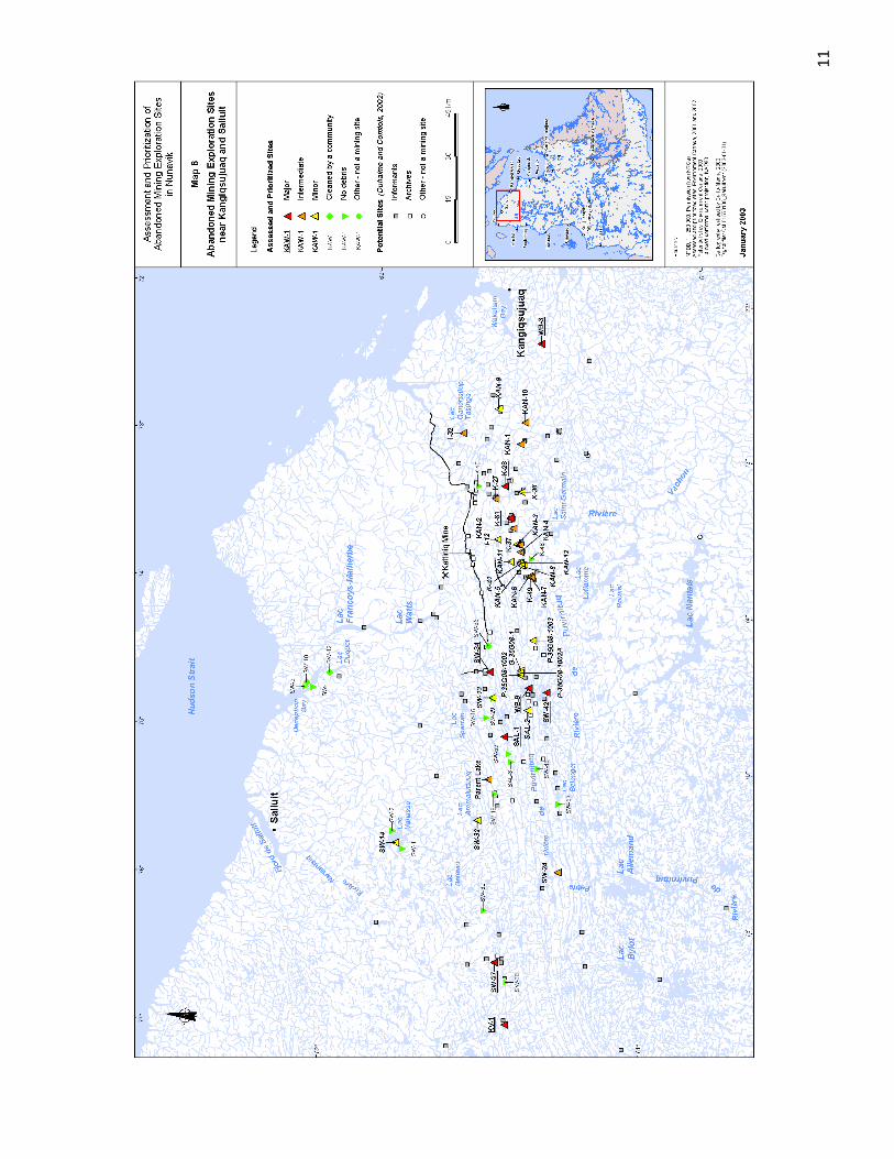
11

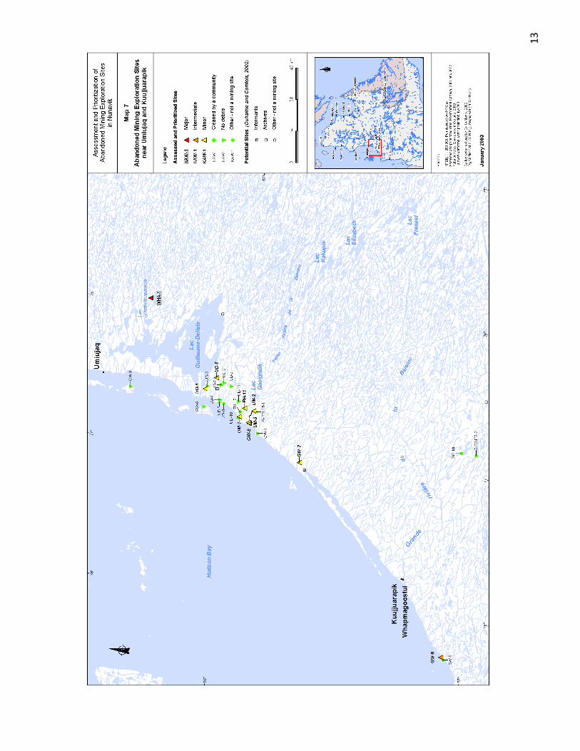
13


15
Map 8 Location of the Abandoned Mining Exploration Sites Which Have Been Cleaned or Partially Cleaned Under the Rehabilitation Project From 2005 to 2011

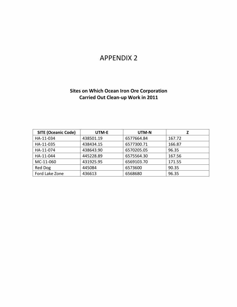
APPENDIX 2
Sites on Which Ocean Iron Ore Corporation Carried Out Clean-up Work in 2011
SITE (Oceanic Code) UTM-E UTM-N Z
HA-11-034 438501.19 6577664.84 167.72
HA-11-035 438434.15 6577300.71 166.87
HA-11-074 438643.90 6570205.05 96.35
HA-11-044 445228.89 6575564.30 167.56
MC-11-060 431925.95 6569103.70 171.55
Red Dog 445084 6573600 90.35
Ford Lake Zone 436613 6568680 96.35


APPENDIX 3
Inventory Sheets (2001-2002) of the 18 Sites Requiring Major Clean-up Work

Kawawachikamach Sector
KAW-35
KAW-45
Tasiujaq Sector
PJ-1
TQ-1
TQ-4
Aupaluk Sector
PJ-10
PJ-17
Kangirsuk Sector
TW
Kangiqsujuaq Sector
K-28
K-61
WB-3
Salluit Sector
KV-1
SAL-1
SW-27
SW-34
SW-42
WB-9
Umiujaq Sector
WHA-1

SECTOR OFKAWAWACHIKAMACH
KAW-35
KAW-45

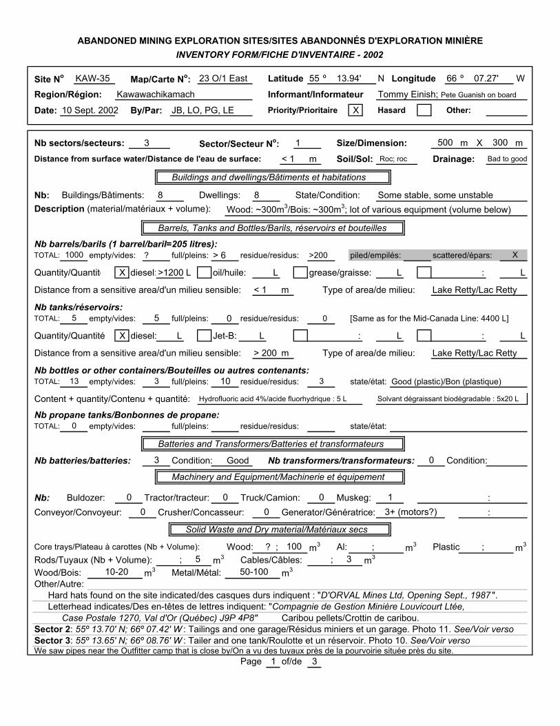
Site No KAW-35 Map/Carte No: 23 O/1 East Latitude 55 º 13.94' N Longitude 66 º 07.27' W
Region/Région: Kawawachikamach Informant/Informateur Tommy Einish; Pete Guanish on board
Date: 10 Sept. 2002 By/Par: JB, LO, PG, LE Priority/Prioritaire X Hasard Other:
Nb sectors/secteurs: 3 Sector/Secteur No: 1 Size/Dimension: m X m
Distance from surface water/Distance de l'eau de surface: < 1 m Soil/Sol: Roc; roc Drainage: Bad to good
Buildings and dwellings/Bâtiments et habitations
Nb: Buildings/Bâtiments: 8 Dwellings: 8 State/Condition: Some stable, some unstableDescription (material/matériaux + volume): Wood: ~300m3/Bois: ~300m3; lot of various equipment (volume below)
Barrels, Tanks and Bottles/Barils, réservoirs et bouteilles
Nb barrels/barils (1 barrel/baril=205 litres):TOTAL: empty/vides: ? full/pleins: > 6 residue/residus: >200 piled/empilés: scattered/épars:
Quantity/Quantité X diesel:>1200 L oil/huile: L grease/graisse: L : L
Distance from a sensitive area/d'un milieu sensible: < 1 m Type of area/de milieu: Lake Retty/Lac Retty
Nb tanks/réservoirs:TOTAL: empty/vides: full/pleins: 0 residue/residus: 0 [Same as for the Mid-Canada Line: 4400 L]
Quantity/Quantité X diesel: L Jet-B: L : L : L
Distance from a sensitive area/d'un milieu sensible: > 200 m Type of area/de milieu: Lake Retty/Lac Retty
Nb bottles or other containers/Bouteilles ou autres contenants:TOTAL: empty/vides: full/pleins: residue/residus: state/état: Good (plastic)/Bon (plastique)
Content + quantity/Contenu + quantité: Hydrofluoric acid 4%/acide fluorhydrique : 5 L Solvant dégraissant biodégradable : 5x20 L
Nb propane tanks/Bonbonnes de propane:TOTAL: empty/vides: full/pleins: residue/residus: state/état:
Batteries and Transformers/Batteries et transformateurs
Nb batteries/batteries: Condition: Good Nb transformers/transformateurs: Condition:
Machinery and Equipment/Machinerie et équipement
Nb: Buldozer: Tractor/tracteur: Truck/Camion: Muskeg: :Conveyor/Convoyeur: Crusher/Concasseur: Generator/Génératrice: :
Solid Waste and Dry material/Matériaux secs
Core trays/Plateau à carottes (Nb + Volume): Wood: ? ; m3 Al: ; m3 Plastic ; m3
Rods/Tuyaux (Nb + Volume): ; m3 Cables/Câbles: ; m3
Wood/Bois: m3 Metal/Métal: m3
Other/Autre:Hard hats found on the site indicated/des casques durs indiquent : "D'ORVAL Mines Ltd, Opening Sept., 1987 ".Letterhead indicates/Des en-têtes de lettres indiquent: "Compagnie de Gestion Minière Louvicourt Ltée,
Case Postale 1270, Val d'Or (Québec) J9P 4P8" Caribou pellets/Crottin de caribou.Sector 2: 55º 13.70' N; 66º 07.42' W : Tailings and one garage/Résidus miniers et un garage. Photo 11. See/Voir versoSector 3: 55º 13.65' N; 66º 08.76' W : Tailer and one tank/Roulotte et un réservoir. Photo 10. See/Voir versoWe saw pipes near the Outfitter camp that is close by/On a vu des tuyaux près de la pourvoirie située près du site.
Page 1 of/de 3
10-20
3
3
3
50-100
00 0
3
1005
1000
1013
ABANDONED MINING EXPLORATION SITES/SITES ABANDONNÉS D'EXPLORATION MINIÈREINVENTORY FORM/FICHE D'INVENTAIRE - 2002
500 300
X
5 5
3+ (motors?)
0
1
0
0 0
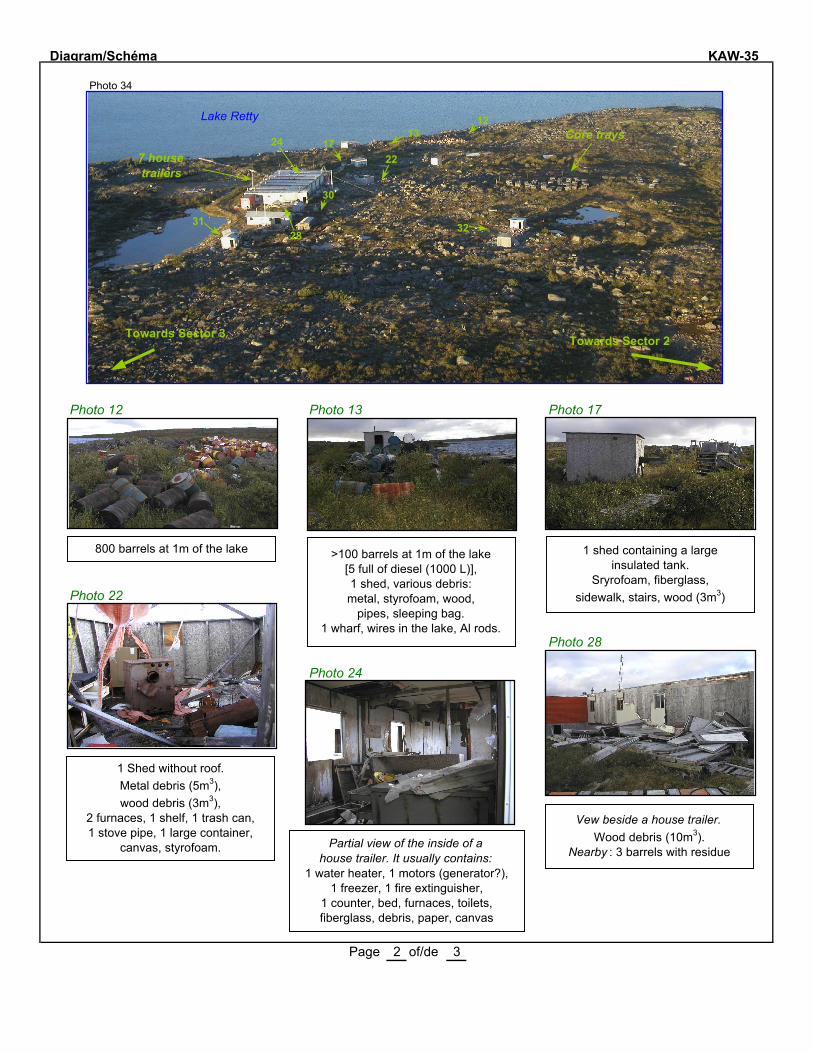
Diagram/Schéma KAW-35
Photo 34
Photo 12 Photo 13 Photo 17
Photo 22
Photo 28
Photo 24
Page 2 of/de 3
28
Lake Retty
800 barrels at 1m of the lake >100 barrels at 1m of the lake [5 full of diesel (1000 L)],1 shed, various debris:metal, styrofoam, wood,
pipes, sleeping bag. 1 wharf, wires in the lake, Al rods.
1 shed containing a large insulated tank.
Sryrofoam, fiberglass,sidewalk, stairs, wood (3m3)
2217
1312
1 Shed without roof. Metal debris (5m3), wood debris (3m3),
2 furnaces, 1 shelf, 1 trash can, 1 stove pipe, 1 large container,
canvas, styrofoam.
7 house trailers
Core trays
Towards Sector 2Towards Sector 3
Partial view of the inside of a house trailer. It usually contains:
1 water heater, 1 motors (generator?), 1 freezer, 1 fire extinguisher,
1 counter, bed, furnaces, toilets,fiberglass, debris, paper, canvas
Vew beside a house trailer.Wood debris (10m3).
Nearby : 3 barrels with residue
31 32
30
24
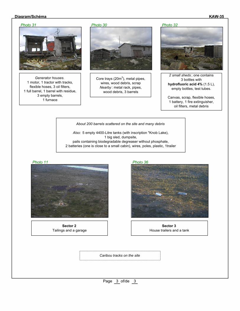
Diagram/Schéma KAW-35
Photo 31 Photo 30 Photo 32
Photo 11 Photo 36
Page 3 of/de 3
Generator houses.1 motor, 1 tractor with tracks,
flexible hoses, 3 oil filters,1 full barrel, 1 barrel with residue,
3 empty barrels,1 furnace
Core trays (20m3), metal pipes,wires, wood debris, scrap
Nearby : metal rack, pipes,wood debris, 3 barrels
2 small sheds ; one contains 3 bottles with
hydrofluoric acid 4% (1.5 L), empty bottles, test tubes.
Canvas, scrap, flexible hoses,1 battery, 1 fire extinguisher,
oil filters, metal debris
About 200 barrels scattered on the site and many debris
Also: 5 empty 4400-Litre tanks (with inscription "Knob Lake), 1 big sled, dumpsite,
pails containing biodegradable degreaser without phosphate, 2 batteries (one is close to a small cabin), wires, poles, plastic, 1trailer
Sector 2Tailings and a garage
Sector 3House trailers and a tank
Caribou tracks on the site

KAW 35
Coord.: 55° 13.94' N 66° 07.27' W.
Number Sample Depth (cm)
Parameters Analytical results (mg/kg)
Conta-minated area (m2)
Soil
KAW 35-1 Soil under a battery 0-3 Hg
Pb
0.10
140
-
KAW 35-3 Soil under a lot of barrels 0-3 C10-C50 3700 30
KAW 35-4 Soil under a battery 0-3 Hg
Pb
0.34
120
-
KAW 35-5 Soil under 2 barrels 0-3 C10-C50 120 000 25
KAW 35-6 Soil under the generator shed
0-3 C10-C50 24 000 48
KAW 35-7 Soil under a 4400 L. tank 0-3 C10-C50 390 -
Total area 103
Water
KAW 35-2A Surface water of Retty Lake N/A C10-C50 < 100 -
KAW 35-2B Surface water of Retty Lake N/A C10-C50 < 100 -
MENV criteria :
Soil
C10-C50 (mg/kg)
Surface water
C10-C50 (µµ g/L)
Soil
Hg (mg/kg)
Soil
Pb (mg/kg)
Soil
PCBs (mg/kg)
A: 300 B: 700
C: 3500
3500 A: 0.2 B: 2
C: 10
A: 50 B: 500
C: 1000
A: 0.05 B: 1
C: 10
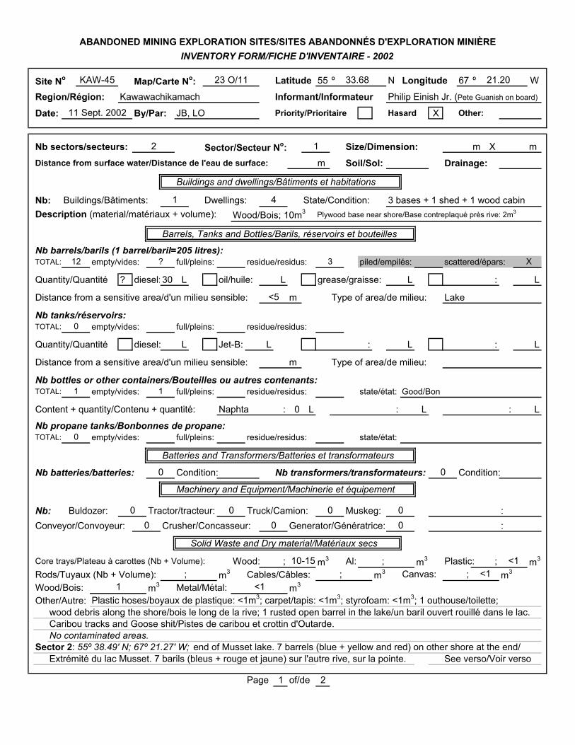
Site No Map/Carte No: Latitude 55 º N Longitude 67 º W
Region/Région: Kawawachikamach Informant/Informateur Philip Einish Jr. (Pete Guanish on board)
Date: By/Par: JB, LO Priority/Prioritaire Hasard X Other:
Nb sectors/secteurs: Sector/Secteur No: Size/Dimension: m X m
Distance from surface water/Distance de l'eau de surface: m Soil/Sol: Drainage:
Buildings and dwellings/Bâtiments et habitations
Nb: Buildings/Bâtiments: Dwellings: State/Condition: 3 bases + 1 shed + 1 wood cabinDescription (material/matériaux + volume): Wood/Bois; 10m3 Plywood base near shore/Base contreplaqué près rive: 2m3
Barrels, Tanks and Bottles/Barils, réservoirs et bouteilles
Nb barrels/barils (1 barrel/baril=205 litres):TOTAL: empty/vides: full/pleins: residue/residus: piled/empilés: scattered/épars:
Quantity/Quantité ? diesel:30 L oil/huile: L grease/graisse: L : L
Distance from a sensitive area/d'un milieu sensible: m Type of area/de milieu: Lake
Nb tanks/réservoirs:TOTAL: empty/vides: full/pleins: residue/residus:
Quantity/Quantité diesel: L Jet-B: L : L : L
Distance from a sensitive area/d'un milieu sensible: m Type of area/de milieu:
Nb bottles or other containers/Bouteilles ou autres contenants:TOTAL: empty/vides: full/pleins: residue/residus: state/état: Good/Bon
Content + quantity/Contenu + quantité: Naphta : 0 L : L : L
Nb propane tanks/Bonbonnes de propane:TOTAL: empty/vides: full/pleins: residue/residus: state/état:
Batteries and Transformers/Batteries et transformateurs
Nb batteries/batteries: Condition: Nb transformers/transformateurs: Condition:
Machinery and Equipment/Machinerie et équipement
Nb: Buldozer: Tractor/tracteur: Truck/Camion: Muskeg: :Conveyor/Convoyeur: Crusher/Concasseur: Generator/Génératrice: :
Solid Waste and Dry material/Matériaux secs
Core trays/Plateau à carottes (Nb + Volume): Wood: ; m3 Al: ; m3 Plastic: ; m3
Rods/Tuyaux (Nb + Volume): ; m3 Cables/Câbles: ; m3 Canvas: ; m3
Wood/Bois: m3 Metal/Métal: m3
Other/Autre: Plastic hoses/boyaux de plastique: <1m3; carpet/tapis: <1m3; styrofoam: <1m3; 1 outhouse/toilette; wood debris along the shore/bois le long de la rive; 1 rusted open barrel in the lake/un baril ouvert rouillé dans le lac.Caribou tracks and Goose shit/Pistes de caribou et crottin d'Outarde.No contaminated areas.
Sector 2: 55º 38.49' N; 67º 21.27' W; end of Musset lake. 7 barrels (blue + yellow and red) on other shore at the end/Extrémité du lac Musset. 7 barils (bleus + rouge et jaune) sur l'autre rive, sur la pointe. See verso/Voir verso
Page 1 of/de 2
<1
1 <1<1
0 0 0
10-15
0 0
0 0 0 0
0
0
1
12 ?
1 4
11 Sept. 2002
12
ABANDONED MINING EXPLORATION SITES/SITES ABANDONNÉS D'EXPLORATION MINIÈREINVENTORY FORM/FICHE D'INVENTAIRE - 2002
KAW-45 23 O/11 33.68 21.20
X
1
3
<5

Diagram/Schéma KAW-45Photo 7
Photo 8
Site KAW-45 (11 September, 2002)
Page 2 of/de 2

KAW 45 Sector 2: End of lake Musset. Coord.: 55° 38.49' N 67° 21.27' W.
Number Sample Depth (cm)
Parameters Analytical results (mg/kg)
Conta-minated area (m2)
Soil
KAW 45 Soil under 6 barrels 0-5 C10-C50 20 000 2
Total area 2
MENV criteria :
Soil C10-C50 (mg/kg)
Surface water C10-C50 (µµ g/L)
Soil Hg (mg/kg)
Soil Pb (mg/kg)
Soil PCBs (mg/kg)
A: 300 B: 700
C: 3500
3500 A: 0.2 B: 2 C: 10
A: 50 B: 500 C: 1000
A: 0.05 B: 1 C: 10

SECTOR OFTASIUJAQ
PJ-1
TQ-1
TQ-4

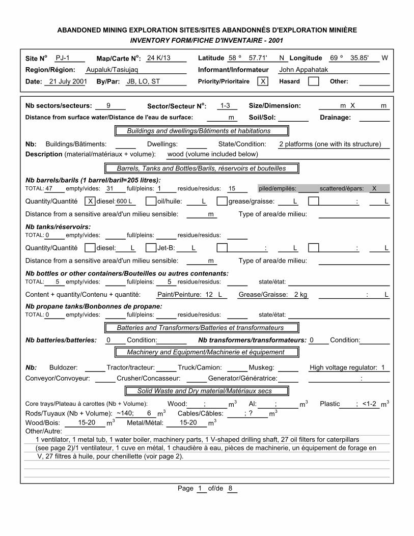
Site No PJ-1 Map/Carte No: 24 K/13 Latitude 58 º 57.71' N Longitude 69 º 35.85' W
Region/Région: Aupaluk/Tasiujaq Informant/Informateur John Appahatak
Date: 21 July 2001 By/Par: JB, LO, ST Priority/Prioritaire X Hasard Other:
Nb sectors/secteurs: 9 Sector/Secteur No: 1-3 Size/Dimension: m X m
Distance from surface water/Distance de l'eau de surface: m Soil/Sol: Drainage:
Buildings and dwellings/Bâtiments et habitations
Nb: Buildings/Bâtiments: Dwellings: State/Condition: 2 platforms (one with its structure)Description (material/matériaux + volume): wood (volume included below)
Barrels, Tanks and Bottles/Barils, réservoirs et bouteilles
Nb barrels/barils (1 barrel/baril=205 litres):TOTAL: 47 empty/vides: 31 full/pleins: 1 residue/residus: 15 piled/empilés: scattered/épars: X
Quantity/Quantité X diesel:600 L oil/huile: L grease/graisse: L : L
Distance from a sensitive area/d'un milieu sensible: m Type of area/de milieu:
Nb tanks/réservoirs:TOTAL: 0 empty/vides: full/pleins: residue/residus:
Quantity/Quantité diesel: L Jet-B: L : L : L
Distance from a sensitive area/d'un milieu sensible: m Type of area/de milieu:
Nb bottles or other containers/Bouteilles ou autres contenants:TOTAL: 5 empty/vides: full/pleins: 5 residue/residus: state/état:
Content + quantity/Contenu + quantité: Paint/Peinture: 12 L Grease/Graisse: 2 kg : L
Nb propane tanks/Bonbonnes de propane:TOTAL: 0 empty/vides: full/pleins: residue/residus: state/état:
Batteries and Transformers/Batteries et transformateurs
Nb batteries/batteries: 0 Condition: Nb transformers/transformateurs: 0 Condition:
Machinery and Equipment/Machinerie et équipement
Nb: Buldozer: Tractor/tracteur: Truck/Camion: Muskeg: High voltage regulator: 1Conveyor/Convoyeur: Crusher/Concasseur: Generator/Génératrice: :
Solid Waste and Dry material/Matériaux secs
Core trays/Plateau à carottes (Nb + Volume): Wood: ; m3 Al: ; m3 Plastic ; <1-2 m3
Rods/Tuyaux (Nb + Volume): ~140; 6 m3 Cables/Câbles: ; ? m3
Wood/Bois: 15-20 m3 Metal/Métal: 15-20 m3
Other/Autre:1 ventilator, 1 metal tub, 1 water boiler, machinery parts, 1 V-shaped drilling shaft, 27 oil filters for caterpillars(see page 2)/1 ventilateur, 1 cuve en métal, 1 chaudière à eau, pièces de machinerie, un équipement de forage en V, 27 filtres à huile, pour chenillette (voir page 2).
Page 1 of/de 8
ABANDONED MINING EXPLORATION SITES/SITES ABANDONNÉS D'EXPLORATION MINIÈREINVENTORY FORM/FICHE D'INVENTAIRE - 2001

Diagram/Schéma PJ-1
Sector 1 (58 o 57.71' N; 69 o 35.85' W) - Area: ~200m x ~60m
Sector 2 (58 o 57.74' N; 69 o 35.73' W) - Area: ~50m x ~40m
Sector 3 (58 o 57.95' N; 69 o 35.71' W) - Area: ~20m x ~10m
Page 2 of/de 8
������������������������������������������������������������������������������������������������������������������������������������������������������������������������������������������������������������������������������������������������������������������������������������������������
������������������������������������������������������������������������������������������������������������������������������������������������������������������������������������������������������������������������������������������������������������������������������������������������
Wat
er
Road
1 open barrel
Towards Sector 4
~8 m further in the valley
1 "V"-shaped drilling shaft with rocks
Rocks and bags
Rocks
1 full barrel
50 m
Metal debris
50 m50 m
40 mPond
Metal debris (0.5m3),wood debris (2m3)
Dangerou s:Deep pit covered
by wood
Wood debris (1m3)
FillingDangerous :Deep pit covered by metal grid and beams
Towards Sector 2
~600 m further
27 caterpillar oil filters(0.5m3),
2 empty barrels, 1 high voltage regulator,1 roll of flexible hose for
water,electric cables,
1 part of drilling machine (1m3)
10 m
5 m
12 m
6 barrels with residue (100 L), canvas (1m3),
1 wood platform,machinery parts,
1 metal shelf,pipe parts,8 oil filters
Metal debris: 8m3
Wood debris: 6m3
1 open barrelwith a pipe
20 barrels,9 with residue (300 L)
1 water boiler
1 group of 20 pipes(6m2; <0.5m3),
1 group of ~100 pipes (15m2, 2.5m3)
Wood debris(0.5m3)
Wood debris
wood frame and floor (3m x 4m) of one cabin,
2 kg of grease,3 x 4-L of paint,3 empty pails,
1 barrel,machinery parts,
nails,1 chimney
plastic pipes
Metal debris: 2m3
Wood debris: 4m3
1 platform of a cabin (5m x 5m),1 ventilator, 1 chimney, 1 metal tub, small rods, nails,
plastic core trays, 15 empty barrels,
Metal debris: 3m3
Wood debris: 3m3
Towards Sector 3
~50 m further
30 m
17 pipes (3m3),1 fire extinguisher

Site No PJ-1 Map/Carte No: 24 K/13 Latitude 58 º 58.02' N Longitude 69 º 35.86' W
Region/Région: Aupaluk/Tasiujaq Informant/Informateur John Appahatak
Date: 21 July 2001 By/Par: JB, LO, ST Priority/Prioritaire X Hasard Other:
Nb sectors/secteurs: 9 Sector/Secteur No: 4 Size/Dimension: ~600 m X ~60 m
Distance from surface water/Distance de l'eau de surface: m Soil/Sol: Drainage:
Buildings and dwellings/Bâtiments et habitations
Nb: Buildings/Bâtiments: Dwellings: State/Condition: 1 wood baseDescription (material/matériaux + volume):
Barrels, Tanks and Bottles/Barils, réservoirs et bouteilles
Nb barrels/barils (1 barrel/baril=205 litres):TOTAL: 92 empty/vides: full/pleins: residue/residus: piled/empilés: scattered/épars: X
Quantity/Quantité diesel: L oil/huile: L grease/graisse: L : L
Distance from a sensitive area/d'un milieu sensible: m Type of area/de milieu:
Nb tanks/réservoirs:TOTAL: 5 empty/vides: full/pleins: residue/residus: (Size: 10 000 L; 5m3 each)
Quantity/Quantité diesel: L Jet-B: L : L : L
Distance from a sensitive area/d'un milieu sensible: m Type of area/de milieu:
Nb bottles or other containers/Bouteilles ou autres contenants:TOTAL: ~51 empty/vides: full/pleins: ~51 residue/residus: state/état:
Content + quantity/Contenu + quantité: Oil/huile : 4 L Grease/graisse: ~50 tubes : L
Nb propane tanks/Bonbonnes de propane: Note: propane or liquid carbonic or liquid air or oxygeneTOTAL: >20 empty/vides: X full/pleins: residue/residus: state/état:
Batteries and Transformers/Batteries et transformateurs
Nb batteries/batteries: 8 Condition: Nb transformers/transformateurs: 0 Condition:
Machinery and Equipment/Machinerie et équipement
Nb: Buldozer: 2 Tractor/tracteur: Truck/Camion: 1 Muskeg: Trailer : 3Conveyor/Convoyeur: 2 Crusher/Concasseur: 1 Generator/Génératrice: 3 Machinery : 8
Solid Waste and Dry material/Matériaux secs Crane/Grue : 1
Core trays/Plateau à carottes (Nb + Volume): Wood: ; m3 Al: ; m3 Plastic ; m3
Rods/Tuyaux (Nb + Volume): ; 10-25 m3 Cables/Câbles: ; 1-5 m3
Wood/Bois: 20-30 m3 Metal/Métal: 30-100 m3 Other/Autre: 20-50 m3
Other/Autre:Rolls of fence (17), 1 cement mixer, plastic bags (6m3), 1 refrigerator, 1 alternator, wheels and tires (>40), machinery parts (>3m3), flexible hoses, extinguishers/rouleaux à clôture (17), 1 mélangeur à ciment, sacs deplastique (6m3), 1 réfrigérateur, 1 alternateur, roues et pneus (>40), pièces de machinerie (>3m3), boyaux flexibles, extincteurs.Ptarminan droppings on the site/Crottin de lagopède sur le site.
Page 3 of/de 8
ABANDONED MINING EXPLORATION SITES/SITES ABANDONNÉS D'EXPLORATION MINIÈREINVENTORY FORM/FICHE D'INVENTAIRE - 2001
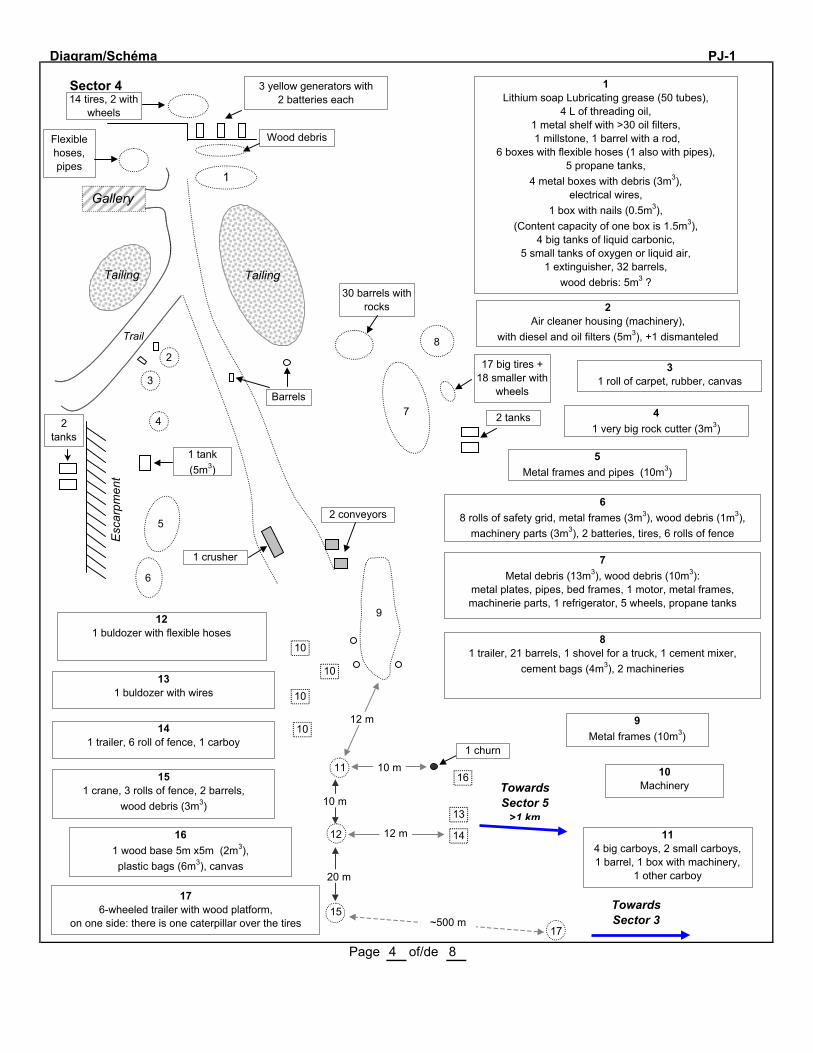
Diagram/Schéma PJ-1
Sector 4
Page 4 of/de 8
Gallery1
Trail
TailingTailing
Esca
rpm
ent
2 tanks
Wood debris
14 tires, 2 with wheels
3 yellow generators with 2 batteries each
30 barrels with rocks
Barrels
2
3
4
1 tank (5m3)
5
6
8
7 2 tanks
17 big tires + 18 smaller with
wheels
1 crusher
2 conveyors
9
10
10
10
1012 m
11
12
10 m
12 m
20 m
15~500 m
17
Towards Sector 3
14
13
1610 m
1 churn
1Lithium soap Lubricating grease (50 tubes),
4 L of threading oil,1 metal shelf with >30 oil filters, 1 millstone, 1 barrel with a rod,
6 boxes with flexible hoses (1 also with pipes),5 propane tanks,
4 metal boxes with debris (3m3),electrical wires,
1 box with nails (0.5m3),(Content capacity of one box is 1.5m3),
4 big tanks of liquid carbonic,5 small tanks of oxygen or liquid air,
1 extinguisher, 32 barrels, wood debris: 5m3 ?
2Air cleaner housing (machinery),
with diesel and oil filters (5m3), +1 dismanteled
31 roll of carpet, rubber, canvas
41 very big rock cutter (3m3)
5Metal frames and pipes (10m3)
68 rolls of safety grid, metal frames (3m3), wood debris (1m3),
machinery parts (3m3), 2 batteries, tires, 6 rolls of fence
7Metal debris (13m3), wood debris (10m3):
metal plates, pipes, bed frames, 1 motor, metal frames, machinerie parts, 1 refrigerator, 5 wheels, propane tanks
81 trailer, 21 barrels, 1 shovel for a truck, 1 cement mixer,
cement bags (4m3), 2 machineries
Towards Sector 5
>1 km
9Metal frames (10m3)
10Machinery
114 big carboys, 2 small carboys,1 barrel, 1 box with machinery,
1 other carboy
121 buldozer with flexible hoses
131 buldozer with wires
141 trailer, 6 roll of fence, 1 carboy
151 crane, 3 rolls of fence, 2 barrels,
wood debris (3m3)
161 wood base 5m x5m (2m3), plastic bags (6m3), canvas
176-wheeled trailer with wood platform,
on one side: there is one caterpillar over the tires
Flexible hoses, pipes

Site No PJ-1 Map/Carte No: 24 K/13 Latitude 58 º 58.21' N Longitude 69 º 35.61' W
Region/Région: Aupaluk/Tasiujaq Informant/Informateur John Appahatak
Date: 21 July 2001 By/Par: JB, LO, ST Priority/Prioritaire X Hasard Other:
Nb sectors/secteurs: 9 Sector/Secteur No: 5-7 Size/Dimension: m X m
Distance from surface water/Distance de l'eau de surface: m Soil/Sol: Drainage:
Buildings and dwellings/Bâtiments et habitations
Nb: Buildings/Bâtiments: 3 Dwellings: State/Condition: 1 good/1 very bad; 1 bon; 1 très mauvais
Description (material/matériaux + volume): Wood and metal, volume ?/Bois et métal, volume ?
Barrels, Tanks and Bottles/Barils, réservoirs et bouteilles
Nb barrels/barils (1 barrel/baril=205 litres):TOTAL: 65 empty/vides: full/pleins: residue/residus: piled/empilés: scattered/épars: X
Quantity/Quantité diesel: L oil/huile: L grease/graisse: L : L
Distance from a sensitive area/d'un milieu sensible: 0 m Type of area/de milieu: Lake/Lac
Nb tanks/réservoirs:TOTAL: 5 empty/vides: full/pleins: residue/residus:
Quantity/Quantité diesel: L Jet-B: L : L : L
Distance from a sensitive area/d'un milieu sensible: 15 m Type of area/de milieu: Lake/Lac
Nb bottles or other containers/Bouteilles ou autres contenants:TOTAL: 0 empty/vides: full/pleins: residue/residus: state/état:
Content + quantity/Contenu + quantité: : L : L : L
Nb propane tanks/Bonbonnes de propane: (include 2 air tanks)TOTAL: 60 empty/vides: full/pleins: residue/residus: state/état:
Batteries and Transformers/Batteries et transformateurs
Nb batteries/batteries: 12 Condition: Nb transformers/transformateurs: 2 Condition:
Machinery and Equipment/Machinerie et équipement
Nb: Buldozer: Tractor/tracteur: Truck/Camion: Muskeg: 2 Radiator : 1Conveyor/Convoyeur: Crusher/Concasseur: Generator/Génératrice: 3 Alternator : 1
Solid Waste and Dry material/Matériaux secs
Core trays/Plateau à carottes (Nb + Volume): Wood: ; m3 Al: ; m3 Plastic ; m3
Rods/Tuyaux (Nb + Volume): ; 1-3 m3 Cables/Câbles: ; m3
Wood/Bois: 10-30 m3 Metal/Métal: 10-30 m3 Other/Autre: 10-30 m3
Other/Autre:3 stoves, 1 sink, 2 furnaces, flexible hoses (>10m3), etc. See page 2/ 2 poêles, 1 réchaud, 2 fournaises, boyaux flexibles (>10m3), etc. Voir page 2.
Page 5 of/de 8
ABANDONED MINING EXPLORATION SITES/SITES ABANDONNÉS D'EXPLORATION MINIÈREINVENTORY FORM/FICHE D'INVENTAIRE - 2001

Diagram/Schéma PJ-1
Sector 5
Page 6 of/de 8
������������������������������������������������������������������������������������������������������������������������������������������������������������������������������������������������������������������������������������������������������������������������������������������������
Lake
25 m
Sector 6 (see below)
60 mSector 7 (see below)
15 m
Tanks
Stream8
7
6
5
4
23 30 m
25 m
Shed2m x 3m
15 m
Towards Sector 4
1
4 barrels,metal debris 1 muskeg,
1 battery,1 furnace
1 muskeg
Barrels
Propane tanks
Transformers
1Metal debris, flexible hoses
21 cabin in good condition, windows broken, lots of debris, 1 ventilator,
2 propane stoves, 1 stove (hot plate), 1 sink, 1 hot water tank, 1 furnace (Premium Iron Ore)
9
31 cabin (15m x 12m) in very bad condition,
lots of debris, no chemicals
421 propane tanks
514 propane tanks
61 generator
72 pumps, 1 motor, 3 barrels
81 generator (5m3)
912 barrels, 11 batteries,
1 wood platform (8m x8m),1 alternator, 1 miller, 1 generator,
1 wood shelf, 2 air tanks, 2 propane tanks
Sector 6 (58 o 58.24' N; 69 o 35.54' W)Flexible hoses (10m3), pails, metal rods (2m3),
1 radiator, see Sammy's notes (Area 60m2)
Sector 7 (58 o 58.23' N; 69 o 35.45' W)53 empty barrels, 18 propane tanks
Scattered barrels,3 are in the lake
Flexible hoses

Site No PJ-1 Map/Carte No: 24 K/13 Latitude 58 º 57.56' N Longitude 69 º 35.87' W
Region/Région: Aupaluk/Tasiujaq Informant/Informateur John Appahatak
Date: 22 July 2001 By/Par: JB, LO, ST Priority/Prioritaire X Hasard Other:
Nb sectors/secteurs: 9 Sector/Secteur No: 8-9 Size/Dimension: m X m
Distance from surface water/Distance de l'eau de surface: m Soil/Sol: Drainage:
Buildings and dwellings/Bâtiments et habitations
Nb: Buildings/Bâtiments: Dwellings: State/Condition: 2 platforms/2 plate-formesDescription (material/matériaux + volume): Wood/Bois, 2-5m3
Barrels, Tanks and Bottles/Barils, réservoirs et bouteilles
Nb barrels/barils (1 barrel/baril=205 litres):TOTAL: ~200 empty/vides: full/pleins: 3 residue/residus: 23 piled/empilés: X scattered/épars: X
Quantity/Quantité X diesel:1900 L X oil/huile: 50 L grease/graisse: L : L
Distance from a sensitive area/d'un milieu sensible: <10 m Type of area/de milieu: Lake/Lac
Nb tanks/réservoirs:TOTAL: 0 empty/vides: full/pleins: residue/residus:
Quantity/Quantité diesel: L Jet-B: L : L : L
Distance from a sensitive area/d'un milieu sensible: m Type of area/de milieu:
Nb bottles or other containers/Bouteilles ou autres contenants:TOTAL: 0 empty/vides: full/pleins: residue/residus: state/état:
Content + quantity/Contenu + quantité: : L : L : L
Nb propane tanks/Bonbonnes de propane:TOTAL: 1 empty/vides: full/pleins: residue/residus: state/état:
Batteries and Transformers/Batteries et transformateurs
Nb batteries/batteries: 3 Condition: Nb transformers/transformateurs: 0 Condition:
Machinery and Equipment/Machinerie et équipement
Nb: Buldozer: Tractor/tracteur: Truck/Camion: Muskeg: :Conveyor/Convoyeur: Crusher/Concasseur: Generator/Génératrice: :
Solid Waste and Dry material/Matériaux secs
Core trays/Plateau à carottes (Nb + Volume): Wood: ; m3 Al: ; ? m3 Plastic: ; ? m3
Rods/Tuyaux (Nb + Volume): ; >2 m3 Cables/Câbles: ; ? m3
Wood/Bois: 5-10 m3 Metal/Métal: 2-10 m3
Other/Autre:See page 2/ Voir page 2
Page 7 of/de 8
ABANDONED MINING EXPLORATION SITES/SITES ABANDONNÉS D'EXPLORATION MINIÈREINVENTORY FORM/FICHE D'INVENTAIRE - 2001
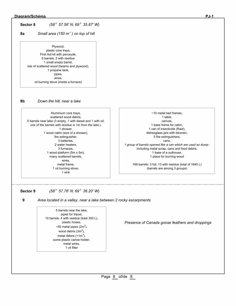
Diagram/Schéma PJ-1
Sector 8 (58 o 57.56' N; 69 o 35.87' W)
8a Small area (150 m 2 ) on top of hill
8b Down the hill, near a lake
Sector 9 (58 o 57.76' N; 69 o 36.20' W)
9 Area located in a valley, near a lake between 2 rocky escarpments
Presence of Canada goose feathers and droppings
Page 8 of/de 8
������������������������������������������������������������������������������������������������������������������������������������������������������������������������������������������������������������������������������������������������������������������������������������������������
Plywood, plastic core trays,
First Aid kit with peroxyde,6 barrels, 2 with residue
1 small empty barrel,lots of scattered wood (beams and plywood),
1 propane tank,pipes,wires,
oil burning stove (inside a furnace)
Aluminium core trays,scattered wood debris,
5 barrels near lake (3 empty, 1 with diesel and 1 with oil; one of the barrels with residue is 1m from the lake ),
1 shower,1 wood cabin (size of a shower),
fire extinguisher,3 batteries,
2 water heaters,3 furnaces,
1 wood platform (5m x 5m),many scattered barrels,
wires,metal frame,
1 oil burning stove,1 sink
~10 metal bed frames,1 table,canvas,
1 base frame for cabin,1 can of insecticide (Raid),
dishesglass jars with bitumen,3 fire extinguishers,
cans,1 group of barrels opened like a can which are used as dump :
including metal scrap, cans and food debris;1 base of a outhouse,
1 place for burning wood
169 barrels: 3 full, 13 with residue (total of 1845 L) (barrels are among 3 groups)
5 barrels near the lake,pipes for tripod,
10 barrels: 4 with residue (total 350 L),plastic hoses,
~50 metal pipes (2m3),wood debris (3m3),
metal debris (<1m3),some plastic canoe holder,
metal wires,1 oil filter

PJ-1 (and TQ-20, G24 K13-4)
Sector 1: Coord.: 58° 57.71' N 69° 35.85' W.
Sector 2: Coord.: 58° 57.74' N 69° 35.73' W.
Sector 3: Coord.: 58° 57.95' N 69° 35.71' W.
Sector 4: Coord.: 58° 58.02' N 69° 35.86' W. Many spots of contaminated soil
Sector 5: Coord.: 58° 58.21' N 69° 35.61' W.
Sector 6: Coord.: 58° 58.24' N 69° 35.54' W.
Sector 7: Coord.: 58° 58.23' N 69° 35.45' W.
Sector 8: Coord.: 58° 57.56' N 69° 35.87' W.
Sector 9: Coord.: 58° 57.76' N 69° 36.20' W.
Number Sample Depth (cm)
Parameters Analytical results (mg/kg)
Conta-minated area (m2)
Soil
PJ 1-2 Sector 1: Soil near the shaft and the head frame.
0-5 C10-C50. 220 -
PJ 1-3 Sector 1: Soil on the southern side of the drilling shaft.
0-5 C10-C50 < 100 -
PJ 1-4 Sector 2: Contaminated soil close
to the building. Sample taken near a lot of wood, metal, motors, pipes and garbage. Contaminated
depth: 20 cm.
0-5 C10-C50 1000
PJ 1-5 Sector 2: Under PJ-1-4. Contaminmated depth: 20 cm.
5-15 C10-C50 100 000 15
PJ 1-6 Sector 2: Close to ≈ 22 drums. 0-5 C10-C50 110 000 12
PJ 1-7 Sector 1: Soil in a field crack, on the southern side of the shaft and
pond.
0-5 Hg
Pb C10-C50
120 -
PJ 1-9 Sector 4. Soil on the south shore of the pond.
0-5 C10-C50 200 -
PJ 1-10 Sector 4. Soil under a battery. Sample depth: cm.
0-5 Hg
Pb
0,04
84
PJ 1-11 Sector 4. Soil under a battery. 0-5
Hg
Pb
0,10
6
PJ 1-12 Sector 4. Soil and peat moss near a pond, on its south-eastern side,
near wire rolls. Iridescence on the pond.
0-5 C10-C50 140
PJ 1-13 Sector 4. Soil at the south-
western part of sector 4 near drums, wood boxes and the gallery.
0-3 C10-C50 240 000 9

Number Sample Depth (cm)
Parameters Analytical results (mg/kg)
Conta-minated area (m2)
Soil
PJ 1-14 Sector 4. Soil of the mine tailings. 0-3 C10-C50 < 100 -
PJ 1-15 Sector 5. Under a battery near a shed.
0-3 Hg
Pb
0,14
650 1
PJ 1-16 Sector 5. Near a transformer,
close to a tank.
0-3 PCBs < 5,0 -
PJ 1-17 Sector 5. Near 9 batteries on a
platform made of wood, ≈ 5 m
apart of Pio Lake.
0-3 Hg
Pb
4,1
580
2,5
PJ 1-19 Sector 5. Soil near the 9 batteries. Contaminated depth: 15 cm.
0-5 C10-C50 310 000 4
PJ 1-20 Sector 6. Soil under 9 lubricant pails. Contaminated depth: 15 cm.
0-5 C10-C50 220 000 9
PJ 1-21 Sector 7. Soil in a pond. 0-5 C10-C50 4000 25
PJ 1-22 Sector 8. In the dump under 2 batteries, 20 m apart from a lake,
near a wood platform.
0-5 Hg
Pb
< 0,02
640
2,5
PJ 1-23 Sector 9. Contaminated soil on the lakeshore near 5 drums.
0-5 C10-C50 750 35
Total area
115
Water
PJ 1-1A Sector 1: Surface water of the pond, close to the shore.
N/A C10-C50 130 -
PJ 1-1B Sector 1: Surface water of the
pond, close to the shore. Duplicata of PJ 1-1A
N/A C10-C50 110
PJ 1-8A Sector 4. Surface water of a creek
close to the mine tailings. Iridescence at the surface of water..
N/A C10-C50 140 -
PJ 1-8B Sector 4. Duplicata of PJ 1-8A. N/A C10-C50 240 -
PJ1-18A Sector 5. Surface water of Pio Lake, near the shore.
N/A C10-C50 160
PJ1-18B Duplicata of PJ-1-18A. N/A C10-C50 110
MENV criteria :
Soil
C10-C50 (mg/kg)
Surface water
C10-C50 (µµ g/L)
Soil
Hg (mg/kg)
Soil
Pb (mg/kg)
Soil
PCBs (mg/kg)
A: 300 B: 700
C: 3500
3500 A: 0.2 B: 2
C: 10
A: 50 B: 500
C: 1000
A: 0.05 B: 1
C: 10
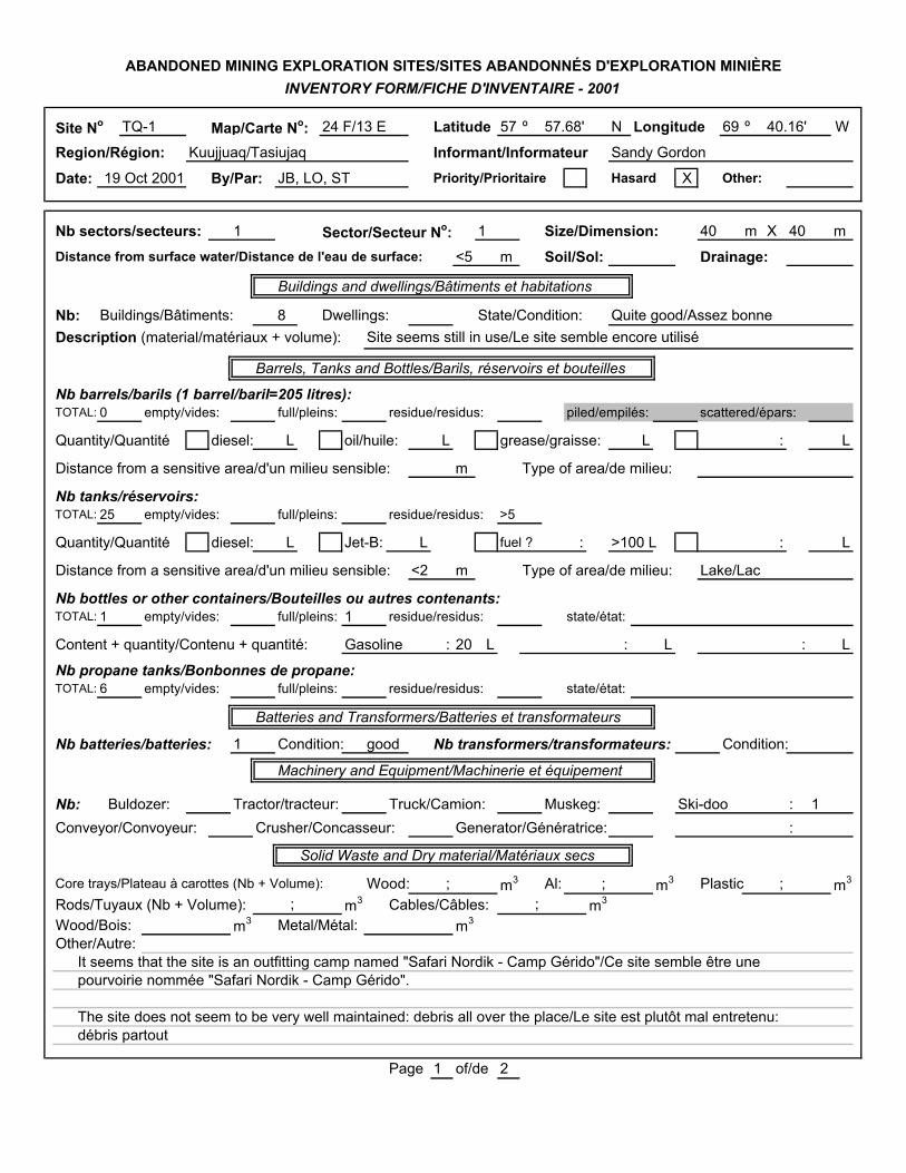
Site No TQ-1 Map/Carte No: 24 F/13 E Latitude 57 º 57.68' N Longitude 69 º 40.16' W
Region/Région: Kuujjuaq/Tasiujaq Informant/Informateur Sandy Gordon
Date: 19 Oct 2001 By/Par: JB, LO, ST Priority/Prioritaire Hasard X Other:
Nb sectors/secteurs: 1 Sector/Secteur No: 1 Size/Dimension: 40 m X 40 m
Distance from surface water/Distance de l'eau de surface: <5 m Soil/Sol: Drainage:
Buildings and dwellings/Bâtiments et habitations
Nb: Buildings/Bâtiments: 8 Dwellings: State/Condition: Quite good/Assez bonneDescription (material/matériaux + volume): Site seems still in use/Le site semble encore utilisé
Barrels, Tanks and Bottles/Barils, réservoirs et bouteilles
Nb barrels/barils (1 barrel/baril=205 litres):TOTAL: 0 empty/vides: full/pleins: residue/residus: piled/empilés: scattered/épars:
Quantity/Quantité diesel: L oil/huile: L grease/graisse: L : L
Distance from a sensitive area/d'un milieu sensible: m Type of area/de milieu:
Nb tanks/réservoirs:TOTAL: 25 empty/vides: full/pleins: residue/residus: >5
Quantity/Quantité diesel: L Jet-B: L fuel ? : >100 L : L
Distance from a sensitive area/d'un milieu sensible: <2 m Type of area/de milieu: Lake/Lac
Nb bottles or other containers/Bouteilles ou autres contenants:TOTAL: 1 empty/vides: full/pleins: 1 residue/residus: state/état:
Content + quantity/Contenu + quantité: Gasoline : 20 L : L : L
Nb propane tanks/Bonbonnes de propane:TOTAL: 6 empty/vides: full/pleins: residue/residus: state/état:
Batteries and Transformers/Batteries et transformateurs
Nb batteries/batteries: 1 Condition: good Nb transformers/transformateurs: Condition:
Machinery and Equipment/Machinerie et équipement
Nb: Buldozer: Tractor/tracteur: Truck/Camion: Muskeg: Ski-doo : 1Conveyor/Convoyeur: Crusher/Concasseur: Generator/Génératrice: :
Solid Waste and Dry material/Matériaux secs
Core trays/Plateau à carottes (Nb + Volume): Wood: ; m3 Al: ; m3 Plastic ; m3
Rods/Tuyaux (Nb + Volume): ; m3 Cables/Câbles: ; m3
Wood/Bois: m3 Metal/Métal: m3
Other/Autre:It seems that the site is an outfitting camp named "Safari Nordik - Camp Gérido"/Ce site semble être unepourvoirie nommée "Safari Nordik - Camp Gérido".
The site does not seem to be very well maintained: debris all over the place/Le site est plutôt mal entretenu: débris partout
Page 1 of/de 2
ABANDONED MINING EXPLORATION SITES/SITES ABANDONNÉS D'EXPLORATION MINIÈREINVENTORY FORM/FICHE D'INVENTAIRE - 2001

Diagram/Schéma TQ-1
Photo 16 General view of site TQ-1
Legend: Letters indicate the buildings (A to I) or specific areas (J and K)Numbers refer to Photo No, and arrows indicates the direction of the view
Photo 12 Buildings A and B Photo 11 Buildings B and C
Photo 10 Buildings G and HPhoto 9 Buildings D, E, and F
Photo 15 Outhouse areaPhoto 13 Launch area
Page 2 of/de 2
A
B
C
DE
FG
H
I
J
K
1211
9
1013
A: Looks like a shelter for having mealsOutside : 3 barrels, pipes
B: Shed of wood and canvas, containing: debris, 1 outboard motor, 1 battery, plastic containers, one with 20 L gas,
styrofoam, 1 wood shelf
C: 1 camp containing: 1 small furnace, 1 wood bed, rubber pipes.
Outside : 2 barrels with fuel, 4 propane tanks, 1 tire
D: Kitchen containing: 2 stoves, 1 freezer, 1 counter, shelves, plastic
chairs, tables, dishes. Outside : 1 freezer, 2 propane tanks,
1 trailer, 2 barrels with fuel
E: 1 camp containing: 1 furnace, 3 wood beds, plastic chairs and table,
wood shelves
F: 1 camp containing 4 metal beds, foam matresses, plastic chairs,
1 furnace, 1 fire extinguisher
15
G and H: Buildings of wood and canvas. Each one contains
1 furnace, wood beds, plastic chairs.
Outside : Core trays (6m3), 4 drums with fuel
1 outhouse, core trays (9m3), 1 ski-doo, ~10 barrels
Area with 3 launches 1 wood dock,
5 or more barrels, scattered debris
Close to the lake: 1 barrel contains ~70 L of fuel
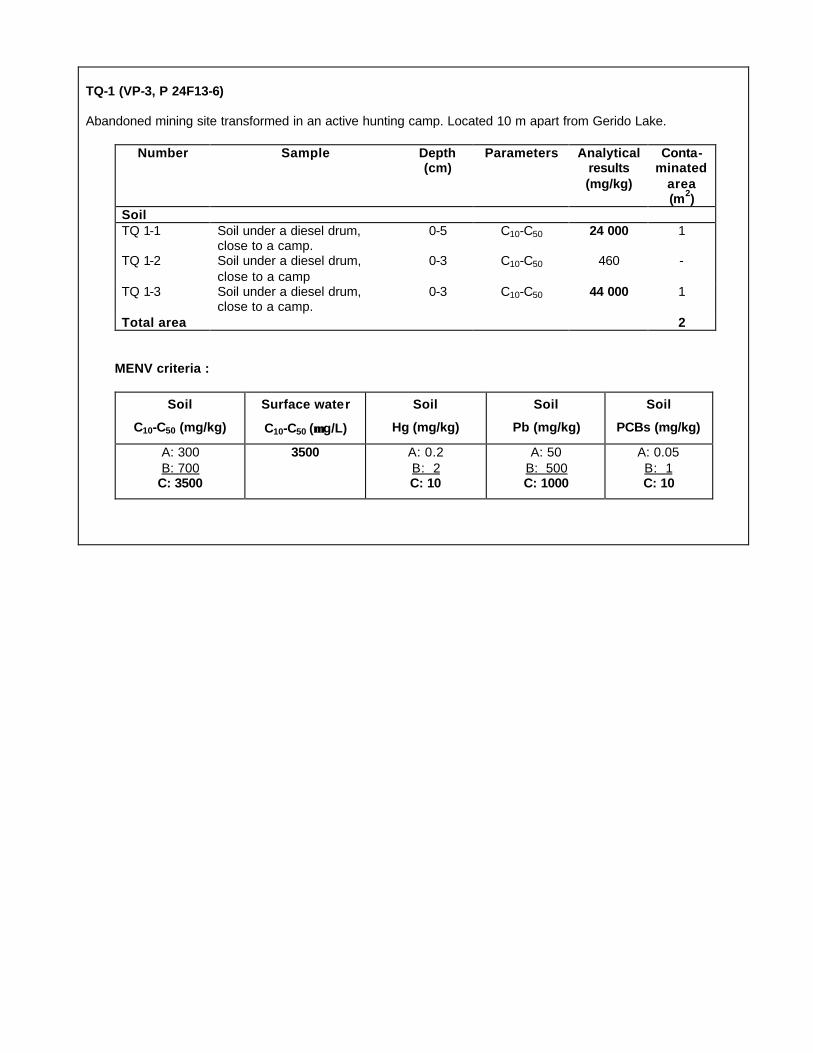
TQ-1 (VP-3, P 24F13-6) Abandoned mining site transformed in an active hunting camp. Located 10 m apart from Gerido Lake.
Number Sample Depth (cm)
Parameters Analytical results (mg/kg)
Conta-minated
area (m2)
Soil
TQ 1-1 Soil under a diesel drum, close to a camp.
0-5 C10-C50 24 000 1
TQ 1-2 Soil under a diesel drum,
close to a camp
0-3 C10-C50 460 -
TQ 1-3 Soil under a diesel drum, close to a camp.
0-3 C10-C50 44 000 1
Total area 2 MENV criteria :
Soil
C10-C50 (mg/kg)
Surface water
C10-C50 (µµ g/L)
Soil
Hg (mg/kg)
Soil
Pb (mg/kg)
Soil
PCBs (mg/kg)
A: 300
B: 700 C: 3500
3500 A: 0.2
B: 2 C: 10
A: 50
B: 500 C: 1000
A: 0.05
B: 1 C: 10


Site No TQ-4 Map/Carte No: 24 L/08 Latitude 58 º 15.23' N Longitude 70 º W
Region/Région: Kuujjuaq/Tasiujaq Informant/Informateur Sandy Berthe/Sandy Gordon
Date: 20 Oct 2001 By/Par: JB, LO Priority/Prioritaire X Hasard Other:
Nb sectors/secteurs: 3 Sector/Secteur No: 1-3 Size/Dimension: S1: 100 m X 150 l m
Distance from surface water/Distance de l'eau de surface: 0 m Soil/Sol: Drainage:
Buildings and dwellings/Bâtiments et habitations
Nb: Buildings/Bâtiments: 2 Dwellings: State/Condition: Quite dirty/Assez malpropreDescription (material/matériaux + volume): Wood, fiberglass, aluminium, styrofoam/Bois, laine minérale/~10 m3
Barrels, Tanks and Bottles/Barils, réservoirs et bouteilles
Nb barrels/barils (1 barrel/baril=205 litres):TOTAL: 153 l empty/vides: 153 l full/pleins: residue/residus: 3 piled/empilés: scattered/épars:
Quantity/Quantité X diesel:150 L oil/huile: L grease/graisse: L : L
Distance from a sensitive area/d'un milieu sensible: 50 m Type of area/de milieu: Lake/Lac
Nb tanks/réservoirs:TOTAL: empty/vides: full/pleins: residue/residus:
Quantity/Quantité diesel: L Jet-B: L : L : L
Distance from a sensitive area/d'un milieu sensible: m Type of area/de milieu:
Nb bottles or other containers/Bouteilles ou autres contenants:TOTAL: 3 empty/vides: full/pleins: 3 residue/residus: state/état: Very good/Très bonne
Content + quantity/Contenu + quantité: Gasoline : 60 L : L : L
Nb propane tanks/Bonbonnes de propane:TOTAL: 8 empty/vides: full/pleins: residue/residus: state/état:
Batteries and Transformers/Batteries et transformateurs
Nb batteries/batteries: Condition: Nb transformers/transformateurs: Condition:
Machinery and Equipment/Machinerie et équipement
Nb: Buldozer: Tractor/tracteur: Truck/Camion: Muskeg: Ski-doo : 1Conveyor/Convoyeur: Crusher/Concasseur: Generator/Génératrice: New ice drill : 1
Solid Waste and Dry material/Matériaux secs
Core trays/Plateau à carottes (Nb + Volume): Wood: ; m3 Al: ; m3 Plastic ; m3
Rods/Tuyaux (Nb + Volume): ~50 ; 1 m3 Cables/Câbles: ; m3
Wood/Bois: 12 m3 Metal/Métal: m3 Other/Autre: 5-10 m3 (fiberglass, foam, tin, …)Other/Autre: 1 log cabin collapsed; 1 wood platform/1 cabane en bois rond effondrée; 1 plate-forme de bois
(volume included above; volume inclus ci-haut). Lot of debris scattered : carpet, styrofoam, 1 plastic tank, insulating Al sheet, core trays, fiberglass, 1 furnace, plywood/Beaucoup de débris épars : tapis, styrofoam, 1 réservoir de plastique,isolant en Al, plateau à carottes, laine minérale, 1 fournaise, contreplaqué.
According to the informant, Mario Carreau uses that camp from Tasiujaq/Mario carreau utiliserait ce camp à partir de Tasiujaq.Sector 2: dikes form two previous "bladders" (rubber reservoirs). ~100 barrels (3 with diesel), few cans, 1 plywood sheet.Sector 3: includes 15 barrels. Presence of caribou and goose droppings. Total area of Sectors 2 and 3 is about 50m x 100 m.
Page 1 of/de 2
ABANDONED MINING EXPLORATION SITES/SITES ABANDONNÉS D'EXPLORATION MINIÈREINVENTORY FORM/FICHE D'INVENTAIRE - 2001
07.20'
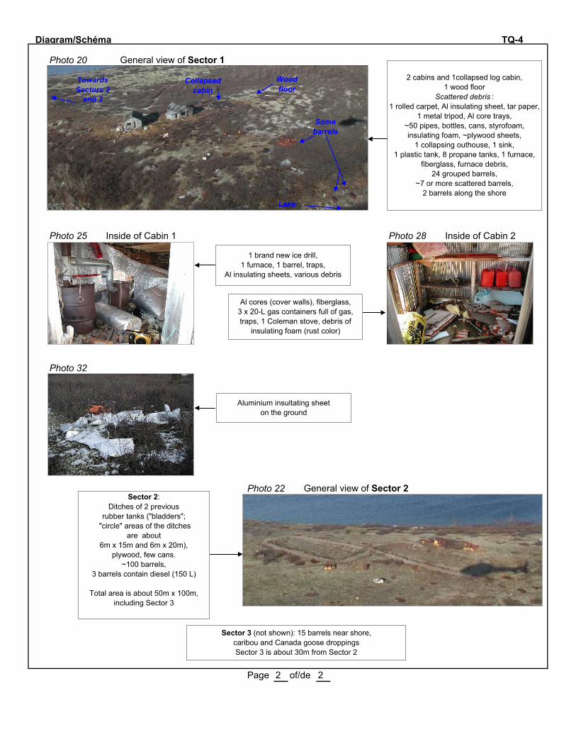
Diagram/Schéma TQ-4
Photo 20 General view of Sector 1
Photo 25 Inside of Cabin 1 Photo 28 Inside of Cabin 2
Photo 32
Photo 22 General view of Sector 2
Page 2 of/de 2
2 cabins and 1collapsed log cabin, 1 wood floor
Scattered debris : 1 rolled carpet, Al insulating sheet, tar paper,
1 metal tripod, Al core trays, ~50 pipes, bottles, cans, styrofoam, insulating foam, ~plywood sheets,
1 collapsing outhouse, 1 sink, 1 plastic tank, 8 propane tanks, 1 furnace,
fiberglass, furnace debris, 24 grouped barrels,
~7 or more scattered barrels, 2 barrels along the shore
Towards Sectors 2
and 3
Collapsed cabin
Some barrels
Lake
Wood floor
Sector 2:Ditches of 2 previous
rubber tanks ("bladders"; "circle" areas of the ditches
are about 6m x 15m and 6m x 20m),
plywood, few cans.~100 barrels,
3 barrels contain diesel (150 L)
Total area is about 50m x 100m, including Sector 3
1 brand new ice drill,1 furnace, 1 barrel, traps,
Al insulating sheets, various debris
Al cores (cover walls), fiberglass, 3 x 20-L gas containers full of gas, traps, 1 Coleman stove, debris of
insulating foam (rust color)
Aluminium insultating sheeton the ground
Sector 3 (not shown): 15 barrels near shore, caribou and Canada goose droppingsSector 3 is about 30m from Sector 2

TQ-4 (VP-2) Sector 1: Camps 40 m apart from Garigue Lake.
Sector 2: Group of 99 diesel drums 50 m from Garigue Lake. Sector 3: Group of 15 drums, 1 m apart of Garigue Lake.
Number Sample Depth (cm)
Parameters Analytical results (mg/kg)
Conta-minated
area (m2)
Soil
TQ 4-1 Sector 1. Soil under the group of drums.
0-5 C10-C50 < 200 -
TQ 4-2 Sector 2. Soil under the group of piled drums.
0-5 C10-C50 < 100 -
TQ 4-3 Sector 2. Soil in the foundation of the bladders.
0-5 C10-C50 < 100 -
TQ 4-4 Sector 2. Soil in the
foundation of the bladders.
0-5 C10-C50 < 100
TQ 4-5 Sector 2. Soil in the foundation of the bladders.
0-5 C10-C50 < 100 -
TQ 4-6 Sector 3. Soil under the group of drums.
0-5 C10-C50 < 400 -
TQ 4-7 Sector 2. Soil under the group of piled drums.
0-5 C10-C50 < 200 -
Total area 0 MENV criteria :
Soil
C10-C50 (mg/kg)
Surface water
C10-C50 (µµ g/L)
Soil
Hg (mg/kg)
Soil
Pb (mg/kg)
Soil
PCBs (mg/kg)
A: 300
B: 700 C: 3500
3500 A: 0.2
B: 2 C: 10
A: 50
B: 500 C: 1000
A: 0.05
B: 1 C: 10


SECTOR OFAUPALUK
PJ-10
PJ-17


Site No PJ-10 Map/Carte No: 24 M/01 Latitude 59 º 15.07' N Longitude 70 º 06.52' W
Region/Région: Aupaluk Informant/Informateur John Appahatak
Date: 20 July 2001 By/Par: JB, LO, ST Priority/Prioritaire X Hasard Other:
Nb sectors/secteurs: 2 Sector/Secteur No: 1-2 Size/Dimension: 400 m X 150 m
Distance from surface water/Distance de l'eau de surface: <5 m Soil/Sol: Drainage:
Buildings and dwellings/Bâtiments et habitations
Nb: Buildings/Bâtiments: Dwellings: State/Condition: Platforms and debrisDescription (material/matériaux + volume): See description above + page 2/Voir description ci-dessous + page 2
Barrels, Tanks and Bottles/Barils, réservoirs et bouteilles
Nb barrels/barils (1 barrel/baril=205 litres):TOTAL: 62 empty/vides: 28 full/pleins: residue/residus: 34 piled/empilés: scattered/épars: X
Quantity/Quantité X diesel:1400 L oil/huile: L grease/graisse: L : L
Distance from a sensitive area/d'un milieu sensible: 10 m Type of area/de milieu: Lake/Lac
Nb tanks/réservoirs:TOTAL: 1 empty/vides: 1 full/pleins: residue/residus:
Quantity/Quantité diesel: L Jet-B: L : L : L
Distance from a sensitive area/d'un milieu sensible: m Type of area/de milieu:
Nb bottles or other containers/Bouteilles ou autres contenants:TOTAL: 9 empty/vides: full/pleins: 9 residue/residus: state/état:
Content + quantity/Contenu + quantité: Grease?/Graisse ?: 2 x 20 L Motor oil/Huile : 7 x 40 L
Nb propane tanks/Bonbonnes de propane:TOTAL: 15 empty/vides: 10 full/pleins: residue/residus: 5 state/état:
Batteries and Transformers/Batteries et transformateurs
Nb batteries/batteries: 1 Condition: Nb transformers/transformateurs: 0 Condition:
Machinery and Equipment/Machinerie et équipement
Nb: Buldozer: Tractor/tracteur: Truck/Camion: Muskeg: :Conveyor/Convoyeur: Crusher/Concasseur: Generator/Génératrice: :
Solid Waste and Dry material/Matériaux secs
Core trays/Plateau à carottes (Nb + Volume): Wood: ; m3 Al: ; 2-5 m3 Plastic ; m3
Rods/Tuyaux (Nb + Volume): ~200 ; 2-3 m3 Cables/Câbles: ; ~1 m3
Wood/Bois: 20-50 m3 Metal/Métal: 12-30 m3
Other/Autre: Aforementioned estimates include Sectors 1 and 2/Les estimations ci-dessus incluent les secteurs 1 et 2Sector 1: see description on page 2/Secteur 1: voir description à la page 2Sector 2: 1 area of 100m2 with wood pallets (core trays?), Al core trays (wood debris: 5m3; metal debris: 5m3);1 area of 100m2 with wood debris of a cabin (2m3) and metal debris (3m3): roofing, 1 furnace, windows; 1 area 4m x 5m with 10 barrels; 1 area with 15 barrels (9 full (or half full ?) of diesel, 1 with 150 L).Note : Along the shore 1 mile West: 1 tin building.
Page 1 of/de 2
ABANDONED MINING EXPLORATION SITES/SITES ABANDONNÉS D'EXPLORATION MINIÈREINVENTORY FORM/FICHE D'INVENTAIRE - 2001

Diagram/Schéma PJ-10
Sector 1
Note: See description of Sector 2 on page 1
Page 2 of/de 2
Open barrels
Pipe 10-cm diameter x 4-m long
Dishes
Metal plates
~40 m
8 m
23 barrels,all with residue (total ~200 L)
Pipe 7-cm diameter x 4-m long
~200 m
6 m 12 m
15 m
6 m
Barrels,water hoses
~40 m
Open barrel
Debris of a cabin (20m x 10m): wood (2m3),
metal rods (0.5m3), shingles,
electric wires
~30 m
1 barrel with 150 L of diesel
1 camp base (10m x 12m):3 metal shelves,
10 propane tanks,1 furnace, 1 barrel,1 roll of big wire,
~15 pipes 10-cm diameter,~30 pipes 5-cm diameter,
~100 pipes 2.5-cm diameter,canvas, cans, dishes
Total area: ~200m2
Total wood debris: ~5m3
Total metal debris: ~5m3
~50 m
5 m 1 empty diesel tank
~30 m
25 mBarrels
5 propane tanks with residue,7 x 40-L pails with oil? (4 are open),
2 x 20-L pails full of Esso Aviation Product,3 chimneys,1 battery,
1 boiler (hot water heater),7 barrels, flexible hoses,
roofing scattered
Total area: ~100m2
Total wood debris: ~2m3
Total metal debris: ~8m3
~90 m
Towards Sector 2
~90 m further
Wood debris (3m3), 6 pipes
??
Lake
Beac
h

PJ-10
Sector 1: 50 m apart from Ford lake.
Sector 2: Lot of 15 drums 500 m. apart from the lake.
Number Sample Depth (cm)
Parameters Analytical results (mg/kg)
Conta-minated
area (m2)
Soil
PJ 10-1 Sector 1. Contaminated soil
in a lot of drums.
0-5 C10-C50 360 000 1
PJ 10-2 Sector 1. 3 m apart from PJ-10-1, closer to the lake.
0-5 C10-C50 8000
PJ 10-3 Sector 2. Contaminated soil
in the lot of drums. Contami-nated depth: 15 cm.
0-5 C10-C50 130 000 19
PJ 10-4 Sector 2. Under PJ-10-3. 5-15 C10-C50. 65 000
PJ 10-5 Sector 2. Contaminated soil in the lot of drums.
0-5 C10-C50. 270 000
PJ 10-6 Under PJ-10-5. 5-15 C10-C50 160 000
PJ 10-7 Sector 2. Contaminated soil in the lot of drums.
0-10 C10-C50 440 000
PJ 10-8 Sector 2. Contaminated soil in the lot of drums.
0-10 C10-C50. 150 000
Total area 20
Water
PJ 10-9 Sector 2. Surface water of Lake Ford near the shore,
downstream of PJ-10-1.
N/A C10-C50 190
PJ 10-10 Sector 2. Surface water of Lake Ford near the shore, east of PJ-10-9.
N/A C10-C50 240
MENV criteria :
Soil
C10-C50 (mg/kg)
Surface water
C10-C50 (µµ g/L)
Soil
Hg (mg/kg)
Soil
Pb (mg/kg)
Soil
PCBs (mg/kg)
A: 300 B: 700
C: 3500
3500 A: 0.2 B: 2
C: 10
A: 50 B: 500
C: 1000
A: 0.05 B: 1
C: 10

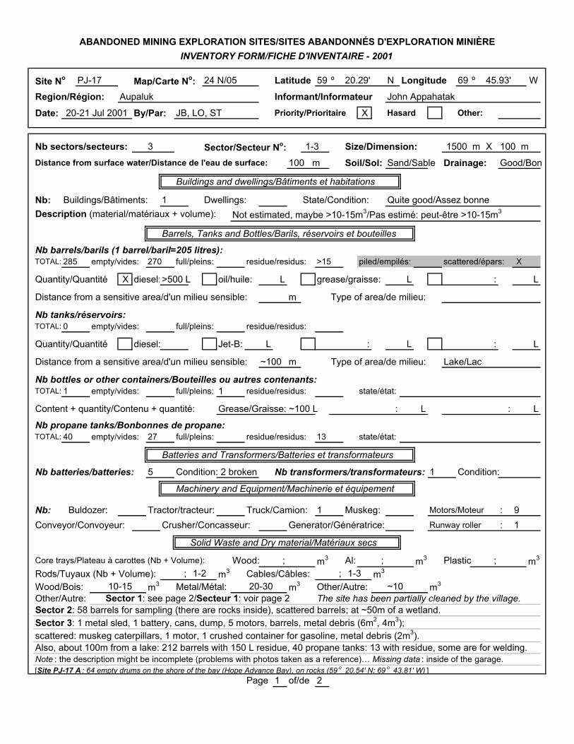
Site No PJ-17 Map/Carte No: 24 N/05 Latitude 59 º 20.29' N Longitude 69 º 45.93' W
Region/Région: Aupaluk Informant/Informateur John Appahatak
Date: 20-21 Jul 2001 By/Par: JB, LO, ST Priority/Prioritaire X Hasard Other:
Nb sectors/secteurs: 3 Sector/Secteur No: 1-3 Size/Dimension: 1500 m X 100 m
Distance from surface water/Distance de l'eau de surface: 100 m Soil/Sol: Sand/Sable Drainage: Good/Bon
Buildings and dwellings/Bâtiments et habitations
Nb: Buildings/Bâtiments: 1 Dwellings: State/Condition: Quite good/Assez bonneDescription (material/matériaux + volume): Not estimated, maybe >10-15m3/Pas estimé: peut-être >10-15m3
Barrels, Tanks and Bottles/Barils, réservoirs et bouteilles
Nb barrels/barils (1 barrel/baril=205 litres):TOTAL: 285 b empty/vides: 270 b full/pleins: residue/residus: >15 piled/empilés: scattered/épars: X
Quantity/Quantité X diesel:>500 L oil/huile: L grease/graisse: L : L
Distance from a sensitive area/d'un milieu sensible: m Type of area/de milieu:
Nb tanks/réservoirs:TOTAL: 0 empty/vides: full/pleins: residue/residus:
Quantity/Quantité diesel: Jet-B: L : L : L
Distance from a sensitive area/d'un milieu sensible: ~100 m Type of area/de milieu: Lake/Lac
Nb bottles or other containers/Bouteilles ou autres contenants:TOTAL: 1 empty/vides: full/pleins: 1 residue/residus: state/état:
Content + quantity/Contenu + quantité: Grease/Graisse: ~100 L : L : L
Nb propane tanks/Bonbonnes de propane:TOTAL: 40 empty/vides: 27 full/pleins: residue/residus: 13 state/état:
Batteries and Transformers/Batteries et transformateurs
Nb batteries/batteries: 5 Condition: 2 broken Nb transformers/transformateurs: 1 Condition:
Machinery and Equipment/Machinerie et équipement
Nb: Buldozer: Tractor/tracteur: Truck/Camion: 1 Muskeg: Motors/Moteur : 9Conveyor/Convoyeur: Crusher/Concasseur: Generator/Génératrice: Runway roller : 1
Solid Waste and Dry material/Matériaux secs
Core trays/Plateau à carottes (Nb + Volume): Wood: ; m3 Al: ; m3 Plastic ; m3
Rods/Tuyaux (Nb + Volume): ; 1-2 m3 Cables/Câbles: ; 1-3 m3
Wood/Bois: 10-15 m3 Metal/Métal: 20-30 m3 Other/Autre: ~10 m3
Other/Autre: Sector 1: see page 2/Secteur 1: voir page 2 The site has been partially cleaned by the village.Sector 2: 58 barrels for sampling (there are rocks inside), scattered barrels; at ~50m of a wetland.Sector 3: 1 metal sled, 1 battery, cans, dump, 5 motors, barrels, metal debris (6m2, 4m3);scattered: muskeg caterpillars, 1 motor, 1 crushed container for gasoline, metal debris (2m3).Also, about 100m from a lake: 212 barrels with 150 L residue, 40 propane tanks: 13 with residue, some are for welding. Note : the description might be incomplete (problems with photos taken as a reference)… Missing data : inside of the garage.[Site PJ-17 A : 64 empty drums on the shore of the bay (Hope Advance Bay), on rocks (59 o 20.54' N; 69 o 43.81' W) ]
Page 1 of/de 2
ABANDONED MINING EXPLORATION SITES/SITES ABANDONNÉS D'EXPLORATION MINIÈREINVENTORY FORM/FICHE D'INVENTAIRE - 2001

Diagram/Schéma PJ-17
Sector 1
Page 2 of/de 2
1 barrel at ~50m and 1 at ~100m
Telecommunication wires(~300 long) from the cabin. On at least 1km, there are
~10 wood poles.There is a runway .
Garage(20mx12m)
10mx3m
~15 m
~60 m
~50 m
~25 m~15 m
~500 m
Sector 3(See page 1)
~12 m
Sector 2( See page 1)
In the garage: 1 truck, 1 empty propane tank, 1 x 20-L pail full of
grease, 1 x 40-L empty pail, 3 empty drums, tires, lots of machinery parts, 2 radiators, 2 furnaces,
1 shelf, 1 motor, contaminated soils, and more…Metal debris: 6m3
15 barrels with residue
Scattered : 1 scraper for runway, water boiler,
stove pipes, metal sled
Metal debris(1.5m2; 3m3)
Metal debris, pipes, 1 water boiler (15m2; 3m3)
Wood and metal debris
Open pit(2m x 0.5m x 0.5m depth)
Barrels
Poles
Wheels and tires, wood debris partly burned, plywood sheet, dump
(burned debris: oil filter, canvas, wood, cans)
Cement base (6mx4m), 1 transformer,
2 batteries, wires, grease gun, 2 motors,
fire extinguishers,1 propane tank, wires.
Nearby : 1 battery (partly buried), 3 open barrels
with debris
~25 beams under the ground
(12m x 4m), tar paper, cabin,
antenna
Sand mound with scattered debris : tar paper (3m3), 5 barrels, 1 antenna(15m long) on the ground, 3 stoves
Tar paper (3m3), 1 barrel, 2 stoves, wires, various
debris, cabin behind
Tin cabin collapsed
1 antenna standing, with wires . Nearby : beams in the ground, 1 open barrel
Scattered debris: tin and metal
2 open barrels with rocks, wood debris
(3m3; <1m3)
Note:There are droppings of
Canada geese, Snowshoe hare, black bear and caribou on the site.

PJ-17
Sector 1: Coord: 59° 20.29' N 69° 45.93' W.
Sector 2: Coord: 59° 20.27' N 69° 45.95' W.
Sector 3: Coord: 59° 20.27' N 69° 45.60' W.
Number Sample Depth (cm)
Parame-ters
Analytical results (mg/kg)
Conta-minated area (m2)
Soil
PJ 17-1 Sector 1. Behind the building, ≈ 15 drums with residue. 1 km apart from Hope
Advance Bay. Soil sampled on the southern side of the lot of drums. more than 30 cm deep in the sandy soil.
0-5 C10-C50 26 000 16
PJ 17-2 Soil sampled under PJ17-1. 5-15 C10-C50 39 000
PJ 17-3 Sector 1. Soil sampled on the northern side of the lot of drums.
0-5 C10-C50 74 000
PJ 17-4 Sector 1. Soil sampled under PJ-17-3. 5-15 C10-C50 21 000
PJ 17-5 Sector 2. Between the building and Hope
Advance Bay. ≈ 55 drums, 700 m apart from the Bay: Soil sampled near the lot of
drums.
0-5 C10-C50 < 100
PJ 17-6 Sector 2. Soil sampled under PJ-17-5. 5-15 C10-C50 < 100
PJ 17-7 Sector 3. 500 m apart from the Bay. Soil
sampled near the lot of drums.
0-5 C10-C50 < 100
PJ 17-8 Soil of the building. 0-5 C10-C50
Hg
Pb
66 000 0,02
160
108
PJ 17-9 Soil under a battery close to the building. 0-3 Hg
Pb
< 0,02
2000
1
PJ 17-10 Soil under the transformer close to the building.
0-5 PCBs < 0,05
PJ 17-11 Soil under a battery on the border of
sector 3.
0-5 Hg
Pb
< 0,02
180
PJ 17-12 Sector 3. Soil under motor parts, filters and a battery.
0-5 Hg
Pb
< 0,02
83
PJ 17-13 Sector 3. Soil under motor parts, filters and a battery.
0-5 C10-C50 2600
Total 125
MENV criteria :
Soil
C10-C50 (mg/kg)
Surface water
C10-C50 (µµ g/L)
Soil
Hg (mg/kg)
Soil
Pb (mg/kg)
Soil
PCBs (mg/kg)
A: 300
B: 700 C: 3500
3500 A: 0.2
B: 2 C: 10
A: 50
B: 500 C: 1000
A: 0.05
B: 1 C: 10


SECTOR OFKANGIRSUK
TW


Site No TW Map/Carte No: 25 C/05 W Latitude 60 º 05.45' N Longitude 69 º 55.48' W
Region/Région: Kangirsuk Informant/Informateur None
Date: 22 Jul 2001 By/Par: JB, LO, ST Priority/Prioritaire Hasard Other: Addition
Nb sectors/secteurs: 1 Sector/Secteur No: 1 Size/Dimension: 100 m X 100 m
Distance from surface water/Distance de l'eau de surface: <1 m Soil/Sol: Drainage: Variable
Buildings and dwellings/Bâtiments et habitations
Nb: Buildings/Bâtiments: Dwellings: State/Condition: 2 wood platformsDescription (material/matériaux + volume): (10m x 4m; 5m x 3m)
Barrels, Tanks and Bottles/Barils, réservoirs et bouteilles
Nb barrels/barils (1 barrel/baril=205 litres):TOTAL: 83 empty/vides: 70 full/pleins: residue/residus: 13 piled/empilés: X scattered/épars: X
Quantity/Quantité X diesel:1230 L oil/huile: L X grease/graisse: 100 L : L
Distance from a sensitive area/d'un milieu sensible: 30 ? m Type of area/de milieu: Lake/Lac
Nb tanks/réservoirs:TOTAL: 0 empty/vides: full/pleins: residue/residus:
Quantity/Quantité diesel: L Jet-B: L : L : L
Distance from a sensitive area/d'un milieu sensible: m Type of area/de milieu:
Nb bottles or other containers/Bouteilles ou autres contenants:TOTAL: 6 empty/vides: (2) full/pleins: 4 residue/residus: state/état: (2 brown glass bottles broken)
Content + quantity/Contenu + quantité: Fire extinguisher powder: 20 L Grease/Graisse: 2 x 4 L ; 1 x 2 kg
Nb propane tanks/Bonbonnes de propane:TOTAL: 11 empty/vides: 7 full/pleins: residue/residus: 4 state/état:
Batteries and Transformers/Batteries et transformateurs
Nb batteries/batteries: 0 Condition: Nb transformers/transformateurs: 0 Condition:
Machinery and Equipment/Machinerie et équipement
Nb: Buldozer: Tractor/tracteur: Truck/Camion: Muskeg: Pipe threader : 1Conveyor/Convoyeur: Crusher/Concasseur: Generator/Génératrice: :
Solid Waste and Dry material/Matériaux secs
Core trays/Plateau à carottes (Nb + Volume): Wood: ; 10-15 m3 Al: ; 5-10 m3 Plastic ; m3
Rods/Tuyaux (Nb + Volume): >10 ; <1 m3 Cables/Câbles: ; m3
Wood/Bois: 10-15 m3 Metal/Métal: 1-5 m3
Other/Autre:See page 2 for description/Voir page 2 pour description: plywood sheets, wood and Al core trays, 1 pipe threader,machinery parts, scattered barrels (some with diesel), containers with grease, container with powder for fire extinguisher, wood pallets, canvas / feulles de contreplaqué, plateaux à carottes en bois et en Al, 1 machine à fileter lestuyaux, pièces de machinerie, barils épars (quelques-uns avec diesel), contenants avec graisse, poudrechimique pour extincteur, palettes en bois, toile.Many caribou droppings on the site/Nombreux crottins de caribous sur le site.
Page 1 of/de 2
ABANDONED MINING EXPLORATION SITES/SITES ABANDONNÉS D'EXPLORATION MINIÈREINVENTORY FORM/FICHE D'INVENTAIRE - 2001
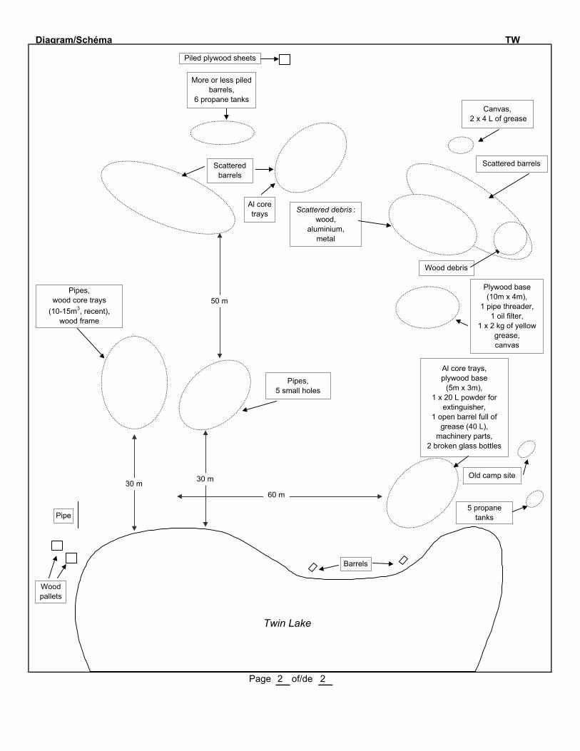
Diagram/Schéma TW
Twin Lake
Page 2 of/de 2
Wood pallets
Pipe
30 m 30 m
50 m
Scattered barrels
Al core trays
More or less piled barrels,
6 propane tanks
Piled plywood sheets
60 m
Barrels
Al core trays, plywood base
(5m x 3m),1 x 20 L powder for
extinguisher,1 open barrel full of
grease (40 L), machinery parts,
2 broken glass bottles
Old camp site
5 propane tanks
Plywood base(10m x 4m),
1 pipe threader, 1 oil filter,
1 x 2 kg of yellow grease,canvas
Scattered debris : wood,
aluminium,metal
Wood debris
Scattered barrels
Canvas, 2 x 4 L of grease
Pipes,wood core trays
(10-15m3, recent),wood frame
Pipes,5 small holes
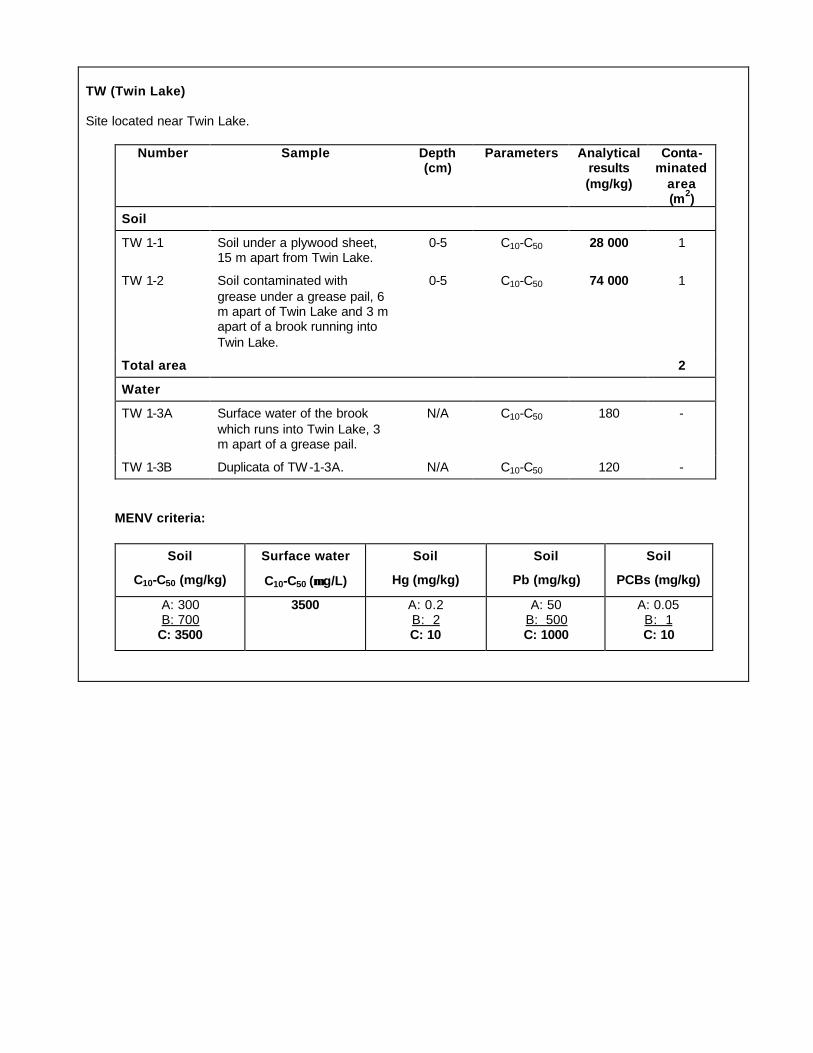
TW (Twin Lake) Site located near Twin Lake.
Number Sample Depth (cm)
Parameters Analytical results (mg/kg)
Conta-minated
area (m2)
Soil
TW 1-1 Soil under a plywood sheet, 15 m apart from Twin Lake.
0-5 C10-C50 28 000 1
TW 1-2 Soil contaminated with
grease under a grease pail, 6 m apart of Twin Lake and 3 m apart of a brook running into
Twin Lake.
0-5 C10-C50 74 000 1
Total area 2
Water
TW 1-3A Surface water of the brook
which runs into Twin Lake, 3 m apart of a grease pail.
N/A C10-C50 180 -
TW 1-3B Duplicata of TW-1-3A. N/A C10-C50 120 -
MENV criteria:
Soil
C10-C50 (mg/kg)
Surface water
C10-C50 (µµ g/L)
Soil
Hg (mg/kg)
Soil
Pb (mg/kg)
Soil
PCBs (mg/kg)
A: 300 B: 700
C: 3500
3500 A: 0.2 B: 2 C: 10
A: 50 B: 500 C: 1000
A: 0.05 B: 1 C: 10


SECTOR OFKANGIQSUJUAQ
K-28
K-61
WB-3


Site No K-28 Map/Carte No: 35 H/11 E Latitude 61 º 34.65' N Longitude 73 º 14.75' W
Region/Région: Kangiqsujuaq Informant/Informateur Amaamak Jaaka
Date: 9 Sept 2001 By/Par: JB, LO, ST Priority/Prioritaire X Hasard Other:
Nb sectors/secteurs: 3 Sector/Secteur No: Size/Dimension: m X m
Distance from surface water/Distance de l'eau de surface: m Soil/Sol: Organic Drainage: Very poor
Buildings and dwellings/Bâtiments et habitations
Nb: Buildings/Bâtiments: Dwellings: 1 State/Condition: Tent collapsing/Tente effondréeDescription (material/matériaux + volume): Wood and canvas/Bois et toile; 3m3
Barrels, Tanks and Bottles/Barils, réservoirs et bouteilles
Nb barrels/barils (1 barrel/baril=205 litres) :TOTAL: 60 empty/vides: 50 full/pleins: 10 residue/residus: piled/empilés: scattered/épars: X
Quantity/Quantité X diesel:2000 L oil/huile: L grease/graisse: L : L
Distance from a sensitive area/d'un milieu sensible: m Type of area/de milieu:
Nb tanks/réservoirs:TOTAL: 2 empty/vides: 2 full/pleins: residue/residus: Note: they are quite crushed
Quantity/Quantité diesel: Jet-B: L : L : L
Distance from a sensitive area/d'un milieu sensible: m Type of area/de milieu:
Nb bottles or other containers/Bouteilles ou autres contenants:TOTAL: 0 empty/vides: full/pleins: residue/residus: state/état:
Content + quantity/Contenu + quantité: : L : L : L
Nb propane tanks/Bonbonnes de propane:TOTAL: 9 empty/vides: 3 full/pleins: residue/residus: 6 state/état:
Batteries and Transformers/Batteries et transformateurs
Nb batteries/batteries: 0 Condition: Nb transformers/transformateurs: 0 Condition:
Machinery and Equipment/Machinerie et équipement
Nb: Buldozer: Tractor/tracteur: Truck/Camion: Muskeg: Motor : 1Conveyor/Convoyeur: Crusher/Concasseur: Generator/Génératrice: :
Solid Waste and Dry material/Matériaux secs
Core trays/Plateau à carottes (Nb + Volume): Wood:20 ; ? m3 Al: ; m3 Plastic ; m3
Rods/Tuyaux (Nb + Volume): ~50 ; ? m3 Cables/Câbles: ; m3
Wood/Bois: 20-30 m3 Metal/Métal: 10-20 m3 Other/Autre: 5 m3
Other/Autre:
See detail at the back/Voir le détail au verso
Sector 1: 61º 34.91' W; 73º 14.15' N . 70 drums.Sector 3: 61º 34.48' W; 73º 15.43' N . Active tripod. Recent equipment, CaCl2 (de-icing salt), 4 drums of Jet-B.
Page 1 of/de 2
ABANDONED MINING EXPLORATION SITES/SITES ABANDONNÉS D'EXPLORATION MINIÈREINVENTORY FORM/FICHE D'INVENTAIRE - 2001
2

Diagram/Schéma K-28
Sector 2 (located between Sectors 1 and 2):Photo 187
Photos 188-189
1 plywood sheet 1 wood base (5m x 5m) with canvas (tent)1 metal chair 1 motor1 fire extinguisher 1 20-L metal container5 wood benches 1 plywood sheet1 metal bed frame 2 metal chairs1 wood base (5m x 5m) wood core trays1 wood table 1 collapsed cabin with canvas~50 aluminium poles for tents wood debris (3m2)2 shovels 5 matressesdishes Flexible hoses for water line 50-m long (3m3)
Photo 190 food in glass jars 1 metal bed framemetal anchors 1 stove~20 wood core trays 1 stove pipe1 double sink 1 propane tank92 scattered drums, 10 containing ~200 L diesel8 propane tanks, 6 containing residue
Sector 1 (Photo 186)
40 scattered drums2 diesel tanks (each having 1000-L capacity)4 wood beams 1.25-m long1 metal pipe2 tanks (quite crushed)
Sector 3 (Photos 191 and 192)
Global amount (m 3 ) of : - wood debris: 20-30 - metal debris: 10-15 - other: 5
Page 2 of/de 2
50 m

K-28
Sector 1: Coord: 61° 34.91' N 73° 14.15' W
Sector 2: Coord.: 61° 34.65' N. 73° 14.75' W.
Sector 3: Coord: 61° 34.48' N 73° 15.43' W.
Number Sample Depth (cm)
Parameters Analytical results (mg/kg)
Conta-minated
area (m2)
Soil
K 28 1 Soil near a tent in sector 2. 0-3 C10-C50 350 -
K 28 2 Soil close to a lot of drums in
sector 1.
0-3 C10-C50 140 000 5
K 28 3 Soil close to empty drums in sector 3.
0-3 C10-C50. 1500 -
K 28 4 Soil close to the pallet in sector 3.
0-5 C10-C50 3000 10
Total area 15
MENV criteria :
Soil
C10-C50 (mg/kg)
Surface water
C10-C50 (µµ g/L)
Soil
Hg (mg/kg)
Soil
Pb (mg/kg)
Soil
PCBs (mg/kg)
A: 300 B: 700
C: 3500
3500 A: 0.2 B: 2
C: 10
A: 50 B: 500
C: 1000
A: 0.05 B: 1
C: 10


Site No K-61 Map/Carte No: 35 H/11 W Latitude 61 º 33.25' N Longitude 73 º 27.25' W
Region/Région: Kangiqsujuaq Informant/InformateurDate: 9 Sept 2001 By/Par: JB, LO, ST Priority/Prioritaire Hasard Other: Seen/Vu
Nb sectors/secteurs: 3 Sector/Secteur No: 1-3 Size/Dimension: m X m
Distance from surface water/Distance de l'eau de surface: >500 m Soil/Sol: gravel/gravier Drainage: good/bon
Buildings and dwellings/Bâtiments et habitations
Nb: Buildings/Bâtiments: 12 Dwellings: State/Condition: 10: quite good/assez bon; 2: collapsedDescription (material/matériaux + volume): (seem still in use: locks/semblent encore utilisés: cadenas); "Canadian Royalties"
Barrels, Tanks and Bottles/Barils, réservoirs et bouteilles
Nb barrels/barils (1 barrel/baril=205 litres) :TOTAL: ~50 empty/vides: ~25 full/pleins: 10 residue/residus: 5 or + piled/empilés: X scattered/épars: X
Quantity/Quantité X diesel:2000 L oil/huile: L X grease/graisse: 45 x 20 L : L
Distance from a sensitive area/d'un milieu sensible: >500 m Type of area/de milieu:
Nb tanks/réservoirs:TOTAL: 1 empty/vides: 1 full/pleins: residue/residus:
Quantity/Quantité diesel: L Jet-B: L : L : L
Distance from a sensitive area/d'un milieu sensible: m Type of area/de milieu:
Nb bottles or other containers/Bouteilles ou autres contenants:TOTAL: 23 empty/vides: full/pleins: 21 residue/residus: 2 Note: the acid is in one collapsed building
Content + quantity/Contenu + quantité: Acid/acide: ? L Paint/Peinture: 1 x 4 L Grease/graisse: 20 x 1 L
Nb propane tanks/Bonbonnes de propane: Oil/Huile: 2 LTOTAL: 34 empty/vides: 18 full/pleins: 16 residue/residus: state/état:
Batteries and Transformers/Batteries et transformateurs
Nb batteries/batteries: 5 Condition: Nb transformers/transformateurs: Condition:
Machinery and Equipment/Machinerie et équipement
Nb: Buldozer: Tractor/tracteur: Truck/Camion: Muskeg: 2 Motor/Moteur : 6Conveyor/Convoyeur: Crusher/Concasseur: Generator/Génératrice: Water heater : 3
Solid Waste and Dry material/Matériaux secs
Core trays/Plateau à carottes (Nb + Volume): Wood: ; m3 Al: ~70 ; ? m3 Plastic ; m3
Rods/Tuyaux (Nb + Volume): >100; 5-10 m3 Cables/Câbles: ; 2 m3
Wood/Bois: 50-100 m3 Metal/Métal: 50-100 m3
Other/Autre:Volume of debris had not been estimated since the site seems still in use. Active Site ?/Site actif ?Note: Hazardous products located in one building had been removed by Gov. of Qc on 8 Aug. 2000/Les produits
dangereux situés dans un bâtiment ont été enlevés par le gouv. du Qc le 8 août 2000: Ref: Clément Vallières, MENV Rouyn, 180 boul. Rideau, 1er étage, Rouyn J9X 1N9. Tel.: (819) 763-3333 ext. 257; clement.valliè[email protected] Sector 2: 61º 33.44' W; 73º 29.40' N . Empty barrels/Barils videsSector 3: 61º 33.34' W; 73º 27.39' N . Dumsite/Site de déchets
Page 1 of/de 3
ABANDONED MINING EXPLORATION SITES/SITES ABANDONNÉS D'EXPLORATION MINIÈREINVENTORY FORM/FICHE D'INVENTAIRE - 2001
500 500

Diagram/Schéma K-61
Photo 211 Sector 1
Photo 210
Photo 203 Photo 204Photo 200
Photo 206 Photo 205 Photo 209
Photo 208
Photo 207
Page 2 of/de 3
Collapsed building with:shelves,
drilling equipment, muskeg parts,
acid in a 4-L plastic container , 2 motors, wires, tires,
20 x 1 L grease Outside :
wood debris (1m3), metal shelves, grease (2 x 5gal.),
bolts (1m3)
1 Yellow muskeg2 Ski-doo topwood beams, wood debris,
1 barrel
~100m
1 40,000-L tank,15 barrels,
canvas
44 pails full of grease, 10 barrels full of used diesel (2000 L)
Building area (see page 3)
Pile of debris including many pipes and wood
1 red muskeg,oil (2 L),
wood bases (2 of 10m x 3m; 1 of 5m x 3m),
welding equipment,1 propane tank
Beside the muskeg :1 Al bath tub,
Al cube
3 water heatersTires,
1 propane tank,4 motors,
wires, metal debris (1m3)
wood beams,3 drums,
1 pail full of grease, metal debris
Wood boxes,1 stand with >100 pipes (2 to 10-cm diameter),
wood boxes and canvas,water hoses, wood debris
Note: the inventory is not exhaustive
>100m
Material on photo 206 is behind the one that
is on photo 205
3 muskeg tracks,1 propane tanks

Diagram/Schéma K-61
Building area (buildings are indicated with No for description) Photo 196
N o 2 : full of core trays inside the buildingN o 3 : camp still in useN o 4 : door lockedN o 5 : door locked
Photos 197 and 198
Pipes
N o 6 : door locked; PipesInscription on the door:"CANADIAN ROYALTIES"
N o 7 : door closed; N o 8 : camp empty
Photo 199
Photo 195 (inside of camp No 1)Pipes
Total: 10 wood cabins
N o 1 : this camp contains 2 sinks, glass bottles (for chemicals),1 furnace, 2 chimneys, wood shelves. One sign indicates thathazardous products have been removed from that camp on8 Aug. 2002 by the MENV - Rouyn.
Page 3 of/de 3
1
2
3
4
5
6
7
8
9
1 stovetin sheets
metal debris
1 sleigh
1 barrel; 1 matress
Recent debris, motor oil cans,
1 barrel with fuel,1 chimney, 16 empty
propane tanks, 2 traps
1 old furnace,stove pipes,
wood, wires, core trays, dishes
1 roll of big water wire,
1 big Al bath tub,2 propane tanks
1 propane tank,10 Al core trays,
cans, 1 bed,1 fire extinguisher,
debris (1m3)
1 barrel with fuel
1 stove
1 diesel tank
2 batteries,60 Al core trays,
wood table,1 metal shelf
1 barrel with fuel
metal debris
60 Al core trays1 fire extinguisher,
1 motor, cans (1m3), electric wires
16 full propane tanks(50-150m)

K-61
Many spots of contaminated soil near dwellings. Total contaminated area: ~ 75 m2
Pile of empty drums coord.: 61° 33.44' N 73° 27.40' W
Dumpsite coord.: 61° 33.34' N 73° 27.39' W
Number Sample Depth (cm)
Parameters Analytical results (mg/kg)
Conta-minated
area (m2)
Soil
KAW 61 1 Soil near a drum connected to a dwelling.
0-3 C10-C50. < 200 -
KAW 61 2 Soil near a drum connected
to a dwelling
0-3 C10-C50 51 000 2
KAW 61 3 Soil under a battery. 0-3 Hg
Pb
< 0,02
130
-
KAW 61 4 Soil under a drum near the muskeg.
0-3 C10-C50 180 000 5
KAW 61 5 Soil under a lot of 8 drums +
20 yellow pails.
0-3 C10-C50 33 000 25
Total area ~ 75
MENV criteria :
Soil
C10-C50 (mg/kg)
Surface water
C10-C50 (µµ g/L)
Soil
Hg (mg/kg)
Soil
Pb (mg/kg)
Soil
PCBs (mg/kg)
A: 300 B: 700
C: 3500
3500 A: 0.2 B: 2 C: 10
A: 50 B: 500 C: 1000
A: 0.05 B: 1 C: 10

Site No WB-3 Map/Carte No: 35 H/08 W Latitude 61 º 29.41' N Longitude 72 º 18.09' W
Region/Région: Kangiqsujuaq Informant/Informateur Amaamak Jaaka
Date: 9 Sept 2001 By/Par: JB, LO, ST Priority/Prioritaire Hasard X Other:
Nb sectors/secteurs: 1 Sector/Secteur No: 1 Size/Dimension: 50 m X 30 m
Distance from surface water/Distance de l'eau de surface: m Soil/Sol: Rock Drainage: Very good
Buildings and dwellings/Bâtiments et habitations
Nb: Buildings/Bâtiments: Dwellings: State/Condition: Damaged/DamagedDescription (material/matériaux + volume): 1 wood base surrounded by a tin sheet/1 plateforme entourée de tôle
Barrels, Tanks and Bottles/Barils, réservoirs et bouteilles
Nb barrels/barils (1 barrel/baril=205 litres):TOTAL: 85 empty/vides: 76 full/pleins: 9 residue/residus: piled/empilés: scattered/épars: X
Quantity/Quantité X diesel:675 L oil/huile: L grease/graisse: L : L
Distance from a sensitive area/d'un milieu sensible: <10 m Type of area/de milieu: Lake/Lac
Nb tanks/réservoirs:TOTAL: empty/vides: full/pleins: residue/residus:
Quantity/Quantité diesel: L Jet-B: L : L : L
Distance from a sensitive area/d'un milieu sensible: m Type of area/de milieu:
Nb bottles or other containers/Bouteilles ou autres contenants:TOTAL: empty/vides: full/pleins: residue/residus: state/état:
Content + quantity/Contenu + quantité: : L : L : L
Nb propane tanks/Bonbonnes de propane:TOTAL: 1 empty/vides: 1 full/pleins: residue/residus: state/état:
Batteries and Transformers/Batteries et transformateurs
Nb batteries/batteries: Condition: Nb transformers/transformateurs: Condition:
Machinery and Equipment/Machinerie et équipement
Nb: Buldozer: Tractor/tracteur: Truck/Camion: Muskeg: :Conveyor/Convoyeur: Crusher/Concasseur: Generator/Génératrice: :
Solid Waste and Dry material/Matériaux secs
Core trays/Plateau à carottes (Nb + Volume): Wood: ; m3 Al: ; m3 Plastic ; m3
Rods/Tuyaux (Nb + Volume): ; m3 Cables/Câbles: ; m3
Wood/Bois: 15-20 m3 Metal/Métal: 5 m3
Other/Autre:NOTE: Some metal rods are coming out from the rock (0.5-1.25 m high)/Des tiges de métal sortent du roc, elles
ont une hauteur de 0,5 à 1,25 m.An inscription is written on many drums:CANICO (Canadian Nickel Co.)./Plusieurs barils portent une inscription: CANICO (Canadian Nickel Co.).The site is accessible by ski-doo and all terrain vehicule (4-Wheels)/Le site est accible par motoneige et véhicule tout terrain (VTT).
Page 1 of/de 2
ABANDONED MINING EXPLORATION SITES/SITES ABANDONNÉS D'EXPLORATION MINIÈREINVENTORY FORM/FICHE D'INVENTAIRE - 2001
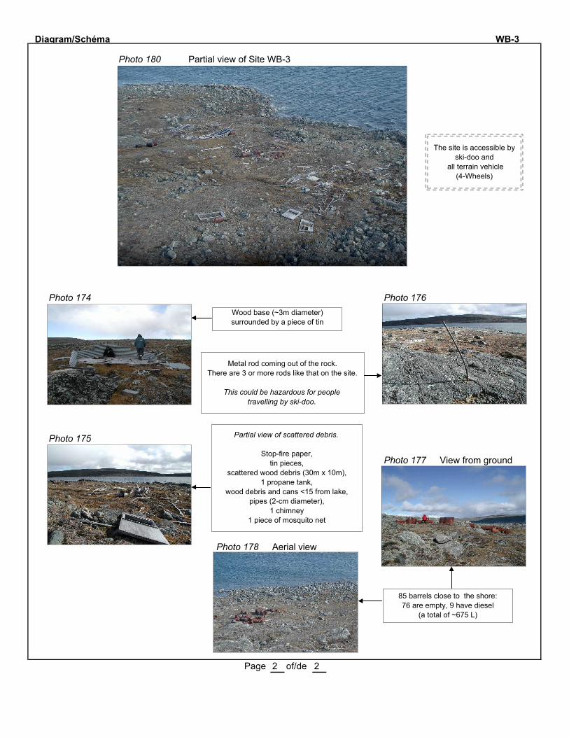
Diagram/Schéma WB-3
Photo 180 Partial view of Site WB-3
Photo 174 Photo 176
Photo 175
Photo 177 View from ground
Photo 178 Aerial view
Page 2 of/de 2
Wood base (~3m diameter) surrounded by a piece of tin
Partial view of scattered debris.
Stop-fire paper,tin pieces,
scattered wood debris (30m x 10m),1 propane tank,
wood debris and cans <15 from lake,pipes (2-cm diameter),
1 chimney1 piece of mosquito net
Metal rod coming out of the rock. There are 3 or more rods like that on the site.
This could be hazardous for people
travelling by ski-doo.
85 barrels close to the shore:76 are empty, 9 have diesel
(a total of ~675 L)
The site is accessible by ski-doo and
all terrain vehicle(4-Wheels)
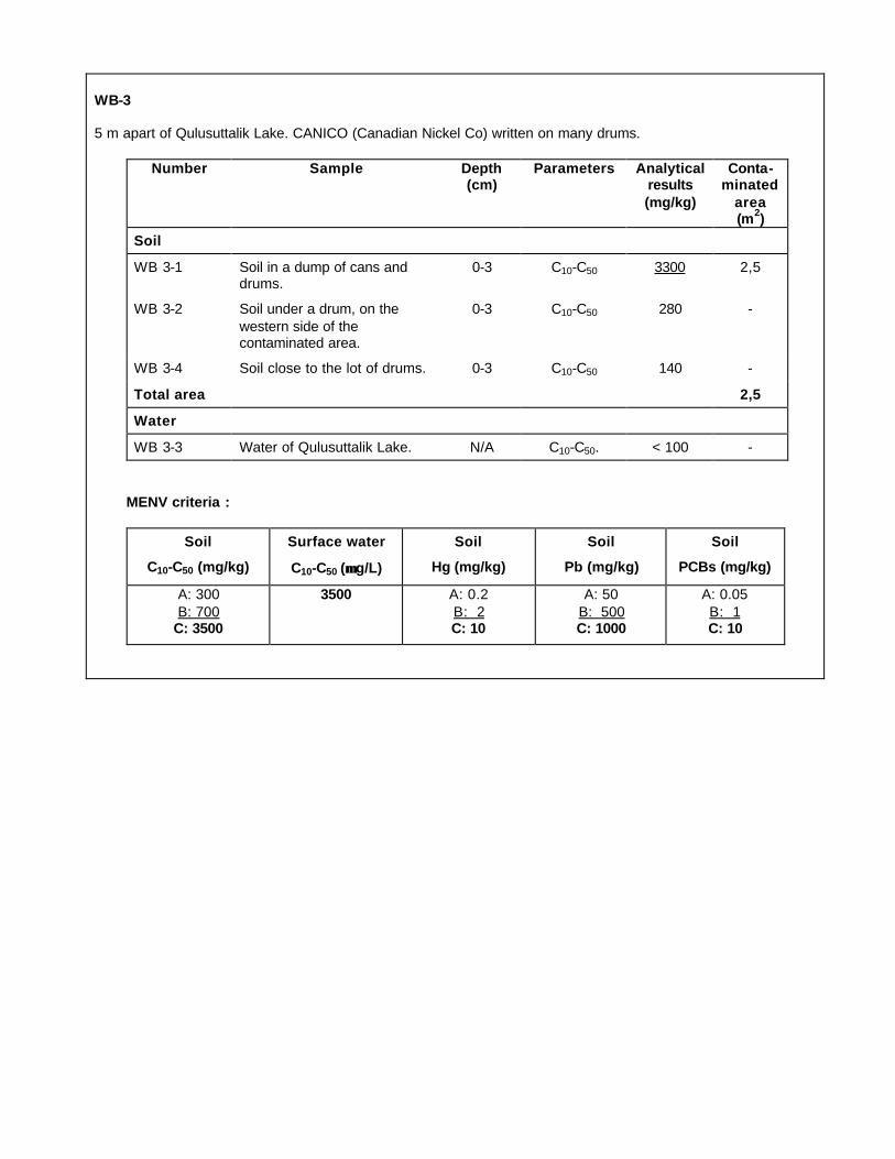
WB-3 5 m apart of Qulusuttalik Lake. CANICO (Canadian Nickel Co) written on many drums.
Number Sample Depth (cm)
Parameters Analytical results (mg/kg)
Conta-minated
area (m2)
Soil
WB 3-1 Soil in a dump of cans and drums.
0-3 C10-C50 3300 2,5
WB 3-2 Soil under a drum, on the
western side of the contaminated area.
0-3 C10-C50 280 -
WB 3-4 Soil close to the lot of drums. 0-3 C10-C50 140 -
Total area 2,5
Water
WB 3-3 Water of Qulusuttalik Lake. N/A C10-C50. < 100 -
MENV criteria :
Soil
C10-C50 (mg/kg)
Surface water
C10-C50 (µµ g/L)
Soil
Hg (mg/kg)
Soil
Pb (mg/kg)
Soil
PCBs (mg/kg)
A: 300
B: 700 C: 3500
3500 A: 0.2
B: 2 C: 10
A: 50
B: 500 C: 1000
A: 0.05
B: 1 C: 10


SECTOR OFSALLUIT
KV-1
SAL-1
SW-27
SW-34
SW-42
WB-9


Site No KV-1 Map/Carte No: 35 F/07 W Latitude 61 º 25.64' N Longitude 76 º 45.46' W
Region/Région: Salluit Informant/Informateur Paulusie Padlayat
Date: 9 Sept 2001 By/Par: JB, LO, ST Priority/Prioritaire Hasard Other: Informant
Nb sectors/secteurs: 2 Sector/Secteur No: 1-2 Size/Dimension: 2 X ( 5 m X 10 m )
Distance from surface water/Distance de l'eau de surface: < 5 m Soil/Sol: variable Drainage: variable
Buildings and dwellings/Bâtiments et habitations
Nb: Buildings/Bâtiments: Dwellings: State/Condition:Description (material/matériaux + volume):
Barrels, Tanks and Bottles/Barils, réservoirs et bouteilles
Nb barrels/barils (1 barrel/baril=205 litres):TOTAL: 30 empty/vides: 28 full/pleins: 0 residue/residus: 2 piled/empilés: X scattered/épars: X
Quantity/Quantité X diesel:50 L oil/huile: L grease/graisse: L : L
Distance from a sensitive area/d'un milieu sensible: > 20 m Type of area/de milieu: Lake/Lac
Nb tanks/réservoirs:TOTAL: 0 empty/vides: full/pleins: residue/residus:
Quantity/Quantité diesel: L Jet-B: L : L : L
Distance from a sensitive area/d'un milieu sensible: m Type of area/de milieu:
Nb bottles or other containers/Bouteilles ou autres contenants:TOTAL: 0 empty/vides: full/pleins: residue/residus: state/état:
Content + quantity/Contenu + quantité: : L : L : L
Nb propane tanks/Bonbonnes de propane:TOTAL: 0 empty/vides: full/pleins: residue/residus: state/état:
Batteries and Transformers/Batteries et transformateurs
Nb batteries/batteries: 0 Condition: Nb transformers/transformateurs: 0 Condition:
Machinery and Equipment/Machinerie et équipement
Nb: Buldozer: Tractor/tracteur: Truck/Camion: Muskeg: :Conveyor/Convoyeur: Crusher/Concasseur: Generator/Génératrice: :
Solid Waste and Dry material/Matériaux secs
Core trays/Plateau à carottes (Nb + Volume): Wood: ; m3 Al: ; m3 Plastic ; m3
Rods/Tuyaux (Nb + Volume): 2 ; <1 m3 Cables/Câbles: ; 1 m3
Wood/Bois: 2-5 m3 Metal/Métal: 2-5 m3
Other/Autre:
This site has been cleaned according to PA/Le site a été nettoyé selon PA
Sector 1: on a hillock (2m x 10m) see description on page 2/sur une butte, voir description à la page 2.Sector 2: at less than 5m from the lake, see description on page 2/à moins de 5m du lac, voir description à la page 2.
Page 1 of/de 2
ABANDONED MINING EXPLORATION SITES/SITES ABANDONNÉS D'EXPLORATION MINIÈREINVENTORY FORM/FICHE D'INVENTAIRE - 2001
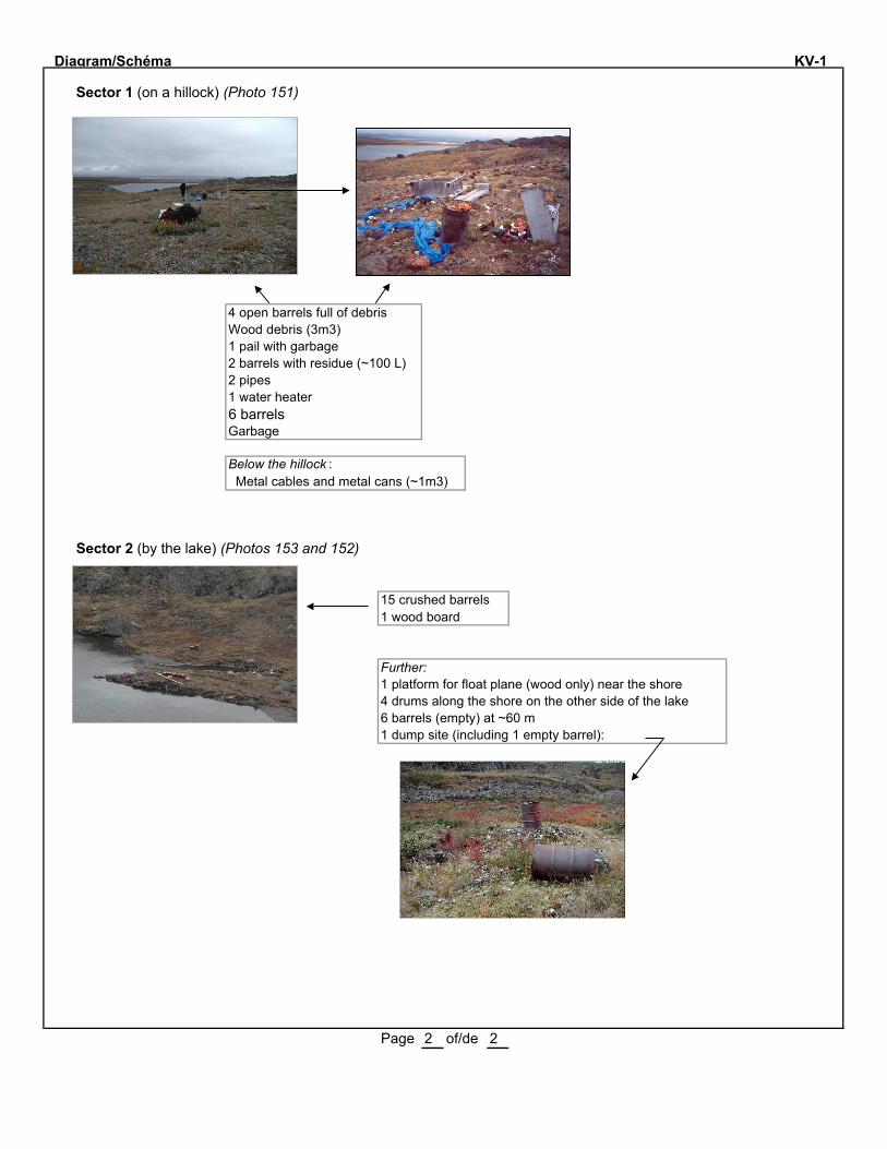
Diagram/Schéma KV-1
Sector 1 (on a hillock) (Photo 151)
4 open barrels full of debrisWood debris (3m3)1 pail with garbage2 barrels with residue (~100 L)2 pipes1 water heater6 barrelsGarbage
Below the hillock : Metal cables and metal cans (~1m3)
Sector 2 (by the lake) (Photos 153 and 152)
15 crushed barrels1 wood board
Further:1 platform for float plane (wood only) near the shore4 drums along the shore on the other side of the lake6 barrels (empty) at ~60 m1 dump site (including 1 empty barrel):
Page 2 of/de 2

KV-1
Number Sample Depth (cm)
Parameters Analytical results (mg/kg)
Conta-minated
area (m2)
Soil
KV 1-1 Soil under a barrel 0-3 C10-C50. 2500 2
Total area 2 MENV criteria :
Soil
C10-C50 (mg/kg)
Surface water
C10-C50 (µµ g/L)
Soil
Hg (mg/kg)
Soil
Pb (mg/kg)
Soil
PCBs (mg/kg)
A: 300
B: 700 C: 3500
3500 A: 0.2
B: 2 C: 10
A: 50
B: 500 C: 1000
A: 0.05
B: 1 C: 10


Site No SAL-1 Map/Carte No: 35 G/10 W Latitude 61 º 31.14' N Longitude 74 º 53.01' W
Region/Région: Salluit Informant/Informateur Paulusie Padlayat
Date: 7 Sept 2001 By/Par: JB, LO, ST Priority/Prioritaire Hasard Other: Seen/Vu
Nb sectors/secteurs: 1 Sector/Secteur No: 1 Size/Dimension: 50 m X m
Distance from surface water/Distance de l'eau de surface: <20 m Soil/Sol: Organic Drainage: Poor
Buildings and dwellings/Bâtiments et habitations
Nb: Buildings/Bâtiments: 6 Dwellings: State/Condition: 4 partly collapsed; 2 collapsedDescription (material/matériaux + volume):
Barrels, Tanks and Bottles/Barils, réservoirs et bouteilles
Nb barrels/barils (1 barrel/baril=205 litres):TOTAL: 336 L empty/vides: 336 L full/pleins: residue/residus: piled/empilés: X scattered/épars: X
Quantity/Quantité diesel: L oil/huile: L grease/graisse: L : L
Distance from a sensitive area/d'un milieu sensible: <20 m Type of area/de milieu: Lacs Nuvilik (in a wetland)
Nb tanks/réservoirs:TOTAL: 0 empty/vides: full/pleins: residue/residus:
Quantity/Quantité diesel: L Jet-B: L : L : L
Distance from a sensitive area/d'un milieu sensible: m Type of area/de milieu:
Nb bottles or other containers/Bouteilles ou autres contenants:TOTAL: 6 empty/vides: 3 full/pleins: 3 residue/residus: state/état: 6 X 40-L pails; 3 full (closed)
Content + quantity/Contenu + quantité: Aviation oil: 3 X 1 L Aviation oil: 3 X 40 L : L
Nb propane tanks/Bonbonnes de propane:TOTAL: 15 empty/vides: 15? full/pleins: residue/residus: state/état:
Batteries and Transformers/Batteries et transformateurs
Nb batteries/batteries: 2 Condition: Nb transformers/transformateurs: 0 Condition:
Machinery and Equipment/Machinerie et équipement
Nb: Buldozer: Tractor/tracteur: Truck/Camion: Muskeg: :Conveyor/Convoyeur: Crusher/Concasseur: Generator/Génératrice: :
Solid Waste and Dry material/Matériaux secs
Core trays/Plateau à carottes (Nb + Volume): Wood: ; m3 Al: ; m3 Plastic ; m3
Rods/Tuyaux (Nb + Volume): ; m3 Cables/Câbles: ; m3
Wood/Bois: 60 m3 Metal/Métal: ~10 m3
Other/Autre: 1 refrigerator, 2 furnaces, 1 stove, 1 wood base (4m X 4m), 1 wood table, 1 metal shelf, 2 batteries, flexible hoses, food cans, canvas, plywood, stove pipes. See some photos on page 2./1 réfrigérateur, 2 fournaises, 1 poêle, 1 base de bois (4m x 4m), 1 table, 1 étagère de métal, 2 batteries,boyaux flexibles, cannettes de nourriture, toile, contreplaqué, tuyaux de poêle. Voir photos en page 2.
Wetland (grass): the slope is orientated towards the lake/Milieu humide: la pente est orientée vers le lac.The drums are close to the lake/Les barils sont situés près du lac.
Page 1 of/de 2
ABANDONED MINING EXPLORATION SITES/SITES ABANDONNÉS D'EXPLORATION MINIÈREINVENTORY FORM/FICHE D'INVENTAIRE - 2001
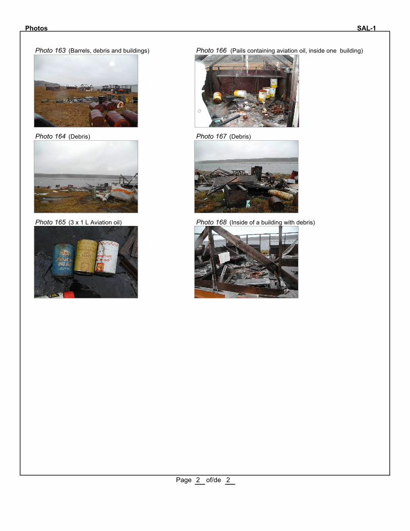
Photos SAL-1
Photo 163 (Barrels, debris and buildings) Photo 166 (Pails containing aviation oil, inside one building)
Photo 164 (Debris) Photo 167 (Debris)
Photo 165 (3 x 1 L Aviation oil) Photo 168 (Inside of a building with debris)
Page 2 of/de 2
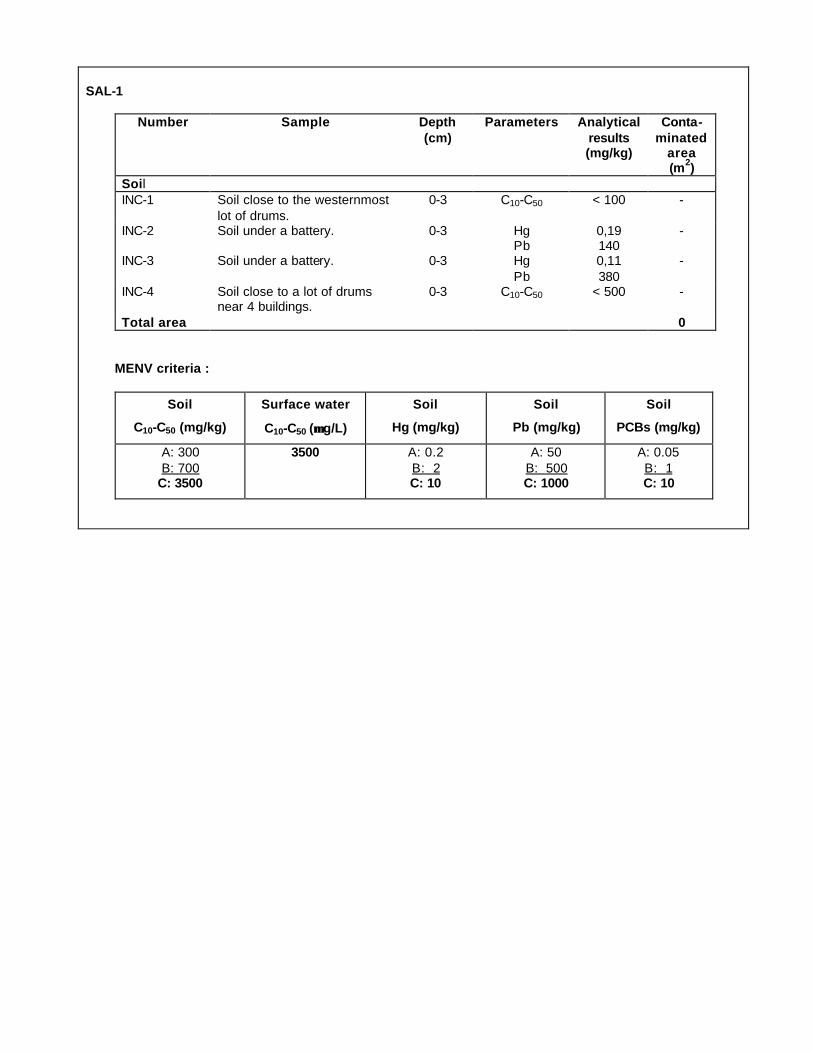
SAL-1
Number Sample Depth (cm)
Parameters Analytical results (mg/kg)
Conta-minated
area (m2)
Soil
INC-1 Soil close to the westernmost
lot of drums.
0-3 C10-C50 < 100 -
INC-2 Soil under a battery. 0-3 Hg Pb
0,19 140
-
INC-3 Soil under a battery. 0-3
Hg
Pb
0,11
380
-
INC-4 Soil close to a lot of drums near 4 buildings.
0-3 C10-C50 < 500 -
Total area 0 MENV criteria :
Soil
C10-C50 (mg/kg)
Surface water
C10-C50 (µµ g/L)
Soil
Hg (mg/kg)
Soil
Pb (mg/kg)
Soil
PCBs (mg/kg)
A: 300
B: 700 C: 3500
3500 A: 0.2
B: 2 C: 10
A: 50
B: 500 C: 1000
A: 0.05
B: 1 C: 10


Site No SW-27 Map/Carte No: 35 F/08 W Latitude 61 º 28.76' N Longitude 76 º 22.93' W
Region/Région: Salluit Informant/Informateur Paulusie Padlayat
Date: 6 Sept 2001 By/Par: JB, LO, ST Priority/Prioritaire X Hasard Other:
Nb sectors/secteurs: 4 Sector/Secteur No: 1-4 Size/Dimension: 4 X (20 m X 20 m)
Distance from surface water/Distance de l'eau de surface: >1000 m Soil/Sol: Gravel Drainage: Good/Bon
Buildings and dwellings/Bâtiments et habitations
Nb: Buildings/Bâtiments: Dwellings: State/Condition: 1 wood base/1 plate-forme de boisDescription (material/matériaux + volume):
Barrels, Tanks and Bottles/Barils, réservoirs et bouteilles
Nb barrels/barils (1 barrel/baril=205 litres):TOTAL: 87 empty/vides: 73 full/pleins: 6 residue/residus: 8 piled/empilés: X scattered/épars: X
Quantity/Quantité diesel:1650 L oil/huile: L grease/graisse: L : L
Distance from a sensitive area/d'un milieu sensible: >1000 m Type of area/de milieu:
Nb tanks/réservoirs:TOTAL: 0 empty/vides: full/pleins: residue/residus:
Quantity/Quantité diesel: L Jet-B: L : L : L
Distance from a sensitive area/d'un milieu sensible: m Type of area/de milieu:
Nb bottles or other containers/Bouteilles ou autres contenants:TOTAL: 17 empty/vides: full/pleins: 15 residue/residus: 2 state/état: some are open or damaged
Content + quantity/Contenu + quantité: Aviation oil (6) : 6 L Grease (9): 260 L Oil/Huile (2) : 20 L
Nb propane tanks/Bonbonnes de propane:TOTAL: 1 empty/vides: full/pleins: residue/residus: 1 state/état:
Batteries and Transformers/Batteries et transformateurs
Nb batteries/batteries: 2 Condition: Nb transformers/transformateurs: 0 Condition:
Machinery and Equipment/Machinerie et équipement
Nb: Buldozer: Tractor/tracteur: 1 Truck/Camion: Muskeg: 1 Trailer : 1Conveyor/Convoyeur: Crusher/Concasseur: Generator/Génératrice: :
Solid Waste and Dry material/Matériaux secs
Core trays/Plateau à carottes (Nb + Volume): Wood: ; m3 Al: ; m3 Plastic ; m3
Rods/Tuyaux (Nb + Volume): ; m3 Cables/Câbles: ; m3
Wood/Bois: 20 m3 Metal/Métal: 15 m3
Other/Autre:
Sector 1: 61º 28.76' W; 76º 22.93' N. Photos 155-156. See/Voir page 2Sector 2: 61º 28.84' W; 76º 21.68' N. Photos 157-158. See/Voir page 2Sector 3: 61º 28.62' W; 76º 21.22' N. Photo159. See/Voir page 2Sector 4: 61º 28.95' W; 76º 22.10' N. Photo 154. See/Voir page 2
Page 1 of/de 2
ABANDONED MINING EXPLORATION SITES/SITES ABANDONNÉS D'EXPLORATION MINIÈREINVENTORY FORM/FICHE D'INVENTAIRE - 2001
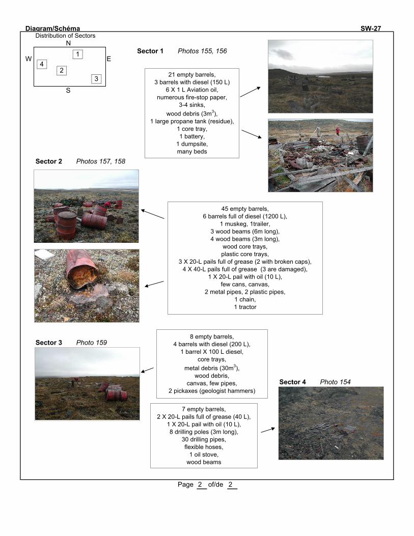
Diagram/Schéma SW-27Distribution of Sectors
NSector 1 Photos 155, 156
W E
S
Sector 2 Photos 157, 158
Sector 3 Photo 159
Sector 4 Photo 154
Page 2 of/de 2
1
23
421 empty barrels,
3 barrels with diesel (150 L)6 X 1 L Aviation oil,
numerous fire-stop paper,3-4 sinks,
wood debris (3m3),1 large propane tank (residue),
1 core tray, 1 battery,
1 dumpsite,many beds
45 empty barrels,6 barrels full of diesel (1200 L),
1 muskeg, 1trailer,3 wood beams (6m long),4 wood beams (3m long),
wood core trays,plastic core trays,
3 X 20-L pails full of grease (2 with broken caps),4 X 40-L pails full of grease (3 are damaged),
1 X 20-L pail with oil (10 L),few cans, canvas,
2 metal pipes, 2 plastic pipes,1 chain,1 tractor
8 empty barrels,4 barrels with diesel (200 L),
1 barrel X 100 L diesel,core trays,
metal debris (30m3),wood debris,
canvas, few pipes,2 pickaxes (geologist hammers)
7 empty barrels,2 X 20-L pails full of grease (40 L),
1 X 20-L pail with oil (10 L),8 drilling poles (3m long),
30 drilling pipes,flexible hoses,
1 oil stove,wood beams

SW-27
Sector 1: Coord: 61° 28.76' N 76° 22.93' W.
Sector 2: Coord: 61° 28.84' N 76° 21.68' W.
Sector 3: Coord: 61° 28.62' N 76° 21.22' W.
Sector 4: Coord: 61° 28.95' N 76° 22.10' W.
Number Sample Depth (cm)
Parameters Analytical results (mg/kg)
Conta-minated
area (m2)
Soil
SW 27-1 Sector 1. Soil under a battery. 0-3 Hg
Pb
<0,02
30
-
SW 27-2 Sector 2. Soil under a grease pail
0-3 C10-C50 160 000 1
SW 27-3 Sector 2. Soil under a diesel drum.
0-3 C10-C50 59 000 1
SW 27-4 Sector 3. Soil under a diesel
drum.
0-3 C10-C50 9400 0,5
Total area 2,5
MENV criteria :
Soil
C10-C50 (mg/kg)
Surface water
C10-C50 (µµ g/L)
Soil
Hg (mg/kg)
Soil
Pb (mg/kg)
Soil
PCBs (mg/kg)
A: 300 B: 700
C: 3500
3500 A: 0.2 B: 2 C: 10
A: 50 B: 500 C: 1000
A: 0.05 B: 1 C: 10

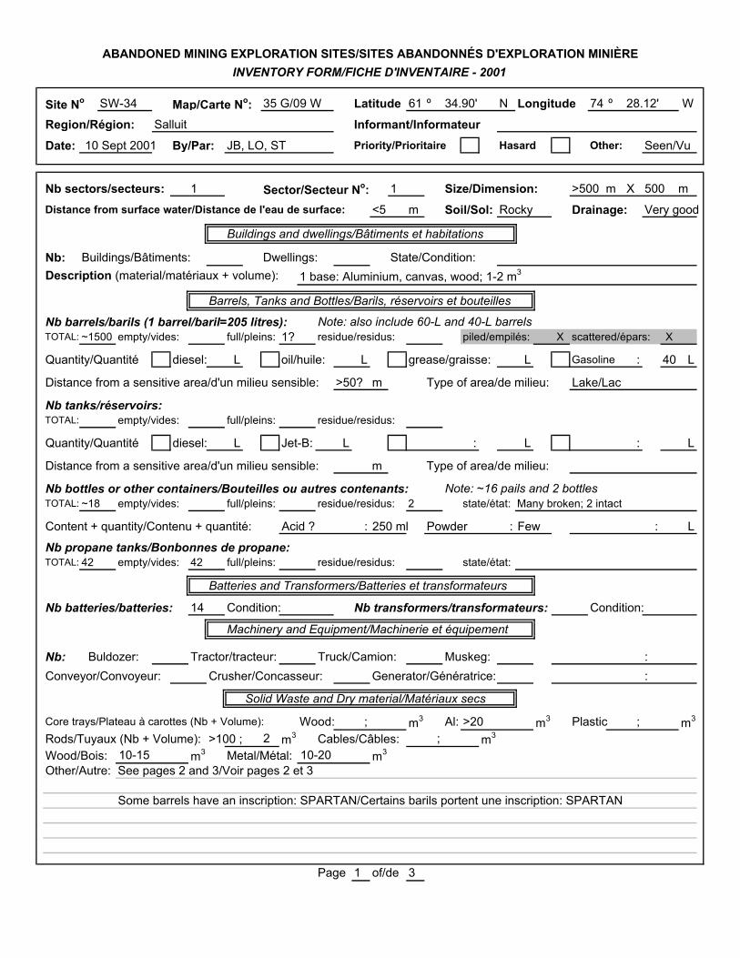
Site No SW-34 Map/Carte No: 35 G/09 W Latitude 61 º 34.90' N Longitude 74 º 28.12' W
Region/Région: Salluit Informant/InformateurDate: 10 Sept 2001 By/Par: JB, LO, ST Priority/Prioritaire Hasard Other: Seen/Vu
Nb sectors/secteurs: 1 Sector/Secteur No: 1 Size/Dimension: >500 m X 500 m
Distance from surface water/Distance de l'eau de surface: <5 m Soil/Sol: Rocky Drainage: Very good
Buildings and dwellings/Bâtiments et habitations
Nb: Buildings/Bâtiments: Dwellings: State/Condition:Description (material/matériaux + volume): 1 base: Aluminium, canvas, wood; 1-2 m3
Barrels, Tanks and Bottles/Barils, réservoirs et bouteilles
Nb barrels/barils (1 barrel/baril=205 litres): Note: also include 60-L and 40-L barrelsTOTAL: ~1500 empty/vides: full/pleins: 1? residue/residus: piled/empilés: X scattered/épars: X
Quantity/Quantité diesel: L oil/huile: L grease/graisse: L Gasoline : 40 L
Distance from a sensitive area/d'un milieu sensible: >50? m Type of area/de milieu: Lake/Lac
Nb tanks/réservoirs:TOTAL: empty/vides: full/pleins: residue/residus:
Quantity/Quantité diesel: L Jet-B: L : L : L
Distance from a sensitive area/d'un milieu sensible: m Type of area/de milieu:
Nb bottles or other containers/Bouteilles ou autres contenants: Note: ~16 pails and 2 bottlesTOTAL: ~18 empty/vides: full/pleins: residue/residus: 2 state/état: Many broken; 2 intact
Content + quantity/Contenu + quantité: Acid ? : 250 ml Powder : Few : L
Nb propane tanks/Bonbonnes de propane:TOTAL: 42 empty/vides: 42 full/pleins: residue/residus: state/état:
Batteries and Transformers/Batteries et transformateurs
Nb batteries/batteries: 14 Condition: Nb transformers/transformateurs: Condition:
Machinery and Equipment/Machinerie et équipement
Nb: Buldozer: Tractor/tracteur: Truck/Camion: Muskeg: :Conveyor/Convoyeur: Crusher/Concasseur: Generator/Génératrice: :
Solid Waste and Dry material/Matériaux secs
Core trays/Plateau à carottes (Nb + Volume): Wood: ; m3 Al: >20 m3 Plastic ; m3
Rods/Tuyaux (Nb + Volume): >100 ; 2 m3 Cables/Câbles: ; m3
Wood/Bois: 10-15 m3 Metal/Métal: 10-20 m3
Other/Autre: See pages 2 and 3/Voir pages 2 et 3
Some barrels have an inscription: SPARTAN/Certains barils portent une inscription: SPARTAN
Page 1 of/de 3
ABANDONED MINING EXPLORATION SITES/SITES ABANDONNÉS D'EXPLORATION MINIÈREINVENTORY FORM/FICHE D'INVENTAIRE - 2001
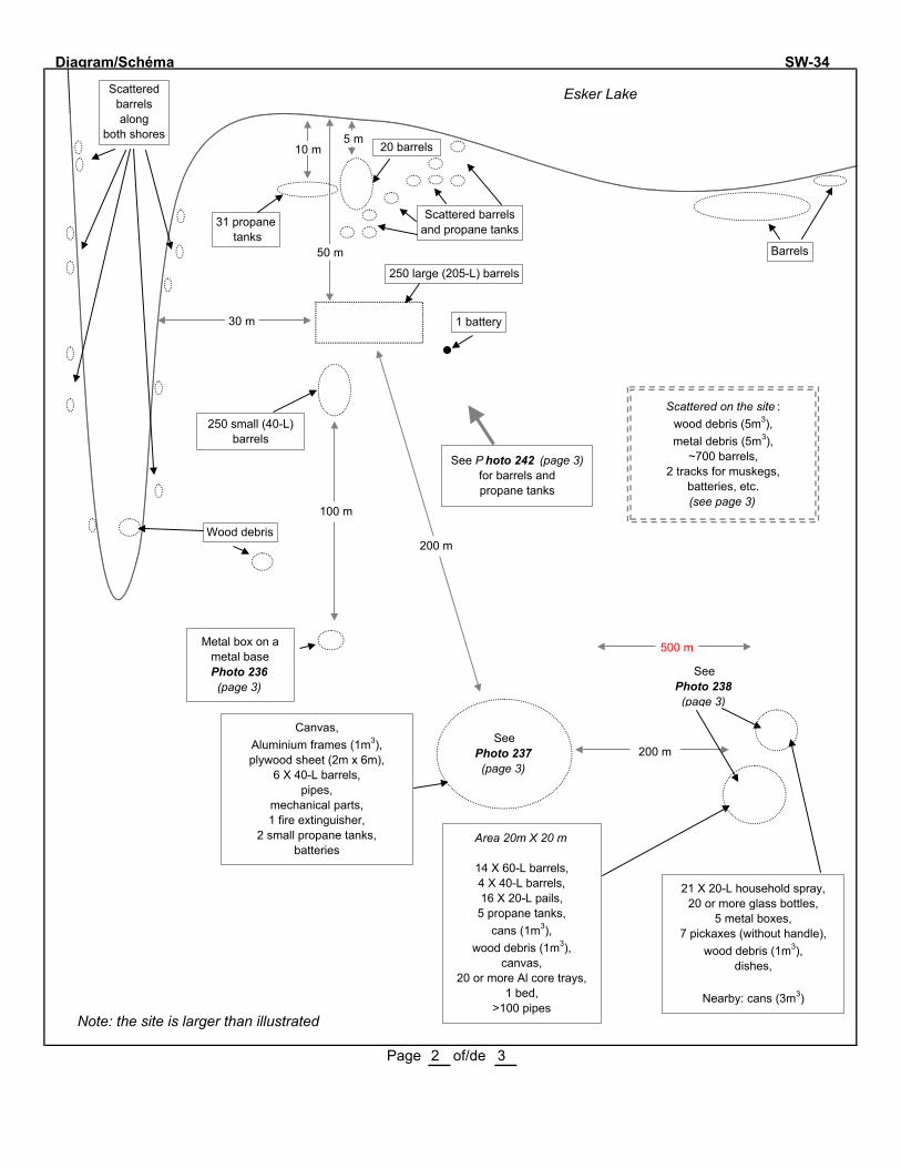
Diagram/Schéma SW-34
Esker Lake
Note: the site is larger than illustrated
Page 2 of/de 3
5 m10 m
31 propane tanks
20 barrels
Scattered barrelsand propane tanks
Barrels
250 small (40-L)barrels
30 m
50 m
1 battery
100 m
Wood debris
Metal box on a metal basePhoto 236(page 3)
See P hoto 242 (page 3) for barrels and propane tanks
200 m
200 mSee
Photo 237(page 3)
Canvas,Aluminium frames (1m3),plywood sheet (2m x 6m),
6 X 40-L barrels,pipes,
mechanical parts,1 fire extinguisher,
2 small propane tanks,batteries
Scattered barrels along
both shores
Area 20m X 20 m
14 X 60-L barrels,4 X 40-L barrels,16 X 20-L pails,5 propane tanks,
cans (1m3),wood debris (1m3),
canvas,20 or more Al core trays,
1 bed,>100 pipes
SeePhoto 238 (page 3)
21 X 20-L household spray,20 or more glass bottles,
5 metal boxes,7 pickaxes (without handle),
wood debris (1m3),dishes,
Nearby: cans (3m3)
Scattered on the site :wood debris (5m3), metal debris (5m3),
~700 barrels,2 tracks for muskegs,
batteries, etc.(see page 3)
500 m
250 large (205-L) barrels
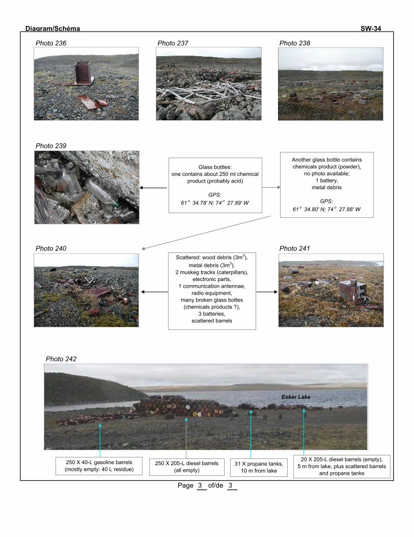
Diagram/Schéma SW-34
Photo 236 Photo 237 Photo 238
Photo 239
Photo 240 Photo 241
Photo 242
Page 3 of/de 3
250 X 40-L gasoline barrels(mostly empty: 40 L residue)
250 X 205-L diesel barrels(all empty)
31 X propane tanks, 10 m from lake
20 X 205-L diesel barrels (empty),5 m from lake, plus scattered barrels
and propane tanks
Esker Lake
Glass bottles: one contains about 250 ml chemical
product (probably acid)
GPS: 61 o 34.78' N; 74 o 27.89' W
Another glass bottle contains chemicals product (powder),
no photo available;1 battery,
metal debris
GPS: 61 o 34.80' N; 74 o 27.88' W
Scattered: wood debris (3m3), metal debris (3m3).
2 muskeg tracks (caterpillars),electronic parts,
1 communication antennae,radio equipment,
many broken glass bottes (chemicals products ?),
3 batteries,scattered barrels

SW-34 Many spots of contaminated soils most under drums. Total contaminated area: ~ 90 m
2.
Number Sample Depth (cm)
Parameters Analytical results (mg/kg)
Conta-minated
area (m2)
Soil
SW 34-1 Soil sample under an old battery
0-3 Hg
Pb
0,02
90 000 0,5
SW 34-2 Soil sample under 2 batteries. 0-3 Hg
Pb
0,03
6100 0,5
SW 34-3 Soil near the pile of small drums.
0-3 C10-C50 < 500 -
SW 34-4 Soil near the pile of diesel drums.
0-3 C10-C50 120 -
SW 34-5B Duplicata of SW 34-5A N/A C10-C50 380 -
SW 34-6 Soil sample under 2 batteries. 0-3
Hg
Pb
1,3
880
0,5
Total area ~90
Water
SW 34-5A Water of Esker Lake close to the pile of drums.
N/A C10-C50. < 100 -
MENV criteria :
Soil
C10-C50 (mg/kg)
Surface water
C10-C50 (µµ g/L)
Soil
Hg (mg/kg)
Soil
Pb (mg/kg)
Soil
PCBs (mg/kg)
A: 300 B: 700
C: 3500
3500 A: 0.2 B: 2
C: 10
A: 50 B: 500
C: 1000
A: 0.05 B: 1
C: 10

Site No SW-42 Map/Carte No: 53 G/09 W Latitude 61 º 23.92' N Longitude 74 º 34.40' W
Region/Région: Salluit Informant/Informateur Paulusie Padlayat
Date: 10 Sept 2001 By/Par: JB, LO, ST Priority/Prioritaire Hasard Other: Informant
Nb sectors/secteurs: 1 Sector/Secteur No: 1 Size/Dimension: 150 l m X 100 l m
Distance from surface water/Distance de l'eau de surface: 30 m Soil/Sol: Shallow Drainage: Variable
Buildings and dwellings/Bâtiments et habitations
Nb: Buildings/Bâtiments: Dwellings: State/Condition: 1 wood baseDescription (material/matériaux + volume):
Barrels, Tanks and Bottles/Barils, réservoirs et bouteilles
Nb barrels/barils (1 barrel/baril=205 litres):TOTAL: 81 empty/vides: 74 full/pleins: residue/residus: 7 piled/empilés: X scattered/épars: X
Quantity/Quantité X diesel:700 L oil/huile: L grease/graisse: L : L
Distance from a sensitive area/d'un milieu sensible: 80 m Type of area/de milieu: Lake/Lac
Nb tanks/réservoirs:TOTAL: 0 empty/vides: full/pleins: residue/residus:
Quantity/Quantité diesel: L Jet-B: L : L : L
Distance from a sensitive area/d'un milieu sensible: m Type of area/de milieu:
Nb bottles or other containers/Bouteilles ou autres contenants:TOTAL: 4 empty/vides: full/pleins: 3 residue/residus: 1 state/état:
Content + quantity/Contenu + quantité: grease (3) : 12 L insect repell.(1): 200 ml : L
Nb propane tanks/Bonbonnes de propane:TOTAL: 0 empty/vides: full/pleins: residue/residus: state/état:
Batteries and Transformers/Batteries et transformateurs
Nb batteries/batteries: 0 Condition: Nb transformers/transformateurs: 0 Condition:
Machinery and Equipment/Machinerie et équipement
Nb: Buldozer: Tractor/tracteur: Truck/Camion: Muskeg: :Conveyor/Convoyeur: Crusher/Concasseur: Generator/Génératrice: :
Solid Waste and Dry material/Matériaux secs
Core trays/Plateau à carottes (Nb + Volume): Wood: ; m3 Al: ; m3 Plastic ; m3
Rods/Tuyaux (Nb + Volume): 20 ; <1 m3 Cables/Câbles: ; m3
Wood/Bois: 5-10 m3 Metal/Métal: 2-5 m3 Other/Autre: 1-5 m3
Other/Autre:
NOTE: A lot of droppings of Canada goose and caribou are present on the site/ Il y a beaucoup de crottin de bernache du Canada et de caribou sur le site.
Page 1 of/de 2
ABANDONED MINING EXPLORATION SITES/SITES ABANDONNÉS D'EXPLORATION MINIÈREINVENTORY FORM/FICHE D'INVENTAIRE - 2001

Diagram/Schéma SW-42
Beauparlant Lake
2 Wood base (4m x 5m)1 Photo 233
3 Photo 234
4 Photo 235
5 Wood roof
Page 2 of/de 2
1
30 m
50 m
1 home made stove (1 barrel and stones)
2 ~100 m3
4
30 m
5
50 m
6 plywood sheets (25m2),1 insect repellent (~200 ml),
cans (2m3),3 X 4-L pails of grease (open; 12 L),
dishes, glass jars,wood debris (2m3),
1 roll of roofing,12 Al pipes (5cm dia. X 3m long),3 Al pipes (2cm dia. X 1.2m long),
4 Al pipes,scattered metal debris (<1m3)
74 empty barrels,7 barrels with 100 L diesel each
(some are open),1 empty metal gas container,
1 pipe with a valve
Wet area
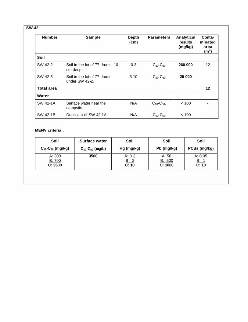
SW-42
Number Sample Depth (cm)
Parameters Analytical results (mg/kg)
Conta-minated
area (m2)
Soil
SW 42-2 Soil in the lot of 77 drums. 10
cm deep.
0-3 C10-C50 260 000 12
SW 42-3 Soil in the lot of 77 drums under SW 42-2.
3-10 C10-C50 25 000
Total area 12
Water
SW 42-1A Surface water near the campsite.
N/A C10-C50. < 100 -
SW 42-1B Duplicata of SW-42-1A. N/A C10-C50 < 100 -
MENV criteria :
Soil
C10-C50 (mg/kg)
Surface water
C10-C50 (µµ g/L)
Soil
Hg (mg/kg)
Soil
Pb (mg/kg)
Soil
PCBs (mg/kg)
A: 300 B: 700
C: 3500
3500 A: 0.2 B: 2 C: 10
A: 50 B: 500 C: 1000
A: 0.05 B: 1 C: 10

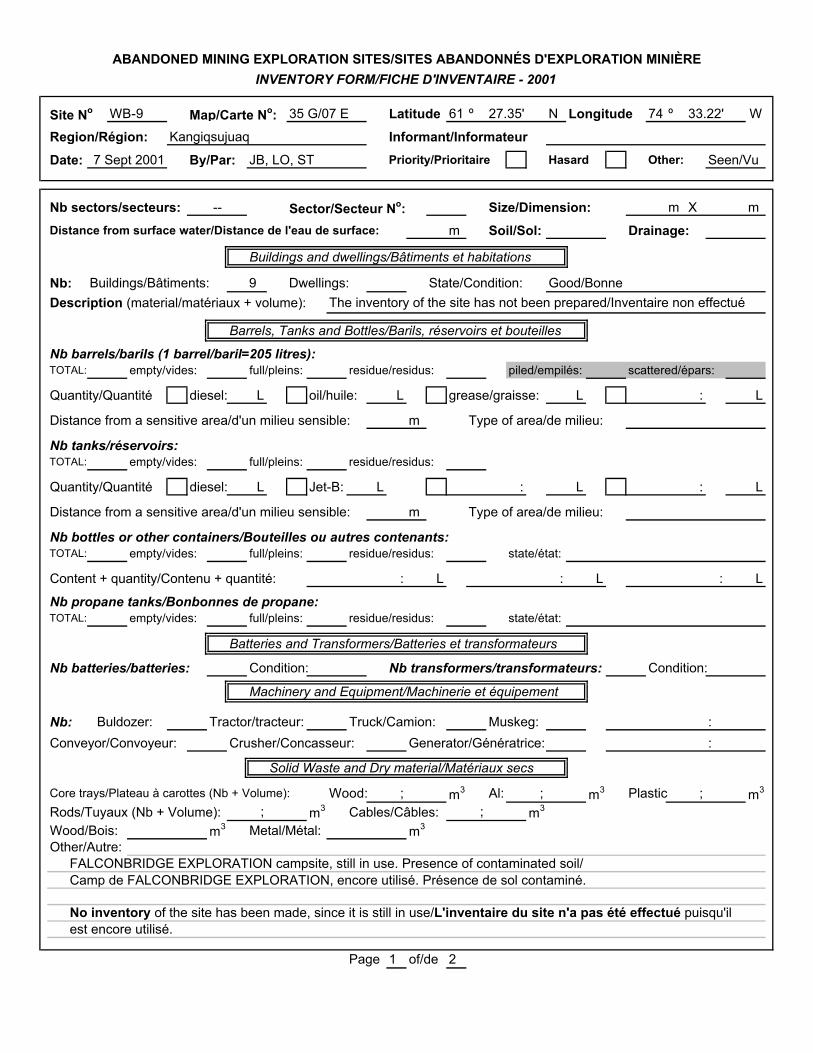
Site No WB-9 Map/Carte No: 35 G/07 E Latitude 61 º 27.35' N Longitude 74 º 33.22' W
Region/Région: Kangiqsujuaq Informant/InformateurDate: 7 Sept 2001 By/Par: JB, LO, ST Priority/Prioritaire Hasard Other: Seen/Vu
Nb sectors/secteurs: -- Sector/Secteur No: Size/Dimension: m X m
Distance from surface water/Distance de l'eau de surface: m Soil/Sol: Drainage:
Buildings and dwellings/Bâtiments et habitations
Nb: Buildings/Bâtiments: 9 Dwellings: State/Condition: Good/BonneDescription (material/matériaux + volume): The inventory of the site has not been prepared/Inventaire non effectué
Barrels, Tanks and Bottles/Barils, réservoirs et bouteilles
Nb barrels/barils (1 barrel/baril=205 litres):TOTAL: empty/vides: full/pleins: residue/residus: piled/empilés: scattered/épars:
Quantity/Quantité diesel: L oil/huile: L grease/graisse: L : L
Distance from a sensitive area/d'un milieu sensible: m Type of area/de milieu:
Nb tanks/réservoirs:TOTAL: empty/vides: full/pleins: residue/residus:
Quantity/Quantité diesel: L Jet-B: L : L : L
Distance from a sensitive area/d'un milieu sensible: m Type of area/de milieu:
Nb bottles or other containers/Bouteilles ou autres contenants:TOTAL: empty/vides: full/pleins: residue/residus: state/état:
Content + quantity/Contenu + quantité: : L : L : L
Nb propane tanks/Bonbonnes de propane:TOTAL: empty/vides: full/pleins: residue/residus: state/état:
Batteries and Transformers/Batteries et transformateurs
Nb batteries/batteries: Condition: Nb transformers/transformateurs: Condition:
Machinery and Equipment/Machinerie et équipement
Nb: Buldozer: Tractor/tracteur: Truck/Camion: Muskeg: :Conveyor/Convoyeur: Crusher/Concasseur: Generator/Génératrice: :
Solid Waste and Dry material/Matériaux secs
Core trays/Plateau à carottes (Nb + Volume): Wood: ; m3 Al: ; m3 Plastic ; m3
Rods/Tuyaux (Nb + Volume): ; m3 Cables/Câbles: ; m3
Wood/Bois: m3 Metal/Métal: m3
Other/Autre:FALCONBRIDGE EXPLORATION campsite, still in use. Presence of contaminated soil/Camp de FALCONBRIDGE EXPLORATION, encore utilisé. Présence de sol contaminé.
No inventory of the site has been made, since it is still in use/L'inventaire du site n'a pas été effectué puisqu'ilest encore utilisé.
Page 1 of/de 2
ABANDONED MINING EXPLORATION SITES/SITES ABANDONNÉS D'EXPLORATION MINIÈREINVENTORY FORM/FICHE D'INVENTAIRE - 2001

Diagram/Schéma WB-9
Photo 162 General view of the campsite
Photo 171
Page 2 of/de 2
Acid in a plastic container, inside a building
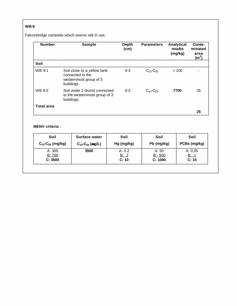
WB-9 Falconbridge campsite which seems still in use.
Number Sample Depth (cm)
Parameters Analytical results (mg/kg)
Conta-minated
area (m2)
Soil
WB 9-1 Soil close to a yellow tank connected to the
westernmost group of 3 buildings.
0-3 C10-C50 < 100 -
WB 9-2 Soil under 2 drums connected to the westernmost group of 3
buildings.
0-3 C10-C50 7700 25
Total area 25
MENV criteria :
Soil
C10-C50 (mg/kg)
Surface water
C10-C50 (µµ g/L)
Soil
Hg (mg/kg)
Soil
Pb (mg/kg)
Soil
PCBs (mg/kg)
A: 300 B: 700
C: 3500
3500 A: 0.2 B: 2
C: 10
A: 50 B: 500
C: 1000
A: 0.05 B: 1
C: 10

Layout of site WB-9 prepared during the 2007 inspection.
Source: KRG (2007b)

SECTOR OFUMIUJAQ
WHA-1


Site No Map/Carte No: Latitude 56 º N Longitude 75 º W
Region/Région: Whapmagoostui Informant/Informateur Joseph and Matthew Petagumskum
Date: By/Par: JB, LO, MP Priority/Prioritaire Hasard Other:
Nb sectors/secteurs: Sector/Secteur No: Size/Dimension: m X m
Distance from surface water/Distance de l'eau de surface: m Soil/Sol: Drainage:
Buildings and dwellings/Bâtiments et habitations
Nb: Buildings/Bâtiments: Dwellings: State/Condition: 1: Bad/Mauvaise/9: floors onlyDescription (material/matériaux + volume): Wood/Bois; 25-40m3
Barrels, Tanks and Bottles/Barils, réservoirs et bouteilles
Nb barrels/barils (1 barrel/baril=205 litres): Also : 19 x 40-L (10-gallons) barrels; 4 having residue of diesel (~50 L)TOTAL: empty/vides: full/pleins: 1 residue/residus: piled/empilés: scattered/épars:
Quantity/Quantité X diesel: 230 L oil/huile: L grease/graisse: L : L
Distance from a sensitive area/d'un milieu sensible: m Type of area/de milieu: Lake/Lac
Nb tanks/réservoirs:TOTAL: empty/vides: full/pleins: residue/residus:
Quantity/Quantité diesel: L Jet-B: L : L : L
Distance from a sensitive area/d'un milieu sensible: m Type of area/de milieu:
Nb bottles or other containers/Bouteilles ou autres contenants: (in the outhouse)TOTAL: empty/vides: full/pleins: residue/residus: state/état: Rusted/Rouillé
Content + quantity/Contenu + quantité: Deodorant cleaner: ? L : L : L
Nb propane tanks/Bonbonnes de propane:TOTAL: empty/vides: full/pleins: residue/residus: state/état:
Batteries and Transformers/Batteries et transformateurs
Nb batteries/batteries: Condition: Nb transformers/transformateurs: Condition:
Machinery and Equipment/Machinerie et équipement
Nb: Buldozer: Tractor/tracteur: Truck/Camion: Muskeg: :Conveyor/Convoyeur: Crusher/Concasseur: Generator/Génératrice: :
Solid Waste and Dry material/Matériaux secs
Core trays/Plateau à carottes (Nb + Volume): Wood: ; m3 Al: ; m3 Plastic ; m3
Rods/Tuyaux (Nb + Volume): ; m3 Cables/Câbles: ; m3
Wood/Bois: m3 Metal/Métal: m3
Other/Autre: PVC Pipe/Tuyau de PVC: 10m long; burnt wood logs/billots brûlés: 6m3; 1 sidewalk made of wood logs/trottoir de billots; 1 collapsed outhouse/1 toilette effondrée; cans near the outhouse/cannettes près de la toillette. In the cabin: stove pipes, 1 half barrel (stove), 1 wood bench, 1 shovel, 1 folding chair,1 bucket/Dans la cabine: tuyaux de poêle, un demi-baril (poêle), 1 banc en bois, 1 pelle, 1 chaise pliante, 1 seau. Inscription on the cabin/Inscription dans la cabine: Harry Coonishish.
Page 1 of/de 3
4 3 X
0 0 0
0
24.08'
25 Sept. 2002
Quite good
10 ?
4
scattered: 6 1-3
0
0 0 0 0
0
15
0
4 Sand
10
1
ABANDONED MINING EXPLORATION SITES/SITES ABANDONNÉS D'EXPLORATION MINIÈREINVENTORY FORM/FICHE D'INVENTAIRE - 2002
WHA-1 34B/5 39.30'
From MP
120 251

Diagram/Schéma WHA-1Photos 14-15
Photo 5Photo WHA8
Photo WHA7
Photo 9Photo 10
Photo 12
Photo 13Photo 3
Page 2 of/de 3
Photo 9
Photo 10
Photo 5
Photo 3
60-70m
Outhouse area :cans, 1 x 40-L barrel,
10 containers of deodorant cleaner,
wood debris (1-2m3),metal debris (1m3)
5m
Inside of the cabin:contaminated soil,
stove pipes,1 stove (barrel),
1 wood bench, 1 shovel,1 folding chair,
1 bucket
Barrel dump:9 x 40-L barrels,
1 open barrel
Wood floors,barrels
Wood floors,barrels
Burnt wood logs (~6m3),1 barrel,1 broom
Behind the wood floor :2 x 200-L barrel (1 full),
4 x 40-L barrels

WHA 1
Number Sample Depth (cm)
Parameters Analytical results (mg/kg)
Conta-minated area (m2)
Soil
WHA1-1 Soil under a barrel close to a
lot of wood
0-5 C10-C50 < 100 -
WHA1-2 Soil close to a group of 4 barrels
0-5 C10-C50 < 200 -
WHA1-3 Soil on the floor of a dirty
cabin
0-3 C10-C50 3400 6
WHA1-4 Soil under the floor of the same dirty cabin
0-5 C10-C50 < 250 -
WHA1-5 Soil of the shore of a swamp near the dirty cabin
0-5 C10-C50 < 100 -
WHA1-6 Soil under a barrel along the
same swamp than WHA1-5
0-3 C10-C50 < 100 -
Total area 6
MENV criteria :
Soil
C10-C50 (mg/kg)
Surface water
C10-C50 (µµ g/L)
Soil
Hg (mg/kg)
Soil
Pb (mg/kg)
Soil
PCBs (mg/kg)
A: 300 B: 700
C: 3500
3500 A: 0.2 B: 2 C: 10
A: 50 B: 500 C: 1000
A: 0.05 B: 1 C: 10


APPENDIX 4
Photographs of Sites Requiring Major Clean-Up, Before and After Clean-up Work
2
Kawawachikamach Sector ................................................................................................................ 3
KAW-35 ....................................................................................................................................................3
KAW-45 ................................................................................................................................................. 15
Tasiujaq Sector .............................................................................................................................. 20
PJ-1 ....................................................................................................................................................... 20
TQ-1 ...................................................................................................................................................... 34
Site requiring intermediate cleanup work, P-24F13-5 ........................................................................ 38
Landing strip near site TQ-1 ................................................................................................................. 39
TQ-4 ...................................................................................................................................................... 40
Aupaluk Sector ............................................................................................................................... 46
PJ-10 ..................................................................................................................................................... 46
PJ-17 ..................................................................................................................................................... 48
Kangirsuk Sector ............................................................................................................................ 53
TW ........................................................................................................................................................ 53
Kangiqsujuaq Sector ...................................................................................................................... 57
K-28....................................................................................................................................................... 57
K-61....................................................................................................................................................... 60
WB-3 ..................................................................................................................................................... 62
Salluit Sector .................................................................................................................................. 68
SAL-1 ..................................................................................................................................................... 68
SW-42 ................................................................................................................................................... 71
Umiujaq Sector .............................................................................................................................. 75
WHA-1 .................................................................................................................................................. 75

3
Kawawachikamach Sector
KAW-35
Photo 1 General view of site KAW-35 during 2001-2002 inventory, September 10, 2002
Photo 2 Overview of site KAW-35 during the inspection visit of September 15, 2011

4
Photo 3 Close-up view of a portion of the site KAW-35, September 15, 2011
Photo 4 Close-up view of a portion of the site KAW-35, September 15, 2011

5
Photo 5 Sector 2: Tailings and garage during the 2001-2002 inventory,
September 10, 2002
Photo 6 Sector 2: Tailings and garage during the inspection visit of September 15,
2011

6
Photo 7 Sector 3: Two trailers and 4,400 liters reservoir during the 2002-2002 inventory, September 10, 2002
Photo 8 Sector 3: Two trailers and 4,400 liters reservoir during the September
2011 inventory

7
Photo 9 Barrels near the shore of Lake Retty during the 2001-2002 inventory,
September 10, 2002
Photo 10 Along the shore of Retty Lake during the inspection visit on 15 September, 2011 after the removal of barrels (see photo above)

8
Photo 11 Barrels and small cabin near the shore of Retty Lake during the of
2001-2002 inventory, September 10, 2002
Photo 12 Along the shore of Retty Lake after removal of barrels and a cabin during the inspection visit on 15 September 2011 (see photo above)

9
Photo 13 Cabin containing an insulated reservoir in the 2001-2002 inventory,
September 10, 2002
Photo 14 Cabin containing an insulated reservoir during the inspection visit on September 15, 2011. The wooden structure nearby was demolished.

10
Photo 15 Buildings and shelter containing samples of rocks and various debris
during 2001-2001 inventory, September 10, 2002
Photo 16 Shelter containing samples of rocks, debris and main building during the
inspection visit on September 15, 2011. It should be noted that the two small buildings in the background in the previous photo, pole and electrical wires, and some debris have been removed.
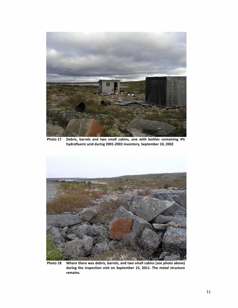
11
Photo 17 Debris, barrels and two small cabins, one with bottles containing 4%
hydrofluoric acid during 2001-2002 inventory, September 10, 2002
Photo 18 Where there was debris, barrels, and two small cabins (see photo above)
during the inspection visit on September 15, 2011. The metal structure remains.

12
Photo 19 Pile of debris, reservoir and tailings on site KAW-35 (September 15, 2011)
Photo 20 Wood and metal debris on site KAW-35 (September 15, 2011)

13
Photo 21 Building, reservoir and other debris at the site KAW-35
(September 15, 2011)
Photo 22 Pile of debris at the site KAW-35 (September 15, 2011)
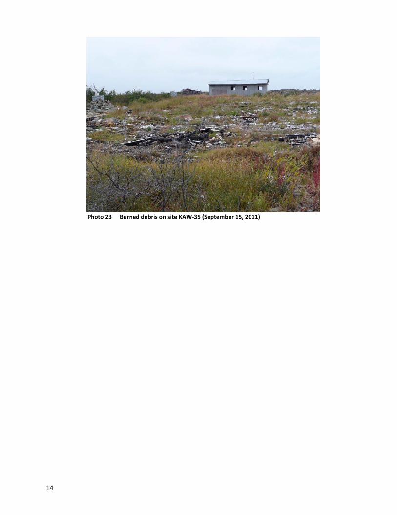
14
Photo 23 Burned debris on site KAW-35 (September 15, 2011)
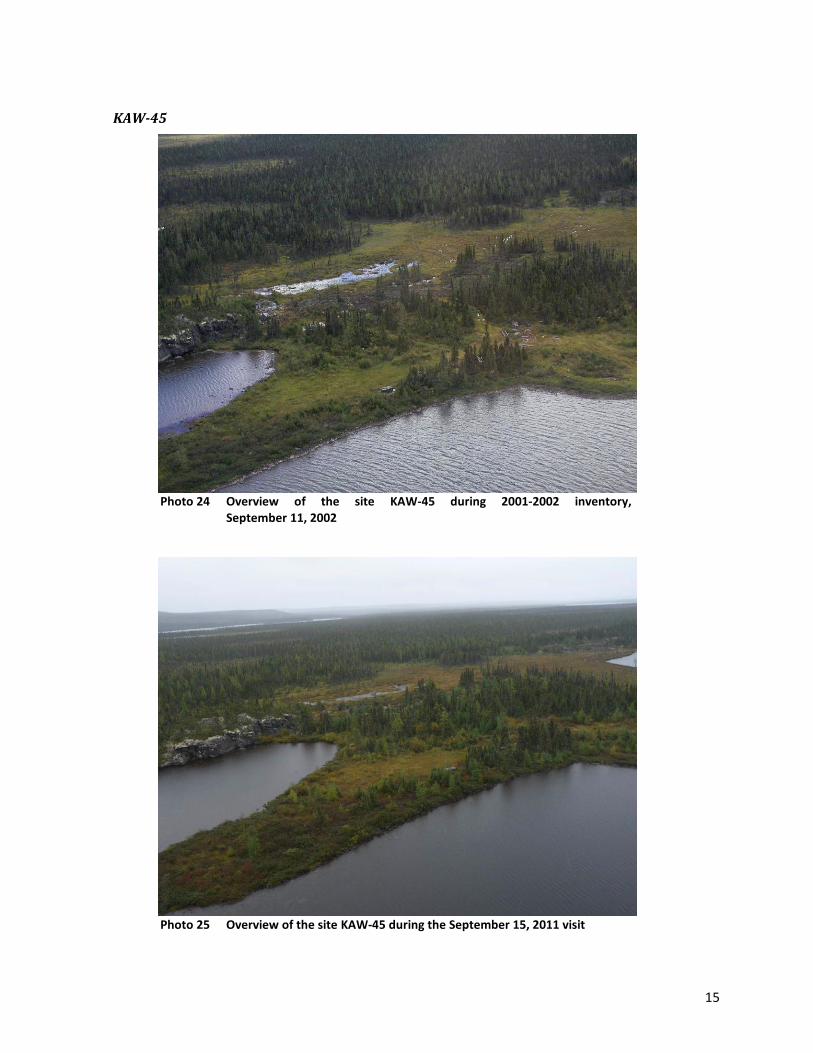
15
KAW-45
Photo 24 Overview of the site KAW-45 during 2001-2002 inventory,
September 11, 2002
Photo 25 Overview of the site KAW-45 during the September 15, 2011 visit

16
Photo 26 Close-up view of site KAW-45 during the 2001-2002 inventory,
September 11, 2002
Photo 27 Close-up view of site KAW-45 during the inspection visit on
September 15, 2011

17
A
B
C Photo 28 Site KAW-45 during the September 11, 2002 inventory (A) and after
cleanup during inspection of September 15, 2011 (B and C)
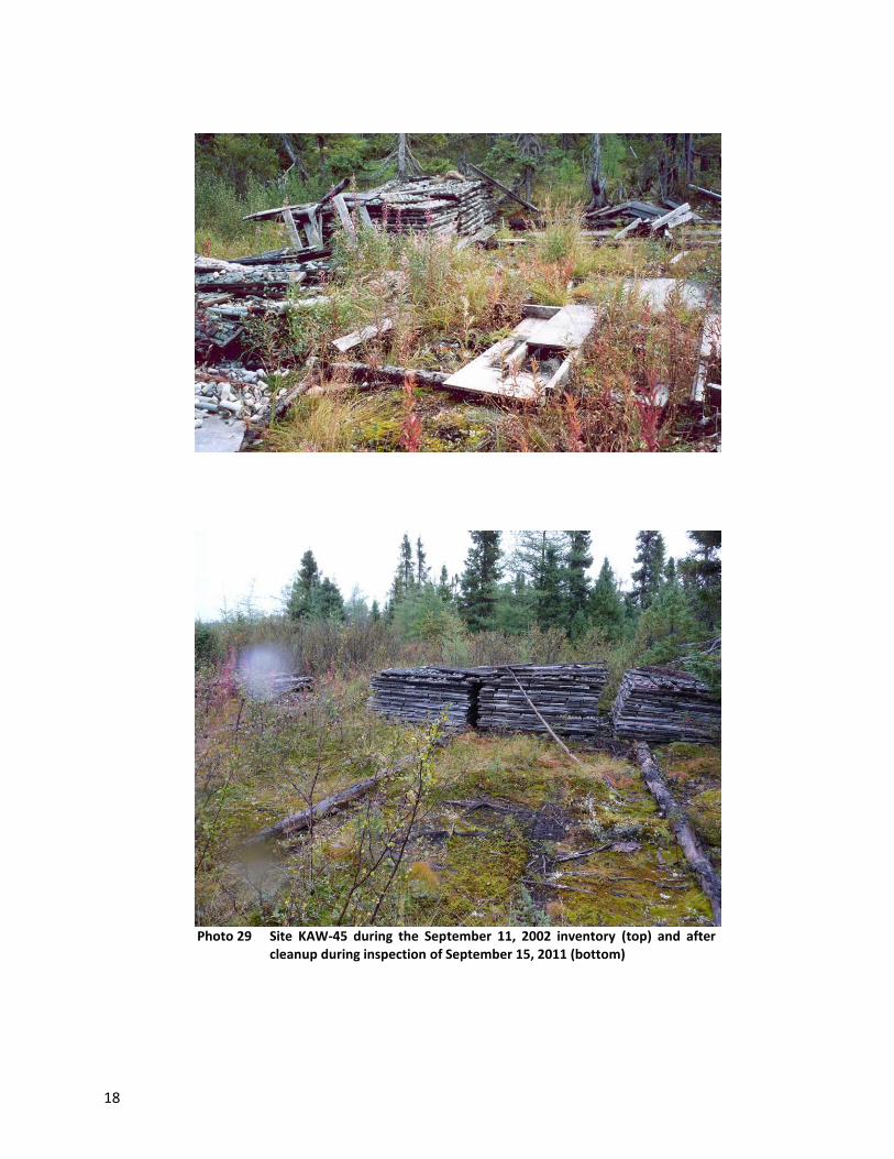
18
Photo 29 Site KAW-45 during the September 11, 2002 inventory (top) and after
cleanup during inspection of September 15, 2011 (bottom)
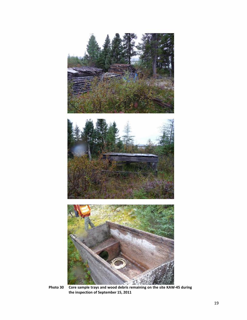
19
Photo 30 Core sample trays and wood debris remaining on the site KAW-45 during
the inspection of September 15, 2011

20
Tasiujaq Sector
PJ-1
Photo 31 Sector 4 after cleanup, all the machinery, tanks and other debris were
removed from the site PJ-1 (September 16, 2011)
Photo 32 Sector 4 before cleanup, July 21, 2001, PJ-1 site

21
Photo 33 Sector 4 before cleanup July 21, 2001, PJ-1 site
Photo 34 Sector 4 after cleanup, all the machinery, tanks and other debris were
removed from the site PJ-1 (September 16, 2011)

22
Photo 35 Sector 4: generators, barrels and other debris before cleanup July 21,
2001, PJ-1 site. Background on the hill: 2 reservoirs
Photo 36 Sector 4 after cleanup: generators, barrels and other debris were
removed from the site. Background on the hill: the two tanks were removed from the site PJ-1 (September 16, 2011)

23
Photo 37 Overview of Sector 4 from which generators, machinery, barrels,
reservoirs and other debris were removed from the site PJ-1 (September 16, 2011)
Photo 38 Sector 4: Opening leading to the gallery having been secured, PJ-1 site
(September 16, 2011)
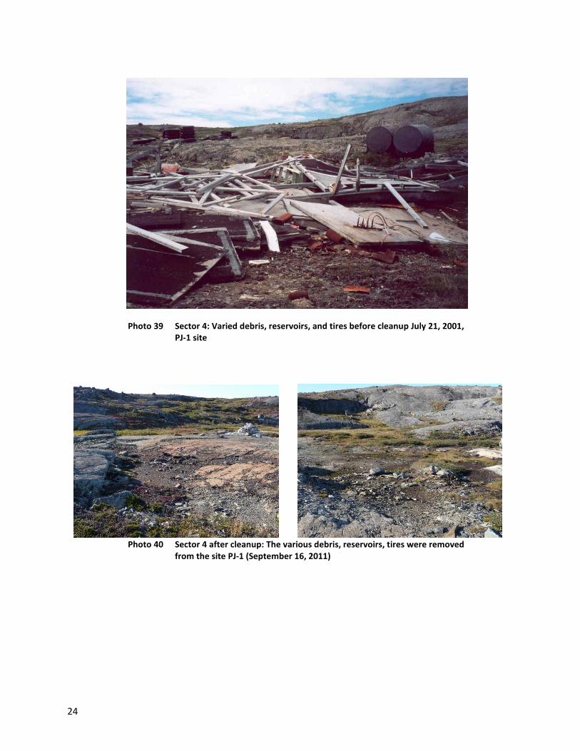
24
Photo 39 Sector 4: Varied debris, reservoirs, and tires before cleanup July 21, 2001, PJ-1 site
Photo 40 Sector 4 after cleanup: The various debris, reservoirs, tires were removed from the site PJ-1 (September 16, 2011)
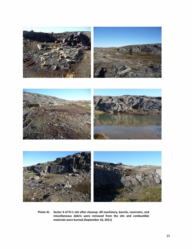
25
Photo 41 Sector 4 of PJ-1 site after cleanup: All machinery, barrels, reservoirs, and miscellaneous debris were removed from the site and combustible materials were burned (September 16, 2011)
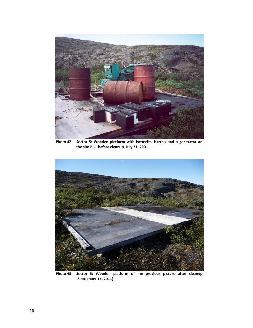
26
Photo 42 Sector 5: Wooden platform with batteries, barrels and a generator on
the site PJ-1 before cleanup, July 21, 2001
Photo 43 Sector 5: Wooden platform of the previous picture after cleanup
(September 16, 2011)

27
Photo 44 Sector 5: Reservoir, barrels and generator on site PJ-1 before cleanup,
July 21, 2001
Photo 45 Sector 5: Location shown in the previous photo after cleanup
(September 16, 2011)
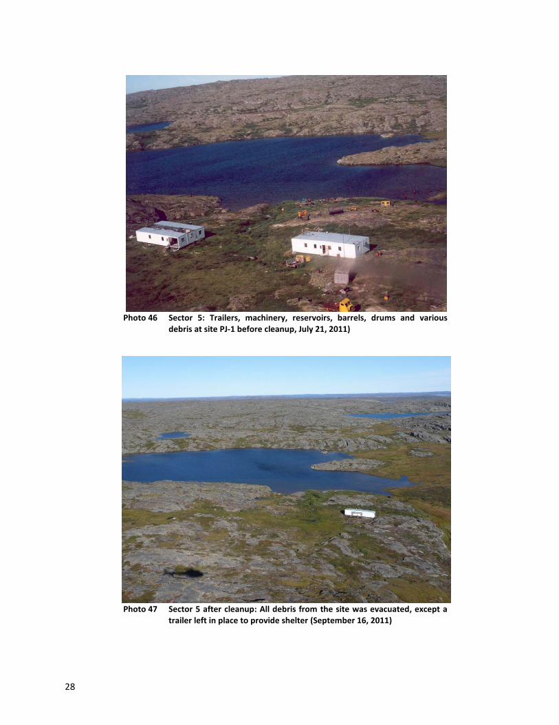
28
Photo 46 Sector 5: Trailers, machinery, reservoirs, barrels, drums and various
debris at site PJ-1 before cleanup, July 21, 2011)
Photo 47 Sector 5 after cleanup: All debris from the site was evacuated, except a
trailer left in place to provide shelter (September 16, 2011)
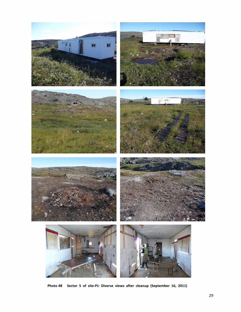
29
Photo 48 Sector 5 of site-PJ: Diverse views after cleanup (September 16, 2011)
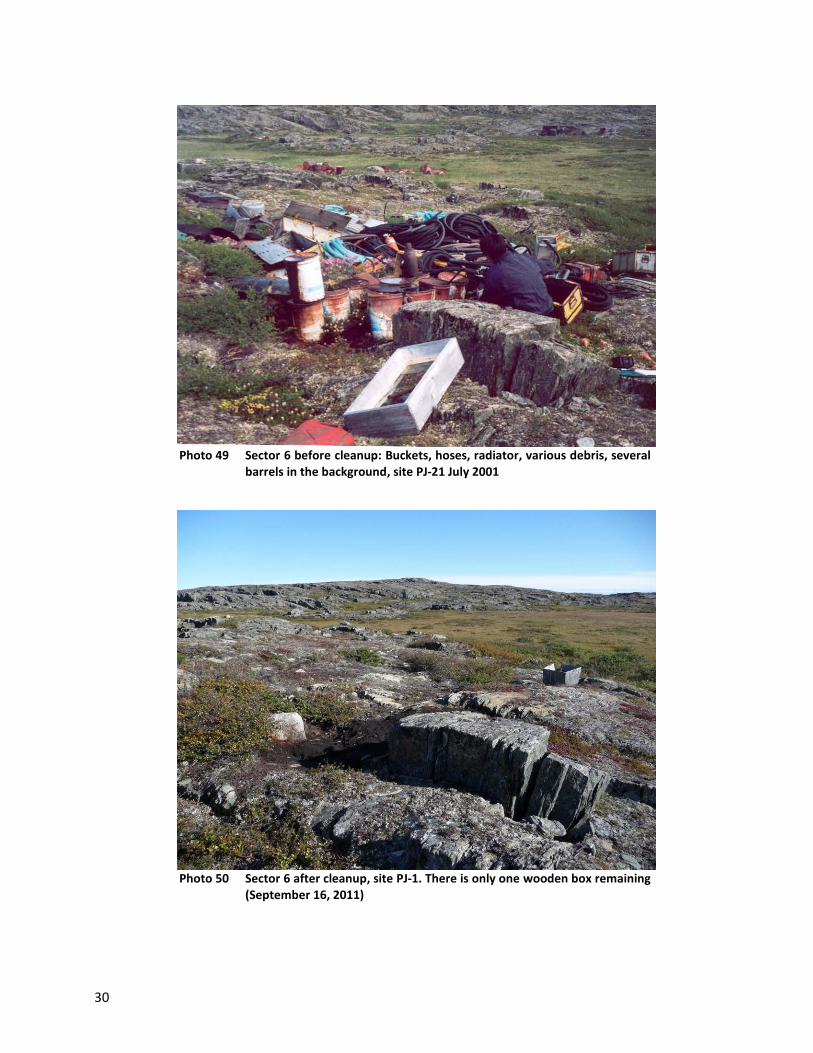
30
Photo 49 Sector 6 before cleanup: Buckets, hoses, radiator, various debris, several
barrels in the background, site PJ-21 July 2001
Photo 50 Sector 6 after cleanup, site PJ-1. There is only one wooden box remaining
(September 16, 2011)

31
Photo 51 Sector 6 after cleanup, site PJ-1: close-up view of the background of the
previous picture where the barrels were located, all were evacuated (September 16, 2011)
Photo 52 Sector 3 after cleanup: All debris was removed from the site PJ-1
(platform, fan, fireplace, metal trays, pipes, nails, plastic core trays, 15 empty barrels) (September 16, 2011)
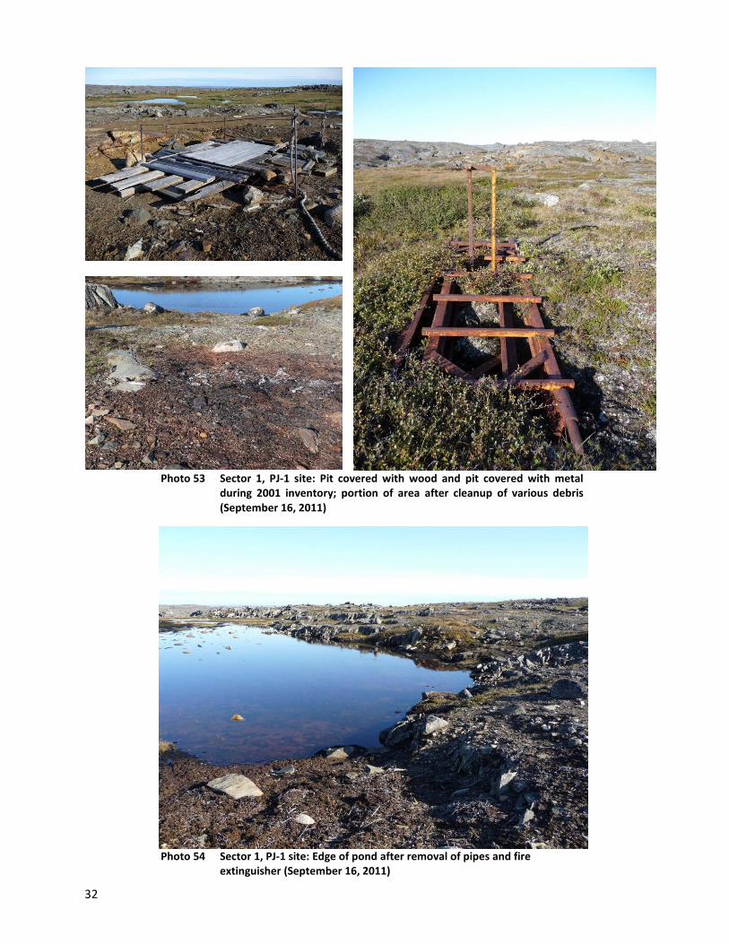
32
Photo 53 Sector 1, PJ-1 site: Pit covered with wood and pit covered with metal during 2001 inventory; portion of area after cleanup of various debris (September 16, 2011)
Photo 54 Sector 1, PJ-1 site: Edge of pond after removal of pipes and fire
extinguisher (September 16, 2011)
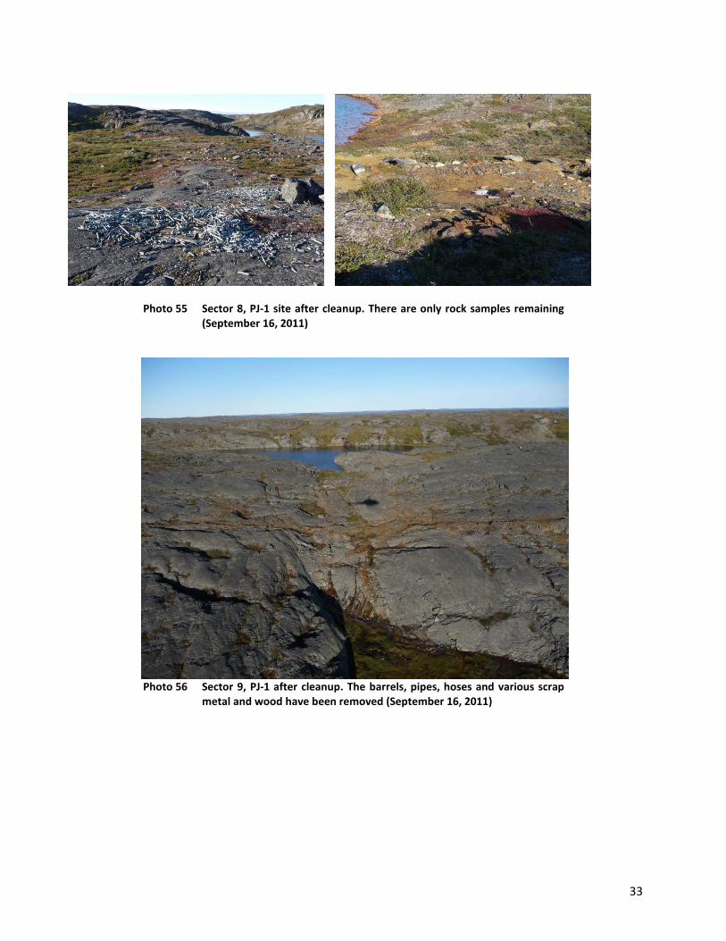
33
Photo 55 Sector 8, PJ-1 site after cleanup. There are only rock samples remaining (September 16, 2011)
Photo 56 Sector 9, PJ-1 after cleanup. The barrels, pipes, hoses and various scrap
metal and wood have been removed (September 16, 2011)

34
TQ-1
Photo 57 TQ-1 site: October 19, 2001
Photo 58 TQ-1 Site: September 16, 2011

35
Photo 59 Two buildings, core trays and various debris at site TQ-1, October 19,
2001
Photo 60 New building for cooking replacing the two buildings that have been
demolished from the previous picture. Trays samples are still there, as well as barrels (September 16, 2011)
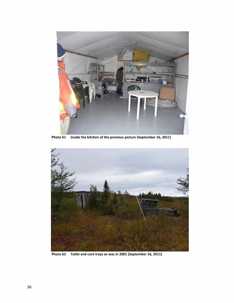
36
Photo 61 Inside the kitchen of the previous picture (September 16, 2011)
Photo 62 Toilet and core trays as was in 2001 (September 16, 2011)

37
Photo 63 Site TQ-1: inside the buildings, September 16, 2001

38
Site requiring intermediate cleanup work, P-24F13-5
Photo 64 Site P-24F13-5 after cleanup. This site is located near site TQ-1
(September 16, 2011)
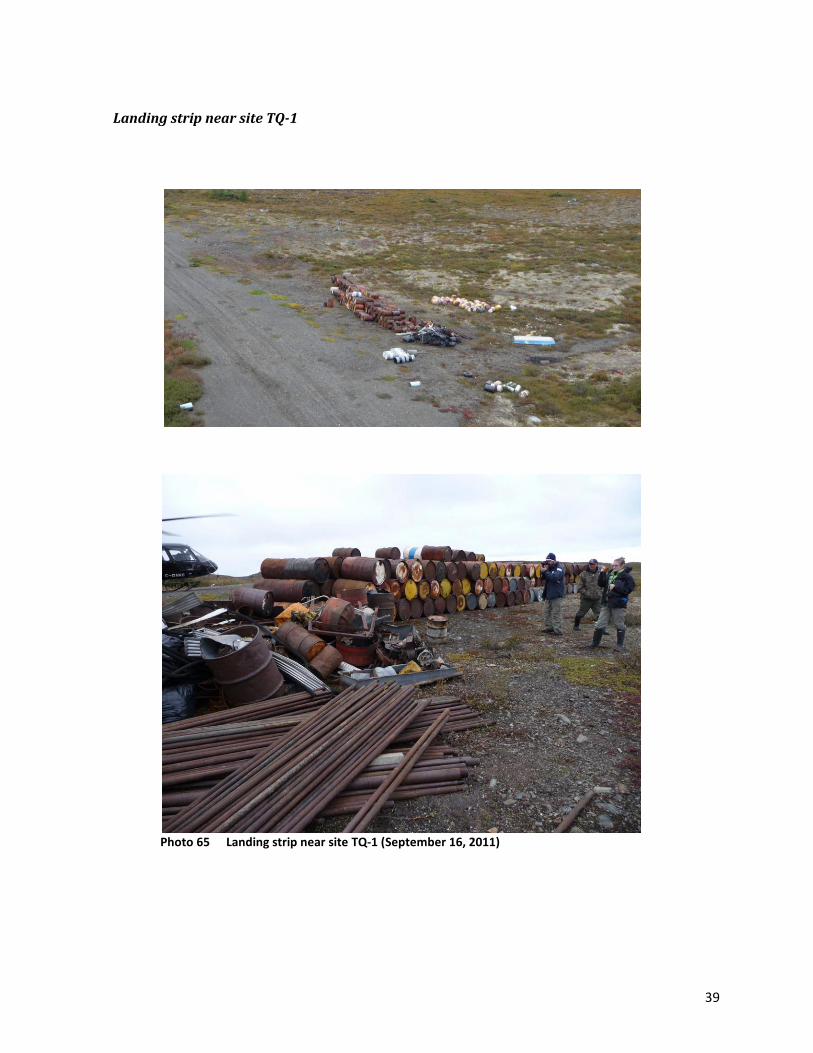
39
Landing strip near site TQ-1
Photo 65 Landing strip near site TQ-1 (September 16, 2011)

40
TQ-4
Photo 66 Overview of site TQ-4 after cleanup (September 16, 2011)
Photo 67 Closeup view of the building left on site TQ-4 and the remains of the
building that was burned (September 16, 2011)

41
Photo 68 Overview of Sector 2 of site TQ-4 before cleanup, October 19, 2011
Photo 69 Overview of Sector 2 of Site TQ-4 after cleanup. The many barrels and
debris were removed (September 16, 2011).

42
Photo 70 Sector 2: Ditches for rubber bladders, barrels and debris, site TQ-4 October 19, 2001
Photo 71 Sector 2 after cleanup: Rubber bladders in ditches, drums and debris were removed from site TQ-4 (September 16, 2011)
Photo 72 Content of the cabins that were on site, October 19 2001. All debris was removed from site TQ-4 and combustible materials were burned

43
Photo 73 Sector 1: Log cabins and debris at the site before cleanup TQ-4, October
19, 2001
Photo 74 Sector after a cleanup: The log cabin left on site TQ-4 is as shown in the
foreground in the previous picture. The other two were emptied and burned (see picture 67) (September 16, 2011).

44
Photo 75 Inside the log cabin that was left on the site TQ-4 (September 16, 2011)
Photo 76 Sector after a cleanup: Debris from burned cabins and traces left by old barrels, site TQ-4 (September 16, 2011)

45
Photo 77 Sector 1: Cabin collapsed, metal tripod and various debris, site TQ-4,
October 19, 2001
Photo 78 Sector 1 after cleanup and burning, site TQ-4 (September 16, 2011)

46
Aupaluk Sector
PJ-10
Photo 79 Overview of the site PJ-10 after cleanup. To the left you can see the
traces of the old platforms (September 17, 2011)
Photo 80 Traces left after burning a platform and debris at the site PJ-10
(September 17, 2011)

47
Photo 81 Comparative photographs before (left) and after cleanup (right) at the site PJ-10 (September 17, 2011)

48
PJ-17
Photo 82 General views of the site PJ-17 after cleanup (September 17, 2011)
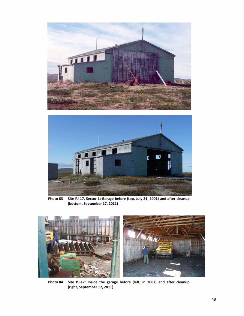
49
Photo 83 Site PJ-17, Sector 1: Garage before (top, July 21, 2001) and after cleanup
(bottom, September 17, 2011)
Photo 84 Site PJ-17: Inside the garage before (left, in 2007) and after cleanup (right, September 17, 2011)
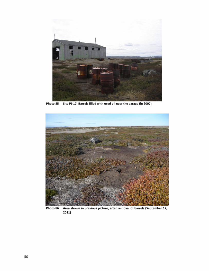
50
Photo 85 Site PJ-17: Barrels filled with used oil near the garage (in 2007)
Photo 86 Area shown in previous picture, after removal of barrels (September 17,
2011)
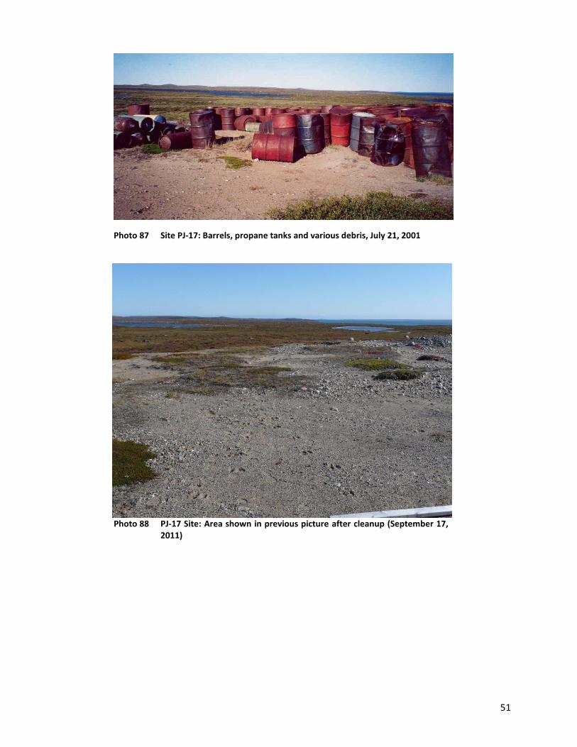
51
Photo 87 Site PJ-17: Barrels, propane tanks and various debris, July 21, 2001
Photo 88 PJ-17 Site: Area shown in previous picture after cleanup (September 17,
2011)
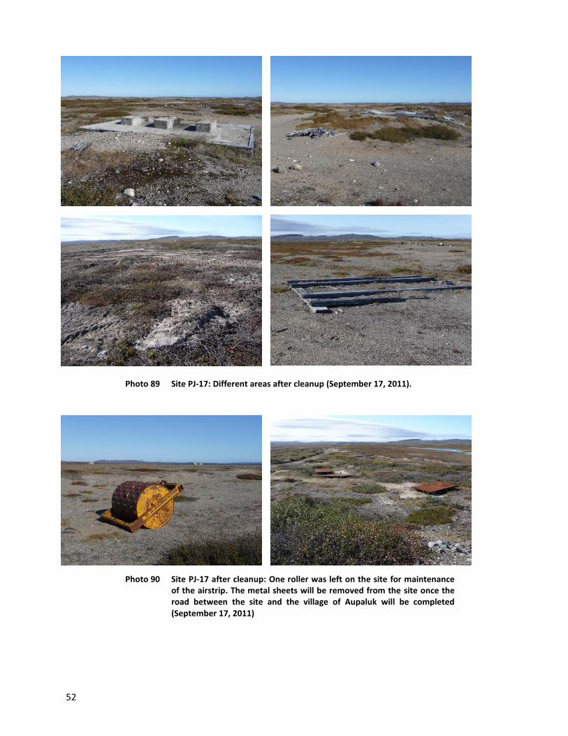
52
Photo 89 Site PJ-17: Different areas after cleanup (September 17, 2011).
Photo 90 Site PJ-17 after cleanup: One roller was left on the site for maintenance of the airstrip. The metal sheets will be removed from the site once the road between the site and the village of Aupaluk will be completed (September 17, 2011)

53
Kangirsuk Sector
TW
Photo 91 Site TW before cleanup work (in 2007)
Photo 92 Overview of site TW after cleanup (September 17, 2011)
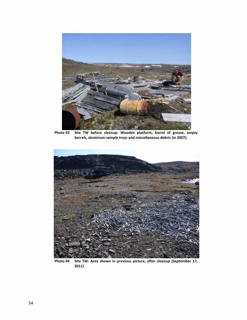
54
Photo 93 Site TW before cleanup: Wooden platform, barrel of grease, empty
barrels, aluminum sample trays and miscellaneous debris (in 2007).
Photo 94 Site TW: Area shown in previous picture, after cleanup (September 17,
2011)

55
Photo 95 Site TW before cleanup: wood platform, barrels, debris, industrial pipes
in 2007
Photo 96 Site TW after cleanup (September 17, 2011)

56
Photo 97 Site TW after cleanup: Top: Core sample trays, tailings; Center: pipes out of the ground; Bottom: Areas free of debris.
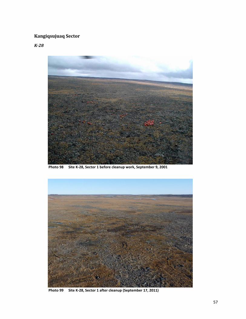
57
Kangiqsujuaq Sector
K-28
Photo 98 Site K-28, Sector 1 before cleanup work, September 9, 2001
Photo 99 Site K-28, Sector 1 after cleanup (September 17, 2011)

58
Photo 100 Site K-28, Sector 2 before cleanup work, September 9, 2001
Photo 101 Site K-28, Sector 2 after cleanup (September 17, 2011)

59
Photo 102 Site K-28, Sector 3: Tripod, drilling equipment, road salt and barrels of
Jet-B, September 9, 2001. The site was being used by Canadian Royalties.
Photo 103 Site K-28: Road and tripod. Active Canadian Royalties site (September 17, 2011)
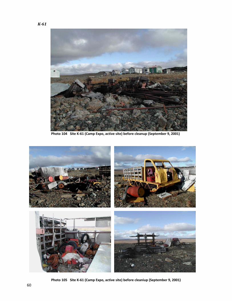
60
K-61
Photo 104 Site K-61 (Camp Expo, active site) before cleanup (September 9, 2001)
Photo 105 Site K-61 (Camp Expo, active site) before cleaniup (September 9, 2001)
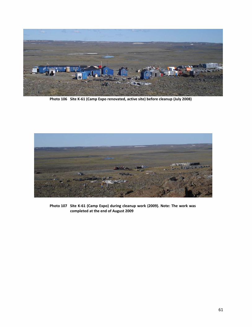
61
Photo 106 Site K-61 (Camp Expo renovated, active site) before cleanup (July 2008)
Photo 107 Site K-61 (Camp Expo) during cleanup work (2009). Note: The work was completed at the end of August 2009

62
WB-3
Photo 108 Partial view of the site WB-3 before cleanup, September 9, 2001
Photo 109 Site WB-3 after the cleanup (September 17, 2011)
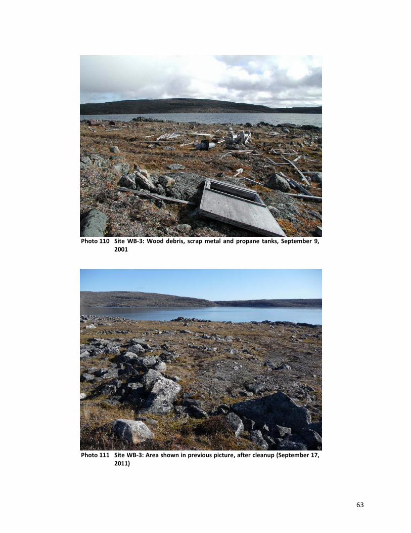
63
Photo 110 Site WB-3: Wood debris, scrap metal and propane tanks, September 9,
2001
Photo 111 Site WB-3: Area shown in previous picture, after cleanup (September 17,
2011)
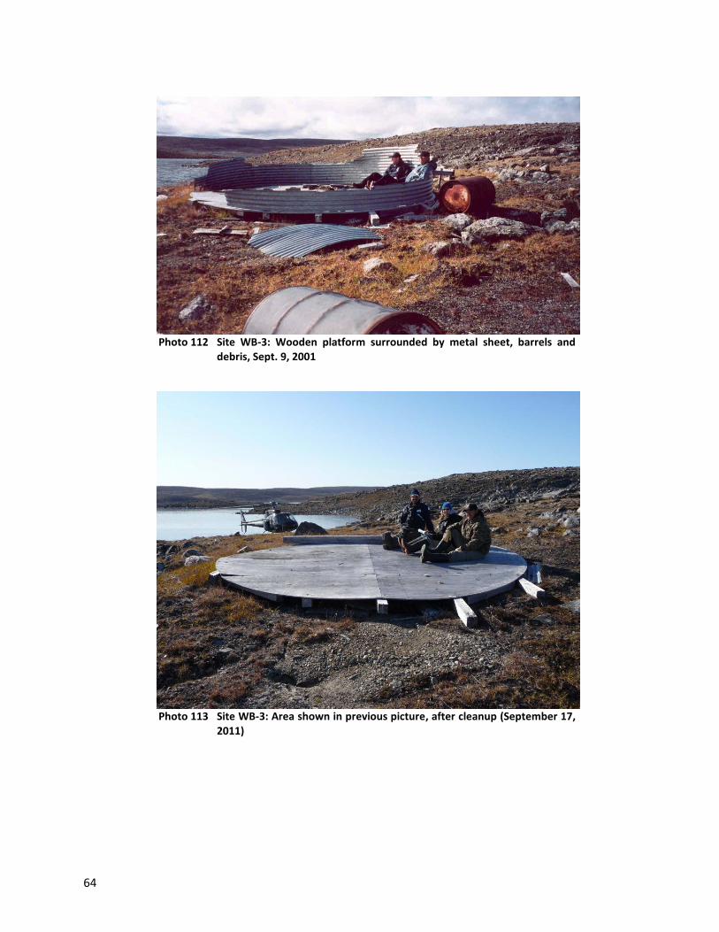
64
Photo 112 Site WB-3: Wooden platform surrounded by metal sheet, barrels and
debris, Sept. 9, 2001
Photo 113 Site WB-3: Area shown in previous picture, after cleanup (September 17,
2011)
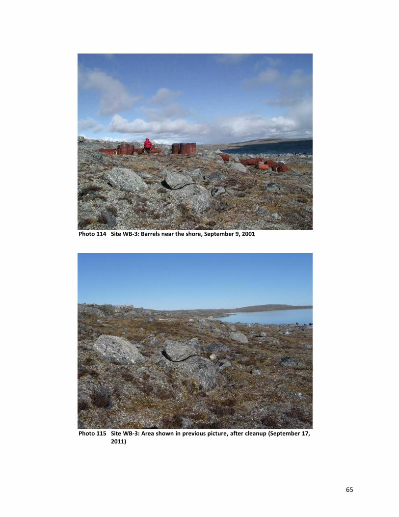
65
Photo 114 Site WB-3: Barrels near the shore, September 9, 2001
Photo 115 Site WB-3: Area shown in previous picture, after cleanup (September 17,
2011)

66
Photo 116 Site WB-3: Barrels, September 9, 2001
Photo 117 Site WB-3: Area shown in previous picture, after cleanup (September 17,
2011)

67
Photo 118 Site WB-3: Some cans (top), metal plate with pipes and metal rod coming out of a rock after cleanup work (September 17, 2011)
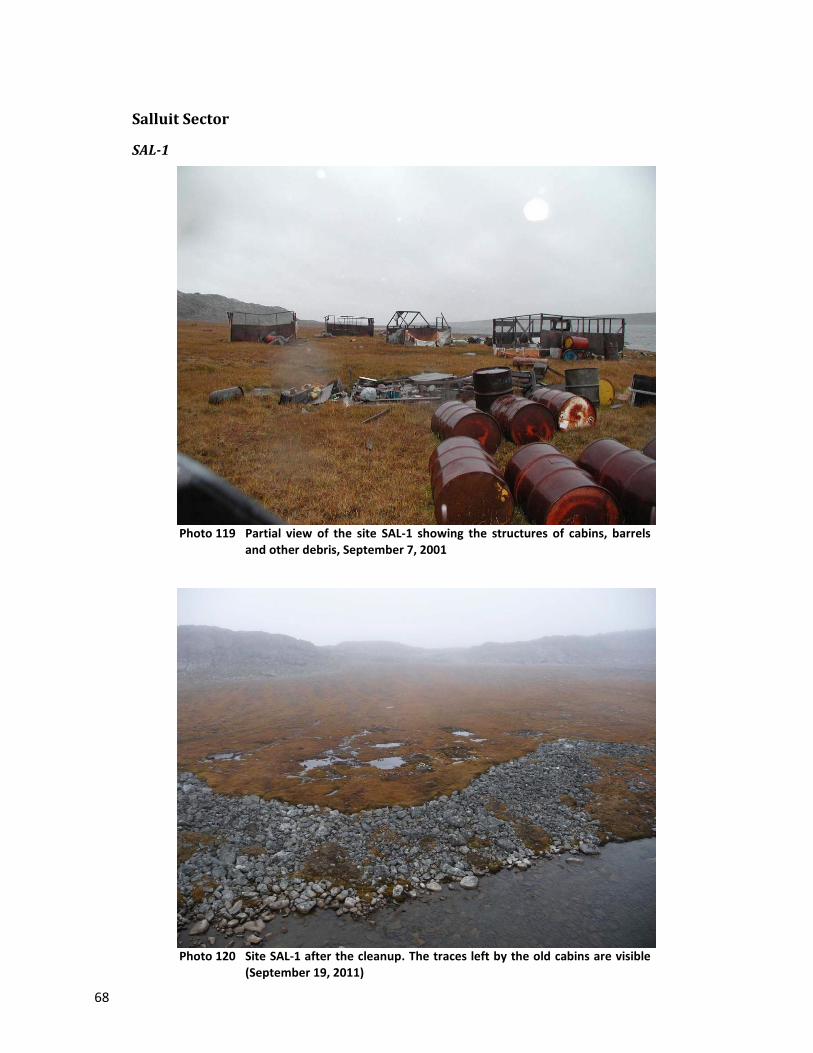
68
Salluit Sector
SAL-1
Photo 119 Partial view of the site SAL-1 showing the structures of cabins, barrels
and other debris, September 7, 2001
Photo 120 Site SAL-1 after the cleanup. The traces left by the old cabins are visible
(September 19, 2011)

69
Photo 121 Site SAL-1: Many barrels, September 7, 2001
Photo 122 Site SAL-1: Area shown in previous picture, after cleanup (September 19,
2011)

70
Photo 123 SAL-1 site: Collapsed cabin, propane tanks, barrels and debris,
September 7, 2001
Photo 124 Site SAL-1: View of area shown in previous photo, after the cleanup
(September 19, 2011)
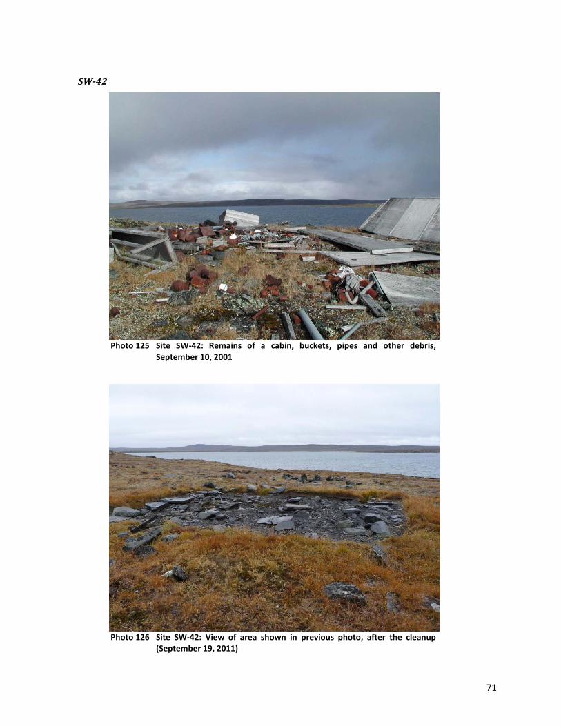
71
SW-42
Photo 125 Site SW-42: Remains of a cabin, buckets, pipes and other debris,
September 10, 2001
Photo 126 Site SW-42: View of area shown in previous photo, after the cleanup
(September 19, 2011)

72
Photo 127 Site SW-42: Group of 81 barrels, 10 September 2001
Photo 128 Site SW-42: Area shown in previous picture, after cleanup
(September 19, 2011)

73
Photo 129 Site SW-42: homemade stove, September 10, 2001
Photo 130 Site SW-42: Stove area shown in previous picture, after cleanup
(September 19, 2011)

74
Photo 131 Site SW-42 after cleanup work (September 19, 2011)
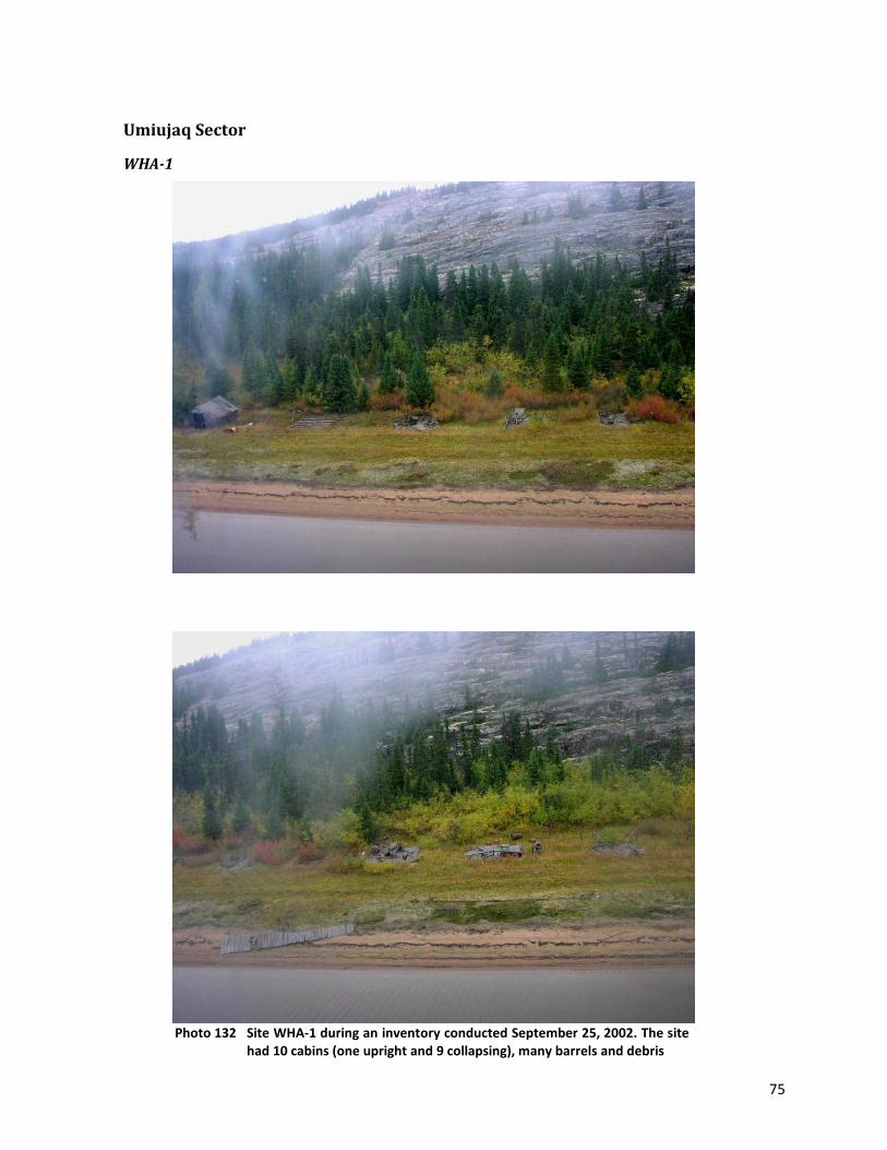
75
Umiujaq Sector
WHA-1
Photo 132 Site WHA-1 during an inventory conducted September 25, 2002. The site
had 10 cabins (one upright and 9 collapsing), many barrels and debris
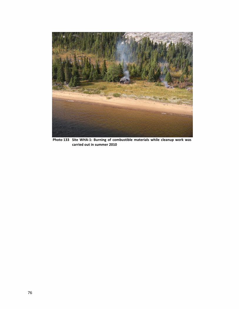
76
Photo 133 Site WHA-1: Burning of combustible materials while cleanup work was
carried out in summer 2010

APPENDIX 5
Photographs of Sites Requiring Intermediate Clean-up Work

2
Kawawachikamach Sector ................................................................................................................ 3
KAW-36 ....................................................................................................................................................3
KAW-59 ....................................................................................................................................................4
KAW-119 ..................................................................................................................................................4
Kuujjuaq Sector................................................................................................................................ 5
P-24F ........................................................................................................................................................5
Tasiujaq Sector ................................................................................................................................ 6
TA-1 .........................................................................................................................................................6
TA-2 and TQ-6 ....................................................................................................................................8
TQ-10 .................................................................................................................................................... 15
TQ-14 .................................................................................................................................................... 17
VP-11 .................................................................................................................................................... 17
Aupaluk Sector .............................................................................................................................. 19
G-24N04-3 ............................................................................................................................................ 19
PJ-17A ................................................................................................................................................... 24
PJ-19 ..................................................................................................................................................... 25
Kangirsuk Sector ............................................................................................................................ 26
QC-3 ...................................................................................................................................................... 26
Kangiqsujuaq Sector ....................................................................................................................... 28
I-32 ........................................................................................................................................................ 28
K-27....................................................................................................................................................... 29
K-37....................................................................................................................................................... 30
K-49....................................................................................................................................................... 30
KAN-1 .................................................................................................................................................... 31
KAN-2 .................................................................................................................................................... 31
KAN-4 .................................................................................................................................................... 32
KAN-6 .................................................................................................................................................... 33
KAN-7 .................................................................................................................................................... 34
KAN-10 .................................................................................................................................................. 34
Salluit Sector .................................................................................................................................. 35
Parent Lake ........................................................................................................................................... 35
SW-24 ................................................................................................................................................... 35
Umiujaq Sector .............................................................................................................................. 36
GW-8 ..................................................................................................................................................... 36
Other sites ..................................................................................................................................... 37

3
Kawawachikamach Sector
KAW-36
Photo 1 General view of site KAW-36 (September 15, 2011)
Photo 2 Close-up view of barrels near the shore, on site KAW-36 (September 15,
2011)

4
KAW-59
Photo 3 Overview of the site KAW-59 (September 15, 2011)
KAW-119
Photo 4 Overview of the site KAW-119 (September 15, 2011)
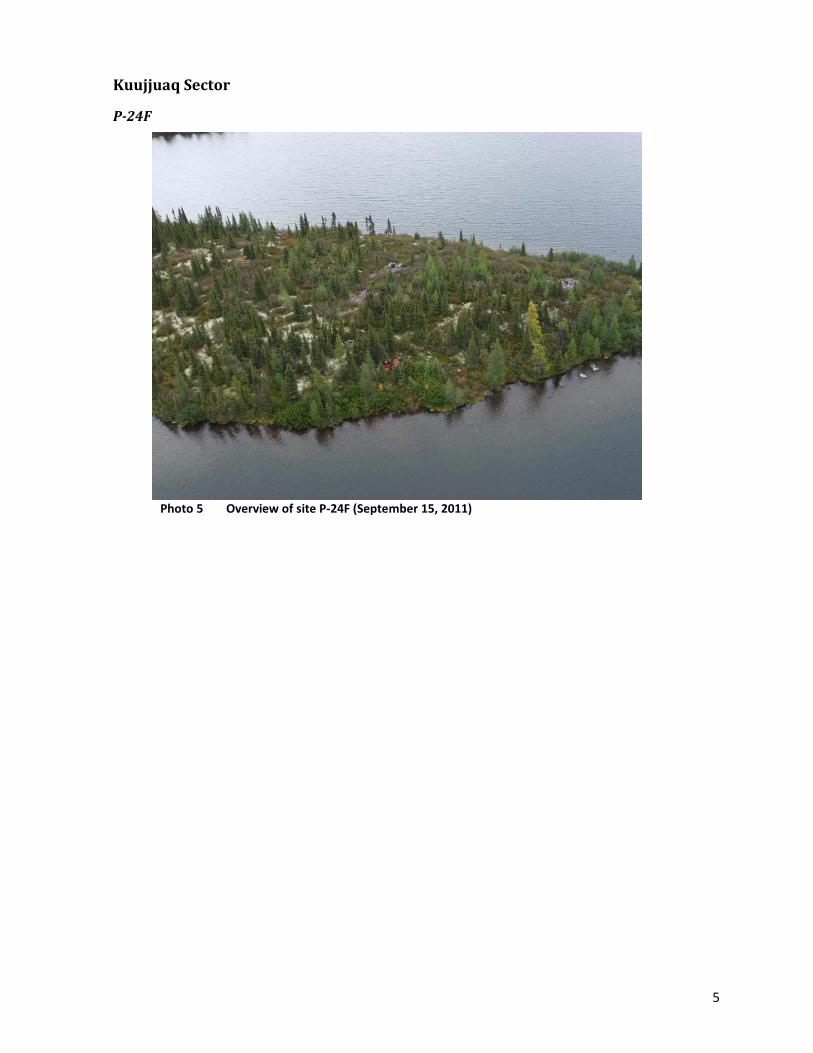
5
Kuujjuaq Sector
P-24F
Photo 5 Overview of site P-24F (September 15, 2011)

6
Tasiujaq Sector
TA-1
Photo 6 Overview of site TA-1 (September 16, 2011)
Photo 7 Close-up view of barrels on the site TA-1 (September 16, 2011)
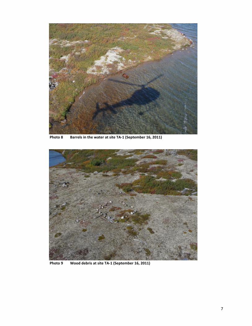
7
Photo 8 Barrels in the water at site TA-1 (September 16, 2011)
Photo 9 Wood debris at site TA-1 (September 16, 2011)

8
Photo 10 Close-up view of wood debris at the site TA-1 (September 16, 2011)
TA-2 and TQ-6 (this is actually one site)
Photo 11 Aerial view of part of site TQ-6 (September 16, 2011)

9
Photo 12 A closer aerial view of the area shown in the background of the previous
picture, site TQ 6
Photo 13 Aerial view of another part of the site TQ-6 (September 16, 2011)

10
Photo 14 Aerial view of another part of the site TQ-6, on a small point
(September 16, 2011)
Photo 15 Metal containers along the shore of site TQ-6 (September 16, 2011)

11
Photo 16 Barrels and scrap metal at site TQ-6 (September 16, 2011)
Photo 17 Barrel and miscellaneous debris at site TQ-6 (September 16, 2011)
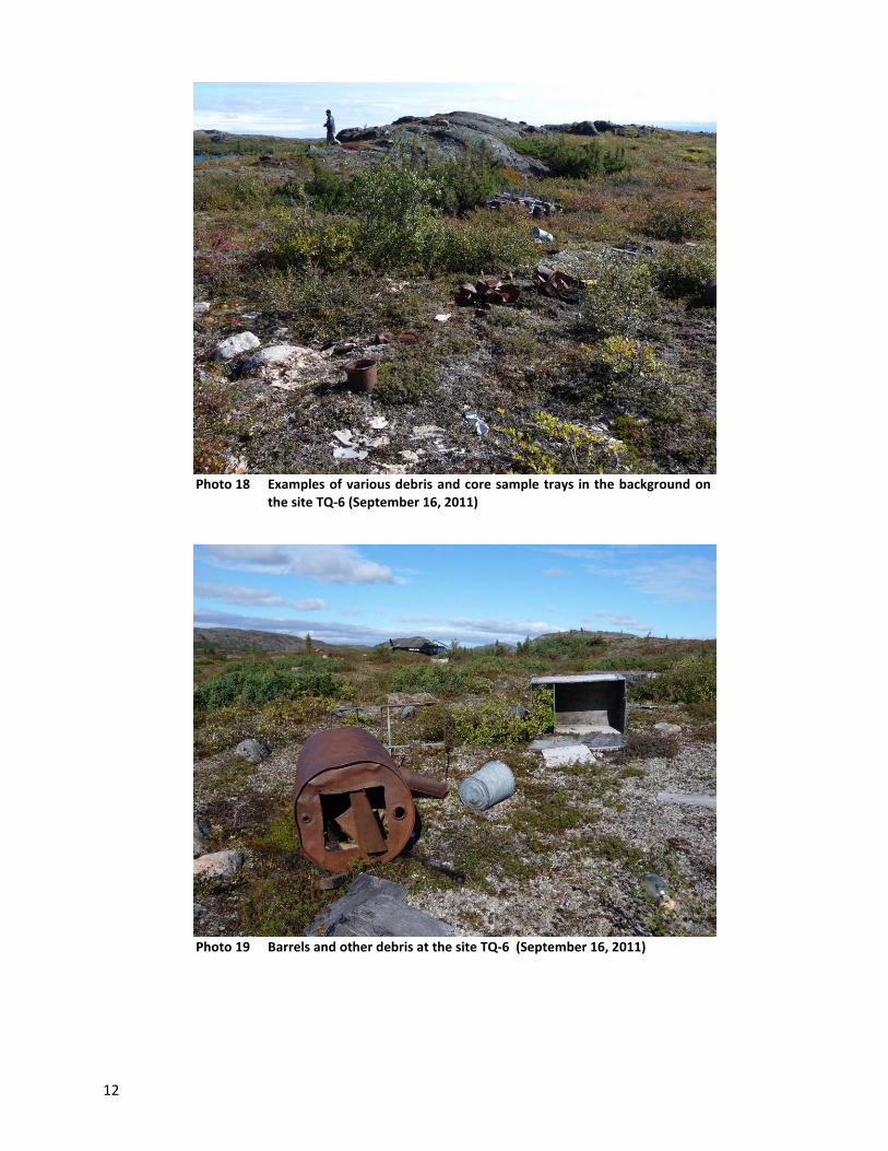
12
Photo 18 Examples of various debris and core sample trays in the background on
the site TQ-6 (September 16, 2011)
Photo 19 Barrels and other debris at the site TQ-6 (September 16, 2011)

13
Photo 20 Sheet metal and other debris at the site TQ-6 (September 16, 2011)
Photo 21 Barrels, pipes and debris (background) at site TQ-6 (September 16, 2011)
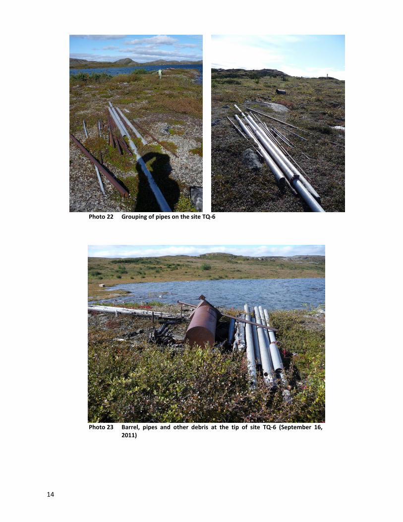
14
Photo 22 Grouping of pipes on the site TQ-6
Photo 23 Barrel, pipes and other debris at the tip of site TQ-6 (September 16,
2011)
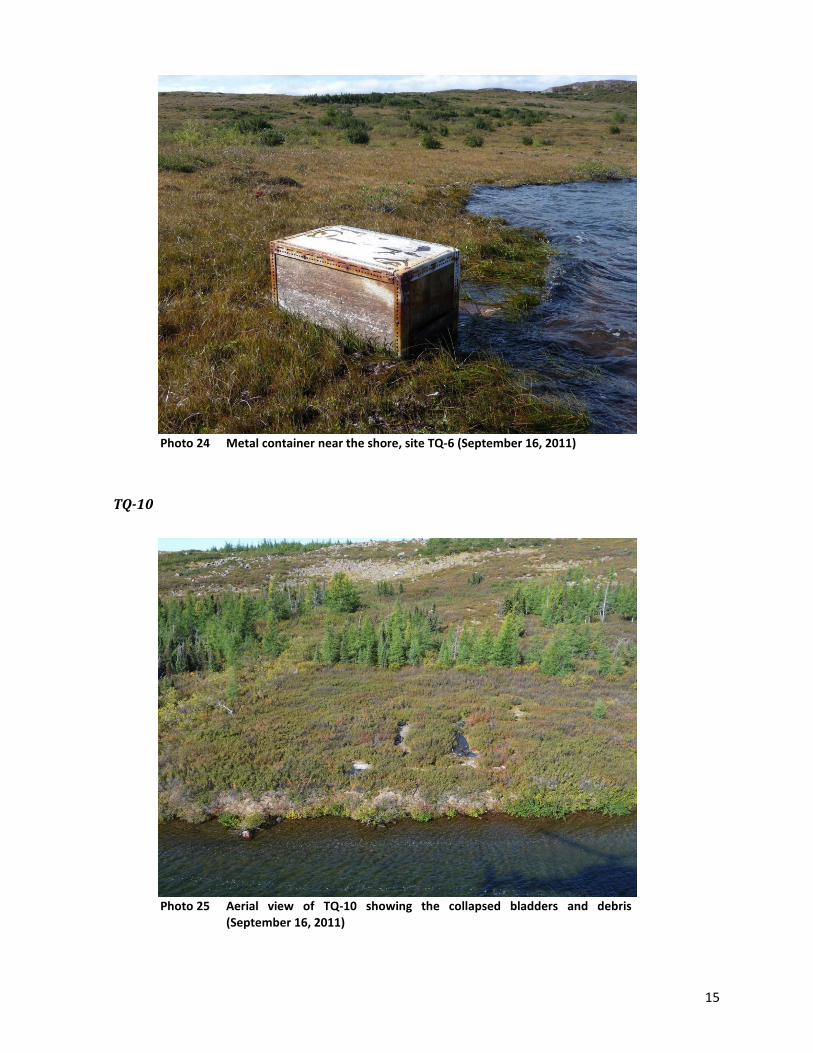
15
Photo 24 Metal container near the shore, site TQ-6 (September 16, 2011)
TQ-10
Photo 25 Aerial view of TQ-10 showing the collapsed bladders and debris
(September 16, 2011)

16
Photo 26 Debris and partial view of a bladder at the site TQ-10 (September 16, 2011)
Photo 27 Hose and some debris on the site TQ-10 (September 16, 2011)
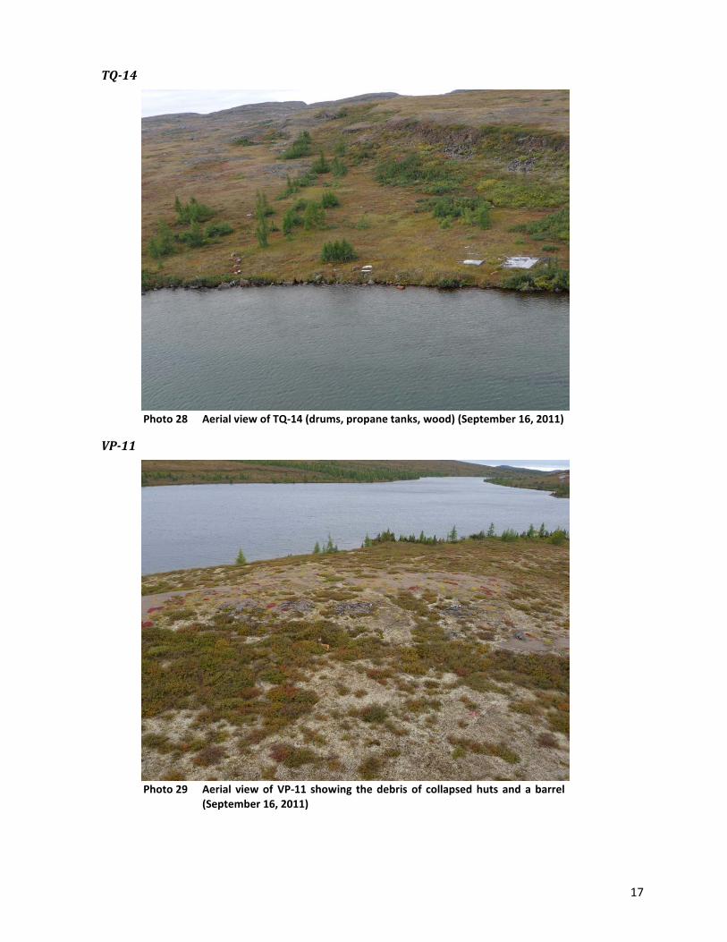
17
TQ-14
Photo 28 Aerial view of TQ-14 (drums, propane tanks, wood) (September 16, 2011)
VP-11
Photo 29 Aerial view of VP-11 showing the debris of collapsed huts and a barrel
(September 16, 2011)
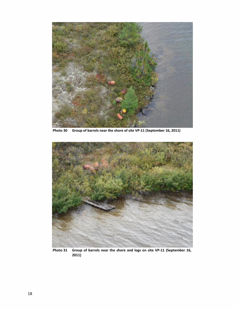
18
Photo 30 Group of barrels near the shore of site VP-11 (September 16, 2011)
Photo 31 Group of barrels near the shore and logs on site VP-11 (September 16,
2011)

19
Aupaluk Sector
G-24N04-3
Photo 32 General view of a portion of the site G-24N04-3 with barrels, propane
tanks and scattered debris (September 17, 2011)
Photo 33 General view of a portion of the site G-24N04-3 with barrels, propane
tanks and scattered debris (September 17, 2011)
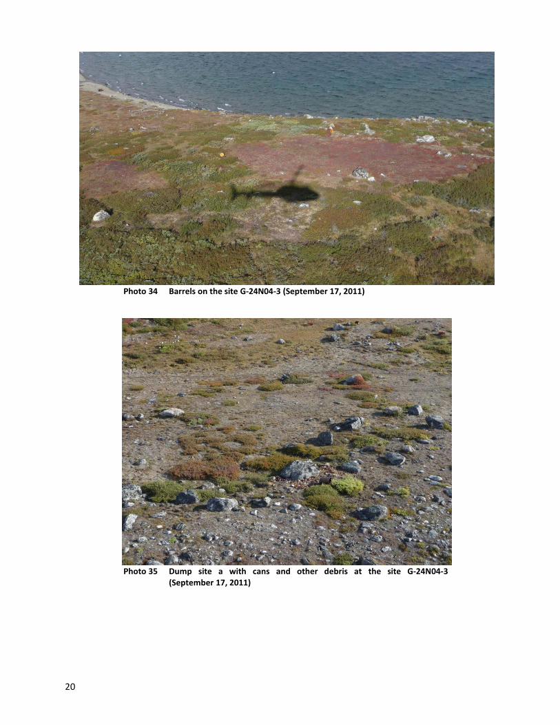
20
Photo 34 Barrels on the site G-24N04-3 (September 17, 2011)
Photo 35 Dump site a with cans and other debris at the site G-24N04-3
(September 17, 2011)

21
Photo 36 Barrels along the shore at the site G-24N04-3 (September 17, 2011)
Photo 37 Group of barrels near the shore at site G-24N04-3 (September 17, 2011)

22
Photo 38 Group of barrels near the shore at site G-24N04-3 (September 17, 2011)
Photo 39 Barrels near shore at site G-24N04-3 (September 17, 2011)

23
Photo 40 Overview of barrels near shore on site G-24N04-3 (September 17, 2011)
Photo 41 Close-up view of barrels near the shore at the site G-24N04-3
(September 17, 2011)
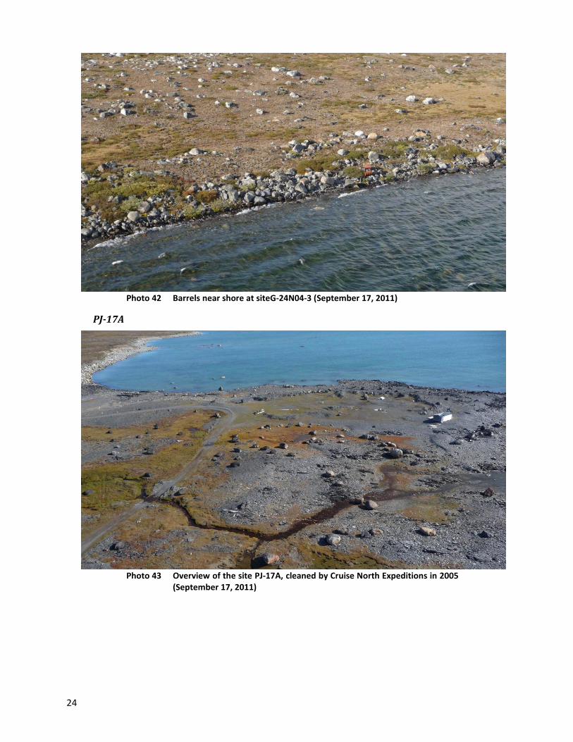
24
Photo 42 Barrels near shore at siteG-24N04-3 (September 17, 2011)
PJ-17A
Photo 43 Overview of the site PJ-17A, cleaned by Cruise North Expeditions in 2005
(September 17, 2011)
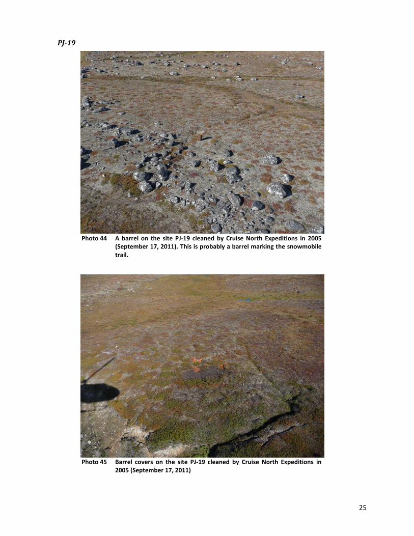
25
PJ-19
Photo 44 A barrel on the site PJ-19 cleaned by Cruise North Expeditions in 2005
(September 17, 2011). This is probably a barrel marking the snowmobile trail.
Photo 45 Barrel covers on the site PJ-19 cleaned by Cruise North Expeditions in
2005 (September 17, 2011)
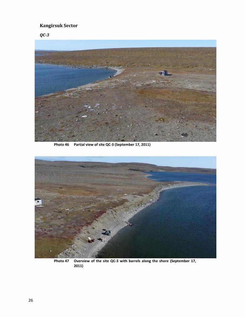
26
Kangirsuk Sector
QC-3
Photo 46 Partial view of site QC-3 (September 17, 2011)
Photo 47 Overview of the site QC-3 with barrels along the shore (September 17,
2011)
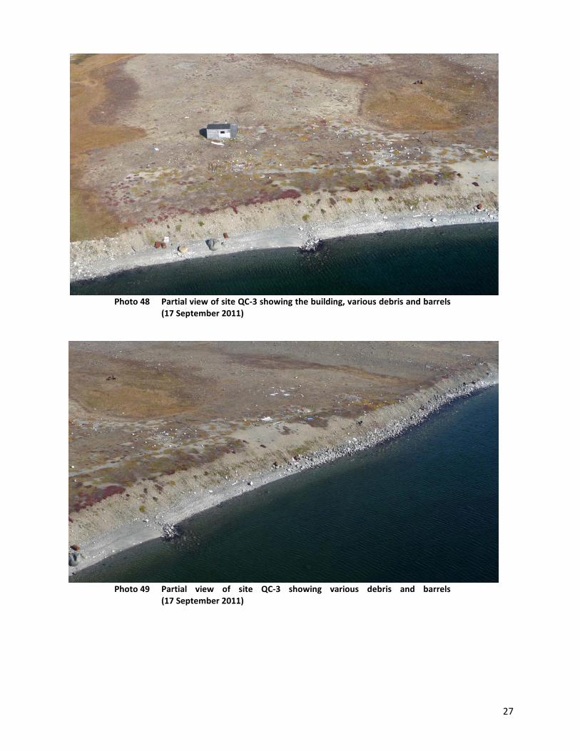
27
Photo 48 Partial view of site QC-3 showing the building, various debris and barrels
(17 September 2011)
Photo 49 Partial view of site QC-3 showing various debris and barrels
(17 September 2011)

28
Photo 50 QC-3 site, several barrels are very close to shore as shown in this photo.
(September 17, 2011)
Kangiqsujuaq Sector
I-32
Photo 51 The site I-32 after cleanup work done by Canadian Royalties
(September 17, 2011)

29
Photo 52 The site I-32 after cleanup work done by Canadian Royalties
(September 17, 2011)
K-27
Photo 53 The site K-27 after cleanup work done by Canadian Royalties
(September 17, 2011)

30
K-37
Photo 54 Site K-37 after cleanup work done by Canadian Royalties (September 17,
2011)
K-49
Photo 55 Site K-49 after cleanup work done by Canadian Royalties (September 17,
2011)
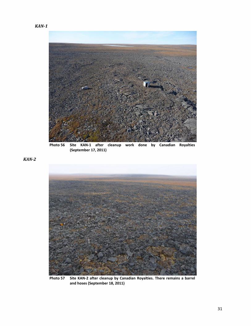
31
KAN-1
Photo 56 Site KAN-1 after cleanup work done by Canadian Royalties
(September 17, 2011)
KAN-2
Photo 57 Site KAN-2 after cleanup by Canadian Royalties. There remains a barrel
and hoses (September 18, 2011)

32
Photo 58 Site KAN-2 after cleanup by Canadian Royalties. There are some wooden
boards remaining (September 18, 2011)
KAN-4
Photo 59 Site KAN-4 after cleanup by Canadian Royalties There remains only the
imprint left by the group of 75 barrels (September 18, 2011)

33
KAN-6
Photo 60 It was confirmed that the site KAN-6 is an Inuit camp (September 18,
2011)
Photo 61 Close-up view of a building on site KAN-6 (September 18, 2011)

34
KAN-7
Photo 62 Site KAN-7 after cleanup by Canadian Royalties. There remains only the
muskeg and you can see the imprint left by the former group of 75 barrels (September 18, 2011)
KAN-10
Photo 63 Site KAN-10 after the first phase of cleanup work by Canadian Royalties.
Propane tanks, barrels and debris have been piled up to be recovered (September 18, 2011)

35
Salluit Sector
Parent Lake
Photo 64 Barrels and debris at Parent Lake (September 19, 2011)
Photo 65 One of the barrels at Parent Lake (September 19, 2011)
SW-24
No photos available for this "site", which is extensively located along the Puvirnituq River.
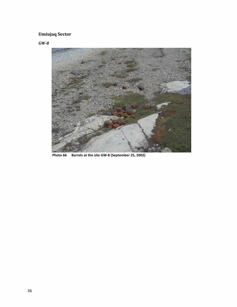
36
Umiujaq Sector
GW-8
Photo 66 Barrels at the site GW-8 (September 25, 2002)
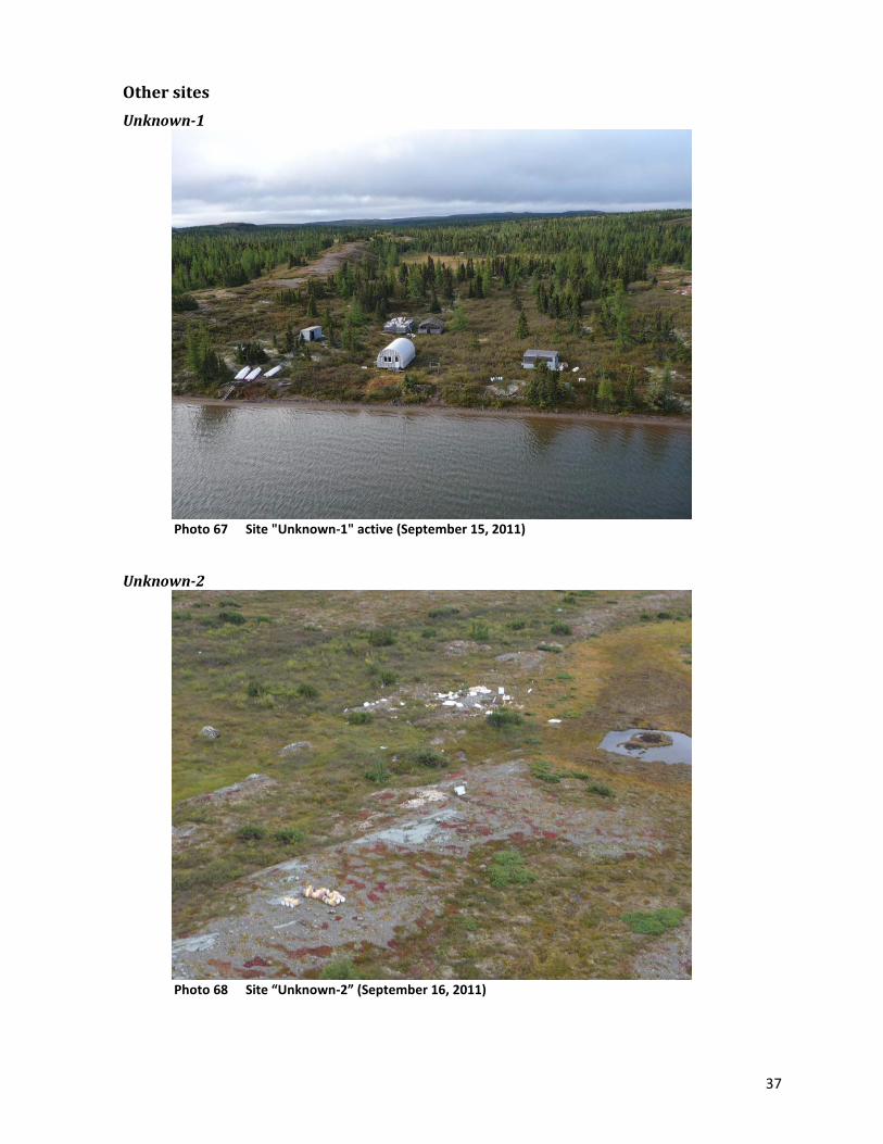
37
Other sites
Unknown-1
Photo 67 Site "Unknown-1" active (September 15, 2011)
Unknown-2
Photo 68 Site “Unknown-2” (September 16, 2011)

38
Photo 69 Another angle of site “Unknown-2” (September 16, 2011)
Unknown-3
Photo 70 One of seven barrels observed at site "Unknown-3", near KAN-1
(September 17, 2011)
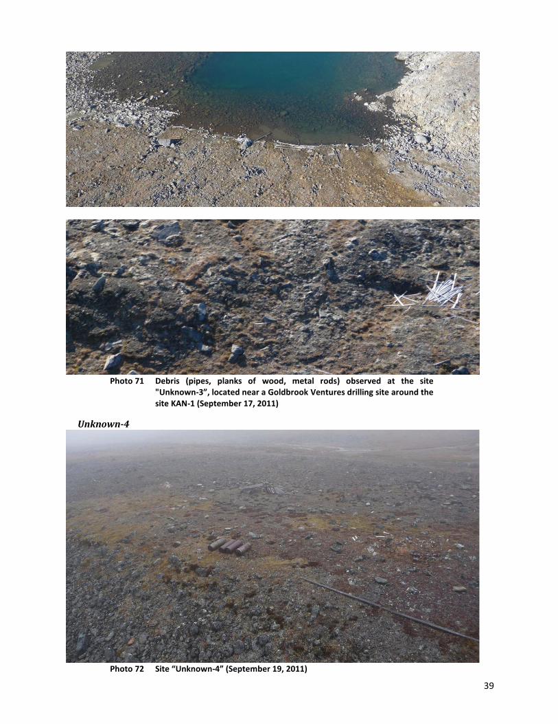
39
Photo 71 Debris (pipes, planks of wood, metal rods) observed at the site
"Unknown-3”, located near a Goldbrook Ventures drilling site around the site KAN-1 (September 17, 2011)
Unknown-4
Photo 72 Site “Unknown-4” (September 19, 2011)


APPENDIX 6
Photographs of the Remaining Sites
Requiring Major Clean-up Work
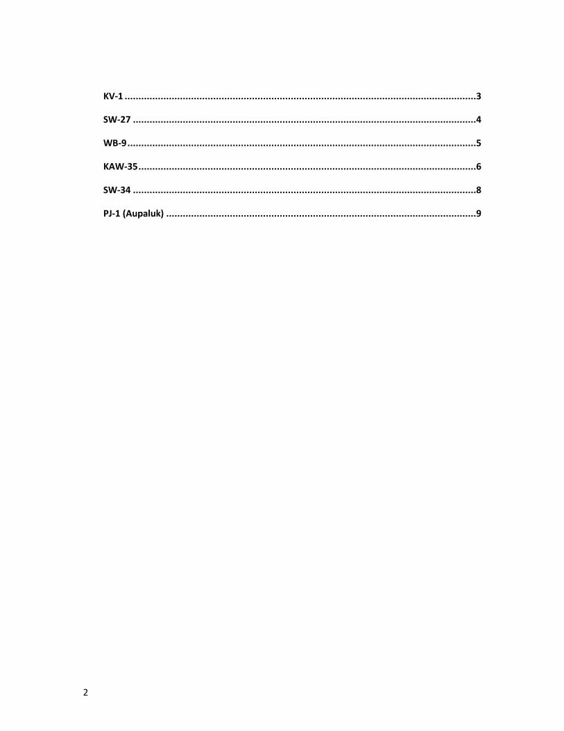
2
KV-1 ...............................................................................................................................3
SW-27 ............................................................................................................................4
WB-9 ..............................................................................................................................5
KAW-35 ..........................................................................................................................6
SW-34 ............................................................................................................................8
PJ-1 (Aupaluk) ................................................................................................................9
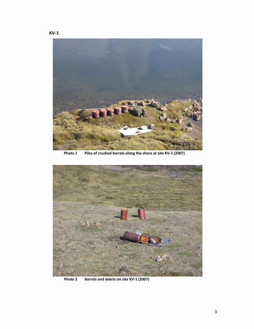
3
KV-1
Photo 1 Piles of crushed barrels along the shore at site KV-1 (2007)
Photo 2 Barrels and debris on site KV-1 (2007)
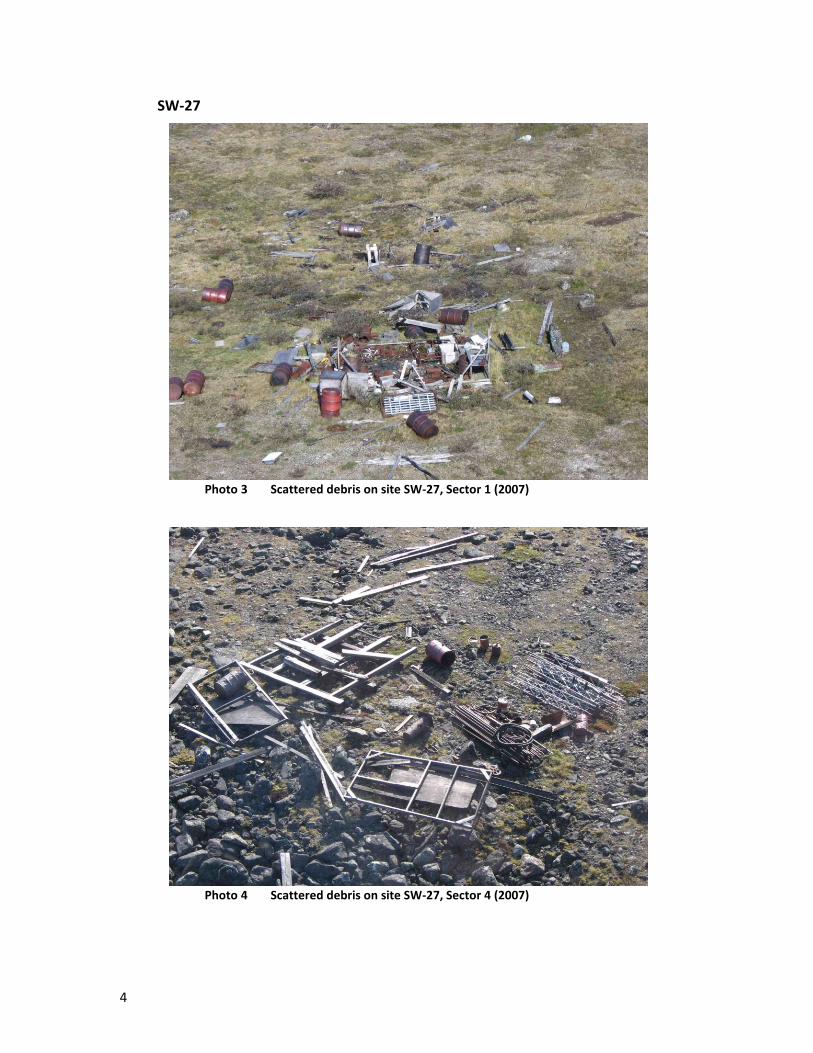
4
SW-27
Photo 3 Scattered debris on site SW-27, Sector 1 (2007)
Photo 4 Scattered debris on site SW-27, Sector 4 (2007)
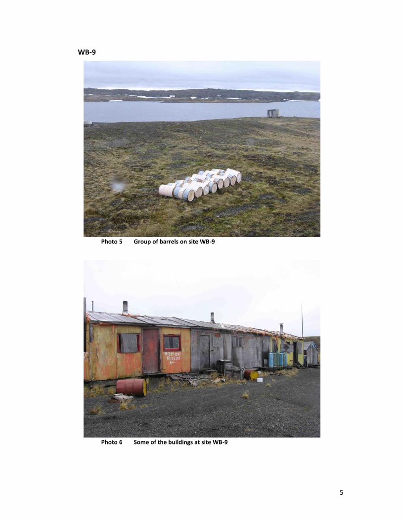
5
WB-9
Photo 5 Group of barrels on site WB-9
Photo 6 Some of the buildings at site WB-9

6
KAW-35
Photo 7 Pile of metal and debris on site KAW-35
Photo 8 One of 5 reservoirs remaining on site KAW-35
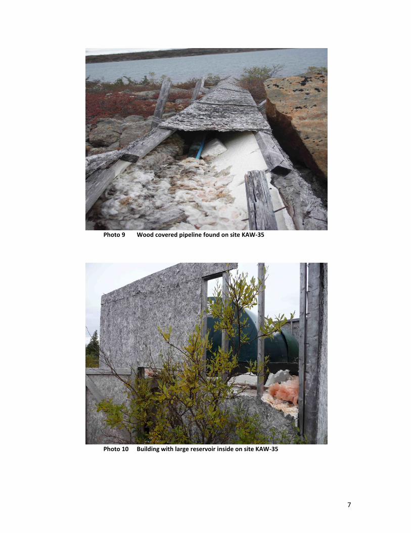
7
Photo 9 Wood covered pipeline found on site KAW-35
Photo 10 Building with large reservoir inside on site KAW-35

8
SW-34
Photo 11 One of the piles of debris remaining at site SW-34
Photo 12 Small dumpsite remaining at site SW-34

9
PJ-1 (Aupaluk)
Photo 13 Barrels and pipes being stored at Aupaluk’s dumpsite
Photo 14 Rolls of metal wire being stored in Aupaluk

10
Photo 15 1 of 10 reservoir halves filled with scrap metal and being
stored in Aupaluk
Photo 16 Piece of heavy equipment remaining in Aupaluk


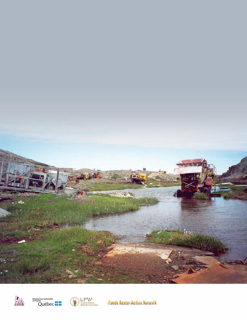
Ressources naturelleset Faune