adaptation pathways - british columbia...integrated management of the natural resources from land,...
TRANSCRIPT


Adaptation Pathways
The adaptation pathways approach was made prominent in 2005 by Deltares and others in the Netherlands, to prepare for sea level rise and manage flood risk. Since then, adaptation pathways have been tested in decision making where uncertainty is high, such as for wildfires, healthcare and natural systems management. Researchers and users are working to develop a standard for adaptation pathways to be internationally recognised, such as through BSI (British Standards Institution). This framework draws substantially on Australian research, development and application of the pathways approach, especially related to Natural Resource Management (NRM). In Australia, NRM is the integrated management of the natural resources from land, water and biodiversity assets, including through agriculture, mining and tourism (1). Projects in two regions were instrumental in developing the Climate Change Adaptation Pathways Framework and User Guide. They are the Southern Slopes Climate Change Adaptation Research Partnership (SCARP) (2) and the Climate Change Adaptation for Natural Resource Management in East Coast Australia project (3). Additional content and formatting was adapted from the Australian publication A User’s Guide to Applied Adaptation Pathways (4).
Disclaimer
Opinions expressed in this document are those of the author and not necessarily those of the B.C. Ministry of Agriculture. The B.C. Ministry of Agriculture, and its directors, agents, employees, or contractors will not be liable for any claims, damages, or losses of any kind whatsoever arising out of the use of, or reliance upon, this information. This framework does not provide advice of an investment or commercial valuation nature. No liability is accepted for investment decisions made on the basis of information provided in this framework document.
About the author
As the 2018-19 Mitacs Science Policy Fellow with the Ministry of Agriculture, Dr. Liese Coulter developed a synthesis of literature supporting adaptation pathways, featuring resources that are relevant to support agricultural adaptation in British Columbia. Liese had extensive experience working with national adaptation research institutions in Australia prior to completing a PhD at Griffith University in Brisbane. She was an editor for the book Communicating Climate Change Information for Decision-Making, which focused on how climate change knowledge is being developed, communicated and applied.
Please cite this report as: Coulter, L. (2019). Climate Change Adaptation Pathways Framework: Supporting Sustainable Local Food in B.C. Prepared for the B.C. Ministry of Agriculture through the 2018-19 Mitacs Science Policy Fellowship. Victoria.
Cover photo: Google Earth, 2019. V1-SEPT-2019

i
Executive Summary
This Climate Change Adaptation Pathways Framework, User Guide and Hypothetical Initiative were developed to help policy makers, communities and agricultural producers to develop shared climate preparedness goals and objectives with a focus on sustainable local food. This document provides background on climate change adaptation in B.C. communities and agriculture where the Adaptation Pathways approach can address key areas of decision-making; sets out the framework to develop an adaptation pathway process that considers agriculture in community planning; and finishes by discussing existing resources to guide the climate preparedness process. Reference material is listed at the end of the document. An illustrative hypothetical application of the adaptation pathways approach is included as an appendix. Producing food locally is one measure of adaptive capacity for a community, and producers have important roles to play within their regions. At the same time, changing water resources and new land use patterns will require negotiation between community sectors to ensure equitable and effective adaptation investment. As demonstrated in the Framework, the pathways approach has already proven useful to manage complex natural and social systems facing uncertain future changes, and where contested decision-making and ambiguous goals make cooperation a challenge.
Adaptation pathways
Adaptation pathways work at many scales, focused on collective actions to manage climate change over time. Pathways can be developed by communities focused on a place such as a town or region, communities which share practices such as farming or fishing, and communities connected through shared beliefs, culture and traditions. Adaptation pathways use a participatory and inclusive engagement approach that helps communities address future goals one step at a time.
An adaptation pathway is a sequence of adaptation options and decision points, laid out over time, to address impacts from climate change in one or more key areas of decision-making. As shown in Figure ES-1, adaptation pathways go through a repeated, five stage cycle:
1. Define objectives and goals2. Analyse the current situation3. Analyse potential futures4. Develop pathways5. Implement, monitor and learn
Figure ES-1. Five stage approach to adaptation pathways planning, adapted from Serrao-Neumann, 2015.
ii
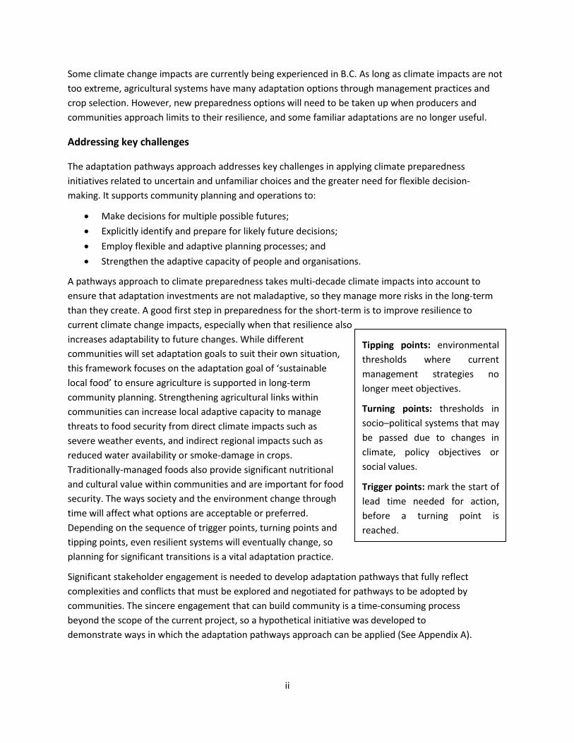
Some climate change impacts are currently being experienced in B.C. As long as climate impacts are not too extreme, agricultural systems have many adaptation options through management practices and crop selection. However, new preparedness options will need to be taken up when producers and communities approach limits to their resilience, and some familiar adaptations are no longer useful.
Addressing key challenges
The adaptation pathways approach addresses key challenges in applying climate preparedness initiatives related to uncertain and unfamiliar choices and the greater need for flexible decision-making. It supports community planning and operations to:
• Make decisions for multiple possible futures;• Explicitly identify and prepare for likely future decisions;• Employ flexible and adaptive planning processes; and• Strengthen the adaptive capacity of people and organisations.
A pathways approach to climate preparedness takes multi-decade climate impacts into account to ensure that adaptation investments are not maladaptive, so they manage more risks in the long-term than they create. A good first step in preparedness for the short-term is to improve resilience to current climate change impacts, especially when that resilience also increases adaptability to future changes. While different communities will set adaptation goals to suit their own situation, this framework focuses on the adaptation goal of ‘sustainable local food’ to ensure agriculture is supported in long-term community planning. Strengthening agricultural links within communities can increase local adaptive capacity to manage threats to food security from direct climate impacts such as severe weather events, and indirect regional impacts such as reduced water availability or smoke-damage in crops. Traditionally-managed foods also provide significant nutritional and cultural value within communities and are important for food security. The ways society and the environment change through time will affect what options are acceptable or preferred. Depending on the sequence of trigger points, turning points and tipping points, even resilient systems will eventually change, so planning for significant transitions is a vital adaptation practice.
Significant stakeholder engagement is needed to develop adaptation pathways that fully reflect complexities and conflicts that must be explored and negotiated for pathways to be adopted by communities. The sincere engagement that can build community is a time-consuming process beyond the scope of the current project, so a hypothetical initiative was developed to demonstrate ways in which the adaptation pathways approach can be applied (See Appendix A).
Tipping points: environmental thresholds where current management strategies no longer meet objectives.
Turning points: thresholds in socio–political systems that may be passed due to changes in climate, policy objectives or social values.
Trigger points: mark the start of lead time needed for action, before a turning point is reached.

iii
Uncertainty
Many environmental and social changes will involve complex interactions, so planning even the first steps for climate preparedness may be daunting. Considering a range of possible futures adds to a sense of uncertainty that can make people hesitate to act. When situations are both complex and uncertain, adaptation planning requires imagination as well as credible information sources. Communities will need to work together to decide priorities, setting climate preparedness goals such as well-managed water resources, adequate emergency response capabilities and sustainable local food production.
It is challenging to know in advance when adaptation limits are approaching and what new options will be acceptable to the community. Some adaptation actions require significant lead time, such as relocating essential services to higher ground to account for flooding. Ongoing adaptation will require continuing community participation to set agreed objectives and goals, and a stepwise approach that identifies adaptation triggers and sequences decisions over time. Many communities will have a good base to inform the pathways cycle and will need to renew their planning horizons over decades while decisions are implemented, social and environmental changes are monitored, and the lessons learned are applied to inform the next round of decisions to manage climate change impacts.
Preparation, planning and practice
When followed as a complete cycle to address a single adaptation goal, the five basic stages for developing adaptation pathways shown in Figure ES-2 can be grouped into three phases: Preparation, Planning and Practice.
Figure ES-2. Adaptation pathways development in four frames of reference: Computation, Judgement, Bargaining, and Inspiration, adapted from Bosomworth, 2015.

iv
How the adaptation pathways approach is applied depends on specific adaptation needs and the people and organisations involved in planning, such as local and First Nations governments, professional associations and engaged groups and leaders. The pathways approach can be used to extend an adaptation process already underway or to develop a new sequence of adaptation actions initiated through a community engagement process. Five fundamental steps guide pathways development.
1. Define objectives: The pathway will be shaped by understanding the why, what and how of acommunity’s response to climate change impacts. Set a vision for the future by making it clear why time,attention and resources will be dedicated to an adaptation pathway over many years. Define goals ofwhat will be accomplished by agreeing on future-focused intentions and purposes. Set objectives thatdrive how goals will be reached and are measurable and realistic, considering expected climate change.
2. Analyse the current situation: How issues are managed will depend on a combination of informationcertainty and community values. Different approaches can be selected to manage issues depending onhow much confidence and certainty there is around the information, compared to how muchcommunity agreement there is around goals. Data can come from scientific and technical sources, andfrom cultural and local knowledge. Incorporating local and traditional knowledge and values in plans willreflect the local character and address key areas of decision-making.
3. Assess possible futures: Considering a range of futures is useful to account for uncertainties andinclude new knowledge as it becomes available. Navigating multiple futures is a fundamental strength ofthe pathways approach to sequence decision points and recognise when adaptation options will nolonger be effective. Choose tools and methods to describe potential futures based on top priorities forthe adaptation pathway. The resulting scenarios can guide what possible futures are explored and howtheir implications are analysed.
4. Develop Pathways: Use participatory techniques to support open discussions about the valuejudgements that are implicit in planning issues and to explicitly address differing perspectives. By havingstakeholders participate in the process of deciding what futures are considered, plans begin to gainagreement from the outset through experimentation, learning and building shared meaning.
Steps that make an adaptation pathway
A) Address existing drivers of vulnerabilities
B) Bookmark decision points
C) Consider alternative actions
D) Develop plausible timelines
E) Evaluate and refine pathways
F) Finalise and visualise pathways
5. Implement, monitor and learn: When applied over time, a pathway will naturally encounter barriers from climate impacts, social change, economic challenges and crises in community support. Considering the goal of sustainable local food, triggers to monitor will include severe weather events, unseasonable temperature and rainfall patterns, and land use changes. Because implementation of climate preparedness strategies affects all levels of government and communities, the pathway planning will

v
need to clearly identify, allocate and coordinate roles and responsibilities for effective action. To illustrate the application of adaptation pathways, a hypothetical example was developed for B.C. where low river flows on the fictional Salish River affected sustainable local food production in the imagined Hulkami Valley.
Climate preparedness requires increased flexibility to enable social learning, innovation, experimentation, re-evaluation and planning for multiple scenarios. Adaptation also requires collaboration between community members so that planning reflects many voices and sectors, including agriculture. By working together to understand the implications of climate change for their region, communities can develop pathways of adaptation actions that build their capacity over time.

vi
Contents
Executive Summary ........................................................................................................................................ i
Contents ....................................................................................................................................................... vi
Glossary ...................................................................................................................................................... viii
Acronyms ...................................................................................................................................................... x
1 Introduction to Adaptation Pathways .................................................................................................. 1
1.1 Resilience and beyond .................................................................................................................. 3
1.2 Agricultural climate preparedness................................................................................................ 5
1.3 Applying new knowledge to adapt ............................................................................................... 6
1.4 The capacity to adapt .................................................................................................................... 7
1.5 Managing conflict through values, rules and knowledge ............................................................. 8
2 Adaptation Pathways: Preparation, Planning and Practice ................................................................ 10
2.1 Preparation: Define objectives ................................................................................................... 11
2.1.1 Vision, goals and objectives ................................................................................................ 11
2.1.2 Climate-ready objectives .................................................................................................... 12
2.2 Preparation: Analyse current situation ....................................................................................... 12
2.2.1 Knowledge platform............................................................................................................ 13
2.2.2 Issue types ........................................................................................................................... 13
2.3 Planning: Analyse potential futures ............................................................................................ 15
2.3.1 Climate Information ............................................................................................................ 16
2.3.2 A range of futures ............................................................................................................... 16
2.4 Planning: Develop Pathways ....................................................................................................... 17
2.4.1 Steps that make a pathway ................................................................................................. 19
2.5 Practice: Implement, monitor and learn ..................................................................................... 22
3 Guiding Adaptation Pathways ............................................................................................................. 25
3.1 Indicators guide adaptation pathways ....................................................................................... 25
3.2 Policies, programs and strategies guide adaptation pathways .................................................. 25
3.3 Stakeholders guide adaptation pathways ................................................................................... 27
Appendix A: Hypothetical Watershed Adaptation Pathways Project ............................................................ I

vii
Appendix B: BC Agriculture & Food Climate Action Initiative (CAI) ............................................................ XX
Appendix C: Adaptation Pathway Indicators ........................................................................................... XXIV
References ............................................................................................................................................... XXVI
Figures
Figure 1. Schematic illustrating the progress of current options over time, reflecting changes in decision and consequence pathways as the climate changes. ................................................................................... 2
Figure 2. Five stage approach to adaptation pathways planning, adapted from Serrao-Neumann, 2015 (3). ................................................................................................................................................................. 4
Figure 3. Learning loops: dynamics of single-, double-, and triple-loop learning and applications to flood management, adapted from Intergovernmental Panel on Climate Change (IPCC), 2012 (47). ................... 6
Figure 4. Adaptation pathways development through preparation, planning and practice in four frames of reference: Computation, Judgement, Bargaining, and Inspiration, adapted from Bosomworth, 2015 (46). ............................................................................................................................................................. 10
Figure 5. Adaptation pathways scenario map illustrated using the Deltares Generator software, adapted from Walker, 2013 (64). .............................................................................................................................. 22
Tables
Table 1. Five capitals framework, adapted from Ellis, 1999 (49). ................................................................. 7
Table 2. Governance principles to manage decisions informing adaptation pathways in communities, adapted from Gorddard, 2016 (52). ............................................................................................................. 8
Table 3. Issue types considering certainty and level of agreement on values and goals, adapted from Bosomworth, 2015 (46). ............................................................................................................................. 14
Table 4. Pathway examples and issues approach considering scientific certainty and level of community agreement on values and goals, adapted from Bosomworth, 2015 (56). .................................................. 18
Table 5. Steps to develop a monitoring system to indicate response triggers for adaptation pathways, after Haasnoot, 2018 (23) ........................................................................................................................... 22

viii
Glossary
Adapted from Siebentritt, 2016 (4)
Adaptation pathway: A sequence of adaptation options and decision points, laid out over time, to address impacts from climate change in one or more key areas of decision-making.
Adaptation pathways map: The graphical representation of adaptation pathways.
Adaptation option: A response that reduces climate change impacts or increases adaptive capacity. Adaptation measures and options can be used differently, where a ‘measure’ refers a specific action to reduce impacts or increase adaptive capacity, whereas an ‘option’ is a mix of measures.
Agricultural Land Use Inventories (ALUI) collect consistent, credible, and comprehensive data about B.C.’s agricultural land use, including crop type, irrigation, livestock, and land use and non-farm uses inthe Agricultural Land Reserve (ALR), a provincial zone that prioritises agriculture.
Applied adaptation pathways: Developing adaptation pathways that have been shown in practice to be useful in creating an action-oriented outcome, and which help decision makers develop and visualise actions needed now compared to in the future.
Bargaining: An issues management approach most useful when uncertainty of systems and assets is limited, and goals are not agreed, so that trade-offs are negotiated by actors with differing needs.
Climate Preparedness: The knowledge and capacities to effectively anticipate, respond to and recover from the impacts of likely, imminent or current climate change impacts.
Computation: An issues management approach most useful when uncertainty of systems and assets is limited, and goals are agreed so that familiar business analysis tools can be useful for decision-makers.
Decision point: A point in time where progress needs to be reviewed and a choice made between alternate response options. Decision points often occur prior to a use-by-date or threshold.
Food security: Reliable access to enough affordable, nutritious food to maintain health and well-being.
Goals: These are future-focused broad aims and aspirations, outlining intentions and purpose as to what is desirable.
Inspiration: An issues management approach most useful when uncertainty of systems and assets is high, and goals are not agreed, so that innovative and unfamiliar options have to be considered.
Judgement: An issues management approach most useful when uncertainty of systems and assets is high and there is clear agreement on goals so that experience and expertise can inform decisions.
Local sustainable food: System of food production, processing, distribution and the consumption and recovery of food to enhance community well-being.
Key area of decision-making: An area of decision-making within which adaptation options may be needed to manage the impacts of climate change on an asset, value or service.

ix
Maladaptation: Responses to climate change that achieve short term adaptation in a key area of decision-making buts may have negative outcomes in other areas or in the same area in the longer term.
Objectives: Targets that are specific, precise and measurable, related to how a goal will be achieved.
Preferred pathway: A preferred subset of adaptation options that have been identified by participants in their complete pathways map.
Resilience: The capacity of a system to absorb disturbance and reorganise to retain essentially the same function, structure, and feedbacks and keep operating in much the same kind of way.
Threshold: The point at which a system starts to operate in a significantly different way. Thresholds can be social, economic, environmental or physical.
Tipping point: A threshold where changes such as long-term drought or flood events exceeds the current ability of management strategies to meet objectives.
Traditional food system: Culturally significant and wild food sources traditionally managed by First Nations people who actively monitor wildlife populations and health to ensure sustainable use.
Transformational adaptation: Adaptation that changes fundamental attributes of a socio- ecological system in anticipation of climate change impacts.
Trigger: When a system driver (such as sea level rise) changes so that existing response options should be reviewed, and new options implemented (e.g. a decision point is activated).
Turning Point: Indicates when a socio-political threshold is reached due to changes in climate, policy objectives or social values and interests and new options need to be found.
Use-by-date: The point in time (usually, or a degree of change such as sea level rise or temperature increase) when an adaptation option is no longer effective. This might be a little later than the trigger and associated decision point to adapt to this failure.
Vision: Provides the highest-level statement to guide a transition or achievement and reflects the collective values of the community as to why an action is desirable.

x
Acronyms
AGRI B.C. Ministry of Agriculture
ALR Agricultural Land Reserve
ALUI Agricultural Land Use Inventory
API Adaption Pathway Indicators
CAI BC Agriculture and Food Climate Action Initiative
CWB Cowichan Water Board
FAIP Farm Adaptation Innovator Program
GEFP Group Environmental Farm Plan
NRM Natural Resource Management
OCP Official Community Plan
PCIC Pacific Climate Impacts Consortium
PCEX PCIC Climate Explorer
RGS Regional Growth Strategy
SDF Stream Depletion Factor
SoCARB State of Climate Adaptation and Resilience in the Basin
1
1 Introduction to Adaptation Pathways
This report provides an adaptation pathways framework suited for use in for British Columbia that can structure long-term climate preparedness planning that integrates the role of agriculture in local communities. Local governments are already preparing for hotter and drier summers with consequences for fire danger and water availability that affect homes, health, business and agriculture (5,6). Overall, B.C. is warming at a faster rate than the global average, with northern B.C. temperatures rising at twice the global average (6). Unfortunately, even with significant global mitigation actions, climate change projections show that changes will continue for decades to come (7). Ongoing climate change has implications for society and the environment that make planning for the future increasingly complex and uncertain (8).
In B.C., governments, economic sectors and communities are working to slow the progress of climate change by mitigating greenhouse gas emissions and to improve resilience to weather-related hazards such as storm damage, drought, flooding and wildfire (9). B.C. communities have some support for climate preparedness such as funding opportunities, political leadership, champions at different levels of government and direct experience of the effects of extreme weather events (10). See Appendix A for a hypothetical example of how adaptation pathways can be developed in a fictional B.C. community, to illustrate the process.
Practical support for adaptation planning includes risk assessment and planning tools, technical information on flood risks and 3D visualisations of potential impacts (11), as well as the development of networks of climate change adaptation researchers and practitioners. The Agricultural Land Use Inventory (ALUI) system, developed by the B.C. Ministry of Agriculture (AGRI), is useful to capture changes in detailed information about land cover and land use on agricultural lands (12).
Agriculture has a been at the forefront in adapting to extremes in weather and climate patterns, and B.C. has supported agricultural adaptation to climate change, informing climate preparedness and programming in other jurisdictions (13). In 2019, a province-wide climate risk assessment built on existing assessments and case studies in the agricultural sector as well as in forestry, mining, and transportation (14). The Regional Adaptation Strategies developed for agriculture in B.C. through the BC Food & Agriculture Climate Action Initiative (CAI) have increased understanding of the expected impacts of a changing climate, such as variable rainfall, increasing temperatures and extreme weather events (9). Climate change adaptation reports, plans and projects using climate projections have now been completed, or are underway, in eight areas of the province: the Peace, Bulkley-Nechako & Fraser-Fort George, the Cariboo, Okanagan, Kootenay & Boundary, Delta, Fraser Valley and Vancouver Island (15). See Appendix B for an overview of agricultural adaptation in B.C. that is supported by CAI programs.
This Climate Change Adaptation Pathways Framework (adaptation pathways) was written to help communities and agricultural producers to develop shared adaptation goals and objectives with a focus on sustainable local food. Adaptation Pathways use a participatory and inclusive approach that helps communities to address future goals one step at a time. This includes recognising the importance of reflecting the voices of Indigenous peoples in adaptation planning, reinforcing modern community

2
relationships with self-governing First Nations (16).
The Pathways process supports communities to identify decision points where new options are needed as previous strategies begin to lose effectiveness. Pathways provide some structure to plan when many viewpoints will have to be negotiated to find solutions that are acceptable, at that time. See Appendix C for an example of indicators that can be used to measure progress toward adaptation goals.
Understanding that there are many paths to reach a desired future, adaptation pathways represent an analytical and cyclic planning process that considers climate-related future scenarios (17). This framework is already in use where ambiguous goals and contested decision-making challenge cooperation to manage complex natural systems with uncertain future trajectories of change (18–20). Figure 1 illustrates how adaptation options will change along a timeline, based on the outcomes of previous decisions and the consequences of ongoing environmental impacts.
Figure 1. Schematic illustrating the progress of current options over time, reflecting changes in decision and consequence pathways as the climate changes.
Having a reliable and commonly used framework to prepare for climate change is useful to coordinate what otherwise might be widely different approaches. A common adaptation framework can guide fundamental choices, such as what information is suitable to understand current situations and how to inform plans already in place to address future issues (21). Distant and dissimilar communities using a shared framework can develop along similar lines while reflecting local environmental, social and economic priorities (22). Over time, a common adaptation pathways framework allows comparison between agreed indicators (23,24) that measure impacts from environmental changes as well as the effectiveness of adaptation responses and progress toward goals. Sample indicators from the Columbia Basin Rural Development Institute that measure some climate impacts are included in Appendix C.
Adaptation pathways are a sequence of adaptation options and decision points, laid out over time, to address impacts from climate change in one or more key areas of decision-making. Developing an adaptation pathway involves creating shared future visions based on an analysis of both current situations and possible futures. This understanding provides the foundation for developing a set of

3
plausible pathways, including identifying the triggers and tipping points beyond which some actions may no longer be possible (25). By monitoring how a pathway is implemented, lessons can be learned to inform the next iterations and identify signposts when approaching the next decision points.
This framework highlights the adaptation goal of ensuring there is sustainable local food to support food security into the future. Sustainable local food links agricultural producers and their communities and offers a vital goal for long-term preparedness for climate change impacts. Strengthening agricultural links within communities can increase local adaptive capacity and help to navigate the indirect effects of climate change in B.C., which will affect water availability (26), smoke-damage in crops (27) and the value of agricultural land in the province (28).
This document provides background on climate change adaptation in B.C. communities and agriculture where the Adaptation Pathways approach can address key areas of decision-making; sets out the framework to develop an adaptation pathway process that considers agriculture in community planning; and finishes by discussing existing resources to guide the adaptation planning process. Reference material is listed at the end of the document.
1.1 Resilience and beyond
Based on existing strategies to address climate risk management, agricultural systems have many adaptation options with substantial benefits, as long as climate change impacts are moderate (29). However, as climate change impacts become more evident, system changes will be needed, for example in how resources are allocated and in targeted diversification of production systems and livelihoods (30). Over time, even resilient systems will change as impacts become more severe, frequent and extensive, so planning for transitions in agricultural production is a vital adaptation practice (31).
In this context, resilience describes the state and characteristics of a system, and how well an existing system can manage impacts and challenges and keep functioning in a similar way. The terms adaptation and transformation describe intentional or forced changes in systems, which mark shifts to more or less desirable systems or states (32). The adaptation pathways approach considers how to manage these transitions in an intentional way to achieve agreed goals. These goals will be reconsidered over time and may aim to first achieve resilience and coping capacity, then to transition away from systems no longer suited to conditions, and eventually, to effect transformation to new systems.
Understanding what climate change impacts to expect is essential when preparing for climate change. Fortunately, there are climate services for B.C. that offer regional scale climate projections and seasonal information, which has greatly improved over the past decade (33). The Pacific Climate Impacts Consortium (PCIC) provides practical information on the physical impacts of climate variability and
A local and sustainable food system aims to achieve food and nutrition security and healthy diets while limiting negative environmental impacts and improving socio-economic welfare (CGIAR).
Food security exists when all people, at all times have physical and economic access to sufficient, safe and nutritious food that meets their dietary needs and food preferences for an active and healthy life (FAO).
4
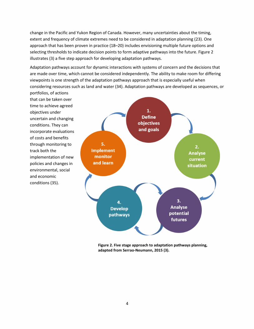
change in the Pacific and Yukon Region of Canada. However, many uncertainties about the timing, extent and frequency of climate extremes need to be considered in adaptation planning (23). One approach that has been proven in practice (18–20) includes envisioning multiple future options and selecting thresholds to indicate decision points to form adaptive pathways into the future. Figure 2 illustrates (3) a five step approach for developing adaptation pathways.
Adaptation pathways account for dynamic interactions with systems of concern and the decisions that are made over time, which cannot be considered independently. The ability to make room for differing viewpoints is one strength of the adaptation pathways approach that is especially useful when considering resources such as land and water (34). Adaptation pathways are developed as sequences, or portfolios, of actions that can be taken over time to achieve agreed objectives under uncertain and changing conditions. They can incorporate evaluations of costs and benefits through monitoring to track both the implementation of new policies and changes in environmental, social and economic conditions (35).
Figure 2. Five stage approach to adaptation pathways planning, adapted from Serrao-Neumann, 2015 (3).

5
1.2 Agricultural climate preparedness
The risks and opportunities from climate change in B.C. agriculture are distinct from other provinces and regions, partly due to landscape, social and economic constraints. Based on an initial Provincial Risk and Opportunity Assessment in 2012, the BC Agriculture & Food Climate Action Initiative identified that B.C. has an unusually limited agricultural land base, with high levels of geographic and product diversity and a high proportion of small-scale family farms (29). These factors combine with an aging producer population to make agricultural productivity in the province especially exposed to risks from climate change impacts (29). In addition, climate impact to traditional foods managed in the local environment pose food security risks, especially for First Nations people,where they provide important nutritional and cultural value (36).
By its nature, agriculture has always been vulnerable to seasonal extremes in rainfall, temperature and storminess that impact planting, flowering, growing and harvest periods (2). However, past adaptations to the existing climate did not need to plan beyond historic weather extremes. Adaptation planning that stops at the past limits of natural variability will likely fail to prepare for unprecedented new levels of climate extremes (37). For example, current planning does not account for projected changes in some areas of B.C. where unprecedented low summer rainfall may lead to seasonal drought while high intensity winter rainfall may lead to flooding in the same year (38).
Choosing climate preparedness actions for agriculture in communities can be informed by the extent that options meet these criteria (39):
• Sustain fundamental function of soil and water;
• Reduce existing stressors of crops and livestock;
• Reduce the risk and long-term impacts of extreme weather events;
• Manage farms and fields as part of a larger landscape;
• Alter infrastructure to match new and expected conditions; and
• Alter management of agricultural systems to accommodate expected future conditions.
Another important concept for agricultural adaptation is phenology, which refers to the timing of plant and animal life events that happen periodically, such as emergence, flowering or migration (2). These events are strongly determined by minimum and maximum temperatures, which are changing in timing and intensity. This changing seasonality could be one of the most important impacts of climate change on agriculture, where periodic life cycle events determine the timing of planting, flowering and harvesting.
Traditional food systems refer to culturally significant and wild food sources traditionally managed by First Nations people who actively monitor wildlife populations and health to ensure sustainable use. Loss of access and reduction in abundance in traditional food are two of the most direct ways people who actively monitor wildlife populations and their health notice environmental change. Traditional food systems remain fundamental to the culture, livelihood, economy, and health of contemporary First Nations people.

6
Even without extreme weather events such as flood or drought, plant interactions with pollinators and pest species may be affected in ways that can significantly reduce crop productivity. In addition, invasive species better adapted to new temperature extremes may outperform agricultural crops unless management measures are in place (18).
Strengthening farming to manage such natural hazards requires support through governance, management and policy-making structures that can help or hinder adaptation, depending on their design and application (40). This is why adaptation pathways are useful to support agriculture in top-down engagement with provincial and local governments and their policies, as well as bottom-up practical options that producers can undertake (41). Across the province, resilient and adaptive agricultural production will require ongoing consideration in land use planning and management that strives to accommodate new environmental and socio-economic conditions (40).
1.3 Applying new knowledge to adapt
Individuals, communities and governments face a range of challenges to access and apply new knowledge when making decisions to prepared for climate change. As shown in Figure 3, understanding how learning operates for different purposes can be framed as three kinds of learning loops (42).
Figure 3. Learning loops: dynamics of single-, double-, and triple-loop learning and applications to flood management, adapted from Intergovernmental Panel on Climate Change (IPCC), 2012 (47).
Simply put, single-loop learning follows known rules and improves routines, double-loop learning questions normal operations to consider different options, and triple-loop learning reconsiders the systems and structures that shape what options are possible (43). The adaptation pathways approach supports double-loop and triple-loop learning to incorporate outcomes from previous actions and new knowledge in adaptation planning (42). Double-loop learning helps consider different perspectives on

7
problems and possible solutions to evaluate how responses are framed. Triple-loop learning is especially valuable when circumstances are changing and can support reimagining the original problems as a new context for choosing solutions. As climate change mitigation and preparedness activities begin to change social and economic systems, triple-loop learning supports planning for the implications of climate change impacts and their consequences.
1.4 The capacity to adapt
In the context of rural livelihoods, the capital needed to invest in adaptation can be seen as five types, each drawing on different resources: human, social, natural, physical, and financial (44). These five kinds of capitals are described in Table 1 as a reminder that human and social assets combine with physical, natural and financial resources to offer a full picture of adaptive capacity for communities.
Table 1. Five capitals framework, adapted from Ellis, 1999 (49).
Capital Description
Human Health, skills, education, knowledge, confidence, ability to work, physical capability
Social Family links, culture, groups, support networks, leadership, influences over political decisions, conflict
Natural Natural resource stocks and environmental services – soil, water, forest and environmental assets
Physical The built environment, infrastructure and equipment – houses, schools, clinics, roads, farm machinery, producer goods accessible by community, improved genetic resources (crops & livestock)
Financial Cash, credit, debt, savings, sources of income, assets which can be traded or sold, financial services
An Australian example demonstrates these capitals in adaptation where farmers in drought-affected Bendigo gave up some of their water rights to irrigate playing fields, so their children could take part in sports and maintain local pride and social cohesion. In this case, capital losses from water shortages (Natural) under changed climatic conditions impacted outdoor sport and recreation facilities (Physical). Sport was important for public health (Human), local lifestyles and cultural identity (Social), and to the economy (Financial) through hosting major sporting events (45).
In the same way, livelihoods based on the agricultural production of plant and animal products depend on the conversion of natural capital to other forms of capital (46). These products are converted by markets into financial capital, which can be traded into physical capital (e.g. purchased farm inputs), human capital (e.g. skill improvement), and social capital (e.g. children’s education). Climate change can fundamentally alter natural capital where for example, diking that once protected a farm from flooding may fail due to erosion from repeated flood events. This can become maladaptive if the degraded dike is

8
relied on to manage future flood risks. Local innovation benefits when local social and human capital are supported (46), so the interplay between local, regional and national assets and institutional arrangements has to be considered when assessing the capacity of a community to prepare for climate change. Access to various types of capital can indicate barriers and opportunities to adaptation and shape what pathways may be available (8,17).
1.5 Managing conflict through values, rules and knowledge
Differences in human and social capitals affect who makes decisions, who benefits and who bears the costs. Aside from physical constraints, adaptation is often framed as a decision problem, working within existing decision processes to define a problem and select solution options (47). For adaptation planning to encourage fair allocation of resources and include many voices within a community, it requires some governing structure. The governance principles shown in Table 2 can help to inform the design and implementation of processes, arrangements and structures that guide how authority and power will be exercised. This includes deciding who will be held accountable, and the roles and responsibilities of participants involved in achieving strategic and operational objectives.
Table 2. Governance principles to manage decisions informing adaptation pathways in communities, adapted from Gorddard, 2016 (52).
Principle Key Elements
1. LegitimacyAn organisation’s authority to govern may be conferred by law or earned through the acceptance of authority by stakeholders and be validated by the integrity and commitment with which authority is exercised.
2. TransparencyDecision-making process is visible, reasoning behind decisions is clearly communicated, and relevant information about the governance and performance of the organisation readily available.
3. AccountabilityResponsibility for decisions and actions is allocated and accepted and how these responsibilities have been met is demonstrated.
4. InclusivenessOpportunities are available for stakeholders to participate in and influence decision-making processes.
5. FairnessStakeholder’s views are given respect and attention, decision-making is consistent and without personal bias, and consideration is given to distribution of costs and benefits of decisions.
6. IntegrationDifferent levels of governance are connected and coordinated and linked across organisations at the same level of governance with visions and strategic directions aligned across governance organisations.
7. CapabilityOrganisations are enabled by systems, resources, skills, leadership, knowledge and experience, and the individuals who direct, manage and work for them deliver on their responsibilities.
8. AdaptabilityNew knowledge and learning are implemented and incorporated into decision-making, threats, opportunities and associated risks are anticipated and managed, and organisational performance has systematic self-reflection
9
When conducting community engagement to develop climate preparedness plans, the focus is generally on the decision process, rather than on the context for those decisions. Due to the often contested goals and complexity of climate change impacts, an explicit focus on changing the decision context is an important prerequisite to effective and accountable adaptation (23). In addition to adapting to climate impacts such as changing river flows or temperature extremes, pathways will need to account for differences in related values, rules and knowledge that will also change as society responds (48).
The perspectives that inform decisions will need to be updated to manage limitations of traditional societal values and principles, familiar regulations and norms and partial knowledge (47). The interactions of values, rules and knowledge can exclude certain groups from decision-making (18), such as the historic exclusion of many indigenous communities (49,50). Planning frameworks that explicitly identify values, rules and knowledge can link how biophysical impacts and related changes in social systems lead to changes across the landscape, and so demonstrate how they affect homes, transport, food production, natural ecosystems and culture (18).
Within a community or sector, differences in goals and objectives can lead to conflict, especially where fundamental values and interests directly compete. For an adaptation pathway to be supported in practice, longstanding conflicts and those likely to emerge from climate impacts and adaptation actions will have to be explicitly addressed through all of the phases (47). Existing processes offer familiar planning supports to manage conflicts. This Climate Change Adaptation Pathways Framework is consistent with a variety of other frameworks and can be used to extend their use (34). These include:
Dynamic Planning and Management Frameworks - These are used when goals and values are expected to shift in an unpredictable manner. This offers an iterative approach to deal with these uncertain shifts where inputs are frequently assessed, and the flexible approach is altered to accommodate change.
Adaptive Management - This is an iterative process of decision-making which flexes to include new information as it becomes known. This helps managers to initiate actions and change their approaches if key objectives are not met.
Resilience Frameworks - These use complex socio-ecological systems to support systematic thinking, enable learning and provide mechanisms for responding to change. Resilience frames are concerned with the ability of a system to absorb or buffer disturbances and still maintain its core economic, social and ecological characteristics.
Systems Approaches - These consider the interactive nature and interdependence of external and internal factors that affect the system being managed.
Action Learning Approach - This assists management when the course of actions needed to achieve outcomes is not clear. Actions are identified through experiment and adjusted depending on the outcome.

10
2 Adaptation Pathways: Preparation, Planning and Practice
Applied adaptation pathways develop in an ongoing cycle with three main phases: preparation, planning and practice. The preparation phase includes two stages: 1) Define objectives and 2) Analyse current situation. Preparation starts with reviewing existing strategies, plans and data to identify the relevant adaptation capacities and needs. This is updated in the context of the most current information on climate change, its impacts and preparedness options to refine adaptation objectives. The planning phase has two stages, to 3) Assess possible futures where scenarios for future change are imagined and 4) Develop pathways where decision points from physical and environmental changes are assessed in terms of social values, rules and knowledge (47) to set out a sequence of potential paths that support resilience and manage transitions. To have meaningful support within communities in the planning phase, developing pathways requires consultation and negotiation. The practice phase, 5) Implement, monitor and learn, will likely extend over decades while decisions are implemented, social and environmental changes are monitored, and the lessons learned are applied to inform adaptation decisions. The schematic of the adaptation pathways process (Figure 4) was adapted from material prepared to support the Natural Resource Management (NRM) sector in Australia (51).
Figure 4. Adaptation pathways development through preparation, planning and practice in four frames of reference: Computation, Judgement, Bargaining, and Inspiration, adapted from Bosomworth, 2015 (46).

11
2.1 Preparation: Define objectives
Setting adaptation goals, and the objectives needed to reach them, looks beyond adapting to current levels of natural climate variability by using the triple-loop learning approach described previously (Figure 2). Goals can be designed that will remain robust over decades by reframing issues to reflect expected multiple and ongoing environmental, social and economic changes. While growth and prosperity remain fundamental goals, they will be challenged by impacts from a climate system that will continue to heat up for decades, and likely centuries, to come.
At its core, adaptation aims to moderate harm and exploit beneficial opportunities (52), and will take into account many factors in addition to climate change. When setting goals to develop adaptation pathways, it is important to take time to look to the future, listen to a wide range of voices and accept that there will be points where new goals will have to be found. Special attention to ensure inclusion is vital at this stage so that all voices are reflected in developing goals.
2.1.1 Vision, goals and objectives
Starting with clear definitions of terms supports clear communication. The Climate Change Adaptation Pathways Framework uses the following definitions (2):
Vision answers the ‘why’ question, providing the highest-level statement to guide the transition or achievement and reflecting the collective values of the community.
Goals address the ‘what’ question. These are future-focused broad aims and aspirations, outlining intentions and purpose. Goals do not have to be measurable.
Objectives answer the ‘how’ question through specific, precise and measurable targets that relate to the achievement of a goal. Use SMART objectives: Specific, Measurable, Achievable, Realistic and Time-limited. These measurable objectives provide the basis for the monitoring, evaluation and learning that underpin adaptive management.
This hypothetical example shows a vision, goal and objective that meet these requirements:
Vision: A sustainable region with a productive agri-food sector and resilient landscapes, supporting healthy communities. Goal: Healthy waterways that provide for ecological integrity and sustainable local food production. Objective: Food security is maintained through sustainable local foods, including traditional foods, and the Sala River provides enough environmental flows as determined in the basin plan baseline and benchmarking guide. Baselines and benchmarking will be reviewed and re-assessed every five years from the commencement of this strategy.
Based on an agreed future vision, climate preparedness goals will need to fit within the scope of identified priorities and capacities. A more generic pathway will include many issues across multiple sectors, while a focused pathway could relate to a single project focused on one sector. When the scope extends to regional goals, such as sustainable food production or equitable water sharing, adaptation pathways for agriculture will need to extend across sectors. More focused goals addressing

12
long-term options for specific land parcels or crop commodities will be useful to inform individual decisions and operational planning.
Uncertainties about the future make it challenging to imagine how goals will be realised over the coming decades. To set effective adaptation goals, it will be important to envision success within the context of future climate change impacts. For example, in an area that will undergo long-term changes in hydrology, where summer rainfall lessens or all but disappears over the next three decades, successful adaptation for agriculture will look very different from today. Tools such as the Agricultural Water Demand Model can inform these discussions (53) where adaptation goals might be measured by water use efficiency in terms of the value of agricultural production compared to megalitres of water used (54). Water efficiency objectives can be achieved through water-sensitive crop and soils selection (53), as well as through management practices such as applying less water to crops during drought-tolerant growth stages to save water and improve crop quality or yield (55).
2.1.2 Climate-ready objectives
To begin preparations for adaptation planning, it will be important to understand the local capacity and readiness to develop long-term goals and programs (34). It will take both time and resources to develop an understanding of climate projections for a region and how climate impacts will likely affect both environmental and social systems. This understanding will help to evaluate the capacity of the relevant natural and social systems to absorb expected climate impacts. Evaluation of climate resilience and impacts informs reassessment of current objectives and management mechanisms to decide if they will stand up to future changes. Existing goals that aim for static solutions that maintain the current status may need to be abandoned to take climate change impacts into account and develop climate-ready objectives.
Rather than being an anomaly, unprecedented patterns of wildfire and flooding in B.C. seem to indicate what can now be expected with unpredictable and increasingly volatile impacts from climate change (5). Incorporating this perspective into goal setting and planning can help to frame an adaptation path for local, provincial, First Nations and federal governments working together with agricultural and other B.C. sectors.
Guiding questions: Setting goals and objectives
• Are the ways in which agriculture is included in community adaptation goals responsive tocurrent and future climate patterns and appropriate for the community vision?
• Are the objectives that will help in achieving these goals consistent with each other and do theybuild capacity to adapt?
• Is the approach to reviewing goals explicitly flexible, and does it respond to decision pointsalong the adaptation pathway?
2.2 Preparation: Analyse current situation
A good knowledge base provides the foundation for analysing possible futures and developing pathways. This includes reflecting on historical drivers of the current situation, such as water availability

13
for agricultural production. The analysis can be used to frame the situation that requires adaptation and an understanding of what main issues need to be addressed. These insights inform approaches to analyse selected futures and help to identify and evaluate adaptation options.
A report on the current situation enables those who are planning to define how the futures analysis will be conducted, understand who to involve as stakeholders in identifying and prioritising options, and consider how potential options might be selected, implemented and evaluated. The analysis will:
• provide insights on social, economic and environmental drivers of the problem to targetmanagement options,
• inform what types of actions can effectively reduce vulnerability to specific climate changeimpacts, and
• help identify effective adaptation options that are likely to be supported over time.
2.2.1 Knowledge platform
Developing and implementing adaptation pathways requires well-informed participants with ready access to a knowledge platform where relevant and credible information is accessible and up-to-date. Existing information resources can be linked to a community knowledge platform, such as agricultural adaptation research outputs found on the websites for CAI (https://www.bcagclimateaction.ca), the Agricultural Climate Adaptation Research Network (https://www.bcacarn.com) and Retooling for Climate Change (https://www.retooling.ca). Climate preparedness information will typically come from a range of credible sources in government, academic and other institutions, sector associations and traditional knowledge. For instance, a knowledge base might include summaries of current scientific understandings of climate information, including locally downscaled climate projections where available. Part of this will be a record of assumptions that are being made as part of projections and underpinning particular actions or policies. It needs to be decided where the knowledge will be hosted and managed, such as within a local government or First Nations agency, or an agricultural association, depending on key stakeholders.
The knowledge platform is useful to systematically analyse many dimensions together to consider (2):
1. Who are the stakeholders?2. To what degree do values diverge among stakeholders (how strongly they agree or disagree on
goals and objectives)?3. How much scientific uncertainty is associated with defining or achieving the goals or objectives?4. What are the scales of the issues (e.g. local, sub-regional, across whole of region)?5. What are the capacity constraints, enablers and potential barriers?6. How much urgency is associated with the objective?
2.2.2 Issue types
Within strategic visions there can be many sub-strategies and implementation plans, often developed separately for different domains such as agriculture, water and biodiversity. However, taking separate approaches for different sectors may create additional challenges for climate preparedness. Resources such as land and water for example, will be affected by climate change in different ways and changes to

14
their use will involve trade-offs that affect the broad community. Understanding physical dimensions of these issues can be informed by existing resources such as the Agricultural Land Use Inventories (ALUI) (12) and the Agricultural Water Demand Model (53). To understand the social dimensions of such complex issues, focused local conversations can be informed and shared though documents like one prepared in the Cowichan region on Vancouver Island: Pathways and Partnerships Framework for Collaboration and Reconciliation in the Cowichan Watershed (56). Negotiations will require transparency and some common goals to maintain support in the long-term.
Taking stock of knowledge and values, as well as resources and data, is essential to incorporate climate change adaptation responses in plans that reflect the local character and address key areas of decision-making. When informing decisions that must be made in the face of uncertain expectations, the combination of levels of uncertainty and community agreement on goals informs what approach is most useful. Unfortunately, ‘low levels of uncertainty’ do not equal ‘high levels of certainty’ because science uses the term ‘uncertainty’ to express how well something is known or the level of confidence in the information. Scientists can have high confidence in knowledge with high uncertainty.
Approaches to managing different kinds of issues can be grouped into categories that offer a useful guide for issues management (Table 3) (51). Selecting an approach reflects the degree of certainty for information and knowledge, compared to the amount of agreement on goals within a community or sector, as described below.
Table 3. Issue types considering certainty and level of agreement on values and goals, adapted from Bosomworth, 2015 (46).
Far from certain about system or asset
Issues requiring ‘Judgement’
• Experimental intervention• Adaptive management• Social learning• Collaboration
Issues requiring ‘Inspiration’
• Leadership• Reframing• Social Learning• Adaptive Governance• Collaboration
Close to certain about system or asset
Issues requiring ‘Computation’
• Analysis• Computation of options• Implementation
Issues requiring ‘Bargaining’
• Trade-offs• Co-operation• Define common ground
Close to agreement on goals Far from agreement on goals
Computation (low uncertainty/low values divergence) - Computation is most useful where there is limited uncertainty (such as rise in minimum temperature over next three decades) and clear agreement
15
on goals (such as sustaining agricultural production inside the ALR). In these cases, familiar business analysis tools such as cost benefit analysis and real options analysis can be useful for decision-makers.
Bargaining (low uncertainty/high values divergence) - Bargaining is most useful when there is limited uncertainty (such as rise in minimum temperature over next three decades) and disagreement on goals (such as sustaining agricultural production outside the ALR). In these cases, trade-offs will need to be negotiated by actors with differing needs.
Judgement (high uncertainty/low values divergence) - Judgement is most useful where there is high uncertainty (such as river low flows or flooding) and clear agreement on goals (such as healthy waterways).
Inspiration (high uncertainty/high values divergence) - Inspiration is most useful when there is high uncertainty (such as wildfire regime changes) and disagreement on goals (such as what areas should be protected first).
Climate preparedness that considers agriculture will include all of these approaches to some extent. For example, computation of temperature and rainfall ranges may be useful to determine suitability of a particular crop. However, access to water rights may require bargaining and negotiation within a community to determine real water availability, especially if irrigation is needed. Similarly, making a significant change from a monoculture to a diversified farm with novel crops requires leadership and judgement. It requires inspiration to introduce new crops to an area lacking existing supply-chains for inputs and capacity to process and market the new commodities. Facing long-term drought for example, some growers may give up on low-value perennial crops, instead opting to use their limited water supply to irrigate high-value annual crops which require little water after harvest, or introduce Mediterranean perennials adapted to drier climate (55).
The current situation also includes relevant policies and programs at international, national and provincial levels that affect community and agricultural planning. However, any adaptation pathway will need to be updated and expanded depending on specific adaptation goals and related issues. While some climate change adaptation literature, policies and programs are referenced at the end of this framework, please search credible online resources for up to date information.
Actions will be implemented in the face of uncertainty, represented by multiple possible futures. The following steps (34) may help when considering the relatively new challenges of how to deal with timing actions as the climate changes and in developing explicit plans to switch tactics when needed.
2.3 Planning: Analyse potential futures
Having identified the main concerns and stakeholders invested in these issues, future scenarios can be developed considering the key system drivers described in the current situation analysis. Climate change is incorporated into this stage of planning so immediate and medium term (e.g. 5-10 year) strategies can be developed in the context of much longer-term environmental change. Climate science has increased understanding of how the Earth’s climate has developed over the millennia and how it may change in the future. An understanding of current and potential future climatic conditions is necessary to identify what impacts and their consequences will require adaptation.

16
2.3.1 Climate Information
Fortunately, the province of B.C. has a regional climate service centre that collaborates with climate researchers and regional stakeholders to produce knowledge and tools in support of long-term planning. The Pacific Climate Impacts Consortium (PCIC) has worked with a number of local governments to develop downscaled climate projections at locally relevant scales, including Metro Vancouver (7), the Capital Regional District including Saanich (57), and the Cowichan Valley Regional District (58). Tools such as the PCIC Climate Explorer (PCEX) are useful to locate, visualise and download data describing regional projected future climate conditions. The CAI’s Regional Adaptation Strategies for agriculture in B.C. have been informed by PCIC.
The ways that climate impacts will affect the landscape and society will also be affected by the consequences of these impacts as natural and social systems respond. For example, information is needed to understand complex problems for agriculture and communities that are influenced in many ways by policies, markets, and people’s perceptions and values. At the interface between communities and the agriculture sector, climate information will need to be understood in the context of related policy and regulatory frameworks which include mandates from numerous government agencies and First Nations.
Disconnection between sustainable food production and related policies and regulations contributes to a challenging and fragmented environment for agricultural producers managing through difficult or variable conditions (29). Future scenarios can be informed by technical and scientific knowledge such as climate change projections and ecosystem responses, as well as by creative processes that combine socio-economic and climate scenarios. These can be used to define plausible futures and understand what methods to achieve futures are suited to local or regional drivers of change (51).
2.3.2 A range of futures
Even without a changing climate, a range of possible futures may happen depending on technological innovations, social change and connections between global events. If only a single possible future is considered, it dismisses uncertainties and cannot account for new knowledge as it becomes available. A fundamental strength of the pathways approach is to provide a mechanism to navigate multiple futures by setting up decision points along the paths and recognising when adaptation options will reach their use-by-date.
While there are many ways to explore potential futures, it is ideal to use a participatory process that combines quantitative and qualitative approaches to issues, as shown in Table 3. Quantitative information aims to explain and predict through focused collection of numerical data (e.g. climate projections, cost and benefit ratios) while qualitative information gains insight and understanding through intensive collection of narrative data (e.g. case studies, expert testimony). By having stakeholders participate in the process of deciding what futures are considered, plans begin to gain agreement from the outset through experimentation, learning and building shared meaning. Participatory techniques involve open discussions about the value judgements that are implicit in situations and can explicitly address differing perspectives.

17
Within a participatory process, there is a range of tools and methods for describing potential futures, depending on the problem or goal that is the focus. The References section includes links to more information on some techniques that can be used to generate or use existing scenarios through foresighting, backcasting, the Delphi process, and Bayesian belief networks (2). Scenario analysis can be useful to reduce complexity, so a smaller number of scenarios can be developed to explore possible futures and analyse their potential implications.
2.4 Planning: Develop Pathways
Identifying and prioritising options is at the core of adaptation pathways planning and builds on selected scenarios that reflect climate change projections and stakeholder issues and concerns. The ways in which issues are understood through the current situation assessment will determine what approaches are taken to identify current options and explore alternatives to reach an agreed set of adaptation options. Based on the four issue approaches described above in Table 3, corresponding examples of pathways are shown in Table 4 that reflect differing levels of certainty and values agreement(51). Developing pathways will usually include multiple approaches depending on the scale and complexity of the objectives and goals and may require multiple iterations. When selecting a mixture of approaches to apply, the degree of certainty of information and knowledge will be reflected, as well as levels of agreement on goals within a community or sector.
Computation is used when there is low uncertainty about the system and stakeholders agree on the objectives (low values divergence). An example might be reassessing the climate zone designation for agricultural production. Options for different crops or practices can be developed by experts and assessed through modelling or other technical approaches using extensive knowledge and research.
Bargaining is used when there is low uncertainty about the system and stakeholders disagree on the objectives (high values divergence). An example might be the use of private land to provide transition zones for agriculture to move outside of the ALR. Where land use was planned for non-agricultural uses, stakeholders are likely to have differing objectives. A pathways approach might be used to explore the implications of different possible futures and pathway options for various stakeholder groups to identify common ground and potential trade-offs.
Judgement is used when there is high uncertainty about the system and stakeholders agree on the objective (low values divergence). An example might be where stakeholders agree that the objective is to maintain water quality or estuarine ‘health’, but factors impacting that objective are complex and knowledge regarding some factors may be limited. In these instances, a Pathways approach could be used to first describe the preferred future and then work to identify pathways (as combinations of actions) that would be needed to be taken to get there. This would become a preferred pathway
Inspiration is used when there is high uncertainty about the system and stakeholders disagree on the objectives (high values divergence). An example might be planning fire management to maintain both ecological and socio-economic values. In this situation, leadership could be needed to map out various pathways to achieving both objectives. The different pathways can then be compared to identify synergies and differences. The entire process can be used to facilitate meaningful discussion

18
surrounding the challenges of trying to achieve both objectives, and as a means of opening potentially transformative and innovative options.
Table 4. Pathway examples and issues approach considering scientific certainty and level of community agreement on values and goals, adapted from Bosomworth, 2015 (56).
Far from certain about system or asset
Issues requiring ‘Judgement’ e.g.
Stakeholders agree about the goal to maintain water quality and estuarine ‘health’.
However, complex system drivers and limited knowledge make the concept of river health ambiguous and dynamic interactions among impacts reduce certainty.
A pathways approach is selected to identify a preferred future, then work to identify pathways (as combinations of actions) that would be needed to be taken to get there (backcasting).
Issues requiring ‘Inspiration’ e.g.
Fire management to maintain both ecological and socio-economic values is contested and complex/uncertain.
A pathways approach is used to map out various options that variously to achieving each and both objectives. The different options are then compared to identify synergies and differences.
The entire process results in substantial learning through meaningful discussion about the challenges of trying to achieve both objectives, and the potential for transformative and innovative options.
Close to certain about system or asset
Issues requiring ‘Computation’ e.g.
Enabling the transition of agricultural production to new areas within the ALR.
This land is set aside for the purpose of agriculture (agreed objective) and there is a high degree of certainty about crop requirements
Options are developed by experts and assessed through modelling studies or other technical approaches because of extensive knowledge and research.
Issues requiring ‘Bargaining’ e.g.
Enabling the transition of agricultural production onto land outside the ALR.
Where land use was planned for non-agricultural uses, stakeholders are likely to have differing objectives and perspectives about the value of land, and knowledge about long-term land use is limited by policy uncertainty (e.g. considering ALR boundary changes in the future).
A pathways approach is used to explore the possible futures and options for various stakeholder groups to identify common ground and potential trade-offs.
Close to agreement on goals Far from agreement on goals

19
Potential adaptation options must be evaluated for robustness as well as flexibility in terms of the range of potential futures developed. Possible turning, tipping and trigger points are identified, drawing on outputs from the current situation and futures analyses. The aim here is to identify alternative options to achieve objectives so stakeholders can justify, prioritise and implement actions that consider climate change and associated changes in ecosystems, values, knowledge, as well as socio-political and economic conditions.
2.4.1 Steps that make a pathway
For a particular objective or goal, developing adaptation pathways broadly follows the steps listed here and described below (51):
A. Address existing drivers of vulnerabilities B. Bookmark decision points C. Consider alternative actions D. Develop plausible timelines E. Evaluate and refine pathways F. Finalise and visualise pathways
A) Address existing drivers of vulnerabilities
Identify options to address existing drivers of vulnerabilities under current conditions. Developing adaptation pathways begins by identifying what is presently being done to manage systems and issues related to the objective. Existing practices have been chosen for reasons that need to be understood in light of the current and historic climate. At this time, additional actions can be identified that could also address the objective within existing constraints without considering future and projected climate change impacts. The guiding question is: What is currently being done, and what else could be done, to create specific outcomes under current conditions?
B) Bookmark decision points
Identify tipping points, turning points and trigger points. The potential implications of climate change for both the system being managed and existing management options will mark where decisions must be made. The current management options can be considered in a range of plausible futures, which
Tipping points identify thresholds where change due to climate change consequences (e.g. long-term drought, flood events) exceeds the current ability of management strategies to meet objectives. Identifying tipping points informs whether and when a management strategy (e.g. rain-fed cropping, lowland production) may fail and other strategies are needed (72). Tipping points show how much climate change we can cope with using current practices.
Turning points indicate when a social-political threshold is reached due to changes in climate, policy objectives or social values and interests. For example, policy changes to manage water may influence farming practices with implications for livelihoods and rural communities. A social threshold relevant to B.C. may be a point where residential water needs do not allow sufficient irrigation for agricultural productivity (51).
Trigger points mark the start of necessary lead time for action before a turning point is reached. They depend on how long it takes to make a decision to change and then for it to be implemented. This is an aspect of defining trigger points which stems from the next stage of considering alternate actions. They are a crucial part of a pathways approach, enabling strategic plans to be made in advance, rather than after tipping points have been reached (51).
20
help to inform the next step. By combining information from the current situation and future analyses, this stage starts to identify potential thresholds or tipping points and possible turning points for options. Potential tipping points in the systems or assets can be identified through the conditions under which: 1) existing or potential future action may no longer be effective, 2) system or asset thresholds might bereached, and 3) an asset or system might change (directly driven by climate change or by changes insurrounding land use). Positive trigger points can also be identified, such as availability of additionalfunds, increased community champions, or political will. This can be done while potential pathways aredrafted in the following stages. The guiding question for this might be: What would we need to enablethis transitional or transformational action?
C) Consider alternative actions
Identify alternate options to help address objectives under the range of potential futures. Having identified decision points, it becomes clearer what other options may be useful to avoid, limit or remove the impacts of climate change and other socio-political, economic and environmental factors. These actions are considered to see if they are robust across plausible futures and are discussed in terms of what triggers could make them necessary. For each potential option, an initial evaluation of their tipping, turning and trigger points will need to be documented. Co-benefits for mitigation and sequestration options could also be considered within the context of adaptation actions. Identifying options is essentially a creative process, so it is important to have diverse and creative participants involved, depending on the objective. Participants should able to constructively work together, and to raise, discuss and consider things that are unusual. The guiding question for this might be: How does an option contribute to achieving the objective and what are the roles of stakeholders, including agricultural producer organisations?
D) Develop plausible timelines
Sequence potential actions into draft pathways. This step draws all the earlier work together to develop a sequence of potential options to create pathways. The previously defined tipping, turning and trigger points are used to identify when, or under what conditions, a specific option no longer works, as well as earlier points when action can, or must, be taken. Existing activities are documented first, and decision points identified to place no-regret options and options that are robust across most futures. The tipping, turning and trigger points identified after this initial sequence to check alignment. This process can show up significant gaps between current management practices and the resources, political and community support, including language and cultural connections, needed to enable the adaptation pathway. Links to guidance on how to map or sequence pathways are included in the References section.
Sequence potential actions
This is particularly important for agricultural producer organisations, because they are often not the ‘lead agency’ within a community planning initiative. In these cases, an agricultural organisation may have to declare its interest in advocating for a particular action or change. This is also a time to compare current organisational conditions and the adaptation goals required for each scenario to identify key issues, risks and success factors to be addressed.

21
E) Evaluate and refine pathways
Analyse and evaluate the pathways. As with any planning process, potential options are evaluated for cost, benefits, feasibility, acceptability and side-effects. The process of choosing preferred pathways will be a negotiated process with priority given to options and actions that can be implemented or supported immediately. In many cases, these will be the no and low regret actions, and those that are robust across a multitude of futures. Criteria to evaluate adaptation pathways in communities include:
Co-benefits: also supports biodiversity, mitigation, traditional foods or other agreed values;
Maladaptation: does not create a ‘dead-end’ by impacts on other assets, species, or values;
Limits: does not introduce constraints in physical, socio-political, financial, or social systems;
Flexible: avoids lock-in and provides options if a strategy must be adapted or replaced;
Sustainable: supports physical & social sustainable adaptation pathways under different futures; and
Responsive: enables switch between strategies or ability to postpone or resolve a turning point.
F) Finalise and visualise pathways
Finalise and document or map pathway. This stage maps out or documents the sequencing of potential pathways. As part of a participatory process, the adaptation pathways can be represented visually to communicate options and share decision-making. Maps of adaptation pathways have been variously depicted as a schematic, a flow chart or even a branching tree. Computer-based tools and methods are available to help communities to depict potential adaptation pathways. The hypothetical example illustrated in Figure 5 demonstrates one visualisation technique (59), using the free software Generator (19) which is listed in the References section. The features are explained in the User Guide (60) associated with this framework document.

22
Figure 5. Adaptation pathways scenario map illustrated using the Deltares Generator software, adapted from Walker, 2013 (64).
Pathways can also be documented initially working with pen, paper and informed, creative people or presented in a well-structured table. Here the guiding question is: What will best represent the probable elements of adaptation pathways for stakeholders and decision-makers?
2.5 Practice: Implement, monitor and learn
The value of an adaptation pathway is demonstrated when it is adopted, implemented and updated over time within a community. Agricultural producers work to maintain strong collaborative relationships in their regions to respond to climate change and contribute to resilient communities through sustainable local food production (13). As keen observers of seasonal changes, producers are a natural source of monitoring information through their work with community members, researchers, consultants and industry to share information and implement adaptation actions.
The trigger for implementing an adaptation pathway may be set before a particular pathway was developed, for example through an existing policy or funding trigger. Taking up new options is more likely to become a priority when external changes occur that were identified as triggers or turning points when the adaptation pathway was developed. As part of the process, ongoing changes in the natural or policy environment will sometimes challenge assumptions and cause options to be re-evaluated. To identify when it is time to re-evaluate, a monitoring system can be developed based on signals that can be objectively trusted as measurable, timely and reliable, and which can be combined to give a full picture. As shown in Table 5, consistent criteria can be applied to evaluate indicators of change and signal thresholds that are needed to initiate critical responses (23).
Table 5. Steps to develop a monitoring system to indicate response triggers for adaptation pathways, after Haasnoot, 2018 (23)
1. Identify primary decisions, actions, tipping points and assumptions in the pathway
2. Determine developments that trigger implementation or invalidate assumptions
3. Select secondary indicators that monitor developments and assumptions to signal action
4. Define measurable, timely and reliable signals to implement or reassess actions
Slope: Do gradual or abrupt indicators give earlier warning?
Signal/noise: Is the area large enough to calculate indicator as signal to noise ratio?
Statistics: Can timing and reliability of the signals be assessed and the risk of false signals?
Timing: Does the signal appear enough in advance of the tipping point or needed action?
5. Combine selected signposts for timely, reliable and influential signals to monitor pathways

24
The knowledge platform discussed in Section 2.2.1 can provide a foundation for the monitoring system that fits with each set of goals and objectives. Deciding what to monitor will be specific to the issues of concern. For example, water levels in a significant river that trigger policy responses, such as mandatory water restrictions, can be anticipated by monitoring long-term and seasonal changes in rainfall, snowpack and freshet, which might trigger early requests for voluntary reductions in water use.
Because implementation of climate preparedness strategies is beyond the responsibility of any one organisation, local governments and their communities will need to clearly allocate and coordinate roles and responsibilities for effective action. Supporting the skills and capacities for adaptation planning and implementation across organisations and groups that include agricultural producers will become a normal activity with a changing climate. Increasing adaptive capacity is fundamental to proactive adaptation. The References section includes links to information that can help to build the capacity to adapt.
25
3 Guiding Adaptation Pathways
Planning for adaptation begins in the context of current requirements and existing policies, rules and laws, as well as taking steps to account for future changes. This section considers how adaptation pathways can be guided by current policies and programs, already agreed government and organisational strategies, and indicators that can be tracked over time. This is an overview to show what kinds of guidance are available. The adaptation goals and objectives that a community makes their priority through a participatory process will influence what guidelines apply, and where institutions may be drivers or barriers to adaptation. For example, successful agriculture is clearly dependent on some weather and water factors where indicators such as rainfall and temperature extremes can be monitored. However, understanding current requirements for government programs may also influence planning decisions, and changes in funding options and policy settings also need to be monitored.
3.1 Indicators guide adaptation pathways
The climate is not the only change that affects adaptation goals and options, so it is useful to track a number of changes that may indicate where vulnerabilities or capacities may be strongest. The Columbia Basin Rural Development Institute has formulated a set of Adaption Pathway Indicators (API) that can be used to develop and monitor adaptation pathways and understand dynamic interactions between impacts, actors and assets. The State of Climate Adaptation and Resilience in the Basin (SoCARB) indicator suite (24) is designed to support adaptation planning for local governments and engaged community members in the Columbia Basin. While the Basin is made up of all the Canadian watersheds that flow into the Columbia River, many of these indicators can be applied to other regions in B.C. and beyond. Within the Columbia Basin, the Adaption Pathway Indicators (API) have been applied to understand five adaptation pathways identified as priorities for the region: Agriculture, Extreme Weather & Emergency Preparedness, Flooding, Water Supply, and Wildfire (24).
Following the broader SoCARB indicator suite, the APIs consider more than the progress of adaptation actions towards an identified goal. They include physical factors that make adaptation necessary, such as Climate Change (e.g. temperature increase, precipitation extremes, strong wind events) and Environmental Impacts (e.g. area burned, drought index, growing season length), as well as social and economic initiatives, such as Adaptation Actions and Capacity Building (e.g. emergency preparedness, water conservation policies, campfire bans) and the implications for communities through Community Impacts and Adaptation Outcomes (e.g. cost of fire suppression, evacuation orders, weather-related highway closures)(24). A full list of the API factors is shown in Appendix A.
Other approaches to adaptation metrics are also available (61), such as those that take into account past adaptation measures or adaptations expected to arise independently or spontaneously in the community (autonomous adaptation) over the duration of the pathway, as part of determining a baseline.
3.2 Policies, programs and strategies guide adaptation pathways
Climate change policies have been dominated by mitigation efforts to reduce the concentration of greenhouse gases in the atmosphere. In contrast to the localised impacts from climate change that

26
prompt adaptation, mitigation is a global issue informing international policies and actions (62). Attempts to reflect climate preparedness in policies have used an up-scaling approach, where lessons from projects in one location are used to influence national and regional policies (63). Local context is important, however, to understand what and how policies apply to specific adaptation goals and objectives.
Local government policies are the focus of adaptation pathways for communities and sectors. A 2012 Implementation Guide for adaptation planning by local government in B.C. (27) offers excellent context to develop adaptation pathways, which have the added benefit of sequencing decisions along a time line. Based on present information and understanding, adaptation pathways can be developed that focus on ‘current best practice and development plan policy and shift at a decision point’ to ‘review and amend development plan policy’ (4). In B.C., an Official Community Plan (OCP) is one of the key planning tools available to develop climate preparedness strategies for decision-making about many issues, including land use and development within its jurisdiction (27). Applying a pathways approach when developing OCPs will help to guide both processes.
Strategic plans are developed to reflect high level goals and aspirations, and guide investment over time. Considering that adaptation pathways stretch for decades into the future, strategic thinking is needed to guide pathway development, evaluation and refinement. There are many barriers to adaptation aside from climate change impacts. Strategic thinking will help to overcome these obstacles, in combination with leadership, resourcefulness, creativity and effective communication (64).
In British Columbia, the 2019 Clean B.C. Plan (9) links provincial strategic thinking about climate change mitigation efforts to a commitment to develop a new Climate Preparedness Strategy. The Ministry of Agriculture in B.C. has already developed a range of programs that support agricultural adaptation to climate change, although some of those programs did not have adaptation as their initial aim. A systematic risk and opportunity assessment completed by CAI in 2012 showed the potential for some government policies and programs to support climate change adaptation in the agriculture sector (28,29). B.C. agriculture has benefited from federal-provincial-territorial government initiatives which have funded much of the work done by the BC Agriculture and Food Climate Action Initiative. The 2018 - 2023 Canadian Agricultural Partnership is the most recent program and supports the development of CAI’s Regional Adaptation Strategies.
When planning for climate change impacts is not a top-down result of policy, it is often called autonomous or spontaneous adaptation and has been characterised as reactive and ad-hoc (2). However, many of the tools developed for agricultural adaptation focus on producers’ actions on their farms (28,29,53), which are often coordinated through industry associations. When many autonomous adaptations are made at the same time, they can influence pathways through such bottom-up actions.
Policies and programs have their own lifetimes, so it is vital to include a policy register within the knowledge platform for any adaptation pathway that is regularly updated to take advantage of new funding and support, as well as regulatory changes.
27
3.3 Stakeholders guide adaptation pathways
Guidance from environmental indicators and policy processes must also reflect the people who are, or will be, affected by climate change impacts and implications. This is why stakeholder participation is fundamental to planning adaptation pathways. In addition to environmental change, social perspectives and preferences will change over time, including what is interesting to stakeholders and how they evaluate their plans. Stakeholder participation is a broad category that encompasses many methods. Effective stakeholder engagement can be done in different ways to suit the issues and community members, including on-line surveys, town hall style meetings, individual interviews, focus groups and exit surveys (2).
For example, as part of the New Normal adaptation initiative in the Cowichan watershed, inclusive participation is built into the process by combining reconciliation and adaptation planning (56). Informed by a series of facilitated conversations, the Cowichan Water Board (CWB) engages differently depending on what issues and opportunities emerge, partnerships grow, and political and institutional contexts evolve. However, the CWB have agreed to begin by recognising Indigenous authority, strengthening partnerships and building readiness to act on opportunities presented by updated legislation in the Water Sustainability Act (56).
From the outset, CAI has carried out extensive engagement in their agricultural adaptation projects. A project that highlighted the level of inclusion needed to fully engage stakeholders, aimed to enhance collaboration for agricultural drainage and ditch management. In addition to funders from government and specific associations of practice (BC Blueberry Council; Dairy Industry Research and Education Committee; Agriculture and Agri-Food Canada; BC Ministry of Agriculture and Growing Forward 2) the project working group consulted with the Ministry of Forests, Lands, Natural Resource Operations and included representatives from: BC Agriculture & Food Climate Action Initiative; City of Abbotsford; District of Kent; BC Poultry Association; City of Chilliwack; BC Dairy Association; Fraser Valley Regional District; and BC Landscape and Nursery Association (65).
For participant information to be useful, it is equally important that data sources and stories are legitimate and relevant to the stakeholders who care about them as well as being scientifically credible. Designing monitoring and evaluation for pathways progress should be fit-for-purpose and targeted to audiences. This means that indicators need to be aligned to the goals and objectives that are central to the pathway. Where objectives include qualities such as availability of ‘culturally appropriate’ food for example, good qualitative data or related proxies should be considered. This requires that initiatives are designed to ensure good communication and feedback with stakeholders who understand their roles and agree on definitions of success (2).
The following hypothetical example (Appendix A) illustrates how the adaptation pathways approach can be applied in B.C. It follows the advice given in this Climate Change Adaptation Pathways Framework (66) and the associated User Guide (60).
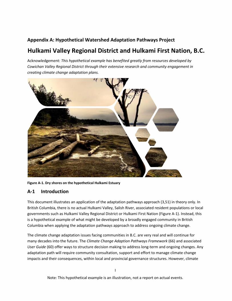
Appendix A: Hypothetical Watershed Adaptation Pathways Project
Hulkami Valley Regional District and Hulkami First Nation, B.C. Acknowledgement: This hypothetical example has benefited greatly from resources developed by Cowichan Valley Regional District through their extensive research and community engagement in creating climate change adaptation plans.
Figure A-1. Dry shores on the hypothetical Hulkami Estuary
A-1 Introduction
This document illustrates an application of the adaptation pathways approach (3,51) in theory only. In British Columbia, there is no actual Hulkami Valley, Salish River, associated resident populations or local governments such as Hulkami Valley Regional District or Hulkami First Nation (Figure A-1). Instead, this is a hypothetical example of what might be developed by a broadly engaged community in British Columbia when applying the adaptation pathways approach to address ongoing climate change.
The climate change adaptation issues facing communities in B.C. are very real and will continue for many decades into the future. The Climate Change Adaption Pathways Framework (66) and associated User Guide (60) offer ways to structure decision making to address long-term and ongoing changes. Any adaptation path will require community consultation, support and effort to manage climate change impacts and their consequences, within local and provincial governance structures. However, climate
I
Note: This hypothetical example is an illustration, not a report on actual events.

II
Note: This hypothetical example is an illustration, not a report on actual events.
preparedness in communities has not explicitly taken a structured adaptation pathways approach. This example describes the issues of climate change related to low river flow events in an imagined location, the Salish River in the Hulkami Valley Regional District (HVRD) and takes a hypothetical, or “what if?”, approach to develop plausible adaptation pathways. This hypothetical example was developed for B.C. to demonstrate ways in which the adaptation pathways approach can be applied.
A1.1 Hulkami Valley Regional District (HVRD)
The imagined Hulkami Valley is fed by the Salish River, which is renowned for fishing and great natural beauty. The Salish River and its tributaries flow to the ocean through the traditional territory of the Hulkami First Nation and past the town of Archibald where the Hulkami Valley Regional District (HVRD) has its main offices. The Hulkami Valley is home to over 90,000 people, half of whom reside in the towns of Archibald, Old Bedford, Port Miller and Hulkwitlam. First Nations people have lived in this region for more than 2,000 years and European settlement began in the 1870s. Since the early 1900s, natural resource sectors such as fisheries, forestry and agriculture have been economic drivers in the valley. Growing activity in the areas of services, tourism and emerging digital industries located at the Hulkwitlam Innovation Hub is bringing jobs and new revenue streams into the area.
A1.2 Water resources in the Hulkami
The hydrology has changed greatly over the past 150 years in the Hulkami Valley. Since the late-1800s, forestry, settlement, agriculture, recreation and tourism, industry, and cultural values have competed for water in the Hulkami, impacting traditional uses and ecosystems.
In the Hulkami Valley, water for drinking, industry and agriculture comes from rain-fed lakes and rivers, as well as groundwater. Reservoirs in the region are small, with limited capacity for additional storage. Regionally scaled climate projections show that over the coming decades, the effects of climate change on precipitation patterns will impact the availability of surface water, as well as flows in lake and river systems, to ultimately affect groundwater resources. Precipitation changes will impact water quality in winter through increased sedimentation, and in summer, through warm water driven algal events because climate change will trigger higher summer temperatures. Understanding temperature changes is useful to plan for agriculture and to understand how ecological systems will change over time, including changing plant growth and the health of fish populations in the rivers.
Drought Impacts Agriculture in the Hulkami
Agricultural production in Hulkami is already exposed to extended dry periods and most producers cannot reduce their vulnerability through irrigation because water sources are already impacted during summer. Water scarcity can reduce crop yields, affect quality and change harvest timing, as well as affect livestock watering options. Drought affects options to manage heat impacts on crops from plant wilting, sun scald and managing existing and new pests. With drying conditions set to increase, water use will become more restricted and affect farm production in the Salish Watershed.

Climate and soils of the Hulkami region have been well-suited to many different agricultural enterprises. Almost 30 percent of arable land is considered prime agricultural land, this requires irrigation for full productivity, although less than a quarter is currently irrigated. Access to water for irrigation is already a significant concern. This is mainly due to connections between ground water and water flowing in rivers, where bore water extraction will reduce river flows.
In the Salish River watershed, a preliminary assessment of hydraulic connection considered the impacts on the streamflow from water pumped for any purpose through wells, which are calculated as a Stream Depletion Factor (SDF). These SDFs indicate how much ground water and streamflow are connected and do not take into account the amount of water pumped, which is a critical factor in understanding how much streamflow will be depleted from well pumping.
A1.3 Climate Change in the HVRD
To understand what climate change impacts are expected, the Regional District commissioned a set of climate projections that were down-scaled from global climate models to be suitable for local planning. Initially, planners generally referenced average values from older climate models to assess expected local changes and implement pilot adaptation projects. Projections have since been prepared for the HVRD, updated to include more advanced modelling. Throughout this hypothetical example, values used for planning purposes are taken from the most recent climate projections and reflect the full ranges of changes, with single numbers taken from the high end of the range, rather than the averages.
The higher projections are used to avoid underestimating changes for planning purposes because averages can obscure the weather extremes that challenge people and systems. As an example, annual temperature increases over the next 30 years to 2050 are projected to be 2.7°C on average, but when using the high end of the projected range, they rise to an increase of 4°C. This presents very different planning options. In the same way, the high end of the projected change in summer rain is a decrease of 41 percent for the Salish watershed, with significant implications for agriculture. This is in keeping with the Climate Change Adaptation Pathways Framework advice to consider the full range of projections and select the high-end values when only one number is considered for planning purposes. Otherwise, underestimating risks from extreme weather events can increase vulnerability by not signaling the full extent of exposure to climate change hazards (37).
In addition to environmental factors, climate preparedness has to take into account the regulatory and institutional frameworks that guide what options are allowed. Planning decisions in the Hulkami, including those for climate preparedness, are governed by provincial and federal legislation. Professional practitioners such as engineers, for example, must adhere to government regulations related to public safety, which may change over time.
III
Note: This hypothetical example is an illustration, not a report on actual events.

IV
Note: This hypothetical example is an illustration, not a report on actual events.
A2 Developing an Adaptation Pathway: Facing Forward Hulkami
A major point of departure from much current practice in the adaptation pathways approach is to develop a sequence of adaptation options and decision points, laid out over time, which address impacts from climate change in one or more key areas of decision-making. An adaptation pathway typically extends three decades, or more, into the future, with periodic reviews and revisions. As seen in Figure A-2, adaptation pathways offer a structure to consider when to make new choices, and what to do when current options are no longer effective, so that significant transitions must be made.
The Hulkami Valley Regional District (HVRD) is working on Facing Forward Hulkami, a multi-phased initiative to act on climate preparedness. In 2014, the HVRD State of the Environment report expressed concern about producing enough local food. At that time, demand for water had already outstripped supply and created conflicts between user groups. Water insecurity, worsened by fluctuations in supply due to climate change, has threatened Hulkami’s ability to meet food self-sufficiency targets.
Approaches to issues
Issues will require different approaches to develop appropriate knowledge to inform community understanding and action. As shown in Figure A-3, aspects of Computation, Judgement, Bargaining and Inspiration will inform the choices that lead to adaptation pathways. Choosing an approach to issues depends on how well the physical systems are understood and the level of agreement on related values and goals that are shared within the community.
Figure A-2. Five stage approach to adaptation pathways planning, adapted from Serrao-Neumann, 2015.
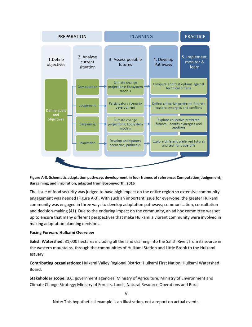
V
Note: This hypothetical example is an illustration, not a report on actual events.
Figure A-3. Schematic adaptation pathways development in four frames of reference: Computation; Judgement; Bargaining; and Inspiration, adapted from Bosomworth, 2015
The issue of food security was judged to have high impact on the entire region so extensive community engagement was needed (Figure A-3). With such an important issue for everyone, the greater Hulkami community was engaged in three ways to develop adaptation pathways; communication, consultation and decision-making (41). Due to the enduring impact on the community, an ad hoc committee was set up to ensure that many different perspectives that make Hulkami a vibrant community were involved in making adaptation planning decisions.
Facing Forward Hulkami Overview
Salish Watershed: 31,000 hectares including all the land draining into the Salish River, from its source in the western mountains, through the communities of Hulkami Station and Little Brook to the Hulkami estuary.
Contributing organisations: Hulkami Valley Regional District; Hulkami First Nation; Hulkami Watershed Board.
Stakeholder scope: B.C. government agencies: Ministry of Agriculture; Ministry of Environment and Climate Change Strategy; Ministry of Forests, Lands, Natural Resource Operations and Rural
VI
Note: This hypothetical example is an illustration, not a report on actual events.
Development; Ministry of Municipal Affairs and Housing; and Agricultural Land Commission. Other stakeholders include Enzyme Paper, Hulkami Agricultural Society, City of Archibald, Union of B.C. Municipalities (UBCM), FutureCorp Hulkami, National Forest Alliance, Natural Resources Canada, and Fisheries and Oceans Canada.
Identified threats: threats to water quality and water supply; cumulative impacts to habitat and agriculture.
Identified impacts: loss of habitat for fish populations; insufficient water for agriculture; forest die-off; loss of social cohesion and economic prosperity.
The initiative was partly funded through provincial and federal programs to initiate adaptation planning. In deciding to fund the balance of the initiative, these overall objectives were incorporated into the Hulkami Adaptation Pathways Charter:
• Build the knowledge and capacity of the community to bring sound science-basedrecommendations into land use decision-making processes for the Salish Watershed,
• Significantly improve the ability of Hulkami decision makers and communities to plan andrespond to likely futures for our river dependent communities,
• Demonstrate the utility of flexible pathways that incorporate future climate risk and adaptationactions into decision-making,
• Establish key partnerships that will position the communities in the longer term to drive thereform required to manage climate change risks,
• Provide leadership in new approaches to cost-effectively manage water asset risk,• Enhance the adaptive capacity of Hulkami governments, communities and infrastructure and
service providers through engagement in developing planning for future options,• Progress the Salish Watershed along flexible community adaptation planning pathways, and• Develop a toolkit based on the adaptation pathways methodology that can be applied to other
vulnerable riverine communities.
The HVRD reviewed climate projections for the region, discussed regional impacts of the projections, and identified recommendations. The HVRD used standardised engineering methodology to undertake vulnerability and risk assessments so that impact responses can be prioritised. The assessment is guiding the development of adaptation and mitigation measures to prepare for, or respond to, climate change impacts. Facing long-term reductions in rainfall and eventual lack of sufficient water for some ecosystems and farming, the community decided to adopt a pathways approach to adaptation based on process outlined in the Climate Change Adaptation Pathways Framework.
This hypothetical example follows the adaptation pathways five stage cycle:
6. Define objectives and goals7. Analyse the current situation8. Analyse potential futures9. Develop pathways10. Implement, monitor and learn
A2.1 Hulkami - Define objectives and goals
Through public participation, drought impacts on local ecosystems and food security were identified as a high priority issue for the community and agriculture in the Hulkami Valley. The issue of low river flows was prioritised because low flows in the Salish River have already resulted in salmon being trucked up the river to spawn. In recent months, Hulkami Lake had the lowest water levels on record, triggering emergency measures to conserve the water supply critical for agriculture and spawning salmon.
Now over ten years old, the Hulkami Basin Water Management Plan was developed with participation from major stakeholders including; the Hulkami Valley Regional District (HVRD), Hulkami First Nation, B.C. Ministry of Environment and Climate Change Strategy, Fisheries and Oceans Canada, Enzyme Pulp and Paper, and the Pacific Salmon Commission. The community welcomed a formal and proactive approach to water management in the Basin in the face of continued population growth, climate change and the cumulative impacts of uncoordinated decision-making on the watershed. An updated water management plan is underway.
A2.1.1 Planning in the Hulkami
Policy and governance arrangements can become very complex, even when planning within a relatively small area such as the Salish Watershed. For example, the area included in the Official Community Plan (OPC) had been subject to two separate OCPs in different Electoral Areas. The current Plan Area also includes Hulkami First Nation reserve land that are within federal jurisdiction and the Hulkami First Nation has been engaged in the B.C. treaty process since the 1990s. Aboriginal rights and title considerations apply to lands within the Plan Area and must be considered in setting out adaptation pathways.
As of 2019, Official Community Plan requirements set out in the Local Government Act, require that OCPs include: policies and map designations respecting commercial, industrial, institutional, agricultural, recreational and public utility land uses; phasing of any major road, sewer and water systems; public
VII
Note: This hypothetical example is an illustration, not a report on actual events.

VIII
Note: This hypothetical example is an illustration, not a report on actual events.
facilities, including schools, parks and waste management sites; and targets, policies and actions for the reduction of greenhouse gas emissions (GHGs). The OCP may also include policies relating to social environmental and regional needs, including the maintenance and enhancement of farming.
The current Hulkami OCP acknowledges planning for an uncertain future with a changing climate as an overarching challenge. Projected local climate change impacts include increasing sea levels, increased precipitation, increased year-round temperatures and more extreme weather events (e.g. summer droughts, heavy rains, winter storms).
The community recognised that possible adaptation pathways could be developed to address a combination of these identified systemic social and economic impacts:
A. Forced resettlement from shoreline areas and relocation of transportation routes B. An expanded food growing season, but a decrease in soil moisture levels C. Changes to critical natural resources (e.g. groundwater supply) D. Emerging health concerns (e.g. heat wave stress and related illness, altered range of vector-
borne diseases) E. More frequent natural disturbances (e.g. forest fires and pestilence), and F. Disturbance to and loss of natural ecosystems and wildlife habitat
These issues were prioritised by the community in an online survey and public meeting. One combination of B, C and F was ranked highly when it was expressed as this hazard:
Climate Change Hazard for Agriculture; Low river flows increasing competition for water between agricultural production and wildlife habitat.
The community also agreed (65% majority) on this vision statement for their adaptation planning:
Climate Change Adaptation Vision: Hulkami Valley Regional District
Together we can face a future of ongoing climate impacts and make good decisions to manage our limited water supply and enjoy all the benefits of living here.
Based on a workshop held in the town of Archibald, the adaptation objective below was agreed to address the Climate Change Hazard for Agriculture and forms the foundation for this adaptation pathway. This pathway will be evaluated for connections to the other five priorities identified to address climate change hazards to health, cultural values, emergency response, public safety and economic prosperity.
Adaptation Pathway Objective:
Sustainable local food production with increasing winter flood and summer drought conditions

IX
Note: This hypothetical example is an illustration, not a report on actual events.
A2.2 Hulkami – Analyse the current situation
Key issues for this pathway relate to: river hydrology and water availability; river health; and water demand for agriculture, natural resources and people. Understanding the current drivers for these issues is the first step to develop pathways to address climate change impacts over the coming decades. The Salish River is significant for everyone who lives in the Hulkami Valley and the Hulkami First Nation has a deep and spiritual connection that goes beyond issues of food and resources. The demands on the Salish River shown in Figure A-4, are based on activities that were developed based on historic river flow
Figure A-4. Current demands on the Salish River as a water and economic resource.
patterns. As the river responds to new and changing patterns of rainfall and runoff, water demands must adjust. To assess existing conditions, Facing Forward Hulkami used three existing types of assessment to inform this adaptation pathway, focused on hydrology, river health and water demand.
A2.2.1 Hydrology
Primary issues approach: Computation and Judgement: Issues associated with hydrology were approached primarily using computation (analysing flow rates) which was further interpreted using judgement (understanding the implications of long-term changes and their consequences.
The Salish River is an unregulated stream that has been identified as vulnerable to low flows during the dry season, which may affect the habitat and survival of aquatic life. While the river may seem disconnected from the underground water resources, within the Salish watershed some aquifers with porous soils mean that pumping water from wells will draw water from the river and deplete streamflow. A government study investigated the hydraulic connection of wells to streams in the watershed to inform management of environmental flows and access to water for users. These stream reaches were identified by mapping where the stream may have a connection to the aquifer. Information was sourced from records on the provincial registry of Groundwater Wells and Aquifers, digital stream and topographic elevation data, as well as from published geological mapping. Mapping
X
Note: This hypothetical example is an illustration, not a report on actual events.
from this study suggests that most, if not all, wells in the Salish watershed can make hydraulic connections to streams within the watershed.
Points of hydraulic connection were made for the vast majority of reported wells to streams in the Salish watershed. Stream depletion factors (SDFs) are a relative measure of how quickly streamflow depletion can occur from well pumping. Calculations showed a range of SDF values across the watershed, from low (a few weeks) to high (a few years). Streamflow depletion from well pumping and recovery from streamflow depletion after pumping stops are expected to occur more quickly where the SDF is smaller. The report recommended that specific licensees diverting groundwater be required to measure and report quantities diverted and monthly static water levels from their wells. This information will be useful to re-evaluate the current situation as water availability changes.
A2.2.2 River Health
Primary issues approach: Judgement and Bargaining: Issues associated with river health were approached primarily using judgement (understanding minimum requirements for ecosystem heath) which was further interpreted using bargaining (considering viable trade-offs to maintain key functions) considering differences in capacity to make changes.
All B.C. watersheds require complex decision-making to balance the needs of human and ecological systems. Rivers traverse diverse ecosystems and often cut through many jurisdictions, including First Nations territories, Regional Districts and municipal entities. While not a regulatory authority, a water board was created for the Salish River to provide leadership through a partnership that brings key leaders and representatives together in a collaborative framework. The water board approached river health by considering a series of questions that matched the capacity of stakeholders to act, addressed their most concerning issues, and would sustain their interest and enthusiasm. This framing to seek solutions fits well into the adaptation pathways approach. The questions agreed by the stakeholders related to: protecting and preserving fish populations, riparian habitat, and estuarine health; supporting adequate summer flows through water conservation; and maintaining clean water. At the same time, the water board developed a program to better educate community members and water users on what is needed for healthy rivers.
The ongoing monitoring program of the watershed board made information available to understand the current health of the waterway and to see changes over time. Monitored indicators of river health included; river flows and lake levels, chinook salmon and steelhead juvenile densities and water quality testing. When water quality testing showed issues with farm runoff from local dairy herds, the board worked with farmers to develop a group-based Environmental Farm Plan (GEFP) for dairy producers in the area that identified best management practices. Ministry of Agriculture funding helped to support improved nutrient management. Ongoing water quality monitoring, coupled with support for agricultural education and nutrient management upgrades, was considered important to reduce current vulnerabilities to climate change impacts.

A2.2.3 Water demand
Primary issues approach: Computation and Inspiration: Issues associated with water demand were approached primarily using computation (analysing extraction amounts per hectare) which was further interpreted using inspiration (new options for scheduled water supply) to envision new solutions when demand exceeds supply.
The Agricultural Water Demand Model was originally developed by the B.C. Ministry of Agriculture to predict water requirements for lands reserved for agriculture in the Okanagan region of B.C. The model has been extended to many areas in B.C. including the Hulkami Valley Regional District. The model provided current and future estimates of water demand by calculating, and verifying in the field, water use on a property-by-property basis. Groundwater was the assigned source when no surface water licences existed on the property and there were no obvious surface water sources.
Crop irrigation system type, soil type and climate data were used to calculate water demand. For the purpose of this hypothetical example, groundwater volumes were derived from crop irrigation. Land uses included in this model were categorised into the following groups: alfalfa, apple, berry, cherry, domestic outdoor, forage, fruit, and golf (67). Understanding water demands for agriculture offered a base level to explore how combinations of new practices and crops, as well as climate change impacts, will affect water demand on the Salish River. Individual farmers who incorporated the water demand model with a planning toolkit to develop farm water use plans decided this would be valuable for future reference because it provided all of the water related data, issues, and recommendations in one document (54).
Key findings: Hydrology, river health and water demand
Uncertainty arises from quality of data and choice of social and economic development scenario used. It became clear that the complexity of the investigation required a very significant level of effort and data in order to assemble the most basic and essential set of evidence capable of informing issues that come from low river flows.
In addition to property and productivity risks, social and economic risks to people (e.g. risk of health impacts, risk of increased fire danger) would represent significant costs and benefits associated with alternative land use and infrastructure decisions. It would be useful for further adaptation planning to assess risks to people, including full social costs and benefits such as loss of life and injury, and the costs of emergency evacuation and recovery.
Consultation with Councillors, local government officers, and key stakeholders, showed a strong recognition of the risk and the need to act, but uncertainty about how proposed strategies should be implemented. Factors of concern included who should be responsible for paying for works and/or property resumptions, impacts on property values (short and medium-term), and the risk to Council that changes to the planning scheme could leave them liable to compensation claims (or the alternative that councils may be liable for not acting). With limited funds and funding mechanisms to address droughts, it was agreed that local action will be needed to manage reduced water availability.
XI
Note: This hypothetical example is an illustration, not a report on actual events.
XII
Note: This hypothetical example is an illustration, not a report on actual events.
A2.3 Hulkami - Assess possible futures
Possible futures were considered first based on the existing Regional Growth Strategy (RGS) then including projected climate change impacts. This allowed the planning group to use a commonly agreed foundation for looking at the future before bringing in new information about climate change. The most recent Hulkami RGS was developed in 2015 to direct long-term planning for the district and the OCPs. The RGS helped to bridge existing policy requirements for local government to make decisions about implementing provincial programs and fit well with adaptation goals. Fundamentally, the RGS promotes social, economic and environmental sustainability and the efficient use of resources to enhance resilience. Possible futures were assessed to focus on managing economic and social growth, watershed and ecosystem health, sustainable local food, transportation and First Nations relations and reconciliation.
Overall, notable changes for Hulkami 2050 were characterised in terms of socio-economic and environmental factors.
Social Change • increased population and development, including more urbanisation• significant demographic shifts with rising cost of living• evolving regional governance as First Nations enhance and expand land management authorities
and capacities
Environmental Change • hotter dryer summers, with less winter snowfall• reduced water supplies for agriculture and forests• increased flooding and coastal erosion in low lying areas• salt water intrusion in coastal landscapes

XIII
Note: This hypothetical example is an illustration, not a report on actual events.
A2.4 Hulkami - Develop pathways
Community planning aimed to inform an adaptation pathway that would be put into practice over multiple years. For each agreed objective, the adaptation pathways generally developed along the six steps illustrated in Figure A-5 (Bosomworth et al., 2015):
1. Address existing drivers of vulnerabilities 2. Bookmark decision points 3. Consider alternative actions 4. Develop plausible timelines 5. Evaluate and refine pathways 6. Finalise and visualise pathways
Some of these steps were repeated as the pathway was developed, while others will be repeated in future years when additional climate impacts require new approaches. For example, existing water vulnerability comes from both supply issues through reduced rainfall and flows in the Salish River, and from demand issues through inefficient water use and increased residential households. Reducing existing drivers of water vulnerability from the demand side required multiple public campaigns (e.g. Tighten the Tap and Three Minute Shower Challenge) and an incentive program to install water saving plumbing fittings in homes, offices and institutions. In addition, when the multi year program is completed to design, build and operate new water storage infrastructure, options will need to be reassessed to determine what immediate drivers remain for water insecurity.
At this stage engagement of many stakeholders within the community was essential to gain support for the proposed adaptation pathways. At the same time, it was a very difficult and emotional process to develop a shared view of what climate change will bring to the community and what can be done to minimise the risks and prepare to take advantage of opportunities. During this process, the support of local industry and government offered vital resources to keep the process moving forward. The support of social organisations was also vital, including the First Nation Council, church and community groups and the very active Climate Youth Group.
Figure A-5. Steps to develop an adaptation pathway, adapted from Bosomworth 2015

XIV
Note: This hypothetical example is an illustration, not a report on actual events.
A2.4.1 Address Vulnerabilities - current conditions
Although the community was already aware of ongoing issues that are subject to weather events and climate patterns, there was little agreement about the strengths and weaknesses of existing management strategies. A working group was set up to understand how practices were especially suited to the past climate and to develop insight into the ways that climate change can increase existing vulnerabilities or present new ones. The group developed content on the Facing Forward Hulkami website, illustrated in Figure A-6. The website provided a communication hub supporting sustainable food production within the community.
Figure A-6. Web based drought tools for agriculture. Accessed from Facing Forward Hulkami website.
The working group identified that efficiencies in both water supply and demand were essential during drought conditions. Efficiencies were seen as the low hanging fruit that would provide economic benefits, even without climate impacts, and worth some infrastructure investment to meet the adaptation objective of sustainable local food. The Facing Forward Hulkami website links to Ministry of Agriculture resources and suggests a mix of supply and demand improvements such as using drip irrigation, reducing the irrigated area, precision irrigation and retaining crop stubble to reduce soil evaporation.
A2.4.2 Bookmark Decisions - tipping, turning and trigger points
Two significant visioning exercises were required to identify what decision points would be most important and what tipping points would trigger the next phases of the adaptation pathway. The first workshop included: HVRD engineers, planners and councillors; representatives from provincial

XV
Note: This hypothetical example is an illustration, not a report on actual events.
departments; and consultants in hydrology, ecosystems, climatology and social cohesion. The group focused on current management options that will be affected by the potential implications of climate change. In addition to considering river flows, factors included: temperature extremes; too little, too much, and unseasonal rainfall; cumulative impacts from recurrent weather events; population growth or decrease; and food supply change disruptions.
• Reduction in severity of drought impacts on people and social cohesion.• The degree of flexibility available in the response to climate change.• Impact on access to recreation areas.• Impact on natural ecosystems.• Indirect economic impacts (e.g. tourism, fishing).• Impact on cultural heritage and landscape.• Capital cost. Complexity of implementation.• Operating and maintenance costs.
Although important, results of economic analyses were just one input for decision-makers, stakeholder views and expectations, feasibility, impacts on local amenity as well as other social or environmental impacts will also need to be considered for individual adaptation options and groupings of options. Where a protection option is popular with the community but has much higher costs than benefits, this was used to start a dialogue regarding possible alternative approaches including changes to design or additional
Tipping points: environmental thresholds where current management strategies no longer meet objectives
Turning points: thresholds in social–political systems that may be passed due to changes in climate, policy objectives or social values.
Trigger points: mark the start of lead time needed for action, before a In the second workshop, participants considered what turning point is reached.
practices must be reconsidered when these thresholds or tipping points and turning points are approached. By combining information on current and future scenarios, the group started to identify potential tipping points where 1) some actions would no longer be effective; 2) system or asset thresholds might be reached; and 3) an asset or system might change (i.e. directly driven by climate change or by changes in surrounding land use). In addition to increased risks, some opportunities were identified from positive triggers such as availability of additional funds, increased community champions or policy changes.
A2.4.3 Consider Alternatives - possible future options
By taking into account the decision points that were identified, some options were recognised that will help to avoid, limit or remove the impacts of climate change and other socio-political, economic and environmental factors. For each potential option, an initial evaluation of their tipping, turning and trigger points was documented and retained for future reference. Because adaptation and mitigation are both needed into the future, co-benefits for mitigation and sequestration were included when choosing adaptation options.
The analysis considered several types of values in comparing adaptation options.

funding mechanisms. Principles for stakeholder engagement included: ensure clarity; create trust; build capacity; deliver responsively; encourage feedback; and evaluate and continuously improve.
The potential impacts of climate change on Canadian agriculture are well documented and include increased invasion of weeds, pests and diseases and changes in crop yields, pasture growth, animal health, carrying capacity and soil condition (68). Of primary concern for farmers in the Salish River watershed is how a warming and drying climate could influence production from vineyards, tree fruit and berries. An understanding of water needs for agriculture has been developed through tools such as the Agricultural Water Demand Model.
Climate projections downscaled for local relevance to the Hulkami District show that more warm days and reduced frosts would create a longer growing season with earlier harvests, and potentially year-round productive growing if there is sufficient available water. However, plant productivity is limited by increased heat stress and sun scald from temperatures that are too high and invasive species, pests, and plant diseases will threaten plant health. More intense spring storms may damage young plants so that secondary planting will be needed in some years and pollinators may not be synchronised with flowering times. The benefits of increased temperatures will be offset by reduced water availability which could result in yield declines of 10-20% depending on location and soil type. In some parts of the Hulkami Valley this may result in greater areas of farming land becoming marginal for cropping.
While climate projections formed a foundation to assess likely futures, it was very challenging to imagine what new options might look like so special events were held to encourage creative participation and constructive collaboration. The Climate Youth Group imagining exercise Want to be in Hulkami resulted in a community exhibition of colourful and optimistic art pieces that generated considerable public comment and supported the community to raise, discuss and consider unusual options. This was followed by a public forum where some of the more practical alternative options were considered.
The main requirements for alternative approaches were to contribute to achieving identified adaptation pathway goals and get backing from stakeholders, including those of agricultural organisations, to ensure there would be ongoing support if an option went forward. For example, there was strong support among agricultural producers for staggered schedules to extract water for irrigation and livestock watering. A five-year review period was recommended to evaluate triggers for changes in the system and to judge if the approach is likely to prove effective with ongoing climate change impacts across plausible future scenarios.
A2.4.4 Develop Timelines -- sequence pathways
Developing timelines to include potential social and environmental changes and adaptation initiatives required significant input from all departments in the HVRD as well as combined outputs from the adaptation working groups. The previously defined tipping, turning and trigger points helped to identify the conditions that would signal when actions would need to start or stop.
XVI
Note: This hypothetical example is an illustration, not a report on actual events.

XVII
Note: This hypothetical example is an illustration, not a report on actual events.
The process began by setting out existing activities that had been documented, followed by including actions that could be taken with low costs or negative side effects, then options were included that would remain useful and effective over a range of climate change impacts (e.g. ongoing reductions in river flows) and social change (e.g. ongoing population growth). The draft timeline was checked against the identified tipping, turning and trigger points. Some gaps became clear between management practices and resources that were already in use and the support needed to start making changes to enable the adaptation pathway. For example, changes in water extraction schedules required new monitoring equipment to be fitted on pumps to record when, and where, water was being used. After consultation and some negotiation, an agreement was made between the HVRD, Enzyme Paper and local agricultural producers to share costs for a trial installation. Early monitoring will inform baselines on water extraction to help prioritise water entitlements in the coming years.
A2.4.5 Evaluate Pathways – long-term options
As with any planning process, potential options were evaluated for cost, feasibility, acceptability and side-effects. As mentioned in the example of scheduling water extraction, preferred pathways will continue to be negotiated, with priority given to options and actions that can be implemented or supported immediately. Adaptation working groups agreed on these criteria to evaluate adaptation pathways across all goals and objectives:
• Co-benefits: also supports biodiversity, mitigation, traditional foods or other agreed values• Maladaptation: does not create a ‘dead-end’ by impacts on other assets, species, or values• Limits: does not introduce constraints in physical, socio-political, financial, or social systems• Flexible: avoids lock-in and provides options if a strategy must be adapted or replaced• Sustainable: supports physical & social sustainable adaptation pathways under different futures• Responsive: enable switch between strategies or ability to postpone or resolve a turning point.
When planning for time horizons longer than 10-15 years, working groups experienced extensive disagreement on likely scenarios and consequent adaptation options. The HVRD steering committee decided to implement an adaptive management strategy where all investments and regulations would be subject to specified triggers for re-evaluation. In these cases, more recent knowledge of how climate change and social impacts were affecting local conditions could better inform decision-making at that time. By building in re-evaluation points into the adaptation pathways the HVRD Facing Forward Hulkami community referendum gained sufficient agreement (72%) to implement the most immediate adaptation options and recognise some triggers for adaptive management and policy programs.

XVIII
Note: This hypothetical example is an illustration, not a report on actual events.
A2.4.6 Finalise Pathways – mapping the path
The referendum process relied heavily on the visual representations of the pathways maps to communicate adaptation pathways within the community. For those who had engaged in the planning process over the preceding two years, the maps offered concrete evidence of their efforts and illustrated significant points of agreement. This allowed others in the community to better understand why some options were seen as necessary and share in decision-making. As shown in Figure A-7, staff at the HVRD contributed many hours to fine tune adaptation pathways maps using computer-based tools and integrate creative outputs from community engagement activities.
Figure A-7. Idealised adaptation pathway map. After Walker 2013.
The maps developed through this process reflected the steps already taken to address vulnerabilities, identify decision points, consider alternatives and present plausible timelines. This was vital to the successful adoption of the adaptation pathways which are meant to be shared, revised and updated as new information becomes available
A2.5 Hulkami - Implement, monitor and learn
The referendum provided community approval for adaptation options to be implemented and two pathways (sustainable local food and transportation) to be integrated into new adaptive management and governance processes in the HVRD. Resources were allocated to develop a monitoring system to understand current conditions and indicate when triggers are approaching to reconsider adaptation pathways. The monitoring system components were chosen based on the identified primary decisions, actions, tipping points and assumptions included in the pathway development. Mechanisms were put in place to signal when some basic assumptions might become invalid, such as hoped-for innovations to mitigate climate change leading to far fewer impacts than anticipated. Signals were also tracked that might show social changes which would shift adaptation goals, such coastal areas becoming less populated and needing less water allocated.
XIX
Note: This hypothetical example is an illustration, not a report on actual events.
The monitoring system included analysis to recognise a range of changes including those that are abrupt or gradual over time, emerge from background variation to create a new trend, indicate a false signal that does not require action, or that appear enough in advance to trigger early action. In addition to the direct changes that can be monitored for new weather extremes such as recorded temperatures or rainfall levels, indirect factors were also assessed including population levels, from people to pollinators. A reporting system was set up to ensure these indicators were evaluated singly and in combination. This was partially funded through a federal program supporting adaptation innovation.
In recognition of their innovative approach and the deep commitment of key champions with the community, the Hulkami Valley Regional District was awarded the inaugural Adaptation Initiator Award as part of the national “Still Standing” initiative.

XX
Note: This hypothetical example is an illustration, not a report on actual events.
Appendix B: BC Agriculture & Food Climate Action Initiative (CAI)
Canada’s changing climate will impact sectors in different ways (68). In its report assessing Canada’s Top Climate Risks (69), The Council of Canadian Academies highlighted the vulnerability of agriculture to climate change impacts, noting that incidents of drought are already affecting forests and agriculture. Calling for adaptation decision-making to be mainstreamed into existing processes, the report shows the importance of developing adaptation pathways now and improving them as capacity and knowledge improves (69).
As part of cross-government collaboration in British Columbia (B.C.), the Ministry of Agriculture is implementing the Pan-Canadian Framework and Canadian Agricultural Partnership through policies and programs that are advancing climate action. The Canadian Agricultural Partnership is a five-year investment by federal, provincial and territorial governments to strengthen the agriculture and agri-food sector. With a focus on increasing resilience, the Ministry contributes funding to the BC Agriculture & Food Climate Action Initiative (CAI) to develop tools and resources that enhance agriculture’s ability to adapt to climate change. Over the coming decades, agricultural producers will be called on to support communities to adapt to climate change by providing sustainable local food. To meet these challenges, adaptation plans will need to be developed, shared and implemented by communities and agriculture. Building on existing knowledge, the adaptation pathways approach developed in the Netherlands (19) supports long-range planning that will be updated as new information becomes available. This overview of agricultural adaptation in B.C. is informed by publications published from 2012 - 2019 through CAI projects and programs. The CAI deliver the Regional Adaptation Strategies, their associated Implementation Projects and the Farm Adaptation Innovator Program (FAIP), which provide a foundation to plan adaptation pathways aiming to enhance local food production and food security.
B.1 Agriculture adapting to climate change
The CAI was initiated by the BC Agriculture Council (BCAC) and is partly funded by Agriculture and Agri-Food Canada. CAI has engaged with agricultural producers, local governments and other partners across the province since 2008 and facilitates the development and delivery of adaptation-related projects at multiple scales. Through this process, CAI has generated a significant document library of adaptation strategies (13), assessments (29) and research reports (40), focused on adaptation challenges and opportunities for B.C. agriculture. These are freely accessible at https://www. B.C.agclimateaction.ca/.
The CAI’s Regional Adaptation Program aims to improve resilience to climate related impacts that will increasingly affect B.C. agriculture. In the process of developing regional adaptation strategies, projected climate change is specifically framed for each region and the multi-partner engagement process provides locally relevant education to those involved. Agricultural producers use their in-depth
‘Climate adaptation needs to be a mainstream activity that incorporates climate risk assessments into existing decision-making processes and approaches to risk management. It is important to develop pathways to adaptation now, allowing course corrections and enhancements to be implemented as capacity and knowledge improve.’
– The Council of Canadian Academies,Expert Panel on Climate Change Risks and Adaptation Potential, 2019

understanding of local issues to identify issues and effective interventions, helping to prioritise investment in regional projects. For example, producers have used their experience to show where increased flooding is related to deficiencies in dikes and drainage, to identify local need for increased water storage and sharing implied by drought, and nominated when severe weather events require new levels of preparedness as well as more extensive and frequent responses (67). CAI works with producers through FAIP to provide direct financial assistance to projects including applied research, pilots and demonstrations that will increase the capacity of B.C. farmers to adapt to climate change and weather-related production risks and impacts. Continual adaptation to the current climate is an essential foundation for B.C. to be prosperous and successful. However, across the range of CAI project reports, some limits to climate preparedness have been attributed to incomplete knowledge and restricted financial resources, as well as some policy and regulation barriers.
B.2 Decisions now and later
With a clear focus on putting climate change adaptation into action, CAI projects have developed knowledge and tools that are immediately useful. For example, water is an important input for food production, and tools have been developed to assist managing water demand, calculate storage needs and even communicate current availability from water purveyors at times of water shortage. The immediacy of seasonal and annual cycles that is familiar for farm planning is also evident in the time frame for much adaptation planning. One tool that predicts pest outbreaks uses a web-based platform to transfer time-sensitive information on pest management to orchardists, using real-time, local weather data and scientific pest and disease management information. While immediate knowledge is useful to manage pests, tree fruit and grape growers have to take more long-term approaches to planning due to establishment times for orchards and vineyards. In the Okanagan, the viticulture industry has been adapting to the impacts of climate change by planting varieties that could not have thrived there earlier. Over time, developmental stages for grapes will be impacted by climate change, affecting management decisions for planting choices, watering regimes, and pest and disease management. A tool is being tested that can be updated over time to inform growers’ planting decisions for future decades, reflecting warmer temperatures.
Planning for longer time horizons comes into play when infrastructure is at risk or investments need to pay off over many decades. CAI’s wildfire preparedness work acknowledges that there have already been increases in fire danger over the past decade, threatening property, stock and crops. Early work on agricultural wildfire preparedness enabled CAI to deliver a series of workshops in 2019 after unprecedented fire seasons showed that new areas had become vulnerable due to climate change impacts. While the planning may be long-term, the workshops shared actions that can be implemented in the near-term to reduce risk and vulnerability.
B.3 Decision support
CAI uses regionally downscaled climate projections to engage local partners in understanding what adaptations may be needed. There are technical differences between the daily nature of weather and the patterns over multiple decades that make up climate. In many cases, however, talking about
XXI
Note: This hypothetical example is an illustration, not a report on actual events.

XXII
Note: This hypothetical example is an illustration, not a report on actual events.
weather events is the most practical way to represent climate change to inform farm and ranch decisions. Many of the CAI projects address management strategies to deal with the implications of extreme weather events such as drought, flood, storm surge and heat waves. For example, the Regional Adaptation Strategies have been developed with stakeholders in Bulkley-Nechako & Fraser-Fort George; Cariboo; Delta; Fraser Valley; Kootenay & Boundary; Okanagan; Peace; and soon for Vancouver Island. The strategies address a range of weather-related water issues, from under-supply in times of drought and over-supply in times of flood, to erosion from extreme precipitation events.
Some climate change impacts are not weather-related, notably sea level rise. Planning for agriculture in low lying coastal areas such as Delta means that understanding projected sea level rise is an adaptation priority. Because little information was available to assess the implications, potential magnitude and severity of salt water flooding on agricultural lands, CAI and local partners initiated a study to evaluate how climate change-related flooding may impact the vulnerable agricultural land base in the Fraser River delta. This kind of information is essential to enable meaningful discussions about what adaptations will be needed in a community and the point at which new practices will be needed to ensure a supply of sustainable local food.
B.4 Stakeholder participation
When considering who should be involved in adaptation planning, CAI projects demonstrate that being inclusive, working with and developing local champions, and connecting with existing initiatives are all useful strategies. Farmers live and work in their local communities and many are also members of producer communities of practice which share information and experience focused on particular crops, such as the B.C. Fruit Growers Association, or on livestock, such as the B.C. Cattlemen’s Association. Taking a broad approach when developing Regional Adaptation Strategies, CAI involved all levels of government, from Agriculture and Agri-Food Canada to the provincial Ministry of Agriculture, to regional districts, down to the local advisory committee and project oversight committee levels. Local agencies, such as the water boards in the Cowichan and Okanagan regions, were engaged as stakeholders in some adaptation projects.
Since 2014, CAI has also supported farm-level, applied research projects through the Farm Adaptation Innovator Program, to help producers manage impacts such as hotter and drier summers and increasing and shifting pest populations. For example, a project to enhance farmer capacity in Delta to adapt to the expected changes in shoulder season precipitation involved local farmers and the Delta Farmer’s Institute, Delta Farmland and Wildlife Trust, and researchers from the University of British Columbia (70).
B.5 Significant policies and programs
While growing food is associated with the constraints in the natural world, civil society and communities are directed by policies and programs that affect agricultural producers in where and how they can operate. Policies guiding the management of land, water and waste are considered in planning to adapt, and existing policies will be challenged to meet the needs of communities and agricultural producers in
the future. In 1973, the Agricultural Land Reserve (ALR) was established in B.C., mapping out approximately five percent of B.C.’s land base within which agriculture is recognised as the priority activity. The intention was to reserve land for current and future generations of farmers and ranchers to operate agricultural businesses for local consumption and export. Many policies and regulations interact on ALR land to govern agricultural production, wildlife values and local government planning.
CAI partnered with the Fraser Valley Regional District in a project showing that, in this most intensively farmed area in Canada, over 40 per cent of the Agricultural Land Reserve is currently vulnerable to freshet flooding (71). A network of dikes has been built to manage Fraser River flooding. However, dike failures from bank erosion, seepage and overtopping can still lead to widespread flooding. The agricultural ditches that drain these flood waters offer valuable habitat regulated by a range of federal and provincial legislation (i.e. Water Sustainability Act, Fisheries Act, DFO self-assessment guidelines and Species at Risk Act). Upgrading drainage may have implications for sensitive habitats and species that are governed within a complex existing regulatory framework, which would need to be navigated by local government. Key issues are affected by multiple policies that need to be navigated within communities to meet their adaptation goals. Findings such as these can be used to inform adaptation pathways and sequence preparation and response actions over time.
Government programs to help deal with climate impacts such as flooding were also addressed in CAI projects. Looking to ensure business continuity after an event, current options were identified that centre on broad financial assistance in the way of business risk management, but not more specific recovery programs or assistance with preparation, such as dam-related costs.
B.6 Links to local government
Climate change mitigation is a global task, while the climate impacts that require adaptation are felt in specific locations, making local governments pivotal drivers of adaptation. Local governments participated in many CAI projects that identified a need for more integrated and coherent policies between provincial ministries and local government. In some cases, the complexity of regulatory frameworks was seen as an adaption barrier to local governments, where conflicting requirements can lead to inaction. Specific adaptation issues identified as priorities for intergovernmental cooperation were: water use, fuel reduction for wildfire prevention, drainage and ditch maintenance, and secondary road access. While these issues are vital in the long-term to maintain supplies of local food, they concern all community members where local government have identified need, but also require provincial support for improvements.
Local governments manage competing priorities for critical projects where water system upgrades, sanitary sewage upgrades and roads often take precedence. Operation and maintenance of environmental assets can be challenging for local governments to adequately fund, so there are few resources available for new initiatives unless they meet multiple objectives. A range of CAI reports identify adaptation limitations through communication issues between local government, regulators and producers, and by top down resource constraints from federal and provincial budgets.
XXIII
Note: This hypothetical example is an illustration, not a report on actual events.
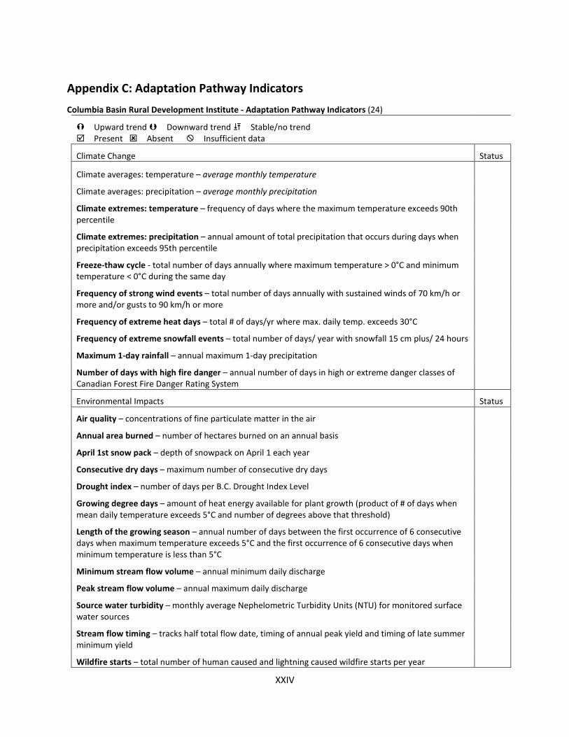
XXIV
Appendix C: Adaptation Pathway Indicators Columbia Basin Rural Development Institute - Adaptation Pathway Indicators (24)
Upward trend Downward trend Stable/no trend Present Absent Insufficient data
Climate Change Status
Climate averages: temperature – average monthly temperature
Climate averages: precipitation – average monthly precipitation
Climate extremes: temperature – frequency of days where the maximum temperature exceeds 90th percentile
Climate extremes: precipitation – annual amount of total precipitation that occurs during days when precipitation exceeds 95th percentile
Freeze-thaw cycle - total number of days annually where maximum temperature > 0°C and minimum temperature < 0°C during the same day
Frequency of strong wind events – total number of days annually with sustained winds of 70 km/h or more and/or gusts to 90 km/h or more
Frequency of extreme heat days – total # of days/yr where max. daily temp. exceeds 30°C
Frequency of extreme snowfall events – total number of days/ year with snowfall 15 cm plus/ 24 hours
Maximum 1-day rainfall – annual maximum 1-day precipitation
Number of days with high fire danger – annual number of days in high or extreme danger classes of Canadian Forest Fire Danger Rating System
Environmental Impacts Status
Air quality – concentrations of fine particulate matter in the air
Annual area burned – number of hectares burned on an annual basis
April 1st snow pack – depth of snowpack on April 1 each year
Consecutive dry days – maximum number of consecutive dry days
Drought index – number of days per B.C. Drought Index Level
Growing degree days – amount of heat energy available for plant growth (product of # of days when mean daily temperature exceeds 5°C and number of degrees above that threshold)
Length of the growing season – annual number of days between the first occurrence of 6 consecutive days when maximum temperature exceeds 5°C and the first occurrence of 6 consecutive days when minimum temperature is less than 5°C
Minimum stream flow volume – annual minimum daily discharge
Peak stream flow volume – annual maximum daily discharge
Source water turbidity – monthly average Nephelometric Turbidity Units (NTU) for monitored surface water sources
Stream flow timing – tracks half total flow date, timing of annual peak yield and timing of late summer minimum yield
Wildfire starts – total number of human caused and lightning caused wildfire starts per year

XXV
Upward trend Downward trend Stable/no trend Present Absent Insufficient data
INDICATOR AND DESCRIPTION
Adaptation Actions & Capacity Building Status
Campfire bans – number of days each year with a B.C. Wildfire Management Branch issued campfire ban
Community food production – number of people in the community who grow at least a small portion of their own food
Emergency preparedness plan – presence of an emergency preparedness plan, including a community evacuation plan that has been updated within the last 5 years
Fire Smart-recognized community – recognition through Fire Smart Canada's Community Recognition Program
Interface fire risk reduction – percentage of mapped high priority area that has been treated to reduce wildfire risk
Policies to reduce water consumption – implementation of policies/practices that have incorporated water consumption considerations in legislation
Residents with 72-hour emergency preparedness kits – proportion of residents with 72-hour emergency preparedness kits
Community Impacts & Adaptation Outcomes Status
Amount of area being farmed – annual number of hectares being farmed
Cost of fire suppression – total amount of money spent on fire suppression annually
Drinking water quality – length of drinking water advisories or boil water notices annually
Fire-related highway closures – number (per year) and/or duration (hours) of highway closures due to wildfire
Frequency of interface fires – annual number of wildfires within 2 km
Implementation of water restrictions – number of days annually where water restrictions are active
Per capita water consumption – volume of total water supplied annually, reported by utility and expressed per capita
Water loss – percentage of water supplied annually that is lost to leakage
Water reservoir levels – number of weeks per year with at least one drawn down day
Weather-related highway closures – number (per year) and/or duration (hours) of highway closures caused by landslides, avalanche, snow, wind, or freezing rain
Wildfire evacuation orders – number of evacuation orders due to the threat of wildfire issued by the wildfire protection branch

XXVI
References
1. NRM Regions Australia. What is NRM? [Internet]. 2019 [cited 2019 Apr 2]. Available from:https://nrmregionsaustralia.com.au/what-is-nrm/
2. Wallis P, Harwood A, Leith P, Hamilton L, Bosomworth K, Turner S, et al. Southern SlopesInformation Portal Report: Climate change adaptation information for natural resource planningand implementation [Internet]. Southern Slopes Climate Change Adaptation ResearchPartnership (SCARP), editor. Melbourne: Monash University, University of Tasmania, RMITUniversity; 2015. 185 p. Available from: https://www.terranova.org.au/repository/southern-slopes-nrm-collection/southern-slopes-information-portal-report-climate-change-adaptation-information-for-natural-resource-planning-and-implementation-1/southern-slopes-information-portal-report.pdf/view
3. Serrao-Neumann S, Cox M, Schuch G, Low Choy D. Adaptation Pathways [Internet]. 2015.Available from: https://www.terranova.org.au/repository/east-coast-nrm-collection/planning-packages
4. Siebentritt MA, Stafford Smith M. A User’s Guide to Applied Adaptation Pathways [Internet].2016. Available from: www.adaptationpathways.net
5. Abbott G, Chapman M. Addressing the New Normal: 21st Century Disaster Management inBritish Columbia [Internet]. 2018. Available from: https://www2.gov.bc.ca/assets/gov/public-safety-and-emergency-services/emergency-preparedness-response-recovery/embc/bc-flood-and-wildfire-review-addressing-the-new-normal-21st-century-disaster-management-in-bc-web.pdf
6. OAG-BC. Managing climate change risks: An independent audit [Internet]. 2018. Available from:https://www.bcauditor.com/sites/default/files/publications/reports/Climate_Change_FINAL.pdf
7. Metro Vancouver. Climate Projections For Metro Vancouver [Internet]. 2016. Available from:http://www.metrovancouver.org/services/air-quality/climate-action/regional-program/Pages/default.aspx
8. Burch S. Transforming barriers into enablers of action on climate change: Insights from threemunicipal case studies in British Columbia, Canada. Glob Environ Chang [Internet].2010;20(2):287–97. Available from:https://www.sciencedirect.com/science/article/pii/S0959378009001046
9. Government of British Columbia. Clean BC [Internet]. Victoria; 2019. Available from:https://cleanbc.gov.bc.ca/
10. Oulahen G, Klein Y, Mortsch L, O’Connell E, Harford D. Barriers and Drivers of Planning forClimate Change Adaptation across Three Levels of Government in Canada. Plan Theory Pract.2018;19(3):405–21.
11. Sheppard SRJ. Visualizing Climate Change : A Guide to Visual Communication of Climate Changeand Developing Local Solutions. Hoboken: Taylor and Francis; 2012.
12. B. C. Ministry of Agriculture. AgFocus Field Guide [Internet]. 2017 [cited 2019 Jun 25]. Availablefrom: https://www2.gov.bc.ca/assets/gov/farming-natural-resources-and-industry/agriculture-and-seafood/agricultural-land-and-environment/strengthening-farming/agfocus/agfocusfieldguide_20170707.pdf

XXVII
13. Thomas A. British Columbia’s Early Adoption of Agricultural Climate Adaptation Programming[Internet]. Victoria BC; 2015. Available from:http://www.iica.int/sites/default/files/publications/files/2016/B4017i.pdf
14. Ministry of Environment and Climate Change Strategy. Preliminary Strategic Climate RiskAssessment for British Columbia. Report prepared for the Government of British Columbia,Victoria, BC; 2019.
15. BC Agriculture and Food Climate Action Initiative. BC Agriculture & FoodClimate Action Initiative:Home [Internet]. 2019. Available from: https://www.bcagclimateaction.ca/
16. Province of British Columbia. Draft Principles that Guide the Province of British Columbia’sRelationship with Indigenous Peoples [Internet]. Victoria, BC; 2018 [cited 2019 Jul 3]. Availablefrom: https://www2.gov.bc.ca/gov/content/governments/indigenous-people/new-relationship/about-the-ten-principles
17. Wise RM, Fazey I, Stafford Smith M, Park SE, Eakin HC, Archer Van Garderen ERM, et al.Reconceptualising adaptation to climate change as part of pathways of change and response.Glob Environ Chang. 2014;28:325–36.
18. Prober SM, Colloff MJ, Abel N, Crimp S, Doherty MD, Dunlop M, et al. Informing climateadaptation pathways in multi-use woodland landscapes using the values-rules-knowledgeframework. Agric Ecosyst Environ. 2017;241:39–53.
19. Haasnoot M, Middelkoop H, Offermans A, van Beek E, van Deursen WPA. Exploring pathways forsustainable water management in river deltas in a changing environment. Clim Change.2012;115(3–4):795–819.
20. Rosenzweig C, Solecki W. Hurricane Sandy and adaptation pathways in New York: Lessons from afirst-responder city. Glob Environ Chang [Internet]. 2014;28:395–408. Available from:https://ntrs.nasa.gov/archive/nasa/casi.ntrs.nasa.gov/20140017430.pdf
21. Haasnoot M, Kwakkel JH, Walker WE, ter Maat J. Dynamic adaptive policy pathways: A methodfor crafting robust decisions for a deeply uncertain world. Glob Environ Chang [Internet].2013;23(2):485–98. Available from:https://www.sciencedirect.com/science/article/pii/S095937801200146X
22. Fünfgeld H, McEvoy D. Frame divergence in climate change adaptation policy: insights fromAustralian local government planning. Environ Plan C Gov Policy [Internet]. 2014;32(4):603–22.Available from: https://www.sciencedirect.com/science/article/pii/S095937801830445X
23. Haasnoot M, van ’t Klooster S, van Alphen J. Designing a monitoring system to detect signals toadapt to uncertain climate change. Glob Environ Chang [Internet]. 2018;52(September):273–85.Available from: https://doi.org/10.1016/j.gloenvcha.2018.08.003
24. Columbia Basin Trust. Indicators of Climate Adaptation in the Columbia Basin [Internet]. 2015[cited 2019 May 3]. Available from: http://www.cbrdi.ca/Projects/Climate-Adaptation
25. Kingsborough A, Borgomeo E, Hall JW. Adaptation pathways in practice: Mapping options andtrade-offs for London’s water resources. Sustain Cities Soc. 2016;27:386–97.
26. Bush E, Lemmen DS, editors. Canada’s Changing Climate Report [Internet]. Ottawa, ON:Government of Canada; 2019. 444 p. Available from: www.ChangingClimate.ca/CCCR2019
27. Carlson D. Preparing for Climate Change: an implementation guide for local governments in

XXVIII
British Columbia [Internet]. West Coast Environmental Law; 2012. Available from: http://www.toolkit.bc.ca/Resource/Preparing-Climate-Change-Implementation-Guide-Local-Governments-British-Columbia
28. McLachlan I, Charlton S, Tyler S. Pilot Application: Adaptive Design & Assessment Policy Tool (ADAPTool). 2013;(December):82. Available from: https://www.iisd.org/pdf/2014/adaptool_bc_ag.pdf
29. BC Agriculture & Food Climate Action Initiative. BC Agriculture Climate Change Adaptation Risk + Opportunity Assessment: Provincial Report [Internet]. British Columbia Agriculture & Food Climate Action Initiative, Victoria BC; 2012 [cited 2019 Dec 12]. Available from: https://www.bcagclimateaction.ca/wp/wp-content/media/AdaptROseries-Provincial.pdf
30. Howden SM, Soussana J-F, Tubiello FN, Chhetri N, Dunlop M, Meinke H. Adapting Agriculture to Climate Change: Preparing Austrailia. PNAS [Internet]. 2007;104(50):19691–6. Available from: https://www.pnas.org/content/pnas/104/50/19691.full.pdf
31. Klein RJT, Midgley GF, Preston BL, Alam M, Berkhout FGH, Dow K, et al. Adaptation Opportunities, Constraints, and Limits. In: Field CB, Barros VR, Dokken DJ, Mach KJ, Mastrandrea MD, Bilir TE, et al., editors. Climate Change 2014: Impacts, Adaptation, and Vulnerability Part A: Global and Sectoral Aspects Contribution of Working Group II to the Fifth Assessment Report of the Intergovernmental Panel on Climate Change. Cambridge UK: Cambridge University Press; 2014. p. 899–943.
32. O’Connell D, Walker B, Abel N, Grigg N. The Resilience , Adaptation and Transformation Assessment Framework: from theory to application. 2015;96. Available from: http://www.stapgef.org/stap/wp-content/uploads/2015/03/CSIRO-STAP-Resilience-Adaptation-Transformation-Assessment-Framework-Report.pdf
33. Sobie SR, Murdock TQ. High-resolution statistical downscaling in southwestern British Columbia. J Appl Meteorol Climatol [Internet]. 2017;56(6):1625–41. Available from: https://journals.ametsoc.org/doi/full/10.1175/JAMC-D-16-0287.1
34. Rissik D, Boulter S, Doerr V, Marshall N, Hobday A, Lim-camacho L. The NRM Adaptation Checklist: Supporting climate adaptation planning and decision--making for regional NRM. [Internet]. CSIRO and NCCARF; 2014. Available from: http://adaptnrm.csiro.au/wp-content/uploads/2014/06/AdaptNRM-Adapt-Planning-Tech-Guide1.pdf
35. Wise RM, Capon TR. Assessing costs and benefits of coastal climate adaptation. CoastAdapt Information Manual 4 [Internet]. Gold Coast: National Climate Change Adaptation Research Facility; 2016. Available from: https://coastadapt.com.au/sites/default/files/information-manual/IM04_Costs_and_benefits.pdf
36. Marushka L, Kenny TA, Batal M, Cheung WWL, Fediuk K, Golden CD, et al. Potential impacts of climate-related decline of seafood harvest on nutritional status of coastal First Nations in British Columbia, Canada. PLoS One. 2019;14(2):1–24.
37. Dilling L, Daly ME, Travis WR, Wilhelmi O V., Klein RA. The dynamics of vulnerability: why adapting to climate variability will not always prepare us for climate change. Wiley Interdiscip Rev Clim Chang [Internet]. 2015;6(4):413–25. Available from: https://sciencepolicy.colorado.edu/admin/publication_files/2015.24.pdf
38. Simms R, Brandes OM. Top 5 water challenges that will define British Columbia’s future [Internet]. POLIS Project on Ecological Governance, Centre for Global Studies, University of
XXIX
Victoria; 2016. 1–32 p. Available from: http://poliswaterproject.org/sites/default/files/POLIS-Top5-final-web-v2.pdf
39. Janowiak M, Dostie D, Wilson M, Kucera M, Howard Skinner R, Hatfield J, et al. Adaptation Resources for Agriculture: Responding to Climate Variability and Change in the Midwest and Northeast [Internet]. Technical Bulletin 1944. Washington, DC: U.S. Department of Agriculture.; 2016. Available from: https://www.climatehubs.oce.usda.gov/sites/default/files/adaptation_resources_workbook_ne_mw.pdf
40. Crawford E, Beveridge R. Strengthening BC’s Agriculture Sector in the Face of Climate Change [Internet]. 2013. Available from: https://pics.uvic.ca/sites/default/files/uploads/publications/Strengthening BC’s Agriculture Sector_0.pdf
41. Social Planning and Research Council of B.C. Community Engagement Toolkit [Internet]. SPARC BC; 2013. 47 p. Available from: http://www.sparc.bc.ca/wp-content/uploads/2017/03/community-engagement-toolkit.pdf
42. Intergovernmental Panel on Climate Change. SREX: Managing the Risks of Extreme Events and Disasters to Advance Climate Change Adaptation. A Special Report of Working Groups I and II of the Intergovernmental Panel on Climate Change [Internet]. Cambridge, UK, and New York, NY, USA: Cambridge University Press; 2012. Available from: https://www.ipcc.ch/site/assets/uploads/2018/03/SREX_Full_Report-1.pdf
43. Lyle G. Understanding the nested, multi-scale, spatial and hierarchical nature of future climate change adaptation decision making in agricultural regions: A narrative literature review. J Rural Stud [Internet]. 2015;37:38–49. Available from: http://dx.doi.org/10.1016/j.jrurstud.2014.10.004
44. Ellis F. Rural livelihoods and diversity in developing countries. Nat Resour Perspect [Internet]. 1999;40. Available from: https://www.odi.org/sites/odi.org.uk/files/odi-assets/publications-opinion-files/2881.pdf
45. Li G, Dovers S. Integrated Assessment of Climate Change Impacts on Urban Settlements: Lessons from Five Australian Cases. In: Berrang-Ford L, Ford JD, editors. Climate change adaptation in developed nations: from theory to practice. Springer; p. 289–302.
46. Jacobs, B., Nelson, R., Kuruppu, N., and Leith P. An Adaptive Capacity Guide Book [Internet]. Hobart: University of Technology Sydney and University of Tasmania; 2015. 27 p. Available from: https://terranova.org.au/repository/southern-slopes-nrm-collection/an-adaptive-capacity-guide-book-assessing-building-and-evaluating-the-capacity-of-communities-to-adapt-in-a-changing-climate-3/scarp-adaptive-capacity-guide.pdf
47. Gorddard R, Colloff MJ, Wise RM, Ware D, Dunlop M. Values, rules and knowledge: Adaptation as change in the decision context. Environ Sci Policy [Internet]. 2016;57:60–9. Available from: https://www.sciencedirect.com/science/article/pii/S1462901115301210
48. Wilby RL, Tye MR, Ekström M, Kirono DGC, Gutmann ED. Robustness of hydroclimate metrics for climate change impact research. Wiley Interdiscip Rev Water [Internet]. 2018;5(4):e1288. Available from: https://onlinelibrary.wiley.com/doi/full/10.1002/wat2.1288
49. Giles A, Fanning L, Denny S, Paul T. Improving the American Eel Fishery Through the Incorporation of Indigenous Knowledge into Policy Level Decision Making in Canada. Hum Ecol. 2016;44(2):167–83.

XXX
50. Brugnach M, Craps M, Dewulf A. Including indigenous peoples in climate change mitigation: addressing issues of scale, knowledge and power. Clim Change. 2017;140(1):19–32.
51. Bosomworth K, Harwood A, Leith P, Wallis P. Adaptation Pathways: a playbook for developing robust options for climate change adaptation in NRM [Internet]. 2015 [cited 2019 Mar 4]. Available from: https://terranova.org.au/repository/southern-slopes-nrm-collection/adaptation-pathways-a-playbook-for-developing-options-for-climate-change-adaptation-in-natural-resource-management/scarp-adaptation-pathways-a-playbook-final.pdf
52. IPCC. Climate Change 2014: Synthesis Report. Contribution of Working Groups I, II and III to the Fifth Assessment Report of the Intergovernmental Panel on Climate Change [Internet]. Pachauri R, Allen M, Barros V, Broome J, Cramer W, Christ R, et al., editors. Geneva, Switzerland: IPCC; 2014. Available from: https://www.ipcc.ch/site/assets/uploads/2018/05/SYR_AR5_FINAL_full_wcover.pdf
53. Neilsen D, Bakker M, Van der Gulik T, Smith S, Cannon A, Losso I, et al. Landscape Based Agricultural Water Demand Modeling—A Tool for Water Management Decision Making in British Columbia, Canada. Front Environ Sci [Internet]. 2018 Aug 3;6. Available from: https://www.frontiersin.org/articles/10.3389/fenvs.2018.00074/full
54. BC Agriculture & Food Climate Action Initiative. Okanagan - Farm Water Use Planning: Pilot project [Internet]. Summary Report, Victoria BC; 2018. Available from: https://www.bcagclimateaction.ca/wp/wp-content/media/OK03-Farm-Water-Use-Planning-Pilot-2018-summary.pdf
55. Nelson L. Expanding Cherry Production in British Columbia under Climate Change. Final Report BC Farm Adaptation Innovator Program [Internet]. 2018 [cited 2019 Apr 2]. Available from: https://www.bcagclimateaction.ca/faip-project/fi12/
56. CWB. Pathways and Partnerships: A Framework for Collaboration and Reconciliation in the Cowichan Watershed [Internet]. 2018 [cited 2019 Jan 20]. Available from: http://www.cowichanwatershedboard.ca/document/pathways-and-partnerships-framework-collaboration-and-reconciliation-cowichan-watershed
57. Capital Region District. Climate projections for the Capital Region. 2017;(APRIL):59. Available from: https://www.crd.bc.ca/docs/default-source/climate-action-pdf/reports/2017-07-17_climateprojectionsforthecapitalregion_final.pdf
58. CVRD. Climate Projections for the Cowichan Valley Regional District [Internet]. 2017. 1–10 p. Available from: https://www.cvrd.bc.ca/DocumentCenter/View/81884
59. Walker WE, Haasnoot M, Kwakkel JH. Adapt or perish: A review of planning approaches for adaptation under deep uncertainty. Sustain. 2013;5(3):955–79.
60. Coulter L. User Guide for the Climate Change Adaptation Pathways Framework: Supporting Sustainable Local Food in B.C. Prepared for the B.C. Ministry of Agriculture through the 2018-19 Mitacs Science Policy Fellowship. Victoria.; 2019.
61. Christiansen L, Martinez G, Naswa P (eds. . Adaptation metrics: Perspectives on measuring, aggregating and comparing adaptation results [Internet]. Copenhagen; 2018. Available from: https://unepdtu.org/publications/adaptation-metrics-perspectives-on-measuring-aggregating-and-comparing-adaptation-results/
62. IPCC. Global Warming of 1.5°C. Summary for Policymakers [Internet]. 2018. Available from:

XXXI
http://report.ipcc.ch/sr15/pdf/sr15_spm_final.pdf
63. Larsen RK, Swartling ÅG, Powell N, May B, Plummer R, Simonsson L, et al. A framework for facilitating dialogue between policy planners and local climate change adaptation professionals: Cases from Sweden, Canada and Indonesia. Environ Sci Policy [Internet]. 2012;23:12–23. Available from: https://www.sciencedirect.com/science/article/pii/S1462901112000949
64. Moser SC, Ekstrom JA. A framework to diagnose barriers to climate change adaptation. PNAS [Internet]. 2010;107(51):22026–31. Available from: https://www.pnas.org/content/107/51/22026
65. Kerr Wood Leidal Associates. Enhanced collaboration for agricultural drainage and ditch management [Internet]. FV01 - B.C.; 2017. Available from: https://www.bcagclimateaction.ca/
66. Coulter L. Climate Change Adaptation Pathways Framework: Supporting Sustainable Local Food in B.C. Victoria: Prepared for the B.C. Ministry of Agriculture through the 2018-19 Mitacs Science Policy Fellowship; 2019.
67. Forstner T, Gleeson T, Borrett L, Allen DM, Wei M, Baye A. Mapping Aquifer Stress, Groundwater Recharge, Groundwater Use, and the Contribution of Groundwater to Environmental Flows for Unconfined Aquifers across British Columbia. Water Scie. Victoria B.C.: Prov. B.C.; 2018.
68. Warren FJ, Lemmen DS. Canada in a Changing Climate: Sector Perspectives on Impacts and Adaptation [Internet]. Ottawa, ON: Government of Canada; 2014. p. 286. Available from: internal-pdf://228.60.152.36/Canada in a Changing Climate.pdf
69. Council of Canadian Academies. Canada’s Top Climate Change Risks [Internet]. Ottawa, ON: The Expert Panel on Climate Change Risks and Adaptation Potential; 2019. Available from: https://cca-reports.ca/reports/prioritizing-climate-change-risks
70. Neufeld K, Siddhartho P, Smukler SM. Improving On-Farm Drainage Management to Reduce the Impacts of Climate Change in Delta. BC Final Report for the Farm Adaptation Innovator Program (FAIP), British Columbia; 2017.
71. Northwest Hydraulic Consultants Ltd, K&M Consulting, Zbeetnoff Agro-Environmental Inc. Freshet flooding and Fraser Valley agriculture: evaluating impacts and options for resilience [Internet]. FV02. B.C.; 2016. Available from: https://www.bcagclimateaction.ca/
72. Kwadijk JCJ, Haasnoot M, Mulder JPM, Hoogvliet MMC, Jeuken ABM, van der Krogt RAA, et al. Using adaptation tipping points to prepare for climate change and sea level rise: A case study in the Netherlands. Wiley Interdiscip Rev Clim Chang [Internet]. 2010;1(5):729–40. Available from: https://agwaguide.org/docs/Kwadijk_et_al_2010.pdf