agroecosystem analysis of the choke mountain watersheds
TRANSCRIPT
Sustainability 2013, 5, 592-616; doi:10.3390/su5020592
sustainability ISSN 2071-1050
www.mdpi.com/journal/sustainability
Article
Agroecosystem Analysis of the Choke Mountain
Watersheds, Ethiopia
Belay Simane 1,*, Benjamin F. Zaitchik
2 and Mutlu Ozdogan
3
1 College of Development Studies, Addis Ababa University, Addis Ababa, Ethiopia
2 Department of Earth and Planetary Sciences, Johns Hopkins University, Baltimore, MD 21218,
USA; E-Mail: [email protected] 3 Forest and Wildlife Ecology, University of Wisconsin-Madison, Madison, WI 53706, USA;
E-Mail: [email protected]
* Author to whom correspondence should be addressed; E-Mail: [email protected];
Tel.: +251-911-223-044.
Received: 22 October 2012; in revised form: 31 December 2012 / Accepted: 30 January 2013 /
Published: 5 February 2013
Abstract: Tropical highland regions are experiencing rapid climate change. In these
regions the adaptation challenge is complicated by the fact that elevation contrasts and
dissected topography produce diverse climatic conditions that are often accompanied by
significant ecological and agricultural diversity within a relatively small region. Such is the
case for the Choke Mountain watersheds, in the Blue Nile Highlands of Ethiopia.
These watersheds extend from tropical alpine environments at over 4000 m elevation to the
hot and dry Blue Nile gorge that includes areas below 1000 m elevation, and contain a
diversity of slope forms and soil types. This physical diversity and accompanying
socio-economic contrasts demand diverse strategies for enhanced climate resilience and
adaptation to climate change. To support development of locally appropriate climate
resilience strategies across the Blue Nile Highlands, we present here an agroecosystem
analysis of Choke Mountain, under the premise that the agroecosystem—the intersection of
climatic and physiographic conditions with agricultural practices—is the most appropriate
unit for defining adaptation strategies in these primarily subsistence agriculture
communities. To this end, we present two approaches to agroecosystem analysis that can
be applied to climate resilience studies in the Choke Mountain watersheds and, as
appropriate, to other agroecologically diverse regions attempting to design climate
adaptation strategies. First, a full agroecoystem analysis was implemented in collaboration
with local communities. It identified six distinct agroecosystems that differ systematically
OPEN ACCESS

Sustainability 2013, 5 593
in constraints and adaptation potential. This analysis was then paired with an objective
landscape classification trained to identify agroecosystems based on climate and
physiographic setting alone. It was found that the distribution of Choke Mountain
watershed agroecosystems can, to first order, be explained as a function of prevailing
climate. This suggests that the conditions that define current agroecosystems are likely to
migrate under a changing climate, requiring adaptive management strategies.
These agroecosystems show a remarkable degree of differentiation in terms of production
orientation and socio-economic characteristics of the farming communities suggesting
different options and interventions towards building resilience to climate change.
Keywords: climate change; adaptation; agroecosystem; Ethiopia
1. Introduction
Tropical highland regions are among the areas most vulnerable to climate change [1].
This vulnerability is frequently characterized in terms of the magnitude of observed or predicted
change and associated physical sensitivities: tropical highlands are experiencing rapid warming [2] that
threatens species and ecosystems adapted to relatively cool conditions, they tend to include
erosion-prone steep lands with weathered soils that can be destabilized by changes in precipitation
patterns and intensity, and upland meadows, forests, and wetlands are often sensitive to seasonal water
stress that will increase as potential evaporation rises. But vulnerability of ecosystems and human
systems to climate change is a function of adaptive capacity as well as physical exposure. The degree
to which natural ecosystems are pressured by deforestation and the encroachment of agriculture, for
example, will influence the availability of biodiversity refugia as the alpine zone retreats. These land
use pressures also affect the vulnerability of agricultural systems, as land degradation associated with
over-cultivation of headwater regions impacts watershed wide erosion rates and water value for
downstream users. Within active agricultural zones, investment capacity and access to
production-enhancing technologies will influence farmers’ ability to maintain yields and conserve soil
resources under changing climate conditions. This, in turn, strongly influences the total agricultural
area needed to support the food security and economic aspirations of the population.
The adaptation challenge is further complicated by the fact that highland regions tend to be
characterized by high internal diversity, both physical—dissected topography and associated climatic
and hydrological contrasts—and cultural, due in part to the isolating effects of terrain. This diversity of
conditions leads to diversity in the character of vulnerability and in the most physically and culturally
appropriate adaptation strategies. Furthermore, highland populations are often poorer, marginalized
groups with relatively low economic capacity to invest in adaptation.
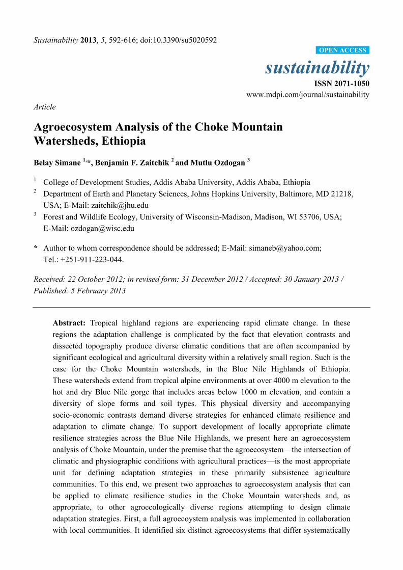
Choke Mountain and its associated watersheds, located in the Blue Nile (Abay) Highlands region of
Ethiopia (Figure 1), is broadly representative of many of these adaptation challenges. Though the
mountain is located in the Ethiopian Highlands, with a peak elevation of more than 4000 m, its
watersheds drain in three directions to the Blue Nile gorge, where elevation drops to below 1000 m.
Over a distance of less than 70 km, then, one finds hot, dry valleys, gently rolling, deep soil midland
Sustainability 2013, 5 594
plains, and cool, wet alpine zones. Complex topography makes for strong local contrasts in
precipitation and temperature, and soils are deeply weathered and erodible over most of the mountain.
While we are not aware of any published studies of rainfall intensity in the Choke Mountain
watersheds, work in the northern Ethiopian Highlands has found that rains in that neighboring region
are characteristically intense and erosive [3]. Given the observed severity of erosion in the Choke
Mountain watersheds, it is possible that erosive rains affect this region as well. The landscape is
dominated by low-input subsistence agriculture, with cultivation extending from the Blue Nile gorge
up to near the summit of the mountain. The alpine zone was, historically, covered in forest and natural
grass and shrublands, but increasing population and associated deforestation and land degradation have
caused cultivation to be extended as high as 3800 meters elevation [4].
Figure 1. The location and topography of Choke Mountain watersheds. In the regional
map, the red line indicates the outline of the Blue Nile River basin and shading is
topography. In the Choke Mountain region inset, colors are topography, blue lines are
major rivers, and grey lines are roads. The watersheds considered in this study run from the
mountain peak to the Blue Nile River.
These pressures have taken a toll on the natural resources of the region. Consultations with
community leaders, agricultural experts, farmers’ cooperatives and other small-scale agri-business
(e.g., tool and grain retailers), and farmers show substantial agreement that Choke ecosystems are
under threat from multiple sources, each posing its own management challenge [5,6]. The natural
resources base (land, water, and biodiversity) is under intense pressure from population growth and
erosion-inducing traditional farming and management practices. The livelihoods of farming
communities face severe constraints related to intensive cultivation, overgrazing and deforestation, soil
erosion and soil fertility decline, water scarcity, livestock feed, and fuel wood demand. Climate change
may already be contributing to these challenges. There has been a perceived increase in extreme rain
Sustainability 2013, 5 595
events, and regional temperatures have exhibited an upward trend over the past 20 years [5,7].
There has been a documented decline in yields in some areas, and portions of the mountain have
deteriorated from food surplus to food deficit areas within 20 years [5,6].
Persistent poverty and declining production within Choke Mountain watersheds has not gone
unnoticed. Government and non-governmental organizations have launched a series of initiatives
promoting agricultural technologies to improve productivity and conserve natural resources. Few of
these initiatives have had a lasting effect, however, as the implementation of new technologies is often
followed quickly by retreat from technology adoption, possibly due to underappreciated local
socioeconomic, cultural, or physical constraints that limit the sustained use of a promoted technology
or technique [8]. ―Local‖ , in the context of a tropical highland region like Choke Mountain and its
watersheds, must be understood to refer to the unique combination of physiography, climate, ecology,
agriculture, and socio-cultural conditions that define a community’s exposure, adaptive capacity, and
vulnerability in the face of resource constraints and climate change. The present study, which is a
foundational component of an ongoing initiative on climate resilient development in the Blue Nile
Highlands region [5], is motivated by the conviction that vulnerability analysis and the design of
resilience building interventions in tropical highlands like the Choke Mountain watersheds region are
inherently location-specific because of the connection between economic development and the local
natural resource base.
The structure of an agroecosystem is a consequence of its environmental setting (e.g., climate, soil,
topography, various organisms in the area), agricultural technologies and practices, and farmers’ social
setting (e.g., human values, institutions and skills) [9]. The primary purpose of mapping
agroecosystems, as carried out for rural land-use planning, is to separate areas with similar sets of
potentials and constraints for development. Specific adaptation strategies and programs can then be
formulated to provide the most effective support for each zone.
The general objective of this study was define the different agro-ecosystems of the Choke Mountain
watersheds i.e., to define areas with fairly homogenous biophysical and socioeconomic conditions to
suggest promising direction for further in-depth research and development plans. The analysis reveals
key agricultural, forestry and socio-economic issues and problems for each zone, for which solutions
can be proposed, some through research and others by extension and development.
The specific objectives of the present study are to identify and describe the important components
of the different agroecosystems (system definition) using participatory and objective approaches, to
identify constraints and opportunities for management of the different agroecosystems (pattern
analysis), and to assess possible ways to overcome constraints to design research and development
options (formulation of adaptation strategies).
2. The Choke Mountain Watersheds
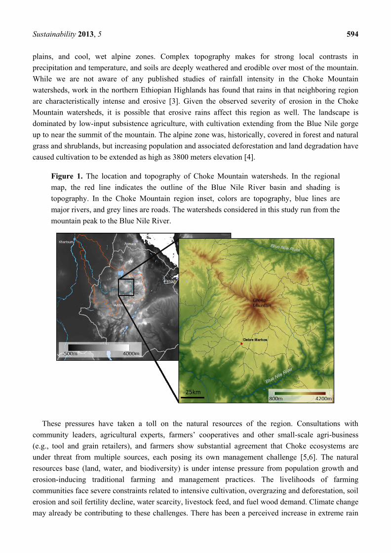
Precipitation in the Choke Mountain region is tightly correlated with the annual migration of the
Inter-tropical Convergence Zone (ITCZ), with most rain falling during the May–October kiremt rainy
season. As shown in Figure 2A, the distribution of precipitation across the mountain is not uniform;
the western slopes tend to be wetter than the eastern slopes, with driest conditions found in the Blue
Sustainability 2013, 5 596
Nile gorge. Interannual variability in precipitation has significant impacts on agricultural production
and soil erosion rates. Mean annual temperature declines with elevation (Figure 2B).
Prevailing soil types (Figure 2C; described in Section 3.1.) are volcanic in origin, derived from
Mio-Pliocene shield volcano lavas and, at lower elevations, Oligocene flood basalts [10].
Under undisturbed conditions, soils tend to be deep: natural depths can extend to several meters, with
rooting depths in this portion of the Ethiopian Highlands extending to one meter [11]. These deep,
weathered tropical soils are highly susceptible to erosion, and on lands in the western Ethiopian
Highlands cultivated using traditional methods the rate of soil loss can exceed the rate of soil
generation by a factor of 4 to 10 [11]—a pattern that has been attributed in part to the prevalence of
traditional ox-drawn tillage systems that have been found to promote rapid erosion on other regions of
the Ethiopian Highlands [12], and that have been implicated in enhanced erosion in the Choke
Mountain region [6]. High rates of on-field erosion are particularly problematic given that nutrients in
soils of this region tend to be concentrated in the upper portion of the soil column [13]. On-field soil
loss also leads to reduced water holding capacity and faster concentration of water on the landscape,
which contributes to large volume gully erosion and sediment transport [14]. Combined erosion
processes have led to dramatic soil loss, particularly from steep slopes, and significant declines in
soil productivity.
Figure 2. (A) Mean annual rainfall from the Tropical Rainfall Measurement Mission
(TRMM) satellite, product 3B42, as described in [15], (B) Mean annual temperature
downscaled from Global Data Assimilation System [15], and (C) dominant soil types
from the FAO global soil map (nominally at scale 1:5,000,000) [16] for Choke
Mountain watersheds.
Sustainability 2013, 5 597
Agriculture in the Choke Mountain watersheds is diverse, but can generally be characterized as
crop-livestock mixed systems, practiced by independent farmers on small plots. Choke Mountain
watershed farms average 0.5 hectares in size, and farmers in the cereal production zone cultivate tef,
maize, and wheat, supplemented by barley and potato for home or local consumption [4,5]. Animals
include cows, oxen, sheep, and horses. A defining characteristic of cropping systems throughout the
Ethiopian Highlands is the use of the ancient Ethiopian ard (or maresha) plow for tillage. This simple
wooden ox-drawn plow is well suited for tropical vertic soils because it breaks through hard, dry
topsoils. It is also, however, an instrument associated with tillage practices that lead to high rates of
on-field erosion, particularly on steep slopes, and the development of a hard, infiltration-limiting plow
pan. Overgrazing and deforestation have also contributed to erosion and soil fertility decline in Choke
Mountain watersheds, and livestock feed shortages and fuel wood demands continue to exert
significant pressure on the resource base.
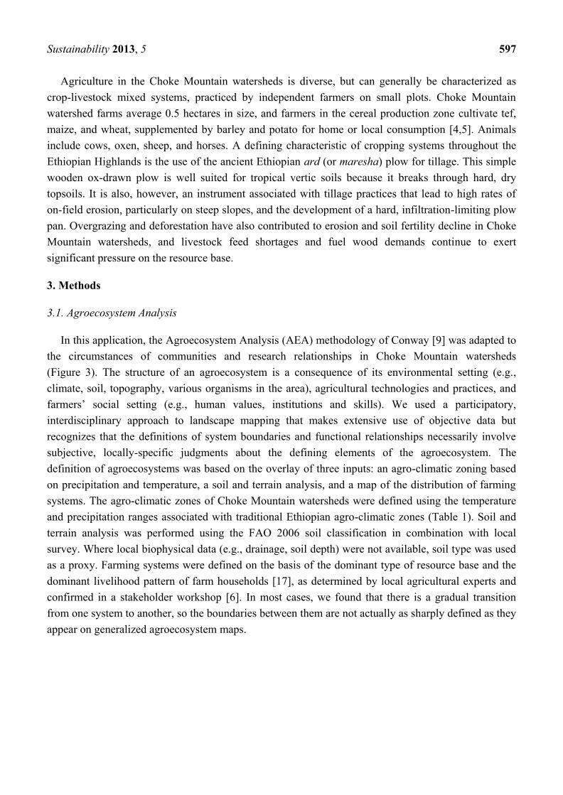
3. Methods
3.1. Agroecosystem Analysis
In this application, the Agroecosystem Analysis (AEA) methodology of Conway [9] was adapted to
the circumstances of communities and research relationships in Choke Mountain watersheds
(Figure 3). The structure of an agroecosystem is a consequence of its environmental setting (e.g.,
climate, soil, topography, various organisms in the area), agricultural technologies and practices, and
farmers’ social setting (e.g., human values, institutions and skills). We used a participatory,
interdisciplinary approach to landscape mapping that makes extensive use of objective data but
recognizes that the definitions of system boundaries and functional relationships necessarily involve
subjective, locally-specific judgments about the defining elements of the agroecosystem. The
definition of agroecosystems was based on the overlay of three inputs: an agro-climatic zoning based
on precipitation and temperature, a soil and terrain analysis, and a map of the distribution of farming
systems. The agro-climatic zones of Choke Mountain watersheds were defined using the temperature
and precipitation ranges associated with traditional Ethiopian agro-climatic zones (Table 1). Soil and
terrain analysis was performed using the FAO 2006 soil classification in combination with local
survey. Where local biophysical data (e.g., drainage, soil depth) were not available, soil type was used
as a proxy. Farming systems were defined on the basis of the dominant type of resource base and the
dominant livelihood pattern of farm households [17], as determined by local agricultural experts and
confirmed in a stakeholder workshop [6]. In most cases, we found that there is a gradual transition
from one system to another, so the boundaries between them are not actually as sharply defined as they
appear on generalized agroecosystem maps.
Sustainability 2013, 5 598
Figure 3. Conceptual framework for agroecosystems analysis and adaptation planning in
Choke Mountain watersheds.
Table 1. Traditional climatic zones and their typical physical characteristics.
Classifications and associated climatic conditions are from [18,19].
Traditional
Zone Climate Altitude (m)
Average annual
temperature
(°C)
Average annual
rainfall (mm)
Bereha hot arid <500 >27.5 <200
Kola warm semiarid 500–1500/1800 27.5–20.0 200–800
Woinadega cool sub-humid 1500/1800–2300/2400 20.0–17.5/16.0 800–1200
Dega cool and humid 2300/2400–3200 17.5/16.0–11.5 1200–2200
Wurch cold and moist above 3200 <11.5 above 2200
These three sources of information were combined to define the major agroecosystems.
Secondary literature was used to develop a preliminary structure and criteria for differentiation, which
was subsequently refined in collaboration with experts and farmers in our discussions with Choke
Mountain watershed communities. This resulted in the distinction of six major agroecosystems.
After defining agroecosystems, we performed pattern, productivity and sustainability assessment.
Pattern analysis is the identification of constraints and opportunities for the management of the system,
while productivity and sustainability assessment focus on key questions about the functioning of the
system, especially with respect to possible ways to overcome constraints to enhance productivity and
sustainability to design research and development options. These analyses began with an objective
productivity potential assessment based on soil and terrain conditions conducted using the FAO
revised Framework for Land Evaluation [17]. Then, a full pattern, productivity and sustainability
assessment was performed through a series of questionnaires and focus-group discussions, facilitated
by local agriculture researchers and complemented by observations made by the researchers.
The assessment includes physical and realizable productivity potentials and existing production
constraints to suggest future adaptation intervention directions through participatory analysis.
Sustainability 2013, 5 599
3.2. Objective Landscape Classification
The local, expert-informed nature of AEA yields important information on decision making,
perceived system characteristics, and social-ecological dynamics that are exceedingly difficult to
capture using automated, fully objective classification methods. Nevertheless, automated objective
classification that is informed by the results of a full AEA provides a number of useful capabilities that
are complementary to the AEA itself. For one, automated classification can increase confidence in the
interpolation and (moderate) extrapolation of agroecological systems maps to areas that had poor
coverage in the participatory AEA process. Detailed social information may be incomplete in these
areas, but the close association between landscape characteristics and farming ecology within many
subsistence agriculture regions and the availability of satellite data to characterize land use and
cropping systems can allow for reasonable estimation of system boundaries. Second, automated
classification systems can be designed to provide information on variable importance in the definition
of agroecological systems. A classification algorithm trained on data collected in traditional AEA, for
example, may show that elevation is the most important predictive factor distinguishing between two
agroecosystems, while human activities (e.g., widespread plantation forest) may distinguish a third
agroecosystem. This information is very useful when evaluating management options and the
physical—though not necessarily cultural—transferability of crops and conservation techniques
between systems.
Insomuch as present-day agroecosystems are constrained by climate conditions, it is possible to
project physically optimal migration of agroecosystems in an evolving climate. If, in addition to
climate, soils or local topography are defining criteria for agroecosystems then we might anticipate
changing productivity patterns as new combinations of quasistatic (soil type, slope) and evolving
(precipitation, temperature) variables emerge. In cases where the present distribution of
agroecosystems is primarily a function of farmer preference rather than physical constraints,
physically-based objective agroecosystem classification will perform poorly and the agroecosystem
may, in fact, not be the most appropriate unit for defining adaptation strategies.
In order to understand the relative contribution of climate and physical setting to the definition of
agroecosystems, we performed an objective landscape classification using climatic and physiographic
variables and information on soil type. Climatic variables included mean annual and mean seasonal
precipitation and temperature estimates drawn from the WorldClim global gridded 1 km
climatologies [20]. WorldClim grids are derived by interpolating mean monthly weather data from
meteorological stations belonging to the Global Historical Climatology Network (GHCN), the FAO,
the WMO, the International Center for Tropical Agriculture (CIAT), R-HydroNet, and minor
additional networks. Interpolation is performed by applying the ANUSPLIN thin plate moving spline
interpolation algorithm to these station data, with Shuttle Radar Topography Mission (SRTM)
elevation data, latitude, and longitude included as independent variables. Climatological averages are
calculated using 1960–1990 data, or in some cases 1950–2000 data.
Physiographic variables, including slope, elevation, aspect, and topographic moisture index were
calculated using 90 m resolution SRTM data. Information on predominant soil type was drawn from
the FAO global soil map database.
Sustainability 2013, 5 600
Classification was performed using the open-source decision tree (DT) classifier C4.5 modified to
perform classifications on binary datasets. DTs are non-parametric, hierarchical classifiers that predict
class membership by recursively partitioning original data sets into increasingly homogeneous,
mutually exclusive subsets via a branched system of data splits [21]. Key components of DTs are
internal nodes, terminal nodes, and branches. At each internal node, the optimal independent variable
and threshold value are identified that result in the best possible data split based on statistical
deviance [22]. Once the classification structure is established, each observation (pixel) from the dataset
to which the DT is applied is passed through the tree and assigned to the class of the leaf node into
which it falls.
A key feature of DTs is pruning, designed to mitigate overfitting and make the trees more
parsimonious to improve predictive power across unseen samples. Pruning involves removing parts of
the tree (splits) that are expected to have a relatively high error rate or contribute little to reducing the
deviance in the training data.
Boosting is another feature of more modern DT modeling that generates multiple classifiers
(decision trees) rather than a single classifier, in an effort to improve classification accuracy.
Applied to C4.5, boosting optimizes multiple classifiers using a base classification algorithm in an
iterative fashion while systematically varying the training sample to emphasize difficult-to-classify
cases from previous iterations. The final classification output is produced by a weighted voting scheme
across the multiple classifiers [23]. In this sense, the boosted classification can be understood as a
consensus of multiple decision trees. While any number of iterations can be performed, traditionally
10 iterations have been used for most previous mapping efforts where boosting was employed [22–25].
To determine the importance variables that contribute to the definition of each agroecosystems
(AES), we also used a numerical method called Random Forests (RF), which is related to the DTs
described above. Random forests are a combination of tree predictors such that each tree depends on
the values of a random vector sampled independently and with the same distribution for all trees in the
forest [26]. The generalization error for forests converges to a limit as the number of trees in the forest
becomes large. The generalization error of a forest of tree classifiers depends on the strength of the
individual trees in the forest and the correlation between them. Using a random selection of features to
split each node, yields error rates that compare favorably to existing boosting algorithms but are more
robust with respect to noise. Internal estimates monitor error, strength, and correlation and these are
used to show the response to increasing the number of features used in the splitting. Internal estimates
are also used to measure variable importance, which is particularly important in determining the
underlying environmental controls of each AES.
In RF, the variable importance is measured in two ways: (1) Mean decrease in accuracy, which
measures how much inclusion of a predictor in the model reduces classification error; and (2) Mean
decrease in Gini coefficient—here used as a measure of ―node impurity‖ in the tree-based
classification. A low Gini (i.e., larger decrease in Gini) means that a particular predictor variable plays
a greater role in partitioning the data into the defined classes. In this application, we use both of these
measures to define the importance of environmental variables with respect to defining each AES.
Using the climatic and physiographic inputs described above, the C4.5 DT algorithm with boosting
was trained using 141 ground truth points identified by their location and their membership in one of
Sustainability 2013, 5 601
the six agroecosystems defined in Table 1. We then applied the trained DT to the entire gridded dataset
of predictor variables, producing an objective map of landscape categories.
3.3. Identification of Adaptation Options
Finally, specific adaptation strategies and development programs were formulated in consultation
with local agricultural experts, informed by farmer interviews and discussion fora, to build climate
resilient and sustainable agricultural development for each agroecosystem. Adaptation strategies
specific to the different agroecosystems were evaluated for three objectives:
(1) Address the problem of low livelihood assets. Such activities generally aim to reduce poverty
and other problems associated with a lack of capabilities, for example through improving
livelihoods. Although these activities do not address specific climate change impacts, they do
help buffer actors from climate trends and shocks [27] and therefore build resilience.
This means that resilience is at the core of adaptation actions.
(2) Build adaptive capacity. These activities specifically address a household or community’s
ability to respond to climate changes (e.g., communicating climate change information,
building awareness of potential impacts, investing in livelihood capital), which is a function
of livelihood assets in combination with climate change awareness and understanding of
potential impacts.
(3) Transform adaptive capacity into action. These activities focus on reducing the cumulative
impacts of climate change, ensuring that no externalities occur from adaptation actions
(e.g., adaptation by one actor does not adversely affect other actors), avoiding anticipated
adverse impacts of climate change and ensuring that the distributional impacts of adaptations
are minimized [28].
We also recognize that adaptation, for both ecosystems and human systems, is a process that
requires the engagement of a wide range of stakeholders at multiple levels and in multiple sectors.
It requires analysis of current exposure to climate shocks and stresses and model-based projections of
future climate impacts. It demands an understanding of the existing vulnerability and adaptive capacity
of households and communities within each agrosystem, as well as an appreciation for the specific
development and policy choices available to the local government. The current study is limited to the
adaptation objectives of participating stakeholders and the knowledge of agroecological systems,
climate sensitivities, and policy options available to the researchers and stakeholders. No attempt is
made in the current study to project future climate trends. Rather, adaptation options to a range of
potential climate threats are considered.
In this context, the adaptation options presented in this study are a qualitative summary of
the leading themes that emerged from community discussion fora and expert workshops.
The discussion fora were transcribed by researchers and students participating in the project and
subsequently analyzed to identify consistent themes. Output of expert workshops are summarized in
formal reports [6].
Sustainability 2013, 5 602
4. Results and Discussion
4.1. AEA Definition of Agroecosystems
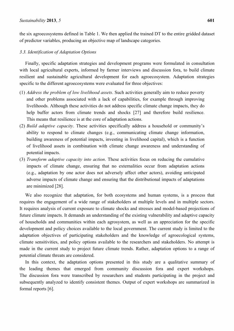
AEA identified six major agroecosystems (AES) in the study area (Figure 4A). These AES show a
remarkable degree of differentiation in terms of constraints, opportunities, production orientation, and
socio-economic characteristics of farmers (Table 2). This diversity offers both an opportunity and
challenge for adaptation to climate change: diversity of current climate conditions suggests that
multiple farming techniques, crops, and strategies are active within the region, providing a broad
foundation for adaptive efforts, but that same diversity makes it difficult to establish climate change
projections and adaptation strategies that are targeted to address to these highly localized conditions.
Figure 4. The six agroecosystems of the Choke Mountain watersheds. (A) As defined
using standard agroecosystem analysis. (B) As defined using automated landscape analysis.
Legend applies to both maps.
1
2
4
3
5
6
20km
A B AES1AES2AES3AES4
AES5AES6
Sustainability 2013, 5 603
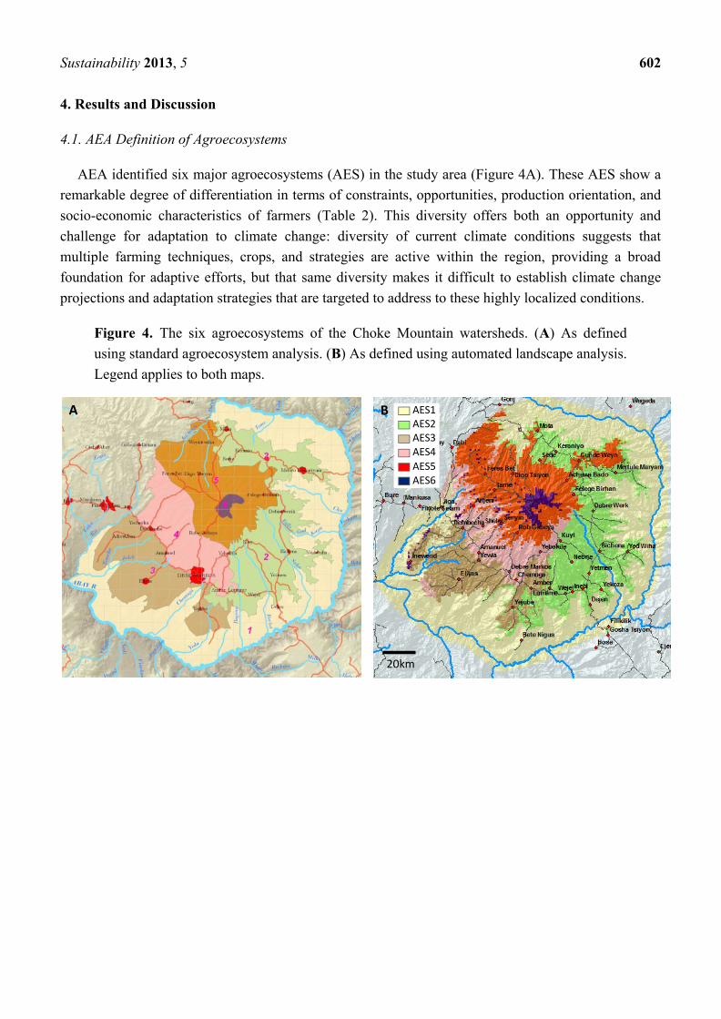
Table 2. Characteristics of AES in the Choke Mountains watersheds
Agroecosystem Farming systems Traditional
Climatic Zone Major soils Major crops
AES 1: Lowlands and
Abay Valley
Fragmented
sorghum-based,
extensive
Upper Kola Leptosols
Cambisols
Sorghum, tef
Maize, haricot bean
AES 2: Midland plains
with black soil
(Dejen-Mota)
Intensive
Tef-based
Lower Weyna
Dega Vertisols
Tef, durum
wheat, barley,
chickpea, grasspea
AES 3: Midland plains
with brown soils
(Baso-Elias)
Intensive
Maize-Wheat
based
Lower Weyna
Dega
Nitosols
Alisols
Maize, wheat,
Tef
AES 4: Midland
Slopping lands
(Macha-Gozamin)
Semi-intensive
Wheat/barley-based
Upper Weyna
Dega- Lower Dega
Leptosols
Nitosols
Alisols
Wheat, tef,
barley, engido
(Avena spp.)
AES 5: Hilly and
Mountainous highlands
Barley/potato-
based Upper Dega
Leptosols
Luvisols
Barley, potato,
Fava bean, engido
AES 6: Afro alpine Choke protected
area Wurch
Cambisols
Andosols
Phaeozems
No major crops.
Shrubs, grasses,
and moorlands
dominate
The six identified AES are:
Lowland and valley fragmented agroecosystems (AES 1; 7200 km2): This agroecosystem includes
the lowlands in the eastern part of the Choke Mountain watersheds and fragmented valleys along the
Blue Nile gorge, with an altitude range of 800 to 1400 m. AES1 is characterized by relatively
unfavorable agro-ecologic conditions: rugged terrain, lower and more sporadic rainfall than the other
AES, and extensive land degradation. Production in this AES is constrained by shallow soil depth, low
soil fertility, and sloping terrain. The annual temperature falls between 21 °C and 27.5 °C and the
growing period ranges between 61 and 120 days. Dominant crops are sorghum, maize and tef, and
soils include Leptisols and Cambisols. Even though these soils are fertile and are generally suitable for
a wide range of agricultural uses, the prevalence of long, steep slopes leads to high rates of erosion.
Oxytenathera abysnica and Accacia spp. are the dominant natural growing trees. The zone has
potential for forest and agroforestry, sorghum and haricot bean production. Malaria is a major health
related constraint in this area.
Midland plains with black soil (AES 2; 3200 km2): AES 2 is found on the eastern toe of Choke
Mountain, extending from the town of Dejen to the town of Mota. This agroecosystem represents
midland plains with black soil with an elevation ranging from 1400 to 2300 m. The annual temperature
varies between 11 and 15 °C. The growing period is between 121 and 180 days. Heavily textured
Vertisols dominate the area. These soils have considerable agricultural potential, on account of their
high fertility and their physiographic setting on extensive level plains amenable to mechanized
cultivation, but adapted management is a precondition for sustained production. Because of the high
Sustainability 2013, 5 604
content of shrink-swell clay in these soils, cultivation is difficult when they are dry and waterlogging is
a problem when they are wet. There is no significant natural vegetation cover in this AES.
Prunus africana, Hagenia abyssinica, Erythrina brucei and Arundinaria alpina species are vegetation
types seen very sparsely. The zone is potential for input-intensive tef, durum wheat and chickpea
production, provided appropriate Vertisol management practice is in place.
Midland plains with brown soils (AES 3; 1600 km2): AES 3 is found on the western and southern
toe of Choke Mountain toe. It is a midland plains area dominated by Nitosols, a brown soil very
suitable for agriculture, and Alisols, with some Cambisols as well. Nitisols are deep, well-drained and
are among the most productive soils of the humid tropics appropriate for a wide variety of crops.
The good workability of Nitisols, their good internal drainage and fair water holding properties are
complemented by their generally good chemical (fertility) properties. Alisols have similar properties,
albeit with potential problems with Aluminum toxicity. The elevation of AES3 varies between
1400 and 2400 m. The annual temperature varies between 16 and 21 °C, and the growing period is
between 121–180 days. Maize and wheat based farming systems dominate in the agroecosystem. It is
also a potential area for pulses and oil crops. This system is potentially suitable for input-intensive,
mechanized agriculture and irrigation that could contribute to rapid increases in productivity.
Midland Sloping Lands (AES4; 1300 km2): AES 4 is located at the foot-slope of Choke Mountain
with elevation ranging from 2400 to 2800 m. Soils are Leptosols, Alisols, and Nitosols, and the terrain
is sloping. The annual temperature varies between 11°C—15°C and the growing period between
120–180 days. There is no dominant natural plant species. Eucalyptus globulus is extensively gown as
a plantation, and some of the residents of the area have become dependent on it for their livelihood.
AES 4 is constrained by low natural fertility due to leaching of base ions (Ca, Mg, and K) and high
level of soil acidity. Sloping terrain is more difficult to cultivate than flatland, and is subject to higher
rates of water runoff and soil erosion. The main crop types produced are wheat, maize, tef, and a range
of pulses. The highly rugged landform, associated land degradation, and soil acidity present major
constraints for crop production. This AES does have potential for more intensive production system,
but soil and water conservation measures are critical.
Hilly and Mountainous highlands (AES5; 2400 km2): These hilly and mountainous highlands are
found on the back-slope of Choke Mountain. Soils are predominantly Leptosols and Luvisols, and
altitude varies between 2800 and 3800 m. The shallowness of soils in this AES, combined with the
rapid drainage characteristics of Leptisols, can result in drought stress even though precipitation rates
are quite high. The annual temperature ranges from 7.5 °C to 10 °C and the growing period is between
61 and 120 days. The major crops grown in the area are potato, wheat, barley, endigo (Avena spp.) and
pulses that are local varieties, and there is virtually no use of chemical fertilizer. The dominant plant
tree species are the Juniperus procera, Erica arborea, Hagenia abyssinica, Hypericum revolutum and
Olea europae. The major constraints on production in AES5 are low temperature, soil erosion, and
deforestation leading to water management problems. Rangeland (grazing or pasture land) degradation
is also common due to overstocking. AES5 is not appropriate for high intensity agriculture, but it does
have high potential for traditional forestry, including bamboos, and potato and barley production with
appropriate mountain agricultural land management.
Sustainability 2013, 5 605
Afro Alpine (AES6; 250 km2): The Afro Alpine is the Choke Mountain summit. Elevation ranges
from 3800 to 4200, and soils are predominantly Cambisols, Andosols, and Phaozems, with some
Luvisols (we note that Figure 2C, generated from FAO soils classifications, is highly simplified in this
zone). The major natural habitats are moist moorland, sparsely covered with Giant Lobelia (Lobelia
synchopetala), lady’s mantle (Alchemilla humania), Guassa grass (Festuca spp.) and other grasses.
The woody plant cover includes Asta (Erica arborea) and Amijja (Hypericum revolutum). Given the
important functions of AES6 as a reservoir for biodiversity and a soil and water retention zone,
combined with the area’s relatively low agricultural potential due to low temperatures, the most
appropriate use of AES6 is as a protected bioreserve. At present, ecological pressure due to grazing
and fuel wood collection is reducing the proportion of AES6 that fulfills this role.
4.2. Objective Mapping of Agroecosystems
Results of the automated landscape mapping procedure are shown in Figure 4B. In general, there is
close agreement between the distribution of agroecosystems defined using full AES analysis and those
defined using objective mapping. Note that this general agreement should not to be interpreted as an
independent confirmation of the AEA mapping, as the objective classification is trained on AEA
ground control points and the AEA, in turn, takes physiographic and climatic information into account
in defining agroecosystems. The agreement does, however, indicate that the distribution of farming
systems in Choke Mountain watersheds is largely under climatic and physiographic control at this
scale of analysis; we see no large or systematic disagreement between the participatory,
farming-system oriented AEA and the physically based objective map. Areas of discrepancy between
maps are in some cases a result of over-specificity in the automated algorithm—the edge effects seen
at boundaries between AES in the automated classification, for example, are not observed on the
landscape—and in other cases indicate areas where the full AEA, which did not include a
comprehensive field survey, might have overgeneralized boundaries between agroecological zones—
for example, the presence of several areas of AES5 along ridges and AES1 within valleys in the
automated classification that are not noted in the standard AEA map.
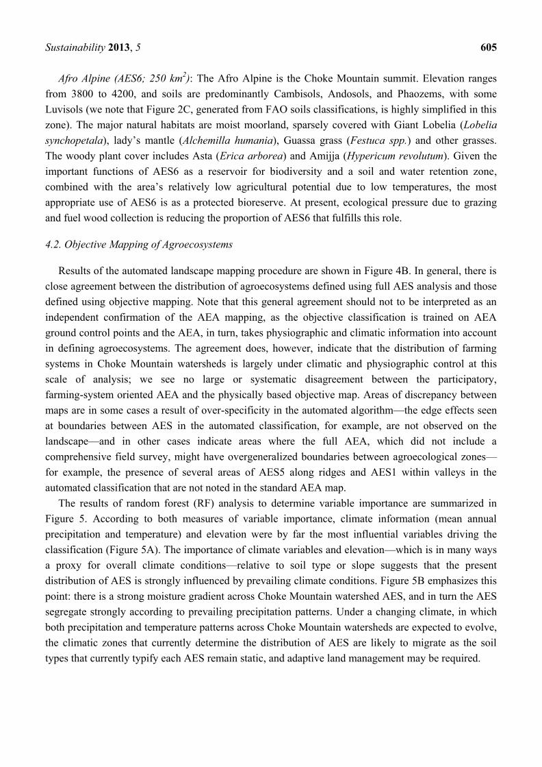
The results of random forest (RF) analysis to determine variable importance are summarized in
Figure 5. According to both measures of variable importance, climate information (mean annual
precipitation and temperature) and elevation were by far the most influential variables driving the
classification (Figure 5A). The importance of climate variables and elevation—which is in many ways
a proxy for overall climate conditions—relative to soil type or slope suggests that the present
distribution of AES is strongly influenced by prevailing climate conditions. Figure 5B emphasizes this
point: there is a strong moisture gradient across Choke Mountain watershed AES, and in turn the AES
segregate strongly according to prevailing precipitation patterns. Under a changing climate, in which
both precipitation and temperature patterns across Choke Mountain watersheds are expected to evolve,
the climatic zones that currently determine the distribution of AES are likely to migrate as the soil
types that currently typify each AES remain static, and adaptive land management may be required.
Sustainability 2013, 5 606
Figure 5. (A)Variable importance determined by the RF method using accuracy and Gini
criteria. (B) The relative distribution of AES across observed precipitation gradients.
4.3. Productivity Potential
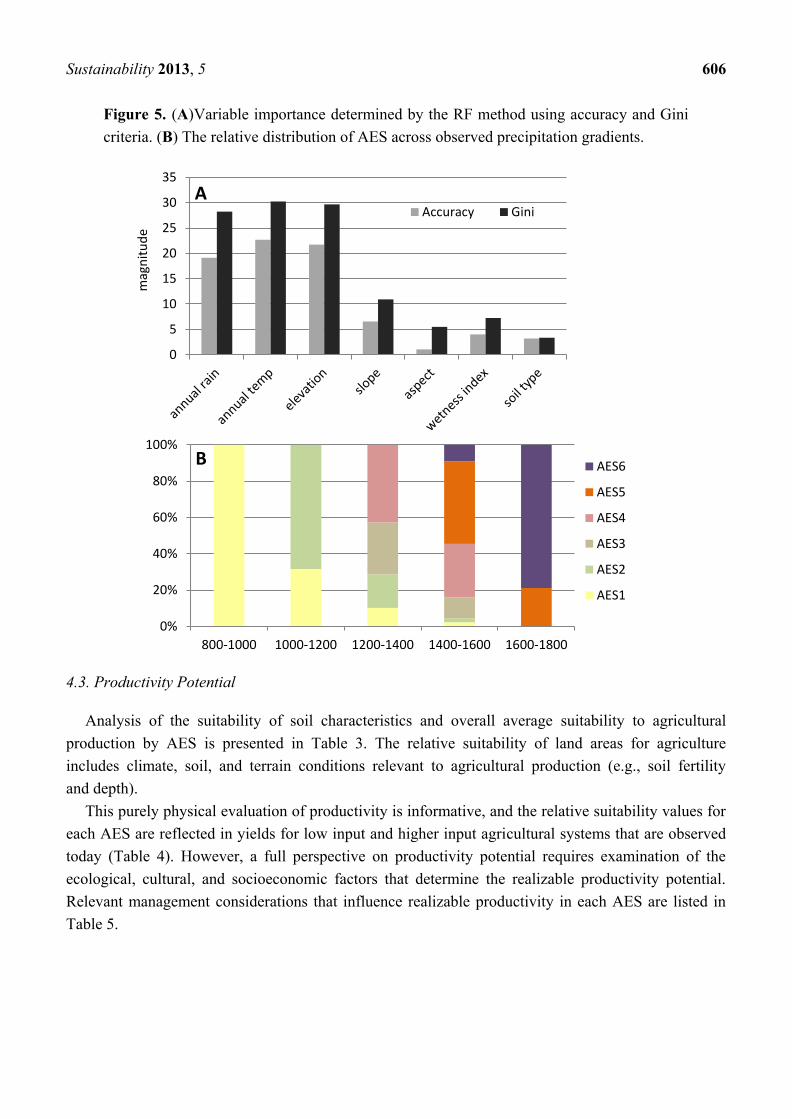
Analysis of the suitability of soil characteristics and overall average suitability to agricultural
production by AES is presented in Table 3. The relative suitability of land areas for agriculture
includes climate, soil, and terrain conditions relevant to agricultural production (e.g., soil fertility
and depth).
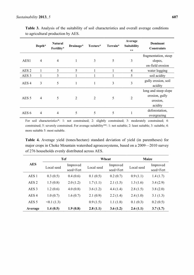
This purely physical evaluation of productivity is informative, and the relative suitability values for
each AES are reflected in yields for low input and higher input agricultural systems that are observed
today (Table 4). However, a full perspective on productivity potential requires examination of the
ecological, cultural, and socioeconomic factors that determine the realizable productivity potential.
Relevant management considerations that influence realizable productivity in each AES are listed in
Table 5.
0
5
10
15
20
25
30
35
Accuracy Gini
0%
20%
40%
60%
80%
100%
800-1000 1000-1200 1200-1400 1400-1600 1600-1800
AES6
AES5
AES4
AES3
AES2
AES1
magnitude
A
B
Sustainability 2013, 5 607
Table 3. Analysis of the suitability of soil characteristics and overall average conditions
to agricultural production by AES.
Depth* Natural
Fertility* Drainage* Texture* Terrain*
Average
Suitability
**
Dominant
Constraints
AES1 4 4 1 3 5 3
fragmentation, steep
slopes,
on-field erosion
AES 2 1 3 5 1 1 4 water logging
AES 3 1 3 1 1 1 5 soil acidity
AES 4 3 5 1 1 3 3 gully erosion, soil
acidity
AES 5 4 5 2 2 5 2
long and steep slope
erosion, gully
erosion,
acidity
AES 6 4 4 5 5 5 1 deforestation,
overgrazing
For soil characteristics*: 1: not constrained; 2: slightly constrained; 3: moderately constrained; 4:
constrained; 5: severely constrained. For average suitability**: 1: not suitable; 2: least suitable; 3: suitable; 4:
more suitable 5: most suitable.
Table 4. Average yield (tones/hectare) standard deviation of yield (in parentheses) for
major crops in Choke Mountain watershed agroecosystems, based on a 2009—2010 survey
of 276 households evenly distributed across AES.
AES
Tef Wheat Maize
Local seed Improved
seed+Fert Local seed
Improved
seed+Fert Local seed
Improved
seed+Fert
AES 1 0.3 (0.5) 0.4 (0.6) 0.1 (0.5) 0.2 (0.7) 0.9 (1.1) 1.4 (1.7)
AES 2 1.5 (0.8) 2.0 (1.2) 1.7 (1.1) 2.1 (1.5) 1.3 (1.6) 3.4 (2.9)
AES 3 1.2 (0.6) 4.0 (0.8) 3.6 (1.2) 4.4 (1.4) 2.8 (1.5) 3.8 (2.0)
AES 4 1.0 (0.7) 1.6 (0.7) 2.1 (0.9) 2.2 (1.4) 2.4 (1.0) 3.1 (1.3)
AES 5 <0.1 (1.3) 0.9 (1.5) 1.1 (1.8) 0.1 (0.3) 0.2 (0.5)
Average 1.4 (0.5) 1.9 (0.8) 2.8 (1.1) 3.6 (1.2) 2.6 (1.1) 3.7 (1.7)

Sustainability 2013, 5 608
Table 5. Realizable potential for agroecosystems of the Choke Mountain watersheds.
Assumed intensity of management reflects the level of agricultural investment deemed
appropriate given the physical constraints on productivity and confirmed through
participatory AEA. Key properties and production potentials were identified through AEA
pattern and productivity analysis and are informed by previous work in the region as well
as stakeholder perspectives.
Assumed intensity of
management Key properties and production potentials
AES1 Low level of inputs/traditional
management (rainfed)
Largely subsistence based and not necessarily, market oriented.
Production is based on the use of traditional cultivars (if improved
cultivars are used, they are treated in the same way as local cultivars),
labor-intensive techniques, and no application of nutrients, no use of
chemicals for pest and disease control and minimum
conservation measures.
AES 2
High level of inputs/advanced
management (rainfed or
irrigated)
Mainly market oriented. Commercial production is a management
objective. Production is based on improved high yielding varieties, is
fully mechanized with low labor intensity, and uses optimum
applications of nutrients and chemical pest, disease and weed control
AES 3
High level of inputs/advanced
management (rainfed or
irrigated)
Mainly market oriented. Commercial production is a management
objective. Production is based on improved high yielding varieties, is
fully mechanized with low labor intensity, and uses optimum
applications of nutrients and chemical pest, disease and weed control
AES 4
Intermediate level of
inputs/improved management
(rainfed or irrigated)
Partly market oriented. Production for subsistence plus commercial sale
is a management objective. Production is based on improved varieties,
on manual labor with hand tools and/or animal traction and some
mechanization, is medium labor intensive, uses some fertilizer
application and chemical pest disease and weed control, adequate
fallows and some conservation measures.
AES 5 Low level of inputs/traditional
management (rainfed)
Largely subsistence based and not necessarily, market oriented.
Production is based on the use of traditional cultivars (if improved
cultivars are used, they are treated in the same way as local cultivars),
labor-intensive techniques, and no application of nutrients, no use of
chemicals for pest and disease control and minimum
conservation measures.
AES 6 Protected area
Because of their extreme cold temperature, shallowness and, usually,
steepness and consequent high erosion hazard, the summit of the
mountain (>3800 masl) are not suitable for arable farming. If its
geographical area is clearly defined, recognized by the community and
managed through legal or other effective means, to achieve the long-
term conservation of nature with associated ecosystem services and
cultural values, this AES could be a potential for climate change
mitigation and adaptation (e.g., watershed protection) activities.
Sustainability 2013, 5 609
4.4. Constraints
At the production level, agricultural productivity measures the value of output for a given level of
inputs. To increase agricultural productivity, the value of output must increase faster than the value of
inputs. Gains in overall agricultural productivity can therefore come from changes in production
process that produce more output per unit of land or labor, or from changes in production and market
costs and hence the increased profitability for farmers. Thus, increasing agricultural productivity not
only relies on improved production efficiencies, such as through adoption of modern or improved
technologies and practices, but also critically relies on many other factors such as adequate access to
productive resources, well-functioning markets and infrastructure, and policy promoting economic and
social stability.
A number of constraints on agricultural productivity have been identified in expert workshops, as
reported previously [6]. Here we consider these constraints in the context of the AES described and
mapped in this study, and as they were reported during participatory agroecosystem analysis. Identified
constraints include a number of biophysical factors that are specific to particular agroecosystems as
well as systemic constraints that affect farmers across the Choke Mountain watersheds.
A partial list of agroecosystem-specific constraints includes:
Land degradation: Soil erosion in Choke Mountain watersheds is a well-recognized problem,
identified as a priority by the local community members. Steep slopes, traditional crisscross ox-drawn
tillage systems that promote rapid erosion as well as limited agricultural land use characterize the
Choke environment. The severity of human-induced land degradation (classified into five major
classes of degradation, following the Land Evaluation method of [17]) differs dramatically across the
six agroecosystems identified in this study (Figure 6). AES 1 and 5 are characterized by fragmented
and steep slopes with the highest degradation rate. AES 2 and 3 have minimal soil erosion and other
degradation problems, as they are in the mountain toes. AES 4 is prone to moderate soil erosion and
associated degradiation. Nevertheless, there are still significant soil resources in the Choke Mountain
watersheds, and experience indicates that productivity can be maintained and enhanced through
effective field scale and landscape scale sustainable land management practices [5].
Figure 6. Human-induced land degradation of Choke Mountain watersheds by
agroecosystems.
0
1
2
3
4
5
AES1 AES2 AES3 AES4 AES5 AES6
Lan
d D
egra
dat
ion
Cat
ego
ry
Agroecosystem

Sustainability 2013, 5 610
Deforestation: Forests, other woody/perennial biomass, and protected areas form an integral part of
mountain farming economies and provide extensive environmental services to society. However,
natural forests, shrub lands, and riparian woodlands are in decline across Choke Mountain
watersheds [29], with the greatest impacts occurring in areas of expanded cultivation in AES 1, AES 5
and, where cultivation and fuel gathering have encroached, AES 6. Due to the landscape-scale benefits
that forests have for soil and water retention, impacts of deforestation have both local and regional
impacts on land degradation. Wetland loss is also occurring on Choke Mountain [4], with the greatest
losses reported in AES 2, 3 and 4.
Water logging: AES 2 of the Choke Mountain watersheds is characterized by extensive areas of
Vertisols, which are prone to severe water logging during the rainy season. Appropriate technologies
do exist to improve drainage and prevent water logging, and in demonstrations these technologies have
been demonstrated to triple wheat yields in AES 2. However, at present only 0.5% of farmers working
in AES 2 Vertisol terrain make use of these technologies [6]. We note that unless the whole watershed
is treated, localized drainage projects can lead to enhanced gully erosion downstream
Soil Acidity: At present, soil acidity is a major constraint on production, particularly for areas with
Nitosols and Acrisols (AES 3 and AES 4), and acidity is increasing due to cultivation practices. In
some areas acidity has forced farmers to switch to lower value, acid tolerant crops, and some land has
been abandoned altogether. In order to improve the productivity of acid soils, the local government has
initiated a liming program, but participation is low [6]. The AES analysis performed here suggests that
a targeted focus on the communities located in AES 3 and AES 4 may allow for a more efficient and
ultimately effective use of resources to address soil acidity.
Broader constraints affecting vulnerable households in all agroecosystems include:
Limited local-level capacity to design and implement resilience building measures: The majority of
development interventions in the region have promoted some generic package of productivity
enhancing practices and technologies. These interventions have had limited staying power, as farmers
retreat from recommended practices that are inappropriate or inconsistent with the local agroecosystem
or traditional practices and priorities. Participatory development of adaptation technologies is required
in order to ensure that recommended interventions are appropriate to local conditions and to build
human capacity for action within Choke Mountain communities. Participatory agroecosystem analysis
conducted for this study indicates that the problem of generic, externally designed agricultural
development interventions exists in all defined AES [5].
Limited access to life-improving technologies: In Choke Mountain watersheds, poverty and rough
terrain conspire to limit the availability of services and technologies that could ease the burden of
subsistence tasks, freeing labor for resilience building activities, and could allow communities to use
their natural resource base in a more efficient manner. Women and girls fetch water and fuel wood
from distant sources, men plow fields with single blade, oxen-drawn plows, and access to electricity is
extremely limited. Relatively simple, development-appropriate technologies ranging from improved
cookstoves to household-level renewable energy sources to water purifiers have been identified as
viable options for communities in Choke Mountain watersheds [6].
Sustainability 2013, 5 611
Climate Change: Choke Mountain watershed agricultural systems are highly vulnerable to negative
impacts of climate variability [15]. As patterns of variability and precipitation intensity alter under
anthropogenic climate change, there is concern that this vulnerability will increase, threatening
economic development and food security in the region. A trend towards higher mean annual
temperature has already been observed [5]. Agronomic studies of predicted future changes suggest that
continued temperature increases on the order of 2.5 to 5.0 °C over the 21st century will have a
significant negative impact on average crop net revenue per hectare across Choke Mountain
watersheds. Participatory agroecosystem analysis indicates that sensitivity to climate variability and
change is a major concern in all defined AES. Objective AES classification further demonstrates that
prevailing climate conditions—and, presumably, changes in prevailing climate under climate change—
play a strong role in defining the distribution of agroecosystems, such that climate change is likely to
influence productivity in all agriculturally active AES.
4.5. Adaptation Strategies
AEA provides a lens for adaptation analysis that takes into account the geographical differentiation
(climate, topography, soils, farming systems) as well as the socio-economic stratification of the
agricultural sector of the study area. In addition to the prevailing climate change impacts, livelihoods
in farming communities face severe constraints related to intensive cultivation, overgrazing and
deforestation, soil erosion and soil fertility decline, water scarcity, livestock feed, and fuel wood.
Through AEA, the productive potential and adaptive capacity of the each agroecosystem were
characterized, and appropriate climate resilience building strategies have been identified. These
proposed strategies are not intended to be conclusive, but they represent a reasonable starting point
from which communities can continue to develop resilience building activities and adaptation plans.
For the Choke Mountain watersheds, it is understood that climate resilient strategies must address both
the challenge of present day climate variability and the potential for shifting agroecological conditions
in a changing climate.
AES-specific strategies for climate resilient development in Choke Mountain watersheds, as
informed by AES analysis and developed at a stakeholder workshop [5,6] were identified as:
AES 1 and AES 5: Biofarm system: This is a system of establishing permanent agriculture
(Permaculture) that draws from several disciplines including organic farming, agroforestry, integrated
farming, sustainable development, and applied ecology. It is an applicable strategy for AES 1 and AES
5, but with different technology packages in each. The main objective of bio-farming is to optimize
agricultural outputs (vegetables, dairy products, honey, etc.) for use by the local community, while
minimizing external inputs (like excessive water or chemically based fertilizers). Specific techniques
include use of drought-tolerant, nitrogen-fixing trees such as Acacia species to rebuild the soil, fruit
trees, vegetables and high value herbal crops as intercrops within cultivated fields, and improved water
harvesting and retention (such as pools, dams, pits, retaining ridges, etc.) and water‐use efficiency
(irrigation systems) to increase production and address increasing irregularity of rainfall patterns
(particularly in AES1, where water stress is a major concern). As climate change brings warmer
conditions and potential shifts in precipitation, the water retaining properties of biofarm systems will
be particularly valuable.
Sustainability 2013, 5 612
AES 2: Sustainable intensification by adopting vertisol management technologies: Vertisols cover
close to 0.4 million hectares, continuously distributed in 4 major Woredas within AES 2. A proven
suite of techniques that includes drainage, water harvesting for a second cropping season, crop rotation
of wheat—chickpea—tef, soil fertility management, and targeted use of improved seed and chemical
fertilizers has the potential to increase yields significantly in this fertile zone. Should climate change
lead to hotter temperatures and more frequent drought stress in this region, robust water infrastructure
for the proposed second cropping season will be required. Drainage will become even more important
should predictions of intensified precipitation events be realized.
AES 3: Sustainable intensification using conservation agriculture technologies: Conservation
Agriculture (CA) is an approach to managing agro-ecosystems for improved and sustained
productivity, increased profits and food security while preserving and enhancing the resource base and
the environment. CA is characterized by three linked principles, namely: continuous minimum
mechanical soil disturbance, permanent organic soil cover and diversification of crop species grown in
sequences and/or associations [30]. CA facilitates good agronomy, such as timely operations, and
improves overall land husbandry for rainfed and irrigated production. Complemented by other known
productivity enhancing practices, including the use of quality seeds, and integrated pest, nutrient, weed
and water management, etc., CA is a base for sustainable agricultural production intensification.
AES 4: Sustainable intensification by applying sloping land management technologies: In AES 4,
an agroforestry based production system is recommended to sustain agricultural production on sloping
lands. The goal of this strategy is to stimulate economic growth by developing new market
opportunities for products, increasing utilization, and consumption of value-added products, and
enhancing productivity and quality of crops through new technologies. Hedgerows are planted along
contours of sloping land at intervals of four to six meters and various cereal crops and perennial cash
plants are cultivated in the alleys. Hedgerows also act as effective barriers to soil erosion. Hedgerows
can also be pruned several times a year, and the pruned leaves can be used as green manure or for
composting. Crop rotation, tillage along contours, and use of compost and liming in addition to
chemical fertilizers are also important components of sustainable management in this system.
AES 6: Bioreserve (protected area): The major focus of this strategy in the afroalpine zone is to
develop a management plan to conserve biodiversity resources while providing some benefit sharing
with the local communities. According to IUCN protected area categories, the Choke Mountains
protected area would be ―Category VI,‖ i.e., protected area managed mainly for the sustainable use of
natural ecosystems.
In addition, there are a number of sustainable production systems that are recommended across
AES 1–5. The home garden is the primary example of such a system. Though home gardens have
existed since very early in Ethiopian agricultural history, they are in decline in Choke Mountain
watersheds. This trend should be reversed, as the home garden provides an array of food sources,
spices, and condiments, as well as medicinal plants, perfumes, and aromatic plants that play a role in
traditional life. Home gardens can also be hotspots of biodiversity on the landscape.
The AES-specific land management strategies listed above are intended to build climate resilience
under current patterns of climate variability, and with recognition for the fact that perceived increases
and changes in the character of variability in recent years demand robust but flexible agricultural
Sustainability 2013, 5 613
techniques. As agroecosystems migrate under climate change, a number of these resilience-building
strategies can migrate with them. While techniques specific to particular soils or landforms will remain
relevant within static geographies, those that are geared towards addressing rainfall variability or
higher temperatures, for example through water management or crop and seed selection, can be
adopted by new communities as climate conditions evolve.
5. Conclusions
An agroecosystem analysis (AEA) of Choke Mountain watersheds demonstrates the significant
challenges associated with climate change adaptation in tropical highland environments. The great
diversity of climate zones, physiographic settings, farming systems, and socioeconomic circumstances
within this relatively small area require similarly diverse interventions to improve agricultural
productivity and ensure sustainability in a changing climate. At the same time, AEA provides a tool for
classifying the landscape into functionally similar systems, for characterizing potential and constraints
within each system, and for developing adaptation strategies that are informed by local-scale analysis
and community priorities. In this application, AEA also provided the foundation for an automated
landscape classification trained using AEA field survey. This automated algorithm provides more
limited information, but it offers a tool for mapping and projecting the physical aspects of each
agroecosystem across the study area and over changing climate conditions.
A critical challenge that cuts across agroecosystems in Choke Mountain watersheds is the need to
achieve realizable production potentials to the extent possible. Improving agricultural productivity is
the key for ecological sustainability in Choke Mountain watersheds because productivity growth is the
most sustainable mechanism to maintain the ecosystem goods and services of the mountain
watersheds. It is potentially possible to increase agricultural production by putting natural forest,
grazing and wetlands into cultivation, but the sustainability of systems that continue to encroach on
these natural lands is questionable. Agricultural technologies such as improved seeds, fertilizer
application, irrigation and soil and water conservation have a central place in enhancing agricultural
productivity where utilized appropriately and efficiently.
The sustainable intensification of agricultural production, considering the challenges and
opportunities of the different agroecosystems, can ensure food security and contribute to climate
change adaptation by reducing deforestation and the encroachment of agriculture into natural
ecosystems. The overall efficiency, resilience, adaptive capacity, and mitigation potential of the
production systems can be enhanced through sustainable land management.
AEA offers a method for classifying the landscape and for identifying agroecosystem-specific
constraints and opportunities for climate change adaptation. The analysis reported in this paper yielded
a classification of six different agroecosystems in Choke Mountain watersheds. Adaptation strategies
specific to each have been developed in consultation with local communities: bioreserve (protected
area) for AES 6, permacalture (biofarm system) for AES 1 and 5, sustainable intensification by
applying sloping land management technologies for AES 4, sustainable intensification by adopting
Vertisol management technologies for AES 2 and sustainable intensification using conservation
agriculture technologies for AES 3. In each case, the proposed land management techniques have been
selected with consideration for present day climate resilience and robustness to changing conditions.
Sustainability 2013, 5 614
These resilience building strategies are processes that require time, investment and the engagement of
a wide range of stakeholders at multiple levels and in multiple sectors, and there is certainly much
work ahead. Participatory agroecosystem analysis has, however, provided communities of Choke
Mountain watersheds and relevant development agencies with a robust foundation for this work. In this
respect, adaptation planning in Choke Mountain watersheds already provides a model for other regions
in Ethiopia and, potentially, subsistence agriculture communities contending with climate change in
other countries and regions.
Conflict of Interest
The authors declare no conflicts of interest.
Acknowledgements
The authors thank three anonymous reviewers for helpful comments that improved the manuscript.
Work on this paper was supported in part by Addis Ababa University and by NSF-CNH
GEO-1211235.
References
1. IPCC. Summary for Policymakers. In Managing the Risks of Extreme Events and Disasters to
Advance Climate Change Adaptation. A Special Report of Working Gropus i and ii of the
Intergovernmental Panel on Climate Change; Field, C.B., Barros, V., Stocker, T.F., Qin, D.,
Dokken, D.J., Ebi, K.L., Masdrandea, M.D., Mach, K.J., Plattner, G.-K., Allen, S.K., et al., Eds.;
Cambridge University Press: Cambridge, UK, 2012; pp 1–19.
2. Bradley, R.S.; Keimig, F.T.; Diaz, H.F.; Hardy, D.R. Recent changes in freezing level heights in
the tropics with implications for the deglacierization of high mountain regions. Geophys. Res. Lett.
2009, 36, L17701.
3. Nyssen, J.; Vandenreyken, H.; Poesen, J.; Moeyersons, J.; Deckers, J.; Haile, M.; Salles, C.;
Govers, G. Rainfall erosivity and variability in the northern ethiopian highlands. J. Hydrol. 2005,
311, 172–187.
4. Teferi, E.; Uhlenbrook, S.; Bewket, W.; Wenninger, J.; Simane, B. The use of remote sensing to
quantify wetland loss in the choke mountain range, upper blue nile basin, ethiopia. Hydrol. Earth
Syst. Sci. 2010, 14, 2415–2428.
5. Simane, B.; Zaitchik, B.F.; Mesfin, D. Climate resilience in the blue nile / abay highlands: A
framework for action. Int. J. Environ. Res. Publ. Health 2012, 9, 610–631.
6. Simane, B. Building Resilience to Climate Change and Green Economy in Mountain Ecosystems
of Ethiopia. Integrating Research, Capacity Building and Sustainable Development Activities. In
Proceedings of the Stakeholders Workshop, Debre Markos, Ethiopia, 10–13 June 2011.
7. Belay, B.A. Analysis of Farmers' Perception and Adaptation to Climate Change and Variability:
The Case of Choke Mountain, East Gojjam; Addis Ababa University: Addis Ababa,
Ethiopia, 2010.
Sustainability 2013, 5 615
8. Byerlee, D.; Spielman, D.J.; Alemu, D.; Gautam, M. Policies to Promote Cereal Intensification
in Ethiopia: A Review of Evidence and Experience; International Food Policy Research Institute
(IFPRI): Washington, DC, USA, 2007; p 37.
9. Conway, G. Agroecosystem analysis. Agr. Admin. 1985, 20, 31–55.
10. Kieffer, B.; Arndt, N.; Lapierre, H.; Bastien, F.; Bosch, D.; Pecher, A.; Yirgu, G.; Ayalew, D.;
Weis, D.; Jerram, D.A.; et al. Flood and shield basalts from ethiopia: Magmas from the african
superswell. J. Petrol. 2004, 45, 793–834.
11. Hurni, H. Degradation and conservation of the resources in the ethiopian highlands. Mt. Res. Dev.
1988, 8, 123–130.
12. Nyssen, J.; Poesen, J.; Haile, M.; Moeyersons, J.; Deckers, J. Tillage erosion on slopes with soil
conservation structures in the ethiopian highlands. Soil Tillage Research 2000, 57, 115–127.
13. Temesgen, M.; Uhlenbrook, S.; Simane, B.; van der Zaag, P.; Mohamed, Y.; Wenninger, J.;
Savenije, H.H.G. Impacts of conservation tillage on the hydrological and agronomic performance
of fanya juus in the upper blue nile (abbay) river basin. Hydrol. Earth Syst. Sci. 2012, 16,
4725–4735.
14. Zegeye, A.D.; Tebebu, T.Y.; Abiy, A.C.; Dahlke, H.E.; White, E.D.; Collick, A.S.; Kidnau, S.;
Dadgari, F.; McCartney, M.; Steenhuis, T.S. Assessment of Hydrological and Landscape
Controls on Gully Formation and Upland Erosion near Lake Tana, Northern Highlands of
Ethiopia. In Proceedings of the Intermediate Results Dissemination Workshop—Improved Water
and Land Management in the Ethiopian Highlands and its Impact on Downstream Stakeholders
Dependent on the Blue Nile, Addis Ababa, Ethiopia, 5–6 Feburary 2009.
15. Zaitchik, B.F.; Simane, B.; Habib, S.; Anderson, M.C.; Ozdogan, M.; Foltz, J.D. Building climate
resilience in the blue nile/abay highlands: A role for earth system sciences. Int. J. Environ. Res.
Publ. Health 2012, 9, 435–461.
16. FAO. World Reference Base for Soil Resources 2006: A Framework for International
Classification, Correlation and Communication; Food and Agriculture Organization of the
United Nations: Rome, Italy, 2006.
17. FAO. Land Evaluation: Towards a Revised Framework. Land and Water Discussion Paper;
Food and Agriculture Organization of the United Nations: Rome, Italy, 2007.
18. Getahun, A. Agro-climates and agricultural systems in ethiopia. Agr. Syst. 1980, 5, 39–50.
19. Hurni, H. Agroecological Belts of Ethiopia: Explanatory Notes on Three Maps at a Scale of
1:1,000,000; Soil Conservation Research Program of Ethiopia: Addis Ababa, Ethiopia,
1998; p. 31.
20. Hijmans, R.J.; Cameron, S.E.; Parra, J.L.; Jones, P.G.; Jarvis, A. Very high resolution
interpolated climate surfaces for global land areas. Int. J. Climatol. 2005, 25, 1965–1978.
21. Breiman, L.; Friedman, J.H.; Olshen, R.A.; Stone, C.J. Classification and Regression Trees;
Wadsworth International Group: Belmont, CA, USA, 1984.
22. Wardlow, B.D.; Egbert, S.L. Large-area crop mapping using time-series modis 250 m ndvi data:
An assessment for the U.S. Central great plains. Rem. Sens. Environ. 2008, 112, 1096–1116.
23. McIver, D.K.; Friedl, M.A. Estimating pixel-scale land cover classification confidence using
nonparametric machine learning methods. IEEE Trans. Geosci. Rem. Sens. 2001, 39, 1959–1968.
Sustainability 2013, 5 616
24. DeFries, R.S.; Chan, J.C.-W. Multiple criteria for evaluating machine learning algorithms for
land cover classification from satellite data. Rem. Sens. Environ. 2000, 74, 503–515.
25. Friedl, M.A.; Brodley, C.E.; Strahler, A.H. Maximizing land cover classification accuracies
produced by decision trees at continental to global scales. IEEE Trans. Geosci. Rem. Sens. 1999,
37, 969–977.
26. Breiman, L. Random forests. Mach. Learn. 2001, 45, 5–32.
27. McGray, H.A.H.; Hammill, A.; Bradley, R. Weathering the Storm: Options for Framing
Adaptation and Development; World Resources Institute: Washington, DC, USA, 2007; p. 57.
28. Adger, W.N.; Dessai, S.; Goulden, M.; Hulme, M.; Lorenzoni, I.; Nelson, D.R.; Naess, L.O.;
Wolf, J.; Wreford, A. Are there social limits to adaptation to climate change? Climatic Change
2009, 93, 335–354.
29. Berhanu, A.A. Community Based Watershed Development for Climate Change Adaptation in
Choke Mountain: The Case of Upper Muga Watershed in East Gojjam of Ethiopia; Addis Ababa
University: Addis Ababa, Ethiopia, 2011.
30. FAO. Climate-Smart Agriculture: Capturing the Synergies Between Mitigation, Adaptation, and
Food Security; Food and Agriculture Organization of the United Nations: Rome, Italy, 2011.
© 2013 by the authors; licensee MDPI, Basel, Switzerland. This article is an open access article
distributed under the terms and conditions of the Creative Commons Attribution license
(http://creativecommons.org/licenses/by/3.0/).