ak sw guide - chapter 5 - alaska department of environmental
TRANSCRIPT
Alaska Storm Water Guide December 2011
Chapter 5: Permanent Storm Water Management Controls 5-1
Chapter 5 Permanent Storm Water Management Controls
5.0 Introduction
This chapter describes several factors that are important for identifying the most appropriate permanent storm water control for a site. The factors that should be evaluated in selecting permanent BMPs are discussed in Section 5.1. LID or environmental site design concepts (Section 5.2) can be used to reduce the volume of runoff discharged to permanent BMPs, thereby reducing their size and cost. For projects in high pollutant source areas, source controls must also be implemented (Section 5.3). In Alaska, the diversity of climate, soils, terrain and other factors make designing permanent storm water controls particularly challenging. Section 5.4 describes permanent BMPs applicable to the five climatic regions in Alaska, as well as design adaptations for those BMPs. Finally, Section 5.5 discusses maintenance issues related to permanent BMPs.
Water quality impacts from urban runoff can be significant, but selecting appropriate permanent storm water controls during the design phase can help mitigate such effects. The Center for Watershed Protection, in cooperation with the EPA, has published Managing Stormwater in Your Community: A Guide for Building an Effective Post-Construction Program (see Link 63 in Appendix A). Although the guide was written for municipalities developing a post-construction program, it has many useful sections for engineers designing permanent storm water controls. The following sections provide relevant guidance:
• Chapter 3 describes how land-use planning and watersheds should be considered when selecting storm water BMPs.
• Chapter 4 describes different design criteria and the hierarchy of permanent storm water BMP selection—from site planning and design to source control/pollution prevention to storm water collection and treatment.
• Tool No. 6 includes checklists for construction and maintenance of various BMPs.
Alaska Storm Water Guide December 2011
5-2 Chapter 5: Permanent Storm Water Management Controls
• Tool No. 8 includes a checklist to help assess the performance of manufactured and proprietary BMPs.
5.1 Selecting Permanent Storm Water Controls
There are many issues that affect the selection of a permanent storm water control for a specific site. The Minnesota Stormwater Steering Committee (MSSC 2006) describes the following systematic approach consisting of eight steps that project designers should consider during BMP selection:
1. Investigate Pollution Prevention Opportunities: Evaluate the site to look for opportunities to prevent pollution mobilization by runoff.
2. Design Site to Minimize Runoff: Assess whether any better site design techniques can be applied at the site to minimize runoff and reduce the size of structural BMPs.
3. Identify Receiving Water Issues: Understand the regulatory status of the receiving water to which the site drains. Depending on the nature of the receiving water, certain BMPs might be promoted, restricted or prohibited, or special design or sizing criteria could apply.
4. Identify Climate and Terrain Factors: Climate and terrain conditions vary widely across the state, and designers need to explicitly consider how each regional factor will influence the BMPs proposed for the site.
5. Evaluate Storm Water Treatment Suitability: Not all BMPs work over the wide range of storm events that need to be managed at the site, so designers need to choose the type or combination of BMPs that will provide the desired level of treatment. (See the storm water treatment suitability matrix below.)
6. Assess Physical Feasibility at the Site: Each development site has many physical constraints that influence the feasibility of different kinds of BMPs; designers confirm feasibility by assessing eight physical factors at the site. Such physical factors include surface area of the BMP, drainage area, soil infiltration rate, hydraulic head, separation from bedrock, depth to seasonally high water table, maximum slope, and whether the BMP is appropriate for ultra-urban settings.
7. Investigate Community and Environmental Factors: Each group of BMPs provides different economic, community and environmental benefits and drawbacks; designers need to carefully weigh these factors when choosing BMPs for the site.
8. Determine Any Site Restrictions and Setbacks: Check to see if any environmental resources or infrastructure are present that will influence where a BMP can be located at the development site.
Alaska Storm Water Guide December 2011
Chapter 5: Permanent Storm Water Management Controls 5-3
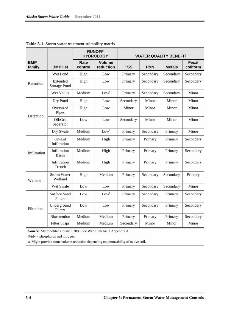
Storm Water Treatment Suitability Matrix Table 5-1 is intended to be used by design engineers as a screen for whether a BMP can meet the runoff hydrology and water quality benefits needed. This table (adapted from the Minnesota Urban Small Sites BMP Manual: Stormwater Best Management Practices for Cold Climates (Metropolitan Council 2009) St. Paul, MN, see Web Link 64 in Appendix A.) rates the runoff rate control or volume reduction as high, medium or low. It also rates the water quality benefit provided for four common pollutants [TSS, phosphorus (P) and nitrogen (N), metals, and fecal coliform]. Primary indicates that this is the primary benefit of the BMP. Secondary indicates that the BMP has some benefit, but this is not its primary purpose. A minor benefit indicates that little or no water quality benefit is expected for that pollutant.
Site designers should first identify the primary pollutant of concern at the site (this is the pollutant expected to be generated by the project after construction) and then select the type of BMP whose primary purpose is the control of that pollutant. For example, a site that would be expected to generate primarily nutrients should consider infiltration BMPs, where feasible.
Site designers should also consider using BMPs in sequence (e.g., a treatment train approach). For example, a site designer could use a check dam, grass channel and wet pond in series to produce the required results, instead of relying on a wet pond only.
Alaska Storm Water Guide December 2011
5-4 Chapter 5: Permanent Storm Water Management Controls
Table 5-1. Storm water treatment suitability matrix
BMP family BMP list
RUNOFF HYDROLOGY WATER QUALITY BENEFIT
Rate control
Volume reduction TSS P&N Metals
Fecal coliform
Retention
Wet Pond High Low Primary Secondary Secondary Secondary
Extended Storage Pond
High Low Primary Secondary Secondary Secondary
Wet Vaults Medium Lowa Primary Secondary Secondary Minor
Detention
Dry Pond High Low Secondary Minor Minor Minor
Oversized Pipes
High Low Minor Minor Minor Minor
Oil/Grit Separator
Low Low Secondary Minor Minor Minor
Dry Swale Medium Lowa Primary Secondary Primary Minor
Infiltration
On-Lot Infiltration
Medium High Primary Primary Primary Secondary
Infiltration Basin
Medium High Primary Primary Primary Secondary
Infiltration Trench
Medium High Primary Primary Primary Secondary
Wetland Storm Water
Wetland High Medium Primary Secondary Secondary Primary
Wet Swale Low Low Primary Secondary Secondary Minor
Filtration
Surface Sand Filters
Low Lowa Primary Secondary Primary Secondary
Underground Filters
Low Low Primary Secondary Primary Secondary
Bioretention Medium Medium Primary Primary Primary Secondary
Filter Strips Medium Medium Secondary Minor Minor Minor
Source: Metropolitan Council, 2009, see Web Link 64 in Appendix A P&N = phosphorus and nitrogen a. Might provide some volume reduction depending on permeability of native soil.
Alaska Storm Water Guide December 2011
Chapter 5: Permanent Storm Water Management Controls 5-5
5.2 Low Impact Development/Environmental Site Design Concepts
The need for traditional permanent BMPs such as infiltration basins or wet ponds can be reduced through the use of LID or environmental site design concepts. Like other alternative development strategies, LID seeks to control storm water at its source. Rather than moving storm water off-site though a conveyance system, the goal of LID is to restore the natural, pre-developed ability of an urban site to absorb storm water.
LID integrates small-scale measures distributed throughout the development site. Constructed green spaces, native landscaping, and a variety of innovative bioretention and infiltration techniques capture and manage storm water on-site. LID reduces peak runoff by allowing rainwater to soak into the ground, evaporate into the air, or collect in storage receptacles for irrigation and other beneficial uses. In areas with slow drainage or infiltration, LID captures the first flush of runoff before excess storm water is diverted into traditional storm conveyance systems. The result is development that more closely maintains predevelopment hydrology. Furthermore, LID has been shown to be cost-effective, and in some cases, less expensive than using traditional storm water management techniques.
Additional information on LID is available from a number of sources: USEPA (see Web Link 65 in Appendix A), the Low Impact Development Center (Link 66 in Appendix A), and the Puget Sound Action Team (Link 67 in Appendix A).
LID Techniques LID can be simple and effective. Instead of relying solely on complex and costly collection, conveyance, storage and treatment systems, LID employs a range of economical devices that control runoff at the source.
Bioretention cells, commonly known as rain gardens, are relatively small-scale, landscaped depressions containing plants and a soil mixture that absorbs and filters runoff.
Cisterns and rain barrels harvest and store rainwater collected from roofs. By storing and diverting runoff, these devices help reduce the flooding and erosion caused by storm water runoff. And because they contain no salts or sediment, they can provide soft, chemical-free water for garden or lawn irrigation, reducing water bills and conserving municipal water supplies.
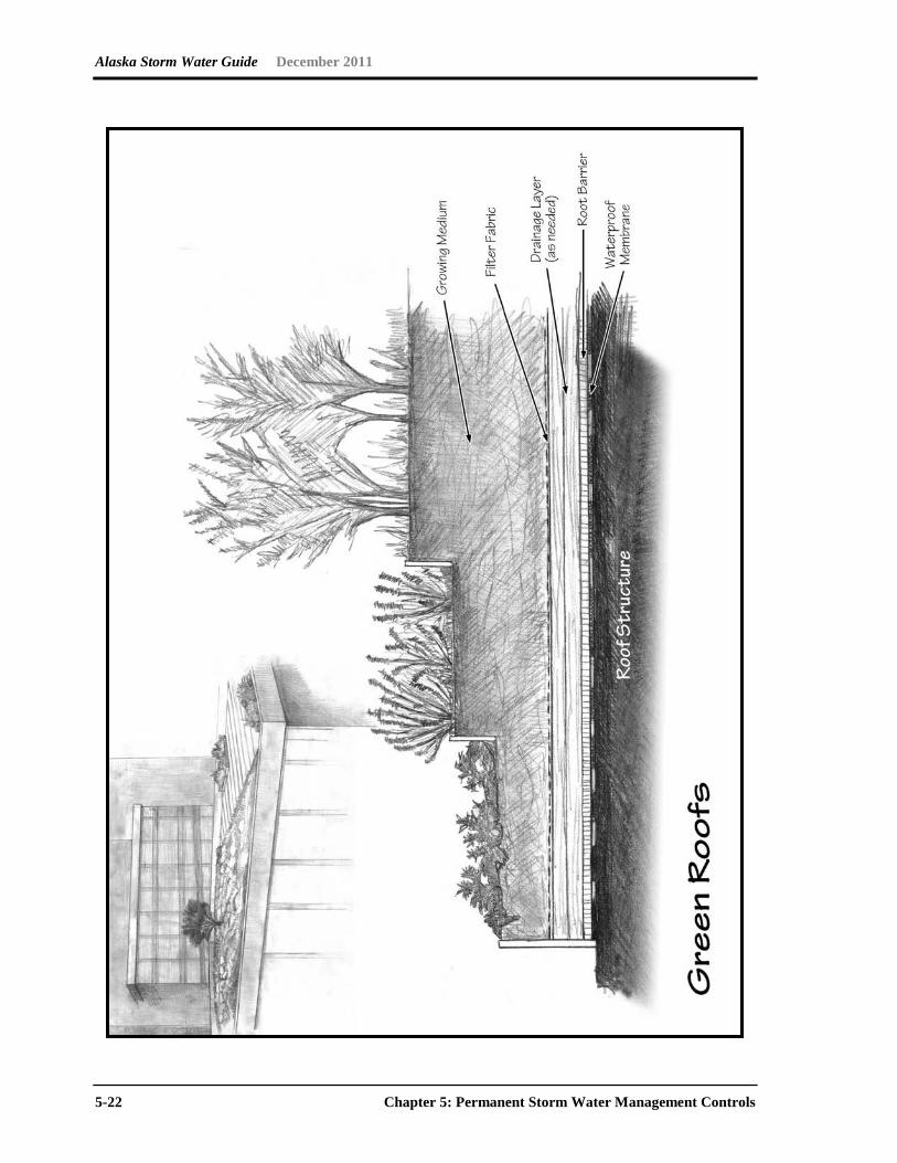
Green roofs are rooftops partially or completely covered with plants. Used for decades in Europe, green roofs help mitigate the urban heat island effect and reduce peak storm water
Alaska Storm Water Guide December 2011
5-6 Chapter 5: Permanent Storm Water Management Controls
flows. The vegetated cover also protects and insulates the roof, extending its life and reducing energy costs.
Permeable and porous pavements reduce storm water runoff by allowing water to soak through the paved surface into the ground beneath. Permeable pavement encompasses a variety of mediums, from porous concrete and asphalt, to plastic grid systems and interlocking paving bricks suitable for driveways and pedestrian malls. Permeable pavement helps reduce runoff volumes at a considerably lower cost than traditional storm drain systems.
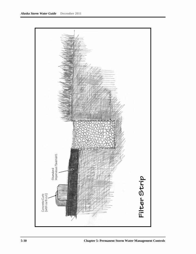
Dry swales are broad, open channels sown with erosion-resistant and flood-tolerant grasses. Used alongside roadways for years primarily as storm water conveyances, swales can slow storm water runoff, filter it and allow it to soak into the ground. Swales and other biofiltration devices like grass filter strips improve water quality and reduce in-stream erosion by slowing the velocity of storm water runoff before it enters the stream. Swales also cost less to install than curbs, storm drain inlets and piping systems.
5.3 Source Control Practices for High Pollutant Source Hotspots
For some high pollutant source hotspots (e.g., some industries and commercial businesses, such as gas stations or large parking lots—for more information, see Section 2.7), the primary focus should be on reducing the exposure of the pollutants to storm water before permanent storm water controls are selected. Source control practices are used to minimize exposure of potential pollutants to storm water runoff. Examples of source control nonstructural and structural BMPs include using less toxic chemicals and covering an activity area that might be a pollutant source. Source control BMPs are preferred over treatment control BMPs because they prevent pollutants from being introduced into storm water (therefore treatment is not required to remove the pollutant), and source controls are usually, but not always, less costly than treatment control BMPs.
Common source control practices include the following:
• Housekeeping Practices
• Public Education/Participation
• Employee Training
• Conserving Natural Areas/Vegetation Controls
Alaska Storm Water Guide December 2011
Chapter 5: Permanent Storm Water Management Controls 5-7
• Protecting Slopes & Channels
• Providing Storm Drain System Stenciling & Signage
• Trash Storage Areas
• Outdoor Material Handling and Storage Areas
• Covering Loading/Unloading Dock Areas
• Covering Waste Handling & Disposal
• Improving Vehicle Fleet Management
• Repair/Maintenance Bays
• Sweeping Parking Area
Additional information on different source control BMPs for pollutant hotspots is at
• California Stormwater Quality Association Industrial and Commercial Stormwater BMP Handbook (see Link 68 in Appendix A).
• Center for Watershed Protection Pollution Source Control Practices (see Link 69 in Appendix A).
Alaska Storm Water Guide December 2011
5-8 Chapter 5: Permanent Storm Water Management Controls
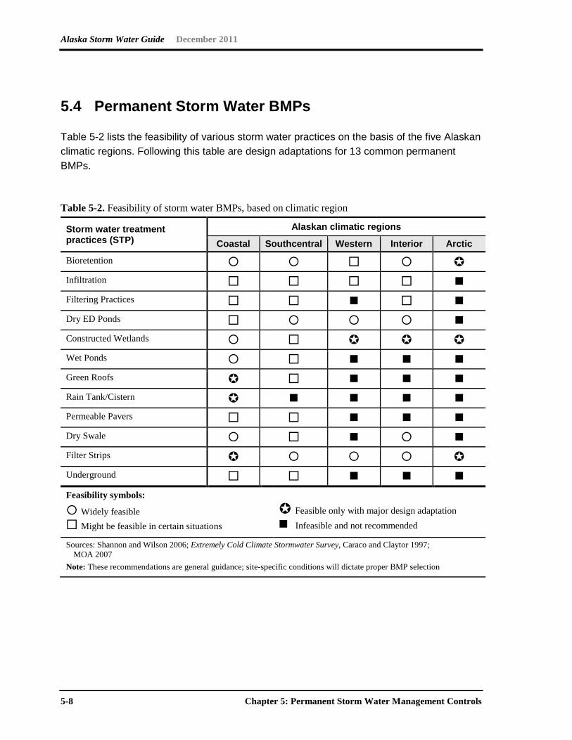
5.4 Permanent Storm Water BMPs
Table 5-2 lists the feasibility of various storm water practices on the basis of the five Alaskan climatic regions. Following this table are design adaptations for 13 common permanent BMPs.
Table 5-2. Feasibility of storm water BMPs, based on climatic region
Storm water treatment practices (STP)
Alaskan climatic regions
Coastal Southcentral Western Interior Arctic
Bioretention Infiltration Filtering Practices Dry ED Ponds Constructed Wetlands Wet Ponds Green Roofs Rain Tank/Cistern Permeable Pavers Dry Swale Filter Strips Underground Feasibility symbols:
Widely feasible Might be feasible in certain situations
Feasible only with major design adaptation Infeasible and not recommended
Sources: Shannon and Wilson 2006; Extremely Cold Climate Stormwater Survey, Caraco and Claytor 1997; MOA 2007
Note: These recommendations are general guidance; site-specific conditions will dictate proper BMP selection

Alaska Storm Water Guide December 2011
Chapter 5: Permanent Storm Water Management Controls 5-9
This page intentionally left blank.
Alaska Storm Water Guide December 2011
5-10 Chapter 5: Permanent Storm Water Management Controls
Alaska Storm Water Guide December 2011
Chapter 5: Permanent Storm Water Management Controls 5-11
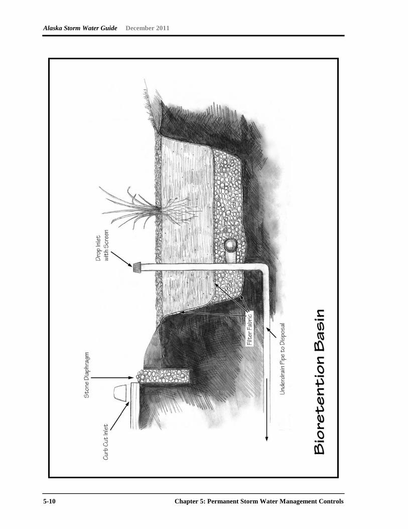
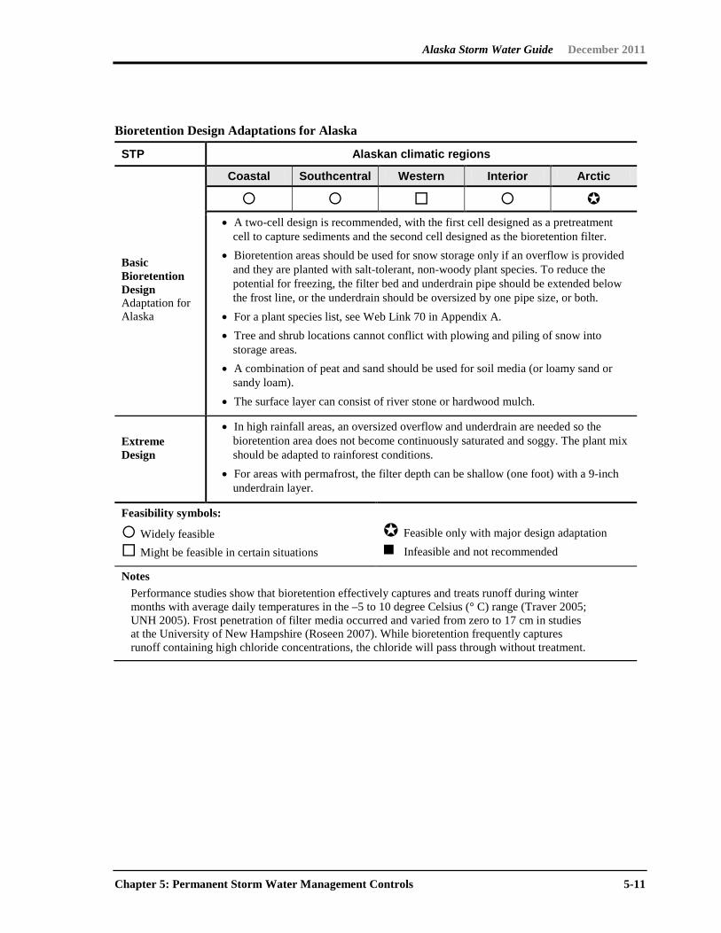
Bioretention Design Adaptations for Alaska
STP Alaskan climatic regions
Basic Bioretention Design Adaptation for Alaska
Coastal Southcentral Western Interior Arctic
• A two-cell design is recommended, with the first cell designed as a pretreatment
cell to capture sediments and the second cell designed as the bioretention filter. • Bioretention areas should be used for snow storage only if an overflow is provided
and they are planted with salt-tolerant, non-woody plant species. To reduce the potential for freezing, the filter bed and underdrain pipe should be extended below the frost line, or the underdrain should be oversized by one pipe size, or both.
• For a plant species list, see Web Link 70 in Appendix A. • Tree and shrub locations cannot conflict with plowing and piling of snow into
storage areas. • A combination of peat and sand should be used for soil media (or loamy sand or
sandy loam). • The surface layer can consist of river stone or hardwood mulch.
Extreme Design
• In high rainfall areas, an oversized overflow and underdrain are needed so the bioretention area does not become continuously saturated and soggy. The plant mix should be adapted to rainforest conditions.
• For areas with permafrost, the filter depth can be shallow (one foot) with a 9-inch underdrain layer.
Feasibility symbols:
Widely feasible Might be feasible in certain situations
Feasible only with major design adaptation Infeasible and not recommended
Notes Performance studies show that bioretention effectively captures and treats runoff during winter
months with average daily temperatures in the –5 to 10 degree Celsius (° C) range (Traver 2005; UNH 2005). Frost penetration of filter media occurred and varied from zero to 17 cm in studies at the University of New Hampshire (Roseen 2007). While bioretention frequently captures runoff containing high chloride concentrations, the chloride will pass through without treatment.
Alaska Storm Water Guide December 2011
5-12 Chapter 5: Permanent Storm Water Management Controls
Alaska Storm Water Guide December 2011
Chapter 5: Permanent Storm Water Management Controls 5-13
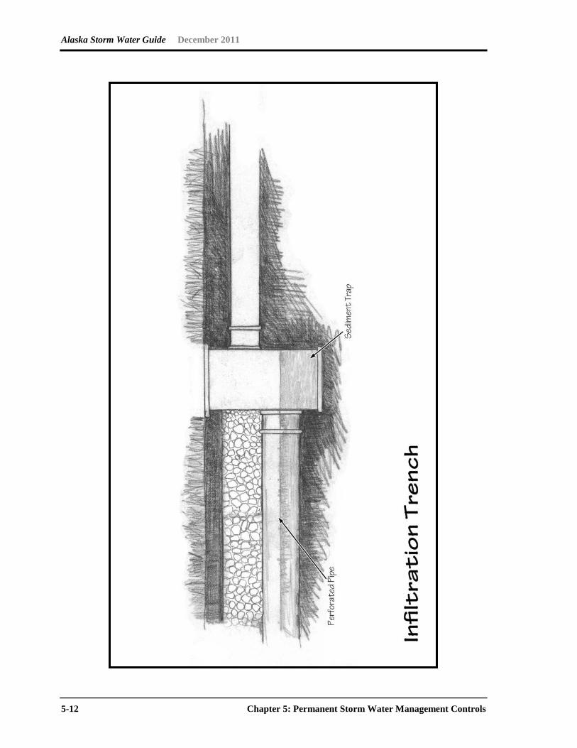
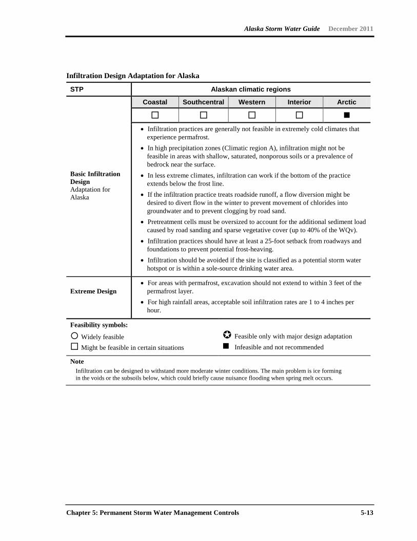
Infiltration Design Adaptation for Alaska
STP Alaskan climatic regions
Basic Infiltration Design Adaptation for Alaska
Coastal Southcentral Western Interior Arctic
• Infiltration practices are generally not feasible in extremely cold climates that
experience permafrost. • In high precipitation zones (Climatic region A), infiltration might not be
feasible in areas with shallow, saturated, nonporous soils or a prevalence of bedrock near the surface.
• In less extreme climates, infiltration can work if the bottom of the practice extends below the frost line.
• If the infiltration practice treats roadside runoff, a flow diversion might be desired to divert flow in the winter to prevent movement of chlorides into groundwater and to prevent clogging by road sand.
• Pretreatment cells must be oversized to account for the additional sediment load caused by road sanding and sparse vegetative cover (up to 40% of the WQv).
• Infiltration practices should have at least a 25-foot setback from roadways and foundations to prevent potential frost-heaving.
• Infiltration should be avoided if the site is classified as a potential storm water hotspot or is within a sole-source drinking water area.
Extreme Design
• For areas with permafrost, excavation should not extend to within 3 feet of the permafrost layer.
• For high rainfall areas, acceptable soil infiltration rates are 1 to 4 inches per hour.
Feasibility symbols:
Widely feasible Might be feasible in certain situations
Feasible only with major design adaptation Infeasible and not recommended
Note Infiltration can be designed to withstand more moderate winter conditions. The main problem is ice forming
in the voids or the subsoils below, which could briefly cause nuisance flooding when spring melt occurs.
Alaska Storm Water Guide December 2011
5-14 Chapter 5: Permanent Storm Water Management Controls
Alaska Storm Water Guide December 2011
Chapter 5: Permanent Storm Water Management Controls 5-15
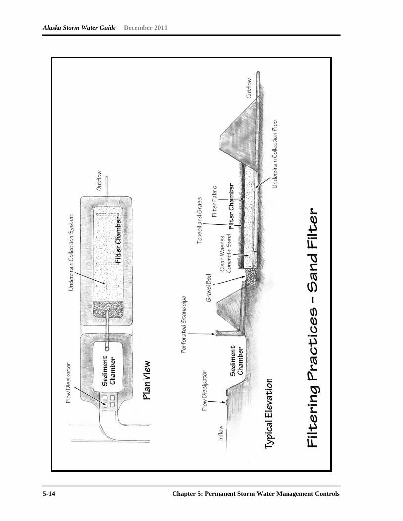
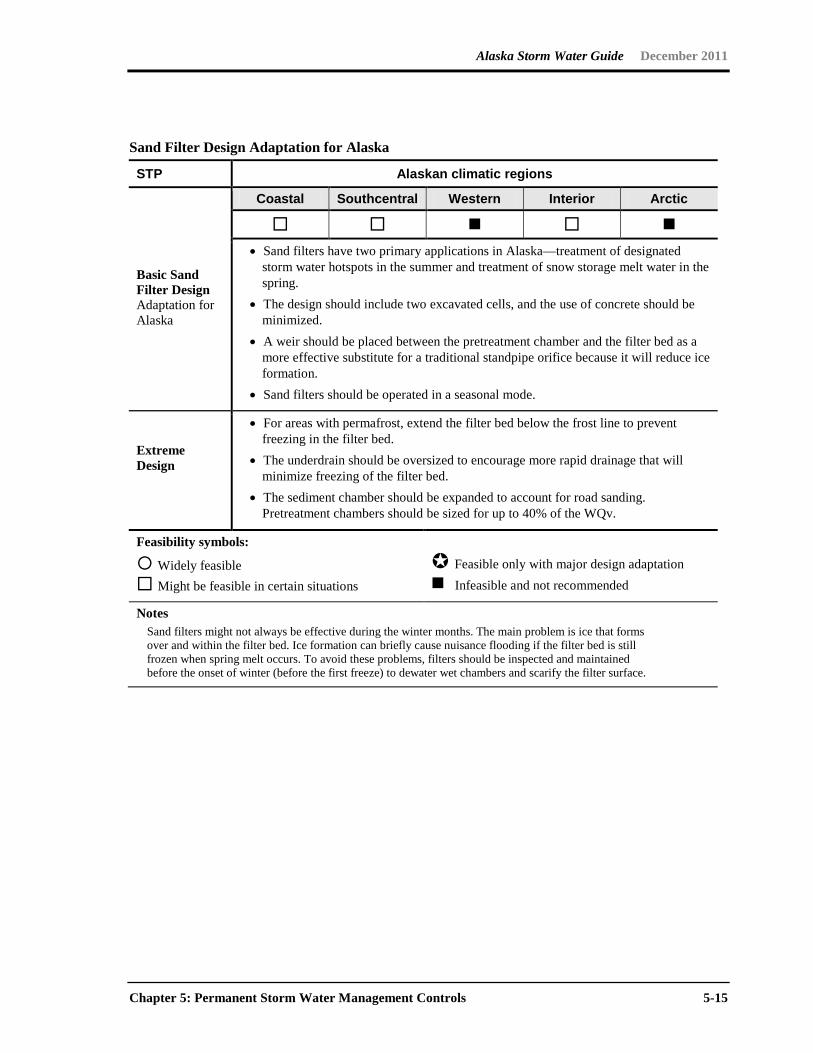
Sand Filter Design Adaptation for Alaska
STP Alaskan climatic regions
Basic Sand Filter Design Adaptation for Alaska
Coastal Southcentral Western Interior Arctic
• Sand filters have two primary applications in Alaska—treatment of designated
storm water hotspots in the summer and treatment of snow storage melt water in the spring.
• The design should include two excavated cells, and the use of concrete should be minimized.
• A weir should be placed between the pretreatment chamber and the filter bed as a more effective substitute for a traditional standpipe orifice because it will reduce ice formation.
• Sand filters should be operated in a seasonal mode.
Extreme Design
• For areas with permafrost, extend the filter bed below the frost line to prevent freezing in the filter bed.
• The underdrain should be oversized to encourage more rapid drainage that will minimize freezing of the filter bed.
• The sediment chamber should be expanded to account for road sanding. Pretreatment chambers should be sized for up to 40% of the WQv.
Feasibility symbols:
Widely feasible Might be feasible in certain situations
Feasible only with major design adaptation Infeasible and not recommended
Notes Sand filters might not always be effective during the winter months. The main problem is ice that forms
over and within the filter bed. Ice formation can briefly cause nuisance flooding if the filter bed is still frozen when spring melt occurs. To avoid these problems, filters should be inspected and maintained before the onset of winter (before the first freeze) to dewater wet chambers and scarify the filter surface.
Alaska Storm Water Guide December 2011
5-16 Chapter 5: Permanent Storm Water Management Controls

Alaska Storm Water Guide December 2011
Chapter 5: Permanent Storm Water Management Controls 5-17
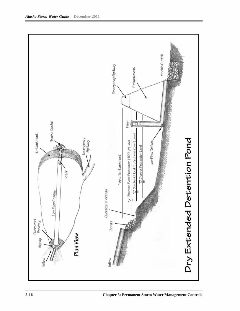
Extended Detention Wetland Design Adaptation for Alaska
STP Alaskan climatic regions
Basic Dry Extended Detention (ED) Pond Design Adaptation for Alaska
Coastal Southcentral Western Interior Arctic
Winter conditions can lead to ice formation within inlets, flow splitters, and ED outlet pipes. Designers can minimize these problems with the following practices: • Oversize the forebay to account for the higher sedimentation rate. • Operate in a seasonal mode that provides ED storage to treat snowmelt runoff in
the spring. During the summer, the facility will act as a shallow wetland. • Do not submerge inlet pipes, and increase the slope of inlet pipes by a minimum of
1% to discourage standing water and prevent potential ice formation in upstream pipes.
• Place all pipes below the frost line to prevent frost heave and pipe freezing. • Design low-flow orifices to withdraw at least 6 inches below the typical ice layer. • Place trash racks at a shallow angle to prevent ice formation.
Extreme Design
• Ponds should not be excavated below permafrost layer; rather, they should be excavated below the frost line.
• If operated as an ED wetland, it is acceptable for excavation to intersect with the water table.
• If soils are so permeable that a constant water table cannot be maintained in the summer, designers should consider an infiltration basin as an alternative.
Feasibility symbols:
Widely feasible Might be feasible in certain situations
Feasible only with major design adaptation Infeasible and not recommended
Note Several alternative outlet designs are in MSSC (2005) and Caraco and Claytor (1997).
Alaska Storm Water Guide December 2011
5-18 Chapter 5: Permanent Storm Water Management Controls

Alaska Storm Water Guide December 2011
Chapter 5: Permanent Storm Water Management Controls 5-19
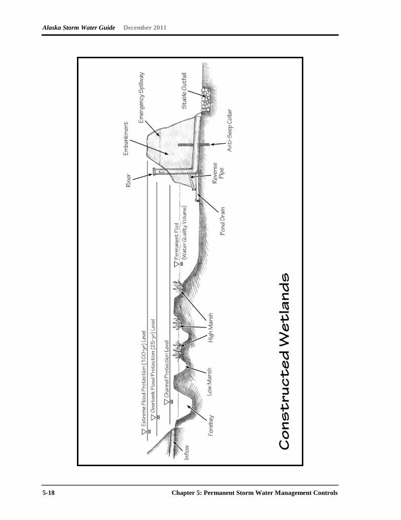
Constructed Wetland Design Adaptation for Alaska
STP Alaskan climatic regions
Basic Constructed Wetland Design Adaptation for Alaska
Coastal Southcentral Western Interior Arctic
• Shallow, forested constructed wetlands are a good option for many precipitation
zones if space is available. • Designs should minimize the amount of complex inflow and outflow devices
and should serve smaller drainage areas (5 to 20 acres). • In regions Southcentral, Western, Interior and Arctic, wetlands should be
designed with two stages and operated seasonally. The top stage should be designed to provide ED for spring snowmelt, and the bottom wetland stage will serve as summer storm treatment.
• The vertical elevation of both stages should not exceed 4 or 5 feet to reduce the likelihood of difficulties with excavation.
• Wetlands should contain multiple cells and maximize plant/water contact. For design guidance, see Cappiella et al. (2008).
• Wetland bottoms can contain sand or peat amendments. • Wetlands can be planted with native trees and shrubs, or they can be prepared
to enable native plant species to colonize. Contact the local COE office to obtain information on native plants.
Extreme Design
• For basic restrictions in cold climates, see the dry ED pond guidelines. • For areas with permafrost, maintain a total depth of one foot or less, use surface
or gravel berms to create cells close to the ground elevation, and do not excavate into the permafrost.
Feasibility symbols:
Widely feasible Might be feasible in certain situations
Feasible only with major design adaptation Infeasible and not recommended
Notes Wetland performance decreases when snowmelt runoff delivers high pollutant loads. Shallow constructed
wetlands can freeze in the winter, which allows runoff to flow over the ice layer and exit without treatment. Inlet and outlet structures close to the surface could also freeze, further diminishing wetland performance.
Salt loadings are higher in cold climates due to winter road maintenance. High chloride inputs have a detrimental effect on native wetland vegetation and can shift the wetland to more salt-tolerant species (Wright et al. 2006). Designers should choose salt-tolerant species when crafting their planting plan.
Alaska Storm Water Guide December 2011
5-20 Chapter 5: Permanent Storm Water Management Controls
Alaska Storm Water Guide December 2011
Chapter 5: Permanent Storm Water Management Controls 5-21
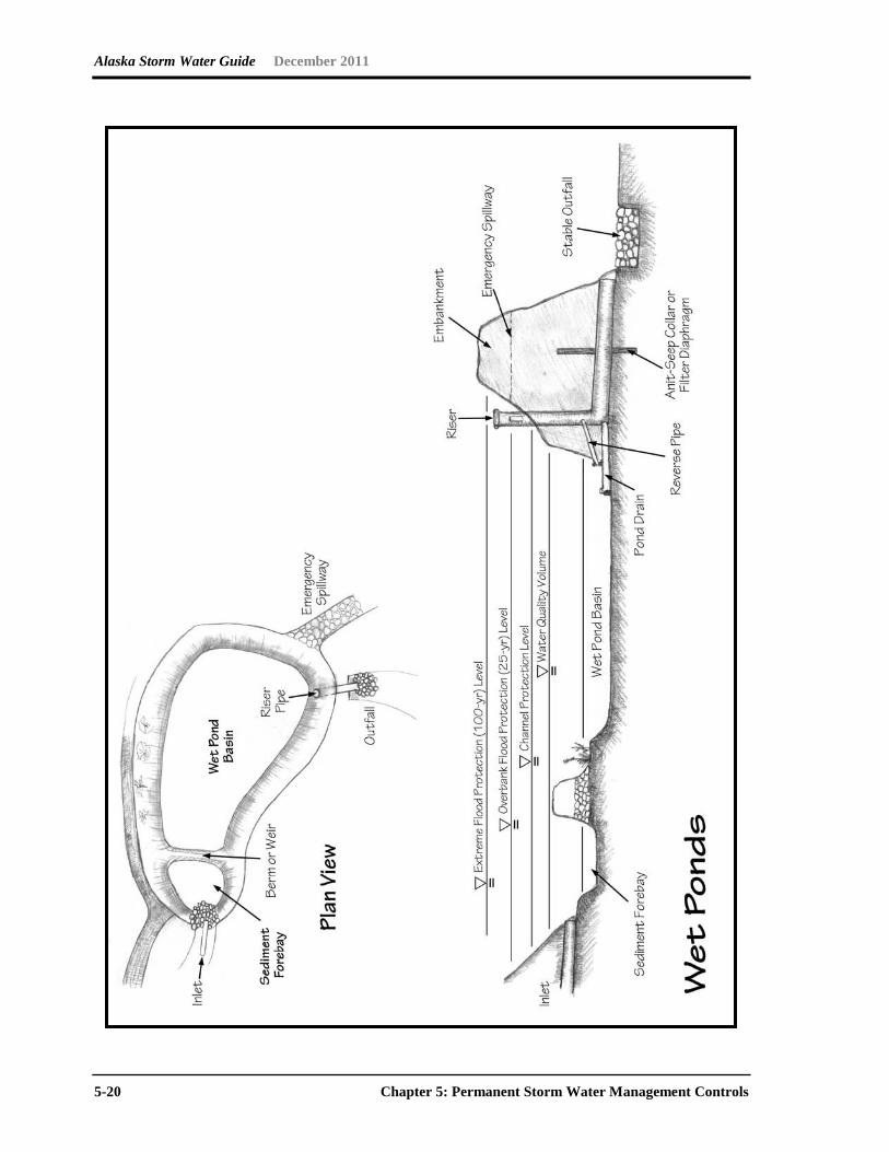
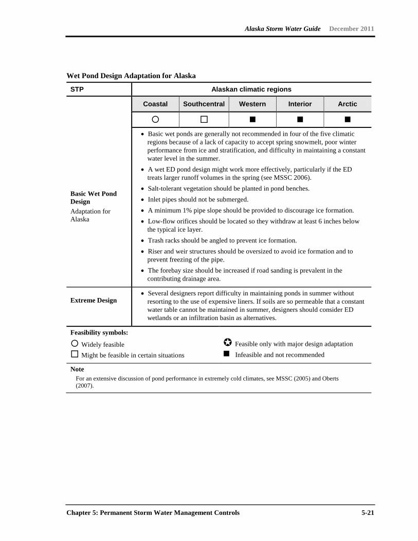
Wet Pond Design Adaptation for Alaska
STP Alaskan climatic regions
Coastal Southcentral Western Interior Arctic
Basic Wet Pond Design Adaptation for Alaska
• Basic wet ponds are generally not recommended in four of the five climatic regions because of a lack of capacity to accept spring snowmelt, poor winter performance from ice and stratification, and difficulty in maintaining a constant water level in the summer.
• A wet ED pond design might work more effectively, particularly if the ED treats larger runoff volumes in the spring (see MSSC 2006).
• Salt-tolerant vegetation should be planted in pond benches. • Inlet pipes should not be submerged. • A minimum 1% pipe slope should be provided to discourage ice formation. • Low-flow orifices should be located so they withdraw at least 6 inches below
the typical ice layer. • Trash racks should be angled to prevent ice formation. • Riser and weir structures should be oversized to avoid ice formation and to
prevent freezing of the pipe. • The forebay size should be increased if road sanding is prevalent in the
contributing drainage area.
Extreme Design
• Several designers report difficulty in maintaining ponds in summer without resorting to the use of expensive liners. If soils are so permeable that a constant water table cannot be maintained in summer, designers should consider ED wetlands or an infiltration basin as alternatives.
Feasibility symbols:
Widely feasible Might be feasible in certain situations
Feasible only with major design adaptation Infeasible and not recommended
Note For an extensive discussion of pond performance in extremely cold climates, see MSSC (2005) and Oberts
(2007).
Alaska Storm Water Guide December 2011
5-22 Chapter 5: Permanent Storm Water Management Controls
Alaska Storm Water Guide December 2011
Chapter 5: Permanent Storm Water Management Controls 5-23
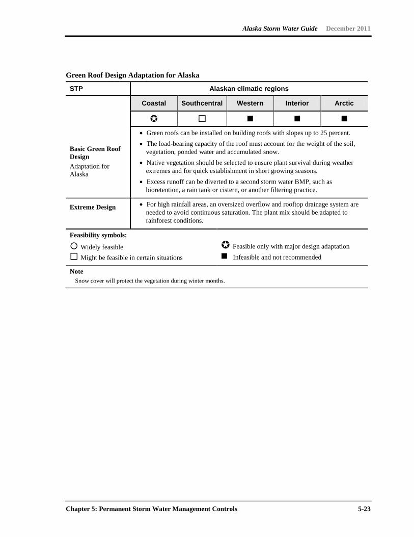
Green Roof Design Adaptation for Alaska
STP Alaskan climatic regions
Coastal Southcentral Western Interior Arctic
Basic Green Roof Design Adaptation for Alaska
• Green roofs can be installed on building roofs with slopes up to 25 percent. • The load-bearing capacity of the roof must account for the weight of the soil,
vegetation, ponded water and accumulated snow. • Native vegetation should be selected to ensure plant survival during weather
extremes and for quick establishment in short growing seasons. • Excess runoff can be diverted to a second storm water BMP, such as
bioretention, a rain tank or cistern, or another filtering practice.
Extreme Design
• For high rainfall areas, an oversized overflow and rooftop drainage system are needed to avoid continuous saturation. The plant mix should be adapted to rainforest conditions.
Feasibility symbols:
Widely feasible Might be feasible in certain situations
Feasible only with major design adaptation Infeasible and not recommended
Note Snow cover will protect the vegetation during winter months.

Alaska Storm Water Guide December 2011
5-24 Chapter 5: Permanent Storm Water Management Controls
Alaska Storm Water Guide December 2011
Chapter 5: Permanent Storm Water Management Controls 5-25
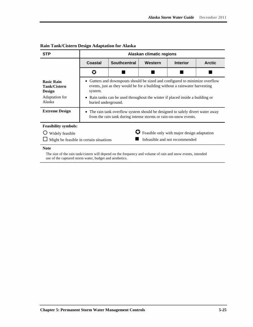
Rain Tank/Cistern Design Adaptation for Alaska
STP Alaskan climatic regions
Coastal Southcentral Western Interior Arctic
Basic Rain Tank/Cistern Design Adaptation for Alaska
• Gutters and downspouts should be sized and configured to minimize overflow events, just as they would be for a building without a rainwater harvesting system.
• Rain tanks can be used throughout the winter if placed inside a building or buried underground.
Extreme Design
• The rain tank overflow system should be designed to safely divert water away from the rain tank during intense storms or rain-on-snow events.
Feasibility symbols:
Widely feasible Might be feasible in certain situations
Feasible only with major design adaptation Infeasible and not recommended
Note The size of the rain tank/cistern will depend on the frequency and volume of rain and snow events, intended
use of the captured storm water, budget and aesthetics.
Alaska Storm Water Guide December 2011
5-26 Chapter 5: Permanent Storm Water Management Controls
Alaska Storm Water Guide December 2011
Chapter 5: Permanent Storm Water Management Controls 5-27
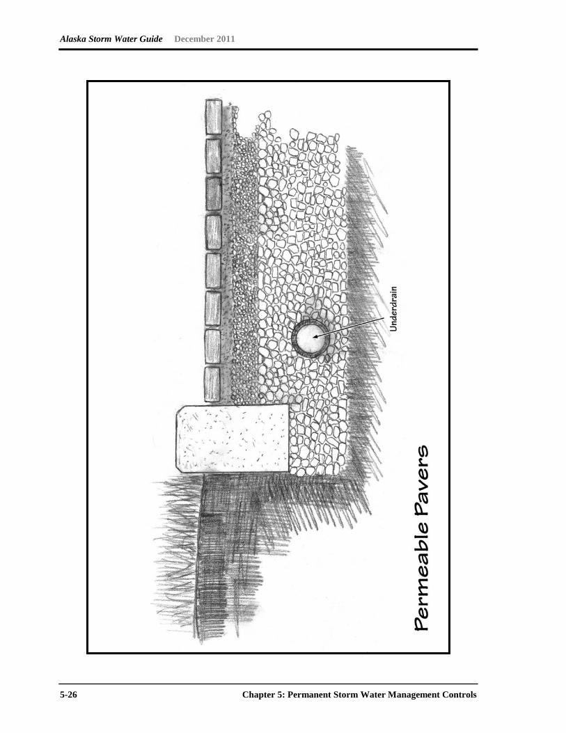
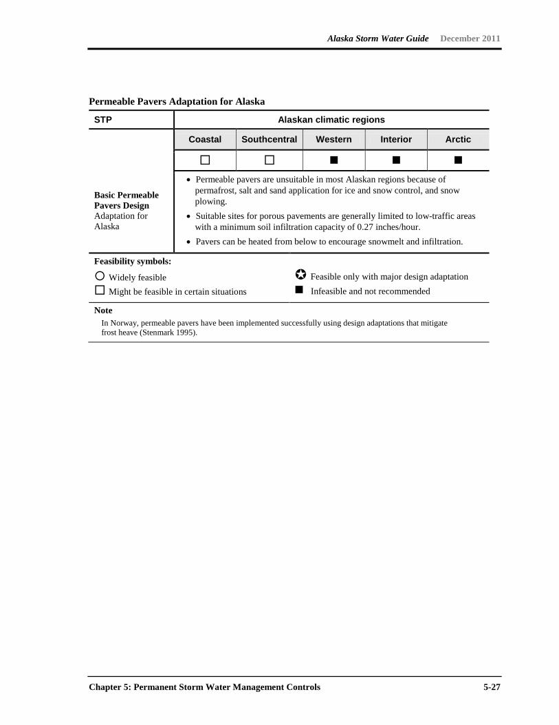
Permeable Pavers Adaptation for Alaska
STP Alaskan climatic regions
Coastal Southcentral Western Interior Arctic
Basic Permeable Pavers Design Adaptation for Alaska
• Permeable pavers are unsuitable in most Alaskan regions because of permafrost, salt and sand application for ice and snow control, and snow plowing.
• Suitable sites for porous pavements are generally limited to low-traffic areas with a minimum soil infiltration capacity of 0.27 inches/hour.
• Pavers can be heated from below to encourage snowmelt and infiltration.
Feasibility symbols:
Widely feasible Might be feasible in certain situations
Feasible only with major design adaptation Infeasible and not recommended
Note In Norway, permeable pavers have been implemented successfully using design adaptations that mitigate
frost heave (Stenmark 1995).
Alaska Storm Water Guide December 2011
5-28 Chapter 5: Permanent Storm Water Management Controls
Alaska Storm Water Guide December 2011
Chapter 5: Permanent Storm Water Management Controls 5-29
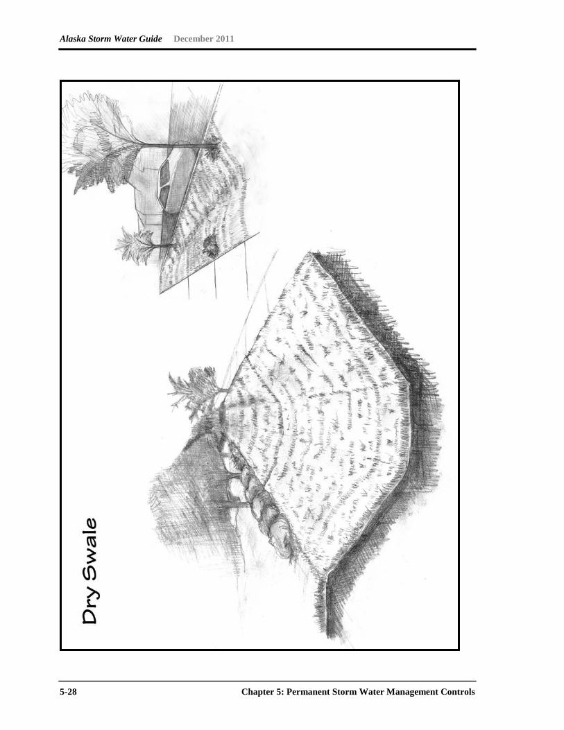
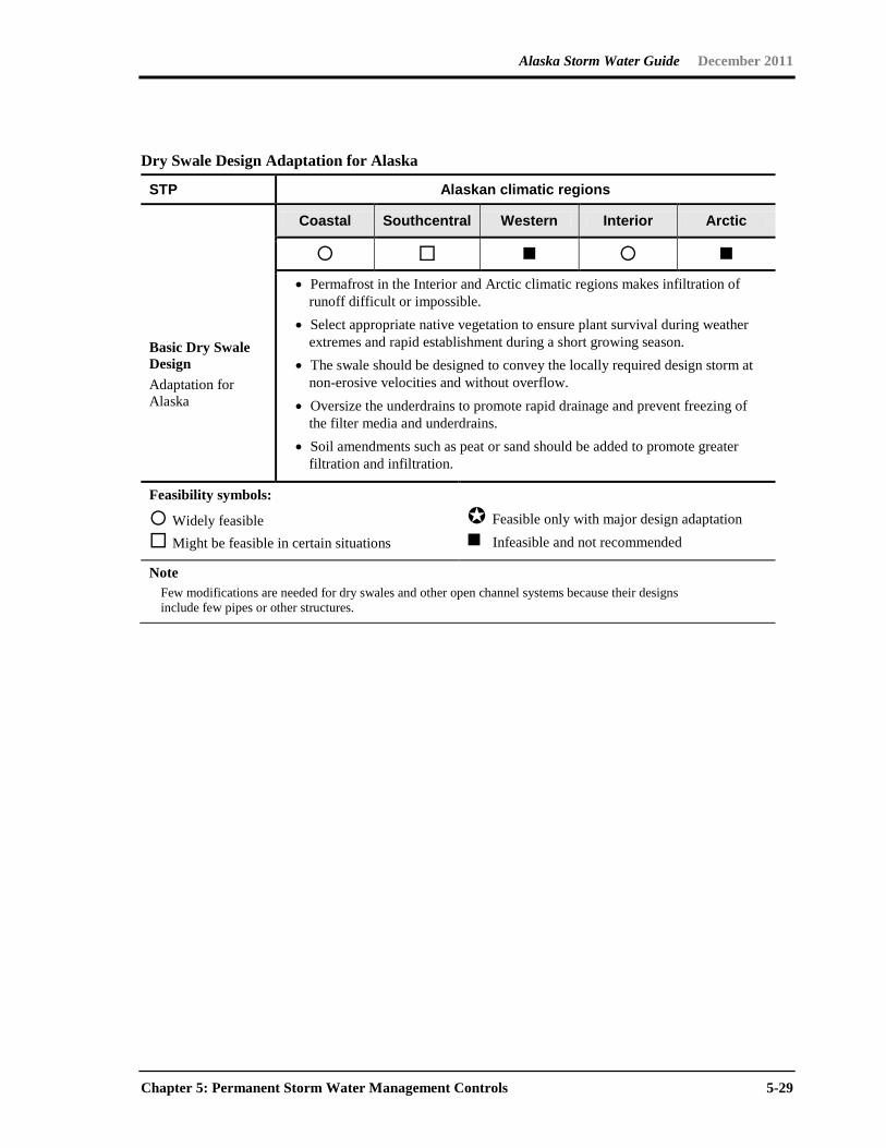
Dry Swale Design Adaptation for Alaska
STP Alaskan climatic regions
Coastal Southcentral Western Interior Arctic
Basic Dry Swale Design Adaptation for Alaska
• Permafrost in the Interior and Arctic climatic regions makes infiltration of runoff difficult or impossible.
• Select appropriate native vegetation to ensure plant survival during weather extremes and rapid establishment during a short growing season.
• The swale should be designed to convey the locally required design storm at non-erosive velocities and without overflow.
• Oversize the underdrains to promote rapid drainage and prevent freezing of the filter media and underdrains.
• Soil amendments such as peat or sand should be added to promote greater filtration and infiltration.
Feasibility symbols:
Widely feasible Might be feasible in certain situations
Feasible only with major design adaptation Infeasible and not recommended
Note Few modifications are needed for dry swales and other open channel systems because their designs
include few pipes or other structures.
Alaska Storm Water Guide December 2011
5-30 Chapter 5: Permanent Storm Water Management Controls
Alaska Storm Water Guide December 2011
Chapter 5: Permanent Storm Water Management Controls 5-31
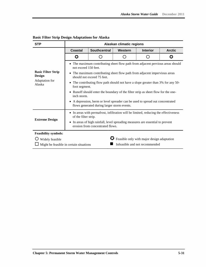
Basic Filter Strip Design Adaptations for Alaska
STP Alaskan climatic regions
Basic Filter Strip Design Adaptation for Alaska
Coastal Southcentral Western Interior Arctic
• The maximum contributing sheet flow path from adjacent pervious areas should
not exceed 150 feet. • The maximum contributing sheet flow path from adjacent impervious areas
should not exceed 75 feet. • The contributing flow path should not have a slope greater than 3% for any 50-
foot segment. • Runoff should enter the boundary of the filter strip as sheet flow for the one-
inch storm. • A depression, berm or level spreader can be used to spread out concentrated
flows generated during larger storm events.
Extreme Design • In areas with permafrost, infiltration will be limited, reducing the effectiveness
of the filter strip. • In areas of high rainfall, level spreading measures are essential to prevent
erosion from concentrated flows.
Feasibility symbols:
Widely feasible Might be feasible in certain situations
Feasible only with major design adaptation Infeasible and not recommended
Alaska Storm Water Guide December 2011
5-32 Chapter 5: Permanent Storm Water Management Controls
Alaska Storm Water Guide December 2011
Chapter 5: Permanent Storm Water Management Controls 5-33
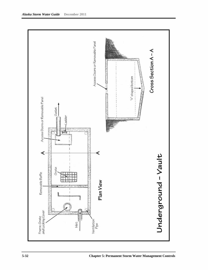
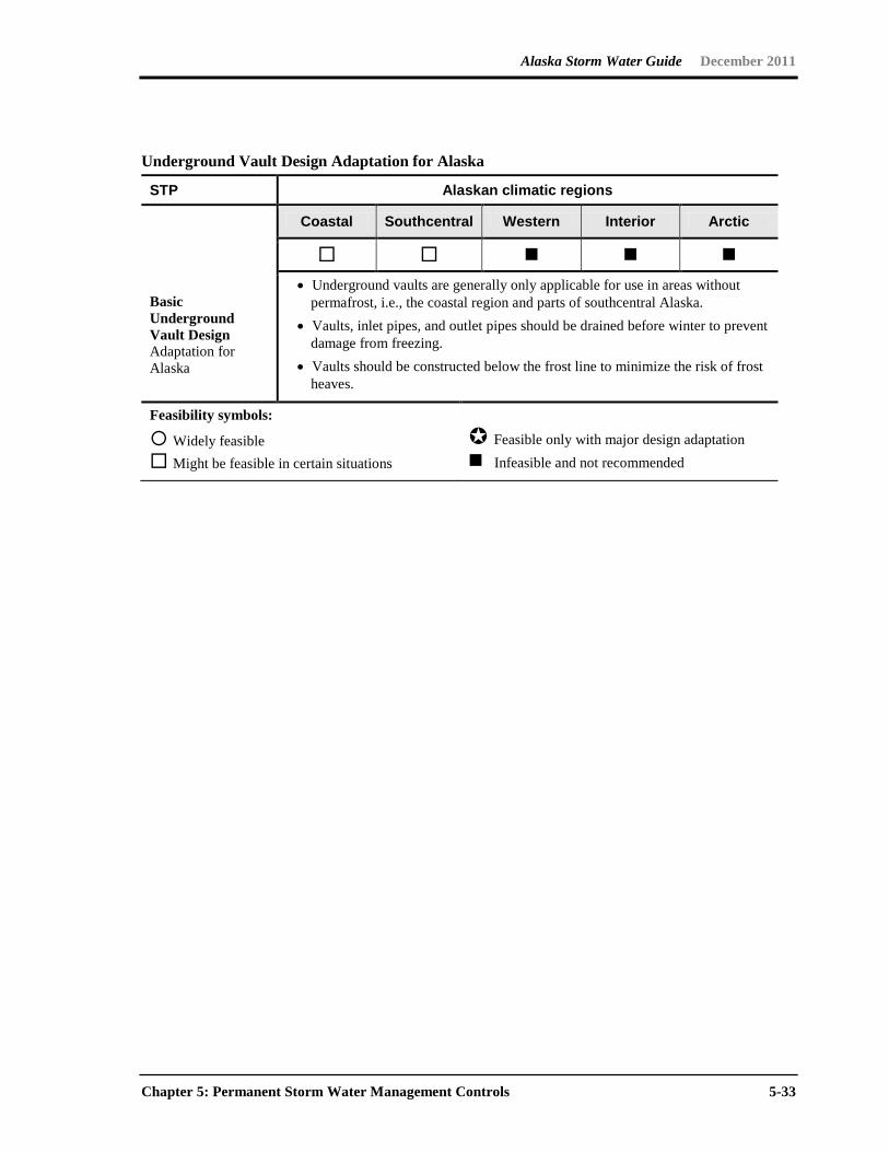
Underground Vault Design Adaptation for Alaska
STP Alaskan climatic regions
Coastal Southcentral Western Interior Arctic
Basic Underground Vault Design Adaptation for Alaska
• Underground vaults are generally only applicable for use in areas without permafrost, i.e., the coastal region and parts of southcentral Alaska.
• Vaults, inlet pipes, and outlet pipes should be drained before winter to prevent damage from freezing.
• Vaults should be constructed below the frost line to minimize the risk of frost heaves.
Feasibility symbols:
Widely feasible Might be feasible in certain situations
Feasible only with major design adaptation Infeasible and not recommended

Alaska Storm Water Guide December 2011
5-34 Chapter 5: Permanent Storm Water Management Controls
5.5 Maintenance
Proper BMP operation and maintenance (O&M) is an important aspect in assuring the effectiveness of a BMP in mitigating storm water pollution. Routine maintenance or service also contributes to the efficiency and continuous operation of the system. To ensure the effectiveness of permanent, structural BMPs, an O&M plan should be developed and implemented. The O&M plan can be developed by the project operator or according to the BMP manufacturer’s manual.
The O&M plan describes how the owner can ensure performance of the BMP over time. O&M plans should specify the following:
• The scope of maintenance activities to be performed at the facilities
• The schedule for performing various maintenance tasks
• The schedule for inspection by the facility owner
• The parties responsible for inspection and maintenance of the facility
Instructions on the proper O&M of the BMPs should be provided to the developer, owner or responsible entities (e.g., homeowners’ associations, employees, tenants or subdivision managers) to ensure adequate and appropriate O&M of the system. The O&M plan should be kept on-site for inspection. Maintenance of the BMP is typically the responsibility of the facility’s owner or operator or both.
A log should be kept on-site, where practical, to record inspection and maintenance activities. The record should contain the following information: (1) type of maintenance activities or source-control practices, (2) date the activities are completed, and (3) the name of operator performing the activities. During transfer of ownership/operation of the facility, the current owner should notify the new owner/operator of these conditions and required activities.
Some typical maintenance activities for permanent BMPs include
• Cleaning and removing debris
• Mowing vegetation
• Repairing animal burrows
• Removing sediment
• Repairing outlets, risers, or other structures
• Reseeding
Alaska Storm Water Guide June 2009
Glossary-1
Glossary
A
adsorption the adhesion of an extremely thin layer of molecules to the surfaces of solid
bodies or liquids with which they are in contact
aggrade the buildup of sediment or eroded material
anaerobic condition operating in a system in which there is the absence of free oxygen
available for biologic use
animal waste management practices and procedures that prevent the movement of animal
wastes or byproducts from feeding or holding areas into the wider environment
annual load quantity of pollutants, sediment, or nutrients carried by a waterbody over the
period of a year
antecedent soil moisture the water content held by a soil before a storm event; this has an
effect on the amount of water that will run off as a result of that event
B
bankfull flow in a stream or river where the water level is to the top of its bank; considered
to be the channel forming flow and has a recurrence interval of around 2.5 years
bank stabilization activities undertaken to shore up or ensure the integrity of a stream or
river bank and protect it from erosion and slumping
base flow the flow coming from ground water inputs to a stream or river system
basin a depression in the surface of the land that holds water
bed load the sand, gravel or rocks that are transported along the stream bottom by traction,
rolling, sliding or saltation
Alaska Storm Water Guide June 2009
Glossary-2
Best Management Practice (BMP) one of many different structural or nonstructural
methods used to prevent pollution or to treat runoff, including such diverse measures as
ponding, street sweeping, filtration through a rain garden and infiltration to a gravel trench
biochemical oxygen demand (BOD) a measure of the amount of oxygen required to
biologically degrade organic matter in the water
bioretention a soil and plant–based storm water management best management practice
(BMP) used to filter runoff
buffers a vegetative setback between development and streams, lakes and wetlands whose
aim is to physically protect and separate the resource from future disturbance or
encroachment
C
catch basin an inlet to the storm drain system that typically includes a grate or curb inlet
channel protection actions taken to prevent habitat degradation and erosion that can
cause downstream enlargement and incision in urban streams due to increased frequency
of bankfull and sub–bankfull stormwater flows
chemical controls includes such activities as salt management, fertilizer/pesticide
management, and spill prevention and containment
cistern a receptacle for holding liquids, usually water; often built to catch and store
rainwater
cluster design a reduction of average lot size within a residential development in exchange
for greater conservation of natural areas
cold climate sizing sizing of stormwater practices to accommodate snowmelt (typically a
larger than rainfall–based criteria sizing because snowmelt represents more than 10 percent
of annual precipitation)
computable pollutant a pollutant for which enough runoff concentration and BMP
performance data is available to perform a site–based pollutant load calculation
documenting no increase in loading
Alaska Storm Water Guide June 2009
Glossary-3
conservation easement a restriction placed on a piece of property to protect the resources
associated with the parcel; the easement is either voluntarily sold or donated by the
landowner and constitutes a legally binding agreement that prohibits certain types of
development from taking place on the land
construction sequencing a specified work schedule that coordinates the timing of land–
disturbing activities and the installation of erosion–protection and sedimentation–control
measures
conveyance a structure or feature used for transferring water from one location to another
curb and gutter system edging along the side of streets meant to quickly convey storm
water runoff from the street and adjacent areas into the storm water system
curve number an index combining hydrologic soil group, land use factors, treatment and
hydrologic condition that is used in a method developed by the Soil Conservation Service to
determine the approximate amount of runoff from a rainfall event in a particular area;
typically used in Low Impact Development calculations
D
dead storage the permanent storage volume of a pond
degrade downcutting where softer material is present in a stream channel
design storm streamflow from a storm event used as a standard for which performance of
storm water management practices are measured
detention time the theoretical calculated time that a prescribed amount of water is held in a
settling basin
disconnection technique to spread runoff generated from rooftops or impervious surfaces
into adjacent pervious areas where it can be filtered and infiltrated
drainageway a course or channel along which water moves in draining an area
dry pond a water bearing storm water management facility that controls peak runoff flows to
receiving bodies such as rivers and streams that is typically free of water during dry periods,
but filled during times of rainfall
Alaska Storm Water Guide June 2009
Glossary-4
dry well a deep covered hole acting as an underground storage facility for storm water until
it seeps into the surrounding soil
dry swale a grassed channel that primarily served to transport stormwater runoff away from
roadways and rights-of-way and provides some treatment of storm water facilitating
infiltration
E
elution washing out of ions in solution from a snowpack
erosion the wearing down or washing away of the soil and land surface by the action of
water, wind or ice
erosion control any efforts to prevent the wearing or washing away of the soil or land
surface
erosion control blanket a natural or geotextile mat placed in areas susceptible to erosion
to hold the soil in place until it can be permanently stabilized through vegetation or armoring
eutrophic an environment that has an excessive concentration of nutrients
evaporation the process of changing from a liquid state into a gas
evapotranspiration loss of water to the atmosphere as a result of the joint processes of
evaporation and transpiration through vegetation
event–based load quantity of pollutants, sediment or nutrients carried by a waterbody for
particular magnitude storm events
exfiltration uncontrolled outward leakage through cracks and interstices
extended detention provides temporary storage of storm water which attenuates peak
flows and because extended detention basins are normally designed as multistage facilities,
they promote the settling of pollutants.
extreme event an 100–year, 24–hour rain event or an 100–year, 10–day snowmelt event or
greater
Alaska Storm Water Guide June 2009
Glossary-5
extreme flood control for the 100–year, 24–hour or larger events, to maintain the
boundaries of the predevelopment 100–year floodplain, reduce flooding risks to life, reduce
property damage and protect the physical integrity of the storm water management
practices.
F
floodplain land adjacent to a waterbody that is inundated when the discharge exceeds the
conveyance capacity of the normal channel (often defined in a regulatory sense as the
extent of the 100–year flood)
flow control controlling the rate and volume of water leaving a site
forebay an extra storage space or small basin near the inlet to settle out incoming
sediments before water moves on into a pond or detention area
freeze–thaw cycle the alternation between freezing and thawing in the snowpack. This
cycle changes the composition and characteristics of the snowpack and can affect its
pollutant carrying ability and the amount of runoff generated
frequency curve A derivative of the probability curve that expresses the relation between
the frequency distribution plot, with the magnitude of the variables on one axis and the
number of occurrences of each magnitude in a given period as the other
frost heave a phenomenon in cold areas in which water that is trapped in soil or cracks in
rocks alternately freezes and thaws; this causes the water to expand and contract, which
can cause significant movement and upheaval of the soil or rock
G
geomorphology the study of the form and development of the landscape
global warming the progressive gradual rise of the earth’s surface temperature thought to
be caused by the greenhouse effect, which could be responsible for changes in global
climate patterns
grass channels a natural open channel conveyance system which is preferable to curb and
gutter where development density, soils and slopes permit
Alaska Storm Water Guide June 2009
Glossary-6
green roof a rooftop treatment practice in which a thin planting media is established on roof
surfaces and then planted with hardy, low–growing vegetation
ground water water occupying the sub–surface saturated zone
gully erosion the widening, deepening and head cutting of small channels and waterways
(rills) due to erosion by water or snowmelt, typified by channels one foot or more deep
H
head the difference in elevation between two points in a body of water and the resulting
pressure of the fluid at the lower point
hotspot a concentrated source of potential storm water pollution generating land uses such
as gas stations, chemical storage facilities, industrial facilities and so on
housekeeping (BMP) any of a number of BMPs designed to keep pollutants from entering
the waste stream by maintaining clean conditions, including street sweeping, litter pickup
and animal cleanup
hydrograph graphical representation of stage or discharge at a point in a drainage as a
function of time
hyetograph a graphical representation of the distribution of rainfall over the total duration of
a storm event
hydrology the science dealing with the properties, distribution and circulation of water
hydroperiod the length of time an area is inundated or saturated by water
I
impaired waters streams or lakes that do not meet their designated uses because of
excess pollutants or identified stressors
impervious surface a surface in the landscape that impedes the infiltration of rainfall and
results in an increased volume of surface runoff
infiltration flow of water from the land surface into the subsurface
Alaska Storm Water Guide June 2009
Glossary-7
industrial materials or activities include but are not limited to material handling equipment
or activities, industrial machinery, raw materials, intermediate products, by-products, final
products or waste products
inlet protection preservation of the integrity and protection from the erosion of the area
where water enters into a treatment area usually by vegetation or armoring
intensity–duration–frequency curves (IDF) graphical representation of the intensity,
duration and frequency of a differing rainfalls over time
J
K
L
live storage the portion of a storage basin or reservoir that is at or above the outlet and
used for temporary water storage
low density residential a low concentration of housing units in a specific area or on a
specific property, typical of rural areas
low impact development (LID) the application of nonstructural practices at residential and
commercial sites to reduce impervious cover, conserve natural areas and use pervious
areas to more effectively treat stormwater runoff; LID hydrology can be tied to the SCS
curve number
M
minimum control measures six required components of the SWMP for Phase II MS4
communities. The six minimum control measures are: public education/outreach; public
participation/involvement; illicit discharge detection and elimination; construction site runoff
control; post–construction site runoff control; and pollution prevention/good housekeeping.
municipal separate storm sewer system (MS4) a conveyance or system of conveyances
owned or operated by a state, city, town, county, district, association or other public body
having jurisdiction over disposal of sewage, industrial wastes, storm water or other wastes
that discharges to waters of the United States; they are required to develop and implement a
Storm Water Management Program
Alaska Storm Water Guide June 2009
Glossary-8
muskeg an acidic soil type common in arctic and boreal areas. Muskeg consists of dead
plants in various states of decomposition (as peat), ranging from fairly intact sphagnum
moss, to sedge peat, to highly decomposed muck. Pieces of wood such as buried tree
branches can make up 5 to 15 percent of the peat soil. Muskeg tends to have a water table
very near the surface. The sphagnum moss forming it can hold 15 to 30 times its own weight
in water, allowing the spongy wet muskeg to form even on sloping ground.
N
native vegetation plants that are adapted to and occur naturally in a specific location
natural area conservation the identification and protection of natural resources and
features that maintain the predevelopment hydrology at a site by reducing runoff, promoting
infiltration and preventing soil erosion.
no exposure all industrial materials or activities are protected by a storm resistant shelter to
prevent exposure to rain, snow, snowmelt or runoff
nonpoint source pollution pollution that enters a waterbody from diffuse origins on the
watershed and does not result from discernable, confined or discrete conveyances
O
Ordinary High Water (OHW) 11 AAC 53.120. Technical Survey Standards (2) Ordinary
High Water Mark. This is to be determined by observing and marking the place on the bank
or shore up to which the presence and action of water are so prolonged as to impress on the
bank or shore a character distinct from that of the bank or shore with respect to vegetation
and the nature of the soil. 11 AAC 53.900. Definitions (23) “ordinary high water mark” means
the mark along the bank or shore up to which the presence and action of the nontidal water
are so common and usual, and so long continued in all ordinary years, as to leave a natural
line impressed on the bank or shore and indicated by erosion, shelving, changes in soil
characteristics, destruction of terrestrial vegetation, or other distinctive physical
characteristics.
P
peak flow control controlling the timing and magnitude of the largest flow either leaving the
site or flowing through the watershed using storm water management techniques to avoid
flooding and damage downstream.
Alaska Storm Water Guide June 2009
Glossary-9
permanent storage pool the volume in a pond or reservoir below the lowest outlet level,
designed for water quality purposes to settle out particles and nutrients
permeable paver a range of products that enable some fraction of rainfall to be infiltrated
into a sub–base underneath the paver
pollution load the product of flow volume times pollutant concentration
pollution prevention practices proactive activities and strategies instituted to avoid
introducing pollution into the environment
pollutograph graphical representation of pollution at a point in a drainage as a function of
time
Q
R
rainfall distribution describes how the rain fell in a 24–hour period, i.e., whether the
precipitation occurred over a 1–hour period or over the entire 24–hour period
rainfall frequency spectrum describes the average frequency of the depth of precipitation
events (adjusted for snowfall) that occur during a normal year
rain garden a landscaping feature that is planted with native perennial plants and is used to
manage storm water runoff from impervious surfaces such as roofs, sidewalks and parking
lots
recharge the addition of water to an aquifer by natural infiltration or artificial means
redevelopment any construction, alteration, or improvement that disturbs greater than or
equal to 5,000 square feet of existing impervious cover performed on sites where the
existing land use is commercial, industrial, institutional or residential
retention maintaining a permanent pool with additional freeboard for storage in a storm
water basin
retrofit the introduction of a new or improved storm water management element where it
either never existed or did not operate effectively
Alaska Storm Water Guide June 2009
Glossary-10
return interval the inverse probability that a certain flow will occur; it represents a mean
time interval based on the distribution of flows over a period of record
rill erosion an erosion process in which numerous small channels several inches deep are
formed
riparian areas areas adjacent to a waterbody acting as transition zones between terrestrial
and aquatic systems
runoff the portion of rainfall or snowmelt not immediately absorbed into the soil that drains
or flows off the land and becomes surface flow
runoff management techniques, practices and strategies for dealing with runoff and
minimizing its effect on the greater environment
S
Soil Conservation Service (SCS) Curve Number a simple, widely used method for
determining the approximate amount of runoff from a rainfall or snowmelt even in a
particular area. The curve number is based on the area's hydrologic soil group, land use,
treatment and hydrologic condition.
sediment any particulate matter that can be transported by fluid flow and that eventually is
deposited as a layer of solid particles on the bed or bottom of a body of water
sediment removal the removal, usually by settling or filtering, of suspended sediments from
the water column
settleable solids are the particulates that settle out of a still fluid
settling basins remove fine particles from water by means of gravity or decanting
silt fence a fence constructed of wood or steel supports and either natural (e.g., burlap) or
synthetic fabric stretched across an area of non–concentrated flow during site development
to trap and retain on–site sediment due to rainfall runoff
site constraints conditions unique to the site that that serve to restrain, restrict or prevent
the implementation of proposed or desired design features
Alaska Storm Water Guide June 2009
Glossary-11
slope stabilization activities or techniques employed to maintain the integrity or stop the
degradation of sloped areas
small storm hydrology study of the effects of the less than 10–year event
snowmelt the sudden release of accumulated snow and ice with the advent of warm
weather
snowpack a horizontally layered accumulation of snow from snowfall events that
accumulates and persists through the winter and can be modified by meteorological
conditions over time
spring snowmelt event large amount of melting of the winter’s accumulated snow over a
short period of time (~2 weeks); large flow volumes are typical and can be the critical water
quality design event
stage the height of a water surface above an established reference point
storm distribution a measure of how the intensity of rainfall varies over a given period of
time
storm water water that is generated by rainfall or snowmelt that causes runoff and is often
routed into drain systems for treatment or conveyence
storm water pollution prevention plan (SWPPP) a plan for preventing or minimizing
pollution generated at construction sites or industrial sites
storm water management program (SWMP) a program that MS4s must develop to control
the pollutants in storm water to the maximum extent practicable
storm water treatment train a series of storm water management practices incorporating
aspects of pollution prevention, volume control and water quality controls
streambank stabilization activities or techniques employed to maintain the integrity or stop
the degradation of streambanks due to erosion and sedimentation
sublimation the process of transforming from a solid directly into a gas without passing
through a liquid phase
Alaska Storm Water Guide June 2009
Glossary-12
subwatershed a subdivision based on hydrology corresponding to a smaller drainage area
within a larger watershed
swale a wide, shallow, vegetated depression in the ground designed to channel drainage of
water
T
Technical Publication 47 (TP–47) U.S. Weather Bureau publication that is the standard
reference for frequency analysis in Alaska
Technical Release Number 20 (TR–20) a single–event, rainfall–runoff computer model
developed by the U.S. Soil Conservation Service in 1964
Technical Release Number 55 (TR–55) a simplified procedure to calculate storm runoff,
volume, peak rate of discharge, hydrographs and storage volumes developed by the U.S.
Natural Resources Conservation Service in 1975
temporary construction sediment control techniques practices employed on an active
construction site to control movement of sediment within or off of the site until permanent
vegetation or sediment controls can be established
thermal impact the effect on streams and waterbodies of storm water runoff addition that
are higher in temperature than the ambient stream or waterbody temperature; it causes
stress or can result in the death of temperature–sensitive organisms such as trout
thermal protection techniques and practices such as infiltration and shading that act to
preserve and protect the ambient temperatures of streams and waterbodies from
temperature–raising effects of stormwater runoff and to temperature drops that lead to icing
and glaciation when ambient air temperatures are below freezing
total maximum daily load (TMDL) the amount of a pollutant from both point and nonpoint
sources that a waterbody can receive and still meet water quality standards
total phosphorus (TP) a nutrient that can also be a contaminant because of its use by
nuisance algae
total suspended solids (TSS) a measure of the amount of particulate material in
suspension in a water column
Alaska Storm Water Guide June 2009
Glossary-13
transpiration the passage of water vapor into the atmosphere through the vascular system
of plants
trash rack a structural device used to prevent debris from entering a pipe spillway or other
hydraulic structure
treatment any method, technique or practice used for management purposes
trench a long steep–sided depression in the ground used for drainage or infiltration
turbidity the cloudy appearance of water caused by the presence of suspended and
colloidal matter
U
ultra–urban highly developed urban land that has limited space and disturbed soils
under drain an underground drain or trench with openings through which the water can
percolate from the soil or ground above
unified sizing criteria statewide criteria for the sizing of storm water management systems
urbanized area per the 2000 census has a population density of more than 1,000 people
per square mile
V
vegetative filters the removal of sediment, nutrients or pollutants by plant structures
volume control controlling the overall volume or amount of storm water that is released
from a site or localized holding area into the larger conveyance system
W
water balance a hydrological formula used by scientists and land managers to determine
water surpluses and deficits in a given area; it includes inputs such as precipitation; outputs
such as evapotranspiration, infiltration and runoff; and storage within the system

Alaska Storm Water Guide June 2009
Glossary-14
water quality volume is a water quality-based approach of capturing and treating the 90
percent storm, as defined by an analysis of a local rainfall frequency spectrum, that
optimizes runoff capture resulting in high load reduction for many storm water pollutants
watershed a topographically defined area within which all water drains to a particular point
waters of the state All streams, lakes, ponds, marshes, watercourses, waterways, wells,
springs, aquifers, irrigation systems, drainage systems and all other bodies or accumulations
of water surface or underground, natural or artificial, public or private, that are contained
within, flow through or under the state or any portion thereof
waters of the United States those waters coming under federal jurisdiction
weir a spillover dam–like device used to measure or control water flow
wellhead protection area an identified area with restricted or modified land use practices
designed to protect the well supply area from the introduction of contaminants
wetland land that is transitional between aquatic and terrestrial ecosystems and must have
a predominance of hydric soils, be inundated or saturated by surface water or ground water
at a frequency and duration sufficient to support a prevalence of hydrophytic vegetation
typically adapted for life in saturated soil conditions, and under normal circumstances
support a prevalence of hydrophytic vegetation (to be a wetland the area must meet wetland
criteria for soils, vegetation and hydrology as outlined in the 2007 U.S. Army Corps of Engineers Wetland Delineation Manual, Supplement for Alaska)
wetland systems hydrologically interconnected series of wetlands that includes the
interrelatedness of habitat, wetland functions and biology
wet pond a permanent pool of water for treating incoming storm water runoff
XYZ
Alaska Storm Water Guide June 2009
References-1
References
ACIAC (Alaska Climate Impact Assessment Commission). 2008. Final Commission Report. Alaska State Legislature, Juneau, AK
ADEC (Alaska Department of Environmental Conservation). 2003a. Wetland Functional
Assessment Guidebook, Operational Draft Guidebook for Assessing the Functions of
Slope/Flat Wetland Complexes in the Cook Inlet Basin Ecoregion, Alaska, Using the
HGM Approach. Juneau, AK.
ADEC (Alaska Department of Environmental Conservation). 2003b. Wetland Functional
Assessment Guidebook Operational Draft Guidebook for Assessing the Functions of
Riverine and Slope River Proximal Wetlands in Coastal Southeast & Southcentral
Alaska Using the HGM Approach. Juneau, AK.
ADEC (Alaska Department of Environmental Conservation) and USGS (U.S. Geological
Survey). 1999. Draft Guidebook for Reference Based Assessment of the Functions of Precipitation-Driven Wetlands on Discontinuous Permafrost in Interior Alaska.
Operational Draft Guidebook for Reference Based Assessment of the Functions of
Precipitation-Driven Wetlands on Discontinuous Permafrost in Interior Alaska.
Anchorage, AK.
ADOT&PF (Alaska Department of Transportation and Public Facilities). 1995. Alaska Highway Drainage Manual. <http://www.dot.state.ak.us/stwddes/desbridge/pop_hwydrnman.shtml>. Accessed April
2008.
ADOT&PF (Alaska Department of Transportation and Public Facilities). 2001. Alaska Highway Drainage Manual—Chapter 16 Erosion and Sediment Control. Alaska
Department of Transportation and Public Facilities.
<http://www.dot.state.ak.us/stwddes/desbridge/pop_hwydrnman.shtml>. Accessed June
2008.
ADOT&PF (Alaska Department of Transportation and Public Facilities). 2005. Alaska Storm
Water Pollution Prevention Plan Guide. Alaska Department of Transportation and Public
Facilities, Juneau, AK.
Alaska Storm Water Guide June 2009
References-2
Brakensiek, D.L., and W.J. Rawls. 1983. Agricultural Management Effects on Soil Water
Processes, Part I: Green and Ampt Parameters for Crusting Soils. Transactions of the American Society of Agricultural Engineers 26(6):1751–1757.
Cappiella, K., L. Fraley-McNeal, M. Novotney and T. Schueler. 2008. The next generation of
storm water wetlands. in Wetlands and Watersheds Article No. 5. Center for Watershed
Protection. Ellicott City, MD.
Caraco, D. and R. Claytor. 1997. Stormwater BMP Design Supplement for Cold Climates.
Center for Watershed Protection. Ellicott City, MD.
CWP (Center for Watershed Protection). 1998. Better Site Design: A Handbook for
Changing Development Rules in Your Community. Ellicott City, MD
CWP (Center for Watershed Protection). 2000. Impacts of Urbanization on Receiving Waters. Draft. Prepared for USEPA by the Center for Watershed Protection, Ellicott City,
MD, under subcontract to Tetra Tech, Inc., Fairfax, VA.
CWP (Center for Watershed Protection). 2003. Impacts of Impervious Cover on Aquatic Systems. Center for Watershed Protection, Ellicott City, MD
Cole, H. 2007. The economic impact and consequences of global climate change on
Alaska’s infrastructure. University of Alaska-Fairbanks, Fairbanks, AK.
COE (U.S. Army Corps of Engineers). 2007. Regional Supplement to the Corps of Engineers Wetland Delineation Manual: Alaska Region (Version 2.0) U.S. Army Corps of
Engineers ERDC\EL TR-07-24. U.S. Army Corps of Engineers, Vicksburg, MS.
CSN (Chesapeake Stormwater Network). 2009. Bay-wide Stormwater Design Specification
No. 13. Constructed Wetlands.Version 2.0. Chesapeake Stormwater Network, Baltimore,
MD. <www.chesapeakestormwater.net>. Accessed April 2009.
Duluth Streams. 2008. Lake Superior Duluth Streams – Understanding Impact: Pollutants.
http://duluthstreams.org/understanding/pollutants/runoff.html. Accessed April 25, 2008.
Ferrians, Jr, O.J., R. Kachadoorian, and G.W. Greene. 1969. Permafrost and Related Engineering Problems in Alaska. U.S. Geological Survey Professional Paper 678. U.S.
Geological Survey, Reston, VA.
Alaska Storm Water Guide June 2009
References-3
Federal Highway Administration. 2004. Evaluation of Stormwater Treatment in Constructed Wetlands in Alaska. Federal Highway Administration. FHWA-AK-RD-03-06.
Gallant, A.L., E.F. Binnium, J.M. Omernik, and M.B. Shasby. 1995. Ecoregions of Alaska.
U.S. Geological Survey Professional Paper 1567. U.S. Geological Survey, Reston, VA.
Hirschman, D.J. and J. Kosco. 2008. Managing Stormwater in Your Community: A Guide for
Building an Effective Post-Construction Program. Center for Watershed Protection and
Tetra Tech, Inc. Ellicott City, MD. July 2008.
Iowa. 2007. Iowa Stormwater Management Manual, Version 1. Iowa State University, Center
for Transportation Research and Education. Ames. IA.
Larsen, P. and S. Goldsmith. 2007. How much might climate change add to future costs for
public infrastructure? UA Research Summary. No. 8. Institute of Social and Economic
Research. University of Alaska-Anchorage, Anchorage, AK.
Local Ordinances Governing Nonpoint Source Pollution in Alaska. Nonpoint source
municipal sources.
http://www.dced.state.ak.us/dca/nonpoint/ordinances.cfm?type=Hy. Accessed June
2009.
MDE (Maryland Department of the Environment). 2000. Stormwater Design Manual. Volume
1. Sediment and Stormwater Division. Maryland Department of the Environment,
Annapolis, MD.
Metropolitan Council. 2009. Minnesota Urban Small Sites BMP Manual: Stormwater Best Management Practices for Cold Climates. St. Paul, MN.
Miller, J.F. 1963. Probable Maximum Precipitation and Rainfall-Frequency Data for Alaska,
Technical Paper No. 47. U.S. Department of Commerce, U.S. Weather Bureau,
Washington, DC. <http://www.wrcc.dri.edu/cgi-bin/cliMAIN.pl?ak4546>.
Accessed March 14, 2008.
MSSC (Minnesota Stormwater Steering Committee). 2006. Cold Climate Impacts on Runoff
Management. Chapter 9 in Minnesota Stormwater Manual.. Minnesota Pollution Control
Agency. St. Paul, MN.
Alaska Storm Water Guide June 2009
References-4
MSSC (Minnesota Stormwater Steering Committee). 2008. Minnesota Stormwater Manual, 2008, Version 2. <http://www.pca.state.mn.us/water/stormwater/stormwater-
manual.html>. Accessed February 2009.
MPCA (Minnesota Pollution Control Agency ). 2004. Stormwater Construction Inspection Guide. <www.pca.state.mn.us/publications/wq-strm2-10.pdf>. Accessed April 2008.
Moore, A. and M. Palmer. 2005. Invertebrate diversity in agricultural and urban headwater
streams. Ecological Applications 15(4):1169–1177.
Morley, S. and J. Karr. 2002. Assessing and restoring the health of urban streams in the
Puget Sound Basin. Conservation Biology 16(6):1498–1509.
Morgan, R. and S. Cushman. 2005. Urbanization effects on stream fish assemblages in
Maryland, USA. Journal of the North American Benthological Society 24(3):643–655.
MOA (Municipality of Anchorage), Watershed Management Services. 2003. Fecal Coliform in Anchorage streams: sources and transport processes. Document APg03001.
Municipality of Anchorage, AK.
MOA (Municipality of Anchorage), Watershed Management Services. 2004. Anchorage Watershed Characterization: A watershed science primer. Final Draft. Municipality of
Anchorage, AK.
MOA (Municipality of Anchorage), Watershed Management Services. 2007. Storm Water
Treatment Plan Review Guidance Manual. 2nd ed. Doc. No. PMg04001.
<http://wms.geonorth.com/library/Documents/PermitGuidance/
Stormwater_Treatment_Plan_Review.pdf>. Accessed April 2008.
NRC (National Research Council). 2008. Urban Stormwater Management in the United
States. National Academy Press, Washington, DC.
<http://books.nap.edu/openbook.php?record_id=12465&page=R1>. Accessed February
2009.
NHDES (New Hampshire Department of Environmental Services). 2008. New Hampshire
Stormwater Manual: Volume 3. Erosion and Sediment Control. Winter Weather
Stabilization and Construction Practices. New Hampshire Department of Environmental
Services, Concord, NH.
Alaska Storm Water Guide June 2009
References-5
Oberts. 1989. Performance of Stormwater Ponds and Wetlands in Winter in CWP (Center
for Watershed Protection). 2000. The Practice of Watershed Protection. Article 71. pp.
413-417. Ellicott City, MD.
Oberts. G. 2007. Climate and Stormwater. Stormwater. May/April.
<http://www.stormh2o.com/sw_0709_climate.html>. Accessed April 2008.
Ourso, R., and Frenzel, A. 2003. Identification of Linear and Threshold Responses in
Streams along a Gradient of Urbanization in Anchorage, Alaska. Hydrobiologia 501:117–
131.
Pitt, R., A. Maestre, and R. Morquecho. 2004. National Quality Database. Version 1.1.
<http://rpitt.eng.ua.edu/Research/ms4/Paper/Mainms4paper.html>.
Accessed January 28, 2008.
Rawls, W.J., S.L. Long, and R.H. McCuen. 1981. Comparison of Urban Flood Frequency Procedures; Preliminary Draft Report prepared for Soil Conservation Service, Beltsville,
MD.
Rawls, W.J., Gimenez, and R. Grossman. 1998. Use of Soil Texture, Bulk Density and
Slope of Water Retention Curve to Predict Saturated Hydraulic Conductivity. In
Transactions of American Society of Agricultural Engineers 41(4):983-988.
Roseen, R., et al. 2007. LID Systems are Less Prone to Seasonal Performance Variations
than Conventional Stormwater Management Systems. University of New Hampshire
Stormwater Center. Durham, NH.
Roy, A., C. Faust, M. Freeman, and J. Meyer. 2005. Reach-scale effects of riparian forest
cover on urban stream ecosystems. Canadian Journal of Fisheries and Aquatic Science 62:2312–2329.
Schueler, T., L. Fraley-McNeal, and K. Cappiella. 2009. Is impervious cover still important?
A review of recent research. Journal of Hydrologic Engineering April, 2009.
Seifert, R. 2007. Permafrost: a building problem in Alaska. HCM-00754. University of
Alaska-Fairbanks, Cooperative Extension Service, Fairbanks, AK.
Alaska Storm Water Guide June 2009
References-6
Shannon and Wilson. 2006. BMP Effectiveness Report. Fairbanks, Alaska. Prepared for
Alaska Department of Environmental Conservation, Water Quality Program, Fairbanks,
AK.
Shulski, M. and G. Wendler. 2007. The Climate of Alaska. Snowy Owl Press, University of
Alaska Press. Fairbanks, AK.
Shuster, W.D., J. Bonta, H. Thurston, E. Warnemuende, and D.R. Smith. 2005. Impacts of
impervious surface on watershed hydrology: A review. Urban Water Journal 2(4):263–
275.
Stenmark, C. 1995. An alternative road construction for stormwater management. Water Science and Technology 32(1):79–84.
Traver. 2005. Villanova University Stormwater Best Management Practice Section 319
National Monitoring Program Project Year 2 Report. Villanova Urban Stormwater
Partnership. Philadelphia, PA.
UNH (University of New Hampshire) Stormwater Center. (UNH). 2005 Data Report. Durham,
NH.
USEPA (U. S. Environmental Protection Agency). 1992. Storm Water Management for Construction Activities: Developing Pollution Prevention Plans and Best Management Practices, Summary Guidance. EPA-833-R-92-001. U. S. Environmental Protection
Agency, Washington, DC.
USEPA. (U.S. Environmental Protection Agency). 1993. Guidance Specifying Management Measures for Sources of Nonpoint Pollution in Coastal Waters. EPA-840-B-92-002. U. S.
Environmental Protection Agency, Washington, DC.
USEPA. (U.S. Environmental Protection Agency). 2007. Developing Your Stormwater Pollution Prevention Plan: A Guide for Construction Sites. EPA-833-R-060-04. U. S.
Environmental Protection Agency, Washington, DC.
USDA. 1986. Technical Release (TR) 55, Urban Hydrology for Small Watersheds. U.S.
Department of Agriculture, Natural Resources Conservation Service, Conservation
Engineering Division.
Alaska Storm Water Guide June 2009
References-7
VTDEC (Vermont Department of Environmental Conservation). 2006. Vermont Standards for and Specifications for Erosion and Sediment Control. Winter Construction Limitations. Vermont Department of Environmental Conservation, Waterbury, VT.
WSDOT (Washington State Department of Transportation) 2005. Hydraulics Manual. Washington State Department of Transportation, Olympia, WA.
Wright, T., J. Tomlinson, T. Schueler, Karen Cappiella, A. Kitchell and D. Hirschman. 2006.
Direct and indirect impacts of land development on wetland quality. Wetlands and
Watersheds Article No. 1. Center for Watershed Protection. Ellicott City, MD.
Wright, S. 2008. A re-vegetation manual for Alaska. Alaska Department of Natural
Resources, Alaska Plant Material Center, Palmer, AK.
WRCC (Western Regional Climate Center). 2007. Period of Record General Climate
Summary—Precipitation. Western Regional Climate Center. <www.wrcc.dri.edu>
Alaska Storm Water Guide December 2011
Appendix A: Links to Relevant Web Pages A-1
Appendix A Links to Relevant Web Pages
Chapter 1 Links
Link 1 Additional information about the NPDES MS4 program http://cfpub2.epa.gov/npdes/stormwater/munic.cfm
Link 2 Detailed information on the 2008 MSGP
Link 3 Details about NPDES general permits
www.epa.gov/npdes/stormwater/msgp
http://yosemite.epa.gov/R10/WATER.NSF/NPDES+Permits/ General+NPDES+Permits#Oil%20and%20Gas
Link 4 ADEC’s electronic NOI system http://www.dec.state.ak.us/water/wnpspc/stormwater/APDESeNOI.html
Link 5 Additional information about the 2011 CGP http://www.dec.state.ak.us/water/wnpspc/stormwater/index.htm
Link 6 Additional information about the 6217 Program http://coastalmanagement.noaa.gov/nonpoint/welcome.html
Link 7 Details about Alaska’s Coastal Nonpoint Program (CNP) boundary http://www.alaskacoast.state.ak.us/GIS/boundary.htm
Link 8 A maintenance and design manual for gravel roads http://www.epa.gov/owow/nps/gravelroads/
Link 9 June 2008 EPA memo Class V UIC wells http://www.epa.gov/npdes/pubs/memo_gi_classvwells.pdf
Alaska Storm Water Guide December 2011
A-2 Appendix A: Links to Relevant Web Pages
Link 10 BMPs for storm water drainage wells (PDF) http://www.epa.gov/ogwdw/uic/class5/pdf/page_uic-class5_storm_water_bmps.pdf
Link 11 General information regarding the UIC program http://yosemite.epa.gov/R10/WATER.NSF/476d8e2e8829cf19882565d400706530/51bbc02148429af1882568730082f6fa!OpenDocument
Link 12 Corps of Engineers (COE) wetlands Web site http://www.poa.usace.army.mil/reg/
Link 13 EPA-administered NPDES MS4 permit (NPDES Permit #AKS052558) http://wms.geonorth.com/library/Documents/NewsProjects/Permit.pdf
Link 14 Additional information about the MOA storm water program http://wms.geonorth.com/
Link 15 A map of the urbanized area (Fairbanks) http://co.fairbanks.ak.us/pworks/StormWaterManagementProgram/MS4_boundary.pdf
Link 16 Additional information on the individual storm water management programs http://co.fairbanks.ak.us/PWorks/StormWaterManagementProgram/
Link 17 The Fairbanks North Star Borough, Permit Number AKS-053414 http://co.fairbanks.ak.us/PWorks/StormWaterManagementProgram/ FNSB%20AKS053414FP.pdf
Link 18 For current list of local ordinances governing NPS pollution in Alaska http://www.dced.state.ak.us/dca/nonpoint/ordinances.cfm?type=Hy
Link 19 Specific information for waters in Alaska http://epa.gov/waterscience/standards/wqslibrary/ak/
Link 20 Summary of the differences between 2009 Alaska water quality standards and the water quality standards effective for CWA purposes http://www.dec.state.ak.us/water/wqsar/wqs/pdfs/Comparison_of_State_and_Federally_Approved_WQS_2-2-10.pdf

Alaska Storm Water Guide December 2011
Appendix A: Links to Relevant Web Pages A-3
Link 21 Pollutants in Stormwater Runoff Web page http://duluthstreams.org/understanding/pollutants/runoff.html
Link 22 ADEC’s implementation guidance http://www.state.ak.us/dec/water/wqsar/wqs
Link 23 EPA-approved TMDLs http://www.dec.state.ak.us/water/tmdl/approvedtmdls.htm
Chapter 2 Links
Link 24 Soil surveys conducted by the Natural Resources Conservation Service of the U.S. Department of Agriculture are available for many areas of Alaska http://www.ak.nrcs.usda.gov/soils/index.html
Link 25 For more information on the engineering geology for many areas of Alaska http://www.dggs.dnr.state.ak.us/index.php?menu_link=engineering&link= engineering overview
Chapter 3 Links
Link 26 Soil surveys conducted by USDA NRCS are available for many areas of Alaska http://www.ak.nrcs.usda.gov/soils/index.html
Link 27 The Alaska DNR Division of Geological and Geophysical Surveys engineering geology reports http://www.dggs.dnr.state.ak.us/index.php?menu_link=engineering&link= engineering_overview
Link 28 Useful information on soil characterization http://www.mt.nrcs.usda.gov/about/lessons/Lessons_Soil/feelmethod.html
Link 29 NRCS soil surveys http://www.ak.nrcs.usda.gov/soils/index.html
Link 30 The process for defining a wetland provided by the COE http://www.usace.army.mil/CECW/Regulatory/Documents/erdc-el_tr-07-24.pdf
Alaska Storm Water Guide December 2011
A-4 Appendix A: Links to Relevant Web Pages
Link 31 HSG for many U.S. soils is available in the documentation for TR-55 http://www.ecn.purdue.edu/runoff/documentation/tr55.pdf
Link 32 Information on the locations where drinking water protection efforts are underway http://www.dec.state.ak.us/eh/dw/DWP/source_water.html
Link 33 The ADF&G Division of Habitat anadromous waters information http://www.sf.adfg.state.ak.us/SARR/FishDistrib/FDD_intro.cfm
Link 34 MOA wetlands atlas http://wms.geonorth.com/library/LibraryMapsWetlandsAtlas.aspx
Link 35 Anchorage Storm Water Treatment in Wetlands: 2002 Guidance http://wms.geonorth.com/library/Documents/Reports/BMP_Guidance/ 02_Wetlnd_text.pdf
Link 36 ADEC provides information on the locations where special actions could be required to manage storm water from new construction sites http://www.dec.state.ak.us/water/tmdl/tmdl_index.htm
Link 37 Current municipal-specific ordinances governing NPS pollution http://www.dced.state.ak.us/dca/nonpoint/ordinances.cfm?type=Hy
Link 38 MOA’s Stormwater Treatment Plan Review Guidance Manual http://www.muni.org/Departments/works/project_management/Documents/SWTPRGM%20Sept2010.pdf
Link 39 End-of-season snowmelt data www.wrcc.dri.edu
Link 40 Technical Paper 47 (TP-47) for rainfall event totals http://hdsc.nws.noaa.gov/hdsc/pfds/other/ak_pfds.html
Link 41 Design Criteria Manual, Chapter 2 Drainage http://www.muni.org/Departments/works/project_management/Design%20Criteria%20Manual/DCM%20Chap2%202009%20clean.pdf
Link 42 Information on the locations where wellhead protection efforts are underway http://www.dec.state.ak.us/eh/dw/DWP/source_water.html

Alaska Storm Water Guide December 2011
Appendix A: Links to Relevant Web Pages A-5
Link 43 Alaska Highway Drainage Manual, Chapter 8 Channels http://www.dot.state.ak.us/stwddes/desbridge/assets/pdf/hwydrnman/ch8_0695.pdf
Link 44 Peak flow regression equations http://pubs.usgs.gov/wri/wri034188/
Link 45 Soil Conservation Service methods including TR-55 http://go.usa.gov/KoZ
Link 46 EPA SWMM http://www.epa.gov/athens/wwqtsc/html/swmm.html
Link 47 Alaska Highway Drainage Manual, Chapter 7 Hydrology http://www.dot.state.ak.us/stwddes/desbridge/pop_hwydrnman.shtml
Link 48 Guidance for Design of Biofiltration Facilities for Stream Water Quality Control http://wms.geonorth.com/library/Documents/Reports/CPg96002-Biofiltration_Facilities.pdf
Link 49 MOA efforts to introduce rain gardens
Link 50 Suite of models, calculators and tools available from EPA
http://www.anchorageraingardens.com
http://cfpub.epa.gov/npdes/greeninfrastructure/modelsandcalculators.cfm
Link 51 EPA’s Low-Impact Development: An Integrated Design Approach http://www.epa.gov/owow/nps/lidnatl.pdf
Link 52 Cold-weather study of LID results http://ciceet.unh.edu/unh_stormwater_report_2007/index.php
Link 53 Information about storm water borne pollutants from roadways http://www.tfhrc.gov/hnr20/runoff/runoff.htm
Link 54 ADT&PF reference documents http://www.dot.state.ak.us/stwddes/desenviron/index.shtml
Link 55 Green Highway Partnership resources http://www.greenhighways.org/tools.cfm
Alaska Storm Water Guide December 2011
A-6 Appendix A: Links to Relevant Web Pages
Link 56 Evolving environmental developments at AASHTO http://environment.transportation.org/
Link 57 Evolving environmental developments at FHWA http://www.fhwa.dot.gov/environment/
Link 58 Anchorage Parking Lots: 2002 Best Management Practices Guidance http://wms.geonorth.com/library/Documents/Reports/BMP_Guidance/ 02_Pkglot_doc.pdf
Link 59 The Center for Watershed Protection Web site http://www.cwp.org/
Link 60 ADNR’s Office of Project Management and Permitting Web site www.dnr.state.ak.us/opmp/
Link 61 CWP’s Cold Climate Manual (requires free registration) http://www.cwp.org/documents/doc_download/190-stormwater-bmp-design-supplement-for-cold-climates-.html
Chapter 4 Links
Link 62 EPA’s Menu of BMPs
Chapter 5 Links
www.epa.gov/npdes/stormwater/menuofbmps
Link 63 Managing Stormwater in Your Community: A Guide for Building an Effective Post-Construction Program (requires free registration)
Link 64 Minnesota Urban Small Sites BMP Manual: Stormwater Best Management Practices for Cold Climates
http://www.cwp.org/documents/doc_download/200-managing-stormwater-in-your-community-a-guide-for-building-an-effective-post-construction-program.html
http://www.metrocouncil.org/environment/Watershed/bmp/manual.htm
Alaska Storm Water Guide December 2011
Appendix A: Links to Relevant Web Pages A-7
Link 65 Additional information on LID from USEPA http://www.epa.gov/owow/nps/lid/
Link 66 Additional information on LID from the Low Impact Development Center http://www.lowimpactdevelopment.org
Link 67 Additional information on LID from the Puget Sound Action Team http://www.psp.wa.gov/downloads/LID/LID_manual2005.pdf
Link 68 California Stormwater Quality Association’s Industrial and Commercial Stormwater BMP Handbook http://www.cabmphandbooks.org/Industrial.asp
Link 69 Center for Watershed Protection’s Pollution Source Control Practices www.cwp.org
Link 70 A plant species list for bioretention design http://www.anchorageraingardens.com/plants.html