alaska and the canadian rockies
TRANSCRIPT

ALASKA AND THE CANADIAN ROCKIES August / September 2016
64 degrees North and 190 miles to the next gas station. This was to be a feature of the whole trip, topping up wherever I could. It wasn’t long before I’d left Anchorage, venturing out across the vast mountainous wilderness of Alaska.
Approaching the large bull in the middle of the road, I remembered the advice well, “moose are really dumb animals”. He stood there, dithering, unable to make up his mind until he was joined by two cows and they all loped off together. Travelling north, closing in on tonight’s destination of Tok (Touk), two people stood on a promontory at the side of the road, arms outstretched and thumbs down. I thought they were warning me of a problem but as I looked in my mirrors a small plane followed me out onto the road and using it as a runway, took off over my head.
As expected, the first 30 miles or so the next day was tarmac but then the road changed to a mixture of compacted earth and stone. It was fine if I stayed in the ruts, avoiding the deep gravel but later, when it was just newly planed earth, heavy rain had turned it into treacherous mud. Crossing the border into Canada and Yukon Territory the ride along the “Top of the World Highway” was bleak. 180 miles without a stop, 140 miles of it on dirt roads in torrential rain.
Dawson City, a small town with dirt streets and wooden sidewalks was my most northerly stop. From here I was heading south, down the Klondike Highway. The wilderness of rolling hills and short trees, stunted by the long winters and short summers, stretched out in all directions. Accommodation at this latitude was often a gas station with log cabin settlements at the side of the road. Towns, small at that, only appeared every two or three days. The trees got bigger as I joined the Alaskan Highway. I was now riding through classic British Columbia with fir tree clad mountains, raging roadside torrents and huge lakes. This was bear country and one afternoon, in glorious sunshine I had four different sightings.
If you’re in Stewart, Northern BC at the right time of the year you can witness bears fishing for Pacific Salmon in the river but I was just too late. The population was around 10,000 folk prior to World War One, now it’s more like 400. Most towns in the remote territories are like that, heavily populated during the mining heyday but now in rapid decline. By the time I’d reached Prince George, the largest town since Anchorage, traffic had increased and the quality of road much improved. The outposts had become homesteads and areas of fenced cultivated land a regular feature.
Read more overleaf...
Contact GordonEmail [email protected] for a chat or advice on your next motorcycle adventure.@
ALASKA AND THE CANADIAN ROCKIES (cont.)It was a shame but my approach to Jasper was not the highlight I’d hoped for, marred by rain and low cloud. They never show the dark clouds and rain like this in the brochures do they?
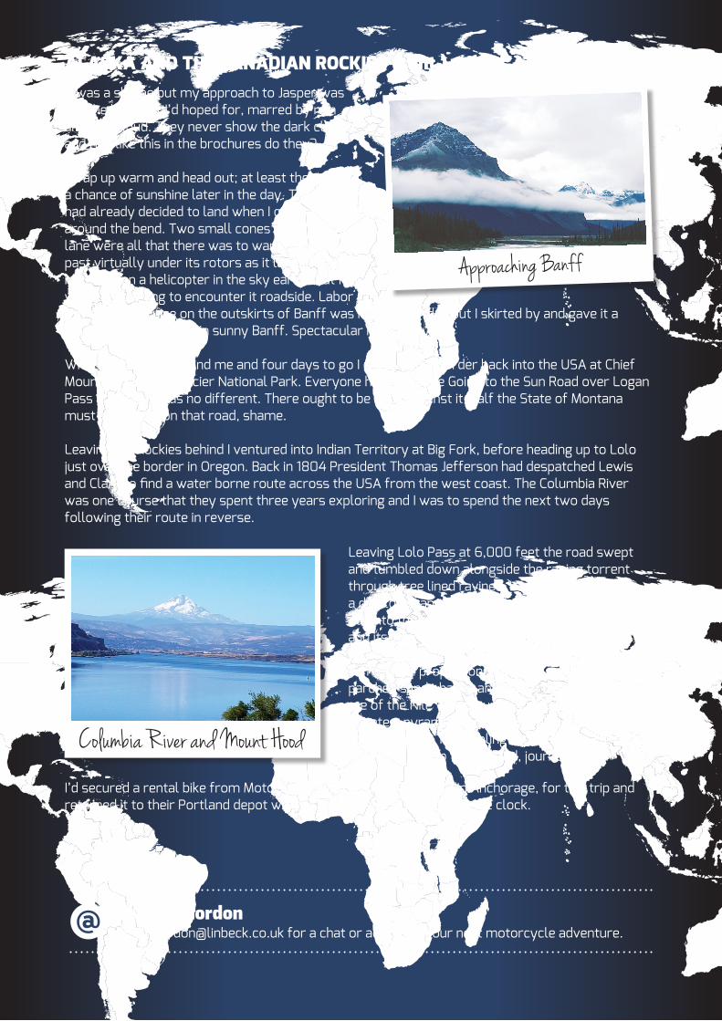
Wrap up warm and head out; at least there was a chance of sunshine later in the day. The Pilot had already decided to land when I cruised up around the bend. Two small cones in the inner lane were all that there was to warn me. I rode past virtually under its rotors as it landed beside me. I’d seen a helicopter in the sky earlier but I wasn’t expecting to encounter it roadside. Labor Day at Lake Louise on the outskirts of Banff was not a good idea but I skirted by and gave it a glance before arriving in sunny Banff. Spectacular if not busy.
With 3,000 miles behind me and four days to go I crossed the border back into the USA at Chief Mountain and into Glacier National Park. Everyone heads for the Going to the Sun Road over Logan Pass and today was no different. There ought to be a law against it, half the State of Montana must have been on that road, shame.
Leaving the Rockies behind I ventured into Indian Territory at Big Fork, before heading up to Lolo just over the border in Oregon. Back in 1804 President Thomas Jefferson had despatched Lewis and Clark to find a water borne route across the USA from the west coast. The Columbia River was one course that they spent three years exploring and I was to spend the next two days following their route in reverse.
Leaving Lolo Pass at 6,000 feet the road swept and tumbled down alongside the raging torrent through tree lined ravines. It took almost half a day to escape the Blue Mountains and head out into the parched rolling farmland of Oregon and its “Fields of Gold”, still following the course of the river. Further down the Columbia took on massive proportions and was so wide with parched sandy banks and bluffs that it reminded me of the Nile with Mount Hood doing its best to imitate a pyramid. Later, the river’s characteristics changed again, resembling Alpine landscape and delivering me up to Portland, journey’s end.
I’d secured a rental bike from MotoQuest, a BMW touring affiliate in Anchorage, for this trip and returned it to their Portland depot with an additional 3,800 miles on the clock.