(also ground-probing radar, gpr)seisweb.usask.ca/classes/geol335/2017/lectures/pdf/11-gpr.pdf ·...
TRANSCRIPT
GEOL 335.3
Ground-Penetrating Radar(also Ground-Probing Radar, GPR)
Similarities and dissimilarities to seismic
Case histories
Reading:➢ Reynolds, Chapter 12
GEOL 335.3
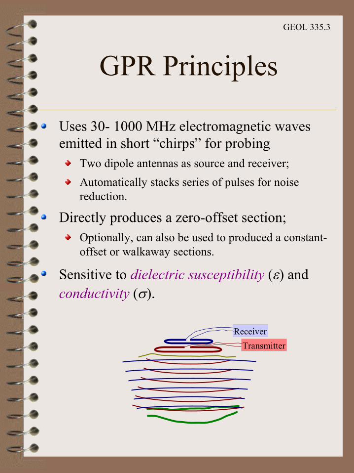
GPR Principles
Uses 30- 1000 MHz electromagnetic waves emitted in short “chirps” for probing
Two dipole antennas as source and receiver;
Automatically stacks series of pulses for noise reduction.
Directly produces a zero-offset section;Optionally, can also be used to produced a constant-offset or walkaway sections.
Sensitive to dielectric susceptibility (e) and conductivity (s).
Receiver
Transmitter
GEOL 335.3
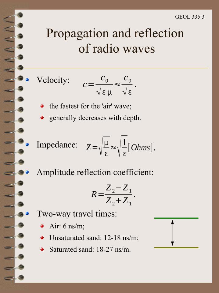
Propagation and reflection of radio waves
Velocity:
the fastest for the 'air' wave;
generally decreases with depth.
Impedance:
Amplitude reflection coefficient:
Two-way travel times:Air: 6 ns/m;
Unsaturated sand: 12-18 ns/m;
Saturated sand: 18-27 ns/m.
c=c0
≈c0.
Z=≈1 [Ohms] .
R=Z 2−Z 1Z 2Z 1
.

GEOL 335.3
Antenna directivity patterns
GPR antenna focuses energy in a beam directed downward;
Receiver antenna has a similar sensitivity pattern.
GEOL 335.3
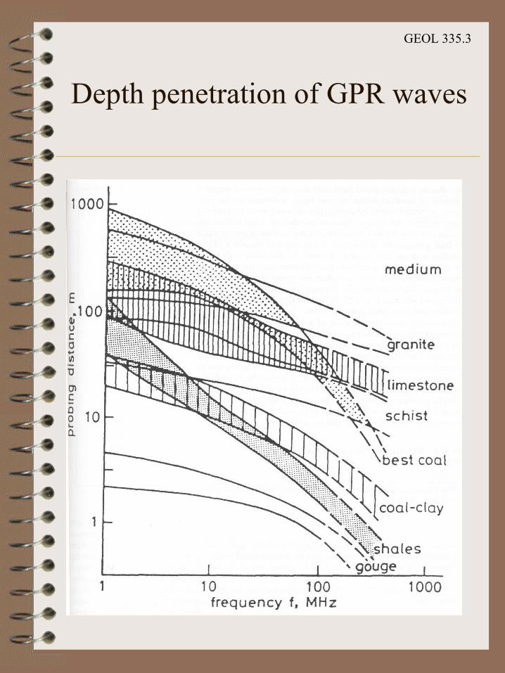
Depth penetration of GPR waves

GEOL 335.3
Relation to Reflection Seismics
Similarities:Processing procedures (filtering, stacking, migration);
Appearance of the zero-offset section;
Resolution-frequency relationships;
Interpretation techniques.
Differences:Nanoseconds (ns) instead of milliseconds (ms);
➢ Sub-meter vertical resolution and ~10-100 m penetration.
Electrical properties instead of acoustic impedance;➢ Very sensitive to buried metallic objects.
Velocities decrease with depth➢ Rays bend toward the vertical;
➢ Free-air arrival is the fastest;
➢ Faster attenuation;
➢ Large velocity contrasts.
Sub-meter resolution.
Thus, GPR is a a valuable complementary technique to shallow seismics.
GEOL 335.3
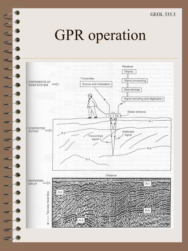
GPR operation
GEOL 335.3
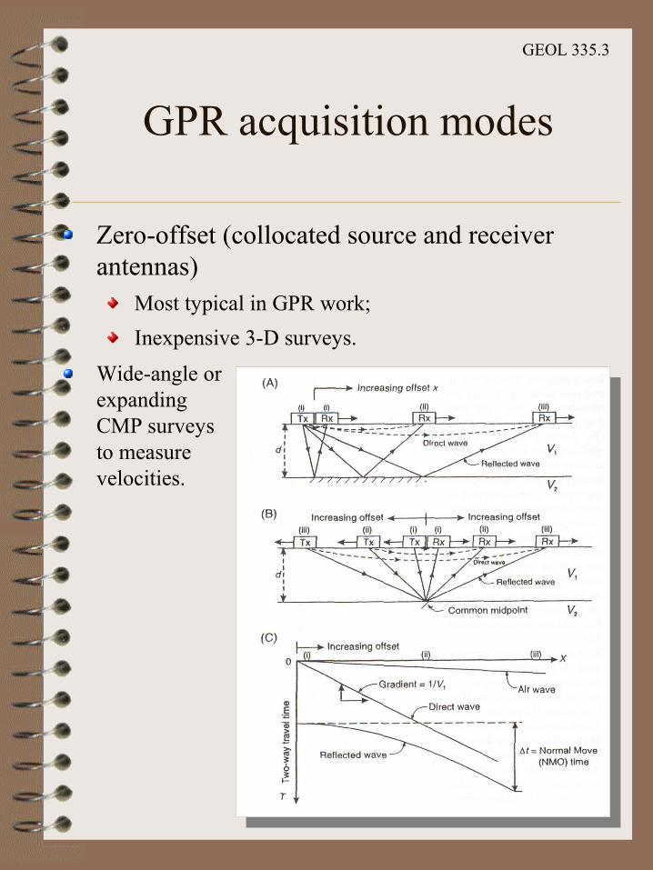
GPR acquisition modes
Zero-offset (collocated source and receiver antennas)
Most typical in GPR work;
Inexpensive 3-D surveys.
Wide-angle or expanding CMP surveys to measure velocities.
GEOL 335.3
GPR applications
Geological:Detection of natural cavities and fissures
Subsidence mapping
Mapping sand body geometry
Mapping of superficial deposits
Soil stratigraphy mapping
Glacial geological investigations
Mineral exploration and resource evaluation
Peat thickness mapping and resource evaluation Permafrost investigations
Location of ice wedges
Fracture mapping in rock salt
Location of faults, dykes, coal seams, etc.
Geological structure mapping
Lake and riverbed sediment mapping

GEOL 335.3
GPR applications (cont)
Environmental:Contaminant plume mapping
Mapping and monitoring pollutants within groundwater Landfill investigations
Location of buried fuel tanks and oil drums
Location of gas leaks
Groundwater investigations
Glaciological:Ice thickness mapping
Determination of internal glacier structures
Ice movement studies
Detection of concealed surface and basal glacier crevasses Mapping water conduits within glaciers
Determination of thickness and type of sea and lake ice Sub-glacial mass balance determination
Snow stratigraphy
GEOL 335.3
GPR applications (cont)
Engineering and construction:Road pavement analysis
Void detection
Location of reinforcement (rebars) in concrete
Location of public utilities (pipes, cables, etc.)
Testing integrity of building materials
Concrete testing
Archaeology:Location of buried structures
Detection and mapping of Roman Roads, etc. Location of post-holes, etc.
Pre-excavation mapping
Detection of voids (crypts, etc.)
Location of graves
Forensic science:Location of buried targets (e.g. bodies and bullion)
GEOL 335.3
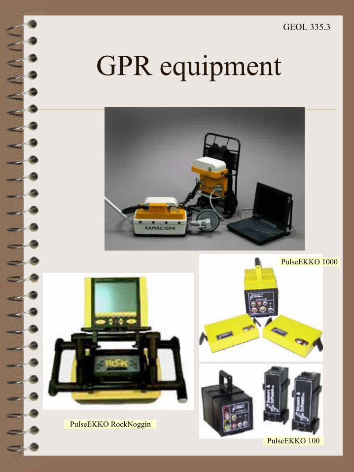
GPR equipment
PulseEKKO 1000
PulseEKKO 100
PulseEKKO RockNoggin

GEOL 335.3
GPR applications
SnowNoggin
Mapping ice thickness
Archeology

GEOL 335.3
Case history:Engineering
Detecting tunnels (Sweden)

GEOL 335.3
Case history:Glaciology
Measuring snow depth on Storglacierien, a small polythermal glacier in northern Sweden.
Snow thickness were estimates by identifying summer ice surfaces
From http://www.terraplus.com/gpr_case_study.htm
GEOL 335.3
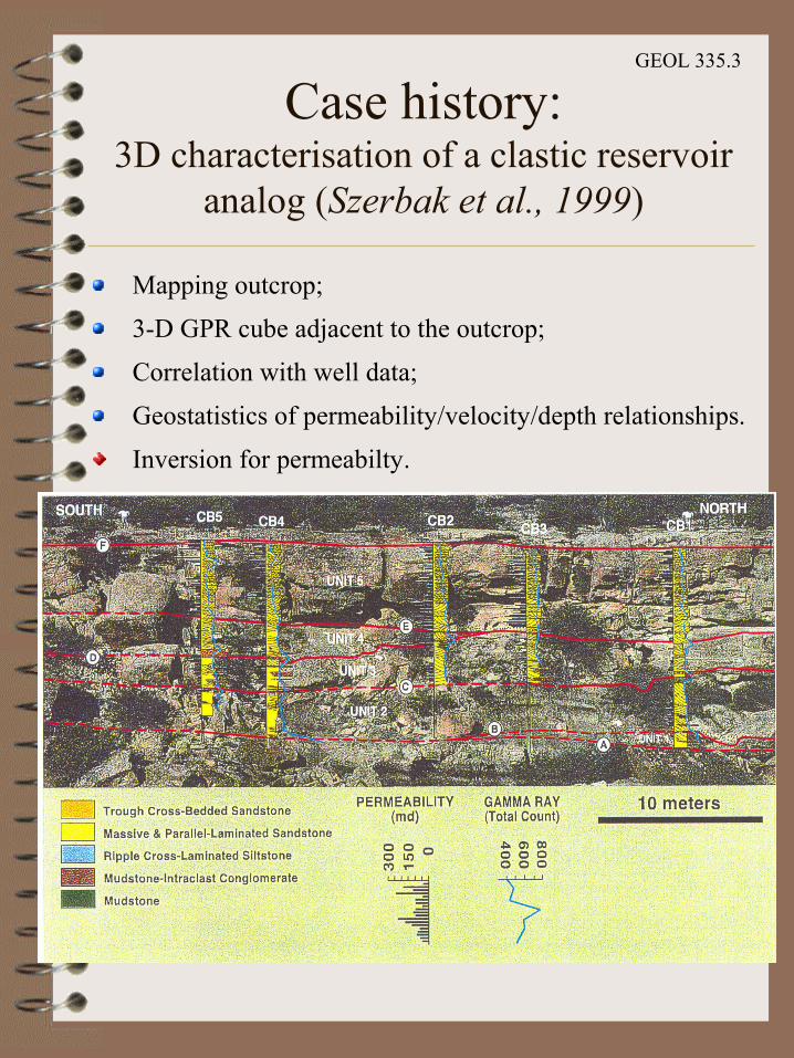
Case history:3D characterisation of a clastic reservoir
analog (Szerbak et al., 1999)
Mapping outcrop;
3-D GPR cube adjacent to the outcrop;
Correlation with well data;
Geostatistics of permeability/velocity/depth relationships.
Inversion for permeabilty.
GEOL 335.3
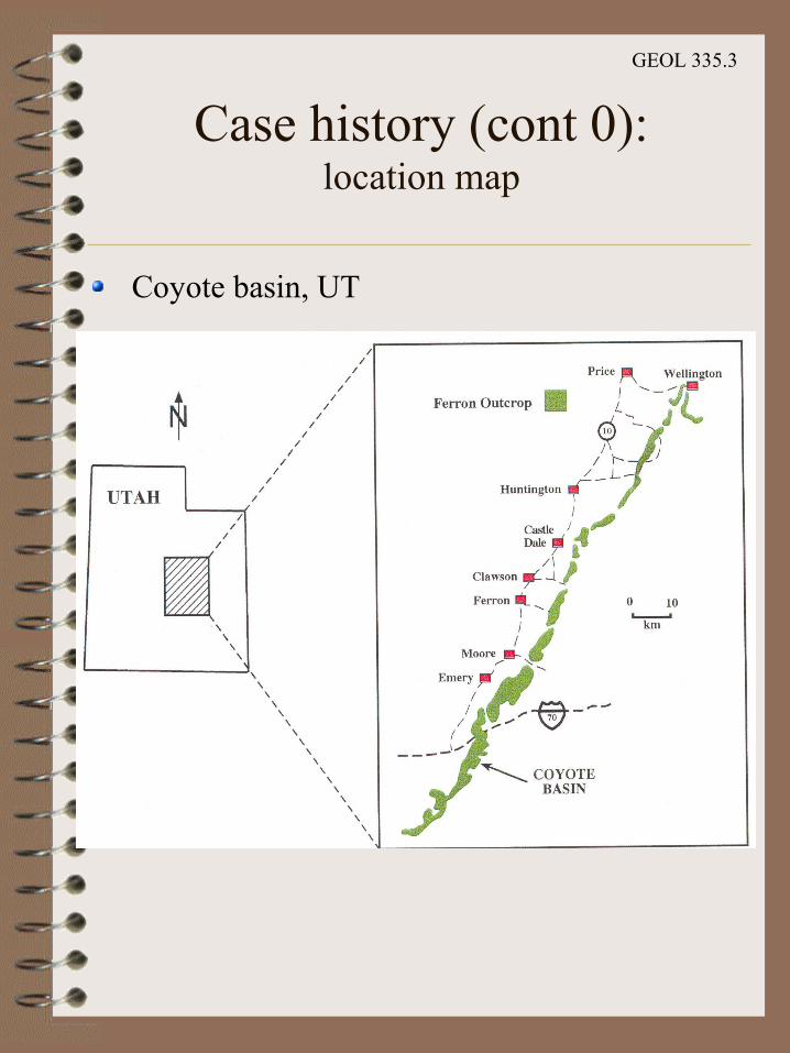
Case history (cont 0):location map
Coyote basin, UT

GEOL 335.3
Case history (cont. 1)(Szerbak et al., 1999)
3D radargram
GEOL 335.3
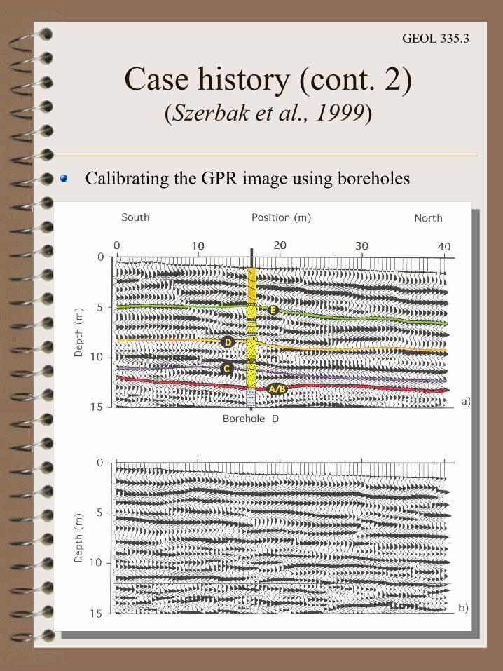
Case history (cont. 2)(Szerbak et al., 1999)
Calibrating the GPR image using boreholes

GEOL 335.3
Case history (cont. 3)(Szerbak et al., 1999)
Correlation with clay and permeability data

GEOL 335.3
Case history (cont. 4)(Szerbak et al., 1999)
Velocity distribution correlation functions.
Above E
Between E and A/B
GEOL 335.3
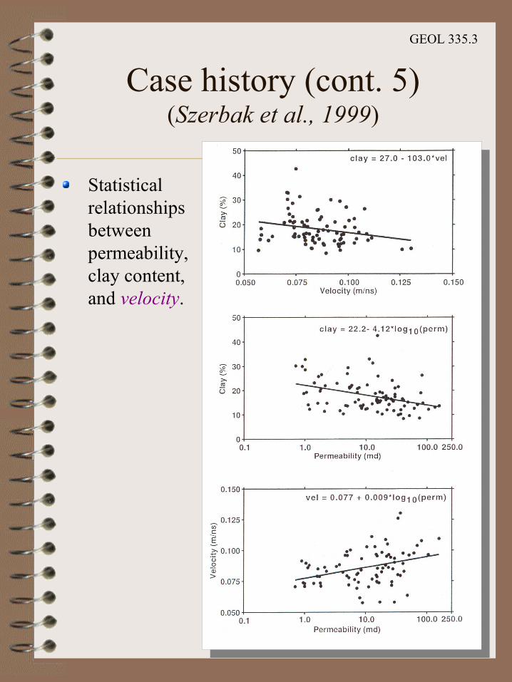
Case history (cont. 5)(Szerbak et al., 1999)
Statistical relationships between permeability, clay content, and velocity.

GEOL 335.3
Case history (cont. 6)(Szerbak et al., 1999)
Final reflectivity, velocity, and permeability models

GEOL 335.3
Case history (cont. 7)(Szerbak et al., 1999)
3D permeability cube