appendix a usfws species lists - center for environmental
TRANSCRIPT

APPENDIX A
USFWS SPECIES LISTS


Updated 3/1/2006 ADAMS COUNTY
LISTED
Endangered
Pygmy rabbit (Brachylagus idahoensis) – Columbia Basin distinct population segment
Threatened
Bald eagle (Haliaeetus leucocephalus)Spiranthes diluvialis (Ute ladies’-tresses), plant
CANDIDATE
Washington ground squirrel (Spermophilus washingtoni)
SPECIES OF CONCERN
Animals
Burrowing owl (Athene cuniculari)Ferruginous hawk (Buteo regalis)Loggerhead shrike (Lanius ludovicianus) Long-eared myotis (Myotis evotis)Northern leopard frog (Rana pipiens)Pallid Townsend’s big-eared bat (Corynorhinus townsendii pallenscens)Sagebrush lizard (Sceloporus graciosus)
Vascular Plants
Polemonium pectinatum (Washington polemonium)

Updated 3/1/06 ASOTIN COUNTY
LISTED
Endangered
Gray wolf (Canis lupus)
Threatened
Bald eagle (Haliaeetus leucocephalus)Bull trout (Salvelinus confluentus) – Columbia River distinct population segment Canada lynx (Lynx canadensis) Silene spaldingii (Spalding’s silene), plantSpiranthes diluvialis (Ute ladies’-tresses), plant
Designated
Critical habitat for the Columbia River distinct population segment of the bull trout
CANDIDATE
Yellow-billed cuckoo (Coccyzus americanus)
SPECIES OF CONCERN
Animals
Burrowing owl (Athene cunicularia)California floater (Anodonta californiensis), mussel Ferruginous hawk (Buteo regalis)Fisher (Martes pennanti) Giant Columbia spire snail (Fluminicola columbiana) Loggerhead shrike (Lanius ludovicianus)Long-eared myotis (Myotis evotis)Northern goshawk (Accipiter gentilis)Olive-sided flycatcher (Contopus cooperi)Pacific lamprey (Lampetra tridentata)Pallid Townsend's big-eared bat (Corynorhinus townsendii pallescens) Preble’s shrew (Sorex preblei)Redband trout (Oncorhynchus mykiss)River lamprey (Lampetra ayresi)Rocky Mountain-tailed frog (Ascaphus montanus)Western brook lamprey (Lampetra richardsoni)
Vascular Plants

Calochortus nitidus (Broad-fruit mariposa) Lupinus cusickii (Prairie lupine)

Updated 3/1/06 BENTON COUNTY
LISTED
Endangered
Pygmy rabbit (Brachylagus idahoensis) – Columbia Basin distinct population segment
Threatened
Bald eagle (Haliaeetus leucocephalus)Bull trout (Salvelinus confluentus) – Columbia River distinct population segment Spiranthes diluvialis (Ute ladies’-tresses), plant
Designated
Critical habitat for the Columbia River distinct population segment of the bull trout
CANDIDATE
Yellow-billed cuckoo (Coccyzus americanus)Eriogonum codium (Umtanum desert buckwheat), plant
SPECIES OF CONCERN
Animals
Burrowing owl (Athene cunicularia)California floater (Anodonta californiensis), mussel Columbia clubtail (Gomphus lynnae), dragonfly Ferruginous hawk (Buteo regalis)Giant Columbia spire snail (Fluminicola columbiana) Loggerhead shrike (Lanius ludovicianus)Long-eared myotis (Myotis evotis)Margined sculpin (Cottus marginatus) Pacific lamprey (Lampetra tridentata)Pallid Townsend's big-eared bat (Corynorhinus townsendii pallescens)Redband trout (Oncorhynchus mykiss)River lamprey (Lampetra ayresi) Sagebrush lizard (Sceloporus graciosus) Townsend’s ground squirrel (Spermophilus townsendii)Western brook lamprey (Lampetra richardsoni)

Vascular Plants
Astragalus columbianus (Columbia milk-vetch) Cryptantha leucophaea (Gray cryptantha) Haplopappus liatriformis (Palouse goldenweed)Lomatium tuberosum (Hoover's desert-parsley)Mimulus jungermannioides (Liverwort monkey-flower) Rorippa columbiae (Persistent sepal yellowcress)

Updated 11/15/06 CHEELAN COUNTY
LISTED
Endangered
Gray wolf (Canis lupus)Hackelia venusta (Showy stickseed), plant Sidalcea oregana var. calva (Wenatchee Mountains checker-mallow), plant
Threatened
Bald eagle (Haliaeetus leucocephalus)Bull trout (Salvelinus confluentus) – Columbia River distinct population segment Canada lynx (Lynx canadensis)Grizzly bear (Ursus arctos horribilis)Marbled murrelet (Brachyramphus marmoratus)Northern spotted owl (Strix occidentalis caurina)Spiranthes diluvialis (Ute ladies’-tresses), plant
Designated
Critical habitat for the northern spotted owl Critical habitat for Sidalcea oregana var. calva Critical habitat for Canada lynx
CANDIDATE
Fisher (Martes pennanti) - West Coast distinct population segment Yellow-billed cuckoo (Coccyzus americanus)
SPECIES OF CONCERN
Animals
Black swift (Cypseloides niger)California floater (Anodonta californiensis), mussel Columbian sharp-tailed grouse (Tympanuchus phasianellus columbianus)Ferruginous hawk (Buteo regalis)Giant Columbia spire snail (Fluminicola columbiana) Kincaid meadow vole (Microtus pennsylvanicus kincaidi)Loggerhead shrike (Lanius ludovicianus)Long-eared myotis (Myotis evotis)Northern goshawk (Accipiter gentilis) Olive-sided flycatcher (Contopus cooperi) Pacific lamprey (Lampetra tridentata)

Pallid Townsend's big-eared bat (Corynorhinus townsendii pallescens) Peregrine falcon (Falco peregrinus) (Delisted, monitor status) Pygmy whitefish (Prosopium coulteri)Redband trout (Oncorhynchus mykiss)River lamprey (Lampetra ayresi)Sagebrush lizard (Sceloporus graciosus)Sharptail snake (Contia tenius)Western brook lamprey (Lampetra richardsoni)Western gray squirrel (Sciurus griseus griseus)Westslope cutthroat trout (Oncorhynchus clarki lewisi)Wolverine (Gulo gulo)
Vascular Plants
Astragalus sinuatus (Whited’s milk-vetch) Botrychium paradoxum (Two-spiked moonwort) Cypripedium fasciculatum (Clustered lady’s-slipper) Delphinium viridescens (Wenatchee larkspur) Petrophyton cinerascens (Chelan rockmat) Pinus albicaulis (Whitebark pine) Silene seelyi (Seely’s silene) Trifolium thompsonii (Thompson’s clover)

Updated 3/1/06 COLUMBIA COUNTY
LISTED
Endangered
Gray wolf (Canis lupus)
Threatened
Bald eagle (Haliaeetus leucocephalus)Bull trout (Salvelinus confluentus) – Columbia River distinct population segment Canada lynx (Lynx canadensis)Spiranthes diluvialis (Ute ladies’-tresses), plant
Designated
Critical habitat for the Columbia River distinct population segment of the bull trout
CANDIDATE
Washington ground squirrel (Spermophilus washingtoni)Yellow-billed cuckoo (Coccyzus americanus)
SPECIES OF CONCERN
Animals
Burrowing owl (Athene cunicularia)California floater (Anodonta californiensis), mussel Ferruginous hawk (Buteo regalis)Giant Columbia spire snail (Fluminicola columbiana)Loggerhead shrike (Lanius ludovicianus)Long-eared myotis (Myotis evotis)Margined sculpin (Cottus marginatus)Northern goshawk (Accipiter gentilis)Olive-sided flycatcher (Contopus cooperi) Pacific lamprey (Lampetra tridentata)Pallid Townsend's big-eared bat (Corynorhinus townsendii pallescens) Preble’s shrew (Sorex preblei)Redband trout (Oncorhynchus mykiss)River lamprey (Lampetra ayresi)Rocky Mountain-tailed frog (Ascaphus montanus)Sagebrush lizard (Sceloporus graciosus)Western brook lamprey (Lampetra richardsoni)
Vascular Plants

Allium dictuon (Blue Mountain onion) Calochortus nitidus (Broad-fruited mariposa) Cypripedium fasciculatum (Clustered lady’s-slipper) Lupinus cusickii (Prairie lupine)

Updated 3/1/2006 DOUGLAS COUNTY
LISTED
Endangered
Pygmy rabbit (Brachylagus idahoensis) – Columbia Basin distinct population segment
Threatened
Bald eagle (Haliaeetus leucocephalus)Bull trout (Salvelinus confluentus) – Columbia River distinct population segment Spiranthes diluvialis (Ute ladies’-tresses), plant
CANDIDATE
Greater sage grouse (Centrocercus urophasianus) – Columbia Basin distinct population segment Washington ground squirrel (Spermophilus washingtoni)

Updated 3/1/2006 FERRY COUNTY
LISTED
Endangered
Gray wolf (Canis lupus)
Threatened
Bald eagle (Haliaeetus leucocephalus)Bull trout (Salvelinus confluentus) – Columbia River distinct population segment Canada lynx (Lynx canadensis)Grizzly bear (Ursus arctos horribilis)Spiranthes diluvialis (Ute ladies’-tresses), plant
CANDIDATE
Botrychium lineare (Slender moonwort), plant
SPECIES OF CONCERN
Animals
Burrowing owl (Athene cunicularia)California floater (Anodonta californiensis), mussel Columbian sharp-tailed grouse (Tympanuchus phasianellus columbianus) Fisher (Martes pennanti)Loggerhead shrike (Lanius ludovicianus)Long-eared myotis (Myotis evotis)Northern goshawk (Accipiter gentilis)Olive-sided flycatcher (Contopus cooperi)Pacific fisher (Martes pennanti pacifica)Pacific lamprey (Lampetra tridentata)Pallid Townsend's big-eared bat (Corynorhinus townsendii pallescens)Pygmy whitefish (Prosopium coulteri)Redband trout (Oncorhynchus mykiss)River lamprey (Lampetra ayresi)Sagebrush lizard (Sceloporus graciosus)Western brook lamprey (Lampetra richardsoni)Westslope cutthroat trout (Oncorhynchus clarki lewisi)Wolverine (Gulo gulo)

Vascular Plants
Botrychium ascendens (Triangular-lobed moonwort) Botrychium crenulatum (Crenulate moonwort) Botrychium paradoxum (Two-spiked moonwort) Botrychium pedunculosum (Stalked moonwort) Pinus albicaulis (Whitebark pine)

Updated 3/1/06 FRANKLIN COUNTY
LISTED
Endangered
None
Threatened
Bald eagle (Haliaeetus leucocephalus)Bull trout (Salvelinus confluentus) – Columbia River distinct population segment Spiranthes diluvialis (Ute ladies’-tresses), plant
CANDIDATE
Washington ground squirrel (Spermophilus washingtoni) Lesquerella tuplashensis (White Bluffs bladderpod), plant
SPECIES OF CONCERN
Animals
Burrowing owl (Athene cunicularia)California floater (Anodonta californiensis), mussel Columbia clubtail (Gomphus lynnae), dragonflyFerruginous hawk (Buteo regalis)Giant Columbia spire snail (Fluminicola columbiana) Loggerhead shrike (Lanius ludovicianus) Long-eared myotis (Myotis evotis)Pacific lamprey (Lampetra tridentata)Pallid Townsend's big-eared bat (Corynorhinus townsendii pallescens) Redband trout (Oncorhynchus mykiss)River lamprey (Lampetra ayresi) Sagebrush lizard (Sceloporus graciosus) Western brook lamprey (Lampetra richardsoni)
Vascular Plants
Cryptantha leucophaea (Gray cryptantha)

Updated 3/1/06 GARFIELD COUNTY
LISTED
Endangered
Gray wolf (Canis lupus)
Threatened
Bald eagle (Haliaeetus leucocephalus)Bull trout (Salvelinus confluentus) – Columbia River distinct population segment Canada lynx (Lynx canadensis)Spiranthes diluvialis (Ute ladies’-tresses), plant
Designated
Critical habitat for the Columbia River distinct population segment of the bull trout
CANDIDATE
Yellow-billed cuckoo (Coccyzus americanus)
SPECIES OF CONCERN
Animals
Burrowing owl (Athene cunicularia)California floater (Anodonta californiensis), mussel Ferruginous hawk (Buteo regalis)Fisher (Martes pennanti)Giant Columbia spire snail (Fluminicola columbiana) Loggerhead shrike (Lanius ludovicianus)Long-eared myotis (Myotis evotis)Northern goshawk (Accipiter gentilis)Olive-sided flycatcher (Contopus cooperi) Pacific lamprey (Lampetra tridentata)Pallid Townsend's big-eared bat (Corynorhinus townsendii pallescens)Preble's shrew (Sorex preblei) Redband trout (Oncorhynchus mykiss)River lamprey (Lampetra ayresi)Rocky Mountain-tailed frog (Ascaphus montanus)Sagebrush lizard (Sceloporus graciosus)Western brook lamprey (Lampetra richardsoni)
Vascular Plants

Allium dictuon (Blue Mountain onion) Calochortus nitidus (Broad-fruit mariposa) Cypripedium fasciculatum (Clustered lady’s-slipper) Lupinus cusickii (Prairie lupine) Rubus nigerrimus (Northwest raspberry)

Updated 3/1/06 GRANT COUNTY
LISTED
Endangered
Pygmy rabbit (Brachylagus idahoensis) – Columbia Basin distinct population segment
Threatened
Bald eagle (Haliaeetus leucocephalus) Bull trout (Salvelinus confluentus) – Columbia River distinct population segment Spiranthes diluvialis (Ute ladies’-tresses), plant
CANDIDATE
Greater sage grouse (Centrocercus urophasianus) – Columbia Basin distinct population segment Washington ground squirrel (Spermophilus washingtoni) Artemisia campestris ssp. borealis var. wormskioldii (Northern wormwood), plant
SPECIES OF CONCERN
Animals
Burrowing owl (Athene cunicularia)California floater (Anodonta californiensis), mussel Columbian sharp-tailed grouse (Tympanuchus phasianellus columbianus)Ferruginous hawk (Buteo regalis)Giant Columbia spire snail (Fluminicola columbiana) Kincaid meadow vole (Microtus pennsylvanicus kincaidi)Loggerhead shrike (Lanius ludovicianus)Long-eared myotis (Myotis evotis)Northern goshawk (Accipiter gentilis)Northern leopard frog (Rana pipiens)Pacific lamprey (Lampetra tridentata)Pallid Townsend's big-eared bat (Corynorhinus townsendii pallescens) Redband trout (Oncorhynchus mykiss) River lamprey (Lampetra ayresi)Sagebrush lizard (Sceloporus graciosus) Western brook lamprey (Lampetra richardsoni)

Vascular Plants
Cryptantha leucophaea (Gray cryptantha) Lomatium tuberosum (Hoover’s desert-parsley) Oxytropis campestris var. wanapum (Wanapum crazyweed)

Updated 09/19/06 KITTITAS COUNTY
LISTED
Endangered
Gray wolf (Canis lupus)
Threatened
Bald eagle (Haliaeetus leucocephalus)Bull trout (Salvelinus confluentus) – Columbia River distinct population segment Grizzly bear (Ursus arctos horribilis)Marbled murrelet (Brachyramphus marmoratus)Northern spotted owl (Strix occidentalis caurina) Ute ladies’-tresses, (Spiranthes diluvialis), plant
Designated
Critical habitat for the northern spotted owl Critical habitat for the Columbia River distinct population segment of the bull trout
CANDIDATE
Fisher (Martes pennanti) - West Coast distinct population segment Greater sage grouse (Centrocercus urophasianus) – Columbia Basin distinct population segment Yellow-billed cuckoo (Coccyzus americanus)Basalt daisy, (Erigeron basalticus), plant
SPECIES OF CONCERN
Animals
Black swift (Cypseloides niger)Burrowing owl (Athene cunicularia)Ferruginous hawk (Buteo regalis)Larch Mountain salamander (Plethodon larselli)Loggerhead shrike (Lanius ludovicianus)Long-eared myotis (Myotis evotis)Northern goshawk (Accipiter gentilis) Olive-sided flycatcher (Contopus cooperi) Pacific lamprey (Lampetra tridentata)Pallid Townsend's big-eared bat (Corynorhinus townsendii pallescens) Peregrine falcon (Falco peregrinus) (Delisted, monitor status) Pygmy whitefish (Prosopium coulteri)

Redband trout (Oncorhynchus mykiss)River lamprey (Lampetra ayresi)Sagebrush lizard (Sceloporus graciosus)Sharptail snake (Contia tenius)Townsend’s ground squirrel (Spermophilus townsendii)Western brook lamprey (Lampetra richardsoni)Western gray squirrel (Sciurus griseus griseus)Westslope cutthroat trout (Oncorhynchus clarki lewisi) Wolverine (Gulo gulo)
Vascular Plants
Astragalus columbianus (Columbia milk-vetch) Cypripedium fasciculatum (Clustered lady’s-slipper) Delphinium viridescens (Wenatchee larkspur)Lomatium tuberosum (Hoover’s desert-parsley) Phacelia minutissima (Least phacelia) Pinus albicaulis (Whitebark pine) Silene seelyi (Seely’s silene) Tauschia hooveri (Hoover’s tauschia)
Mosses
Orthotrichum praemorsum

Updated 09/19/06 KLICKITAT COUNTY
LISTED
Endangered
Gray wolf (Canis lupus)
Threatened
Bald eagle (Haliaeetus leucocephalus)Bull trout (Salvelinus confluentus) – Columbia River distinct population segment Northern spotted owl (Strix occidentalis caurina)Ute ladies’-tresses, (Spiranthes diluvialis), plant
Designated
Critical habitat for the northern spotted owl Critical habitat for the Columbia River distinct population segment of the bull trout
CANDIDATE
Fisher (Martes pennanti) - West Coast distinct population segmentMardon Skipper (Polites mardon), butterfly Oregon spotted frog (Rana pretiosa) Yellow-billed cuckoo (Coccyzus americanus)Northern wormwood, (Artemisia campestris ssp. borealis var. wormskioldii), plant
SPECIES OF CONCERN
Animals
Burrowing owl (Athene cunicularia) California floater (Anodonta californiensis), mussel Ferruginous hawk (Buteo regalis)Giant Columbia spire snail (Fluminicola columbiana) Larch Mountain salamander (Plethodon larselli)Loggerhead shrike (Lanius ludovicianus)Long-eared myotis (Myotis evotis)Northern goshawk (Accipiter gentilis) Olive-sided flycatcher (Contopus cooperi)Pacific lamprey (Lampetra tridentata)Pacific Townsend's big-eared bat (Corynorhinus townsendii townsendii)Pallid Townsend's big-eared bat (Corynorhinus townsendii pallescens) Peregrine falcon (Falco peregrinus) (Delisted, monitor status) Redband trout (Onchrhynchus mykiss)

River lamprey (Lampetra ayresi) Sagebrush lizard (Sceloporus graciosus)Sharptail snake (Contia tenius)Townsend’s ground squirrel (Spermophilis townsendii)Western brook lamprey (Lampetra richardsoni)Western gray squirrel (Sciurus griseus griseus) Western pond turtle (Clemmys marmorata)Westslope cutthroat trout (Oncorhynchus clarki lewisi) Wolverine (Gulo gulo)
Vascular Plants
Astragalus pulsiferae var. suksdorfii (Ames’ milk-vetch) Calochortus longebarbatus var. longebarbatus (Long-bearded sego lily) Cypripedium fasciculatum (Clustered lady’s-slipper) Lomatium suksdorfii (Suksdorf’s desert-parsley)Meconella oregana (White meconella) Mimulus jungermannioides (Liverwort monkey-flower) Penstemon barrettiae (Barrett’s beardtongue) Pinus albicaulis (Whitebark pine) Ranunculus reconditus (Obscure buttercup) Rorippa columbiae (Persistent sepal yellowcress)Sisyrinchium sarmentosum (Pale blue-eyed grass)
Lichen
Texosporium sancti-jacobi (Woven spore lichen)

Updated 3/1/2006 LINCOLN COUNTY
LISTED
Endangered
Pygmy rabbit (Brachylagus idahoensis) – Columbia Basin distinct population segment
Threatened
Bald eagle (Haliaeetus leucocephalus)Bull trout (Salvelinus confluentus) – Columbia River distinct population segment Silene spaldingii (Spalding’s silene), plantSpiranthes diluvialis (Ute ladies’-tresses), plant
CANDIDATE
Washington ground squirrel (Spermophilus washingtoni)
SPECIES OF CONCERN
Animals
Burrowing owl (Athene cunicularia)California floater (Anodonta californiensis), mussel Columbian sharp-tailed grouse (Tympanuchus phasianellus columbianus)Ferruginous hawk (Buteo regalis)Giant Columbia spire snail (Fluminicola columbiana) Loggerhead shrike (Lanius ludovicianus)Long-eared myotis (Myotis evotis)Olive-sided flycatcher (Contopus cooperi) Pacific lamprey (Lampetra tridentata)Pallid Townsend's big-eared bat (Corynorhinus townsendii pallescens) Redband trout (Oncorhynchus mykiss)River lamprey (Lampetra ayresi)Sagebrush lizard (Sceloporus graciosus)Western brook lamprey (Lampetra richardsoni)Wolverine (Gulo gulo)
Vascular Plants
Lupinus cusickii (Prairie lupine) Polemonium pectinatum (Washington polemonium)

Updated 11/15/06 OKANOGAN COUNTY
LISTED
Endangered
Gray wolf (Canis lupus)
Threatened
Bald eagle (Haliaeetus leucocephalus)Bull trout (Salvelinus confluentus) – Columbia River distinct population segment Canada lynx (Lynx canadensis) Grizzly bear (Ursus arctos horribilis)Northern spotted owl (Strix occidentalis caurina)Spiranthes diluvialis (Ute ladies’-tresses), plant
Designated
Critical habitat for the northern spotted owl
CANDIDATE
Fisher (Martes pennanti) - West Coast distinct population segment (west of the Okanogan River) Yellow-billed cuckoo (Coccyzus americanus)
SPECIES OF CONCERN
Animals
Black swift (Cypseloides niger)Burrowing owl (Athene cunicularia)California floater (Anodonta californiensis), musselColumbian sharp-tailed grouse (Tympanuchus phasianellus columbianus)Fisher (Martes pennanti), east of the Okanogan River Giant Columbia spire snail (Fluminicola columbiana) Loggerhead shrike (Lanius ludovicianus)Long-eared myotis (Myotis evotis)Northern goshawk (Accipiter gentilis)Olive-sided flycatcher (Contopus cooperi) Pacific lamprey (Lampetra tridentata)Pallid Townsend's big-eared bat (Corynorhinus townsendii pallescens) Peregrine falcon (Falco peregrinus) (Delisted, monitor status) Pygmy whitefish (Prosopium coulteri)

Redband trout (Oncorhynchus mykiss)River lamprey (Lampetra ayresi)Sagebrush lizard (Sceloporus graciosus)Western brook lamprey (Lampetra richardsoni)Western gray squirrel (Sciurus griseus griseus)Westslope cutthroat trout (Oncorhynchus clarki lewisi)Wolverine (Gulo gulo)
Vascular Plants
Botrychium ascendens (Triangular-lobed moonwort) Botrychium crenulatum (Crenulate moonwort) Botrychium paradoxum (Two-spiked moonwort) Botrychium pedunculosum (Stalked moonwort) Pinus albicaulis (Whitebark pine)

Updated 3/1/06 PEND OREILLE COUNTY
LISTED
Endangered
Gray wolf (Canis lupus)Woodland caribou (Rangifer tarandus caribou)
Threatened
Bald eagle (Haliaeetus leucocephalus)Bull trout (Salvelinus confluentus) – Columbia River distinct population segment Canada lynx (Lynx canadensis)Grizzly bear (Ursus arctos horribilis)
Designated
Critical habitat for the Columbia River distinct population segment of the bull trout
SPECIES OF CONCERN
Animals
Fisher (Martes pennanti) Kincaid meadow vole (Microtus pennsylvanicus kincaidi)Long-eared myotis (Myotis evotis)Northern goshawk (Accipiter gentilis)Northern leopard frog (Rana pipiens)Olive-sided flycatcher (Contopus cooperi) Pacific lamprey (Lamperta tridentata)Pallid Townsend's big-eared bat (Corynorhinus townsendii pallescens)Pygmy whitefish (Prosopium coulteri)Redband trout (Oncorhynchus mykiss) River lamprey (Lampetra ayresi)Western brook lamprey (Lampetra richardsoni)Westslope cutthroat trout (Oncorhynchus clarki lewisi)Wolverine (Gulo gulo)

Vascular Plants
Botrychium ascendens (Triangular-lobed moonwort) Botrychium crenulatum (Crenulate moonwort) Botrychium paradoxum (Two-spiked moonwort) Botrychium pedunculosum (Stalked moonwort) Pinus albicaulis (Whitebark pine)

Updated 3/1/2006 SPOKANE COUNTY
LISTED
Endangered
Gray wolf (Canis lupus)
Threatened
Bald eagle (Haliaeetus leucocephalus)Bull trout (Salvelinus confluentus) – Columbia River distinct population segment Howellia aquatilis (Water howellia), plant Silene spaldingii (Spalding’s silene), plant Spiranthes diluvialis (Ute ladies’-tresses), plant
SPECIES OF CONCERN
Animals
Burrowing owl (Athene cunicularia)California floater (Anodonta californiensis), mussel Ferruginous hawk (Buteo regalis)Giant Columbia spire snail (Fluminicola columbiana) Loggerhead shrike (Lanius ludovicianus)Long-eared myotis (Myotis evotis)Northern goshawk (Accipiter gentilis)Olive-sided flycatcher (Contopus cooperi)Pallid Townsend's big-eared bat (Corynorhinus townsendii pallescens)Peregrine falcon (Falco peregrinus) (Delisted, monitor status) Redband trout (Oncorhynchus mykiss)Sagebrush lizard (Sceloporus graciosus)Westslope cutthroat trout (Oncorhynchus clarki lewisi)
Vascular Plants
Haplopappus liatriformis (Palouse goldenweed)

Updated 3/1/06 STEVENS COUNTY
LISTED
Endangered
None
Threatened
Bald eagle (Haliaeetus leucocephalus)Bull trout (Salvelinus confluentus) – Columbia River distinct population segment Canada lynx (Lynx canadensis)Grizzly bear (Ursus arctos horribilis)Spiranthes diluvialis (Ute ladies’-tresses), plant
Designated
Critical habitat for the Columbia River distinct population segment of the bull trout
SPECIES OF CONCERN
Animals
Burrowing owl (Athene cunicularia)California floater (Anodonta californiensis), mussel Columbian sharp-tailed grouse (Tympanuchus phasianellus columbianus)Fisher (Martes pennanti) Giant Columbia spire snail (Fluminicola columbiana) Kincaid meadow vole (Microtus pennsylvanicus kincaidi)Loggerhead shrike (Lanius ludovicianus)Long-eared myotis (Myotis evotis)Northern goshawk (Accipiter gentilis)Olive-sided flycatcher (Contopus cooperi) Pallid Townsend's big-eared bat (Corynorhinus townsendii pallescens)Pygmy whitefish (Prosopium coulteri)Redband trout (Oncorhynchus mykiss) Sagebrush lizard (Sceloporus graciosus)Westslope cutthroat trout (Oncorhynchus clarki lewisi)Wolverine (Gulo gulo)

Vascular Plants
Botrychium ascendens (Triangular-lobed moonwort) Botrychium crenulatum (Crenulate moonwort) Botrychium paradoxum (Two-spiked moonwort) Botrychium pedunculosum (Stalked moonwort) Pinus albicaulis (Whitebark pine)

Updated 3/1/06 WALLA WALLA COUNTY
LISTED
Endangered
None
Threatened
Bald eagle (Haliaeetus leucocephalus)Bull trout (Salvelinus confluentus) – Columbia River distinct population segment Canada lynx (Lynx canadensis)Spiranthes diluvialis (Ute ladies’-tresses), plant
Designated
Critical habitat for the Columbia River distinct population segment of the bull trout
CANDIDATE
Washington ground squirrel (Spermophilus washingtoni)Yellow-billed cuckoo (Coccyzus americanus)
SPECIES OF CONCERN
Animals
Burrowing owl (Athene cunicularia)California floater (Anodonta californiensis), mussel Ferruginous hawk (Buteo regalis)Giant Columbia spire snail (Fluminicola columbiana) Loggerhead shrike (Lanius ludovicianus)Long-eared myotis (Myotis evotis)Margined sculpin (Cottus marginatus)Northern goshawk (Accipiter gentilis)Olive-sided flycatcher (Contopus cooperi) Pacific lamprey (Lampetra tridentata)Pallid Townsend's big-eared bat (Corynorhinus townsendii pallescens)Redband trout (Onchrhynchus mykiss)River lamprey (Lampetra ayresi)Rocky Mountain-tailed frog (Ascaphus montanus)Sagebrush lizard (Sceloporus graciosus)Western brook lamprey (Lampetra richardsoni)Westslope cutthroat trout (Oncorhynchus clarki lewisi)

Vascular Plants
Astragalus kentrophyta var. douglasii (Thistle milk-vetch) Cryptantha leucophaea (Gray cryptantha) Mimulus jungermannioides (Liverwort monkey-flower)
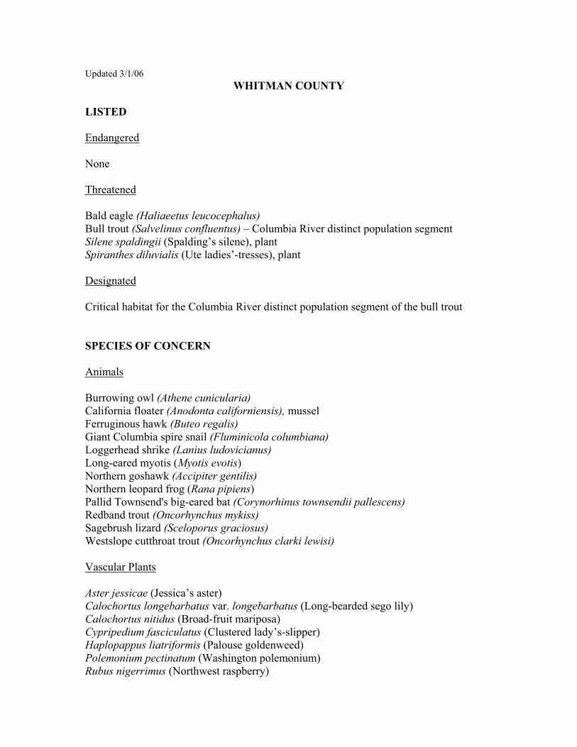
Updated 3/1/06 WHITMAN COUNTY
LISTED
Endangered
None
Threatened
Bald eagle (Haliaeetus leucocephalus)Bull trout (Salvelinus confluentus) – Columbia River distinct population segment Silene spaldingii (Spalding’s silene), plant Spiranthes diluvialis (Ute ladies’-tresses), plant
Designated
Critical habitat for the Columbia River distinct population segment of the bull trout
SPECIES OF CONCERN
Animals
Burrowing owl (Athene cunicularia)California floater (Anodonta californiensis), mussel Ferruginous hawk (Buteo regalis)Giant Columbia spire snail (Fluminicola columbiana) Loggerhead shrike (Lanius ludovicianus)Long-eared myotis (Myotis evotis)Northern goshawk (Accipiter gentilis)Northern leopard frog (Rana pipiens)Pallid Townsend's big-eared bat (Corynorhinus townsendii pallescens)Redband trout (Oncorhynchus mykiss) Sagebrush lizard (Sceloporus graciosus)Westslope cutthroat trout (Oncorhynchus clarki lewisi)
Vascular Plants
Aster jessicae (Jessica’s aster) Calochortus longebarbatus var. longebarbatus (Long-bearded sego lily) Calochortus nitidus (Broad-fruit mariposa) Cypripedium fasciculatus (Clustered lady’s-slipper) Haplopappus liatriformis (Palouse goldenweed) Polemonium pectinatum (Washington polemonium) Rubus nigerrimus (Northwest raspberry)

Updated 09/19/06 YAKIMA COUNTY
LISTED
Endangered
Gray wolf (Canis lupus)
Threatened
Bald eagle (Haliaeetus leucocephalus)Bull trout (Salvelinus confluentus) – Columbia River distinct population segment Grizzly bear (Ursus arctos horribilis)Marbled murrelet (Brachyramphus marmoratus)Northern spotted owl (Strix occidentalis caurina)Ute ladies’-tresses, (Spiranthes diluvialis), plant
Designated
Critical habitat for the northern spotted owl Critical habitat for the Columbia River distinct population segment of the bull trout
CANDIDATE
Fisher (Martes pennanti) - West Coast distinct population segment Greater sage grouse (Centrocercus urophasianus) – Columbia Basin distinct population segment Mardon skipper (Polites mardon), butterfly Yellow-billed cuckoo (Coccyzus americanus)Basalt daisy, (Erigeron basalticus), plant
SPECIES OF CONCERN
Animals
Black swift (Cypseloides niger)Burrowing owl (Athene cunicularia)Ferruginous hawk (Buteo regalis)Larch Mountain salamander (Plethodon larselli)Loggerhead shrike (Lanius ludovicianus)Long-eared myotis (Myotis evotis)Northern goshawk (Accipiter gentilis)Olive-sided flycatcher (Contopus cooperi)Pacific lamprey (Lampetra tridentata)Pallid Townsend's big-eared bat (Corynorhinus townsendii pallescens)Peregrine falcon (Falco peregrinus) (Delisted, monitor status)


APPENDIX B
INDIRECT EFFECTS GUIDANCE


Indirect Effects
b /document1
Biological Assessment Preparation 1
WSDOT GUIDANCE—ESA, TRANSPORTATION, AND DEVELOPMENT: ASSESSING INDIRECT EFFECTS
Under the Endangered Species Act, federal agencies must consult with NOAA Fisheries and USFWS to determine the effects of federal project actions on threatened and endangered species. WSDOT is designated to consult on behalf of FHWA for informal consultations.
The consultation process includes an analysis of direct and indirect effects of the action, as well as the effects of any interrelated or interdependent activities, on listed species. During the Section 7 consultation, questions may arise regarding the relationship of a transportation project to development in adjacent or nearby areas and whether such development is considered an indirect effect as defined under the ESA. This document provides general guidance for reviewing and analyzing only the indirect effect relationship between transportation and land use development during the consultation process. Other types of transportation project effects that require analysis are not addressed here. Note that WSDOT and FHWA are not required by Section 7 to mitigate the indirect effects of an action.
Background Within the state of Washington, development is managed through the Growth Management Act (GMA). The law requires that infrastructure investments (not just transportation investments, but water supply, sewage treatment, parks, and schools) must be adequate to serve a development at the time the development is available for occupancy without decreasing current service levels below locally established minimum standards.
“Concurrent with the development" shall mean that improvements or strategies are in place at the time of development, or that a financial commitment is in place to complete the improvements or strategies within 6 years (RCW 36.70A.070 Comprehensive Plans – Mandatory Elements).
An important component of the Growth Management Act is the designation of urban growth areas to accommodate urban growth 20 years into the future, to restrict the advance of urban sprawl into rural areas, and to protect resource lands. The designation of urban growth areas may increase the intensity of commercial and residential land uses and the density of development, thereby creating the opportunity for alternative travel options (e.g., rail, bus, carpool/vanpool, and bicycle/pedestrian modes), as well as reducing the need for and cost of extending infrastructure beyond the urban growth boundary.
Another important component of the Growth Management Act is the protection of critical areas, which include wetlands, frequently flooded areas, aquifer recharge zones, geologically hazardous areas, and fish and wildlife conservation areas. The law requires that local jurisdictions designate and protect these critical areas by ordinance.
The Growth Management Act was amended in 1995 to require that counties and cities “include the best available science in developing policies and development regulations to protect the

Indirect Effects
b /document1
Biological Assessment Preparation 2
functions and values of critical areas. . . . In addition, counties and cities shall give special consideration to conservation or protection measures necessary to preserve or enhance anadromous fisheries.” This amendment provides the direction for jurisdictions with weak critical area protections to do more. The need for including good science has become a requirement as fish recovery is implemented under the Endangered Species Act. Also, counties and cities were required to review and, if necessary, revise their plans and regulations by September 1, 2002, to be consistent with the statute and its amendments. However, consistency with critical area regulations developed under the Growth Management Act does not necessarily ensure that a project will not result in indirect effects on listed species or critical habitat.
Guidance for Preparing Biological Assessments This guidance has resulted from discussions among the USFWS, NOAA Fisheries, FHWA, Office of Community Development, and WSDOT, with input from local agencies and stakeholder groups, in 1999 and 2000. It was updated in 2003 as a result of coordination with NOAA Fisheries, USFWS, FHWA, and WSDOT. The guidance provides general recommendations for the consideration of indirect effects in biological assessments prepared for ESA Section 7 consultations on transportation projects. The intent is to provide a framework to facilitate the appropriate treatment of indirect effects in a biological assessment. This guidance is expected to be an evolving document; as understanding of biological aspects of indirect effects increases, more definitive recommendations may result.
This document describes a step-by-step approach to assess indirect effects by posing a series of questions about the proposed project. These are shown graphically with a decision-making flowchart, reproduced here in Figure 1, and explained in the text that follows. Table 1 gives examples of project types, potential land use changes, and the level of assessment usually required in a BA.
This guidance pertains only to indirect effects. It is assumed that any project undergoing Section 7 consultation is also evaluated for direct effects, using ESA regulations and other guidance.
General guidance on indirect effects and ESA consultation are also found in ESA Section 7 Consultation Handbook, March 1998, pages 4-27 to 4-29. This guidance is not intended for NEPA cumulative effects analysis; while there is some overlap with ESA consultation, there are important distinctions between the two regulatory processes.
Definitions
The Action Analysis for ESA consultation must address the proposed action, including any interrelated and interdependent actions. Interrelated actions are those that are part of the larger action and dependent on the larger action for their justification. Interdependent actions are those that have no independent utility apart from the action under consideration.

Indirect Effects
b /document1
Biological Assessment Preparation 3
The Effect According to ESA rules and regulations, direct effects occur at or very close to the time of the action itself. Examples include construction noise disturbance, loss of habitat, or sedimentation that results from construction activity. Indirect effects are those that are caused by the action and are later in time (after the action is completed) but still reasonably certain to occur. Examples include changes to ecological systems, such as predator/prey relationships, long-term habitat changes, or anticipated changes in human activities, including changes in land use. The geographic extent of these effects is the action area, defined as all areas to be affected directly or indirectly by the federal action and not merely the immediate area involved in the action.

Indirect Effects
b /document1
Biological Assessment Preparation 4
Figure 1. Indirect effect determinations based on transportation and land development.
No
No
*NO EFFECT
1. DOES THE PROJECT CREATE A NEW FACILITY OR INCREASE THE CAPACITY OF THE EXISTING SYSTEM?
2. IS THERE NEW DEVELOPMENT CONTINGENT ON THE ROAD PROJECT (CAN’T OCCUR WITHOUT IT)?
4. DEFINE THE ACTION (INCLUDING INTERDEPENDENT INTERRELATED ACTIONS)
6. IDENTIFY THE POTENTIAL IMPACT OF THE DEVELOPMENT ON THE SPECIES AND HABITAT
7. IDENTIFY ANY RULES THAT ARE IN PLACE TO HELP MINIMIZE POTENTIAL EFFECTS
*NOT LIKELY TOADVERSELY AFFECT
9. DOES THE DEVELOPMENT HAVE POTENTIAL EFFECTS ON THE SPECIES?
8. DESCRIBE HOW THE DEVELOPMENT WOULD AFFECT THE ENVIRONMENTAL BASELINE
10. IS THE DEVELOPMENT LIKELY TO ADVERSELY AFFECT THE SPECIES OR CRITICAL HABITAT?
*LIKELY TOADVERSELY AFFECT
No
YesNo
Yes
No
No
*This process is for the assessment of indirect effects only and presumes that the project is analyzed for direct effects before a final effect determination is made.
3. IS ANY DEVELOPMENT AN EFFECT OF THE ACTION?
No
Yes
Yes
Yes
5. ARE PROPOSED, LISTED SPECIES OR DESIGNATED CRITICAL HABITAT IN THE ACTION AREA?
Yes

Indirect Effects
b /document1
Biological Assessment Preparation 5
Table 1. Project screening for indirect effects and effect calls in light of indirect effects.
Project Category Project Description Potential Land Use
Changes Analysis Need for BA
Effect Call (Considering Indirect
Effects Only)
Design standards upgrade
Improve roadway design to engineering standards for lane width, curb, gutter and sidewalk, and other geometrics.
Very limited potential to cause land use change
Assessment in BA that details why project will not result in indirect effects.
Mostly NE
Operations and safety improvements
Make improvements to enhance traffic operations and safety including signalization, traffic control, channelization, median treatments, turn pockets/lanes, and other benefits to traffic flow.
Usually insignificant potential to cause land use change
Assessment in BA that details why project has insignificant potential to result in indirect effects.
Mostly NE
Pavers (preservation)
Repave road surface without providing an increase in capacity.
No potential to cause land use change
Assessment in BA that details why project has insignificant potential to result in indirect effects.
Mostly NE
Bridge replacement Replacing bridges without providing an increase in capacity.
Very limited potential to cause land use change
Assessment in BA that details why project has insignificant potential to result in indirect effects.
Mostly NE
Increased lane capacity, improvements to existing interchanges
Add physical through-lane capacity to an existing roadway.
Potential to cause land use change
Detailed analysis of indirect effects
NLTAA or LTAA, depending on specific impacts
Roadway extension, new roadway, new interchange
Construct extension of roadway, or new roadway on new alignment.
Potential to cause land use change
Detailed analysis of indirect effects
NLTAA or LTAA, depending on specific impacts
NE = no effect; NLTAA = not likely to adversely affect; LTAA = likely to adversely affect.
Indirect effects of transportation projects include changes in land use, such as the development of undeveloped areas when those changes are induced by the action or can reasonably be expected to result from the action.
Indirect Effect Evaluation Process 1. Does the project create a new facility (e.g., new road or new interchange) or increase the capacity of the existing system?
This step identifies the types of transportation improvements that have the potential to influence land use.

Indirect Effects
b /document1
Biological Assessment Preparation 6
New capacity is defined as an increased ability for the transportation system to handle traffic volumes. New roadways or significant changes in capacity or land access have the potential for indirect effects on listed species and their habitat, because these changes potentially cause changes in land development by altering access to land. Other examples are the addition of lanes to a roadway, or the creation of new land access (such as new intersections or interchanges) from an existing road. New interchanges on limited-access roads may lead to changes in land development, but upgrading an existing intersection with a new interchange generally has very limited or no effect on land use. These are generalities, and it is important to consider the specific facts of the project being evaluated. Other examples are given in Table 1.
Many transportation projects are intended to improve traffic flow, relieve congestion, or increase safety. Safety projects often include construction of auxiliary lanes (e.g., for turning, acceleration, or deceleration) on existing roadways, but these new lanes do not increase capacity. Because these projects generally improve operation of the transportation system but do not change the development potential of land, they are not likely to cause land use changes (this applies to many high-occupancy vehicle [HOV] projects that are primarily modal changes). For these types of projects, the indirect effects analysis may be brief. Otherwise, if a transportation project is anticipated to result in a land use change through significant change in land access or capacity improvement, then potential indirect effects on listed species and habitat should be identified and evaluated.
It can be unclear whether a project actually increases capacity or simply redistributes the same traffic in different ways. Land use and transportation planning and engineering expertise may help with this distinction and with the evaluation of likely impacts. Such expertise may also provide information about development patterns in the area and the impacts of comparable projects. When this issue is not reasonably clear, project proponents should confer with the Services in advance to agree on an approach before the completion of a BA.
BA Task: Determine whether proposed project creates a new facility or increases the capacity of the existing system.
Example: WSDOT proposes to construct a new lane in either direction along SR 395 between I-90 and the Tri-Cities to relieve traffic congestion and improve safety. The project will also flatten horizontal curves and establish a divided highway, which will allow a speed limit increase from 55 mph to 65 mph. Between the speed limit increase and the additional lanes, the project will more than double the capacity along this highway segment. The project will not create a new facility, but it will increase the capacity of the existing system.
2. Is new development in the vicinity contingent on the transportation project (i.e., would not occur without the project)?
In some cases, a development is tied by a permit condition (or a building moratorium associated with Growth Management Act concurrency) to certain transportation improvements. In these cases, if the development could not proceed without the transportation improvement and is reasonably certain to result from it, the effects of the development must be considered as part of

Indirect Effects
b /document1
Biological Assessment Preparation 7
the indirect effects of the transportation action. These indirect effects must be addressed in the consultation for the project. However, from the perspective of concurrency with the Growth Management Act rather than ESA consultation, the new development is viewed as the driver. This makes the roadwork necessary as mitigation for the increased traffic caused by that new development. Although the development may be the actual cause of adverse effects on species, development in most cases does not involve a federal nexus and thus may not trigger Section 7 consultation on its own.
BA Task: Check with appropriate local agency public works or planning office to determine whether development projects in the area meet these criteria. Relevant documents include the transportation element of the comprehensive plan, and the capital facilities plan. This is useful as documentation to support the analysis.
Example: A road-widening project proposes to add two new lanes along Skinny Boulevard, an existing arterial. The project occurs within King County’s transportation service area (TSA) 3 as identified in the county’s comprehensive plan. The transportation service strategy within TSA 3 is “construct arterials to meet existing and future capacity needs.” The county identifies the proposed project as one of several projects considered necessary to meet these future capacity needs. The project is also located in a transportation concurrency zone identified as over threshold where a development moratorium is in place until transportation infrastructure improvements are in place to adequately handle additional traffic. Upon review of the pending transportation concurrency applications, the approval of three development projects is dependent upon the completion of the proposed Skinny Boulevard road-widening project. Following this review, new development is clearly dependent on the completion of the proposed project.
3. Is any development in the vicinity caused by or dependent on the project? This step identifies any activities that are likely to result from the proposed project, such as residential and commercial development or other land use changes.
This task is complicated by the present high rate of population growth and land development in many parts of Washington. In many cases, transportation projects are being constructed in the context of a developing landscape. Land development is driven by a variety of social and economic factors, in addition to the provision of access. It is difficult to isolate which of these factors are causal in a particular development. Road projects are often built in response to problems resulting from population growth, but only infrequently do they actually trigger the development itself. In most cases, land development generally is not caused by a transportation project, although transportation projects can in some cases influence the rate or type of development.
One approach to identify any land use change caused by a project is to look at existing zoning in areas potentially influenced by the project and consider the build and no-build scenarios for the
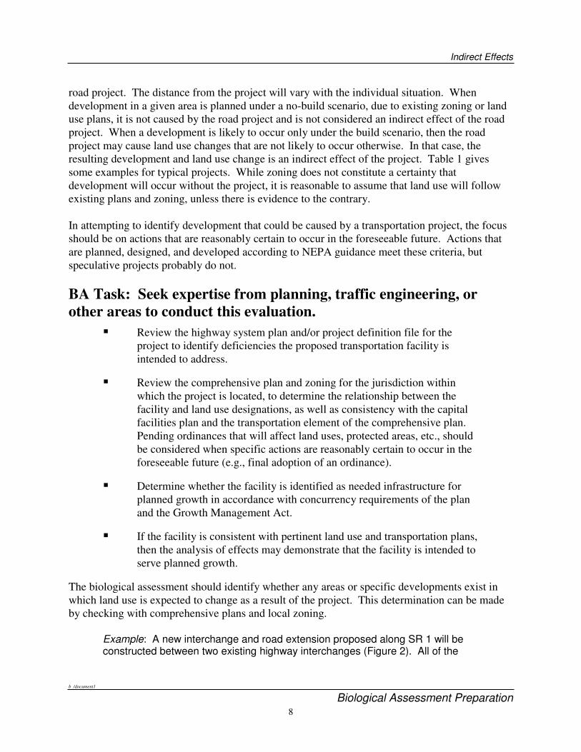
Indirect Effects
b /document1
Biological Assessment Preparation 8
road project. The distance from the project will vary with the individual situation. When development in a given area is planned under a no-build scenario, due to existing zoning or land use plans, it is not caused by the road project and is not considered an indirect effect of the road project. When a development is likely to occur only under the build scenario, then the road project may cause land use changes that are not likely to occur otherwise. In that case, the resulting development and land use change is an indirect effect of the project. Table 1 gives some examples for typical projects. While zoning does not constitute a certainty that development will occur without the project, it is reasonable to assume that land use will follow existing plans and zoning, unless there is evidence to the contrary.
In attempting to identify development that could be caused by a transportation project, the focus should be on actions that are reasonably certain to occur in the foreseeable future. Actions that are planned, designed, and developed according to NEPA guidance meet these criteria, but speculative projects probably do not.
BA Task: Seek expertise from planning, traffic engineering, or other areas to conduct this evaluation.
�� Review the highway system plan and/or project definition file for the project to identify deficiencies the proposed transportation facility is intended to address.
�� Review the comprehensive plan and zoning for the jurisdiction within which the project is located, to determine the relationship between the facility and land use designations, as well as consistency with the capital facilities plan and the transportation element of the comprehensive plan. Pending ordinances that will affect land uses, protected areas, etc., should be considered when specific actions are reasonably certain to occur in the foreseeable future (e.g., final adoption of an ordinance).
�� Determine whether the facility is identified as needed infrastructure for planned growth in accordance with concurrency requirements of the plan and the Growth Management Act.
�� If the facility is consistent with pertinent land use and transportation plans, then the analysis of effects may demonstrate that the facility is intended to serve planned growth.
The biological assessment should identify whether any areas or specific developments exist in which land use is expected to change as a result of the project. This determination can be made by checking with comprehensive plans and local zoning.
Example: A new interchange and road extension proposed along SR 1 will be constructed between two existing highway interchanges (Figure 2). All of the

Indi
rect
Effe
cts
b /d
ocum
ent1
B
iolo
gica
l Ass
essm
ent P
repa
ratio
n
9 A
dvan
ced
Tra
inin
g M
anua
l Ver
sion
4
Fig
ure
2.
Exa
mpl
e of
a t
rans
port
atio
n pr
ojec
t th
at h
as in
dire
ct e
ffec
ts o
n la
nd u
se.

Indirect Effects
b /document1
December 9, 2005 10
roads and adjoining lands that will be accessible from the new interchange are currently accessed from the two existing interchanges. However, the new interchange and road extension will likely result in improved freeway access to much of the area located between the existing interchanges. The project definition indicates that the existing SR 1 access points are insufficient in accommodating the anticipated future highway access needs in the service area.
The city’s comprehensive plan identifies the area in the vicinity of the proposed new road and interchange as occurring within the city’s urban growth boundary. The city’s comprehensive plan identifies this area as a key area for growth because of its proximity to SR 1 and existing commercial centers. The comprehensive plan also identifies the need for improved transportation facilities as the primary limiting factor for growth in this area. As a result, the city has imposed traffic concurrency requirements for future development in this designated growth area.
These proposed improvements are consistent with the city’s land use and transportation plans. The above information indicates that the proposed project is intended to serve planned growth.
The construction of the new interchange is proposed to improve access to and from SR 1. Although the proposed project will not provide access to currently inaccessible lands, the undeveloped parcels located along the proposed road extension may have greater development appeal as a result of the improved mobility in the vicinity that results from this project. In this case, development of these parcels may occur as a result of this project, or more likely, their development may occur sooner than it would occur without the completion of this project. Moreover, given the traffic concurrency requirements imposed for this area, future development cannot occur without the proposed transportation improvements.
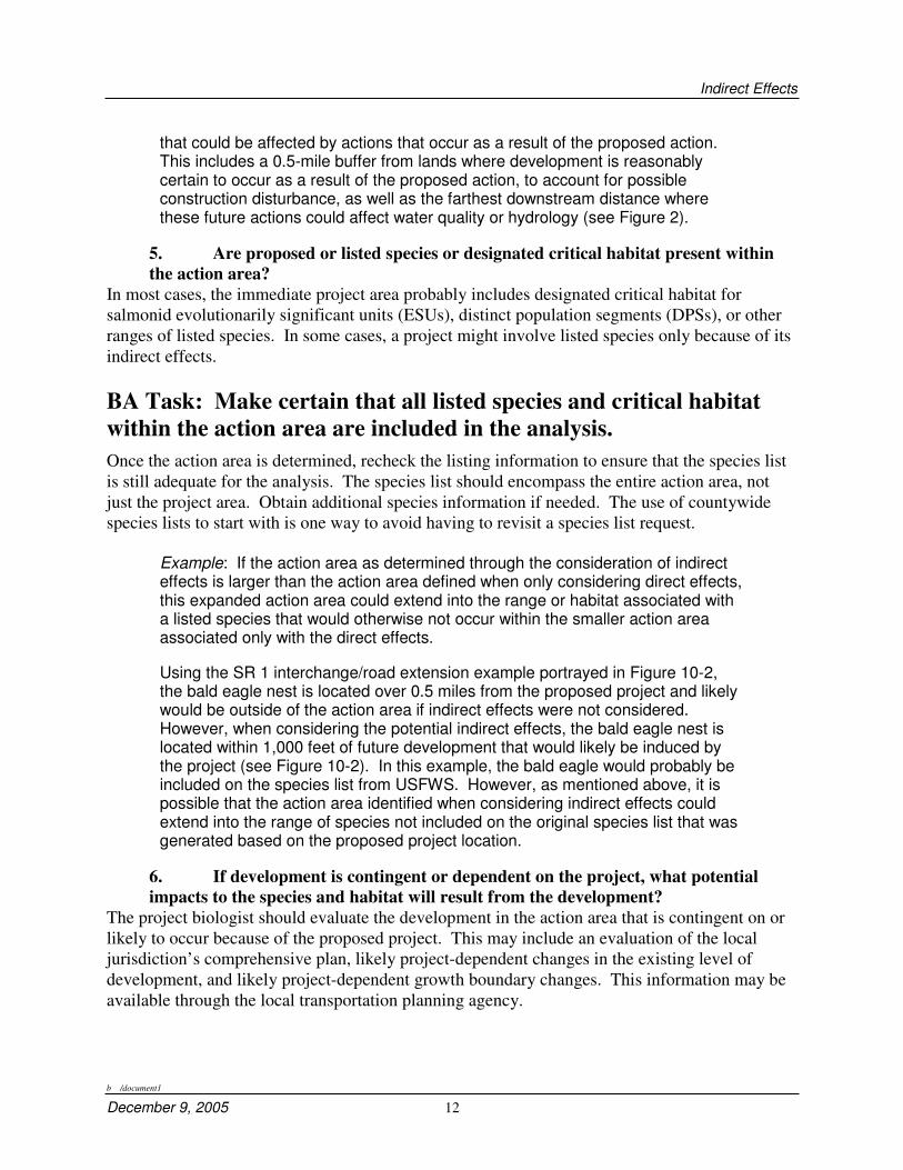
4. Define the action area. Indirect effects occur later in time than the original action and may occur outside the area directly affected by the action. The entire area evaluated in the BA for potential project effects on listed species is called the action area. When defining the action area it is important to include the areas that are both directly and indirectly affected by the proposed action. The extent of the action area is based on the physical, chemical, and biotic extent of the project effects.
In more complex cases, determining an action area for a transportation project may involve analysis of surface water, traffic patterns, and local land development. The project biologist may need to consult specialists in traffic engineering, transportation land use planning, and other areas in preparing the BA. The purpose is to determine whether a project may ultimately affect a listed species by affecting land use. Defining the action area can be complex for development-related indirect effects. An overly wide definition of the action area leads to more complexity for cumulative effects analysis and a potential to overestimate effects. This can create unnecessary complications, particularly for formal consultation. An undersized action area may fail to adequately characterize the extent of potential impacts. For the BA, the objective is to identify the geographic extent of the effect of land use changes that are caused by the action and

Indirect Effects
b /document1
December 9, 2005 11
that may ultimately affect listed species or their habitat. In some cases, the action area may not be a single contiguous area but rather a patchy distribution.
BA Task: Choose an appropriate method of defining the action area. Several methods are suggested below for help in determining the action area. These may be tailored with respect to project specifics and the available information. Alternative methods may be used; however, an explanation of the method used may be necessary. Such alternatives should be discussed with the Services before significant work is undertaken.
Step 1: Characterize the potential zone of influence for change in traffic caused by the project.
a. The zone of influence for traffic could be estimated by using projected traffic volumes and focusing on any projected changes in traffic patterns due to the proposed action (i.e., the area accessed though a new interchange).
b. In some cases, the zone of influence for traffic could be generally defined as a corridor along the road, including the project, and continuing to the closest intersection with a major transportation route such as a state highway.
c. Existing planning units delineated in some jurisdictions as part of land use planning and traffic mitigation analysis could be used to define the action area, or in conjunction with subwatershed boundaries to define the action area.
d. Detailed analyses of traffic patterns such as origin-destination studies or other studies may be performed as part of planning for certain actions. These may be used where available from project planning materials.
Step 2: Factor in the watershed To define the action area, overlay the traffic zone-of-influence boundary with the subwatershed (i.e., watershed administrative unit) that coincides. For aquatic species, the BA analysis should cover the geographic area defined by the overlap, plus any downstream portions of the subwatershed.
Example: Under the SR 1 interchange scenario, the zone of influence includes all roads that will be affected by the new interchange. This area includes all locations where access to SR 1 is most direct or quickest using the new interchange, compared to the existing interchanges and the roads from which traffic would be diverted as a result of the proposed action (see Figure 2). The action area includes this zone of traffic influence as well as any surrounding area
Indirect Effects
b /document1
December 9, 2005 12
that could be affected by actions that occur as a result of the proposed action. This includes a 0.5-mile buffer from lands where development is reasonably certain to occur as a result of the proposed action, to account for possible construction disturbance, as well as the farthest downstream distance where these future actions could affect water quality or hydrology (see Figure 2).
5. Are proposed or listed species or designated critical habitat present within the action area?
In most cases, the immediate project area probably includes designated critical habitat for salmonid evolutionarily significant units (ESUs), distinct population segments (DPSs), or other ranges of listed species. In some cases, a project might involve listed species only because of its indirect effects.
BA Task: Make certain that all listed species and critical habitat within the action area are included in the analysis. Once the action area is determined, recheck the listing information to ensure that the species list is still adequate for the analysis. The species list should encompass the entire action area, not just the project area. Obtain additional species information if needed. The use of countywide species lists to start with is one way to avoid having to revisit a species list request.
Example: If the action area as determined through the consideration of indirect effects is larger than the action area defined when only considering direct effects, this expanded action area could extend into the range or habitat associated with a listed species that would otherwise not occur within the smaller action area associated only with the direct effects.
Using the SR 1 interchange/road extension example portrayed in Figure 10-2, the bald eagle nest is located over 0.5 miles from the proposed project and likely would be outside of the action area if indirect effects were not considered. However, when considering the potential indirect effects, the bald eagle nest is located within 1,000 feet of future development that would likely be induced by the project (see Figure 10-2). In this example, the bald eagle would probably be included on the species list from USFWS. However, as mentioned above, it is possible that the action area identified when considering indirect effects could extend into the range of species not included on the original species list that was generated based on the proposed project location.
6. If development is contingent or dependent on the project, what potential impacts to the species and habitat will result from the development?
The project biologist should evaluate the development in the action area that is contingent on or likely to occur because of the proposed project. This may include an evaluation of the local jurisdiction’s comprehensive plan, likely project-dependent changes in the existing level of development, and likely project-dependent growth boundary changes. This information may be available through the local transportation planning agency.

Indirect Effects
b /document1
December 9, 2005 13
The key question is whether there will be adverse effects on the species or its habitat. In addition to direct effects on listed species, consider potential impacts on aquatic habitats, adjacent riparian zones, downstream water quality, and properly functioning habitat conditions.
BA Task: Expand the analysis of effects to include effects of the development. The analysis of the effects of the development should cover the same elements as the analysis of the original project, although it may be necessary to make estimates if future land use actions are involved.
Example: Using the SR 1 interchange/road extension example portrayed in Figure 2, the indirect effects could result in three key forms of impact: 1) loss of habitat from future development dependent or caused by the proposed action, 2) increased disturbance from future construction and population growth that occurs as a result of the proposed action, and 3) water quality impacts from increased impervious surface and pollutant sources.
In addition to direct impacts on habitat, impacts on habitat resulting from future development that could occur due to the proposed action could result in the loss of as much as 160 acres of mixed deciduous-coniferous forest and 100 acres of unforested land consisting of an abandoned gravel pit and fallow pasture.
The active bald eagle nest identified in Figure 2 is located within 0.25 miles of a parcel of land where development could occur as a result of the proposed interchange construction. Suitable bald eagle perching and feeding habitat also occurs on and adjacent to this and other parcels located adjacent to the proposed interchange. Development of these parcels could result in the loss of bald eagle habitat within this active territory. Construction associated with the development of these parcels, as well as future land use activities, could result in increased disturbance to eagles in this nest territory and could lead to nest failure. Increased traffic at the proposed new interchange and road extension could also result in additional noise and visual disturbance to bald eagles.
Based on the existing zoning of the parcels where development could occur as a result of the proposed action, as much as 80 acres of new impervious surface could be generated if each of these parcels is developed to their full density potential. This increase in impervious surface area could have an adverse effect on water quality and hydrology in the action area, in turn affecting listed salmonids that rear in the action area.
7. What rules or measures are in place to help minimize these potential effects? The BA author should note any protection for listed species and habitat provided by existing local critical area ordinances in the action area. This may include protection for riparian or wetland buffers, stormwater regulations, and implementation and enforcement of existing critical area ordinances.

Indirect Effects
b /document1
December 9, 2005 14
BA Task: Identify required conditions or measures that may prevent or minimize adverse effects. The BA should address the following questions: What are the protective measures available to minimize project impacts? Are there factors that would help reduce or minimize the potential effect of development caused by the project? These might include plans or commitments by agencies or project proponents outside the critical area ordinances. Other protective regulations such as conditions of the hydraulic project approval (HPA) should be included where applicable. The results of this assessment should be incorporated into the discussion of the effects of the proposed action on the environmental baseline.
Example: The local jurisdiction currently requires all development to provide treatment of stormwater consistent with the Department of Ecology stormwater manual. The local jurisdiction also has established a critical areas ordinance that regulates development in the vicinity of wetlands and streams. Depending on the class of stream or wetland, buffers ranging from 25 to 100 feet apply to these features. Any permissible unavoidable impacts on critical areas must be mitigated through the implementation of approved enhancement, creation, or restoration measures. All future land use actions are also subject to Section 9 of the Endangered Species Act, the Washington state hydraulic code, and state and federal bald eagle protection rules. Given these existing regulations, development that results from the proposed action will not significantly alter water quality, hydrology, streams, or wetlands, and is not likely to result in significant impacts on bald eagles.
8. If development is contingent or dependent on the project, how will this development affect the environmental baseline conditions?
The potential effects of the action should be compared to the environmental baseline conditions using the NMFS (1996) matrix of pathways and indicators guidance document and any appropriate guidance from USFWS. Measures in place to protect the species or habitat should be considered in this assessment.
BA Task: As part of the effect determination, describe the existing environmental baseline condition and describe how the direct and indirect effects of the action would likely affect it. Would indirect effects of the project degrade, maintain or improve the existing conditions?
9. If development is contingent or dependent on the project, will this development have potential effects on the species?
If the project has any effects on listed species or designated critical habitat, even small or temporary effects, then a biological assessment must be prepared and ESA Section 7 consultation is required.

Indirect Effects
b /document1
December 9, 2005 15
BA Task: Combine this analysis with the evaluation of direct effects. If no indirect effect resulting from any development is likely to result from the action, and there are no other direct or indirect effects, then the project as a whole will have no effect. Combine this analysis with the evaluation of direct effects and proceed with the appropriate no effect documentation for the project. Adequate information must be provided to explain and support the conclusions of the analysis.
If the project does have potential effects, then proceed with the biological assessment to determine if the effects are significant or discountable.
Example: Because future development is dependent upon completion of the proposed SR 1 interchange/road extension project, the most notable indirect effects of the project include possible development in the vicinity of the interchange and along SR 1 that would not likely occur without the project. Other impacts include a potential accelerated rate of development of lands along the road extension, which will occur eventually, regardless of the proposed action. It is assumed that complete build-out within the action area will result sooner with the proposed project than without these roadway improvements, although this rate of acceleration cannot be quantified, given the difficult task of isolating this factor from the numerous other influences on development.
Because development in the vicinity could affect bald eagle habitat and could result in disturbance to nesting bald eagles, the proposed action could indirectly result in increased impacts on bald eagles. However, the required compliance with existing state and federal laws pertaining to bald eagles will minimize these impacts. Because treatment of stormwater and development in and near critical areas is regulated by the local jurisdiction, indirect impacts on listed fish species and bald eagle are likely to be insignificant and discountable.
10. If development is contingent or dependent on the project, is this development likely to adversely affect the species or critical habitat?
In this step, a determination is made as to the significance of any potential effects on listed species or designated critical habitat. This differentiation will lead to either formal or informal consultation, based on whether the effect is considered insignificant or discountable (informal consultation) or adverse (formal consultation).
Insignificant effects are generally very small in scale, do not reach the level of take as defined by the ESA, and cannot be meaningfully measured, detected, or evaluated. Discountable effects are those that are extremely unlikely to occur.
An adverse effect is one that cannot be considered insignificant or discountable. If an action significantly degrades the baseline conditions, the Services may consider it an adverse effect. Actions that result in a take of individuals or that modify critical habitat are considered to adversely affect the species under consideration. The extent of any adverse effect is considered in the consultation.

Indirect Effects
b /document1
December 9, 2005 16
BA Task: If the answer to question 10 (in Figure 1) is no, then the determination is not likely to adversely affect (NLTAA) for the indirect effects part of the BA. If the direct effects of the project are also NLTAA, then proceed with informal consultation.
If the answer to question 10 is yes, then the determination is likely to adversely affect (LTAA); the project requires formal consultation. This analysis must be combined with an analysis of the project’s direct effects to complete the biological assessment.
If the consultation results in a no jeopardy opinion, the Services issue an incidental take statement for take that cannot be avoided. The Services do not have to authorize take for indirect effects over which FHWA has no jurisdiction. The incidental take statement includes reasonable and prudent measures (RPMs) to minimize take, together with terms and conditions. If the consultation results in a jeopardy opinion, reasonable and prudent alternatives may be provided to avoid jeopardy to the species or adverse modification of critical habitat. Also, the Services may make voluntary conservation recommendations to help further reduce potential effects.
As part of formal consultation, the effects of the action must be evaluated in the context of cumulative effects. These are defined in the ESA as the effects of future state, tribal, local, or private activities that are reasonably certain to occur in the foreseeable future within the action area. The larger the extent of the project action area, the more extensive this aspect of the consultation becomes. Once identified, the cumulative effects are evaluated with the direct and indirect effects of the action, to provide the context for the Services’ jeopardy/adverse modification determination. Project impacts in areas where baseline conditions are severely degraded are more significant than those where the baseline is functioning well.
Example: Indirect impacts of growth induced by the proposed SR 1 interchange and road extension project may affect but are not likely to adversely affect bald eagles.
A may affect determination is based on:
�� The possibility of disturbance and habitat impacts resulting from induced development at the proposed interchange located within 0.25 miles of a bald eagle nest
�� The potential for water quality impacts that could affect bald eagle food resources.
A not likely to adversely affect determination is based on:
�� The applicability of state and federal laws regulating development activities in the vicinity of bald eagle nests located in the action area

Indirect Effects
b /document1
December 9, 2005 17
�� The applicability of the local agency’s critical area ordinance and stormwater treatment requirements minimizing impacts on bald eagle habitat and food resources.
Note that these preliminary effect determinations represent the indirect effects only and must be combined with analysis of the direct effects to reach an overall effect determination for each listed species and critical habitat.
Indirect effects analyses can be very detailed. One of the documents referenced by USFWS as containing a particularly thorough analysis of effects was 15 pages long for the indirect effects analysis alone. This analysis addressed four interrelated projects located adjacent to each other along a single roadway. Because the projects were interrelated, USFWS requested that the indirect effects be collectively assessed for the four projects. This well-written analysis included the following:
�� A discussion of the phasing for each of the staged projects
�� A detailed description and map of the zone of influence or action area
�� The indirect effects analysis itself
�� A preliminary effect determination based on the indirect effects analysis for each species in the project action area.
The BA also provided supporting documentation, including the following:
�� References for information sources
�� Maps of local zoning and areas of approved development within the project action area
�� Historical land development by grid section
�� Past and present photographs along the proposed alignment
�� Several maps illustrating lots with projects under review within the defined zone of influence.


APPENDIX C
EXEMPTED RIVERS LIST


Flow Control Exempt Surface Waters From WSDOT Highway Runoff Manual (2006)
Water Body Upstream Point/Reach for Exemption (if applicable)
Skagit River Downstream of Canadian border Skokomish River Downstream of confluence of North and South Forks Skokomish River, South Fork Downstream of confluence with Vance Creek Skokomish River, North Fork Downstream of confluence with McTaggert Creek Skookumchuck River 1 mile upstream of Bucoda at State Route 507, milepost 11.0 Skykomish River Downstream of South Fork Skykomish River, South Fork Downstream of confluence of Tye and Foss Rivers Snake River Entire reach along Idaho boarder to the Columbia River Snake River Reservoirs Snohomish River Downstream of confluence of Snoqualmie and Skykomish Rivers Snoqualmie River Downstream of confluence of the Middle Fork Snoqualmie River, Middle Fork Downstream of confluence with Rainy Creek Sol Duc River Downstream of confluence of North and South Fork Soleduck River Spokane River Downstream of Idaho border Spokane River Reservoirs Stillaguamish River Downstream of confluence of North and South Forks Stillaguamish River, North Fork 7.7 highway miles west of Darrington on State Route 530,
downstream of confluence with French Creek Stillaguamish River, South Fork Downstream of confluence of Cranberry Creek and South Fork Suiattle River Downstream of confluence with Milk Creek Sultan River 0.4 miles upstream of State Route 2 Swift Creek Reservoir Teanaway River Downstream of confluence of North and West Forks Thunder Creek Downstream of confluence with Neve Creek Tieton River Downstream of Rimrock Lake Tilton River Downstream of confluence with North Fork Tilton River Toppenish Creek Downstream of confluence with Wanity Slough Touchet River Downstream of confluence with Patit Creek Toutle River North and South Fork confluence Toutle River, North Fork Downstream of confluence with Hoffstadt Creek Toutle River, South Fork Downstream of confluence with Thirteen Creek Tucannon River Downstream of confluence with Pataha Creek Walla Walla River Downstream of confluence with Mill Creek Wenatchee River Downstream of confluence with Icicle Creek White River Downstream of confluence with Huckleberry Creek White Salmon River 0.15 miles upstream of confluence with Trout Lake Creek Willapa River Downstream of confluence with Mill Creek Wind River Downstream of confluence with Cold Creek Wynochee Lake Wynoochee River Downstream of confluence with Schafer Creek Yakima River Downstream of Lake Easton


APPENDIX D CONSERVATION MEASURES


CONSERVATION MEASURES � CM-1 A TESC Plan and Stormwater Site Plan will be developed and implemented for
all projects requiring clearing, vegetation removal, grading, ditching, filling, embankment compaction or excavation. The BMPs in the plans will be used to control sediments from all vegetation or ground disturbing activities.
� CM-2 A SPCC plan that meets the standard specifications in Appendix H, will be developed for the project to ensure that all pollutants and products will be controlled and contained.
� CM-3 No contractor staging areas will be allowed within 300-feet of any jurisdictional wetland, stream, river or drainage as identified by the project biologist unless site specific review completed by the project biologist indicates that no impacts to the sensitive resource areas will occur due to topography or other factors.
� CM-4 BMPs will be used on all projects that occur within 200-feet of surface water or wetland habitat as identified by the project biologist, to ensure that no foreign material, such as pavement slurry, is sidecast, and to control and prevent sediments from entering aquatic systems.
� CM-5 Construction impacts will be confined to the minimum area necessary to complete the project.
� CM-6 Boundaries of clearing limits associated with site access and construction will be flagged to prevent ground disturbance outside of the limits.
� CM-7 Vegetation will only be grubbed from areas undergoing permanent alteration. No grubbing will occur in areas slated for temporary impacts.
� CM-8 Disturbed areas shall be restored to pre-work conditions. Complete restoration for projects involving vegetation removal may be delayed until native plantings can mature to pre-work conditions. Native plant species shall be used that are endemic to the project vicinity or region of the State where the activity is occurring.
� CM-9 Individual management plans shall be developed for all individual bald eagle nest trees and winter roosts located on WSDOT ROW land within 800 feet of the project area.
� CM-10 Seasonal restrictions applied to work conducted below the ordinary high water mark (OHWM) will be as required by a HPA issued by the Washington State Department of Fish and Wildlife, and Water Quality Standards for Surface Waters of the State of Washington (Chapter 173-201A WAC) and approved by USFWS.
� CM-11 Removal of riparian vegetation will be minimized to the greatest extent possible. Native riparian vegetation will be replanted where feasible. Vegetation restoration will be coordinated with WDFW and/or USFWS.
� CM-12 Projects involving bridge replacements within the range of the grizzly bear will design the new structure to accommodate wildlife crossings when practicable.
� CM-13 For projects that occur within 1.0 mile of suitable marbled murrelet nesting habitat, all trash, food waste, and other items attractive to crows, jays and other Corvidae shall be removed from the project area on a daily basis.
� CM-14 Construction of new facilities such as rest areas or maintenance facilities within 5 miles of suitable marbled murrelet nesting habitat will develop a trash

handling plan to insure that food wastes and other items attractive to crows, jays and other Corvidae will not accumulate at the project site.
� CM-15 Trees that are removed in suitable marbled murrelet and/or spotted owl habitat are to be dropped into the road right of way or areas that will be cleared. Where LWD is lacking in adjacent forests, they will be placed in the forest where practicable and agreeable to the adjacent property owner, following coordination with and approval by USFWS.
� CM-16 For all projects adding 150 square feet or more of new impervious surface, water quality and quantity treatment will be completed.
� CM-17 Report emergency actions to the Spokane Washington office of the USFWS within 1 workday where listed species are potentially present. Limit scope of actions in response to emergency to only those actions that are necessary to address immediate emergency.
� CM-18 When feasible on stream bank protection and slide repair projects, evaluate and implement fish habitat improvement measures by incorporating available LWD and boulders in the bank protection or repair design.
� CM-19 Fisheries habitat restoration projects located in watersheds that contain listed or proposed species under USFWS jurisdiction will be evaluated in coordination with the USFWS for feasibility/suitability as appropriate restoration activities. Fish passage improvement projects that are consistent with WDFW Salmon Steelhead Habitat Enhancement and Restoration Program are exempt from this requirement.
� CM-20 Temporary material storage piles will not be placed within the 100-year floodplain during the rainy season (October through May) unless the following conditions are met: (1) storage does not occur when flooding is eminent; and (2) if storage piles consist of erosive material they are to be covered with plastic tarps (or similar) and surrounded with straw bales. Material used within 12 hours of deposition will not be considered a temporary material storage pile.
� CM-21 All in-water work must comply with appropriate work windows as agreed upon by USFWS and WDFW.
� CM-22 During bridge removal projects, as much of the existing structure as possible shall be removed before finally dismantling the structure to limit the amount of material and debris from entering receiving waters. This shall include all roadbed material, decking, concrete curbs, etc.
� CM-23 Concentrated accumulations of bird feces, road grit, sand, and loose paint chips shall be removed as much as practicable from bridges before dismantling.
� CM-24 All bridge removal projects shall comply with water quality standards identified in the WSDOT – Washington State Department of Ecology Water Quality Implementing Agreement or approved Temporary Water Quality Modification Permit to maintain turbidity levels with approved standards and prevent degradation of water quality standards.
� CM-25 All fish will be removed from the work area prior to any in-water work activities. Salmonid removal methods could include dewatering of salmonid habitat, netting of individuals, electrofishing, dispersal of salmonids through snorkeling or use of seine nets, and/or establishing a net enclosure around the work area.

� CM-26 Prior to entering the water, all equipment shall be checked for leaks and cleaned free of any external petroleum products, hydraulic fluid, coolants, and other deleterious materials. Wash water shall not be discharged to any waterbody without pre-treatment to State water quality standards.
� CM-27 All equipment entering waters containing bull trout will use vegetable oil or other biodegradable, acceptable hydraulic fluid substitute.
� CM-28 During subsurface sampling, when working off the highway, bridge deck, barge, or road surface, within 100 feet of waters containing listed fish species, a silt fence will be installed between the drilling site and waterbody to contain sediments.
� CM-29 During subsurface sampling within 100 feet of waters containing listed fish species, where practical, all materials removed from the test hole shall be removed from the site.
� CM-30 Oil absorbent pads shall be placed under the drill rig during subsurface sampling when within 100 feet of waters containing listed fish species, to catch and control spills.
� CM-31 For subsurface sampling within 100 feet of waters containing listed fish species, the team lead shall have a minimum of 4 hours erosion control, spill control and containment training.
� CM-32 For subsurface sampling within 100 feet of waters containing listed fish species, all existing large woody debris will be left on site.
� CM-33 Installation of riprap and other materials will occur from the banks or outside the wetted perimeter as much as possible.
� CM-34 Projects will follow the “Integrated Streambank Protection Guidelines” as much as practicable.
� CM-35 All concrete shall be poured in the dry, or within confined waters not being dewatered to surface waters, and shall be allowed to cure a minimum of seven (7) days before contact with surface water.
� CM-36 Debris accumulations on the bridge, road surface, and within the bridge drains shall be collected or swept up and properly disposed of prior to fresh water flushing. Flushing will involve the use of clean water only, to prevent detergents or other cleaning agents from entering waters of the State.
� CM-37 Structural cleaning: Pressure washing of structures shall be done using appropriate screened tarping to control and contain paint particles generated by the activity. Concentrated accumulations of bird feces and nests shall not be allowed to drop into the water. This material shall be scraped from the bridge structure and collected and disposed of at an appropriate upland location.
� CM-38 Pressure washing of concrete structures shall be held to the minimum necessary to maintain structure integrity. (Pressure washing of concrete structures can result in an increased pH discharge with a potential to violate State water quality criteria.)
� CM-39 Abrasive Blasting Containment: During abrasive blasting of a steel bridge prior to painting, a containment system appropriate for the type and location of the bridge shall be in place and maintained to prevent spent blast media from reaching State waters. Spent blast media shall be collected, sampled, designated for its hazardous material content and disposed of as appropriate for its waste designation.
� CM-40 Painters shall work from pails containing a maximum of two (2) gallons of paint to minimize the impact of accidental spillage, except for sealed containers that are part of a spray system.
� CM-41 Cleaning of paint materials and maintenance equipment shall not be done in waters of the State or shall resultant cleaning runoff be allowed to enter State waters.
� CM-42 Drip pans or other protective devices shall be required for all paint mixing and solvent transfer operations.
� CM-43 Drip tarps shall be suspended below paint platforms to prevent spilled paint, buckets, brushes, etc. from entering State waters.
� CM-44 When practicable, all fueling and maintenance of equipment (except for large cranes) will occur more than 150 feet from the nearest wetland, ditches, flowing or standing water. Fueling large cranes, pile drivers and drill rigs over 300 feet away may not be practicable.
� CM-45 Culvert cleaning and repair will occur during the dry or when listed or proposed fish are not likely to be present.
� CM-46 Culvert cleaning will occur from the top of the bank as much as possible. � CM-47 Work will not inhibit passage of any adult or juvenile salmonid species
throughout the construction periods or after project completion. � CM-48 All dredged or excavated materials will be removed to an upland location
where it cannot enter the waterbody.� CM-49 New stream crossing structures shall not reduce the existing stream width. � CM-50 Fill material shall be placed, not randomly dumped. � CM-51 Temporary fills must be entirely removed and the site restored to pre-existing
conditions.� CM-52 The establishment and use of temporary access roads will meet the following
conditions:� Activities will comply with HPA requirements. � Existing roadways or travel paths will be used whenever reasonable. � Where stream crossings are essential, the crossing design will accommodate
reasonably foreseeable risks (such as flooding and associated bedload and debris) to prevent diversion of stream flow out of the channel and down the road in the event of a crossing failure.
� Vehicles and machinery must cross-riparian areas and streams perpendicular to the main channel wherever reasonable.
� The number of stream crossings will be minimized.
� CM-53 All materials, such as riprap, placed within the water will be pre-washed to remove sediment and or other contaminants.
� CM-54 Water pumped from work isolation area will be filtered to remove suspended sediments prior to returning to the creek. Discharge will occur in such a manner as not to cause erosion.
� CM-55 No treated wood debris will be allowed to fall in the water. If any debris does fall in, it will be removed immediately.

� CM-56 All treated wood will be disposed of at an approved disposal facility for treated wood.
� CM-57 No contractor staging areas will be allowed within 200 feet of northern wormwood habitat as identified by the project biologist.
� CM-58 BMPs will be used on all projects located within 200 feet of native upland prairies as identified by the project biologist, to ensure that no foreign material, such as pavement slurry, is sidecast, and that sediment discharge is minimized.
� CM-59 No contractor staging areas will be allowed within 200-feet of native upland prairies as identified by the project biologist, unless site specific review completed by the project biologist indicates that no impacts to the sensitive resource areas will occur due to topography or other factors.


APPENDIX E
PBA DETERMINATION FORM


APPENDIX F
HAZARDOUS MATERIALS SAMPLING ACTIVITIES


3/31/2007 1
Hazardous Materials Sampling Activities Soil/Groundwater/Aquatic Sediments
Throughout each calendar year, the WSDOT Hazardous Materials Program samples soil/groundwater/aquatic sediments for various types of construction projects located throughout the state. Samples are obtained on construction projects if 1) WSDOT needs to prove due diligence for property acquisition and/or disposal purposes, and/or 2) historical and current land use practices indicate that contamination may exist on site. Although sampling for soil and/or groundwater occurs throughout the state, the majority of sampling activities take place in the more urbanized areas. The number and location of samples for each project are dependent upon individual site conditions. Sampling activities are typically completed within one to two days regardless of the type of construction project.
Geoprobe (Soil/Groundwater) Subsurface sampling and testing associated with hazardous materials are often necessary. Following is the procedure for conducting soil and groundwater sampling through soil borings:
� Subsurface sampling conducted through soil borings is typically accomplished by using a drill rig mounted on either a truck or a barge.
� Subsurface sampling is accomplished by drilling test holes up to an estimated maximum depth of 9.1 meters (30 feet) beneath ground surface (bgs). A 1.2-meter (4-foot) clean stainless steel probe using hydraulic pressure is pushed into the soil at an initial 0.9-meter (3-foot) interval followed by subsequent 1.2-meter (4-foot) intervals. Grab samples are then taken directly from the split-spoon sampler. Groundwater samples are collected through use of a peristaltic pump and dedicated sampling tube.
The split spoon sampler is piece of pipe that is split into two lengthwise. The bit end of the split spoon sampler is advanced through the soil by the use of specialized hammer that is mounted onto a truck. As the split spoon sampler is drove into the soil with the aid of a downhole hammer, a “core” of soil is pushed up into the split spoon sampler. When the split spoon sampler is removed from the specialized hammer, the soil sample is within the pipe. On a peristaltic pump, the tubing and its contents are squeezed between rotating rollers that draw the water from the ground surface in order to obtain the sample.
� When drilling bore holes, impacts are minimized as much as possible through the selection of the appropriate sized and mounted drill rig and minimization of vegetation removal. Normally, vegetation is cut and not grubbed, and trees are rarely removed.

3/31/2007 2
� Upon reaching the desired depth and at the completion of all soil sample collection activities, the borehole is backfilled using water and bentonite chips.
� If contaminated, all soil excavated from the borehole will be removed from the site and disposed of as appropriate.
Test Pits (Soil/Groundwater) Following is the procedure for conducting soil and groundwater sampling using test pits:
� Subsurface sampling conducted through test pits is typically accomplished by using a backhoe to dig test pits up to an estimated maximum depth of 3 meters (10 feet) bgs. Samples are then taken from the middle of the backhoe bucket.
� When digging test pits, impacts are minimized as much as possible through the selection of the appropriate sized equipment and minimization of vegetation removal. Normally, vegetation is cut and not grubbed, and trees are rarely removed.
� Upon reaching the desired completion depth and at the completion of all soil sample collection activities, the test pit is backfilled using the soil excavated from the sampling location.
Drill Rig (Aquatic Sediments) Aquatic sediment sampling and testing associated with hazardous materials are often necessary in marine and fresh water. Following is the procedure for conducting aquatic sediment sampling through soil borings:
� Subsurface sediment sampling conducted through soil borings is typically accomplished by using a drill rig mounted on either a truck located on the shoreline or a barge.
� All sediment borings will be advanced using a truck-mounted drilling rig equipped with hollow-stem auger flights or a Vibracorer.
Hollow-stem auger is a drilling method that uses an engine to continuously turn the auger into the sediments. A cap is installed on the hollow-stem auger until the desired sampling depth is reached. At that point, the cap is removed and the hollow-stem auger is drilled down to the necessary sample depth where the sediment sample is retrieved from inside the auger. A second type of drill device that is used for aquatic sediments is the Vibracorer that uses vibration to obtain vertical core samples in unconsolidated materials. The Vibracorer, which is mounted on a boat, is lowered to the ground surface and the vibration cycles the core through the sediments until it reaches the desired sample depth.
� All sediments excavated from the borehole will be removed from the site and disposed of as appropriate.

3/31/2007 3
Ponar, Van Veen, Hart Samplers (Aquatic Sediments)Following is the procedure for conducting aquatic sediment sampling with a Ponar, Hart, or Van Veen Sampler:
� The sampler will be lowered through the water column at a slow speed to prevent a bow effect and sediment disturbance. After contacting the bottom, the sampler will be retrieved at the same controlled rate of speed.
The above-mentioned samplers can all be used to collect sediment samples. The equipment is lowered into the sediments so that a grab sample can be obtained. The equipment acts as a scoop and picks up the sample as the equipment is removed from the sediments. The equipment is powered by the person sampling the sediments, and does not require the use of a generator or other power source. The main differences between the Ponar, Hart, and Van Veen samplers are the amount of strength it takes to properly operate the equipment and the obtainable sample size.
� After securing the sampler, the depth of penetration of the sampler will be measured and recorded on a field sample data form. A minimum penetration depth of 4 centimeters (1.6 inches) bgs for fine-grained sediments, and 5 centimeters (2 inches) bgs for coarse-grained sediments will be required.
� After recording sample depth, overlying water will be removed by siphoning from a corner of the sampler. All siphoned water will be immediately discharged back into the water body. The sediments within the grab sampler will then be collected.
� All sediments excavated will be removed from the site and disposed of as appropriate.
Hand Auger (Aquatic Sediments/Soil) Sampling and testing of aquatic sediments and upland soils associated with hazardous materials are often necessary. Sampling of aquatic sediments in marine waters is typically conducted during low tide. The conditions that are acceptable for the use of hand auger are: 1) the sediments are soft enough to obtain the sample using only arm pressure, and 2) the necessary sampling depth does not exceed 1.5 meters (5 feet) bgs. A hand auger contains a bit that is twisted into the sediment and withdrawn to collect the sample. Following is the procedure for conducting sampling with a hand auger:
� Clear surface vegetation (0 to 2.5 centimeters [0 to 1 inch]) from sample location.� Insert auger into ground/sediment surface (0 to 15 centimeters [0 to 6 inches]) by
rotating handle in a clockwise rotation.� Once desired sample depth is reached, place cap onto top of the auger sleeve and
extract the auger. � All excavated sediments will be removed from the site and disposed of as
appropriate.

3/31/2007 4
Soil Handling and Analysis When soil is removed from the ground surface, a temporary stockpile is created to store the soil until disposal can occur. The stockpiled material is lined and covered with visqueen and weighted on the edges to avoid exposure of the soil to weather elements. A second option is to contain the soil in drums on the project site. Samples are obtained from the stockpiled soil and delivered to an accredited laboratory. Specific analyses are run on the soil depending on the suspected source of contamination. The typical turnaround time for laboratory results is two weeks. When the sample results are returned, the analytical results are compared to the Model Toxics Control Act Method A cleanup limits. If the soil is determined to be contaminated, the soil is removed from the site and taken to the appropriate disposal facility or off-site location. The amount of soil that is stockpiled on a site is specifically dependent upon the site conditions and the sampling protocol.
Note: Projects located on sites having contaminated soils that require removal and disposal are not covered under this PBA.
Special Conditions for Aquatic Areas Any sampling that occurs within the ordinary high water mark will require prior issuance of a Hydraulic Project Approval permit from the Washington State Department of Wildlife. For all sampling activities occurring in, over, or within 30 meters (100 feet) of water containing listed fish species, the following procedures will be followed:
� When working off of the highway, bridge deck, barge, or road surface, a silt fence will be installed between any temporary soil stockpiles on the drilling/digging site and the water body to contain sediments.
� Petroleum – absorbent “diapers” shall be placed under the drill rig to catch and control any drips.
Hazardous Materials Sampling Impacts Hazardous materials sampling typically occurs in areas that have experienced past disturbance such as urban areas. Sampling is often accomplished within the maintained portion of the road right-of-way or nearby developed areas. Sampling is typically confined to a few locations and affects a small area at each sample location. The actual area affected varies depending on the sampling technique used. Hand augers may affect no more than a few square feet of surface area, whereas the excavation of test pits with a backhoe typically affects several hundred square feet. Test pit excavation can potentially affect several thousand square feet of surface area to access sample locations that are not readily accessed from developed areas. However, these situations are uncommon as sampling is typically performed in urban areas where potentially contaminated sites most often occur. The potential impacts associated with hazardous materials sampling typically include:
� Impacts to vegetation including riparian vegetation if activities are conducted near streams;
� Increased sedimentation/turbidity if sampling is conducted in or near aquatic areas;

3/31/2007 5
� Agitation and subsequent dissemination of contaminants, especially if sampling is conducted in or near aquatic areas;
� Localized disturbance of aquatic substrate (limited to aquatic sampling); and � Increased noise and visual disturbance when mechanical sampling techniques are
used.
Vegetation impacts are minimized by utilizing equipment of appropriate size and by removing only the vegetation necessary to provide access and obtain the sample. Vegetation is normally cut and not grubbed, and trees are rarely removed.
Impacts to the aquatic environment and listed salmonids from increased sedimentation, turbidity, and contaminants are described in Section ____. Impacts to the aquatic substrate from sampling are typically insignificant and discountable given the small area affected from sample extraction. The most notable potential substrate impacts include localized degradation of salmonid rearing and spawning habitat.
Sampling techniques that utilize machinery can create noise above ambient levels. Because the samplings are for WSDOT transportation projects, sampling generally occurs along or near highways where ambient noise levels exceed the noise produced by the sampling machinery. Therefore, elevated noise levels are limited to projects that occur away from State highways or in remote areas with light traffic volumes. Visual disturbance is only associated with hazardous material sampling when conducted in rural areas where outdoor human activity is minimal.


APPENDIX G SENSITIVE PLANT LISTS


SEN
SITI
VE S
PEC
IES
PLA
NT
LIST
REG
ION
6U
.S. F
OR
EST
SER
VIC
EA
pril
1999
Spec
ies
Nam
eA
utho
rity
U.S.F.W.S. Status
Washington StatusOregon StatusRegional Forester's Sensitive Species List
Heritage GRANK
Heritage SRANK WA/OR
Columbia R. Gorge NSAColvilleDeschutesFremontGifford PinchotMalheurMt. Baker-SnoqualmieMt. HoodOchocoOkanoganOlympicRogue RiverSiskiyouSiuslawUmatillaUmpquaWallowa-WhitmanWenatcheeWillametteWinema
Abr
onia
um
bella
tass
p. b
revi
flora
Lam
.(S
tand
l.) M
unz
SoC
LEO
G4T
2S
1D
Ach
nath
erum
hen
ders
onii
(Vas
ey) M
uhl.
CO
G3
S2
SD
Ach
nath
erum
wal
low
ensi
sM
aze
& K
.A. R
obso
nO
G2
S2
SD
DA
gose
ris e
lata
(Nut
t.) G
reen
eS
W/O
G4
S2/
S1
DS
DD
DS
DS
Agr
ostis
bor
ealis
Trin
.S
WG
5S
1?D
Agr
ostis
how
ellii
Scr
ibn.
SoC
CO
G2
S2
DA
llium
cam
panu
latu
mS
. Wat
s.S
WG
4S
1D
Alli
um d
ictu
onS
t. Jo
hnS
oCT
WG
1S
1D
Alli
um g
eyer
i var
. gey
eri
S. W
ats.
OG
4G5T
4S
1D
Alli
um p
enin
sula
reLe
m.
OG
5S
HS
And
rosa
ce e
long
ata
ssp.
acu
taL. (G
reen
e) G
.T.
OG
5T2T
3S
HS
Ane
mon
e nu
ttalli
ana
DC
.S
WG
5S
1S2
SD
Ane
mon
e or
egan
ava
r. fe
lixG
ray
(M.E
. Pec
k) C
.L.
OG
4T2Q
S1
S
Ant
enna
ria c
orym
bosa
E. N
els.
SW
G5
S1
DS
Ant
enna
ria p
arvi
folia
Nut
t.S
WG
5S
2D
DA
rabi
s ha
stat
ula
Gre
ene
OG
1S
1D
Ara
bis
mac
dona
ldia
naE
astw
.LE
OG
1G3Q
S1
DA
rabi
s m
odes
taR
ollin
sO
G2Q
S2
DA
rabi
s sp
arsi
flora
var.
atro
rube
nsN
utt.
(Suk
sdor
f ex
Gre
ene)
O
G5T
3S
2D
D
Ara
bis
suffr
utes
cens
var.
horiz
onta
lisS
. Wat
son
(Gre
ene)
Rol
lins
SoC
CO
G5T
1S
1S
SS
D
Arc
tost
aphy
los
hisp
idul
aT.
J. H
owel
lO
G3
S2
DA
rena
ria p
alud
icol
aB
.L. R
obin
s.LE
XW
G1
SX
SA
rnic
a vi
scos
aG
ray
OG
4S
2D
SS
DS
DA
rtem
isia
cam
pest
risss
p. b
orea
lisva
r. w
orm
skio
ldii
L. Hal
l & C
lem
.(B
ess.
) Cro
nq.
SoC
EW
G5T
US
1D
Arte
mis
ia lu
dovi
cian
ass
p. e
stes
iiN
utt.
Cha
mbe
rsS
oCO
G5T
2S
2D
S
Pag
e 1

SEN
SITI
VE S
PEC
IES
PLA
NT
LIST
REG
ION
6U
.S. F
OR
EST
SER
VIC
EA
pril
1999
Spec
ies
Nam
eA
utho
rity
U.S.F.W.S. Status
Washington StatusOregon StatusRegional Forester's Sensitive Species List
Heritage GRANK
Heritage SRANK WA/OR
Columbia R. Gorge NSAColvilleDeschutesFremontGifford PinchotMalheurMt. Baker-SnoqualmieMt. HoodOchocoOkanoganOlympicRogue RiverSiskiyouSiuslawUmatillaUmpquaWallowa-WhitmanWenatcheeWillametteWinema
Asp
leni
um s
epte
ntrio
nale
(L.)
Hof
fman
nO
G4G
5S
1D
DS
DA
ster
gor
man
ii(P
iper
) Bla
keS
oCO
G3
S3
SD
DA
ster
sib
iricu
sva
r. m
eritu
sL. (A
. Nel
s.) R
aup
SW
G4T
4S
1S2
DS
Ast
er v
ialis
(Bra
ds.)
Bla
keS
oCLT
OG
2S
2D
SS
Ast
raga
lus
arre
ctus
Gra
yS
WG
2G3
S2
DA
stra
galu
s ar
thur
iiM
.E. J
ones
SW
G5
S1S
2D
Ast
raga
lus
aust
ralis
var.
olym
picu
s(L
.) La
m.
Isel
yS
oCT
WG
5T1
S1
D
Ast
raga
lus
cusi
ckii
var.
cusi
ckii
Gra
yS
WG
5T4
S1?
D
Ast
raga
lus
diap
hanu
sva
r. di
urnu
sD
ougl
as(S
.Wat
s.) B
arne
by e
xS
oCLT
OG
4T2
S2
SD
Ast
raga
lus
mic
rocy
stis
Gra
yS
WG
5S
2D
SD
Ast
raga
lus
peck
iiP
iper
S
oCLT
OG
3S
3D
SD
Ast
raga
lus
tege
tario
ides
M.E
. Jon
esS
oCC
OG
3S
3D
DA
stra
galu
s ty
ghen
sis
Pec
kS
oCLT
OG
1S
1D
Ben
soni
ella
ore
gana
(Abr
ams
& B
acig
.) S
oCC
OG
2S
2D
Bol
andr
a or
egan
aS
. Wat
s.
S
WG
3S
2D
DD
Bot
rych
ium
asc
ende
nsW
.H. W
agne
rS
oCS
CW
/OG
3S
2/S
2D
DD
DD
SD
Bot
rych
ium
cam
pest
reW
.H. W
agne
r &
Farr
ar e
x W
.H. &
F.
SW
/OG
3S
1/S
1D
SD
Bot
rych
ium
cre
nula
tum
W.H
. Wag
ner
SoC
SC
W/O
G3
S3/
S2
DD
DD
SS
DD
Bot
rych
ium
fene
stra
tum
W.H
. Wag
ner &
O
G3?
S2?
DD
Bot
rych
ium
hes
periu
m(M
axon
& C
laus
en)
W.H
. Wag
ner &
S
WG
3S
1D
S
Bot
rych
ium
lanc
eola
tum
(Gm
el.)
Ang
stro
mO
G5/
T4S
2D
DS
DS
DS
Bot
rych
ium
line
are
W.H
. Wag
ner
SoC
SW
/OG
1G2
S1/
S1
DS
DB
otry
chiu
m lu
naria
(L.)
Sw
.O
G5
S2
SD
DB
otry
chiu
m m
inga
nens
eV
ict.
OG
4S
2D
DD
SD
DB
otry
chiu
m m
onta
num
W.H
. Wag
ner
OG
3S
2D
DD
DD
Bot
rych
ium
par
adox
umW
.H. W
agne
rS
oCS
CW
/OG
2S
1/S
1D
DD
DD
D
Pag
e 2

SEN
SITI
VE S
PEC
IES
PLA
NT
LIST
REG
ION
6U
.S. F
OR
EST
SER
VIC
EA
pril
1999
Spec
ies
Nam
eA
utho
rity
U.S.F.W.S. Status
Washington StatusOregon StatusRegional Forester's Sensitive Species List
Heritage GRANK
Heritage SRANK WA/OR
Columbia R. Gorge NSAColvilleDeschutesFremontGifford PinchotMalheurMt. Baker-SnoqualmieMt. HoodOchocoOkanoganOlympicRogue RiverSiskiyouSiuslawUmatillaUmpquaWallowa-WhitmanWenatcheeWillametteWinema
Bot
rych
ium
ped
uncu
losu
mW
.H. W
agne
rS
oCS
CW
/OG
3S
1/S
1D
DS
SD
Bot
rych
ium
pin
natu
mS
t. Jo
hnO
G4?
S2S
3D
DD
DD
DD
Bot
rych
ium
pum
icol
aC
ovill
e ex
Und
erw
ood
SoC
LTO
G3
S3
DD
SS
SD
Cal
amag
rost
is b
rew
eri
Thur
b.O
G4
S2
SD
SD
Cal
ocho
rtus
how
ellii
S. W
ats.
SoC
LTO
G3
S3
DC
aloc
hortu
s lo
ngeb
arba
tus
var.
long
ebar
batu
sS
. Wat
s.S
oCS
W/O
G3T
3S
2S3/
S2
SS
DS
SS
DD
D
Cal
ocho
rtus
long
ebar
batu
sva
r. pe
ckii
S. W
ats.
Ow
nbey
SoC
CO
G3T
2S
2D
D
Cal
ocho
rtus
mac
roca
rpus
var.
mac
ulos
usD
ougl
as(A
. Nel
s. &
J.F
. M
acbr
.) A
. Nel
s. &
S
W/O
G5T
2S
1/S
2D
D
Cal
ocho
rtus
mon
ophy
llus
(Lin
dl.)
Lem
.O
G3G
4S
1S
Cal
ocho
rtus
nitid
usD
ougl
.S
oCT
W/O
G3
S1/
S1
SD
Cal
ocho
rtus
nutu
dus
S. W
ats.
OG
3G4
S2
DC
aloc
hortu
s um
pqua
ensi
sN
.A. F
redr
icks
CLE
OG
1S
1S
DC
amas
sia
how
ellii
S. W
ats.
SoC
CO
G2
S2
DC
amis
soni
a gr
acili
flora
Hoo
k. &
Arn
.O
G4
S2
DS
Cam
isso
nia
pygm
aea
(Dou
gl. e
x Le
hm.)
CO
G3
S1
SS
SC
ampa
nula
lasi
ocar
paC
ham
.S
WG
5S
2D
Car
dam
ine
patte
rson
iiH
ende
rson
SoC
CO
G2
S2
DC
arex
ant
hoxa
nthe
aJ.
& K
. Pre
slS
WG
5S
1D
Car
ex a
trata
var.
atro
squa
ma
(WA
trac
ks a
s C
. at
rosq
uam
a)
L. (Mac
k.) C
ronq
.S
W/O
G5T
4S
1D
D
Car
ex a
trata
var
. ere
cta
(C.
hete
rone
ura
W. B
oott
SW
G5
S2
DD
Car
ex b
acki
iB
oott
OG
4S
1D
SD
DC
arex
cap
illar
isL.
SW
G5
S1
SD
Car
ex c
hord
orrh
iza
Ehr
h. e
x L.
f.S
WG
5S
1D
Car
ex c
ircin
ata
C.A
. Mey
.S
WG
3G4
S1
D
Pag
e 3

SEN
SITI
VE S
PEC
IES
PLA
NT
LIST
REG
ION
6U
.S. F
OR
EST
SER
VIC
EA
pril
1999
Spec
ies
Nam
eA
utho
rity
U.S.F.W.S. Status
Washington StatusOregon StatusRegional Forester's Sensitive Species List
Heritage GRANK
Heritage SRANK WA/OR
Columbia R. Gorge NSAColvilleDeschutesFremontGifford PinchotMalheurMt. Baker-SnoqualmieMt. HoodOchocoOkanoganOlympicRogue RiverSiskiyouSiuslawUmatillaUmpquaWallowa-WhitmanWenatcheeWillametteWinema
Car
ex c
omos
aB
oott
SW
G5
S2
SS
SS
DC
arex
cra
wfo
rdii
Fern
.O
G5
S1
SD
SC
arex
den
sa(B
aile
y) B
aile
yS
WG
5S
1D
Car
ex d
ioic
ava
r. gy
nocr
ates
(WA
trac
ks a
s C
. dio
ica)
L. (Wom
sk.)
Ost
enf.
SW
/OG
5T5
S1
SD
D
Car
ex fl
ava
L.S
WG
5S
1S2
DS
Car
ex fo
enea
Will
d.S
WG
5S
1D
Car
ex g
igas
(Hol
m) M
acke
nzie
OG
3?S
2D
DC
arex
hys
teric
ina
Muh
l. ex
Will
d.S
W/O
G5
S2/
S2
SS
DS
DD
SC
arex
inte
rior
L. B
aile
yO
G5
S1
DS
DS
Car
ex li
vida
(Wah
lenb
.) W
illd.
OG
5S
2S
DD
SC
arex
mac
roch
aeta
C.A
. Mey
.O
G5
S2
DS
SC
arex
nar
dina
Frie
sO
G4G
5S
2?D
Car
ex n
ervi
naL.
Bai
ley
OG
4S
1D
SC
arex
nor
vegi
caR
etz.
SW
/OG
5S
2/S
1D
DC
arex
nov
aB
aile
yO
G5
S1
DC
arex
obt
usat
aLi
lj.S
WG
5S
2D
Car
ex p
arry
ana
Dew
eyO
G5?
S2
DS
Car
ex p
auci
flora
Ligh
tf.S
WG
5S
2D
DS
Car
ex p
lurif
lora
Hul
ten
SW
/OG
4S
1S2/
S1
SS
SC
arex
pro
posi
taM
acke
nzie
SW
G5
S1
DC
arex
rost
rata
Sto
kes
SW
G5
S1
DS
SC
arex
sax
atili
sva
r. m
ajor
L. Oln
eyS
WG
5TQ
S2
DD
SD
Car
ex s
cirp
oide
a va
r. sc
irpoi
dea
Mic
hx.
SW
G5T
4S
2D
D
Car
ex s
cirp
oide
a va
r. st
enoc
hlae
naH
olm
.O
G5?
S2
D
Car
ex s
erra
tode
nsW
. Boo
ttO
G5
S2
DS
SC
arex
ste
noph
ylla
(C.
eleo
char
is)
C.A
. Mey
.S
W/O
G5/
G5
S1/
S1
SS
DS
SS
Car
ex s
tylo
saC
.A. M
ey.
SW
G5
S1S
2D
SS
Pag
e 4

SEN
SITI
VE S
PEC
IES
PLA
NT
LIST
REG
ION
6U
.S. F
OR
EST
SER
VIC
EA
pril
1999
Spec
ies
Nam
eA
utho
rity
U.S.F.W.S. Status
Washington StatusOregon StatusRegional Forester's Sensitive Species List
Heritage GRANK
Heritage SRANK WA/OR
Columbia R. Gorge NSAColvilleDeschutesFremontGifford PinchotMalheurMt. Baker-SnoqualmieMt. HoodOchocoOkanoganOlympicRogue RiverSiskiyouSiuslawUmatillaUmpquaWallowa-WhitmanWenatcheeWillametteWinema
Car
ex s
ychn
ocep
hala
Car
eyS
WG
4S
1S2
DD
Car
ex te
nuifo
liaW
ahle
nb.
SW
G5
S1
DC
arex
val
licol
aD
ewey
SW
G5
S1
DC
arex
xer
antic
aB
aile
yS
WG
5S
1S
DC
assi
ope
lyco
podi
oide
s(P
alla
s) D
. Don
SW
G4G
5S
1S
Cas
tille
ja c
hlor
otic
aP
iper
SoC
OG
3S
3D
DD
Cas
tille
ja c
rypt
anth
aP
enne
ll &
G.N
. Jon
esS
oCS
WG
2S
2S
DC
astil
leja
frat
erna
Gre
enm
.S
oCO
G2
S2
DC
astil
leja
rubi
daP
iper
SoC
OG
2S
2D
Cas
tille
ja s
chiz
otric
haG
reen
m.
OG
2G3Q
S2
DS
Cas
tille
ja th
omps
onii
Pen
nell
OG
3G4
S1
DC
haen
actis
thom
pson
iiC
ronq
.S
WG
2G3
S2S
3D
DC
heila
nthe
s in
terte
xta
Max
imG
5S
1S
Chl
orog
alum
ang
ustif
oliu
mK
ello
ggO
G4G
5S
1S
SC
hrys
olep
is c
hrys
ophy
llaD
C.
SW
G5
S2
SD
DC
hrys
ospl
eniu
m te
trand
rum
(L
und)
Th.
Frie
sS
WG
5S
1S2
SD
Cic
uta
bulb
ifera
L.S
W/O
G5
S2/
SH
DS
SS
SD
SC
imic
ifuga
ela
taN
utt.
SoC
TC
W/O
G2
S2/
S2
DD
SD
SD
SS
DD
Cla
rkia
het
eran
dra
(Tor
r.) L
ewis
& R
aven
OG
4S
1?D
SC
layt
onia
lanc
eola
tava
r. pa
cific
aP
ursh
McN
eill
SW
G5T
3S
1S2
D
Clin
toni
a an
drew
sian
aTo
rr.
OG
4S
HS
Col
linsi
a sp
arsi
flora
var.
bruc
eae
y(M
.E. J
ones
) N
ewso
mS
WG
4T4
S1S
2D
Col
lom
ia m
azam
aC
ovill
eS
oCO
G3
S3
SD
DD
Cop
tis a
sple
niifo
liaS
alis
b.S
WG
4S
1S2
DS
SC
optis
trifo
lia(L
.) S
alis
b.O
G5
S1
DS
Cor
dyla
nthu
s m
ariti
mus
ssp.
pal
ustri
sN
utt.
ex B
enth
.(B
ehr)
Chu
ang
&
SoC
LEO
G3T
2S
1D
Cor
ydal
is a
quae
-gel
idae
M.E
. Pec
k &
Wils
onS
oCT
CW
/OG
3S
2/S
2D
DD
DC
rypt
anth
a m
iloba
keri
John
st.
OG
3S
1D
SC
rypt
anth
a ro
stel
lata
(Gre
ene)
Gre
ene
SW
G4
S1
DS
Cry
ptog
ram
ma
stel
leri
(S.G
. Gm
el.)
Pra
ntl
SW
G5
S1S
2D
DD
Pag
e 5

SEN
SITI
VE S
PEC
IES
PLA
NT
LIST
REG
ION
6U
.S. F
OR
EST
SER
VIC
EA
pril
1999
Spec
ies
Nam
eA
utho
rity
U.S.F.W.S. Status
Washington StatusOregon StatusRegional Forester's Sensitive Species List
Heritage GRANK
Heritage SRANK WA/OR
Columbia R. Gorge NSAColvilleDeschutesFremontGifford PinchotMalheurMt. Baker-SnoqualmieMt. HoodOchocoOkanoganOlympicRogue RiverSiskiyouSiuslawUmatillaUmpquaWallowa-WhitmanWenatcheeWillametteWinema
Cup
ress
us b
aker
iJe
pson
OG
2S
1D
SC
yper
us b
ipar
titus
Torr
.S
WG
5S
2D
SC
yprip
ediu
m fa
scic
ulat
umK
ello
gg e
x S
. Wat
s.S
oCT
CW
/OG
4S
2/S
2D
DS
DS
DD
DD
DD
Cyp
riped
ium
par
viflo
rum
Sal
isb.
EW
/OG
5S
2/S
HD
SD
SD
amas
oniu
m c
alifo
rnic
umS
mal
lS
WG
4S
1D
SD
elph
iniu
m n
udic
aule
Torr
. & A
. Gra
yO
G4
S2
DS
Del
phin
ium
viri
desc
ens
Leib
.S
oCT
WG
2S
2D
Dic
entra
pau
ciflo
raS
. Wat
s.O
G3?
S1
DS
Dod
ecat
heon
aus
trofri
gidu
msp
. nov
. ine
d.S
oCT
W/O
G2
S1/
S2
DS
Dra
ba a
urea
Vah
l ex
Hor
nem
.S
WG
5S
1S2
DD
raba
can
aR
ydb.
SW
G5
S1S
2D
DD
raba
how
ellii
S. W
atso
nC
OG
4S
2D
DD
raba
long
ipes
Rau
pS
WG
4S
1S2
DD
ryas
dru
mm
ondi
iR
icha
rds.
ex
Hoo
k.S
WG
5S
2D
DS
SD
ryop
teris
cris
tata
(L.)
Gra
yS
WG
5S
1D
Ele
ocha
ris a
tropu
rpur
ea(R
etz.
) J. &
K. P
resl
XW
G4G
5S
XS
SE
pilo
bium
ore
ganu
mG
reen
eS
oCC
OG
2S
1D
Epi
lobi
um s
iski
youe
nse
(Mun
z) H
och
& R
aven
CO
G3
S2
DS
arbo
resc
ens+
A20
0(G
ray)
Gre
ene
OG
4S
1D
Erig
eron
cer
vinu
sG
reen
eO
G3?
S2
SD
Erig
eron
dis
parip
ilus
Cro
nq.
OG
5S
2D
DE
riger
on e
ngel
man
nii
var.
davi
sii
A. N
els.
(Cro
nq.)
Cro
nq.
OG
5T2
S1
D
Erig
eron
how
ellii
Gra
yS
oCT
CW
/OG
2S
1/S
2D
SD
Erig
eron
ore
ganu
sG
ray
SoC
TC
W/O
G3
S1/
S3
DS
Erig
eron
per
egrin
usss
p. p
ereg
rinus
var.
thom
pson
ii
(Pur
sh) G
reen
e(B
lake
) Cro
nq.
SW
G5T
2S
2S
Erig
eron
pet
roph
ilus
Gre
ene
OG
4S
2D
DE
riger
on s
alis
hii
G.W
. Dou
glas
&
SW
G2
S2
SD
DE
riogo
num
lobb
iiTo
rr. &
Gra
yO
G4
S2
SD
Pag
e 6

SEN
SITI
VE S
PEC
IES
PLA
NT
LIST
REG
ION
6U
.S. F
OR
EST
SER
VIC
EA
pril
1999
Spec
ies
Nam
eA
utho
rity
U.S.F.W.S. Status
Washington StatusOregon StatusRegional Forester's Sensitive Species List
Heritage GRANK
Heritage SRANK WA/OR
Columbia R. Gorge NSAColvilleDeschutesFremontGifford PinchotMalheurMt. Baker-SnoqualmieMt. HoodOchocoOkanoganOlympicRogue RiverSiskiyouSiuslawUmatillaUmpquaWallowa-WhitmanWenatcheeWillametteWinema
Erio
gonu
m p
roci
duum
Rev
eal
SoC
CO
G3
S2
DD
Erio
phor
um c
ham
isso
nis
C.A
. Mey
.O
G5
S1
SE
rioph
orum
viri
dica
rinat
um(E
ngel
m.)
Fern
.S
WG
5S
1D
DE
ritric
hium
nan
umva
r. el
onga
tum
(Vill
.) S
chra
d.(R
ydb.
) Cro
nq.
SW
G4G
5T4
S1
DD
Ery
ngiu
m p
etio
latu
mH
ook.
TW
G4
S1
DS
Ery
thro
nium
ele
gans
Ham
mon
d &
S
oCLT
OG
1S
1D
Ery
thro
nium
how
ellii
S. W
ats.
OG
3S
3D
Esc
hsch
olzi
a ca
espi
tosa
Ben
th.
OG
5S
1S
Euo
nym
us o
ccid
enta
lisN
utt.
ex T
orr.
SW
G5
S1
SFe
stuc
a el
mer
iS
crib
n. &
Mer
r.O
G5?
S1
DS
Filip
endu
la o
ccid
enta
lis(S
. Wat
s.) T
.J.
SoC
CO
G2
S2
SFr
aser
a um
pqua
ensi
sP
eck
& A
pple
gate
SoC
CO
G3Q
S3
DD
DD
Friti
llaria
cam
scha
tcen
sis
(L.)
Ker
-Gaw
l.S
W/O
G5
S2/
S1
SD
DS
Friti
llaria
gla
uca
Gre
ene
OG
4S
2D
DD
Friti
llaria
pur
dyi
Eas
tw.
OG
3G4
S1
SG
aliu
m k
amts
chat
icum
Ste
ller
WG
5S
2S3
DD
SG
alliu
m s
erpe
ntic
um v
ar.
war
nere
nse
Dem
pst.
& E
hren
d.O
G4G
5T2
S2
D
Gau
lther
ia h
ispi
dula
(L.)
Muh
l. ex
Big
elow
SW
G5
S1
SG
entia
na d
ougl
asia
naB
ong.
SW
G4
S1S
2D
Gen
tiana
gla
uca
Pal
las
SW
G4G
5S
1S2
DD
Gen
tiana
new
berr
yiva
r. ne
wbe
rryi
A. G
ray
OG
4S
2D
SS
SD
D
Gen
tiana
plu
riset
osa
C.T
. Mas
onS
oCO
G3
S1
DD
Gen
tiana
set
iger
aG
ray
SoC
CO
G2
S2
DG
entia
nella
tene
lla(R
ottb
.) B
oern
erS
WG
4G5
S1
DG
eum
riva
leL.
SW
G5
S1S
2D
DG
eum
ross
iiva
r. de
pres
sum
(R. B
r.) S
er. i
n D
C.
(Gre
ene)
C.L
. Hitc
hc.
SW
G5T
1S
1D
Geu
m tr
iflor
umva
r. ca
mpa
nula
tum
Pur
sh(G
reen
e) C
.L. H
itchc
.O
G4G
5T4
S1
S
Pag
e 7
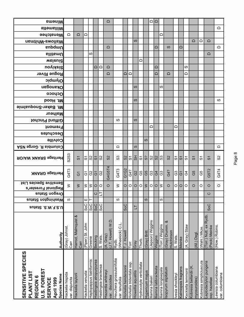
SEN
SITI
VE S
PEC
IES
PLA
NT
LIST
REG
ION
6U
.S. F
OR
EST
SER
VIC
EA
pril
1999
Spec
ies
Nam
eA
utho
rity
U.S.F.W.S. Status
Washington StatusOregon StatusRegional Forester's Sensitive Species List
Heritage GRANK
Heritage SRANK WA/OR
Columbia R. Gorge NSAColvilleDeschutesFremontGifford PinchotMalheurMt. Baker-SnoqualmieMt. HoodOchocoOkanoganOlympicRogue RiverSiskiyouSiuslawUmatillaUmpquaWallowa-WhitmanWenatcheeWillametteWinema
Hac
kelia
his
pida
var.
disj
unct
a(G
ray)
Joh
nst.
Car
rS
WG
4T3
S2S
3D
Hac
kelia
tayl
orii
Har
rod,
Mal
mqu
ist &
C
arr
WG
1 S
1D
Hac
kelia
ven
usta
(Pip
er) S
t. Jo
hnS
oCE
WG
1S
1D
Hap
lopa
ppus
liat
rifor
mis
Gre
ene
SoC
TW
G2
S2
SH
astin
gsia
atro
purp
urea
Bec
king
SoC
CO
G1
S1
DH
astin
gsia
bra
cteo
saS
. Wat
s.S
oCLT
OG
2S
2D
Haz
ardi
a w
hitn
eyi
var.
dis
coid
ea(A
. Gra
y)(J
.T. H
owel
l) W
.D.
OG
4G5T
4S
2D
DD
D
Heu
cher
a gr
ossu
larii
folia
var.
tenu
ifolia
Ryd
b.(W
heel
ock)
C.L
. S
WG
4T3
S3
DS
Hor
kelia
hen
ders
onii
T.J.
How
ell
SoC
OG
1G2
S2
DH
orke
lia tr
iden
tata
ssp
. To
rr.
OG
4?S
1D
How
ellia
aqu
atili
sG
ray
LTO
G2
SH
SS
SS
SH
ydro
coty
le v
ertic
illat
aTh
urb.
OG
5S
1D
Hyp
eric
um m
ajus
(Gra
y) B
ritt.
SW
G5
S?
SIli
amna
bak
eri
(Jep
son)
Wig
gins
OG
3S
2D
DIli
amna
latib
ract
eata
Wig
gins
OG
4S
2D
DD
DIli
amna
long
isep
ala
(Tor
r.) W
iggi
nsS
WG
3S
3S
DIs
opyr
um s
tipita
tum
(Gra
y) D
rum
m. &
H
utch
inso
nO
G4?
S2
DS
Ives
ia s
hock
leyi
S. W
ats.
OG
3S
1D
Kal
mio
psis
frag
rans
Mei
nke
OG
1S
1D
Kec
kiel
la le
mm
onii
(A. G
ray)
Sta
wO
G4
S1
DS
Kob
resi
a be
llard
ii (K
. m
yosu
roid
es)
(All.
) Deg
l.O
G5
S1
D
Kob
resi
a si
mpl
iciu
scul
a(W
ahl.)
Mkz
e.O
G5
S1
DLe
ptod
acty
lon
pung
ens
ssp.
haz
elia
e(T
orr.)
Nut
t. ex
Ryd
b.(P
eck)
Mei
nke
SoC
CO
G5T
2S
1D
D
Lew
isia
col
umbi
ana
var.
colu
mbi
ana
(How
.) R
obin
s.O
G4T
4S
2D
SD
D
Pag
e 8

SEN
SITI
VE S
PEC
IES
PLA
NT
LIST
REG
ION
6U
.S. F
OR
EST
SER
VIC
EA
pril
1999
Spec
ies
Nam
eA
utho
rity
U.S.F.W.S. Status
Washington StatusOregon StatusRegional Forester's Sensitive Species List
Heritage GRANK
Heritage SRANK WA/OR
Columbia R. Gorge NSAColvilleDeschutesFremontGifford PinchotMalheurMt. Baker-SnoqualmieMt. HoodOchocoOkanoganOlympicRogue RiverSiskiyouSiuslawUmatillaUmpquaWallowa-WhitmanWenatcheeWillametteWinema
Lew
isia
cot
yled
onva
r. pu
rdyi
(S.W
ats.
) Rob
ins.
Jeps
.S
oCC
OG
4T3
S3
D
Lew
isia
lean
a(P
orte
r) R
obin
s.O
G4
S2
DD
SLi
lium
kel
logg
iiP
urdy
OG
3G4
S1
DLi
lium
occ
iden
tale
Pur
dyLE
LEO
G1
S1
SLi
mna
nthe
s flo
ccos
ass
p. b
ellin
geria
naH
ow.
(M.E
. Pec
k) A
rroy
oS
oCC
OG
4T2
S2
S
Lim
nant
hes
grac
ilis
var.
grac
ilis
How
.S
oCC
OG
3T2
S2
S
Lim
oniu
m c
alifo
rnic
um(B
oiss
.) H
elle
rO
G4
S1
SLi
nant
hus
bola
nder
i(G
ray)
Gre
ene
SW
G4G
5S
2D
SLi
paris
loes
elii
(L.)
L.C
. Ric
h.E
WG
5S
1S
SLi
ster
a bo
real
isM
oron
gO
G4
S1
DLo
belia
dor
tman
naL.
TW
/OG
4S
2/S
1D
SLo
belia
kal
mii
L.E
WG
5S
1S
Lois
eleu
ria p
rocu
mbe
ns(L
.) D
esv.
SW
G5
S1S
2D
SD
Lom
atiu
m c
ooki
iK
agan
CLE
OG
1S
1S
Lom
atiu
m c
usic
kii
Ros
eX
WG
4S
XS
Lom
atiu
m e
ngel
man
nii
Mat
hias
OG
4S
1S
DLo
mat
ium
ery
thro
carp
umM
eink
e &
Con
stan
ceS
oCLE
OG
1S
1S
DLo
mat
ium
gre
enm
anii
Mat
hias
SoC
LTO
G1
S1
DLo
mat
ium
laev
igat
um(N
utt.)
Cou
lt. &
Ros
eS
W/O
G3
S2
DLo
mat
ium
och
ocen
seH
elliw
ell &
Con
stan
ce
sp. n
ov.
OG
2G3
S1?
D
Lom
atiu
m ra
veni
iM
ath.
& C
onst
.O
G4
S1
DS
Lom
atiu
m s
alm
onifl
orum
(Cou
lt. &
Ros
e)
Mat
hias
& C
onst
ance
OG
3S
HS
S
Lom
atiu
m s
uksd
orfii
(S. W
ats.
) Cou
lt. &
S
oCS
CW
/OG
3S
3/S
2D
SLo
mat
ium
trac
yiM
ath.
& C
onst
.O
G3G
4S
1S
SLo
mat
ium
wat
soni
i(C
oult.
& R
ose)
Cou
lt.
& R
ose
OG
4S
1S
D
Lotu
s st
ipul
aris
(B
enth
.) G
reen
eO
G5
S1
SS
Pag
e 9

SEN
SITI
VE S
PEC
IES
PLA
NT
LIST
REG
ION
6U
.S. F
OR
EST
SER
VIC
EA
pril
1999
Spec
ies
Nam
eA
utho
rity
U.S.F.W.S. Status
Washington StatusOregon StatusRegional Forester's Sensitive Species List
Heritage GRANK
Heritage SRANK WA/OR
Columbia R. Gorge NSAColvilleDeschutesFremontGifford PinchotMalheurMt. Baker-SnoqualmieMt. HoodOchocoOkanoganOlympicRogue RiverSiskiyouSiuslawUmatillaUmpquaWallowa-WhitmanWenatcheeWillametteWinema
Luin
a se
rpen
tina
Cro
nq.
SoC
LTO
G2
S2
DLu
pinu
s ar
idus
ssp.
ash
land
ensi
sD
ougl
as e
x Li
ndl.
Cox
SoC
CO
G5T
1S
1D
Lupi
nus
sabi
nii
Dou
gl. e
x Li
ndl.
EW
G4
S1
SLu
pinu
s su
lphu
reus
ssp.
kin
caid
iiD
ougl
.(S
mith
) Phi
llips
PT
LTO
G5T
2S
2D
Lupi
nus
tracy
iE
astw
.O
G4
S2
DLu
zula
arc
uata
(Wah
lenb
.) S
w.
SW
G5
S1
DS
Lyco
podi
ella
inun
data
(L.)
Hol
ubS
W/O
G5
S2/
S2
DS
DS
DD
DD
Lyco
podi
um c
ompl
anat
umL.
OG
5S
2S
DS
DLy
copo
dium
den
droi
deum
Mic
hx.
SW
G5
S1S
2
DD
SM
econ
ella
ore
gana
Nut
t.S
oCT
CW
/OG
2S
1/S
1D
SS
SM
icro
seris
bor
ealis
(Bon
g.) S
chul
tz-B
ip.
SW
G3?
S2
DS
Mic
rose
ris d
ougl
asii
ssp.
dou
glas
ii(D
.C.)
Sch
ult-B
ip.
OG
4T4
SH
S
Mic
rose
ris h
owel
liiG
ray
SoC
LTO
G3
S3
D
Mic
rose
ris la
cini
ata
(Hoo
k.) S
ch. B
ip.
SoC
OG
4T2
S2
SM
imul
us b
olan
deri
Gra
yO
G4
S1
DM
imul
us c
livic
ola
Gre
enm
.O
G4
S2
SD
Mim
ulus
eva
nesc
ens
Mei
nke
CO
G3?
S2
SD
SS
Mim
ulus
hym
enop
hyllu
sM
eink
eS
oCC
OG
1S
1D
Mim
ulus
jung
erm
anni
oide
sS
uksd
orf
SoC
XW
G2
SH
DS
Mim
ulus
pul
sife
rae
Gra
yS
WG
4?S
2S
DM
imul
us s
uksd
orfii
Gra
yS
WG
4S
2S
DS
Mim
ulus
tric
olor
Har
tw. e
x Li
ndl.
OG
4S
2D
SD
Mira
bilis
mac
farla
nei
Con
stan
ce &
Rol
lins
LTLE
OG
2S
1D
Mon
arde
lla p
urpu
rea
T.J.
How
ell
OG
3S
3D
Mon
tia d
iffus
a(N
utt.)
Gre
ene
SW
G4
S1S
2D
DS
SD
DM
ontia
how
ellii
S. W
ats.
SoC
CO
G3
S2
SS
SD
Pag
e 10

SEN
SITI
VE S
PEC
IES
PLA
NT
LIST
REG
ION
6U
.S. F
OR
EST
SER
VIC
EA
pril
1999
Spec
ies
Nam
eA
utho
rity
U.S.F.W.S. Status
Washington StatusOregon StatusRegional Forester's Sensitive Species List
Heritage GRANK
Heritage SRANK WA/OR
Columbia R. Gorge NSAColvilleDeschutesFremontGifford PinchotMalheurMt. Baker-SnoqualmieMt. HoodOchocoOkanoganOlympicRogue RiverSiskiyouSiuslawUmatillaUmpquaWallowa-WhitmanWenatcheeWillametteWinema
Muh
lenb
ergi
a gl
omer
ata
(Will
d.) T
rin.
SW
G5
S1S
2D
Nav
arre
tia ta
getin
aG
reen
eT
WG
5S
1S2
DS
Nem
acla
dus
capi
llaris
Gre
ene
OG
4S
1S
Nic
otia
na a
ttenu
ata
Torr
. ex
S. W
ats.
SW
G4
S2
SD
Oph
iogl
ossu
m p
usill
umR
af.
TW
/OG
5S
1S2/
S1
SS
SD
SD
DD
Oxy
tropi
s bo
real
isva
r. vi
scid
aD
C.
(Nut
t.) W
elsh
SW
G5T
5S
1S2
S
Oxy
tropi
s ca
mpe
stris
var.
grac
ilis
(L.)
DC
.(N
els.
) Bar
neby
SW
G5?
T4?
S2
S
Par
nass
ia fi
mbr
iata
var.
hood
iana
Kon
ig.
C.L
. Hitc
hc.
SW
G4T
4S
1S
Par
nass
ia k
otze
buei
Cha
m. e
x S
pren
g.S
WG
4S
1D
Par
nass
ia p
alus
tris
var.
neog
aea
L. Fern
.S
WG
4T4
S2
D
Ped
icul
aris
how
ellii
Gra
yO
G3
S2
DD
Ped
icul
aris
rain
iere
nsis
Pen
nell
& W
arre
nS
WG
2G3
S2S
3S
DD
Pel
laea
and
rom
edae
folia
(Kau
lf.) F
eeO
G4
S2
SS
SP
ella
ea b
rach
ypte
ra(T
. Moo
re) B
aker
SW
G4G
5S
2S
DP
ella
ea b
rew
eri
D.C
. Eat
.S
WG
5S
2D
DP
ella
ea b
ridge
sii
Hoo
k.O
G4
S2
SD
Pel
laea
muc
rona
ta s
sp
muc
rona
ta(D
.C. E
at.)
D.C
. Eat
.O
G5T
5S
1S
S
Pen
stem
on b
arre
ttiae
Gra
yS
oCT
CW
/OG
2S
2/S
2D
DP
enst
emon
gla
ucin
usP
enne
llS
oCO
G3
S3
DD
Pen
stem
on p
ecki
iP
enne
llS
oCO
G3
S3
DS
Per
ider
idia
ery
thro
rhiz
a(P
iper
) Chu
ang
&
SoC
CO
G1
S1
SD
SD
Pet
roph
yton
cin
eras
cens
(Pip
er) R
ydb.
SoC
TW
G1
S1
DP
hace
lia m
inut
issi
ma
Hen
ders
onS
oCS
CW
/OG
3S
1?/S
1S
DS
DD
Phl
ox h
ende
rson
ii(E
. Nel
s.) C
ronq
.O
G4
S1
DP
hlox
mul
tiflo
raA
. Nel
s.O
G4
S1
SD
Phy
saria
did
ymoc
arpa
var.
didy
moc
arpa
(Hoo
k.) G
ray
SW
G5T
4S
1S
D
Pag
e 11

SEN
SITI
VE S
PEC
IES
PLA
NT
LIST
REG
ION
6U
.S. F
OR
EST
SER
VIC
EA
pril
1999
Spec
ies
Nam
eA
utho
rity
U.S.F.W.S. Status
Washington StatusOregon StatusRegional Forester's Sensitive Species List
Heritage GRANK
Heritage SRANK WA/OR
Columbia R. Gorge NSAColvilleDeschutesFremontGifford PinchotMalheurMt. Baker-SnoqualmieMt. HoodOchocoOkanoganOlympicRogue RiverSiskiyouSiuslawUmatillaUmpquaWallowa-WhitmanWenatcheeWillametteWinema
Pilu
laria
am
eric
ana
A. B
r.O
G5
S1
SS
S
Pity
opus
cal
iforn
ica
(Eas
tw.)
Cop
elan
d f.
SW
G4G
5S
1S
SP
lagi
obot
hrys
figu
ratu
sss
p. c
oral
licar
pus
(Pip
er) J
ohns
t.(P
iper
) Cha
mb.
OG
5T1
S1
SS
Pla
giob
othr
ys g
lypt
ocar
pus
(Pip
er) J
ohns
t.O
G3G
4S
2?S
SP
lant
ago
mac
roca
rpa
Cha
m. &
Sch
lech
t.S
WG
4S
2S
Pla
tant
hera
cho
risia
na(C
ham
.) R
eich
enb.
TW
G3G
4S
1D
SP
lata
nthe
ra o
btus
ata
Lind
l.S
W/O
G5
S2/
S1
DD
DD
SP
lata
nthe
ra s
pars
iflor
a(S
. Wat
s.) S
chle
chte
rS
WG
4G5
S1
SD
D
Ple
urop
ogon
ore
gonu
sC
hase
SoC
LTO
G1
S1
SS
SP
oa la
xiflo
raB
uckl
.T
WG
3S
1S2
SS
Poa
ner
vosa
var
. ner
vosa
(Hoo
k.) V
asey
SW
G5
S2
SP
olem
oniu
m c
arne
umG
ray
TW
G4
S1S
2D
SS
Pol
emon
ium
vis
cosu
mN
utt.
SW
G5
S1S
2D
Pol
ystic
hum
cal
iforn
icum
(D.C
.Eat
.) D
iels
OG
4S
2D
DP
oten
tilla
bre
wer
iS
. Wat
s.S
WG
5QS
1?S
Pot
entil
la d
iver
sifo
liava
r. pe
rdis
sect
aLe
hm.
(Ryd
b.) C
.L. H
itchc
.S
WG
5T4
S1
S
Pot
entil
la n
ivea
L.S
WG
5S
2D
Pot
entil
la q
uinq
uefo
liaLe
hm.
SW
G4
S1
S
Pot
entil
la v
illos
a
Pal
l. ex
Pur
sh
OG
4T4Q
SH
DP
rimul
a cu
sick
iana
Gra
yO
D
Ran
uncu
lus
cool
eyae
(Vas
ey &
Ros
e)
Gre
ene
SW
G4
S1S
2D
D
Ran
uncu
lus
popu
lago
Gre
ene
SW
G4
S1?
SD
D
Ran
uncu
lus
reco
nditu
s(A
. Nel
s. &
J.F
. M
acbr
.) L.
Ben
s.S
oCT
LEW
/OG
2S
1/S
1D
SS
Rha
mnu
s ili
cifo
liaK
ell.
OG
4S
1D
Pag
e 12

SEN
SITI
VE S
PEC
IES
PLA
NT
LIST
REG
ION
6U
.S. F
OR
EST
SER
VIC
EA
pril
1999
Spec
ies
Nam
eA
utho
rity
U.S.F.W.S. Status
Washington StatusOregon StatusRegional Forester's Sensitive Species List
Heritage GRANK
Heritage SRANK WA/OR
Columbia R. Gorge NSAColvilleDeschutesFremontGifford PinchotMalheurMt. Baker-SnoqualmieMt. HoodOchocoOkanoganOlympicRogue RiverSiskiyouSiuslawUmatillaUmpquaWallowa-WhitmanWenatcheeWillametteWinema
Rib
es c
ereu
mva
r. co
lubr
inum
Dou
gl.
C.L
. Hitc
hc.
SW
G5T
4S
1S2
Rom
anzo
ffia
thom
pson
iiM
artta
la
OG
3S
3S
DD
DR
orip
pa c
olum
biae
Suk
sdor
f ex
T.J.
H
owel
lS
oCT
CW
/OG
3S
2/S
3D
SS
SS
SS
D
Rub
us a
caul
isM
ichx
.S
WG
5S
1D
Rub
us b
arto
nian
usM
.E. P
eck
SoC
CO
G2
S2
DS
alix
can
dida
Flue
gge
ex W
illd.
SW
G5
S1S
2D
Sal
ix d
elno
rtens
isS
chne
id.
OG
3G4
S2
DS
alix
farr
iae
Bal
lO
G4
S2
DS
alix
gla
uca
L.S
WG
4S
1?D
Sal
ix m
acca
llian
aR
owle
eS
WG
4S
1D
Sal
ix p
seud
omon
ticol
aB
all
SW
G5?
S1
DS
alix
twee
dyi
(Beb
b ex
Ros
e) B
all
SW
G3
S2
DS
alix
ves
tita
var.
erec
taP
ursh
And
erss
.S
WG
5T?
SH
D
San
guis
orba
men
zies
iiR
ydb.
SW
G3G
4S
1S2
SS
anic
ula
mar
iland
ica
L.S
WG
5S
2D
DS
axifr
aga
adsc
ende
ns
L
.
OG
5T4T
5S
1D
Sax
ifrag
a ce
rnua
L.S
WG
4S
1S2
DS
axifr
aga
hitc
hcoc
kian
aE
lvan
der
SoC
CO
G1
S1
SS
axifr
agop
sis
fraga
rioid
es(G
reen
e) S
mal
lS
W/O
G3?
S1/
S2
SD
DS
cheu
chze
ria p
alus
tris
L.
OG
5T5
S2
SD
DD
DS
cirp
us p
endu
lus
Muh
l.O
G4?
S1
DS
Sci
rpus
sub
term
inal
isTo
rr.
OG
4G5
S1
DS
S
Scr
ibne
ria b
olan
deri
(Thu
rb.)
Hac
k.S
WG
3G4
S1
DS
Sed
um la
xum
ssp.
hec
kner
i(B
ritt.)
Ber
ger
(M.E
. Pec
k) C
laus
enO
G5T
3S
3D
D
Sed
um m
oran
iiC
laus
enS
oCC
OG
1S
1D
Sed
um o
blan
ceol
atum
Cla
usen
SoC
CO
G3
S2
D
Pag
e 13

SEN
SITI
VE S
PEC
IES
PLA
NT
LIST
REG
ION
6U
.S. F
OR
EST
SER
VIC
EA
pril
1999
Spec
ies
Nam
eA
utho
rity
U.S.F.W.S. Status
Washington StatusOregon StatusRegional Forester's Sensitive Species List
Heritage GRANK
Heritage SRANK WA/OR
Columbia R. Gorge NSAColvilleDeschutesFremontGifford PinchotMalheurMt. Baker-SnoqualmieMt. HoodOchocoOkanoganOlympicRogue RiverSiskiyouSiuslawUmatillaUmpquaWallowa-WhitmanWenatcheeWillametteWinema
Sen
ecio
dim
orph
ophy
llus
Gre
ene
OG
4S
2D
Sen
ecio
flet
tiiW
eiga
ndO
G4
S2
SS
enec
io h
espe
rius
Gre
ene
SoC
CO
G3
S3
DS
idal
cea
hirti
pes
C.L
. Hitc
hc.
EC
W/O
G2
S1/
S2
DD
Sid
alce
a m
alac
hroi
des
(H.&
A.)
A. G
ray
OG
4S
HS
Sid
alce
a m
alvi
flora
ssp.
pat
ula
(D.C
.) G
ray
ex B
enth
. C
.L. H
itchc
.S
oCC
OG
4G5T
1S
1D
Sid
alce
a ne
lson
iana
Pip
erLT
LTO
G2
S2
SS
idal
cea
oreg
ana
var.
calv
a(N
utt.)
Gra
yC
.L. H
itchc
.P
EP
EW
G5T
1S
1D
Sile
ne d
ougl
asii
var.
orar
iaS
. Wat
son
(M.E
. Pec
k) C
.L.
SoC
LTO
G4T
1S
1S
Sile
ne h
ooke
riss
p. b
olan
deri
Nut
t.(G
ray)
Abr
ams
OG
4T4
S1
D
Sile
ne s
eely
iM
orto
n &
J.W
. Th
omps
onS
oCT
WG
1G2
S1S
2D
Sile
ne s
pald
ingi
iS
. Wat
s.S
oCT
LEW
/O
G2
S2/
S1
DD
Sis
yrin
chiu
m s
arm
ento
sum
Suk
sdor
f ex
Gre
ene
SoC
TC
W/O
G2
S2/
S1
DD
SS
isyr
inch
ium
sep
tent
riona
leB
ickn
.S
WG
3G4
S1S
2D
DS
opho
ra le
achi
ana
M.E
. Pec
kS
oCC
OG
2S
2D
Spa
rtina
pec
tinat
aLi
nkS
WG
5S
2S
Spi
rant
hes
dilu
vial
isLT
LTW
SS
SS
pira
nthe
s po
rrifo
liaLi
ndl.
SW
G4
S2
DD
SD
Stre
ptan
thus
how
ellii
S. W
ats.
CO
G2
S2
DS
uksd
orfia
vio
lace
aG
ray
OG
4S
1D
DS
SS
ulliv
antia
ore
gana
S. W
ats.
SoC
TC
W/O
G2
S1/
S2
DS
Syn
thyr
is p
inna
tifid
ava
r. la
nugi
nosa
S. W
ats.
(Pip
er) C
ronq
.S
WG
4T2
S2
D
Talin
um s
edifo
rme
Poe
lln.
SW
G2G
3S
2D
DTa
usch
ia h
owel
lii(C
oult.
& R
ose)
J.F
. M
acbr
.S
oCC
OG
1S
1D
S
Taus
chia
stri
ckla
ndii
(Cou
lt. &
Ros
e)
Mat
hias
& C
onst
ance
OG
4S
1D
Pag
e 14

SEN
SITI
VE S
PEC
IES
PLA
NT
LIST
REG
ION
6U
.S. F
OR
EST
SER
VIC
EA
pril
1999
Spec
ies
Nam
eA
utho
rity
U.S.F.W.S. Status
Washington StatusOregon StatusRegional Forester's Sensitive Species List
Heritage GRANK
Heritage SRANK WA/OR
Columbia R. Gorge NSAColvilleDeschutesFremontGifford PinchotMalheurMt. Baker-SnoqualmieMt. HoodOchocoOkanoganOlympicRogue RiverSiskiyouSiuslawUmatillaUmpquaWallowa-WhitmanWenatcheeWillametteWinema
Teuc
rium
can
aden
sess
p. v
isci
dum
(Pip
er) T
aylo
r &
Mac
Bry
deS
WG
5T4
S2
SS
Thal
ictru
m a
lpin
umva
r. he
betu
mL. B
oiv.
OG
5T4
S2
D
Thal
ictru
m d
asyc
arpu
mFi
sch.
& A
ve-L
all.
SW
G5
S2
DS
Thel
ypod
ium
bra
chyc
arpu
mTo
rr.
OG
3S
2S
DTh
elyp
odiu
m e
ucos
mum
B.L
. Rob
ins.
SoC
LTO
G2
S2
DS
DS
Thel
ypod
ium
how
ellii
S
. Wat
s.O
G3?
T3?
SH
SS
Tow
nsen
dia
mon
tana
Jone
sO
G4
S1
DTo
wns
endi
a pa
rryi
Eat
.O
G4?
S1
DTr
ifoliu
m d
ougl
asii
Hou
seW
/OG
3G4
S1/
S1
DD
Trifo
lium
plu
mos
umva
r. pl
umos
umD
ougl
. ex.
Hoo
k.S
WG
4T?
S1
S
Trifo
lium
thom
pson
iiM
orto
nS
oCT
WG
2S
2D
Trill
ium
ang
ustip
etal
um(T
orr.)
J.D
. Fre
eman
OG
4S
1D
Trim
orph
a el
ata
(Hoo
k.) N
esom
SW
G4?
S1
STr
itele
ia h
ende
rson
iiva
r. le
achi
aeG
reen
e(M
.E. P
eck)
Hoo
ver
CO
G4G
5T2
S2
D
Trite
leia
ixio
ides
ssp.
ani
lina
(Ait.
f.) G
reen
e(P
eck)
Len
zO
G4T
4S
HS
Trite
leia
laxa
Ben
th.
OG
4S
1D
STr
olliu
s la
xus
var.
albi
floru
sS
alis
b.G
ray
OG
4T4
S1
D
Utri
cula
ria g
ibba
L.O
G5
S1
SU
tricu
laria
inte
rmed
iaH
ayne
SW
G5
S2
DV
acci
nium
myr
tillo
ides
Mic
hx.
SW
G4
S1?
SD
Ver
atru
m in
solit
umJe
pson
SW
G3G
4S
1S
Vio
la p
rimul
ifolia
idt
liL. (G
)Rll
SoC
CO
G5T
2S
2D
Wol
ffia
bore
alis
(Heg
elm
.) La
ndol
t &
OG
5S
1S
SS
SS
SS
Wol
ffia
colu
mbi
ana
Kar
st.
OG
5S
1S
DS
SS
SS
Woo
dwar
dia
fimbr
iata
Sm
.S
WG
5S
2S
Pag
e 15


APPENDIX H STANDARD SPECIFICATIONS FOR SPILL PREVENTION, CONTROL,
AND COUNTERMEASURES PLAN


8-01 WATER POLLUTION AND EROSION CONTROL
Construction Requirements Section 8-01.3 is supplemented with the following:
(DATE)Spill Prevention, Control and Countermeasures Plan The Contractor shall prepare a project specific spill prevention, control and countermeasures (SPCC) plan to be used for the duration of the project. The plan shall be submitted to the Engineer prior to the commencement of any on site construction activities. The Contractor shall maintain a copy of the plan at the work site, including any necessary updates as the work progresses. If hazardous materials are encountered during construction, the Contractor shall do everything possible to control and contain the material until appropriate measures can be taken. Hazardous material, as referred to within this specification, is defined in RCW 70.105.010 under "Hazardous Substances". Occupational safety and health requirements that pertain to SPCC planning are contained in WAC 296-155 and WAC 296-62.
The SPCC plan shall address the following project-specific information:
1. SPCC Plan Elements A. Site Information
Identify general site information useful in construction planning, recognizing potential sources of spills, and identifying personnel responsible for managing and implementing the plan.
B. Project Site Description Identify staging, storage, maintenance, and refueling areas and their relationship to drainage pathways, waterways, and other sensitive areas. Specifically address:
� the Contractor’s equipment maintenance, refueling, and cleaning activities.
� the Contractor’s on site storage areas for hazardous materials.
C. Spill Prevention and Containment Identify spill prevention and containment methods to be used at each of the locations identified in B., above.
D. Spill Response Outline spill response procedures including assessment of the hazard, securing spill response and personal protective equipment, containing and eliminating the spill source, and mitigation, removal and disposal of the material.
E. Standby, On-Site, Material and Equipment The plan shall identify the equipment and materials the Contractor will maintain on site to carry out the preventive and responsive measures for the items listed.
F. Reporting

The plan shall list all federal, state and local agency telephone numbers the Contractor must notify in the event of a spill.
G. Program Management Identify site security measures, inspection procedures and personnel training procedures as they relate to spill prevention, containment, response, management and cleanup.
H. Preexisting Contamination If preexisting contamination in the project area is described elsewhere in the plans or specifications, the SPCC plan shall indicate measures the Contractor will take to conduct work without allowing release or further spreading of the materials.
2. Attachments A. Site plan showing the locations identified in (1. B. and 1.
C.) noted previously. B. Spill and Incident Report Forms the Contractor will be
using.
Implementation Requirements As described elsewhere in the special provisions, the Contractor shall be prepared and carry out the SPCC plan in the event of a hazardous spill within the project limits.
Payment The lump sum contract price for the “Spill Prevention, Control, and Countermeasures (SPCC) Plan” shall be full pay for:
1. all costs associated with creating the SPCC plan. 2. all costs associated with providing and maintaining on site
standby materials and equipment described in the SPCC plan.
In addition, for costs directly associated with spills:� Consistent with Standard Specifications section 1-07, the
Contractor shall be solely responsible for all costs, delays and damages associated with spills associated with the Contractor's operations or due to the Contractor’s negligence.
� Otherwise, payment for cleanup of a spill shall be as provided for elsewhere in the contract.

APPENDIX I
FISH MOVING PROTOCOLS


Fish Exclusion Protocols and Standards
8/3/06


Draft August_O6_FishHandlig.doc; 8/17/2006
WSDOT Fish Exclusion Protocols and Standards
Prior to dewatering, all fish and other vertebrate aquatic life will be removed from sites that will be dewatered. For projects where in-water work is limited to a specific area and dewatering will not occur, fish will be excluded from the area to the maximum extent feasible within an isolated work area.
The sequence for fish exclusion is as follows:
� Isolation of the work area.
� Removal of as many fish as possible.
� Gradual dewatering of the work area (if the work area is to be dewatered).
� Removal of remaining fish.
� Record fish exclusion activities and notify Services as required.
Isolation of the work area, fish removal and release shall be conducted or directed by a biologist who possesses the competence to ensure the safe handling of all Endangered Species Act (ESA) listed fish, and who is also experienced with work area isolation. This protocol may not apply or may be modified in emergency situations or in certain areas that have unique site-specific characteristics.
Isolation of the Work Area
Installation of block nets will occur at predetermined locations, based on site characteristics, to prevent fish and other aquatic wildlife from moving into the work area. Sites will be selected based on desirable attributes such as slower flows and suitable locations for stake and/or gravel bag placement. Areas with heavy vegetation, undercut banks, deep pools, etc. will be avoided due to the difficulty of sealing nets. The downstream block net will be angled across the stream if possible to prevent impingement of fish on the net. Additionally, a “mini-pool” may be constructed at the downstream block net to provide a lower velocity area for fish to maneuver away from the net. Whenever conditions allow, the upstream block net shall be placed first. The downstream block net shall then be used as a seine to herd fish from the upstream block net location downstream to the point selected for the downstream block net installation. If feasible, this action will potentially move significant numbers of fish downstream, out of the impact area prior to other removal methods.
Block net mesh size, length, type of material, and depth will vary based on site conditions. The directing biologist on site will base the design of block nets on specific site characteristics such as water depth, velocity and channel width. Typical block net material is 9.5 millimeter stretched mesh. Block nets shall remain in place until in-water work is completed. Block nets will require frequent leaf and debris removal. An individual will be assigned the responsibility of frequently checking the nets to maintain their effectiveness and integrity. The frequency of such checks will be determined on a
Fish Exclusion Protocols and Standards Page 3 August 2006

Draft August_O6_FishHandlig.doc; 8/17/2006
case-by-case basis, dependent upon the system, season and weather conditions. Block nets need to be secured along both banks and in-channel to prevent failure during unforeseen rain events or debris accumulation. Some locations may require additional block net support (examples include galvanized hardware cloth and metal fence posts).
Fish Removal and Dewatering
If the site is dewatered, dewatering and the placement of cofferdams or diversions will be in accordance with any provisions contained in the Hydraulic Project Approval (HPA) permit from WDFW.
Pumps used to temporarily bypass water around a work site, or to dewater residual pools within a dewatered site, shall be fitted with mesh screens to prevent aquatic life from entering the intake hose of the pump. The screens will also prevent aquatic life from entering the intake hose if a block net should fail. Screens shall be placed approximately 2-4 feet from the end of the intake hose to assure fish are not pinned upon the screen. Screening techniques must utilize the specifications in the HPA and be in compliance with Washington State Laws RCW 77.55.320, RCW 77.55.040 and RCW 77.55.070.
The site will be dewatered slowly enough to allow the efficient removal of all fish species and avoid strandings. The site will be rewatered slowly enough to prevent the loss of surface water downstream as the streambed absorbs water and to minimize or avoid a sudden increase in stream turbidity. During rewatering, the site will be monitored to prevent stranding of aquatic organisms below the construction site.
Removal Methods:
Methods for exclusion or removal of fish from the area between the block nets are described below. These methods are given in order of preference and for many locations a combination of methods will need to be applied. The use of visual observation techniques (e.g.. snorkeling, surveying with polarized glasses or Plexiglas bottomed buckets) should be considered for evaluation of removal method effectiveness and to identify specific locations of fish concentrations prior to removal attempts.
� Seining shall be the preferred method. The remaining methods shall be used when seining is not possible or to enhance the effectiveness of removal through seining. Seines made from 9.5 mm stretched nylon mesh shall be used to remove fish from the isolated stream reach. Seine design will be dependent upon site-specific characteristics. The on-site biologist will plan seining procedures based on an evaluation of site characteristics. Seines, once pursed, will remain partially in the water while aquatic life is removed. Aquatic life will be captured by personnel in water or on shore using hand held nets.
� Baited minnow traps (typically used in conjunction with seining) may be left in overnight, but will be checked at least three times daily to minimize predation within the trap. Traps will be checked more frequently if temperatures are in excess of 15�C.
Fish Exclusion Protocols and Standards Page 4 August 2006
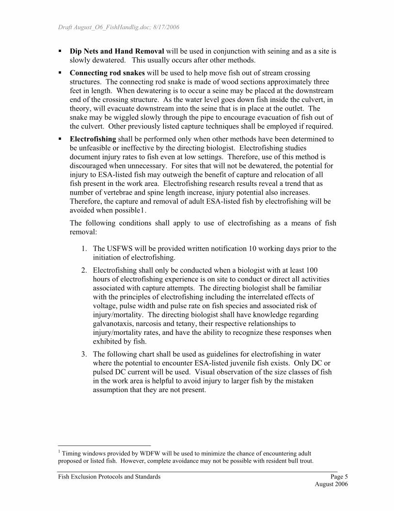
Draft August_O6_FishHandlig.doc; 8/17/2006
� Dip Nets and Hand Removal will be used in conjunction with seining and as a site is slowly dewatered. This usually occurs after other methods.
� Connecting rod snakes will be used to help move fish out of stream crossing structures. The connecting rod snake is made of wood sections approximately three feet in length. When dewatering is to occur a seine may be placed at the downstream end of the crossing structure. As the water level goes down fish inside the culvert, in theory, will evacuate downstream into the seine that is in place at the outlet. The snake may be wiggled slowly through the pipe to encourage evacuation of fish out of the culvert. Other previously listed capture techniques shall be employed if required.
� Electrofishing shall be performed only when other methods have been determined to be unfeasible or ineffective by the directing biologist. Electrofishing studies document injury rates to fish even at low settings. Therefore, use of this method is discouraged when unnecessary. For sites that will not be dewatered, the potential for injury to ESA-listed fish may outweigh the benefit of capture and relocation of all fish present in the work area. Electrofishing research results reveal a trend that as number of vertebrae and spine length increase, injury potential also increases. Therefore, the capture and removal of adult ESA-listed fish by electrofishing will be avoided when possible1.
The following conditions shall apply to use of electrofishing as a means of fish removal:
1. The USFWS will be provided written notification 10 working days prior to the initiation of electrofishing.
2. Electrofishing shall only be conducted when a biologist with at least 100 hours of electrofishing experience is on site to conduct or direct all activities associated with capture attempts. The directing biologist shall be familiar with the principles of electrofishing including the interrelated effects of voltage, pulse width and pulse rate on fish species and associated risk of injury/mortality. The directing biologist shall have knowledge regarding galvanotaxis, narcosis and tetany, their respective relationships to injury/mortality rates, and have the ability to recognize these responses when exhibited by fish.
3. The following chart shall be used as guidelines for electrofishing in water where the potential to encounter ESA-listed juvenile fish exists. Only DC or pulsed DC current will be used. Visual observation of the size classes of fish in the work area is helpful to avoid injury to larger fish by the mistaken assumption that they are not present.
1 Timing windows provided by WDFW will be used to minimize the chance of encountering adult proposed or listed fish. However, complete avoidance may not be possible with resident bull trout.
Fish Exclusion Protocols and Standards Page 5 August 2006

Draft August_O6_FishHandlig.doc; 8/17/2006
Guidelines for initial and maximum settings for backpack electrofishing2.
Initial Setting Conductivity(�S/cm)
Maximum Settings
Voltage 100 V < 300 800 V > 300 400 V Pulse Width 500 �s 5 ms Pulse Rate 15 Hz 60 Hz (In general, exceeding
40 Hz will injure more fish)
Each session shall begin with low settings for pulse width and pulse rate. If fish present in the area being electrofished do not exhibit an appropriate response, the settings shall be gradually increased until the appropriate response is achieved (galvanotaxis). Conducting electrofishing activity at the minimal effective settings is imperative because as pulse width and pulse rate increase, fish injury rates increase. Minimum effective voltage settings are dependent upon water conductivity and will need to increase as conductivity decreases. Higher voltages elevate the risk of serious injury to fish removal personnel. The lowest effective setting for pulse width, pulse rate and voltage will be used to minimize personnel safety concerns and help minimize fish injury/mortality rates.
4. Seasonal timing restrictions for conducting electrofishing shall be dependent upon the river system, fish composition and an analysis of the life history of documented species. Spawning adults and redds with incubating eggs will not be subjected to the effects of electrofishing. As a general rule, waters with anadromous salmon should not be electrofished from October 15 to May 15 and resident waters from November 1 to May 15. In waters with potential bull trout presence, the timing may be more restrictive. It shall be the responsibility of the directing biologist to research and assess the time of year (for each river segment) when electrofishing is appropriate.
5. An individual shall be stationed at the downstream block net continuously during electrofishing sessions to recover stunned fish in the event they are washed downstream and pinned against the net.
6. The operator shall avoid allowing fish to come into contact with the anode. The zone of potential fish injury is 0.5 m from the anode. Netting shall never be attached to the anode. Techniques employed when using an unnetted anode keep fish farther from the anode and expose them to significantly less time in the zone of potential injury. Extra care shall be taken near in-water structures or undercut banks, in shallow waters or high-density fish areas. In these areas fish are more likely to come into close contact with the anode because fish may be less visible and the voltage gradients may be abnormally intensified. Voltage settings in shallow water sections shall be checked and readjusted by the operator if necessary. When electrofishing areas near
Fish Exclusion Protocols and Standards Page 6 August 2006

Draft August_O6_FishHandlig.doc; 8/17/2006
undercut banks or where structures may provide cover for fish, the anode will be used to draw the fish out by placing the activated anode near the area fish are likely present and slowly drawing the anode away. Fish experiencing galvanotaxis will be attracted to the anode and will swim away from the structure toward the anode so that they can be netted. This will not work on fish that experience narcosis or tetany. Therefore, fish response will be noted in adjacent areas prior to attempts made near structures. This should help avoid prolonged exposure of fish to the electrical field while in an immobilized state.
7. Electrofishing shall be performed in a manner that minimizes harm to fish. Once an appropriate fish response (galvanotaxis) is noted, the stream segment shall be worked systematically, moving the anode continuously in a herringbone pattern through the water without electrofishing one area for an extended period of time. The number of passes shall be kept to a minimum, will be dependent upon site-specific characteristics, and be at the discretion of the directing biologist. Adequate numbers of personnel shall be on-site to minimize the number of passes required for fish removal. Adequate staff to net, recover, and release fish as soon as possible shall be present. Fish shall be removed from the electrical field immediately. Fish shall not be held in the net while continuing to capture additional fish.
8. Condition of captured fish will be carefully observed and documented. Dark bands on the body and extended recovery times are signs of injury or handling stress. When such signs are noted, the settings for the electrofishing unit and/or manner in which the electrofishing session is proceeding need adjustment. These characteristics may be an indication that electrofishing has become an inappropriate removal method for that specific site. Each fish shall be capable of remaining upright and actively swimming prior to release (see Fish Handling, Holding and Release section).
9. Electrofishing shall not occur when turbidity reduces visibility to less than 0.5 meters, when water conductivity exceeds 350 μS/cm, or when water temperature is above 18�C or below 4�C.
Fish Handling, Holding and Release: � Fish handling will be kept to the minimum necessary to remove fish from the work
site.
� Fish will not be sampled or anesthetized during removal activities as this protocol is intended to address fish removal not research. Fish species, number, age class estimate, and release location will be documented.
� Individuals handling fish shall ensure that their hands are free of sunscreen, lotion, or insect repellent.
� Fish or other aquatic life captured shall be immediately put into dark colored containers filled with clean stream water. Fish removal personnel shall provide a
Fish Exclusion Protocols and Standards Page 7 August 2006

Draft August_O6_FishHandlig.doc; 8/17/2006
healthy environment for fish with minimum holding periods and low fish densities in holding containers to avoid effects of overcrowding. Large fish shall be kept separate from smaller fish to avoid predation during containment. Water-to-water transfers shall occur whenever possible. ESA listed fish should not be transferred out of water to prevent added stress. Holding container temperature and well being of specimens will be frequently monitored to assure that all specimens will be released unharmed. Potential shade areas and supplemental oxygen for fish holding shall be considered in designing fish handling operations.
� The release site(s) will be determined by the directing biologist and may be based on specific site characteristics (flow refuge and cover) and type of fish captured (out migrating smolt, kelt, prespawn migrating adult, etc). More than one site may be designated to provide for varying migrational needs and to separate prey size fish from larger fish. The directing biologist shall consider fish migration requirements, size classes of fish, and duration of work area isolation when designing fish release plans. Each fish shall be capable of remaining upright and have the ability to actively swim upon release. ESA-listed or proposed fish will have priority over other species for release. One person shall be designated to transport specimens in a timely manner to the site selected for release.
� All ESA-listed dead fish shall be preserved and delivered to the pertinent regulatory agency (see documentation below) as outlined in the appropriate permit’s conditions.
� If authorized level of take is exceeded, the pertinent regulatory agency shall be notified as soon as possible.
Documentation
� All work area isolation, fish removal and fish release activity shall be thoroughly documented in a log book with the following information: project location, date, methods, personnel, in-stream temperature, visibility, electrofisher settings, and other comments.
� Species, number of each species, age class estimate, and location of release will be recorded for all fish handled.
� Information regarding injuries or mortalities to ESA-listed or proposed species shall be documented and provided within three working days to NOAA fisheries or USFWS, depending on which agency has jurisdiction over that species.
Fish Exclusion Protocols and Standards Page 8 August 2006