appendix e junction layout drawings · 2016-02-11 · 3.20m 3.30m 3.00m 2.90m 2.95m 2.95m 91.50m...
TRANSCRIPT

Appendix E Junction Layout Drawings

3.20m
3.30m
3.00m
2.90m
2.95m
2.95m
91.50m
36.40m
7.00m
3.80m
4.50m
2.80m2.00m
1.50m
6.60m
Checked by
Drawing Issue Status
Date of 1st Issue
Drawing Number
Drawn by
Revision
DrawnMark Revision ChkdDate
File Location: j:\28085 - dr - brentwood\transport\drawings, gis, photos and video\cad\dwgs\junction measurements os mapping updated.dwg
UTILITIES NOTE: The position of any existing public or private sewers, utility services, plant or apparatus shown on this
drawing is believed to be correct, but no warranty to this is expressed or implied. Other such plant or apparatus may also
be present but not shown. The Contractor is therefore advised to undertake his own investigation where the presence of
any existing sewers, services, plant or apparatus may affect his operations.
SCALING NOTE: Do not scale from this drawing. If in doubt, ask.
Reproduced from/based upon Ordnance Survey material with the permission of Ordnance Survey ®on behalf of The Controller of Her Majesty's Stationery Office. © Crown Copyright.
Unauthorised reproduction infringes Crown Copyright and may lead to prosecution or civil proceedings.
Licence No. Year of Publication Owner/Purchaser of Mapping
user name: perry roose
Offices throughoutthe UK and Europe
© Peter Brett Associates LLPwww.peterbrett.com
READINGTel: 0118 950 0761
DR Brentwood
Junction 1
Chelmsford Rd / Hutton Rd / Shenfield Rd
Junction Meaurements
Client
FOR INFORMATION
28085/1003/SK01
-
08.10.2014
1: 500
PR
JH
Brett Consultant LLP0100031673 2015
A4 Scale
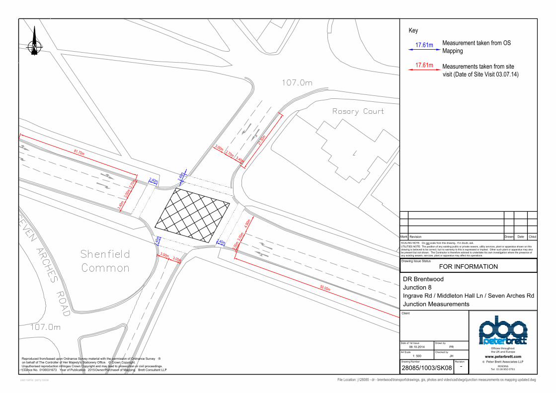
17.61m
17.61m
Measurement taken from OSMapping
Measurements taken from sitevisit (Date of Site Visit 03.07.14)
Key

4.83m
3.20m
5.60m
5.30m
4.50m
4.50m
9.31m
1.51m
3.40m
16.34m
10.41
m10.78m
2.20m
8.50m
5.50m
5.30m5.70m
4.40m
3.30m
17.50m
3.20mEntry Corner Kerb Line Distance: 7.70m
Entry Corner Kerb Line Distance: 7.70m
Entry Corner Kerb Line Distance: 16.50m
Checked by
Drawing Issue Status
Date of 1st Issue
Drawing Number
Drawn by
Revision
DrawnMark Revision ChkdDate
File Location: j:\28085 - dr - brentwood\transport\drawings, gis, photos and video\cad\dwgs\junction measurements os mapping updated.dwg
UTILITIES NOTE: The position of any existing public or private sewers, utility services, plant or apparatus shown on this
drawing is believed to be correct, but no warranty to this is expressed or implied. Other such plant or apparatus may also
be present but not shown. The Contractor is therefore advised to undertake his own investigation where the presence of
any existing sewers, services, plant or apparatus may affect his operations.
SCALING NOTE: Do not scale from this drawing. If in doubt, ask.
Reproduced from/based upon Ordnance Survey material with the permission of Ordnance Survey ®on behalf of The Controller of Her Majesty's Stationery Office. © Crown Copyright.
Unauthorised reproduction infringes Crown Copyright and may lead to prosecution or civil proceedings.
Licence No. Year of Publication Owner/Purchaser of Mapping
user name: perry roose
Offices throughoutthe UK and Europe
© Peter Brett Associates LLPwww.peterbrett.com
READINGTel: 0118 950 0761
DR Brentwood
Junction 2
Rayleigh Rd / Hanging Hill Ln
Junction Measurements
Client
FOR INFORMATION
28085/1003/SK02
-
08.10.2014
1: 500
PR
JH
Brett Consultant LLP0100031673 2015
A4 Scale
17.61m
17.61m
Key
Measurement taken from OSMapping
Measurements taken from sitevisit (Date of Site Visit 03.07.14)

7.84m
3.00m
5.20m
5.10m
4.23m
5.20m
3.80m
0.93m
10.03m
12.17m
19.20m
2.50m
7.30m
17.30m
4.00m
3.00m
3.70m
3.80m
3.70m
2.50m
6.70m
6.20m
1.00m
Entry Corner Kerb Line Distance: 5.00m
Entry Corner Kerb Line Distance: 7.20m
17.30m
21.00m
Checked by
Drawing Issue Status
Date of 1st Issue
Drawing Number
Drawn by
Revision
DrawnMark Revision ChkdDate
File Location: j:\28085 - dr - brentwood\transport\drawings, gis, photos and video\cad\dwgs\junction measurements os mapping updated.dwg
UTILITIES NOTE: The position of any existing public or private sewers, utility services, plant or apparatus shown on this
drawing is believed to be correct, but no warranty to this is expressed or implied. Other such plant or apparatus may also
be present but not shown. The Contractor is therefore advised to undertake his own investigation where the presence of
any existing sewers, services, plant or apparatus may affect his operations.
SCALING NOTE: Do not scale from this drawing. If in doubt, ask.
Reproduced from/based upon Ordnance Survey material with the permission of Ordnance Survey ®on behalf of The Controller of Her Majesty's Stationery Office. © Crown Copyright.
Unauthorised reproduction infringes Crown Copyright and may lead to prosecution or civil proceedings.
Licence No. Year of Publication Owner/Purchaser of Mapping
user name: perry roose
Offices throughoutthe UK and Europe
© Peter Brett Associates LLPwww.peterbrett.com
READINGTel: 0118 950 0761
DR Brentwood
Junction 3
Ongar Rd / Doddinghurst Rd
Junction Measurements
Client
FOR INFORMATION
28085/1003/SK03
-
08.10.2014
1: 500
PR
???????????? ????
A4 Scale
17.61m
17.61m
Key
Measurement taken from OSMapping
Measurements taken from sitevisit (Date of Site Visit 03.07.14)

30.52m
40.25m
131.54m
3.60m
1.60m 3.4
0m
5.00m
3.40m
3.90m
9.40m
8.60m
4.30m
Checked by
Drawing Issue Status
Date of 1st Issue
Drawing Number
Drawn by
Revision
DrawnMark Revision ChkdDate
File Location: j:\28085 - dr - brentwood\transport\drawings, gis, photos and video\cad\dwgs\junction measurements os mapping updated.dwg
UTILITIES NOTE: The position of any existing public or private sewers, utility services, plant or apparatus shown on this
drawing is believed to be correct, but no warranty to this is expressed or implied. Other such plant or apparatus may also
be present but not shown. The Contractor is therefore advised to undertake his own investigation where the presence of
any existing sewers, services, plant or apparatus may affect his operations.
SCALING NOTE: Do not scale from this drawing. If in doubt, ask.
Reproduced from/based upon Ordnance Survey material with the permission of Ordnance Survey ®on behalf of The Controller of Her Majesty's Stationery Office. © Crown Copyright.
Unauthorised reproduction infringes Crown Copyright and may lead to prosecution or civil proceedings.
Licence No. Year of Publication Owner/Purchaser of Mapping
user name: perry roose
Offices throughoutthe UK and Europe
© Peter Brett Associates LLPwww.peterbrett.com
READINGTel: 0118 950 0761
DR Brentwood
Junction 4
Ongar Rd / Western Avenue
Junction Measurements
Client
FOR INFORMATION
28085/1003/SK04
-
08.10.2014
1: 500
PR
JH
Brett Consultant LLP0100031673 2015
A4 Scale
17.61m
17.61m
Key
Measurement taken from OSMapping
Measurements taken from sitevisit (Date of Site Visit 03.07.14)

2.48m
9.89m
5.00m
6.53m
3.60m
7.50m
3.20m
13.59m9.2
5m
15.65m5.20m
9.60m
2.80m
7.30m
2.50m
2.50m
4.20m4.40m
16.60m
3.50m
3.50m
6.90m
3.40m
7.80m
4.80m
Entry Corner Kerb Line Distance: 5.50m
Distance to ped crossing (exit side): 5.50m
Entry Corner Kerb Line Distance: 7.00m
Entry Corner Kerb Line Distance: 19.20m
Checked by
Drawing Issue Status
Date of 1st Issue
Drawing Number
Drawn by
Revision
DrawnMark Revision ChkdDate
File Location: j:\28085 - dr - brentwood\transport\drawings, gis, photos and video\cad\dwgs\junction measurements os mapping updated.dwg
UTILITIES NOTE: The position of any existing public or private sewers, utility services, plant or apparatus shown on this
drawing is believed to be correct, but no warranty to this is expressed or implied. Other such plant or apparatus may also
be present but not shown. The Contractor is therefore advised to undertake his own investigation where the presence of
any existing sewers, services, plant or apparatus may affect his operations.
SCALING NOTE: Do not scale from this drawing. If in doubt, ask.
Reproduced from/based upon Ordnance Survey material with the permission of Ordnance Survey ®on behalf of The Controller of Her Majesty's Stationery Office. © Crown Copyright.
Unauthorised reproduction infringes Crown Copyright and may lead to prosecution or civil proceedings.
Licence No. Year of Publication Owner/Purchaser of Mapping
user name: perry roose
Offices throughoutthe UK and Europe
© Peter Brett Associates LLPwww.peterbrett.com
READINGTel: 0118 950 0761
DR Brentwood
Junction 5
Ongar Rd / William Hunter Way
Junction Measurements
Client
FOR INFORMATION
28085/1003/SK05
-
08.10.2014
1: 500
PR
JH
Brett Consultant LLP0100031673 2015
A4 Scale
17.61m
17.61m
Key
Measurement taken from OSMapping
Measurements taken from sitevisit (Date of Site Visit 03.07.14)

3.33m
5.80m
7.40m
6.00m
13.91m
13.82m
16.94m
4.60m
15.97m11
.06m
14.38m
3.69m
5.80m7.40m
2.80m
2.80m
4.10m
2.80m
12.00m
6.70m
3.20m 2.80m
5.80m3.00m
3.00m
3.00m3.00m
3.00m3.20m
3.40m3.40m
3.70m
3.20m
5.00m4.00m
1.50m
24.30m
Entry Corner Kerb Line Distance: 7.00m
17.10m
Entry Corner Kerb Line Distance: 16.30m
Entry Corner Kerb Line Distance: 10.60m
Entry Corner Kerb Line Distance: 10.00m
Entry Corner Kerb Line Distance: 13.00m
Entry Corner Kerb Line Distance: 7.40m
10.00m
19.30m
9.60m
2.80m
Checked by
Drawing Issue Status
Date of 1st Issue
Drawing Number
Drawn by
Revision
DrawnMark Revision ChkdDate
File Location: j:\28085 - dr - brentwood\transport\drawings, gis, photos and video\cad\dwgs\junction measurements os mapping updated.dwg
UTILITIES NOTE: The position of any existing public or private sewers, utility services, plant or apparatus shown on this
drawing is believed to be correct, but no warranty to this is expressed or implied. Other such plant or apparatus may also
be present but not shown. The Contractor is therefore advised to undertake his own investigation where the presence of
any existing sewers, services, plant or apparatus may affect his operations.
SCALING NOTE: Do not scale from this drawing. If in doubt, ask.
Reproduced from/based upon Ordnance Survey material with the permission of Ordnance Survey ®on behalf of The Controller of Her Majesty's Stationery Office. © Crown Copyright.
Unauthorised reproduction infringes Crown Copyright and may lead to prosecution or civil proceedings.
Licence No. Year of Publication Owner/Purchaser of Mapping
user name: perry roose
Offices throughoutthe UK and Europe
© Peter Brett Associates LLPwww.peterbrett.com
READINGTel: 0118 950 0761
DR Brentwood
Junction 6a & 6b
Ongar Rd / Shenfield Rd / Ingrave Rd / High St
Junction Measurements
Client
FOR INFORMATION
28085/1003/SK06
-
08.10.2014
1: 500
PR
JH
Brett Consultant LLP0100031673 2015
A4 Scale
17.61m
17.61m
Key
Measurement taken from OSMapping
Measurements taken from sitevisit (Date of Site Visit 03.07.14)

10.01m
5.00m
3.00m
4.20m
3.50m
2.70m
45.39m
10.73
m
18.82m
13.53m
2.80m
7.00m
9.20m
2.80m
4.40m
3.50m
3.70m
3.30m
2.70m
3.80m
2.70m
4.30m
6.90m
6.70m
44.00m
Entry Corner Kerb Line Distance: 19.60m
Entry Corner Kerb Line Distance: 6.70m
Entry Corner Kerb Line Distance: 6.90m
19.00m9.24m
Checked by
Drawing Issue Status
Date of 1st Issue
Drawing Number
Drawn by
Revision
DrawnMark Revision ChkdDate
File Location: j:\28085 - dr - brentwood\transport\drawings, gis, photos and video\cad\dwgs\junction measurements os mapping updated.dwg
UTILITIES NOTE: The position of any existing public or private sewers, utility services, plant or apparatus shown on this
drawing is believed to be correct, but no warranty to this is expressed or implied. Other such plant or apparatus may also
be present but not shown. The Contractor is therefore advised to undertake his own investigation where the presence of
any existing sewers, services, plant or apparatus may affect his operations.
SCALING NOTE: Do not scale from this drawing. If in doubt, ask.
Reproduced from/based upon Ordnance Survey material with the permission of Ordnance Survey ®on behalf of The Controller of Her Majesty's Stationery Office. © Crown Copyright.
Unauthorised reproduction infringes Crown Copyright and may lead to prosecution or civil proceedings.
Licence No. Year of Publication Owner/Purchaser of Mapping
user name: perry roose
Offices throughoutthe UK and Europe
© Peter Brett Associates LLPwww.peterbrett.com
READINGTel: 0118 950 0761
DR Brentwood
Junction 7
Ingrave Rd / Queens Rd
Junction Measurements
Client
FOR INFORMATION
28085/1003/SK07
-
08.10.2014
1: 500
PR
JH
Brett Consultant LLP0100031673 2015
A4 Scale
17.61m
17.61m
Key
Measurement taken from OSMapping
Measurements taken from sitevisit (Date of Site Visit 03.07.14)
3.00m
3.00m
50.00m
3.40m
2.70m
21.50
m
2.70m
3.00m
3.00m
81.70m
2.40m
2.40m2.40m
2.40m
4.90m
3.00m
3.00m
3.40m
Checked by
Drawing Issue Status
Date of 1st Issue
Drawing Number
Drawn by
Revision
DrawnMark Revision ChkdDate
File Location: j:\28085 - dr - brentwood\transport\drawings, gis, photos and video\cad\dwgs\junction measurements os mapping updated.dwg
UTILITIES NOTE: The position of any existing public or private sewers, utility services, plant or apparatus shown on this
drawing is believed to be correct, but no warranty to this is expressed or implied. Other such plant or apparatus may also
be present but not shown. The Contractor is therefore advised to undertake his own investigation where the presence of
any existing sewers, services, plant or apparatus may affect his operations.
SCALING NOTE: Do not scale from this drawing. If in doubt, ask.
Reproduced from/based upon Ordnance Survey material with the permission of Ordnance Survey ®on behalf of The Controller of Her Majesty's Stationery Office. © Crown Copyright.
Unauthorised reproduction infringes Crown Copyright and may lead to prosecution or civil proceedings.
Licence No. Year of Publication Owner/Purchaser of Mapping
user name: perry roose
Offices throughoutthe UK and Europe
© Peter Brett Associates LLPwww.peterbrett.com
READINGTel: 0118 950 0761
DR Brentwood
Junction 8
Ingrave Rd / Middleton Hall Ln / Seven Arches Rd
Junction Measurements
Client
FOR INFORMATION
28085/1003/SK08
-
08.10.2014
1: 500
PR
JH
Brett Consultant LLP0100031673 2015
A4 Scale
17.61m
17.61m
Key
Measurement taken from OSMapping
Measurements taken from sitevisit (Date of Site Visit 03.07.14)

3.20m
17.12m
20.72
m
17.81m
22.98m
3.32m
3.20m
3.80m 3.80m
2.60m 2.70m
3.90m3.90m
9.00m
8.50m
7.20m
2.10m3.80m
Entry Corner Kerb Line Distance: 20.40m
Entry Corner Kerb Line Distance: 19.50m
Entry Corner Kerb Line Distance: 9.80m
13.94
m
8.66mChecked by
Drawing Issue Status
Date of 1st Issue
Drawing Number
Drawn by
Revision
DrawnMark Revision ChkdDate
File Location: j:\28085 - dr - brentwood\transport\drawings, gis, photos and video\cad\dwgs\junction measurements os mapping updated.dwg
UTILITIES NOTE: The position of any existing public or private sewers, utility services, plant or apparatus shown on this
drawing is believed to be correct, but no warranty to this is expressed or implied. Other such plant or apparatus may also
be present but not shown. The Contractor is therefore advised to undertake his own investigation where the presence of
any existing sewers, services, plant or apparatus may affect his operations.
SCALING NOTE: Do not scale from this drawing. If in doubt, ask.
Reproduced from/based upon Ordnance Survey material with the permission of Ordnance Survey ®on behalf of The Controller of Her Majesty's Stationery Office. © Crown Copyright.
Unauthorised reproduction infringes Crown Copyright and may lead to prosecution or civil proceedings.
Licence No. Year of Publication Owner/Purchaser of Mapping
user name: perry roose
Offices throughoutthe UK and Europe
© Peter Brett Associates LLPwww.peterbrett.com
READINGTel: 0118 950 0761
DR Brentwood
Junction 9
Kings Rd / Queens Rd
Junction Measurements
Client
FOR INFORMATION
28085/1003/SK09
-
08.10.2014
1: 500
PR
JH
Brett Consultant LLP0100031673 2015
A4 Scale
17.61m
17.61m
Key
Measurement taken from OSMapping
Measurements taken from sitevisit (Date of Site Visit 03.07.14)

3.7m
4.6m
3.10m
4.70m
3.50m
3.5m3.0m
2.60m3.00m
2.80m
2.80m
2.80m
2.80m
2.80m
3.20m3.60m
3.30m
2.00m 6.20m
24.90m
3.60m
12.00m
3.00m
Effective Flare Length: 32.50m
Checked by
Drawing Issue Status
Date of 1st Issue
Drawing Number
Drawn by
Revision
DrawnMark Revision ChkdDate
File Location: j:\28085 - dr - brentwood\transport\drawings, gis, photos and video\cad\dwgs\junction measurements os mapping updated.dwg
UTILITIES NOTE: The position of any existing public or private sewers, utility services, plant or apparatus shown on this
drawing is believed to be correct, but no warranty to this is expressed or implied. Other such plant or apparatus may also
be present but not shown. The Contractor is therefore advised to undertake his own investigation where the presence of
any existing sewers, services, plant or apparatus may affect his operations.
SCALING NOTE: Do not scale from this drawing. If in doubt, ask.
Reproduced from/based upon Ordnance Survey material with the permission of Ordnance Survey ®on behalf of The Controller of Her Majesty's Stationery Office. © Crown Copyright.
Unauthorised reproduction infringes Crown Copyright and may lead to prosecution or civil proceedings.
Licence No. Year of Publication Owner/Purchaser of Mapping
user name: perry roose
Offices throughoutthe UK and Europe
© Peter Brett Associates LLPwww.peterbrett.com
READINGTel: 0118 950 0761
DR Brentwood
Junction 10
High St / Kings Rd / London Rd / Weald Rd
Junction Measurements
Client
FOR INFORMATION
28085/1003/SK10
-
08.10.2014
1: 500
PR
JH
Brett Consultant LLP0100031673 2015
A4 Scale
17.61m
17.61m
Key
Measurement taken from OSMapping
Measurements taken from sitevisit (Date of Site Visit 03.07.14)

7.21m
3.65m
4.33m
4.40m
4.10m
4.80m
3.90m
3.60m
3.00m
10.38m
8.88m
9.64m
3.90m
41.50m
4.80m
4.60m
3.50m
Entry Corner Kerb Line Distance: 9.50m
Entry Corner Kerb Line Distance: 5.90m
Entry Corner Kerb Line Distance: 15.20m
Checked by
Drawing Issue Status
Date of 1st Issue
Drawing Number
Drawn by
Revision
DrawnMark Revision ChkdDate
File Location: j:\28085 - dr - brentwood\transport\drawings, gis, photos and video\cad\dwgs\junction measurements os mapping updated.dwg
UTILITIES NOTE: The position of any existing public or private sewers, utility services, plant or apparatus shown on this
drawing is believed to be correct, but no warranty to this is expressed or implied. Other such plant or apparatus may also
be present but not shown. The Contractor is therefore advised to undertake his own investigation where the presence of
any existing sewers, services, plant or apparatus may affect his operations.
SCALING NOTE: Do not scale from this drawing. If in doubt, ask.
Reproduced from/based upon Ordnance Survey material with the permission of Ordnance Survey ®on behalf of The Controller of Her Majesty's Stationery Office. © Crown Copyright.
Unauthorised reproduction infringes Crown Copyright and may lead to prosecution or civil proceedings.
Licence No. Year of Publication Owner/Purchaser of Mapping
user name: perry roose
Offices throughoutthe UK and Europe
© Peter Brett Associates LLPwww.peterbrett.com
READINGTel: 0118 950 0761
DR Brentwood
Junction 11
Weald Rd / Western Rd
Junction Measurements
Client
FOR INFORMATION
28085/1003/SK11
-
08.10.2014
1: 500
PR
JH
Brett Consultant LLP0100031673 2015
A4 Scale
Key
Measurement taken from OSMapping
Measurements taken from sitevisit (Date of Site Visit 03.07.14)
17.61m
17.61m

6
.
7
6
m
2.35m
3.70m
3.60m
4.30m
3.80m
3.40m
10.07m
9.76m
3.70m
15.26
m
2.00m
7
.
0
0
m
3.60m
7.80m
2
6
.
5
0
m
4
.
3
0
m
4
.
0
0
m
4
.
7
0
m
Entry Corner Kerb Line Distance: 7.70mEntry Corner Kerb Line Distance: 15.20m
Entry Corner Kerb Line Distance: 7.40m
Distance to Pedestrian Crossing: 4.50m
Checked by
Drawing Issue Status
Date of 1st Issue
Drawing Number
Drawn by
Revision
DrawnMark Revision ChkdDate
File Location: j:\28085 - dr - brentwood\transport\drawings, gis, photos and video\cad\dwgs\junction measurements os mapping updated.dwg
UTILITIES NOTE: The position of any existing public or private sewers, utility services, plant or apparatus shown on this
drawing is believed to be correct, but no warranty to this is expressed or implied. Other such plant or apparatus may also
be present but not shown. The Contractor is therefore advised to undertake his own investigation where the presence of
any existing sewers, services, plant or apparatus may affect his operations.
SCALING NOTE: Do not scale from this drawing. If in doubt, ask.
Reproduced from/based upon Ordnance Survey material with the permission of Ordnance Survey ®on behalf of The Controller of Her Majesty's Stationery Office. © Crown Copyright.
Unauthorised reproduction infringes Crown Copyright and may lead to prosecution or civil proceedings.
Licence No. Year of Publication Owner/Purchaser of Mapping
user name: perry roose
Offices throughoutthe UK and Europe
© Peter Brett Associates LLPwww.peterbrett.com
READINGTel: 0118 950 0761
DR Brentwood
Junction 12
Western Rd / William Hunter Way
Junction Measurements
Client
FOR INFORMATION
28085/1003/SK12
-
08.10.2014
1: 500
PR
JH
Brett Consultant LLP0100031673 2015
A4 Scale
Key
Measurement taken from OSMapping
Measurements taken from sitevisit (Date of Site Visit 03.07.14)
17.61m
17.61m

6.36m
6.70m
8.85m
5.77m
2.87m
35.36m
5.19m
5.19m
45.28mR48.62
5.36m
6.10m
5.76m
6.13m
8°
9°
8°8°
46.99m
55.31m
138.64m
140.50m
4.03m
3.88m
Checked by
Drawing Issue Status
Date of 1st Issue
Drawing Number
Drawn by
Revision
DrawnMark Revision ChkdDate
File Location: j:\28085 - dr - brentwood\transport\drawings, gis, photos and video\cad\dwgs\junction measurements os mapping updated.dwg
UTILITIES NOTE: The position of any existing public or private sewers, utility services, plant or apparatus shown on this
drawing is believed to be correct, but no warranty to this is expressed or implied. Other such plant or apparatus may also
be present but not shown. The Contractor is therefore advised to undertake his own investigation where the presence of
any existing sewers, services, plant or apparatus may affect his operations.
SCALING NOTE: Do not scale from this drawing. If in doubt, ask.
Reproduced from/based upon Ordnance Survey material with the permission of Ordnance Survey ®on behalf of The Controller of Her Majesty's Stationery Office. © Crown Copyright.
Unauthorised reproduction infringes Crown Copyright and may lead to prosecution or civil proceedings.
Licence No. Year of Publication Owner/Purchaser of Mapping
user name: perry roose
Offices throughoutthe UK and Europe
© Peter Brett Associates LLPwww.peterbrett.com
READINGTel: 0118 950 0761
DR Brentwood
Junction 13
A127 / Brentwood Rd / Tilbury Rd
Junction Measurements
Client
FOR INFORMATION
28085/1003/SK13
-
08.10.2014
1: 1250
PR
JH
Brett Consultant LLP0100031673 2015
A3 Scale
Key
Measurement taken from OSMapping
Measurements taken from sitevisit (Date of Site Visit 03.07.14)
17.61m
17.61m

47.02m
33.24m
9.40m
2.50m 3.00m
4.50m
1
0
.6
0
m
4.60m1
0
.0
0
m
4.40m
2.30m 2.20m
7.30m
7.00m
7.20m
7.20m
3
.0
0
m
3
.0
0
m
3
.5
0
m
1
7
9
.0
0
m
1
9
4
.0
0
m
1
8
8
.0
0
m
2
3
8
.0
0
m
Checked by
Drawing Issue Status
Date of 1st Issue
Drawing Number
Drawn by
Revision
DrawnMark Revision ChkdDate
File Location: j:\28085 - dr - brentwood\transport\drawings, gis, photos and video\cad\dwgs\junction measurements os mapping updated.dwg
UTILITIES NOTE: The position of any existing public or private sewers, utility services, plant or apparatus shown on this
drawing is believed to be correct, but no warranty to this is expressed or implied. Other such plant or apparatus may also
be present but not shown. The Contractor is therefore advised to undertake his own investigation where the presence of
any existing sewers, services, plant or apparatus may affect his operations.
SCALING NOTE: Do not scale from this drawing. If in doubt, ask.
Reproduced from/based upon Ordnance Survey material with the permission of Ordnance Survey ®on behalf of The Controller of Her Majesty's Stationery Office. © Crown Copyright.
Unauthorised reproduction infringes Crown Copyright and may lead to prosecution or civil proceedings.
Licence No. Year of Publication Owner/Purchaser of Mapping
user name: perry roose
Offices throughoutthe UK and Europe
© Peter Brett Associates LLPwww.peterbrett.com
READINGTel: 0118 950 0761
DR Brentwood
Junction 14a & 14b
Ongar Rd / Western Avenue
Junction Measurements
Client
FOR INFORMATION
28085/1003/SK14
-
08.10.2014
1: 500
PR
JH
Brett Consultant LLP0100031673 2015
A4 Scale
17.61m
17.61m
Measurement taken from OSMapping
Measurements taken from sitevisit (Date of Site Visit 03.07.14)
Key

17.91m
11.33m
4.40m
6.20m
3.30m
6.00m
3.30m
6.70m
20.90m
17.50m
21.54m
10.30m
6
.
7
0
m
6
.
5
0
m
5
.
6
0
m
7
1
.
4
0
m
Entry Corner Kerb Line Distance: 8.00m
Entry Corner Kerb Line Distance: 11.00m
Entry Corner Kerb Line Distance: 17.00m
Checked by
Drawing Issue Status
Date of 1st Issue
Drawing Number
Drawn by
Revision
DrawnMark Revision ChkdDate
File Location: j:\28085 - dr - brentwood\transport\drawings, gis, photos and video\cad\dwgs\junction measurements os mapping updated.dwg
UTILITIES NOTE: The position of any existing public or private sewers, utility services, plant or apparatus shown on this
drawing is believed to be correct, but no warranty to this is expressed or implied. Other such plant or apparatus may also
be present but not shown. The Contractor is therefore advised to undertake his own investigation where the presence of
any existing sewers, services, plant or apparatus may affect his operations.
SCALING NOTE: Do not scale from this drawing. If in doubt, ask.
Reproduced from/based upon Ordnance Survey material with the permission of Ordnance Survey ®on behalf of The Controller of Her Majesty's Stationery Office. © Crown Copyright.
Unauthorised reproduction infringes Crown Copyright and may lead to prosecution or civil proceedings.
Licence No. Year of Publication Owner/Purchaser of Mapping
user name: perry roose
Offices throughoutthe UK and Europe
© Peter Brett Associates LLPwww.peterbrett.com
READINGTel: 0118 950 0761
DR Brentwood
Junction 15
A128 Ingrave Road / The Avenue
Junction Measurements
Client
FOR INFORMATION
28085/1003/SK15
-
08.10.2014
1: 500
PR
JH
Brett Consultant LLP0100031673 2015
A4 Scale
17.61m
17.61m
Measurement taken from OSMapping
Measurements taken from sitevisit (Date of Site Visit 03.07.14)
Key

5.68m
4.88m
18.71m
8.10m
6.10m
7.10m
3.10m
3.50m
17.20m
18.31m
18.24m
7
1
.
4
0
m
7
.
0
0
m
7
.
9
0
m
6
.
6
0
m
Entry Corner Kerb Line Distance: 9.30m
Entry Corner Kerb Line Distance: 10.30m
Entry Corner Kerb Line Distance: 14.50m
Checked by
Drawing Issue Status
Date of 1st Issue
Drawing Number
Drawn by
Revision
DrawnMark Revision ChkdDate
File Location: j:\28085 - dr - brentwood\transport\drawings, gis, photos and video\cad\dwgs\junction measurements os mapping updated.dwg
UTILITIES NOTE: The position of any existing public or private sewers, utility services, plant or apparatus shown on this
drawing is believed to be correct, but no warranty to this is expressed or implied. Other such plant or apparatus may also
be present but not shown. The Contractor is therefore advised to undertake his own investigation where the presence of
any existing sewers, services, plant or apparatus may affect his operations.
SCALING NOTE: Do not scale from this drawing. If in doubt, ask.
Reproduced from/based upon Ordnance Survey material with the permission of Ordnance Survey ®on behalf of The Controller of Her Majesty's Stationery Office. © Crown Copyright.
Unauthorised reproduction infringes Crown Copyright and may lead to prosecution or civil proceedings.
Licence No. Year of Publication Owner/Purchaser of Mapping
user name: perry roose
Offices throughoutthe UK and Europe
© Peter Brett Associates LLPwww.peterbrett.com
READINGTel: 0118 950 0761
DR Brentwood
Junction 16
Brentwood Rd /Running Waters
Junction Measurements
Client
FOR INFORMATION
28085/1003/SK16
-
08.10.2014
1: 500
PR
JH
Brett Consultant LLP0100031673 2015
A4 Scale
17.61m
17.61m
Measurement taken from OSMapping
Measurements taken from sitevisit (Date of Site Visit 03.07.14)
Key

45.00m
2.70m2.70m
4.90m 4.00m
5.20m
3.20m
49.00m
2.90m 3.20m
4.00m
4.10m
Checked by
Drawing Issue Status
Date of 1st Issue
Drawing Number
Drawn by
Revision
DrawnMark Revision ChkdDate
File Location: j:\28085 - dr - brentwood\transport\drawings, gis, photos and video\cad\dwgs\junction measurements os mapping updated.dwg
UTILITIES NOTE: The position of any existing public or private sewers, utility services, plant or apparatus shown on this
drawing is believed to be correct, but no warranty to this is expressed or implied. Other such plant or apparatus may also
be present but not shown. The Contractor is therefore advised to undertake his own investigation where the presence of
any existing sewers, services, plant or apparatus may affect his operations.
SCALING NOTE: Do not scale from this drawing. If in doubt, ask.
Reproduced from/based upon Ordnance Survey material with the permission of Ordnance Survey ®on behalf of The Controller of Her Majesty's Stationery Office. © Crown Copyright.
Unauthorised reproduction infringes Crown Copyright and may lead to prosecution or civil proceedings.
Licence No. Year of Publication Owner/Purchaser of Mapping
user name: perry roose
Offices throughoutthe UK and Europe
© Peter Brett Associates LLPwww.peterbrett.com
READINGTel: 0118 950 0761
DR Brentwood
Junction 17
Brook St /Mascalls Ln
Junction Measurements
Client
FOR INFORMATION
28085/1003/SK17
-
08.10.2014
1: 500
PR
JH
Brett Consultant LLP0100031673 2015
A4 Scale
17.61m
17.61m
Measurement taken from OSMapping
Measurements taken from sitevisit (Date of Site Visit 03.07.14)
Key

27.00
m
2.10m 2.40m
5.90m
23.40m
2.40m
2.40m
3.60m
3.20m
3.50m
4.00m
4.30m
Checked by
Drawing Issue Status
Date of 1st Issue
Drawing Number
Drawn by
Revision
DrawnMark Revision ChkdDate
File Location: j:\28085 - dr - brentwood\transport\drawings, gis, photos and video\cad\dwgs\junction measurements os mapping updated.dwg
UTILITIES NOTE: The position of any existing public or private sewers, utility services, plant or apparatus shown on this
drawing is believed to be correct, but no warranty to this is expressed or implied. Other such plant or apparatus may also
be present but not shown. The Contractor is therefore advised to undertake his own investigation where the presence of
any existing sewers, services, plant or apparatus may affect his operations.
SCALING NOTE: Do not scale from this drawing. If in doubt, ask.
Reproduced from/based upon Ordnance Survey material with the permission of Ordnance Survey ®on behalf of The Controller of Her Majesty's Stationery Office. © Crown Copyright.
Unauthorised reproduction infringes Crown Copyright and may lead to prosecution or civil proceedings.
Licence No. Year of Publication Owner/Purchaser of Mapping
user name: perry roose
Offices throughoutthe UK and Europe
© Peter Brett Associates LLPwww.peterbrett.com
READINGTel: 0118 950 0761
DR Brentwood
Junction 18
Warley Hill / Eagle Way / Warley Rd / Mascalls Ln
Junction Measurements
Client
FOR INFORMATION
28085/1003/SK18
-
08.10.2014
1: 500
PR
JH
Brett Consultant LLP0100031673 2015
A4 Scale
17.61m
17.61m
Measurement taken from OSMapping
Measurements taken from sitevisit (Date of Site Visit 03.07.14)
Key

Goes Down / Up Hill from here
36.94
m
31.85m
102.3
3m
3.50m3.60m
3.40m 3.70m
3.40m3.60m
Checked by
Drawing Issue Status
Date of 1st Issue
Drawing Number
Drawn by
Revision
DrawnMark Revision ChkdDate
File Location: j:\28085 - dr - brentwood\transport\drawings, gis, photos and video\cad\dwgs\junction measurements os mapping updated.dwg
UTILITIES NOTE: The position of any existing public or private sewers, utility services, plant or apparatus shown on this
drawing is believed to be correct, but no warranty to this is expressed or implied. Other such plant or apparatus may also
be present but not shown. The Contractor is therefore advised to undertake his own investigation where the presence of
any existing sewers, services, plant or apparatus may affect his operations.
SCALING NOTE: Do not scale from this drawing. If in doubt, ask.
Reproduced from/based upon Ordnance Survey material with the permission of Ordnance Survey ®on behalf of The Controller of Her Majesty's Stationery Office. © Crown Copyright.
Unauthorised reproduction infringes Crown Copyright and may lead to prosecution or civil proceedings.
Licence No. Year of Publication Owner/Purchaser of Mapping
user name: perry roose
Offices throughoutthe UK and Europe
© Peter Brett Associates LLPwww.peterbrett.com
READINGTel: 0118 950 0761
DR Brentwood
Junction 19
Warley St / A127 Eastbound
Junction Measurements
Client
FOR INFORMATION
28085/1003/SK19
-
08.10.2014
1: 1000
PR
JH
Brett Consultant LLP0100031673 2015
A4 Scale
17.61m
17.61m
Measurement taken from OSMapping
Measurements taken from sitevisit (Date of Site Visit 03.07.14)

Goes Down / Up Hill from here
92.68
m
57.74m
64.23
m
4.00m
3.70m
3.20m1.10m
3.00m
3.00m
1.20m3.00m
Checked by
Drawing Issue Status
Date of 1st Issue
Drawing Number
Drawn by
Revision
DrawnMark Revision ChkdDate
File Location: j:\28085 - dr - brentwood\transport\drawings, gis, photos and video\cad\dwgs\junction measurements os mapping updated.dwg
UTILITIES NOTE: The position of any existing public or private sewers, utility services, plant or apparatus shown on this
drawing is believed to be correct, but no warranty to this is expressed or implied. Other such plant or apparatus may also
be present but not shown. The Contractor is therefore advised to undertake his own investigation where the presence of
any existing sewers, services, plant or apparatus may affect his operations.
SCALING NOTE: Do not scale from this drawing. If in doubt, ask.
Reproduced from/based upon Ordnance Survey material with the permission of Ordnance Survey ®on behalf of The Controller of Her Majesty's Stationery Office. © Crown Copyright.
Unauthorised reproduction infringes Crown Copyright and may lead to prosecution or civil proceedings.
Licence No. Year of Publication Owner/Purchaser of Mapping
user name: perry roose
Offices throughoutthe UK and Europe
© Peter Brett Associates LLPwww.peterbrett.com
READINGTel: 0118 950 0761
DR Brentwood
Junction 20
Warley St / A127 Westbound
Junction Measurements
Client
FOR INFORMATION
28085/1003/SK20
-
08.10.2014
1: 1000
PR
JH
Brett Consultant LLP0100031673 2015
A4 Scale
17.61m
17.61m
Measurement taken from OSMapping
Measurements taken from sitevisit (Date of Site Visit 03.07.14)

23.23m
2.7m
3m8.5m
8.7m
2.7m
3
2
.2
0
m
7
.3
0
m
Checked by
Drawing Issue Status
Date of 1st Issue
Drawing Number
Drawn by
Revision
DrawnMark Revision ChkdDate
File Location: j:\28085 - dr - brentwood\transport\drawings, gis, photos and video\cad\dwgs\junction measurements os mapping updated.dwg
UTILITIES NOTE: The position of any existing public or private sewers, utility services, plant or apparatus shown on this
drawing is believed to be correct, but no warranty to this is expressed or implied. Other such plant or apparatus may also
be present but not shown. The Contractor is therefore advised to undertake his own investigation where the presence of
any existing sewers, services, plant or apparatus may affect his operations.
SCALING NOTE: Do not scale from this drawing. If in doubt, ask.
Reproduced from/based upon Ordnance Survey material with the permission of Ordnance Survey ®on behalf of The Controller of Her Majesty's Stationery Office. © Crown Copyright.
Unauthorised reproduction infringes Crown Copyright and may lead to prosecution or civil proceedings.
Licence No. Year of Publication Owner/Purchaser of Mapping
user name: perry roose
Offices throughoutthe UK and Europe
© Peter Brett Associates LLPwww.peterbrett.com
READINGTel: 0118 950 0761
DR Brentwood
Junction 21
A127 Westbound / Thorndon Avenue
Junction Measurements
Client
FOR INFORMATION
28085/1003/SK21
-
08.10.2014
1: 500
PR
JH
Brett Consultant LLP0100031673 2015
A4 Scale
17.61m
17.61m
Measurement taken from OSMapping
Measurements taken from sitevisit (Date of Site Visit 03.07.14)
Key

26.75m
15.49m
Chelmsfo
rd Roa
d
2.80m
3.20m
3.10m
15.70m
33.40m
2.80m3.30m
8.80m
2.80m
2.60m
2
.
9
0
m
250.0
0m
Checked by
Drawing Issue Status
Date of 1st Issue
Drawing Number
Drawn by
Revision
DrawnMark Revision ChkdDate
File Location: j:\28085 - dr - brentwood\transport\drawings, gis, photos and video\cad\dwgs\junction measurements os mapping updated.dwg
UTILITIES NOTE: The position of any existing public or private sewers, utility services, plant or apparatus shown on this
drawing is believed to be correct, but no warranty to this is expressed or implied. Other such plant or apparatus may also
be present but not shown. The Contractor is therefore advised to undertake his own investigation where the presence of
any existing sewers, services, plant or apparatus may affect his operations.
SCALING NOTE: Do not scale from this drawing. If in doubt, ask.
Reproduced from/based upon Ordnance Survey material with the permission of Ordnance Survey ®on behalf of The Controller of Her Majesty's Stationery Office. © Crown Copyright.
Unauthorised reproduction infringes Crown Copyright and may lead to prosecution or civil proceedings.
Licence No. Year of Publication Owner/Purchaser of Mapping
user name: perry roose
Offices throughoutthe UK and Europe
© Peter Brett Associates LLPwww.peterbrett.com
READINGTel: 0118 950 0761
DR Brentwood
Junction 22
Chelmsford Rd / Alexander Ln
Junction Measurements
Client
FOR INFORMATION
28085/1003/SK22
-
08.10.2014
1: 500
PR
JH
Brett Consultant LLP0100031673 2015
A4 Scale
17.61m
17.61m
Measurement taken from OSMapping
Measurements taken from sitevisit (Date of Site Visit 03.07.14)
Key

105.00m
3.60m
5.70m
6.80m
3.40m
3.50m
2.00m
3.50m
3.60m
3.5m
3.6m
4.60m
6.30m
3.50m3.60m
3.70m
1.20m
80.40
m
7.50m
6.70m
Checked by
Drawing Issue Status
Date of 1st Issue
Drawing Number
Drawn by
Revision
DrawnMark Revision ChkdDate
File Location: j:\28085 - dr - brentwood\transport\drawings, gis, photos and video\cad\dwgs\junction measurements os mapping updated.dwg
UTILITIES NOTE: The position of any existing public or private sewers, utility services, plant or apparatus shown on this
drawing is believed to be correct, but no warranty to this is expressed or implied. Other such plant or apparatus may also
be present but not shown. The Contractor is therefore advised to undertake his own investigation where the presence of
any existing sewers, services, plant or apparatus may affect his operations.
SCALING NOTE: Do not scale from this drawing. If in doubt, ask.
Reproduced from/based upon Ordnance Survey material with the permission of Ordnance Survey ®on behalf of The Controller of Her Majesty's Stationery Office. © Crown Copyright.
Unauthorised reproduction infringes Crown Copyright and may lead to prosecution or civil proceedings.
Licence No. Year of Publication Owner/Purchaser of Mapping
user name: perry roose
Offices throughoutthe UK and Europe
© Peter Brett Associates LLPwww.peterbrett.com
READINGTel: 0118 950 0761
DR Brentwood
Junction 23
West Mayne / Lower Dunton Rd
Junction Measurements
Client
FOR INFORMATION
28085/1003/SK23
-
08.10.2014
1: 1000
PR
JH
Brett Consultant LLP0100031673 2015
A4 Scale
17.61m
17.61m
Measurement taken from OSMapping
Measurements taken from sitevisit (Date of Site Visit 03.07.14)
Key