application reference number: wwo10001 daylight/ sunlight ... · pdf filedaylight/sunlight...
TRANSCRIPT
Hard copy available in
Daylight/ Sunlight AssessmentDoc Ref: 7.24 APFP Regulations 2009: Regulation 5(2)(q)
Box 58 Folder A January 2013
Day
light
/ Sun
light
Ass
essm
ent
Thames Tideway Tunnel Thames Water Utilities Limited
Application for Development ConsentApplication Reference Number: WWO10001

This page is intentionally left blank
Thames Tideway Tunnel
Daylight/Sunlight Assessment
List of contents
Page number
1 Introduction ...................................................................................................... 1
1.1 Purpose of this report .............................................................................. 1
1.2 Project overview ...................................................................................... 1
1.3 Temporary and permanent project structures .......................................... 2
1.4 Structure of this report ............................................................................. 2
2 Scoping assessment ....................................................................................... 5
2.1 Introduction .............................................................................................. 5
2.2 Site scoping assessments ....................................................................... 8
2.3 Scoping assessment conclusions .......................................................... 16
3 Detailed assessment ...................................................................................... 17
3.1 Introduction ............................................................................................ 17
3.2 Carnwath Road Riverside ...................................................................... 18
3.3 Chambers Wharf ................................................................................... 19
3.4 Detailed assessment conclusions .......................................................... 20
Glossary .................................................................................................................. 21
Appendices ............................................................................................................. 23
Appendix A : Detailed assessment drawings and tables .................................... 25
List of tables
Page number
Table 2.1 Construction layouts and hoarding heights ................................................. 6
Daylight/Sunlight Assessment i
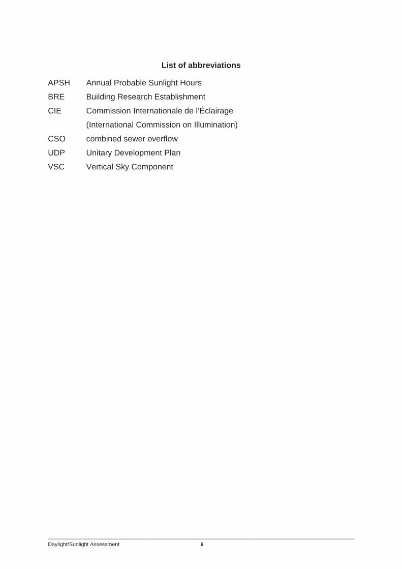
List of abbreviations
APSH Annual Probable Sunlight Hours
BRE Building Research Establishment
CIE Commission Internationale de l’Éclairage
(International Commission on Illumination)
CSO combined sewer overflow
UDP Unitary Development Plan
VSC Vertical Sky Component
Daylight/Sunlight Assessment ii

Hard copy available in
Daylight/ Sunlight AssessmentDoc Ref: 7.24
Main ReportAPFP Regulations 2009: Regulation 5(2)(q)
Box 58 Folder A January 2013
Mai
n Re
port
Thames Tideway Tunnel Thames Water Utilities Limited
Application for Development ConsentApplication Reference Number: WWO10001

This page is intentionally blank
1 Introduction
1 Introduction
1.1 Purpose of this report 1.1.1 This assessment is submitted in support of the application for
development consent for the Thames Tideway Tunnel project (the ‘project’). It assesses the potential impact that the structures associated with the project would have on the daylight and sunlight amenity of properties surrounding the proposed construction sites.
1.2 Project overview 1.2.1 At present, untreated sewage mixed with rainwater (combined sewage)
regularly overflows into the River Thames from London’s Victorian sewerage system via combined sewer overflows (CSOs).
1.2.2 Combined sewage discharges must be reduced in order to protect the environment and comply with relevant wastewater legislation. The project has been determined to be the most technologically-sound and cost-effective means of controlling CSO discharges and satisfying regulatory requirements.
1.2.3 The project would control CSO discharges by intercepting and diverting combined sewage flows into a new storage and transfer tunnel (the ‘main tunnel’). The tunnel would run from Acton Storm Tanks in west London to Abbey Mills Pumping Station in the east, where it would connect to the Lee Tunnel, which would transfer the flows to Beckton Sewage Treatment Works for treatment.
1.2.1 A detailed site selection process was carried out, having regard to engineering, planning, environment, socio-economic, community and property constraints. Twenty-four worksites were selected in total, which can be categorised by function as follows: a. Five ‘main tunnel sites’: These sites would be used to construct the
main tunnel and can be further classified as ‘drive sites’ and/or ‘reception sites’. Shafts would be excavated to the appropriate depth and the tunnel boring machines would start at ‘drive shafts’ and be removed via ‘reception shafts’. A shaft may serve as both a drive and a reception shaft, and in one case it is also a CSO site.
b. Sixteen ‘CSO sites’: These sites would be used to construct the CSO drop shafts and interception structures and to drive or receive connection tunnels. Greenwich Pumping Station is used to drive a long connection tunnel.
c. Two ‘system modification sites’: These sites would be used to control CSOs locally rather than connecting them to the main tunnel.
Daylight/Sunlight Assessment 1
1 Introduction
d. Beckton Sewage Treatment Works: The main use of this site would be to lift the combined sewage flows from the main tunnel system and transfer them for treatment.
1.3 Temporary and permanent project structures 1.3.1 During the temporary construction phase the sites would be set-up for
typical activities such as those listed below. The list is not exhaustive but nevertheless gives a reasonable indication of what is required and has been considered for this assessment. a. up to 30m diameter shaft and surrounding working for construction b. deliveries of construction materials for shafts and tunnelling
requirements c. storage, treatment and removal of excavated material arising from the
shaft, tunnel and other structures d. material stockyard for tunnel segments and accessories, including
loading e. cranage of materials within the worksite and into and out of the shaft f. for riverside sites, river access comprising: a wharf / jetty to service
barges; loading and unloading g. workshops to maintain all the mechanical and electrical plant and
stores for spare parts h. cooling plant, generators, back-up equipment, power supply
installations i. construction offices, welfare facilities and medical facilities j. hoardings, noise barriers and noise enclosures.
1.3.2 The permanent above-ground infrastructure at main tunnel sites and CSO sites might include: a. air management facilities including ventilation structures and
ventilation columns b. a kiosk structure to house electrical and control equipment.
1.4 Structure of this report 1.4.1 In general, daylight sunlight assessments consider the impact of proposed
permanent structures on existing residential properties. However, because construction of the project would take a number of years, this assessment also considers how temporary construction-related structures would affect existing residential properties. The assessment considers each of the 24 proposed sites and sets out any potential impacts from the temporary works and the permanent works.
1.4.2 This report is split into two sections: the first outlines the scoping assessment undertaken for all sites. This scoping assessment highlighted
Daylight/Sunlight Assessment 2
1 Introduction
two sites at which more detailed assessment was required. The detailed assessment is set out in the second section.
Daylight/Sunlight Assessment 3

1 Introduction
This page is intentionally left blank
Daylight/Sunlight Assessment 4
2 Scoping assessment
2 Scoping assessment
2.1 Introduction 2.1.1 This assessment followed the methodology set out in the 2011 Building
Research Establishment Report Site layout planning for daylight and sunlight - A guide to good practice by Paul Littlefair (the ‘BRE Report’), which has been adopted in many relevant local authority Unitary Development Plans. Even where some local authorities have not explicitly adopted the methodology, it is put forward as the best available means of determining potential impacts.
2.1.2 The BRE Report states that: “If any part of a new building or extension, measured in a vertical section perpendicular to a main window wall of an existing building, from the centre of the lowest window, subtends an angle of more than 25 degrees to the horizontal, then the daylighting to the existing building may be adversely affected”. The report provides the same guideline for sunlighting.
2.1.3 This guideline was considered in the initial screening exercise for the temporary construction phase and for the permanent works at each site. Where an obstruction would subtend an angle of more than 25 degrees for only a relatively short distance in plan, a judgement was made as to whether this would likely cause a significant reduction in light. For instance, cranes used at a number of sites would likely subtend an angle of more than 25 degrees; however, the obstruction they would cause would only be for a short distance in plan and their impact on daylight and sunlight would not likely be significant.
2.1.4 The site-specific assessments were based on the permanent works layouts and construction phasing drawings provided in the Book of Plans. The information in relation to the nature, type, timing, extent and layout of the temporary works used for the assessments was consistent with that used in the Environmental Statement for the assessment of likely significant environmental effects. The construction layouts and assumptions are illustrative only since the final layouts would be prepared by contractors appointed to carry out detailed design and construct the works. However, they are representative of practical methods that might be used to construct the works and, on that basis, formed a suitable basis for assessing potential impacts.
2.1.5 The construction phasing plans illustrate temporary buildings, construction plant, and site hoardings for the different phases of construction. Where the hoarding line would change between phases, the phase at which the hoarding would sit at its maximum extent was used for the purposes of the assessments. The standard hoarding height would be 2.4m; however, it would be higher in certain locations at some sites. All residential and commercial properties that are surrounding the construction sites, which is those that are adjacent to the sites and potentially impacted by the works, have been considered.
Daylight/Sunlight Assessment 5
2 Scoping assessment 2.1.6 The assumed hoarding heights in this assessment were based on the
heights set out in the Code of Construction Practice Part B and are summarised in Table 2.1 below. In a few cases the project team have identified noise impacts that would be mitigated by higher noise barriers not assessed for daylight and sunlight impacts. However, the Code of Construction Practice contains the following requirement: “The site layout shall also consider and minimise where practical potential impacts from restrictions to natural light to adjacent property”, which means that the final design of construction site layouts would take account of both noise and light requirements.
2.1.7 At main tunnel drive sites, temporary buildings and site equipment would be in place for longer periods of time than at CSO sites and the layout would be more constrained. Therefore a more in depth assessment was completed for the construction phases at these sites, as follows: a. Dormay Street b. Carnwath Road Riverside c. Kirtling Street d. Chambers Wharf e. Greenwich Pumping Station.
2.1.8 Three dimensional models for the construction layout were used for the assessment, where available. Where such models were unavailable, it was conservatively assumed that there would be a 7m high structure over the full site area between the hoardings. The structures, buildings, hoardings and construction plant that would obstruct daylight and sunlight define the massing used in this assessment.
Table 2.1 Construction layouts and hoarding heights
Site name
Assumed hoarding height
Acton Storm Tanks 2.4m: except at the western boundary adjacent to 1 to 5 Canham Road and along the southwestern boundary alongside Greenend Road, where it would be 3.6m
Hammersmith Pumping Station 3.6m
Barn Elms 3.6m
Putney Embankment Foreshore 2.4m
Dormay Street 3.6m
King George’s Park 2.4m
Carnwath Road Riverside
5m high hoarding/noise barrier on the eastern and western boundaries of the site; 3.6m around rest of site; 2.4m noise barrier
Daylight/Sunlight Assessment 6
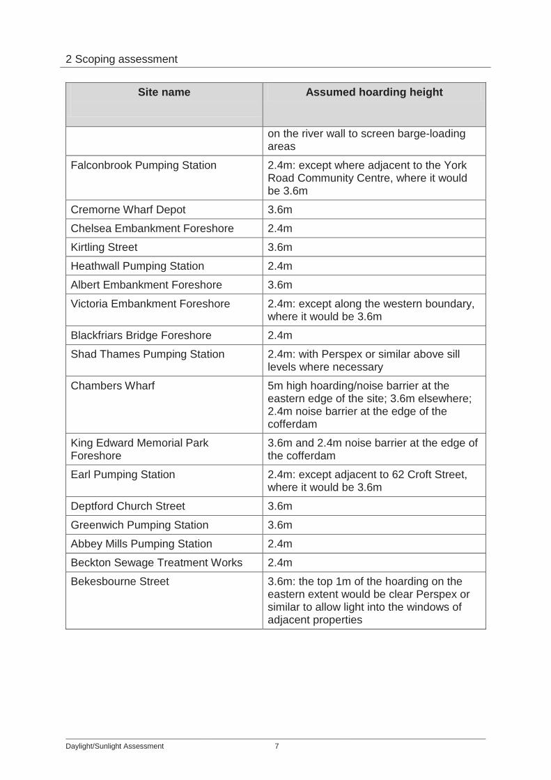
2 Scoping assessment
Site name
Assumed hoarding height
on the river wall to screen barge-loading areas
Falconbrook Pumping Station 2.4m: except where adjacent to the York Road Community Centre, where it would be 3.6m
Cremorne Wharf Depot 3.6m
Chelsea Embankment Foreshore 2.4m
Kirtling Street 3.6m
Heathwall Pumping Station 2.4m
Albert Embankment Foreshore 3.6m
Victoria Embankment Foreshore 2.4m: except along the western boundary, where it would be 3.6m
Blackfriars Bridge Foreshore 2.4m
Shad Thames Pumping Station 2.4m: with Perspex or similar above sill levels where necessary
Chambers Wharf 5m high hoarding/noise barrier at the eastern edge of the site; 3.6m elsewhere; 2.4m noise barrier at the edge of the cofferdam
King Edward Memorial Park Foreshore
3.6m and 2.4m noise barrier at the edge of the cofferdam
Earl Pumping Station 2.4m: except adjacent to 62 Croft Street, where it would be 3.6m
Deptford Church Street 3.6m
Greenwich Pumping Station 3.6m
Abbey Mills Pumping Station 2.4m
Beckton Sewage Treatment Works 2.4m
Bekesbourne Street
3.6m: the top 1m of the hoarding on the eastern extent would be clear Perspex or similar to allow light into the windows of adjacent properties
Daylight/Sunlight Assessment 7
2 Scoping assessment 2.2 Site scoping assessments
Acton Storm Tanks 2.2.1 The proposed development site is located in the London Borough of
Ealing. It is an inland site that currently comprises the Thames Water operational storm water tanks and associated pumping station.
2.2.2 The site is bounded by Canham Road to the north, Warple Way to the east and southeast, and by a private car park to the south and west. There are both residential and commercial properties surrounding this site.
2.2.3 The screening assessment concluded that the permanent works would have no material impact on daylight or sunlight.
2.2.4 During construction, the potential impacts would be acceptable. The crane and silos would subtend an angle of greater than 25 degrees from the lowest window in the surrounding properties; however, this would not be for a significant distance in plan.
Hammersmith Pumping Station 2.2.5 The proposed development site is located in the London Borough of
Hammersmith and Fulham. It comprises a vacant former industrial site known as Hammersmith Embankment, part of the Thames Water Hammersmith Pumping Station site and a small area of roadway.
2.2.6 The site is bounded by Chancellor’s Road to the north, Distillery Road to the east, and Winslow Road to the south. Vacant former industrial land lays to the west and beyond this the River Thames. There are existing residential properties adjacent to the site across Chancellor’s Road.
2.2.7 The screening assessment concluded that the permanent works would have no impact on these properties.
2.2.8 There would be no material impact during the construction phases on existing residential properties as the tallest elements would be situated to the south of the site away from those properties. However, it is possible that these elements may impact on the new Fulham Reach development which under construction but that would depend upon the progress and phasing of this new development.
Barn Elms 2.2.9 The proposed development site is located in the London Borough of
Richmond upon Thames near the London Borough of Wandsworth. It comprises a band of greenfield land along the northern, eastern and southern borders of the Barn Elms Schools Sports Centre covering an area of approximately 3.1ha, and a small area of roadway at the junction of Queen Elizabeth Walk and Rocks Lane.
2.2.10 The site is bounded to the north by the pedestrian section of Queen Elizabeth Walk, to the east by a line of mature trees and the Thames Path, to the southeast and south by Beverley Brook (approximately 15m from
Daylight/Sunlight Assessment 8
2 Scoping assessment
the site), and to the west by the Barn Elms Schools Sports Centre. There are no residential properties immediately surrounding this site.
2.2.11 The screening assessment concluded that there would be no material impact on daylight or sunlight from construction or the permanent works.
Putney Embankment Foreshore 2.2.12 The proposed development site is located in the London Borough of
Wandsworth. It comprises an area of the foreshore of the River Thames. 2.2.13 The site is bounded by the River Thames to the north, east and west. An
area of open space known as Waterman’s Green, Lower Richmond Road and the Embankment carriageway form the southern boundary. There are existing residential properties adjacent to the site.
2.2.14 The screening assessment concluded that the permanent works would have no impact.
2.2.15 Similarly, there would be no material impacts during the construction phases.
Dormay Street (tunnel drive site) 2.2.16 The proposed development site is located in the London Borough of
Wandsworth. It comprises part of the Frogmore Industrial Complex and Causeway Island. It is mostly made up of hardstanding.
2.2.17 The site is bounded by railway lines and a vehicle storage area to the north, The Causeway to the east, beyond which lies the River Wandle, and to the south by the junction of Dormay Street and Armoury Way. A London Borough of Wandsworth maintenance depot is situated to the west. There are no residential properties immediately surrounding this site.
2.2.18 The screening assessment concluded that there would be no material impact on daylight or sunlight from construction or the permanent works.
King George's Park 2.2.19 The proposed development site is located in the London Borough of
Wandsworth. It comprises an area of land at the northern end of King George’s Park, adjacent to the main Buckhold Road entrance.
2.2.20 The site is bounded by the Buckhold Road/Neville Gill Close junction to the north, Neville Gill Close to the east, King George’s Park to the south and Buckhold Road to the west. There are no residential properties surrounding this site.
2.2.21 The screening assessment concluded that there would be no material impact on daylight or sunlight from construction or the permanent works.
Carnwath Road Riverside (tunnel drive site) 2.2.22 The proposed development site is located in the London Borough of
Hammersmith and Fulham. It comprises three adjacent parcels of land: Whiffin Wharf and the safeguarded Hurlingham Wharf, which are both
Daylight/Sunlight Assessment 9
2 Scoping assessment
largely vacant areas of hardstanding with some existing unauthorised uses, and Carnwath Road Industrial Estate.
2.2.23 The site is bounded by Carnwath Road to the north, a four-storey residential block and a PC World superstore to the east, the River Thames to the south, and three to four-storey residential dwellings that overlook the site and the River Thames to the west. There are both residential and commercial properties surrounding this site.
2.2.24 The screening assessment concluded that the permanent works would have no material impact.
2.2.25 During the construction phases, it is possible that the acoustic shed would have an impact on the daylight and sunlight at the residential property at 89 to 101 Carnwath Road to the west of the site. The maintenance workshop and storage required on the site during construction might also impact on this property.
2.2.26 The proposed temporary support/welfare buildings might impact on the windows in the flank wall of 5 Carnwath Road to the east of the site. There is an existing two-storey warehouse in front of these windows; however, it angles away from the boundary. The support/welfare buildings would come right up to the boundary with this property.
Falconbrook Pumping Station 2.2.27 The proposed development site is located in the London Borough of
Wandsworth. It comprises part of the Thames Water operational Falconbrook Pumping Station compound, a disused toilet block to the southwest of the pumping station and part of an area of public realm adjacent to the York Gardens Library and Community Centre.
2.2.28 The site is bounded by York Gardens Children’s Centre and Adventure Playground to the north. York Gardens surrounds the site to the east and south, and it is bounded to the west by York Road. There are no residential properties immediately surrounding this site.
2.2.29 The screening assessment concluded that there would be no material impact on daylight or sunlight from construction or the permanent works.
Cremorne Wharf Depot 2.2.30 The proposed development site is located in the Royal Borough of
Kensington and Chelsea. It comprises an existing council depot used for storage and street cleaning, the Thames Water Lots Road Pumping Station and the River Thames foreshore.
2.2.31 The site is bounded by Chelsea Wharf to the north, the River Thames to the east, Chelsea Creek to the south, and Lots Road to the west. There are no residential properties immediately surrounding this site.
2.2.32 The screening assessment concluded that there would be no impact during construction.
Daylight/Sunlight Assessment 10
2 Scoping assessment 2.2.33 The proposed replacement depot building would be no bigger than the
existing depot building therefore the permanent works would have no impact.
Chelsea Embankment Foreshore 2.2.34 The proposed development site is located in the Royal Borough of
Kensington and Chelsea. It comprises the foreshore of the River Thames opposite the Bull Ring Gates of the Royal Hospital Chelsea South Grounds, sections of Chelsea Embankment carriageway and pavement, and a small section of Ranelagh Gardens.
2.2.35 The site is bounded to the north by the Royal Hospital, the hospital’s South Grounds, and Ranelagh Gardens. To the northeast lies the Lister Hospital and Chelsea Bridge Gardens on the northern side of Chelsea Bridge Road and to the east Chelsea Bridge crosses the River Thames. The River Thames surrounds the site to the east, south and west. There are no residential properties immediately surrounding this site.
2.2.36 The screening assessment concluded that there would be no material impact on daylight or sunlight from construction or the permanent works.
Kirtling Street (tunnel drive site) 2.2.37 The proposed development site is located in the London Borough of
Wandsworth. It comprises a section of the foreshore of the River Thames and the river wall close to Cringle Street and four adjacent land areas: a warehouse, a depot, a mixed-use area including a depot, a former petrol station and various office units, and an active concrete batching works on the safeguarded Kirtling Wharf (also known as Cringle Wharf).
2.2.38 The site is bounded to the north by the River Thames. To the northeast lie two houseboat communities: Nine Elms Pier, which is subject to a planning application for redevelopment as a marina, and Tideway Village in Tideway Dock. It is bounded to the east by the former Tideway Industrial Estate ‘Riverlight’ development, which is under construction; to the south by Nine Elms Lane; and to the west by the Cringle Dock waste transfer station, a Thames Water ring main pumping station and the grounds of the disused Battersea Power Station.
2.2.39 The screening assessment concluded that there would be no material impact on daylight or sunlight from construction or the permanent works.
Heathwall Pumping Station 2.2.40 The proposed development site is located within the London Borough of
Wandsworth. It comprises Thames Water’s operational Heathwall Pumping Station, the designated safeguarded Middle Wharf and an area of the River Thames that includes the Battersea Barge restaurant.
2.2.41 The site is bounded by the River Thames to the north, open space and the Elm Quay residential block to the east, Nine Elms Lane to the south, and the Tideway Industrial Estate (now a re-development site) and the
Daylight/Sunlight Assessment 11
2 Scoping assessment
proposed Kirtling Street site to the west. There are no existing residential properties immediately surrounding this site.
2.2.42 The screening assessment concluded that there would be no material impact on daylight or sunlight from construction or the permanent works.
Albert Embankment Foreshore 2.2.43 The proposed development site is located in the London Borough of
Lambeth. It comprises an area of the foreshore of the River Thames parallel to Albert Embankment between Tintagel House and St George Wharf. It also comprises Lack’s Dock, a section of the Thames Path, and potentially an area of land between Tintagel House and Camelford House (subject to final access arrangements).
2.2.44 The River Thames surrounds the site to the north, south and west. The site is bounded to the east by the Thames Path. There are both residential and commercial properties surrounding this site.
2.2.45 The screening assessment concluded that neither the temporary nor the permanent works would have a material impact.
Victoria Embankment Foreshore 2.2.46 The proposed development site is located in the City of Westminster. It
comprises an area of the foreshore of the River Thames and a section of pavement and carriageway of Victoria Embankment. A permanently moored vessel, the Tattershall Castle (a floating bar and restaurant), and two service moorings lie within the site.
2.2.47 The site is bounded to the north, east and south by the River Thames and to the west by Victoria Embankment, the pavement of which forms the Thames Path. There are no residential properties immediately surrounding this site.
2.2.48 The screening assessment concluded that there would be no material impact on daylight or sunlight from construction or the permanent works.
Blackfriars Bridge Foreshore 2.2.49 The proposed development site is located in the City of London. It
comprises two sections of the foreshore of the River Thames: the main site extends from Temple Stairs to Blackfriars Rail Bridge and the secondary site lies between Blackfriars Rail Bridge and the City of London School.
2.2.50 The site is bounded by Victoria Embankment/Blackfriars Underpass/Upper Thames Street to the north and the River Thames to the east, south and west. There are no residential properties immediately surrounding this site.
2.2.51 The screening assessment concluded that there would be no material impact on daylight or sunlight from construction or the permanent works.
Daylight/Sunlight Assessment 12
2 Scoping assessment
Shad Thames Pumping Station 2.2.52 The proposed development site is located in the London Borough of
Southwark. It comprises the Thames Water operational pumping station, the length of Maguire Street and its intersection with Gainsford Street.
2.2.53 The site is bounded by the Grade II listed Wheat Wharf residential conversion to the north, the Design Museum and Clove Building along Maguire Street to the east, Tamarind Court to the south, and by a courtyard car park associated with Vanilla and Sesame Court to the west. There are residential properties immediately surrounding this site.
2.2.54 The screening assessment concluded that the replacement facilities building would be smaller than the existing facilities building on-site therefore the permanent works would have no impact.
2.2.55 During the construction phases, the hoarding would potentially have an impact on ground floor windows in areas where it would sit close to neighbouring properties. The hoarding would be 2.4m high with “Perspex or similar above sill levels where necessary”. For the purposes of the daylight and sunlight assessment, it was assumed that the Perspex or similar element would not form an obstruction.
Chambers Wharf (tunnel drive site) 2.2.56 The proposed development site is located in the London Borough of
Southwark. It comprises previously developed land that has now been cleared, an area of the River Thames foreshore and two small areas of roadway.
2.2.57 The site is bounded by the River Thames to the north, Loftie Street to the east, Chambers Street to the south and East Lane Bermondsey Wall West to the west. There are both residential and commercial properties surrounding this site.
2.2.58 The screening assessment concluded that the permanent works would not impact on any surrounding properties.
2.2.59 There would potentially be an impact during the construction phases. The acoustic shed over the main tunnel shaft and gantry crane could potentially impact on the residential properties to east of the site (8 to 14 Fountain Green Square) as well as the property to the southwest across Bermondsey Wall East. The proposed three-storey office and welfare block in the southwestern corner of the site would likely impact on 1 to 59 Axis Court, and possibly on 10 to 28 Chambers Street.
Earl Pumping Station 2.2.60 The proposed development site is located in the London Borough of
Lewisham and adjacent to the London Borough of Southwark to the north and west. It comprises Thames Water’s operational Earl Pumping Station at the northern end of the site and four adjacent plots of industrial land at the southern end.
Daylight/Sunlight Assessment 13
2 Scoping assessment 2.2.61 The site is bounded by Chilton Grove to the north and Yeoman Street to
the east. Occupied commercial/industrial units and a row of two-storey terraced houses with gardens lie adjacent to the southern site boundary and the first dwelling in the terrace sits adjacent to the site boundary. The site is bounded to the west by Croft Street. There are residential and commercial properties surrounding the site.
2.2.62 The screening assessment concluded that neither the temporary nor the permanent works would have a material impact on any properties.
Deptford Church Street 2.2.63 The proposed development site is located in the London Borough of
Lewisham and is also close to the London Borough of Greenwich to the north and east. It is triangular in shape and comprises an area of public open space and roadway.
2.2.64 The site is bounded by Coffey Street to the north, by Deptford Church Street to the east, and by Crossfield Street to the southwest. There are no residential properties immediately surrounding this site.
2.2.65 The screening assessment concluded that there would be no material impact on daylight or sunlight from construction or the permanent works.
Greenwich Pumping Station (tunnel drive site) 2.2.66 The proposed development site is located in the Royal Borough of
Greenwich immediately to the west of the administrative boundary with the London Borough of Lewisham. It comprises Thames Water’s existing operational Greenwich Pumping Station and associated buildings, two railway viaducts and a shared pedestrian and cycle path that bisect the site, Phoenix Wharf and a builder’s yard.
2.2.67 The site is bounded by the Brook Marsh Trading Estate, a vehicle repair garage and offices to the north, Norman Road to the east, Greenwich High Road to the south, and Deptford Creek to the west. There are residential properties to the southwest of the site.
2.2.68 The screening assessment concluded that the permanent works would have no material impact.
2.2.69 During the construction phases, the 7m high massing over the entire site might have an impact on the daylight to the basement of the new building to the southwest of the site; however, it seems unlikely that this building is residential.
King Edward Memorial Park Foreshore 2.2.70 The proposed development site is located in the London Borough of
Tower Hamlets. It comprises the foreshore of the River Thames adjacent to King Edward Memorial Park and an area in the south of the park, including hard-surfaced sections of the Thames Path, a small area of green space and part of the multi-purpose sports pitches to the west.
Daylight/Sunlight Assessment 14
2 Scoping assessment 2.2.71 The site is bounded by King Edward Memorial Park and The Highway to
the north, the residential Free Trade Wharf building to the east, the River Thames to the south, and by the Shadwell Basin Outdoor Activity Centre and Glamis Road to the west. There are no residential properties immediately surrounding this site.
2.2.72 The screening assessment concluded that there would be no material impact on daylight or sunlight from construction or the permanent works.
Bekesbourne Street 2.2.73 The proposed development site is located in the London Borough of
Tower Hamlets. It comprises a section of Bekesbourne Street and its junction with Ratcliffe Lane.
2.2.74 The site is bounded by Limehouse Station and the Docklands Light Railway to the north, John Scurr House (a six-storey block of flats) to the east, and three to four-storey residential blocks of flats and the John Scurr Community Centre to the south and west. There are both residential and commercial properties surrounding this site.
2.2.75 The screening assessment concluded that the permanent works would not have any material impact.
2.2.76 During the construction phases, the hoardings would be 3.6m high and the top 1m would be Perspex or similar. It was assumed that it was not necessary to consider the Perspex or similar element. The hoarding would potentially impact on ground floor windows in areas where it would come right up to neighbouring properties.
Abbey Mills Pumping Station 2.2.77 The proposed development site is located in the London Borough of
Newham. The new development would be concentrated within the southern and western areas of the pumping station site.
2.2.78 The site is bounded by Abbey Mills Pumping Station, operational infrastructure and buildings to the north and northeast, the Channelsea River and Abbey Creek to the east and southeast, the Prescott Channel to the west, and Riverside Road to the northwest. There are no residential properties immediately surrounding this site.
2.2.79 The screening assessment concluded that there would be no material impact on daylight or sunlight from construction or the permanent works.
Beckton Sewage Treatment Works 2.2.80 The proposed development site is located in the London Borough of
Newham. It comprises two areas within the southern and western sections of the operational Beckton Sewage Treatment Works compound.
2.2.81 Beckton Sewage Treatment Works is bounded by the Alfred’s Way trunk road to the north, Barking Creek to the east, the River Thames to the south, and by Royal Docks Road, Hornet Way and Armada Way to the
Daylight/Sunlight Assessment 15
2 Scoping assessment
west. There are no residential properties immediately surrounding this site.
2.2.82 The screening assessment concluded that there would be no material impact on daylight or sunlight from construction or the permanent works.
2.3 Scoping assessment conclusions 2.3.1 In summary, none of the 24 sites needed more detailed examination in
relation to the permanent works. 2.3.2 With regard to the construction phases the following sites are potentially
affected: a. Bekesbourne Street b. Greenwich Pumping Station c. Hammersmith Pumping Station d. Shad Thames Pumping Station e. Carnwath Road Riverside f. Chambers Wharf.
2.3.3 At Bekesbourne Street and Shad Thames Pumping Station, it was assumed that the utilisation of Perspex or similar hoardings is acceptable. Furthermore, it should be possible to ‘fine tune’ the construction arrangements and limit the duration of the impacting works in order to minimise the potential impacts. A requirement to that effect is included in the Code of Construction Practice Part B. Therefore no detailed assessment was undertaken.
2.3.4 At Greenwich Pumping Station, it was assumed that the basement of the new building to the southwest of the site is not residential. However, if it proves to be a residential building, it should nonetheless be possible to relocate the site facilities building which would impact on it. A requirement to that effect is included the Code of Construction Practice Part A. Therefore no detailed assessment was undertaken.
2.3.5 The potential impacts at Hammersmith Pumping Station would depend on which phases of the surrounding residential development are complete at the time of project construction. This information is not available so no detailed assessment has been carried out at this stage.
2.3.6 Carnwath Road Riverside and Chambers Wharf are both main tunnel drive sites and the layout and duration of the construction works is constrained. For this reason, more detailed investigation of the construction impacts at these sites was considered necessary and was undertaken.
Daylight/Sunlight Assessment 16
3 Detailed assessment
3 Detailed assessment
3.1 Introduction 3.1.1 This assessment was completed in accordance with the guidelines set out
in the BRE Report. One of the primary sources for this report is the more detailed guidance provided within British Standard 8206 Part 2:2008.
3.1.2 In accordance with conventional practice, only main habitable spaces (ie, living rooms, bedrooms and kitchens) within residential properties were considered in the assessment.
3.1.3 The BRE Report guidelines provide two principal measures of daylight and sunlight with which to assess the potential impact of a proposed development on neighbouring properties: Vertical Sky Component (VSC) and Annual Probable Sunlight Hours (APSH).
Vertical Sky Component 3.1.4 VSC is a measure of the amount of skylight that reaches a given point
from an overcast sky. It is defined in the BRE Report as: “Ratio of that part of illuminance, at a point on a given vertical plane, that is received directly from a CIE standard overcast sky, to illuminance on a horizontal plane due to an unobstructed hemisphere of this sky”.
3.1.5 A CIE standard overcast sky is defined as: “A completely overcast sky for which the ratio of its luminance Ly at an angle of elevation y above the horizontal to the illuminance Lz at the zenith is given by: Ly = Lz (1+2sin y) ”
3
3.1.6 A CIE standard overcast sky is darkest at the horizon and brightest at the zenith.
3.1.7 For existing buildings, the BRE VSC guideline is based on the loss at a point in the centre of a window, on the outer plane of the wall. The BRE guidelines state that if the VSC at the centre of a window is less than 27 per cent, and it is less than 0.8 times its former value, then the diffuse daylighting of the existing building may be adversely affected.
Annual Probable Sunlight Hours 3.1.8 APSH is the long-term average of the hours during a year in which direct
sunlight reaches an unobstructed point, taking weather conditions into account. The BRE provides 100 typical sun positions for a number of locations to facilitate the calculation of the percentage of APSH. The typical sun positions for London are illustrated on the Sunlight Availability Indicator (Figure A2) in the BRE Report. The percentage of total APSH at
Daylight/Sunlight Assessment 17
3 Detailed assessment
a given point is determined by how many sun positions would be directly visible from the given point.
3.1.9 The BRE Report recommends that the APSH received at a given window should be at least 25 per cent of the total available sunlight, including at least five per cent in winter. Where the values fall short as a result of the proposed development and the absolute loss of light is greater than four per cent, the post-development values should not be less than 0.8 times their existing value in each season.
3.1.10 The BRE guidelines also state that: “all main living rooms of dwellings should be checked if they have a window facing within 90 degrees of due south. Kitchens and bedrooms are less important, although care should be taken not to block out too much sun”.
Analysis 3.1.11 Initially, detailed three dimensional computer models of both Carnwath
Road Riverside and Chambers Wharf and the surrounding buildings were created. The models were created using the available construction phasing drawings and other three dimensional models. Window positions and sizes were estimated based on photographs taken from the sites.
3.1.12 These models were then analysed using a software package called ‘Sol’ to calculate the existing VSC and APSH at each window. Sol was designed by Waterslade Ltd and is widely used by daylight and sunlight consultants.
3.1.13 The existing light levels were then compared to models with the construction phase massing in place. The resulting reduced levels of sunlight were then compared to the relevant BRE Report guidelines.
3.1.14 The figures and tables that illustrate the results of the analysis are provided in Appendix A and referred to in the following sections.
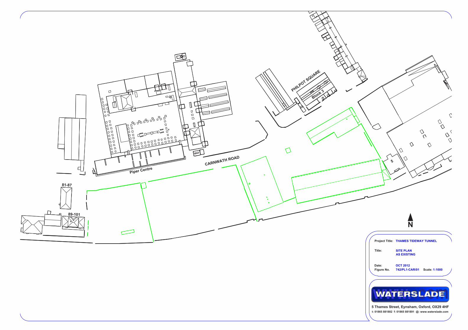
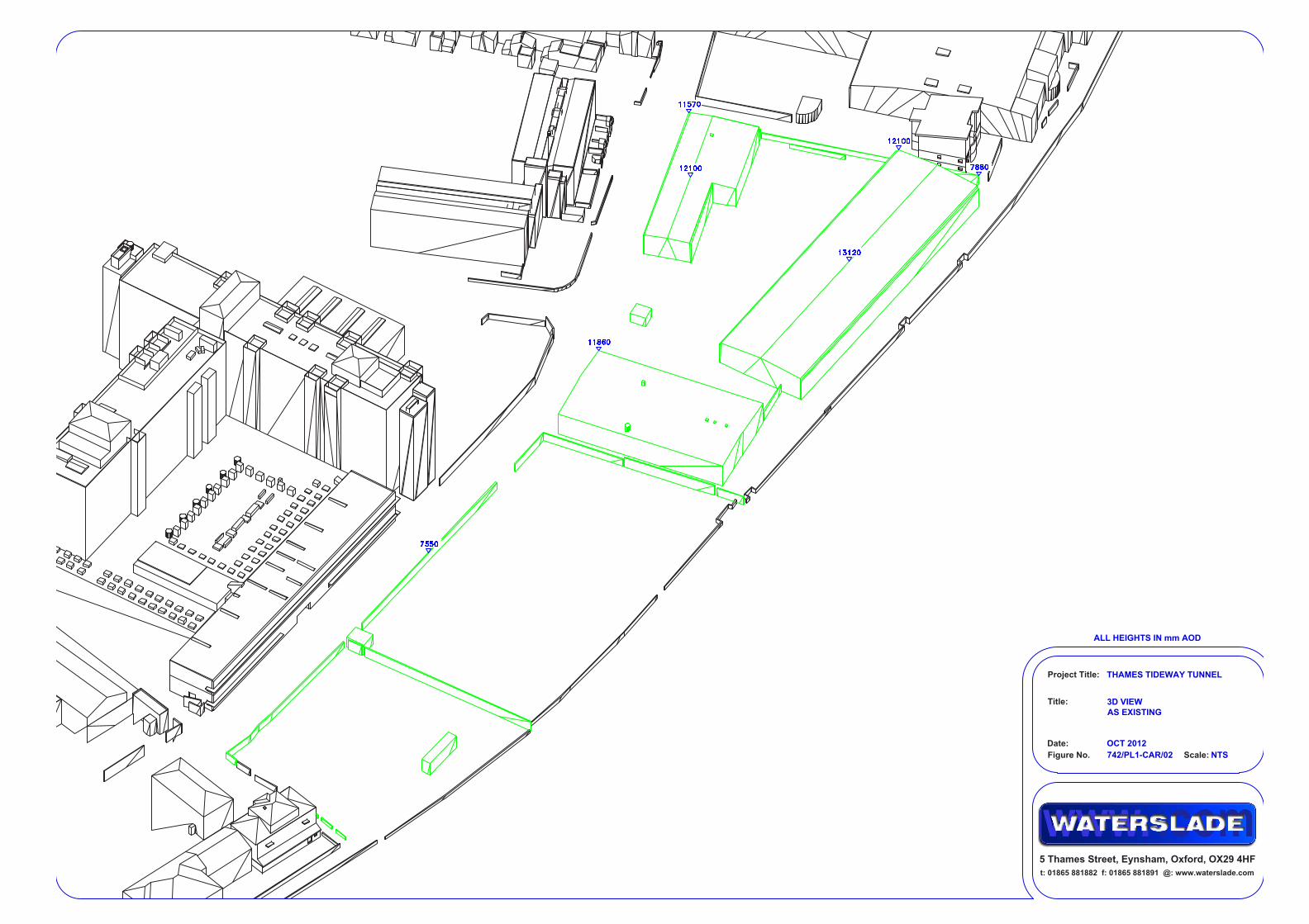
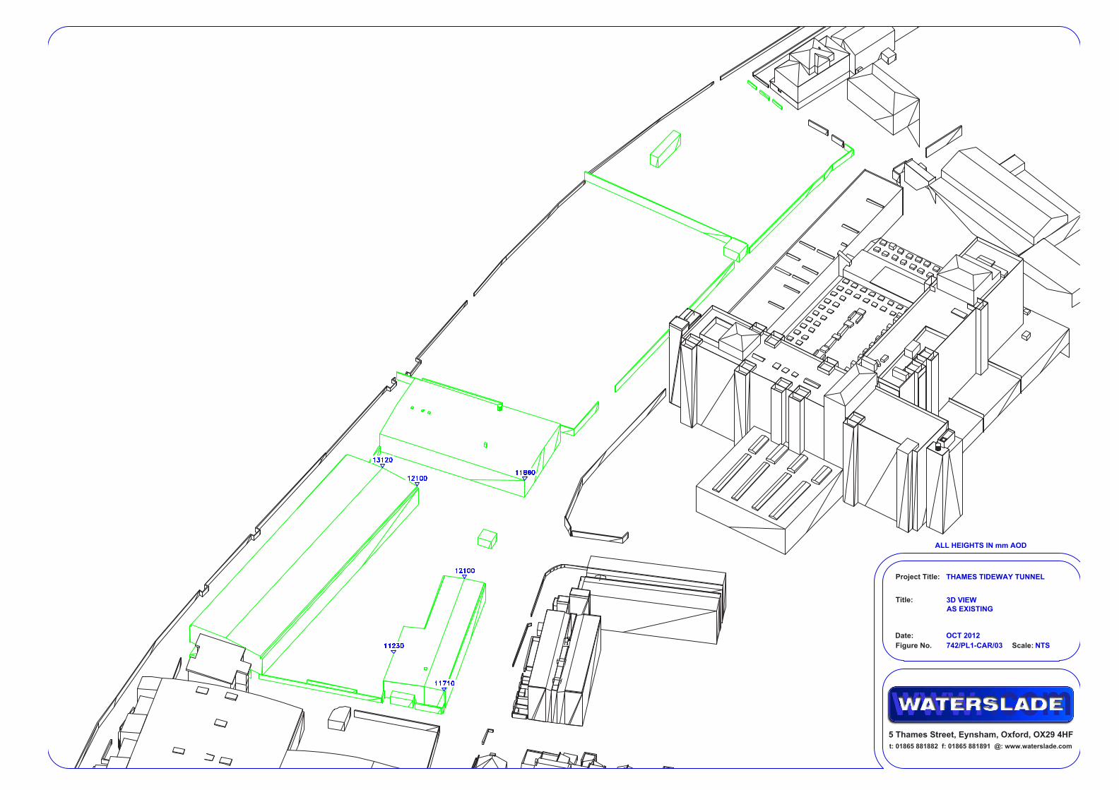
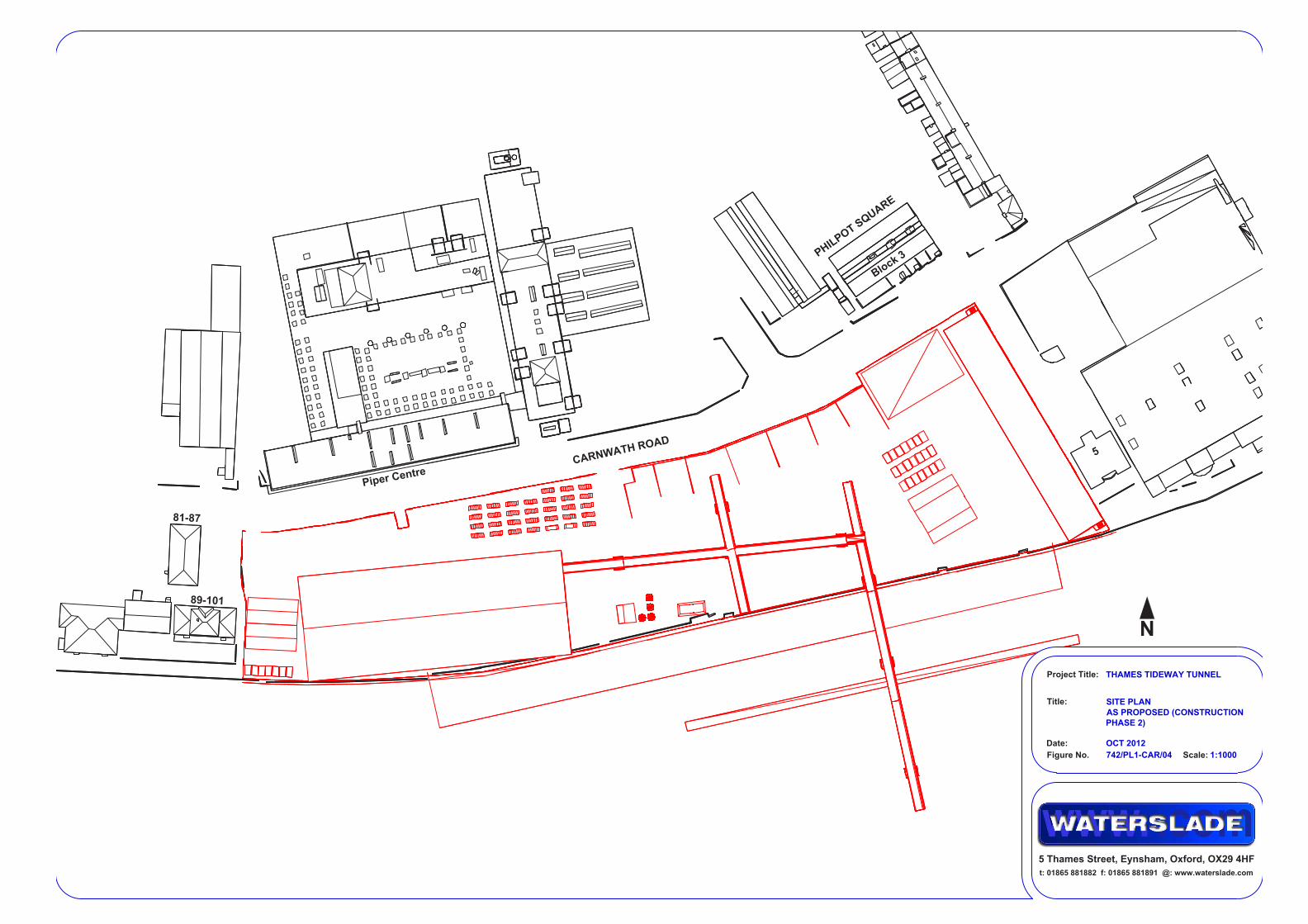
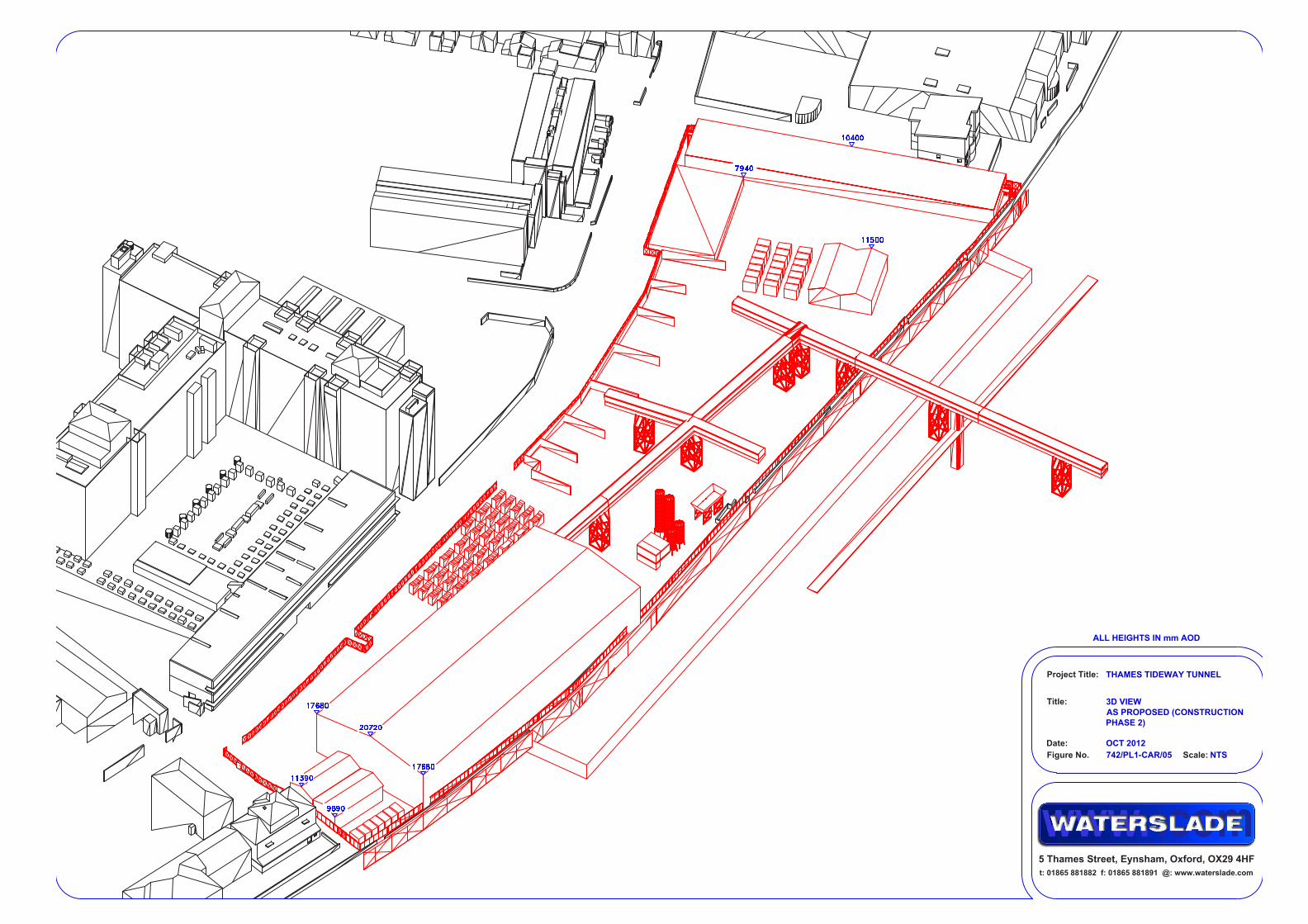
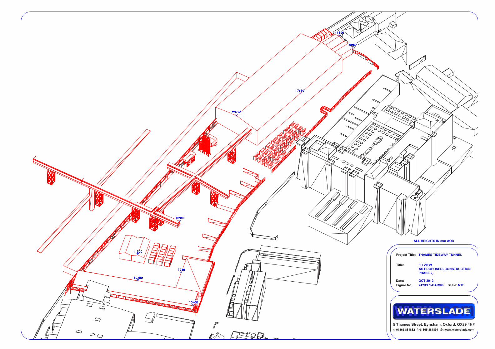
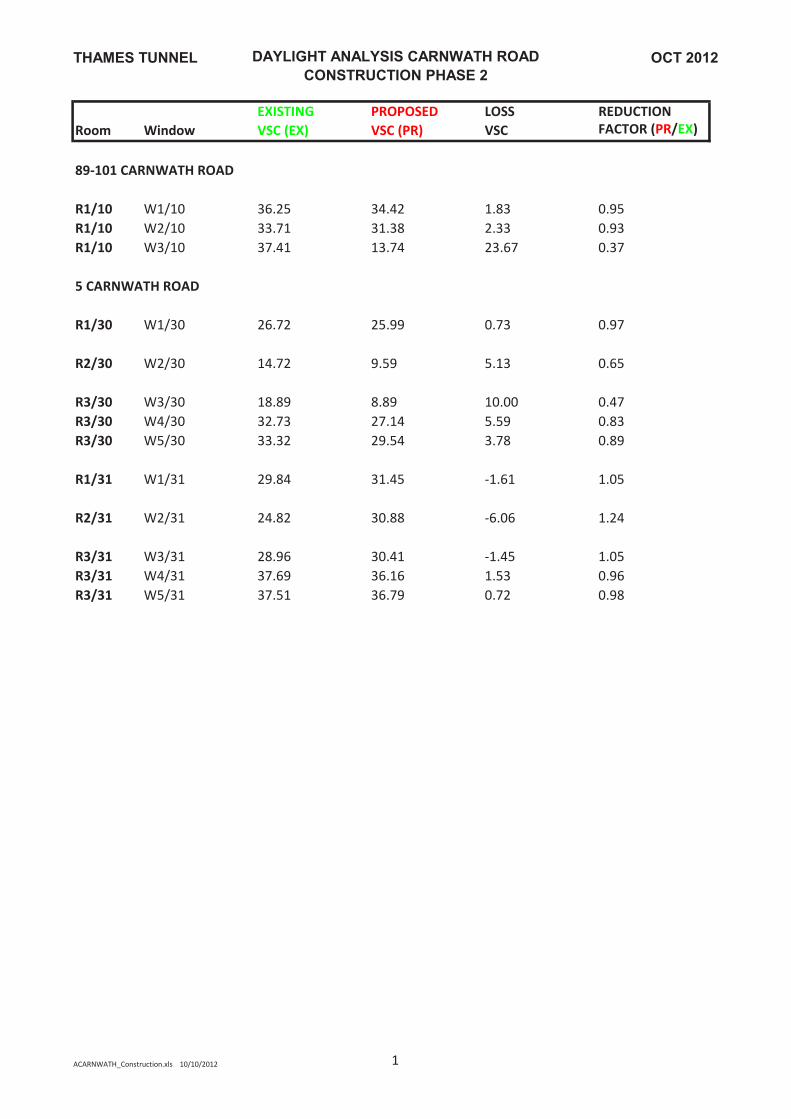
3.2 Carnwath Road Riverside 3.2.1 The potential impacts that construction phase 2 would have on 89 to 101
Carnwath Road to the west and 5 Carnwath Road to the east of the site were assessed. These are the only residential properties surrounding the site that could potentially be impacted because the site area opposite 81 to 87 Carnwath Road is the assumed vehicle entrance road, and the massing of the proposed structures during construction opposite Block 3 Philpot Square is lower than the existing massing of structures on the site.
3.2.2 Figures 742/PL1 to CAR/01-06 in Appendix A illustrate the existing site and the construction massing that was assessed.
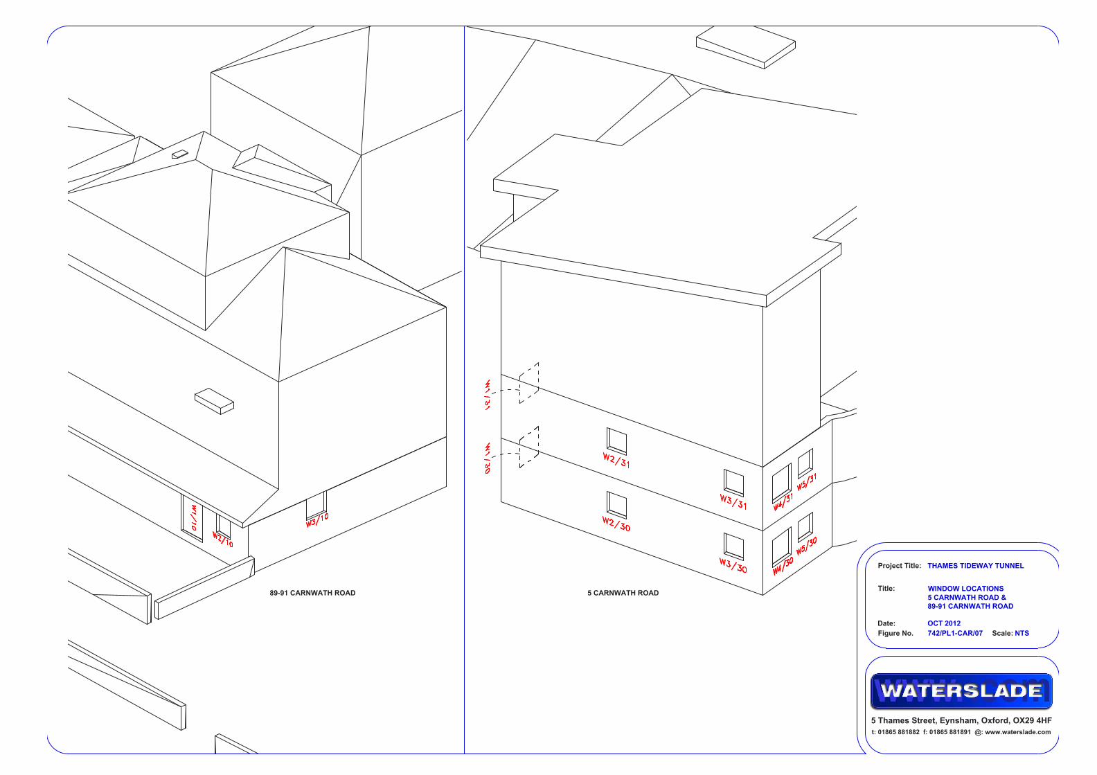
3.2.3 Each window for assessment in the surrounding properties was assigned a unique label, as illustrated in figure 742/PL1-CAR/07 in Appendix A.
89 to 101 Carnwath Road 3.2.4 With reference to the table of results titled ‘DAYLIGHT ANALYSIS
CARNWATH ROAD’, window W3/10 located in the flank wall of the
Daylight/Sunlight Assessment 18
3 Detailed assessment
property falls short of achieving the BRE VSC criteria. However, there would be negligible impact on the other window and the French doors, both continuing to receive excellent levels of daylight during construction. Project staff have entered this property and confirm that the two windows and the French doors assessed serve the same kitchen/diner. The overall impact on the daylight amenity to the kitchen/diner would not be material.
3.2.5 With reference to the table titled ‘SUNLIGHT ANALYSIS CARNWATH ROAD’, the situation with regard to sunlight is similar to that for daylight – W3/10 falls short of achieving the BRE APSH criteria, while windows W1/10 and W2/10 that serve the same room, comfortably comply. Overall the kitchen/diner would continue to receive excellent levels of sunlight during construction
5 Carnwath Road 3.2.6 Two ground floor windows at 5 Carnwath Road (W2/30 and W3/30) would
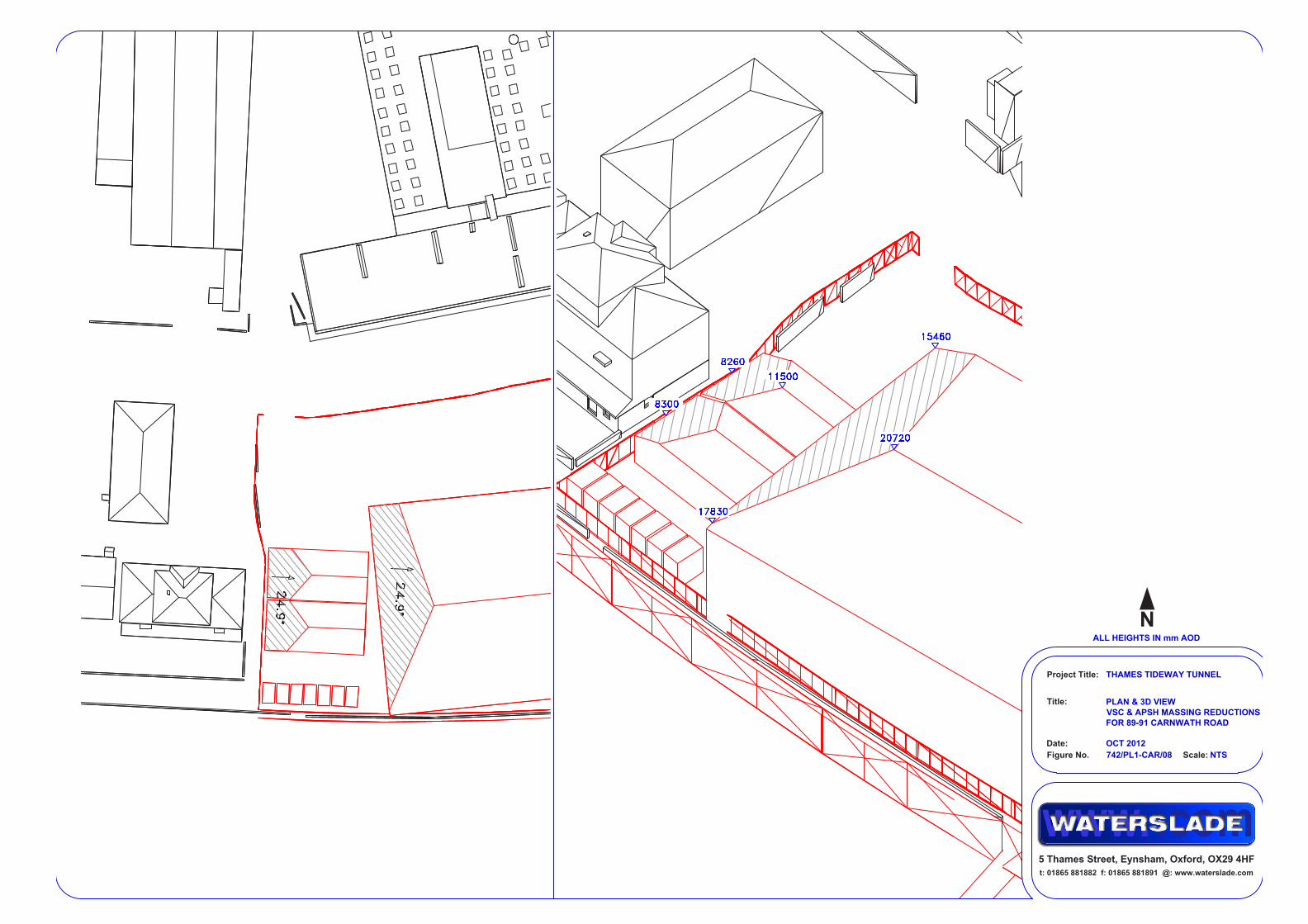
not meet the BRE VSC and APSH criteria. 3.2.7 Window W2/30 appears to be the only window to the room it serves. It is
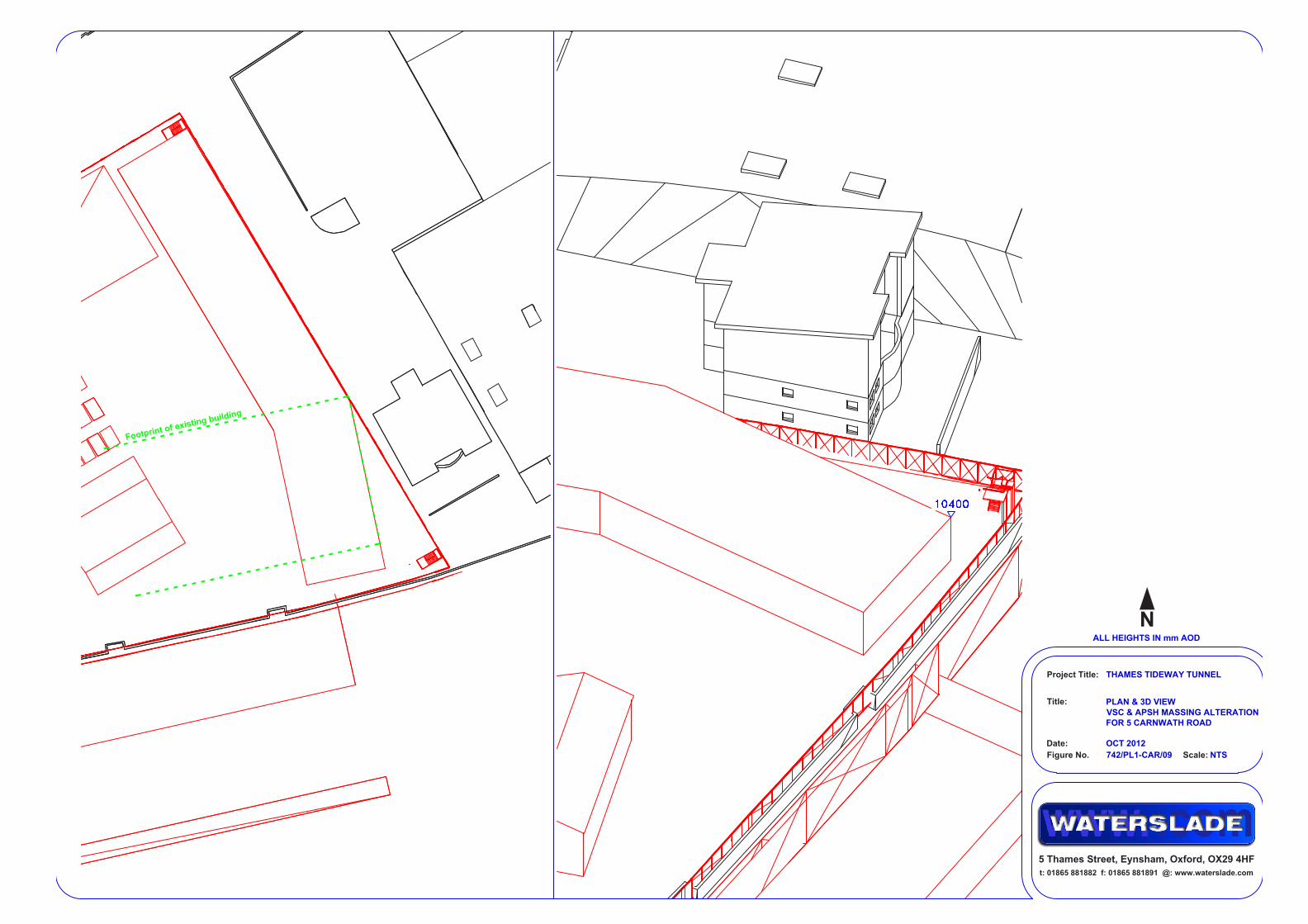
possible that the room this window serves is circulation space and not a main habitable space; however, it is just as likely to be a bedroom. It was therefore determined that rotating the section of proposed two-storey construction accommodation building adjacent to the property to sit in line with the gable end of the existing warehouse would ensure that all windows would meet the BRE VSC and APSH criteria. This suggested alteration is illustrated in figures 742/PL1 to CAR/09 in Appendix A. If the noise barrier is aligned to minimise light impacts this alteration would not be necessary.
3.2.8 The Code of Construction Practice Part B for Carnwath Road Riverside contains the following requirement: ”The site layout, hoarding and noise barriers on the east of the site shall be designed where practical to minimise potential sunlight/daylight impacts on the lower floors of 5 Carnwath Road.”
3.2.9 Window W3/30 serves the same room as W4/30 and W5/30, and would receive acceptable levels of both daylight and sunlight during the construction phases.
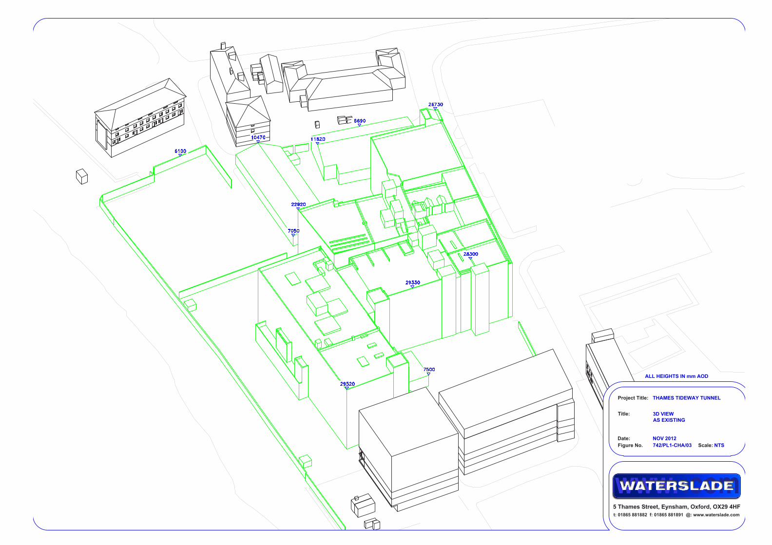
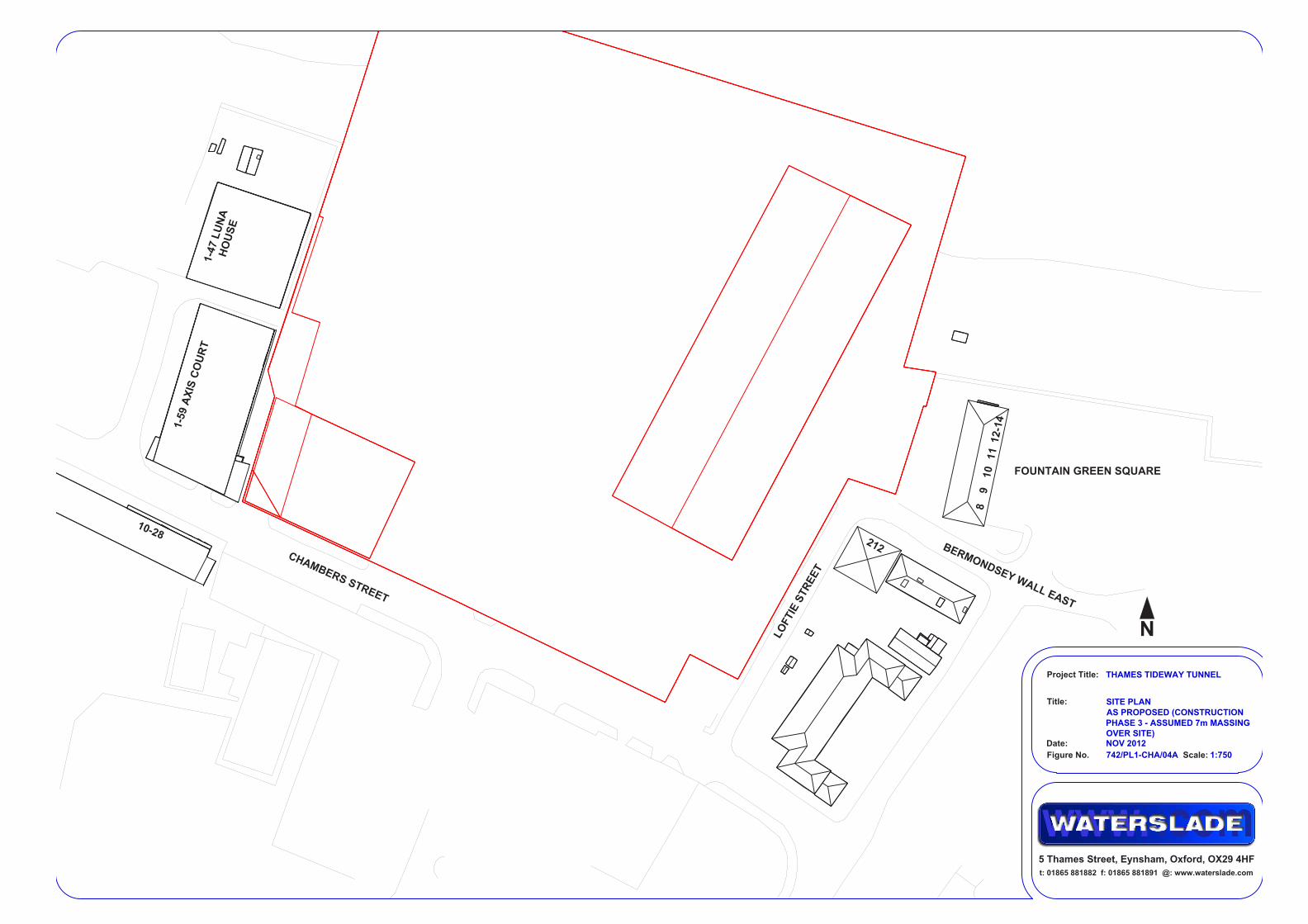
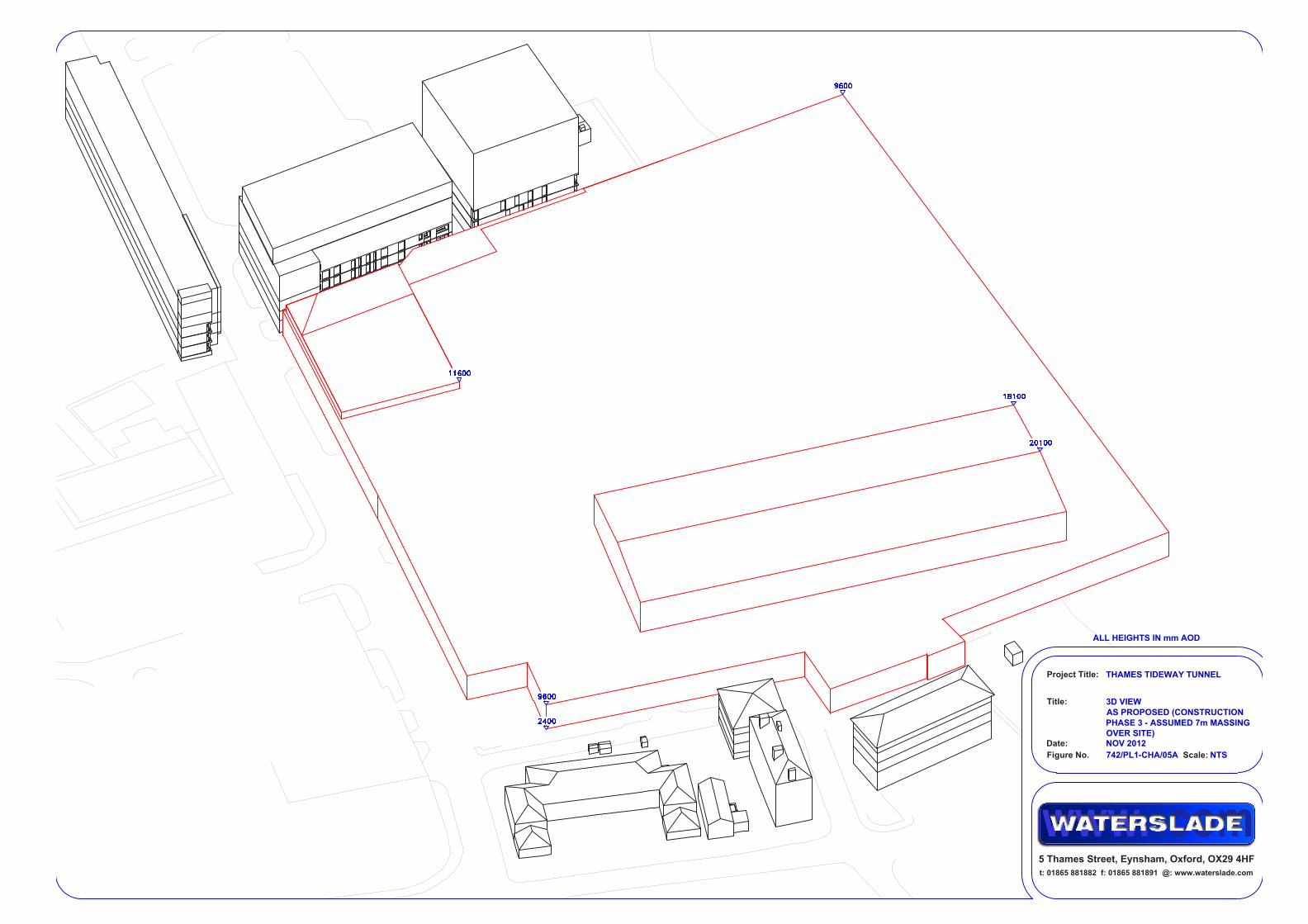
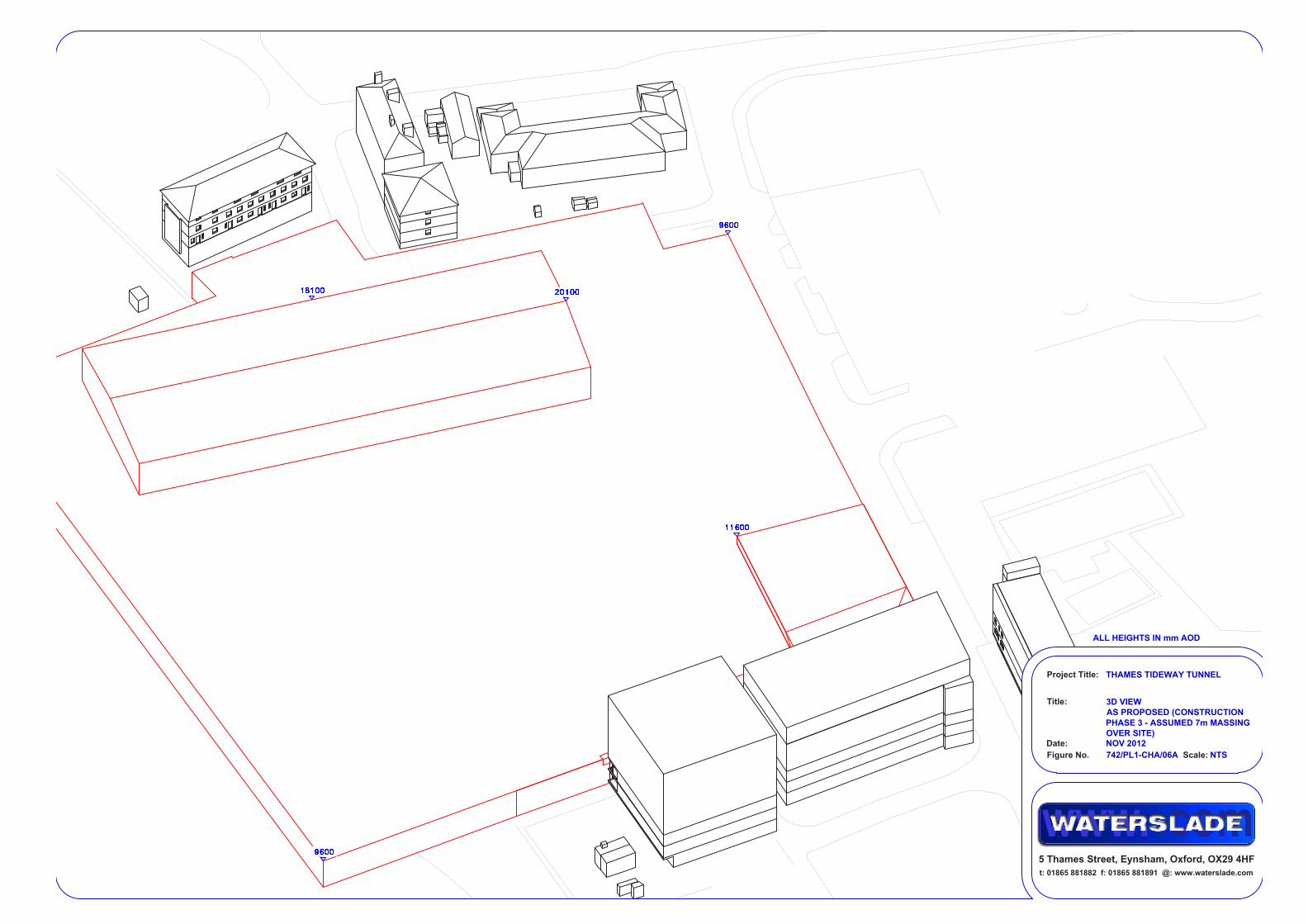
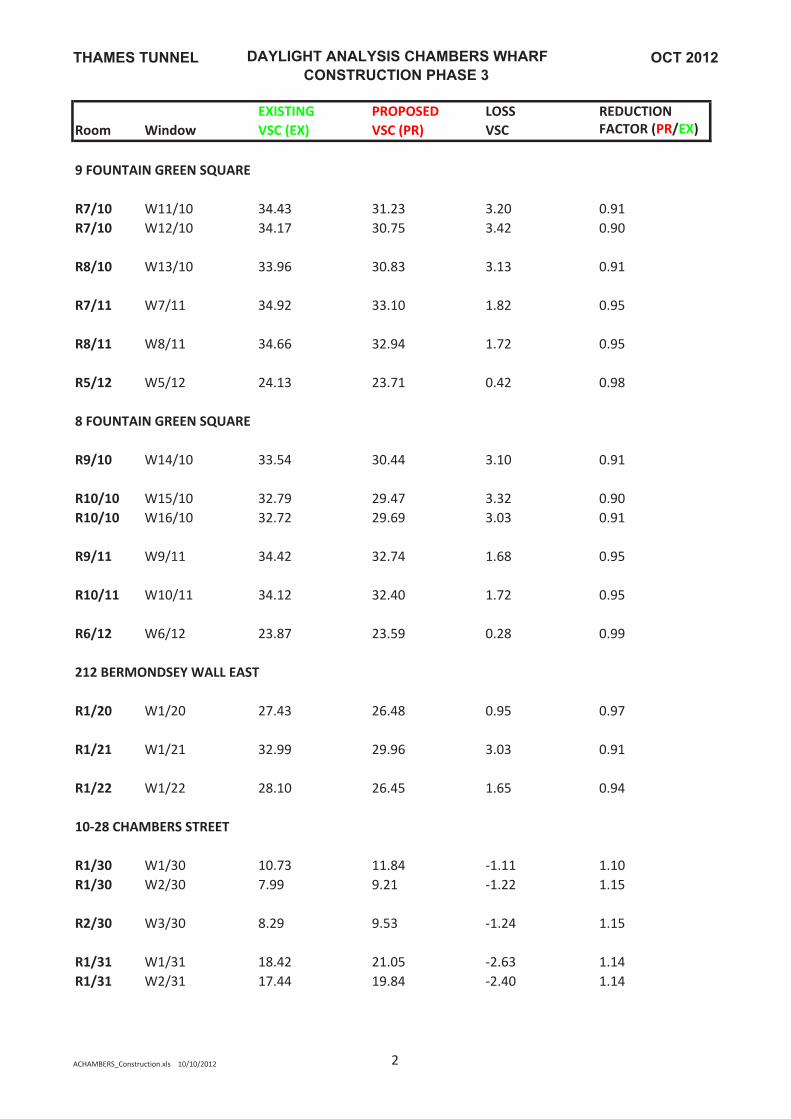
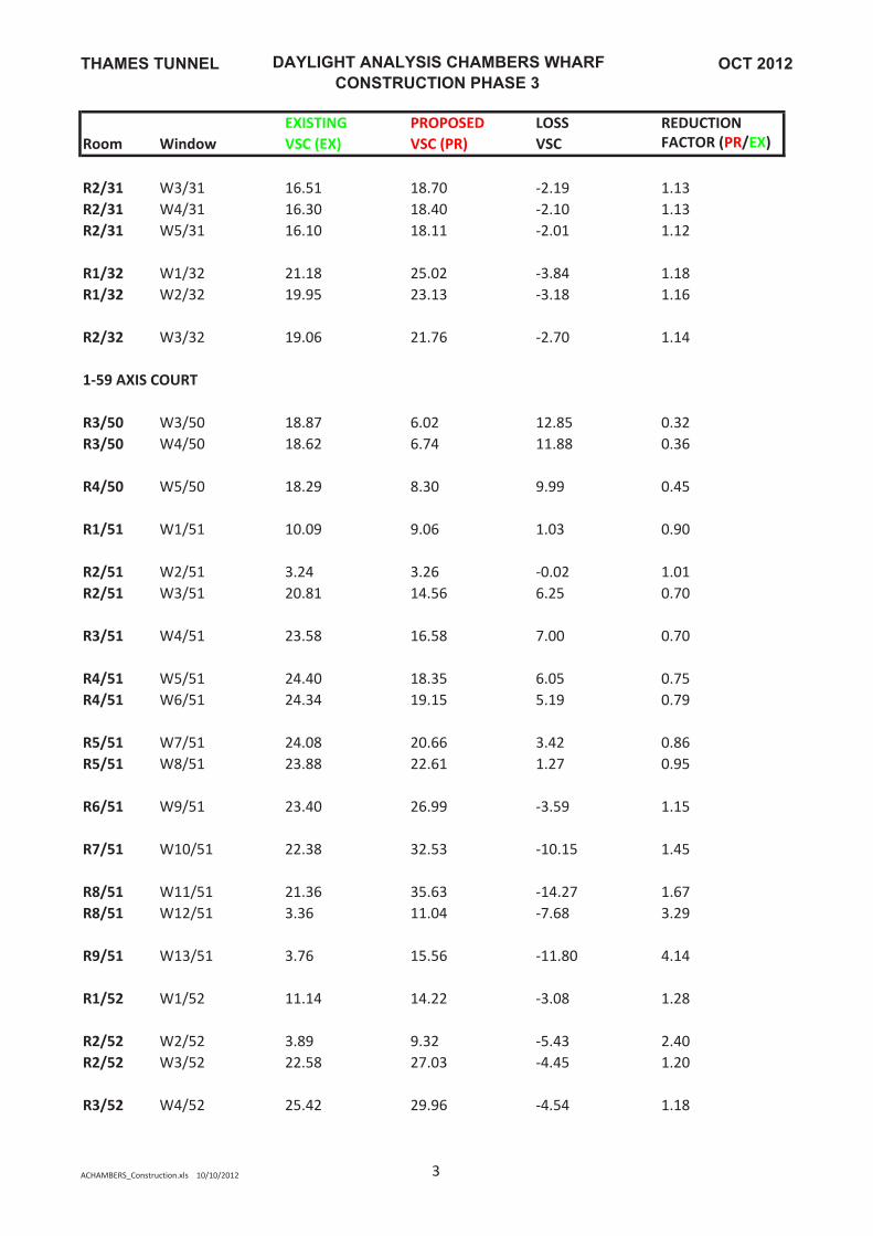
3.3 Chambers Wharf 3.3.1 The impact that construction phase 3 would have on 8 to 14 Fountain
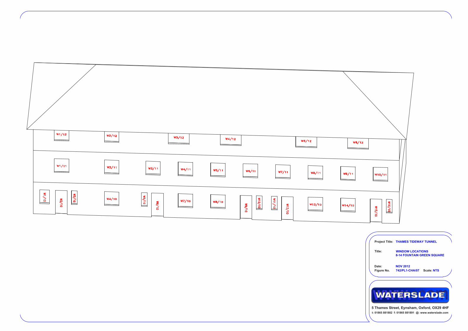
Green Square and 212 Bermondsey Wall East to the east of the site, 10 to 28 Chambers Street to the south west of the site, and 1 to 59 Axis Court and Luna House to the west of the site has been assessed. Of these properties only 1 to 59 Axis Court and Luna House have potentially impacted windows that face within 90 degrees of south. These are therefore the only properties that require consideration with regard to sunlight.
Daylight/Sunlight Assessment 19
3 Detailed assessment 3.3.2 At present the site lies predominantly vacant, but the former buildings on
the site have been demolished in recent years. It is therefore appropriate to use them as the existing baseline condition.
3.3.3 Figures 742/PL1-CHA/01-03 show the existing site, and figures 742/PL2-CHA/01-03 the construction massing that has been assessed.
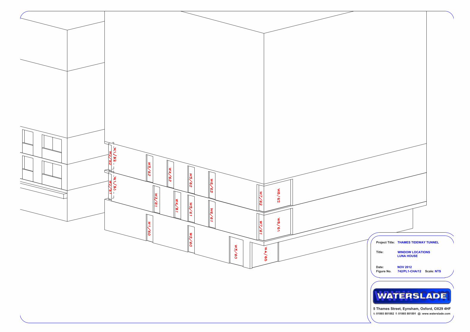
3.3.4 Each window in the surrounding properties to be assessed has been assigned a unique label; these are shown in figures 742/PL1-CHA/07-10 & 12.
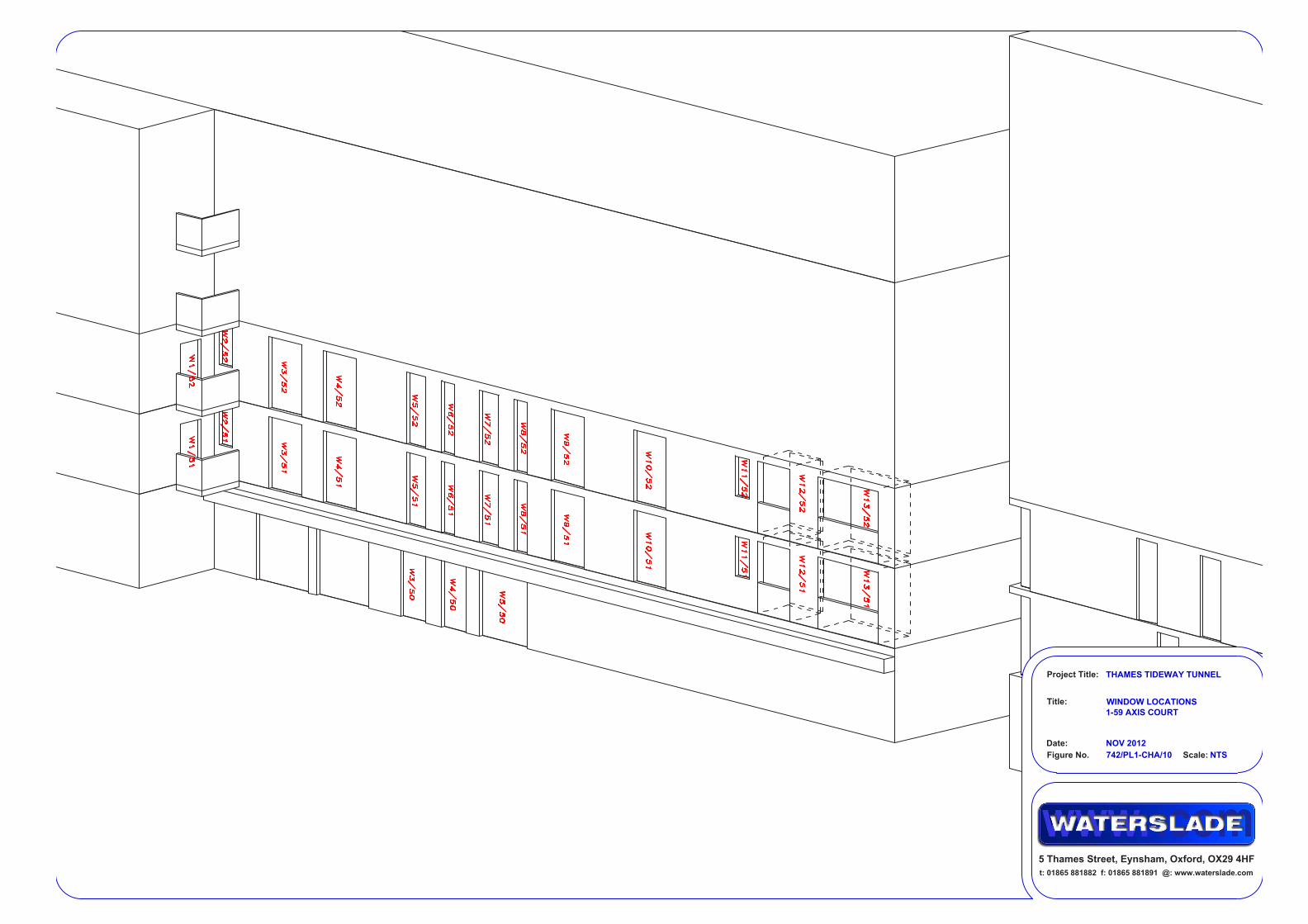
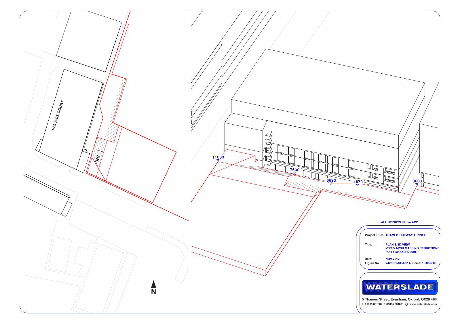
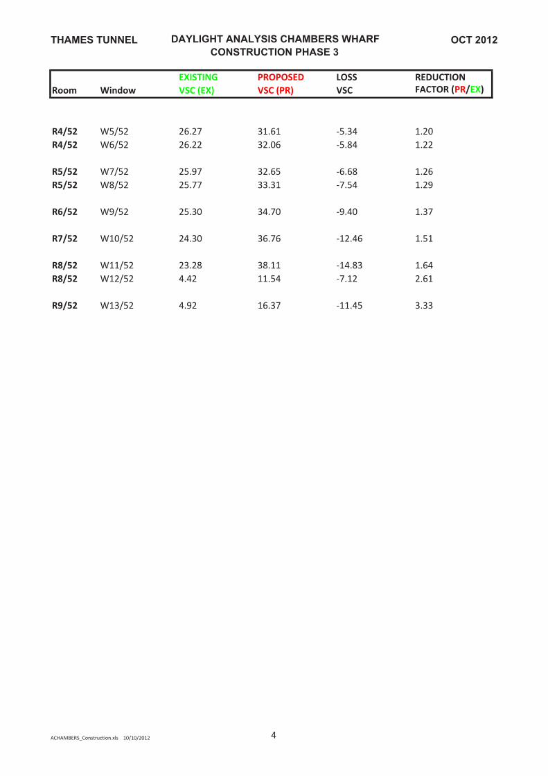
3.3.5 With reference to the table of results titled, ‘DAYLIGHT ANALYSIS CHAMBERS WHARF’ and ‘SUNLIGHT ANALYSIS CHAMBERS WHARF’ it is clear that the majority of windows very comfortably achieve the BRE VSC and APSH criteria. The only windows that do not achieve the guideline figures are located on the ground and first floor of 1 to 59 Axis Court, and the first floor of Lunar House (the ground floor of Luna house has not been assessed as it is not in residential use). The losses to the ground floor windows in 1 to 59 Axis Court are significant. A suggested alternative to reduce the massing in front of these windows is shown in Figure 742/PL1-CAR/11. It shows how the massing might to be reduced for full compliance with the BRE daylight and sunlight guidelines. If the noise mitigation is aligned to minimise light impacts this alternative would not be necessary.
3.3.6 The Code of Construction Practice Part B for Chambers Wharf contains the following requirement: “The site layout, hoarding and noise barriers on the west of the site shall be designed where practical to minimise potential sunlight/daylight impacts on the lower floors of Axis Court.”
3.4 Detailed assessment conclusions 3.4.1 In summary, the construction phases at both Carnwath Road Riverside
and Chambers Wharf would have localised impacts on the surrounding residential properties. The Code of construction practice includes requirements for contractors to consider these properties when finalising site layouts and to minimise sunlight daylight impacts.
Daylight/Sunlight Assessment 20
Glossary
Glossary
Term Description Above Ordnance Datum Ground elevation is measured relative to the mean sea
level at Newlyn in Cornwall, referred to as Ordnance Datum (OD), and heights are reported in metres above or below OD.
Above Tunnel Datum Above Tunnel Datum where Tunnel Datum is 100m below Ordnance Datum Newlyn: 100m ATD equals 0m AOD
acoustic enclosures An enclosed structure installed around plant or machinery to reduce or attenuate noise.
combined sewer overflow
A structure, or series of structures, that allows sewers that carry both rainwater and wastewater to overflow into a river when at capacity during periods of heavy rainfall. The flows are discharged in order to prevent the sewers backing up and flooding streets or houses. Flows may discharge by gravity or by pumping.
cranage Moving objects using a crane.
habitable spaces Living rooms, bedrooms and kitchens.
illuminance The total luminous flux incident on a surface, per unit area.
massing The assumed shape and volume of structures, buildings, hoardings and construction plant that would obstruct daylight and sunlight.
Perspex A transparent thermoplastic, often used as a lightweight or shatter-resistant alternative to glass.
Daylight/Sunlight Assessment 21

Glossary
This page is intentionally left blank
Daylight/Sunlight Assessment 22

Appendices
Appendices
Daylight/Sunlight Assessment 23

Appendices
This page is intentionally left blank
Daylight/Sunlight Assessment 24

Hard copy available in
Daylight/ Sunlight Assessment AppendicesDoc Ref: 7.24
Appendix AAPFP Regulations 2009: Regulation 5(2)(q)
Box 58 Folder A January 2013
Appe
ndix
A
Thames Tideway Tunnel Thames Water Utilities Limited
Application for Development ConsentApplication Reference Number: WWO10001

This page is intentionally blank

Appendices
Appendix A: Detailed assessment drawings and tables
Daylight/Sunlight Assessment 25

This page is intentionally blank
Project Title:
Title:
Figure No.
Date:
742/PL1-CAR/01 1:1000Scale:
SITE PLAN
AS EXISTING
OCT 2012
THAMES TIDEWAY TUNNEL
t: 01865 881882 f: 01865 881891 @: www.waterslade.com
5 Thames Street, Eynsham, Oxford, OX29 4HF
C
A
R
N
W
A
T
H
R
O
A
D
P
ip
e
r C
e
n
tre
89-101
5
81-87
P
H
I
L
P
O
T
S
Q
U
A
R
E
B
l
o
c
k
3
Project Title:
Title:
Figure No.
Date:
742/PL1-CAR/02 NTSScale:
3D VIEW
AS EXISTING
OCT 2012
THAMES TIDEWAY TUNNEL
t: 01865 881882 f: 01865 881891 @: www.waterslade.com
5 Thames Street, Eynsham, Oxford, OX29 4HF
ALL HEIGHTS IN mm AOD
Project Title:
Title:
Figure No.
Date:
742/PL1-CAR/03 NTSScale:
3D VIEW
AS EXISTING
OCT 2012
THAMES TIDEWAY TUNNEL
t: 01865 881882 f: 01865 881891 @: www.waterslade.com
5 Thames Street, Eynsham, Oxford, OX29 4HF
ALL HEIGHTS IN mm AOD
Project Title:
Title:
Figure No.
Date:
742/PL1-CAR/04 1:1000Scale:
SITE PLAN
AS PROPOSED (CONSTRUCTION
PHASE 2)
OCT 2012
THAMES TIDEWAY TUNNEL
t: 01865 881882 f: 01865 881891 @: www.waterslade.com
5 Thames Street, Eynsham, Oxford, OX29 4HF
C
A
R
N
W
A
T
H
R
O
A
D
P
ip
e
r C
e
n
tre
89-101
5
81-87
P
H
I
L
P
O
T
S
Q
U
A
R
E
B
l
o
c
k
3
Project Title:
Title:
Figure No.
Date:
742/PL1-CAR/05 NTSScale:
3D VIEW
AS PROPOSED (CONSTRUCTION
PHASE 2)
OCT 2012
THAMES TIDEWAY TUNNEL
t: 01865 881882 f: 01865 881891 @: www.waterslade.com
5 Thames Street, Eynsham, Oxford, OX29 4HF
ALL HEIGHTS IN mm AOD
Project Title:
Title:
Figure No.
Date:
742/PL1-CAR/06 NTSScale:
3D VIEW
AS PROPOSED (CONSTRUCTION
PHASE 2)
OCT 2012
THAMES TIDEWAY TUNNEL
t: 01865 881882 f: 01865 881891 @: www.waterslade.com
5 Thames Street, Eynsham, Oxford, OX29 4HF
ALL HEIGHTS IN mm AOD
Project Title:
Title:
Figure No.
Date:
742/PL1-CAR/07 NTSScale:
WINDOW LOCATIONS
5 CARNWATH ROAD &
89-91 CARNWATH ROAD
OCT 2012
THAMES TIDEWAY TUNNEL
t: 01865 881882 f: 01865 881891 @: www.waterslade.com
5 Thames Street, Eynsham, Oxford, OX29 4HF
5 CARNWATH ROAD89-91 CARNWATH ROAD
Project Title:
Title:
Figure No.
Date:
742/PL1-CAR/08 NTSScale:
PLAN & 3D VIEW
VSC & APSH MASSING REDUCTIONS
FOR 89-91 CARNWATH ROAD
OCT 2012
THAMES TIDEWAY TUNNEL
t: 01865 881882 f: 01865 881891 @: www.waterslade.com
5 Thames Street, Eynsham, Oxford, OX29 4HF
ALL HEIGHTS IN mm AOD
Project Title:
Title:
Figure No.
Date:
742/PL1-CAR/09 NTSScale:
PLAN & 3D VIEW
VSC & APSH MASSING ALTERATION
FOR 5 CARNWATH ROAD
OCT 2012
THAMES TIDEWAY TUNNEL
t: 01865 881882 f: 01865 881891 @: www.waterslade.com
5 Thames Street, Eynsham, Oxford, OX29 4HF
ALL HEIGHTS IN mm AOD
F
o
o
tp
rin
t o
f e
x
is
tin
g
b
u
ild
in
g

This page is intentionally left blank
OCT 2012THAMES TUNNEL
DAYLIGHT ANALYSIS CARNWATH ROAD
CONSTRUCTION PHASE 2
EXISTING PROPOSED LOSS REDUCTION
Room Window VSC (EX) VSC (PR) VSC FACTOR (PR/EX)
89‐101 CARNWATH ROAD
R1/10 W1/10 36.25 34.42 1.83 0.95
R1/10 W2/10 33.71 31.38 2.33 0.93
R1/10 W3/10 37.41 13.74 23.67 0.37
5 CARNWATH ROAD
R1/30 W1/30 26.72 25.99 0.73 0.97
R2/30 W2/30 14.72 9.59 5.13 0.65
R3/30 W3/30 18.89 8.89 10.00 0.47
R3/30 W4/30 32.73 27.14 5.59 0.83
R3/30 W5/30 33.32 29.54 3.78 0.89
R1/31 W1/31 29.84 31.45 ‐1.61 1.05
R2/31 W2/31 24.82 30.88 ‐6.06 1.24
R3/31 W3/31 28.96 30.41 ‐1.45 1.05
R3/31 W4/31 37.69 36.16 1.53 0.96
R3/31 W5/31 37.51 36.79 0.72 0.98
ACARNWATH_Construction.xls 10/10/2012 1
OCT 2012THAMES TUNNEL
SUNLIGHT ANALYSIS CARNWATH ROAD
CONSTRUCTION PHASE 2
EXISTING PROPOSED LOSS REDUCTION FACTOR
Room Window Summer Winter Total Summer Winter Total Total Winter Total
89‐101 CARNWATH ROAD
R1/10 W1/10 52 30 82 50 27 77 5 0.90 0.94
R1/10 W2/10 44 30 74 42 27 69 5 0.90 0.93
R1/10 W3/10 36 15 51 12 9 21 30 0.60 0.41
5 CARNWATH ROAD
R2/30 W2/30 21 11 32 13 5 18 14 0.45 0.56
R3/30 W3/30 26 14 40 13 4 17 23 0.29 0.43
R3/30 W4/30 48 22 70 41 13 54 16 0.59 0.77
R3/30 W5/30 47 22 69 46 17 63 6 0.77 0.91
R2/31 W2/31 30 16 46 39 19 58 ‐12 1.19 1.26
R3/31 W3/31 35 19 54 39 19 58 ‐4 1.00 1.07
R3/31 W4/31 50 26 76 50 26 76 0 1.00 1.00
R3/31 W5/31 50 27 77 50 27 77 0 1.00 1.00
SCARNWATH_Construction.xls 10/10/2012 1
BUTTERFIELDProject Title:
Title:
Figure No.
Date:
742/PL1-CHA/01 1:750Scale:
SITE PLAN
AS EXISTING
NOV 2012
THAMES TIDEWAY TUNNEL
t: 01865 881882 f: 01865 881891 @: www.waterslade.com
5 Thames Street, Eynsham, Oxford, OX29 4HF
C
H
A
M
B
E
R
S
S
T
R
E
E
T
1
-
5
9
A
X
I
S
C
O
U
R
T
B
E
R
M
O
N
D
S
E
Y
W
A
L
L
E
A
S
T
L
O
F
T
I
E
S
T
R
E
E
T
FOUNTAIN GREEN SQUARE
1
-
4
7
L
U
N
AH
O
U
S
E
2
1
2
1
0
-
2
8
8
9
1
0
1
1
1
2
-1
4
Project Title:
Title:
Figure No.
Date:
742/PL1-CHA/02 NTSScale:
3D VIEW
AS EXISTING
NOV 2012
THAMES TIDEWAY TUNNEL
t: 01865 881882 f: 01865 881891 @: www.waterslade.com
5 Thames Street, Eynsham, Oxford, OX29 4HF
ALL HEIGHTS IN mm AOD
Project Title:
Title:
Figure No.
Date:
742/PL1-CHA/03 NTSScale:
3D VIEW
AS EXISTING
NOV 2012
THAMES TIDEWAY TUNNEL
t: 01865 881882 f: 01865 881891 @: www.waterslade.com
5 Thames Street, Eynsham, Oxford, OX29 4HF
ALL HEIGHTS IN mm AOD
Project Title:
Title:
Figure No.
Date:
742/PL1-CHA/04A 1:750Scale:
SITE PLAN
AS PROPOSED (CONSTRUCTION
PHASE 3 - ASSUMED 7m MASSING
OVER SITE)
NOV 2012
THAMES TIDEWAY TUNNEL
t: 01865 881882 f: 01865 881891 @: www.waterslade.com
5 Thames Street, Eynsham, Oxford, OX29 4HF
C
H
A
M
B
E
R
S
S
T
R
E
E
T
1
-
5
9
A
X
I
S
C
O
U
R
T
B
E
R
M
O
N
D
S
E
Y
W
A
L
L
E
A
S
T
L
O
F
T
I
E
S
T
R
E
E
T
FOUNTAIN GREEN SQUARE
1
-
4
7
L
U
N
AH
O
U
S
E
2
1
2
1
0
-
2
8
8
9
1
0
1
1
1
2
-1
4
Project Title:
Title:
Figure No.
Date:
742/PL1-CHA/05A NTSScale:
3D VIEW
AS PROPOSED (CONSTRUCTION
PHASE 3 - ASSUMED 7m MASSING
OVER SITE)
NOV 2012
THAMES TIDEWAY TUNNEL
t: 01865 881882 f: 01865 881891 @: www.waterslade.com
5 Thames Street, Eynsham, Oxford, OX29 4HF
ALL HEIGHTS IN mm AOD
Project Title:
Title:
Figure No.
Date:
742/PL1-CHA/06A NTSScale:
3D VIEW
AS PROPOSED (CONSTRUCTION
PHASE 3 - ASSUMED 7m MASSING
OVER SITE)
NOV 2012
THAMES TIDEWAY TUNNEL
t: 01865 881882 f: 01865 881891 @: www.waterslade.com
5 Thames Street, Eynsham, Oxford, OX29 4HF
ALL HEIGHTS IN mm AOD
Project Title:
Title:
Figure No.
Date:
742/PL1-CHA/07 NTSScale:
WINDOW LOCATIONS
8-14 FOUNTAIN GREEN SQUARE
NOV 2012
THAMES TIDEWAY TUNNEL
t: 01865 881882 f: 01865 881891 @: www.waterslade.com
5 Thames Street, Eynsham, Oxford, OX29 4HF
Project Title:
Title:
Figure No.
Date:
742/PL1-CHA/08 NTSScale:
WINDOW LOCATIONS
212 BERMONDSEY WALL EAST
NOV 2012
THAMES TIDEWAY TUNNEL
t: 01865 881882 f: 01865 881891 @: www.waterslade.com
5 Thames Street, Eynsham, Oxford, OX29 4HF
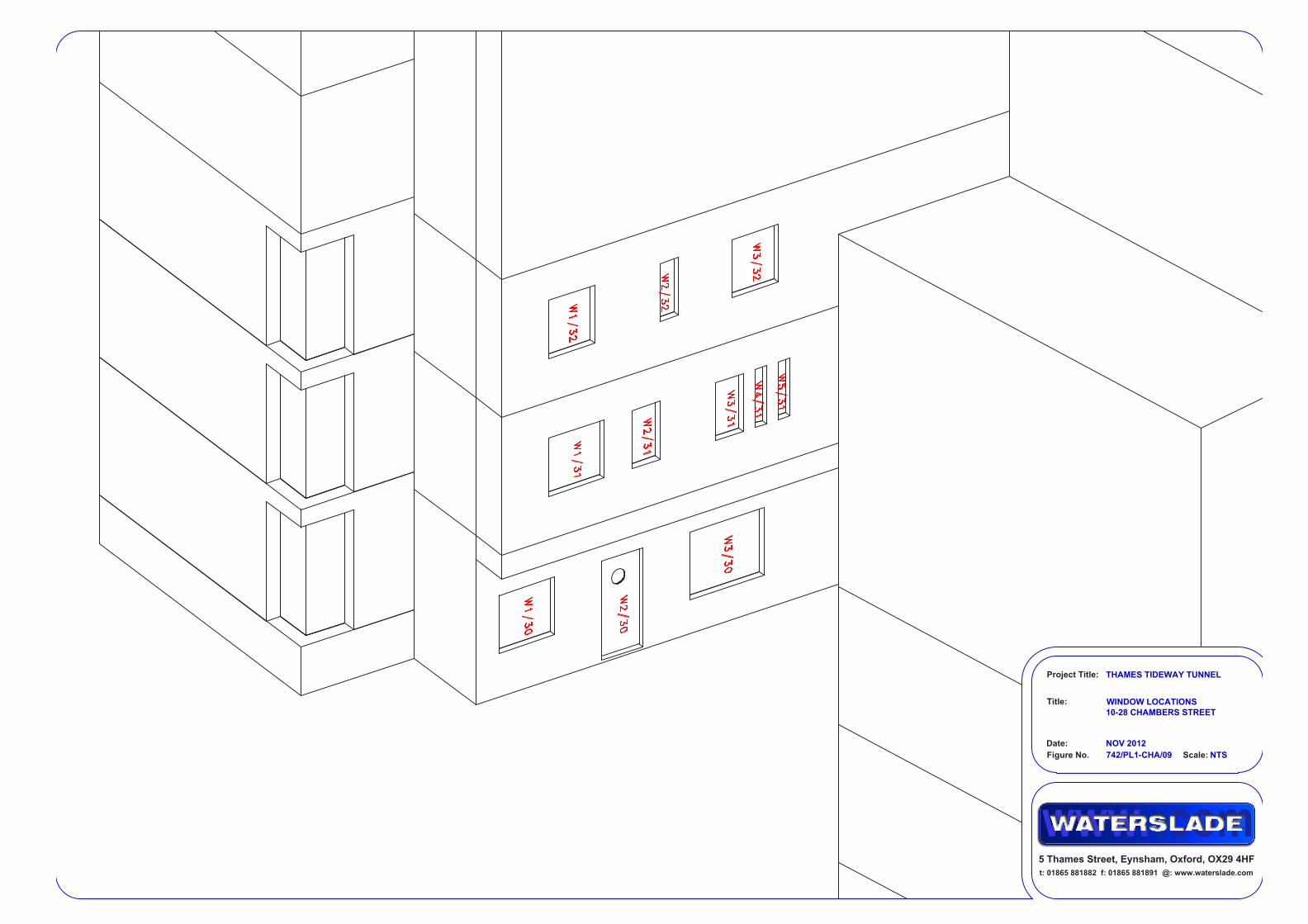
Project Title:
Title:
Figure No.
Date:
742/PL1-CHA/09 NTSScale:
WINDOW LOCATIONS
10-28 CHAMBERS STREET
NOV 2012
THAMES TIDEWAY TUNNEL
t: 01865 881882 f: 01865 881891 @: www.waterslade.com
5 Thames Street, Eynsham, Oxford, OX29 4HF
Project Title:
Title:
Figure No.
Date:
742/PL1-CHA/10 NTSScale:
WINDOW LOCATIONS
1-59 AXIS COURT
NOV 2012
THAMES TIDEWAY TUNNEL
t: 01865 881882 f: 01865 881891 @: www.waterslade.com
5 Thames Street, Eynsham, Oxford, OX29 4HF
Project Title:
Title:
Figure No.
Date:
742/PL1-CHA/11A 1:500/NTSScale:
PLAN & 3D VIEW
VSC & APSH MASSING REDUCTIONS
FOR 1-59 AXIS COURT
NOV 2012
THAMES TIDEWAY TUNNEL
t: 01865 881882 f: 01865 881891 @: www.waterslade.com
5 Thames Street, Eynsham, Oxford, OX29 4HF
ALL HEIGHTS IN mm AOD
1
-
5
9
A
X
I
S
C
O
U
R
T
Project Title:
Title:
Figure No.
Date:
742/PL1-CHA/12 NTSScale:
WINDOW LOCATIONS
LUNA HOUSE
NOV 2012
THAMES TIDEWAY TUNNEL
t: 01865 881882 f: 01865 881891 @: www.waterslade.com
5 Thames Street, Eynsham, Oxford, OX29 4HF

OCT 2012THAMES TUNNEL
DAYLIGHT ANALYSIS CHAMBERS WHARF
CONSTRUCTION PHASE 3
EXISTING PROPOSED LOSS REDUCTION
Room Window VSC (EX) VSC (PR) VSC FACTOR (PR/EX)
12‐14 FOUNTAIN GREEN SQUARE
R1/10 W1/10 35.92 30.86 5.06 0.86
R1/10 W2/10 35.74 30.51 5.23 0.85
R1/10 W3/10 35.77 30.93 4.84 0.86
R2/10 W4/10 35.60 30.98 4.62 0.87
R1/11 W1/11 36.01 32.97 3.04 0.92
R2/11 W2/11 35.82 33.00 2.82 0.92
R1/12 W1/12 24.75 23.25 1.50 0.94
R2/12 W2/12 24.68 23.34 1.34 0.95
11 FOUNTAIN GREEN SQUARE
R3/10 W5/10 35.36 31.05 4.31 0.88
R3/10 W6/10 35.23 30.72 4.51 0.87
R4/10 W7/10 35.11 31.16 3.95 0.89
R3/11 W3/11 35.64 33.12 2.52 0.93
R4/11 W4/11 35.46 33.16 2.30 0.94
R3/12 W3/12 24.54 23.53 1.01 0.96
10 FOUNTAIN GREEN SQUARE
R5/10 W8/10 34.89 31.23 3.66 0.90
R6/10 W9/10 34.59 30.93 3.66 0.89
R6/10 W10/10 34.57 31.32 3.25 0.91
R5/11 W5/11 35.31 33.18 2.13 0.94
R6/11 W6/11 35.11 33.17 1.94 0.94
R4/12 W4/12 24.35 23.63 0.72 0.97
ACHAMBERS_Construction.xls 10/10/2012 1
OCT 2012THAMES TUNNEL
DAYLIGHT ANALYSIS CHAMBERS WHARF
CONSTRUCTION PHASE 3
EXISTING PROPOSED LOSS REDUCTION
Room Window VSC (EX) VSC (PR) VSC FACTOR (PR/EX)
9 FOUNTAIN GREEN SQUARE
R7/10 W11/10 34.43 31.23 3.20 0.91
R7/10 W12/10 34.17 30.75 3.42 0.90
R8/10 W13/10 33.96 30.83 3.13 0.91
R7/11 W7/11 34.92 33.10 1.82 0.95
R8/11 W8/11 34.66 32.94 1.72 0.95
R5/12 W5/12 24.13 23.71 0.42 0.98
8 FOUNTAIN GREEN SQUARE
R9/10 W14/10 33.54 30.44 3.10 0.91
R10/10 W15/10 32.79 29.47 3.32 0.90
R10/10 W16/10 32.72 29.69 3.03 0.91
R9/11 W9/11 34.42 32.74 1.68 0.95
R10/11 W10/11 34.12 32.40 1.72 0.95
R6/12 W6/12 23.87 23.59 0.28 0.99
212 BERMONDSEY WALL EAST
R1/20 W1/20 27.43 26.48 0.95 0.97
R1/21 W1/21 32.99 29.96 3.03 0.91
R1/22 W1/22 28.10 26.45 1.65 0.94
10‐28 CHAMBERS STREET
R1/30 W1/30 10.73 11.84 ‐1.11 1.10
R1/30 W2/30 7.99 9.21 ‐1.22 1.15
R2/30 W3/30 8.29 9.53 ‐1.24 1.15
R1/31 W1/31 18.42 21.05 ‐2.63 1.14
R1/31 W2/31 17.44 19.84 ‐2.40 1.14
ACHAMBERS_Construction.xls 10/10/2012 2
OCT 2012THAMES TUNNEL
DAYLIGHT ANALYSIS CHAMBERS WHARF
CONSTRUCTION PHASE 3
EXISTING PROPOSED LOSS REDUCTION
Room Window VSC (EX) VSC (PR) VSC FACTOR (PR/EX)
R2/31 W3/31 16.51 18.70 ‐2.19 1.13
R2/31 W4/31 16.30 18.40 ‐2.10 1.13
R2/31 W5/31 16.10 18.11 ‐2.01 1.12
R1/32 W1/32 21.18 25.02 ‐3.84 1.18
R1/32 W2/32 19.95 23.13 ‐3.18 1.16
R2/32 W3/32 19.06 21.76 ‐2.70 1.14
1‐59 AXIS COURT
R3/50 W3/50 18.87 6.02 12.85 0.32
R3/50 W4/50 18.62 6.74 11.88 0.36
R4/50 W5/50 18.29 8.30 9.99 0.45
R1/51 W1/51 10.09 9.06 1.03 0.90
R2/51 W2/51 3.24 3.26 ‐0.02 1.01
R2/51 W3/51 20.81 14.56 6.25 0.70
R3/51 W4/51 23.58 16.58 7.00 0.70
R4/51 W5/51 24.40 18.35 6.05 0.75
R4/51 W6/51 24.34 19.15 5.19 0.79
R5/51 W7/51 24.08 20.66 3.42 0.86
R5/51 W8/51 23.88 22.61 1.27 0.95
R6/51 W9/51 23.40 26.99 ‐3.59 1.15
R7/51 W10/51 22.38 32.53 ‐10.15 1.45
R8/51 W11/51 21.36 35.63 ‐14.27 1.67
R8/51 W12/51 3.36 11.04 ‐7.68 3.29
R9/51 W13/51 3.76 15.56 ‐11.80 4.14
R1/52 W1/52 11.14 14.22 ‐3.08 1.28
R2/52 W2/52 3.89 9.32 ‐5.43 2.40
R2/52 W3/52 22.58 27.03 ‐4.45 1.20
R3/52 W4/52 25.42 29.96 ‐4.54 1.18
ACHAMBERS_Construction.xls 10/10/2012 3
OCT 2012THAMES TUNNEL
DAYLIGHT ANALYSIS CHAMBERS WHARF
CONSTRUCTION PHASE 3
EXISTING PROPOSED LOSS REDUCTION
Room Window VSC (EX) VSC (PR) VSC FACTOR (PR/EX)
R4/52 W5/52 26.27 31.61 ‐5.34 1.20
R4/52 W6/52 26.22 32.06 ‐5.84 1.22
R5/52 W7/52 25.97 32.65 ‐6.68 1.26
R5/52 W8/52 25.77 33.31 ‐7.54 1.29
R6/52 W9/52 25.30 34.70 ‐9.40 1.37
R7/52 W10/52 24.30 36.76 ‐12.46 1.51
R8/52 W11/52 23.28 38.11 ‐14.83 1.64
R8/52 W12/52 4.42 11.54 ‐7.12 2.61
R9/52 W13/52 4.92 16.37 ‐11.45 3.33
ACHAMBERS_Construction.xls 10/10/2012 4
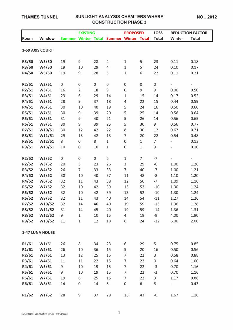
NOV 2012THAMES TUNNEL
SUNLIGHT ANALYSIS CHAMBERS WHARF
CONSTRUCTION PHASE 3
EXISTING PROPOSED LOSS REDUCTION FACTOR
Room Window RSummer Winter Total Summer Winter Total Total Winter Total
1‐59 AXIS COURT
R3/50 W3/50 19 9 28 4 1 5 23 0.11 0.18
R3/50 W4/50 19 10 29 4 1 5 24 0.10 0.17
R4/50 W5/50 19 9 28 5 1 6 22 0.11 0.21
R2/51 W2/51 0 0 0 0 0 0 0 ‐ ‐
R2/51 W3/51 16 2 18 9 0 9 9 0.00 0.50
R3/51 W4/51 23 6 29 14 1 15 14 0.17 0.52
R4/51 W5/51 28 9 37 18 4 22 15 0.44 0.59
R4/51 W6/51 30 10 40 19 5 24 16 0.50 0.60
R5/51 W7/51 30 9 39 20 5 25 14 0.56 0.64
R5/51 W8/51 31 9 40 21 5 26 14 0.56 0.65
R6/51 W9/51 30 9 39 25 5 30 9 0.56 0.77
R7/51 W10/51 30 12 42 22 8 30 12 0.67 0.71
R8/51 W11/51 29 13 42 13 7 20 22 0.54 0.48
R8/51 W12/51 8 0 8 1 0 1 7 ‐ 0.13
R9/51 W13/51 10 0 10 1 0 1 9 ‐ 0.10
R2/52 W2/52 0 0 0 6 1 7 ‐7 ‐ ‐
R2/52 W3/52 20 3 23 26 3 29 ‐6 1.00 1.26
R3/52 W4/52 26 7 33 33 7 40 ‐7 1.00 1.21
R4/52 W5/52 30 10 40 37 11 48 ‐8 1.10 1.20
R4/52 W6/52 32 11 43 38 12 50 ‐7 1.09 1.16
R5/52 W7/52 32 10 42 39 13 52 ‐10 1.30 1.24
R5/52 W8/52 32 10 42 39 13 52 ‐10 1.30 1.24
R6/52 W9/52 32 11 43 40 14 54 ‐11 1.27 1.26
R7/52 W10/52 32 14 46 40 19 59 ‐13 1.36 1.28
R8/52 W11/52 31 14 45 40 19 59 ‐14 1.36 1.31
R8/52 W12/52 9 1 10 15 4 19 ‐9 4.00 1.90
R9/52 W13/52 11 1 12 18 6 24 ‐12 6.00 2.00
1‐47 LUNA HOUSE
R1/61 W1/61 26 8 34 23 6 29 5 0.75 0.85
R1/61 W2/61 26 10 36 15 5 20 16 0.50 0.56
R2/61 W3/61 13 12 25 15 7 22 3 0.58 0.88
R3/61 W4/61 11 11 22 15 7 22 0 0.64 1.00
R4/61 W5/61 9 10 19 15 7 22 ‐3 0.70 1.16
R5/61 W6/61 9 10 19 15 7 22 ‐3 0.70 1.16
R6/61 W7/61 19 6 25 15 7 22 3 1.17 0.88
R6/61 W8/61 14 0 14 6 0 6 8 ‐ 0.43
R1/62 W1/62 28 9 37 28 15 43 ‐6 1.67 1.16
SCHAMBERS_Construction_7m.xls 08/11/2012 1
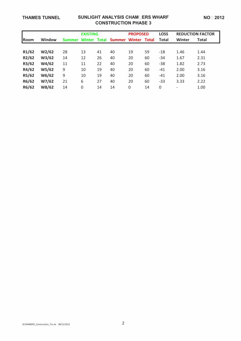
NOV 2012THAMES TUNNEL
SUNLIGHT ANALYSIS CHAMBERS WHARF
CONSTRUCTION PHASE 3
EXISTING PROPOSED LOSS REDUCTION FACTOR
Room Window RSummer Winter Total Summer Winter Total Total Winter Total
R1/62 W2/62 28 13 41 40 19 59 ‐18 1.46 1.44
R2/62 W3/62 14 12 26 40 20 60 ‐34 1.67 2.31
R3/62 W4/62 11 11 22 40 20 60 ‐38 1.82 2.73
R4/62 W5/62 9 10 19 40 20 60 ‐41 2.00 3.16
R5/62 W6/62 9 10 19 40 20 60 ‐41 2.00 3.16
R6/62 W7/62 21 6 27 40 20 60 ‐33 3.33 2.22
R6/62 W8/62 14 0 14 14 0 14 0 ‐ 1.00
SCHAMBERS_Construction_7m.xls 08/11/2012 2

This page is intentionally blank

Copyright notice Copyright © Thames Water Utilities Limited January 2013. All rights reserved. Any plans, drawings, designs and materials (materials) submitted by Thames Water Utilities Limited (Thames Water) as part of this application for Development Consent to the Planning Inspectorate are protected by copyright. You may only use this material (including making copies of it) in order to (a) inspect those plans, drawings, designs and materials at a more convenient time or place; or (b) to facilitate the exercise of a right to participate in the pre-examination or examination stages of the application which is available under the Planning Act 2008 and related regulations. Use for any other purpose is prohibited and further copies must not be made without the prior written consent of Thames Water. Thames Water Utilities LimitedClearwater Court, Vastern Road, Reading RG1 8DB The Thames Water logo and Thames Tideway Tunnel logo are © Thames Water Utilities Limited. All rights reserved. DCO-DT-000-ZZZZZ-072400