assets & services committee meeting
TRANSCRIPT

Assets & Services Committee Meeting
12 November 2020
This Report relates to Item 13 in the Agenda
“Middle Renwick Road Report”


Middle Renwick Road, Blenheim Proposed cycle facilities
Report prepared for
Marlborough District Council and Marlborough Roads
October 2020
Tra
nsp
ort
Pla
nnin
g a
nd D
esi
gn
Level 1, 284 K
ilmore
Str
eet
ww
w.v
iast
rada.n
z

This document has been prepared for the benefit of Marlborough District Council and Marlborough Roads. No liability is accepted by ViaStrada Ltd, or any of its employees or sub-consultants with respect to its use by any other party.
Quality Assurance Statement
ViaStrada Ltd Level 1, 284 Kilmore Street PO Box 22 458 Christchurch 8140 New Zealand Phone: (03) 366-7605 www.viastrada.nz [email protected]
Project manager: Warren Lloyd Director – Senior Transportation Engineer 027 292 9830 [email protected]
Prepared by: Gemma Dioni, MSc, BSc Senior Transportation Engineer 021 400 599 [email protected]
Reviewed by: Warren Lloyd Director – Senior Transportation Engineer 027 292 9830 [email protected]
Project number:
Project name:
1124-10
Middle Renwick Road, Blenheim
Document version Date
V05 (not issued – edits discussed with BP)
Final report V04 6/10/20206/10/2020
Third draft V03 (for client review) 10/09/2020
Second draft V02 (for client review) 20/08/2020
First draft V01 (for client review) 3/08/20203/08/2020

Middle Renwick Road, Blenheim – Proposed cycle facilities
Project 1124-10 i
Table of Contents
1 Introduction .......................................................................................................................................... 1
ViaStrada project team .............................................................................................................. 1 1.1
Report format ............................................................................................................................ 1 1.2
2 Existing conditions and future demands ............................................................................................... 2
Current context .......................................................................................................................... 2 2.1
Pedestrian facilities and demands ............................................................................................. 3 2.2
Cycle facilities and demand ....................................................................................................... 4 2.3
Public transport & School buses ................................................................................................ 5 2.4
General traffic demand .............................................................................................................. 5 2.5
Traffic speeds ............................................................................................................................. 6 2.6
Parking ....................................................................................................................................... 6 2.7
Existing street trees ................................................................................................................... 8 2.8
3 Crash data and risk ................................................................................................................................ 8
Risk Ratings ................................................................................................................................ 8 3.1
Crash data .................................................................................................................................. 9 3.2
Near miss data ......................................................................................................................... 10 3.3
4 Strategic Context ................................................................................................................................. 11
5 Target user .......................................................................................................................................... 11
Enthused and confident ........................................................................................................... 11 5.1
Interested but concerned ........................................................................................................ 11 5.2
6 Stakeholder Engagement .................................................................................................................... 12
7 Project outcomes ................................................................................................................................ 12
8 Buffered cycle lanes ............................................................................................................................ 13
9 Option development ........................................................................................................................... 14
Option 1 ................................................................................................................................... 14 9.1.1
Option 2 ................................................................................................................................... 14 9.1.2
Option 3 ................................................................................................................................... 14 9.1.3
10 Multi-criteria analysis .......................................................................................................................... 15
11 Preferred Option ................................................................................................................................. 17
Parking ..................................................................................................................................... 18 11.1
Street trees to be removed...................................................................................................... 19 11.2
Proposed layout ....................................................................................................................... 20 11.3
Proposed cross-sections .......................................................................................................... 22 11.4

Middle Renwick Road, Blenheim – Proposed cycle facilities
ii Marlborough District Council and Marlborough Roads
Next Steps ................................................................................................................................ 23 11.5
Safety audits ............................................................................................................................ 23 11.5.1
Public consultation................................................................................................................... 23 11.5.2
12 Services and rough order costs ........................................................................................................... 23
13 Additional project considerations ....................................................................................................... 24
14 Appendices .......................................................................................................................................... 24
PAK’n SAVE / Kmart access for people travelling on foot and by bike ........................................................... 61
Shared path link to Murphys Road ................................................................................................................. 62
Off road cycle options at roundabout............................................................................................................. 62
List of Appendices
Traffic Volumes from Waka Kotahi ........................................................................................... 25 Appendix A
Parking ...................................................................................................................................... 26 Appendix B
B.1 Weekday parking - Zone 1 ....................................................................................................... 26
B.2 Weekday parking - Zone 2 ....................................................................................................... 27
B.3 Weekday parking Zone 3 ......................................................................................................... 28
B.4 Weekend parking All Zones ..................................................................................................... 29
B.5 Weekday parking raw data ...................................................................................................... 30
B.6 Weekend parking raw data ...................................................................................................... 31
B.7 Photos of illegal parking and advertising activity .................................................................... 32
CAS crash data .......................................................................................................................... 33 Appendix C
C.1 Vulnerable user crashes ........................................................................................................... 33
C.2 Battys / Murphys roundabout all road users’ crashes ............................................................. 34
C.3 All road user crash data for the balance of the route ............................................................. 35
C.4 Near miss crashes .................................................................................................................... 36
Strategic context ....................................................................................................................... 37 Appendix D
D.1 Government Policy Statement on Land Transport 2018–28 ................................................... 37
D.2 Road to Zero: A New Road Safety Strategy for NZ (2019) ....................................................... 38
D.3 Regional Land Transport Plan 2015–2021 ............................................................................... 39
D.4 Marlborough District Council Walking and Cycling Strategy 2019-29 ..................................... 39
Buffered Cycle lanes ................................................................................................................. 41 Appendix E
E.1 Introduction ............................................................................................................................. 41
E.2 Buffered cycle lane design ....................................................................................................... 41

Middle Renwick Road, Blenheim – Proposed cycle facilities
Project 1124-10 iii
E.2.1 Parking side buffer configuration ............................................................................................ 41
E.2.2 Traffic adjacent buffer configuration ....................................................................................... 43
E.3 Design parameters ................................................................................................................... 43
E.3.1 Buffered cycle lanes, establishing parking ............................................................................... 44
E.3.2 Instructions for use .................................................................................................................. 45
E.3.3 Calculate element widths ........................................................................................................ 45
E.3.4 Re-distribute width if necessary .............................................................................................. 45
E.3.5 Tips for finding space ............................................................................................................... 45
Option Development ................................................................................................................ 49 Appendix F
Multi Criteria Analysis ............................................................................................................... 52 Appendix G
Preferred Option 2 Plans .......................................................................................................... 54 Appendix H
Services ..................................................................................................................................... 58 Appendix I
Rough Order Cost Estimate ...................................................................................................... 59 Appendix J
Additional Project Considerations ............................................................................................ 61 Appendix K


Middle Renwick Road, Blenheim – Proposed cycle facilities
1
1 Introduction
ViaStrada has been engaged by Marlborough District Council and Marlborough Roads to consider options for implementing cycle facilities on Middle Renwick Road from Westwood Avenue to the Battys Road/Murphys Road roundabout (inclusive of these intersections), in the Springlands area of Blenheim, as shown in Figure 1-1.
Figure 1-1: Middle Renwick Road study area (source: www.openstreetmap.org)
There are currently on-road cycle lanes marked on the carriageway on Middle Renwick Road to the east of Battys Road and at the Westwood Ave roundabout.
Middle Renwick Road forms part of the State Highway (SH6) network managed by Waka Kotahi NZ Transport Agency providing a connecting to SH1 (Picton and Christchurch to the east) and Havelock and the west coast to the west.
ViaStrada project team 1.1
The ViaStrada staff involved on this project:
Warren Lloyd, project leader and technical lead
Gemma Dioni; technical and report writing assistant
Jon Ashford; data analysis and scheme design.
Report format 1.2
The report considers strategic alignment, the existing network conditions and demands, the existing crash risk and trends within the crash data, and a review of the accuracy and relevance of data used.
Describes the background context and data related to the existing area
Describes the proposed options for the area when considered from a holistic approach; and
Assess the various options and make recommendations for a preferred option.

Middle Renwick Road, Blenheim – Proposed cycle facilities
2 Marlborough District Council and Marlborough Roads
2 Existing conditions and future demands
Current context 2.1
It is predominantly residential land use fronting Middle Renwick Road (SH6) in the study area as shown in Figure 2-1 . There are motels and a petrol station also along this route. At the western end, Middle Renwick Road, it is mainly newly developed large format retail, with additional land in this area zoned for future development. There are larger high schools to the east, in addition to local shops on the south side of Middle Renwick Road. There are likely to be residents in this area making local trips to and from the shops, schools and into central Blenheim, which is located to the southeast.
Figure 2-1: Land-use and property zoning along Middle Renwick Road (Source: Marlborough District Council)

Middle Renwick Road, Blenheim – Proposed cycle facilities
3
Pedestrian facilities and demands 2.2
Walking is a healthy and affordable choice of transport. Safe, attractive and connected walking facilities will make walking an even more inviting choice. Connectivity to local shops, education, parks, and medical services within a neighbourhood means that the community has the option to travel on foot locally and reduce the need for motorised vehicles trips and reduce the need to make longer distance trips.
Figure 2-2: Pedestrian crossings on Middle Renwick Road
The local pedestrian network generally provides good access around the community, with the main road and local streets having footpaths on both sides. There are some crossing points provided relatively close to the roundabout intersections and there is one mid-block pedestrian island close to the western end. The crossings on the south and east approaches are well back from the intersection and most pedestrians are likely to cross on their desire line without the assistance of a formal crossing facility. There are no crossing facilities between Rose Street and Battys Road as shown in Figure 2-2.

Middle Renwick Road, Blenheim – Proposed cycle facilities
4 Marlborough District Council and Marlborough Roads
Cycle facilities and demand 2.3
Figure 2-3 shows an extract from the Marlborough District Council GIS page that illustrates the cycle network in this area of Blenheim.
This shows that there are gaps in the network along Middle Renwick Road. On-road cycle lanes are provided to the east of Battys Road, and there are some on and off-road facilities at the new SH6/Westwood Avenue roundabout. There are off-road facilities through some reserves and to the southeast is the Taylor River Reserve and Shared Pathway. The off-road paths are shown as blue and yellow dashed lines in Figure 2-3.
Figure 2-3: Cycle facilities within and around Middle Renwick Road (Source: Marlborough District Council)
There is limited cycle count data available1. In this case the Strava heatmap can be used to highlight the more popular routes. Figure 2-4 shows that, within the area, Middle Renwick Road, and Battys Road are well used cycle routes.
Figure 2-4: Cycle usage on different streets (Source: Strava)
Adams Lane and the Taylor River Reserve shared paths are shown to be well used routes and therefore, connections to these routes should be considered.
1 Cycle counts were completed between 14 Nov - 8 Dec 2019, and show an average daily count of 26 cyclists,
with a peak of 46 cyclists in one day. The count site suggests that these are cyclists leaving Blenheim, heading towards Woodbourne and Renwick.

Middle Renwick Road, Blenheim – Proposed cycle facilities
5
Public transport & School buses 2.4
For people wanting to travel by public transport to the Springlands area, there are two routes that use Middle Renwick Road.
Figure 2-5: Public transport routes using Middle Renwick Road (Source: Marlborough District Council)
Whilst on-road cyclists would be sharing the carriageway with buses, there are no bus stops in this section of Middle Renwick Road.
General traffic demand 2.5
Middle Renwick Road is part of the State Highway Network and as such is classified as a regional route (SH1 is a national route). It is a two-lane road with a flush median and parking lanes (total carriageway width varies but is approximately 13.5 m).
Figure 2-6: One Network Road Classification
There are three side roads that connect onto Middle Renwick Road, all of which are classified as access roads. Westwood Avenue at the western end is unclassified and maybe a private road servicing the new development only, until any future connections are made. At the eastern end Battys Road and Murphys Road which connect at the roundabout are classified as arterial (Battys) and primary collector (Murphys).
There is permanent traffic counter located on SH6 at the Springlands Shopping Centre. Although not directly on Middle Renwick Road, the flow profile is considered applicable. The data provided by Waka Kotahi shows that in general SH6 carries an average of 15,000 vehicles per day (VPD). There are peak volumes occurring in April with the wine harvest and a summer build up to Christmas, starting in November.
This can be seen on the day rolling average chart, provided in Appendix A.
April around 16,000 VPD
November to Christmas around 16,000 - 18,000 VPD
Middle Renwick Road, Blenheim – Proposed cycle facilities
6 Marlborough District Council and Marlborough Roads
There is around 9-10% Heavy Goods Vehicles (HGV’s) on this route. Data extracted from the One Network Road Classification and Mobile Roads shows that side roads such as Murphys Road and Battys Road carry around 3,000 VPD with 6% of the traffic comprising heavy goods vehicles.
In summary, Middle Renwick Road is an arterial road that carries higher volumes of traffic with a large proportion of HGV’s, it is a bus route and a well-used cycle route.
Traffic speeds 2.6
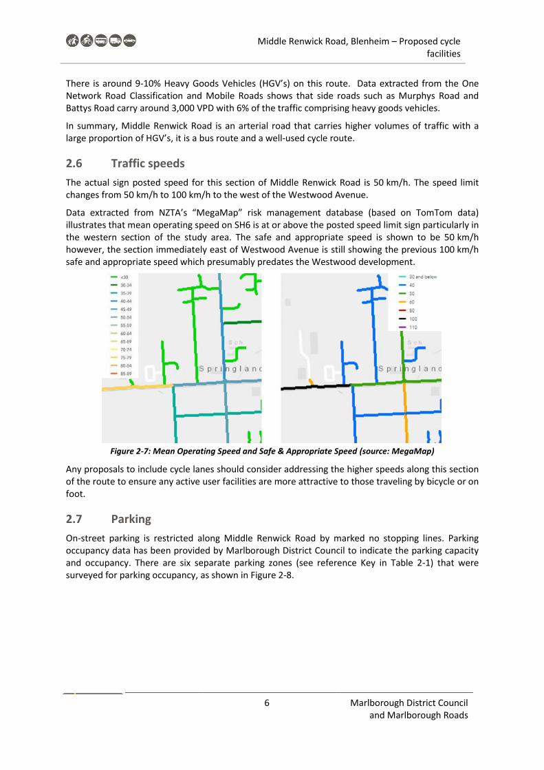
The actual sign posted speed for this section of Middle Renwick Road is 50 km/h. The speed limit changes from 50 km/h to 100 km/h to the west of the Westwood Avenue.
Data extracted from NZTA’s “MegaMap” risk management database (based on TomTom data) illustrates that mean operating speed on SH6 is at or above the posted speed limit sign particularly in the western section of the study area. The safe and appropriate speed is shown to be 50 km/h however, the section immediately east of Westwood Avenue is still showing the previous 100 km/h safe and appropriate speed which presumably predates the Westwood development.
Figure 2-7: Mean Operating Speed and Safe & Appropriate Speed (source: MegaMap)
Any proposals to include cycle lanes should consider addressing the higher speeds along this section of the route to ensure any active user facilities are more attractive to those traveling by bicycle or on foot.
Parking 2.7
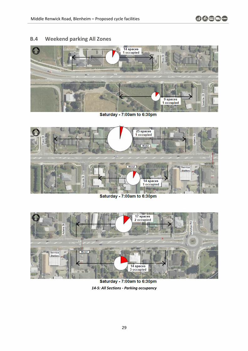
On-street parking is restricted along Middle Renwick Road by marked no stopping lines. Parking occupancy data has been provided by Marlborough District Council to indicate the parking capacity and occupancy. There are six separate parking zones (see reference Key in Table 2-1) that were surveyed for parking occupancy, as shown in Figure 2-8.

Middle Renwick Road, Blenheim – Proposed cycle facilities
7
Figure 2-8: Parking survey zone locations
A weekday survey between 7:00 am to 7:00 pm (12 hours) on 24th June 2020 captured the parking demand. As shown in Table 2-1 the weekday demand is low with only 8 vehicles recorded in the 56 spaces available on the northside and 37 spaces available on the south side.
A weekend survey between 7:00 am to 7:00 pm (12 hours) on 11th July 2020 also showed that parking demands from Westwood Avenue to Battys Road roundabout are overall low with 8 vehicles also recorded in the 93 spaces available.
This survey indicates the parking capacity for at least 8 vehicles is required to accommodate the expected parking demand.
Table 2-1: Parking occupancy results
Weekday Weekend
Street Key Side From To Capacity Highest
Occupancy Max. %
Occupied Highest
Occupancy Max. %
Occupied
Mid
dle
Ren
wic
k R
oad
(SH
6)
15
No
rth
sid
e
Murphys Adams 17 5 29.4% 2 11.8%
17 Adams Rose 25 2 8.0% 1 8.0%
19 Rose Westwood 14 1 7.1% 1 7.1%
8
Sou
th s
ide
Battys Opposite Adams
14 4 28.6% 3 21.4%
10 Opposite Adams
Severne 14 2 14.3% 1 7.1%
12 Severne Westwood Ave
9 2 22.2% 1 11.1%
Diagrams of parking capacity and occupancy can be found in Appendix B along with the raw data used to inform Table 2-1.
Also noted and recorded during the parking survey, cars were parked on the side of the road that were for sale and there was a trailer continuously parked for advertising overseas cruises. These activities are not permitted on State Highways and providing indented parking is not considered desirable to accommodate it. This is the reason that no indented carparking will be provided towards Westwood Avenue. Photos of vehicles for sale and advertising trailers can be seen in Appendix B, refer B.7.

Middle Renwick Road, Blenheim – Proposed cycle facilities
8 Marlborough District Council and Marlborough Roads
Existing street trees 2.8
There are cherry trees (Prunus sp. And Prunus Kanzan) planted along the sides of Middle Renwick Road, see Figure 2-9. These trees provide aesthetic relief along the route, where there is no street front tree planting in the residential or reserve properties.
Figure 2-9: Cherry trees along Middle Renwick Road
3 Crash data and risk
Risk Ratings 3.1
MegaMap provides several different comparative risk assessments of road sections throughout New Zealand, based on crash data, traffic volumes, road features, and other attributes.
Figure 3-1: Collective Risk (Source: MegaMap)
Collective Risk is a measure of the total estimated DSI casualty equivalents per km for a road segment. It is effectively a measure of the number of deaths and serious injuries per km that can be expected on a road segment over the next five years. MegaMap does not identify any section on the

Middle Renwick Road, Blenheim – Proposed cycle facilities
9
corridor in the study area that have a “high” collective risk in terms of safety as shown in Figure 3-1. The section that has the highest risk (medium) is from Severne Street to the Westwood Avenue roundabout and beyond.
Figure 3-2: Personal risk (Source: MegaMap)
Personal Risk is a measure of the risk of an individual dying or being seriously injured on a road corridor. It is calculated by dividing Collective Risk by traffic volume exposure. The whole section of Middle Renwick Road is identified with a Low-Medium personal risk, see Figure 3-2.
Another MegaMap risk assessment tool is the Infrastructure Risk Rating (IRR) which includes, land use, road stereotype, alignment, AADT, Intersection density, lane and shoulder width, roadside hazards and access density. The IRR adopts a (5) band risk rating and Middle Renwick Road is rated Low-Medium, see Figure 3-3
Figure 3-3: Infrastructure Risk Rating IRR (Source: MegaMap)
Crash data 3.2
All reported crashes along the Middle Renwick Road section were retrieved from NZTA’s Crash Analysis System (CAS) for the five full years from 2015 to 2019 as shown in Figure 3-4. There were no pedestrian crashes recorded along the subject route.
Middle Renwick Road, Blenheim – Proposed cycle facilities
10 Marlborough District Council and Marlborough Roads
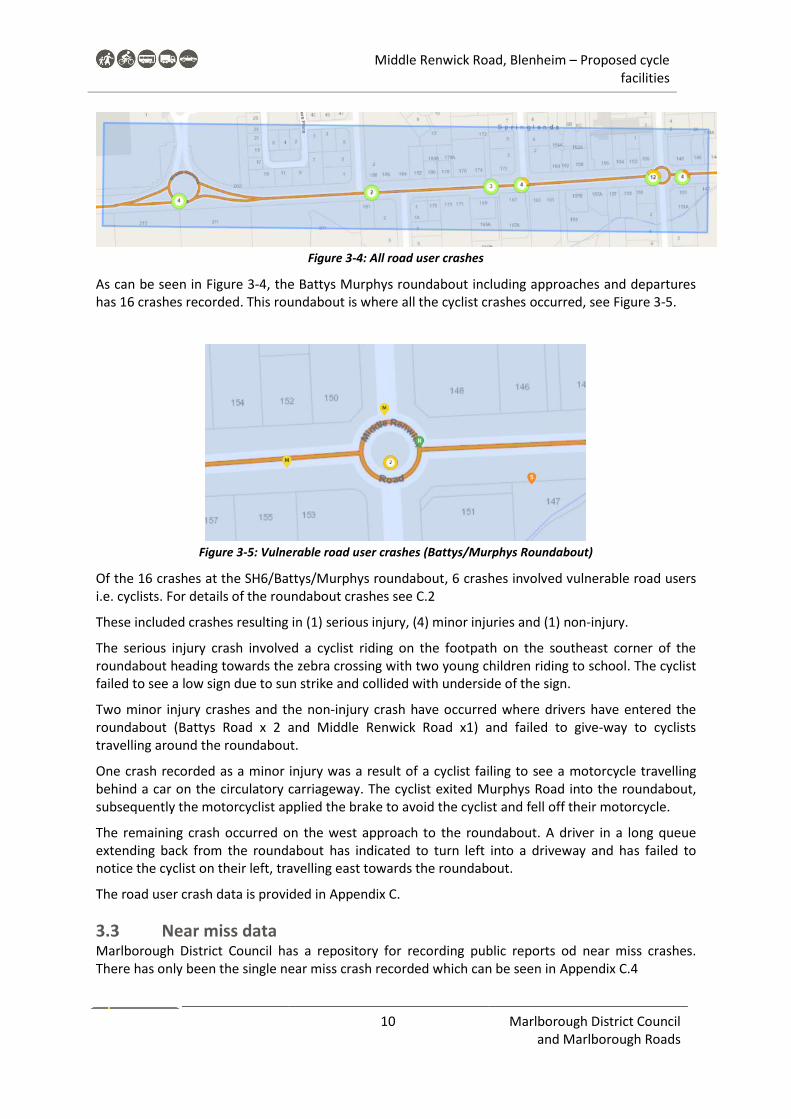
Figure 3-4: All road user crashes
As can be seen in Figure 3-4, the Battys Murphys roundabout including approaches and departures has 16 crashes recorded. This roundabout is where all the cyclist crashes occurred, see Figure 3-5.
Figure 3-5: Vulnerable road user crashes (Battys/Murphys Roundabout)
Of the 16 crashes at the SH6/Battys/Murphys roundabout, 6 crashes involved vulnerable road users i.e. cyclists. For details of the roundabout crashes see C.2
These included crashes resulting in (1) serious injury, (4) minor injuries and (1) non-injury.
The serious injury crash involved a cyclist riding on the footpath on the southeast corner of the roundabout heading towards the zebra crossing with two young children riding to school. The cyclist failed to see a low sign due to sun strike and collided with underside of the sign.
Two minor injury crashes and the non-injury crash have occurred where drivers have entered the roundabout (Battys Road x 2 and Middle Renwick Road x1) and failed to give-way to cyclists travelling around the roundabout.
One crash recorded as a minor injury was a result of a cyclist failing to see a motorcycle travelling behind a car on the circulatory carriageway. The cyclist exited Murphys Road into the roundabout, subsequently the motorcyclist applied the brake to avoid the cyclist and fell off their motorcycle.
The remaining crash occurred on the west approach to the roundabout. A driver in a long queue extending back from the roundabout has indicated to turn left into a driveway and has failed to notice the cyclist on their left, travelling east towards the roundabout.
The road user crash data is provided in Appendix C.
Near miss data 3.3Marlborough District Council has a repository for recording public reports od near miss crashes. There has only been the single near miss crash recorded which can be seen in Appendix C.4

Middle Renwick Road, Blenheim – Proposed cycle facilities
11
4 Strategic Context
The strategic context of providing a buffered cycle lane facility along Middle Renwick Road fits within the policy and planning is described in Appendix D. The facility is specifically designed to accommodate to more confident rider which is appropriate for this route.
As presented in Section 7, see Figure 7-2, the provision of separated riding facilities for the interested but concerned riders is planned for other surrounding parts of the network. These future facilities can connect to the shared path of this project.
5 Target user
Enthused and confident 5.1
A review of the context of the area and the characteristics of the street, in addition to a review of the strategy, the target user for Middle Renwick Road is the enthused and confident, and the more confident riders within the interested but concerned users group, because in summary:
The street is an arterial vehicle route with high volumes (over 12,000 VPD). It carries over 5% Heavy Goods Vehicles due to the strategic route status. This is where HGV’s should be and not on the local road network.
There are frequent driveways including high volume driveways at businesses.
Is a well-used cycle route, likely to be used by confident cyclists.
Is a bus route, althoughthere are no bus stops in this section.
Has inconsistent road widths and cross-sections.
Has limited pedestrians crossings.
Has intersections including dual entry roundabouts that are unfavourable for journeys by bicycle
Interested but concerned 5.2
The route is not considered desirable or suitable for the interested but concerned users, because in summary;
It would need significant infrastructure changes to the corridor to make it suitable for interested but concerned users and yet it would still have the issues of road noise, driveway risks etc, that can make riding unpleasant and include higher risks.
It’s not the sort of road environment interested but concerned users typically want to ride along.
Although the target user of the route is expected to stay on-road using the buffered cycle lanes, there are shorter links along the route where interested but concerned riders may want to ride. For example the future link between Severne Street and Westwood Avenue. There is also a possible future link betyween Springlands School / Murphys Road and Severne Street on a shared off-road path along Middle Renwick Road.
Based on the target user analysis the preferred treatment along Middle Renwick Road is on-road buffered cycle lanes with shorter sections of off-road shared path provided to complete links for the interested but concerned riders.

Middle Renwick Road, Blenheim – Proposed cycle facilities
12 Marlborough District Council and Marlborough Roads
6 Stakeholder Engagement
Microsoft Teams meetings were held between Warren Lloyd (ViaStrada) and Braden Prideaux (Marlborough District Council) on 5 and 20 May for project scope discussion, project updates and parking survey briefing.
Microsoft Teams meetings was held between the ViaStrada project team, Braden Prideaux, and Andy High of Waka Kotahi NZ Transport Agency on 12 June to discuss project issues including:
cross sections,
preferred option rationale (safety Vs efficiency Vs parking)
MCA criteria
treatments of key intersections
Marlborough District Council and Waka Kotahi staff have provided feedback on the three options included in this report, see Section 9. To date, Waka Kotahi support option 2 that retains the flush median and some indented parking where there is identified demand.
Public consultation should be considered in the future to ensure residents and the wider community have an opportunity to have their say on the proposed cycle lanes.
7 Project outcomes
Considering all the background data above, and in considering good design principles for design cycle facilities, the following principles are recommended:
• Provide for existing users but with a focus on encouraging new users too (more confident riders within the Interested but Concerned group). Among this group would be residents and workers, people who are young and old, and may include those with assisted (e-)bicycles.
• Traffic speed and volume management are just as crucial as providing specific cycle facilities to improve the attractiveness and reduce stress when riding
• Address connections to side streets that may provide access to shopping facilities, schools and parks.
Five core design principles provide a blueprint for good outcomes for bicycle journeys and, in a broader sense, the concept of placemaking for neighbourhoods.
Figure 7-1: Core design principles
Consistency in treatments and application help to create a network for people to move around by bicycle that is easy to understand and for users to navigate their way.
Whilst the study area focuses on the section of Middle Renwick Road from Westwood Avenue to Battys Road/Murphys Road roundabout, it is important to consider the wider network of routes and facilities for overall network legibility. Whilst the cycle facility here is for a certain target user, some

Middle Renwick Road, Blenheim – Proposed cycle facilities
13
sections of the overall corridor may not work for the Interested but Concerned user and so parallel shared path routes may be more suitable for this rider.
Figure 7-2 shows an overall approach for links for different users of the network. As a neighbourhood facility the retail offering at Westwood Avenue should be accessible for all residents in proximity so additional measures may be required to allow less confident riders the option to ride to the supermarket.
Figure 7-2: MDC Cycle Strategy with further possible routes for less confident riders
Note that the possible interested but concerned cycle routes shown along Middle Renwick Road in Figure 7-2 relate to off-road shared path options and does not include any on-road options, due to high traffic volume and speed.
Because of the traffic environment, buffered cycle lanes are proposed for the more confident on-road cyclists, with short sections of off-road shared path provided for less confident / experienced cyclists.
8 Buffered cycle lanes
The general design approach incorporates the thinking used to inform the proposed draft Waka Kotahi technical note for publication on buffered cycle lanes. ViaStrada has used their experience and expertise to collaborate in the development of the technical note and bring this knowledge to the Middle Renwick Road project. For the latest thinking on buffered cycle lanes, see Appendix E.3.1.
Using the existing data, traffic information, and the principles identified in Section 5 it is proposed that buffered cycle lanes be introduced along Middle Renwick Road for confident on-road cyclists.
Buffered cycle lanes comprise a conventional on-road cycle lane with a marked buffer between the cycle lane and moving traffic lane and/or parking lane. The use of the buffer can encourage people riding a bicycle to travel outside the door opening zone but can also increase the perception of safety by having something between the rider and the traffic lane. They also make it easier for drivers to pass cyclists at a safer distance.
The dimensions in Table 8-1 inform the possible combinations of elements for the different cross-section widths. In terms of overall design, there is potential to increase road user risk if all absolute minimums are provided on the cross-section.
Middle Renwick Road measures approximately 13.5 m from kerb to kerb and currently comprises parking lanes, traffic lanes and a flush median.

Middle Renwick Road, Blenheim – Proposed cycle facilities
14 Marlborough District Council and Marlborough Roads
Table 8-1: Basic parameters for cross-section design
9 Option development
Based on the existing conditions, crash history, strategic context, and the target user cyclist, three options have been developed for consideration. In all options it is proposed to incorporate a shared path from the Westwood Avenue roundabout to Severne Street to facilitate access to a local street that some riders may feel more confident to use than travelling along Middle Renwick Road.
The options considered by the project team are included in Appendix F.
Option 1 9.1.1
Option 1 provides buffered bike lanes within the existing kerb to kerb width and retains the flush median. It is not possible to accommodate on-street parking also with these cross-section elements.
This option will be relatively low cost as it requires minor removal of existing road markings and many of the new markings can align with the existing.
Option 2 9.1.2
Option 2 provides buffered bike lanes within the existing kerb to kerb width and retains the flush median. The flush median is propsoed to be reduced in width from Option 1 and some on-street car parking can be provided with indented parking bays with some localised widening.
This option will be the highest cost as it requires kerb and channel works associated with the indented parking and removal of much of the existing road markings as not many of the new markings align with the existing.
One of the consequences of option 2 is that providing indented parking results in having to remove some of the existing street trees.
Option 3 9.1.3
Option 3 provides buffered bike lanes within the existing kerb to kerb width but it is proposed to remove the flush median to accommodate on-street car parking within the existing kerb to kerb width. This results in parking be provided, without the cost of constructing indented parking bays.

Middle Renwick Road, Blenheim – Proposed cycle facilities
15
This option will be relatively low cost as it requires removal of existing road markings and some of the new markings align with the existing.
10 Multi-criteria analysis
The Multi-criteria analysis looks at all the different considerations for each different option, including
design context
community and stakeholder interest
project costs and programme risk
As discussed in Section 7 considering good design principles for designing cycle facilities, design context considers safety, comfort, directness, coherence and attractiveness.
The summary tables are provided below with the overall MCA table provided in Appendix G. The MCA was undertaken for two locations within Section 1, to reflect the different environment and context. These are shown below. Location 1A extends from the Westwood Avenue roundabout to Severne Street and 1B extends from Rose Street to the Battys/Murphys roundabout.
Figure 10-1: Locations for MCA

Middle Renwick Road, Blenheim – Proposed cycle facilities
16 Marlborough District Council and Marlborough Roads
Table 10-1: Design Context
Design Context (55%)
Safety Comfort Directness Coherence & Connectivity
Attractiveness and Social Safety
* Safety along route for users * Relative conflict with other road users: pedestrians; residents; traffic * Higher volume driveways/turning vehicles
* users experience *perceptions of risk; *impacts from other traffic noise; CO
2
*cycleway width, level of protection, obstacles, gradient
* Time and distance to travel * Easy to recognise route * Limited changing of facility types * Few complicated manoeuvres
* Good match to: ***local schools ***shops ***parks ***other public spaces/buildings
* Cycling experience and amenity. * Lighting levels
Location 1a & 1b
Option 1
Option 2
Option 3
Community and stakeholder interests appraise factors that look at the effects on those directly affected, or overall effects on the transport network.
Table 10-2: Community and stakeholder Interest
Community & Stakeholder Interest (30%)
Business/ Schools
Residents Network Effects
* Effects on access * Changes to on-street parking and loading
* Access to properties * Changes to on-street parking
* Effect of changes to arterial corridor? * Public transport routes affected? * Effect on operational & maintenance costs? (waste collection etc)
Location 1a
Option 1
Option 2
Option 3 XX
Location 1b
Option 1 - X
Option 2 -
Option 3 - XX
Option 3 scored poorly in the network effects as it proposes the removal of the flush median. The flush median allows vehicles to wait clear of through traffic om the State Highway so if it was removed, through traffic would need to wait behind turning vehicles. If drivers choose not to wait

Middle Renwick Road, Blenheim – Proposed cycle facilities
17
behind a turning vehicle, they may use the cycle lane space to pass and could come into conflict with people riding in the facility and therefore affect safety of users. This is also the case where a drier may stop suddenly to make a turn and a following driver may not have time to react resulting in a rear end collision.
Lastly, project costs and programme risks look at the different costs and issues that could delay the implementation of the scheme. Collectively these factors assist the project team in determining a preferred option to discuss with the community.
Table 10-3: Project Cost and Programme Risk
Project Costs and Programme Risks 25%
Cost Risks Programme Risks
Increased costs due to: * Physical works (K&C) *Property purchase *Complicated facilities (Budget Risk)
Programme delays due to: *Land/property acquisition *Legal processes - consents (Timing Risk)
Location 1a & 1b
Option 1
Option 2 X
Option 3
The preferred option includes the buffered cycle lanes, the shared path link between Westwood Avenue and Severne Street, some indented car parking to accommodate the demand that were identified in the on-street parking survey.
11 Preferred Option
It is proposed to implement buffered bicycle lanes, a continuous 2.5 – 2.8 m wide flush median
(width varies to achieve consistent traffic lane widths and tie into existing right turn bays) and some
indented parking along Middle Renwick Road from Westwood Avenue to the Battys Road/Murphys
Road roundabout. This completes a gap in the on-road cycle network and improves the road
environment for people travelling on-road by bicycle.
There are also two short sections of off-road shared path proposed for the interested but concerned
riders that may not want to ride on Middle Renwick Road.
The proposed layout plan is included in Section 11.3 and plans of the revised option 2 following RCA feedback can be viewed in Appendix H.

Middle Renwick Road, Blenheim – Proposed cycle facilities
18 Marlborough District Council and Marlborough Roads
Parking 11.1
There are 12 parking spaces proposed along the north side and 13 parking spaces proposed along
the south side of Middle Renwick Road. The provision of 25 spaces along this section of Middle
Renwick road exceeds the measured parking demand of 8 cars parked during the weekday and
weekend surveys undertaken by Marlborough District Council earlier in 2020.
Table 11-1: Parking provision
Street Zone Side From To Capacity Weekday Highest
Occupancy
Weekend Highest
Occupancy
Parking provision
Mid
dle
Ren
wic
k R
oad
(SH
6)
15
No
rth
sid
e
Murphys Adams 17 5 2 7
17 Adams Rose 25 2 1 5
19 Rose Westwood 14 1* 1* 0
8
Sou
th s
ide
Battys Opposite Adams
14 4 3 6
10 Opposite Adams
Severne 14 2 1 7
12 Severne Westwood Ave
9 2^ 1^ 0
* Trailer parked all day advertising travel ^ Cars parked all day that were advertised ‘for sale’ The removal of parking from Middle Renwick Road will remove the lane marking ambiguity for all
road users. As seen in Figure 11-1, an on-road cyclist departing from the Westwood Ave roundabout,
in the cycle lane is confronted by parked vehicles, in the green coloured and marked cycle lane.
However, there are no more cycle symbols marked along this lane and some people feel comfortable
parking here, although many park here for business, see appendix B.7.
Figure 11-1: Parking in cycle lane or cycling in parking lane

Middle Renwick Road, Blenheim – Proposed cycle facilities
19
Street trees to be removed 11.2
This option does require the removal of 5 street trees and care has been taken to maximise parking
provision while minimising tree removal. Indented parking has been provided where trees have been
identified with an average ‘environmental condition’2. The parking is to be provided in blocks where
more cars can fit into a space provided.
Table 11-2: Summary of indented parking and street trees
Indented
parking
No of
parks
No of
trees Species Tree Condition
Environmental
Condition
North side 5 2 Prunus sp. All Good All Average
South side 7 3 Prunus Kanzan 1 Good, 2 Average All Average
Figure 11-2 shows the three cherry trees along the south side of Middle Renwick Road that would be removed with option 2. These three trees are dwarfed by the trees in the adjacent property and their removal will have minimal impact on the street scape.
Figure 11-2: Cherry trees along south side of Middle Renwick Road
2 Information provided by Marlborough District Council

Middle Renwick Road, Blenheim – Proposed cycle facilities
20 Marlborough District Council and Marlborough Roads
Proposed layout 11.3
Figure 11-3: Westwood Avenue roundabout
Figure 11-4: Mid-block section from Westwood Avenue

Middle Renwick Road, Blenheim – Proposed cycle facilities
21
Figure 11-5: Mid-block section to Battys Murphys roundabout
Figure 11-6: Battys Murphys roundabout

Middle Renwick Road, Blenheim – Proposed cycle facilities
22 Marlborough District Council and Marlborough Roads
Proposed cross-sections 11.4
The proposed cross-sections are shown below.
Figure 11-7: Proposed cross-section for where there is no on-street parking
Figure 11-8: Proposed cross-section for where there is indented parking

Middle Renwick Road, Blenheim – Proposed cycle facilities
23
Next Steps 11.5
Safety audits 11.5.1
It is best practice to have scheme proposals assessed through a Safety Audit. This should occur prior to public consultation.
Public consultation 11.5.2
It is recommended that the plans be provided to the community for public consultation.
12 Services and rough order costs
Details about services are provided in Appendix I. The have been services identified that will require surface modification, these are included in ancillary costs and identified on the plans. The rough order cost (ROC) contingency is 25% or $80,000 for unexpected discovery.
The overall cost to deliver the project is estimated to be under $460,000 as shown in Table 12-1. This amount does not include professional fees for project management, contract administration and supervision, as some of these services may be provided in-house.
Table 12-1: Summary of costs
The more detailed breakdown of the ROC is included in Appendix J.
Middle Renwick Road Project: 1124-10
Cycle facilities Date: 1/08/2020
Scheme Design ROC Estimate Prepared: JA
Reviewed: WL
Construction costs
Item Amount
Preliminary & General 10,000$
Shared path & cycle path (All 75mm conc) 58,773$
Kerb 23,060$
Road 17,500$
Parking indents inc footpath 63,750$
Road Marking 77,100$
Traffic Signs 7,400$
Landscape 12,425$
Ancillary Costs 9,900$
Traffic management 38,100$
Construction Cost Total 318,100$
Contingency 25% 79,600$
Construction Estimate 397,700$
Other fees
Item
General project management (3%) 9,600$
Professional fees (safety audit) 8,000$
Contract administration & supervision (14%) 44,600$
Total 62,200$
TOTAL PROJECT ESTIMATE 459,900$

Middle Renwick Road, Blenheim – Proposed cycle facilities
24 Marlborough District Council and Marlborough Roads
13 Additional project considerations
In developing options for this section of road, there are further improvements that could be made to improve connectivity an accessibility that are outside of the scope but could contribute to improved access and mobility options around the neighbourhood. These are included in Appendix L.
14 Appendices
The following information in these appendices support and validates the buffered cycle lane option along this section of Middle Renwick Road.

Middle Renwick Road, Blenheim – Proposed cycle facilities
25
Traffic Volumes from Waka Kotahi Appendix A
Figure 14-1: Middle Renwick Road Daily and 7 day rolling average traffic volumes

Middle Renwick Road, Blenheim – Proposed cycle facilities
26 Marlborough District Council and Marlborough Roads
Parking Appendix B
The parking results from the Councils parking survey for the Middle Renwick Road study are is broken into 3 Zones for presentation in this appendix.
B.1 Weekday parking - Zone 1
Figure 14-2: Section 1 Parking occupancy
The survey for Zone 1 at the western end of the study area showed that there was no change throughout the survey in terms of demand, with only two of the 23 spaces being used throughout the day. It is noted that this higher than the occupancy shown on the LINZ aerial photograph below (taken summer 2017/18 at an unknown time of day) with no cars parked in the 23 spaces available.

Middle Renwick Road, Blenheim – Proposed cycle facilities
27
B.2 Weekday parking - Zone 2
Figure 14-3: Section 2 Parking occupancy
The survey for Zone 2 to the east of Rose Street showed that the greatest demand for parking in this location was during the interpeak when 4 of the 39 spaces were being used. It is noted that this is lower than the occupancy shown on the LINZ aerial photograph below (taken summer 2017/18 at an unknown time of day) with 10 cars parked in the 39 spaces available.

Middle Renwick Road, Blenheim – Proposed cycle facilities
28 Marlborough District Council and Marlborough Roads
B.3 Weekday parking Zone 3
Figure 14-4: Section 3 Parking occupancy
The survey for Zone 3 at the eastern end of the study area showed that the greatest demand for parking in this location was also during the interpeak when 9 of the 31 spaces were being used. It is noted that this higher than the occupancy shown on the LINZ aerial photograph below (taken summer 2017/18 at an unknown time of day) with 4 cars parked in the 31 spaces available.
Middle Renwick Road, Blenheim – Proposed cycle facilities
29
B.4 Weekend parking All Zones
14-5: All Sections - Parking occupancy

Middle Renwick Road, Blenheim – Proposed cycle facilities
30 Marlborough District Council and Marlborough Roads
B.5 Weekday parking raw data
Stre
et
KEY
Fro
mTo
Cap
acit
yH
igh
est
Occ
up
en
cy
Max
. %
Occ
up
ied
7.00
7.30
8.00
8.30
9.00
9.30
10.0
010
.30
11.0
011
.30
12.0
012
.30
1.00
1.30
2.00
2.30
3.00
3.30
4.00
4.30
5.00
5.30
6.00
6.30
MR
R (
SH6
)1
5M
urp
hys
Ad
am
s1
75
29
.4%
33
33
33
55
44
44
44
34
44
32
01
22
MR
R (
SH6
)1
7A
da
ms
Ro
se2
52
8.0
%0
00
00
10
02
12
00
00
00
00
00
11
1
MR
R (
SH6
)1
9R
ose
Wes
two
od
14
17
.1%
11
11
11
11
11
11
11
11
11
11
1T
TT
12
10
17
14
30
17
21
18
25
25
28
20
19
19
18
18
23
15
10
10
91
31
31
1
Stre
et
KEY
Fro
mTo
Cap
acit
yH
igh
est
Occ
up
en
cy
Max
. %
Occ
up
ied
7.00
7.30
8.00
8.30
9.00
9.30
10.0
010
.30
11.0
011
.30
12.0
012
.30
1.00
1.30
2.00
2.30
3.00
3.30
4.00
4.30
5.00
5.30
6.00
6.30
MR
R (
SH6
)8
Ba
ttys
Op
po
site
Ad
am
s1
44
28
.6%
01
00
11
12
23
22
43
31
11
11
01
11
MR
R (
SH6
)1
0O
pp
osi
te
Ad
am
sSe
vern
e1
42
14
.3%
00
00
22
11
22
20
00
01
11
11
00
00
MR
R (
SH6
)1
2Se
vern
eW
estw
oo
d A
ve9
22
2.2
%0
00
01
11
22
22
11
11
10
11
20
10
0
78
79
15
13
24
26
29
25
22
19
27
25
24
23
33
11
14
15
91
18
8
North side South side

Middle Renwick Road, Blenheim – Proposed cycle facilities
31
B.6 Weekend parking raw data
Stre
et
Ke
yFr
om
ToCa
paci
tyH
ighe
st
Occ
upen
cy
Max
. %
Occ
upie
d7.
007.
308.
008.
309.
009.
3010
.00
10.3
011
.00
11.3
012
.00
12.3
01.
001.
302.
002.
303.
003.
304.
004.
305.
005.
306.
006.
30
MR
R (S
H6
)1
5M
urp
hys
Ad
am
s17
211
.8%
00
00
01
11
10
00
00
00
22
21
11
11
MR
R (S
H6
)1
7A
da
ms
Ro
se25
18.
0%1
11
11
11
11
11
01
00
10
11
00
00
0
MR
R (S
H6
)1
9R
ose
We
stw
oo
d14
17.
1%1
11
11
11
11
11
01
11
11
11
11
11
1
11
11
71
31
31
51
51
41
31
51
31
21
31
21
01
11
31
21
11
01
01
21
21
1
Stre
et
Ke
yFr
om
ToCa
paci
tyH
ighe
st
Occ
upen
cy
Max
. %
Occ
upie
d7.
007.
308.
008.
309.
009.
3010
.00
10.3
011
.00
11.3
012
.00
12.3
01.
001.
302.
002.
303.
003.
304.
004.
305.
005.
306.
006.
30
MR
R (S
H6
)8
Ba
ttys
Op
po
site
Ad
am
s1
43
21.4
%0
00
00
11
32
11
11
10
20
00
00
03
2
MR
R (S
H6
)1
0O
pp
osi
te A
da
ms
Seve
rne
14
17.
1%1
00
00
00
00
00
00
00
00
00
00
00
0
MR
R (S
H6
)1
2Se
vern
eW
est
wo
od
Ave
91
11.1
%0
00
00
00
00
00
00
00
00
00
00
00
1
87
77
81
01
01
29
87
56
66
79
55
55
58
8
North side South side

Middle Renwick Road, Blenheim – Proposed cycle facilities
32 Marlborough District Council and Marlborough Roads
B.7 Photos of illegal parking and advertising activity
Figure 14-6: Trailer continuously parked in this location
One of the key safety concerns is that the trailer parked in this location forces Blenheim bound cyclists into live traffic lane. The fact that the advertiser is trying to divert the driver’s attention away from the driving task to read their sign is also a road user safety concern.
Figure 14-7: Vehicles for sale along Middle Renwick Road
Again, the advertiser is trying to divert passing driver’s attention away from the driving task to notice their vehicle for sale is a road user safety concern.

Middle Renwick Road, Blenheim – Proposed cycle facilities
33
CAS crash data Appendix C
C.1 Vulnerable user crashes
Table 14-1: CAS vulnerable road user crash data
Note; that this data is for the whole route, but all of the cycle crashes occurred at or on the approaches and or departures of the Battys / Murphys roundabout.
Cra
sh R
oad
Dis
tan
ce
Dir
ecti
on
Sid
e R
oad
ID Dat
e
Day
Tim
e
Description of events Crash factors
Surf
ace
Nat
ura
l Lig
ht
Wea
ther
Fata
l
Ser
Min
or
006-0000 I BATTYS 201958520 27/01/2019 Sun 11:00
Car/Wagon1 DIRN on 006-0000
hit Cyclist2 (Age 0) crossing at
right angle from right
CAR/WAGON1, failed to give
way at priority traffic controlDry Bright sun Fine 0 0 0
006-0000 I MURPHYS 201956539 20/05/2019 Mon 16:10
Motorcycle1 EDB on MIDDLE
RENWICK ROAD, SPRINGLANDS,
MARLBOROUGH lost control
turning right but did not leave
the road
CYCLE2, did not check/notice
another party from other dirn,
failed to give way at priority
traffic control MOTORCYCLE1,
sudden action
Dry Bright sun Fine 0 0 1
BATTYS I SH 6 201713232 23/04/2017 Sun 17:26
Car/Wagon1 NDB on Battys
road hit Cyclist2 (Age 26)
crossing at right angle from right
CAR/WAGON1, failed to give
way at priority traffic controlDry Twilight Fine 0 0 1
BATTYS I SH 6 201819009 27/10/2018 Sat 12:46
Car/Wagon1 NDB on Murphys
Rd hit Cyclist2 (Age 46) crossing
at right angle from right
CAR/WAGON1, alcohol test
below limit, did not
check/notice another party
from other dirn, failed to give
way at priority traffic control
Dry Overcast Fine 0 0 1
SH 6 60 E BATTYS 201812918 20/03/2018 Tue 8:40
Cycle1 EDB on Middle Renwick
Road hit obstruction, Cycle1 hit
non specific traffic sign
CYCLE1, driver dazzled, failed to
notice signs, wrong way in one
way street, motorway or
roundabou, ENV: visibility
limited by traffic sign, dazzling
sun
Dry Bright sun Null 0 1 0
SH 6 40 W MURPHYS 201513376 8/05/2015 Fri 17:00
Cycle1 EDB on SH 6 sideswiped
by SUV2 EDB on SH 6 turning
left
CYCLE1, overtaking on left
without due care, ENV: entering
or leaving private house / farm
Dry Twilight Fine 0 0 1

Middle Renwick Road, Blenheim – Proposed cycle facilities
34 Marlborough District Council and Marlborough Roads
C.2 Battys / Murphys roundabout all road users’ crashes
Table 14-2: CAS all road user crash data (Battys / Murphys roundabout)
CO
DED
CR
ASH
ID
Cra
sh r
oad
Dis
tan
ce
Dir
ect
ion
Sid
e r
oad
ID
Dat
e
Day
of
we
ek
Tim
e
Description of events Crash factors
Surf
ace
co
nd
itio
n
Nat
ura
l lig
ht
We
ath
er
Fata
l
Seve
re
Min
or
1193327 006-0000 I BATTYS 201958520 27/01/2019 Sun 11:00
Car/Wagon1 DIRN on
006-0000 hit Cyclist2
(Age 0) crossing at right
angle from right
CAR/WAGON1, failed to
give way at priority
traffic control
Dry Bright sun Fine 0 0 0
1187504 006-0000 I BATTYS 201897999 27/08/2018 Mon 7:50
Unknown1 DIRN on 006-
0000 hit Car/Wagon2
crossing at right angle
from right
UNKNOWN1, failed to
give way at priority
traffic control
Dry Bright sun Fine 0 0 0
1187684 006-0000 I MURPHYS 201956539 20/05/2019 Mon 16:10
Motorcycle1 EDB on
MIDDLE RENWICK ROAD,
SPRINGLANDS,
MARLBOROUGH lost
control turning right but
did not leave the road
CYCLE2, did not
check/notice another
party from other dirn,
failed to give way at
priority traffic control
MOTORCYCLE1, sudden
action
Dry Bright sun Fine 0 0 1
1139267 BATTYS I SH 6 201753159 7/11/2017 Tue 11:27
Car/Wagon1 NDB on
Battys road hit
Car/Wagon2 crossing at
right angle from right
CAR/WAGON1, did not
check/notice another
party from other dirn,
failed to give way at
priority traffic control
Dry Bright sun Fine 0 0 0
1153632 BATTYS I SH 6 201819009 27/10/2018 Sat 12:46
Car/Wagon1 NDB on
Murphys Rd hit Cyclist2
(Age 46) crossing at right
angle from right
CAR/WAGON1, alcohol
test below limit, did not
check/notice another
party from other dirn,
failed to give way at
priority traffic control
Dry Overcast Fine 0 0 1
1108751 BATTYS I SH 6 201713232 23/04/2017 Sun 17:26
Car/Wagon1 NDB on
Battys road hit Cyclist2
(Age 26) crossing at right
angle from right
CAR/WAGON1, failed to
give way at priority
traffic control
Dry Twilight Fine 0 0 1
1043906 SH 6 I BATTYS 201517983 23/11/2015 Mon 12:30
Motorcycle1 WDB on SH
6 hit obstruction,
Motorcycle1 hit non
specific kerb
MOTORCYCLE1, speed on
straightDry Bright sun Fine 0 0 1
1079125 SH 6 I BATTYS 201630988 20/01/2016 Wed 6:54
Car/Wagon1 WDB on SH
6 hit Car/Wagon2
merging from the left
CAR/WAGON2, failed to
give way at priority
traffic control, other
inattentive
Dry Twilight Fine 0 0 0
1147585 SH 6 60 E BATTYS 201812918 20/03/2018 Tue 8:40
Cycle1 EDB on Middle
Renwick Road hit
obstruction, Cycle1 hit
non specific traffic sign
CYCLE1, driver dazzled,
failed to notice signs,
wrong way in one way
street, motorway or
roundabou, ENV:
visibility limited by traffic
sign, dazzling sun
Dry Bright sun Null 0 1 0
1159214 SH 6 40 E BATTYS 201833454 15/02/2018 Thu
Car/Wagon1 WDB on SH
6 hit rear end of Van2
stop/slow for queue
CAR/WAGON1, following
too closelyDry Bright sun Fine 0 0 0
1165583 SH 6 40 W BATTYS 201839857 17/05/2018 Thu 20:05
Van1 EDB on SH 6 lost
control turning right,
Van1 hit non specific
traffic island, non specific
traffic sign
VAN1, failed to notice
obstruction on roadwayDry Dark Fine 0 0 0
1093149 SH 6 15 W BATTYS 201645226 12/08/2016 Fri 23:35
Car/Wagon1 WDB on
Middle Renwick Road
lost control; went off
road to right,
Car/Wagon1 hit non
specific fence
CAR/WAGON1, alcohol
test above limit or test
refused, over the speed
limit, ENV: slippery road
due to rain
Wet Dark Light rain 0 0 0
1039541 SH 6 40 W MURPHYS 201513376 8/05/2015 Fri 17:00
Cycle1 EDB on SH 6
sideswiped by SUV2 EDB
on SH 6 turning left
CYCLE1, overtaking on
left without due care,
ENV: entering or leaving
private house / farm
Dry Twilight Fine 0 0 1
1136416 SH 6 I MURPHYS 201750254 7/09/2017 Thu 16:20
Car/Wagon1 EDB on SH 6
hit rear end of
Car/Wagon2 stop/slow
for cross traffic
CAR/WAGON1,
emotionally upset/road
rage, failed to notice car
slowing,
stopping/stationary
Dry Overcast Fine 0 0 0
1053536 SH 6 I MURPHYS 201538092 20/05/2015 Wed 7:20
Van1 WDB on SH 6 hit
Car/Wagon2 crossing at
right angle from right
VAN1, failed to give way
at priority traffic controlDry Overcast Fine 0 0 0
1127402 SH 6 70 E MURPHYS 201741114 13/05/2017 Sat 8:20
Car/Wagon1 EDB on SH 6
hit rear end of Van2
stop/slow for
PEDESTRIAN
CAR/WAGON1, failed to
notice car slowing,
stopping/stationary
Dry Overcast Null 0 0 0
1157815 SH 6 50 W MURPHYS 201832046 26/01/2018 Fri 11:30
Car/Wagon1 EDB on SH 6
hit rear end of
Car/Wagon2 stop/slow
for queue
CAR/WAGON1, failed to
notice car slowing,
stopping/stationary
Dry Bright sun Fine 0 0 0

Middle Renwick Road, Blenheim – Proposed cycle facilities
35
C.3 All road user crash data for the balance of the route
Table 14-3: CAS all road user crash data for the balance of the route
Cra
sh r
oad
Dis
tan
ce
Dir
ect
ion
Sid
e r
oad
Dat
e
Day
Tim
e
Description of events Crash factors
Surf
ace
con
dit
ion
Nat
ura
l lig
ht
We
ath
er
Jun
ctio
n
Co
ntr
ol
Fata
l
Sev
Min
SH 6 40 WWESTWOOD
AVENUE25/11/2016 Fri 12:24
Car/Wagon1 EDB on
Middle Renwick Road hit
rear end of Car/Wagon2
stop/slow for queue
CAR/WAGON1, other
inattentive, ENV: slippery
road due to rain
Wet OvercastLight
rainNil (Default) Un known 0 0 0
SH 6 IWESTWOOD
AVENUE7/04/2015 Tue 18:55
Car/Wagon1 WDB on SH
6 hit rear end of
Car/Wagon2 stop/slow
for cross traffic
CAR/WAGON1,
misjudged intentions of
another party
Wet DarkLight
rainRoundabout Give way 0 0 0
SH 6 IWESTWOOD
AVENUE15/04/2015 Wed 16:05
Truck1 EDB on SH 6 lost
control but did not leave
the road , Car/Wagon2
hit generic debris
TRUCK1, lost control -
vehicle fault, wheel offDry Bright sun Fine Roundabout Give way 0 0 0
MIDDLE
RENWICK
ROAD
IWESTWOOD
AVENUE11/11/2019 Mon 5:15
Car/Wagon1 DIRN on
MIDDLE RENWICK ROAD
overtaking Car/Wagon2
CAR/WAGON1, other
postion on road
CAR/WAGON2, alcohol
test above limit or test
refused
Wet TwilightLight
rainRoundabout Give way 0 0 0
ROSE ST I SH 6 23/06/2018 Sat 20:30
Car/Wagon1 NDB on
ROSE ST hit Car/Wagon2
doing driveway
manoeuvre
CAR/WAGON2, did not
check/notice another
party behind
CAR/WAGON1,
misjudged own vehicle
Dry Dark Fine T Junction Nil 0 0 0
SH 6 25 W SEVERNE ST 11/08/2016 Thu 17:30
SUV1 WDB on SH 6 hit
Car/Wagon2 U-turning
from same direction of
travel
CAR/WAGON2, did not
check/notice another
party behind
Dry Twilight Fine Nil (Default) Un known 0 0 0
006-0000 65 W ADAMS LANE 3/04/2019 Wed 15:00
Car/Wagon1 WDB on
Middle Rewick Road hit
Car/Wagon2 U-turning
from same direction of
travel
CAR/WAGON2, alcohol
test below limit, did not
check/notice another
party behind
CAR/WAGON1, alcohol
test below limit
Dry Overcast Fine Nil (Default) Un known 0 0 0
SH 6 20 W ADAMS LANE 28/03/2017 Tue 10:30
Car/Wagon1 WDB on
Middle Renwick road
Blenheim lost control;
went off road to left,
Car/Wagon1 hit non
specific parked
CAR/WAGON1, sudden
illnessDry Bright sun Fine Nil (Default) Un known 0 0 0
SH 6 10 W ADAMS LANE 5/03/2016 Sat 14:30
Car/Wagon1 WDB on SH
6 hit rear end of
Car/Wagon2 stop/slow
for queue
CAR/WAGON1, attn
diverted by console
inbuilt features radio/ac,
following too closely,
wheelspins/wheelies/dou
ghnuts/drifting
Dry Bright sun Fine T Junction Un known 0 0 0
SH 6 I ADAMS LANE 15/07/2016 Fri 16:25
Car/Wagon1 EDB on SH 6
hit rear end of
Car/Wagon2 stop/slow
for cross traffic
CAR/WAGON1, failed to
notice car slowing,
stopping/stationary,
following too closely
Dry Bright sun Fine T Junction Give way 0 0 0
006-0000 I ADAMS LANE 21/08/2019 Wed 15:55
Truck1 WDB on Middle
renwick road hit rear of
Ute2 WDB on Middle
renwick road turning
right from centre line,
Truck1 hit parked
(unattended) vehicle
TRUCK1, alcohol test
above limit or test
refused, failed to notice
car slowing,
stopping/stationary
UTE2, alcohol test below
limit
Dry Bright sun Fine T Junction Give way 0 0 1
MIDDLE
RENWICK
ROAD
I ADAMS LANE 27/09/2019 Fri 8:40
Car/Wagon1 EDB on
MIDDLE RENWICK ROAD
hit rear end of
Car/Wagon2 stop/slow
for queue
CAR/WAGON1, failed to
notice car slowing,
stopping/stationary,
other attention diverted
Dry Bright sun Fine T Junction Nil 0 0 0
SH 6 50 W ADAMS LANE 15/06/2016 Wed 17:00
Car/Wagon1 EDB on SH 6
hit rear end of
Car/Wagon2 stop/slow
for queue
CAR/WAGON1, following
too closelyDry Twilight Fine Nil (Default) Un known 0 0 0

Middle Renwick Road, Blenheim – Proposed cycle facilities
36 Marlborough District Council and Marlborough Roads
C.4 Near miss crashes
Figure 14-8: Near miss crashes reported to MDC

Middle Renwick Road, Blenheim – Proposed cycle facilities
37
Strategic context Appendix D
The following strategies and plans provide the long-term direction for transport in the Marlborough District and will assist in developing a connected central network for people to move around by bicycle.
The current strategic direction at national, regional, and local levels have consistent themes of improving travel choice and improving safety.
D.1 Government Policy Statement on Land Transport 2018–28
The Government Policy Statement (GPS) on Land Transport3 outlines the Government’s strategy to guide land transport investment over the next 10 years and provides guidance to decision-makers where the Government will focus resources. Under the Land Transport Management Act 2003, the GPS influences decisions on how money from the National Land Transport Fund will be invested across activity classes, such as state highways and public transport. It also guides the Waka Kotahi NZ Transport Agency and local government on the type of activities that should be included in Regional Land Transport Plans and the National Land Transport Programme (NLTP).
Figure 14-9: Strategic direction of the GPS 2018
The 2018 GPS set a clear strategic direction with priorities focused on safety (i.e. a safe system free of death and serious injury) and access (i.e. enabling transport choice, providing access to economic/social opportunities, and resilient networks; refer to Figure 14-9). The resulting draft
3 https://www.transport.govt.nz/multi-modal/keystrategiesandplans/gpsonlandtransportfunding/

Middle Renwick Road, Blenheim – Proposed cycle facilities
38 Marlborough District Council and Marlborough Roads
national 2020–30 Road Safety Strategy “Road to Zero” also reinforces the focus on road safety, and recent changes to funding allocations in the NLTP have also invested a lot more in local government road safety programmes.
D.2 Road to Zero: A New Road Safety Strategy for NZ (2019)
The strategy sets out the vision and guiding principles for designing the road network and making road safety decisions. It sets out the five areas of focus, and a framework for accountability. The strategy is to be implemented through a series of separate action plans. The overall vision set out in the strategy states:
“a New Zealand where no one is killed or seriously injured in road crashes. This means that no death or serious injury while travelling on our roads is acceptable.”
Figure 14-10: Strategic direction of the Road to Zero
Underpinning this vision are seven guiding principles:
promote good choices but plan for mistakes
We design for human vulnerability
We strengthen all parts of the road transport system
We have a shared responsibility for improving road safety

Middle Renwick Road, Blenheim – Proposed cycle facilities
39
Our actions are grounded in evidence and evaluated
Our road safety actions support health, wellbeing and liveable places
We make safety a critical decision-making priority.
A target of a 40 percent reduction in deaths and serious injuries by 2030 has been set. This is to be achieved through action in five key areas:
Infrastructure improvements and speed management
Vehicle safety
Work-related road safety
Road user choices
System management.
D.3 Regional Land Transport Plan 2015–2021
The Marlborough Regional Land Transport Plan 2015 - 2021 is a critical document for the Marlborough District as it underpins all of the District’s road network and transportation planning and investment priorities.
The 2018 update to the plan recognises that:
“Whilst private vehicles remain the most popular choice for journeys to work across the main urban centres, in the 2013 census Nelson/Richmond urban centre recorded the highest number of commuter cyclists (journeys to work) of any centre in New Zealand (18%). The cycle networks across the Top of the South in the urban areas does not provide a connected network which is a barrier to less confident users. This is reflected in the annual customer surveys of both Nelson and Tasman that feature high levels of dis-satisfaction in the urban cycle networks. The transport system will need to respond to the changing demographic, e.g. road environments that accommodate increasing reaction times, safe pedestrian facilities including for mobility scooters and convenient public transport and total mobility services.
The plan also identifies the key issues, problems and opportunities facing the State Highway network through Marlborough are
Safety is compromised by transport infrastructure deficiencies and poor user behaviours
High level of motorcyclists and cyclists involved in fatal and serious injury crashes.
Lack of attention/observation is a contributing factor to fatal and serious crashes.
Appropriate speed and targeting low KiwiRAP rated roads would reduce DSI’s.
D.4 Marlborough District Council Walking and Cycling Strategy 2019-29
The overall vision in the strategy is that Marlborough people and visitors walk and cycle safely for travel, health and enjoyment.
The following objectives are set out in the strategy:
Encourage and support people in Marlborough to choose walking and cycling.
Develop a safe, convenient and connected travel network for walking and cycling.
Ensure that all relevant strategies, policies, plans and practices for Marlborough support walking and cycling.
The barriers to people interested in using active travel modes include:
Incomplete cycle network and lack of facilities for pedestrians and cyclists.
Increased presence of heavy vehicles putting pedestrians and cyclists at greater risk.
High vehicle speeds in some places.

Middle Renwick Road, Blenheim – Proposed cycle facilities
40 Marlborough District Council and Marlborough Roads
Unfavourable road and intersection layout.
There is a real need to make changes to the network to improve safety and perceived safety for interested but concerned users (60%).
Figure 14-11: Four types of cyclist
The interested but concerned users are people that would like to try cycling as a mode of transport but have concerns around safety and connectivity and would like higher quality infrastructure to improve the perception of safety an increase the comfort of riding on street.
Figure 14-12: Targets set out in the Walking and Cycling Strategy

Middle Renwick Road, Blenheim – Proposed cycle facilities
41
Buffered Cycle lanes Appendix E
The following is taken from the proposed draft Waka Kotahi technical note for publication on buffered cycle lanes.
E.1 Introduction
This technical note has been developed to assist in the design of buffered cycle lanes. As detailed throughout the Cycling Network Guidance (CNG), the decision to implement buffered cycle lanes depends on many factors (both high-level and site-specific), one of which is carriageway width.
Understanding the street function and context will determine what other cross-section elements are required or desired and the space available for these elements in addition to cycle facilities.
At certain available widths, it may either not be feasible to provide buffered cycle lanes, or there may be so much space that another form of provision becomes possible. As such, the provision of buffered cycle lanes should be assessed alongside other facility options.
An important distinction is that a buffer adjacent to a traffic lane is in addition to the width of a cycle lane. A buffer adjacent to parking is placed within the width of a cycle lane.
E.2 Buffered cycle lane design
Buffered cycle lanes comprise a conventional on-road cycle lane with a marked buffer between the cycle lane and moving traffic lane and/or parking lane. The use of the buffer can encourage people riding a bicycle to travel outside the door opening zone but can also increase the perception of safety by having something between the rider and the traffic lane. They also make it easier for drivers to pass cyclists at a safer distance.
Many of the concept design considerations around buffered cycle lanes are developed from existing guidance in the CNG on on-road cycle lanes. However, there is scope for further research into the design of this facility type, and the areas for further work are identified through the text below.
E.2.1 Parking side buffer configuration
Drivers will use the parking space markings as a guide (i.e. rather than the kerb) – therefore, parking spaces should be kept narrow, so that good parking discipline is encouraged, allowing people on bikes to avoid opening car doors.
A well-defined line is required at the side adjacent to the parking, so that drivers do not consider any buffer between parking and cycle lane as an extension of the parking zone.
The door zone of parked vehicles is an actual safety concern for people on bikes.
The current default is to not mark a painted buffer between the parking lane and cycle lane. To encourage cyclists to keep away from the door opening zone, it is recommended that the cycle lane symbol and green surfacing are marked closer to the general traffic lane (Figure 14-13). Note that the preferred shade of green surfacing is Apple Green G26.
The following section of this technical note assumes that the markings will be provided within the stated width of the cycle lane and an offset is provided.
There is need for more research to identify how much influence such an offset has on the position of the rider in the lane.
Some RCAs mark buffers between the parking and cycle lane. This will only keep people on bikes safe from the door zone if good parking discipline is achieved.

Middle Renwick Road, Blenheim – Proposed cycle facilities
42 Marlborough District Council and Marlborough Roads
Some studies suggest that marking parking buffers result in poorer parking discipline. There is scope for further research into this, including consideration of different buffer marking styles that could reduce this issue.
The Figures below show the recommended layout for a buffered cycle lane next to parking.
Figure 14-13: Cycle symbol offset from parking, buffer against traffic lane, Nelson. Photo: E Teekman
Figure 14-14: Road markings for parking and cycle lane buffer

Middle Renwick Road, Blenheim – Proposed cycle facilities
43
E.2.2 Traffic adjacent buffer configuration
People on bikes often have a perceived safety issue of conflict with moving traffic.
The current default is to mark a buffer between the cycle lane and the general traffic lane (i.e. a traffic-adjacent buffer) to address this perception (e.g. Figure 14-16).
Buffer styles that could be marked between the cycle lane and traffic lane should be parallel lines with diagonal stripes aligned according to the direction of motor vehicle drivers.
Figure 14-15: Road markings with buffer between cycle lane and traffic lane
E.3 Design parameters
The following graphic (Figure 14-16) outlines various scenarios depending on the priorities for provision and elements that are introduced (established) as available carriageway width increases.
(Table 14-4) outlines the basic parameters used to develop the design and gives instructions and examples for how to use these charts.
It is important to note that the figure does not represent a layout plan for a roadway; they are provided to inform the possible combinations of elements at a given cross-section width.

Middle Renwick Road, Blenheim – Proposed cycle facilities
44 Marlborough District Council and Marlborough Roads
E.3.1 Buffered cycle lanes, establishing parking
Figure 14-16: Design: standard cycle lanes – buffered cycle lanes – establishing parking
The design charts are based on the following basic parameters; these should be considered if modifying the configurations obtained from the design charts:
Table 14-4: basic parameters for cross-section elements for buffered bike lane design
Key Element
Desirable min
Acceptable min
Practical max
Parallel parking 2.0 2.0 2.5
Cycle lane – next to parallel parking 1.8 1.7 2.0
Cycle lane buffer – traffic side 1.0 0.3 1.0
General traffic lane 3.2 2.9 4.5
Cycle lane buffer – traffic side 1.0 0.3 1.0
Cycle lane – kerbside 1.6 1.4 1.8
Flush median 2.5 0.5 4.0

Middle Renwick Road, Blenheim – Proposed cycle facilities
45
Notes:
The values for the basic parameters are taken from the CNG and its various sources.
The acceptable minima are used as the starting point for all combinations, with widths working up to the desirable minima, or the point at which the next combination is deemed acceptable.
The acceptable minima stated should be used as a guide only, and with caution; they may vary depending on the local authority, or site-specific context. A design option that contains all acceptable minimum elements is likely to result in increased safety risks and should be avoided.
The practical maxima are guidelines only and are rarely achieved in reality (thus not shown on the charts), as the additional width can normally be better allocated elsewhere.
E.3.2 Instructions for use
The resulting cross-section depends on the elements of the cross-section that are desired and the available width in the existing roadway.
E.3.3 Calculate element widths
The width of each element on the carriageway is calculated from the difference between successive cumulative widths.
E.3.4 Re-distribute width if necessary
In cases where the acceptable minima (see Table 14-4) have been achieved for multiple elements, there is scope to redistribute width among the elements, according to site-specific objectives and constraints.
For example, in locations with speed limit greater than 50 km/h, or a high proportion of heavy vehicles, it may be preferred to increase the width of general traffic lanes before increasing the width of the cycle facilities. Conversely, in locations with high cycling and e-scooter demand, it may be preferable to increase the width of the cycle facility before increasing other elements above their acceptable minima.
E.3.5 Tips for finding space
If there is insufficient space for the desired configuration, it will be necessary to either:
Re-examine the priorities in terms of which elements to provide and choose different elements.
Consider gaining space from somewhere else (e.g. relocating the kerb lines).
In some cases, the cross-section width will vary along a corridor. It may be acceptable to reduce widths of certain elements for short sections of road – the CNG should be consulted if this affects the cycle facilities. Usually, it will be necessary to transition to a different configuration. Where possible, it makes sense to retain a consistent type of cycle provision along a corridor – for example, if buffered cycle lanes are desired, it is preferable to remove parking than to revert to standard cycle lanes for a section with reduced cross-section width.
A range of examples are included in the figures below.

Middle Renwick Road, Blenheim – Proposed cycle facilities
46 Marlborough District Council and Marlborough Roads
Figure 14-17: Cross-section widths for narrow carriageways
Figure 14-18: Cross-section widths that could accommodate parking one side
Figure 14-19: Cross-section widths that could accommodate parking on both sides

Middle Renwick Road, Blenheim – Proposed cycle facilities
47
Figure 14-20: Cross-section widths that could accommodate a flush median
Figure 14-21: Cross-section widths that could accommodate a flush median and parking on one-side
Figure 14-22: Cross-section widths that could accommodate a flush median and parking on both sides

Middle Renwick Road, Blenheim – Proposed cycle facilities
48 Marlborough District Council and Marlborough Roads
Where the width is greater than 18.7 metres there could be a greater buffer between the cycle lane and parking, to improve comfort and safety for those getting out of parked cars, or those parking larger vehicles. The designer should consider the local conditions and context, the users of the parking bays, the speed of the road and the users of the cycleway.

Middle Renwick Road, Blenheim – Proposed cycle facilities
49
Option Development Appendix F
Below are the original options that were first discussed with Marlborough District Council and Marlborough Roads.
Figure 14-23: Option 1 - no parking and wide flush median
This option has the following features
No parking on either side
Wide flush median
Width appropriate traffic lanes
Option 1 removes parking from both sides of Middle Renwick Road which provides the safest environment for on-road cycling, but this is very controversial with residents and businesses along the route.
The wide flush median accommodates median islands for pedestrian crossing facilities, turning movements on and off the highway and vehicle lane width appropriate right turn bays.
The traffic lanes at 3.2 m is appropriate for state highway traffic in a 50 km/h speed environment.

Middle Renwick Road, Blenheim – Proposed cycle facilities
50 Marlborough District Council and Marlborough Roads
Figure 14-24: Option 2 - indented parking with flush median
This option has the following features
Indented parking where demand was identified
Flush median
Width appropriate traffic lanes
Option 2 retains some of the parking on Middle Renwick Road which should find favour with residents and businesses along the route and should be less controversial.
The indented parking bays have been identified from parking surveys undertaken during the week and weekend, see Section 2.7 and Appendix B. The sites have been chosen to maximise the length of the bay to accommodate parked cars while minimising the need to remove existing street trees.
This does not provide the safest environment for on-road cycling, but the buffered cycle lanes add an element of extra safety for people riding past parked vehicles.
The flush median accommodates median islands for pedestrian crossing facilities, turning movements on and off the highway.
The traffic lanes at 3.2 m is appropriate for state highway traffic in a 50 km/h speed environment.
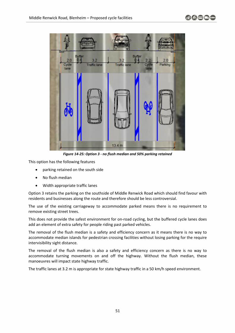
Middle Renwick Road, Blenheim – Proposed cycle facilities
51
Figure 14-25: Option 3 - no flush median and 50% parking retained
This option has the following features
parking retained on the south side
No flush median
Width appropriate traffic lanes
Option 3 retains the parking on the southside of Middle Renwick Road which should find favour with residents and businesses along the route and therefore should be less controversial.
The use of the existing carriageway to accommodate parked means there is no requirement to remove existing street trees.
This does not provide the safest environment for on-road cycling, but the buffered cycle lanes does add an element of extra safety for people riding past parked vehicles.
The removal of the flush median is a safety and efficiency concern as it means there is no way to accommodate median islands for pedestrian crossing facilities without losing parking for the require intervisibility sight distance.
The removal of the flush median is also a safety and efficiency concern as there is no way to accommodate turning movements on and off the highway. Without the flush median, these manoeuvres will impact state highway traffic.
The traffic lanes at 3.2 m is appropriate for state highway traffic in a 50 km/h speed environment.

Middle Renwick Road, Blenheim – Proposed cycle facilities
52 Marlborough District Council and Marlborough Roads
Multi Criteria Analysis Appendix G
Table 14-5: MCA Location 1A
Safe
tyC
om
fort
Dir
ect
ne
ssC
oh
ere
nce
&
Co
nn
ect
ivit
y
Att
ract
ive
ne
ss
an
d S
oci
al
Safe
ty
Bu
sin
ess
/
Sch
oo
lsR
esi
de
nts
Ne
two
rk E
ffe
cts
Co
st R
isks
Pro
gra
mm
e R
isks
* Sa
fety
alo
ng r
oute
for
user
s
* Re
lati
ve c
onf
lict
wit
h ot
her
road
use
rs: p
edes
tria
ns;
resi
dent
s; t
raff
ic
* H
ighe
r vo
lum
e
driv
eway
s/tu
rnin
g ve
hicl
es
* C
omfo
rt o
f use
rs
expe
rien
ce
*per
cept
ions
of r
isk;
*im
pact
s fr
om o
ther
tra
ffic
nois
e; C
O2
*cyc
lew
ay w
idth
, lev
el o
f
prot
ecti
on, o
bsta
cles
,
grad
ient
* Ti
me
and
dist
ance
to
trav
el
* Ea
sy t
o re
cogn
ise
rout
e
* Li
mit
ed c
han
ging
of
faci
lity
type
s
* Fe
w c
om
plic
ate
d
man
oeuv
res
* G
ood
mat
ch
to:
***l
oca
l sch
ools
***s
hops
***p
arks
***o
ther
pub
lic
spac
es/
build
ings
* C
yclin
g
expe
rien
ce a
nd
amen
ity.
* Li
ghti
ng le
vels
* Ef
fect
s on
acc
ess
* C
hang
es t
o on
-str
eet
park
ing
and
load
ing
* A
cces
s to
prop
erti
es
* C
hang
es t
o on
-
stre
et p
arki
ng
* Ef
fect
of c
han
ges
to
arte
rial
co
rrid
or?
* Pu
blic
tra
nspo
rt r
oute
s
affe
cted
?
* Ef
fect
on
oper
atio
nal &
mai
nten
ance
co
sts?
(was
te c
olle
ctio
n et
c)
Incr
ease
d co
sts
due
to:
* Ph
ysic
al w
orks
(K&
C)
*Pro
pert
y pu
rch
ase
*Com
plic
ate
d
faci
litie
s
(Bud
get
Risk
)
Prog
ram
me
dela
ys
due
to:
*Lan
d/pr
oper
ty
acq
uisi
tion
*Leg
al p
roce
sses
-
cons
ents
(Tim
ing
Risk
)
Buf
fere
d on
-roa
d cy
cle
lane
No
on-s
tree
t pa
rkin
g so
redu
ced
risk
of d
oori
ng
Off
-roa
d sh
ared
pat
h fo
r
inte
rest
ed b
ut c
onc
ern
ed
user
s
Goo
d cy
cle
lane
wid
th w
ith
addi
tion
al b
uffe
r fr
om t
he
traf
fic
Flat
co
rrid
or
Stra
ight
line
Min
or s
ide
road
inte
rsec
tion
to
be
high
light
ed a
s a
conf
lict
poin
t
Easi
ly id
enti
fiabl
e ro
ute
Con
nect
s
resi
dent
s to
loca
l
shop
s
On-
road
lane
s
wit
h bu
ffer
.
Vis
ible
to
road
user
s.
Wid
e en
ough
to
cycl
e w
ith
frie
nd.
No
chan
ges
to a
cces
s.
Min
imal
ch
ange
to
park
ing
as lo
ng
sect
ions
of n
o st
oppi
ng
in p
lace
.
No
chan
ges
to
acce
ss.
Min
imal
ch
ange
to
park
ing
as lo
ng
sect
ions
of n
o
stop
ping
in p
lace
.
No
chan
ge.
Flus
h m
edia
n re
tain
s
capa
city
of r
oute
.
No
bus
stop
s af
fect
ed.
No
chan
ges
to c
ost
s.
No
phys
ica
l wor
ks
requ
ired
for
on-r
oad
lane
s
No
risk
s.
Buf
fere
d on
-roa
d cy
cle
lane
On-
stre
et p
arki
ng p
rese
nt s
o
incr
ease
d ri
sk o
f doo
ring
Off
-roa
d sh
ared
pat
h fo
r
inte
rest
ed b
ut c
onc
ern
ed
user
s
Goo
d cy
cle
lane
wid
th w
ith
addi
tion
al b
uffe
r fr
om t
he
traf
fic
Flat
co
rrid
or
Incr
ease
d st
ress
due
to
pres
ence
of p
arke
d ca
rs
Stra
ight
line
Min
or s
ide
road
inte
rsec
tion
to
be
high
light
ed a
s a
conf
lict
poin
t
Easi
ly id
enti
fiabl
e ro
ute
Con
nect
s
resi
dent
s to
loca
l
shop
s
On-
road
lane
s
wit
h bu
ffer
.
Vis
ible
to
road
user
s.
Wid
e en
ough
to
cycl
e w
ith
frie
nd.
No
chan
ges
to a
cces
s.
Min
imal
ch
ange
to
park
ing
as lo
ng
sect
ions
of n
o st
oppi
ng
in p
lace
.
No
chan
ges
to
acce
ss.
Min
imal
ch
ange
to
park
ing
as lo
ng
sect
ions
of n
o
stop
ping
in p
lace
.
No
chan
ge.
Flus
h m
edia
n re
tain
s
capa
city
of r
oute
.
No
bus
stop
s af
fect
ed.
No
chan
ges
to c
ost
s.
Phys
ica
l wor
ks r
eqd
to a
ccom
mod
ate
park
ing
No
risk
s.
Con
sent
requ
irem
ents
for
tree
rem
oval
for
kerb
wor
ks?
X
Buf
fere
d on
-roa
d cy
cle
lane
On-
stre
et p
arki
ng p
rese
nt s
o
incr
ease
d ri
sk o
f doo
ring
Off
-roa
d sh
ared
pat
h fo
r
inte
rest
ed b
ut c
onc
ern
ed
user
s
Dri
vers
may
use
cyc
le la
ne t
o
over
take
veh
icle
s w
aiti
ng t
o
turn
.
Goo
d cy
cle
lane
wid
th w
ith
addi
tion
al b
uffe
r fr
om t
he
traf
fic
Flat
co
rrid
or
Incr
ease
d st
ress
due
to
pres
ence
of p
arke
d ca
rs
and
vehi
cles
tur
ning
,
may
be u
nder
mor
e
pres
sure
wit
h ho
ldin
g up
traf
fic
Stra
ight
line
Min
or s
ide
road
inte
rsec
tion
to
be
high
light
ed a
s a
conf
lict
poin
t
Easi
ly id
enti
fiabl
e ro
ute
Con
nect
s
resi
dent
s to
loca
l
shop
s
On-
road
lane
s
wit
h bu
ffer
.
Vis
ible
to
road
user
s.
Wid
e en
ough
to
cycl
e w
ith
frie
nd.
No
chan
ges
to a
cces
s.
Min
imal
ch
ange
to
park
ing
as lo
ng
sect
ions
of n
o st
oppi
ng
in p
lace
.
No
chan
ges
to
acce
ss.
Min
imal
ch
ange
to
park
ing
as lo
ng
sect
ions
of n
o
stop
ping
in p
lace
.
Rem
oval
of f
lush
med
ian
will
cre
ate
dela
ys fr
om
vehi
cles
wai
ting
beh
ind
turn
ing
vehi
cles
(co
uld
affe
ct s
afet
y).
No
bus
stop
s af
fect
ed.
No
chan
ges
to c
ost
s.
No
phys
ica
l wor
ks
requ
ired
for
on-r
oad
lane
s
No
risk
s.
XX
Opt
ion
3
Opt
ion
2
De
sig
n C
on
text
55
%C
om
mu
nit
y/St
ake
ho
lde
r In
tere
sts
30
%P
roje
ct C
ost
s a
nd
Pro
gra
mm
e R
isks
25
%
Opt
ion
1
Loca
tio
n 1
a

Middle Renwick Road, Blenheim – Proposed cycle facilities
53
Table 14-6: MCA Location 1B
Safe
tyC
om
fort
Dir
ect
ne
ssC
oh
ere
nce
&
Co
nn
ect
ivit
y
Att
ract
ive
ne
ss
an
d S
oci
al
Safe
ty
Bu
sin
ess
/
Sch
oo
lsR
esi
de
nts
Ne
two
rk E
ffe
cts
Co
st R
isks
Pro
gra
mm
e R
isks
* Sa
fety
alo
ng
rou
te f
or
use
rs
* R
elat
ive
con
flic
t w
ith
oth
er
road
use
rs: p
edes
tria
ns;
resi
den
ts; t
raff
ic
* H
igh
er v
olu
me
dri
vew
ays/
turn
ing
veh
icle
s
* C
om
fort
of
use
rs
exp
erie
nce
*per
cep
tio
ns
of
risk
;
*im
pac
ts f
rom
oth
er t
raff
ic
no
ise;
CO
2
*cyc
lew
ay w
idth
, lev
el o
f
pro
tect
ion
, ob
stac
les,
grad
ien
t
* Ti
me
and
dis
tan
ce t
o
trav
el
* Ea
sy t
o r
eco
gnis
e
rou
te
* Li
mit
ed c
han
gin
g o
f
faci
lity
typ
es
* Fe
w c
om
plic
ated
man
oeu
vres
* G
oo
d m
atch
to:
***l
oca
l sch
oo
ls
***s
ho
ps
***p
arks
***o
ther
pu
blic
spac
es/b
uild
ings
* C
yclin
g
exp
erie
nce
an
d
amen
ity.
* Li
ghti
ng
leve
ls
* Ef
fect
s o
n a
cces
s
* C
han
ges
to o
n-s
tree
t
par
kin
g an
d lo
adin
g
* A
cces
s to
pro
per
ties
* C
han
ges
to o
n-
stre
et p
arki
ng
* Ef
fect
of
chan
ges
to
arte
rial
co
rrid
or?
* P
ub
lic t
ran
spo
rt r
ou
tes
affe
cted
?
* Ef
fect
on
op
erat
ion
al &
mai
nte
nan
ce c
ost
s?
(was
te c
olle
ctio
n e
tc)
Incr
ease
d c
ost
s d
ue
to:
* P
hys
ical
wo
rks
(K&
C)
*Pro
per
ty p
urc
has
e
*Co
mp
licat
ed
faci
litie
s
(Bu
dge
t R
isk)
Pro
gram
me
del
ays
du
e to
:
*Lan
d/p
rop
erty
acq
uis
itio
n
*Leg
al p
roce
sses
-
con
sen
ts
(Tim
ing
Ris
k)
Bu
ffer
ed o
n-r
oad
cyc
le la
ne
No
on
-str
eet
par
kin
g so
red
uce
d r
isk
of
do
ori
ng
Off
-ro
ad s
har
ed p
ath
fo
r
inte
rest
ed b
ut
con
cern
ed
use
rs
Go
od
cyc
le la
ne
wid
th w
ith
add
itio
nal
bu
ffer
fro
m t
he
traf
fic
Flat
co
rrid
or
Stra
igh
t lin
e
Min
or
sid
e ro
ad
inte
rsec
tio
n t
o b
e
hig
hlig
hte
d a
s a
con
flic
t p
oin
t
Easi
ly id
enti
fiab
le r
ou
te
Co
nn
ects
resi
den
ts t
o lo
cal
sho
ps
On
-ro
ad la
nes
wit
h b
uff
er.
Vis
ible
to
ro
ad
use
rs.
Wid
e en
ou
gh t
o
cycl
e w
ith
fri
end
.
No
ch
ange
s to
acc
ess.
No
on
-str
eet
par
kin
g
pro
vid
ed.
Cu
rren
tly
no
on
-str
eet
par
kin
g
pro
vid
ed f
or
Z st
atio
n
and
all
mo
tels
hav
e o
ff-
stre
et p
arki
ng
No
ch
ange
s to
acce
ss.
Ch
ange
to
par
kin
g
pro
visi
on
fo
r
resi
den
ts
No
ch
ange
.
Flu
sh m
edia
n r
etai
ns
cap
acit
y o
f ro
ute
.
No
bu
s st
op
s af
fect
ed.
No
ch
ange
s to
co
sts.
Ph
ysic
al w
ork
s ar
e fo
r
cost
of
wid
enin
g th
e
foo
tpat
h t
o c
reat
e a
shar
ed p
ath
.
No
ris
ks.
-X
Bu
ffer
ed o
n-r
oad
cyc
le la
ne
On
-str
eet
par
kin
g p
rese
nt
so
incr
ease
d r
isk
of
do
ori
ng
Off
-ro
ad s
har
ed p
ath
fo
r
inte
rest
ed b
ut
con
cern
ed
use
rs
Go
od
cyc
le la
ne
wid
th w
ith
add
itio
nal
bu
ffer
fro
m t
he
traf
fic
Flat
co
rrid
or
Incr
ease
d s
tres
s d
ue
to
pre
sen
ce o
f p
arke
d c
ars
Stra
igh
t lin
e
Min
or
sid
e ro
ad
inte
rsec
tio
n t
o b
e
hig
hlig
hte
d a
s a
con
flic
t p
oin
t
Easi
ly id
enti
fiab
le r
ou
te
Co
nn
ects
resi
den
ts t
o lo
cal
sho
ps
On
-ro
ad la
nes
wit
h b
uff
er.
Vis
ible
to
ro
ad
use
rs.
Wid
e en
ou
gh t
o
cycl
e w
ith
fri
end
.
No
ch
ange
s to
acc
ess.
No
on
-str
eet
par
kin
g
pro
vid
ed.
Cu
rren
tly
no
on
-str
eet
par
kin
g
pro
vid
ed f
or
Z st
atio
n
and
all
mo
tels
hav
e o
ff-
stre
et p
arki
ng
No
ch
ange
s to
acce
ss.
Som
e p
arki
ng
pro
vid
ed f
or
resi
den
ts t
hro
ugh
ind
ente
d b
ays.
No
ch
ange
.
Flu
sh m
edia
n r
etai
ns
cap
acit
y o
f ro
ute
.
No
bu
s st
op
s af
fect
ed.
No
ch
ange
s to
co
sts.
Ph
ysic
al w
ork
s re
qd
to a
cco
mm
od
ate
par
kin
g
No
ris
ks.
Co
nse
nt
req
uir
emen
ts f
or
tree
rem
ova
l fo
r ke
rb
wo
rks?
-
X
Bu
ffer
ed o
n-r
oad
cyc
le la
ne
On
-str
eet
par
kin
g p
rese
nt
so
incr
ease
d r
isk
of
do
ori
ng
Off
-ro
ad s
har
ed p
ath
fo
r
inte
rest
ed b
ut
con
cern
ed
use
rs
Dri
vers
may
use
cyc
le la
ne
to
ove
rtak
e ve
hic
les
wai
tin
g to
turn
.
Go
od
cyc
le la
ne
wid
th w
ith
add
itio
nal
bu
ffer
fro
m t
he
traf
fic
Flat
co
rrid
or
Incr
ease
d s
tres
s d
ue
to
pre
sen
ce o
f p
arke
d c
ars
and
veh
icle
s tu
rnin
g,
may
be
un
der
mo
re
pre
ssu
re w
ith
ho
ldin
g u
p
traf
fic
Stra
igh
t lin
e
Min
or
sid
e ro
ad
inte
rsec
tio
n t
o b
e
hig
hlig
hte
d a
s a
con
flic
t p
oin
t
Easi
ly id
enti
fiab
le r
ou
te
Co
nn
ects
resi
den
ts t
o lo
cal
sho
ps
On
-ro
ad la
nes
wit
h b
uff
er.
Vis
ible
to
ro
ad
use
rs.
Wid
e en
ou
gh t
o
cycl
e w
ith
fri
end
.
No
ch
ange
s to
acc
ess.
No
on
-str
eet
par
kin
g
pro
vid
ed.
Cu
rren
tly
no
on
-str
eet
par
kin
g
pro
vid
ed f
or
Z st
atio
n
and
all
mo
tels
hav
e o
ff-
stre
et p
arki
ng
No
ch
ange
s to
acce
ss.
Min
imal
to
no
chan
ge t
o p
arki
ng
pro
visi
on
fo
r
resi
den
ts
Rem
ova
l of
flu
sh m
edia
n
will
cre
ate
del
ays
fro
m
veh
icle
s w
aiti
ng
beh
ind
turn
ing
veh
icle
s.
No
bu
s st
op
s af
fect
ed.
No
ch
ange
s to
co
sts.
No
ph
ysic
al w
ork
s
req
uir
ed f
or
on
-ro
ad
lan
es
No
ris
ks.
-
X
Op
tio
n 1
Op
tio
n 2
Op
tio
n 3
De
sig
n C
on
text
55
%C
om
mu
nit
y/St
ake
ho
lde
r In
tere
sts
30
%P
roje
ct C
ost
s a
nd
Pro
gra
mm
e R
isks
25
%
Loca
tio
n 1
b

Middle Renwick Road, Blenheim – Proposed cycle facilities
54 Marlborough District Council and Marlborough Roads
Preferred Option 2 Plans Appendix H

Middle Renwick Road, Blenheim – Proposed cycle facilities
55

Middle Renwick Road, Blenheim – Proposed cycle facilities
56 Marlborough District Council and Marlborough Roads

Middle Renwick Road, Blenheim – Proposed cycle facilities
57

Middle Renwick Road, Blenheim – Proposed cycle facilities
58 Marlborough District Council and Marlborough Roads
Services Appendix I
The following three waters service information was provided on 3 July
Services layers are schematic only and actual positions and level should be confirmed from Council’s hard copy records.
Data is provided in terms of New Zealand Geodetic Datum 2000 (version 20180701).
Date of supply: 3rd July 2020
Supplied data: ArcGIS Shapefiles of SH 6 between Westwood Avenue and Battys Road
Stormwater_Inlet_03072020
Stormwater_Main_Pipe_03072020
Stormwater_Manhole_03072020
Stormwater_Node_03072020
Stormwater_Service_Lines_03072020
Wastewater_Main_Pipe_03072020
Wastewater_Manhole_03072020
Wastewater_Service_Lines_03072020
Water_Backflow_Preventer_03072020
Water_Hydrant_03072020
Water_Main_Pipe_03072020
Water_Service_Lines_03072020
Water_Valve_03072020
Please note that there is a wastewater pipeline which runs along SH6 which is not included in the data provided as it is not a Council owned asset. Please contact John White ([email protected]) in the first instance for further details on this asset.
The project is predominantly road markings which includes the removal of existing and or redundant markings, implementation of the buffered cycle lanes, flush median, no stopping lines etc. There is very limited physical works apart from some footpath widening, kerb cut downs and short sections of indented parking. For the Rough Order Cost Estimate inclusion of adjustments to public utility services are included as a contingency amount only where we have identified the need.

Middle Renwick Road, Blenheim – Proposed cycle facilities
59
Rough Order Cost Estimate Appendix J
Project: 1124-10
Date: 1/Aug/20
Prepared: JA
Reviewed: WL
Item Description Quantity Unit Rates Amount
A
1Establishment, site clearance, setting out, consents &
compliance 1 LS 10,000$ 10,000$
10,000$
B
1 Excavate to sub base (200mm) 555 m2 25$ 13,875$
2 New footpath (inc basecourses) 555 m2 65$ 36,075$
3 New residential crossing (E/O) 21 m2 55$ 1,155$
4 Sawcut 16 m 8$ 128$
5 Tactile pavers 84 ea 45$ 3,780$
6 Battons and timber edge 235 m 16$ 3,760$
58,773$
C
1 Remove old kerb to waste 92 m 45$ 4,140$
2 New kerb & channel (inc basecourse) 76 m 120$ 9,120$
3 New kerb (inc basecourse) 56 m 95$ 5,320$
4 New commercial crossing 28 m 160$ 4,480$
23,060$
D
1 Existing pavement 50mm AC
2 New pavement 50mm AC
3 Bituminous removal (50mm) 160 m2 5$ 800$
4 Excavate to sub base (250mm) 160 m2 25$ 4,000$
5 Saw cut 150 m 8$ 1,200$
6 New pavement (inc basecourses) 115 m2 100$ 11,500$
17,500$
E
1Parking indent & footpath (inc. kerbs, seal &
basecourses)85 m 750$ 63,750$
63,750$
F
1 100 mm lines (white or yellow) 4600 m 5 23,000$
2 300 Limit lines - White or Yellow 32 m 15 480$
3 600 mm white (diagonal bars) 230 m2 25 5,750$
4 Ped & cycle symbols 35 ea 80 2,800$
5 Arrows 3 ea 90 270$
6 GW triange & STOP text- 2 ea 100 200$
7 RRPMs & KTMs 100 ea 20 2,000$
8 Green surface (long life) 220 m2 80 17,600$
9 Removal of road marking 250 m2 100 25,000$
77,100$
Middle Renwick Road
Cycle facilities
Scheme Design ROC Estimate
Kerb
Shared path & cycle path (All 75mm conc)
Road
Preliminary & General
Parking indents inc footpath
Road Marking

Middle Renwick Road, Blenheim – Proposed cycle facilities
60 Marlborough District Council and Marlborough Roads
Project: 1124-10
Date: 1/Aug/20
Prepared: JA
Reviewed: WL
Item Description Quantity Unit Rates Amount
G
1 Regulatory signs (shared path) 12 ea 500 6,000$
2 Relocate sign including new post 4 ea 350 1,400$
7,400$
H
1 Repair of existing berm 245 m2 15 3,675$
2 Top soil 50 m2 15 750$
3 Planting 50 m2 60 3,000$
4 Trees - Removal 5 ea 1000 5,000$
12,425$
J
1 Adjust surface boxes - Large 3 ea 2500 7,500$
2 Adjust surface boxes - Small 6 ea 400 2,400$
9,900$
K
1 Traffic management 30 Days 1250 37,500$
2 Notice boards 2 LS 300 600$
38,100$
L
Subtotal 318,008$
Rounded $318,100
M
1 Contingency 25% 79,600$
ROC Estimate (Excluding GST) $397,700
N
1 General project management (3%) 1 ea $9,600 $9,600
2 Professional fees (safety audit) 1 ea $8,000 $8,000
3 Contract administration & supervision (14%) 1 ea $44,600 $44,600
$459,900
Middle Renwick Road
Cycle facilities
Scheme Design ROC Estimate
Fees
Total Project Estimate
Contingency
Traffic Signs
Landscape
Ancillary Costs
Traffic management
Total Construction costs

Middle Renwick Road, Blenheim – Proposed cycle facilities
61
Additional Project Considerations Appendix K
PAK’n SAVE / Kmart access for people travelling on foot and by bike
When looking at access opportunities for residents in the local community, it appears that when travelling from the east to the shops, people walking are expected to walk north to the zebra crossing on Westwood Avenue and then travel south on the footpath, cross over the petrol filling station access and then use another section of footpath before crossing without priority to the entrance of the supermarket as highlighted by the dashed yellow line in the figure below.
Figure 14-26: Convoluted path for pedestrians (source: https://maps.marlborough.govt.nz/)
On reviewing google street view footage, it is evident that people travelling on foot and bicycle are using shortcuts to enter the shopping area.
Figure 14-27: Worn grass and gaps in hedges indicating pedestrian desire lines (source: google streetview)
It is recommended that additional pedestrian entry points are added at the development and that current cycle crossings are adapted to allow pedestrians to cross at these locations also. Surveys should be undertaken at the intersection to understand existing desire lines and numbers using the intersection, however there is likely to be latent demand as the current arrangement is less
Middle Renwick Road, Blenheim – Proposed cycle facilities
62 Marlborough District Council and Marlborough Roads
conducive for trips to the local shopping centre by foot and by bicycle due to the current level of service and facilities.
Shared path link to Murphys Road
Interested but concerned cycle commuters, mainly students, would benefit from a wide shared path the full length of the north side of Middle Renwick Road from the median island crossing just west of Westwood Ave to the Murphys Road intersection.
Off road cycle options at roundabout
There are options to provide Interested but concerned cycle commuters and recreational cyclists with an off-road option to avoid having to negotiate the circulating lanes of the Murphys / Battys roundabout.
NE quadrant
This quadrant requires considerable kerb widening on the north approach and or encroachment into the corner property to provide a suitable shared path facility around the corner to accommodate the path uses and mitigate the existing utility streetlight pole.
NW quadrant
Consider making the kerb buildout continuous around this corner, increasing the roundabout west approach deflection, and providing more space for a shared path facility.
SE quadrant
Consider providing a continuous kerb buildout around the corner, increasing the roundabout east approach deflection, and providing more space for a shared path facility.
SW quadrant
Consider providing a continuous kerb buildout on the east approach and around the corner, increasing the roundabout south approach deflection and providing more space for a shared path facility. There is also the option to include the Marlborough District Council Reserves team to look at accommodating a suitable shared path within the Springlands Green and avoiding having it so close to the kerb.